Embed Size (px)
Citation preview

1
A Master Plan for the
Unrecognized Bedouin Villages in the Negev
Selected Parts 2013

2

3
A Master Plan for the
Unrecognized Bedouin Villages in the Negev
Selected Parts 2013
Planning Team:
Oren Yiftachel, Nili Baruch, Said Abu Sammur, Nava Sheer, Ronen Ben Arie
Community planning seminars for women
This project was funded by the European Union.
All content is the responsibility of Bimkom and the RCUV
and does not reflect the views of the European Union

4

5
Preface
This document presents an English translation of selected parts from the "Master Plan for the
Unrecognized Bedouin Villages" completed in 2013 by a professional team of planners for the
Regional Council of Unrecognized Villages (RCUV). Time and budget constraints allowed us
to translate only small parts of the original document which holds 350 pages. The translated
parts include summaries of the four of the document's chapters, and the most important
sections from the sixth chapter, outlining our proposals and models for future planning. We
believe that these sections clearly show that it is possible and desirable to arrive at a just and
sustainable planning for, and with, the Negev's indigenous Bedouin Arab communities.
Orientation map

6

7
Table of Contents
Executive Summary 9
1. Introduction 13
1.1 Program Goals and Objectives 14
2. Abstracts of Background Chapters 16
2.1 The Bedouin Villages in the Negev: Background 16
2.2 Survey of Unrecognized Villages 18
2.3 The Planning Policy 21
2.4 The Situation of Unrecognized Villages: Expert Reports 24
3. Planning for the Bedouin Villages: Towards 2030 27
3.1 Planning Vision and Outline 27
3.2 Meta-Principles in Planning, and Planning Alternatives 27
3.3 Types of Bedouin Villages and their Municipal Options 32
3.4 The Bedouin Village: Planning and Development Background 37
3.5 The Bedouin Villages: Processes of Recognition, Planning and Regulation 40
3.6 The Proposed Plan as an Alternative to the Authorities’ Plans 44
3.7 Proper Planning for the Bedouin Village: Models 46
3.8 Illustration: Planning Outline for the Village of Chashem Zaneh 49
4. Economic Development of the Bedouin Villages 51
Tables, figures and maps:
Figure 2a. Water Supply to the Unrecognized Villages 18
Figure 2b. Electricity Supply to the Unrecognized Villages 19
Figure 3a. The Bedouin in the Negev: Social-Familial and Tribal Structure 37
Figure 3b. Archetype of a Bedouin Village– Spatial Structure 39
Figure 3c. The Unrecognized Bedouin Villages: Processes of Recognition and regulation 41
Figure 3d. The Bedouin Village: Theoretical Planning Outline – Residential Area 47
Table 1. Population of Unrecognized Villages, 2010, by Age Groups 20
Table 2. Forecast Population of Unrecognized Villages by 2030, by Age Groups 20
Table 3. Recommended Solutions for the Unrecognized Villages 33
Table 4. Effects of the Beersheba Metropolitan Plan on the Villages 45
Map 1. Location of villages of the Government’s Beersheba Metropolitan Plan 53
Map 2. Expected transfer of communities based on government plans 54

8
Map 3. Rural-Agricultural Village: Current layout, future layout and design scheme 55
Map 4. Residential Village: Current layout, future layout and design scheme 56
Map 5. Rural Neighborhood: Current layout, future layout and design scheme 57
Map 6. Shepherding Village/Family Farm: Current layout, future layout
and design scheme
58
Map 7. Chashem Zaneh: First step 56
Map 8. Chashem Zaneh: Second step 60
Map 9. Chashem Zaneh: Third step 61
Map 10. Chashem Zaneh: Fourth step 62
Map 11. Regional Strategy: Integration of villages into metropolitan area 63

9
A Master Plan for the
Unrecognized Bedouin Villages in the Negev
Executive Summary
The Regional Council for the Unrecognized Villages (RCUV) and Bimkom – Planners for
Planning Rights, in collaboration with Sidreh – the Bedouin Arab Women’s Organization of
the Negev, have formulated a Master Plan for the unrecognized Bedouin villages in the Negev.
Contrary to government plans, the Master Plan shows that it is possible, desirable and necessary
to recognize all of the unrecognized Bedouin villages. The Bedouin are not “squatters.” They have
lived in the region for many generations, and as citizens of the State, they are entitled to equal
rights. This must include full respect for their planning and development rights, which should not
be conditioned on the complex and lengthy procedure of resolving land ownership issues.
The full document of the Alternative Master Plan comprises six chapters spanning some 350
pages. It includes historical, land-use and planning background, analysis of trends, problems
and opportunities, and five expert reports, as well as concrete recommendations regarding
planning for the unrecognized villages.
The first five chapters describe the history of Bedouin settlement in the Negev, the state of
the villages today, policy analysis, residents’ attitudes, and professional reports, reflecting a
variety of angles relevant to planning and development for the Bedouin communities. These
chapters describe the hardship and neglect that have been the fate of the villages’ residents
since the founding of the State, and constitute a basis for the formulation of guidelines for their
recognition and development.
Building on the above information and analysis, chapter six of the Plan presents a detailed
professional outline for the recognition, planning and development of all Bedouin villages
in the Negev, formulated together with the communities. This Plan also presents a basis for
sustainable development of the entire Beersheba area, while upholding the principles of equality,
recognition and human rights. The Plan strives to ensure a future of respect for the villages
– home to some 108,000 Bedouin – which are currently concentrations of deprivation.
The Master Plan proposes a range of professional, feasible means for recognizing and developing
all 46 Bedouin villages. Of these, 35 villages are still unrecognized, and they comprise the heart
of this Plan. The population of all the Bedouin villages (recognized and unrecognized) in the
Plan’s target year, 2030, will total some 235,000 people, out of an overall anticipated population
of 440,000 Bedouin in the Beersheba area (including those in the Bedouin townships).
The Bedouin villages consist of communities that have developed over the course of many
years of shared living. The population in each of the villages included in the Plan is significantly

10
larger than the minimum size of a locality, according to the criteria of the Israeli planning
system. It should be noted that over the years, many Jewish localities have been established in
the Negev, including dozens of single-family farms, whose population is much smaller than that
in the existing Bedouin villages.
As the Plan attests, there are no genuine professional considerations that negate recognition of
all the Bedouin villages. The Plan employs an egalitarian approach, incorporating the planning
standards used in the rest of the Israeli rural sector as a basis for the plan developed for each
village.
The Plan proposes a process for recognizing the Bedouin villages, in situ, with provision of
infrastructure and services on a par with Jewish rural localities or villages. Due to the Bedouin’s
strong historical attachment to their land and in order to ensure sustainable development, the
Plan’s recognition of the villages in their present location is preferable to the government’s
current approach, which is based on the transfer of tens of thousands of people. The Plan will
also save significant public resources which would be expended for the enforcement of Bedouin
relocation and will prevent escalation of the conflict between the State and the Bedouin.
The Master Plan offers planning solutions from three perspectives: regional, local and
administrative. At the regional level, it offers municipal recognition for each village, either
through annexation to a neighboring municipality, the creation of clusters of villages, or as an
independent village in the framework of a regional council. It recommends allocation of land to
the Bedouin villages, in the same way that land is allocated in the Jewish rural sector. According
to the Plan, the villages will be grouped into regional councils thus establishing a municipal
system, including the provision of services and infrastructure. The Master Plan also outlines
a strategy for regional economic development along three geographical axes: North, East and
South, along which public transportation lines, employment zones and public institutions will
be integrated.
At the local level, the Plan seeks to recognize the Bedouin village as a distinct type of locality
that will be recognized and codified by the Israeli planning system, in a manner similar to a
moshav or kibbutz. Such recognition will integrate both the historical and the planning logic of
the Bedouin village. To this end, the Plan outlines, for the first time, a model for the development
of the Bedouin village. This model is based on: (i) attachment forged between communities and
their living space; (ii) on the system of traditional land inheritance in which the land is divided
between tribes and extended families; and (iii) on the location and function of the open spaces,
roads and public institutions in these villages.
The Master Plan illustrates how the villages can be developed according to density and zoning
criteria, as is accepted in national Israeli plans, with adjustments according to Bedouin spatial
norms. The result is planning that employs, as a starting point, the existing development
patterns, yet seeks to densify development in the future. This is needed in order to meet the
minimum population size required for the provision of public services. The model addresses the
possibility of extending the village neighborhoods, as well as of providing services to distant

11
clusters of families. The Plan also outlines the desired development structure of roads, public
institutions and open spaces in the villages.
At the administrative level, the Plan recommends the establishment of a special government
planning branch, a “Committee for the Planning of Bedouin Villages,” that will accelerate
the process of recognition and planning for the villages. It is proposed that this Committee
be established under the auspices of the District Planning and Building Committee, with
a significant representation of village residents, professional experts, academics and
representatives of government ministries.
The Plan proposes a planning process of eight main stages, leading from the present situation
of neglect and marginality to full recognition, development and prosperity for the villages,
based on respect of the Bedouin’s rights. This will eventually benefit all residents of the region,
Bedouin and Jews alike.

12
13
1. Introduction
The Alternative Master Plan presented in this document is based on an in-depth and multi-
dimensional analysis of the Bedouin situation, their development trends, and desirable
prospects for the future. The Plan grapples with the issue which today constitutes one of
the most formidable social, environmental and planning challenges in Israel. After over sixty
years of neglect, the problem is plainly visible and even glaring: tens of thousands of Israeli
citizens live in terrible conditions, lacking basic services including electricity, water and roads,
without any local government, or recognition of their community or their villages, and without
the ability to obtain building permits for their homes. This harsh daily reality faced by some
100,000 people is a direct result of government policies that have abandoned and marginalized
an entire group within Israeli society, while violating their basic human and civil rights on an
ongoing basis. If the issue is not immediately addressed, and if no fundamental improvement
in the living conditions of the residents of the unrecognized villages is made, the situation will
exacerbate and pose a real danger to the entire society of the northern Negev.
The Master Plan aims to offer solutions to these hardships. The Plan’s underlying assumption
is that a fair and agreed upon solution, achieved in collaboration with the residents, is
possible and within reach. The solution will be based on accepted professional norms, as well
as on principles of recognition, equality and justice, which will also begin to close the vast
gaps between the Bedouin and other populations in this area.
The non-recognition of the villages is intimately connected with the land issue. This is not
merely a legal issue of ownership and property; it is also a matter of Bedouin culture and social
order, which have fundamental importance to spatial planning. The patterns of land ownership
and related social structure underlie the planning solutions that the Master Plan proposes. The
Plan offers a fair and practical approach to the issue, which is not conditioned on formal land
settlements.
The Plan seeks to present a different and comprehensive approach to planning, which will lead
to a process of recognition of the social and spatial arrangements that have already existed for
many years in the Bedouin villages. At the same time, it upholds proper principles of spatial
planning. The Plan takes, as a starting point, recognition of the legitimate status of the villages
and their continued existence in their historical locations, based on planning considerations
that ensure their sustainable future. The Plan’s underlying principle is that the villages ought to
be legally recognized in their historical locations, and planned to facilitate their development,
while striving to avoid communal upheaval and displacement.
The main approach of the Master Plan is to base planning on Bedouin social, cultural and
spatial norms, and on the aspirations, needs and visions of the Bedouin communities living
there. The local history and the years of work on the topic of the unrecognized villages carried
1 The plan's target year is 2030.

14
out by the RCUV and Bimkom, in collaboration with the Arab women’s organization Sidra - all
attest that the Bedouin villages do fulfill all basic criteria to be considered legitimate localities
in Israel. Our mission is to navigate the development of Bedouin space in the desired direction
for communities and society in the Negev at large.
The Alternative Master Plan, formulated in light of the above approach, is based on a variety of
professional methods, including:
♦ Expert analysis of the existing social, gender, economic and legal aspects of life in the
villages and their future effects on key planning areas.
♦ Professional analysis of the geographic, climatic, economic and demographic aspects of the
unrecognized villages;
♦ Land-use analysis on the basis of up-to-date aerial photographs;
♦ Preparation of a comprehensive database, based on a first-of-its kind survey of the villages;
♦ Regional and village -based workshops;
♦ In-depth understanding of the field, based on site visits, in all areas of the Plan, including
dozens of meetings, discussions and consultations with residents of the villages;
♦ Selection of a number of representative villages for a more detailed illustration of
concepts for the design of rural Bedouin space, incorporating consideration of inter-tribal,
inter-generational and gender relations, as well as the question of future building and
development.
1.1 Program Goals and Objectives
Over Arching Aim:
To provide a planning solution for the recognition of all of the existing Bedouin villages, their
proper integration into the Beersheba metropolitan area, and provision of infrastructure that
will enable sustainable development of the area, as well as implementation of the principles of
equality, recognition and justice.
Goals:
♦ Establishing village and community infrastructure for a multicultural metropolitan area,
based on recognition of all the existing Bedouin villages;
♦ Planning of the Bedouin villages, according to their traditional land system, and not
conditioned on imposed legal land settlements.
♦ Recognition of the Bedouin village and its spatial logic, as a distinct type, based on historical,
and social considerations;

15
♦ Establishment of a database and comprehensive analysis of the processes affecting the
villages;
♦ Advancing regional resource allocation along principles of distributive justice;
Objectives:
♦ Designing infrastructure for diverse types of Bedouin localities – rural, agricultural
and suburban – in order to ensure a range of spatial options for long- and short-term
development;
♦ Advancement of plans for recognition and development for all villages, as amendments to
existing District and Metropolitan plans for the northern Negev;
♦ Provision of full civil and municipal services to the various populations, based on their needs
and traditions;
♦ Provision of infrastructure to connect villages to roads and transportation networks, to
enable suitable access to resource centers in the metropolitan area;
♦ Provision of equitable services and opportunities for women in the villages;
♦ Striking a proper balance between the goals of the Bedouin villages for development and
recognition, and environmental conservation and sustainability;
♦ Preservation of open, natural and cultivated land for agriculture, leisure, development of
tourism and conservation of the local flora and fauna;
♦ Consolidation of mechanisms to repair the long years of neglect and damage to the Bedouin
population, through affirmative action in a range of fields;
♦ Provision of proper planning and governing mechanisms for villages that gain recognition.

2. Abstracts of Background Chapters
16
2.1 The Bedouin Villages in the Negev: Background
The Master Plan’s geographic area extends east, south and north of Beersheba, between Rahat
in the northwest, Arad and Dimona in the east, and the Yerucham area in the south, along the
Beersheba–Arad Valley and between highways 40, 31, 25 and 80. This space is part of the
metropolitan area of Beersheba, with the exception of the village of Abdah, and other dwelling
compounds of Bedouin families living in the Mitzpeh Ramon area.
The forty-six Bedouin villages are divided into two main types: (a) Historical villages, which
are located on ancestral lands and which predate the establishment of the State in 1948. Their
population comprises between 70-75% of all of the residents of the villages; (b) Villages of
internally displaced residents who were transferred to their current location by the State during
the forced concentration of the Bedouin in the area known as the “siyyag” region2 between 1951
and 1966. They comprise approximately one quarter of all the residents of the villages.
In preparing the Master Plan, we used the accepted estimate that some 55% of all of the
Bedouin residents of the Negev live today in some kind of unrecognized setting, including the
unrecognized villages, villages undergoing a process of recognition and regulation, and smaller
clusters of families located between the villages or in the jurisdiction area of Bedouin villages
or townships. According to the figures used in preparing the Master Plan, the population of the
Bedouin villages, both recognized and unrecognized, numbers some 108,000 residents, and
in the target year of 2030, this number will reach approximately 235,000, most of them in the
unrecognized villages.
As is well known, one of the main impediments to planning and development of the villages
is the longstanding conflict regarding land ownership. There are varied reasons for the land
problem, the most prominent of which is the State’s refusal to recognize historical Bedouin
land ownership. The State has claimed that the lands concerned are State property. There is
no dispute that the lands held or claimed by the Bedouin today were in their possession for
generations before 1948, according to the traditional land system prevalent at the time, which
granted rights to tribes and families. The Bedouin bequeathed, divided and sold lands in the
Beersheba area, under the auspices of the Ottoman Empire and the British Mandate. In this
context, it is important to note that from a legal standpoint, according to Ottoman law and British
land regulations, continuous agricultural cultivation of land grants ownership to the cultivator.
Nevertheless, the State of Israel classified these lands as wastelands belonging to the State, and
in so doing, dispossessed their traditional owners, most of whom nevertheless continued to hold
on to and cultivate the land. At the same time, in the early 1970s, the State of Israel allowed
Bedouin to submit ownership claims, although the processing of these claims was subsequently
frozen - this in contrast to other areas in Israel, such as the Galilee, where traditional Arab land
ownership was commonly recognized. After years of inaction, in recent years the conflict over
land has escalated, with the State launching a series of “counter claims” in an effort to channel
the land claims to the courts. Between 2005 and 2010, some five hundred counter claims were
submitted by the government. One hundred and ninety of them reached court arbitration, and
2 Siyyag: lit. "fence", referring to a restricted zone in the northern Negev.

17
in all of the cases, the State won. In over one half of the cases, the Bedouin claimants were not
present at court deliberations, and the decisions were rendered in their absence. In most of the
other claims, the Bedouin represented themselves or had low-budget legal representation, and
therefore were unable to contend with the legal system of the State Attorney’s Office. These
rulings have received no legitimacy among the Bedouin communities, which continues to
operate according to their traditional land laws.
The Master Plan is a planning – and not a legal – document. It therefore provides an in-depth
description of the Bedouin land-system structure and its history, as a basis for appropriate
planning of the villages while taking into account the local culture and tradition.
From an historical point of view, already during the Ottoman Period, most of the Bedouin
had adopted a semi-nomadic lifestyle, which integrated permanent residence, cultivation of
agricultural lands and shepherding. They preserved various characteristics of nomadic life,
combined with development of villages and expanding agricultural activity. The Bedouin
tribes established living areas for themselves, with each tribe’s area including grazing areas,
cultivated areas and residential areas. An individual family’s lands within the tribal area were
passed from generation to generation, leading to increasing and extensive division of the
original plots among family members. In addition, certain public lands remained undivided.
At the same time, a system of land ownership developed within the Bedouin population, which
constitutes the basis of the spatial-communal layout of Bedouin villages to this day.
An understanding of these developments is essential for professional planning of the villages
which properly takes into consideration the local culture and tradition. Over the last hundred
years, the Bedouin villages have developed within the tribal areas. These villages reflect the
pattern of communal division of land, and they continue to develop according to their traditional
land system to this day. The land and planning laws during the periods of the Ottoman and
British governments enabled construction within the area of the villages and, therefore, the
status of those buildings was legal until the foundation of the State of Israel. It should also be
stated that the names of most of the villages already appeared in British maps in the 1930s.
The land and planning rights of the Bedouin in the Negev also derive from their status as an
indigenous population, as defined in international declarations and conventions, as well as in
publications of various UN committees. They are to be considered as a population that was
subjected to the rule of modern States after generations of self-rule. A common approach to
indigenous peoples in democratic countries is that of transitional justice. According to these
norms, the public policy system can set unique regulations for indigenous groups in order to
preserve their rights and possessions in a case of transition between types of regime. In these
communities, land is central to all realms of community life, and therefore, attachment to the
land is very deep3. The Master Plan views the principles of the recognition of indigenous
peoples and transitional justice as a necessary basis to be considered when planning the future
of the Bedouin population of the Negev, as specified in the Plan itself.
3 Land is the most central axis along which the struggle of indigenous peoples plays out. This is due to its supreme
importance to these populations and to the expulsions they have faced around the world.

18
2.2 Survey of Unrecognized Villages
The master plan involved a first-of-its-kind comprehensive survey of all 35 (completely)
unrecognized Bedouin towns and villages in the Negev. The survey collected historical,
socioeconomic, property and public service data on each of the communities included in the
plan. Its findings provide a clear and up-to-date picture of the living conditions in the
unrecognized villages and the gamut of their inhabitants' vital needs that must be met in any
future planning. It also presents basic physical and social data for all villages, forming an
essential foundation for planning work.
The survey shows that most (81%) settlements predated the State of Israel. The rest are
inhabited by internally displaced persons and were created in the 1950s by the Military
Administration due to population transfers into the Siyyag. Some are a combination of a
historical settlement comprised of internally displaced groups over the years. Each is inhabited
by at least 300 people, about half are inhabited by one thousand or more, and a few are
inhabited by up to 5000 and more. The main sources of livelihood in unrecognized settlements
are state transfer payments (child and old age allowances, income support and unemployment
benefits); wage employment in the Negev far from the settlement or in Central Israel;
livestock (sheep, goats and camels); and dry land farming. There are also a few freelance
businesses, mainly in construction and commerce.
The following figures illustrate the profound lack of basic utility infrastructures in the
unrecognized villages:
Figure 2a Water supply to the Unrecognized Villages
Green: Connected to a water
pipeline – 58% (27 villages)
Pink: Pipeline & containers –
22% (10)
Purple: Containers & wells –
13% (6)
Brown: Water transported from a
nearby town connected to
pipeline – 7% (3)
Source: Plan survey

19
Figure 2b Electricity supply to the Unrecognized Villages
Beige: Generators + solar
energy – 91% (42 villages)
Olive: Generators and
connection from a nearby town
– 7% (3)
Brown: Directly connected to
the grid – 2% (1)
Source: Plan survey data
Survey findings show that the settlements still suffer from a severe lack of basic utilities and
public services. Nearly all villages have no clinics and are not connected to the national grid
and most lack regular water supply. Even in the villages connected to a water pipeline, the
inhabitants have to transport water in containers to their homes? at their own expense.
Moreover, in most villages, the lack of power supply means that they have to use costly
generators. In addition, most villages cannot be reached by paved roads, a situation
detrimental to accessibility and safety. Finally, despite considerable natural growth, most
villages suffer from low quality, makeshift construction due to recurring house demolitions
and the constant threat of eviction by state authorities. For example, in 2012 the number of
Bedouin homes demolished by the state exceeded 1,000 and was, for the first time, higher than
the equivalent number in the Occupied Palestinian Territories. House demolitions among Jews
in the Negev are very rare.
In preparation for writing the plan layout chapter, we conducted a demographic analysis to
provide estimates of the current population as well as a population forecast for the 2030 target
year. The number of Bedouins in unrecognized villages is disputed. According to estimates by
the Israel Central Bureau of Statistics (for early 2010), the Arab population in the Beersheba
district is nearly 190,000 people, of which 129,000 live in the seven permanent townships,
13,500 live in the settlements of the Abu-Basma Regional Council, and the remaining 45,000
live in unrecognized towns and villages. Most other estimates are higher however. The
Goldberg Commission set up in 2007 to resolve land disputes between the government and
Bedouins quoted data from the Ministry of the Interior for 2010 as being more than 60,000.
The reasons for this ambiguity are the lack of accurate data, the indeterminacy of the status of
villages in the (protracted) process of gaining recognition, and above all the fact that housing
registration in the permanent townships does not always match the situation on the ground.
As already mentioned, in preparing the plan we have relied on the conventional estimate that
some 55% of all Bedouin Arabs in the Negev currently reside in some form of unrecognized

20
settlement, so that the basis for our population forecasts is that the population of all Bedouin
villages (including those in the process of gaining recognition) is currently around 108,000,
and forecast to grow to some 235,000 in the 2030 target year. The following tables break these
estimates down according to age groups.
Table 1 Population of unrecognized villages, 2010, by age groups
VILLAGE
TYPE POPULATION
AGE GROUPS
1-2 3-4 5 6-12 13-17 18-21 22-40 41-60 61+
Total 108,650 11,300 9,127 4,563 26,076 11,952 8,692 26,076 8,692 2,173
Age group percentages
100 10.4 8.4 4.2 24.0 11.0 8.0 24.0 8.0 2.0
Completely unrecognized villages
64,450 6,703 5,414 2,707 15,468 7,090 5,156 15,468 5,156 1,289
Abu-Basma (villages in process of recognition & planning)
44,200* 4,597 3,713 1,856 10,608 4,862 3,536 10,608 3,536 884
Source: Plan survey data *Including all villagers, i.e. also those beyond the villages' "blue lines"
Table 2
Forecast Population of unrecognized villages by 2030, by age groups
Source: Plan survey data
Our work on the plan also included workshops in several villages, public participation
processes and field trips designed to provide deeper insights into the inhabitants' actual needs
and how to realize them in future plans. We held thirteen planning meetings and eight tours
involving 16 meetings during field excursions on village sites. We held three regional
workshops with representatives of most unrecognized villages and four workshops for women
focused on their particular needs and views on the villages' future. In some villages, (Khashem
Zana, Rakhme and Tel Arad) we held in-depth workshops to map their special logic and
construct scenarios for their future development in order to demonstrate the planning approach
promoted by the plan. Naturally, these workshops also contributed significantly to
VILLAGE TYPE
POPULATION AGE GROUPS
1-2 3-4 5 6-12 13-17 18-21 22-40 41-60 61+
Total 234,684 24,407 19,714 9,857 56,234 25,815 18,775 56,324 18,775 4,694
Age group percentages
100 10.4 8.4 4.2 24.0 11.0 8.0 24.0 8.0 2.0
Completely unrecognized villages
139,212 14,478 11,694 5,847 33,411 15,311 11,137 33,411 11,137 2,784
Abu-Basma (villages in process of recognition & planning)
95,472 9,929 8,020 4,010 22,913 10,502 7,638 22,913 7,638 1,909

21
accumulating profound knowledge about the villages and their socioeconomic and physical
environment.
The survey findings and extensive information – collected for the first time in a consolidated
way – together with the outcomes of the joint learning in the workshops indicate that it is
possible to plan the Bedouin settlement space on the basis of full recognition of all 46 towns
and villages, and moreover, outline the planning approaches that are suitable for the future
development of these villages according to their way of life and their inhabitants' stated
preferences.
2.3 The Planning Policy
This chapter presents a detailed analysis of statutory plans on various levels, with particular
reference to their failures, but also in an effort to learn how they can be applied to better
planning.
Until the 2000s, Israel's planning policy towards the Bedouins had several key characteristics.
The first was concentrating the entire Bedouin Arab population, which in many cases involved
removing it from its historical territory and property, combined with accelerated
modernization, development and urbanization processes. This approach culminated in the
'seven township policy', which anticipated, that over three decades, the entire Bedouin
population in the Negev would sooner or later move into these seven modern towns, given the
negative incentive of denying basic services to the 46 unrecognized villages in the area.
Another important characteristic was the desire to Judaize the desert by allocating the land
areas of Bedouin villages to new Jewish settlements, military bases and training grounds,
development infrastructures, nature reserves, industries, etc. Over the years, this policy was
grounded both in political considerations and in a professional planning concept founded on
values of functional efficiency and uniformity, and was manifested in various documents,
including a national outline, district-level and local outline plans, master plans and policy
papers by various authorities and government resolutions, etc. Many of the planning activities
for this space remained theoretical, but some were also realized on the ground. The common
denominator of all these government plans is the state's failure to recognize the Bedouin
settlements which have predated it.
Our review of existing plans examines the situation and planning status of the living and
settlement space of the Bedouin Arab population of the Negev, with emphasis on rural
settlements. This space includes all the areas directly and indirectly affecting community life
in all its aspects, in both functional and spatial terms. These areas may be categorized both on
the local and on the regional level, into local built, residential and public areas; grazing and
farming areas; land claim areas; roads, open and leisure areas; employment and service areas,
etc. Based on these categories, we examined statutory plans, master plans and policy papers on
both the national and district level (comprehensive and localized planning), as well as local
outline plans for the entire space defined above, and for the Beersheba metropolitan area as a
whole.
22
Our analysis exposes the obstacles and impediments posed by state planning, preventing any
possibility of recognizing and regulating the unrecognized Bedouin settlements and the daily
lives of their inhabitants. Above all, we are looking at a planning system which is alienated
from these inhabitants, a system which has operated for decades without making any honest
attempt to include them in the planning of their own living spaces. The proposals in the
various plans are based on the aforementioned population concentration concept, ignoring
existing social and spatial relations. These proposals promote uniform solutions which are not
tailored for this population, with no diversity to meet the particular needs and customs of
various subgroups. Moreover, they stipulate multiple land uses which are not intended to
promote the welfare of locals but on the contrary, damage them and come at their expense.
The regional plans that have affected the population and the villages' continued existence
include the national outline plan for Highway 6 along the section from Lehavim Junction to
Hanegev Junction (crossing the villages of Al-Mas'adiya, Al-Grin, Khirbet Al-Watan, Bir Al-
Hammam, Khashem Zana, Al-Shahabi, Sawawin, Wadi Al-Na'am & Wadi Al-Mashash); the
plan to reroute Regional Road 31a through Khirbet al-Watan; the expansion of Road 31,
involving the blocking of all access routes to the villages on the way; plans for the Mishmar
Hanegev and Gevaot Goral Forests, which completely ignore the Bedouin villages in their
respective areas (Al-'Araqib, 'Awajan and Al-Mas'adiya); military training areas and bases
planned over the villages and their lands, including 'Awajan, Al-Maqiman, Al-Sir, Sa'awa and
others (the Kiryat Modi'in Plan specifically – Laqqiya, Kidmat Negev and Nevatim, Beqa
Plateau). Even the Metropolitan Outline Plan submitted in 2010 largely ignores the Bedouins'
rights for recognition and equality, thereby following the tradition of state planning which
alienates the local population, its culture and rights.
Nevertheless, the existing government plans also offer possibilities and opportunities for
transforming and improving the living conditions of the Bedouins. The existing definition of
most of the territory in question as a non-jurisdictional area and the fact that for years,
extensive areas in the region have not realized the land uses assigned to them create an
opportunity for a comprehensive planning concept for the entire area able to provide a solution
benefitting the entire population.
Despite the alienated planning approach, we have recently seen a change in the government
planning discourse, with growing willingness to adjust planning to the existing spatial
deployment of the unrecognized villages. Based on this approach, the state has partly and
informally recognized eleven rural settlements (in addition to the seven "original" townships).
This recognition has still not matured into approved outline plans that will enable construction
permits, but there is significant progress in that direction. It is our hope that this trend will gain
further momentum and that state planning will adopt the principles proposed in this plan.
Thus, two contradictory trends are evident in the state planning system; one seeking to
continue concentrating and dispossessing the Bedouins and the other, admittedly weaker at
present, seeking to use democratic planning tools and continue recognizing the villages. The
positive change is manifested, among other things, in an agreement signed in 2000 under the
High Court of Justice's tutelage where the government undertook to take the Council's
demands into consideration. The planning statement in the 2009 Goldberg Commission
23
Report, to the effect that "villages should be recognized as much as possible", also reinforces
the recognition policy.
Contrary to those encouraging developments, in September 2011 the government approved a
plan for "regulating" the Bedouin settlement in the Negev, based on the report of the Goldberg
Commission implementation team and the District Outline Plan for the Beersheba
Metropolitan Area (Prawer Plan). The planning concept behind this plan is negative and
dangerous, as it reverts to the use of the Hebrew word pzura (variously translated as
"dispersal" or "scattered dwellings" and calculated to connote a nomadic lifestyle), and seeks
to evict the tens of thousands of Bedouins from their villages and concentrate them in a
restricted space, in the townships or areas demarcated mainly near existing, recognized
settlements. Should the Prawer Plan be implemented, it is feared that the Bedouin village with
its social, spatial and planning logics would disappear from the Negev. At the end of 2013, the
government stopped its attempts to legislate the Prawer Plan, due to widespread opposition. Its
status remains that of a government decision, which enables planning and law enforcement
activities, but without the power of new land and development legislation. The government
announced that it will resume the legislation procedures if, and when, it sees fit.
The planning for the Bedouin villages is part of a state system created and uniquely dedicated
to dealing with the villages over the years, as part of an overall policy of dividing and ruling
the Bedouin population. In the years 1948-1966 the Bedouins together with the rest of Israel's
Arab citizens were subject to the Military Administration which severely restricted individual
liberties. Since then, they have remained largely separated from the Negev society in most
areas, with dedicated government authorities created "for their benefit", such as the Authority
for the Advancement of the Bedouins; the recently revoked Bedouin Education Authority; the
Unit for the Supervision of Open Spaces (better known as the Green Commando) in charge of
enforcing the law in the Bedouin sector; and more recently the Authority for the Regulation of
Bedouin Settlement in the Negev, headed by former Police Major General Yehuda Bachar. In
2011, former IDF Major General Yehuda Amidror was appointed supervisor of the Prawer
team and consultant to the Prime Minister on related matters, and former IDF Major General
Doron Almog was appointed head of the plan's implementation staff. The Council and its
planning teams view with great concern the continued involvement of the security apparatus in
planning for the Bedouins, and argue for equitable civil planning that will put an end to the
misleading and discriminating attitude to the Bedouins as a "security risk".

24
2.4 The Situation of Unrecognized Villages: Expert Reports
This chapter presents an up-to-date, multidimensional view of reality in the unrecognized
Bedouin villages by the finest experts in the field. Several prominent experts and NGOs
contributed reports analyzing long-term processes in the villages and identifying problems and
opportunities for addressing urgent issues and promoting future development.
Adv. Ahmad Amara and the Harvard University Legal Clinic present the land rights
and housing situation of the Bedouins in the Negev, with reference to international legal
norms and the way other countries have faced similar challenges. Their report lists
several rights enshrined in international law, conventions signed by Israel and the
experience of many nations, suggesting the potential for considerable improvement in
Bedouin land and housing shortage.
In particular, the report focuses on the right to housing, recognized in multiple
international conventions signed by Israel. It also relates the Bedouin situation with the
human and community rights of other indigenous groups that have recently been
receiving increasing attention in international law and practice. The report examines the
experiences of comparable countries such as New Zealand, Kosovo, South Africa and
Latin American countries, suggesting their strengths and weaknesses as a basis for a just
and sustainable regional plan for the Bedouins.
Dr. Suliman Abu Bader of Ben-Gurion University analyzes the socioeconomic reality
of the Bedouins in the Negev, based on updated data and a thorough examination of the
impact of societal changes, the living conditions imposed on Bedouin society and
economic realities in the unrecognized villages. The report points to structural problems
and failures in village economies, and the major reasons for their extremely high poverty
incidence – up to 80 percent, or two-and-a-half times the national average, and four
times the average in the Jewish sector. The report lists the main internal and external
causes of poverty and underdevelopment, including the lack of basic infrastructures for
development, particularly roads, transportation, welfare, education and industry, all of
which have been systematically neglected by all Israeli governments.
Dr. Sarab Abu-Rabia-Queder of Ben-Gurion University discusses the lived realities
of women in the unrecognized villages and their social status, showing how these are
directly affected by the uniquely poor living conditions in these settlements. Abu-Rabia
focuses on several key aspects of the Bedouin women's hardships, characterizing them
as a population at high risk due to the lack of basic utilities and infrastructures such as
water, electricity, roads and transportation; lack of health services and associated high
morbidity; high poverty incidence; and ongoing house demolitions. These risks are
coupled with a reality of limited socioeconomic mobility and future possibilities. On a
more positive note, Abu-Rabia also discusses the recent change in terms of women's
increasing organization, education, participation in family economy, identity-building
and community work.
Prof. Ismael Abu-Saad of Ben-Gurion University shows how education in Bedouin
society is affected by the sociopolitical upheavals experienced by this community: how
the education system of young Bedouins developed; the obstacles it places before them,

25
limiting their future options; and possible ways of acting to transform the existing
system. In analyzing the system's development, Abu-Saad pays particular attention to
the government's involvement, including the security establishment.
According to Abu-Saad, although mandatory state education has rapidly increased
literacy rates, huge gaps still remain compared to Jewish society. Large numbers of
students drop out, particularly girls. In addition, the failure to recognize the villages and
the resulting lack of educational facilities severely disrupts educational activities and
compromises student achievements. Abu-Saad identifies further gaps in instructional
quality and conditions for school development in the villages. Finally, he recommends
possible ways of narrowing these gaps, involving physical, human and instructional
aspects.
Mr. Khier Al-Baz and a Mandel Center research team describe the condition of
welfare services in the unrecognized Bedouin villages and the challenges, failures and
difficulties faced by the welfare system. In almost all services – for families, children,
youth, senior citizens, disabled persons, and drug addicts – the supply rate is one fifth to
one quarter of the standard in Jewish communities. Moreover, there are hardly any civil
society organizations to fill the gap, and when some kind of local authority is available,
it is too weak and poor. To overcome this distress, the report outlines a desirable policy
that includes expanding the Abu-Basma Regional Council and creating a social
administration for all Bedouin local councils, which together will provide the welfare to
all villages and upgrade the current services which are far from satisfying the urgent
demand.
The Physicians for Human Rights team presents a somber view of health services in
the unrecognized villages, including ways in which the right to maintain basic health is
violated, and how villagers are discriminated due to severe shortage of clinics and
family health centers as well as in terms of access to the limited services, their
availability and adjustment to the population's needs. The severe implications of this
dire situation include high infant mortality, low life expectancy and a high rate of
injuries, anomalies and defects. The population also suffers from high birth rates,
environmental pollution and high exposure to trauma. While the report claims that the
level of medical services in Israel, including the Negev, is reasonable, it stresses that it
must reach out to the villages, particularly mother-and-child services, general practice
and specialist services. The report concludes that ending the discrimination and a period
of affirmative action will significantly improve Bedouin health.
The state of affairs described in these expert reports, encompassing all aspects of daily life in
the unrecognized villages, is severe and perturbing, supporting the conclusions of our
planning team: the population of these villages suffers hardships unparalleled in the sovereign
territory of the State of Israel. The Bedouins suffer continually from a policy of dispossession,
discrimination and alienation from the state and its authorities, combined with severely limited
accessibility, lack of opportunities to improve their living conditions and lack of any hope for
a better future. Nevertheless, the reports also paint an encouraging picture of strong and
determined communities, surviving on their land despite everything thanks to local initiatives
and a passion for education and progress. All these testify to the sustainability of the

26
unrecognized villages and give us hope that appropriate planning could redress the wrongs
listed above and ensure a respectable future for all inhabitants.
Overall, the situation as described in the reports is a red flag. The experts' describe a range of
hardships, discrimination, challenges and needs that must be met by planning, for the sake of
the unrecognized villagers, the Bedouin sector and Israel in general. Our plan suggests
potential solutions within the framework for an alternative planning concept centered on
improving the villagers' welfare and living conditions. The expert reports are important raw
materials that can be translated into planning spatial development processes. These in turn will
eliminate or reduce the problems and hardships described in the reports and maximize
opportunities to improve living standards and services in the Bedouin villages up to an
appropriate level as equal citizens.

3. Planning for the Bedouin Villages: Towards 2030
27
3.1 Planning Vision and Outline
This section presents the Master Plan at the strategic-regional level, providing guidelines and
principles for the planning of Bedouin villages. With a few exceptions, the Plan does not address
a local level of detail for each and every village. This will have to be prepared individually, with
the full cooperation of the relevant communities in the formulation of local and detailed outline
plans. The Master Plan forms the framework for regional planning, including its theoretical
basis, within the context of which every village can design, in detail, its future planning. The
document is mostly devoted to the 35 villages that have not yet been recognized and planned.
Nonetheless, all 46 villages together constitute the rural-agricultural Bedouin village area and
therefore, the Plan refers to the future planning of all the villages.
3.2 Meta-Principles in Planning, and Planning Alternatives
The goal of the planning principles below is to present a sustainable and viable solution
for regulating the planning of all of the Bedouin villages in the Negev, based on the rights
and changing needs of the populations in the villages, alongside existing planning tools.
The principles seek to uphold the civil, social, cultural, political and ownership rights of the
Bedouin population, and establish the spatial conditions required to ensure the well-being of the
population and improvement in their standard of living. The Alternative Master Plan provides a
planning infrastructure which is adapted to the ongoing social and spatial changes taking place
in the community.
The planning principles of the Master Plan seek to address the large gap between the planning
policy currently in practice vis-à-vis the Bedouin, and the logic of the local regulatory system
within the Bedouin villages. Years of experience show that when this gap is not taken into
account, immense difficulties arise in the implementation of the plans; the attempt to implement
such plans usually gives rise to social-spatial conflicts in the Bedouin community, both
internally and externally.
The planning principles in the Master Plan therefore offer directions and options for reducing
this gap, by expanding the planning language and concepts, in order to take into consideration the
spatial, social and economic rules underlying the Bedouin villages. In our opinion, it is indeed
possible to adopt these principles, since they do not contradict the professional principles of the
planning system in Israel, and in some cases, are even parallel to planning practices employed
in Israel’s rural sector.
Below are proposed planning principles regarding two complementary foci: (a) the overall
region; (b) the local-internal level of the specific village. Both in the regional and local contexts,
a variety of key needs relating to the future of the area were examined, such as residential

28
patterns, transportation networks, allocations for public needs, and addressing employment
needs. These principles will constitute the professional basis for the recognition of Bedouin
villages and for the preparation of outline plans that will enable construction and development
therein.
(I) Protection of human rights, civil and gender equality, distributive justice, and
affirmative action as planning guidelines for the Bedouin villages
The planning we propose for the Bedouin villages is meant to advance human rights, equality,
and historical and distributive justice, to ensure that the rights of residents to a home, community,
culture and dignified life will be upheld. Based on this principle, criteria are proposed for the
equitable allocation of land resources for planning and development. Residents with no land
or little land in the villages will receive a fair allocation, whereby State lands will be allocated
for the development of the villages in a manner similar to that in the Jewish sector. At the same
time, affirmative action will be applied to the Bedouin villages in order to reduce the large gaps
in the allocation of resources and basic services such as education, transportation, water and
development grants.
(II) Recognition of the existing Bedouin villages in their current locations according to
professional criteria
All 35 Bedouin villages that have not yet been recognized will obtain formal recognition,
since they, together with those 11 villages that have already been recognized, conform to the
standards determined by the State authorities for defining a place as a locality.
In Israel, it is the government that determines the establishment of localities, through the
planning authorities and development organizations at its disposal. To this end, there are
a number of formal definitions for a locality. For example, the Central Bureau of Statistics
stipulates that a locality is a place that is permanently populated, inhabited by at least forty
adults, is self-administrated, not located within the municipal boundaries of another locality,
and whose establishment has been approved by the planning institutions.4
The fact that all the villages included in the present Master Plan fulfill the criteria of the
Central Bureau of Statistics (other than approval by the planning institutions), as well as those
mentioned in the National Outline Plan 355, enhances the planning vision whereby the villages
should remain in their current locations, to the extent possible.
Following is an analysis of the Bedouin villages according to aspects which are central to the
village character and its planning: size of the village/its community, attachment of the residents
to the place, community structure and social cohesion of its residents, physical layout of the
village.
4 The Central Bureau of Statistics, http://www1.cbs.gov
5 There is a reference to the question of what defines a locality in Israel’s National Outline Plan 35. This plan
distinguishes between three types of localities: (a) an existing locality is any local authority or local committee
which, according to a valid plan, is intended for at least fifty residential units, and does not belong to another
locality; (b) a rural locality is a locality that in 1995 numbered less than 2,000 residents and did not belong at
the time to another locality or to another local authority. (c) a new locality is a place intended for residence that
does not belong to an existing locality, but with no requisite population size.

29
Size of the village or community: Today, there are 46 Bedouin villages in the Negev, varying
widely in population size from 500 to 6,000 individuals.
Residents’ attachment to the land: The 46 Bedouin villages in the Negev have existed on their
present sites some for decades and some for hundreds of years. The attachment of the residents
to their land is indisputable.
Community structure and social cohesion of the residents: The unrecognized Bedouin
villages are localities characterized by a consolidated communal-social structure and a unique
local identity which is based mainly on division by family. The structure of the villages
constitutes an organized and consolidated spatial community system, which developed over
generations of living together in a particular place. In addition, each village has a local
committee that advances the needs of the village on behalf of the residents as a whole. The
villages hence fulfill the condition of self-administration, as stipulated in the definitions of the
Central Bureau of Statistics.
Physical layout of the village: In the Bedouin villages, there is a clear order regarding
how various land uses are distributed. Although over the years the villages have developed
independently, in the absence of governmental planning guidance, they function as localities
in every aspect. They have a clear and agreed upon division between residential areas, centers
for the benefit of the entire community, which include public and commercial buildings, and
agricultural areas, all of which are connected by an internal road network. All of these establish
a full spatial system with a functional structure comparable to that of any locality.
(III) Collaboration with communities to determine the future and design of their
spatial habitat
A central principle of proper planning in general, and of this Master Plan in particular, is the
use of plans as a tool for improving the living conditions and well-being of communities.
Therefore, much emphasis has been placed on the participation of the communities in the
formulation of the Plan. This was carried out through a series of workshops, meetings and
conferences, and ongoing dialogue throughout. There is a direct connection between the degree
of community participation and the prospects for the plan’s implementation. Therefore, the
needs and wishes of the Bedouin communities provided the basis for the planning process of the
Master Plan, together with the professional dimensions added by the planning team. This aspect
was particularly prominent in topics such as the nature of future development in a village, the
essence of social and spatial ties, and the place of the village within the regional fabric. The
community aspirations were counter-balanced by other planning needs in the vicinity of the
villages.
(IV) Integration of the Bedouin villages into the civic, financial and infrastructure
systems of the Beersheba metropolitan area.
The Master Plan outlines directions for regional development over the next two decades. It
seeks to synchronize, to the extent possible, the existing plans in the area, and adjust them to
the process of village recognition. The Master Plan strives, where possible, to base itself on
reciprocal relationships and ties that already exist in the area, in order to enhance the efficiency
of the provision of services and regional opportunities, such as educational institutions, health
and social services, as well as employment and commercial centers.

30
(V) Recognition of the Bedouin village as a distinct type of settlement, with a logic,
order and set of rules
The Bedouin village is a distinct type of locality whose planning must take into consideration
its internal logic, just like other unique types of localities, such as the kibbutz, moshav or
communal locality. In the Bedouin village, as in the case of the kibbutz or the moshav, the
principles of social organization, central values, and social agreements structure the physical
space and delineate the spatial layout and its development. Thus the local “planning language”
is the basis of the Plan.
(VI) Taking the traditional Bedouin land system into
account
According to our approach, which endorses collaborative planning and recognition of the
local culture, traditional patterns of land ownership are a decisive factor in the planning of the
villages. Traditional land ownership determined the location of the villages and the nature of
their development. The planning which we propose for the villages will respect the extensive
land system developed by the Bedouin over hundreds of years. Likewise, the planning will
identify villages where the allocation of State land is necessary for continued development and
for the reduction of gaps in society. In the overwhelming majority of cases, there is no practical
or planning obstacle to adapting the Israeli land system to the Bedouin system. An integration
of the traditional system into current planning will also increase the plan’s efficacy and the
ability of the government to implement and enforce its rules. Current plans which do not take
Bedouin culture into account, are generally un-implementable.
The interface between the land system and the planning system will be based on a new concept:
“planning compounds,” which define each extended family’s land. Planning for the villages
must be based on the division into compounds, and the needs of each extended family (for
housing, and where possible for agriculture and employment) should be provided within the
family’s compound. We propose that the planning compounds, that is, the lands claimed by all
the families within the village, be considered collectively as the village lands. These will also
include additional allocations of State land. As a key part of the village recognition process, the
Plan recommends that all parties shall agree that all of the compounds will remain in use by
the families and the villages that possess them today. We hold that it is possible and reasonable
to grant planning rights to the Bedouin, without conditioning this on legal land settlements for
residents who have land ownership claims.
(VII) Maintaining the Bedouin lifestyle in its varied forms, while
preserving the historical landscape and cultural heritage
The physical layout of the villages clearly reflects the Bedouin lifestyle, historical landscape
and cultural heritage. The Master Plan recognizes this basic structure of the Bedouin village: it
respects the separation between the dwelling areas of the various families, while in other realms
of life, such as employment, commerce and education, there is no such separation. The planning
approach that we adopt is hence based on the existing situation, as a starting point, and views
the current layout of the villages as an important planning component. The Plan recommends
recognition of all existing residential areas and defines spaces for future development, based on
the land ownership structure and on the social-functional structure of the community.

31
(VIII) Establishing spatial conditions for accelerated economic
development and reduced economic gaps in the region
The economic basis of the villages is the starting point for planning its spatial needs in the
present and in the future. The unemployment rate and number of village residents receiving
welfare are high. In light of these data, the Plan seeks to create conditions for new and innovative
employment, based on smooth transition from a livestock/agriculture-based society, to one that
is modern and urbanized, with an emphasis on encouraging mobility. According to the Plan,
the mobility of residents between villages will increase, as well as between villages and centers
of employment, education and commerce, such as Beersheba, Rahat, Dimona and Arad. This
will require integration of the villages into the transportation system of the metropolitan area.
The development strategy will strive to establish a proper balance between local development
of small businesses, and higher level development in employment areas and transportation,
common to Jews and Bedouin alike. This will increase growth in the Jewish localities as well.
(IX) Conservation of open spaces, and natural and environmental
resources
The Master Plan seeks to integrate development needs in the Bedouin villages with the
conservation of open spaces and natural and environmental resources, at the level of both local
and regional planning. Planning and development trends of the villages until 2030 will be
directed at concentrating future building in the family compounds; at preferring development
that is contiguous with existing built-up areas; and at keeping broad land reserves for agricultural
and open lands as “buffer zones” between residential areas. Small groups of residents living
on their own lands, which are sustainable from a spatial, agricultural and social point of view,
should be recognized as “family farms”. Such family farms will inherently integrate the open
environment, in a similar way to the Jewish single family farms established in the Negev over
the past decade.

32
3.3 Types of Bedouin Villages and their Municipal Options Planning Outline
In the Alternative Master Plan, we emphasize three main features in the planning of the Bedouin
villages in the Negev:
1. Residential areas and their related uses, namely, backyard farming area to produce basic
provisions for the family, a system of roads, etc.
2. Public buildings for health, education and welfare services.
3. Employment, industry, commercial activity and agriculture.
These three main features constitute essential recommended “layers” in the proposed Master
Plan. They will be assessed vis-à-vis the existing needs as well as the development needs of the
villages until the target year of 2030, at two basic levels: the village and the region.
Framework for Planning Solutions
These recommendations set forth policy directions rather than specific solutions. All the
solutions will be subject, of course, to further consultation and final agreement of the
communities affected. The recommendations focus on the desired nature of the village and on the
administrative arrangements as two main dimensions that will ensure efficient development:
The village type: This will be determined through an analysis of the existing development
trends in the Bedouin village in question, following a detailed evaluation of its characteristics,
based on spatial data and development potential.
The Plan distinguishes between several main types of villages:
• Family farm: small, separate clusters, located on land owned by the residents, whose
lifestyle is agricultural (similar to existing single family farms in the Negev);
• Shepherding village: a small village, low density, with many grazing and
agricultural areas
• Rural-agricultural village: rural density, combination of residential
neighborhood development with continued cultivation of agricultural areas;
• Community village: rural density and construction, agricultural lands at the margins of
the village, far from urban centers;
• Rural neighborhood: rural and suburban construction density, agricultural lands –
mostly at the neighborhood margins; near to a suburban or urban locality.
Desired administrative arrangements for advancing recognition of villages and their
development: these arrangements reflect the size of the village to determine service needs
and provision; reciprocal relations between adjacent villages likely to support one another
through shared use of public services, employment, etc. The administrative solution for each
village will be determined following an examination of the residents’ preferences. There are
three main types of municipal solutions:
• Independent village: full recognition of the village, including granting the status of a
local council to the village, or its inclusion in a regional council;

33
• Part of a village-cluster: joining a locality comprised of a number of small autonomous
villages; this village-cluster will be part of a regional council;
• Joining an existing town as a neighborhood: recognition of the village, in situ, as part
of an existing urban council, by expanding the latter’s jurisdictional boundary. The
nature of the neighborhood (rural, community, suburban) will be determined in the
planning process.
Table 3
Recommended Solutions for the Unrecognized Villages
6 Population size projections are based on results of a computerized model, and should be treated as estimations
only. Source: Data processed from the survey of villages.

34

35

36

37
3.4 The Bedouin Village: Planning and Development
The locations in which the Bedouin settled were determined mainly by a traditional division of
the space: the Negev was divided into clusters of a number of tribes, sub-tribes and clans. The
clan, as the largest family unit, is the central organizing social unit in Bedouin society. The clan
is part of a tribe up to the fifth generation, comprising in most cases hundreds or thousands of
members. Historically, the Bedouin settlement corresponds, with great precision, to the land
division between clans, whereby the families divided and established new clusters through
sub-division into extended families. Units of extended families include the father, his sons and
their nuclear families. The smallest unit – the nuclear family - continues to exist in physical
proximity and close contact with the extended family. Illustration 3a represents the family-
tribal structure of Bedouin society, which, over the generations, was divided spatially in rural
Bedouin society, as it is today.
Figure 3a
The Bedouin in the Negev: Social-Familial and Tribal Structure

38
Sub-tribes, clans and new extended families are created every few generations, following
population increase, thus generating new residential clusters. Traditionally, these small clusters
were initially comprised mainly of tents. At the turn of the century, mud homes were added,
and later, stone houses. Usually, the stone houses belonged to the heads of the sub-tribes, or to
residents who had become wealthy. These stone houses became the center of tent clusters that
eventually turned into today’s villages.
In this context, the process of spatial division is relatively simple: the family patriarch divides
his compound among his sons, usually equally. The daughters, on marriage, move to other
living areas – usually nearby, since marriages usually occur between cousins or members of
neighboring tribes. The sons and their nuclear families live relatively close to their father, in
order to leave as much land as possible for agriculture and grazing. After several generations,
the same logic forms residential clusters of cousins and their children, relatively close to one
another. These clusters comprise the Bedouin village of the twentieth century. The residential
clusters are essentially “neighborhoods” of the unrecognized villages that exist in the Negev.
Over the past hundred years, the Bedouin land market became established and commercialized,
leading to lively sales and purchasing activity. As a result, many Bedouin tribes purchased
lands in a number of locations in the northern Negev, and in some cases settled on them, greatly
increasing the number of villages. In addition, in the twentieth century, landless populations
began purchasing lands, often settling on them, leading to an even greater increase in the
number of villages, residential clusters and localities. This came to halt with the 1948 War,
during which most of the Bedouin villages were destroyed, and their residents forced to flee and
live as refugees mainly in Gaza, the West Bank and Jordan.
Most of the unrecognized villages are Bedouin villages that survived the 1948 War, and are
located mainly east and south of Beersheba. Communities of displaced persons, who were left
within the boundaries of the State of Israel, were evacuated to this area, where they developed a
variety of village types, and later, townships. All of the existing villages continue the traditional
multi-generational method of bequeathing and dividing land, as well as the custom of living in
more or less adjacent clusters, according to the traditional ownership system.
Figure 3b displays the typical structure of the Bedouin village, and illustrates how the social
system described above assumes a spatial pattern that is ubiquitous in the unrecognized
villages.

39
Figure 3b
Archetype of a Bedouin Village– Spatial Structure
The basis for understanding the Bedouin village relies on the interaction of two main units:
1. The basic social planning unit is, as mentioned, the clan, comprising a number of
extended families, among which there is familial or other connection of social, functional
or planning significance, as described in Figure 3a, above.
2. The basic spatial planning unit is the land/family-based compound that the clan inherited
from its ancestors. As previously described, according to tradition, this compound is
divided between its inheritors into sub-compounds, which become residential areas.
The residential area of an extended family is in turn divided into residential areas of the
nuclear families of the sons. To this day, construction in the residential area is carried out
by the families with no formal parcellation into plots, as is the accepted practice in other
localities in Israel (such as kibbutzim), yet, the inheritors are well aware of the boundaries
of their land inheritance.
In addition, there are a number of main groups whose land situation is different, and they
constitute a substantial minority in the villages: (a) landless persons within the village
boundaries who occupy State lands; (b) families that occupy land in agreement with other

40
families following land exchanges/purchase/social ties, or via agreements with the State;
(c) families that purchased lands during the past hundred years (and did not receive them as
a family inheritance), whose land holdings are usually small. In most cases, residents in these
categories live at the margins of the village and lack adequate land and housing. Proper future
planning will also address the land needs of all these groups in a fair manner.
3.5 The Bedouin Villages: Processes of Recognition, Planning and Regulation
The appropriate planning solution for the unrecognized Bedouin villages does not comprise
merely the formulation of spatial, social or economic principles. It also includes: (i) formulation
of suitable legal-planning recognition processes; (ii) the integration of planning the villages with
the existing land ownership patterns; (iii) formulation of regional and local planning processes;
and (iv) transfer of enforcement powers to the local authorities that will be established in the
We recommend that the recognition and planning process be based on a number of main stages,
detailed in figures 3c and 3d. Figure 3c presents the process pertaining to the three types of
unrecognized villages: historical village; village of displaced persons; neighborhood within
a township. Approximately thirty of the unrecognized villages are historical villages, and
therefore, our attention will be mostly devoted to planning solutions for this type of locality.
At the same time, the rights and needs of residents of the villages of displaced persons and
unrecognized neighborhoods within Bedouin townships, which need to receive a full and
suitable answer in the framework of the metropolitan planning, will also be emphasized. Figure
3d maps out the desirable institutional structure for carrying out the outline planning of the
Bedouin villages.
We propose that the planning process for the unrecognized villages proceed according to the
general outline set forth below. This outline, of course, will be subject to changes according to
the local circumstances of each village.

41
Figure 3c
The Unrecognized Bedouin Villages: Processes of Recognition and regulation
Appointment of a Planning Committee for the Bedouin villages as a special authority,
under the auspices of the District Committee for Planning and Building – Southern Region,
and relevant government agencies: The committee’s composition will include appropriate
representation of the local population, of government authorities, and of independent experts
on planning in the Bedouin sector, with a preference for residents of the South. The Committee
is intended to be temporary, operating until a solution for each of the unrecognized villages
is formulated. The Committee will operate relatively quickly (yet with full involvement of
community residents), in order to consolidate the map of Negev villages and to launch the
process of outline planning.

42
Following are the stages for recognition and planning of the villages:
1. Declaration of recognition for the Bedouin villages appearing in Figure 3c: These
villages will be defined as having a status of “Bedouin Village Undergoing Recognition”
and will be marked appropriately on the Regional Beersheba Metropolitan Outline Plan.
This status will apply for the intermediate period, during which the planning of the village
will be formalized. During this intermediate stage:
A freeze will be declared on demolitions of homes constructed without a permit until
preparation of the outline plan for the village has been concluded, and until all the
existing construction in the villages has received the status of “temporary approval.”
The village will be connected to basic infrastructure, including water, electricity,
public transportation, and the paving of main roads.
An accelerated planning process will be launched, including involvement of
community representatives in the village, men and women alike.
2. Determining the village status: In the framework of the recognition process, the future
status of the village – independent village, part of a cluster of villages or annexation to
an existing locality – will be determined in full cooperation with the residents and the
surrounding localities.
3. Land-planning demarcation: Based on an understanding of the Bedouin village
structure described above, the compounds of the various families will be demarcated,
with the agreement of the residents and their neighbors (based on land claims). The family
compounds will be the basic spatial unit for purposes of planning - their demarcation will
be for planning purposes, not legal status of the land. The planning process does not
intend to resolve the land ownership claims vis-à-vis the State, which will likely continue
for many years. Rather, it aims to sketch out planning compounds acceptable to residents
of the village, in order to accelerate the planning and development process, independent
of land settlement.
4. Demarcation of village lands: This will include all the planning compounds, with the
addition of: (a) public lands according to the traditional approach (for example, grazing
lands, areas for wells, roads, etc); (b) State lands to be allocated according to the needs
of landless residents, or for public institutions and infrastructure. All these lands will
constitute the area of the village outline plan. It will be subject to the village municipal
institutions, according to the municipal status it receives.
5. Demarcation of residential areas: The areas slated for development over the next
twenty years will be determined based on three factors:
• The division into family compounds;
• The social-familial structure;
• Existing residential clusters, with the addition of land needs for the landless.

43
The residential clusters within the family compounds will enable approved construction
without parcellation of individual plots – in line, of course, with the principles of local
planning, as detailed in this Plan. In the development of new residential areas, parcellation
may be carried out, as needed. The areas outside the development area will be marked as
open spaces, agricultural lands, commercial areas, or areas allocated for public buildings
or infrastructure.
6. Land allocation: As part of the demarcation of the compounds and development areas,
a process of State land allocation will take place in order to complement insufficiencies.
The development areas will not be marked until it is clear and agreed upon that every
family in the village, including those who are landless, has a residential solution for the
next two decades. This process can also be realized via land exchanges (within the village
or with other areas), and via the allocation of construction areas for the landless and for
public institutions in the village. It should be recalled that most of those who are landless
reached this situation due to forced transfer from their historical lands. It is therefore the
State’s responsibility to find fair land solutions for them on an equitable basis. In addition,
in light of the enormous areas of State land in the Negev, ample and relatively simple
possibilities exist for finding a solution to this important issue.
7. Awarding municipal status: After reaching agreements regarding the planning components
mentioned above, the village will be awarded municipal status as an independent local
authority, as an area annexed to another municipal authority, or as part of a regional council.
Elections for municipal leadership will take place in the village. After a certain period for
consolidating the relevant municipal institutions, responsibility for local planning and its
enforcement will be granted to these institutions.
8. Approval and implementation of plans: After fulfilling the above stages, the municipal
authority responsible for the village will advance outline and detailed plans for the
village. Based on these plans, it will be possible to approve building permits for additions
to existing houses or new structures, under the auspices of the local committees. At the
same time, a process of regulating and registering existing buildings will take place, in
order to connect them to infrastructure, to the extent possible, and to establish a basis for
property tax and for the residents’ accessibility to public institutions and services.
9. Connection to infrastructure: While the outline plans are being concluded, public and
commercial centers, as well as service and public institution will be established, and the
final infrastructure – including water, electricity and roads – will be accessible to the
residences in the village.
44
3.6 The Proposed Plan as an Alternative to the Authorities’ Plans
To conclude, we would like to examine the Alternative Master Plan in comparison with the State
plans in effect today, beginning with the regional outline plan for the Beersheba metropolitan
area which was approved by the National Council for Planning and Building in 2012
(Map 1, p. 52). The proposed Master Plan, we believe, offers a viable alternative, from a
theoretical, professional and practical standpoint, to current State plans.
3.6.1 The Revised Beersheba Metropolitan Area Plan
The approved regional plan for the Beersheba metropolitan area relates to the overwhelming
majority of the Bedouin villages. This process began with a compromise overseen by the High
Court of Justice (HCJ), in which the State institutions promised that:
The plan will address – as its main matter – formulation of a proposal for solving the problem
of Bedouin settlement in the area. The planners […] will meet with representatives of the
residents and together they will examine proposals […] including the plan of the Regional
Council of Unrecognized Villages.
In addition, it was declared that the plan would constitute
a crucial step in solving the problem of Bedouin settlement […] The existing situation will
constitute the basis for planning solutions […] Formalizing Bedouin settlement will lean
more in the direction of possible recognition of a substantial portion of the settlements in
their present location and in enabling permanent construction adjacent to the temporary
construction […].
Despite these declarations, the original Beersheba Metropolitan Plan deposited for public
review in 2006 recommended recognition of only two villages (al-Fur’a and Abu Tlul) of the
37 then-unrecognized villages. This recommendation aroused a wave of bitterness. Following
this, dozens of planning objections to the plan were submitted. After the hearing process of the
objections, the government nominated rapporteur, Talma Dochan, recommended far-reaching
changes in that plan, but only a few of these were accepted by the National Council for Planning
and Building, in August 2010. Essentially, the plan for the Beersheba metropolitan area, as
eventually approved, reneged on the rapporteur’s recommendations, according to which
recognition was to be given to a number of villages. The Beersheba Metropolitan Plan merely
defined a geographical space (“Integrated rural-agricultural landscape”, which contains some
unrecognized villages, and in which rural-type Bedouin localities will be allowed), without any
commitment to recognition, and thus the planning solutions for the villages remained vague.
The Beersheba Metropolitan Plan contains significant problems, mainly related to the forced
transfer of villages and communities, and concentrating them into a limited space. Table 4
presents the scope of the transfers recommended by the plan, which will encompass over forty
thousand people. The table implies that there is a possibility (albeit uncertain) for recognizing
eleven villages in their present location (since they are in the area zoned “Integrated mixed

45
rural-agricultural landscape”). The remaining 24 villages will be fully or partially relocated to
other villages or to townships. In other words, the amended Beersheba Metropolitan Plan seeks
to transfer, fully or partially, 24 Bedouin villages, which in 2010 included 43,000 residents. We
believe that this part of the plan is unreasonable, unethical and impossible to implement.
Table 4
Effects of the Beersheba Metropolitan Plan on the Villages
* Source: Data from survey of villages
As a matter of principle, we oppose forced transfer of families and villages, which violates
basic rights, and negates the rights of indigenous populations. The essential principles of
urban and regional planning necessitate the recognition of communities that existed prior to
the planning. Forced transfer of communities stands in utter contradiction to the basic logic of
urban and regional planning, which aims at improving the life of communities and protecting
their property. Upholding these principles, in proper balance with the public good, would enable
regulation and development of the villages in their historical locations. Such recognition would
thus avoid the crises and conflicts inherent in the problematic process of uprooting villages.
3.6.2 The Prawer-Begin Plan
In January 2009, the Israeli government approved the Goldberg Committee report, with
recommendations for the planning and legal regulation of the Bedouin villages and lands in the
Negev. The government appointed a team for implementing the report, headed by Ehud Prawer,
head of the Planning Policy Branch in the Prime Minister’s Office. In 2011 the government
approved the Prawer Report and in 2013, the Begin Plan. These plans, constitute a serious

46
regression from the progress towards recognition that had been taking place in planning policy
since the 1990s. The Prawer-Begin ignores the Goldberg Committee Report’s recommendations
“to recognize the villages to the extent possible,” while completely omitting any mention of the
names of the villages.
The Prawer-Begin Plan recommends a multi-stage procedure of concentrating Bedouin
settlement into a very limited number of townships or recognized villages. The procedure
includes legislation that denies Bedouin ownership of most of their lands, while conditioning
receipt of planning rights on a land-compromise with the State. A bill to this effect for the
regulating of Bedouin settlements in the Negev is currently advanced in the Knesset. The
Prawer-Begin Plan stipulates that most of the Bedouin are to be transferred or annexed to
existing townships and villages, and that a new administrative procedure under the direct
control of the Implementation Team in the Prime Minister’s Office is to be instituted, in which,
to the best of our knowledge, the Bedouin have no representation. Map 2 (p. 53) displays the
main spatial changes resulting from the Prawer Report, in combination with the Beersheba
Metropolitan. There is no assurance of recognition even of the villages located in the Integrated
Rural-Agricultural Landscape which is designated for Bedouin villages. The Prawer-Begin plan
endangers the prospects of any sustainable future of the entire Negev Bedouin population.
3.7 Proper Planning for the Bedouin Village: Models
Based on the planning principles presented in the preceding chapters, we propose a theoretical
planning blueprint which will be in line with the internal logic of the typical Bedouin village,
as previously described. The blueprint is based on the norms identified in most of the villages,
namely, on the division of land according to compounds of extended families and clans, in
which residential, agricultural and public areas are developed and are joined to one another by
a hierarchical road system (Fig. 3d).
Following, then, is a general blueprint for development of a typical Bedouin village, which
proposes options for building within the residential area in a manner that maintains contiguity
and densification of the building area, while preserving open spaces. In addition, the blueprint
seeks to provide a solution to the future residential needs of the communities in the villages, by
placing new residential neighborhoods within the planning compounds of the village.
In addition to the general outline, we sought to propose more specific models, based on different
types of Bedouin villages, stemming from the general model. Following are a number of
models that we developed for four different types of Bedouin localities which were prominent
in our field work 7 (a) rural-agricultural village (most common); (b) residential village; (c) rural
neighborhood; (d) shepherding village or family farms. The proposed planning models are
based on the typical spatial-social structure for these types of localities, as understood through
7 The models of the localities are only theoretical, and do not represent specific localities.

47
analysis of the existing situation and layout of the villages, taking into consideration future
regulation and development. Each village, obviously, has its own local circumstances which
shape the planning.
Figure 3d
The Bedouin Village: Theoretical Planning Outline – Residential Area
3.7.1 Rural-agricultural village
Usually, the rural-agricultural village corresponds to the structure of the historical village
(Map 3, p. 54). As a rule, these villages possess lands that were passed by inheritance from
previous generations, according to the traditional ownership system: in most cases, residents
claim ownership of the lands on which the village resides. The outline proposed for the village
also includes residential clusters on State land, for those who do not own land. According to
the development model of the rural-agricultural village, the residential and related areas of
the extended family are located within the family compound of the clan. According to the
development directions proposed for the village, the agricultural areas will be integrated into
the residential areas; neighborhood service facilities will also be integrated in residential areas
while larger service facilities will be provided in a regional service center.
48
3.7.2 Residential village
In most cases, the model of the residential village corresponds to the village of internally
displaced persons (Map 4, p. 55). It is generally populated by small community clusters that
were transferred by the State to their present villages. Usually, these communities reside on State
lands, and less commonly, on limited lands purchased from other Bedouin. In spatial-social
terms, the development model of the residential community is based on the extended family and
its living spaces, as a basic unit. In these villages, there is a certain flexibility in the relationship
to the family territory. For the sake of clarity, the residential structures and the compounds of
the various families that populate the village were marked in different colors. These villages
will have separate residential neighborhoods, with rural density and construction, open spaces
between neighborhoods, as well as agricultural areas for family use and larger agricultural areas
outside the residential area, at the village outskirts.
3.7.3 Rural neighborhood
The model of the rural neighborhood corresponds to the model of the rural-agricultural village
and the historical village (Map 5, p.56). Its uniqueness lies in its close proximity to a recognized
locality, and in its limited land reserves. Its proximity to a recognized locality affects, to some
extent, the village construction density – which is mostly higher in the areas near the towns – as
well as the public service usage, namely some reliance on service facilities in the recognized
locality. In such rural neighborhoods, residential clusters generally correspond to the local land
ownership claims. In addition, this model also includes residential clusters on State land for
those who do not own land. In the future, as the neighborhood develops and gets nearer to the
adjacent locality, its density will increase.
3.7.4 Shepherding villages and family farms
The last type that we identified includes small shepherding villages and family farms (Map 6,
p.57). The shepherding village is small and remote. The family farms are small, discrete plots
located on land owned by their inhabitants, who lead an agricultural lifestyle. In the future, the
layout of the village will enable continued shepherding. It will include small residential clusters
of low density and large grazing and agricultural areas. Small service facilities will be offered
on the farms, and larger service facilities will be provided in regional centers and adjacent
settlements.
49
3.8 Illustration: Planning Outline for the Village of Chashem Zaneh 8
Chashem Zaneh is a typical Bedouin locality in terms of size, social and tribal composition
and development trajectory. The village demonstrates clearly the possibility and desirability of
planning the Bedouin localities according to their own inner logic, which can be
accommodated by existing Israeli rural planning standards. Chashem Zaneh is located some 10
kilometers south-east of Beersheba. It exists since Ottoman times, sitting continuously on its
ancestors' lands.
Drawing on our analysis of the structure of Bedouin localities, we propose here a planning
'roadmap' for the next two decades for this typical rural-agricultural community. The plan was
formulated after a series of four workshops with the community conducted during 2011 and
2012. The village accommodates 2,200 people, and projected to reach 4,400 in two decades.
The plan strategy stretches over 12000 dunam, being the extent of the village's ancestors land
with some addition of state land...
The 'roadmap' for the village's planning process includes several steps that 'translate' the
spatial and social logics to planning-related information and action. These steps have to deal
not only with locating and defining future development and land uses, as in most localities, but
with the added problems of finding housing solutions for dozens of families residing north of
Road 25 which split during the 1950s the village in two; and for families to be displaced by a
new major highway (Road 6) to be built on the locality eastern clusters. The new highway is
likely to cause dozens of families to lose their homes and land (The current master plan also
proposes an alternative route for Road 6 which will not require the forced evacuation of
dozens of families, but this alternative was rejected by the planning authorizes).
Drawing on knowledge gathered in 14 workshops, the process of planning of a typical
Bedouin village includes four main steps. The first entails the demarcation of land holdings
(or 'claims' as the Israeli government addresses them) based on knowledge derived from the
local community, as illustrated in Map 7 (p.58), This mapping clearly shows that, the locality's
residential clusters exist in near overlap with the pattern land holdings. In other words,
families respect the traditional land ownership and boundaries. In this respect Chashem Zaneh
is very similar to the other Bedouin localities... However, the land mapping also reveals some
deviations: two extended families reside on state land, and one on land claimed by other tribes.
In the workshops we discovered that these families are landless families, which were forced to
reside on state land, or reached an agreement with a neighboring family to use its land.
The second step involved the detailed mapping of the locality's land uses. We mapped the
existing housing, clusters and neighborhoods, according to their family affiliation. We
identified 32 such clusters, and calculated the number of dwelling units, densities and housing
conditions. At this stage, we also analyzed the connection between the clusters through the
village's circulation system -- gravel roads, pedestrian paths, paved roads), as well as the
village's systems of open and agricultural fields (Map 8, p.59).
8 It should be noted that the content of this chapter is an illustration of the planning process according to the
four workshops we conducted with only part of the community. Future planning will require clear agreement
from all the affected land owners, communities and families

50
The third step entails the locations for possible future residential development around the
existing clusters. It was calculated that the built up area will be doubled by the target year
2030 alongside the consolidation and densification of future housing (Map 9, p.60).
Importantly, the expansion of all residential clusters was achieved without crossing the land
holdings boundaries or encroaching into the land of other families. The development
directions of the neighborhoods intentionally create continuous patterns of development that
will consolidate development into larger future neighborhoods. This step was very important,
because we plan that within two decades, the planned locality will see the reduction of
neighborhood numbers from 32 to 14. The development and densification process will enable
a more efficient and diverse provision of services given the higher thresholds. The
consolidation will also enable better protection of open and agricultural spaces for the village's
future generation.
The fourth step creates the overall outline plan for the locality for the Year 2030. (Map 10,
p.61). The plan outlines the distribution of all land uses, most importantly -- residential areas,
public uses, open spaces, agricultural fields and a circulation system. We also determined the
locality's 'central area' in which future commercial and service activity will be located. The
proposed location was preferred by most participants in the planning workshops, as displays
strong spatial logic, due to its accessibility to the road system and proximity to the various
neighborhoods.
At this stage, we were asked to resolve two further planning issues: the first involved the
possibility of relocating families residing north of national (and dangerous) Road 25 to its
southern residential side. This is needed to ease their accessibility to services and family
members, and prevent a daily hazardous crossing of the road. For this end, we located lands
belonging to the same families, who agreed in principle to 'absorb' their brethren into their
lands. The lands north of Road 25, will be converted to agricultural uses for the use of the
same family. Hence, this voluntary relocation, despite its difficulties, will not interfere with
family land holdings.
The second issue involves the willingness, and even desire, of some of the young generation in
the village to construct mixed neighborhoods for young families belonging to families,
particularly from landless families. For this purpose we located a state lands abutting the
village on the south-western side. These could be used for the construction of a new mixed
neighborhood for the needy young families, and also present a new format of neighborhood
development which may be more suitable for the demand of future development.

4. Economic Development of the Bedouin Villages
51
The guiding principles underlying the Master Plan aim to integrate the Bedouin villages in the
Beersheba Metropolitan area and advance improvement of the communities living conditions.
An important tool for achieving this goal is economic development.
The Bedouin villages currently suffer from lack of any economic infrastructure, very little
industrial and business activity, as well as from high unemployment rates. In order to change
this situation, there is a need to create a range of options for new occupations, and much greater
mobility within each village, among the villages and between villages and employment centers.
Back-yard agriculture provides for the most basic and immediate needs of Bedouin families in
the villages. However, in view of the economic potential inherent in agriculture, the Master
Plan seeks to also enable income from larger scale agriculture. The Plan therefore designates
agricultural zones for the villages. A number of government planning documents indeed state
that the Beersheba area will continue to be based on agriculture (in addition to industry), as a
leading economic field. This will require, however, government allocations of land and water to
the Bedouin villages, just as these are allocated to other agricultural settlements in the Negev.
The Master Plan also seeks to expand employment options for Bedouin residents, on a local
and regional level.
At the neighborhood level, economic activity may be located between residential or other
areas. Such activity may include groceries, hospitality and catering as well as traditional
women’s occupations, like weaving and embroidery.
At the village level, activity may include small shops, offices, restaurants, or private clinics.
They will be located in the village center and/or along inner roads. Economic activity
involving customers from outside the village, such as markets or tourist centers, should be
located on the outskirts of the village.
At the regional level, joint economic enterprises of a number of Jewish and Bedouin villages
are proposed, which may include businesses as well as services, such as shopping centers,
restaurants, hospitality areas, galleries, pharmacies, medical clinics, business services and
more. They will be located in special centers on major inter-urban roads, such as between
Beersheba and Rahat; between the Shoket junction and Arad, where there are Jewish and
Bedouin localities; and along the Beersheba-Dimona artery. In addition to the three new
centers already proposed by the government, we suggest the development of a further three
centers, along with public transportation hubs (Map 11, p.62).
In the area lying between these three arteries, where most Bedouin villages are located, the
Plan designates agricultural zones for villages of a rural-agricultural nature. Other villages
of a communal-suburban nature in this area will have easy accessibility to these arteries,
where other employment options will be available.

52
The Master Plan proposes other potential sources of income to ensure the viability of the
villages and their local authorities: (1) taxes generated from the proposed joint employment
zones; (2) municipal taxes generated from existing and planned major projects, such as mining
and quarrying sites, industry, military facilities and camps, and waste treatment sites. At present
such taxes are not divided fairly between the various local authorities in the area, such that the
Bedouin are not receiving any of the tax income from these projects.
Obviously, the planning tool in and of itself cannot ensure economic development of the villages
and opportunity for their residents. To that end, a comprehensive economic development plan
is required, as well as massive government investment for infrastructure and incentives for
entrepreneurs. Professional training and guidance for small businesses are also needed.
According to the Master Plan, a major component required for the economic development of
the Bedouin villages and their integration in the region is better transportation systems adapted
to their needs and to the spatial spread of the communities.

53

54

55

56

57

58

59

60
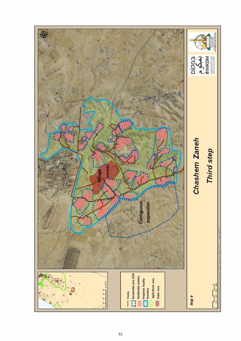
61

62

63

64
The Council for the Unrecognized Villages, Bimkom – Planners for Planning Rights
and Sidreh – the organization of Arab Bedouin women in the Negev, prepared a Master
Plan for the unrecognized villages in the Negev over the course of three years. This
document is an abridged version of the Plan. The first of its kind, this Plan constitutes
a sustainable alternative to the various government plans. It enables recognition and
planning based on the existing villages, upholding principles of equality, justice and
public participation, alongside professional planning norms. If implemented, this Plan
will benefit all the residents of the region, Bedouin and Jews alike.