Embed Size (px)
Citation preview
Contract Reference: NYCC/BES/18376 English Heritage project reference 5590 MAIN
Managing Landscape Change
A multi-disciplinary approach to future mineral
extraction in North Yorkshire
Stage 2 Technical Report on Predictive Landscape Modelling
NYCC/BES/18376: Managing Landscape Change Stage 2 Technical Report on Predictive Landscape Modelling. January 2012
2
Document Control
Title: NYCC/BES/18376: Managing Landscape Change –
Stage 2 Technical Report on Predictive Landscape Modelling
Authors: Dr Alan Thompson, Director of Earth Sciences, Capita Symonds
Jane Jackson, Senior Heritage Planner, Capita Symonds
Jamie Quartermaine, Oxford Archaeology North
Jayne Garbutt, Landscape Architect, Capita Symonds
Sam Griffin, ecologist, Capita Symonds
Derivation: Report produced to describe the development of predictive landscape models during Stage 2. Derived in part from the interim dossiers produced for each ASMRP, with substantial additional discussion.
Origination Date: 17 October 2011
Reviser(s): All Authors
Date of last revision: 19 April 2012
Version: Revision 4.1 (Compressed Images)
Status: Final
Summary of
Changes: Revisions in accordance with Steering Group comments
Circulation: Steering Group and Project Team
Required Action: Final Approval
File Name/Location:
Approval: Jayne Garbutt Project Manager, Capita Symonds
Dr. Alan Thompson Technical Director, Capita Symonds
Robin McCartney Director, Capita Symonds
Photographic acknowledgements:
Aerial image on front cover: copyright 2011, Jamie Quartermaine, Oxford Archaeology North.
All other images: copyright 2011 Dr Alan Thompson, Cuesta Consulting Limited, used with permission.
NYCC/BES/18376: Managing Landscape Change Stage 2 Technical Report on Predictive Landscape Modelling. January 2012
3
Contents
1. Introduction ................................................................................................ 4
Background ...................................................................................................................................... 4
Aims and Objectives ......................................................................................................................... 4
The Scope of this Report .................................................................................................................. 5
2. Methodology for Tasks 2(vi) and 2(vii) ........................................................ 7
Task 2(vi): Topographic Modelling ................................................................................................... 7
Task 2 (vii): Predictive Landscape Modelling ................................................................................... 9
3. Landscape Evolution and Archaeological Potential .................................... 10
Major River Valleys ........................................................................................................................ 12
The Vales of York and Mowbray, and the Magnesian Limestone Ridge ........................................ 21
The Vale of Pickering and the Yorkshire Wolds ............................................................................. 32
The Pennine Moors ........................................................................................................................ 39
4. ASMRP 1 Profile: Sub-Alluvial Sand & Gravel ............................................. 45
5. ASMRP 2 Profile: River Terrace Sand & Gravel ........................................... 48
6. ASMRP 3 Profile: Glacio-Fluvial Sand & Gravel .......................................... 51
7. ASMRP 4 Profile: Glacial Sand & Gravel ..................................................... 54
8. ASMRP 5 Profile: Undifferentiated Sand & Gravel Resources .................... 57
9. ASMRP 6 Profile: Quaternary Glacio-Lacustrine Brick Clay Resources ........ 60
10. ASMRP 7 Profile: Cretaceous Chalk Resources ........................................... 62
11. ASMRP 8 Profile: Jurassic Limestone Resources ......................................... 64
12. ASMRP 9 Profile: Permian ‘Magnesian’ Limestone Resources ................... 66
13. ASMRP 12 Profile: Carboniferous Sandstone Resources ............................ 68
14. ASMRP 14 Profile: Carboniferous Limestone Resources ............................ 70
NYCC/BES/18376: Managing Landscape Change Stage 2 Technical Report on Predictive Landscape Modelling. January 2012
4
1. Introduction
1.1 In January 2011, Capita Symonds was commissioned by North Yorkshire County Council to
‘develop an environmental evidence base and assess environmental sensitivities and capacity
in North Yorkshire to inform a spatial planning strategy for the extraction of minerals’.
Background
1.2 Pressure on the environment from the extraction of surface minerals, particularly aggregates, in
North Yorkshire has created an urgent need for a high quality, mapped environmental dataset
to assess environmental sensitivities and capacity and to underpin informed decision-making
and management of the environmental resource in areas of past, present and future mineral
extraction. Such management will help ensure that key environmental issues are factored into
minerals strategy development in a balanced way alongside a range of economic and social
considerations. Output generated by the project will contribute to the production of a robust,
credible yet proportionate evidence base to underpin spatial strategy development for
minerals in North Yorkshire. Adequate evidencing of spatial strategies helps ensure that these
strategies are rational, widely accepted by stakeholders and focused on delivery of meaningful
outcomes.
1.3 Understanding of the capacity of an asset to accept change and the possibility of mitigation
against negative aspects of change is an important tool for decision making, particularly where
there are competing demands for the preservation or development of an asset. The results of
this study will inform new policy and decision making and will also provide a case study of how
such policies can be created and used in other areas where a multi-disciplinary approach can
be used to address complex problem.
Aims and Objectives
1.4 The principal aim of this project is thus “to develop an environmental evidence base and to
assess environmental sensitivities and capacity to inform a spatial planning strategy for the
extraction of minerals within North Yorkshire”.
1.5 The more detailed objectives of the contract are to:
i. define mineral specific Areas of Surface Mineral Resource Potential (ASMRPs) within the
overall minerals resource area for North Yorkshire through the identification of the
relevant geologies and their spatial extent;
NYCC/BES/18376: Managing Landscape Change Stage 2 Technical Report on Predictive Landscape Modelling. January 2012
5
ii. collate in GIS format available environmental data for the mineral resource areas to be
studied, including historic environment, biodiversity and landscape data;
iii. analyse the current state of knowledge about, and sensitivity of, the environment of
each area of surface mineral resource potential;
iv. undertake detailed environmental studies of indicative sample area(s) for each area of
surface mineral resource potential, to include desk-based research, land-use study,
landform classification and descriptions of environmental associations;
v. assess the capacity for change within each ASMRP and provide a strategic assessment of
the degree of impact that mineral extraction would have on each;
vi. produce a short and focused research framework for each ASMRP to guide
environmental evaluation and mitigation works associated with future minerals
applications; and to
vii. produce a report and prepare a digital archive resulting from the project results,
suitable for web-access.
1.6 The Project is being delivered in five Stages:
Stage 1: Environmental mapping and characterisation
Stage 2: Detailed environmental evidence gathering and assessment of sample areas
Stage 3: Analysis and environmental overview of each ASMRP
Stage 4: Production of Guidance
Stage 5: Reporting, archive and dissemination of project results
The Scope of this Report
1.7 This report covers part of the output from Stage 2 of the project: detailed environmental
evidence gathering and assessment of sample areas.
1.8 The Stage 2 work, overall, involved eight individual tasks, as follows:
Task 2(i): Desk-based assessment and literature review;
Task 2ii): Site visits and walk-over surveys;
Task 2(iii): Landform Element Classification;
Task 2(iv): Land Use Mapping;
Task 2(v): Detailed Landscape Character Assessment;
Task 2(vi): Topographic Modelling;
NYCC/BES/18376: Managing Landscape Change Stage 2 Technical Report on Predictive Landscape Modelling. January 2012
6
Task 2(vii): Predictive Landscape Models; and
Task 2(viii): Production of Stage 2 Highlight Report.
1.9 This report deals specifically with Tasks 2(vi) and 2(vii).
1.10 The earlier tasks which (along with the Stage 1 output) have helped to inform this work are
reported separately in the Stage 2 Technical Report on Sample Areas. Task 2(viii) is also
reported separately and the output files from the Geographic Information System (GIS) will
form part of the project’s digital archive.
NYCC/BES/18376: Managing Landscape Change Stage 2 Technical Report on Predictive Landscape Modelling. January 2012
7
2. Methodology for Tasks 2(vi) and 2(vii)
Task 2(vi): Topographic Modelling
2.1 Topographic information for the whole of the project area was made available through the
Ordnance Survey’s Land-Form PROFILE data product. Supplied in vector format as both
gridded spot heights (10m x 10m) and contour lines (predominantly with a 5m contour
interval, but up to 10m in some upland areas), the product provided detailed height
information for the project area, captured at a scale of 1:10,000. Additional PROFILE data was
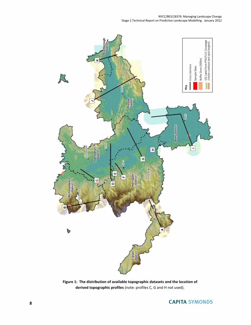
obtained to complete each of the topographic cross sections, as shown in Figure 1, on the
following page. To supplement this information, 1m resolution LiDAR data was also sourced
(coverage permitting), which enabled a more detailed understanding of the topography to be
gained for the majority of the twelve sample areas and their 500m radius buffer zones.
2.2 Each of the datasets was used to construct digital terrain models (DTMs) appropriate to the
scale of investigation, i.e. with LiDAR data being utilised for detailed analysis of
geomorphological and archaeological surface features within the sample areas, prior to the
walk-over surveys, and with the other data being used to examine and illustrate the broader
scale topography of the ASMRPs as a whole. The LiDAR models, enhanced by the use of hill
shading within the GIS, helped to identify subtle topographic features (such as abandoned,
infilled channels, field boundaries and degraded archaeological features such as Nunwick
Henge), which were not readily identifiable on the ground. Illustrations from these models are
included within the Stage 2 report on Sample Areas. The more general models were used as
part of the predictive landscape modelling, as covered in this report. In particular, a number of
cross-sections were derived from the models to illustrate key topographic relationships of the
various ASMRPs. The locations of these sections are shown on Figure 1, on page 7, and an
Excel spreadsheet showing all of the cross sections as simple graphs is provided as part of the
digital archive. In all cases, the cross sections incorporate vertical exaggeration, as indicated
by the horizontal and vertical scales, in order to emphasise the topographic variations.
2.3 Selected cross sections (all except C, G and H) have been used to illustrate some of the key
relationships in Chapter 3 of this report. In constructing these, the surface outcrop positions of
individual ASMRP polygons were abstracted from the GIS as part of the Excel spreadsheet
data, and are therefore accurately shown. The sub-surface details shown on these cross
sections, however, are schematic. They are intended to provide a good indication of the
underlying geology, based on a general understanding of the solid and drift geological
relationships in the areas concerned, but the scope of work did not allow for the collation and
detailed examination of sub-surface information such as borehole records.
NYCC/BES/18376: Managing Landscape Change Stage 2 Technical Report on Predictive Landscape Modelling. January 2012
8
Figure 1: The distribution of available topographic datasets and the location of
derived topographic profiles (note: profiles C, G and H not used).
NYCC/BES/18376: Managing Landscape Change Stage 2 Technical Report on Predictive Landscape Modelling. January 2012
9
Task 2 (vii): Predictive Landscape Modelling
2.4 The concept of predictive landscape modelling entails building up an understanding of the
inter-relationships between the various facets of the modern landscape and how they have
evolved over time, such that expectations regarding likely archaeological potential or
environmental sensitivities (for example) can be developed for areas where substantive
evidence is currently lacking.
2.5 In areas where there is scope to examine available evidence in great detail (for example in the
case of individual planning applications), and in areas which have been subject to more
comprehensive research programmes (such as the recent ALSF-funded studies of the Swale-
Ure Washlands (Bridgland et al., 2011) and the Twill-Tweed catchment (Passmore et al.,
2006)), this can be done with a reasonably high degree of confidence. In this case, however,
where the requirement is to cover the whole of North Yorkshire, and where such detailed, site-
specific analysis is not possible within the available timescale and budget, except within the
very limited number of small sample areas, a more generalised approach has had to be taken.
This draws primarily on the evidence base described in the Stage 1 report, supplemented by
the additional desk study and field observations from the Stage 2 sample areas report, and by
existing knowledge within the project team.
2.6 The work firstly involved developing an understanding of the causal relationships between the
underlying geology, the geomorphological evolution of the landscape, and changes in climate,
natural vegetation, land use and human settlement throughout the Holocene period. This
information is set out in Chapter 3. From this, although the details must inevitably be
generalised, it has been possible to identify reasonably distinctive ‘profiles’ for some, though
not all individual ASMRPs, which allow the prediction of broad environmental characteristics
and expectations. The profiles are described in Chapters 4 to 14.
NYCC/BES/18376: Managing Landscape Change Stage 2 Technical Report on Predictive Landscape Modelling. January 2012
10
3. Landscape Evolution and Archaeological Potential
Introduction
3.7 The Stage 1 report included (within Chapter 5) a very broad overview of the historical (and pre-
historic) evolution of the modern landscape within North Yorkshire, so this is not repeated
here. It is, however, worth considering that evolution in more detail within a number of
contrasting environments, where different facets of the relationships between geology,
geomorphology, biodiversity, landscape and archaeological potential can be examined. This
chapter seeks to explore these differences as a precursor to developing predictive landscape
models, or profiles, for the individual ASMRPs.
3.8 One of the most important aspects to consider in this respect is the relationship between Man
and his changing environment within the major river valleys (including ASMRPs 1 and 2),
throughout the post-glacial period. Here, in particular, there have been demonstrable cause
and effect relationships between climate change, landform development, vegetation
succession and human activity. The latter has both responded to, and increasingly influenced,
the other factors.
3.9 Also important, primarily because of the mineral resources which they contain, are the Vale of
York and the Vale of Mowbray (encompassing ASMRPs 1, 2, 3, 4 and 6) together with the
adjoining Magnesian Limestone Ridge (ASMRP 9). Here, the available archaeological and
palaeo-environmental evidence is patchier, and the distinctions which can be made between
at least some of the different deposits are open to a number of alternative explanations.
3.10 A third area of importance, not least because of the immense richness of archaeological
evidence available from successive periods throughout the Holocene period, are the
relationships seen within the Vale of Pickering (including ASMRP 5) and the adjoining
Yorkshire Wolds (ASMRP 7).
3.11 Finally, quite different relationships can be gleaned from sites within the upland areas of the
Pennine Moors, including large parts of ASMRPs 12, 13 and 14).
3.12 Each of these broad areas is considered separately below, to provide a context in which the
individual ASPRPs are subsequently examined, in the later chapters of this report.
Timescales
3.13 Throughout these accounts there are repeated references to periods of historical and
geological time, particularly during the last 26,000 years Before Present (BP). For convenience,
Table 1, below, summarises the sequences and approximate correlations involved.
NYCC/BES/18376: Managing Landscape Change Stage 2 Technical Report on Predictive Landscape Modelling. January 2012
11
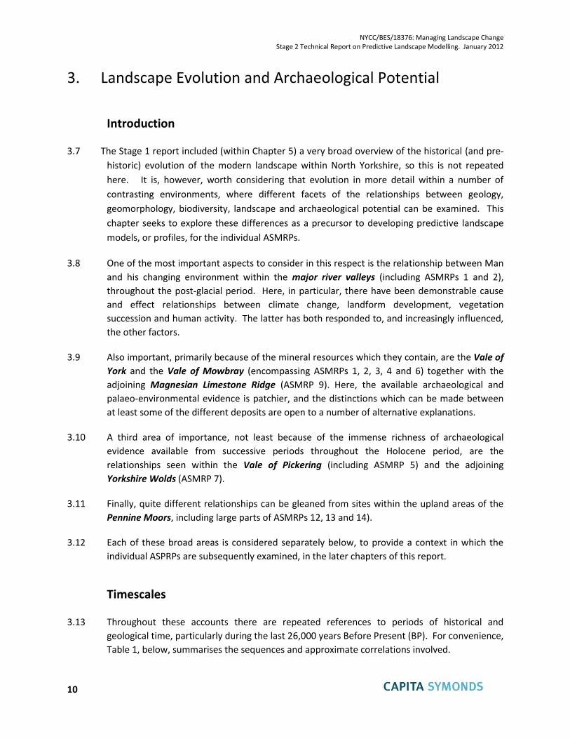
Historical / Cultural period
Dates Age (years BP)
(Calibrated radio-Carbon
years Before Present, where ‘Present’= 1950)
Geological /Palaeo-environmental period
Post-Medieval Since 1540 AD Less than 410 BP
Sub-Atlantic
Late Holocene
Ho
loce
ne
(= F
lan
dri
an)
Late Medieval 1066 – 1540 AD 884 – 410 BP
Early Medieval 410 – 1066 AD 1,540 – 884 BP
Roman 43 – 410 AD 1,907 – 1,540 BP
Iron Age BC 600 – 43 AD 2,550 – 1,907 BP
Bronze Age BC 2500 – 600 4,450 – 2,550 BP
Sub-Boreal
Neolithic BC 4000 – 2500 5,950 – 4,450 BP
Mid Holocene
Mesolithic BC 10000 – 4000
11,950 – 5,950 BP
Atlantic
Boreal Early Holocene
Pre-Boreal
Palaeolithic
Upper Palaeolithic
12,800 – 11,950 BP Younger Dryas Stadial (Late Glacial / Loch Lomond)
Dev
ensi
an g
laci
atio
n
Mid
dle
an
d U
pp
er P
leis
toce
ne
26,000 – 12,800 BP
Dimlington Stadial (includes the Bølling – Allerød (=Windermere) Interstadial, around 13,000 BP, and the Last Glacial Maximum (LGM) (=Oldest Dryas), around 23,000 BP)
38,000 - 26,000 BP
Early Devensian
Middle Palaeolithic
110,000 - 38,000 BP
130,000 - 110,000 BP Ipswichian Interglacial
200,000 - 130,000 BP Wolstonian glaciation
Lower Palaeolithic
380,000 - 200,000 BP Hoxnian Interglacial
455,000 - 380,000 BP Anglian glaciation
Pre- 455,000 BP Pre-Anglian
Important note: dates and age ranges shown in this table are based on the latest known information but are constantly
changing as new dating evidence is obtained. For this reason there are differences between previously published studies
Table 1: Correlation of historical/ cultural and geological/palaeo-environmental periods,
with corresponding dates / age ranges
NYCC/BES/18376: Managing Landscape Change Stage 2 Technical Report on Predictive Landscape Modelling. January 2012
12
Major River Valleys
3.14 The following account is based on an integrated analysis of geomorphological, archaeological
and palaeo-environmental research, combined with the existing knowledge and observations
of the multi-disciplinary project team. It draws extensively on the recently completed
synthesis of work undertaken on the Swale-Ure Washlands project (Bridgland et al., 2011), but
also on a variety of other sources, as cited in the text.
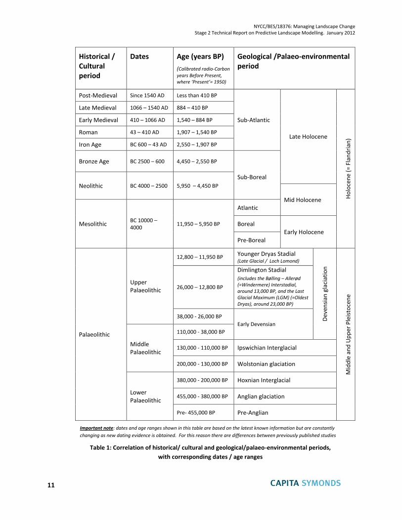
3.15 Figure 2, below, uses an accurate cross section from the topographic modelling exercise to
illustrate the relationship of river valley deposits (ASMRP 1, river floodplains and ASMRP 2,
river terraces) to other ASMRPs within the surrounding landscape. Although precise details
vary from one location to another, the section illustrates how these fluvial sediments form flat,
low-lying areas which are often incised into older Quaternary glacial (ASMRP 4) and glacio-
fluvial (ASMRP 3) sediments. This particular example (Section F) extends from south west to
north east just to the north of Ripon (see Figure 1 for location). Although the surface profile
and the surface positions of the ASMRP outcrops are accurate, the sub-surface detail and the
distribution of glacial till (pale blue) are schematic (though informed by previous research
carried out in this area – Thompson et al. 1996).
Figure 2: topographic profile (F) and schematic geological cross section to illustrate the
relationship of ASMRPs 1 and 2 to the surrounding landscape
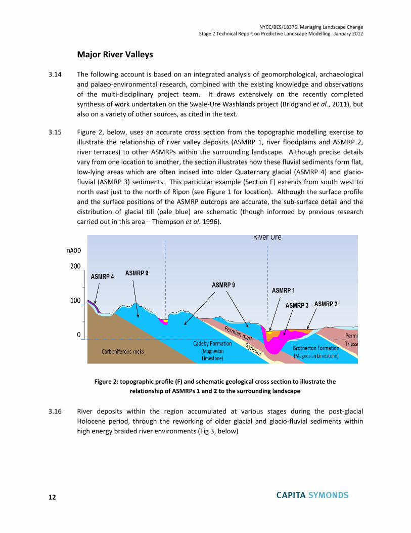
3.16 River deposits within the region accumulated at various stages during the post-glacial
Holocene period, through the reworking of older glacial and glacio-fluvial sediments within
high energy braided river environments (Fig 3, below)
NYCC/BES/18376: Managing Landscape Change Stage 2 Technical Report on Predictive Landscape Modelling. January 2012
13
Figure 3: example of a braided river depositional environment (Morsadalur, south east Iceland)
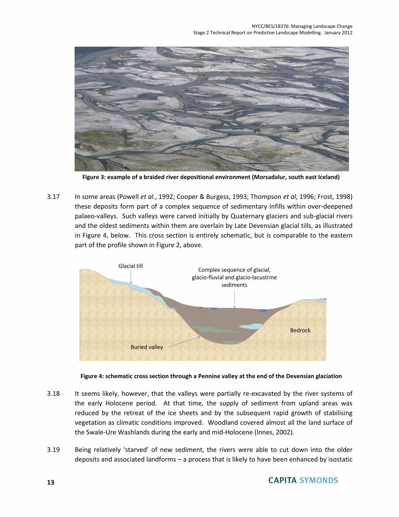
3.17 In some areas (Powell et al., 1992; Cooper & Burgess, 1993; Thompson et al, 1996; Frost, 1998)
these deposits form part of a complex sequence of sedimentary infills within over-deepened
palaeo-valleys. Such valleys were carved initially by Quaternary glaciers and sub-glacial rivers
and the oldest sediments within them are overlain by Late Devensian glacial tills, as illustrated
in Figure 4, below. This cross section is entirely schematic, but is comparable to the eastern
part of the profile shown in Figure 2, above.
Figure 4: schematic cross section through a Pennine valley at the end of the Devensian glaciation
3.18 It seems likely, however, that the valleys were partially re-excavated by the river systems of
the early Holocene period. At that time, the supply of sediment from upland areas was
reduced by the retreat of the ice sheets and by the subsequent rapid growth of stabilising
vegetation as climatic conditions improved. Woodland covered almost all the land surface of
the Swale-Ure Washlands during the early and mid-Holocene (Innes, 2002).
3.19 Being relatively ‘starved’ of new sediment, the rivers were able to cut down into the older
deposits and associated landforms – a process that is likely to have been enhanced by isostatic
Glacial tillComplex sequence of glacial,
glacio-fluvial and glacio-lacustrine sediments
Bedrock
Buried valley
NYCC/BES/18376: Managing Landscape Change Stage 2 Technical Report on Predictive Landscape Modelling. January 2012
14
uplift of the land surface following the retreat of the ice sheets (Bridgland, 1999; Bridgland &
Austin, 1999; Shennan & Andrews, 2000; Shennan et al., 2006; Howard et al., 2000a). Figure 5,
below, provides a schematic illustration of this stage of landscape evolution during the early to
mid-Holocene.
Figure 5: schematic cross section through a Pennine valley during the early Holocene
3.20 Evidence from other sources suggests that the subsequent accumulation of fluvial deposits
within the re-excavated valleys was due, at least in part, to the progressive influence of
humans on the landscape: in particular the clearance of trees to facilitate cultivation and
grazing, which would have increased the supply of sediment once more.
3.21 From the Mesolithic period there is pollen evidence of a decline in upland tree species
associated with the use of fire by hunter-gatherers, leading to the establishment of heath, bog
and grassland over wide areas (Simmons and Innes, 1985). More widespread disturbance,
through the permanent clearance of trees for animal husbandry and crop cultivation, occurred
from the early Neolithic period onwards, around 5,000 years BP. Evidence for this is seen in
the ‘Elm Decline’ a marked and widespread reduction in Elm pollen (Ulnus sp.) from around
this time, accompanied by a rise in cereal pollen from arable farming. The process accelerated
considerably, both in spatial extent and intensity, during the latter part of the Neolithic and
into the mid Bronze Age (Bridgland et al. 2011). This was a time when the level of human
settlement and activity in the area greatly increased – not least in response to a period of
warmer and drier climate which allowed expansion of farming into previously unfavourable
areas.
3.22 Throughout this period, from before 5,000 BP to around 3,000 BP, it is likely that river valleys
would have experienced considerable net aggradation, i.e. the accumulation of sediment to
higher levels than those of both pre-existing and present-day rivers (Figure 6, below). The
sediments, being contemporaneous with Mesolithic to Bronze Age human activity, both
incorporated and buried older archaeological evidence, whilst the depositional surfaces
Partial re-excavation of buried valleys by downcutting river
systems
Bedrock
Buried valley
Vegetation succession to climax broadleaved woodland, reducing
sediment supply

NYCC/BES/18376: Managing Landscape Change Stage 2 Technical Report on Predictive Landscape Modelling. January 2012
15
(remnants of which now form the highest river terraces), retain evidence of land use and
settlement from these and subsequent periods.
Figure 6: schematic cross section through a Pennine valley during the mid-Holocene
3.23 Within this period, as Neolithic settlers began to make their mark on the landscape, some of
Yorkshire’s most important prehistoric features were created. These included the three henges
at Thornborough, which are almost perfectly aligned with the one at Nunwick, north of Ripon
and also linked with the largely destroyed henge at Catterick, further north. The henges at
Thornborough (Fig 7, below) were constructed on ASMRP 3 sand & gravel deposits, slightly
above the aggrading deposits of the Ure valley, whilst those at Nunwick and Catterick were
built on slightly lower ASMRP 2 terrace surfaces.
Figure 7: part of the central henge at Thornborough
Aggradation of fluvial sediments to create
depositional surfaces parts of which now
remain as river terraces
Bedrock
Buried valley
Vegetation reduced by forest clearance, allowing increased
sediment supply into valley floors
NYCC/BES/18376: Managing Landscape Change Stage 2 Technical Report on Predictive Landscape Modelling. January 2012
16
3.24 Interestingly, all five of these henges, as well as being located close to major rivers, were also
constructed very close to the narrow outcrops of Permian gypsum deposits (Fig 8, below), and
two more henges to the east of Ripon (Hutton Moor and Cana Barn) are not far from the same
outcrops. Gypsum (alabaster) is known to have been used in covering the earthworks of at
least the central henge at Thornborough (Burl, 1976), giving it a brilliant white sheen visible for
miles around within the landscape, and comparable in many ways with the use of Chalk for
similar purposes in parts of southern England (e.g. at Silbury Hill, the largest man-made mound
in Europe, which forms part of the Stonehenge, Avebury and Associated Sites UNESCO World
Heritage site in Wiltshire).
3.25 It is postulated here that the geological link with gypsum outcrops might form part of the
explanation for the location of these henge monuments within North Yorkshire, and may help
to provide a focus for future investigations of prehistoric remains within or close to other parts
of the gypsum outcrop.
Figure 8: topographic profile (E) and schematic geological cross section to illustrate the
relationship of ASMRPs 1, 2 and 3 to the Ure Valley and the Thornborough Henges complex
3.26 The conversion of the former depositional surfaces into the terrace features seen today
resulted from subsequent downcutting by the rivers, interrupted by periods of renewed
aggradation to produce complex ‘cut and fill’ sequences in many of the valleys, as illustrated
schematically in Figure 9, below. The incision was driven partly by continued isostatic rebound
of the uplands, but the process was also strongly influenced by the effects of ongoing climate
change – both directly, in relation to the hydrology and delivery of sediment from upland
catchments, and indirectly through its effects on farming practices and tree clearances.
NYCC/BES/18376: Managing Landscape Change Stage 2 Technical Report on Predictive Landscape Modelling. January 2012
17
Figure 9: schematic illustration of the detail of Holocene cut and fill sequences within a river valley. In this example, the base of the Holocene sediments corresponds to the underlying
bedrock surface but, elsewhere, these sediments may be underlain by older Quaternary deposits infilling much deeper valley systems (as illustrated in Figure 6, above).
3.27 In the Ripon area, borehole evidence has revealed that the River Ure had achieved an
equilibrium valley floor level nearly 10 metres below that at present by c. 5000 cal. BP.
Following this, it aggraded by c. 10 m to the levels represented by the later Holocene terraces,
as well as incising to at least 20 m below modern river level (Bridgland et al. 2011).
3.28 Evidence from peat stratigraphy and other sources, summarised by Bridgland et al. 2011
(Ibid.), shows that there was a marked climatic deterioration towards the end of the Bronze
Age, from about 3100 to 2500 14C BP, with a particularly wet and cold phase near the end of
that period, at around 2650 14C BP. This is likely to have had a strong influence on the
distribution and types of land use conducted by late Bronze Age and early Iron Age
communities. Palaeo-environmental and archaeological evidence from the region (Bridgland
et al. 2011) suggests that this led to the regeneration of woodland, the spread of wetland
ecosystems within the valley floors and the near absence of forest clearance and agriculture
within upland areas.
3.29 Initially, this change in climate may have combined with isostatic effects to allow for a period
of incision into the older terrace deposits but this was subsequently replaced by a widespread
episode of net deposition – particularly of fine-grained overbank flood deposits. As noted by
Bridgland et al. 2011 (Ibid.), virtually all relevant studies of Yorkshire rivers record a major
episode of alluvial deposition following the c. 2650 14C BP climate event, from upper reaches,
as in Wharfedale (Howard et al., 2000b) to the Humber and Tees estuaries (Plater et al., 2000;
Rees et al., 2000), as well as many stretches in between (Lewin et al., 2005). It may be
conjectured that the presence of dense, wetland vegetation within the valley floors at this
time would have helped to prolong flood events and to trap the fine grained sediment.
Older terraces Younger
terraces
Recent alluvium
Modern floodplain
Base of erosion into underlying bedrock
Older terraces
River
NYCC/BES/18376: Managing Landscape Change Stage 2 Technical Report on Predictive Landscape Modelling. January 2012
18
3.30 During the late Iron Age and Roman periods which followed, environmental and cultural
conditions were profoundly different to the preceding wet phase of the early Iron Age.
Climate studies suggest that a dry and warm phase began about 2400 14C BP and lasted for
several centuries. This greatly reduced the incidence of overbank flooding and alluviation
(Macklin et al., 2005), so that much of the lowland in the Ouse system became drier and more
stable and thus available for intensive agricultural exploitation. Environmental evidence also
suggests that most areas experienced a high level of renewed forest clearance in the late Iron
Age, and that this continued into and through the period of Roman control.
3.31 Thereafter, during the medieval period, there appears to have been a relaxation of human
pressure on the landscape and a widespread regeneration of woodland. Throughout this time,
from the late Iron Age to the early / mid-medieval period, human activity took place on what
were then the valley floors, but which have since become low river terraces, following
subsequent further incision to form the modern floodplains. In one example of this, on the
right bank of the Swale near Catterick, Taylor and Macklin (1997) have identified and mapped
up to eight low terraces, formed late in the Holocene as a result of meander migration.
3.32 During the periods when the various terrace surfaces were active floodplains, their ecological
characteristics would have reflected contemporary climatic conditions and the varying
influence of human activity. The highest terraces, which were active depositional surfaces
during the mid-Holocene, are likely to have been characterised, at that time, by willow and
alder carr. In drier areas and on the woodland edge, species such as hazel and birch would
dominate. A rich herbaceous ground flora would have existed within the floodplain with grass
and sedge species thriving in seasonally inundated woodland.
3.33 The younger terraces, which were formed at lower elevations during and after the much colder
and wetter period between around 3,100 and 2,500 BP, would originally have been
characterised by extensive wetland environments and dense vegetation. Habitats such as this
would have been extensively engineered by European Beaver (Castor fiber) until it was finally
hunted to extinction in Britain in the sixteenth century. This would have resulted in a dynamic
environment consisting of a mosaic of woodland, woodland edge and open water which would
have been of high ecological value. Wetlands would have supported a wide biodiversity and
provided habitat for species typical of the Euro-Siberian region of the Palearctic ecozone; these
would include water voles, otters and water shrews. Waterside trees and shrubs (often
naturally coppiced by beaver) would grow as dense belts which would provide cover for birds
and other wildlife. Beaver dams would trap sediment and improve water quality; recharge
groundwater tables and increase cover and forage for trout and salmon. Bats would have
utilised the woodland edge and open water habitats and watercourses.
3.34 Subsequently, during the much drier and warmer climate which characterised the late Iron Age
to the Roman era (around 2,400 to 1,500 BP), many of these areas would have been
progressively reclaimed for agriculture, a process assisted by the gradual further incision of the
NYCC/BES/18376: Managing Landscape Change Stage 2 Technical Report on Predictive Landscape Modelling. January 2012
19
rivers down to their present levels, which left the terraces as higher surfaces of well-drained
land, less frequently inundated by flooding. At this time grass, plantain, bracken, dandelion,
thistle and nettle would have increased in association with an increasingly open arable and
pastoral landscape. The presence of hazel and ash are indicative of opening-up of the forest
cover and these species are likely to have become more widespread. Fields would have
originally been enclosed by deep ditches, banks and fillets of pre-existing woodland. It is
unclear when hedge planting became commonplace, but certainly by the tenth century hedges
were used to enclose pasture.
3.35 Human occupation has progressively transformed the natural habitats through altering the
fauna, felling forests, drainage, agriculture and built development. In places a good diversity of
species still remains, including protected species such as water voles, otter, and great crested
newts, but the residual habitats are much denuded resulting in fragmented (and
consequentially fragile) populations.
Figure 10: the modern floodplain of the River Ure, immediately upstream of Ripon: remnants
of formerly more extensive habitats survive within the Ripon Parks SSSI, seen in the far
distance, but in the foreground the floodplain is dominated by improved pasture
3.36 Dating evidence from various sources suggests that most of the present-day floodplains are
features of the last millennium and that, in many cases, they are of much more recent origin,
having been reworked by the active migration of meandering rivers within the last few
hundred years. This applies especially to the most active, gravel-bed rivers, such as the Swale
upstream of Leeming, the Ure upstream of Boroughbridge, the Nidd upstream of
Knaresborough and the Wharfe upstream of Harewood. Further downstream, lateral shifting
of the river channels has been more limited in historical times, and the modern floodplains are
NYCC/BES/18376: Managing Landscape Change Stage 2 Technical Report on Predictive Landscape Modelling. January 2012
20
often narrow features constrained between higher river terraces (Fig 11, below), but overbank
deposition of silts and clays on these surfaces during periodic major flood events is likely to
have buried archaeological features. For this reason, the antiquity of archaeological evidence
preserved on modern floodplain surfaces is typically limited to the last 200 to 1,000 years,
depending on location.
Figure 11: The River Nidd at Cattal, showing the restricted modern floodplain incised below the
older, glacio-fluvial depositional surface of ASMRP 3, on which the village is built.
3.37 In conclusion, although the understanding of alluvial (including terrace) sequences across
North Yorkshire is continually improving through new research, the general pattern being
revealed is one of complex response to a variety of different causal effects throughout the
Holocene period. One implication of this is that the precise sequence and dates of origin of
individual surfaces are likely to have varied from one river valley to another and even from one
part of a particular valley to another.
3.38 More generally, however, the most important distinguishing features of all surviving fluvial
deposits are that they post-date all other mineral deposits in the region, including glacial,
glacio-fluvial and glacio-lacustrine sediments, and that they have developed in parallel with
human occupation. Crucially, this means that each successive phase of fluvial deposition has
buried and/or reworked and redistributed any evidence of earlier occupation or land use; and
that any evidence preserved at the surface can only be expected to date from the time of the
last reworking of the sediments by the shifting course of the river. In the case of the oldest
post-glacial terraces this may be up to around 3,000 to 5,000 years ago (Neolithic to Bronze
NYCC/BES/18376: Managing Landscape Change Stage 2 Technical Report on Predictive Landscape Modelling. January 2012
21
age), although the deposits beneath those surfaces may well contain or overlie evidence dating
from much earlier periods, as far back as the early Holocene (Mesolithic), up to around 11,000
years ago. In the case of the present-day floodplains, the depositional surfaces date
predominantly from the last few hundred years.
3.39 These features contrast with all other ASMRPs, where the deposits existed prior to any known
human activity in the area, and where archaeological evidence can therefore only be expected
to be found at or very near the surface (or in underground cave systems and mine workings in
the case of the Carboniferous Limestone of ASMRP 14). In some other ASMRPs (notably 3, 4,
5, 6, 12, 13 and 14), archaeological features which were originally associated with the exposed
surface of the associated mineral deposits have since been concealed by the accumulation of
overlying soils, including windblown ‘cover’ sands and/or peat deposits (including lowland
raised bog, valley mires and upland blanket bog). But in all of these cases, archaeological
remains are most unlikely to occur within or beneath the mineral deposits themselves and, in
terms of predictive landscape modelling, it is this which distinguishes all of them from the
Holocene fluvial sediments of ASMRPs 1 and 2.
The Vales of York and Mowbray, and the Magnesian Limestone Ridge
3.40 Most of the major valley systems within North Yorkshire, other than those in the far west,
which continue into Lancashire, and those in the north east which discharge into the North
Sea, cut discordantly through the Magnesian Limestone Ridge and extend down into the Vale
of Mowbray and/or the Vale of York.
Figure 12: panoramic view across the Vale of Mowbray, looking west from Sutton Bank
3.41 Here, along the lower reaches of the Ure, Nidd, Wharfe and Aire, eventually combining to form
the River Ouse, the deposits associated with ASMRPs 1 and 2 continue, with similar
characteristics to those described above (Figure 13, below).
NYCC/BES/18376: Managing Landscape Change Stage 2 Technical Report on Predictive Landscape Modelling. January 2012
22
Figure 13: The lower reaches of the River Ure downstream from Aldwark Bridge, near Linton-on-Ouse
3.42 However, these deposits form only a small part of a much wider range of Quaternary
sediments distributed widely across a low-lying but complex landscape. Figure 14, below, uses
an accurate cross section (D) from the topographic modelling exercise to illustrate the
relationship of the various ASMRPs from west to east across the southern part of the Vale of
Mowbray (see Figure 1 for location). Once again, whilst the surface profile and the surface
positions of the ASMRP outcrops are accurate, the sub-surface detail and the distribution of
glacial till (pale blue) are schematic.
3.43 Although the precise details vary substantially from one location to another, this cross section
illustrates the typically complex arrangement of ASMRP 1 (sub-alluvial gravels), ASMRP 3
(glacio-fluvial sand & gravel), ASMRP 4 (glacial sand & gravel), ASMRP 6 (glacio-lacustrine clays)
and the intervening outcrops of glacial till (shown in pale blue). It also shows the marked
contrast between the low-lying Vale of York and the more elevated Magnesian Limestone
Ridge (ASMRP 9) which characteristically demarcates the western edge of the Vale.
NYCC/BES/18376: Managing Landscape Change Stage 2 Technical Report on Predictive Landscape Modelling. January 2012
23
Figure 14: topographic profile (D) and schematic geological cross section to illustrate the relationship
of ASMRPs 3, 4 and 6 to each other and to the surrounding landscape, across the Vale of Mowbray.
3.44 Within the Vale of Mowbray, and continuing southwards into the Vale of York, the areas of
most prominent relief are generally those underlain by glacial till and, to a lesser extent, the
ice-contact glacial sands and gravels of ASMRP 4 (Fig 15). In places these deposits occur within
moraine ridges or more complex areas of irregular, undulating ground.
Figure 15: typical undulating arable landscape developed on ASMRP 14 deposits within the
northern part of the Vale of York, at Kirby Hill, near Boroughbridge
3.45 Figure 16, below, illustrates the nature of the depositional environment involved, using a
contemporary analogue from one of the broadest glacier forelands in south-east Iceland.
NYCC/BES/18376: Managing Landscape Change Stage 2 Technical Report on Predictive Landscape Modelling. January 2012
24
Figure 16: contemporary depositional environment for glacial sands and gravels in front of the
broad ice front of the Breiðamerkurjökull glacier in south east Iceland.
3.46 The glacio-fluvial sediments of ASMRP 3, which were deposited contemporaneously with and
after the glacial sediments as the ice sheet retreated, generally form areas of very limited
relief, often contained between areas of moraine, as seen in Figure 17, below.
Figure 17: contemporary depositional environment for glacio-fluvial sands and gravels with
intervening recessional moraine ridges, in Morsardalur, south east Iceland.
NYCC/BES/18376: Managing Landscape Change Stage 2 Technical Report on Predictive Landscape Modelling. January 2012
25
3.47 Similarly, the glacio-lacustrine clays and silts deposited within former glacial lakes are usually
intimately associated with, and often contained by, other glacial sediments. This is illustrated
by a further contemporary example from Iceland (Figure 18), where lakes trapped between the
glacier snout and the moraine systems beyond are receiving a constant influx of fine grained
sediment from the melting ice. As the ice recedes, such lakes begin to silt up, but are
eventually cut off from the supply of sediment and will either remain isolated or gradually
drain as the groundwater table falls, becoming transformed into low-lying wetland areas.
Figure 18: contemporary depositional environment for glacio-lacustrine sediments within an ice-
contact glacial lake in front of Skaftafellsjökull, south east Iceland.
3.48 Figure 19, below, uses a further cross section (I) from the topographic modelling exercise to
illustrate the distribution of the more extensive glacio-lacustrine clay deposits within the
southern part of the Vale of York (see Figure 1 for location). Once again, whilst the surface
profile and the surface positions of the ASMRP outcrops are accurate, the sub-surface detail
and the distribution of glacial till (pale blue) are schematic. The western boundary of the Vale,
defined by the Magnesian Limestone ridge (ASMRP 9), is clearly seen once again but, in
contrast to the area depicted in Figure 8, above, the Vale itself has a very limited distribution
of sand & gravel resources. Instead, in this area, it is characterised by the sporadic distribution
of glaciolacustrine brick clay resources underlain and separated by extensive areas of glacial
till. The modern course of the River Ouse has cut down into this low-lying plain and, in the
eastern and northern-most parts of the profile, the till forms two prominent moraine ridges
which mark the positions of the Vale of York glacier at different times during its gradual
recession from the last glacial maximum: the Escrick Moraine, furthest south, and the York
Moraine (the latter being outside the study area).
NYCC/BES/18376: Managing Landscape Change Stage 2 Technical Report on Predictive Landscape Modelling. January 2012
26
Figure 19: topographic profile (I) and schematic geological cross section to illustrate the relationship
of ASMRP 6 to the surrounding landscape, across the southern part of the Vale of York.
Landscape evolution and archaeological potential within the Vale of York
3.49 In the Vale of York, many of the former glacial lakes are likely to have been gradually
transformed, as climatic conditions improved during the early Holocene, into wetland areas
including densely vegetated swamps and, in some cases, lowland raised bogs, sustained by
incoming rainfall rather than groundwater. Evidence of this is found in the southern part of
the Vale of York and the Humberhead levels, where there are extensive areas of peat, albeit
severely degraded by historic peat extraction and drainage for agriculture which has taken
place since medieval times (Fig 20).
Figure 20: degraded lowland raised bog, following peat extraction, within the Humberhead Levels.
NYCC/BES/18376: Managing Landscape Change Stage 2 Technical Report on Predictive Landscape Modelling. January 2012
27
3.50 Although those areas are largely within South Yorkshire, and developed within areas which
were formerly occupied by the extensive glacial Lake Humber, they serve as a model for
smaller-scale former lakes which developed further north, within the central and northern
parts of the Vale of York and the Vale of Mowbray, as the Devensian ice sheet retreated.
3.51 During the early Holocene, the ASMRP 6 areas would have been in transition from lakes to
wetlands and, in some cases at least, to lowland raised bogs. By comparison with the slightly
higher and therefore less waterlogged ground of the glacial deposits around them, they are
therefore likely to have been unattractive areas for early Man, including both the hunter-
gatherers of the Mesolithic period and the farmers and settlers of the succeeding Neolithic and
Bronze Age periods.
Figure 21: modern day wetland environment within the Humberhead Levels.
3.52 Some areas may have been transformed by forest clearances during the Bronze Age and used
for agriculture, although direct evidence from that period is currently limited, as noted in the
Stage 1 report.
3.53 As previously mentioned, there was a marked climatic deterioration towards the end of the
Bronze Age, from about 3100 to 2500 14C BP. Bridgland et al. (2011) have suggested that this
probably led to the regeneration of woodland and the spread of wetland ecosystems, further
limiting the likelihood of human activity during this period.
NYCC/BES/18376: Managing Landscape Change Stage 2 Technical Report on Predictive Landscape Modelling. January 2012
28
3.54 Although there is some evidence of later Iron Age and Roman activity within the ASMRP 6
deposits, corresponding to a long period of climatic improvement, this evidence is largely
focused on areas close to the A1 route corridor. This is partly because of the historical
importance of that route for communication and settlement but also because of the more
extensive archaeological investigations that have been undertaken in connection with recent
widening of the A1 to motorway standards.
3.55 Thus, whilst the lack of evidence of early human activity elsewhere within ASMRP 6 might
support the notion that these areas were not conducive to either agriculture or settlement
until they were artificially drained in the post-Medieval period, it might equally be due to the
limited extent of recent development in this rural area (which has limited the recovery of
artefacts), and problems with site visibility.
3.56 The National Mapping Programme in conjunction with the Vale of York Visibility Project
(Howard et al., 2008) has demonstrated that the visibility and preservation of archaeological
remains across the Vale of York are closely related to the underlying substrate. Particular
contrasts were observed in that study between the sandy components of the ’25 foot drift’
deposits of the former glacial Lake Humber (which generally exhibit high concentrations of
findspots, from the Neolithic period onwards) and the glacial tills and glacio-lacustrine silts and
clays, which show very low concentrations across all periods).
3.57 As noted in the Stage 1 report, cropmarks do not form well on these water-retaining soils, and
geophysical survey can yield unreliable results. For these reasons, the archaeological potential
of the soils and organic sediments which overlie the ASMRP 6 deposits cannot be dismissed,
and is worthy of further investigation.
3.58 As with the waterlogged organic deposits within the Vale of Pickering (see below), those which
overlie the ASMRP 6 clays may also provide good conditions for the preservation of artefacts.
Wetlands and peat soils have the ability to preserve a wide spectrum of organic archaeological
evidence (particularly organic based materials such as wood, leather or bone) due largely to
their saturated and anoxic nature (Corfield, 2007; Ward et al. 2009). Below the water table,
the oxygen content of the burial environment can be very low, thereby limiting or preventing
the rate of decay (oxidation), especially of organic remains. In waterlogged peatland (bog and
fen) environments, the high organic carbon content of the topsoil and surface water further
restrict the diffusion of oxygen into the soil and so create ideal conditions for preservation
(Thompson et al., 2008).
3.59 The preservation potential within ASMRP 6 will have been diminished by the agricultural
drainage which has taken place since medieval times. Whilst this has been a major cause for
concern in the Vale of Pickering, where the organic sediments are underlain by (and perhaps
intercalated with) the more permeable sand & gravel deposits of ASMRP 5, it might be less of a
problem within ASMRP 6, where the underlying deposits (clays) are much less permeable.
NYCC/BES/18376: Managing Landscape Change Stage 2 Technical Report on Predictive Landscape Modelling. January 2012
29
Nevertheless, there is an outstanding need to investigate the archaeological potential of
ASMRP 6 in order to add detail to the palaeo-environmental record and to confirm whether or
not these areas contain significant evidence of early (pre-Medieval) human activity.
3.60 Whilst the ASMRP 6 outcrops are distinguished by their low-lying, flat topography, their heavy
clay soils and (perhaps) by their lack of early human activity, the other ASMRPs within the Vale
of York, particularly ASMRPs 3 and 4, are much less easily distinguished from each other, or
from the intervening outcrops of glacial till. The sand & gravel deposits are naturally better
drained than the heavy, clay-rich soils associated with the outcrops of till, and will therefore
have been more suited to arable cultivation from the Neolithic period onwards. But in
practice, the distinction is not so clear: both the glacial sediments of ASMRP 4 and the glacio-
fluvial deposits of ASMRP 3 are sometimes overlain by an irregular drape of ‘flow till’ – the
result of saturated debris flows from the surface of the decaying ice sheets. It is these
sediments, usually of very limited thickness, which conceal the surface expression of the sand
& gravel deposits, and which thereby have a controlling influence on the nature of the topsoil.
3.61 The areas of concealed and unconcealed sand & gravel resources are differentiated within the
BGS resource maps, and are shown as sub-divisions within the resulting ASMRP outlines. In
practice, however, the various types of deposit tend to grade into each other and it is highly
doubtful whether the differences would have influenced the nature or patterns of early human
activity. The same is true of more recent historical development and land use, with very little
generic distinction being possible between the landscapes associated with ASMRP 3, ASMRP 4
and the intervening outcrops of glacial till. Although there will have been more detailed
variations in natural ecology between the various deposits, these distinctions are likely to have
become blurred by the effects of human activity – especially the drainage and ‘improvement’
(for agriculture) of heavier clay soils.
3.62 Once again, there are differences in terms of visibility of archaeological evidence, with the
heavier soils on glacial till deposits being less conducive to cropmarks than the lighter and
better-drained soil elsewhere, but the variations appear to be less stark than those between
these various deposits and ASMRP 6.
3.63 The overall conclusion to be reached for the Vale of York and Vale of Mowbray, in terms of
predictive landscape modelling, is that there seems to be little prospect for differentiation
between ASMRP 3, ASMRP 4 and intervening landscapes underlain by glacial till; but that,
potentially at least, there could be a distinction between these areas and ASMRP 6, subject to
further research.
The Magnesian Limestone Ridge
3.64 The Magnesian Limestone Ridge generally forms a quite separate and more distinctive part of
the landscape (Fig 22, below), although less so in areas where it is mantled by glacial drift, and
where its height above the Vale of York is reduced, in the northern part of its outcrop.
NYCC/BES/18376: Managing Landscape Change Stage 2 Technical Report on Predictive Landscape Modelling. January 2012
30
Figure 22: Typical rolling agricultural landscape of the Magnesian Limestone outcrop, near Tadcaster
3.65 The western-most parts of the resource to the south of Knaresborough, and all of the resource
to the south of Tadcaster, were ice-free during the Devensian glaciation. The implication of
this is that all of these areas (except for those on the eastern edge of the resource which were
submerged beneath glacial Lake Humber) would have been exposed to both vegetation
development and (potentially) to human activity for a very long period of time.
3.66 Moreover, the elevation of the ridge, combined with the free-draining character of its soils, in
areas where the limestone is at or very near the surface, will have made this an attractive
landscape for early human occupation and cultivation, certainly by comparison with the lower
ground and heavier soils which occur across much of the Vale of York. As detailed in the Stage
1 report, this is evidenced by the archaeological finds dating from the Mesolithic period
onwards, by the presence of major Roman roads and forts, and by the post-medieval influence
of wealthy land owners in creating extensive designed landscapes.
3.67 At the time of the Last Glacial Maximum (LGM) during the late Devensian period, around
23,000 years BP, these areas would have experienced a severe periglacial climate, with little
more than arctic Tundra vegetation (Fig 23, below), and the prospects for human (Palaeolithic)
activity would have been extremely slight.
NYCC/BES/18376: Managing Landscape Change Stage 2 Technical Report on Predictive Landscape Modelling. January 2012
31
Figure 23: Contemporary tundra vegetation in central Iceland, with localised wetland
oases within a more general barren, treeless environment
3.68 Although conditions would have begun to improve during the Mesolithic period, with the
climatic amelioration which heralded the onset of the Holocene, the earliest evidence of
sustained human activity within ASMRP 9 dates from the much later Neolithic and Bronze
Ages. By that time the natural vegetation would have progressed through sequential stages of
succession to Celtic broadleaved forest and the human impact on this, through forest
clearance for agriculture, would have been well advanced.
3.69 During the climatic deterioration which took place at the end of the Bronze Age, the spread of
both settlement and agriculture withdrew from the high ground of the Pennines, North York
Moors and Yorkshire Wolds, and also from the extensive wetlands which became re-
established within river floodplains and other low-lying areas. It may be conjectured, however,
that the Magnesian Limestone ridge, being elevated and well-drained but much lower in
height than the main upland areas, would have continued to function as an important area for
both agriculture and settlement.
3.70 The fact that the Magnesian Limestone ridge is elevated above the former wetlands of the
Vale of York also explains why it has been utilised throughout history as a major line of north-
south communication, including the alignment of major Roman roads which subsequently
became the Great North Road and now the A1(M) motorway. This has enabled the area, from
at least the Iron Age onwards, to attract settlement, and to facilitate trade. Whilst the richness
of archaeological evidence within ASMRP 9 has undoubtedly been highlighted by the
investigations associated with upgrading the A1, for the reasons given above it is reasonable to
expect that the archaeological potential should be high throughout most of the limestone
outcrop and across all periods of human activity, from at least the Mesolithic period onwards.
The archaeological resource is also likely to have been degraded by many centuries of
ploughing within the extensive arable fields which characterise much of the limestone ridge,
but this does not preclude the likelihood of further evidence being found in future
investigations.
NYCC/BES/18376: Managing Landscape Change Stage 2 Technical Report on Predictive Landscape Modelling. January 2012
32
The Vale of Pickering and the Yorkshire Wolds
3.71 In marked contrast to most of the Vale of York and the Vale of Mowbray, the Vale of Pickering
has been extensively investigated, in terms of archaeology, as detailed in both the Stage 1
report and the Stage 2 report on the sample areas. The following account does not attempt to
repeat the detail provided in those reports or in the numerous previously published papers
(notably Clark, 1954; Mellars & Dark, 1998; Powlesland, 2003; Powlesland et al., 1997, 2006).
Instead, it seeks to focus on the cause-and-effect relationships between human activity and
environmental change within this area from the last glacial maximum to the present day.
Vale of Pickering
3.72 Throughout the Devensian Glaciation, most of the Vale of Pickering, together with the North
York Moors to the north and most of the Yorkshire Wolds, to the south, were free of ice (Evans
et al., 2005, Catt, 2007). Scandinavian ice sheets impinged onto the coast of East Yorkshire,
extending inland from Filey Bay and into the eastern part of the Vale of Pickering, whilst ice
from the Lake District flowed into North Yorkshire across the Pennines via the Stainmore Gap
to form the extensive Vale of York glacier. Drainage from the Vale of Pickering was therefore
blocked both to the east and west by ice, and to the north and south by higher ground. As a
consequence, a large glacial lake developed (Lake Pickering) and, as explained more fully in the
Stage 1 report, the sand & gravel deposits of ASMRP 5 accumulated at the margins of this lake,
through a combination of deltaic and beach sedimentation. The deposits extend continuously
along the foot of the Chalk escarpment of the Yorkshire Wolds and, more sporadically, along
the northern and western margins of the former lake. At the eastern end of the Vale of
Pickering, between Staxton and Seamer (Figures 24 and 25, below), the ASMRP 5 deposits
extend most of the way across the former lake floor. Further west, they are overlain in the
centre of the Vale by lacustrine clays and postglacial organic sediments (Figures 26 and 27).
Figure 24: View across the eastern end of the Vale of Pickering, with the Wykeham Lakes (former
and active sand & gravel workings) seen at the northern edge of the ASMRP 5 deposits.
NYCC/BES/18376: Managing Landscape Change Stage 2 Technical Report on Predictive Landscape Modelling. January 2012
33
3.73 Figures 25 and 26, below, use accurate cross sections (K and J) from the topographic modelling
exercise to illustrate the relationship of the various ASMRPs from north to south across the
eastern and central parts of the Vale of Pickering, respectively (see Figure 1 for locations).
Once again, whilst the surface profiles and the surface positions of the ASMRP outcrops are
accurate, the sub-surface details are schematic. Although the precise details vary from one
location to another (particularly regarding the extent of the ASMRP 5 deposits), these cross
sections illustrate the general arrangement of the geology and topography of the area. They
highlight the topographic contrast between the Vale of Pickering/ Vale of Rye and the higher
ground to the north and south. Also evident is the marked contrast between the dip-slope of
the Tabular Hills and Limestone Foothills, which form the southern part of the North York
Moors; the steep, north-facing scarp slope of the Yorkshire Wolds; and the detailed variations
between rolling plateau and deeply incised dry valleys on the dip-slope of the Wolds.
Figure 25: topographic profile (K) and schematic geological cross section to illustrate the relationship
of ASMRPs 5, 7 and 8 to each other, across the eastern end of the Vale of Pickering
Figure 26: topographic profile (J) and schematic geological cross section to illustrate the relationship
of ASMRPs 5, 7 and 8 to each other, across the central part of the Vale of Pickering and Vale of Rye
(note reduced vertical exaggeration compared with Fig 25)
NYCC/BES/18376: Managing Landscape Change Stage 2 Technical Report on Predictive Landscape Modelling. January 2012
34
Figure 27: View southwards across the central part of the Vale of Pickering, towards the village of
East Heslerton, with the Yorkshire Wolds rising steeply behind.
3.74 The earliest evidence of human activity within this area dates from the early Mesolithic period,
soon after the rapid global warming which marked the late glacial / Holocene transition,
approximately 11,500 years ago1. Such evidence, relating to hunter gatherer activities from
approximately 10,920 years ago, has been found at Star Carr – a world-renowned
archaeological site located immediately adjacent to ASMRP 5, close to the centre of the profile
shown in Figure 26, (Clark, 1954; Mellars & Dark, 1998; Dark, 2000).
3.75 It maybe conjectured that the reasons for such early human activity around the margins of the
Vale of Pickering is not least because these areas were ice free during the last glaciation and
relatively sheltered, by comparison with the adjoining, equally ice-free but higher landscapes
of the Yorkshire Wolds and the North York Moors. They were also marginally elevated,
compared with the areas submerged beneath the intervening Lake Pickering, and underlain by
relatively free-draining sand & gravel.
Figure 28: The irregular surface of ASMRP 5 deposits adjacent to the Star Carr archaeological site
1 The transition from the Devensian glaciation to the subsequent (post-glacial) Holocene period has traditionally been dated at about 10,000
years Before Present (BP), but recent evidence from the Mesolithic site at Star Carr in the Vale of Pickering has suggested a more accurate dating of 11,530+/-30 Calendar years BP (Dark, 2000).
NYCC/BES/18376: Managing Landscape Change Stage 2 Technical Report on Predictive Landscape Modelling. January 2012
35
3.76 Even though the former lake drained and silted up during the Holocene, for much of that time
(until reclamation for agriculture in the post-medieval period) it would have been a mosaic of
open water and poorly-drained mire (Menuge 2003). The lake margins, by comparison, are
likely to have been colonised by drier and more open vegetation, better able to support
hunter-gatherer communities. Initially, and contemporaneously with the glacial lake, tundra
and taiga habitats would have dominated.
3.77 Prehistoric people had an impact on the vegetation cover from the beginning of the Holocene.
Birch trees were used to construct a platform at the early Mesolithic site of Star Carr and reed-
swamps were burned around the edge of the shallow lake (“Lake Flixton”) (Atherden, 2003,
Innes et al. 2012, in press). As the climate warmed rapidly during the early Holocene, there
would have been a gradual succession towards boreal birch forest, coniferous forest and
ultimately Celtic broadleaf forest. These habitats would have been occupied, at that time, by
various species typical of the Palearctic ecozone including Brown Bear (Ursus arctos), Red Deer
(Cervus elaphus), Reindeer (Rangifer tarandus), European Lynx (Lynx lynx) and European Wolf
(Canis lupus lupus).
3.78 Optimum conditions during the mid-Holocene allowed the maximum development of closed
forest ecosystems. The rise in alder pollen, which defines the mid-Holocene (Hibbert and
Switsur 1976), has an early date at Star Carr (Day, 1996) in comparison with the dates for a
more regional rise in north-east England (Bridgland et al. 1999).
3.79 During the Neolithic period, from approximately 5,500 to 3,700 years BP, human civilisation
progressed from hunter gathering to farming and began to make a more permanent impact on
the landscape. The closed forests began to give way, during this period, to open oak, hazel and
birch forests of variable tree density, similar to modern pasture woodland. This habitat would
have become prevalent as grazing increased. Large mature trees will have become less
prevalent as timber was felled for building purposes. Continued grazing will have gradually
improved the soil changing the floral diversity and invertebrate assemblage which in turn will
have affected the fauna of the area. Natural habitats are likely to have rapidly given way to a
man-made environment dominated by pastoral agriculture.
3.80 Earthen long barrows distributed across the Vale are a sign of occupation by Neolithic farmers
and there is evidence elsewhere within ASMRP 5 of all subsequent periods of occupation. In
particular, the well-investigated settlement site at West Heslerton has revealed evidence of
activity dating from the Mesolithic period through to the late Bronze Age. There is also
evidence here of later Iron Age and Roman activity and it became an important early and late
Anglo-Saxon settlement.
3.81 As explained more fully in the Stage 1 report and the Stage 2 sample areas report, the
Heslerton Parish Project has, over a period of 25 years, revealed both a continuum of activity
throughout all periods of history and prehistory, and a previously unsuspected density of sites,
NYCC/BES/18376: Managing Landscape Change Stage 2 Technical Report on Predictive Landscape Modelling. January 2012
36
demonstrating the major archaeological potential of this area - despite the seemingly bland
characteristics of the modern agricultural landscape. The intensive geophysical research
carried out as part of the Heslerton Project has also demonstrated that the best archaeological
features are likely to be below later deposits and that crop marks are therefore not good
predictors of archaeological potential.
3.82 Within the Vale of Pickering, intensification of farming in medieval times led to a clearance of
most of the remaining woodland (that hadn't already been cleared during the Bronze Age to
Romano-British periods) and extensive land drainage (Atherden, 2003). Medieval farming
included intensive cultivation on clay islands in the western end of the Vale with marsh and
meadow areas being used for pastoral farming. During this period, the wooded areas were
greatly outnumbered by those that were not. Even on the Jurassic outcrops, where woodland
remained most pronounced, the landscape seems to have been predominantly open as early
as the beginning of the fourteenth century (Wightman, 1968). The Vale of Pickering wetland
project has documented changes to the environment in the historical past, including changes
caused by drainage ditches and canals (Menuge, 2001, 2003).
3.83 In terms of predictive landscape modelling it can be concluded that much of the Vale of
Pickering and at least parts of the Vale of Rye, and especially the well-drained marginal areas
that are underlain by ASMRP 5 resources, are likely to be characterised by extremely high
archaeological potential. It must also be noted, however, that (for the reasons explained
earlier in relation to the ASMRP 6 deposits in the Vale of York), these areas are under threat
from the reduction in groundwater levels associated with agricultural drainage and
(potentially) any dewatering activities associated with nearby mineral extraction.
Yorkshire Wolds
3.84 As noted above, the high ground of the Yorkshire Wolds was also ice-free during the Devensian
glaciation and, although it would have experienced a severe periglacial climate, with little
more than sparse tundra vegetation, it is likely to have been one of the first parts of North
Yorkshire to respond to the post-glacial climatic improvement.
NYCC/BES/18376: Managing Landscape Change Stage 2 Technical Report on Predictive Landscape Modelling. January 2012
37
Figure 29: Typical view of the rolling chalk farmland of the Yorkshire Wolds.
3.85 Though perhaps lagging somewhat behind the more sheltered lower ground at the margins of
Lake Pickering immediately to the north, the Wolds are likely to have moved through a similar
succession of distinct habitats and plant communities - all typical of the Palearctic ecozone.
Initially, tundra and taiga habitats would have dominated, followed by gradual succession
towards boreal birch forest, coniferous forest and (in places at least) Celtic broadleaf forest.
3.86 Unfortunately, detailed palaeo-environmental evidence for the Wolds is restricted, by
comparison with other parts of North Yorkshire, by the limited availability of organic and lake
sediments which incorporate pollen. Evidence from Willow Garth (Bush and Flenley, 1987)
shows that herbaceous plants were important elements in the mid-Holocene assemblages, and
open grassland habitats appear to have been a continuous landscape element since the
Lateglacial period, at least locally, although the species composition has changed greatly over
time (Bush, 1993). The nature of the lithology (chalk) combined with the effects of altitude to
limit the density of forest development through the mid-Holocene period
3.87 It is likely that human occupation of this high ground did not have as marked an impact on the
natural habitat in this area as in the lower lying areas to the north and west. The woodland
which is likely to have developed on such calcareous soil is likely to have contained species
such as field maple (Acer campestre), bird cherry (Prunus padus), elder (Sambucus nigra) and
other woody species frequently found on lime-rich soils.
3.88 The area is likely to have been used by Mesolithic hunter-gatherers but the earliest
archaeological evidence dates from the Neolithic period. This includes high concentrations of
NYCC/BES/18376: Managing Landscape Change Stage 2 Technical Report on Predictive Landscape Modelling. January 2012
38
stone axes originating from Langdale in the Lake District and substantial numbers of Neolithic
monuments, including long barrows and the Duggleby Howe round barrow, located
immediately north of the sample area. Iron Age/Romano-British field systems and associated
ladder settlements have been identified, reflecting the settlement of this area during the
climatic warm period at that time. During the late Holocene, much the landscape on the
Wolds became a “sheepscape” (Atherden, 1998). Deserted Medieval Villages (DMVs),
particularly along the northern margins of the Wolds, testify not only to settlement during the
Medieval period but also to the subsequent retreat from widespread cultivation during periods
of poorer climate, including the so-called ‘Little Ice Age’ of the late 16th to late 19th Centuries
3.89 The historic landscape character of the Wolds is thus, very broadly, a combination of medieval
settlement around the margins and prehistoric remains across the upland areas. The present
day site visibility is poor, however, and the archaeological remains have been mostly ploughed
flat, reflecting the fact that the area has been subject to intensive cultivation throughout the
twentieth century. This has primarily affected the higher parts of the slopes, however, where
Chalk is now clearly visible at the surface, and has resulted in topsoil (and, potentially,
disturbed artefacts) accumulating at the base of the slopes. This is clearly seen in the darker
soils evident at the base of slopes within freshly ploughed fields (as seen in the middle distance
in Figure 30, below), and may be indicative of more significant buried archaeology in those
areas. Overall, the high identified resource reflects that, in the past, there was much improved
site visibility by comparison with the present, and that the former earthwork features show up
as crop marks only under certain conditions.
Figure 30: Intensive ploughing of arable fields on the Yorkshire Wolds has contributed to the movement of soils from the rounded summits to the dry valley bottoms - degrading the
archaeology of the upper slopes and potentially burying features lower down.
NYCC/BES/18376: Managing Landscape Change Stage 2 Technical Report on Predictive Landscape Modelling. January 2012
39
The Pennine Moors
3.90 In complete contrast to the Quaternary deposits of ASMRPs 1 to 6, and also to the pre-
Quaternary bedrock deposits of ASMRPs 7 to 9, the moorlands associated with the much older
Carboniferous rocks in the western parts of the study area (ASMRPS 12, 14 and part of ASMRP
13) require a very different model to explain their likely heritage potential. In these areas
there has been little or no arable cultivation to degrade the evidence of earlier human activity,
but there has been, to varying degrees, the development of blanket bogs, and the effects of
historic mineral workings. Respectively, these have potentially obscured, modified and added
to the natural and historic environment resources within the areas concerned.
3.91 Figure 31, below, combines accurate topographic data (profile A on Figure 1) with a schematic
geological cross section to illustrate the distribution and topographic features of the ASMRP 12
resources.
Figure 31: topographic profile (A) and schematic geological cross section to illustrate the relationship
of ASMRP 12 (Carboniferous Sandstone) to the topography of the landscape around Skipton.
3.92 Figure 32, below, illustrates the present-day topography of the ASMRP 12 resource, looking
from Skipton Moor, across the sample area and the industrialised Aire Valley below, to Elsack
Moor in the distance.
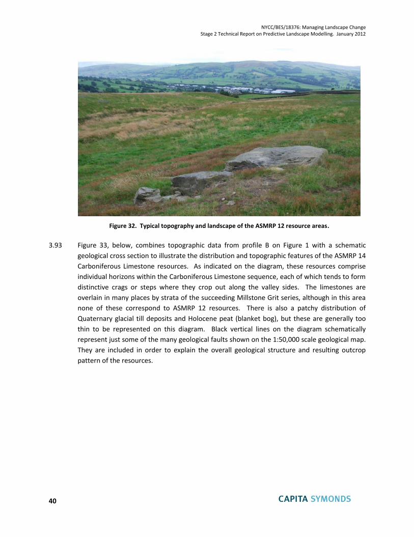
NYCC/BES/18376: Managing Landscape Change Stage 2 Technical Report on Predictive Landscape Modelling. January 2012
40
Figure 32. Typical topography and landscape of the ASMRP 12 resource areas.
3.93 Figure 33, below, combines topographic data from profile B on Figure 1 with a schematic
geological cross section to illustrate the distribution and topographic features of the ASMRP 14
Carboniferous Limestone resources. As indicated on the diagram, these resources comprise
individual horizons within the Carboniferous Limestone sequence, each of which tends to form
distinctive crags or steps where they crop out along the valley sides. The limestones are
overlain in many places by strata of the succeeding Millstone Grit series, although in this area
none of these correspond to ASMRP 12 resources. There is also a patchy distribution of
Quaternary glacial till deposits and Holocene peat (blanket bog), but these are generally too
thin to be represented on this diagram. Black vertical lines on the diagram schematically
represent just some of the many geological faults shown on the 1:50,000 scale geological map.
They are included in order to explain the overall geological structure and resulting outcrop
pattern of the resources.
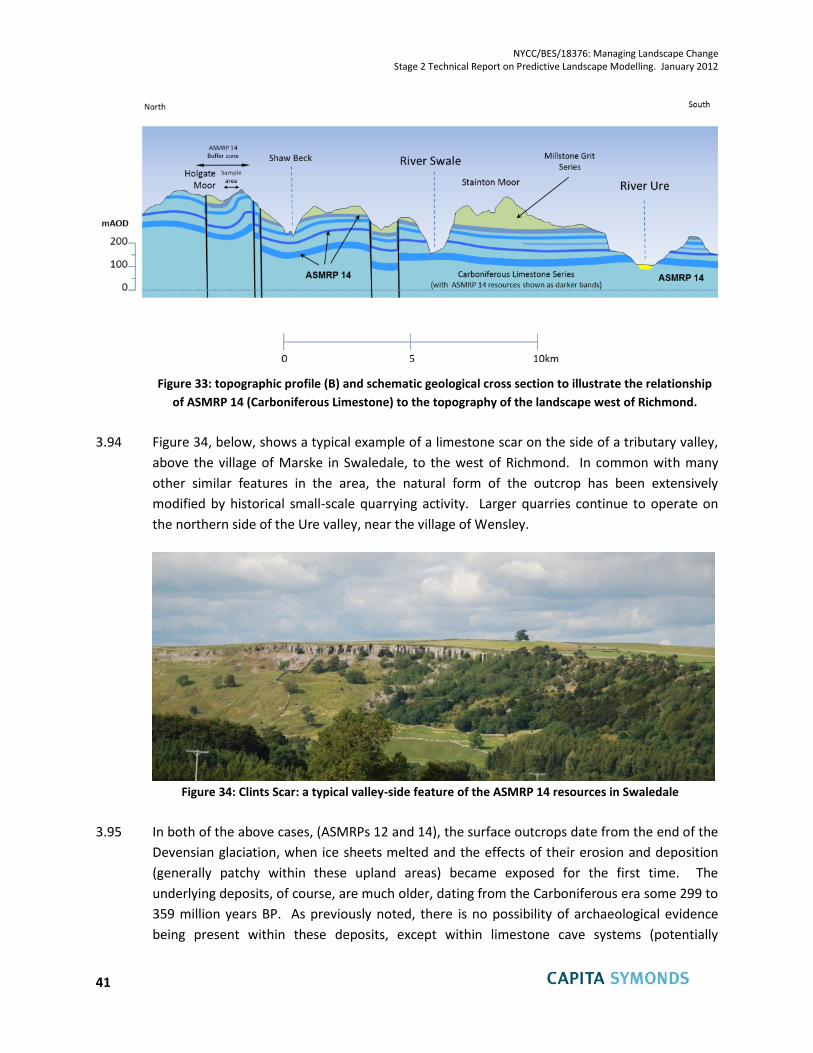
NYCC/BES/18376: Managing Landscape Change Stage 2 Technical Report on Predictive Landscape Modelling. January 2012
41
Figure 33: topographic profile (B) and schematic geological cross section to illustrate the relationship
of ASMRP 14 (Carboniferous Limestone) to the topography of the landscape west of Richmond.
3.94 Figure 34, below, shows a typical example of a limestone scar on the side of a tributary valley,
above the village of Marske in Swaledale, to the west of Richmond. In common with many
other similar features in the area, the natural form of the outcrop has been extensively
modified by historical small-scale quarrying activity. Larger quarries continue to operate on
the northern side of the Ure valley, near the village of Wensley.
Figure 34: Clints Scar: a typical valley-side feature of the ASMRP 14 resources in Swaledale
3.95 In both of the above cases, (ASMRPs 12 and 14), the surface outcrops date from the end of the
Devensian glaciation, when ice sheets melted and the effects of their erosion and deposition
(generally patchy within these upland areas) became exposed for the first time. The
underlying deposits, of course, are much older, dating from the Carboniferous era some 299 to
359 million years BP. As previously noted, there is no possibility of archaeological evidence
being present within these deposits, except within limestone cave systems (potentially
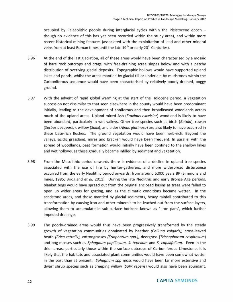
NYCC/BES/18376: Managing Landscape Change Stage 2 Technical Report on Predictive Landscape Modelling. January 2012
42
occupied by Palaeolithic people during interglacial cycles within the Pleistocene epoch –
though no evidence of this has yet been recorded within the study area), and within more
recent historical mining features (associated with the exploitation of lead and other mineral
veins from at least Roman times until the late 19th or early 20th Centuries).
3.96 At the end of the last glaciation, all of these areas would have been characterised by a mosaic
of bare rock outcrops and crags, with free-draining scree slopes below and with a patchy
distribution of overlying glacial deposits. Topographic hollows would have supported upland
lakes and ponds, whilst the areas mantled by glacial till or underlain by mudstones within the
Carboniferous sequence would have been characterised by relatively poorly-drained, boggy
ground.
3.97 With the advent of rapid global warming at the start of the Holocene period, a vegetation
succession not dissimilar to that seen elsewhere in the county would have been predominant
initially, leading to the development of coniferous and then broadleaved woodlands across
much of the upland areas. Upland mixed Ash (Fraxinus excelsior) woodland is likely to have
been abundant, particularly in wet valleys. Other tree species such as birch (Betula), rowan
(Sorbus aucuparia), willow (Salix), and alder (Alnus glutinosa) are also likely to have occurred in
these base-rich flushes. The ground vegetation would have been herb-rich. Beyond the
valleys, acidic grassland, mires and bracken would have been frequent. In parallel with the
spread of woodlands, peat formation would initially have been confined to the shallow lakes
and wet hollows, as these gradually became infilled by sediment and vegetation.
3.98 From the Mesolithic period onwards there is evidence of a decline in upland tree species
associated with the use of fire by hunter-gatherers, and more widespread disturbance
occurred from the early Neolithic period onwards, from around 5,000 years BP (Simmons and
Innes, 1985; Bridgland et al. 2011). During the late Neolithic and early Bronze Age periods,
blanket bogs would have spread out from the original enclosed basins as trees were felled to
open up wider areas for grazing, and as the climatic conditions became wetter. In the
sandstone areas, and those mantled by glacial sediments, heavy rainfall contributed to this
transformation by causing iron and other minerals to be leached out from the surface layers,
allowing them to accumulate in sub-surface horizons known as ‘ iron pans’, which further
impeded drainage.
3.99 The poorly-drained areas would thus have been progressively transformed by the steady
growth of vegetation communities dominated by heather (Calluna vulgaris), cross-leaved
heath (Erica tetralix), cottongrasses (Eriophorum spp.), deergrass (Trichophorum cespitosum)
and bog-mosses such as Sphagnum papillosum, S. tenellum and S. capillifolium. Even in the
drier areas, particularly those within the surface outcrops of Carboniferous Limestone, it is
likely that the habitats and associated plant communities would have been somewhat wetter
in the past than at present. Sphagnum spp moss would have been far more extensive and
dwarf shrub species such as creeping willow (Salix repens) would also have been abundant.
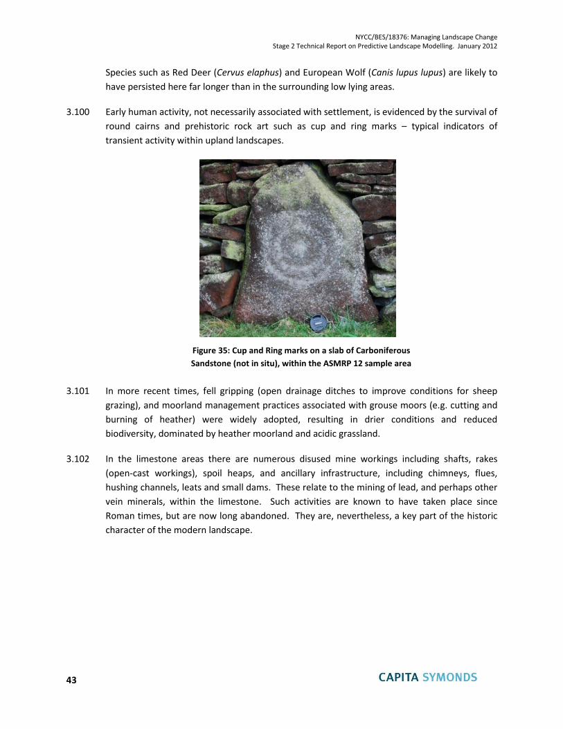
NYCC/BES/18376: Managing Landscape Change Stage 2 Technical Report on Predictive Landscape Modelling. January 2012
43
Species such as Red Deer (Cervus elaphus) and European Wolf (Canis lupus lupus) are likely to
have persisted here far longer than in the surrounding low lying areas.
3.100 Early human activity, not necessarily associated with settlement, is evidenced by the survival of
round cairns and prehistoric rock art such as cup and ring marks – typical indicators of
transient activity within upland landscapes.
Figure 35: Cup and Ring marks on a slab of Carboniferous
Sandstone (not in situ), within the ASMRP 12 sample area
3.101 In more recent times, fell gripping (open drainage ditches to improve conditions for sheep
grazing), and moorland management practices associated with grouse moors (e.g. cutting and
burning of heather) were widely adopted, resulting in drier conditions and reduced
biodiversity, dominated by heather moorland and acidic grassland.
3.102 In the limestone areas there are numerous disused mine workings including shafts, rakes
(open-cast workings), spoil heaps, and ancillary infrastructure, including chimneys, flues,
hushing channels, leats and small dams. These relate to the mining of lead, and perhaps other
vein minerals, within the limestone. Such activities are known to have taken place since
Roman times, but are now long abandoned. They are, nevertheless, a key part of the historic
character of the modern landscape.
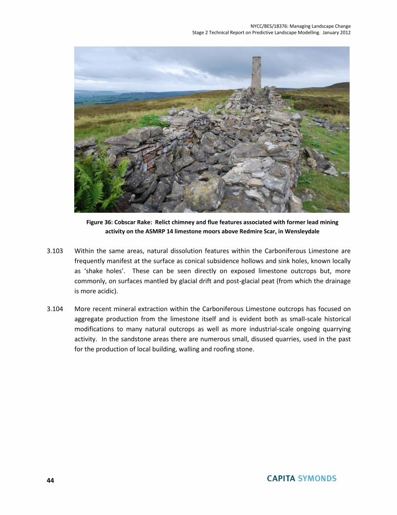
NYCC/BES/18376: Managing Landscape Change Stage 2 Technical Report on Predictive Landscape Modelling. January 2012
44
Figure 36: Cobscar Rake: Relict chimney and flue features associated with former lead mining
activity on the ASMRP 14 limestone moors above Redmire Scar, in Wensleydale
3.103 Within the same areas, natural dissolution features within the Carboniferous Limestone are
frequently manifest at the surface as conical subsidence hollows and sink holes, known locally
as ‘shake holes’. These can be seen directly on exposed limestone outcrops but, more
commonly, on surfaces mantled by glacial drift and post-glacial peat (from which the drainage
is more acidic).
3.104 More recent mineral extraction within the Carboniferous Limestone outcrops has focused on
aggregate production from the limestone itself and is evident both as small-scale historical
modifications to many natural outcrops as well as more industrial-scale ongoing quarrying
activity. In the sandstone areas there are numerous small, disused quarries, used in the past
for the production of local building, walling and roofing stone.
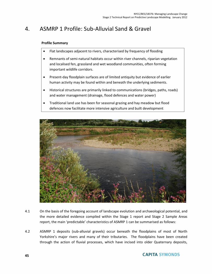
NYCC/BES/18376: Managing Landscape Change Stage 2 Technical Report on Predictive Landscape Modelling. January 2012
45
4. ASMRP 1 Profile: Sub-Alluvial Sand & Gravel
Profile Summary
Flat landscapes adjacent to rivers, characterised by frequency of flooding
Remnants of semi-natural habitats occur within river channels, riparian vegetation
and localised fen, grassland and wet woodland communities, often forming
important wildlife corridors.
Present-day floodplain surfaces are of limited antiquity but evidence of earlier
human activity may be found within and beneath the underlying sediments.
Historical structures are primarily linked to communications (bridges, paths, roads)
and water management (drainage, flood defences and water power)
Traditional land use has been for seasonal grazing and hay meadow but flood
defences now facilitate more intensive agriculture and built development
4.1 On the basis of the foregoing account of landscape evolution and archaeological potential, and
the more detailed evidence compiled within the Stage 1 report and Stage 2 Sample Areas
report, the main ‘predictable’ characteristics of ASMRP 1 can be summarised as follows:
4.2 ASMRP 1 deposits (sub-alluvial gravels) occur beneath the floodplains of most of North
Yorkshire’s major rivers and many of their tributaries. The floodplains have been created
through the action of fluvial processes, which have incised into older Quaternary deposits,
NYCC/BES/18376: Managing Landscape Change Stage 2 Technical Report on Predictive Landscape Modelling. January 2012
46
leaving these as river terrace surfaces, at varying heights above the modern floodplains,
and/or as more variable and higher surfaces associated with former glacio-fluvial and/or glacial
deposition.
4.3 In the course of their formation, the floodplains have incorporated both older sediments and
historical artefacts, redistributing them downstream from their original locations. They may
also have buried further archaeological evidence contained within undisturbed older fluvial
deposits which extend beneath the modern alluvium.
4.4 As the modern floodplains were created, through incision of the rivers into older terrace
surfaces during the late Iron Age and subsequent Roman period, they would originally have
been characterised by extensive wetland environments and dense vegetation with the
European Beaver (Castor fiber) being a vital part of the ecosystem until it was finally hunted to
extinction in Britain in the sixteenth century. This would have been a dynamic environment
consisting of a mosaic of woodland, woodland edge and open water habitats, of high
ecological value. Following centuries of increasingly intensive drainage, flood protection,
agriculture and infrastructure development, only scattered remnants of these semi-natural
habitats now remain. These include the river channels themselves, riparian vegetation and
localised fen, grassland and wet woodland communities, many of which are now protected by
environmental designations. Where they remain connected, or where such connections can
be reinstated, these provide vitally important wildlife corridors.
4.5 Dating evidence from various sources suggests that, although they may have been formed
originally up to 2,000 years ago, the present day surfaces of most floodplains are features of
the last millennium and, in many cases, of much more recent origin, having been reworked by
the active migration of meandering rivers within the last few hundred years. The antiquity of
historical features preserved on these surfaces is therefore limited.
4.6 Historically, and in recognition of the risk of periodic inundation by the rivers, the predominant
use of river floodplains would have been as flood meadows for seasonal grazing and hay
production, together with residual areas of woodland. Artificial drainage and the construction
of artificial levees as flood defences progressively enabled more intensive agriculture to take
place in some floodplain areas, including both improved pasture and arable farming. Despite
these changes the predominant landscape character of most river floodplains in the area is one
of flat land and enclosed views, with extensive mature trees, hedgerows and lush riparian
vegetation.
4.7 Infrastructure and buildings located on river floodplains have historically been limited to
features associated with:
communication (e.g. fords, bridges, footpaths, bridleways and canals);
the use of water for power (i.e. water wheels, mills, leats and weirs);
land drainage (including river diversions, channelisation, sluice gates etc.);
NYCC/BES/18376: Managing Landscape Change Stage 2 Technical Report on Predictive Landscape Modelling. January 2012
47
water resources (i.e. reservoirs, intakes etc.); and
flood defences (artificial levees).
4.8 Evidence of all of these survive in the modern landscape, many but not all of which are still in
use. It is only within the last century or so that more extensive development has occurred
within some of the North Yorkshire floodplains, particularly within the areas identified as
Landscape Character Type LCT 31 (Settled Industrial Valleys). In many cases this has been
facilitated by the construction of more robust flood defences, land raising and river
engineering schemes. These have completely changed the character of the floodplains, but
have rarely succeeded in eliminating the risk of flooding.
4.9 With evidence of increased flood magnitude and frequency associated with ongoing climate
change and/or land use change, there has been increased emphasis in the last decade or so on
the avoidance of vulnerable development in flood-prone areas. This has been accompanied by
a growing public and policy recognition of the intrinsic importance of ‘functional floodplains’
which facilitate the conveyance of floodwater. This, together with the recent identification of
Green Infrastructure Corridors and associated biodiversity initiatives, particularly (but not only)
along river valleys, emphasises the importance of these areas in contributing to a healthy
natural environment.
4.10 Much more extensive development has taken place, throughout all periods of history, on the
river terraces and other higher ground which lies adjacent to the modern floodplains. Such
areas tend to be much richer in known archaeological remains and archaeological potential as
well as in the abundance of Scheduled Ancient Monuments, registered Parks and Gardens and
Listed Buildings. Further details are given separately in the accounts of other ASMRPs but the
significance to ASMRP 1 lies in the close proximity of these areas and associated features.
4.11 In conclusion, the heritage potential of ASMRP 1 is, for the most part, limited to the last few
hundred years in terms of surface features, but a much richer resource, extending perhaps
over several millennia, is likely to be concealed within and beneath the mineral resources. A
further important characteristic is the intimate relationship between ASMRP 1 and adjoining
landscapes, which generally exhibit a longer history of landscape evolution at the surface.
Despite the adverse effects of both agricultural and urban development in recent centuries,
the modern floodplains still retain important ecological resources and offer major potential for
biodiversity enhancement through green infrastructure initiatives and the re-establishment of
wildlife corridors.
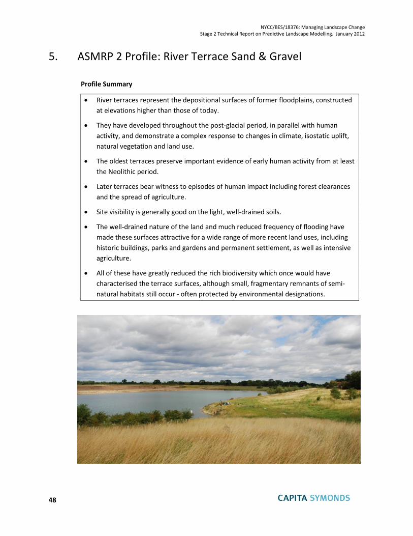
NYCC/BES/18376: Managing Landscape Change Stage 2 Technical Report on Predictive Landscape Modelling. January 2012
48
5. ASMRP 2 Profile: River Terrace Sand & Gravel
Profile Summary
River terraces represent the depositional surfaces of former floodplains, constructed
at elevations higher than those of today.
They have developed throughout the post-glacial period, in parallel with human
activity, and demonstrate a complex response to changes in climate, isostatic uplift,
natural vegetation and land use.
The oldest terraces preserve important evidence of early human activity from at least
the Neolithic period.
Later terraces bear witness to episodes of human impact including forest clearances
and the spread of agriculture.
Site visibility is generally good on the light, well-drained soils.
The well-drained nature of the land and much reduced frequency of flooding have
made these surfaces attractive for a wide range of more recent land uses, including
historic buildings, parks and gardens and permanent settlement, as well as intensive
agriculture.
All of these have greatly reduced the rich biodiversity which once would have
characterised the terrace surfaces, although small, fragmentary remnants of semi-
natural habitats still occur - often protected by environmental designations.
NYCC/BES/18376: Managing Landscape Change Stage 2 Technical Report on Predictive Landscape Modelling. January 2012
49
5.1 ASMRP 2 deposits (river terrace sands and gravels) occur, sporadically, along parts of the same
major valleys as the floodplain sediments of ASMRP 1, between the modern alluvium and the
valley sides. The terraces are the discontinuous remnants of older floodplains into which the
present-day rivers have incised.
5.2 The deposits accumulated at various stages during the post-glacial Holocene period, through
the reworking of older glacial and glacio-fluvial sediments. Deep valleys which originated
during and before the Quaternary glaciations, and which were infilled by glacial, glacio-
lacustrine and glacio-fluvial sediments, were partially re-excavated by the river systems of the
early Holocene period. The subsequent accumulation of fluvial deposits within the re-
excavated valleys was due, at least in part, to the progressive influence of humans on the
landscape: in particular the clearance of trees to facilitate cultivation and grazing, which would
have increased the supply of sediment once more. The process began during the Mesolithic
period but accelerated markedly during the Neolithic and into the mid Bronze Age.
5.3 Importantly, the sediments both incorporated and buried older archaeological evidence, whilst
the remnants of the depositional surfaces, which now form the highest river terraces, retain
evidence of land use and settlement from these and subsequent periods. The conversion of
these surfaces into the terrace features seen today resulted from subsequent downcutting by
the rivers, interrupted by periods of renewed aggradation to produce complex ‘cut and fill’
sequences in many of the valleys. The pattern being revealed by ongoing research is one of
complex response to a variety of different causal effects (climate change, land use change,
vegetation changes, continued isostatic rebound and interactions between all of these).
5.4 During the much drier and warmer climate which characterised the late Iron Age to the Roman
era, the floodplains of the time would have been progressively reclaimed for agriculture, a
process assisted by the gradual further incision of the rivers down to their present levels,
which left the terraces as higher surfaces of well-drained land, less frequently inundated by
flooding.
5.5 From an historical perspective, evidence of human activity during the times when the terraces
were active depositional surfaces can be expected to reflect the types of land use associated
with river floodplains, with an emphasis on water-related activities and infrastructure (see
ASMRP 1 for details). Subsequently, however, as each terrace surface became abandoned by
the downcutting of the rivers, it would have become a favoured location for a much wider
range of land uses, including intensive agriculture, parks and gardens and permanent
occupation.
5.6 As a consequence of this complex history of geomorphological, environmental and historical
evolution, the present day landscape of the ASMRP 2 river terraces can be expected to
comprise lowland arable farmed landscape divided by hedgerows and containing a few mature
trees. HLC type ‘Modern Improved Fields’ is typical of these areas (NYCC and EH 2010), whilst
NYCC/BES/18376: Managing Landscape Change Stage 2 Technical Report on Predictive Landscape Modelling. January 2012
50
HLC type ‘Private Designed Landscapes’ is also important in defining the historic character of
parts of this landscape.
5.7 The Stage 2 sample area investigations demonstrated that, despite anthropogenic impacts
(particularly twentieth century cultivation) there is, remarkably, reasonable site visibility –
particularly where LiDAR data is available to distinguish very subtle earthworks features, such
as the substantially plough-flattened Nunwick Henge. Many of the buried features have also
been revealed as crop marks by aerial photography, even though they no longer have a surface
expression.
5.8 In summary, combining the evidence presented in the Stage 1 report, the Stage 2 sample areas
report and the foregoing review of landscape evolution, the river terraces of ASMRP 2 can be
expected to have a rich and complex heritage potential, with a long history of human activity
and occupation being preserved both on the terrace surfaces and within and beneath the
underlying sediments.
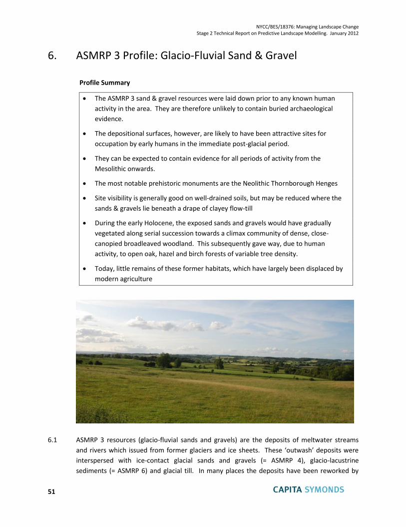
NYCC/BES/18376: Managing Landscape Change Stage 2 Technical Report on Predictive Landscape Modelling. January 2012
51
6. ASMRP 3 Profile: Glacio-Fluvial Sand & Gravel
Profile Summary
The ASMRP 3 sand & gravel resources were laid down prior to any known human
activity in the area. They are therefore unlikely to contain buried archaeological
evidence.
The depositional surfaces, however, are likely to have been attractive sites for
occupation by early humans in the immediate post-glacial period.
They can be expected to contain evidence for all periods of activity from the
Mesolithic onwards.
The most notable prehistoric monuments are the Neolithic Thornborough Henges
Site visibility is generally good on well-drained soils, but may be reduced where the
sands & gravels lie beneath a drape of clayey flow-till
During the early Holocene, the exposed sands and gravels would have gradually
vegetated along serial succession towards a climax community of dense, close-
canopied broadleaved woodland. This subsequently gave way, due to human
activity, to open oak, hazel and birch forests of variable tree density.
Today, little remains of these former habitats, which have largely been displaced by
modern agriculture
6.1 ASMRP 3 resources (glacio-fluvial sands and gravels) are the deposits of meltwater streams
and rivers which issued from former glaciers and ice sheets. These ‘outwash’ deposits were
interspersed with ice-contact glacial sands and gravels (= ASMRP 4), glacio-lacustrine
sediments (= ASMRP 6) and glacial till. In many places the deposits have been reworked by
NYCC/BES/18376: Managing Landscape Change Stage 2 Technical Report on Predictive Landscape Modelling. January 2012
52
subsequent (post-glacial) river activity, leaving behind remnants of the original outwash
surfaces amongst a mosaic of other sediments. The process of fluvial erosion and downcutting
would have begun as the ice sheets receded; gathering pace as stabilising vegetation
developed on the exposed hill slopes and as the supply of sediment into the river systems was
thereby further reduced. All of these changes resulted directly from the abrupt amelioration
of climate which marked the end of the last glaciation and the start of the Holocene period.
6.2 The earliest indications of human activity within ASMRP 3 resource areas are likely to have
been associated with nomadic hunter-gatherer communities of the Mesolithic (= early
Holocene) period. Earlier (Palaeolithic) activity has been evidenced more sporadically in
northern England, linked to the temporary climatic improvement of the Windermere
Interstadial towards the end of the Late Glacial period, but nothing specific is known from that
period within the ASMRP 3 resource areas. At the time, these would have been highly dynamic
fluvial environments with minimal, tundra vegetation. For the same reason it is unlikely that
any archaeological evidence exists either within or beneath the ASMRP 3 deposits. This is a
very important distinguishing feature, when compared to the younger landscapes of ASMRP 2
and ASMRP 1, which evolved in parallel with human occupation and activity. A further
distinction is that, unlike those younger surfaces, the former outwash surfaces of ASMRP 3 can
be expected to contain evidence for all periods of activity from the Mesolithic onwards, as
noted in the Nosterfield Environs Report (Archaeoscope, April 2008).
6.3 During the early Holocene, the exposed sands and gravels would have gradually vegetated
along a similar serial succession to that seen in similar habitats today, towards a climax
community of dense, close-canopied broadleaved woodland. This subsequently gave way, due
to human activity, to open oak, hazel and birch forests of variable tree density, similar to
modern pasture woodland. This habitat would have become prevalent as grazing increased.
6.4 The Thornborough Henges and associated archaeological landscape provide spectacular
evidence of human activity in the late Neolithic and early Bronze Age (Harding, 1998, 2000a).
Within this area, in particular, Bridgland et al. (2011), quoting Robinson (1992b) and Brown
(2003) have drawn attention to the logical preference of early settlers for ‘islands’ of drier,
well-drained land (such as that underlain by ASMRP 3 resources), compared with adjoining
areas of dense fen-carr wetlands that occupied lower parts of the landscape, including the
sites of former glacial lakes, as discussed in Chapter 3, above.
6.5 One of the most important characteristics of ASMRP 3 is that it generally provides good
agricultural quality, well drained, land. For this reason it has been used for cultivation and has
had a long history of ploughing. Archaeological features do survive but rarely on the surface.
The only upstanding feature identified during fieldwork within the sample area was The
‘Rampart’ - a large boundary feature, formerly defining the edge of the designed landscape of
Knaresborough Park, which has subsequently survived as a field boundary, and hence has not
been ploughed out.
NYCC/BES/18376: Managing Landscape Change Stage 2 Technical Report on Predictive Landscape Modelling. January 2012
53
6.6 Almost all monuments identified within the sample area, and much of this ASMRP, have been
identified as crop marks from aerial photography. Substantial areas of the overall ASMRP,
including the sample area, have been examined by the Yorkshire Henges Aerial Photographic
Mapping Project, but the identified archaeological resource within the sample area was scored
low, and is one of the lowest of any of the ASMRP sample areas. This reflects the fact that site
visibility is generally low, which may simply be due to the fact that crop marks do not show
well on certain soils. More generally, the visibility of archaeological evidence would be
expected to be better in other parts of the ASMRP 3 outcrop, because of the generally lighter,
well-drained soils (compared with adjoining areas of glacial till and glacio-lacustrine clays).
However, as noted in Chapter 3, the distinction between ASMRP 3 and ASMRP 4 is likely to be
subtle, in terms of topography, general landscape character, historical land use and
archaeological potential.
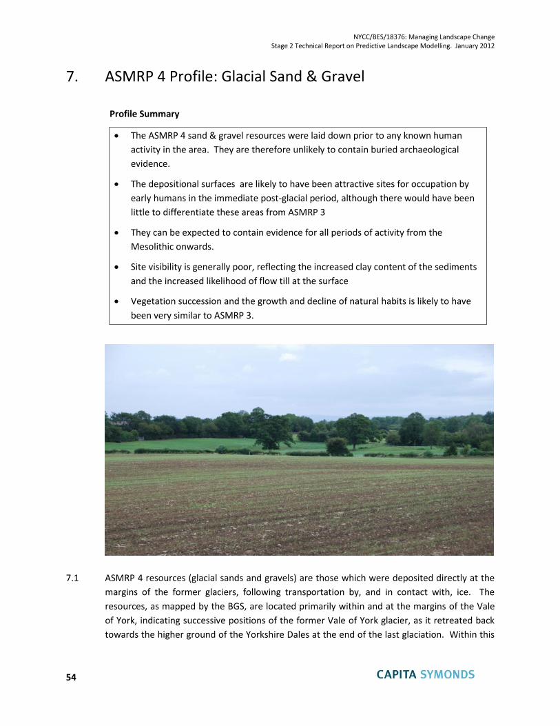
NYCC/BES/18376: Managing Landscape Change Stage 2 Technical Report on Predictive Landscape Modelling. January 2012
54
7. ASMRP 4 Profile: Glacial Sand & Gravel
Profile Summary
The ASMRP 4 sand & gravel resources were laid down prior to any known human
activity in the area. They are therefore unlikely to contain buried archaeological
evidence.
The depositional surfaces are likely to have been attractive sites for occupation by
early humans in the immediate post-glacial period, although there would have been
little to differentiate these areas from ASMRP 3
They can be expected to contain evidence for all periods of activity from the
Mesolithic onwards.
Site visibility is generally poor, reflecting the increased clay content of the sediments
and the increased likelihood of flow till at the surface
Vegetation succession and the growth and decline of natural habits is likely to have
been very similar to ASMRP 3.
7.1 ASMRP 4 resources (glacial sands and gravels) are those which were deposited directly at the
margins of the former glaciers, following transportation by, and in contact with, ice. The
resources, as mapped by the BGS, are located primarily within and at the margins of the Vale
of York, indicating successive positions of the former Vale of York glacier, as it retreated back
towards the higher ground of the Yorkshire Dales at the end of the last glaciation. Within this
NYCC/BES/18376: Managing Landscape Change Stage 2 Technical Report on Predictive Landscape Modelling. January 2012
55
area the deposits are preserved as residual patches (following post-glacial erosion) both within
the major valleys and across many of the intervening areas.
7.2 As explained in Chapter 3 of this report, the ASMRP 4 resources within the Vale of York are
intimately associated with ASMRP 3 (glacio-fluvial outwash), ASMRP 6 (glacio-lacustrine clays)
and areas of glacial till, all of which combine to form an intricate mosaic of roughly
contemporaneous depositional environments, dating from the end of the Devensian glaciation.
7.3 As with ASMRP 3, the process of fluvial erosion and downcutting would have begun as the ice
sheets receded, gathering pace as stabilising vegetation developed on the exposed hill slopes
and as the supply of sediment into the river systems was reduced. All of these changes
resulted directly from the abrupt amelioration of climate which marked the end of the
glaciation and the start of the Holocene period.
7.4 As with ASMRP 3, the earliest indications of human activity within ASMRP 4 resource areas are
likely to have been associated with nomadic hunter-gatherer communities of the Mesolithic (=
early Holocene) period. Prior to this, the ASMRP 4 deposits would have been complex
environments, frequently disturbed by the melting of buried ice, and with minimal, tundra
vegetation. It is therefore extremely unlikely that any archaeological evidence exists either
within or beneath the ASMRP 4 deposits. Once again, this is a very important distinguishing
feature, when compared to the younger landscapes of ASMRP 2 and ASMRP 1, which evolved
in parallel with human occupation and activity. As with ASMRP 3, the ASMRP 4 surfaces can be
expected to contain evidence for all periods of activity from the Mesolithic onwards.
7.5 During the early Holocene, the exposed sands and gravels of ASMRP 4 would have gradually
vegetated along a similar serial succession to that seen in similar habitats today, towards a
climax community of dense, close-canopied broadleaved woodland. This subsequently gave
way, due to human activity, to open oak, hazel and birch forests of variable tree density,
similar to modern pasture woodland. This habitat would have become prevalent as grazing
increased. Large mature trees will have become less prevalent as timber was felled for
building purposes. Continued grazing will have gradually improved the soil changing the floral
diversity and invertebrate assemblage which in turn will have affected the fauna of the area.
Natural habitats are likely to have rapidly given way to a man-made environment dominated
by pastoral agriculture.
7.6 Although the ASMRP 4 surfaces may have offered better conditions for both agriculture and
settlement, compared with adjoining areas of lower ground characterised by dense wetland
vegetation and/or open water, there would have been little practical difference, in terms of
land use and settlement opportunities, between ASMRP 4 and ASMRP 3.
7.7 ASMRP 4 is now characterised by a mixture of arable and pasture land, but even on present
day pasture land there is a history of ploughing and surface monuments have been lost or
degraded. The Southern Magnesian Limestone National Character Area in which much of this
NYCC/BES/18376: Managing Landscape Change Stage 2 Technical Report on Predictive Landscape Modelling. January 2012
56
ASMRP is located is characterised by intensive farming. The HLC type ‘Modern Improved
Fields’ accounts for 41% of the NCA but specific trends are more difficult to characterise across
the whole area (NYCC and EH 2010).
7.8 The scoring of the archaeological resource within the sample area is not particularly high,
despite having been subject to archaeological investigation for two pipeline surveys to the
south of Crakehall village, and the availability of LiDAR survey data. With the notable exception
of a single confirmed tumulus, the archaeological resource is relatively low key. It relates to
the adjacent village of Crakehall but also includes narrow ridge and furrow and roadside
quarries. The LiDAR data reveals the slightly undulating character of the landscape and also
the ridge and furrow adjacent to the village, but does not show the tumulus or other
significant landscape features. This would appear to reflect the situation observed at similar
sites, that ploughing has steadily degraded any surface features, and few crop marks have
been identified by aerial photography.
7.9 The implication of the low and relatively late identified resource is that this area, and probably
much of the ASMRP, has relatively poor site visibility. There is the potential for an extant but
buried resource within the near surface layers of soil but, as explained above, little or no
potential within or beneath the underlying mineral deposits.
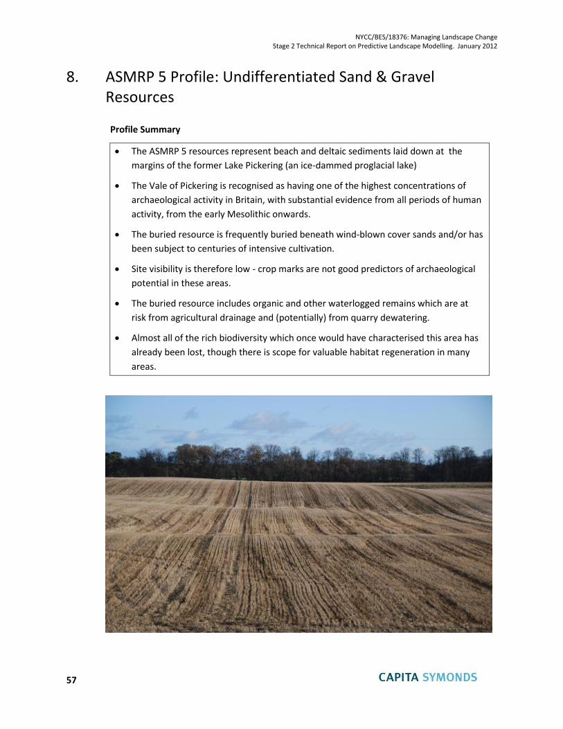
NYCC/BES/18376: Managing Landscape Change Stage 2 Technical Report on Predictive Landscape Modelling. January 2012
57
8. ASMRP 5 Profile: Undifferentiated Sand & Gravel Resources
Profile Summary
The ASMRP 5 resources represent beach and deltaic sediments laid down at the
margins of the former Lake Pickering (an ice-dammed proglacial lake)
The Vale of Pickering is recognised as having one of the highest concentrations of
archaeological activity in Britain, with substantial evidence from all periods of human
activity, from the early Mesolithic onwards.
The buried resource is frequently buried beneath wind-blown cover sands and/or has
been subject to centuries of intensive cultivation.
Site visibility is therefore low - crop marks are not good predictors of archaeological
potential in these areas.
The buried resource includes organic and other waterlogged remains which are at
risk from agricultural drainage and (potentially) from quarry dewatering.
Almost all of the rich biodiversity which once would have characterised this area has
already been lost, though there is scope for valuable habitat regeneration in many
areas.
NYCC/BES/18376: Managing Landscape Change Stage 2 Technical Report on Predictive Landscape Modelling. January 2012
58
8.1 ASMRP 5 sand & gravel resources correspond to beach and deltaic deposits formed at the
margins of the former ice-dammed glacial lake (Lake Pickering) which occupied the whole of
what is now the Vale of Pickering and the Vale of Rye during the Devensian glaciation. The
deposits extend continuously along the foot of the Chalk escarpment of the Yorkshire Wolds
and, more sporadically along the northern and western margins of the former lake.
8.2 As noted in Chapter 3, and detailed more fully in the Stage 1 report and the Stage 2 Sample
Areas report, the earliest evidence of human activity within this area dates from the early
Mesolithic period, soon after the rapid global warming which marked the late glacial /
Holocene transition. These areas were ice free during the last glaciation and relatively
sheltered, by comparison with the adjoining, equally ice-free but higher landscapes of the
Yorkshire Wolds and the North York Moors. They were also marginally elevated, compared
with the areas submerged beneath the intervening Lake Pickering, and underlain by relatively
free-draining sand & gravel.
8.3 Even though the former lake drained and silted up during the Holocene, for much of that time
it would have been an area of poorly-drained mire. The lake margins, by comparison, are likely
to have been colonised by drier and more open vegetation, better able to support hunter-
gatherer communities. There is substantial evidence within ASMRP 5 of all subsequent periods
of human activity and occupation, and the Vale of Pickering is now recognised as having one of
the highest concentrations of archaeological activity in Britain. Intensive geophysical research
here has also demonstrated that the best archaeological features are likely to be below later
deposits and that, once again, crop marks are therefore not good predictors of archaeological
potential.
8.4 Fieldwork within the sample area at Rillington has confirmed that there is little or no surface
expression of any of the resource – not only because much of it is buried, but also because the
area has been used for arable farming for many centuries and has been drained and ploughed
extensively.
8.5 During the early Holocene, the ice-dammed lake drained away to leave behind a mosaic of
smaller lakes, ponds and wetlands. For several millennia (until reclamation for agriculture in
the post-medieval period) it would have been an area of poorly-drained mire. The lake
margins, by comparison, are likely to have been colonised by drier and more open vegetation.
As the climate warmed rapidly during the early Holocene, there would have been a gradual
succession towards boreal birch forest, coniferous forest and ultimately Celtic broadleaf forest.
This subsequently gave way, due to human activity, to open oak, hazel and birch forests of
variable tree density, similar to modern pasture woodland. This habitat would have become
prevalent as grazing increased.
8.6 The whole of the Vale of Pickering is now dominated by enclosed farmland, and today’s
landscape is characterised as ‘Modern Improved Fields’ (NYCC and EH 2010). Drainage and
NYCC/BES/18376: Managing Landscape Change Stage 2 Technical Report on Predictive Landscape Modelling. January 2012
59
enclosure have created a productive agricultural landscape but have destroyed and
fragmented almost all of the semi-natural habitats which once existed. Also, by lowering the
water table, this may have inadvertently compromised the preservation conditions for buried
archaeological features – especially organic remains. Historically, the host deposits have been
characterised by having a high preservation potential, because of the waterlogged anoxic
conditions associated with the organic clay soils. As a direct consequence of agricultural
drainage, however, the heritage resource may now be at risk.
8.7 It may be concluded that much of the Vale of Pickering, and especially the well-drained
marginal areas that are underlain by ASMRP 5 resources, are likely to be characterised by
extremely high archaeological potential, but that in some areas at least, the buried features
may be at risk of degradation and some are already compromised. By comparison, almost all
of the rich biodiversity which once would have characterised this area has already been lost,
though there is scope for valuable habitat regeneration in many areas.
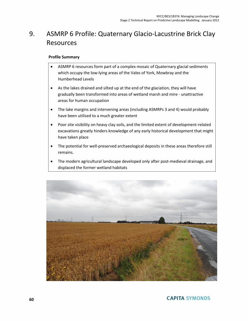
NYCC/BES/18376: Managing Landscape Change Stage 2 Technical Report on Predictive Landscape Modelling. January 2012
60
9. ASMRP 6 Profile: Quaternary Glacio-Lacustrine Brick Clay Resources
Profile Summary
ASMRP 6 resources form part of a complex mosaic of Quaternary glacial sediments
which occupy the low-lying areas of the Vales of York, Mowbray and the
Humberhead Levels
As the lakes drained and silted up at the end of the glaciation, they will have
gradually been transformed into areas of wetland marsh and mire - unattractive
areas for human occupation
The lake margins and intervening areas (including ASMRPs 3 and 4) would probably
have been utilised to a much greater extent
Poor site visibility on heavy clay soils, and the limited extent of development-related
excavations greatly hinders knowledge of any early historical development that might
have taken place
The potential for well-preserved archaeological deposits in these areas therefore still
remains.
The modern agricultural landscape developed only after post-medieval drainage, and
displaced the former wetland habitats
NYCC/BES/18376: Managing Landscape Change Stage 2 Technical Report on Predictive Landscape Modelling. January 2012
61
9.8 The Vales of York, Mowbray and the Humberhead Levels, where this ASMRP is predominant,
are generally low-lying, with limited relief. As explained in Chapter 3, the Vale of York, in
particular, is covered by a mosaic of different Quaternary drift deposits, of which the brick clay
resources of ASMRP 6 is one. These deposits originated in a series of former glacial lakes,
including the very extensive iced-dammed feature known as Lake Humber, but also
innumerable smaller ice-marginal lakes which had a temporary existence as the Vale of York
glacier retreated northwards at the end of the Devensian glaciation.
9.9 Throughout the area, many of these former glacial lakes are likely to have been gradually
transformed, as climatic conditions improved during the early Holocene, into wetland areas
including densely vegetated swamps and, in some cases, lowland raised bogs. By comparison
with the slightly higher and therefore less waterlogged ground of the glacial deposits around
them, these areas are likely to have been unattractive areas for early Man, including both the
hunter-gatherers of the Mesolithic period and the farmers and settlers of the succeeding
Neolithic and Bronze Age periods.
9.10 The lack of evidence of early human activity in most of these areas might simply be because
they were not conducive to either agriculture or settlement until they were artificially drained
in the post-Medieval period. Equally, however, this lack of evidence might be due to the
limited extent of recent development in this rural area (which has limited the recovery of
artefacts), and problems with site visibility – crop marks generally do not show up well on
heavy clay soils. The archaeological potential of the soils and organic sediments which overlie
the ASMRP 6 deposits cannot therefore be dismissed, and is worthy of further investigation.
9.11 As with the waterlogged organic deposits within the Vale of Pickering, those which overlie the
ASMRP 6 clays may also provide good conditions for the preservation of artefacts. Once again,
however, the preservation potential within ASMRP 6 will have been diminished by the
agricultural drainage which has taken place since medieval times. Whilst this has been a major
cause for concern in the Vale of Pickering, where the organic sediments are underlain by (and
perhaps intercalated with) the more permeable sand & gravel deposits of ASMRP 5, it might be
less of a problem within ASMRP 6, where the underlying deposits (clays) are much less
permeable. Nevertheless, there is an outstanding need to investigate the archaeological
potential of ASMRP 6 in order to add detail to the palaeo-environmental record and to confirm
whether or not these areas contain significant evidence of early (pre-medieval) human activity.
9.12 Today, the ASMRP 6 resources occupy a predominantly an agricultural landscape which has
been intensively managed and improved, with hedged enclosed fields in the Vales of York and
Mowbray, changing largely to ditches in the flatter and less well drained Humberhead Levels.
In the south, closer to the Humber estuary, the large cooling towers and electricity pylons
associated with a number of power stations are over-scaled features within the predominantly
flat landscape.
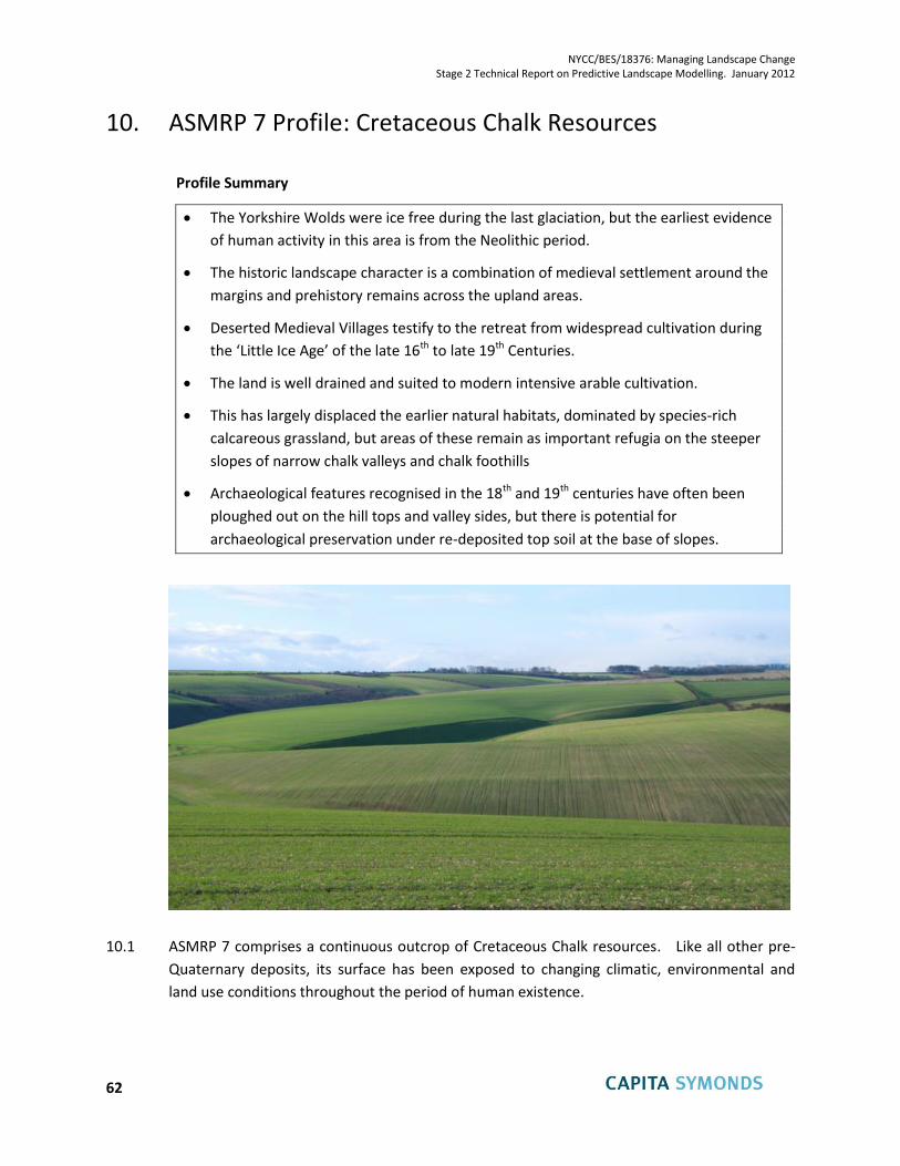
NYCC/BES/18376: Managing Landscape Change Stage 2 Technical Report on Predictive Landscape Modelling. January 2012
62
10. ASMRP 7 Profile: Cretaceous Chalk Resources
Profile Summary
The Yorkshire Wolds were ice free during the last glaciation, but the earliest evidence
of human activity in this area is from the Neolithic period.
The historic landscape character is a combination of medieval settlement around the
margins and prehistory remains across the upland areas.
Deserted Medieval Villages testify to the retreat from widespread cultivation during
the ‘Little Ice Age’ of the late 16th to late 19th Centuries.
The land is well drained and suited to modern intensive arable cultivation.
This has largely displaced the earlier natural habitats, dominated by species-rich
calcareous grassland, but areas of these remain as important refugia on the steeper
slopes of narrow chalk valleys and chalk foothills
Archaeological features recognised in the 18th and 19th centuries have often been
ploughed out on the hill tops and valley sides, but there is potential for
archaeological preservation under re-deposited top soil at the base of slopes.
10.1 ASMRP 7 comprises a continuous outcrop of Cretaceous Chalk resources. Like all other pre-
Quaternary deposits, its surface has been exposed to changing climatic, environmental and
land use conditions throughout the period of human existence.
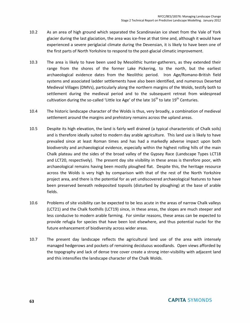
NYCC/BES/18376: Managing Landscape Change Stage 2 Technical Report on Predictive Landscape Modelling. January 2012
63
10.2 As an area of high ground which separated the Scandinavian ice sheet from the Vale of York
glacier during the last glaciation, the area was ice-free at that time and, although it would have
experienced a severe periglacial climate during the Devensian, it is likely to have been one of
the first parts of North Yorkshire to respond to the post-glacial climatic improvement.
10.3 The area is likely to have been used by Mesolithic hunter-gatherers, as they extended their
range from the shores of the former Lake Pickering, to the north, but the earliest
archaeological evidence dates from the Neolithic period. Iron Age/Romano-British field
systems and associated ladder settlements have also been identified, and numerous Deserted
Medieval Villages (DMVs), particularly along the northern margins of the Wolds, testify both to
settlement during the medieval period and to the subsequent retreat from widespread
cultivation during the so-called ‘Little Ice Age’ of the late 16th to late 19th Centuries.
10.4 The historic landscape character of the Wolds is thus, very broadly, a combination of medieval
settlement around the margins and prehistory remains across the upland areas.
10.5 Despite its high elevation, the land is fairly well drained (a typical characteristic of Chalk soils)
and is therefore ideally suited to modern day arable agriculture. This land use is likely to have
prevailed since at least Roman times and has had a markedly adverse impact upon both
biodiversity and archaeological evidence, especially within the highest rolling hills of the main
Chalk plateau and the sides of the broad valley of the Gypsey Race (Landscape Types LCT18
and LCT20, respectively). The present day site visibility in these areas is therefore poor, with
archaeological remains having been mostly ploughed flat. Despite this, the heritage resource
across the Wolds is very high by comparison with that of the rest of the North Yorkshire
project area, and there is the potential for as yet undiscovered archaeological features to have
been preserved beneath redeposited topsoils (disturbed by ploughing) at the base of arable
fields.
10.6 Problems of site visibility can be expected to be less acute in the areas of narrow Chalk valleys
(LCT21) and the Chalk foothills (LCT19) since, in these areas, the slopes are much steeper and
less conducive to modern arable farming. For similar reasons, these areas can be expected to
provide refugia for species that have been lost elsewhere, and thus potential nuclei for the
future enhancement of biodiversity across wider areas.
10.7 The present day landscape reflects the agricultural land use of the area with intensely
managed hedgerows and pockets of remaining deciduous woodlands. Open views afforded by
the topography and lack of dense tree cover create a strong inter-visibility with adjacent land
and this intensifies the landscape character of the Chalk Wolds.
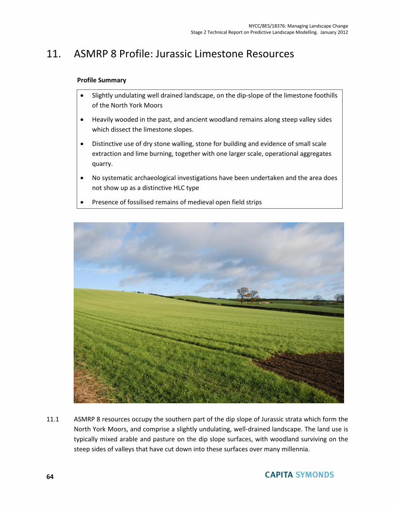
NYCC/BES/18376: Managing Landscape Change Stage 2 Technical Report on Predictive Landscape Modelling. January 2012
64
11. ASMRP 8 Profile: Jurassic Limestone Resources
Profile Summary
Slightly undulating well drained landscape, on the dip-slope of the limestone foothills
of the North York Moors
Heavily wooded in the past, and ancient woodland remains along steep valley sides
which dissect the limestone slopes.
Distinctive use of dry stone walling, stone for building and evidence of small scale
extraction and lime burning, together with one larger scale, operational aggregates
quarry.
No systematic archaeological investigations have been undertaken and the area does
not show up as a distinctive HLC type
Presence of fossilised remains of medieval open field strips
11.1 ASMRP 8 resources occupy the southern part of the dip slope of Jurassic strata which form the
North York Moors, and comprise a slightly undulating, well-drained landscape. The land use is
typically mixed arable and pasture on the dip slope surfaces, with woodland surviving on the
steep sides of valleys that have cut down into these surfaces over many millennia.
NYCC/BES/18376: Managing Landscape Change Stage 2 Technical Report on Predictive Landscape Modelling. January 2012
65
11.2 Prior to human occupation of the area it is likely that dense, closed canopy forest similar to
that within the remnant ancient woodland dominated. This will have been occupied by Red
Deer (Cervus elaphus), Roe Deer (Capreolus capreolus), Badger (Meles meles) and Red Squirrel
(Sciurus vulgaris) as well as a range of woodland bird species many of which are considerably
less abundant today. It is probable that the nature of this forest made engineering field
boundaries from fillets of existing woodland difficult which, considered alongside the
availability of stone, would explain the presence of dry-stone walls. This has also helped to
preserve a network of species-rich mature hedgerows.
11.3 No systematic archaeological investigations have been undertaken across the area of ASMRP 8
and the area does not show up as a distinctive HLC type.
11.4 The fields within the sample area are arterial shaped strip fields, and reflect the post-medieval
fossilisation of medieval open field strips. However, there is little survival of any ridge and
furrow, and this reflects a long history of cultivation and ploughing.
11.5 There are limited numbers of prehistoric features identified within ASMRP 8 such as round
cairns, and also a Roman road leading to Cawthorne Camp. These reflect both early activity
and some survival of old features as surface expressions.
11.6 Fieldwork within the sample area and its buffer zone revealed that the great majority of the
monuments in those areas are either disused quarries or limekilns, and are evidence of former
commercial extraction. Most of the extraction sites were small scale operations, however, and
the limekilns would have served agricultural rather than industrial needs. The exception is one
larger aggregates quarry at Newbridge
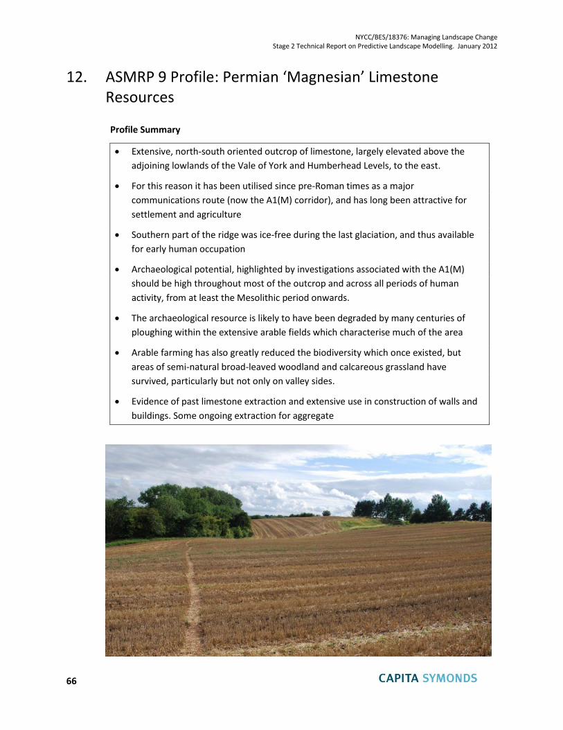
NYCC/BES/18376: Managing Landscape Change Stage 2 Technical Report on Predictive Landscape Modelling. January 2012
66
12. ASMRP 9 Profile: Permian ‘Magnesian’ Limestone Resources
Profile Summary
Extensive, north-south oriented outcrop of limestone, largely elevated above the
adjoining lowlands of the Vale of York and Humberhead Levels, to the east.
For this reason it has been utilised since pre-Roman times as a major
communications route (now the A1(M) corridor), and has long been attractive for
settlement and agriculture
Southern part of the ridge was ice-free during the last glaciation, and thus available
for early human occupation
Archaeological potential, highlighted by investigations associated with the A1(M)
should be high throughout most of the outcrop and across all periods of human
activity, from at least the Mesolithic period onwards.
The archaeological resource is likely to have been degraded by many centuries of
ploughing within the extensive arable fields which characterise much of the area
Arable farming has also greatly reduced the biodiversity which once existed, but
areas of semi-natural broad-leaved woodland and calcareous grassland have
survived, particularly but not only on valley sides.
Evidence of past limestone extraction and extensive use in construction of walls and
buildings. Some ongoing extraction for aggregate
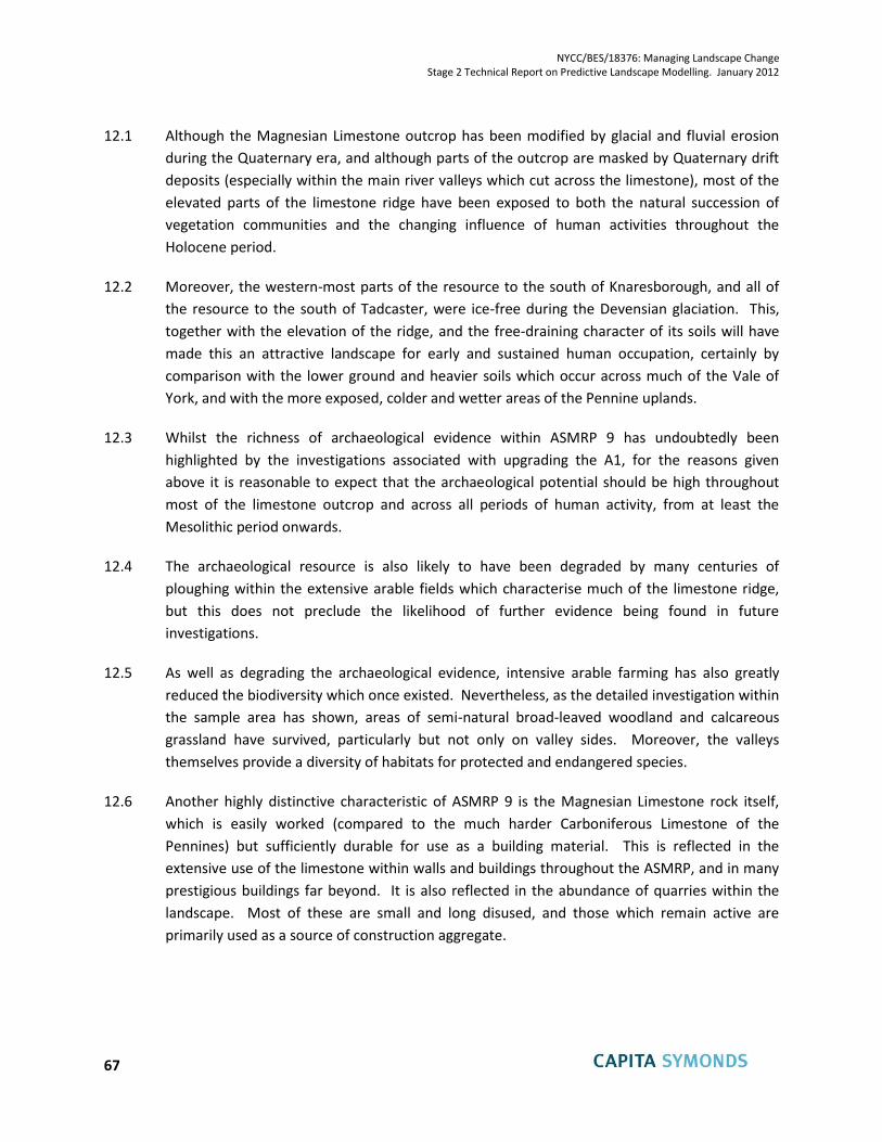
NYCC/BES/18376: Managing Landscape Change Stage 2 Technical Report on Predictive Landscape Modelling. January 2012
67
12.1 Although the Magnesian Limestone outcrop has been modified by glacial and fluvial erosion
during the Quaternary era, and although parts of the outcrop are masked by Quaternary drift
deposits (especially within the main river valleys which cut across the limestone), most of the
elevated parts of the limestone ridge have been exposed to both the natural succession of
vegetation communities and the changing influence of human activities throughout the
Holocene period.
12.2 Moreover, the western-most parts of the resource to the south of Knaresborough, and all of
the resource to the south of Tadcaster, were ice-free during the Devensian glaciation. This,
together with the elevation of the ridge, and the free-draining character of its soils will have
made this an attractive landscape for early and sustained human occupation, certainly by
comparison with the lower ground and heavier soils which occur across much of the Vale of
York, and with the more exposed, colder and wetter areas of the Pennine uplands.
12.3 Whilst the richness of archaeological evidence within ASMRP 9 has undoubtedly been
highlighted by the investigations associated with upgrading the A1, for the reasons given
above it is reasonable to expect that the archaeological potential should be high throughout
most of the limestone outcrop and across all periods of human activity, from at least the
Mesolithic period onwards.
12.4 The archaeological resource is also likely to have been degraded by many centuries of
ploughing within the extensive arable fields which characterise much of the limestone ridge,
but this does not preclude the likelihood of further evidence being found in future
investigations.
12.5 As well as degrading the archaeological evidence, intensive arable farming has also greatly
reduced the biodiversity which once existed. Nevertheless, as the detailed investigation within
the sample area has shown, areas of semi-natural broad-leaved woodland and calcareous
grassland have survived, particularly but not only on valley sides. Moreover, the valleys
themselves provide a diversity of habitats for protected and endangered species.
12.6 Another highly distinctive characteristic of ASMRP 9 is the Magnesian Limestone rock itself,
which is easily worked (compared to the much harder Carboniferous Limestone of the
Pennines) but sufficiently durable for use as a building material. This is reflected in the
extensive use of the limestone within walls and buildings throughout the ASMRP, and in many
prestigious buildings far beyond. It is also reflected in the abundance of quarries within the
landscape. Most of these are small and long disused, and those which remain active are
primarily used as a source of construction aggregate.
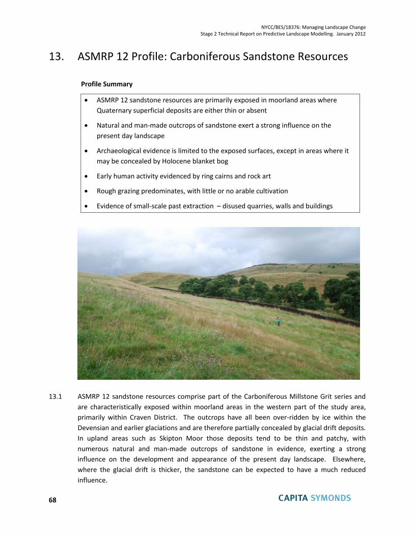
NYCC/BES/18376: Managing Landscape Change Stage 2 Technical Report on Predictive Landscape Modelling. January 2012
68
13. ASMRP 12 Profile: Carboniferous Sandstone Resources
Profile Summary
ASMRP 12 sandstone resources are primarily exposed in moorland areas where
Quaternary superficial deposits are either thin or absent
Natural and man-made outcrops of sandstone exert a strong influence on the
present day landscape
Archaeological evidence is limited to the exposed surfaces, except in areas where it
may be concealed by Holocene blanket bog
Early human activity evidenced by ring cairns and rock art
Rough grazing predominates, with little or no arable cultivation
Evidence of small-scale past extraction – disused quarries, walls and buildings
13.1 ASMRP 12 sandstone resources comprise part of the Carboniferous Millstone Grit series and
are characteristically exposed within moorland areas in the western part of the study area,
primarily within Craven District. The outcrops have all been over-ridden by ice within the
Devensian and earlier glaciations and are therefore partially concealed by glacial drift deposits.
In upland areas such as Skipton Moor those deposits tend to be thin and patchy, with
numerous natural and man-made outcrops of sandstone in evidence, exerting a strong
influence on the development and appearance of the present day landscape. Elsewhere,
where the glacial drift is thicker, the sandstone can be expected to have a much reduced
influence.
NYCC/BES/18376: Managing Landscape Change Stage 2 Technical Report on Predictive Landscape Modelling. January 2012
69
13.2 The surface outcrops date from the end of the Devensian glaciation but the underlying
deposits are much older, dating from the Carboniferous era some 299 to 359 million years BP.
In marked contrast to the ASMRPs associated with Quaternary drift deposits, the impact of
human development on the landscape is directly evident at the surface. There has been little
or no arable cultivation to degrade the evidence of earlier human activity, but there has been,
to varying degrees, the development of blanket bogs, as described in Chapter 3, and the
effects of historic mineral workings.
13.3 Early human activity, not necessarily associated with settlement, is evidenced by the survival of
round cairns and prehistoric rock art such as cup and ring marks – typical indicators of
transient activity within upland landscapes.
13.4 The present-day landscape shows less evidence of past intensive land use and management
than is the case within the lower and better draining ASMRPs. Within the sample area, at
least, the archaeological resource (including disused small scale quarries) and the character of
the built environment are directly related to the geological character of the location and this
has resulted in archaeological features that are well preserved and visible across the site. The
use of the natural stone in boundaries and buildings contributes to the particular landscape
character of this landscape and provides habits for wildlife.
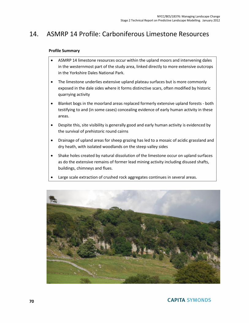
NYCC/BES/18376: Managing Landscape Change Stage 2 Technical Report on Predictive Landscape Modelling. January 2012
70
14. ASMRP 14 Profile: Carboniferous Limestone Resources
Profile Summary
ASMRP 14 limestone resources occur within the upland moors and intervening dales
in the westernmost part of the study area, linked directly to more extensive outcrops
in the Yorkshire Dales National Park.
The limestone underlies extensive upland plateau surfaces but is more commonly
exposed in the dale sides where it forms distinctive scars, often modified by historic
quarrying activity
Blanket bogs in the moorland areas replaced formerly extensive upland forests - both
testifying to and (in some cases) concealing evidence of early human activity in these
areas.
Despite this, site visibility is generally good and early human activity is evidenced by
the survival of prehistoric round cairns
Drainage of upland areas for sheep grazing has led to a mosaic of acidic grassland and
dry heath, with isolated woodlands on the steep valley sides
Shake holes created by natural dissolution of the limestone occur on upland surfaces
as do the extensive remains of former lead mining activity including disused shafts,
buildings, chimneys and flues.
Large scale extraction of crushed rock aggregates continues in several areas.
NYCC/BES/18376: Managing Landscape Change Stage 2 Technical Report on Predictive Landscape Modelling. January 2012
71
14.1 ASMRP 14 Carboniferous Limestone resources occur most extensively within Richmondshire
District, primarily within and above the valleys of Swaledale and Wensleydale, where they
provide a continuation of the more extensive outcrops seen in the adjoining Yorkshire Dales
National Park. They also occur within the central part of Craven District, adjacent to the
southern boundary of the National Park, and around Pateley Bridge in Harrogate District.
14.2 The limestone underlies extensive upland plateau surfaces, either directly or beneath overlying
sandstones and/ or cherts of the Carboniferous Millstone Grit Series. These rocks are
commonly overlain by a thin cover of Quaternary glacial drift deposits which, in turn, have
restricted surface drainage and allowed the development of upland peat (blanket bog) and a
mosaic of acidic grassland and dry heath that is typical of most of the limestone moorlands of
the Pennines.
14.3 It is likely that the habitats and associated plant communities would have been somewhat
wetter in the past than at present. Fell gripping (open drainage ditches to improve conditions
for sheep grazing), and moorland management practices associated with grouse moors (e.g.
cutting and burning of heather) were widely adopted during the 19th Century, resulting in
drier conditions and reduced biodiversity, dominated by heather and acid grassland.
14.4 A greater part of the ASMRP 14 outcrop occurs along the side of the dales, where it is directly
exposed at the surface and characteristically forms rugged limestone scars and associated
scree slopes. These, in turn, provide important niche habitats for a wide range of species and
there are many areas of woodland on the steep, uncultivable slopes.
14.5 Across the limestone outcrop there are numerous disused mine workings, spoil heaps, and
ancillary infrastructure, relating to the mining of lead, and perhaps other vein minerals, from at
least Roman times until the 19th Century. Within the same areas, natural dissolution features
within the limestone have caused the formation, at the surface, of conical subsidence hollows
and ‘shake holes’. More recent mineral extraction within the Carboniferous Limestone
outcrops has focused on aggregate production from the limestone itself and is evident both as
small-scale historical modifications to many natural outcrops as well as more industrial-scale
ongoing quarrying activity.
14.6 Much older human activity, not necessarily associated with settlement, is evidenced by the
survival of prehistoric round cairns – typical indicators of transient activity within upland
landscapes. The relatively thin covering of peat within the sample area and elsewhere means
that site visibility is relatively good. In some areas, however, visibility is hampered by the
growth of heather, which is intensively managed as Grouse moorland.
HLC types associated with ASMRP 14 include recreational on unenclosed moorland – reflecting
the fact that these areas are used and managed as a grouse moor; and ‘dominant dispersed
industry’ relating to the areas where past and present mineral extraction has a dominant
influence (North Yorkshire and Lower Tees HLC. NYCC and English Heritage 2010).
NYCC/BES/18376: Managing Landscape Change Stage 2 Technical Report on Predictive Landscape Modelling. January 2012
72
15. References Cited
Archaeoscope (2008): Nosterfield Environs Report,
Bridgland, D. R. (1999): The Pleistocene of north-east England. In: The Quaternary of North-east
England. Field Guide (eds D.R. Bridgland, B.P. Horton, & J.B. Innes), pp. 1–9. Quaternary Research
Association, London.
Bridgland, D. R. & Austin, W.E.N. (1999): Shippersea Bay to Hawthorn Hive. In: The Quaternary of North-
East England. Field Guide (eds D.R. Bridgland, B.P. Horton, & J.B. Innes), pp. 51–56. Quaternary Research
Association, London.
Bridgeland, D. R., Innes, J., Long, A. and Mitchell, W. (editors) (2011): Late Quaternary Landscape
Evolution of the Swale-Ure Washlands, North Yorkshire. Oxbow Books, Oxford.
Brightman, J and Waddington, C (2010) Aggregates and Archaeology in Derbyshire and the Peak
District Bakewell, Archaeological Research Services Ltd
Burl, A. (1976): The Stone Circles of the British Isles. New Haven: Yale University Press
Butlin, RA (2003) Historical Atlas of North Yorkshire. Skipton
Catt, J. A. (2007): The Pleistocene glaciations of eastern Yorkshire: a review. Proceedings of the
Yorkshire Geological Society May 2007, v. 56:177-207
Chris Blandford Associates (2011): North Yorkshire and York Landscape Characterisation Project. Final
Report to North Yorkshire County Council (May 2011) 244pp.
Clark, J.G.D. (1954): Excavations at Star Carr: an Early Mesolithic site at Seamer near Scarborough,
Yorkshire. Cambridge: Cambridge University Press.
Conneller, C., (2007a): Inhabiting new landscapes: settlement and mobility in Britain after the last
glacial maximum. Oxford Journal of Archaeology. Volume 26, Issue 3, pages 215–237.
Conneller, C. (2007b): New excavations at Star Carr, PAST 56, 3-5.
Conneller, C. and Schadla-Hall, T. 2003: Beyond Star Carr: The Vale of Pickering in the 10th Millennium
BP. Proc. Prehist. Soc. 69, 85-105.
Cooke, L. (August 2011) Vale of Pickering: Statement of Significance Landscape Research Centre,
unpublished.
Cooper, A.H. & Burges, I.C. (1993): Geology of the country around Harrogate (Sheet 62). Her Majesty’s
Stationery Office
NYCC/BES/18376: Managing Landscape Change Stage 2 Technical Report on Predictive Landscape Modelling. January 2012
73
Corfield, M. (2007): Wetland Science. In: Lillie, M.E. and Ellis, S. (Eds.) Wetland Archaeology and
Environments. Regional Issues, Global Perspectives. P 143 – 155. Oxbow; Oxford
Dark, P. (2000): The Environment of Britain in the First Millennium AD. Duckworth, London
Dickson, A and Hopkinson, G, 2011 Holes in the landscape: seventeen years of archaeological
investigations at Nosterfield Quarry, North Yorkshire,
http://www.archaeologicalplanningconsultancy.co.uk/thornborough/nos.php
English Heritage (2006) The Humber Wetland Survey: Vale of York Region project
Evans, D.J.A, Clark, C.D. & Mitchell, W.A. (2005): The last British Ice Sheet: a review of the evidence
utilised in the compilation of the Glacial Map of Britain. Earth Science Reviews, 70, 253–312.
Fenton-Thomas, C., (2005): The Forgotten Landscapes of the Yorkshire Wolds.
Frost, D.V. (1998): Geology of the country around Northallerton. Memoir of the British Geological
Survey.
Mike Griffiths & Associates website ‘The Archaeology of the Thornborough Area’:
http://www.archaeologicalplanningconsultancy.co.uk/thornborough/index.php
Haughton, C., and Powlesland, D.J. (1999): West Heslerton - The Anglian Cemetery. Volume 1: The
Excavation and Discussion of Evidence. English Heritage (197pp)
Howard, A.J., Keen, D.H., Mighall, T.M., Field, M.H., Coope, G.R., Griffi ths, H.I. & Macklin, M.G. (2000a):
Early Holocene environments of the River Ure near Ripon, North Yorkshire, UK. Proceedings of the
Yorkshire Geological Society, 53, 31–42.
Howard, A.J., Macklin M,.G., Black, S. & Hudson-Edwards, K. (2000b): Holocene river development and
environmental change in upper Wharfedale, Yorkshire Dales, England. Journal of Quaternary Science,
15, 239–252.
Howard, A.J., Whyman, M., Challis, K. and McManus, K.B. (2008): Recent work on the geomorphological
and archaeological landscape of the Vale of York. In Atherden, M. and Milsom, T. (eds) Yorkshire
Landscapes Past and Present. PLACE, York. pp. 69-76.
Innes, J.B. (2002): The Holocene record of northern England: introduction. In: Quaternary of Northern
England, Geological Conservation Review Vol. 25 (eds D. Huddart & N.F. Glasser). Joint Nature
Conservation Committee, Peterborough.
Lewin, J., Macklin, M.G. & Johnstone, E. (2005): Interpreting alluvial archives: sedimentological factors
in the British Holocene fluvial record. Quaternary Science Reviews, 24, 1873–1889.
NYCC/BES/18376: Managing Landscape Change Stage 2 Technical Report on Predictive Landscape Modelling. January 2012
74
Macklin, M.G. (1999): Holocene river environments in Prehistoric Britain: human interaction and
impact. In: Holocene Environments of Prehistoric Britain. (eds K.J. Edwards & J. Sadler), pp. 521–530.
Wiley, Chichester.
Manby TG, Moorhouse S & Ottaway, P. (Eds) (2003): The Archaeology of Yorkshire: An Assessment at
the Beginning of the 21st Century. YAS Occasional Paper 3.
Mellars, P. and Dark, P. (1998): Star Carr in Context: New Archaeological and Palaeoecological
Investigations at the Early Mesolithic Site of Star Carr, North Yorkshire. Cambridge: McDonald Institute
for Archaeological Research.
Minerals Historic Environment Forum, (2008): Mineral Extraction and Archaeology: A Practice Guide.
(30pp)
Passmore, D.G. & Waddington, C. (2009): Managing archaeological landscapes. Till-Tweed Studies,
North-East England Volume 1. Oxbow Books, Oxford.
Passmore, D.G. & Waddington, C. (2011): Archaeology and Environment in North Northumberland.
Till-Tweed Studies, North-East England Volume 2. Oxbow Books, Oxford.
Passmore, D.G., Waddington, C. & Van der Schriek, T. 2006: Enhancing the evaluation and
management of river valley archaeology; geoarchaeology in the Till–Tweed catchment, northern
England. Archaeological Prospection. Vol 13 No. 4 pp 269-281.
Peacock, C. (2003): Rivers, Floodplains and Wetlands - Connectivity and Dynamics (RSPB, Sandy,
Bedfordshire (64pp)
Pennington, W. (1977) The Late Devensian flora and vegetation of Britain. Philosophical Transactions of
the Royal Society of London, B280, 247–270.
Plater, A.J., Ridgway, J., Rayner, B., Shennan, I., Horton, B.P., Hayworth, E.Y., Wright, M.R., Rutherford,
M.M. & Wintle, A.G. (2000): Sediment provenance and flux in the Tees estuary: the record from the
Late Devensian to the present. In: Holocene Land–Ocean Interaction and Environmental Change around
the North Sea (eds I. Shennan & J. Andrews), pp. 171–195. Geological Society of London. Special
Publication 166, London.
Powell, J.H., Cooper, A.H. & Benfield, A.C. (1992) Geology of the country around Thirsk. Memoir of the
Geological Survey.
Powlesland, D., Lyall, J. and Donoghue, D., (1997): Enhancing the record through remote sensing: the
application and integration of multi-sensor, non-invasive remote sensing techniques for the
enhancement of the Sites and Monuments Record. Heslerton Parish Project, N. Yorkshire, England.
Internet Archaeology 2 (http://intarch.ac.uk/journal/issue2/pld/index.html)
NYCC/BES/18376: Managing Landscape Change Stage 2 Technical Report on Predictive Landscape Modelling. January 2012
75
Powlesland, D.J. (2000): West Heslerton: Aspects of Settlement Mobility, Oxbow, Oxford.
Powlesland, D.J. (2003): 25 years of archaeological research on the sands and gravels of Heslerton.
Landscape Research Centre, Yedingham (48pp).
Powlesland, D., Lyall, J., Hopkinson, G., Donoghue, D., Beck, M., Harte, A. and Stott, D. 2006: Beneath
the sand—remote sensing, archaeology, aggregates and sustainability: a case study from Heslerton,
the Vale of Pickering, North Yorkshire, UK. Archaeological Prospection. Vol 13 No. 4 pp 291-299.
Powlesland, D.J. (2011): Identifying the Unimaginable - Managing the Unmanageable. In Cowley, D.C.
(Ed): Remote Sensing for Archaeological Heritage Management. EAC Occasional Paper No. 5.
(Proceedings of the 11th EAC Heritage Management Symposium, Reykjavik, Iceland, 25-27 March 2010).
Raistrick, A. 1933: The correlation of glacial retreat stages across the Pennines. Proceedings of the
Yorkshire Geological Society, v. 22: pp. 199-214
Richards, C, (1996): Henges and Water, Towards an Elemental Understanding of Monumentality and
Landscape in Late Neolithic Britain, J Material Culture, 1.3, pp. 313-36
Roberts, I, Deegan, A. & Berg, D, (2010): Understanding the cropmark landscapes of the Magnesian
Limestone: the archaeology of the Magnesian Limestone and its margins in South and West Yorkshire
and parts of North Yorkshire and north Nottinghamshire, English Heritage/Archaeological Services
WYAS
Roskams, S and Whyman, M (2005): Yorkshire Archaeological Research Framework – draft resource
assessment report (unpublished)
Shennan, I., Bradley, S., Milne, G., Brooks, A., Bassett, S. & Hamilton, S. (2006): Relative sea-level
changes, glacial isostatic modelling and ice sheet reconstructions from the British Isles since the Last
Glacial Maximum. Journal of Quaternary Science, 21, 585–599.
Simmons, I.G. & Innes, J.B. (1985) Late Mesolithic land use and its environmental impacts in the English
uplands. Biogeographical Monographs, 2, 7–17.
Stoertz, C (1997): Ancient Landscapes of the Yorkshire Wolds (Royal Commission on the Historical
Monuments of England)
Taylor, M.P. & Macklin, M.G. (1997) Holocene alluvial sedimentation and valley floor development: the
River Swale, Catterick, North Yorkshire. Proceedings of the Yorkshire Geological Society, 51, 317–327.
Taylor, M.P., Macklin, M.G. and Hudson-Edwards, K. (2000): River sedimentation and fluvial response
to Holocene environmental change in the Yorkshire Ouse Basin, northern England. The Holocene.
February 2000, 10: pp 201-212
NYCC/BES/18376: Managing Landscape Change Stage 2 Technical Report on Predictive Landscape Modelling. January 2012
76
Thompson, A., Hine, P., Greig, J.R., and Peach, D.W., (1996): Assessment of Subsidence Arising from
Gypsum Dissolution, with particular reference to Ripon, North Yorkshire. Department of the
Environment. Symonds Travers Morgan, East Grinstead. (288pp).
Thompson, A., Hine, P., Peach, D.W., Frost, L. and Brook, D., (1998): Subsidence Hazard Assessment as a
Basis for Planning Guidance in Ripon. In Maund, J.G. & Eddleston, M. (eds) Geohazards in Engineering
Geology. Geological Society, London, Engineering Geology Special Publications, 15, pp 415-426.
Thompson, A.; Howarth, C.L.; Goodwin, A.; Buckley, C; and Harris, K. (2008): Good Practice Guidance on
Controlling the Effects of Surface Mineral Working on the Water Environment. Report to the
Department of Communities and Local Government, and the Mineral Industry Research Organisation.
Capita Symonds Ltd, East Grinstead. (207 pp plus Appendices).
Ward, I., Smith, B. & Lawley, R. (2009): Mapping the Archaeological Soil Archive of Sand and Gravel
Mineral Reserves in Britain. Geoarchaeology, 24 (1). 1-21.
Whyman, M. & Howard, A.J. (2005): Archaeology and Landscape in the Vale of York
http://www.yorkarchaeology.co.uk/resources/voy-web.pdf
Wilson, P R, 2002 Cataractonium: Roman Catterick and its hinterland, Excavations and research 1958-
1997 , Council for British Archaeology, York.

NYCC/BES/18376: Managing Landscape Change Stage 2 Technical Report on Predictive Landscape Modelling. January 2012
77
Capita Symonds
The Capita Building
Kingmoor Business Park
Carlisle
CA4 6SJ
Tel: 01228 673000
Fax: 01228 673111