Embed Size (px)
Citation preview
A New Performance Measure and Evaluation Benchmarkfor Road Detection Algorithms
Jannik Fritsch, Tobias Kuhnl, Andreas Geiger
Abstract— Detecting the road area and ego-lane ahead of avehicle is central to modern driver assistance systems. Whilelane-detection on well-marked roads is already available inmodern vehicles, finding the boundaries of unmarked or weaklymarked roads and lanes as they appear in inner-city and ruralenvironments remains an unsolved problem due to the highvariability in scene layout and illumination conditions, amongstothers. While recent years have witnessed great interest in thissubject, to date no commonly agreed upon benchmark exists,rendering a fair comparison amongst methods difficult.
In this paper, we introduce a novel open-access dataset andbenchmark for road area and ego-lane detection. Our datasetcomprises 600 annotated training and test images of highvariability from the KITTI autonomous driving project, cap-turing a broad spectrum of urban road scenes. For evaluation,we propose to use the 2D Bird’s Eye View (BEV) space asvehicle control usually happens in this 2D world, requiringdetection results to be represented in this very same space.Furthermore, we propose a novel, behavior-based metric whichjudges the utility of the extracted ego-lane area for driverassistance applications by fitting a driving corridor to the roaddetection results in the BEV. We believe this to be importantfor a meaningful evaluation as pixel-level performance is oflimited value for vehicle control. State-of-the-art road detectionalgorithms are used to demonstrate results using classical pixel-level metrics in perspective and BEV space as well as the novelbehavior-based performance measure. All data and annotationsare made publicly available on the KITTI online evaluationwebsite in order to serve as a common benchmark for roadterrain detection algorithms.
I. INTRODUCTION
Recent years have witnessed a strong increase of imageprocessing functions in Advanced Driver Assistance Systems(ADAS) for passenger cars. While holistic traffic sceneunderstanding might still be a dream of the future [1],specialized systems such as lane keeping assistance havebecome a standard ADAS component that is available inmost new car models. While such systems are alreadycommercially available [2], they are targeted at markedroads with smooth curvatures, limiting their applicability tohighways and highway-like roads.
In order to provide support on unmarked roads that arecommon in rural areas and inner-city, a number of publica-tions have proposed road detection algorithms that avoid the
J. Fritsch is with the Honda Research Institute Europe GmbH, Offenbacham Main, Germany. [email protected]
T. Kuhnl is with the Honda Research Institute Europe GmbH,Offenbach am Main, Germany, and with the Research Institute forCognition and Robotics, Bielefeld University, Bielefeld, [email protected]
A. Geiger is with the Max Planck Institute for Intelligent Systemsin Tubingen and with the Karlsruhe Institute of Technology, [email protected]
need for lane marking detection. Early works focused on theoverall road area as it is more easy to extract. For example,the physical property of the road being flat has been used in avariety of approaches [3], [4]. However, this requires the roadarea to be limited by sufficiently elevated structures as well asaccurate depth information which for stereo cameras is onlyavailable in the close range. Consequently, many approachesput higher emphasis on appearance cues such as the colorand texture of the road area [5], [6], [7], [8], [9], [10], [11],[12]. These visual properties of the road area have been usedfor estimating the overall road shape [12] or for segmentingthe complete road area [5], [6], [8], [10].
Unfortunately, most of the existing approaches have beenevaluated on different datasets, prohibiting a fair performancecomparison. Furthermore, most of the existing work does notdistinguish road areas on a semantic level, e.g., ego-lane vs.opposing lane, which is crucial for ADAS and autonomousdriving. Only recently, methods for detecting lane markingsand curbstones have been combined explicitly [13], [14], [15]or implicitly [16] to achieve city lane detection. The finaltarget of such approaches is the identification of the ego-lane, independent of the boundary type or lane shape.
In order to turn research efforts into actual driver assis-tance systems, their performance has to be evaluated andthe strengths and weaknesses of the approaches have tobe clearly identified, requiring suitable evaluation measures.Often, pixel-based evaluation measures, inspired from thevision community, have been directly applied in the imagedomain. We believe that the evaluation of road detectionalgorithms requires a stronger focus on the target application:Any driving maneuver or vehicle control is performed inthe metric 2D space on the road. Consequently, the resultof any road detection algorithm will need to be providedor transformed into such a spatial representation which isappropriate for vehicle control. The metric road space canbe represented in the so-called Bird’s Eye View (BEV) [17]by assuming a flat world for the transformation from theperspective image to the BEV space. We argue that anyroad detection algorithm should be evaluated in the BEV.While previous attempts at pixel-based evaluation [18] couldbe configured to mimic this requirement by weighting thepixels in the perspective image, the weighting would needto be adaptive as the 2D world position of a pixel variesnon-linearly with its location in the image.
Instead, in this paper we apply classical pixel-basedevaluation measures directly in the BEV. Furthermore, aspixel-level annotation does not provide suitable answersto questions like ’Where are the ego-lane boundaries?’ or
’Can the driver safely continue driving?’, we additionallyfit a hypothesis for a possible driving path to the roaddetection result in the BEV. This driving corridor hypothesisrepresents an abstraction from the pixel level and allows fora behavior-based evaluation of road detection algorithms.
A second contribution of this paper is the introductionof a benchmark for the evaluation of road detection al-gorithms. We present three novel and highly challengingdatasets derived from the KITTI autonomous driving project[19], capturing a variety of inner city scenarios includingunmarked and marked lanes, as illustrated in Fig. 2. OurKITTI-ROAD dataset and benchmark are made publiclyavailable together with the proposed behavior-based per-formance measure, classical pixel-level evaluation metricsas well as an automatic evaluation service on the KITTIwebsite1. We believe this to be an important step towardsinvestigating the pros and cons of different approaches onthe same basis and to foster novel research and progress inthis field.
The outline of this paper is as follows: Section II re-views existing evaluations measures. The new KITTI-ROADbenchmark dataset is introduced in Section III. Section IVreviews classical pixel-based performance metrics and in-troduces the proposed behavior-based performance measure.Evaluation results for the pixel-based and behavior-basedperformance measures using a simple baseline and severalroad detection algorithms are presented in Section V. Thepaper concludes in Section VI.
II. RELATED WORK
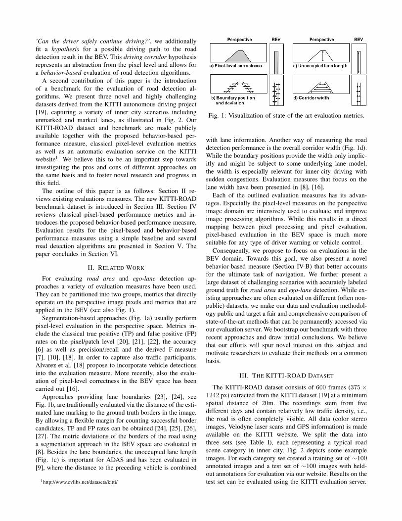
For evaluating road area and ego-lane detection ap-proaches a variety of evaluation measures have been used.They can be partitioned into two groups, metrics that directlyoperate on the perspective image pixels and metrics that areapplied in the BEV (see also Fig. 1).
Segmentation-based approaches (Fig. 1a) usually performpixel-level evaluation in the perspective space. Metrics in-clude the classical true positive (TP) and false positive (FP)rates on the pixel/patch level [20], [21], [22], the accuracy[6] as well as precision/recall and the derived F-measure[7], [10], [18]. In order to capture also traffic participants,Alvarez et al. [18] propose to incorporate vehicle detectionsinto the evaluation measure. More recently, also the evalu-ation of pixel-level correctness in the BEV space has beencarried out [16].
Approaches providing lane boundaries [23], [24], seeFig. 1b, are traditionally evaluated via the distance of the esti-mated lane marking to the ground truth borders in the image.By allowing a flexible margin for counting successful bordercandidates, TP and FP rates can be obtained [24], [25], [26],[27]. The metric deviations of the borders of the road usinga segmentation approach in the BEV space are evaluated in[8]. Besides the lane boundaries, the unoccupied lane length(Fig. 1c) is important for ADAS and has been evaluated in[9], where the distance to the preceding vehicle is combined
1http://www.cvlibs.net/datasets/kitti/
Fig. 1: Visualization of state-of-the-art evaluation metrics.
with lane information. Another way of measuring the roaddetection performance is the overall corridor width (Fig. 1d).While the boundary positions provide the width only implic-itly and might be subject to some underlying lane model,the width is especially relevant for inner-city driving withsudden congestions. Evaluation measures that focus on thelane width have been presented in [8], [16].
Each of the outlined evaluation measures has its advan-tages. Especially the pixel-level measures on the perspectiveimage domain are intensively used to evaluate and improveimage processing algorithms. While this results in a directmapping between pixel processing and pixel evaluation,pixel-based evaluation in the BEV space is much moresuitable for any type of driver warning or vehicle control.
Consequently, we propose to focus on evaluations in theBEV domain. Towards this goal, we also present a novelbehavior-based measure (Section IV-B) that better accountsfor the ultimate task of navigation. We further present alarge dataset of challenging scenarios with accurately labeledground truth for road area and ego-lane detection. While ex-isting approaches are often evaluated on different (often non-public) datasets, we make our data and evaluation methodol-ogy public and target a fair and comprehensive comparison ofstate-of-the-art methods that can be permanently accessed viaour evaluation server. We bootstrap our benchmark with threerecent approaches and draw initial conclusions. We believethat our efforts will spur novel interest on this subject andmotivate researchers to evaluate their methods on a commonbasis.
III. THE KITTI-ROAD DATASET
The KITTI-ROAD dataset consists of 600 frames (375 ×1242 px) extracted from the KITTI dataset [19] at a minimumspatial distance of 20m. The recordings stem from fivedifferent days and contain relatively low traffic density, i.e.,the road is often completely visible. All data (color stereoimages, Velodyne laser scans and GPS information) is madeavailable on the KITTI website. We split the data intothree sets (see Table I), each representing a typical roadscene category in inner city. Fig. 2 depicts some exampleimages. For each category we created a training set of ∼100annotated images and a test set of ∼100 images with held-out annotations for evaluation via our website. Results on thetest set can be evaluated using the KITTI evaluation server.
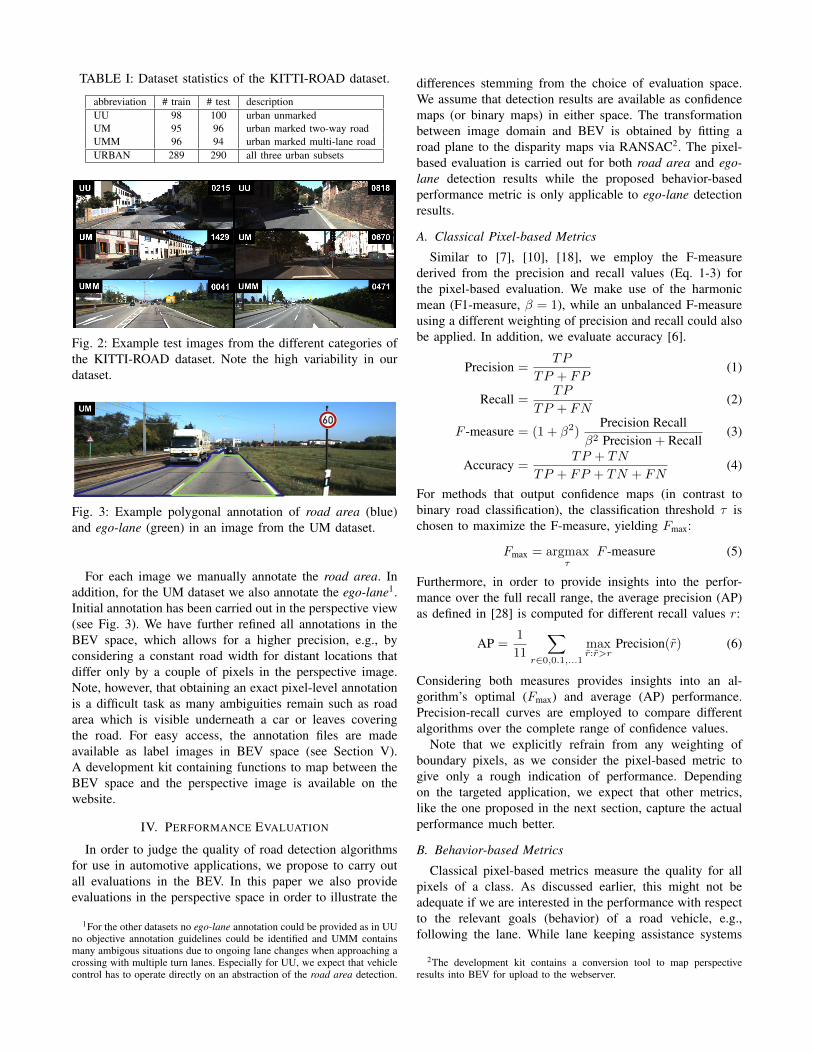
TABLE I: Dataset statistics of the KITTI-ROAD dataset.
abbreviation # train # test descriptionUU 98 100 urban unmarkedUM 95 96 urban marked two-way roadUMM 96 94 urban marked multi-lane roadURBAN 289 290 all three urban subsets
Fig. 2: Example test images from the different categories ofthe KITTI-ROAD dataset. Note the high variability in ourdataset.
Fig. 3: Example polygonal annotation of road area (blue)and ego-lane (green) in an image from the UM dataset.
For each image we manually annotate the road area. Inaddition, for the UM dataset we also annotate the ego-lane1.Initial annotation has been carried out in the perspective view(see Fig. 3). We have further refined all annotations in theBEV space, which allows for a higher precision, e.g., byconsidering a constant road width for distant locations thatdiffer only by a couple of pixels in the perspective image.Note, however, that obtaining an exact pixel-level annotationis a difficult task as many ambiguities remain such as roadarea which is visible underneath a car or leaves coveringthe road. For easy access, the annotation files are madeavailable as label images in BEV space (see Section V).A development kit containing functions to map between theBEV space and the perspective image is available on thewebsite.
IV. PERFORMANCE EVALUATION
In order to judge the quality of road detection algorithmsfor use in automotive applications, we propose to carry outall evaluations in the BEV. In this paper we also provideevaluations in the perspective space in order to illustrate the
1For the other datasets no ego-lane annotation could be provided as in UUno objective annotation guidelines could be identified and UMM containsmany ambigous situations due to ongoing lane changes when approaching acrossing with multiple turn lanes. Especially for UU, we expect that vehiclecontrol has to operate directly on an abstraction of the road area detection.
differences stemming from the choice of evaluation space.We assume that detection results are available as confidencemaps (or binary maps) in either space. The transformationbetween image domain and BEV is obtained by fitting aroad plane to the disparity maps via RANSAC2. The pixel-based evaluation is carried out for both road area and ego-lane detection results while the proposed behavior-basedperformance metric is only applicable to ego-lane detectionresults.
A. Classical Pixel-based Metrics
Similar to [7], [10], [18], we employ the F-measurederived from the precision and recall values (Eq. 1-3) forthe pixel-based evaluation. We make use of the harmonicmean (F1-measure, β = 1), while an unbalanced F-measureusing a different weighting of precision and recall could alsobe applied. In addition, we evaluate accuracy [6].
Precision =TP
TP + FP(1)
Recall =TP
TP + FN(2)
F -measure = (1 + β2)Precision Recall
β2 Precision + Recall(3)
Accuracy =TP + TN
TP + FP + TN + FN(4)
For methods that output confidence maps (in contrast tobinary road classification), the classification threshold τ ischosen to maximize the F-measure, yielding Fmax:
Fmax = argmaxτ
F -measure (5)
Furthermore, in order to provide insights into the perfor-mance over the full recall range, the average precision (AP)as defined in [28] is computed for different recall values r:
AP =1
11
∑r∈0,0.1,...1
maxr:r>r
Precision(r) (6)
Considering both measures provides insights into an al-gorithm’s optimal (Fmax) and average (AP) performance.Precision-recall curves are employed to compare differentalgorithms over the complete range of confidence values.
Note that we explicitly refrain from any weighting ofboundary pixels, as we consider the pixel-based metric togive only a rough indication of performance. Dependingon the targeted application, we expect that other metrics,like the one proposed in the next section, capture the actualperformance much better.
B. Behavior-based Metrics
Classical pixel-based metrics measure the quality for allpixels of a class. As discussed earlier, this might not beadequate if we are interested in the performance with respectto the relevant goals (behavior) of a road vehicle, e.g.,following the lane. While lane keeping assistance systems
2The development kit contains a conversion tool to map perspectiveresults into BEV for upload to the webserver.
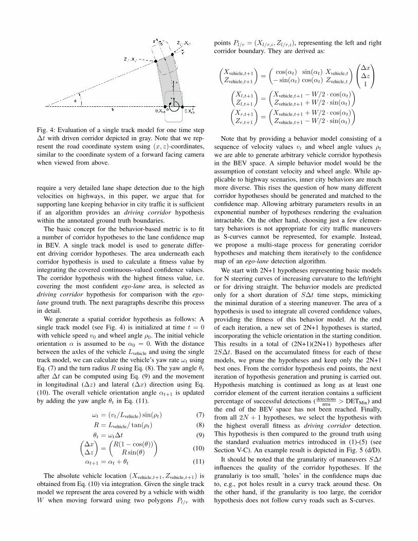
Fig. 4: Evaluation of a single track model for one time step∆t with driven corridor depicted in gray. Note that we rep-resent the road coordinate system using (x, z)-coordinates,similar to the coordinate system of a forward facing camerawhen viewed from above.
require a very detailed lane shape detection due to the highvelocities on highways, in this paper, we argue that forsupporting lane keeping behavior in city traffic it is sufficientif an algorithm provides an driving corridor hypothesiswithin the annotated ground truth boundaries.
The basic concept for the behavior-based metric is to fita number of corridor hypotheses to the lane confidence mapin BEV. A single track model is used to generate differ-ent driving corridor hypotheses. The area underneath eachcorridor hypothesis is used to calculate a fitness value byintegrating the covered continuous-valued confidence values.The corridor hypothesis with the highest fitness value, i.e.covering the most confident ego-lane area, is selected asdriving corridor hypothesis for comparison with the ego-lane ground truth. The next paragraphs describe this processin detail.
We generate a spatial corridor hypothesis as follows: Asingle track model (see Fig. 4) is initialized at time t = 0with vehicle speed v0 and wheel angle ρ0. The initial vehicleorientation α is assumed to be α0 = 0. With the distancebetween the axles of the vehicle Lvehicle and using the singletrack model, we can calculate the vehicle’s yaw rate ωt usingEq. (7) and the turn radius R using Eq. (8). The yaw angle θtafter ∆t can be computed using Eq. (9) and the movementin longitudinal (∆z) and lateral (∆x) direction using Eq.(10). The overall vehicle orientation angle αt+1 is updatedby adding the yaw angle θt in Eq. (11).
ωt = (vt/Lvehicle) sin(ρt) (7)R = Lvehicle/ tan(ρt) (8)θt = ωt∆t (9)(
∆x∆z
)=
(R(1 − cos(θ))R sin(θ)
)(10)
αt+1 = αt + θt (11)
The absolute vehicle location (Xvehicle,t+1, Zvehicle,t+1) isobtained from Eq. (10) via integration. Given the single trackmodel we represent the area covered by a vehicle with widthW when moving forward using two polygons Pl/r with
points Pl/r = (Xl/r,i, Zl/r,i), representing the left and rightcorridor boundary. They are derived as:
(Xvehicle,t+1
Zvehicle,t+1
)=
(cos(αt) sin(αt) Xvehicle,t− sin(αt) cos(αt) Zvehicle,t
)∆x∆z1
(Xl,t+1
Zl,t+1
)=
(Xvehicle,t+1 −W/2 · cos(αt)Zvehicle,t+1 +W/2 · sin(αt)
)(Xr,t+1
Zr,t+1
)=
(Xvehicle,t+1 +W/2 · cos(αt)Zvehicle,t+1 −W/2 · sin(αt)
)Note that by providing a behavior model consisting of a
sequence of velocity values vt and wheel angle values ρtwe are able to generate arbitrary vehicle corridor hypothesisin the BEV space. A simple behavior model would be theassumption of constant velocity and wheel angle. While ap-plicable to highway scenarios, inner city behaviors are muchmore diverse. This rises the question of how many differentcorridor hypotheses should be generated and matched to theconfidence map. Allowing arbitrary parameters results in anexponential number of hypotheses rendering the evaluationintractable. On the other hand, choosing just a few elemen-tary behaviors is not appropriate for city traffic maneuversas S-curves cannot be represented, for example. Instead,we propose a multi-stage process for generating corridorhypotheses and matching them iteratively to the confidencemap of an ego-lane detection algorithm.
We start with 2N+1 hypotheses representing basic modelsfor N steering curves of increasing curvature to the left/rightor for driving straight. The behavior models are predictedonly for a short duration of S∆t time steps, mimickingthe minimal duration of a steering maneuver. The area of ahypothesis is used to integrate all covered confidence values,providing the fitness of this behavior model. At the endof each iteration, a new set of 2N+1 hypotheses is started,incorporating the vehicle orientation in the starting condition.This results in a total of (2N+1)(2N+1) hypotheses after2S∆t. Based on the accumulated fitness for each of thesemodels, we prune the hypotheses and keep only the 2N+1best ones. From the corridor hypothesis end points, the nextiteration of hypothesis generation and pruning is carried out.Hypothesis matching is continued as long as at least onecorridor element of the current iteration contains a sufficientpercentage of successful detections ( detections
area > DETMin) andthe end of the BEV space has not been reached. Finally,from all 2N + 1 hypotheses, we select the hypothesis withthe highest overall fitness as driving corridor detection.This hypothesis is then compared to the ground truth usingthe standard evaluation metrics introduced in (1)-(5) (seeSection V-C). An example result is depicted in Fig. 5 (d/D).
It should be noted that the granularity of maneuvers S∆tinfluences the quality of the corridor hypotheses. If thegranulariy is too small, ’holes’ in the confidence maps dueto, e.g., pot holes result in a curvy track around these. Onthe other hand, if the granularity is too large, the corridorhypothesis does not follow curvy roads such as S-curves.
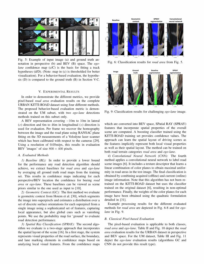
Fig. 5: Example of input image (a) and ground truth an-notation in perspective (b) and BEV (B) space. The ego-lane confidence map (c/C) is the basis for fitting a trackhypotheses (d/D). (Note: map in (c) is thresholded for bettervisualization). For a behavior-based evaluation, the hypothe-sis (D) is compared to the ground truth (B) in Section V-C.
V. EXPERIMENTAL RESULTS
In order to demonstrate the different metrics, we providepixel-based road area evaluation results on the completeURBAN KITTI-ROAD dataset using four different methods.The proposed behavior-based evaluation metric is demon-strated on the UM subset, with two ego-lane detectionsmethods trained on this subset only.
A BEV representation covering −10m to 10m in lateral(x) direction and 6m to 46m in longitudinal (z) direction isused for evaluation. Per frame we recover the homographybetween the image and the road plane using RANSAC planefitting on the 3D measurements of a Velodyne laser scannerwhich has been calibrated with respect to the cameras [29].Using a resolution of 0.05m/px, this results in evaluationBEV ’images’ of size 800 × 400 pixels.
A. Evaluated Methods
1) Baseline (BL): In order to provide a lower boundfor the performance any road detection algorithm shouldachieve, we extract baselines for road area and ego-laneby averaging all ground truth road maps from the trainingset. This results in confidence maps indicating for eachperspective/BEV location the confidence for beeing roadarea or ego-lane. These baselines can be viewed as scenepriors similar to the one used as input to [10].
2) Geometric Context (GC): The first method we evaluateis geometric context from Hoiem et al. [30], which segmentsthe image into superpixels and estimates a distribution over aset of discrete surface orientations for each superpixel from asingle image using a sophisticated set of features, capturinglocal appearance, but also global cues such as vanishingpoints. We use the probability map for ’ground’ to evaluateroad detection performance.
3) Spatial Ray Classification (SPRAY): The second algo-rithm we evaluate is a two-stage approach that incorporatesthe spatial layout of the scene [16]. In a first stage, the systemrepresents visual properties of the road surface, the boundary,and lane marking elements in confidence maps based onanalyzing local visual features. From the confidence maps
BaselineSPRAY
segmentationGeometric
contextConvolutional
neural network
Fig. 6: Classification results for road area from Fig. 5.
ImageGround
truthBaseline
segmentationSPRAY
segmentation
Fig. 9: Classification results for challenging ego-lane image.
which are converted into BEV space, SPatial RAY (SPRAY)features that incorporate spatial properties of the overallscene are computed. A boosting classifier trained using theKITTI-ROAD training set provides confidence values. Theapproach can learn the spatial layout of driving scenes asthe features implicitly represent both local visual propertiesas well as their spatial layout. The method can be trained onboth road terrain categories road area and ego-lane.
4) Convolutional Neural Network (CNN): The fourthmethod applies a convolutional neural network to label roadscene images [6]. It includes a texture descriptor that learns alinear combination of color planes to obtain maximal unifor-mity in road areas in the test image. The final classification isobtained by combining acquired (offline) and current (online)image information. Note that this algorithm has not been re-trained on the KITTI-ROAD dataset but uses the classifiertrained on the original dataset [6], resulting in non-optimalperformance. Finally, the weights of the color planes for eachimage have been obtained using the quadratic formulationdetailed in [31].
Example processing results for the different evaluatedmethods for road area are depicted in Fig. 6-8 and for ego-lane in Fig. 9.
B. Classical Pixel-based Evaluation
The pixel-based evaluation is applicable to both classes,road area and ego-lane. Table II and Fig. 10 depict the roadarea evaluation results for the URBAN dataset in perspectiveand BEV space. For the UM dataset, Table III and Fig. 11depict the ego-lane evaluation results (algorithms GC andCNN do not provide this result type).
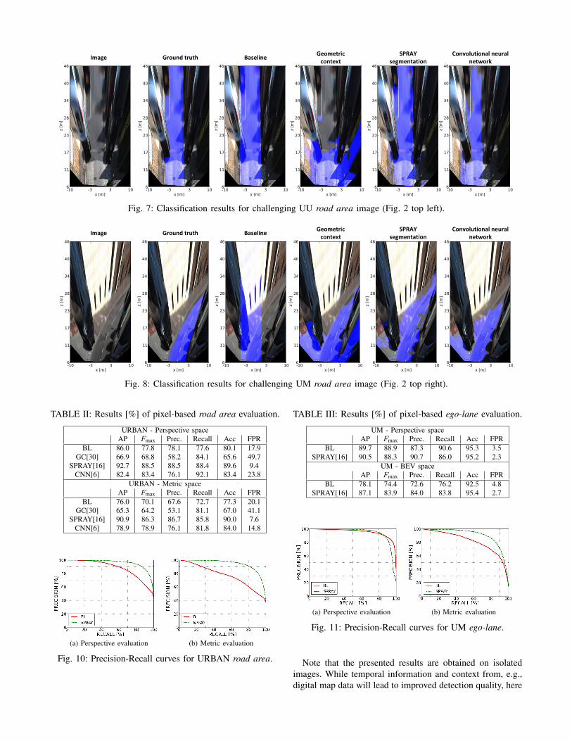
Image Ground truth BaselineSPRAY
segmentationGeometric
contextConvolutional neural
network
Fig. 7: Classification results for challenging UU road area image (Fig. 2 top left).
Image Ground truth BaselineSPRAY
segmentationGeometric
contextConvolutional neural
network
Fig. 8: Classification results for challenging UM road area image (Fig. 2 top right).
TABLE II: Results [%] of pixel-based road area evaluation.
URBAN - Perspective spaceAP Fmax Prec. Recall Acc FPR
BL 86.0 77.8 78.1 77.6 80.1 17.9GC[30] 66.9 68.8 58.2 84.1 65.6 49.7
SPRAY[16] 92.7 88.5 88.5 88.4 89.6 9.4CNN[6] 82.4 83.4 76.1 92.1 83.4 23.8
URBAN - Metric spaceAP Fmax Prec. Recall Acc FPR
BL 76.0 70.1 67.6 72.7 77.3 20.1GC[30] 65.3 64.2 53.1 81.1 67.0 41.1
SPRAY[16] 90.9 86.3 86.7 85.8 90.0 7.6CNN[6] 78.9 78.9 76.1 81.8 84.0 14.8
(a) Perspective evaluation (b) Metric evaluation
Fig. 10: Precision-Recall curves for URBAN road area.
TABLE III: Results [%] of pixel-based ego-lane evaluation.
UM - Perspective spaceAP Fmax Prec. Recall Acc FPR
BL 89.7 88.9 87.3 90.6 95.3 3.5SPRAY[16] 90.5 88.3 90.7 86.0 95.2 2.3
UM - BEV spaceAP Fmax Prec. Recall Acc FPR
BL 78.1 74.4 72.6 76.2 92.5 4.8SPRAY[16] 87.1 83.9 84.0 83.8 95.4 2.7
(a) Perspective evaluation (b) Metric evaluation
Fig. 11: Precision-Recall curves for UM ego-lane.
Note that the presented results are obtained on isolatedimages. While temporal information and context from, e.g.,digital map data will lead to improved detection quality, here
we target at evaluating a very diverse set of challengingimages. Note that improving detection on single images willautomatically lead to improved performance in the presenceof a tracking stage as well.
C. Behavior-based Evaluation
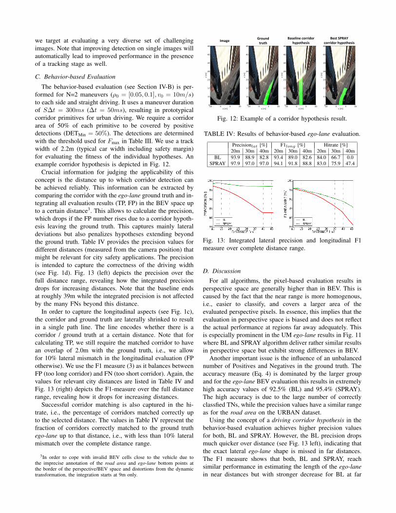
The behavior-based evaluation (see Section IV-B) is per-formed for N=2 maneuvers (ρ0 = [0.05, 0.1], v0 = 10m/s)to each side and straight driving. It uses a maneuver durationof S∆t = 300ms (∆t = 50ms), resulting in prototypicalcorridor primitives for urban driving. We require a corridorarea of 50% of each primitive to be covered by positivedetections (DETMin = 50%). The detections are determinedwith the threshold used for Fmax in Table III. We use a trackwidth of 2.2m (typical car width including safety margin)for evaluating the fitness of the individual hypotheses. Anexample corridor hypothesis is depicted in Fig. 12.
Crucial information for judging the applicability of thisconcept is the distance up to which corridor detection canbe achieved reliably. This information can be extracted bycomparing the corridor with the ego-lane ground truth and in-tegrating all evaluation results (TP, FP) in the BEV space upto a certain distance3. This allows to calculate the precision,which drops if the FP number rises due to a corridor hypoth-esis leaving the ground truth. This captures mainly lateraldeviations but also penalizes hypotheses extending beyondthe ground truth. Table IV provides the precision values fordifferent distances (measured from the camera position) thatmight be relevant for city safety applications. The precisionis intended to capture the correctness of the driving width(see Fig. 1d). Fig. 13 (left) depicts the precision over thefull distance range, revealing how the integrated precisiondrops for increasing distances. Note that the baseline endsat roughly 39m while the integrated precision is not affectedby the many FNs beyond this distance.
In order to capture the longitudinal aspects (see Fig. 1c),the corridor and ground truth are laterally shrinked to resultin a single path line. The line encodes whether there is acorridor / ground truth at a certain distance. Note that forcalculating TP, we still require the matched corridor to havean overlap of 2.0m with the ground truth, i.e., we allowfor 10% lateral mismatch in the longitudinal evaluation (FPotherwise). We use the F1 measure (3) as it balances betweenFP (too long corridor) and FN (too short corridor). Again, thevalues for relevant city distances are listed in Table IV andFig. 13 (right) depicts the F1-measure over the full distancerange, revealing how it drops for increasing distances.
Successful corridor matching is also captured in the hi-trate, i.e., the percentage of corridors matched correctly upto the selected distance. The values in Table IV represent thefraction of corridors correctly matched to the ground truthego-lane up to that distance, i.e., with less than 10% lateralmismatch over the complete distance range.
3In order to cope with invalid BEV cells close to the vehicle due tothe imprecise annotation of the road area and ego-lane bottom points atthe border of the perspective/BEV space and distortions from the dynamictransformation, the integration starts at 9m only.
ImageGround
truth
Baseline corridorhypothesis
Best SPRAY corridor hypothesis
Fig. 12: Example of a corridor hypothesis result.
TABLE IV: Results of behavior-based ego-lane evaluation.
Precisionlat [%] F1long [%] Hitrate [%]20m 30m 40m 20m 30m 40m 20m 30m 40m
BL 93.9 88.9 82.8 93.4 89.0 82.6 84.0 66.7 0.0SPRAY 97.9 97.0 97.0 94.1 91.8 88.8 83.0 75.9 47.4
Fig. 13: Integrated lateral precision and longitudinal F1measure over complete distance range.
D. Discussion
For all algorithms, the pixel-based evaluation results inperspective space are generally higher than in BEV. This iscaused by the fact that the near range is more homogenous,i.e., easier to classify, and covers a larger area of theevaluated perspective pixels. In essence, this implies that theevaluation in perspective space is biased and does not reflectthe actual performance at regions far away adequately. Thisis especially prominent in the UM ego-lane results in Fig. 11where BL and SPRAY algorithm deliver rather similar resultsin perspective space but exhibit strong differences in BEV.
Another important issue is the influence of an unbalancednumber of Positives and Negatives in the ground truth. Theaccuracy measure (Eq. 4) is dominated by the larger groupand for the ego-lane BEV evaluation this results in extremelyhigh accuracy values of 92.5% (BL) and 95.4% (SPRAY).The high accuracy is due to the large number of correctlyclassfied TNs, while the precision values have a similar rangeas for the road area on the URBAN dataset.
Using the concept of a driving corridor hypothesis in thebehavior-based evaluation achieves higher precision valuesfor both, BL and SPRAY. However, the BL precision dropsmuch quicker over distance (see Fig. 13 left), indicating thatthe exact lateral ego-lane shape is missed in far distances.The F1 measure shows that both, BL and SPRAY, reachsimilar performance in estimating the length of the ego-lanein near distances but with stronger decrease for BL at far
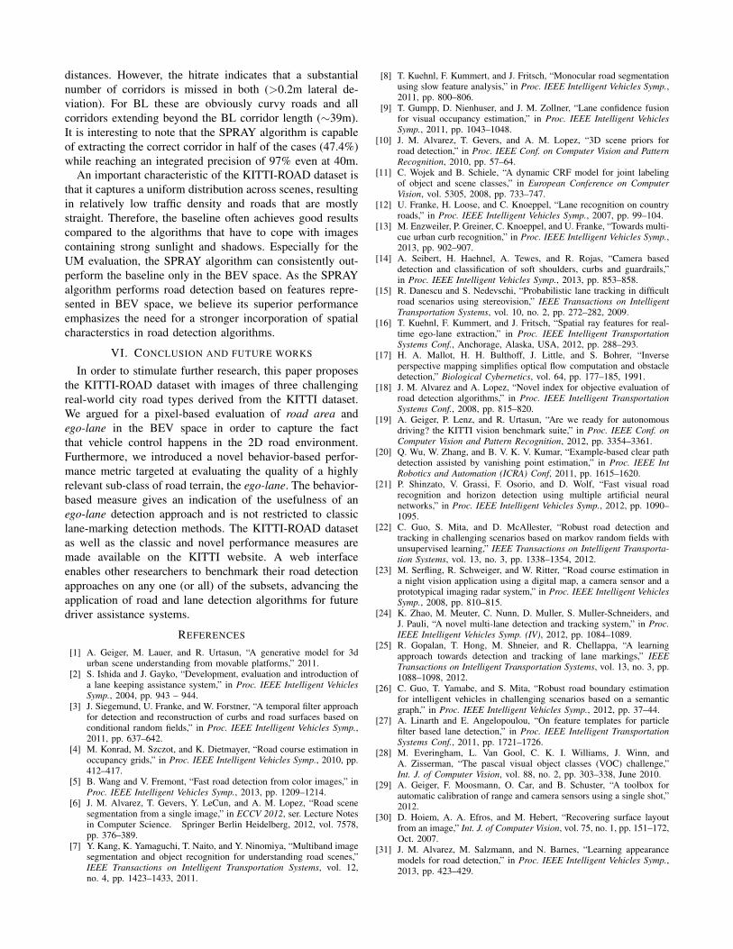
distances. However, the hitrate indicates that a substantialnumber of corridors is missed in both (>0.2m lateral de-viation). For BL these are obviously curvy roads and allcorridors extending beyond the BL corridor length (∼39m).It is interesting to note that the SPRAY algorithm is capableof extracting the correct corridor in half of the cases (47.4%)while reaching an integrated precision of 97% even at 40m.
An important characteristic of the KITTI-ROAD dataset isthat it captures a uniform distribution across scenes, resultingin relatively low traffic density and roads that are mostlystraight. Therefore, the baseline often achieves good resultscompared to the algorithms that have to cope with imagescontaining strong sunlight and shadows. Especially for theUM evaluation, the SPRAY algorithm can consistently out-perform the baseline only in the BEV space. As the SPRAYalgorithm performs road detection based on features repre-sented in BEV space, we believe its superior performanceemphasizes the need for a stronger incorporation of spatialcharacterstics in road detection algorithms.
VI. CONCLUSION AND FUTURE WORKS
In order to stimulate further research, this paper proposesthe KITTI-ROAD dataset with images of three challengingreal-world city road types derived from the KITTI dataset.We argued for a pixel-based evaluation of road area andego-lane in the BEV space in order to capture the factthat vehicle control happens in the 2D road environment.Furthermore, we introduced a novel behavior-based perfor-mance metric targeted at evaluating the quality of a highlyrelevant sub-class of road terrain, the ego-lane. The behavior-based measure gives an indication of the usefulness of anego-lane detection approach and is not restricted to classiclane-marking detection methods. The KITTI-ROAD datasetas well as the classic and novel performance measures aremade available on the KITTI website. A web interfaceenables other researchers to benchmark their road detectionapproaches on any one (or all) of the subsets, advancing theapplication of road and lane detection algorithms for futuredriver assistance systems.
REFERENCES
[1] A. Geiger, M. Lauer, and R. Urtasun, “A generative model for 3durban scene understanding from movable platforms,” 2011.
[2] S. Ishida and J. Gayko, “Development, evaluation and introduction ofa lane keeping assistance system,” in Proc. IEEE Intelligent VehiclesSymp., 2004, pp. 943 – 944.
[3] J. Siegemund, U. Franke, and W. Forstner, “A temporal filter approachfor detection and reconstruction of curbs and road surfaces based onconditional random fields,” in Proc. IEEE Intelligent Vehicles Symp.,2011, pp. 637–642.
[4] M. Konrad, M. Szczot, and K. Dietmayer, “Road course estimation inoccupancy grids,” in Proc. IEEE Intelligent Vehicles Symp., 2010, pp.412–417.
[5] B. Wang and V. Fremont, “Fast road detection from color images,” inProc. IEEE Intelligent Vehicles Symp., 2013, pp. 1209–1214.
[6] J. M. Alvarez, T. Gevers, Y. LeCun, and A. M. Lopez, “Road scenesegmentation from a single image,” in ECCV 2012, ser. Lecture Notesin Computer Science. Springer Berlin Heidelberg, 2012, vol. 7578,pp. 376–389.
[7] Y. Kang, K. Yamaguchi, T. Naito, and Y. Ninomiya, “Multiband imagesegmentation and object recognition for understanding road scenes,”IEEE Transactions on Intelligent Transportation Systems, vol. 12,no. 4, pp. 1423–1433, 2011.
[8] T. Kuehnl, F. Kummert, and J. Fritsch, “Monocular road segmentationusing slow feature analysis,” in Proc. IEEE Intelligent Vehicles Symp.,2011, pp. 800–806.
[9] T. Gumpp, D. Nienhuser, and J. M. Zollner, “Lane confidence fusionfor visual occupancy estimation,” in Proc. IEEE Intelligent VehiclesSymp., 2011, pp. 1043–1048.
[10] J. M. Alvarez, T. Gevers, and A. M. Lopez, “3D scene priors forroad detection,” in Proc. IEEE Conf. on Computer Vision and PatternRecognition, 2010, pp. 57–64.
[11] C. Wojek and B. Schiele, “A dynamic CRF model for joint labelingof object and scene classes,” in European Conference on ComputerVision, vol. 5305, 2008, pp. 733–747.
[12] U. Franke, H. Loose, and C. Knoeppel, “Lane recognition on countryroads,” in Proc. IEEE Intelligent Vehicles Symp., 2007, pp. 99–104.
[13] M. Enzweiler, P. Greiner, C. Knoeppel, and U. Franke, “Towards multi-cue urban curb recognition,” in Proc. IEEE Intelligent Vehicles Symp.,2013, pp. 902–907.
[14] A. Seibert, H. Haehnel, A. Tewes, and R. Rojas, “Camera baseddetection and classification of soft shoulders, curbs and guardrails,”in Proc. IEEE Intelligent Vehicles Symp., 2013, pp. 853–858.
[15] R. Danescu and S. Nedevschi, “Probabilistic lane tracking in difficultroad scenarios using stereovision,” IEEE Transactions on IntelligentTransportation Systems, vol. 10, no. 2, pp. 272–282, 2009.
[16] T. Kuehnl, F. Kummert, and J. Fritsch, “Spatial ray features for real-time ego-lane extraction,” in Proc. IEEE Intelligent TransportationSystems Conf., Anchorage, Alaska, USA, 2012, pp. 288–293.
[17] H. A. Mallot, H. H. Bulthoff, J. Little, and S. Bohrer, “Inverseperspective mapping simplifies optical flow computation and obstacledetection,” Biological Cybernetics, vol. 64, pp. 177–185, 1991.
[18] J. M. Alvarez and A. Lopez, “Novel index for objective evaluation ofroad detection algorithms,” in Proc. IEEE Intelligent TransportationSystems Conf., 2008, pp. 815–820.
[19] A. Geiger, P. Lenz, and R. Urtasun, “Are we ready for autonomousdriving? the KITTI vision benchmark suite,” in Proc. IEEE Conf. onComputer Vision and Pattern Recognition, 2012, pp. 3354–3361.
[20] Q. Wu, W. Zhang, and B. V. K. V. Kumar, “Example-based clear pathdetection assisted by vanishing point estimation,” in Proc. IEEE IntRobotics and Automation (ICRA) Conf, 2011, pp. 1615–1620.
[21] P. Shinzato, V. Grassi, F. Osorio, and D. Wolf, “Fast visual roadrecognition and horizon detection using multiple artificial neuralnetworks,” in Proc. IEEE Intelligent Vehicles Symp., 2012, pp. 1090–1095.
[22] C. Guo, S. Mita, and D. McAllester, “Robust road detection andtracking in challenging scenarios based on markov random fields withunsupervised learning,” IEEE Transactions on Intelligent Transporta-tion Systems, vol. 13, no. 3, pp. 1338–1354, 2012.
[23] M. Serfling, R. Schweiger, and W. Ritter, “Road course estimation ina night vision application using a digital map, a camera sensor and aprototypical imaging radar system,” in Proc. IEEE Intelligent VehiclesSymp., 2008, pp. 810–815.
[24] K. Zhao, M. Meuter, C. Nunn, D. Muller, S. Muller-Schneiders, andJ. Pauli, “A novel multi-lane detection and tracking system,” in Proc.IEEE Intelligent Vehicles Symp. (IV), 2012, pp. 1084–1089.
[25] R. Gopalan, T. Hong, M. Shneier, and R. Chellappa, “A learningapproach towards detection and tracking of lane markings,” IEEETransactions on Intelligent Transportation Systems, vol. 13, no. 3, pp.1088–1098, 2012.
[26] C. Guo, T. Yamabe, and S. Mita, “Robust road boundary estimationfor intelligent vehicles in challenging scenarios based on a semanticgraph,” in Proc. IEEE Intelligent Vehicles Symp., 2012, pp. 37–44.
[27] A. Linarth and E. Angelopoulou, “On feature templates for particlefilter based lane detection,” in Proc. IEEE Intelligent TransportationSystems Conf., 2011, pp. 1721–1726.
[28] M. Everingham, L. Van Gool, C. K. I. Williams, J. Winn, andA. Zisserman, “The pascal visual object classes (VOC) challenge,”Int. J. of Computer Vision, vol. 88, no. 2, pp. 303–338, June 2010.
[29] A. Geiger, F. Moosmann, O. Car, and B. Schuster, “A toolbox forautomatic calibration of range and camera sensors using a single shot,”2012.
[30] D. Hoiem, A. A. Efros, and M. Hebert, “Recovering surface layoutfrom an image,” Int. J. of Computer Vision, vol. 75, no. 1, pp. 151–172,Oct. 2007.
[31] J. M. Alvarez, M. Salzmann, and N. Barnes, “Learning appearancemodels for road detection,” in Proc. IEEE Intelligent Vehicles Symp.,2013, pp. 423–429.