Embed Size (px)
Citation preview
“main” — 2011/12/15 — 12:24 — page 105 — #1
Pesquisa Antártica Brasileira (2012) 5: 105-113(Brazilian Antarctic Research)ISSN 0103-4049http://vega.cnpq.br/pub/doc/proantar/
A new topographic map for Keller Peninsula,King George Island, Antarctica
CLÁUDIO W. MENDES JÚNIOR1, NORBERTO DANI1, JORGE ARIGONY-NETO2,JEFFERSON C. SIMÕES1, LUIZ F. VELHO1, RAFAEL R. RIBEIRO1,
ILDO PARNOW1, ULISSES F. BREMER1, EDVALDO S. FONSECA JÚNIOR3
and HERBERT J.B. ERWES4
1Centro Polar e Climático, Instituto de Geociências, Universidade Federal do Rio Grande do Sul,Avenida Bento Gonçalves, 9500, 91501-970 Porto Alegre, RS, Brasil
2Laboratório de Monitoramento da Criosfera, Instituto de Ciências Humanas e da Informação,Universidade Federal do Rio Grande, Avenida Itália, km 8, 96201-900 Rio Grande, RS, Brasil.
3Escola Politécnica da USP / LTG Laboratório de Topografia e Geodésia, EPUSP / PTR,Caixa Postal 61548, 05424-970 São Paulo, SP, Brasil
4Instituto Militar de Engenharia, Seção de Engenharia Cartográfica,Praça General Tibúrcio, 80 (SE-6), Praia Vermelha, 22290-270 Rio de Janeiro, RJ, Brasil
ABSTRACT
The Keller Peninsula (KP), on the King George Island, shelters the Brazilian Comandante Ferraz Station(EACF) and it has been the site from several international research projects. However, this area has not yetbeen mapped in detail, except for the area around the EACF, which is mapped at 1:500. Aiming to overcomethe lack of a detailed and accurate map for the entire KP, this work proposes the use of photogrammetric andGIS techniques for the compilation of a new topographic map at a scale of 1:5,000. The elaboration of thismap was based on interior and exterior orientation of aerial photographs, generation and edition of a DigitalTerrain Model (DTM), derivation of contour lines from the created DTM and accuracy assessment of theresults. Verification of horizontal position and elevation data of the resulting map showed a good correlationwith data from other maps, mainly in the area around the EACF and at Flagstaff Hill.
Key words: Keller Peninsula, King George Island, Topographic Map.
INTRODUCTION
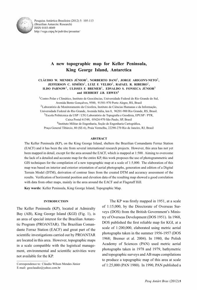
The Keller Peninsula (KP), located at AdmiraltyBay (AB), King George Island (KGI) (Fig. 1), isan area of special interest for the Brazilian Antarc-tic Program (PROANTAR). The Brazilian Coman-dante Ferraz Station (EACF) and great part of thescientific investigations carried out by PROANTARare located in this area. However, topographic mapsin a scale compatible with the logistical manage-ment, environmental and scientific activities werenot available for the KP.
Correspondence to: Cláudio Wilson Mendes JúniorE-mail: [email protected]
The KP was firstly mapped in 1951, at a scaleof 1:15,000, by the Directorate of Overseas Sur-veys (DOS) from the British Government’s Minis-try of Overseas Development (DOS 1951). In 1968,DOS published the first reliable map for KGI, at ascale of 1:200,000, elaborated using metric aerialphotographs taken in the summer 1956-1957 (DOS1968; Bremer et al. 2004). In 1980, the PolishAcademy of Sciences (PAN) used metric aerialphotographs taken in 1978 and 1979, bathymetricand topographic surveys and AB maps compilationsto produce a topographic map of this area at scaleof 1:25,000 (PAN 1980). In 1990, PAN published a
Pesq Antárt Bras (2012) 5
“main” — 2011/12/15 — 12:24 — page 106 — #2
106 CLÁUDIO WILSON MENDES JÚNIOR et al.
Fig. 1 – Location of the Keller Peninsula, Comandante Ferraz station and the site of the former British Base G (removed in 1987).
new edition of this map, at a scale of 1:50,000, with25 m contour intervals (Battke 1990). The Hydro-graphic Service (DHN) of the Brazilian Navy car-ried out geodesic, topographic and bathymetric sur-veys of the AB during the 1983-1984 summer, andproduced a nautical chart for this region at 1:40,000(Erwes 1984). A second edition of this chart waspublished in 1992, updated by surveys carried outduring the 1984-1985 summer (DHN 1992; Souza2008).
The most updated KP base map consisted ofa topographic map at a scale of 1:100,000, pro-duced in 2001 by the Institute of Physical Geo-graphy (IPG) of the University of Freiburg, Ger-many, and by Centro Polar e Climático – CPC (for-merly called Laboratório de Pesquisas Antárticase Glaciológicas – LAPAG) at the Federal Univer-sity of Rio Grande do Sul (UFRGS). This map has50 m contour intervals, derived from a Digital Ter-
rain Model (DTM) compiled with data from severalsources (Braun et al. 2001). However, data sourcecorresponding to the AB area was extracted fromthe PAN topographic map (IPG and LAPAG 2001).More recently, Francelino et al. (2004) used con-tour lines from the topographic map elaborated byBraun et al. (2001) and 90 altimetric points sur-veyed by Differential Global Positioning System(DGPS) for generating a new DTM for the KP.Furthermore, a team from the Laboratório de To-pografia e Geodésia da Escola Politécnica, Univer-sity of São Paulo (USP), Brazil, in collaborationwith the project Geoespaço(http://www.inpe.br/antartica/geoespacial.html),carried out in January–February 2006 a topographicsurvey in the area surrounding the EACF. As a resultof this survey, a topographic plan at 1:500 was pro-duced with 1 m contour intervals (Fonseca Jr. et al.2006). To overcome the lack of a detailed and ac-
Pesq Antárt Bras (2012) 5
“main” — 2011/12/15 — 12:24 — page 107 — #3
A NEW TOPOGRAPHIC MAP FOR KELLER PENINSULA 107
curate map for the entire KP area, we compiled newdata from photogrammetric and plani-altimetric datato produce a new topographic map for this area at ascale of 1:5,000.
METHODOLOGY
We used a stereopair of panchromatic vertical aerialphotographs in 23×23 cm format, at 1:50,000 scale,taken by “Servicio Aerofotogramétrico de la FuerzaAerea de Chile” (SAF) using a photogrammetriccamera Wild RC10, with focal length of 88.10 mm.These photographs were taken on January 22, 2003,as part of a flight mission requested by the “Ser-vicio Hidrográfico y Oceanográfico de la Armadadel Chile” (SHOA), covering the Antarctic Penin-sula and adjacent islands. For the data processing ina Digital Photogrammetric Station (DPS), the aerialphotographs were digitized (12.5μm resolution)using a photogrammetric scanner. We used the fol-lowing methodology: aerial photographs process-ing in the DPS (i.e., interior and exterior orienta-tion, generation and edition of a DTM); contourlines derivation from the DTM; elaboration of thetopographic map; and accuracy assessment of theresults.
INTERIOR ORIENTATION
Aerial photographs were processed in a DPS modelLPSTM (Leica Photogrammetry Suite – Leica Geo-systems GIS and Mapping, LLC), available at CPC.Firstly, a project was created in the LPSTM with theUniversal Transverse of Mercator (UTM) projec-tion, zone 21 south (21S), and data referenced to theWorld Geodetic System 1984 (WGS84) ellipsoid,which is recommended by the Scientific Committeeon Antarctic Research (SCAR) for maps at scaleslarger than 1:1,000,000 (Simões et al. 2004; SC-AGI 2009). Photographs were then stored in thisproject, as well as camera calibration parameters(SAF 1996). For this orientation, a 0.4 pixels RootMean Square Error (RMSE) was obtained for bothphotographs.
EXTERIOR ORIENTATION
As a second step, the exterior orientation of thephotographs was done. The control points used forthis step were acquired from the EACF topographicplan (Fonseca Jr. et al. 2006) and from a DGPSsurvey carried out in the KP with single-frequencyGPS receivers, executed by Bremer and Debiasi(2006). GPS data pos-processing were carried outusing reference data from the EACF GPS antenna(Fig. 3), which is a station integrated into the so-called Brazilian Network for Continuous GPSMonitoring (RBMC), managed by the BrazilianInstitute for Geography and Statistics – IBGE(Bremer and Debiasi 2006). Due to the lack of aprecise local geoid undulation model, for calcula-tion of orthometric heights from the GPS measure-ments, we used only the horizontal position of thesepoints acquired by DGPS. To overcome the lack ofaltimetric control points, we used aerial photographsto get points along the AB coastline and consideredthem as an arbitrary zero level.
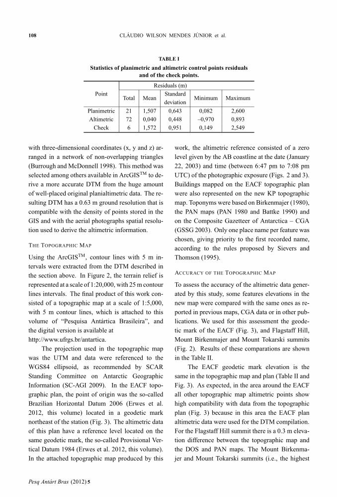
A total of 72 altimetric control points wereidentified in the stereopair along the AB coastline,as well as 21 planimetric control points and 198 tiepoints on the KP area. For the planimetric data ac-curacy assessment, 6 check points were selectedon the stereopair. A RMSE of 1.2 pixels (approx-imately 0.76 m of ground resolution) was obtainedin the Bundle Block Adjustment (Leica Geosys-tems 2003). The statistics of the planimetric andaltimetric control point’s residuals, and checkpoints, are described in Table I.
DTM GENERATION AND EDITION
Altimetry points, derived from the stereomodel,were edited in the LPSTM. These points and thedata from the EACF topographic plan (Fonseca Jr.et al. 2006) totalized 70,787 points, which werestored in the program ArcGISTM (ESRI Inc.). Inthis Geographical Information System (GIS), aDTM was created with the interpolation methodso-called Triangular Irregular Network (TIN). ATIN is a vector-based representation of the relief,made up of irregularly distributed nodes and lines
Pesq Antárt Bras (2012) 5
“main” — 2011/12/15 — 12:24 — page 108 — #4
108 CLÁUDIO WILSON MENDES JÚNIOR et al.
TABLE I
Statistics of planimetric and altimetric control points residualsand of the check points.
Residuals (m)
PointTotal Mean
StandardMinimum Maximum
deviation
Planimetric 21 1,507 0,643 0,082 2,600
Altimetric 72 0,040 0,448 –0,970 0,893
Check 6 1,572 0,951 0,149 2,549
with three-dimensional coordinates (x, y and z) ar-ranged in a network of non-overlapping triangles(Burrough and McDonnell 1998). This method wasselected among others available in ArcGISTM to de-rive a more accurate DTM from the huge amountof well-placed original planialtimetric data. The re-sulting DTM has a 0.63 m ground resolution that iscompatible with the density of points stored in theGIS and with the aerial photographs spatial resolu-tion used to derive the altimetric information.
THE TOPOGRAPHIC MAP
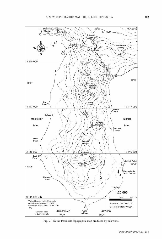
Using the ArcGISTM, contour lines with 5 m in-tervals were extracted from the DTM described inthe section above. In Figure 2, the terrain relief isrepresented at a scale of 1:20,000, with 25 m contourlines intervals. The final product of this work con-sisted of a topographic map at a scale of 1:5,000,with 5 m contour lines, which is attached to thisvolume of “Pesquisa Antártica Brasileira”, andthe digital version is available athttp://www.ufrgs.br/antartica.
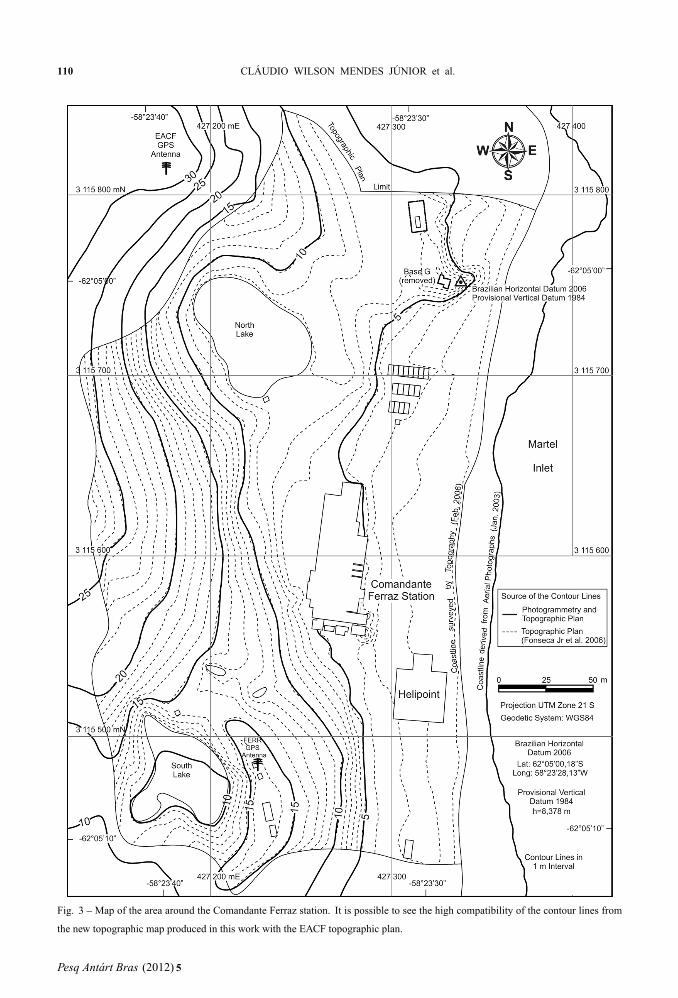
The projection used in the topographic mapwas the UTM and data were referenced to theWGS84 ellipsoid, as recommended by SCARStanding Committee on Antarctic GeographicInformation (SC-AGI 2009). In the EACF topo-graphic plan, the point of origin was the so-calledBrazilian Horizontal Datum 2006 (Erwes et al.2012, this volume) located in a geodetic marknortheast of the station (Fig. 3). The altimetric dataof this plan have a reference level located on thesame geodetic mark, the so-called Provisional Ver-tical Datum 1984 (Erwes et al. 2012, this volume).In the attached topographic map produced by this
work, the altimetric reference consisted of a zerolevel given by the AB coastline at the date (January22, 2003) and time (between 6:47 pm to 7:08 pmUTC) of the photographic exposure (Figs. 2 and 3).Buildings mapped on the EACF topographic planwere also represented on the new KP topographicmap. Toponyms were based on Birkenmajer (1980),the PAN maps (PAN 1980 and Battke 1990) andon the Composite Gazetteer of Antarctica – CGA(GSSG 2003). Only one place name per feature waschosen, giving priority to the first recorded name,according to the rules proposed by Sievers andThomson (1995).
ACCURACY OF THE TOPOGRAPHIC MAP
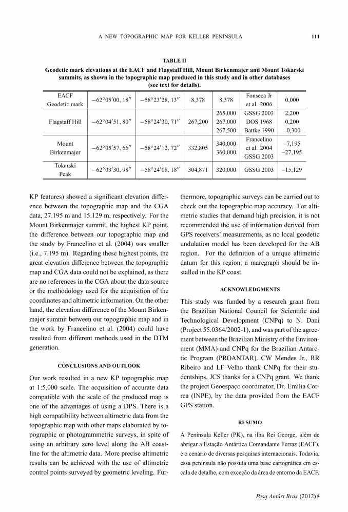
To assess the accuracy of the altimetric data gener-ated by this study, some features elevations in thenew map were compared with the same ones as re-ported in previous maps, CGA data or in other pub-lications. We used for this assessment the geode-tic mark of the EACF (Fig. 3), and Flagstaff Hill,Mount Birkenmajer and Mount Tokarski summits(Fig. 2). Results of these comparations are shownin the Table II.
The EACF geodetic mark elevation is thesame in the topographic map and plan (Table II andFig. 3). As expected, in the area around the EACFall other topographic map altimetric points showhigh compatibility with data from the topographicplan (Fig. 3) because in this area the EACF planaltimetric data were used for the DTM compilation.For the Flagstaff Hill summit there is a 0.3 m eleva-tion difference between the topographic map andthe DOS and PAN maps. The Mount Birkenma-jer and Mount Tokarski summits (i.e., the highest
Pesq Antárt Bras (2012) 5
“main” — 2011/12/15 — 12:24 — page 109 — #5
A NEW TOPOGRAPHIC MAP FOR KELLER PENINSULA 109
Fig. 2 – Keller Peninsula topographic map produced by this work.
Pesq Antárt Bras (2012) 5
“main” — 2011/12/15 — 12:24 — page 110 — #6
110 CLÁUDIO WILSON MENDES JÚNIOR et al.
Fig. 3 – Map of the area around the Comandante Ferraz station. It is possible to see the high compatibility of the contour lines from
the new topographic map produced in this work with the EACF topographic plan.
Pesq Antárt Bras (2012) 5
“main” — 2011/12/15 — 12:24 — page 111 — #7
A NEW TOPOGRAPHIC MAP FOR KELLER PENINSULA 111
TABLE II
Geodetic mark elevations at the EACF and Flagstaff Hill, Mount Birkenmajer and Mount Tokarskisummits, as shown in the topographic map produced in this study and in other databases
(see text for details).
EACF−62◦05′00, 18′′ −58◦23′28, 13′′ 8,378 8,378
Fonseca Jr0,000
Geodetic mark et al. 2006
265,000 GSSG 2003 2,200
Flagstaff Hill −62◦04′51, 80′′ −58◦24′30, 71′′ 267,200 267,000 DOS 1968 0,200
267,500 Battke 1990 –0,300
Mount−62◦05′57, 66′′ −58◦24′12, 72′′ 332,805
340,000Francelino
–7,195
Birkenmajer 360,000et al. 2004
–27,195GSSG 2003
Tokarski−62◦03′30, 98′′ −58◦24′08, 18′′ 304,871 320,000 GSSG 2003 –15,129
Peak
KP features) showed a significant elevation differ-ence between the topographic map and the CGAdata, 27.195 m and 15.129 m, respectively. For theMount Birkenmajer summit, the highest KP point,the difference between our topographic map andthe study by Francelino et al. (2004) was smaller(i.e., 7.195 m). Regarding these highest points, thegreat elevation difference between the topographicmap and CGA data could not be explained, as thereare no references in the CGA about the data sourceor the methodology used for the acquisition of thecoordinates and altimetric information. On the otherhand, the elevation difference of the Mount Birken-majer summit between our topographic map and inthe work by Francelino et al. (2004) could haveresulted from different methods used in the DTMgeneration.
CONCLUSIONS AND OUTLOOK
Our work resulted in a new KP topographic mapat 1:5,000 scale. The acquisition of accurate datacompatible with the scale of the produced map isone of the advantages of using a DPS. There is ahigh compatibility between altimetric data from thetopographic map with other maps elaborated by to-pographic or photogrammetric surveys, in spite ofusing an arbitrary zero level along the AB coast-line for the altimetric data. More precise altimetricresults can be achieved with the use of altimetriccontrol points surveyed by geometric leveling. Fur-
thermore, topographic surveys can be carried out tocheck out the topographic map accuracy. For alti-metric studies that demand high precision, it is notrecommended the use of information derived fromGPS receivers’ measurements, as no local geodeticundulation model has been developed for the ABregion. For the definition of a unique altimetricdatum for this region, a maregraph should be in-stalled in the KP coast.
ACKNOWLEDGMENTS
This study was funded by a research grant fromthe Brazilian National Council for Scientific andTechnological Development (CNPq) to N. Dani(Project 55.0364/2002-1), and was part of the agree-ment between the Brazilian Ministry of the Environ-ment (MMA) and CNPq for the Brazilian Antarc-tic Program (PROANTAR). CW Mendes Jr., RRRibeiro and LF Velho thank CNPq for their stu-dentships, JCS thanks for a CNPq grant. We thankthe project Geoespaço coordinator, Dr. Emília Cor-rea (INPE), by the data provided from the EACFGPS station.
RESUMO
A Península Keller (PK), na ilha Rei George, além de
abrigar a Estação Antártica Comandante Ferraz (EACF),
é o cenário de diversas pesquisas internacionais. Todavia,
essa península não possuía uma base cartográfica em es-
cala de detalhe, com exceção da área de entorno da EACF,
Pesq Antárt Bras (2012) 5
“main” — 2011/12/15 — 12:24 — page 112 — #8
112 CLÁUDIO WILSON MENDES JÚNIOR et al.
que está mapeada em uma planta topográfica na escala
1:500. Para suprir a falta de uma base cartográfica precisa
e detalhada para toda a área da PK, este estudo elaborou
um mapa topográfico dessa península na escala 1:5.000,
a partir de um estereopar de fotografias aéreas métricas
em uma estação fotogramétrica digital e usando dados
da planta da EACF, armazenados em um Sistema de In-
formações Geográficas (SIG). A metodologia utilizada
na elaboração deste mapa consistiu na orientação interna
e externa das fotografias, geração e edição de um Mo-
delo Digital do Terreno (MDT), extração das curvas de
nível do MDT e avaliação da precisão dos dados produzi-
dos. Os dados planialtimétricos do mapa topográfico apre-
sentaram boa compatibilidade com outros mapas-base,
principalmente na área de entorno da EACF e do morro
Flagstaff.
Palavras-chave: Península Keller, ilha Rei George,
mapa topográfico.
REFERENCES
BATTKE Z. 1990. Admiralty Bay, King George Island.Map, 1:50.000. Warsaw: Nakladem InstytutuEkologii, PAN.
BIRKENMAJER K. 1980. New place names introducedto the area of Admiralty Bay, King George Island(South Shetland Islands, Antarctica). Studia Geo-logica Polonica 66: 67–88.
BRAUN M, SIMÕES JC, VOGT S, BREMER UF, BLIN-DOW N, PFENDER M, SAURER H, AQUINO FEAND FERRON FA. 2001. An improved topographicdatabase for King George Island. Compilation,application and outlook. Antarct Sci 13: 41–52.
BREMER UF AND DEBIASI P. 2006. Projeto Integraçãode dados ambientais da Área Antártica Especialmen-te Gerenciada Baía do Almirantado através de Sis-tema de Informações Geográficas. Relatório sucintode campo. Fase III da OPERANTAR XXIV. PortoAlegre: NUPAC. 4 p. Unpublished.
BREMER UF, ARIGONY-NETO J AND SIMÕES JC.2004. Teledetcção de mudanças nas bacias de dre-nagem de gelo da ilha Rei George, Shetlands do Sul,Antártica, entre 1956 e 2000. Pesq Antart Bras 4:37–48.
BURROUGH PA AND MCDONNELL RA. 1998. Princi-ples of Geographical Information Systems. Oxford:Oxford University. 333 p.
DHN – DIRETORIA DE HIDROGRAFIA DE NAVEGA-ÇÃO. 1992. Baía do Almirantado – Ilha Rei George.Map, 1:40.000. Rio de Janeiro: DHN, Marinha doBrasil.
DOS – DIRECTORATE OF OVERSEAS SURVEYS. 1951.A plane-table survey of the area around Base G.Map, 1:15,000. Cambridge: DOS.
DOS – DIRECTORATE OF OVERSEAS SURVEYS. 1968.British Antarctic Territory. South Shetland Islands.Map, 1:200,000. Cambridge: DOS.
ERWES HJB. 1984. Levantamentos Geodésicos e To-pográficos no Projeto Antárctica II (CartografiaNáutica na Antárctica) da DHN – Diretoria de Hi-drografia e Navegação. Janeiro–Fevereiro de 1984(Separata dos Anais Hidrográficos – TOMO XLI).
ERWES HJB, PRADO WS, FAZAN JA, FONSECA JR
ES AND MENDES JR CW. 2012. Topographic sur-vey and photogrammetric documentation of the Bra-zilian Antarctic Station Comandante Ferraz. PesqAntart Bras 5: 95–103.
FONSECA JR ES, ERWES HJB, FAZAN JA, SASSAKI
ASA AND CORREIA E. 2006. Levantamento to-pográfico plani-altimétrico da Estação AntárticaComandante Ferraz. In: SIMPÓSIO BRASILEIRO
SOBRE PESQUISA ANTÁRTICA, 14, São Paulo.Anais..., São Paulo: USP, 2006, p. 111–112.
FRANCELINO MR, SCHAEFER CEGR, FERNANDES
FILHO EIF, ALBUQUERQUE FILHO MR, SIMAS
FNB AND MOREIRA GF. 2004. Geoformas da Pe-nínsula Keller, Antártica Marítima: subsídios aomonitoramento ambiental. In: SCHAEFER CEGRET AL. (Ed.), Ecossistemas costeiros e monitora-mento ambiental da Antártica Marítima, Viçosa:NEPUT, p. 15–25.
GSSG – STANDING SCIENTIFIC GROUP ON GEO-SCIENCE. 2003. Composite Gazetteer of Antarctica.http://data.aad.gov.au/aadc/gaz/scar/
IPG AND LAPAG – INSTITUT FÜR PHYSISCHE
GEOGRAPHIE AND LABORATÓRIO DE PESQUISAS
ANTÁRTICAS E GLACIOLÓGICAS. 2001. KingGeorge Islands. Map, 1:100.000. Freiburg: IPG.
LEICA GEOSYSTEMS. 2003. Leica PhotogrammetrySuite OrthoBASE & OrthoBASE Pro. User’s guide.Georgia: Leica Geosystems GIS & Mapping. 516 p.
PAN – POLSKIEJ AKADEMII NAUK. 1980. ZatokaAdmiralicji. Map, 1:25.000. Warsaw: PAN.
SAF – SERVICIO AEROFOTOGRAMÉTRICO DE LA
FUERZA AEREA DE CHILE. 1996. Certificado decalibración de cámara RC-10. Calibration made by
Pesq Antárt Bras (2012) 5

“main” — 2011/12/15 — 12:24 — page 113 — #9
A NEW TOPOGRAPHIC MAP FOR KELLER PENINSULA 113
Leica Instruments Inc. in 06/06/1996. Santiago:SAF. 5 p.
SC-AGI – STANDING COMMITTEE ON ANTARCTIC
GEOGRAPHIC INFORMATION OF THE SCIENTIFIC
COMMITTEE ON ANTARCTIC RESEARCH. 2009.http://www.antsdi.scar.org/
SIEVERS J AND THOMSON W. 1995. Adopting onename per feature on maps of Antarctica: an experi-mental application – Topographic Map (SatelliteImage Map) 1:250.000. Trinity Peninsula SP 21-22/13. Polarforschung 65: 123–131.
SIMÕES JC, ARIGONY-NETO J AND BREMER UF.2004. O uso de mapas antárticos em publicações.Pesq Antart Bras 4: 191–197.
SOUZA JEB. 2008. Brasil na Antártica: 25 anos deHistória. São Carlos: Vento Verde. 167 p.
Pesq Antárt Bras (2012) 5