Embed Size (px)
Citation preview
A PATH THROUGH THE MOUNTAINS:
THE ARCHEOLOGY AND HISTORY OF THE
CHESAPEAKE & OHIO CANAL NATIONAL HISTORICAL PARK
By
John Bedell, Stuart Fiedel, and Jason Shellenhamer
September 2011
A PATH THROUGH THE MOUNTAINS:
THE ARCHEOLOGY AND HISTORY OF THE
CHESAPEAKE & OHIO CANAL NATIONAL HISTORICAL PARK
PREPARED FOR:
National Park Service National Capital Region 1100 Ohio Drive, S.W.
Washington, D.C. 20242
PREPARED BY:
John Bedell, Stuart Fiedel, Jason Shellenhamer
THE LOUIS BERGER GROUP, INC. 1250 23rd Street, N.W.
Washington, D.C. 20037
September 2011
i
TABLE OF CONTENTS
Page I. The Canal and the River ............................................................................................ II. Archeology along the River ....................................................................................... The Archeological Inventory Study ........................................................................... Digging Deep for the Distant Past ............................................................................. High Tech Archeology ............................................................................................... III. Making a Living ......................................................................................................... Hunting and Gathering in the Archaic Era ................................................................ The First Invaders: the Broadspear People ................................................................ Potsherds .................................................................................................................... Farming ...................................................................................................................... The Moore Village .............................................................................................. Tenants Along the Potomac ....................................................................................... Spring Dell Road Site Industry Along the Canal ........................................................................................... Iron Works at the Antietam Furnace .................................................................. Spring Dell Road Site ......................................................................................... Lock Keepers and Other Canal People ...................................................................... Box: Harvey Brandt ................................................................................................... IV. Frontiers ..................................................................................................................... Dividing Lines ........................................................................................................... Meeting Places ........................................................................................................... Israel Friend’s Deed ............................................................................................ Box: Charles Anderson .............................................................................................. V. A Battleground ........................................................................................................... The Fur Trade Wars ................................................................................................... The Rangers ........................................................................................................ King Opessa and the Shawnee ............................................................................ King Opessa’s Town ........................................................................................... The End of King Opessa’s Town ........................................................................ Search for King Opessa’s Town ......................................................................... The Great War for Empire ......................................................................................... Box: Thomas Cresap ........................................................................................... Cresap’s Fort ....................................................................................................... Labor Strife and Financial Turmoil ...........................................................................

ii
Searching for Workers’ Camps .......................................................................... Garrisons and Skirmishes: The Civil War ................................................................. Antietam and Gettysburg Campaigns ................................................................. The Canal in Wartime ......................................................................................... VI. The End of an Era, the Beginning of an Era ..............................................................
iii
LIST OF ILLUSTRATIONS
Page 1 The C&O Canal Today .............................................................................................. 2 The Potomac River Cutting Through the Appalachian Mountains ........................... 3 Test Unit at a Stratified Prehistoric Site in the C&O Canal Park .............................. 4 Stone Spear and Arrow Points from a Site in the C&O Canal Park .......................... 5 Deep Test Unit at a Stratified Site near Tuscarora Creek .......................................... 6 Scraper ....................................................................................................................... 7 Aerial Photograph of the Shawnee Oldfields Site ..................................................... 8 High Resolution Magnetometer in Use at the Shawnee Oldfields Site ..................... 9 Raw Magnetometer Data from the Shawnee Oldfields Site ...................................... 10 Magnetometer Map of the Shawnee Oldfields Site ................................................... 11 Excavation of Feature 1 at the Shawnee Oldfields Site ............................................. 12 Artifacts from Feature 1 at the Shawnee Oldfields Site ............................................ 13 Scraper of the Type Called a Spokeshave, Found near Tuscarora Creek .................. 14 Large Stone Ax from a Site Along the Potomac ........................................................ 15 Bifurcate Points, 8000 to 7000 BC, from a Site Along the Potomac ......................... 16 Late Archaic Halifax Points from the Virginia Piedmont ......................................... 17 Savannah River Points, 2500 to 2000 BC, from a Site Along the Potomac .............. 18 Excavation at the Broad Run Site, Showing the Savannah River Level ................... 19 Savannah River Point in situ at the Broad Run Site .................................................. 20 John White’s 1585 Watercolor of an Indian Pot on a Fire ........................................ 21 Excavation at the 999 Levee Site ............................................................................... 22 Artifacts from the 999 Levee Site .............................................................................. 23 Excavation at the Frog Run Site ................................................................................ 24 Potsherds from the Frog Run Site .............................................................................. 25 John White’s 1585 Watercolor of the Village of Pomeioc ........................................ 26 Keyser Pottery from the Moore Village ..................................................................... 27 Bone Tools from the Moore Village .......................................................................... 28 Map of Tenancies at Brightwell’s Hunting Quarter .................................................. 29 Artifacts from the Eighteenth-Century Tenancy at Spring Dell Road ....................... 30 Dabny Mill and Foundation ....................................................................................... 31 Gold Mine near Dargan ............................................................................................. 32 Lime Kilns Along the C&O Canal ............................................................................. 33 Williamsport in the Early Twentieth Century ............................................................ 34 Mill Foundations Along Antietam Creek .................................................................. 35 Antietam Furnace ....................................................................................................... 36 Archeologists Working by a Lockhouse .................................................................... 37 Lockhouse 44 around 1920 ........................................................................................ 38 Lockhouse 44 Today .................................................................................................. 39 Philemon Lloyd’s 1721 Map of the Upper Potomac River ....................................... 40 Artifacts from a Middle Woodland Burial at the Whitehurst Freeway Site .............. 41 Swedish Settlers Painted in the Early 1700s by Gustavus Hesselius ......................... 42 Swedish Log House in New Jersey ............................................................................
iv
LIST OF ILLUSTRATIONS (continued)
Page 43 The Oldtown Area in 1736, Showing Charles Anderson’s Cabin ............................. 44 A Susquehannock Warrior ......................................................................................... 45 Franquelin Map of North America, Showing the Route of the Shawnee from Starved Rock to the East ................................................................................... 46 Tishcohan, a Delaware Chief Who Lived for a Time at Conestoga, Painted by Gustavus Hesselius .................................................................................. 47 The Route from Wills Creek (Cumberland) to the Forks of the Ohio ....................... 48 The Cresap’s Fort Site ............................................................................................... 49 Artifacts from the Cresap’s Fort Site ......................................................................... 50 Irish Workers Repairing the C&O Canal in the 1890s .............................................. 51 Excavating a Brick Clamp at the Paw Paw Supervisor’s House Site ........................ 52 Stone Foundation of Large Building at the Paw Paw Supervisor’s House Site ........ 53 A Small Civil War Earthwork near Whites Ferry ...................................................... 54 Contemporary Drawing of Jackson’s Attempt to Destroy Dam No. 5 in December 1861 ...................................................................................................... 55 Walking the Towpath .................................................................................................

1
I. THE CANAL AND THE RIVER The Chesapeake & Ohio Canal National Historical Park follows the Potomac River for 184.5 miles, from Washington, D.C., westward to Cumberland, Maryland. Beginning just below the Falls of the river, at the edge of the Coastal Plain, the canal runs up across the hilly Piedmont and deep into the heart of the Appalachian Mountains (Figure 1). Long before the canal was built, the river had cut a level path through the steep mountain ridges, a route that was used by hundreds of generations of native people to pass from the eastern Coastal Plain to the Ohio Valley (Figure 2). The canal, built between 1828 and 1850, shares the river shore with the Baltimore & Ohio Railroad, which won the race to provide the first easy route between Chesapeake Bay and the Ohio River. Before the canal barges and the steam engines, the keelboats and wagons of traders and pioneer farmers traveled along the river, first carrying goods and then settlers into the hills and valleys. French Canadians, Swedes from Delaware, Quakers from Philadelphia, and English planters from the Chesapeake all traveled upriver beyond the Falls of the Potomac before 1710, followed later by Germans, Scots, and Irish. In 1755 General Braddock marched his doomed army along the river, dragging their cannons behind them, toward the French fort on the site now known as Pittsburgh, and the survivors of his defeat marched back the same way, having left their cannons and other heavy gear behind them. One of the survivors was Daniel Boone, making his first trip west into the Ohio country, where he would later make his name and fortune. Another was George Washington, who was making this journey for the third time. Neither of the previous two trips was any more successful than his expedition with Braddock, but Washington was captivated by the country and by the river that ran through it, and he returned home to become both a major investor in Ohio Valley lands and a great promoter of navigation on the Potomac. Before the route Braddock used to cross from the Potomac to the Monongahela was known as Braddock’s Road, it was called the Nemacolin Trail. Nemacolin, a Delaware Indian, had laid it out for the frontier scout, Christopher Gist. But Nemacolin was only following one version of a route used by thousands of Native Americans before him. Shawnees, Piscataways, Tuscaroras, Susquehannocks, and Delawares all lived along the river at various times, while Senecas, Miamis, Cherokees, and many others crossed its fords and paddled on its waters. Some of them called the upper river Cohongorooto, distinguishing it from the tidal Potomac below the Falls. Before them, before records survive that say what people called themselves, others lived along the river, building villages and planting corn in the rich soils of the floodplain. Before the corn planters came, hunters, fishers, and gatherers of wild plants camped along the river, as they had for thousands of years. Even further back, at the end of the Ice Age, America’s first people, trekked along the river, perhaps hunting caribou in the cold spruce forests. All of these people left traces of themselves along the Potomac River, and therefore in the C&O Canal National Historical Park. Hunters dropped stone knives and spear points, gatherers their grinding stones, and everywhere Stone Age people went they left their signature, the piles of waste flakes discarded when they made or sharpened their stone tools. Later peoples made pottery, and sherds of their vessels mark the spots of their homes. At the villages of the corn planters, archeologists find the stains left in the soil by the posts that made up their houses and the stockades that kept out their enemies. European settlers left pottery, glass, and nails; Civil
2
War soldiers left bullets, buttons, and bits and pieces of their gear. The banks of the Potomac are therefore lined with archeological sites that preserve a record of 13,000 years of history. The special nature of a river valley like the Potomac’s makes these sites even more important. Whenever the river overflows its banks, it dumps sand and silt on the flooded ground, and as a result the surface of those floodplains slowly rises. Artifacts laid down next to the river are gradually buried more and more deeply. The river’s silt therefore separates the artifacts from different periods into layers, one above the other, and the deeper archeologists dig along the river bank, the further they reach back into time. The archeology of the Potomac River valley is extraordinary. Along this natural highway traversed by so many people, the action of the river buries and protects the remains they left behind. The result is a record with few parallels. This book uses that record to tell the story of the people who lived along the river, from caribou hunters to canal boatmen. For the first 12,000 years the story is based only on archeology, but for the past few hundred much can be learned from written records. The history of the canal is one part of the long and magnificent story of the Potomac River, a story well worth the years of effort it has taken to uncover it and write it out.
3
II. ARCHEOLOGY ALONG THE RIVER THE ARCHEOLOGICAL INVENTORY STUDY For nine years, from 2001 to 2010, archeologists from The Louis Berger Group, Inc., carried out an archeological inventory and assessment study of the C&O Canal Park. The study was funded by the National Park Service to discover and document important archeological sites in the Park. The study was divided into three parts. The first three years were devoted to the lower segment of the canal, from Georgetown to Sandy Hook. The second three years covered the central segment, across the Great Valley from Sandy Hook to Hancock. The final three years covered the upper segment, from Hancock to Cumberland. Each one of these studies was documented in a multi-volume technical report. The main goals of the nine-year study were finding archeological sites and assessing their importance. Therefore, not much excavation was done on any one site. At some sites no digging was done at all, just inspecting visible ruins or collecting artifacts on the surface of a plowed field. At other sites a single deep excavation unit was dug, typically measuring about 3x6 feet (Figure 3). Of course, many archeological sites had already been discovered in the Park by other archeologists. Artifact collections from these sites were inspected, and old notes and reports reviewed. Where there were questions, old sites were revisited, but where the older work was well documented and the location of the site clear, no new fieldwork was done. The great challenge of the project was coping with such a vast resource. At some time in the past, somebody lived or camped on almost every square foot of the Potomac’s banks, along the whole 184.5 miles of the canal. Most of the Park, at least the parts that are not too steep to stand on, is in some sense an archeological site. Not only that, but in some places artifacts could be buried as much as 15 feet below the surface. To document all of the archeological sites in the Park was therefore impossible. The goals of the archeologists were to find a sample of the most important sites, and to find sites related to every period of the Park’s history. That is, they wanted to find camp sites of Indians from thousands of years ago, villages of more recent Indians, cabins of pioneer settlers, camps of the men who built the canal, Civil War earthworks, industrial sites such as mills, and the homes of people who lived and worked along the canal. To assist in this search, a great deal of documentary research was done, using colonial land records, old maps, narrative histories, and other works. A geologist, Dr. Daniel Wagner, carried out an extensive study of the river terraces, searching for places that would have been good camp sites at various times in the distant past. The results of the study have been spectacular. More than 100 new archeological sites have been discovered and thousands of artifacts found (Figure 4). Several of the newly discovered sites are of very high significance because they contain important data about little known periods in the past. The historical research turned up new information, especially about the colonial frontier. Some myths about the Park’s history were refuted, other old stories confirmed. New chapters have been added to the exciting history of the Potomac River, and already known stories have acquired new richness and detail.
4
DIGGING DEEP FOR THE DISTANT PAST It is not difficult to find artifacts left by prehistoric Native Americans, at least not in the Middle Atlantic region. At some time or other in the past 13,000 years, a band, a family, or a hunting party camped on most level hilltops and terraces overlooking streams or swamps. Traces of their presence can be found by walking a field after plowing, or by sticking a shovel in the ground. Most of the “artifacts” (human-made objects) that turn up in these places are the waste flakes and chips from making stone tools. Archeologists call this stone debris “debitage.” These stone flakes are the basic signature of Stone Age peoples, and they are present by the hundreds or thousands wherever Native Americans camped. Spear or dart points and other stone tools are also quite common, and many farmers have taken bushel baskets full out of their fields (most people call the stone points “arrowheads,” but archeologists are fairly sure that the bow and arrow were not used in North America before about AD 500). Unfortunately, these hilltop sites are not especially useful for learning about the past. They usually tell archeologists only that somebody, sometime, camped there. Almost all such sites have been plowed, which mixes up everything that has ever been deposited in a given spot into one layer. Artifacts now lying side by side may have been dropped thousands of years apart. Archeologists therefore have no way of knowing if the artifacts found in the “plowzone” represent a stay of several months by a group of 50 people or many one-day visits by lone hunters; nor can they say whether those visits were spread over a decade or 5,000 years. Sometimes the stone tools themselves speak about what people were doing. For example, stones used to grind nuts or seeds are quite distinctive, and some notched stones seem to have been weights for fishing nets. For the most part, though, all archeologists know about a hilltop site is that people were there, and that they made, repaired, or lost stone knives and spear points. Also, in the shallow, acidic, and often exposed soils on hilltop sites, organic materials such as bone, burnt nutshells, seeds, and wood are rarely preserved. Without bones archeologists cannot determine which animals people hunted or which fish they netted; without nutshells and seeds they cannot know which plants were collected; and without any preserved charcoal in direct association with the stone tools, they cannot use the radiocarbon method to obtain a precise date for the occupation. Archeologists can extract much better information from sites where the settlements of different periods are clearly separated from each other. Flooding rivers, which continually add to the thick layers of silt and sand on their banks, often achieve this very neatly. By studying these “stratified” sites, built up like layer cakes by repeated flooding, archeologists can learn what particular groups of people did and when they did it (Figure 5). Artifacts found at the same undisturbed level must have been dropped at about the same time. Patterns of artifacts and fireplaces (“hearths”) at the same level mark out camps and show how people used space. Floodplain sediments also sometimes preserve bone, charcoal, and other organic materials that are always destroyed on the uplands. To understand what archeologists can learn from digging along the Potomac, it is simplest to look at one site among many and see what was found there. A good site to consider is the one shown in Figure 5. This site is not far west of the Monocacy River, where a little stream makes a
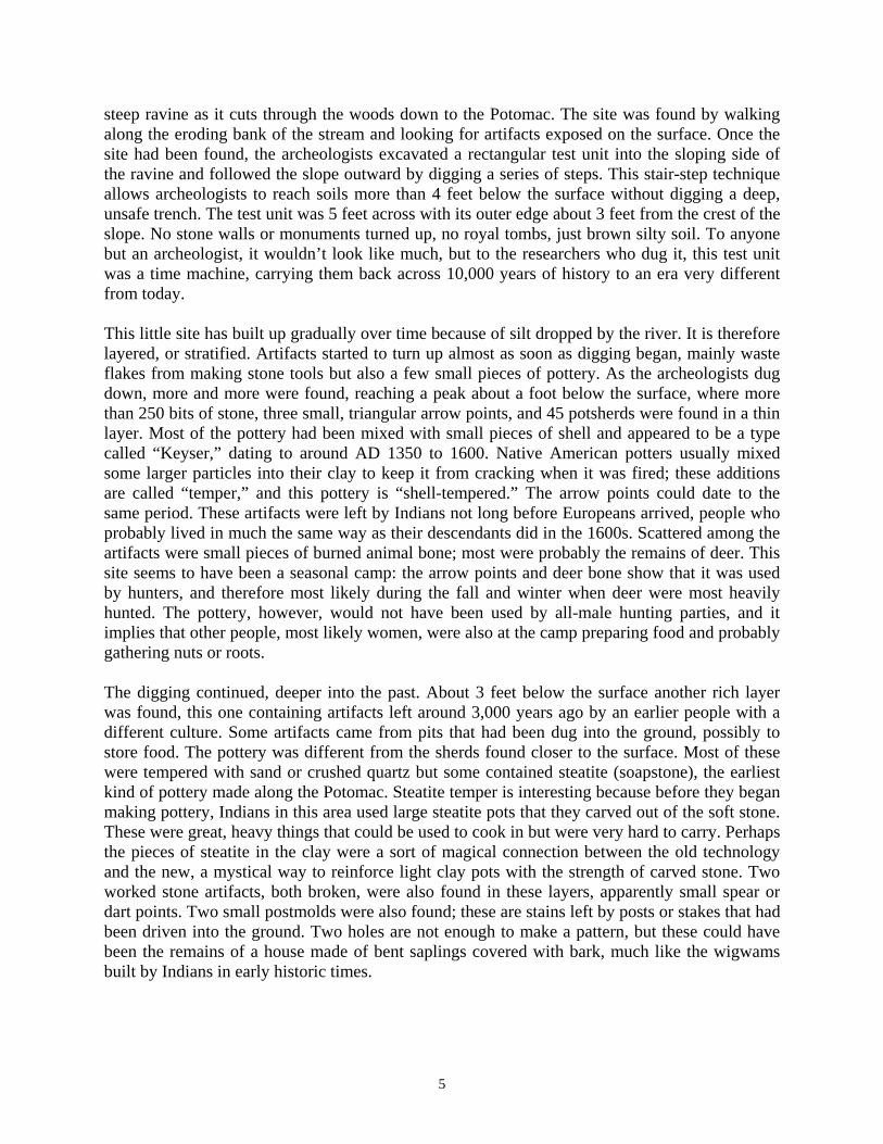
5
steep ravine as it cuts through the woods down to the Potomac. The site was found by walking along the eroding bank of the stream and looking for artifacts exposed on the surface. Once the site had been found, the archeologists excavated a rectangular test unit into the sloping side of the ravine and followed the slope outward by digging a series of steps. This stair-step technique allows archeologists to reach soils more than 4 feet below the surface without digging a deep, unsafe trench. The test unit was 5 feet across with its outer edge about 3 feet from the crest of the slope. No stone walls or monuments turned up, no royal tombs, just brown silty soil. To anyone but an archeologist, it wouldn’t look like much, but to the researchers who dug it, this test unit was a time machine, carrying them back across 10,000 years of history to an era very different from today. This little site has built up gradually over time because of silt dropped by the river. It is therefore layered, or stratified. Artifacts started to turn up almost as soon as digging began, mainly waste flakes from making stone tools but also a few small pieces of pottery. As the archeologists dug down, more and more were found, reaching a peak about a foot below the surface, where more than 250 bits of stone, three small, triangular arrow points, and 45 potsherds were found in a thin layer. Most of the pottery had been mixed with small pieces of shell and appeared to be a type called “Keyser,” dating to around AD 1350 to 1600. Native American potters usually mixed some larger particles into their clay to keep it from cracking when it was fired; these additions are called “temper,” and this pottery is “shell-tempered.” The arrow points could date to the same period. These artifacts were left by Indians not long before Europeans arrived, people who probably lived in much the same way as their descendants did in the 1600s. Scattered among the artifacts were small pieces of burned animal bone; most were probably the remains of deer. This site seems to have been a seasonal camp: the arrow points and deer bone show that it was used by hunters, and therefore most likely during the fall and winter when deer were most heavily hunted. The pottery, however, would not have been used by all-male hunting parties, and it implies that other people, most likely women, were also at the camp preparing food and probably gathering nuts or roots. The digging continued, deeper into the past. About 3 feet below the surface another rich layer was found, this one containing artifacts left around 3,000 years ago by an earlier people with a different culture. Some artifacts came from pits that had been dug into the ground, possibly to store food. The pottery was different from the sherds found closer to the surface. Most of these were tempered with sand or crushed quartz but some contained steatite (soapstone), the earliest kind of pottery made along the Potomac. Steatite temper is interesting because before they began making pottery, Indians in this area used large steatite pots that they carved out of the soft stone. These were great, heavy things that could be used to cook in but were very hard to carry. Perhaps the pieces of steatite in the clay were a sort of magical connection between the old technology and the new, a mystical way to reinforce light clay pots with the strength of carved stone. Two worked stone artifacts, both broken, were also found in these layers, apparently small spear or dart points. Two small postmolds were also found; these are stains left by posts or stakes that had been driven into the ground. Two holes are not enough to make a pattern, but these could have been the remains of a house made of bent saplings covered with bark, much like the wigwams built by Indians in early historic times.
6
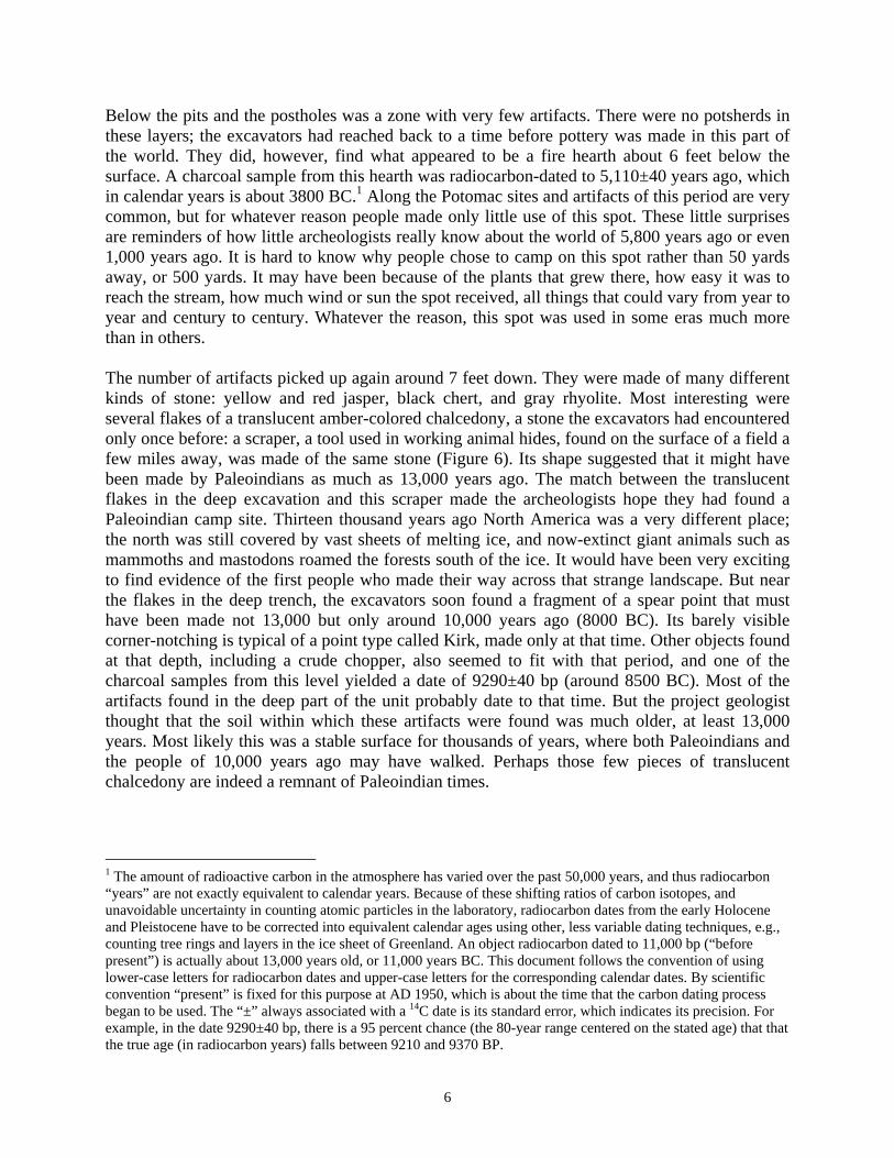
Below the pits and the postholes was a zone with very few artifacts. There were no potsherds in these layers; the excavators had reached back to a time before pottery was made in this part of the world. They did, however, find what appeared to be a fire hearth about 6 feet below the surface. A charcoal sample from this hearth was radiocarbon-dated to 5,110±40 years ago, which in calendar years is about 3800 BC.1 Along the Potomac sites and artifacts of this period are very common, but for whatever reason people made only little use of this spot. These little surprises are reminders of how little archeologists really know about the world of 5,800 years ago or even 1,000 years ago. It is hard to know why people chose to camp on this spot rather than 50 yards away, or 500 yards. It may have been because of the plants that grew there, how easy it was to reach the stream, how much wind or sun the spot received, all things that could vary from year to year and century to century. Whatever the reason, this spot was used in some eras much more than in others. The number of artifacts picked up again around 7 feet down. They were made of many different kinds of stone: yellow and red jasper, black chert, and gray rhyolite. Most interesting were several flakes of a translucent amber-colored chalcedony, a stone the excavators had encountered only once before: a scraper, a tool used in working animal hides, found on the surface of a field a few miles away, was made of the same stone (Figure 6). Its shape suggested that it might have been made by Paleoindians as much as 13,000 years ago. The match between the translucent flakes in the deep excavation and this scraper made the archeologists hope they had found a Paleoindian camp site. Thirteen thousand years ago North America was a very different place; the north was still covered by vast sheets of melting ice, and now-extinct giant animals such as mammoths and mastodons roamed the forests south of the ice. It would have been very exciting to find evidence of the first people who made their way across that strange landscape. But near the flakes in the deep trench, the excavators soon found a fragment of a spear point that must have been made not 13,000 but only around 10,000 years ago (8000 BC). Its barely visible corner-notching is typical of a point type called Kirk, made only at that time. Other objects found at that depth, including a crude chopper, also seemed to fit with that period, and one of the charcoal samples from this level yielded a date of 9290±40 bp (around 8500 BC). Most of the artifacts found in the deep part of the unit probably date to that time. But the project geologist thought that the soil within which these artifacts were found was much older, at least 13,000 years. Most likely this was a stable surface for thousands of years, where both Paleoindians and the people of 10,000 years ago may have walked. Perhaps those few pieces of translucent chalcedony are indeed a remnant of Paleoindian times.
1 The amount of radioactive carbon in the atmosphere has varied over the past 50,000 years, and thus radiocarbon “years” are not exactly equivalent to calendar years. Because of these shifting ratios of carbon isotopes, and unavoidable uncertainty in counting atomic particles in the laboratory, radiocarbon dates from the early Holocene and Pleistocene have to be corrected into equivalent calendar ages using other, less variable dating techniques, e.g., counting tree rings and layers in the ice sheet of Greenland. An object radiocarbon dated to 11,000 bp (“before present”) is actually about 13,000 years old, or 11,000 years BC. This document follows the convention of using lower-case letters for radiocarbon dates and upper-case letters for the corresponding calendar dates. By scientific convention “present” is fixed for this purpose at AD 1950, which is about the time that the carbon dating process began to be used. The “±” always associated with a 14C date is its standard error, which indicates its precision. For example, in the date 9290±40 bp, there is a 95 percent chance (the 80-year range centered on the stated age) that that the true age (in radiocarbon years) falls between 9210 and 9370 BP.
7
HIGH TECH ARCHEOLOGY These days, archeologists can sometimes learn what is under the ground without digging. A battery of new technologies can “see” buried things without the work of excavation, saving a great deal of time and money. Since digging always damages the excavated sites, these new technologies also offer a more sensitive way to study the past, without damaging important or sacred sites. Some of these new techniques were used to study an Indian village site near Oldtown known as the Shawnee Oldfields Site. Artifacts collected on the surface showed that this site dates to the Late Woodland period, AD 1200 to 1600. The oldest of these “remote sensing” technologies is aerial photography, which archeologists have been using for 80 years. When the light is right, mounds and ditches too gradual to be visible from the ground can be seen from the air because of their shadows. Archeological features can also cause change in how plants grow — poorly over stone walls, well over pits full of organic trash — and these differences can also be seen from the air. If you look closely at this photograph of the Shawnee Oldfields Site (Figure 7), you can see two dark rings that mark the locations of two separate villages. Before the archeologists put a shovel to the ground, they knew they were dealing with two villages rather than just one. To learn more about these villages, the archeologists used one of the newest technologies: high-resolution magnetometry. A magnetometer is a machine that measures minute changes in the earth’s magnetic field (Figure 8). Because digging and burning change the magnetic properties of the soil, and all people dig holes and make fires, a magnetometer in expert hands can pick up signals that show where people lived and worked. The raw data from the magnetometer survey of the Shawnee Oldfields Site are shown in Figure 9. This picture is fascinating in its own right, but powerful new software can improve the image by, for example, screening out the effects of plowing and the signatures of modern fence posts. This produces an image like the next figure (Figure 10). Many Indian villages were surrounded by palisades made of logs set upright in the ground. The processed magnetometer data from Shawnee Oldfields show that the western village had at least three palisades, and the eastern village, at least one. The image of the western village shows concentrations of features that may be houses. The larger dots in the image are probably pits that contain a lot of wood ash and other trash, just the sort of features that archeologists love to dig up. To test the magnetometer map, the archeologists went to the location of one of those large dots and dug a test unit. They did indeed find a large pit, measuring about 3 feet across and a foot deep (Figures 11 and 12). The soil in the pit was mixed with ash and burned daub and it contained hundreds of artifacts: three triangular stone arrow points, dozens of potsherds, hundreds of waste flakes from making stone tools, and dozens of animal bones. Most of the bones were from white-tailed deer, and others are from turtles. The pottery is a type known to archeologists as Keyser, in which the clay is mixed with crushed shell. Because the soil contained so much charcoal, a sample was sent to the laboratory of a paleobotanist (a scientist who studies ancient plants). The paleobotanist put the soil in water in a special machine called a flotation tank that uses fine mesh to collect all the plant matter that

8
floated in the water. Most of this was wood ash. Mixed with the ash were several pieces of hickory nut, three small pieces of maize or corn, and a sumac seed. Those burned hickory nut shells were radiocarbon-dated, returning a date of about AD 1490 to 1560. Using all of these techniques, from magnetometry to paleobotany to old-fashioned shovel work, archeologists have learned a great deal about the Shawnee Oldfields Site and the people who lived there.
9
III. MAKING A LIVING HUNTING AND GATHERING IN THE ARCHAIC ERA The first inhabitants of the upper Potomac were hunters and gatherers. Instead of living in villages, they roamed the landscape in small groups, finding food and shelter as they moved about. Their tools were made of stone, bone, and wood. From the first settlement of the region, around 13,000 years ago, down to 7,000 years ago, the population of the region was low. The whole of the Potomac drainage above the falls might have been within the territory of a single band of 100 to 300 people. Such a group might come together in one season of the year at a place where food was plentiful, perhaps along the river for the spring runs of herring and shad, or the deer hunts and nut gathering in the fall. In other seasons they might split up into smaller family groups that journeyed to favorite valleys. The most obvious evidence these people left behind is their stone tools (Figure 13). Thousands of ancient stone tools have been found along the river. Some were made with great care, whereas others are just sharp rocks. The Indians of thousands of years ago did not use the bow and arrow. Instead they hunted with spears or darts, probably using a spear thrower or atlatl to throw harder and farther. The sharp stone points found where ancient Indians camped are not arrowheads, but spear or dart points. Other kinds of stone tools archeologists often find are ax heads, scrapers, drills, and knives. Life for hunter-gatherers depended heavily on the climate. Around 7800 BC the North American climate grew warmer and drier, and as one would expect, archeologists find much more evidence of human settlement in the mountains than before. This period is called the Middle Archaic. Middle Archaic sites are larger and more numerous than those from earlier periods. Because of changes in the resources they used, Middle Archaic people camped in areas that had been previously ignored, such as upland swamps and interior ridges and mountaintops, but their base camps were still located mainly in the floodplains of major streams. New tools were specifically designed for wood-working, such as axes, adzes, and mauls (Figure 14), seed-grinding (groundstone slabs), or nut-cracking (pitted stones). People of this time liked to make their spear points from a volcanic stone called rhyolite, which can be found on certain slopes of the Blue Ridge and Catoctin Mountains. They must have walked for days to reach these outcrops. Spear points made between 7800 and 6000 BC often have a split or “bifurcated” base. Nobody knows why. This unusual style makes it easy to identify sites of this period. Many bifurcate points have been found at sites in the Piedmont (Figure 15) and in the mountains, showing that people camped regularly along the river at that time. By around 5000 BC the population of North America had grown much larger. Artifacts of the next 3,000 years — the Late Archaic period — are very common across the whole Middle Atlantic region, along almost every river, creek, pond, and swamp. People of that time must have been masters of the forest environment. They knew how to hunt all of the animals and how to find all of the edible plants. They seem to have moved frequently across the landscape in small groups, camping for a few days or weeks in each spot. Beyond that, little is known about them. At their campsites archaeologists find little beyond stone tools, waste flakes, and cobbles cracked
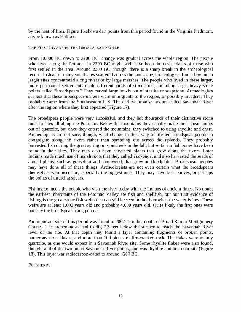
10
by the heat of fires. Figure 16 shows dart points from this period found in the Virginia Piedmont, a type known as Halifax. THE FIRST INVADERS: THE BROADSPEAR PEOPLE From 10,000 BC down to 2200 BC, change was gradual across the whole region. The people who lived along the Potomac in 2200 BC might well have been the descendants of those who first settled in the area. Around 2200 BC, though, there is a sharp break in the archeological record. Instead of many small sites scattered across the landscape, archeologists find a few much larger sites concentrated along rivers or by large marshes. The people who lived in these larger, more permanent settlements made different kinds of stone tools, including large, heavy stone points called “broadspears.” They carved large bowls out of steatite or soapstone. Archeologists suspect that these broadspear-makers were immigrants to the region, or possibly invaders. They probably came from the Southeastern U.S. The earliest broadspears are called Savannah River after the region where they first appeared (Figure 17). The broadspear people were very successful, and they left thousands of their distinctive stone tools in sites all along the Potomac. Below the mountains they usually made their spear points out of quartzite, but once they entered the mountains, they switched to using rhyolite and chert. Archeologists are not sure, though, what change in their way of life led broadspear people to congregate along the rivers rather than spreading out across the uplands. They probably harvested fish during the great spring runs, and eels in the fall, but so far no fish bones have been found in their sites. They may also have harvested plants that grow along the rivers. Later Indians made much use of marsh roots that they called Tuckahoe, and also harvested the seeds of annual plants, such as goosefoot and sumpweed, that grow on floodplains. Broadspear peoples may have done all of these things. Archeologists are not even certain what the broadspears themselves were used for, especially the biggest ones. They may have been knives, or perhaps the points of thrusting spears. Fishing connects the people who visit the river today with the Indians of ancient times. No doubt the earliest inhabitants of the Potomac Valley ate fish and shellfish, but our first evidence of fishing is the great stone fish weirs that can still be seen in the river when the water is low. These weirs are at least 1,000 years old and probably 4,000 years old. Quite likely the first ones were built by the broadspear-using people. An important site of this period was found in 2002 near the mouth of Broad Run in Montgomery County. The archeologists had to dig 7.3 feet below the surface to reach the Savannah River level of the site. At that depth they found a layer containing fragments of broken points, numerous stone flakes, and more than 100 pieces of fire-cracked rock. The flakes were mainly quartzite, as one would expect in a Savannah River site. Some rhyolite flakes were also found, though, and of the two intact Savannah River points, one was rhyolite and one quartzite (Figure 18). This layer was radiocarbon-dated to around 4200 BC. POTSHERDS
11
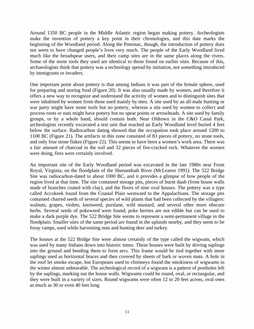
Around 1350 BC people in the Middle Atlantic region began making pottery. Archeologists make the invention of pottery a key point in their chronologies, and this date marks the beginning of the Woodland period. Along the Potomac, though, the introduction of pottery does not seem to have changed people’s lives very much. The people of the Early Woodland lived much like the broadspear users, and their camp sites are in the same places along the rivers. Some of the stone tools they used are identical to those found on earlier sites. Because of this, archaeologists think that pottery was a technology spread by imitation, not something introduced by immigrants or invaders. One important point about pottery is that among Indians it was part of the female sphere, used for preparing and storing food (Figure 20). It was also usually made by women, and therefore it offers a new way to recognize and understand the activity of women and to distinguish sites that were inhabited by women from those used mainly by men. A site used by an all-male hunting or war party might have stone tools but no pottery, whereas a site used by women to collect and process roots or nuts might have pottery but no spear points or arrowheads. A site used by family groups, or by a whole band, should contain both. Near Oldtown in the C&O Canal Park, archeologists recently excavated a test unit that reached an Early Woodland level buried 4 feet below the surface. Radiocarbon dating showed that the occupation took place around 1200 to 1100 BC (Figure 21). The artifacts in this zone consisted of 83 pieces of pottery, no stone tools, and only four stone flakes (Figure 22). This seems to have been a women’s work area. There was a fair amount of charcoal in the soil and 32 pieces of fire-cracked rock. Whatever the women were doing, fires were certainly involved. An important site of the Early Woodland period was excavated in the late 1980s near Front Royal, Virginia, on the floodplain of the Shenandoah River (McLearen 1991). The 522 Bridge Site was radiocarbon-dated to about 1000 BC, and it provides a glimpse of how people of the region lived at that time. The site contained storage pits, pieces of burnt daub (from house walls made of branches coated with clay), and the floors of nine oval houses. The pottery was a type called Accokeek found from the Coastal Plain westward to the Appalachians. The storage pits contained charred seeds of several species of wild plants that had been collected by the villagers: walnuts, grapes, violets, knotweed, purslane, wild mustard, and several other more obscure herbs. Several seeds of pokeweed were found; poke berries are not edible but can be used to make a dark purple dye. The 522 Bridge Site seems to represent a semi-permanent village in the floodplain. Smaller sites of the same period are found in the uplands nearby, and they seem to be foray camps, used while harvesting nuts and hunting deer and turkey. The houses at the 522 Bridge Site were almost certainly of the type called the wigwam, which was used by many Indians down into historic times. These houses were built by driving saplings into the ground and bending them to form arcs. This frame would be tied together with more saplings used as horizontal braces and then covered by sheets of bark or woven mats. A hole in the roof let smoke escape, but Europeans used to chimneys found the smokiness of wigwams in the winter almost unbearable. The archeological record of a wigwam is a pattern of postholes left by the saplings, marking out the house walls. Wigwams could be round, oval, or rectangular, and they were built in a variety of sizes. Round wigwams were often 12 to 20 feet across, oval ones as much as 30 or even 40 feet long.
12
FARMING Indians in North America began to experiment with farming around 3,000 years ago. They gradually learned to encourage the native plants they harvested, like sunflowers, sumpweed, and goosefoot. Eventually they had gardens of these plants and began to breed them for larger seeds and sweeter roots. Because these were the same plants they had been collecting in the wild, it is hard to spot evidence of this early horticulture. Still, archeologists think that people who left their potsherds along the river between 1000 BC and AD 900 may have been part-time gardeners. Around AD 1000 many Indians in the Middle Atlantic began to grow maize. Maize (corn) was a plant from the warm subtropics, first domesticated in Mexico about 7,000 years ago. It must have taken many generations of selective planting by native farmers in the Southwest and Midwest to create maize that would grow in the north. Corn kernels do not preserve well, so there is only a little direct evidence of maize farming. Signs of its arrival can be seen in how and where people chose to live. After AD 1000 Indians moved their settlements to the broad floodplains of the Potomac and other rivers, or to other places where there was plenty of good farmland. Besides providing a lot of calories per acre, maize is easy to store for use long after the harvest. With such an abundant food source, Indian populations grew, and large, permanent villages were founded. Indians had no domestic animals besides dogs, so they still relied on hunting and fishing to provide meat. Archeology and written accounts show that Indians along the Potomac hunted indiscriminately, eating almost anything they could catch. Daniel Denton (1947:7), who traveled among the Delaware Indians in the 1660s, wrote, “The meat they live most upon is Fish, Fowl, and Venison; they eat likewise Polecats, Skunks, Raccoon, Possum, Turtles, and the like.” John Lawson (1966[1709]:178) described Carolina Indians eating all sorts of turtles and even “Young wasps, when they are white in the Combs, before they can fly,” which are “esteemed a Dainty.” John Smith (1986[1608-1631]) summed up the Powhatan Indians’ habits by noting “they devoure all they can catch in their power.” The most common bones from Late Woodland sites along the Potomac are those of deer and turkey, but elk, rabbit, beaver, groundhog, raccoon, opossum, squirrel, chipmunk, dove, passenger pigeon, song birds, frog, salamander, box turtle, musk turtle, terrapin, snake, and many kinds of fish have also been found. Freshwater clam and mussel shells are common. An important archeological marker of the Late Woodland period is the first appearance of definite arrowheads. All across North America the bow and arrow (probably borrowed originally from East Asians by ancestral Eskimos) were adopted after AD 500, largely replacing the atlatl and dart. In the Northeast and Middle Atlantic regions, triangular stone arrow points start to show up around AD 700. Many Indian village sites are known along the Potomac. The earlier villages, dating to AD 1000 to 1300, are shapeless and hard to define. They stretch along the river for hundreds of yards in some places, without clear centers or boundaries. Excavation tends to produce widely scattered pits and houses rather than a tight concentration. At the Frog Run Site near Spring Gap, archeologists recently excavated a trash deposit or midden dating to the Late Woodland period
13
(Figure 23). The midden was more than a foot thick and stratified (built up in layers over time), so that the lower part was expected to be older than the upper part. The pottery in the lower layers is mainly limestone tempered, and that in the upper layers is tempered with dark rock (Figure 24). Radiocarbon dates for the upper and lower parts of the midden came out the same, AD 1030 to 1160, so the makers of the two pottery types lived on the site within a century of each other. This suggests that more than one group of people lived along the upper Potomac at the time. Around AD 1300 there was a major change in the culture. Populations grew, the land became more crowded, and many villages were built as tight groupings of houses surrounded by a defensive palisade (Figure 25). Archeologists think the stockades mean that warfare had become much more common and destructive. Building a palisade was a major undertaking involving much labor, and people would not have done it unless they felt threatened. Palisaded villages have been excavated both on the lower Potomac (such as the Piscataway Creek and Patawomeke sites) and on the mid-Potomac (such as the Winslow, Hughes, Gore, and Shepard Barracks sites) (Slattery and Woodward 1992). Also around AD 1300, a new people entered the Potomac Valley, probably from the west. Archeologists call their culture Luray, after a site in Virginia’s Shenandoah Valley. Their pottery, known as Keyser ware, is shell-tempered. Their artifacts closely resemble those of the Monongahela culture of western Pennsylvania, and some archeologists think they were an offshoot of that culture. They built palisaded villages and spread along the river from its source down almost to the Falls. Climate could also have played a part in these cultural changes. The period from around AD 800 to 1300 is called the Medieval Climactic Optimum, when it was warm and dry across the northern hemisphere. During this period, grapes grew in England and the Vikings found Greenland comfortable. But the climate shifted abruptly to cold and wet around AD 1300, the onset of the Little Ice Age that lasted until 1850. Maize crops may have been threatened by cold weather, and deer and other game animals may also have suffered. Scarcity of game and fertile soil may have heightened tensions between Late Woodland groups and led some to migrate in search of better land. Population growth and warfare contributed to the emergence, or in some cases the reappearance, of ranked societies, which developed into the complex tribes and chiefdoms encountered by the Europeans in the late sixteenth and early seventeenth centuries.
The Moore Village One village site of the Late Woodland has been partially excavated in the Park, the Moore Village near Oldtown. The site is located on a high, ancient terrace about 300 feet from the Potomac, and it spans two low knolls and the saddle between them. The site was discovered by amateur collectors decades ago, but it was first investigated by professional archeologists in 1976 (Handsman 1977). The artifacts from the 1976 testing have never been cataloged but they include thousands of potsherds and dozens of triangular arrow points. Another group of archeologists returned to the site in 1982 to learn more. During the 1982 testing 148 triangular

14
arrow points were found, along with many other kinds of stone tools: drills, several kinds of scrapers, anvil stones that may have been used for crushing nuts, and very crude tools that were little more than rocks with a few flakes knocked to make them sharp. Primitive-looking stone tools do not have to be older than well-made ones. The more than 9,000 sherds of pottery recovered from the site consist almost entirely of shell-tempered, cordmarked Keyser ware (Figure 26). The pottery was mostly very simple, with only a little decoration on some of the rims. Many tools found on the site were made of bone. Archaic people almost certainly used bone tools, but few are found because bone rarely survives thousands of years in acidic soil. On Late Woodland villages, less than a thousand years old, bone does often survive. Finds from the Moore Village include fragments of turtle carapace cups, antler flakers, bone awls, and antler arrow points (Figure 27). The animal bones included several species of fish, bullfrog, turtle, duck, goose, passenger pigeon, squirrel, raccoon, black bear, and elk. White-tailed deer accounted for most of the meat represented by the collection. The charred plant remains include one corn kernel and one bit of corn cob, four plum pits, and numerous hickory shell fragments. The rich archeological record of the Luray culture tells archeologists much about how these people lived, even it is not known what language they spoke or what tribe they belonged to. They lived in villages surrounded by palisades, showing that they inhabited a violent world and feared a sudden attack by their enemies. They placed those villages on level lands near the river, where they had access to rich farmland. Their houses were oval wigwams. They raised corn and other crops. They hunted a wide variety of animals, from salamanders to turkeys, but most of their meat was deer. They fished and collected mussels in the river. They cooked in clay pots. They were attached to their traditions, making their pots and arrowheads in the same way that their ancestors had for generations. They made jewelry and ornaments from animal bones, and probably also from feathers and skins. And then, rather mysteriously, they disappeared. TENANTS ALONG THE POTOMAC The first European farmers moved west of the Falls in the early 1700s. Land above the Falls had been claimed by speculators as early as the 1680s, but violent conflict along the frontier kept settlers out until after the Treaty of Albany in 1722. In that agreement the Iroquois League promised to keep its warriors west of the mountains. Settlement then began to move rapidly westward, reaching the Great Valley in the 1730s and Oldtown and Cumberland by 1750. The men who claimed land along the Potomac mostly lived in the east, well away from the frontier and its dangers. The settlers were tenants, many of them young people who could not afford land in settled areas but were willing to do the hard and dangerous work of settling in the back country in return for low rents and freedom. It has been very hard to find the homes of these frontiersmen, even when their locations are marked on old maps or can be worked out from property deeds. In 1738 to 1740 a series of seven leases for the property known as Brightwell’s Hunting Quarter were enrolled in the county deed books. These tenements are described in sufficient detail to make possible the tentative reconstruction shown in Figure 28. The tenements all measured about 100 acres. Rents were payable in tobacco, and each tenant was required to plant an orchard of about 100 apple trees. The leases all specify that no timber will be sold or
15
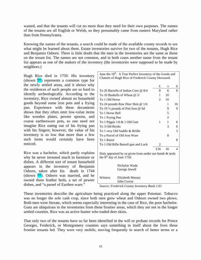
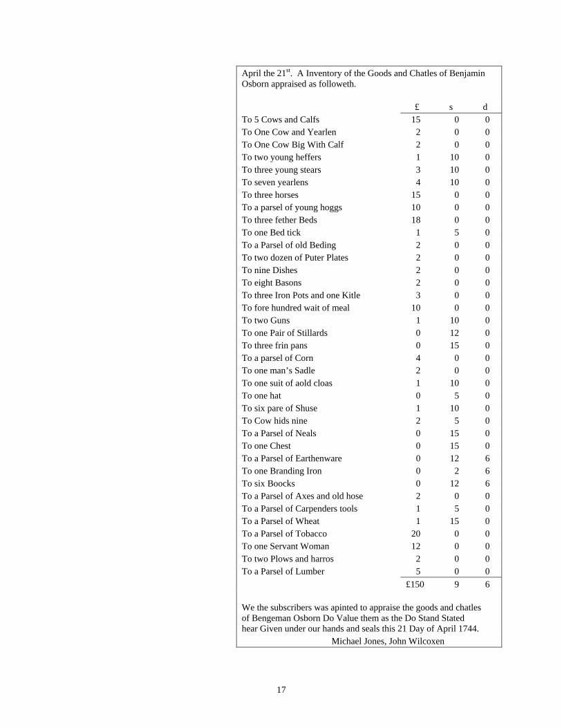
wasted, and that the tenants will cut no more than they need for their own purposes. The names of the tenants are all English or Welsh, so they presumably came from eastern Maryland rather than from Pennsylvania. Knowing the names of the tenants, a search could be made of the available county records to see what might be learned about them. Estate inventories survive for two of the tenants, Hugh Rice and Benjamin Osborn. There is little doubt that the men in the inventories are the same as those on the tenant list. The names are not common, and in both cases another name from the tenant list appears as one of the makers of the inventory (the inventories were supposed to be made by neighbors.) Hugh Rice died in 1750. His inventory (shown **) represents a common type for the newly settled areas, and it shows why the residences of such people are so hard to identify archeologically. According to the inventory, Rice owned almost no household goods beyond some iron pots and a frying pan. Experience with these documents shows that they often omit low-value items like wooden plates, pewter spoons, and coarse earthenware pots, so one need not imagine Rice eating out of his frying pan with his fingers; however, the value of his inventory is so low that more than a few such items would certainly have been noticed. Rice was a bachelor, which partly explains why he never invested much in furniture or dishes. A different sort of tenant household appears in the inventory of Benjamin Osborn, taken after his death in 1744 (shown **). Osborn was married, and he owned three feather beds, a set of pewter dishes, and “a parsel of Earthen ware.” These inventories describe the agriculture being practiced along the upper Potomac. Tobacco was no longer the sole cash crop, since both men grew wheat and Osborn owned two plows. Both men were literate, which seems especially interesting in the case of Rice, the poor bachelor. Guns are ubiquitous in the inventories from these frontier areas, which they are not in the longer settled counties. Rice was an active hunter who traded deer skins. That only two of the tenants have so far been identified in the will or probate records for Prince Georges, Frederick, or Montgomery counties says something in itself about the lives these frontier tenants led. They were very mobile, moving frequently in search of better terms or a
June the 18th. A True Perfect Inventory of the Goods and Chattels of Hugh Rice of Frederick County Deceased. £ s d To 20 Barrells of Indian Corn @ 8/4 8 6 8 To 10 Bushells of Wheat @ 3/ 1 10 To 1 Old Horse 2 10 To 24 pounds Raw Deer Skin @ 1/6 1 16 To 19 ½ pounds of Pott Iron @ 6d 9 9 To 1 Horse Bell 5 To 1 Frying Pan 2 To 1 Piggin 1/6 & 1 Old Gun 1 1 6 To 3 Old Books 3 6 To 1 very Old Saddle & Bridle 3 To a Parcel of Old Iron Ware 8 To 1 Razor 8 To 1 Old Rifle Barrell gun and Lock 2 £18 16 4 Duly appraised by us given from under our hands & seals the 8th day of June 1750. Nicholas Wade
George Jewell
Witness Elizabeth Massey John Coxon
Source: Frederick County Inventory Book 1:61

16
better place to live, and when they died they often did not own enough for it to be worth enrolling their wills or taking inventories of their possessions.
17
April the 21st. A Inventory of the Goods and Chatles of Benjamin Osborn appraised as followeth. £ s d To 5 Cows and Calfs 15 0 0 To One Cow and Yearlen 2 0 0 To One Cow Big With Calf 2 0 0 To two young heffers 1 10 0 To three young stears 3 10 0 To seven yearlens 4 10 0 To three horses 15 0 0 To a parsel of young hoggs 10 0 0 To three fether Beds 18 0 0 To one Bed tick 1 5 0 To a Parsel of old Beding 2 0 0 To two dozen of Puter Plates 2 0 0 To nine Dishes 2 0 0 To eight Basons 2 0 0 To three Iron Pots and one Kitle 3 0 0 To fore hundred wait of meal 10 0 0 To two Guns 1 10 0 To one Pair of Stillards 0 12 0 To three frin pans 0 15 0 To a parsel of Corn 4 0 0 To one man’s Sadle 2 0 0 To one suit of aold cloas 1 10 0 To one hat 0 5 0 To six pare of Shuse 1 10 0 To Cow hids nine 2 5 0 To a Parsel of Neals 0 15 0 To one Chest 0 15 0 To a Parsel of Earthenware 0 12 6 To one Branding Iron 0 2 6 To six Boocks 0 12 6 To a Parsel of Axes and old hose 2 0 0 To a Parsel of Carpenders tools 1 5 0 To a Parsel of Wheat 1 15 0 To a Parsel of Tobacco 20 0 0 To one Servant Woman 12 0 0 To two Plows and harros 2 0 0 To a Parsel of Lumber 5 0 0 £150 9 6 We the subscribers was apinted to appraise the goods and chatles of Bengeman Osborn Do Value them as the Do Stand Stated hear Given under our hands and seals this 21 Day of April 1744. Michael Jones, John Wilcoxen

18
Source: Prince Georges County Inventory Book DD:1
19
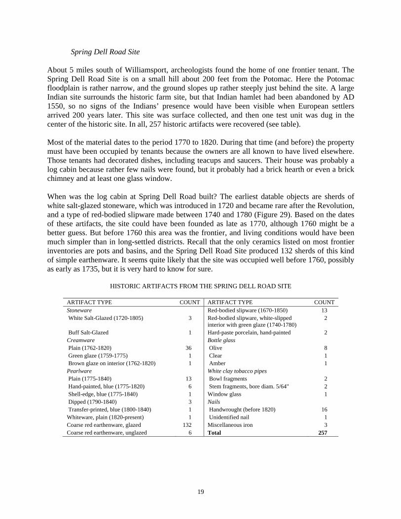
Spring Dell Road Site About 5 miles south of Williamsport, archeologists found the home of one frontier tenant. The Spring Dell Road Site is on a small hill about 200 feet from the Potomac. Here the Potomac floodplain is rather narrow, and the ground slopes up rather steeply just behind the site. A large Indian site surrounds the historic farm site, but that Indian hamlet had been abandoned by AD 1550, so no signs of the Indians’ presence would have been visible when European settlers arrived 200 years later. This site was surface collected, and then one test unit was dug in the center of the historic site. In all, 257 historic artifacts were recovered (see table). Most of the material dates to the period 1770 to 1820. During that time (and before) the property must have been occupied by tenants because the owners are all known to have lived elsewhere. Those tenants had decorated dishes, including teacups and saucers. Their house was probably a log cabin because rather few nails were found, but it probably had a brick hearth or even a brick chimney and at least one glass window. When was the log cabin at Spring Dell Road built? The earliest datable objects are sherds of white salt-glazed stoneware, which was introduced in 1720 and became rare after the Revolution, and a type of red-bodied slipware made between 1740 and 1780 (Figure 29). Based on the dates of these artifacts, the site could have been founded as late as 1770, although 1760 might be a better guess. But before 1760 this area was the frontier, and living conditions would have been much simpler than in long-settled districts. Recall that the only ceramics listed on most frontier inventories are pots and basins, and the Spring Dell Road Site produced 132 sherds of this kind of simple earthenware. It seems quite likely that the site was occupied well before 1760, possibly as early as 1735, but it is very hard to know for sure.
HISTORIC ARTIFACTS FROM THE SPRING DELL ROAD SITE
ARTIFACT TYPE COUNT ARTIFACT TYPE COUNT Stoneware Red-bodied slipware (1670-1850) 13 White Salt-Glazed (1720-1805) 3 Red-bodied slipware, white-slipped
interior with green glaze (1740-1780) 2
Buff Salt-Glazed 1 Hard-paste porcelain, hand-painted 2 Creamware Bottle glass Plain (1762-1820) 36 Olive 8 Green glaze (1759-1775) 1 Clear 1 Brown glaze on interior (1762-1820) 1 Amber 1 Pearlware White clay tobacco pipes Plain (1775-1840) 13 Bowl fragments 2 Hand-painted, blue (1775-1820) 6 Stem fragments, bore diam. 5/64" 2 Shell-edge, blue (1775-1840) 1 Window glass 1 Dipped (1790-1840) 3 Nails Transfer-printed, blue (1800-1840) 1 Handwrought (before 1820) 16 Whiteware, plain (1820-present) 1 Unidentified nail 1 Coarse red earthenware, glazed 132 Miscellaneous iron 3 Coarse red earthenware, unglazed 6 Total 257
20
INDUSTRY ALONG THE CANAL Today the landscape along the C&O Canal is natural, dominated by trees and the river itself. In the nineteenth century, though, much more of the land would have been cleared for fields and pastures. Many industries also prospered along the canal, from boat builders in Cumberland to flour mills in Georgetown. There were iron mines around Pleasantville and Dargan, a gold mine at Great Falls, quarries at Seneca, a coal yard and tanneries at Williamsport, a foundry, a manganese refinery, a sand mine, and several mills (Figures 30-33). Many local people worked in these industries. The archeological record of all this activity is easy to see, in the form of massive stone foundations, pits gouged into the face of the bluffs, and even standing buildings. Even more evidence of industry is buried in the ground and was uncovered during the archeological survey: more foundations, tools, and even a vast slag heap at the Antietam Furnace.
Iron Workers at the Antietam Furnace Along the south bank of Antietam Creek, just above the bridge, low stone walls peek through the weeds and brush (Figure 34). They form a complex maze of foundations stretching along the creek for more than 50 yards. To understand what they once were, look across the road to private property where the stone pile of the Antietam Furnace still stands (Figure 35). From around 1765 until the 1880s, the Antietam Furnace was one of the most important industrial enterprises in this part of Maryland. Besides the furnace, where pig iron was made from the burning of charcoal, iron ore, and limestone, the iron works included water-powered mills where the iron was forged, rolled, and cut. The foundations along the creek are the remains of these mills. There is much confusion about the history of iron furnaces and forges of that time, and it is quite difficult to work out who owned what and when. The furnace at the mouth of Antietam Creek was probably founded by Dr. David Ross, Samuel Beall, Jr., and Richard Henderson (Frye 1984:18; Hahn 1997:119). In 1769 these men claimed a huge tract of nearby hilly, forested land, measuring 8,025 acres, to supply charcoal for the furnace, and the remains of charcoal pits have been found throughout the area. In 1806 the furnace was purchased by John McPherson, a Frederick businessman (Howell 2001). He handled business affairs while a Pennsylvania ironmaster, John Brien, ran the works. The Antietam Furnace was known for custom casting and pig iron. About 1830, after McPherson’s death, Brien adopted Welsh puddling and rolling techniques to make cut nails. Brien died of a liver disease in 1834; his son, John McPherson Brien, took over the furnace. While the C&O Canal was being built, Brien wrote a letter to the president of the C&O Canal Company complaining that Irish canallers were selling whiskey to his men during work hours. The furnace converted to coal after the Civil War, and continued operating into the 1880s. An interesting account of the condition of African-American workers at the furnace circa 1844 is provided in the autobiography of Reverend Thomas W. Henry, an A.M.E. Church minister:
From this place I moved on to a place called Brinn’s Antietam Iron Works, in Washington county. This Mr. Brinn was a long and tried friend of mine; his father made

21
me a present of a church on his place before he died, and when Mr. Brinn moved from his works at Catoctin; he left the doors open for me, the same as his father left them. I had long wanted to see Mr. Brinn, and he had told his servants that he had wanted to see me as long as I had wanted to see him. I had always made it a practice to start out early in the morning, and for this reason had never seen him. On one of these occasions I had left something behind—I cannot think what it was—but I had to return for it, and in doing so I met him at his gate for the first time. He asked me if I was Thomas Henry. I answered in the affirmative. He then told me that he had long wanted to see me, and I told him that such was my case about him exactly; he then said that he wanted to have a conversation with me; and said that he had been told by a young man who was at that time a clerk for him, that I was not a safe man to be among slave servants, and that he was sorry to hear such a report about me. I told him that such report was unfounded, and that the young man who circulated such a report about me was a member of the M. E. Church, and it was because I had left that connection that he had so arranged matters to harm me. He told me that he saw through the whole matter, and that they had lost their interest in me when I left their Church. I told Mr. Brinn that he could perceive very readily that such charges against my character were unfounded, and that I had been among his father’s servants for at least seven years, and none had ever been misled or run away in that time. He told me that all I said was the truth.
Having gone so far about Mr. Brinn’s Antietam Iron Works, I had forgotten to mention one fact. This place was said to be one of the wickedest places in Washington county prior to my taking charge of the Circuit, which takes in this place. Mr. Brinn told me that he had a very fine set of young men there to work and attend to his business, and said he, “I am very glad that you have come among them to teach them the way to live.” He further said that he did not wish any of his men to marry slave women, and he would rather they should marry free women and bring them on the place, and he would have them there with him, that he might do and care for them as he liked; he stated further, that he had plenty of land and timber to build them houses, just as they wished to have them built: he further gave them more privileges than any white man had on his place; he also offered the men all the refuse from his mills, which was an immense quantity of fuel, which no white man on the premises could disturb—and at any time that his white employees wanted any work done, it should be done by his men’s wives, that they might make all the extra money that could possibly be made, and to encourage his own slaves, he gave them their tasks—all over their tasks they were paid for, just as free men were paid for their labor, and on Saturday night every man would be seen waiting for his pay, just as all the other hands were paid. He told me that he allowed them their board and clothing, and they all had their book accounts at his store, which accounts were properly adjusted every Saturday night, and at the end of each year there was a general settlement.
This good man told me that the white help had a spirit of animosity against his servants because they were so well treated. He had occasion to leave home for several days, and while he was gone the agent and some of the white hands had some words with the colored servants; they wanted to catch them and tie them and whip them. Mr. Brinn exclaimed: “good God! Thomas, they could never do that, as I had never whipped them myself.” This caused a young insurrection. He had a colored man that they called Stuttering Pete, who caught one of the white men and threw him across the mill race. He then told me that his men could not be taken—and well he might say this, for a more powerful set of men I have never seen. The agent then went up to Sharpsburg to bring down the militia, and when they arrived the boys had fled to the hills and mountains, and could not be seen. They stayed away from the forge and watched for the return of Mr.
22
Brinn, their master, and when he returned he said to me, “Thomas, here comes my boys from the mountains and hills, all coming to me like wild cattle.” He told the agent that no man had authority to strike any of his hands, and if they have done anything that conflicts with the law, I will settle that myself. He told me that he called his men together and settled with them as he thought best. The first cause of this outbreak was, that Mr. Brinn had a very faithful colored man, named James Reeder, who dealt out all the stuff that the puddlers used, and this was a great saving to Mr. Brinn. The white employees did not like this colored man dealing out their stuff. Hence the animosity. He said that all his men were very fine men; but as to young James Reeder, the money was never made to buy him. Mr. Brinn then told me that was his place, and that I could come as often and stay as long as I pleased, at any and all times. He said he had given orders to old James Reeder that, if any of the men misbehaved in my meetings, he would hoop-polp them. From this time I had no trouble during my stay at the Antietam Iron Works [Henry 1872:23-26].
LOCK KEEPERS AND OTHER CANAL PEOPLE During the archeological inventory study, archeologists tested in the yards of a number of lock keeper’s houses and other structures close by the canal (Figure 36). These humble homes are reminders that for many people the canal was a way of life. The C&O Canal Company began looking for lock keepers soon after construction got under way. The board of directors was determined to recruit sober, reliable men for these jobs, and they tried to make the positions attractive. In the 1830s pay was usually $200 a year for a keeper who looked after one lock, and $300 for a keeper who looked after two (Unrau 2007:792). This salary was about what an unskilled factory worker would earn in a northern city. In addition they received the use of the lock keeper’s house and a plot of company land on which they could plant a garden or raise animals. They were allowed to let rooms to travelers, provided they did not serve liquor. Some had other businesses: in the early 1900s the wife of the keeper at Lock 38 near Shepherdstown sold bread and pies to passing boatmen (Hahn 1979:65). The company’s rules specified that lock keepers be men, but the board did occasionally let a widow take over from her husband. The company established standards for lock houses, and they were built to a common plan. Until 1836 all were stone. Between 1836 and 1847, contractors could build them of stone or brick; in the last phase of construction, from 1847 to 1850, the standards were relaxed, and some were built of wood or even logs. The houses measured 18x30 feet, with a main floor raised off the ground, a basement under half the house, and an attic floor. They had glass windows, strong locks on the outside doors, pine floors, and fireplaces. They were small but snug houses, better than many poor country people lived in. Test excavations around lock keeper’s houses yielded the same kind of artifacts that were found around other nineteenth-century sites in the region, including glass and potsherds from decorated dishes. These were working homes, and old photographs show them surrounded by sheds and tools, not lawns or flower gardens. The archeology supports this image, since bits of domestic trash like broken glass and animal bone were found close to the front doors of some houses. Box: Harvey Brant

23
Harvey Brant was the last lockkeeper of Lock 44 at Williamsport. During the flood of 1924, which closed the canal, he raised his piano up on trestles to keep it out of the water, but the water was still rising when the piano hit the ceiling, so he had to float it out on a boat. Lock keepers lived in their houses rent free, and they were also paid wages, but those wages were never enough to live on. To make ends meet they had to do other kinds of work. When Harvey Brant was interviewed by Elizabeth Kytle in 1979, he remembered all the different ways he used his company plot to make money. He had a large garden, and in season he sold vegetables to passing boatmen. Toward the end of his career he also sold sodas and ice cream. He put eelpots in the spillway to catch eels when they were running in the fall, and one night caught 720 eels. He sold them the next day for $85. He raised hogs. He set up a canoe club and rented canoes to fishermen and vacationers. He bought bread from a bakery in Williamsport for 7 cents a loaf and sold it to boatmen for 10 cents. He collected coal that fell off the boats and corn that fell out of the corn cribs. He raised hunting dogs and sold the puppies. In the winter when the canal was frozen, he sometimes worked in a tannery. “The boatsmen had a hard life,” Brant said, “but the locktenders did too, because they couldn’t go nowhere. They had to be on the job all the time.” Figure 37 shows Harvey Brant and his family posed by the Lock, some time around 1920. Harvey Brant’s old house is still standing by Lock 44, and archeologists have worked around it (Figure 38). Old photographs show the lock as a busy place, with several buildings. The archeologists found pieces of glass and pottery around the foundations that show the lock keepers had painted plates and teacups much like those of farmers in the area. They found the foundations of the buildings around the lock, and also some of the small pieces of coal that lock keepers and their families collected to stretch their budgets.

24
IV. FRONTIERS DIVIDING LINES In 1720 Philemon Lloyd, the Secretary of Maryland, received two diplomatic envoys from the Iroquois League in Annapolis. When their business had been concluded, Lloyd showed his guests one of his projects, a new map of the Potomac River (Figure 39). He wrote,
I had ye Curiosity of Shewing them the draft wch I found at once surprised and pleased them for as soon as they perceived to be a draft of ye Potowmack River of themselves they Pointed to ye Severall Creeks, falling into it and told me the Names thereof . . . Ye fellows were pleased to see their Warr Road or Great Tract to ye Southward, laid down by ye double Prickt Lines wch of themselves they took Notice of & as well as they could make me to Understand that it was their Tract when they went to Warr with the Southward Indians & Wondered how I came to know anything of it [Mayre 1935:117].
This was a true meeting of cultures. These Iroquois diplomats were able to make the leap from their own mental maps of the upper Potomac to Philemon Lloyd’s pen scratchings, understanding that the two kinds of maps depicted the same landscape. Those Potomac lands were a place where many cultures met and overlapped. Among the people who travelled the Potomac in the colonial period were Seneca, Shawnee, Susquehannock, Piscataway, Catawba, Miami, and Delaware Indians; French and Swedish traders; English, German, and Scottish settlers; French and English soldiers; Quaker pacifists; Moravian missionaries; and many others. On the Potomac frontier, people from all these groups met and interacted. The Appalachian Mountains that in 1720 marked the boundary between the European and Native American worlds may have been a frontier zone much further in the past. In the Late Archaic period, from 5000 to 2500 BC, people east and west of the mountains used quite different artifacts. To the east archeologists find quartz spear points of a type called Halifax, which was used throughout the Piedmont and Coastal Plain down to Georgia. To the west they find chert points of a type called Brewerton that was used up and down the Appalachians from Vermont to the Great Smoky Mountains. Although these people had very similar ways of life, they clearly belonged to different groups and probably spoke different languages. The Potomac probably flowed across a major frontier in Woodland times as well. In the Middle Woodland period the Coastal Plain was densely inhabited compared to the Piedmont and the mountains. Large Middle Woodland sites have been found in the neighborhood of the Falls, including a spectacular burial at the Whitehurst Freeway Site near the mouth of Rock Creek (Figure 40). This burial resembles others from New York and the Great Lakes area, and that may show something important. When European explorers reached the Chesapeake Bay, the Indians they met were mostly speaking Algonquian languages. Linguists and archeologists think that these languages, and many of the people who spoke them, came from around the Great Lakes. There is no agreement, though, about when the Algonquian speakers arrived in the east. The Whitehurst burial may be a sign that some people had recently arrived in the Chesapeake region from farther north, possibly bringing Algonquian languages with them. In Late Woodland times, after AD 900, new groups of people began pushing into the mountains
25
from the Ohio Valley to the west. Maize agriculture was probably brought into the east by these migrants, and since farming allowed them to sustain denser populations, they overwhelmed the people who had occupied the mountains before them. They built settlements along the Potomac from near its source down to just above the Falls. Meanwhile the people of the Coastal Plain had already built up fairly dense populations without maize, based on their exploitation of the Chesapeake estuary and its vast resources. They were able to hold onto their homes, so instead of the major break between Middle and Late Woodland apparent in the mountains, in the Tidewater archeologists see a gradual evolution toward agriculture and village life. The Potomac Falls marked the frontier between the Coastal Plain people, who spoke Algonquian languages, and different tribes with different languages to the west. MEETING PLACES Philemon Lloyd knew something of the upper Potomac from an acquaintance, an Indian trader. This man’s house is shown on the map at the mouth of Conococheague Creek, labeled “An Indian Traders Habitacon @ 40 Miles from Monokkasey.” This man was almost certainly Andrew or Anders Friend. Despite his name, Friend was not an Englishman but a Finn from the old Swedish colony on the Delaware River. Indian traders made their livings at the intersection of native and European cultures. They had to work in both worlds, the Indian’s and the white man’s. In the early days of the Potomac frontier, most of them were not English. Some were French Canadians, like Pierre Bisaillon, who acted as the Pennsylvania agent for a network that spanned the continent from Quebec to New Orleans. Others were Swedes or Finns like Andrew Friend. Sweden set up a colony on the Delaware River in the 1630s, with the help of dissident Dutch merchants. More than 600 settlers spread out along both sides of the river in what is now New Jersey, Delaware, and Pennsylvania (Figure 41). In the 1600s Finland was ruled by Sweden, and many Finns emigrated to New Sweden. Finland, like America, was a land of vast forests, and these Finns made important contributions to America’s frontier culture. Building with logs was barely known in the crowded countries of western Europe, where forests were scarce and wood expensive, but it was the norm in Finland. The log cabin, the icon of the American frontier, may have been introduced by these Finnish settlers (Figure 42). The Swedes and Finns from the Delaware River entered the Potomac trade through their connection with the Susquehannock Indians. In the 1500s the Susquehannocks were a powerful tribe that controlled all the lands drained by the Susquehanna River. They were gradually forced to the south by the Iroquois League, and when John Smith met them in 1608, they lived along the lower river and dominated the northern end of the Chesapeake Bay. In 1645 the Susquehannocks, with Swedish help, prevailed in a war with the colony of Maryland. By 1690, though, they had been defeated in wars with the Iroquois League and the colony of Virginia, and their power was broken. They accepted the Iroquois League as their overlords and settled down in Pennsylvania at a place called Conestoga. The Susquehannocks claimed ownership of the upper Potomac region, where they had had villages in the decades around 1600. The upper Potomac was rich in furs and provided a gateway to the vast Ohio country beyond, so it became for a while an important trading area. Because of their connections with the Susquehannocks, the first Europeans to enter this trade were Swedes and Finns.
26
In the 1680s William Penn’s Pennsylvania colony took over the lands of New Sweden, and many of the Swedish and Finnish settlers moved on. One cluster of Swedes moved into Cecil County, Maryland, at the head of the Chesapeake Bay. Around 1690 John Hansson Steelman, a Swede born in America in 1655, set up a trading post at Elk Landing at the head of the Chesapeake. Steelman and his son, also named John, were naturalized as residents of Cecil County by an act of the Maryland Assembly in October 1695 (Archives of Maryland [AM] 19:281). They served as interpreters for the Maryland government in its dealings with Indians, although the council did not trust them and the Steelmans were investigated at least twice for illegal dealings with the French. Some idea of the content and volume of the early eighteenth-century fur trade can be gleaned from the account book of James LeTort, a French trader active in Pennsylvania. In October 1704, 57 Indians (mainly Munsee and Shawnees, probably) brought to Pachoqualmah (on the upper Delaware) and Conestoga 454 foxes, 34 raccoons, nine fishers, eight buckskins, six doeskins, and three bear skins (Grumet 1991:229). No beaver skins were mentioned; intensive trapping had already wiped out the eastern populations.
Israel Friend’s Deed
By 1712 traders had set up cabins at the mouth of the Monocacy, and in the 1720s they had pushed west of the Blue Ridge. In 1727 Israel Friend, one of the sons of Andrew Friend, tried to solidify his position in the valley by purchasing a large tract of land at the mouth of Antietam (Andahetem) Creek from the Susquehannock Indians. The grant was issued by six Susquehannock chiefs who lived at Conestoga. This seems to be one of only two Indian land purchases ever recorded for the mid-Potomac. The deed (see box) has several fanciful details, including measuring out the parcel as so many arrow “shoots” — the distance an arrow flies when shot from a bow — and one might guess that the deed was a forgery. However, a letter written to the Maryland government on January 12, 1731/1732, by Captain Civility, a Susquehannock chief, states “. . . We have give no body Land yet but Israel Friend at the mouth of Andahetem . . .” (AM 20:10). The letter was co-signed by another Indian chief, Toyl Hangue, whose name, along with Captain Civility’s, also appears on the deed. In the letter the chiefs say they represent “all the five Nations”; in the deed they are similarly styled as “Kings and Rulers of the five Nations.” If the deed is not genuine, it seems that a very similar document must have recorded the deal between Friend and the Susquehannocks.
The original deed of purchase was reputedly written on birch bark, but copies were made early on and can be found in the Maryland Archives. The chiefs signed with marks, some of which appear to represent animals.
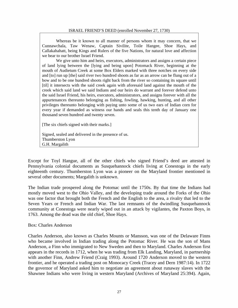
27
ISRAEL FRIEND’S DEED (enrolled November 27, 1730)
Whereas be it known to all manner of persons whom it may concern, that we Cunnawchala, Taw Wenaw, Captain Sivilite, Toile Hangee, Shoe Hays, and Callakahahatt, being Kings and Rulers of the five Nations, for natural love and affection we bear to our brother Israel Friend.
We give unto him and heirs, executors, administrators and assigns a certain piece of land lying between the [lying and being upon] Potomack River, beginning at the mouth of Audietum Creek at some Box Elders marked with three notches on every side and [to] run up [the] said river two hundred shoots as far as an arrow can be flung out of a bow and to be one hundred shoots right back from the river so containing its square until [til] it intersects with the said creek again with aforesaid land against the mouth of the creek which said land we said Indians and our heirs do warrant and forever defend unto the said Israel Friend, his heirs, executors, administrators, and assigns forever with all the appurtenances thereunto belonging as fishing, fowling, hawking, hunting, and all other privileges thereunto belonging with paying unto some of us two ears of Indian corn for every year if demanded as witness our hands and seals this tenth day of January one thousand seven hundred and twenty seven. [The six chiefs signed with their marks.] Signed, sealed and delivered in the presence of us. Thumberston Lyon G.H. Margalith
Except for Toyl Hangue, all of the other chiefs who signed Friend’s deed are attested in Pennsylvania colonial documents as Susquehannock chiefs living at Conestoga in the early eighteenth century. Thumberston Lyon was a pioneer on the Maryland frontier mentioned in several other documents; Margalith is unknown. The Indian trade prospered along the Potomac until the 1750s. By that time the Indians had mostly moved west to the Ohio Valley, and the developing trade around the Forks of the Ohio was one factor that brought both the French and the English to the area, a rivalry that led to the Seven Years or French and Indian War. The last remnants of the dwindling Susquehannock community at Conestoga were nearly wiped out in an attack by vigilantes, the Paxton Boys, in 1763. Among the dead was the old chief, Shoe Hays. Box: Charles Anderson Charles Anderson, also known as Charles Mounts or Mansson, was one of the Delaware Finns who became involved in Indian trading along the Potomac River. He was the son of Mans Anderson, a Finn who immigrated to New Sweden and then to Maryland. Charles Anderson first appears in the records in 1712, when he was trading from Elk Landing, Maryland, in partnership with another Finn, Andrew Friend (Craig 1993). Around 1720 Anderson moved to the western frontier, and he operated a trading post on Monocacy Creek (Tracey and Dern 1987:14). In 1722 the governor of Maryland asked him to negotiate an agreement about runaway slaves with the Shawnee Indians who were living in western Maryland (Archives of Maryland 25:394). Again,
28
in May 1725, Anderson and John Powell were delegated by the assembly to go to Opessa’s Town to resolve this issue. They invited the Shawnee chiefs to a meeting at Anderson’s house “on Mononknisea” (AM 25:442-4). The Indians did not come, so Andrew Friend’s son, Israel, was delegated in August 1725 to invite the Shawnees to attend the next assembly meeting in Annapolis on October 5 (AM 25:450-1). However, the Shawnees did not appear, and the runaway dispute continued for years. Charles Anderson was one of those frontiersmen who refused to settle down but kept moving farther west throughout his life. In 1734 he had land surveyed on the Potomac River in Frederick County, Virginia (now Berkeley County, West Virginia). Shortly after acquiring the land, Charles turned it over to his son, Joseph Mounts, and moved upriver to present-day Oldtown, Maryland, where he lived for the remainder of his life (Figure 43; Craig 2002). The land patent for this location, dating to 1742, places it near an “Old Indian Town upon Potomack where a Certain Charles Anderson made some Cultivations” (Marye 1939:327; Maryland Warrants I, G, A, 1738-1742:71). He settled on the site of the Lower Shawnee Town within a year or two of the Indians’ departure. He and his sons continued to be active in the western movement of the frontier, and they gave their name to two land grants along the North Branch, Anderson’s Cabin and Anderson’s Bottom. Anderson and men like him were driven ever westward by a restlessness that left them ill-suited for settled life. The “Delaware Finns” brought to the Swedish colony on the Delaware River their experience as slash-and-burn farmers in the forests of Finland and Sweden. They were skilled in forest living and knew how to hunt, trap, and build with logs (Jordan and Kaups 1989). They helped create the culture of the American frontier, and from Pennsylvania to Missouri they were always in the vanguard of American expansion. Not only did they teach other European settlers how to build log cabins, through their close relations with the Susquehannock and Delaware Indians they taught Indians to do so as well. Other early frontiersmen usually had some connection to these Finns. Consider Charles Polke, an Indian trader with an English name who lived near modern Hancock in the 1730s and 1740s. Polke grew up around Swedes in Somerset County, Maryland, and lived for a while at Conestoga. His wife, Christiana Cartledge, was part of a trading family that usually worked in partnership with Swedish/Finnish traders, especially the Steelmans and the Andersons. In 1722 John Cartledge was accused of the murder of a Seneca warrior named Sawataeny in an argument over rum and furs. The murder took place somewhere along the Monocacy River, where both Charles Anderson and John Hans Steelman were also trading. News of the murder was brought to the Maryland authorities by John Hans Steelman. While he was living on the upper Potomac, Polke was often associated with a Swede named Ralph Matson. After Polke died, in 1753, Matson served as the executor of his will and then married his widow. Another good example is Daniel Boone, who grew up in Berks County, Pennsylvania, with Finns for his neighbors. Boone, like most English settlers, was the son of a tradesman whose family knew nothing about the wilderness. Where could he have learned his skills, if not from his Finnish neighbors and their Indian friends? The contribution of these Finnish settlers to American culture is little known, but it may have been very important.

29
V. A BATTLEGROUND As a place where many different peoples met, the upper Potomac Valley was often a zone of conflict. From ancient times down to the Civil War, the river was regularly crossed by bands of warriors and soldiers on their way to raid or conquer. The first clear evidence of war along the river is the palisades built around their villages by the Indians of the Luray culture between 1300 and 1550 AD. Earlier Indians had no doubt engaged in some fighting, but the building of the fortified towns shows that warfare had become a regular part of life. The Susquehannocks were great warriors much feared by their neighbors around the Chesapeake Bay, and Susquehannock settlements of the early 1600s were also fortified (Figure 44). THE FUR TRADE WARS The Susquehannocks were defeated in the end by the greatest Indian warriors of the East, the Iroquois League. According to their own traditions, the “Longhouse League” or Five Nations was formed in the 1400s when the Mohawk Valley of New York was torn by constant fighting. Rather than fight each other to the death, the chiefs of five tribes came together to form the League. United, they were able to defeat most of their neighbors and become the dominant power in their region. War was deeply ingrained in their culture. At a council held in Philadelphia in 1720, an Iroquois chief remarked that when his people were at peace with both the French and the English, they tried not to fight any Indians allied to either. Because of this, he said, some young Iroquois men walked all the way to the lower Mississippi to find enemies they could fight (MPC III:99). The arrival of white men touched off yet more warfare among the Indians. The European demand for furs made the forests where fur-bearing mammals lived suddenly more valuable to the Indians, and clashes broke out over the control of remote mountainous districts. The Iroquois fought a decades-long war against the Catawba and Cherokee of the Carolinas over control of the fur trade in Kentucky and Tennessee. The closest villages of the combatants were around 500 miles apart, but they still raided back and forth. The Rangers The year 1692 was a hard one in the colonies. Fighting in Europe between Britain’s new Protestant rulers, William and Mary, and His Catholic Majesty the King of France spilled over into North America, and both kingdoms urged their Indian allies to take up the hatchet. There had been attacks by Indians on settlements in Massachusetts and New York, with many captives taken. Hundreds of refugees had fled outlying towns to take refuge in older settlements like Salem, Massachusetts, where a group of refugee girls made the accusations that launched America’s worst witch hunt. In Pennsylvania rumors spread that an army of French soldiers and their Indian allies was marching to Maryland, where they would join with English Catholics and overthrow the Protestant governments, handing the colonies over to France. The response of Maryland’s government was to reform their frontier defense force, the Maryland Rangers. The numbers of these irregular soldiers were increased, their pay was fixed, arrangements were made with friendly tribes to supply them with Indian auxiliaries, and three forts were built at key places along the frontier. One of the ranger forts was on the Potomac, probably on the bluffs
30
overlooking the foot of Little Falls. The inlet at the base of those bluffs, where Fletcher’s Boat House now stands, was known for decades as Garrison Cove. (A century later this cove, also called Lock Harbor, would be the starting place of the Patowmack Company’s first canal.) The Potomac rangers were commanded by Captain Richard Brightwell, who would be remembered 150 years later as a rough frontiersman in the style of Davy Crockett: “Brightwell seldom visited the lower settlements, being content with his dogs, pet bears, and deer for companions . . .” (Scharf 1882:65). As for his men, their character can perhaps be judged by the order given to Brightwell “to keep his men out ranging and not let them come to the settlements.” Brightwell and his men regularly patrolled the whole area from the Potomac River to the Patuxent, venturing perhaps 20 miles west of their fort. They were mainly looking for “strange Indians,” that is, Indians other than the Piscataways and Nanticokes who lived in Maryland and had always been friendly with the English. Captain Brightwell was not so busy with ranging and trading that he forgot to look after his own financial interests. In his report of October 12, 1697, Brightwell wrote, “. . . We kept constantly Ranging from our Garrison to the Sugar Lands wch we compute to be about forty miles, being generally Stony Rocky land, near the River, all the way thither, and barrens backwards; but the Sugar Lands extraordinary rich . . .” (AM 23:261). By then Brightwell had already claimed 1,086 acres of the Sugarlands for himself; in a patent dated to 1695, he called the land Brightwell’s Hunting Quarter. The plantation established on Brightwell’s claim was one of the most important outposts of English settlement west of the Falls for the next 30 years. Archeologists have searched for remains of the Rangers’ fort on the bluffs overlooking Garrison Cove, but without success. Most likely the site of the fort is now in the yards and under the houses in the neighborhood known as Palisades. King Opessa and the Shawnee In that same troubled year of 1692, a band of Indians arrived in Maryland from the west. These were Shawnee, numbering 172 men, women, and children, and they were accompanied by a Frenchman named Martin Chartier. The startled Maryland authorities at first feared that these refugees were the vanguard of a French and Indian army. They had Chartier arrested — “taken up for a spie,” the record says — and sent for some of their Indian friends to help them understand the situation. Chartier explained that he and the Shawnee had been living at Fort St. Louis on the Illinois River, under French protection (Figure 45). Chartier offered a convoluted account of his own career that had him in trouble with the French authorities for trading without a license, but this was actually not true; Chartier was in trouble for joining a mutiny against the French governor-general. Unwelcome among the French, he joined the Shawnee, marrying a Shawnee woman. The Shawnee became dissatisfied with their situation in Illinois and came east looking for better land. They were led by two chiefs, the “aged” Meauroway and a younger man the colonists came to call King Opessa (AM 19:574). The original homeland of the Shawnee was probably the lands around the Ohio River in southern Ohio and northern Kentucky. But by the time they became known to Europeans, they had been
31
scattered far and wide. In the 1600s the world of the Indians was upended by European diseases and the arrival of European settlers along the coasts. Some tribes disappeared completely, their numbers so reduced by smallpox, measles, influenza, or gunfire that the survivors scattered across the land or sought refuge with neighboring peoples. The European demand for furs created opportunities for the Indians, but also more conflict. In the vacated lands, the animals multiplied, so the surviving tribes fought each other over the now unclaimed regions. One area hit particularly hard by these disasters was the upper Ohio Valley. Once the native populations had been reduced and scattered, powerful tribes from the north and south warred over the great hunting territories that are now Kentucky, West Virginia, and southern Ohio. Living in the Ohio Valley, the Shawnee were caught up in the center of this storm. They fled from their old villages in Ohio and Kentucky and dispersed across eastern North America, from coastal Georgia to Illinois. The Shawnee kept their own identity and language but remained wanderers for generations, moving frequently until they eventually settled down in Oklahoma, many decades and many wars later. The Shawnee who came east in 1692 accepted the Five Nations as their overlords and settled at Pequea on the Susquehannock River, just a few miles from Conestoga (Figure 46). For the next 30 years they appear regularly in the Pennsylvania and Maryland records, and many place names record their presence. By 1700 the sole chief of the Shawnee was the man called Opessa. The Shawnee language did not have a simple “s” sound, and Opessa’s Shawnee name was probably more like Opeththa. In June 1707, in a council at Pequea, Opessa said that he and his people were “happy to live in a country at peace, and not as in those parts of the country where we formerly lived, for then, upon our return from hunting, we found our town surprised, and our women and children taken prisoners by our enemies.” As if to underscore the king’s point, during the council men came in from the Shawnee settlement near Carolina, saying that their town had been attacked by the Catawbas (MPC 2:388-389.) In October 1714 a delegation of Susquehannock chiefs from Conestoga reported to the Pennsylvania authorities that:
Opessah, the late king of ye said Shawanoise, having absented himself from his people for about three years, and upon divers messages sent to him still refused to return to them, they have at leangth thought it necessary to appoint another in his stead, and presented the person chosen, by name Cakundawanna, to the board, as the new elected King of the Shawanois [MPC II:574].
This statement implies that Opessa left Pequea in 1711. The chiefs offered no explanation of why Opessa “absented himself from his people.” In July 1720 the chief of the Shawnee still living at Pequea told James Logan, the secretary of Pennsylvania, “That when their King who was then living, Opessah, took the Government upon him, but the People differed with him; he left them, they had then no Chief…” (MPC 3:92). No record from the 1710s says where he went, but in 1722 Philemon Lloyd, the secretary of Maryland’s governor, made reference to a “large town” of the Shawnee on the upper Potomac that he called “Opessa’s town” (Marye 1935a:7). The testimony of the Shawnee chief in 1720 seems to imply that Opessa was already dead by that time (“their King who was then living”),
32
but the garbled syntax of this sentence suggests problems with either the translation or the transcription (or both), so this is hardly certain. At any rate, sometime between 1711 and 1722, Opessa moved to the upper Potomac. Since the town bore his name throughout the 1720s, he probably either founded the settlement, moved it to a new location (the possibility that there were two separate Shawnee towns on the upper Potomac is discussed below), or presided over a major transformation of the community. Why did Opessa leave? The phrase “the people differed with him” could cover a multitude of issues, since the Shawnee at Pequea faced an array of challenges: relations with the whites, relations with the Five Nations, relations with their neighbors (Susquehannocks, Piscataways, Delawares), not to mention finding food to eat and furs to trade. King Opessa’s Town Our only certain evidence of the existence of King Opessa’s Town dates to the 1720s. Most historians date its founding to not long after 1711, when Opessa left Pequea on the Susquehanna River. Opessa’s decision to move to the upper Potomac had serious consequences for the people who followed him. They probably gained greater freedom of movement in a land with more game to hunt, far from the confining fences and garden-destroying livestock of the Pennsylvanians. On the other hand, European goods would have become more expensive and harder to obtain. More seriously, they lost the safety from attack that Opessa had cited in 1707 as an important benefit of life at Pequea on the Susquehanna. King Opessa’s Town was directly between the homelands of the Five (later Six) Nations Iroquois and the Catawbas, at a time when they were fighting a decades-long war. For example, in July 1717 the Conestoga chiefs complained in Philadelphia that a son of the Delaware chief Ovwchela had been killed on the upper Potomac by a party of “about Thirty Christians, armed Horsemen, & about as many Indians, from whom they retired” (MPC III:20). Investigation showed that this attack was made in revenge for an attack by Seneca Indians on some Catawbas near Fort Christanna in Virginia. During the ensuing negotiations the Shawnee revealed that they held one Catawba prisoner, but they declined to return him, saying “that they had taken him several years agoe, when he was but a little Lad; that he had now forgot his Native Language, & spoke theirs” (MPC III:28). In 1729 Captain Civility, one of the chiefs of the Susquehannocks at Conestoga, wrote to Governor Gookin and told him that “the Southern Indians [i.e., the Catawba] killed and took nine of the Shawaners, living on a branch of Potomac, near the Great Mountains; the which impute to their own fault, for settling so near their enemies” (Hanna 1911:156). The precarious situation of King Opessa’s Town is emphasized by the 1722 Treaty of Albany, between the Five Nations of the Iroquois League and the British Crown. That agreement fixed the Potomac River as the boundary between the Iroquois and Catawba spheres of influence:
And the Five Nations have in like manner solemnly agreed . . . that none of them without having a Pasport shall on any Account whatsoever pass to the Southward of the River Potawmack, which they call Kahangorouton, nor to the Eastward the great Ridge of Mountains, or in case any of them or you shall pass the Boundaries on any account
33
whatsoever without a Passport produce, such Indians shall be put to Death . . . [MPC III:210].
The location of King Opessa’s Town on this contested frontier helps answer the question of how and why it was founded. Opessa must have had the permission of the Five Nations to settle on the upper Potomac. In that exposed location neither the colonial authorities nor the Conestoga tribes could protect him from Iroquois attack; in fact he would have needed Iroquois protection from attack by the Catawbas and Miamis. Extending their protection over such an isolated settlement would have been risky for the Iroquois, and they would not have given their protection without a good reason to do so. The settlement on the upper Potomac must have been an element in the strategic calculations of the Iroquois chiefs. Perhaps Opessa suggested the idea to them, or perhaps they suggested it to him, but either way there must have been agreement between Opessa and the leadership of the Five Nations before Opessa made his move. The presence of Opessa’s settlement on the frontier of the Iroquois sphere of influence highlights the temporary alliance that the Shawnee and the Five Nations seem to have made in this period. The move of Meauroway’s band from Fort St. Louis, which was serving as the capital of an anti-Iroquois, anti-British alliance, to territory under British and Iroquois control can be taken as the beginning of this détente. One reason for the change may have been Shawnee dissatisfaction with their place in the French system, where they had much less importance than the Illinois, Miamis, and some other tribes. As Matasit reported, they may have been dissatisfied with the land they were offered in Illinois. Another factor was probably conflict between the Shawnee and the Catawbas. As the Catawbas and Cherokees used their alliance with South Carolina to consolidate their power in the southeast, they drove out tribes opposed to them, including the Shawnee who had been settled for decades on the Savannah River. Many of those Shawnee migrated northward and settled in Pennsylvania under Iroquois protection. This Shawnee/Iroquois alliance dissolved in the 1730s, but it was an important political fact during the time when the Shawnee resided in Maryland and Pennsylvania. The main reason King Opessa’s Town appeared in the records of Maryland and Virginia was that the town was rumored to be harboring several runaway slaves. The colonial authorities were always worried about the possibility that their slaves and indentured servants would run away to join the Indians, and they sent numerous letters to King Opessa demanding that the fugitives be returned, offering substantial bribes (AM 35:200, 206, 505, 562; 36:583). The Shawnee leaders stalled, neither refusing these demands nor actually returning the runaways. In 1722, during a council held at Philadelphia, trader James LeTort brought responses from the Conestoga chiefs to questions from the governor, and he read a letter from “the Shawanna King” concerning runaway slaves who were sheltering in his village (MPC II:215):
From the Shawanna King to his Excellency Sir William Keith, Bart. Governour of the Province of Pennsylvania. These are to acquaint you Brother concerning these Negroes Slaves belonging to Virginia, now at or amongst the Shawannoes at Oppertus. I will go my own self and take assistance where they are not exceeding the number 10 as directed. And as soon in the Spring as the Bark will run, We will lose no time to perform the taking of them according to Direction, for now they are abroad a hunting, so it can be done no sooner; besides,

34
there will be Hazard in Seizing them, for they are well armed, but we must take them by Guile I am yr. Excellys most humble Servt. THE SHAWANNA KING
The constant stream of letters implies that the Shawnee leaders never followed through on this commitment. The reason the Shawnee chiefs refused the bribes offered them to return slaves is probably related to their precarious position on the frontier of the Iroquois sphere: because of the threat of violence and the depredations of European diseases, the Shawnee needed every able-bodied man to defend their town. The End of King Opessa’s Town King Opessa’s Town was abandoned in 1731 or 1732. The Shawnee moved farther west, over the mountains, and eventually back to their old homeland in Ohio and Kentucky. No Shawnee explained why they chose to move back westward. It was reported at the time that there had been a falling out between the Shawnee and the Iroquois, but the colonial authorities did not take this reported breach seriously, and the leaders of the Six Nations did not give public expression to any such quarrel (MPC III:329). Probably the Shawnee’s desire for independence from both the Iroquois and the British was a key reason. In the 1790s Shawnee leaders proudly asserted both their own independence and even their right to lead other Indians, so they cannot have enjoyed accepting tributary status. The Shawnee leader Black Hoof told Charles Trowbridge in 1824 that the Great Spirit so favored the Shawnee over other Indians that he had given them a piece of his own heart, which made them brave (Trowbridge 1939:61). The Shawnee reputation was summed up by two modern historians:
The Shawnee, with their history of erratic movements, appeal to the student in much the way that they appealed to other Indians in the eighteenth century and later. They were desperate people, courageous even among Indians, self-assured and at home anywhere, defiant of authority, always ready to remove to some distant part. Of all our eastern peoples, the Shawnee held best to certain ideal Indian patterns of behavior: fearlessness; contempt for property and comfort; arrogance toward Whites; disregard for authority; reserve; unbridled, forthright expression of aggression and other emotions [Witthoft and Hunter 1955:43].
Searching for King Opessa’s Town
Where was King Opessa’s Town? Two kinds of documents contain hints. Winslow’s map of 1736 notes “Shawnee Old Fields Deserted” at two places, one near Old Town and one a few miles west of Cumberland along the North Branch. Both locations are mentioned in early colonial property deeds, which describe grants as so many miles above “the lower Indian Town” or the “Upper Indian Town.” It seems, therefore, that there were actually two Shawnee towns along the Potomac. One may have been earlier than the other, or they may have been occupied at the same time. Around Old Town most of the good land near the Potomac is within the C&O Canal Park, and archeologists made an intensive search for the Lower Town. It was not found. Testing at and around the Moore Village produced many Late Woodland artifacts, dating to around 1400 to 1550 AD, and some colonial material dating to after 1740, but nothing Shawnee

35
and nothing that has to date to around 1720. The most likely location for the Upper Town is at the Barton Site, which has been explored by archeologists for many years, but the only evidence found there that may relate to the Shawnee is about 20 trade beads dating to the early 1700s.
The missing Shawnee towns are an archeological mystery. Dr. Robert Wall, who has directed excavations at the Barton Site for many years, suggested that the Upper Shawnee settlement was not a town but a wide scatter of separate cabins. But the colonists always referred to the site as a “town,” and this town was on the military frontier between Iroquois and Catawba territory, where violence was a real danger. Surely any major settlement in such an exposed position would have been protected by a palisade.
Whatever the settlement looked like, the difficulty of finding it conveys something about the culture of the Shawnee. After so many moves across so much of eastern North America, they traveled light. Pottery is the easiest way to find American Indians in the archeological record, and if the Shawnee at King Opessa’s Town made pots, it should be possible to find them through their potsherds. No one has been able to do this, so they probably did not make pottery. They must have switched over to cooking in copper or iron pots they obtained through trade. But they must not have been very rich in trade goods, either, since these are also easy for archeologists to identify.
It is worth pointing out that the home sites of the first European settlers on the frontier are also very difficult to find. Frontiersmen lived without many of the civilized comforts, like ceramic teacups and earthenware butter pans, that are found around farms in more settled districts. It may be that the people of King Opessa’s Town were also part of this frontier culture, perhaps even pioneers in developing a way of life less dependent on owning things and more on mobility and wits. In later years, around 1800, the Shawnee came to be divided into people who adopted European ways and those who resisted this assimilation. One party began living in European-style log houses, farming in the European way with plows and cattle, and using all the tools and refinements of the colonists. Others remained attached to Indian traditions.
The Shawnee who opposed the white man’s way found a leader in Tecumseh, who tried to organize a coalition of Indian tribes to resist white expansion. Tecumseh was openly scornful of material goods. He mocked those Indians who traded their traditions for log houses, wool clothes, leather boots, and all the other paraphernalia of the European way of life (Calloway 2007). Perhaps Tecumseh’s attitude had a history among the Shawnee that went back to the years of their wandering, in the late 1600s and early 1700s. Maybe it was his great-grandparents’ generation who slowly shed their old village culture in favor of a lifestyle more like that of a hunting camp. They adopted a few of the most useful European inventions — guns, metal cooking pots, steel knives and hatchets — but otherwise resisted accumulating possessions, whether native or imported. They moved so frequently, across such long distances, that acquiring material possessions seemed mainly an annoyance. If this is true, it may explain why King Opessa’s Town has proved so difficult to find.
THE GREAT WAR FOR EMPIRE
36
The conflict Americans know as the French and Indian War began in 1754 over the Ohio Valley. The French wished to retain control of the interior of the continent and keep the British confined to the Atlantic coast, but the growing population of the British colonies was pressing ever westward, and speculators like the Ohio Company of Virginia were already making land claims along the Ohio by 1750. At length the two countries struggled for control of the Ohio region (Figure 47). Fighting on this remote colonial frontier led to a general war between Britain and France that spread throughout eastern North America and also to other colonial outposts in the Caribbean, India, and the Philippines. Winston Churchill argued that the French and Indian War was, in fact, the “first world war” (Churchill 1957). Now the conflict is often called the Great War for Empire. The New World empires of the two powers were very different. The British Empire was based on a string of colonies occupied by European settlers. In 1750 these colonies were still confined to the Atlantic Coastal Plain, but their populations were growing rapidly. As these colonies grew, they took over more and more Indian land, so their relations with Indians tended to be bad. The French Empire was much larger but contained few Frenchmen. Instead it was based on a series of trading posts that spanned the Continent from Quebec to New Orleans and on treaty relations with Indians throughout this vast region. The conflict therefore pitted a comparatively small number of French soldiers and adventurers with a large number of Indian allies against a much larger number of British settlers. The British also had Indian allies, in part because their superior shipping and access to a greater number of ports meant that they could usually offer European goods at lower prices than their French competitors. The Five (later Six) Nations of the Iroquois played a special role in this conflict, trying to maintain their independence and even expand their power by playing the French and British against each other. At first there was little fighting in the Potomac country, except for some limited raiding by Indians and French irregulars. In February 1755 Maj. Gen. Edward Braddock arrived in Virginia to take command of the British forces in North America. He made Fort Duquesne at the Forks of the Ohio — later called Pittsburgh — his first objective, and he organized a major expedition to take the fort. In April Braddock’s 2,100 men began their march westward. Braddock divided his force during the march, sending one through northern Virginia and the other along the Potomac in Maryland. In May part of Braddock’s army stopped at the frontier trading post owned by Thomas Cresap. One of Braddock’s officers kept a journal of the campaign in which he describes his short stay under the hospitality of Col. Thomas Cresap:
May 8th. Ferried over the River into Maryland; and March’d to Mr. Jackson’s, 8 Miles from Mr. Coxs’s where we found a Maryland Company encamped in a fine Situation on the Banks of the Potomack; with clear’d ground about it; there lives Colonel Cressop, a Rattle Snake, Colonel and a D – d Rascal; calls himself a Frontiersman, being nearest the Ohio; he had a summons sometimes since from the French to retire from his Settlement, which they claim as their property, but he refused it like a man of Spirit; This place is the Track of Indian Warriours, when going to War, either to the No’ward, or So’ward. He hath built a little Fort round his House, and is resolved to keep his Ground. We got plenty of Provisions. &ca. General arrived with Captains Orme and Morris, with Secretary

37
Shirley and a Company of light Horse for his Guard, under the Command of Capt. Stewart, the General lay at the Colonels [Wroth 1914].
The expedition progressed slowly westward, in some cases moving only 2 miles a day. Frustrated by their pace, Braddock divided his force. The main body of 1,500 soldiers moved ahead with the general, while a smaller force under Colonel Dunbar followed with the supply wagons, which were impeded by the rugged terrain. Braddock’s 1,500-man army outnumbered the much smaller French force of about 250 French regulars and Canadian militia; however, the French commander at Fort Duquesne, Captain Daniel-Hyacinthe-Marie Lienard de Beaujeu, also had more than 600 Indian warriors. The French and the Indians ambushed the British column in the forest about 9 miles from the fort. With the advantage of high ground and tree cover, the French and their Indian allies defeated Braddock’s army. Of the 1,500 soldiers he took into battle, almost 900 were either killed or wounded. Among the casualties was General Braddock, shot in the side. He was carried from the field but succumbed to his injuries three days later. Colonel Dunbar assumed command of the British force and marched the survivors back to Wills Creek. After spending 11 days at Fort Cumberland, Dunbar led his army to Philadelphia to set up winter quarters. His departure in early August left the Maryland frontier wide open to attack. Lacking trained troops and adequate fortifications and supplies, frontier residents were not ready to withstand the onslaughts of the French and their Indian allies (Powell 1998). Cresap’s stockade at Oldtown served as a haven for the refugees fleeing the Ohio Valley and western Maryland:
Many Families from the back Settlements, are come in as far as Col. Cresap’s, where they are fortifying themselves against the Indians. That among the many Murders committed by the Indians, one was within three Miles of Fort Cumberland [Maryland Gazette 1755a].
Within months the conditions in western Maryland had gone from bad to terrible. Reports from the western settlements continued to reach Annapolis telling of wholesale destruction and abandonment of settlements. One such story appeared in the Maryland Gazette, written by an anonymous person returning from Colonel Cresap’s fort. He reported:
That last Wednesday, in the Morning, the Indians had taken a Man Prisoner, who was going to Fort Cumberland from Frazier’s, and had also carried of a Woman from Frazier’s Plantation, which is four miles on this side of Fort Cumberland. The same Morning, they fell in with a Man and his Wife, who had left their Plantations, and were retiring into the more populous Parts of the Country; they shot the Horse on which the Man rid, but as it did not fall immediately, he made his escape; the Woman, it is supposed, fell into their Hands, as neither she nor the horse on which she was riding, have been seen or heard of. The same Party of Indians have also killed or carried off Benjamin Rogert, his Wife, and seven children, and Edward Morle, of Frederick County [Maryland Gazette 1755].
Early on in the conflict, Cresap’s defenses at Oldtown were one of several stockades or blockhouses located up and down the Potomac River in western Maryland. As the war continued, settlement after settlement along the upper Potomac was raided and burned by Indian parties aligned with the French. Those that were not yet destroyed were often abandoned. By October

38
1755 reports from the frontier said that the settlements at Patterson’s Creek and Tonoloway Creek (present-day Hancock, Maryland) were vacated either by abandonment or Indian attack. By the winter of 1755, only Cresap’s fort at Oldtown remained. Aware that he was alone and vulnerable, Cresap removed his family to his son Michael’s plantation on Conococheague Creek. In 1757 the governor-general of Canada reported to Paris that raiding parties operating from Fort Duquesne (Pittsburgh) had taken only 27 captives and 27 scalps in the past few months, not for want of trying but because there were no settlers left to attack: “all our parties have carried terror among our enemies to a point that the settlements of the English in Pinsilvanie, Mariland, and Virginia are abandoned. All the settlers have retreated to the city or into the forest” (Anderson 2000:204). People on the frontier did organize to repel the Indian attacks. Many frontier colonists formed their own ranging parties for the defense of their homes. These parties were usually led by a commissioned colonial officer and consisted of a handful of local farmers and tradesmen. The group functioned as the garrison at a community blockhouse and tracked Indian raiding parties that threatened the local farms and towns. Colonel Cresap organized such ranging parties near Conococheague Creek and Oldtown. On July 8, 1756, Colonel Cresap wrote the Maryland Gazette describing an encounter his party had with a group of Indians:
Yesterday about 11 o’clock as myself and 12 more men were on our Way down when we got as far as the End of the Fence below the Saw Mill, by which the Men, who were before following one another, got all standing together, and while they were in that Posture were fired on by a Party of Indians. Two of the Men who were behind in the Road, fired and kill’d one of the Indians on the Spot, another says he fired at 3 Indians who stood together… I immediately muster’d up about 20 Men, and went to the Place of Action, where we found a Indian lying dead, together with the three men before mentioned; we scalp’d the Indians, and found several things belonging to them, such as Wampum, Silver Wrist-bands, Ear-Rings & a French Gun, together with our own Mens Guns. Our Dead we brought home [Maryland Gazette 1756].
Maryland responded to the crisis by building Fort Frederick and several smaller forts, but these installations could not prevent raiding by small, mobile bands of Indians and French irregulars. As George Washington repeatedly urged, only an offensive against Fort Duquesne could save the situation. The British launched such an expedition in 1758 under Brig. Gen. John Forbes. Forbes marched 6,000 men to the Forks of the Ohio and easily took the fort, which he renamed Fort Pitt. After the fall of Fort Duquesne to British forces in 1758 and the signing of the Treaty of Easton that same year, Indian raids on Maryland’s western settlements came to an end. Box: Thomas Cresap Cresap was born in Yorkshire, England, in 1694 and came to America at the age of 15. In the 1730s he had been a land agent for the Calvert family of Maryland in their border dispute with the Penns of Pennsylvania. This conflict is sometimes known as Cresap’s War, making Cresap part of that select band of men, like Napoleon and Red Cloud, who have their own wars. The
39
Pennsylvania authorities accused Cresap of murder, and in 1736 his house was surrounded by an armed company of 24 Pennsylvanians, lead by the sheriff of Lancaster County. Cresap was captured only after sheriff’s men set his house on fire. He was taken to Philadelphia and imprisoned for two years, earning his release as part of an overall truce between the Calverts and the Penns. After leaving Philadelphia, Cresap moved his family west, settling for a time on Antietam Creek. By 1744 he had moved still farther west, to a spot near Oldtown where he set up as an Indian trader. Cresap’s cabin at Oldtown became a landmark and waypoint for Europeans traveling in western Maryland, Virginia, and Pennsylvania. In 1747 a 15-year-old George Washington visited Cresap’s cabin while working on the survey of Lord Fairfax’s western lands, and he was stranded there for five days by heavy rains. From his journal it is possible to get a glimpse at what life was like for Thomas Cresap in Oldtown. On his third day Washington wrote:
Wednesday 23d. Rain’d till about two oClock & Clear’d when we were agreeably surpris’d at the sight of thirty odd Indians coming from War with only one Scalp. We had some Liquor with us of which we gave them Part it elevating there Spirits put them in the Humour of Dauncing of whom we had a War Daunce. There Manner of Dauncing is as follows Viz. They clear a Large Circle & make a great Fire in the Middle then seats themselves around it the Speaker makes a grand Speech telling them in what Manner they are to Daunce after he has finish’d the best Dauncer Jumps up as one awaked out of a Sleep & Runs & Jumps about the Ring in a most comicle Manner he is followd by the Rest then begins there Musicians to Play the Musick is a Pot half of Water with a Deerskin Streched over it as tight as it can & a goard with some Shott in it to Rattle & a Piece of an horses Tail tied to it to make it look fine the one keeps Rattling and the other Drumming all the While the others is Dauncing.
By 1749 Cresap was a member and agent of the Ohio Company, serving as trader and speculator in their newly acquired lands in the Ohio Valley. He helped the Delaware Sachem Nemacolin lay out a rugged 60-mile trail from the Potomac River to the Monongahela, opening the road to the west. Over the years the trail would come to be known by several names, including Nemacolin’s Trail and Braddock’s Road. When war broke out between France and England in 1754, Cresap found himself on the front line. Cresap’s eldest son, Thomas, was one of the many killed in the fighting. After the war the elder Cresap resumed his career as a farmer and land speculator. He died at Oldtown in 1790 at the age of 96. Cresap’s Fort Because Cresap’s Fort is such an important historical site, many people have tried to find it, and over the years there have been several theories as to where it might have been. One contribution of the recent archeological study was to confirm that one of those theories is right. The fort was in a hayfield south of Oldtown, on a high terrace about 1,000 feet from the river (Figure 48). The excavation of seven 3x3-foot test units here produced more than 200 artifacts dating to 1740 to 1770. The artifacts include oriental porcelain, Delftware, white salt-glazed stoneware, brown stoneware, Rhenish blue and gray stoneware, coarse red earthenware, olive wine bottle glass, case bottle glass, white clay pipe stems and bowl fragments, a gunflint of English flint, two lead
40
shot of about .30 caliber, a small lead shot, hand-wrought nails, and a substantial amount of window glass (Figure 49). Especially intriguing is a single paste gemstone, probably once part of a button, cufflink, or shoe buckle. This is by far the largest collection of colonial artifacts from anywhere in western Maryland and indicates that this site was a major settlement, which can only be Cresap’s Fort. The artifacts found on the site include a great many nails and a few bricks. The brick is probably from the hearth of the chimney; since there was not enough brick for a complete chimney, the rest of it was presumably built of logs lined with mud. Log houses could be built with very few nails, so the nails from this site must mean that the original log house was added to or modified over the years. Many pieces of broken bedrock were also found across the site. Bedrock is buried deeply enough beneath this part of the terrace that these rocks were probably not turned up by the plow. The rock is mostly in pieces fist-sized or smaller, but the rock is soft and was easily broken with a shovel. Most likely this stone is the remains of the foundations of log structures, including Cresap’s house. Since the site is some distance from any stream, it probably had a well, although it has not yet been found. Not only is Cresap’s Fort an important historical site, it is also a very rare representative of colonial settlement along the Potomac frontier. Eighteenth-century frontiersmen were highly mobile and traveled light, and their log cabins could be built without nails or substantial foundations. They left so little behind them that it has proved very difficult to find archeological evidence of their homes. Cresap’s Fort is by far the richest colonial archeological site yet found in western Maryland, yielding a collection of artifacts that can be used to study life on the frontier. The site is an important discovery, and it has only begun to share the knowledge it holds about America’s past.

41
LABOR STRIFE AND FINANCIAL TURMOIL Among the most famous conflicts that took place along the route of the C&O Canal were the ones among the men who built and financed it. Construction of the canal took place between 1828 and 1850, during the early stages of American industrial capitalism. The men who dug and blasted it were early exemplars of the industrial working class, and their conflicts with the C&O Canal Company offered the nation a glimpse of a century of labor strife looming in the future. In the first half of the nineteenth century, a wage labor force was being molded out of immigrants. The C&O Canal Company, like other capitalist enterprises, relied on the wage labor force to get the canal built at low cost to investors. In this equation the laborers figured as an expense to be minimized; the less they were paid, the more the investors made — and if a way could be found to avoid paying them altogether, so much the better. The majority of the laborers on the canal were Irish immigrants, with a few Germans and native-born Americans. Early on, enslaved blacks were used in some places, but that practice was quickly abandoned. In the 1830s and 1840s unskilled laborers had not developed a refined criticism of capitalism, but they certainly recognized exploitation and banded together to fight it (Way 1989). In addition to unpredictable, short, or unpaid wages, the canallers (as they were called) faced dangers on the job, unsanitary living conditions in their camps, and payment in company scrip instead of cash. To fight such injustices, canallers often resorted to violence, or at least the threat of it. In the six years between 1834 and 1840, the C&O Canal experienced numerous disturbances and virtually continuous labor unrest (Way 1989). Work on the C&O Canal was difficult and the living conditions were primitive (Figure 50). Laborers worked 12- to 15-hour days in all kinds of weather, beginning at sunup and continuing to sundown. There were breaks at lunch, dinner, and during periodic visits by the “jiggerman,” who brought the daily ration of liquor. The workers would spend much of their day in the ditches, mired in mud or water up to the waist. Labor was uniformly backbreaking: hauling rocks, cutting trees and brush, and digging, always digging (Way 1989). Injuries were common on the line, maiming and death far from rare. Living conditions were rough in the shanty towns along the canal line. Supplies were typically provided by the contractors, and the contractors often supplied little. Laborers and their families often did not have enough fuel for their fires or enough food to eat. Matthew Carey, an Irish American journalist, wrote that canallers and their families lived in the shadow of want (Way 1989). According to his calculations in 1831, a laborer with a wife and two children earned $156 annually and their expenses were $171.02, leaving a deficit of $15. They lived a hand-to-mouth existence. Accounts of the day show that workers often stole from local residents to make life a little easier (Way 1993a). Laborers chopped down trees or pulled apart fences for firewood, took poultry and pigs from farms and fruit from nearby orchards. Such thefts became more widespread in the 1830s as the C&O Canal Company continually missed payments and the laborers were left even more desperate. The squalid living conditions often led to hunger and sickness among the canallers, and serious illness was a very real threat. Epidemics regularly swept the line, scattering men and their families and leaving a trail of bodies in their wake. In 1832 cholera appeared in the camps,
42
spreading along the line over a period of several months, sickening hundreds and killing dozens. Without the support of the company and left to fend for themselves, many workers decided to abandon their work on the canal for safety elsewhere. Labor unrest amongst the workers was largely caused by the financial difficulties of the contractors and the C&O Canal Company as a whole. The cost of constructing the canal had been grossly underestimated from the beginning, with the result that the company was never far from bankruptcy. According to one recent calculation, the overall cost of building the canal from Georgetown to Cumberland was at least 51 percent above the initial estimate (Unrau 2007). When they ran short of money, the Canal Company delayed payments to the contractors, who in turn delayed or shorted the wages of their workers. The immigrant workers had no other resources to fall back on, and few other employment options, so they needed their pay to survive. During the 1830s the workforce along the C&O Canal fluctuated between 2,000 and 5,000. In order to ensure prolonged employment, laborers began organizing to protect themselves and assert their right to work. Workers banded together and sought to establish a certain amount of control over the workplace. These organizations typically defined themselves along ethnic lines, and none were more successful than the Irish. The Irish secret society acted as the model for organization. These societies were rooted in the breakdown of traditional social and economic relations and governed by a common code, the basic premise of which was the right to subsist (Way 1993b). These groups were communally based, loosely organized, bound by oath, and they were willing to use terror to achieve their ends. This violence was an effort to dominate allocation of contracts and jobs and, in effect, claim control over the labor process. The groups asserted their control by chasing off contractors and laborers that refused to meet the societies’ demands. Organization among the workers was a thorn in the side of the company, undermining its authority, interfering with construction, and damaging property (Way 1993b). The most successful organizations operating amongst the canallers were two Irish factions: the Fardowns, or Longfords, and the Corkonians. The Fardowns were composed of workers who had immigrated from the west of Ireland; the Corkonians hailed from the Irish south. The two factions often competed with each other, using intimidation in an attempt to lay claim to the remaining jobs on the canal. Sometimes real violence erupted. One such war occurred near Williamsport, Maryland, in January 1834 and led to the one of the most famous labor conflicts to occur along the C&O Canal. The conflict started on January 16 when Corkonians assaulted Longford laborers. The fight resulted in the death of one Longford man. Over that day and night, Fardowns and Corkonians made sorties against each other’s camps north and south of Williamsport. Several newspapers of the day covered the events:
…A party of Fardowns or Longfords, consisting of about three hundred men, headed by intrepid leaders, were announced as approaching from below. Their design, they stated to be, to pass up the line of the canal to the upper dam, for the purpose of exhibiting their strength, and not to commit a breach of the peace unless attacked. They were armed in part with guns, but principally with halves, clubs, &c. They passed up quietly over the
43
aqueduct, and on their way, as we learn, three or four hundred more of the same party fell into their ranks. At the upper dam, in a field on the other side of Middlekauff’s, they met the enemy in battle array, drawn up on the top of a hill, about three hundred in number, and armed, in part, with military weapons.
Newspaper accounts depicted the riot and others like it as ethnic brawls between rival factions of Irish immigrants, and to most of the public these acts were the strange doings of troublesome foreigners. Agents of the Canal Company saw these events in a different light. They, at least, understood that these conflicts were driven not by ethnic hatreds but by economic conditions:
We were engaged all Monday & Tuesday in suppressing a riot among the laborers of the Canal; they gathered to the number of about 300 from various parts of the line & at the hour of 6 in the morning attacked the hands engaged on sections 170, 171, and 172. Several shanties were torn down and much injury done to the men… it has struck a fancie in the hands on the whole line and the work is nearly stopped… The disturbances are supposed to be the result of a regular organization for that purpose, the ultimate object being to expel from the canal all except those that belong to the strongest party and thus secure for the remainder higher wages. - Thomas Purcell, January 23, 1834
The riot of January 1834 grew out of the workers’ increasing frustration over months of missed wages and the fear that contracts would dry up. The canal company knew this. Throughout the winter and spring of 1834, the company tottered on the brink of insolvency, and frantic efforts were made to secure loans from local banks so that contractors could be paid (Way 1993b). The laborers’ anxiety that work would be abruptly halted seemed to have been confirmed when one contractor, owed money from the company, discharged his workers, unpaid, upon the completion of a job. These disgruntled laborers later formed the core of the rioters. As more workers created work stoppages or left the line, canallers created an artificial labor shortage, driving up wages and imposing their conditions on the line. In 1828, at the opening of construction, wages ranged from $10 to $12 per month plus board for laborers. By 1839 laborers were being paid between $30 and $39 a month. Such attempts to manipulate the labor market and establish what amounted to a “closed shop” were effective strategies for workers given prevailing conditions on the canal and the limited options open to them (Way 1989). Influenced by rising costs and violence among the Irish societies, some contractors sought to evade their grip on the canal by using non-Irish laborers. But this only led to more violence. In 1834 Irish laborers attacked German workers near Point of Rocks, Maryland. The disturbance led to three deaths and was put down by the local militia. Another similar attack occurred in April 1836, when a workforce of German and “country born” laborers was attacked and dispersed by Irish hands. Although attacks on non-Irish workers were driven by ethnic animosities, they were fueled by concern over a stable income (Way 1993b). Some contractors accepted the demands of the rioters and dismissed their non-Irish workers, but others were determined to keep control of their operations and hold down their costs. They continued to use “scab,” or non-Irish, laborers, and the societies continued to target their sections.

44
One of the offending contractors was Lee Montgomery, who was contracted to build the Paw Paw Tunnel. In the spring of 1837, he imported 40 miners from England, both for their skill and to keep the Irish from his section (Way 1993b). He was already known as an employer of “scabs,” and his hiring of the English did not improve the situation. Eventually, Montgomery’s need for unskilled labor forced him to hire a number of Irish laborers, and almost immediately they began to scare off the English. By 1838 only two English miners remained. Financial problems had plagued Montgomery from the beginning of the project, and by May 1839 he had to lay off most of his men so he could purchase necessary gunpowder. The out-of-work Irish laborers responded by riotously marching up and down the line. The trouble was momentarily averted when the company secured the needed money and rehired the workers. By August 1839, however, a rumor spread that the company was planning to suspend parts of the work and cut the number of laborers employed on the line. The Paw Paw Irish decided to preempt the company by walking off the job. On August 11, 1839, about 100 armed Irish from the tunnel marched on German laborers downriver near Little Orleans. The violence carried out that day caused a priest, Father Guth, who ministered to the German laborers, to confess in a letter to Chief Engineer Charles Fisk, “…were I superstitious I would really believe they [the Irish rioters] are incarnate Devils.” The events of August 11 served as a breaking point for the canal company. Chief Engineer Fisk decided the societies had been tolerated for too long, and with the aid of the state militia he sought to break them up (Way 1989). The Washington and Allegany County militias, led by Colonel Thruston, swept down the line and over the next five days rounded up rioters and weapons. During the 1830s the use of the militia following a riot or labor uprising was quite common. It was also common to have ringleaders rounded up and carted off to jail. The events at Little Orleans caused a shift in how the company dealt with the riotous groups. Previously the militia would arrest the leaders, a period of quiet would descend on the line, and the leaders would be released from jail without prosecution. Such treatment did not deter conflict in the long run, and authority on the canal continued to shift out of the hands of the company and into those of the secret societies. Chief Engineer Fisk was determined not to make that same mistake this time. James Finney served as a laborer spy for Fisk and collected evidence against the riot leaders and on the secret societies after the events of August 11, 1839. The evidence and the testimony of Finney led to the conviction of 14 laborers with charges ranging from riot, robbery, and arson to assault with the intent to kill. They were sentenced to the state penitentiary for five to 18 years. Nine others, convicted on lesser charges, were given a fine and a short imprisonment. Four others were acquitted. For his service to the company, James Finney was awarded $100. Dealing firmly with the secret labor societies did not solve the financial problems of the C&O Canal Company. Labor unrest lessened after 1839 but never completely disappeared. Severe financial problems after 1839 forced the company to cut back on construction and its labor force. Unemployed laborers straggled off the line to find work elsewhere. The organization that the laborers had built up on the canal over the last 10 years was broken down by the rhythms of the labor market more so than by the “union-busting” techniques of the canal company (Way 1989).

45
Many canallers found other sorts of wage-earning jobs, moving to the mines, docks, or eventually railroads. Some canallers even moved into farming, particularly in the frontier regions where land was cheaper and the labor was in short supply. Still others remained canallers, moving from one canal project another, eventually finding themselves in Illinois or Michigan. By 1841 the C&O Canal had only 600 laborers on the line. Construction ground to a halt. Occasionally work was renewed for a short time, only to peter out quickly. The shanty towns of canallers that dotted the landscape along the line in the 1830s had vanished by the 1840s. In reaction to their dangerous, poorly paid, uncertain jobs, the workers organized their secret societies and worked for better lives. These associations were in some ways heroic but in other ways vicious. They were based on the principle that every man who was willing to work was entitled to a living, and that poor people could achieve this end by banding together to oppose the machinations of the rich. These men looked after each other and fought for justice as they understood it. They had considerable success. For more than five years, they were able to get better pay and to insist that they be paid in full for work they had done, allowing many of them to put down roots in America. On the other hand, their tactics were violent and based on hostility toward all outsiders. The few deaths they caused seem to have been accidents, but they were certainly willing to attack workers who didn’t belong to their associations and to destroy other people’s property to get their way. To advance their own rights, they disregarded those of Germans, Englishmen, and even Irishmen from the “wrong” part of Ireland. It is hard for us, so far removed from their fears and needs, to fully understand their actions. They were strangers in a foreign land where many people despised them, and their employers often treated them as intelligent mules. They were willing to work hard at difficult, dangerous jobs, but in return they expected a decent wage and some security in their employment. The one thing they knew was that to win the lives they wanted, they had to stick together. If that meant fighting against outsiders, breaking bones with wooden clubs, burning shanties, being mocked in the newspapers, or even being sent to jail, so be it. They were willing to do all of those things to be sure that they, and not just their employers, received the fruits of their labor. Searching for Workers’ Camps One of the goals of the C&O Canal archeological survey from the beginning was to find the remains of a workers’ camp. After nine years of searching, no certain evidence of a camp has been found. This in itself says something important, because if the workers had had much in the way of belongings, they would have left behind more trash for archeologists to find. Scatters of nineteenth-century artifacts have been found at several places along the canal, but it has proved impossible to say whether any of them were left by canallers. Some artifacts of the right date were found during the excavation of a prehistoric site near the Monocacy Aqueduct in the 1970s, but this area was also the location of a Civil War camp, and the archeologists could not be sure whether the artifacts were left by canallers, soldiers, tenant farmers, or someone else.
46
A search of the letter books of the Canal Company turned up only one document that mentioned the location of a camp. This was an 1835 letter from the master of the Antietam Iron Furnace to the president of the C&O Canal Company, complaining that:
There are several shanties at the mouth of this creek on the line of the canal, that are great nuisances to us, the Irish who occupy them sell liquor and are consequently injuring the habits of our hands greatly, their houses or shanties are a common resort for these people & indeed it is almost impossible to operate our works on account of these nuisances [Brien 1835].
With this clue in hand, archeologists searched for the troublesome shanties at the mouth of Antietam Creek. This area was covered with a dense deposit of slag from the Antietam furnace, which made digging difficult and metal detecting impossible. The slag probably dates to after the furnace switched from charcoal to coke in the 1860s (Hahn 1997:120). If so, the slag deposit conceivably could have capped and preserved the location of the shanties. So shovel testing was pursued in the area, and a handful of historic artifacts was recovered from underneath the slag: a plain brass button, two machine-cut nails, three unidentified nails, an iron staple, two unidentified pieces of iron, a sherd of whiteware (post-1820), and one decorated pipe stem (Figure 56). These artifacts are not much to go on, but they certainly could come from a workers’ camp. The artifacts one would expect from such a site would probably be nails, tobacco pipe fragments, and bottle glass, so the fit is not perfect. Also, these are the same artifacts that one might expect from workers at the iron works, whose trash might have ended up mixed with the slag. Archeologists had better luck at Paw Paw, where they found brick kilns and building foundations that date to the canal building period (Figures 51, 52). The building was probably a storehouse or workshop used during the digging of the tunnel. Only two domestic artifacts were found in the large test unit over the foundation, more evidence that people working on the canal had few belongings with them. GARRISONS AND SKIRMISHES: THE CIVIL WAR During the Civil War the Potomac was the boundary between North and South, so there was a great deal of military activity in the area. Fortifications were built, such as Fort Duncan near Harper’s Ferry; armies crossed and camped; skirmishes were fought; farms were burned. The C&O Canal and the Baltimore & Ohio railroad were important supply lines for Washington, D.C., and therefore tempting targets for Confederate raiders. Union troops were stationed along the Potomac to guard against Confederate attack, and the Confederates attacked them many times. During the archeological inventory study small earthworks were found in several places (Figure 52). The first attempts to break the canal were made under Brig. Gen. Joseph E. Johnston, who commanded Confederate forces at Harper’s Ferry. Before withdrawing his men to a safer position at Winchester, he ordered them to damage local infrastructure that might be useful to the Union, including the C&O Canal. This led to a series of skirmishes along the river. On June 8, 1861, Confederates attempted to blow up Dam No. 5. The alarm was raised and the Clearspring Guards took up their muskets and marched through the night to the dam, driving off the rebels
47
before significant damage was done. By June 13 the gates of four locks between Point of Rocks and Williamsport had been destroyed. The Confederates made a serious attempt to destroy Dam No. 4, which, according to the Washington newspapers, was led by an Irish Virginian who had superintended the dam’s construction. Companies of militia from Boonsboro and Sharpsburg drove off the Confederates after a pitched battle in which four Virginians were badly wounded (Unrau 2007:711-712). Other actions in this period included a skirmish at Falling Waters on July 2, during which the bridge over the Potomac to Shepherdstown was burned by the Confederates. Despite these efforts, the canal remained open. In December 1861 Maj. Gen. T.J. “Stonewall” Jackson, hero of the Confederate victory at Manassas in July, tried once again to destroy Dam No. 5. He wrote,
The Chesapeake and Ohio Canal having been repaired to such an extent as to render it boatable and of great service to the Federal Army at Washington, I determined, if practicable, to cut off western supplies by breaking Dam No. 5. . . . A few days subsequently, Capt. R. T. Colston, Company E, Second Regiment of Virginia Volunteers, who was well acquainted with the locality of the dam and its structure, volunteered to take charge of the working party to accomplish the desired object. As there was reason to believe that General Banks could soon concentrate a large force there, I moved, with Garnett’s Brigade, part of the cavalry under Lieutenant-Colonel Ashby, and part of Carson’s brigade, to the neighborhood of the dam. General Carson made a demonstration towards Falling Waters and Williamsport, while the remaining troops took such a position as to support the working party [O.R. Series 1, Vol. V:390].
Jackson posted artillery on a hill overlooking the dam to protect the demolition party, and his guns destroyed a house on the Maryland side from which militiamen had been firing on his men. But General Banks—that is, Union Maj. Gen. Nathaniel Banks—was able to “concentrate a large force there,” including two rifled guns from the 1st Pennsylvania Artillery. These took Jackson’s gunners under fire, drove them off the heights, and then turned their fire on the Confederate sappers. One man was killed, but instead of withdrawing, the Confederates continued their work by night. Eventually four Union regiments and a second artillery battery were sent to defend the canal, and artillery and musket fire thundered across the river (Figure 53). After three days of this, Jackson withdrew. He thought at the time that his sappers had made a breach “sufficiently large for the object in view,” but in fact the damage was superficial and easily repaired. Jackson returned to the canal in January 1862, attempting to destroy Dam No. 5 with artillery fire and briefly shelling the town of Hancock. This, he said, was in retaliation for Union shelling of Shepherdstown in the summer. Antietam and Gettysburg Campaigns During the two Confederate invasions of the North, which led to the Battles of Antietam and Gettysburg, thousands of troops crossed the canal. After the bloody stalemate of Antietam (September 17, 1862), the Confederate Army retreated across the Potomac at a place then called Boteler’s Ford. On September 19 two Union divisions under Maj. Gen. Fitz John Porter stormed across the ford and attacked the Confederate rear guard, taking four guns. But a Confederate counterattack the next day drove them back and nearly destroyed the 118th Pennsylvania Regiment, which took 267 casualties (Unrau 2007:738). This Battle of Boteler’s Ford, as it was
48
called, discouraged the Union army from pursuing the Confederates, who retired unmolested to Winchester. The Confederates had tried but failed to blow up the Antietam Aqueduct during this campaign, and at other times they tried to blow up the Monocacy and Catoctin aqueducts. It is testimony to the skill of the canal’s engineers and builders that the Confederates never succeeded in demolishing or even seriously damaging any of these stone structures. There was also fighting along the Potomac in the aftermath of Gettysburg. Lee’s Army of Northern Virginia retreated on July 4, 1863, after its defeat at Gettysburg, pursued by Union troops of the Army of the Potomac. Lee had established a defensive line east of Williamsport by July 10. A pontoon bridge, constructed by the Confederates at Williamsport the next day, was floated downstream to Falling Waters on July 12. Confederate engineers had to improve the road, across the C&O Canal, on the Maryland side. To defend the army as it crossed the Potomac, engineers and pioneers constructed breastworks and gun emplacements about one and a half miles up the road from the river, near J.M. Downey’s brick farmhouse. These defensive works stretched across the bend in the river from bank to bank. The Confederate rear guard, flanking the breastworks, was formed by Maj. Gen. Henry Heth’s Division. Lee had to allow 26 hours for the army’s crossing. It rained heavily into the early morning on July 13, turning the road into ankle- or knee-deep mud: “The shoes of those who still had them were literally sucked off their feet” by the mud (Brown 2005:334). Despite this, the wagons and troops of Longstreet’s and Hill’s corps proceeded to cross the pontoon bridge to Virginia with relatively small losses during their march. Lee’s artillery lost 10 forges, two caissons, two guns, and a number of battery wagons and horses during the retreat (Brown 2005:351). On the foggy morning of July 14, Union cavalrymen of the 6th Michigan attacked Heth’s Division. In chaotic hand-to-hand fighting, the cavalry suffered heavy casualties: 40 killed (including their commander, Maj. Peter Weber) and 85 wounded. But the Confederates also suffered losses: among the dead was Brig. Gen. James Pettigrew of North Carolina. As the last men crossed the pontoon bridge before it was dismantled, Confederate artillery took up position on the bluffs along the Virginia bank and discouraged any Federal pursuit. The Canal in Wartime Once Lee’s men were back in Virginia, in July 1863, they mostly stayed there. The Union grip on West Virginia tightened, and the Confederates were driven away from the Potomac. There was still some raiding and skirmishing across the river, and damage was done to the canal during Jubal Early’s 1864 raid on Washington, D.C., but for the most part the canal remained in operation. Between Confederate attacks and major floods, 1861 and 1862 had been dire years for the Canal Company, forcing it close to bankruptcy. But by 1863 the damage had been repaired, the attacks had slackened, and the canal entered one of the most profitable periods of its history. With the capital swollen by wartime immigrants, a huge army to feed in Virginia, and many trains commandeered by the military, demand for flour and coal in Washington was very great. Canal boat operators cashed in, raising their costs by as much as 50 percent, and the tolls paid to the Canal Company also swelled. The resulting profits staved off bankruptcy for the canal and ensured that it would keep operating for years to come (Unrau 2007:743-769).

49
The memoirs of Capt. Frank Myers of the 35th Virginia Cavalry, which was stationed along the river in 1863, provide a sense of what the fighting along the river was like, the constant patrolling, the small forays by night, the brief battles:
About the last of August Colonel White learned that a force, entitled “Scott’s 900” (the 11th New York Cavalry) was stationed at Edward’s Ferry, and crossing the river some distance above the ferry about midnight, which one hundred and fifty men, the Colonel hid his force along the bank to wait until the patrol which passed up and down the towpath of the canal, every half hour, should go down, and at the same time he placed two men near the towpath, with instructions to notice closely the patrol, and if they appeared hurried or excited, to stop them, for that would be evidence enough that they had learned something of his presence on the Maryland side, and they must not be permitted to reach the camp, but if they came long quietly, as usual, to let them pass, for they evidently would know nothing of his movement; but it so happened that old “Uncle” Charley Butler was along, and moreover that he was about half drunk, and when the patrol of two men came riding very leisurely along, “Uncle Charley” sprang up and caught the bridle of the leading Yankee, who raised his gun to fire at Butler, and to save him the other boys had to shoot the Yankee, and of course the firing alarmed the camp.
Colonel White now urged his people across the canal as rapidly as possible, and coming up in rear of the camp, (which he knew to be fortified in front), halted along enough to form his line and ordered a charge, in which they received a volley from the enemy that badly wounded one man, and several slightly; and on reaching he camp found that it had a regular fortification all around it, but the men spurred their horses on, leaping the ditch and riding recklessly over the breastworks. Most of the enemy, thanks to Butler’s drunken blunder at the canal, had escaped, and the daring and desperate assault only resulted in the capture of about a dozen, but their whole equipage fell into the hands of White’s people [Myers 1871:10-11].
Fortifications have been identified in the vicinity of Edwards Ferry, which could be the remains of the fort described.
50
VI. THE END OF AN ERA, THE BEGINNING OF AN ERA The canal struggled financially throughout its history. The Baltimore & Ohio Railroad took over more and more of its business, and with the arrival of the automobile era, trucks took the rest. In 1924 another devastating flood struck the canal, and there was just no money for repairs. The canal went out of business, bringing an era to a close. In 1938 the bankrupt canal was acquired by the U.S. Government. After a long debate, during which Supreme Court Justice William O. Douglas played a prominent part, it was decided to develop the Park as a historic resource, rather than replacing it with a parkway for automobiles. As a National Park, the canal continues to carry people through the mountains, although now they walk or ride bicycles instead of riding boats (Figure 55). Riding or trekking along the canal, visitors are passing through the remarkable record of a long and fascinating history. Some remains of that history are visible: old houses and barns, the ruins of mills, railroad tracks, the scars left by mining. The canal itself stands as a monument to the men who built it, and to the people who traveled it and worked along it. Buried in the ground are traces of earlier inhabitants, from ancient reindeer hunters to frontier fur traders. In the places where those remains are arranged in layers, they are a fabulous record of the past that could keep archeologists busy for decades. Everywhere they invite us to imagine the fascinating, 13,000-year history of human life along the Potomac River.
51
REFERENCES AM (Archives of Maryland) various Archives of Maryland Online, 2005. Accessed at
<http://www.mdarchives.state.md.us/megafile/msa/speccol/ sc2900/sc2908/html/index.html>.
Brien, John McPherson 1835 Letter to Charles Fisk, President of the C&O Canal Company, February 3.
National Archives RG 79/190. Brown, Kent M.
2005 Retreat from Gettysburg. University of North Carolina Press, Chapel Hill and London.
Calloway, Colin G. 2007 The Shawnees and the War for America. Penguin. New York. Churchill, Sir Winston
1957 A History of the English-Speaking Peoples. Dodd, Mead, & Company, New York. Craig, Peter S.
1993 The 1693 Census of the Swedes on the Delaware. Privately published, Washington, D.C.
2002 Mons Andersson and his Mounts Descendants. Swedish Colonial News 2(6):7. Denton, Daniel
1947 A Brief Description of New York. Columbia University Press, New York. Originally published 1670.
Franquelin, Jean Baptist 1686 America Septentrionale. Geography and Maps Division, Library of Congress,
Washington, D.C. Frederick County Inventories var. On microfilm, Maryland State Archives, Annapolis. Frye, Susan W. 1984 Archeological Excavations at the Antietam Iron Furnace Complex (18 WA 288),
Washington County, Maryland. Maryland Historical Trust, Crownsville.
52
Grumet, Robert S. 1991 The Minisink Settlements: Native American Identity and Society in the Munsee
Heartland, 1650-1778. In The People of Minisink, Papers from the 1989 Delaware Water Gap Symposium, edited by David G. Orr and Douglas V. Campana, pp. 175-250. National Park Service, Philadelphia.
Hahn, Thomas F.
1997 Towpath Guide to the C&O Canal. Harpers Ferry Historical Association, Harper’s Ferry, West Virginia.
unknown Files and notes, in the Hahn Collection, Gelman Library, George Washington
University, Washington, D.C. The original source of this drawing is probably Leslie’s Illustrated.
Handsman, Russell G. 1977 A Cultural Resource Management Study of the Oldtown, Maryland Locality:
Resource Inventory and Assessment and Alternative Policies for Land Use. On file, Maryland Historical Trust, Crownsville.
Hanna, Charles A. 1911 The Wilderness Trail, or the Ventures and Adventures of the Pennsylvania
Traders on the Allegheny Path. G.P. Putnam’s Sons, New York. Henry, Thomas W. 1872 Autobiography of Rev. Thomas W. Henry, of the A. M. E. Church. Baltimore.
Electronic edition 2003, part of UNC-CH digitization project, Documenting the American South, Academic Affairs Library, University of North Carolina, Chapel Hill.
Jordan, Terry G., and Matti Kaups
1989 The American Backwoods Frontier: An Ethnic and Ecological Interpretation. Johns Hopkins University Press, Baltimore and London.
Kytle, Elizabeth 1983 Home on the Canal. Johns Hopkins University Press, Baltimore. Lawson, John
1966 A New Voyage to North Carolina. Reprinted by Readex Microprint Corporation, Naples, Florida. Originally published 1709, London.
Marye, William B.
1935 Patowmeck above ye Inhabitants. Maryland Historical Magazine 30:1-11, 114-137.
1939 “Patowmeck above ye Inhabitants”: A Commentary on the Subject of an Old Map. Part Four. Maryland Historical Magazine 34:325-333.
53
Maryland Gazette (Annapolis, Maryland) 1755 Reports of Indian Attacks in western Maryland. 9 October. 1756 Col. Cresap engaged Indians at Cox’s Fort. 8 July. McLearen, Douglas
1991 Late Archaic and Early Woodland Material Culture in Virginia. In Late Archaic and Early Woodland Research in Virginia: A Synthesis, edited by Theodore R. Reinhart and Mary Ellen N. Hodges, pp. 89-138. Special Publication No. 23. Archaeological Society of Virginia, Richmond.
MPC (Memoirs of the Provincial Council of Pennsylvania) 1852 Memoirs of the Provincial Council of Pennsylvania. Published by the State,
printed by John Severns & Co., Philadelphia. Myers, Frank 1871 White’s Commanches: A History of the 35th Battalion of Virginia Cavalry. Kelly,
Piet, & Co., Baltimore. Niles’ Weekly Register (Baltimore)
1834 Chesapeake and Ohio Canal. A Battle! February 1. OR (The War of the Rebellion, A Compilation of the Official Records of the Union and Confederate Armies) various Available on CD-Rom, Guild Press of Indiana, Inc., Zionsville, Indiana. Pousson, John F. 1983 Archeological Excavations at the Moore Village Site, Chesapeake and Ohio
Canal National Historical Park, Allegany County, Maryland. National Park Service, Washington, D.C.
Powell, Allan 1998 Maryland and the French and Indian War. Gateway Press, Inc., Baltimore. Prince William County Inventories var. On microfilm, Maryland State Archives, Annapolis. Purcell, Thomas 1834 Letter to C&O Canal Company President Fisk. National Archives Record Group
79/190. On File at the National Archives, College Park, Maryland. Scharf, J. Thomas
1882 History of Western Maryland. Regional Publishing Co., Baltimore. Reprinted 1968.

54
Slattery, Richard G., and Douglas R. Woodward 1992 The Montgomery Focus: A Late Woodland Potomac River Culture. Archeological
Society of Maryland Bulletin (No. 2). Smith, John 1986 Complete Works. Three volumes, edited by Philip L. Barbour. University of North
Carolina Press, Chapel Hill. Tracey, Grace L., and John P. Dern
1987 Pioneers of Old Monocacy: The Early Settlement of Frederick County, Maryland, 1721-1743. Genealogical Publishing Company, Baltimore.
Trowbridge, C.C. 1939 Shawnese Traditions. In Occasional Contributions No. 9, Museum of
Anthropology, edited by Vernon Kinietz and Erminie W. Voegelin. University of Michigan Press, Ann Arbor.
Unrau, Harlan D. 2007 Historical Resource Study: Chesapeake and Ohio Canal. Chesapeake and Ohio
Canal National Historic Park, Hagerstown, Maryland. Way, Peter
1989 Shovel and Shamrock: Irish Workers and Labor Violence in the Digging of the Chesapeake and Ohio Canal. Labor History 30:489-517.
1993a Evil Humors and Ardent Spirits: The Rough Culture of Canal Construction
Laborers. Journal of American History 79(4):1397-1428. 1993b Common Labor: Workers and the Digging of North American Canals 1780-1860.
Johns Hopkins University Press, Baltimore. Winslow, Benjamin
1736 A Plan of the upper Part of Potomack River called Cohongorooto Survey’d in the Year 1736. Copy of map on file, Library of Congress, Washington, D.C. Original manuscript in Enoch Pratt Free Library, Baltimore.
Wroth, Lawrence C. 1914 The Story of Thomas Cresap, a Maryland Pioneer. Maryland Historical Magazine
9(1): 1-37.
A PATH THROUGH THE MOUNTAINS:
THE ARCHEOLOGY AND HISTORY OF THE CHESAPEAKE AND OHIO CANAL NATIONAL HISTORICAL PARK ILLUSTRATIONS By John Bedell, Stuart Fiedel, and Jason Shellenhamer September, 2011
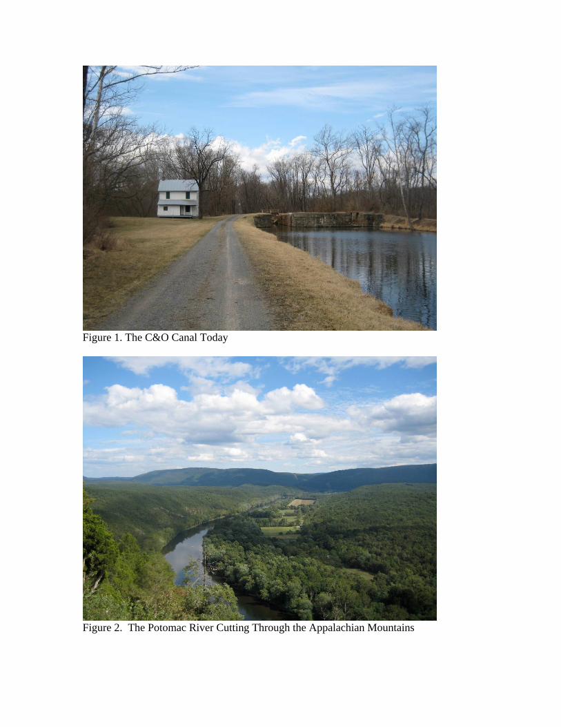
Figure 1. The C&O Canal Today
Figure 2. The Potomac River Cutting Through the Appalachian Mountains

Figure 3. Test Unit at a Stratified Prehistoric Site in the C&O Canal Park
Figure 4. Stone Spear and Arrow Points from a Site in the C&O Canal Park
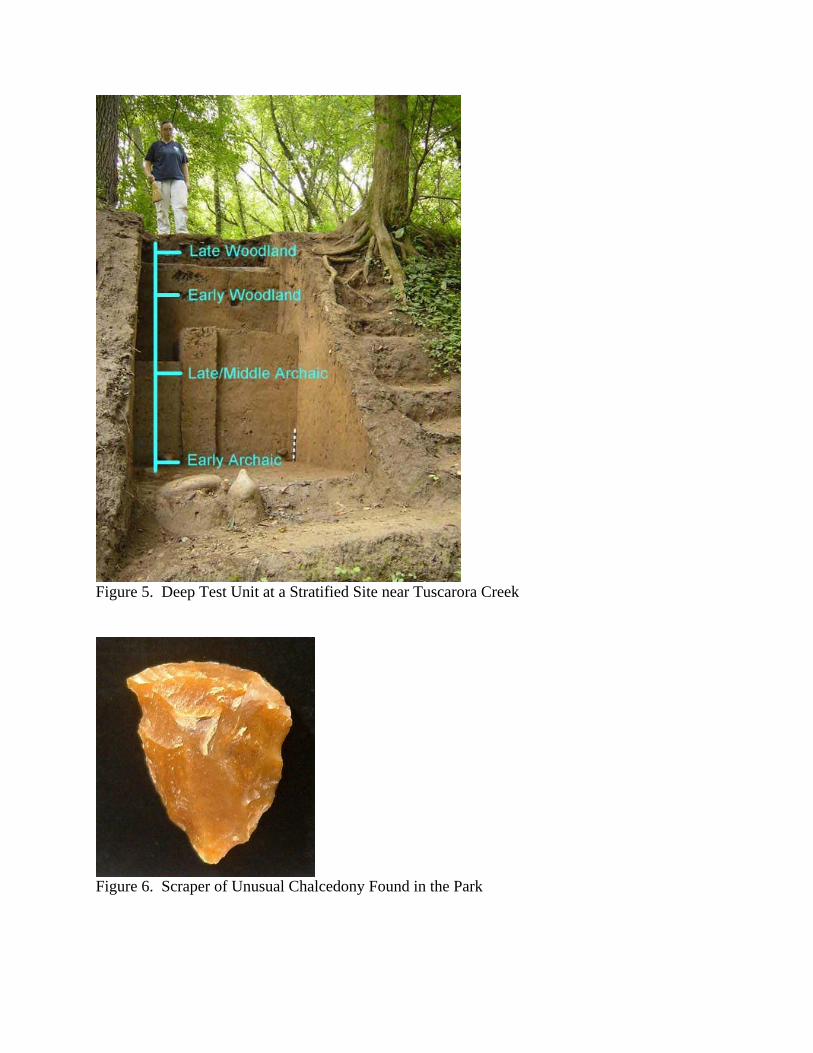
Figure 5. Deep Test Unit at a Stratified Site near Tuscarora Creek
Figure 6. Scraper of Unusual Chalcedony Found in the Park
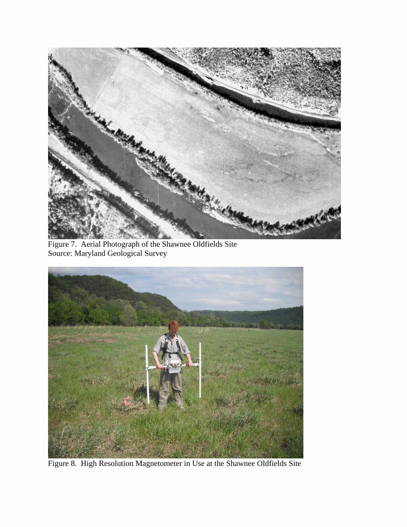
Figure 7. Aerial Photograph of the Shawnee Oldfields Site Source: Maryland Geological Survey
Figure 8. High Resolution Magnetometer in Use at the Shawnee Oldfields Site
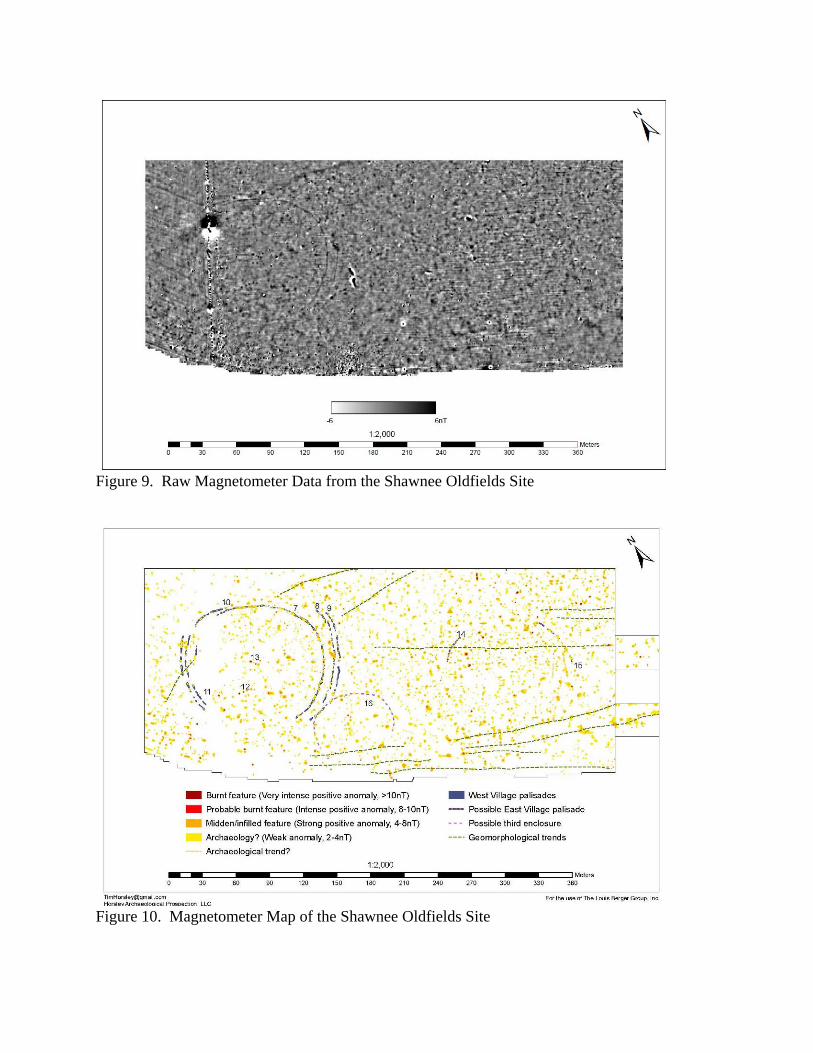
Figure 9. Raw Magnetometer Data from the Shawnee Oldfields Site
Figure 10. Magnetometer Map of the Shawnee Oldfields Site
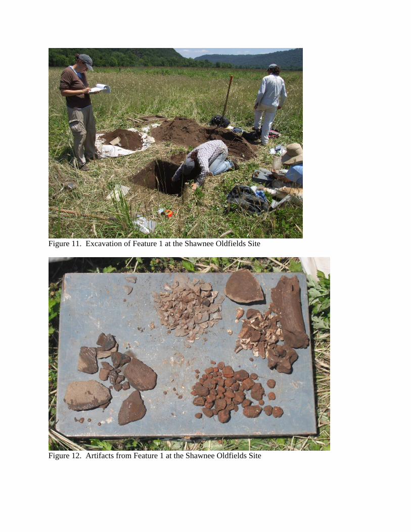
Figure 11. Excavation of Feature 1 at the Shawnee Oldfields Site
Figure 12. Artifacts from Feature 1 at the Shawnee Oldfields Site
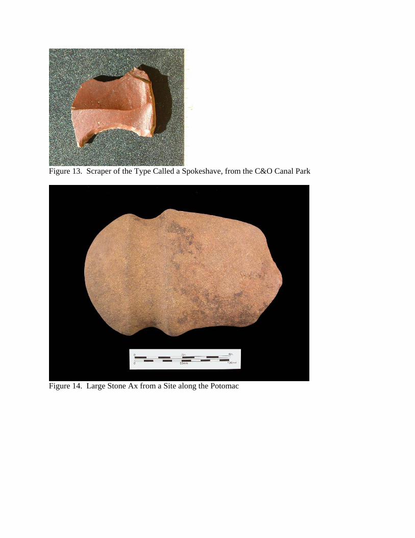
Figure 13. Scraper of the Type Called a Spokeshave, from the C&O Canal Park
Figure 14. Large Stone Ax from a Site along the Potomac
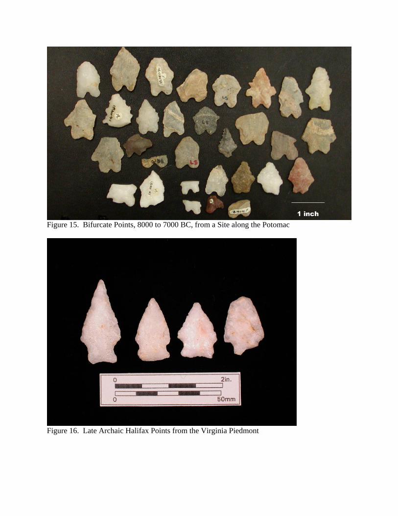
Figure 15. Bifurcate Points, 8000 to 7000 BC, from a Site along the Potomac
Figure 16. Late Archaic Halifax Points from the Virginia Piedmont

Figure 17. Savannah River Points, 2500 to 2000 BC, from a Site along the Potomac
Figure 18. Excavation at the Broad Run Site, Showing the Savannah River Level
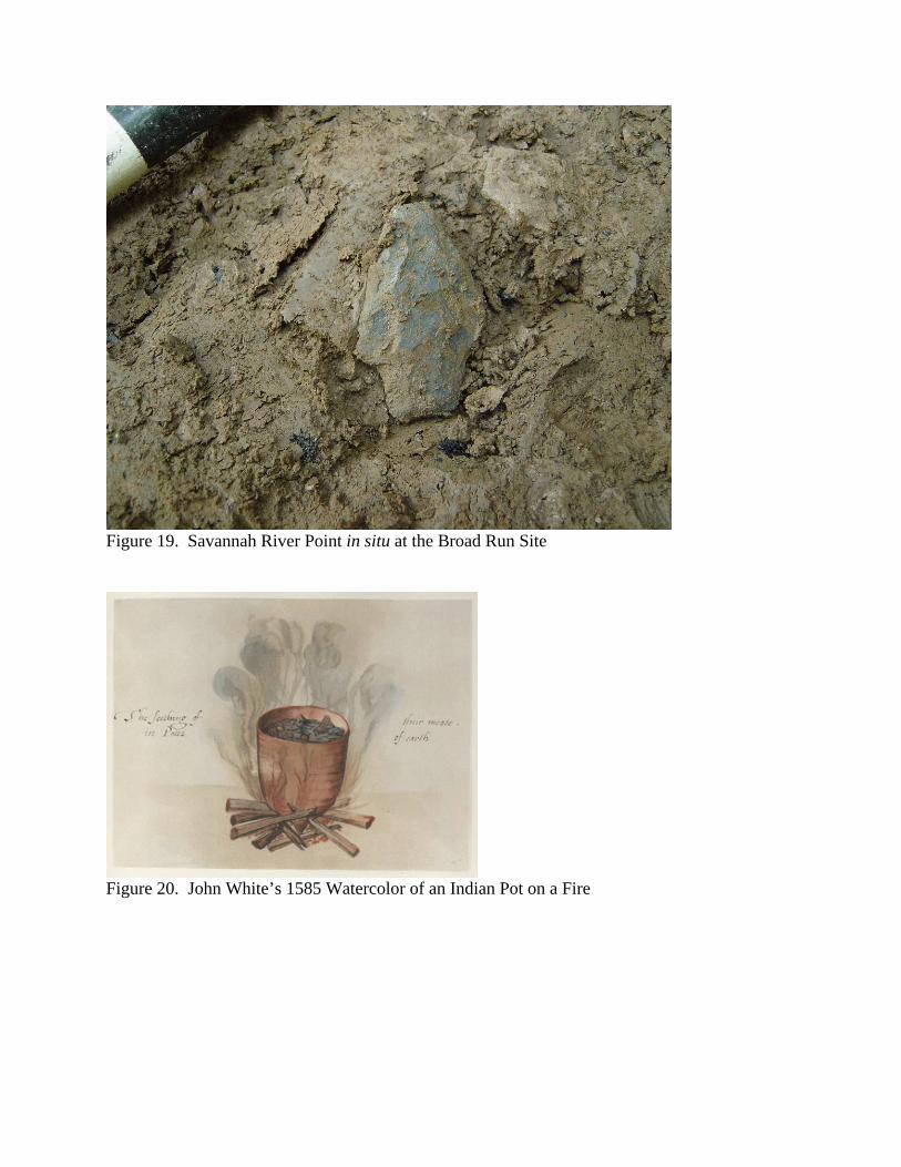
Figure 19. Savannah River Point in situ at the Broad Run Site
Figure 20. John White’s 1585 Watercolor of an Indian Pot on a Fire
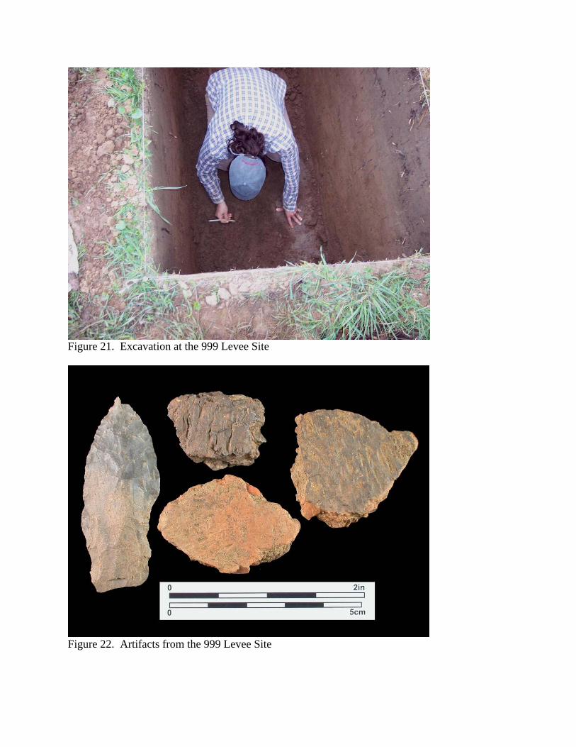
Figure 21. Excavation at the 999 Levee Site
Figure 22. Artifacts from the 999 Levee Site

Figure 23. Excavation at the Frog Run Site
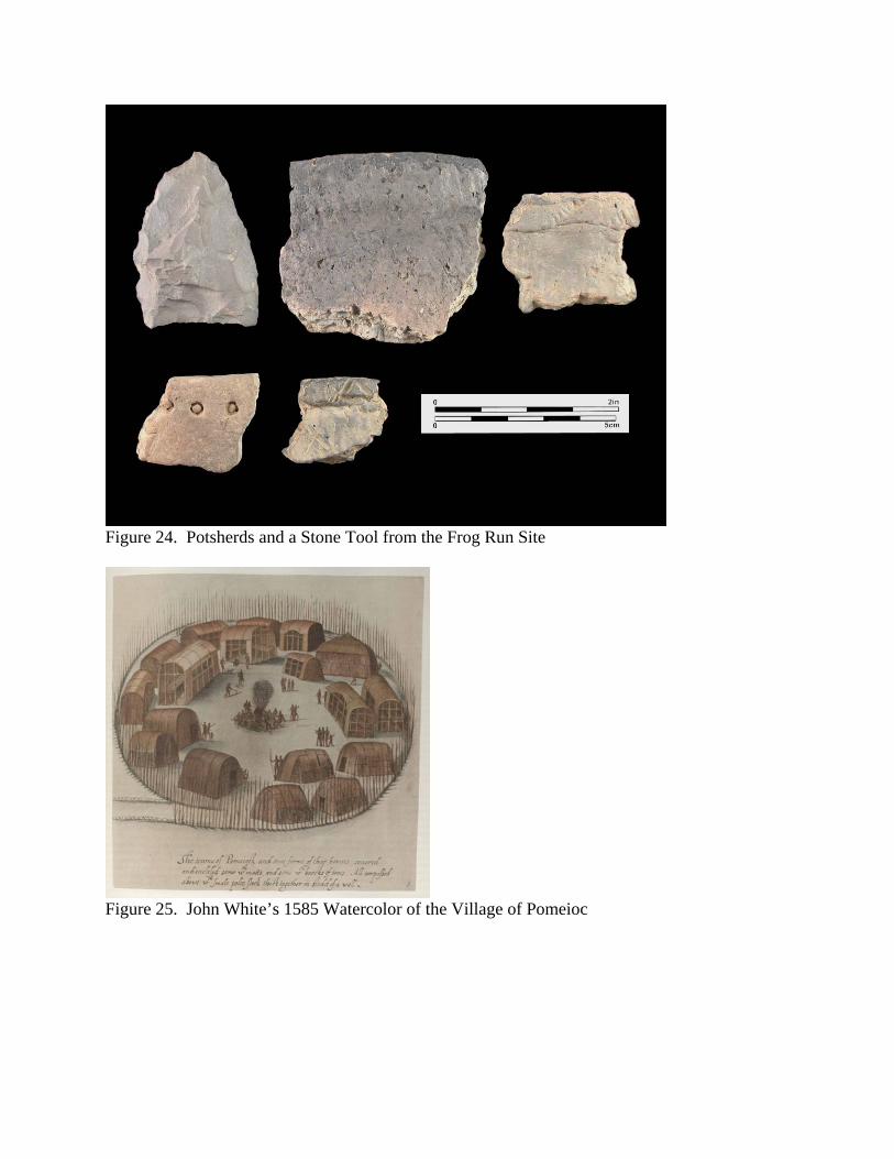
Figure 24. Potsherds and a Stone Tool from the Frog Run Site
Figure 25. John White’s 1585 Watercolor of the Village of Pomeioc
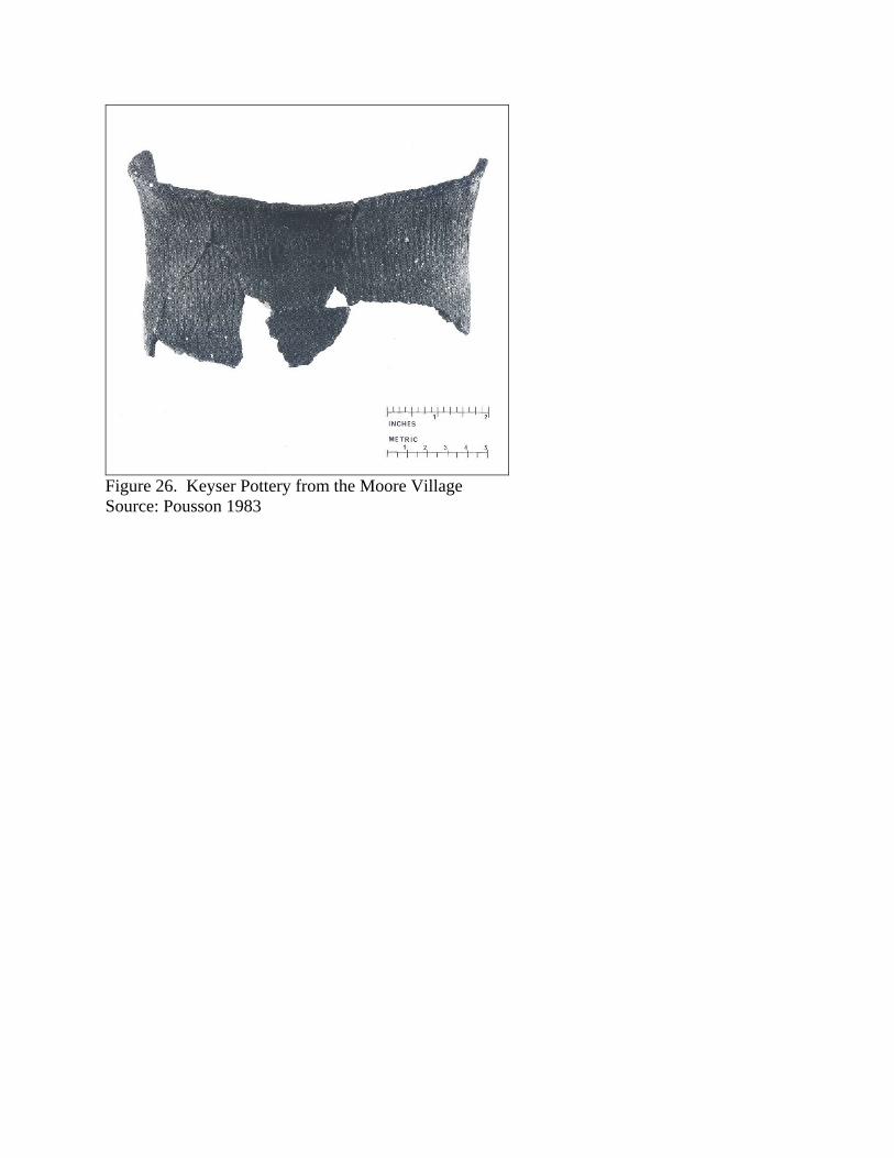
Figure 26. Keyser Pottery from the Moore Village Source: Pousson 1983
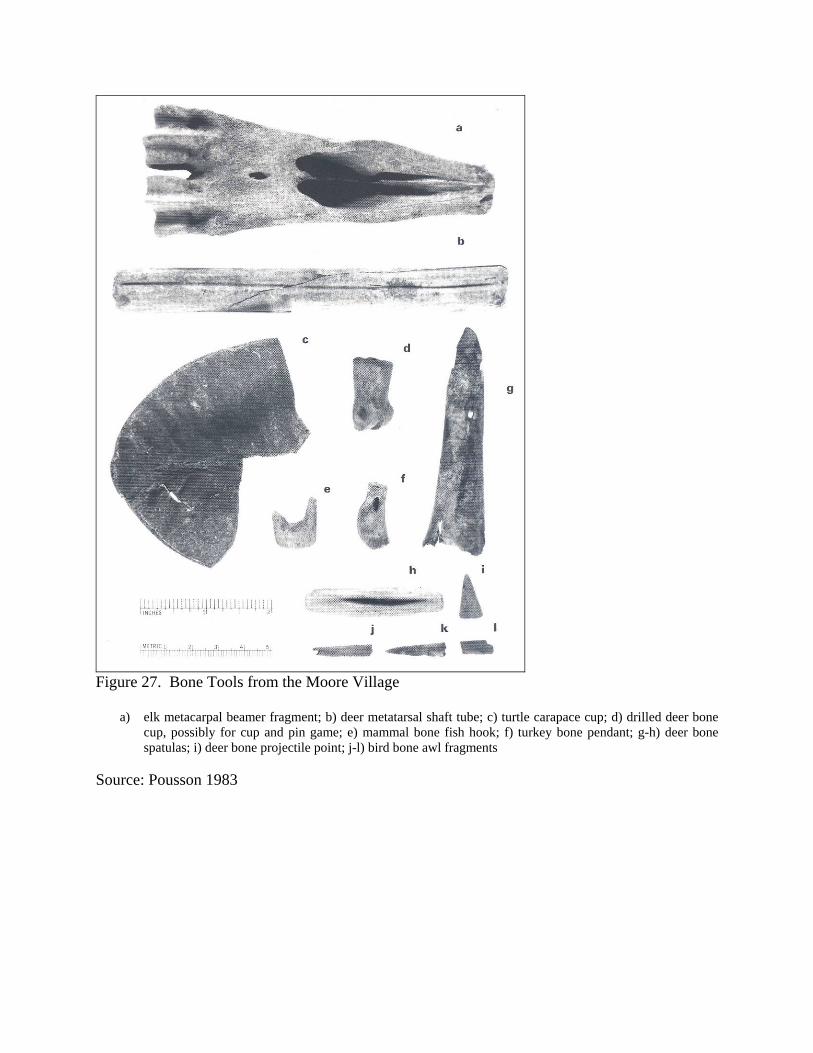
Figure 27. Bone Tools from the Moore Village
a) elk metacarpal beamer fragment; b) deer metatarsal shaft tube; c) turtle carapace cup; d) drilled deer bone cup, possibly for cup and pin game; e) mammal bone fish hook; f) turkey bone pendant; g-h) deer bone spatulas; i) deer bone projectile point; j-l) bird bone awl fragments
Source: Pousson 1983
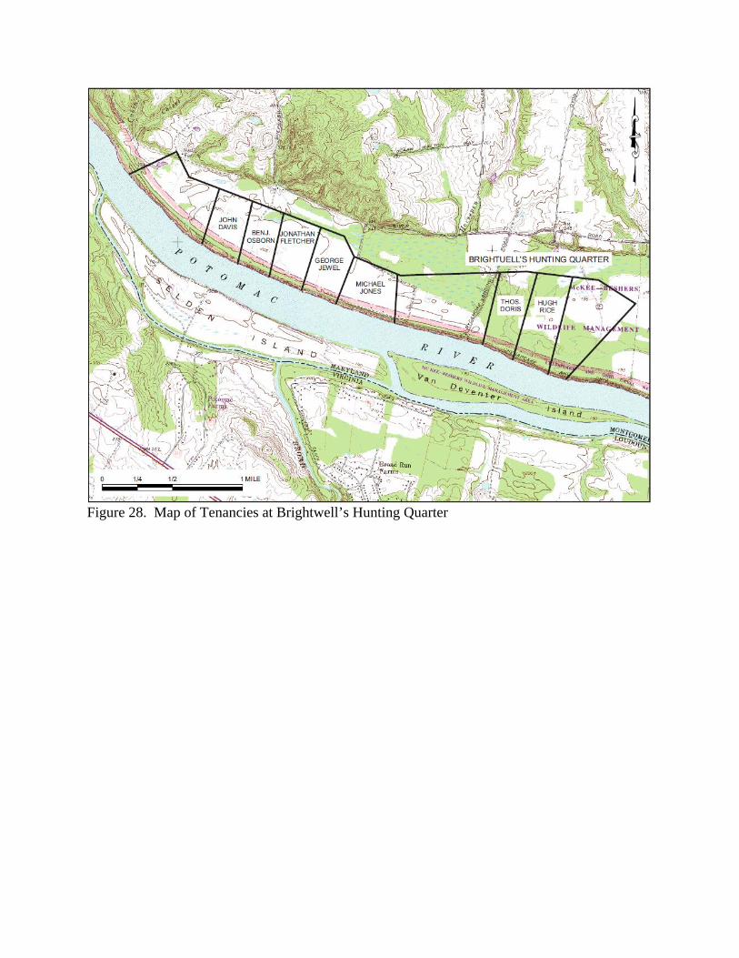
Figure 28. Map of Tenancies at Brightwell’s Hunting Quarter
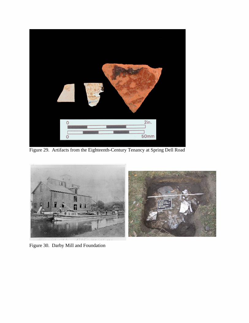
Figure 29. Artifacts from the Eighteenth-Century Tenancy at Spring Dell Road
Figure 30. Darby Mill and Foundation
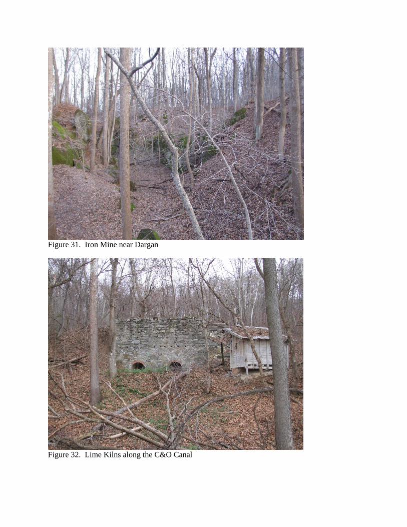
Figure 31. Iron Mine near Dargan
Figure 32. Lime Kilns along the C&O Canal
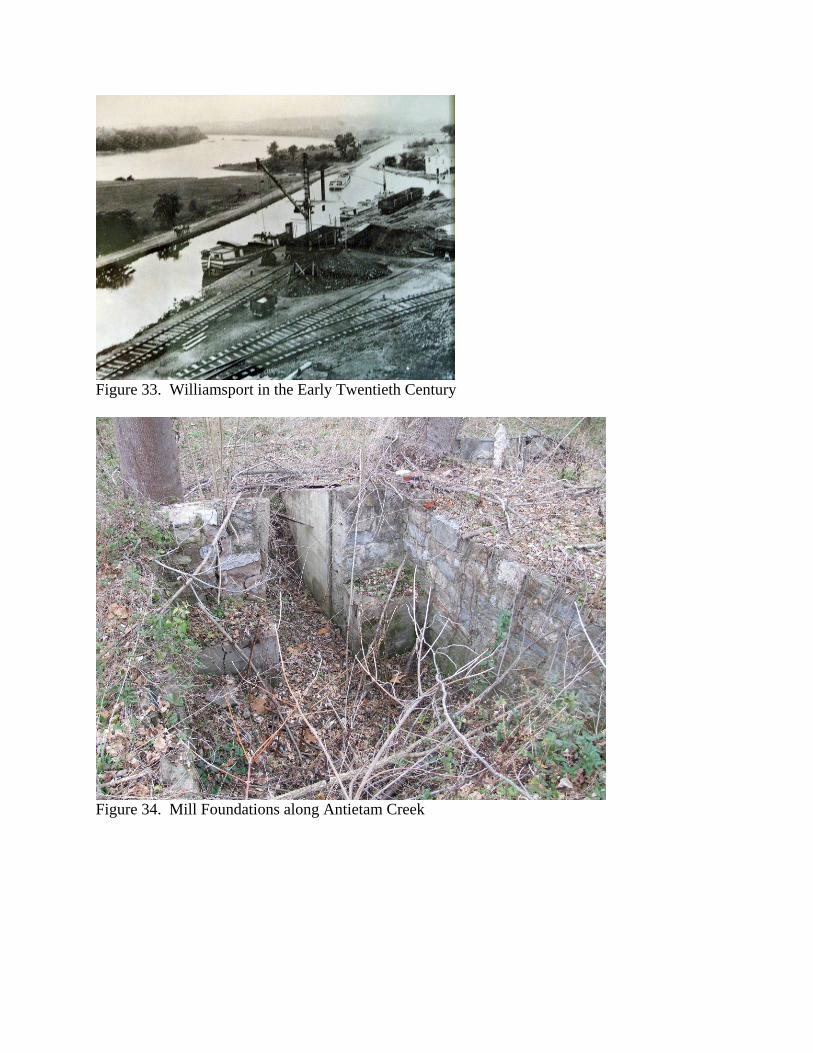
Figure 33. Williamsport in the Early Twentieth Century
Figure 34. Mill Foundations along Antietam Creek

Figure 35. Antietam Furnace
Figure 36. Archeologists Working by a Lock House
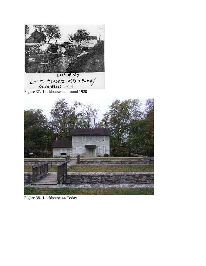
Figure 37. Lockhouse 44 around 1920
Figure 38. Lockhouse 44 Today
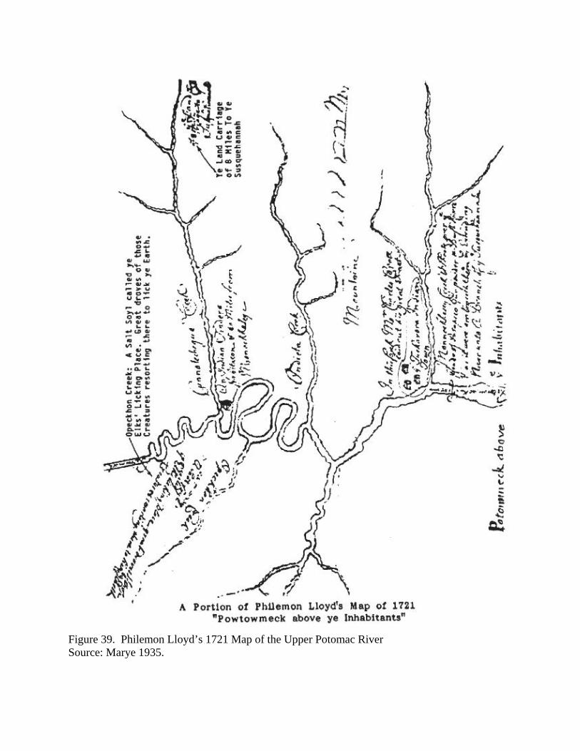
Figure 39. Philemon Lloyd’s 1721 Map of the Upper Potomac River Source: Marye 1935.
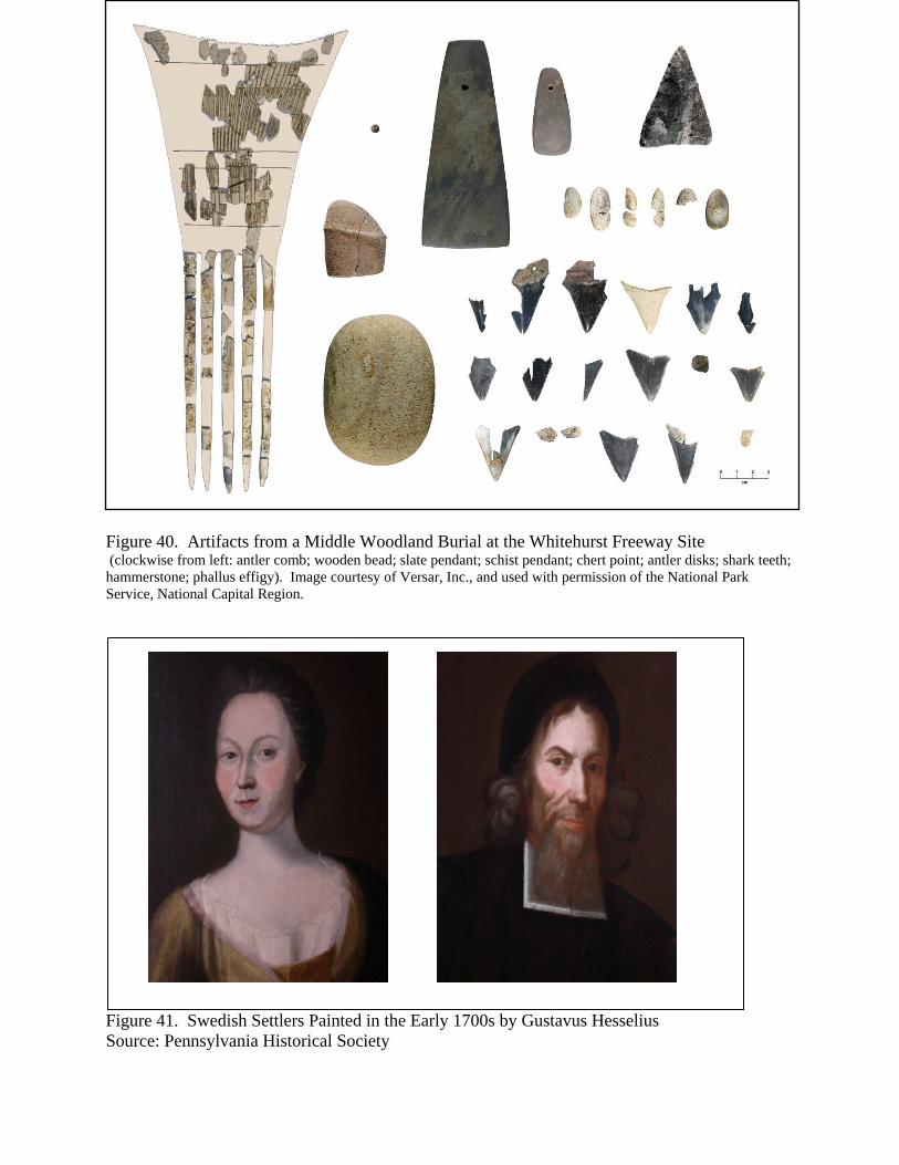
Figure 40. Artifacts from a Middle Woodland Burial at the Whitehurst Freeway Site (clockwise from left: antler comb; wooden bead; slate pendant; schist pendant; chert point; antler disks; shark teeth; hammerstone; phallus effigy). Image courtesy of Versar, Inc., and used with permission of the National Park Service, National Capital Region.
Figure 41. Swedish Settlers Painted in the Early 1700s by Gustavus Hesselius Source: Pennsylvania Historical Society

Figure 42. Swedish Log House in Pennsylvania Source: Pennsylvania Historical Society
Figure 43. The Oldtown Area in 1736, Showing Charles Anderson’s Cabin Source: Winslow 1736.
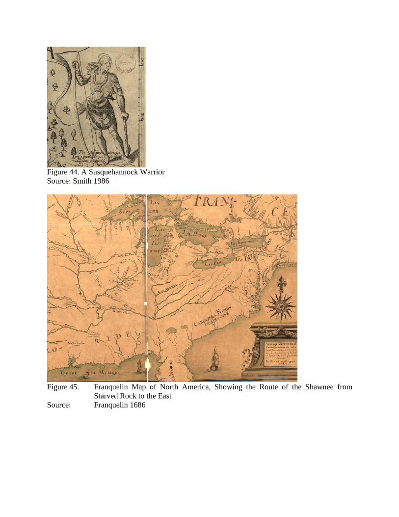
Figure 44. A Susquehannock Warrior Source: Smith 1986
Figure 45. Franquelin Map of North America, Showing the Route of the Shawnee from
Starved Rock to the East Source: Franquelin 1686
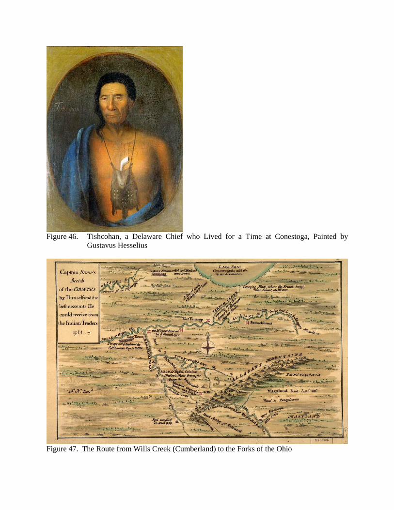
Figure 46. Tishcohan, a Delaware Chief who Lived for a Time at Conestoga, Painted by
Gustavus Hesselius
Figure 47. The Route from Wills Creek (Cumberland) to the Forks of the Ohio
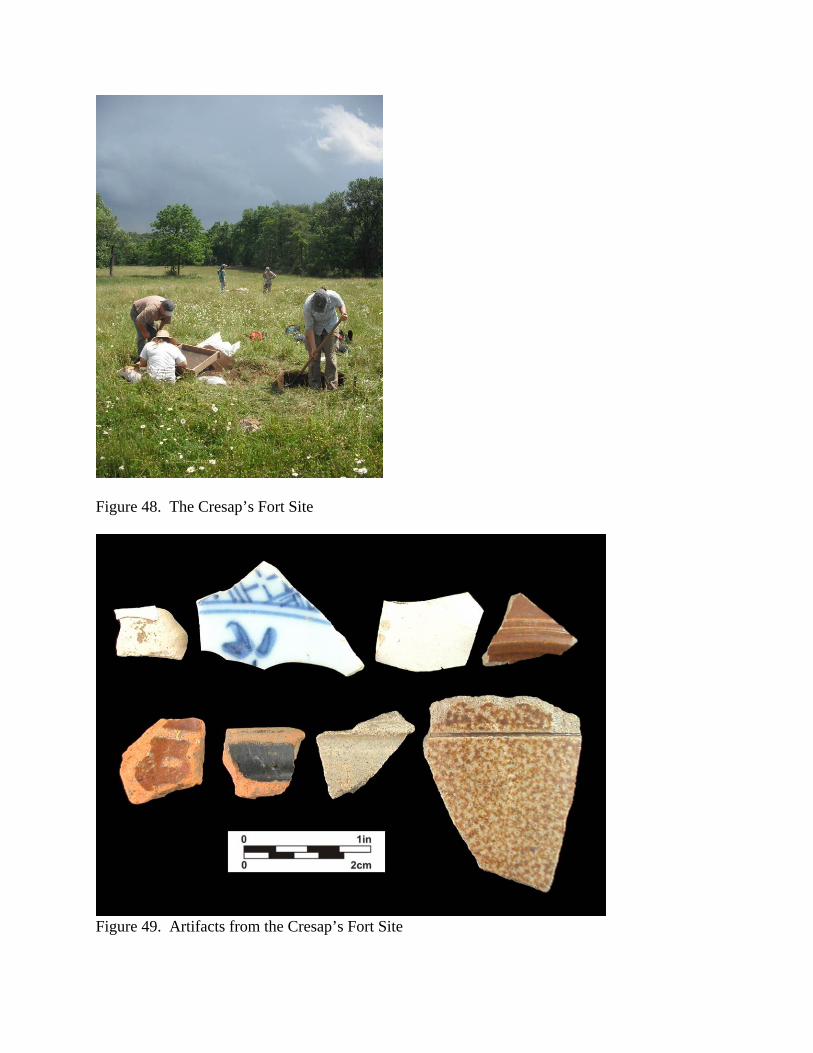
Figure 48. The Cresap’s Fort Site
Figure 49. Artifacts from the Cresap’s Fort Site

Figure 50. Irish Workers Repairing the C&O Canal in the 1890s
Figure 51. Excavating a Brick Clamp at the Paw Paw Supervisor’s House Site
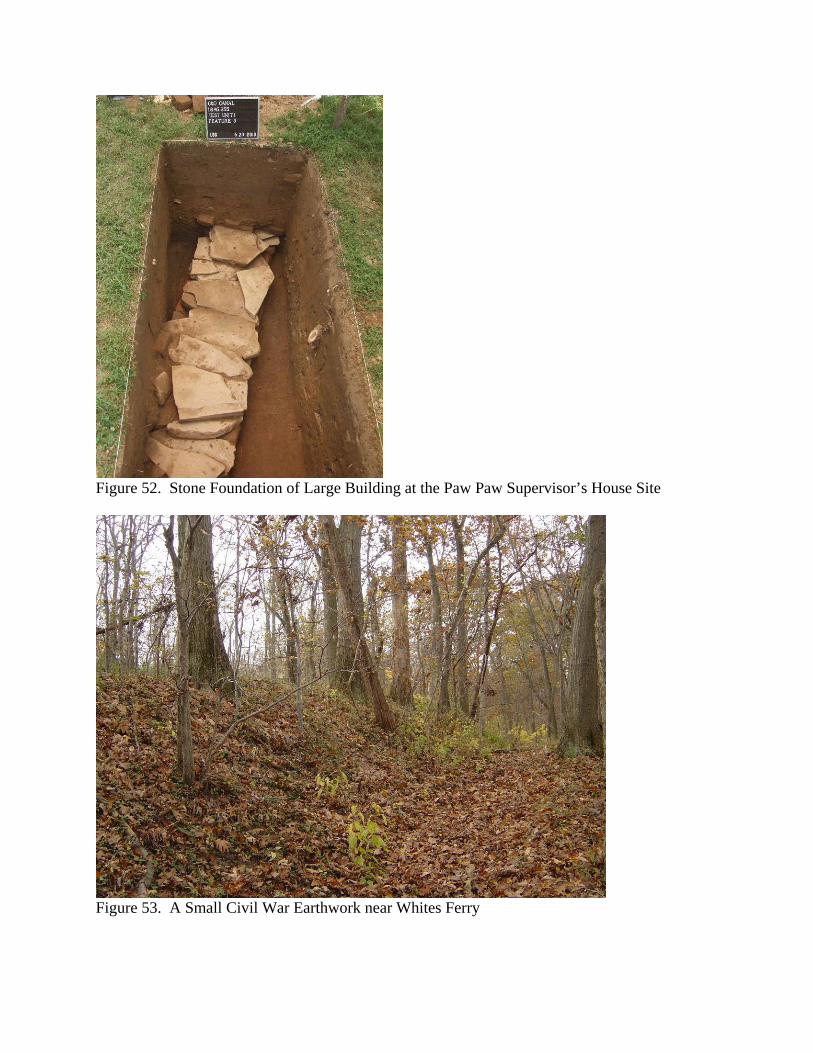
Figure 52. Stone Foundation of Large Building at the Paw Paw Supervisor’s House Site
Figure 53. A Small Civil War Earthwork near Whites Ferry
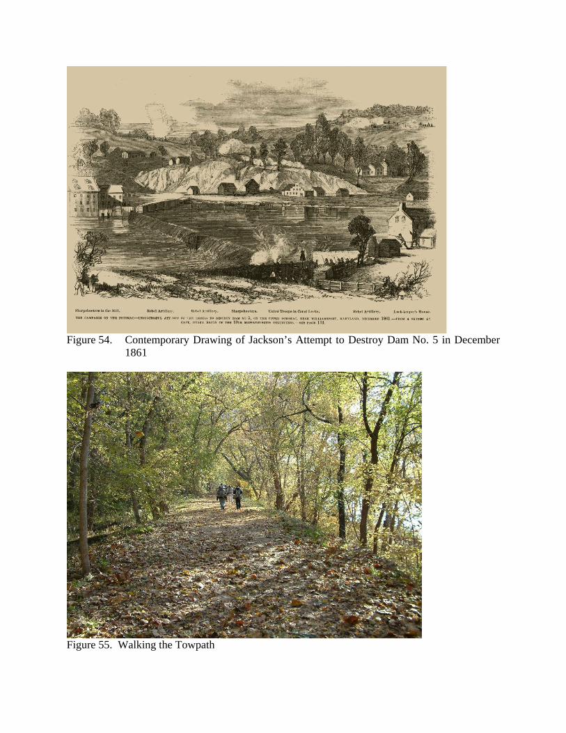
Figure 54. Contemporary Drawing of Jackson’s Attempt to Destroy Dam No. 5 in December
1861
Figure 55. Walking the Towpath