Embed Size (px)
Citation preview

September 2014
Aiken County, South Carolina
A Phase I Archaeological Resources Survey of the 17.6-Mile Urquhart-
Graniteville Transmission Line Corridor
Brockington'ULTURAL
RESOURCES CONSULTING

A Phase I Archaeological Resources Survey of the 17.6-Mile Urquhart-Graniteville Transmission Line Corridor, Aiken County, South Carolina. Final Report Prepared For: UC Synergetic, LLC Charlotte, North Carolina Prepared By: Jana J. Futch, M.A., R.P.A. Project Manager And
Patricia Stallings M.A. Principal Investigator Brockington and Associates, Inc. Atlanta Charleston Pensacola Elizabethtown Savannah September 2014

v
Management Summary In March 2014, Brockington and Associates, Inc. (Brockington), contracted with UC-Synergetic, LLC to conduct an Archaeological Resources Survey (ARS) of the Urquhart-Graniteville transmission line corridor in Aiken County, South Carolina. Brockington was concurrently tasked with conducting a Literature Review and Windshield Reconnaissance of historic architectural resources within the study area. Both Brockington projects were conducted for UC-Synergetic, LLC on behalf of South Carolina Electric and Gas (SCE&G), in preparation for proposed capacity upgrades of the transmission line from 115kV to 230kV, which will require a Certificate of Public Convenience and Necessity (CPCN) by the South Carolina Public Service Commission (SCPSC). The goal of the archaeological survey and architectural windshield reconnaissance was to determine whether any historic properties (i.e., sites, buildings, structures, objects, or districts listed on or eligible for the National Register of Historic Places [NRHP]) may be affected by this transmission line upgrade project. SCE&G proposes to upgrade its infrastructure along approximately 17.6 miles of the existing transmission line corridor. This existing corridor is 100 feet (ft) (approximately 30 meters [m]) wide and constitutes the project right of way (ROW). No new ROW is anticipated for the project. Brockington archaeologists conducted archival research of the extant corridor and a two kilometer- (km) radius surrounding the corridor. This research revealed that there are nine previously recorded archaeological sites within the two-km buffer, including three resources that are listed on the National Register of Historic Places (NRHP). However, Brockington recommends that none of these previously identified resources will be affected by the proposed upgrades to the extant transmission line corridor. Brockington archaeologists also conducted an intensive shovel test survey of the entire 17.6-mile corridor. Shovel tests were excavated at 30-m intervals along a single transect placed down the center of the corridor. Five new archaeological resources were identified as a result of this survey, including three sites (38AK1089, 38AK1090, and 38AK1091) and two isolated finds (Isolate 1 and Isolate 2). Brockington recommends that none of these five archaeological resources is eligible for the National Register of Historic Places (NRHP), and that no further management of these resources is necessary. Brockington further recommends that, as no newly or previously recorded archaeological resources will be impacted by the proposed infrastructure upgrades, the project should be allowed to proceed.

i
Table of Contents Management Summary v 1.0 Introduction and Methods of Investigation 1
1.1 Introduction 1 1.2 Methods of Investigation 4
1.2.1 Project Objective 4 1.2.2 Background Research 4 1.2.3 Field Investigations 4 1.2.4 Laboratory Analysis and Curation 5 1.2.5 Assessing NRHP Eligibility 5
2.0 Environmental Overview 8
2.1 Geology and Geomorphology 8 2.2 Topography and Soils 9 2.3 Temperatures and Climate 13 2.4 Floral and Faunal Habitats 13
3.0 Cultural Overview 14
3.1 The Pre-Contact Era 14 3.1.1 The Lithic Stage 14 3.1.2 The Archaic Stage 16 3.1.3 The Woodland Stage 18 3.1.4 The Mississippian Stage (1,000–450 BP) 19
3.2 Contact Era 20 3.3 Post-Contact Overview 22
4.0 Results and Recommendations 29
4.1 Results of Background Research 29 4.2 Survey Results 33
4.2.1 38AK1089 37 4.2.2 38AK1090 40 4.2.3 38AK1091 43 4.2.4 Isolate 1 46 4.2.5 Isolate 2 49
4.3 Recommendations 52 References Cited 53

ii
List of Figures Figure 1.1 Location of the 17.6-mile of the Urquhart to Graniteville Transmission Line Corridor, Aiken County, South Carolina (USGS Quadrangle Maps, 7.5 minute series, Graniteville [1980] and Aiken [1980]). 2 Figure 1.2 Location of the 17.6-mile of the Urquhart to Graniteville Transmission Line Corridor, Aiken County, South Carolina on modern aerial imagery (Esri 2011). 3 Figure 2.1 Typical view of the northeastern portion of the project corridor, showing erosion; view is to the southwest. 10 Figure 2.2 Typical view of the middle section of the project corridor, looking south to horse jumping arena. 11 Figure 2.3 Soils within the 17.6-mile Urquhart to Graniteville Transmission Line Corridor. 12 Figure 3.1 1825 Mills Atlas showing the location of the 17.6-mile Project Corridor in relation to Augusta, Fort Moore, and historic roads. 25 Figure 4.1 Map of all Previous Surveys and Previously Recorded Archaeological Sites within the Two-km project buffer. 30 Figure 4.2a Map 1 of 3 showing of all Newly Recorded Archaeological Resources within the Project Corridor. 34 Figure 4.2b Map 2 of 3 showing of all Newly Recorded Archaeological Resources within the Project Corridor. 35 Figure 4.2c Map 3 of 3 showing of all Newly Recorded Archaeological Resources within the Project Corridor. 36 Figure 4.3 Site map of 38AK1089. 38 Figure 4.4 View of 38AK1089, looking southwest down the corridor. 39 Figure 4.5 View of 38AK1089, looking southeast to steep drop in middle ground of photograph. 39 Figure 4.6 Site map of 38AK1090. 41 Figure 4.7 View of 38AK1090, looking southeast. 42 Figure 4.8 View of 38AK1090, looking southwest towards a slight rise and the location of 38AK1089. 42

iii
Figure 4.9 Site map of 38AK1091. 44 Figure 4.10 View of 38AK1091, looking east along the corridor. 45 Figure 4.11 View of 38AK1091, looking south down slope. 45 Figure 4.12 Site map of Isolate 1. 47 Figure 4.13 View of Isolate 1, looking south along corridor and eroded slope wash. 48 Figure 4.14 View of Isolate 1, looking north along disturbed corridor and down slope; the fenced area to the west is a substation. 48 Figure 4.15 Site map of Isolate 2. 50 Figure 4.16 View of Isolate 2, looking north upslope along corridor. 51 Figure 4.17 View of Isolate 2, looking south to edge of ridge nose; a wetland is located at the base of the ridge out of view in the photograph. 51

iv
List of Tables Table 4.1 List of all Previous Surveys within the Two-km Project Buffer. 31 Table 4.2 List of all Previously Recorded Archaeological Resources within the Two-km Project Buffer. 31 Table 4.3 List of all Newly Recorded Archaeological Resources within the Project Corridor. 33 Table 4.4 List of artifacts recovered at 38AK1089. 37 Table 4.5 List of artifacts recovered at 38AK1090. 40 Table 4.6 List of artifacts recovered at 38AK1091. 43 Table 4.7 List of artifacts recovered at Isolate 1. 46 Table 4.8 List of artifacts recovered at Isolate 2. 49

1
1.0 Introduction and Methods of Investigation 1.1 Introduction In March 2014, Brockington and Associates, Inc. (Brockington), contracted with UC-Synergetic, LLC to conduct an Archaeological Resources Survey (ARS) of the Urquhart-Graniteville transmission line corridor in Aiken County, South Carolina. Brockington was concurrently tasked with conducting a Literature Review and Windshield Reconnaissance of historic architectural resources within the study area. Both projects were conducted for UC-Synergetic, LLC on behalf of South Carolina Electric and Gas (SCE&G), in preparation for proposed capacity upgrades of the transmission line from 115kV to 230kV, which will require a Certificate of Public Convenience and Necessity (CPCN) by the South Carolina Public Service Commission (SCPSC). The goal of the archaeological survey and architectural windshield reconnaissance was to determine whether any historic properties (i.e., sites, buildings, structures, objects, or districts listed on or eligible for the National Register of Historic Places [NRHP]) may be affected by this transmission line upgrade project. Both the survey and the reconnaissance were conducted in accordance with Section 106 of the National Historic Preservation Act of 1966, as amended (16 USC 470). Information pertaining to the architectural literature review and reconnaissance is included in a separate letter report (see Stallings 2014). This report provides the results of the ARS. SCE&G proposes to upgrade its infrastructure along approximately 17.6 miles of the existing transmission line corridor (Figures 1.1 and 1.2). The survey corridor passes through agricultural and wooded areas as well as areas that have been developed in recent years. The corridor extends from SCE&G’s Urquhart Plant near Beech Island, South Carolina to an electrical substation in Graniteville, South Carolina. This existing corridor is 100 ft (approximately 30 m) wide and constitutes the project right of way (ROW). No new ROW is anticipated for the project. The current 115kV corridor was first constructed in 1950 and has not been previously surveyed for cultural resources. Anticipated disturbance from the proposed project includes excavation of select locations to place new structures within the existing corridor. This ARS included a review of previous cultural resource investigations in the project area, an archaeological survey of the corridor, and an architectural survey of approximately two km (1.25 miles) surrounding the corridor. Jana Futch, the project manager for this ARS, reviewed the ArchSite program for previous cultural resource surveys and previously identified archaeological sites and historical architectural resources within the two km survey buffer. Scott Kitchens conducted additional research at the state site files office at the South Carolina Institute of Archaeology and Anthropology (SCIAA) and the South Carolina Department of Archives and History (SCDAH). The archaeological survey was conducted from April 28 to May 9, 2014, and was completed by Jana Futch, John O’Donnell, James Page, Cristian LaRosa, and Bronwen Morgan. The architectural literature review and windshield reconnaissance was conducted from May 12 to 14, 2014, and was completed by Patricia Stallings. A separate letter report detailing the results of the architectural reconnaissance was provided to UC Synergetic in developing a viewshed sensitivity assessment.

2
Figure 1.1 Location of the 17.6-mile of the Urquhart to Graniteville Transmission Line Corridor, Aiken County, South Carolina (USGS Quadrangle Maps, 7.5 minute series, Graniteville [1980] and Aiken [1980]).

3
Figure 1.2 Location of the 17.6-mile of the Urquhart to Graniteville Transmission Line Corridor, Aiken County, South Carolina on modern aerial imagery (Esri 2011).
r 4
I ,1
\r .pg
J4
~ L
'
l, ')(
~4
/r
'
4
P
''J8
i',jP.",, ~,
1
)
~ 4
frI

4
1.2 Methods of Investigation 1.2.1 Project Objective The objective of these cultural resource investigations was to assess the potential for the proposed replacement of the transmission line structures for the 17.6-mile transmission line corridor to affect historic properties. Tasks performed to accomplish this objective include background research, archaeological survey, and architectural reconnaissance. Additional tasks undertaken by Brockington include laboratory analysis, curation, and report writing. Methods employed for each of these tasks are described below. 1.2.2 Background Research The project manager searched the ArchSite program for previous cultural resource surveys and previously identified archaeological sites and historical architectural resources within two km (1.25 miles) of the project corridor. Brockington staff conducted additional research at SCIAA and the SCDAH. This research focused on specific reports and maps associated with studies identified through ArchSite. Previous cultural resource investigations and recorded cultural resources within two km of the corridor are discussed in Chapter 4. The purposes of the archival research were to identify known Pre- or Post-Contact archaeological sites and buildings that are listed on or eligible for listing on the NRHP and to develop a historical context that would assist in evaluating cultural resources identified during the field investigations. The principal investigator also researched primary and secondary resources pertaining to the Aiken area, including Mills (1979 [1825]), the series of historic topographic maps in the University of South Carolina’s Thomas Cooper Library digital archives, Strother (2008), Vandervelde (1999), and Hale (2000). 1.2.3 Field Investigations Field survey entailed the systematic examination of the project corridor following South Carolina Standards and Guidelines for Archaeological Investigations (COSCAPA et al. 2013). The proposed upgrades to the transmission line structures and equipment will be within the existing ROW. Brockington archaeologists examined the transmission line corridor by means of a single shovel test transect located on the corridor. Depending upon the topography within the corridor itself, this transect was either excavated down the center of the corridor, or near the north-central/east-central portion of the corridor. We excavated shovel tests at 100-ft (30-m) intervals along the transect. Each shovel test measured approximately one foot in diameter and was excavated into culturally sterile subsoil. The fill from these tests was sifted through one-quarter-inch mesh hardware cloth. Information relating to each shovel test and soil profile was recorded in field notebooks. This information included the content (e.g., presence or absence of cultural materials) and context (e.g., soil color, texture, and stratification) of each test. Investigators also visually inspected the ground surface where possible. All shovel tests were backfilled upon completion. When surface or subsurface archaeological materials were encountered, the interval between shovel tests was reduced to 15 m (33 ft) to delimit site boundaries. Per COSCAPA (2013:19), two consecutive negative shovel tests (at 15-m [33-ft] intervals) are considered sufficient to provide an edge determination for a site boundary. An archaeological site is a locale yielding

5
three or more Pre- or Post-Contact artifacts within a 100-ft radius. Locales where structures, berms, soils stains, or other features are present may also be classified as sites. Locales that produce fewer than three contemporaneous artifacts are identified as isolated finds (COSCAPA et al. 2013). Also, obviously redeposited artifacts (even if greater than three in number) are typically defined as an isolated find rather than a site unless there is a compelling reason for doing otherwise. 1.2.4 Laboratory Analysis and Curation In Brockington’s laboratory, artifacts from the field are washed by laboratory technicians. After washing, artifacts are allowed to air dry. Provenience numbers are assigned to each excavation bag. Within each provenience, artifacts are sorted by criteria such as material class, manufacture method, object form, and decoration. Each group of artifacts is counted and weighed, then bagged in archivally stable bags and assigned a catalog number. All artifacts are identified and classified based on their material, cultural association, and function, among other attributes. All artifact and provenience data is compiled in a Microsoft Access (2010) database. Following review and acceptance of the final report, all artifacts, project maps, field notes, analysis forms, photographs, and other information generated by this investigation will be prepared for storage at a federally approved curation repository following standards outlined in 36 CFR 79 (Curation of Federally-Owned and Administered Archaeological Collections: Final Rule). These standards include, but are not limited to, the packaging of all materials in archivally stable bags and boxes. Artifacts, maps and photograph files associated with this project currently are stored at the Brockington’s Norcross office. Upon acceptance of the final report, Brockington and Associates, Inc. will deliver the curation package to the SCIAA. 1.2.5 Assessing NRHP Eligibility All cultural resources encountered are assessed as to their significance based on the criteria of the NRHP. As per 36 CFR 60.4, there are four broad evaluative criteria for determining the significance of a particular resource and its eligibility for the NRHP. Any resource (building, structure, site, object, or district) may be eligible for the NRHP that: A. is associated with events that have made a significant contribution to the broad pattern of history; B. is associated with the lives of persons significant in the past; C. embodies the distinctive characteristics of a type, period, or method of construction, or represents the work of a master, possesses high artistic value, or represents a significant and distinguishable entity whose components may lack individual distinction; or D. has yielded, or is likely to yield, information important to history or prehistory. A resource may be eligible under one or more of these criteria. Criteria A, B, and C are most frequently applied to historic buildings, structures, objects, non-archaeological sites (e.g., battlefields, natural features, designed landscapes, or cemeteries), or districts. The eligibility of archaeological sites is most frequently considered with respect to Criterion D. Also, a general

6
guide of 50 years of age is employed to define “historic” in the NRHP evaluation process. That is, all resources greater than 50 years of age may be considered. However, more recent resources may be considered if they display “exceptional” significance (Sherfy and Luce n.d.). Following National Register Bulletin: How to Apply the National Register Criteria for Evaluation (Savage and Pope 1998), evaluation of any resource requires a twofold process. First, the resource must be associated with an important historical context. If this association is demonstrated, the integrity of the resource must be evaluated to ensure that it conveys the significance of its context. The applications of both of these steps are discussed in more detail below. Determining the association of a resource with a historical context involves five steps (Savage and Pope 1998). First, the resource must be associated with a particular facet of local, regional (state), or national history. Secondly, one must determine the significance of the identified historical facet/context with respect to the resource under evaluation. A lack of Native American archaeological sites within a project area would preclude the use of contexts associated with the Pre-Contact use of a region. The third step is to demonstrate the ability of a particular resource to illustrate the context. A resource should be a component of the locales and features created or used during the historical period in question. For example, early nineteenth-century farmhouses, the ruins of African American slave settlements from the 1820s, and/or field systems associated with particular antebellum plantations in the region would illustrate various aspects of the agricultural development of the region prior to the Civil War. Conversely, contemporary churches or road networks may have been used during this time period but do not reflect the agricultural practices suggested by the other kinds of resources. The fourth step involves determining the specific association of a resource with aspects of the significant historical context. Savage and Pope (1998) define how one should consider a resource under each of the four criteria of significance. Under Criterion A, a property must have existed at the time that a particular event or pattern of events occurred, and activities associated with the event(s) must have occurred at the site. In addition, this association must be of a significant nature, not just a casual occurrence (Savage and Pope 1998). Under Criterion B, the resource must be associated with historically important individuals. Again, this association must relate to the period or events that convey historical significance to the individual, not just that this person was present at this locale (Savage and Pope 1998). Under Criterion C, a resource must possess physical features or traits that reflect a style, type, period, or method of construction; display high artistic value; or represent the work of a master (an individual whose work can be distinguished from others and possesses recognizable greatness) (Savage and Pope 1998). Under Criterion D, a resource must possess sources of information that can address specific important research questions (Savage and Pope 1998). These questions must generate information that is important in reconstructing or interpreting the past (Butler 1987; Townsend et al. 1993). For archaeological sites, recoverable data must be able to address specific research questions. After a resource is associated with a specific significant historical context, one must determine which physical features of the resource reflect its significance. One should consider the types of

7
resources that may be associated with the context, how these resources represent the theme, and which aspects of integrity apply to the resource in question (Savage and Pope 1998). As in the antebellum agriculture example given above, a variety of resources may reflect this context (farmhouses, ruins of slave settlements, field systems, etc.). One must demonstrate how these resources reflect the context. The farmhouses represent the residences of the principal landowners who were responsible for implementing the agricultural practices that drove the economy of the South Carolina area during the antebellum period. The slave settlements housed the workers who conducted the vast majority of the daily activities necessary to plant, harvest, process, and market crops. Once the above steps are completed and the association with a historically significant context is demonstrated, one must consider the aspects of integrity applicable to a resource. Integrity is defined in seven aspects of a resource; one or more may be applicable depending on the nature of the resource under evaluation. These aspects are location, design, setting, materials, workmanship, feeling, and association (36 CFR 60.4; Savage and Pope 1998). If a resource does not possess integrity with respect to these aspects, it cannot adequately reflect or represent its associated historically significant context. Therefore, it cannot be eligible for the NRHP. To be considered eligible under Criteria A and B, a resource must retain its essential physical characteristics that were present during the event(s) with which it is associated. Under Criterion C, a resource must retain enough of its physical characteristics to reflect the style, type, etc., or work of the artisan that it represents. Under Criterion D, a resource must be able to generate data that can address specific research questions that are important in reconstructing or interpreting the past.

8
2.0 Environmental Overview The project corridor is located just south of the Fall Line, in the interface between the Coastal Plain and the Piedmont. This area is known as the Fall Line Hills district of the Southern Coastal Plain physiographic province. More specifically, it is located in the middle portion of the Savannah River Valley, a major watershed that slopes from more than 5,000 feet in the Appalachians to sea level at the Atlantic. The environmental overview presented here highlights the nature, regional geology, soils, climate, and ecosystems of the project area. 2.1 Geology and Geomorphology The Savannah River Valley has undergone a great deal of complex tectonic alteration since the formation of the Appalachians, some 500 million years ago. Built largely on folded, upturned, and metamorphosed rocks, the rolling hills and narrow stream valleys of the Piedmont extend southeastward from the higher Blue Ridge and terminate abruptly at the Fall Line, where they dive under the later sediments of the Coastal Plain. Magma, extruded through the underlying mantle, has shaped those hills and valleys. It has also contributed to the diversity of surface minerals by creating dikes and expanses of granitic and metavolcanic rocks. Surface geology in the Piedmont is typically masked by saprolite, a layer of decomposed rock consisting of clay-sized iron oxides, aluminum, quartz, and silica minerals (Hodler and Shretter 1986:36). In contrast, the Coastal Plain has a distinctly maritime origin. Between 135 million to 11,000 years ago, sea level changes built a succession of barrier islands extending from the Fall Line to the modern coast of South Carolina and Georgia. The area nearest the Piedmont shows the most dynamic environment with the deposition of a belt of deep sands (the Fall Line Hills) eroded from the Piedmont edge. Much of the remainder of the Coastal Plain was built up through marine settling of clay and silty sands. Vast deposits of limestone were created around 25 million years ago across the Florida, Georgia, South Carolina, and Alabama Coastal Plains. The Floridan aquifer developed in conjunction with this limestone deposition, and this aquifer remains a significant source of fresh water even today (Hodler and Shretter 1986:32-33). Surface sediments are widely variable given that the flat topography tends toward marshy expanses between very low, broad interfluvial ridges (Hodler and Shretter 1986:17). The Savannah River begins in the Blue Ridge of southwestern North Carolina and flows southeast for more than 313 miles, forming the boundary between South Carolina and Georgia, before it empties into the Atlantic Ocean. The Savannah River Basin encompasses more than 10,469 square miles divided into nine separate hydrologic units. The primary tributaries of the Savannah include the Seneca River, Tugaloo River, Broad River, Little River, Stevens Creek, and Brier Creek. In past times, the upper section of the Savannah River flowed swiftly through the rolling hills of the Piedmont to the shoals at the Fall Line. South of the shoals the flatter terrain broadened the river and created a series of wide terraces bordered by back channels, meanders, and oxbow swamps. On the Coastal Plain, the wetlands and natural levees are occasionally interrupted by limestone outcrops, such as Silver Bluff. Tidal action begins to have an influence on the river as much as 28 miles upstream from the ocean, where it starts to form a complex deltaic estuary.
9
The alluvial deposits of the Savannah date back at least 150,000 years to the Early Pleistocene (Segovia 1985:16). After periods of downcutting and stability through the Pleistocene, the transition to the Holocene (around 12,000 years ago) witnessed a river that probably fluctuated drastically seasonally. The floodplain above the Fall Line was unstable, with steep scarps and rapid colluviation (Segovia 1985:21). From 10,000 to 7000 years before the present (BP), there appears to have been “sedimentary pulsing” or deposition of fine- to medium-grained sands, during periods of deforestation, presumably as a result of climatic change (Segovia 1985:22). Around 3600 BP the river became fairly stable up through the historic period (circa 300 BP), reflecting a slow deposition rate of around one centimeter (cm) per 100 years (Segovia 1985:26). European settlement began in the mid-1700s with the founding of Augusta. Prior to that time, European contact was limited to trading arrangements and military expeditions. Settlement occurred slowly at first, with settlers locating their farms and plantations alongside the river and major tributaries. Cutting of the forests was de rigueur for the earliest settlers, and it resulted in an increase of sheetwash erosion during the wetter seasons. Sediment loading swelled the river and led to increases in seasonal flood events beginning at least as early as 1796 (Speer and Gamble 1964). With the building of the Augusta Canal in 1845, upriver settlement rapidly increased, with large expanses of land being cleared for cotton agriculture. Soil loss in the Piedmont of South Carolina and Georgia approached an average of nine to 12 inches by the early twentieth century (Trimble 1974:Figure 17). Below the Fall Line, sedimentation rates became as much as 30 times or more their normal rate (Segovia 1985:26). The USGS (1999) reports the bankfull discharge (amount associated with the most frequent flood interval) at 3,300 cubic meters per second (cms). On a monthly scale, data from 1907 through 1910 show a range in flow from 2,640 to 5,670 cms. According to USGS records (between 1796 and 1950), five years (1796, 1888, 1908, 1929, and 1930) witnessed floods exceeding 8,500 cms, the largest being 10,800 cms in 1796 (Elliott and Doyon 1981:51; Speer and Gamble 1964:318). In 1951, the US Army Corps of Engineers built the Clarks Hill Dam, forming the 72,000-acre Clarks Hill Lake by 1954 (known as J. Strom Thurmond Lake in South Carolina). This was followed by the 56,000-acre Lake Hartwell in 1963 and the 27,000-acre Richard B. Russell Reservoir in 1983. The Clarks Hill Dam, about 40 miles north of Augusta, stabilized sedimentation rates downstream, while the now-flooded Piedmont portions of the Savannah experience no further severe downcutting. Today, the annual average flow of the Savannah is 270 cms at Augusta, and around 343 cms as measured along the lower sections of the river (USGS 1999). This is one of the largest normal discharges of any river in the Southeast. 2.2 Topography and Soils The project corridor passes through rolling hills of the upper Coastal Plain. The northeastern portion of the corridor near Graniteville contains sections with very variable topography and relief, while hills within the southwestern portion closer to Beech Island are more gently sloped. The corridor passes through agricultural and wooded areas, as well as areas that have been developed in recent years for residential and recreational purposes, like horse riding. Figure 2.1 presents a typical view of an eroded portion of the corridor, near the northeastern end of the project. Figure 2.2 presents a typical view of the gently rolling hills more common to the

10
southwestern and middle portions of the corridor. Figure 2.3 shows the soil types present within the 17.6-mile corridor.
Figure 2.1 Typical view of the northeastern portion of the project corridor, showing erosion; view is to the southwest.

11
Figure 2.2 Typical view of the middle section of the project corridor, looking south to horse jumping arena. As mentioned above, surface sediments in the project area highly variable, though most eroded sections of the corridor feature exposed clays and most upland areas contain pockets of deep sand. The Vaucluse-Ailey complex has been mapped on many of the project corridor’s steeper slopes (USDA 2014). These are well-drained soils that form on marine terraces and can range from 2 to 25 percent slopes (Rogers 1985). A typical soil profile contains loamy sand from the surface to about 25 cm, over sandy clay loam that extends well below a meter. Given that the corridor was first cleared decades ago, and that it has been constantly maintained since that time, soils on the steeper slopes have become drastically eroded. In areas mapped with Vaucluse-Ailey complex soils, Brockington archaeologists usually encountered dense, compact clays near or at the surface. Several areas of the corridor that are less sloped, and are therefore notable because they are usually less eroded, have been mapped with the Fuquay Series of soils (USDA 2014). Soils within this series form on broad ridges and adjoining side slopes, and are well drained (Rogers 1985). A typical soil profile contains sand from the surface to about 20 cm below surface, over loamy sand to about 54 cm below surface, before encountering sandy clay loam subsoil (Rogers 1985). Most of the deepest and most intact soil profiles Brockington recorded are within pockets of Fuquay Series or similar soils, like Troup Series.
TY
4
Rl
g.lk
"f

12
Figure 2.3 Soils within the 17.6-mile Urquhart to Graniteville Transmission Line Corridor.
re
eTK
re
vo
M e
Corridor
F eF e

13
2.3 Temperatures and Climate The Middle Savannah Region falls within a warm, temperate subtropical climatic zone, with long, hot summers and short, cool winters. The typical daily January temperature in Aiken County, South Carolina, is a maximum of about 55°F, with a minimum of around 33°F, and averages close to 47°F. The typical daily July temperature is a maximum of 90°F, with a minimum of about 70°F, and averages around 80°F. The region usually has more than 240 frost-free days per year, with fewer than 60 days per year of temperatures below 32°F. The first frost typically occurs after mid-November, while the last frost usually takes place after March (Hodler and Schretter 1986:38-43; Rogers 1985:1-2, 94-95). Modern average total annual rainfall in Aiken County is approximately 120 cm (48 inches). Even though monthly precipitation tends to peak in summer and/or spring, the Fall Line Hills may experience a net water deficit between the months of May and October in a typical year. This is generally through agricultural use of the available surface water (Hodler and Schretter 1986:42). Water levels in the Savannah River are now regulated by the Clarks Hill Dam. 2.4 Floral and Faunal Habitats The Savannah River Valley today (excluding farmland) includes six primary forested habitats. These include over four million acres of loblolly-shortleaf pine, more than one million acres of oak-pine, 545,000+ acres of longleaf-slash pine, 533,000+ acres of oak-hickory, 516,000+ acres of oak-gum-cypress, and about 11,000 acres of live-oak forest or coastal marsh. Much of the region is managed plantation pine or other timber products and, therefore, subclimax forest. Modern forest types do not directly equate with these habitats, especially in the Pre-Contact period. Plummer (1975) provides more substantial insight into the forested habitat of the eighteenth century in the region, while Bartram (1791) describes a sample of plant species and habitats of the lower Savannah River Valley from his 1773 travels. These sources suggest a continuity of oak-gum-cypress species and habitats on the floodplains and in the marshes between the 1700s and today, but a transition of upland areas from oak-hickory, and oak-pine, to a great deal more loblolly-shortleaf pine dominated managed habitat. Notably, a large segment of the middle portion of the corridor is currently used by private residential developments/equine-focused communities for horse-jumping, dressage, and trail riding (see Figure 2.2). The grass is kept short for these activities, and multiple ponds have been added for the jumps. Horses are a common sight in these areas.

14
3.0 Cultural Overview 3.1 The Pre-Contact Era In South Carolina, the Pre-Contact era is divided into four stages (after Willey and Phillips 1958). These include the Lithic, Archaic, Woodland, and Mississippian. Specific technologies and strategies for procuring resources define each of these stages, with approximate temporal limits also in place. Within each stage, with the exception of the Lithic stage, there are temporal periods that are defined on technological bases as well. A brief description of each stage follows, including discussions of the temporal periods within each stage. Readers are directed to Goodyear and Hanson (1989) for more detailed discussions of particular aspects of these stages and periods in South Carolina. 3.1.1 The Lithic Stage Pre-Clovis Period (13,000+ BP). The beginning of the human occupation of North America is unclear. For most of the twentieth century, archaeologists believed that humans arrived on the continent near the end of the last Pleistocene glaciation, termed the Wisconsinan in North America, a few centuries prior to 12,000 BP. The distinctive fluted projectile points and blade tool technology of the Paleoindians (described below) occurs throughout North America by this time. During the last few decades of the twentieth century, researchers began to encounter artifacts and deposits that predate the Paleoindian period at a number of sites in North and South America. To date, these sites are few in number. The most notable are Meadowcroft Rock Shelter in Pennsylvania (Adovasio et al. 1990; Carlisle and Adovasio 1982), Monte Verde in Chile (Dillehay 1989, 1997; Meltzer et al. 1997), Cactus Hill in Virginia (McAvoy and McAvoy 1997), and most recently, the Topper/Big Pine Tree site in Allendale County, South Carolina (Goodyear 1999). All of these sites contain artifacts in stratigraphic locales below Paleoindian deposits. Radiocarbon dates indicate occupations at the Meadowcroft and Topper/Big Pine Tree sites that are 10,000 to 20,000 years earlier than the earliest Paleoindian occupations. Cactus Hill produced evidence of a blade technology that predates Paleoindian sites by 2,000 to 3,000 years. Monte Verde produced radiocarbon dates comparable to those at North and South American Paleoindian sites, but reflects a very different lithic technology than that evidenced at Paleoindian sites. Similarly, the lithic artifacts associated with the other pre-Paleoindian deposits discovered to date do not display the blade technology so evident during the succeeding period. Unfortunately, the numbers of artifacts recovered from these sites are too small at present to determine if they reflect a single technology or multiple approaches to lithic tool manufacture. Additional research at these and other sites will be necessary to determine how they relate to the better-known sites of the succeeding Paleoindian period, and how these early sites reflect the peopling of North America and the New World. Paleoindian Period (13,000–10,000 BP). The Paleoindian period, the earliest securely dated and documented period of human occupation in the New World, corresponds with the terminal Pleistocene, when the climate was generally much colder than today, and when sea levels were

15
over 60 m below present levels. Another notable feature of the terminal Pleistocene was the presence of large mammalian species (i.e., megafauna). The pattern of human adaptation for this period has been reconstructed from data from other areas of the country and from distributional data on the diagnostic fluted projectile points (e.g., Clovis, Hardaway, Dalton) within the Southeast. Very few Paleoindian sites have been excavated in the Southeast, and only relatively recently have South Carolina sites received attention (Goodyear et al. 1989). However, the data from surface finds of Paleoindian points seem to indicate that cultures of this period were focused along major river drainages, especially in terrace locations (Anderson and Logan 1981; Goodyear 1979; Michie 1977). Similarly, Anderson et al. (1990:39-40) suggest an emphasis on floodplain locales in the Oconee River valley of Georgia, with a shift to an increased use of upland areas through time. Work in the Oconee Valley by O’Steen et al. (1986) also demonstrated the presence of specific Paleoindian site types associated with particular settings within the valley. If the pattern from other areas of the country holds true in South Carolina, then the adaptation was one of broad-range, high-mobility hunting and gathering with a possible focus on megafauna exploitation (Gardner 1974). Evidence to suggest a more generalized approach, with small game and plant foods providing the bulk of Paleoindian subsistence, also has been collected for the eastern United States (Meltzer 1988; Meltzer and Smith 1986); the limited association of megafaunal remains with cultural artifacts in the Southeast may support this contention. The material culture of the Paleoindian period is dominated by fluted or semi-fluted projectile points, most commonly produced on high-quality cryptocrystalline material. Although fluted points have been found in surface contexts across the South Carolina Piedmont, the Paleoindian (i.e., Clovis) period is relatively poorly represented (Goodyear et al. 1989). Artifacts and sites of a Transitional period (12,000–9,500 BP) are much more common in the region. It should be noted that there is disagreement regarding the placement of the Hardaway and Palmer phases, with the Palmer phase sometimes placed in the Paleoindian period (e.g., Claggett and Cable 1982; Purrington 1983; Ward 1983). The Hardaway complex includes semi-fluted/side-notched projectile points and a wide variety of formal scrapers (Coe 1964). It is best known from the Hardaway (type) site in Stanly County, North Carolina (Coe 1964), but other excavations have also yielded Hardaway and Hardaway-Dalton material (e.g., Claggett and Cable 1982). The following Palmer phase retains many of the same formal tool types, while the Palmer projectile point is a side-notched variety generally lacking basal thinning or fluting (Coe 1964). In terms of settlement, there appears to have been a dramatic increase in site frequency from Clovis to Hardaway. Hardaway and Palmer sites are present in a wide variety of environmental zones. If O’Steen’s (1983) model of Transitional period settlement in the Georgia Piedmont can be applied to the South Carolina Piedmont and Sandhills, the major sites would be expected near large rivers, particularly around areas of shoals or narrows. Only a few Paleoindian projectile points have been reported from the area, particularly the earlier fluted types. The majority of these specimens has been recovered from surface or plow zone

16
contexts. Charles’s (1986) survey of lanceolate Paleoindian points in South Carolina suggests that the majority of the specimens recovered to date were manufactured from high-quality Coastal Plain cherts that are exposed along the Savannah River in Allendale County and adjacent portions of Georgia. 3.1.2 The Archaic Stage The Archaic stage represents the adaptation of Southeastern Native Americans to Holocene environments. By 10,000 BP, the forests had changed from sub-boreal types common during the Paleoindian period to more modern types. The Archaic stage is divided into three temporal periods: Early, Middle, and Late. Distinctive projectile point types serve as markers for each of these periods. Hunting and gathering was the predominant subsistence mode throughout the Archaic periods, although incipient use of cultigens probably occurred by the Late Archaic period. Also, the terminal Archaic witnessed the introduction of a new technology, namely, the manufacture and use of pottery. Early Archaic Period (10,000–8,000 BP). The Early Archaic corresponds to the initial adaptation of native groups to Holocene conditions. The environment in central South Carolina during this period was still colder and moister than at present, and an oak-hickory forest was establishing itself on the Coastal Plain (Watts 1970, 1980; Whitehead 1965, 1973). The megafauna of the Pleistocene had disappeared, and more typical woodland flora and fauna were established. Early Archaic finds in the region are typically side- or corner-notched projectile points (e.g., Taylor, Palmer, and Kirk), which have been determined to be Early Archaic through excavation of sites in other areas of the Southeast (Claggett and Cable 1982; Coe 1964). Early Archaic sites generally are small, suggesting a high degree of mobility. Diagnostic projectile points have been recovered from all portions of the lower Piedmont and Upper Coastal Plain, suggesting a shift from the riverine emphasis of the earlier Paleoindian period (Goodyear et al. 1989:38; Wetmore et al. 1986:18). This is particularly true for the earliest Palmer points. Interestingly, these types display a technological continuation of the earlier Paleoindian lithic tradition not found in the later corner-notched or bifurcated types (Goodyear et al. 1989:39; Oliver 1985:200). Anderson and Hanson (1988) propose a model for Early Archaic subsistence/settlement on the South Atlantic Slope. This model suggests the implementation of high residential mobility throughout most of a season, with aggregation in the winter when resources are less widely distributed within the region. Further, population aggregates are associated with specific drainages. Annual population movements include use of the Piedmont and upper Coastal Plain within each drainage; the Sandhills presumably were visited in the fall, probably due to the presence of dense oak masts and concentrations of mast-consuming ungulates (i.e., deer; also see Sassaman et al. 1990:50-52; Sassaman et al. 2002). Anderson and Hanson (1988:271) suggest the presence of “macrobands” associated with the larger drainages that cross the region. Interaction between these larger aggregates permitted the flow of extra-local raw materials, information, and mates between the groups occupying each drainage. In contrast, O’Steen’s (1983) model of Early Archaic settlement suggests fairly restricted occupation during this period in the Oconee Valley of the Georgia Piedmont. Recurring

17
occupation of base camps within the valley, at locales that provided access to the greatest density and diversity of resources, was suggested with lithic exchange networks that extended across territorial boundaries of particular groups. Middle Archaic Period (8,000–4,000 BP). The trends initiated in the Early Archaic (i.e., increased population and adaptation to local environments) continued through the Middle Archaic period. Climatically, the study area was still warming, and an oak-hickory forest dominated the region until circa 2000 BC, when pines became more prevalent (Watts 1970, 1980). Stemmed projectile points (e.g., Stanly, Morrow Mountain, Guilford Lanceolate) and ground stone artifacts characterize this period. On the nearby Piedmont, site densities increased through the Middle Archaic period, suggesting more intensive implementation of foraging strategies; no specific locales appear to be favored for occupation (Blanton and Sassaman 1989:59-60). On the Coastal Plain, Middle Archaic sites occur with less frequency but show evidence of more intensive habitation and large-scale tool production. This suggests increased “patchiness” in resources on the Coastal Plain, compared to earlier periods or the contemporary Piedmont (Sassaman et al. 1990:10). Middle Archaic sites in the Sandhills region appear to relate more to the Coastal Plain pattern. Anderson’s (1979) excavations at 38LX5 and 38LX64 on the Congaree River suggest the use of the floodplain as long-term residential locales similar to logistical base camps and the use of nearby upland settings as more specialized resource extraction locales. Middle Archaic sites, usually consisting of a few flakes and points, are scattered throughout the Savannah River Site (SRS), located to the south of the project corridor. These distributions parallel site occurrences on the Piedmont, suggesting that Middle Archaic groups were highly mobile and exploited a wide variety of resources from all possible settings in the region. Excavations at Middle Archaic sites in the Sandhills along Lynches River in Chesterfield County to the northeast by Gunn and Wilson (1993) and McMakin et al. (2000) suggest adaptations similar to those noted by Sassaman et al. (1990). Late Archaic Period (4,000–2,500 BP). The Late Archaic period apparently relates to a time of population expansion and increased local adaptations (Caldwell 1958). It also is during this time that the first pottery appears on the South Carolina coast and in the Fall Line region. This pottery is the sand-tempered or untempered Thom’s Creek series and the fiber-tempered Stallings series; both are decorated by punctation, incising, finger pinching, and, for Thom’s Creek, possibly simple stamping and dentate stamping. Large, stemmed bifaces (e.g., Savannah River) are the most common lithic artifacts in the earlier pre-ceramic Late Archaic assemblages. Smaller, stemmed points appear in association with the ceramic wares, apparently representing a transition between the ceramic Late Archaic and subsequent Early Woodland cultural manifestations of the region. Late Archaic sites throughout the southeastern Atlantic seaboard suggest that intensive exploitation of specific aquatic resources was common throughout the period. Large sites, presumably representing long periods of occupation by a large population aggregate, occur along the major drainages and the coastal estuaries. An emphasis on anadromous fishes (at the Fall Line and on the Piedmont) and shellfish (along the coast) has been suggested by several researchers (Claggett and Cable 1982:40; Taylor and Smith 1978) to explain the presence of

18
these large sites. However, the distinctive large, stemmed projectile points generally associated with Late Archaic occupations have been recovered from sites in almost all environmental settings from the mountains to the coast throughout South Carolina (Wetmore et al. 1986:21). Thus, Late Archaic sites can be expected throughout the Inner Coastal Plain of South Carolina. Sassaman et al. (1990:312-314) propose a model for Late Archaic settlement on the SRS that includes large population aggregations in the river valley during the spring and summer, with a dispersal of smaller family groups into tributary drainages during the fall and winter of each year. This would result in the development of large, dense sites with very diverse artifact assemblages in the river floodplain, and smaller, less diverse sites along smaller drainages and in the inter-riverine areas. Anderson’s (1979:236-237) excavations at four sites in the Congaree Valley in Lexington County tend to support such a model, with two sites located in upland settings adjacent to the floodplain containing remains suggestive of limited-activity animal processing and two sites on the floodplain containing evidence of intensive occupation suggestive of long-term residence and a wide range of activities. 3.1.3 The Woodland Stage The Woodland stage is marked by the introduction of pottery and the use of smaller triangular projectile points, assumed to indicate the presence of the bow and arrow. The change in material culture represents a change in subsistence strategies and approaches to hunting and gathering. The Woodland is divided into three temporal types (Early, Middle, and Late), marked by distinctive pottery types. Early Woodland Period (2,500–1,800 BP). The first Woodland manifestations in the region are characterized by a significant increase in stamp-decorated pottery. Following Espenshade and Brockington (1989), definitive markers of the Early Woodland are considered to be Deptford Check Stamped (linear and bold), Deptford Simple Stamped (including possible Refuge Simple Stamped), and coarse sand-tempered, fabric-impressed pottery. In the Early Woodland, the region apparently represented an area of interaction between widespread ceramic traditions, with the paddle-stamped tradition dominant to the south and the fabric-impressed and cord-marked tradition dominant to the north and west (Blanton et al. 1986; Caldwell 1958; Espenshade 1986; Espenshade and Brockington 1989). The subsistence and settlement pattern of the Early Woodland period suggests population expansion and the movement of groups into areas used less intensively in earlier periods. Hanson (1982) suggests that this dispersal reflects a collapse of a previously stable resource base (e.g., drowned estuaries on the coast [Trinkley 1989:78]) and the attempt of Early Woodland populations to replace a focused subsistence strategy with one more diffuse (after Cleland 1976). Anderson and Joseph (1988:218) note a similar diffusion of population and reduced regional interaction during the Early Woodland period of the Middle Savannah River Valley of South Carolina as well. Similar dispersals are noted for the Savannah River Site, with a shift from the floodplains to an occupation of the uplands along the many tributaries of the Savannah River (Sassaman et al. 1990:315). Anderson (1979:237) suggests a general shift away from the Congaree floodplain as well. Presumably, single-family residences were established in upland locales that were inhabited throughout the year. Additional resources were procured through

19
exchange with neighbors or collected from specialized sites scattered throughout the immediate area. Thus, Early Woodland sites most common in the region generally consist of small ceramic and lithic scatters in a variety of environmental zones. Some sites will represent residential locations of single-family units, while others will represent resource-extraction loci. Lower artifact frequencies and diversity, and also reduced site size, could be expected at the resource-extraction sites. Middle and Late Woodland Periods (1,800–1,000 BP). The typological manifestations of the Middle and Late Woodland periods in the region are somewhat unclear. The check-stamped tradition of the Early Woodland Deptford series continues through most of the Middle Woodland period. Cord-marked and fabric-impressed ceramics continue to be produced through the Middle and Late Woodland periods, as do simple-stamped wares. There is no single decorative mode that can be associated with these periods, and research in the project region has only begun to sort out the confusion (Anderson et al. 1982; Blanton et al. 1986; Trinkley 1983). Middle and Late Woodland settlement patterns appear to continue the diffused distributions noted for the Early Woodland (Trinkley 1989:83-84). Interior Coastal Plain sites of the periods tend to occur adjacent to the large, swampy floodplains of the many rivers crossing the Coastal Plain, with numerous small scatters of Middle/Late Woodland artifacts occurring on the inter-riverine uplands. McMakin et al. (2000) recovered few Late Woodland artifacts from sites excavated on the upper Lynches River; however, two sites contained burials that produced radiocarbon dates from the Late Woodland period (circa 1,200–1,100 BP). 3.1.4 The Mississippian Stage (1,000–450 BP) Mississippian societies represent the most complex prehistoric cultural development in the southern United States. The diagnostic complicated stamped ceramics and small triangular projectile points of this period mark the transition of groups in the region to a complex system of social organization that lasted until European contact. In most areas of the Southeast, the Mississippian period is characterized by an emphasis on agriculture and by the development of complex public works and ceremonial centers occupied by a highly stratified society. The Native American groups encountered in the region by European explorers and traders from the 1540s through the mid-1700s were Mississippian societies. Contact with the Europeans introduced new technologies and diseases that greatly altered the social and political organizations that were present in the region in the sixteenth century. Mississippian groups apparently were aligned along major drainages (i.e., those with extensive floodplains) and the coastal strand (i.e., near estuarine resources) (Anderson 1989:114). A wide range of site types has been identified for Piedmont Mississippian occupations throughout South Carolina, North Carolina, and Georgia. Larger villages tend to be associated with specific mound sites. Smaller habitation sites are scattered along the surrounding drainages, to the extent that single-family compounds may be present on secondary drainages with adequate floodplains to support the agricultural production of foodstuffs (Ferguson and Green 1984; Poplin 1990). Ferguson and Green (1984) also note that Mississippian centers generally display a symmetric distribution above and below the Fall Line, with few large sites in the immediate location of the

20
distinctive rapids of the local rivers. Thus, major Mississippian sites tend to be located along the major drainages of South Carolina that possess extensive floodplains; however, they occur either on the lower Piedmont (above the Fall Line) or on the upper Coastal Plain (below the Fall Line) rather than at the transition between these two major physiographic regions of the state. Much of the Savannah River Valley appears to have been abandoned during the later Pre-Contact and Contact periods. Anderson (1989:119) suggests that an extensive buffer existed between the province associated with Cofitachequi—the regional “center” of Mississippian settlement throughout central South Carolina (DePratter 1989) on the Wateree River near Camden—and the neighboring province of Ocute, presumably centered on the Oconee River in Georgia. Extensive research has not been conducted in the drainages between the Savannah and Wateree, but large Mississippian settlements have not been positively identified in these drainages to date. Besides the large central-mound villages, many small scatters of Mississippian artifacts are found in diverse environmental settings throughout the surrounding region. These sites probably represent resource-extraction loci, since an amalgam of agricultural produce and hunted and gathered remains provided subsistence for Mississippian groups throughout the Southeast (Smith 1975). As an example, Goodyear (1976:11-12) noted extensive Mississippian sites along the Congaree River below Columbia. These sites are interpreted as base camps located near prime agricultural lands, from which inter-riverine locales were visited to collect resources not available on the floodplain. 3.2 Contact Era This is the time of initial contact between the indigenous populations and Europeans arriving in North America. Other than a few direct contacts, most Native American groups “encountered” Europeans through trade goods and diseases. However, a number of groups established strong relationships with the European colonists, monopolizing trade with the coastal settlements and sometimes capturing slaves for the new settlers. Although a few Spanish explorers landed on the coast of South Carolina during the first half of the sixteenth century, the first incursion into the interior occurred in 1540 when the De Soto expedition passed through the region. The French and Spanish both established settlements on Parris Island in Port Royal Sound in the 1550s and 1560s; the Spanish settlement of Santa Elena would remain in place until the late 1580s. During this time, a few Spanish explorers and traders traveled into the interior of the Carolinas. After the abandonment of Santa Elena in 1588 until the establishment of Charles Towne in 1670, no known European visits to the interior of South Carolina occurred. The middle Savannah River Valley appears to have been unoccupied during the sixteenth century. The area was reported to be deserted by the 1540 Hernando de Soto expedition and has been termed the “desert of Ocute” (Hudson et al. 1984). Anderson (1990) links this abandonment to cycling in chiefdoms and other episodes of political upheaval. A number of groups are identified in the region after the establishment of Charles Towne in 1670, including the Westo during the late seventeenth century and the Shawnee, Apalachee, Apalachicola, Chickasaw, Yamacraw, and Yuchi in subsequent decades (DePratter 1988).

21
In 1680, the Savannas migrated into the region and drove out the Westo, whose numbers had been decimated by a war with other local tribes. These mysterious Savannas were probably a group of isolated Chickasaw that moved from the Georgia side of the Savannah River to Beech Island on the South Carolina side of the river. They made trading connections with the Goose Creek men near Charles Towne, and were given a town on the bluff of the big river initially called the Westbou, but then the Savannah. As friends of the Carolinians, the Savanna received special trading rights and enjoyed a brisk trade of deerskins and Indian slaves sold to Charles Towne merchants (Crane 1956). Very little is known about Savannah Town before the year 1690. The Joel Gascoyne Map, dated 1685, shows a path running from Charles Towne via Goose Creek to the fork of the Edisto River and then west to “Savanna Town and Fort.” Gascoyne’s map substantiates a settlement at that time, but the exact date that of permanent settlements of colonial traders is not known. It is likely that traders lived in the area very early on with protection from their Savanna allies. One of the better documented and longest lasting occupations was that of a small, possibly renegade band of the Chickasaw invited by the Carolina leadership to settle near Fort Moore. Fort Moore was constructed in 1716 by the British near the abandoned site of Savannah Town (Ivers 1970). Note that this settlement is now recorded as archaeological Sites 38AK0004 and 38AK0005. Under the leadership of a chief known as the Squirrel King, this small band of Chickasaw, perhaps 30 or 40 in number, arrived in the project area circa 1723 (Milling 1969:188). Their settlement, located across the Savannah River from New Windsor township, originally consisted of 8,710 hectares. The Lower Chickasaw, as the group came to be known, became faithful allies of the British. While their loyal military service was praised, the Lower Chickasaw had a series of small altercations with white settlers on adjacent lands. To help prevent encroachment by the immigrating Carolinians, the Chickasaw settlement was surveyed and officially deeded to the tribe in 1739 (Milling 1969). This did little to relieve friction between the Chickasaw and their neighbors. Accusations of theft and threats against white settlers plagued local officials, who hastily reprimanded alleged Chickasaw perpetrators. Also feeling pressure from neighboring Indian groups such as the Cherokee, the Lower Chickasaw traded some of their holdings in the New Windsor township for a tract located on the Georgia side of the Savannah River (Milling 1969). When asked why they preferred the new tract to their older holdings around Horse Creek, the Old Doctor, apparently a shaman among the Lower Chickasaw, replied that the new location was less vulnerable to attack by Indian neighbors to the north (Milling 1969). According to some sources (Milling 1969), the Lower Chickasaw never officially ceded their lands on the east bank of the Savannah River and lived for a while on both sides of the river; however, the entire settlement was located on the Georgia side by 1758 (Cashin 1978). According to Cashin (1986), the Chickasaw were awarded lands on the Georgia side of the river in exchange for agreeing to help establish the city of Augusta. Roger Lacy, appointed by Oglethorpe to enforce Indian trade regulations and to establish Augusta, had surveyors “run out” a town for the Lower Chickasaw (Cashin 1986:31). This town, called New Savannah, was
22
located approximately 16 kilometers south of Augusta on a bend of the Savannah River. Records of grievances made by the Lower Chickasaw concerning, among other things, squatters from the north and horse thieves, indicate that a considerable number of tribal members were still living on the South Carolina side of the river as late as 1766 (Milling 1969). The Chickasaw, like most of the Native American groups in the Southeast, sided with the British during the American Revolution. In 1783, the Assembly of South Carolina passed an ordinance authorizing the confiscation of loyalist estates, including the land holdings of the Chickasaw (Milling 1969). Georgia adopted a similar policy toward loyalists, completely removing the Chickasaw from the area. The Catawba, who sided with the patriots during the Revolution, assumed the position of frontier guardsmen along the Savannah River. In the years that followed the Revolution, many former Tories were able to recover confiscated properties; however, the Lower Chickasaw were not as fortunate. On the technicality that the Indians held these properties as individuals and not as the Chickasaw Nation, a petition to recover their lands was denied by the courts (Milling 1969). 3.3 Post-Contact Overview The first known Europeans to come to South Carolina were the Spanish captains Francisco Gordillo and Pedro de Quexos and their sailors in the summer of 1521. Thereafter, the southern Carolina coast was of great interest to both the Spanish and the French. The Spaniard Ayllon attempted to establish the settlement of San Miguel de Gualdape in 1526, but was unsuccessful. The location of this settlement is not known, although it is thought to have been in the vicinity of Winyah Bay (Quattlebaum 1956). In 1526, the French under Jean Ribault attempted to establish a settlement on the South Carolina coast. This settlement, in the Port Royal Sound area, was called Charlesfort and also was unsuccessful. Hernando de Soto and his expedition explored the interior of the southeast in 1540-1542 and visited the Province of Cofitachique. Scholars disagree on the exact location of this province; generally, it is placed in western South Carolina. Indian groups of the area were probably contacted by the Juan Pardo expedition during 1566 and 1567. A successful Spanish settlement was finally established on Parris Island in Port Royal Sound in 1566. This settlement, called Santa Elena, was abandoned by the Spanish in 1587 (South 1979). The interior of South Carolina remained largely unexplored by Europeans until the establishment of Charles Towne (Charleston) in 1670. This English settlement grew slowly in the beginning, but served as a base for repeated explorations into the interior of the region. Shortly before 1700, English trappers and traders began moving into western South Carolina. Diseases and warfare had largely decimated Lowcountry native groups, and the dominant tribe in western South Carolina was the Iroquois-speaking Cherokee. The English and the Cherokee soon became major trade partners. Coarse woolen cloth, hardware, glass beads, hatchets, hoes, and knives were exchanged for furs and skins (Petty 1943:29). Deer hides became the most important product exported to England in the first quarter of the eighteenth century. Trade with the Cherokee was so brisk that it was taken over by the provisional government in 1716. As many as 230,000 deer skins were received in Charleston in 1732. By 1750 exports of deer skins were worth $1 million (Klosky 1971:6). In 1751, trade legislations regulated the employment of traders, rum distribution, and traders’ bond limits. In 1752 the Cherokee Nation was mapped into 13 hunting ranges with one trader assigned to each

23
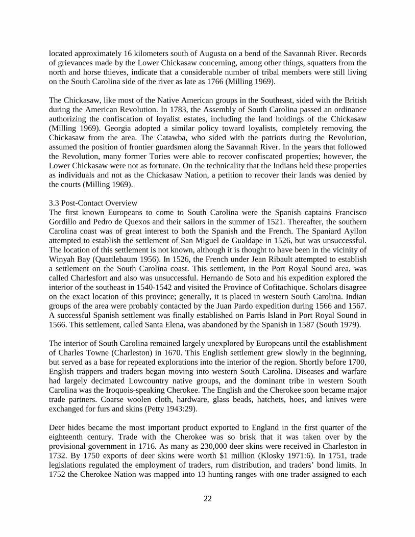
range. Contemporary reports include one trader’s estimate that he would buy 14,000 deer skins (Van Clayton 1988:4). For decades, traders financed by Charles Towne’s merchants had plundered, killed, and enslaved the Indians of the backcountry. In 1715, the Yamasee and their confederates – the Creeks, Choctaws, and Catawbas – retaliated against the European settlers. On Good Friday, 15 April 1715, they fell on frontier settlements 129 kilometers southwest of Charles Towne, murdering about 100 persons, including the wealthy Indian trader and legislator Thomas Nairne, who was slowly burned to death. Indian raiding parties struck with terrifying suddenness along the Combahee and Edisto Rivers, and then along the Stono just below Charles Towne. Refugees streamed into the city and governor called out the South Carolina militia and led them on a counterattack. “The Carolinians sought help from the Proprietors, but they refused to spend any more money on Carolina and indicated that the colonists should rely on their own resources. The crisis ended only when the Cherokees at the western end of the colony agreed to aid the Carolinians by attacking the Creeks in early 1716, thus relieving the pressure on Charles Towne and helping to end one of the bloodiest and most costly of the Indian wars in colonial America” (Fraser 1989:32-33). Trade came to a standstill during the war and the colony’s indebtedness to English creditors put Charles Towne’s economy on shaky ground. In addition, crops were neglected for several years, buildings and fences were burned, and livestock slaughtered or carried off. At least 400 Carolinians, mostly farmers, were murdered and many others fled the colony. The conflict impressed upon the colonists the strategic value of settling the backcountry and constructing frontier fortifications. The Carolinians immediately designed plans for a fort in the backcountry for their allies, the Cherokees, and the expedition to build it soon departed. Fort Moore was constructed as a strategic buffer between Charles Towne and hostile Indian groups along and west of the Savannah River (Weir 1983:84-85). Fort Moore was built at Savannah Town on the high bluff that had been recently occupied by the Savanna Tribe. The construction of Fort Moore was handled by Captain Gerald Monger, who was the first commander of the post. It was named in honor of former Governor James Moore, a prominent slave trader. The fort possessed a commanding view of the trading trails that approached from both across the Savannah River and upriver. For over 50 years the wooden fort guarded the western edge of the Carolina colony, providing protection for traders and settlers moving into the upcountry. It served as both garrison and trading post for the friendly inland tribes (Crane 1956). Fort Moore was often in a state of disrepair, the walls rotting, the footing devoured by termites. Even though the fort was small, it was important to the upcountry defense and lucrative deerskin trade, so constant effort and expense went into maintenance. By 1720 the garrison was manned by 20 regulars and the path from Fort Moore and Savannah Town was continually patrolled by frontier soldiers called Rangers. About 1747, Fort Moore was rebuilt with walls over nine feet high and a walkway platform around the inside. Though the barracks could hold a hundred soldiers, there was rarely such a large contingent there, the usual number ranging from fifteen to thirty. The settlement of Augusta on the west side of the Savannah River marked the decline of

24
Fort Moore as a military and trading factor and in 1763, the fort was abandoned. George Johnston (1763) described Fort Moore before it was abandoned as: . . . on a beautiful and commanding Situation, is another Fort, named Fortmore, about one Hundred and fifty Miles West from Charles-Town; it is built of six-inch Plank nailed to Posts of light Wood, with four Towers or Bastions on the Angles, on which are small Cannon mounted; on the Inside is a Banquet, with loop-holes in the Courtines for small-arms; it has neither Ditch nor Glacis, but very good Barracks for one Hundred Men. Mills’ (1825) map of Edgefield District shows Fort Moore, though it was probably little more than ruins after several decades of abandonment (Figure 3.1). Prior to and during the Revolution, western South Carolina was a lawless border land (Klosky 1971:13). It was occupied by European American squatters who had gone there to escape the laws of the Colony (the closest law court was in Charleston). Concerned citizens banded together and formed a vigilante group called the Regulators. Another group was formed to support the existing colonial authorities and called themselves the Scovils. These two groups would eventually become known as Whigs (Regulators) and Tories (Scovils).
25
Figure 3.1 1825 Mills Atlas showing the location of the 17.6-mile Project Corridor in relation to Augusta, Fort Moore, and historic roads.

26
European settlement of the Savannah River drainage system began with the establishment of Augusta and New Windsor in the 1730s (Brooks 1981:25). Trading posts established along the Savannah River became important centers of fur trade between the English, the Cherokee, and the Creek Indians. Ties between the colonists and the Cherokees began to disintegrate during the middle 1700s (Klosky 1971:8). The global conflicts between England and France spread to the New World, as evinced by the French and Indian War of 1756-58. The Creek and Cherokee became involved in this brutal conflict as allies of the English and French. Numerous battles had decimated the ranks of fighting men from both tribes, weakening their military strengths, and, therefore, their usefulness to England and France. Tensions between the Cherokee and the English escalated to war in 1759 with the Cherokee War. Bands of Cherokee raided settlements and burned homesteads along the frontier (Van Clayton 1988:4). British troops, along with the local militia repeatedly defeated the Indians in battle, and eventually burned all Cherokee towns in South Carolina (Van Clayton 1988:7). South Carolina was held by Patriot forces from November 1775 until the spring of 1780 (Holschlag and Rodeffer 1977:21). The British attacked and captured Charleston in May 1780, and a month later General Andrew Williamson surrendered his Patriot forces at the town of Ninety-Six. The British garrisoned the town with 650 Loyalists as part of a string of fortifications at Augusta, Camden, and Georgetown. Patriot General Nathanael Greene laid siege to the town in May 1781 but could not hold the siege. The town was abandoned by the British soon after because it was difficult to maintain and re-supply (Holschlag and Rodeffer 1977:23). The Revolutionary War further stifled settlement in the area. Rebel and Tory groups fought back and forth over western South Carolina. Two skirmishes occurred in Aiken County at Beech Island (near the project corridor) and Galphin’s Fort; both were related to the American capture of Augusta from the British (Brooks 1981:28). Another skirmish occurred in Barnwell County at Wiggins Hill. After the Revolution, settlement and farming began in earnest. The land was cleared and cultivated, and corn and wheat were the major cash crops until Eli Whitney’s cotton gin made the slave production of cotton economically possible. Lack of good roads, however, made transportation of goods to market difficult, and the Savannah River became the major transportation route between the backcountry and the coast (Brooks 1981). To stimulate commerce, Charleston businessmen, including William Aiken, procured a charter in 1827 to build a railroad from Charleston to Hamburg (Brooks 1981:36). The 136-mile-long track was built primarily by slaves and free blacks (Strother 2008). When completed in 1833, it was the longest railway in the world at that time. The South Carolina Railroad carried over 100,000 bales of cotton a year to Charleston by 1846 (Brooks 1981:36). The railroad encouraged settlement of the interior of the state, and substantial towns, including the town of Aiken, were constructed at almost every train station from Hamburg to Charleston. Beech Island, near the project tract, also vied for a railroad stop, but was bypassed by a stop at Williams crossroad (Vandervelde 1999:70).

27
At the same time that the South Carolina railroad was being constructed and began transporting cotton to Charleston, several back-country entrepreneurs began attempting to set up their own milling operations. The Panic of 1837 had impressed on many South Carolinians the importance of a diversified economy that was not entirely reliant on agriculture (Vandervelde 1999:76). However, many early attempts to establish manufacturing in the Aiken County area were disastrous failures, mostly due to poor management, but also to events like enslaved workers setting fires. A former jeweler named William Gregg was the first to establish a successful mill after proving himself an adept manager and partner at other mill operations. Gregg chose to set up his own textile mill on Horse Creek, about a mile south of the South Carolina Railroad, and near the north end of the existing project corridor under study. The company, known as the Graniteville Manufacturing Company, purchased the land for the operation in 1846, and Gregg busied himself having men dig a canal, establish a sawmill for lumber, and build dams for the water supply (Vandervelde 1999). Gregg also designed and built an entire mill village, simultaneously, including a school, a hotel, two churches, several boarding houses (for single workers), six stores, and 90 cottages (for families) (Swint 1935). The cottages have been described as “real houses, not arranged in serried rows like the average mill village, but properly spaced about the landscape” (Swint 1935:no page numbers). The mill itself, also designed by Gregg, was two stories high, partially built from locally quarried granite, with elevated machinery, two turbines, and pipe systems to provide heat and fire protection (Vandervelde 1999). When this modern factory went into operation in 1849, it was the largest in the state (Vandervelde 1999:80). By the 1850 census, Gregg has attracted 325 workers to his mill, and 900 white citizens to the new town of Graniteville. Most mill workers were girls and young women, and Gregg insisted that all workers be white. Gregg’s company made money from more than the products it produced; workers paid rent for company houses; items were purchased at the company stores; and all children ages 6 to 12 were required to attend the mill school, for a fee (Vandervelde 1999:82). The Greggs kept houses in the Edgefield District and in Charleston. Gregg was not above hard work himself, however. A flood in 1867 broke the Graniteville mill dam, and Gregg caught pneumonia trying to help his workers fix the leak; he died soon after (Swint 1935; Vandervelde 1999:206). During the Civil War, a large portion of the textiles produced by the Graniteville mill went to the Confederacy. This supply was reimbursed in 1861 and 1862, but “commandeered as a tax” (Swint 1935: no page numbers) in the last years of the war. Little activity occurred in the South Carolina backcountry until the last year of the war. After the capture of Savannah, General Sherman’s army moved north and captured and burned the towns of Blackville and Williston, as well as destroying a substantial amount of railroad track in between. Sherman sent General Kirkpatrick and his cavalry to raid Aiken; he hoped to confuse the Confederates into believing Augusta, instead of Columbia, was the next object of his attentions. General Wheeler and his cavalry successfully opposed the Federal raid into Aiken on 11 February 1865. After the raid, both Wheeler and Kirkpatrick moved back toward General Sherman’s route to Columbia. General Lee surrendered in Appomattox, Virginia on 9 April 1865 and General Johnston surrendered in Bentonville, North Carolina on 26 April (Barrett 1987:98).

28
The end of the Civil War brought vast changes to South Carolina, and particularly to the upcountry. New ways of doing business came to the fore, which placed a premium on the small, but growing, inland towns and their merchants. Agriculture also was profoundly changed with the sudden end of slavery. Reconstruction began a period of experimentation in systems of organizing labor, particularly on the area’s farms. Prunty (1955) attributes the development and growth of the tenant system to extensive changes in sources of labor and availability of capital. The reorganization that occurred was based primarily on changes in the relationship between management and labor, and resulted in the broad dispersal of smaller, individual farmsteads within the former boundaries of plantations. Spatial differences between antebellum and postbellum plantation settlement patterns resulted from a movement away from the pre-war nucleated plantation village toward a dispersed pattern of tenant farms. The critical factor determining the extent of settlement distribution was the control and ownership of working livestock, agricultural implements, and housing. Shifts in settlement related to plantation reorganization occurred throughout the study area, establishing new spatial and labor relationships between former slave owners, freedmen, and non-landholding whites. Orser (1988:92) describes two main subtypes of the pattern: the cropper and the tenant farmer. The cropper relied on the amenities of the plantation, utilizing its barn and other outbuildings; the croppers’ houses were similar to slave quarters. The tenant farmers’ outbuildings were placed near their own residences. These were usually larger than the croppers’ homes, and provided the tenant farmers with a greater degree of independence. The typical tenant house was “a dilapidated, unpainted, weather beaten frame cabin leaning out of plumb on rock or brick pilings--unceiled, unscreened, covered with a leaky roof” (Orser 1988:94). Aiken also became a destination for wealthy northerners who established grand equestrian estates. The start of this trend began when Thomas Hitchcock, a sportsman from Long Island, married Celestine Eustis who had moved to Aiken in 1876 from New Orleans (Vandervelde 1999). This Winter Colony, as this section of Aiken came to be known, centered on life that evolved around horses and included homes, trails, pastures, tracks, and stables. In town, the Winter Colony residents also established banks, churches, a tennis facility, and other community buildings. Aiken today remains much the same, with local cotton, fruit and vegetable farmers sharing this small community with part time wealthy residents who spend their winters in Aiken in much more recreational pursuits. In the 1950s, the federal government built the Savannah River Nuclear Plant 10 miles south of town, from which Aiken “was wrenched out of its fairyland existence. Today, with a three-tiered society of horse enthusiasts, Southern townspeople, and another stratum of scientists and technocrats, Aiken is a community like no other” (Hale 2000:7).

29
4.0 Results and Recommendations 4.1 Results of Background Research To develop a context for evaluation purposes, background research was conducted at SCIAA in Columbia, South Carolina and focused on all archaeological resources located within a two-km (1.25-mile) radius of the Urquhart-Graniteville 230 kV transmission line corridor. A search of previously recorded resources within the area identified nine previous cultural resources surveys and nine known archaeological sites located within the two-km radius (Figure 4.1). Tables 4.1 and 4.2 list these sites and surveys and information about the nine archaeological sites within the research buffer is provided below. In summary, no eligible or listed NRHP properties are located within the corridor and those lying within the two-km research buffer will not be directly or indirectly impacted by proposed improvements within the existing transmission line corridor. Sites 38AK0004 and 38AK0005 encompass historic Fort Moore/Savano Town, located adjacent to the Savannah River. This area was inhabited by Indian traders as early as 1685, before Fort Moore was built in 1716 (Groover and Johnson 2001:2). The fort occupied an important military and trading position in the region until the mid-1760s, when newly-founded Augusta began to dominate the deerskin trade (Groover and Johnson 2001:4). Fort Moore was abandoned in 1766 and not reoccupied. This prominent archaeological site was first investigated in 1966 by Dr. William E. Edwards of the University of South Carolina. Later, an avocational archaeologist named J. Walter Joseph conducted excavations at the site(s) from 1969-1970. Fort Moore/Savano Town was listed on the NRHP in 1973. It received no archaeological attention until 2001, when limited investigations were conducted by Savannah River Archaeological Research Program to determine evaluate the condition of the site(s) (Groover and Johnson 2001). Sites 38AK0004 and 38AK0005 are not within the visual or audible range of the proposed improvements to the existing 230 kV Urquhart-Graniteville Transmission Line corridor. Site 38AK0032 is a small prehistoric mound site. It was recorded by J. W. Joseph in 1973 during construction of the South Aiken bypass. Joseph noted that it had been impacted by looters, and he himself only examined artifacts gathered by a collector. Based on these artifacts, Joseph assigned a Late Archaic affiliation, with “some evidence of later occupation” (38AK0032 Site Inventory Record). This site has not been evaluated for the NRHP. Site 38AK0043 is a Late Woodland site that was recorded by J. W. Joseph in 1974. Joseph recovered a Palmer point and an unknown number of ceramics, including fiber-tempered ceramics. The site has not been relocated since it was recorded, and its location is considered questionable by the SC SHPO.

30
Figure 4.1 Map of all Previous Surveys and Previously Recorded Archaeological Sites within the Two-km project buffer.
0 0.5 1 Mrles
0 0.5 1 Kilometers
Previously Recorded~ Survey Area
Lrrrr3 Archaeological Siteg
I
'eji
('
He
878
38AK0652
)6l'
km Buffe
198
/ee
J 109838AK0786
661
38AK1069
38AK0032
~ 121le'
Css Project Corridor~Qes
)
C,
r(,
c
951
)
2 ~
136\
9RI1030
38AK0004
c.
I~& hleed
ece ~
~ e ~1
38AK0047 — Iaeso.
1
e ~
46
38AK0005 vc
~ - rs
38AK0043
gopyrlghhcl 2813 atl
y,~
'.,'
s
rglr
O9raphlC. O ety, ssub d

31
Table 4.1 List of all Previous Surveys within the Two-km Project Buffer. Number Date Type Agency Author (Consultant) Survey Name 661 1978 Reconnaissance DOT Trinkley (DOT) Archaeological survey of
proposed Aiken Connector
878 2000 Intensive USACE Baluha and Hendrix (Brockington)
CR Survey of 5.3 Hectares at the Sage Valley Golf Club
136 2000 Intensive USACE Fletcher and Poplin (Brockington)
CR Survey of the Proposed Urquhart Natural Gas Pipeline
46 2001 Intensive USACE Fletcher (Brockington) CR Survey of the Proposed Urquhart Natural Gas Pipeline Re-route, Aiken
198 2001 Intensive DOT Frick (DOT) Int. Archaeo. and Hist. Archi. Survey of SC Rte. 191 over Bridge Creek
1098 2002 Intensive USACE O'Neal (Brockington) CR Survey of the Aiken Combustion Turbine Plant Tract
951 2009 Intensive FERC Trinkley and Southerland (Chicora)
Cultural Resources Survey of the Silver Bluff-North Augusta 115kV Transmission Line
27 2011 Reconnaissance FERC Bailey (Brockington) CRS of the Line 1 Replacement Project
121 2012 Reconnaissance SCDOT None given (New South & Associates)
Cultural Resource Survey of Seven Miles of Hitchcock Parkway, Aiken
Table 4.2 List of all Previously Recorded Archaeological Resources within the Two-km Project Buffer. Site Number Site Description Cultural Affiliation NRHP Eligibility 38AK0004 Historic Fort 17th-18th century Listed on Register 38AK0005 Historic Fort 17th-18th century Listed on Register 38AK0032 Prehistoric Mound Late Archaic Not Assessed 38AK0043 Unknown Late Woodland Not Assessed 38AK0047 Historic Plantation 18th-19th century Listed on Register 38AK0052 Artifact scatter Unknown Prehistoric/20th century Recommended Potentially Eligible 38AK0786 Railroad grade 19th-20th century Recommended Potentially Eligible 38AK1069 Historic Artifact Scatter 20th century Recommended Not Eligible 9RI1030 Kathryn S. Vessel 20th century Not Assessed

32
Site 38AK0047 encompasses the Redcliffe Plantation, an eighteenth- to nineteenth-century plantation located to the southeast of Beech Island, South Carolina. An architectural and archaeological investigation of the site took place in the early 1980s, and was subsequently reported in the Notebook, the journal of the Institute of Archaeology and Anthropology, University of South Carolina (Scurry 1982). The plantation was in use from the 1770s through at least the 1850s, with some occupation possibly occurring later, in the twentieth century (Scurry 1982). The Redcliffe Plantation was listed on the NRHP in 1973. Site 38AK0047 is not within the visual or audible range of the proposed improvements to the existing 230 kV Urquhart-Graniteville Transmission Line corridor. Site 38AK0652 was identified during a Phase I Cultural Resources Survey (CRS) for a proposed pipeline in 1995 (Berkin et al. 1995). The site is a lithic scatter of indeterminate prehistoric age. However, one pit feature with charred bones was found during the survey, indicating that the site could have the potential to meet Criterion D of the NRHP. Site 38AK0652 has been recommended potentially eligible for the NRHP. Site 38AK0786 is a railroad grade that was recorded during a Phase I CRS for a proposed pipeline in 1999 (Adams 2002). The investigators note that the grade appears to be a diversion off of Trolley Line Road, indicating that 38AK0786 may have been a portion of the trolley line. Adams (2002) recommended that more research be conducted to confirm this theory. If the site does represent a portion of the old trolley line, they believe that it may be significant to local history. The investigators recommend that 38AK0786 is potentially eligible for the NRHP. Site 38AK1069 is a twentieth-century artifact scatter located in a disturbed environment adjacent to several roads. It was recorded in 2012 during a Phase I CRS for proposed road widening for the South Carolina Department of Transportation (Davis and Person 2012). Davis and Person (2012) believe that the artifacts were probably deposited in their current location during previous road or housing construction. Site 38AK1069 is recommended not eligible for the NRHP. Site 9RI1030 consists of the remains of the Kathryn S. vessel, a rear wheel paddle boat that now occupies the west bank of the Savannah River in Richmond County, Georgia. The paddle boat was built in the 1930s in Charleston for use as a passenger service vessel (Newell 1994). According to the recorder, the Kathryn S. was the last paddle boat to operate on the Savannah River (Newell 1994). Site 9RI1030 has not been evaluated for the NRHP, but is listed on the Georgia Register for its state-wide significance.

33
4.2 Survey Results Brockington archaeologists excavated 837 shovel tests within the project corridor. This number includes delineation shovel tests at identified site locations, and those tests that could not be excavated due to extreme slope or standing water. Notably, the corridor has been maintained for many years over a hilly terrain, which has led to a loss of topsoil and pronounced erosion in some portions of the corridor. In these eroded and deflated areas, 7.5YR 4/6 strong brown clay or 10YR 6/4 light yellowish brown sandy clay subsoil were present at the surface. Isolate 1 was found in this type of environment. Most of the other archaeological resources that were recorded by this survey were identified in those areas where some topsoil has been retained. Sites 38AK1089 and 38AK1090, especially, featured soils that were deeper than those encountered elsewhere on the project corridor. As a result of these investigations, Brockington personnel identified four sites (38AK1089, 38AK1090, and 38AK1091) and two isolated finds (Isolate 1 and Isolate 2) (Figure 4.2a, 4.2b, and 4.2c; Table 4.3). Each newly identified site contained three or more contemporaneous artifacts, the isolated finds contain only two artifacts each within a 30-m area. Table 4.3 List of all Newly Recorded Archaeological Resources within the Project Corridor. Site Number
Site Description Cultural Affiliation NRHP Eligibility
38AK1089 Lithic scatter Indeterminate Prehistoric Recommended Not Eligible 38AK1090 Historic artifact
scatter 19-20th Century Recommended Not Eligible
38AK1091 Historic artifact scatter
19-20th Century Recommended Not Eligible
Isolate 1 Lithic and ceramic scatter
Paleoindian/Indeterminate Prehistoric
Recommended Not Eligible
Isolate 2 Lithic scatter Indeterminate Prehistoric Recommended Not Eligible

34
Figure 4.2a Map 1 of 3 showing of all Newly Recorded Archaeological Resources within the Project Corridor.
'1', "4lI
0 230 500 Meters)
r
Site Datum~ URKGranttevttle
)(V 1''
I
't
aC ~ )."( ~+
38AK1
38A K
(i
7
13

35
Figure 4.2b Map 2 of 3 showing of all Newly Recorded Archaeological Resources within the Project Corridor.
Site Datum~ URK Grantteralle
( +aaa )),/yt
i
i 'w e 'ea. //'
Ii.
a
'J nunsI';:."'/ir
( ~ Ci'.m. iX t ~ ',)l I
~g/ (~W~~c 2013 N tional Geogr phtc Society;@cubed
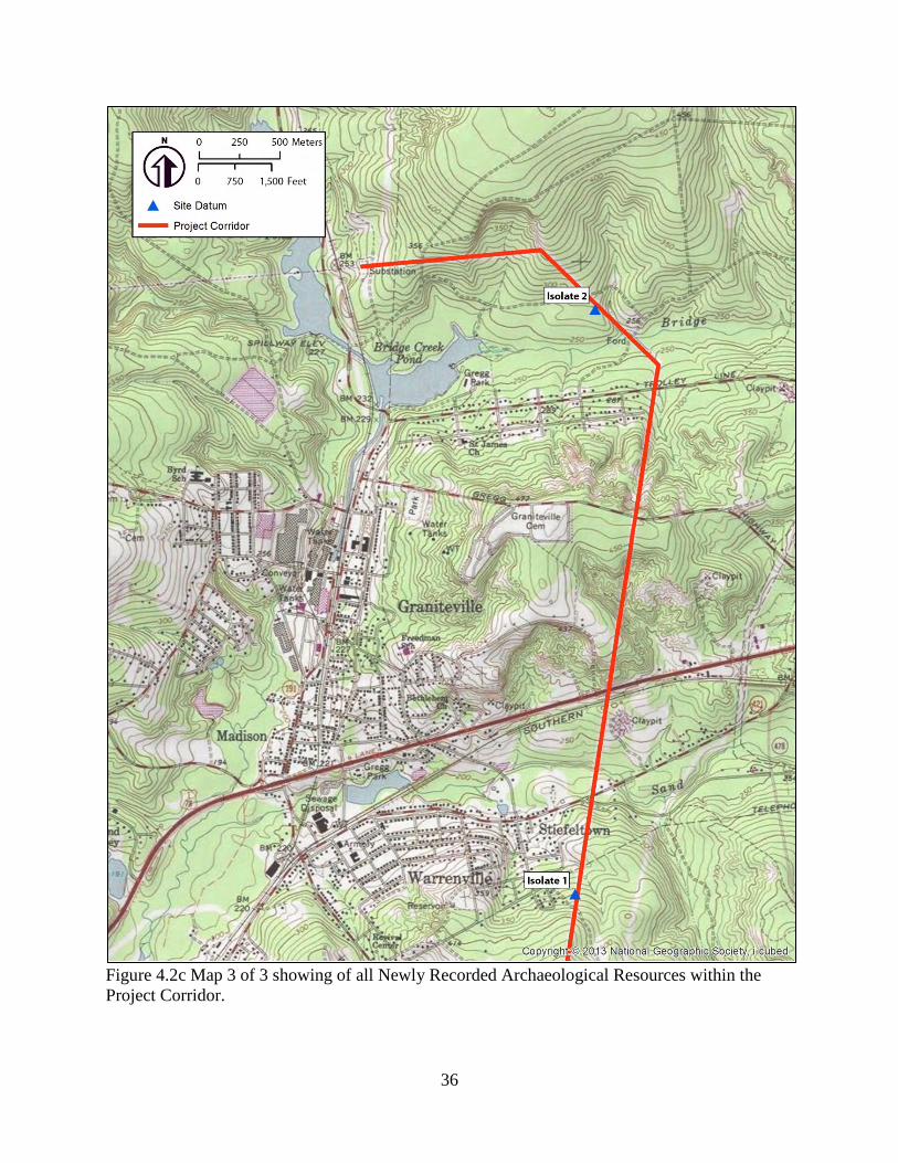
36
Figure 4.2c Map 3 of 3 showing of all Newly Recorded Archaeological Resources within the Project Corridor.
seee
Site Datum
( 8
Isolate 2
(3
aa
T e
I)iI
&4&0
wg).
/ fe lsv lie
I.) , ~lS
jj /
l', 'e
Ista
Sss
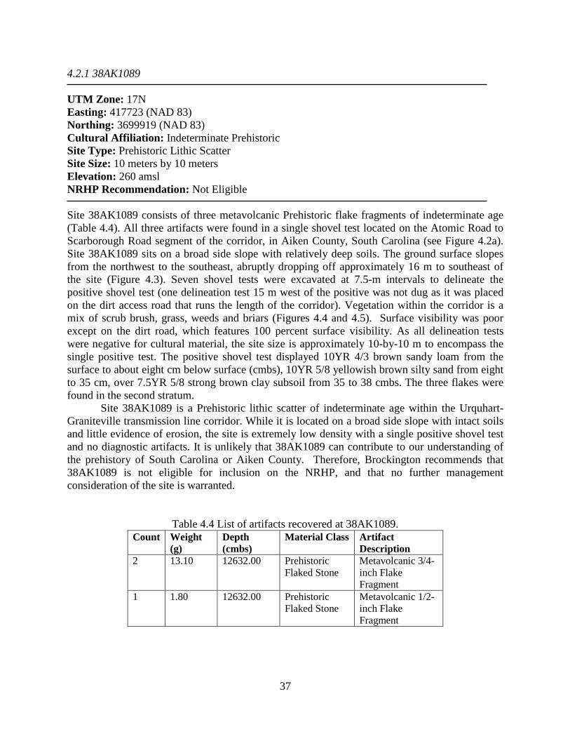
37
4.2.1 38AK1089 UTM Zone: 17N Easting: 417723 (NAD 83) Northing: 3699919 (NAD 83) Cultural Affiliation: Indeterminate Prehistoric Site Type: Prehistoric Lithic Scatter Site Size: 10 meters by 10 meters Elevation: 260 amsl NRHP Recommendation: Not Eligible Site 38AK1089 consists of three metavolcanic Prehistoric flake fragments of indeterminate age (Table 4.4). All three artifacts were found in a single shovel test located on the Atomic Road to Scarborough Road segment of the corridor, in Aiken County, South Carolina (see Figure 4.2a). Site 38AK1089 sits on a broad side slope with relatively deep soils. The ground surface slopes from the northwest to the southeast, abruptly dropping off approximately 16 m to southeast of the site (Figure 4.3). Seven shovel tests were excavated at 7.5-m intervals to delineate the positive shovel test (one delineation test 15 m west of the positive was not dug as it was placed on the dirt access road that runs the length of the corridor). Vegetation within the corridor is a mix of scrub brush, grass, weeds and briars (Figures 4.4 and 4.5). Surface visibility was poor except on the dirt road, which features 100 percent surface visibility. As all delineation tests were negative for cultural material, the site size is approximately 10-by-10 m to encompass the single positive test. The positive shovel test displayed 10YR 4/3 brown sandy loam from the surface to about eight cm below surface (cmbs), 10YR 5/8 yellowish brown silty sand from eight to 35 cm, over 7.5YR 5/8 strong brown clay subsoil from 35 to 38 cmbs. The three flakes were found in the second stratum.
Site 38AK1089 is a Prehistoric lithic scatter of indeterminate age within the Urquhart-Graniteville transmission line corridor. While it is located on a broad side slope with intact soils and little evidence of erosion, the site is extremely low density with a single positive shovel test and no diagnostic artifacts. It is unlikely that 38AK1089 can contribute to our understanding of the prehistory of South Carolina or Aiken County. Therefore, Brockington recommends that 38AK1089 is not eligible for inclusion on the NRHP, and that no further management consideration of the site is warranted.
Table 4.4 List of artifacts recovered at 38AK1089. Count Weight
(g) Depth (cmbs)
Material Class Artifact Description
2 13.10 12632.00 Prehistoric Flaked Stone
Metavolcanic 3/4-inch Flake Fragment
1 1.80 12632.00 Prehistoric Flaked Stone
Metavolcanic 1/2-inch Flake Fragment
38
Figure 4.3 Site map of 38AK1089.

39
Figure 4.4 View of 38AK1089, looking southwest down the corridor.
Figure 4.5 View of 38AK1089, looking southeast to steep drop in middle ground of photograph.
1
4~ I'
H,q, g., -i
P
&I
I

40
4.2.2 38AK1090 UTM Zone: 17N Easting: 417979 (NAD 83) Northing: 3700058 (NAD 83) Cultural Affiliation: Nineteenth or Twentieth Century Site Type: Historic Artifact Scatter Site Size: 35 meters by 20 meters Elevation: 300 amsl NRHP Recommendation: Not Eligible Site 38AK1090 consists of a single brick fragment located in a shovel test, and two bricks observed on the surface within 30 m of the positive shovel test (Table 4.5). The two surface bricks were not collected. Site 38AK1090 is located on the Atomic Road to Scarborough Road segment of the corridor, in Aiken County, South Carolina (see Figure 4.2a). Like 38AK1089, 38AK1090 sits on a broad side slope with relatively deep soils. The ground surface is gently rolling, rising to the north and descending to the south. Seven shovel tests were excavated at 7.5-m intervals to delineate the positive shovel test (one delineation test 15 m west of the positive was not dug as it was placed on the dirt access road that runs the length of the corridor)(Figure 4.6). Vegetation within the corridor is a mix of scrub brush, grass, weeds and briars (Figures 4.7 and 4.8). Surface visibility was poor except on the dirt road, which features 100 percent surface visibility. All delineation tests were negative for cultural material, but given the presence of the bricks on the surface, the site size is approximately 30-by-30 m. The positive shovel test displayed 7.5YR 5/2 brown sand from the surface to about 50 cmbs, over very compact 7.5YR 5/8 strong brown sandy clay subsoil from 50 to 60 cmbs. The brick fragment was found in the first stratum.
Site 38AK1090 is an extremely low density historic artifact scatter that likely dates to the nineteenth or twentieth century within the Urquhart-Graniteville transmission line corridor. While it is located on a broad side slope with intact soils and little evidence of erosion, the site is extremely low density and only bricks were noted. It is possible that 38AK1090 was once an historic homestead, though there is not enough evidence to state this with certainty. It is unlikely that 38AK1090 can contribute to our understanding of the history of South Carolina or Aiken County. Therefore, Brockington recommends that 38AK1090 is not eligible for inclusion on the NRHP, and that no further management consideration of the site is warranted.
Table 4.5 List of artifacts recovered at 38AK1090. Count Weight
(g) Depth (cmbs)
Material Class
Artifact Description
1 1.30 0-30 Ceramics Brick, Fragment

41
Figure 4.6 Site map of 38AK1090.

42
Figure 4.7 View of 38AK1090, looking southeast.
Figure 4.8 View of 38AK1090, looking southwest towards a slight rise and the location of
38AK1089.
H
:,)~&~,lj4.
K

43
4.2.3 38AK1091 UTM Zone: 17N Easting: 423548 (NAD 83) Northing: 3699728 (NAD 83) Cultural Affiliation: Nineteenth or Twentieth Century Site Type: Historic Artifact Scatter Site Size: 25 meters by 20 meters Elevation: 300 amsl NRHP Recommendation: Not Eligible Site 38AK1091 consists of four historic artifacts of that were located within three positive shovel tests (Table 4.6). This site is located on the Pine Log Road to Storm Branch Road segment of the corridor, in Aiken County, South Carolina (see Figure 4.2b). The four artifacts include three fragments of stoneware and one amber glass sherd. Site 38AK1091 is situated on a low ridge top and the area is eroded with deflated soils. Surface visibility was poor. Twenty shovel tests were excavated at 7.5-m intervals to delineate the site, resulting in three positive shovel tests (Figure 4.9). The site size is approximately 25 m from east to west and 20 m from north to south. As elsewhere, vegetation with in the corridor is a mix of scrub brush, grass, weeds and briars (Figures 4.10 and 4.11). A typical shovel test contained 10YR 5/6 yellowish brown loamy sand from the surface to about 20 cmbs, over a sterile and compact 10YR 6/4 light yellowish brown silty sand subsoil. The four artifacts were found in the first stratum.
Site 38AK1091 is low density historic artifact scatter that likely dates to the nineteenth or twentieth century. Due to the paucity of artifacts, it is not known whether this site represents the prior location of a house, dump site, or some other historic site type. Site 38AK1091 is located on an eroded ridge top within an extant corridor and contains deflated, non-intact soils. Given the site’s low artifact density and lack of intact soils, it is unlikely that 38AK1091 can contribute to our understanding of the history of South Carolina or Aiken County. Therefore, Brockington recommends that 38AK1091 is not eligible for inclusion on the NRHP, and that no further management consideration of the site is warranted.
Table 4.6 List of artifacts recovered at 38AK1091.
Count Weight (g)
Depth (cmbs)
Material Class
Artifact Description
1 2.70 0-10 Ceramics Stoneware, Alkaline Glazed Gray-Bodied Body
1 8.10 0-10 Ceramics Stoneware, Unglazed Buff-Bodied Base
1 1.20 0-21 Ceramics Stoneware, Brown Glazed Buff-Bodied
2 4.70 0-21 Glass Amber Molded Glass Container Body

44
Figure 4.9 Site map of 38AK1091.

45
Figure 4.10 View of 38AK1091, looking east along the corridor.
Figure 4.11 View of 38AK1091, looking south down slope.

46
4.2.4 Isolate 1 UTM Zone: 17N Easting: 426519 (NAD 83) Northing: 3712134 (NAD 83) Cultural Affiliation: Paleoindian and Indeterminate Prehistoric Site Type: Prehistoric Lithic/Ceramic Scatter Site Size: 10 meters by 10 meters Elevation: 350 amsl NRHP Recommendation: Not Eligible Isolate 1 consists of an unfinished Paleoindian point and a Prehistoric ceramic sherd (Table 4.7). Both artifacts were found on the surface. This site is located on the Golf Course to Augusta Road segment of the corridor, in Aiken County, South Carolina (see Figure 4.2c). Though the Paleoindian point is a relatively rare, diagnostic find, as there are only two non-contemporaneous artifacts that were identified within 30 m at this location these artifacts are still classified as an isolated find. The two artifacts were identified on a sandy trail/eroded slope wash in a very disturbed environment; multiple power line poles surround the find location, and a substation has been constructed nearby. Upslope to the southwest is a mobile home where modern trash is eroding down to the find location. This building is not visible within the site photos of the corridor, but is obvious in Figure 4.12. This area was less vegetated than other parts of the corridor, though there are patches of scrub brush, grass, weeds and briars (Figures 4.13 and 4.14). Surface visibility was moderate, varying between about 50 percent on brushy areas, but 100 percent on the sandy slope wash. Within this highly eroded environment, 10YR 6/4 light yellowish brown silty sand subsoil is present at the surface. A total of nine shovel tests were attempted at 7.5-m intervals to delineate the site. All shovel tests were negative for cultural material, and the site area was determined to measure about 10-by-10 m.
The second artifact found at the site, an eroded sand-tempered body sherd, is undoubtedly from a later, though indeterminate, prehistoric period. Neither artifact was found in situ; instead, both were located on an eroded slope wash. Isolated finds are generally not eligible for the NRHP. With its data potential exhausted, Brockington recommends that Isolate 1 is not eligible for inclusion on the NRHP, and that no further management consideration of the site is warranted.
Table 4.7 List of artifacts recovered at Isolate 1.
Count Weight (g)
Depth (cmbs)
Material Class
Artifact Description
1 25.70 Surface Prehistoric Flaked Stone
Coastal Plain Chert Projectile Point Tool Distal - Unfinished Paleoindian
1 2.90 Surface Prehistoric Ceramics
Eroded Body Sherd, Fine/Medium Sand Tempered

47
Figure 4.12 Site map of Isolate 1.
Isolate I
o ~
e
Gully Road~Source.CNEI GP,

48
Figure 4.13 View of Isolate 1, looking south along corridor and eroded slope wash.
Figure 4.14 View of Isolate 1, looking north along disturbed corridor and down slope; the fenced
area to the west is a substation.
I
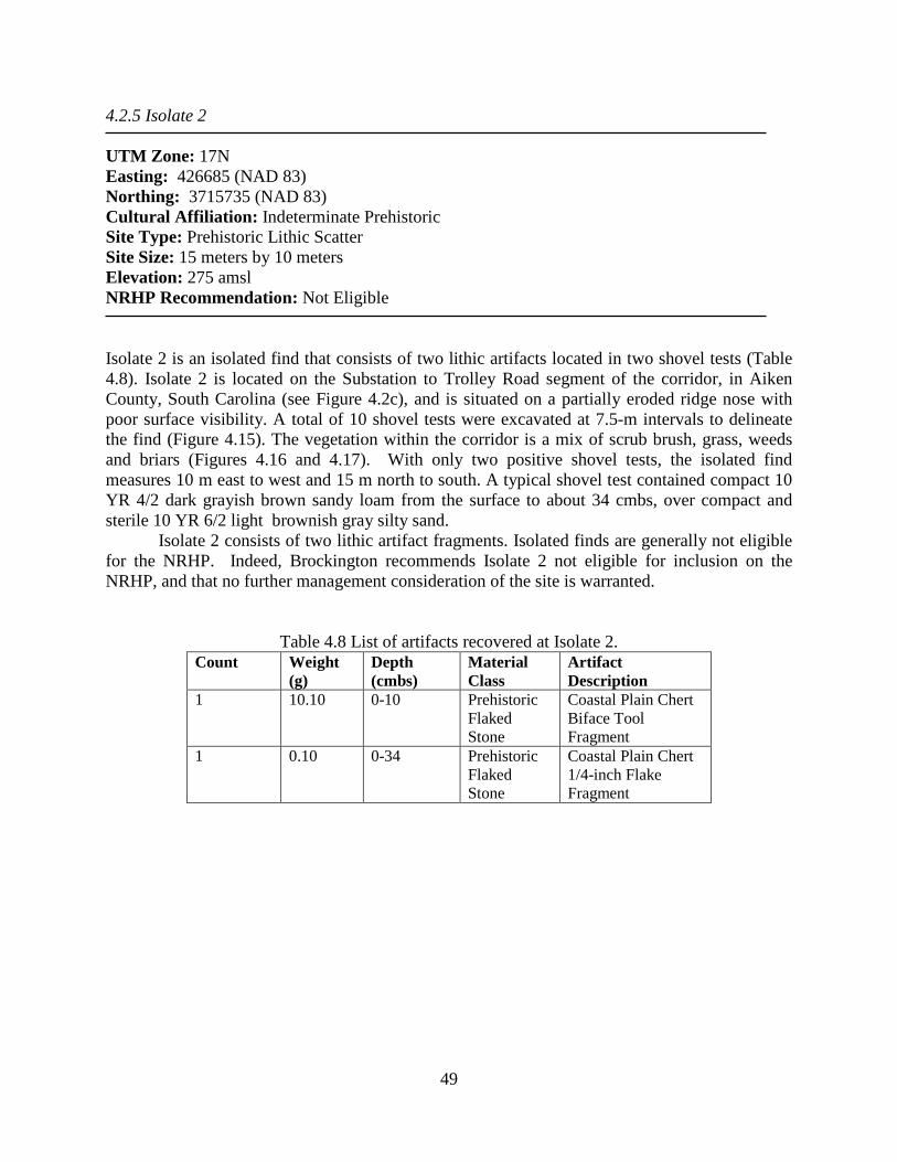
49
4.2.5 Isolate 2 UTM Zone: 17N Easting: 426685 (NAD 83) Northing: 3715735 (NAD 83) Cultural Affiliation: Indeterminate Prehistoric Site Type: Prehistoric Lithic Scatter Site Size: 15 meters by 10 meters Elevation: 275 amsl NRHP Recommendation: Not Eligible Isolate 2 is an isolated find that consists of two lithic artifacts located in two shovel tests (Table 4.8). Isolate 2 is located on the Substation to Trolley Road segment of the corridor, in Aiken County, South Carolina (see Figure 4.2c), and is situated on a partially eroded ridge nose with poor surface visibility. A total of 10 shovel tests were excavated at 7.5-m intervals to delineate the find (Figure 4.15). The vegetation within the corridor is a mix of scrub brush, grass, weeds and briars (Figures 4.16 and 4.17). With only two positive shovel tests, the isolated find measures 10 m east to west and 15 m north to south. A typical shovel test contained compact 10 YR 4/2 dark grayish brown sandy loam from the surface to about 34 cmbs, over compact and sterile 10 YR 6/2 light brownish gray silty sand.
Isolate 2 consists of two lithic artifact fragments. Isolated finds are generally not eligible for the NRHP. Indeed, Brockington recommends Isolate 2 not eligible for inclusion on the NRHP, and that no further management consideration of the site is warranted.
Table 4.8 List of artifacts recovered at Isolate 2.
Count Weight (g)
Depth (cmbs)
Material Class
Artifact Description
1 10.10 0-10 Prehistoric Flaked Stone
Coastal Plain Chert Biface Tool Fragment
1 0.10 0-34 Prehistoric Flaked Stone
Coastal Plain Chert 1/4-inch Flake Fragment

50
Figure 4.15 Site map of Isolate 2.

51
Figure 4.16 View of Isolate 2, looking north upslope along corridor.
Figure 4.17 View of Isolate 2, looking south to edge of ridge nose; a wetland is located at the
base of the ridge out of view in the photograph.
tjt
g I
II
f44
t,
+r
.pp~~:
l
-1
I
l~tj'':
fkP,

52
4.3 Recommendations Nine previously recorded archaeological resources were identified within the two-km project buffer as a result of archival research. This includes eight archaeological resources in South Carolina and one resource in Georgia. None of these archaeological sites are within the project ROW, and Brockington does not anticipate that any of these resources will be affected by the proposed 230kV upgrades to equipment and structures within the project ROW. Five archaeological resources were identified as a result of intensive shovel test survey, including three sites (38AK1089, 38AK1090, and 38AK1091) and two isolated finds (Isolate 1 and Isolate 2). All three of the newly-identified sites display very low artifact density, and lack diagnostic artifacts. One of the isolated finds identified during this survey (Isolate 1) contains a Paleoindian point, a diagnostic artifact type that is rarely encountered in South Carolina. However, Brockington archaeologists found this point on the surface and believe that it was redeposited in this location. It likely eroded from an area further upslope of the find spot, possibly outside of the project ROW. Isolated finds are generally not eligible for the NRHP, and the context of the find does not support an argument for its recommending it otherwise. Brockington recommends that none of the resources identified during this survey have the potential to contain significant archaeological data, and that none are eligible for the NRHP. Brockington further recommends that no archaeological resources that are listed, or eligible for listing, on the NRHP will be impacted by the proposed 230kV transmission line upgrades, and that the project should be allowed to proceed.

53
References Cited Adams, Natalie P. 2002 Carolinas Pipeline Cultural Resources Overview and Survey Report. Prepared by New South Associates, Stone Mountain, Georgia, for Foster Wheeler Corporation, Morris Plain, New Jersey. Adovasio, J. M., J. Donahue, and R. Stuckenrath 1990 The Meadowcroft Rockshelter Radiocarbon Chronology, 1975-1990. American Antiquity 55:348-354. Anderson, David G. 1979 Excavations at Four Fall Line Sites in the Southeastern Columbia Beltway Project. Prepared for the South Carolina Department of Highways and Public Transportation, Columbia. Anderson, David G., and Glen T. Hanson 1988 Early Archaic Settlement in the Southeastern United States: A Case Study from the Savannah River Basin. American Antiquity 53:262-286. Anderson, David G., and J. W. Joseph 1988 Prehistory and History along the Upper Savannah River: Technical Synthesis of Cultural Resource Investigations, Richard B. Russell Multiple Resource Area (Volume I). US Department of the Interior, National Park Service, Interagency Archaeological Services, Atlanta, Georgia. Anderson, David G., and Patricia A. Logan 1981 Francis Marion National Forest Cultural Resources Overview. US Forest Service, Columbia, South Carolina. Anderson, David G., R. Gerald Ledbetter and Lisa O'Steen 1990 Paleo indian Archaeology of Georgia. University of Georgia Laboratory of Archaeology Series Report 28. Athens Barrett, John Gilchrist 1987 North Carolina as a Civil War Battleground: 1861-1865. North Carolina Department of Cultural Resources, Raleigh. Bartram, William 1791 Travel through North and South Carolina, Georgia, East and West Florida, The Cherokee Country: The Extensive Territories of the Muscogulges or Creek Confederacy, and the Country of the Choctaws; Containing an Account of the Soil and Natural Production of These Regions, Together with Observations on the Manners of the Indians. Philadelphia: James and Johnson.

54
Berkin, Jon, Stephen Hinks, Ralph Draughon, Jr., E. Burton Kemp III, Luis Williams, and William P. Athens 1995 Phase I Cultural Resources Survey of the Proposed Southern Natural Gas Company Graniteville Pipeline Expansion Project, Aiken County, South Carolina. Report by R. Christopher Goodwin and Associates, New Orleans, Louisiana, for Southern Natural Gas Company, Birmingham, Alabama. Blanton, Dennis B. and Kenneth E. Sassaman 1989 Pattern and Process in the Middle Archaic Period of South Carolina. In Studies in South Carolina Archaeology, edited by Albert C. Goodyear III and Glen T. Hanson, pp. 53-72. South Carolina Institute of Archaeology and Anthropology Anthropological Studies 9. Columbia. Blanton, D.B., C.T. Espenshade, and P.E. Brockington, Jr. 1986 An Archaeological Study of 38SU83: A Yadkin Phase Site in the Upper Coastal Plain of South Carolina. Prepared for the South Carolina Department of Highways and Public Transportation, Columbia. Brooks, Richard D. 1981 Initial Historic Overview of the Savannah River Plant, Aiken and Barnwell Counties, South Carolina. South Carolina Institute of Archaeology and Anthropology Research Manuscript Series 170. Butler, William B. 1987 Significance and Other Frustrations in the CRM Process. American Antiquity 53:820-829. Caldwell, Joseph R. 1958 Trend and Tradition in the Prehistory of the Eastern United States. Memoirs of the American Anthropological Association 88. Carlisle, R. C., and J. M. Adovasio (editors) 1982 Meadowcroft: Collected Papers on the Archaeology of Meadowcroft Rockshelter and the Cross Creek Drainage. University of Pittsburgh Press, Pittsburgh. Cashin, Edward H. 1978 An Informal History of Augusta. Richmond County Board of Education, Augusta, GA. Cashin, Joseph R. 1986 Colonial Augusta: Key to the Indian Country. Published by Mercer University Press. Charles, Tommy 1986 The Fifth Phase of the Collectors' Survey. South Carolina Institute of Archaeology and Anthropology Notebook XVIII: 1-27. Columbia. Claggett, Stephen R., and John S. Cable (compilers)

55
1982 The Haw River Sites: Archaeological Investigations at Two Stratified Sites in the North Carolina Piedmont. Prepared for the US Army Corps of Engineers, Wilmington District. Wilmington, North Carolina. Cleland, Charles E. 1976 The Focal-Diffuse Model: an Evolutionary Perspective on the Prehistoric Cultural Adaptations of the Eastern United States. Mid-continental Journal of Archaeology 1:59- 76. Code of Federal Regulations 36 CFR Part 60: National Register of Historic Properties. Coe, Joffre L. 1964 The Formative Cultures of the Carolina Piedmont. Transactions of the American Philosophical Society 54. Council of South Carolina of Professional Archaeologists [COSCAPA] 2013 South Carolina Standards and Guidelines for Archaeological Investigations. Electronic document available at http://www.coscapa.org/standards-and-guidelines.html, accessed August, 2014. Crane, Verner M. 1956 Southern Frontier 1670-1732. University of Michigan Press, Ann Arbor. Davis, Valerie, and Kristie Person 2012 Cultural Resource Survey of Seven Miles of Hitchcock Parkway, Aiken, South Carolina (SCDOT Environmental Section, Archaeological Field Report) PIN: 40695 RD01. Prepared by New South Associates, Stone Mountain, Georgia. DePratter, Chester 1988 Indian Occupations of the Savannah River Valley During the Late Prehistoric and Early Historic Periods. Manuscript on file, Chester B. DePratter, Columbia, South Carolina. 1989 Cofitachequi: Ethnohistorical and Archaeological Evidence. In Studies in South Carolina Archaeology, edited by Albert C. Goodyear III and Glen T. Hanson, pp.133-156. South Carolina Institute of Archaeology and Anthropology Anthropological Studies 9. Columbia. Dillehay, T. D. 1989 Monte Verde: A Late Pleistocene Settlement in Chile. Smithsonian Institution Press, Washington, DC. 1997 Monte Verde: A Late Pleistocene Settlement in Chile, Volume II: The Archaeological Context and Interpretation. Smithsonian Institution Press, Washington, DC. Elliott, D. T. and R. Doyon

56
1981 Archeology and Historical Geography of the Savannah River Floodplain Near Augusta, Georgia. Laboratory of Archeology Series Report No. 22, University of Georgia, Athens. Espenshade, Christopher T. 1986 Climbing on the Macro Band Wagon. Paper presented at the Twelfth Annual Meeting of the Archaeological Society for South Carolina, Columbia. Espenshade, Christopher T., and Paul E. Brockington, Jr. 1989 An Archaeological Study of the Minim Island Site: Early Woodland Dynamics in Coastal South Carolina. US Army Corps of Engineers, Charleston District, Report COESAM/PDER/89/004. Charleston, South Carolina. Ferguson, Leland G. and Stanton W. Green 1984 South Appalachian Mississippian: Politics and Environment in the Old, Old South. Southeastern Archaeology 3:139-143. Fraser, Walter J. 1989 Charleston! Charleston! The History of a Southern City. University of South Carolina Press, Columbia. Gardner, William H. 1974 The Flint Run Paleo Indian Complex: A Preliminary Report 1971 through 1973 Seasons. Catholic University of America, Archaeology Laboratory, Occasional Paper No. 1. Washington, DC. Goodyear, Albert C., III 1979 A Hypothesis for the Use a/Cryptocrystalline Raw Materials Among Paleo-Indian Groups of North America. South Carolina Institute of Archaeology and Anthropology Research Manuscript Series 156. Columbia. 1999 The Early Holocene Occupation of the Southeastern United States: A Geoarchaeological Summary. In Ice Age People of North America: Environments, Origins, and Adaptations, edited by R. Bonnichsen and K. L. Turnmire, pp. 432-481. Oregon State University Press, Corvallis. Goodyear, Albert C., III, and Glen T. Hanson 1989 Studies in South Carolina Archaeology. South Carolina Institute of Archaeology and Anthropology Anthropological Studies 9. Columbia. Goodyear, Albert C., III, James L. Michie, and Tommy Charles 1989 The Earliest South Carolinians. In Studies in South Carolina Archaeology, edited by Albert C. Goodyear III and Glen T. Hanson, pp. 19-52. South Carolina Institute of Archaeology and Anthropology Anthropological Studies 9. Columbia. Groover, Mark D., and Pamela Johnson

57
2002 Archaeological Investigations at Fort Moore: Results of 2001 Site Survey and Testing. Savannah River Archaeological Research Program, South Carolina Institute of Archaeology and Anthropology, University of South Carolina. Gunn, J. D., and K. Wilson 1993 Archaeological Data Recovery Investigations at Sites 38CT54 and 38CT58 along the S.C. 151 Jefferson Bypass, Chesterfield County, South Carolina. Report submitted to the South Carolina Department of Highways and Public Transportation. Prepared by Garrow and Associates, Inc., Raleigh, North Carolina. Hale, Stephen Delaney 2000 Aiken and its horses: A celebration of equestrian sports. The Augusta Chronicle, Augusta, Georgia. Hanson, Glen T. 1982 The Analysis of Late Archaic-Early Woodland Adaptive Change along the Savannah River: A Proposed Study. South Carolina Institute of Archaeology and Anthropology Notebook XIV:1-38. Columbia. Hodler, Thomas W. and Donald R. Schretter 1986 The Atlas of Georgia. University of Georgia Institute of Community and Area Development, Athens. Holshlag, Stephanie and Michael J. Rodeffer 1977 Ninety Six: Exploratory Excavations in the Village. Report prepared for the National Park Service and the South Carolina Department of Archives and History, Grant No. 4 5-7 4- 00 124-00, Columbia. Hudson, Charles, Marvin T. Smith, and Chester B. DePratter 1984 The Hernando DeSoto Expedition: From Apalachee to Chiaha. Southeastern Archaeology 3(1):65-77. Ivers, Larry 1970 Colonial Forts of South Carolina: 1670-1775. University of South Carolina Press, Columbia. Johnston, George Milligen 1763 A Short Description of the Province of South Carolina, with an account of The Air, Weather, and Diseases, at Charles-town. On file at the South Caroliniana Library, University of South Carolina, Columbia. Klosky, Beth Ann 1971 The Pendleton Legacy. Sandlapper Press, Columbia, South Carolina. McAvoy, J. M., and L. D. McAvoy

58
1997 Archaeological Investigations of Site 44SX202, Cactus Hill, Sussex County, Virginia. Virginia Department of Historic Resources Research Series No. 8. Richmond. McMakin, Todd A., Tina R. Rust, and Eric C. Poplin 2000 Archaeological Data Recovery in the SC 151 Widening Project, Chesterfield County, South Carolina. Prepared for the South Carolina Department of Transportation, Columbia. Meltzer, David J. 1988 Late Pleistocene Human Adaptations in Eastern North America. Journal of World Prehistory 2:1-53. Meltzer, D., D. Grayson, G. Ardila, A. Barker, D. Dincauze, C. Haynes., F. Mena, L. Nunez, and D. Stanford 1997 On the Pleistocene Antiquity of Monte Verde, Southern Chile. American Antiquity 62:659-663. Meltzer, David J., and Bruce D. Smith 1986 Paleoindian and Early Archaic Subsistence Strategies in Eastern North America. In Foraging, Collecting, and Harvesting: Archaic Period Subsistence and Settlement in the Eastern Woodlands, edited by S. Neusius, pp. 3-31. Southern Illinois University Center for Archaeological Investigations Occasional Paper 6. Carbondale. Michie, James L. 1977 Late Pleistocene Human Occupation of South Carolina. Senior Honors Thesis, Department of Anthropology, University of South Carolina, Columbia. Milling, Chapman J. 1969 Red Carolinians. University of South Carolina Press, Columbia. Mills, Robert 1825 Atlas of South Carolina. The Sandlapper Store, Lexington, South Carolina. Newell, Mark 1994 Kathryn S.: Preliminary Site Survey. Georgia Archaeological Institute, Augusta, Georgia. Oliver, B. L. 1985 Tradition and Typology: Basic Elements of the Carolina Projectile Point Sequence.
University of Alabama Press, Tuscaloosa, Alabama. Orser, Charles E., Jr. 1988 The Material Basis of the Postbellum Tenant Plantation: Historical Archaeology in the South Carolina Piedmont. University of Georgia Press, Athens. O'Steen, Lisa

59
1983 Early Archaic Settlement Patterns in the Wallace Reservoir: An Inner Piedmont Perspective. Unpublished Master's Thesis, Department of Anthropology, University of Georgia. Athens. O'Steen, L., R.J. Ledbetter, D.T. Elliott and W.W. Barker 1986 Paleoindian Sites of the Inner Piedmont of Georgia: Observations of Settlement in the Oconee Watershed. Early Georgia 13:1-63. Petty, Julian J. 1943 The Growth and Distribution of Population in South Carolina. State Council for Defense, Industrial Development Committee, Columbia, South Carolina. Plummer, G.L. 1975 18th century forests in Georgia. Bulletin of the Georgia Academy of Sciences 33:1–19. Poplin, Eric C. 1990 Prehistoric Settlement in the Dog River Valley: Archaeological Data Recovery at 9D034, 9D039, and 9D045, Douglas County, Georgia. Prepared for the Douglasville-Douglas County Water and Sewer Authority, Douglasville, Georgia. Prunty, Merle, Jr. 1955 The Renaissance of the Southern Plantation. The Geographical Review. XLV (4): 459- 491. Purrington, Burton L. 1983 Ancient Mountaineers: An Overview of the Prehistoric Archaeology of North Carolina’s Western Mountain Region. In The Prehistory of North Carolina: An Archaeological Symposium, edited by Mark A. Mathis and Jeffrey J. Crow, pp. 83-160. North Carolina Division of Archives and History, Raleigh. Quattlebaum, Paul 1956 The Land Called Chicora, the Carolinas Under Spanish Rule with French Intrusions, 1520-1670. University of Florida Press, Gainesville. Rogers, Vergil A. 1985 Soil Survey of Aiken County Area, South Carolina. U.S. Department of Agriculture, Soil Conservation Service, Washington, D.C. Sassaman, K.E., M.J. Brooks, G.T. Hanson, and D.G. Anderson 1990 Native American Prehistory of the Middle Savannah River Valley. South Carolina Institute of Archaeology and Anthropology Savannah River Archaeological Research Papers 1. Columbia. Sassaman, Kenneth E., I. Randolph Daniel Jr., and Christopher R. Moore

60
2002 G. S. Lewis-East: Early and Late Archaic Occupations along the Savannah River, Aiken County, South Carolina. Savannah River Archaeological Research Papers 12. South Carolina Institute of Archaeology and Anthropology, Columbia. Segovia, Antonio V. 1985 Archeological Geology of the Savannah River Valley and Main Tributaries in the Richard B. Russell Multiple Resource Area. Thunderbird Research Corporation, Front Royal, Virginia. Sherfy, Marcella, and W. Ray Luce n.d. National Register Bulletin 22: Guidelines for Evaluating and Nominating Properties That Have Achieved Significance in the Last Fifty Years. US Department of the Interior, National Park Service, Interagency Resources Division, Washington, DC. Smith, Bruce D. 1975 Middle Mississippian Exploitation of Animal Populations. University of Michigan Museum of Anthropology Anthropological Papers 57. Ann Arbor. South, Stanley 1979 The Search for Santa Elena on Parris Island in South Carolina. South Carolina Institute of Archaeology and Anthropology Research Manuscript Series 150. Columbia. Savage, Beth L., and Sarah Dillard Pope 1998 National Register Bulletin: How to Apply the National Register Criteria for Evaluation. US Department of Interior, National Park Service, Interagency Resources Division, Washington DC. Scurry, James D. 1982 Archaeological Investigations at Redcliffe Plantation. Notebook 1982:14. Speer, Paul R., and Charles R. Gamble 1964 Magnitude and frequency of floods in the United States, Part 2-A, South Atlantic slope basins, James River to Savannah River. USGS Water Supply Paper: 1673. Stallings, Patricia 2014 Literature Review and Windshield Reconnaissance for the Urquhart-Graniteville 230kV Siting Study, Aiken County, South Carolina. Prepared by Brockington and Associates, Norcross, Georgia, for UC Synergetic, LLC, Charlotte, North Carolina. Strother, T. Ella 2008 A Pictorial History of African-Americans and Aiken County. Donning Company Publishers, Virginia Beach, Virginia. Swint, Samuel 1935 The History of Graniteville. In Centennial Celebration Commemorating the Founding of Aiken South Carolina, April 4th-6th, 1935. Aiken County Library, Aiken, South Carolina

61
Taylor, Richard L. and Marion F. Smith 1978 The Report of the Intensive Survey of the Richard B. Russell Dam and Lake Project, Savannah River, Georgia and South Carolina. South Carolina Institute of Archaeology and Anthropology Research Manuscript Series 143. Columbia. Townsend, Jan, John H. Sprinkle, Jr. and John Knoerl 1993 National Register Bulletin 3 6: Guidelines for Evaluating and Registering Historical Archaeological Sites and Districts. US Department of the Interior, Park Service, Interagency Resources Division, Washington, DC. Trinkley, Michael 1983 Ceramics of the Central South Carolina Coast. South Carolina Antiquities 12:1-35. 1989 An Archaeological Overview of the South Carolina Woodland Period: It's the Same Old Riddle. In Studies in South Carolina Archaeology, edited by Albert C. Goodyear III and Glen T. Hanson, pp. 73-90. South Carolina Institute of Archaeology and Anthropology Anthropological Studies 9. Columbia. United States Department of Agriculture (USDA) 2014 Custom Soil Survey Report for Aiken County, South Carolina. Electronic document available at http://websoilsurvey.nrcs.usda.gov/app/HomePage.htm, accessed May, 2014. United States Geologic Survey (USGS) 1999 Station #02197000 records. Van Clayton, Frederick 1988 Settlement of Pendleton District. Southern Historical Press, Easley, South Carolina. Vandervelde, Isabel 1999 Aiken County: The Only South Carolina County Founded During Reconstruction. Spartanburg, SC: Reprint Company Publishers. Ward, H. Trawick 1983 A Review of Archaeology in the North Carolina Piedmont: A Study of Change. In The Prehistory of North Carolina: An Archaeology Symposium, edited by Mark A. Mathis and Jeffrey J. Crow, pp. 53-81. North Carolina Division of Archives and History, Raleigh. Watts, W.A. 1970 The Full Glacial Vegetation of Northern Georgia. Ecology 51(1). 1980 Late Quaternary Vegetation History at White Pond on the Inner Coastal Plain of South Carolina. Quaternary Research 10. Weir, Robert.

62
1983 Colonial South Carolina: A History. KTO Press. Columbia, South Carolina. Wetmore, R.Y., A. C. Goodyear III and D.J. Colquhoun 1986 Archaeological Investigations at Nipper Creek (38RDJ8): An Archaic Fall-Line Site. South Carolina Institute of Archaeology and Anthropology Research Manuscript Series 201. Columbia. Whitehead, Donald R. 1965 Palynology and Pleistocene phytogeography of unglaciated eastern North America. In The Quaternary of the United States, edited by H.E. Wright, Jr. and D.G. Frey. Princeton University Press. 1973 Late Wisconsin vegetational changes in unglaciated eastern North America. Quaternary Research 3:621-631. Willey, Gordon R., and Philip Phillips 1958 Method and Theory in American Archaeology. University of Chicago Press, Chicago, Illinois.