Embed Size (px)
Citation preview
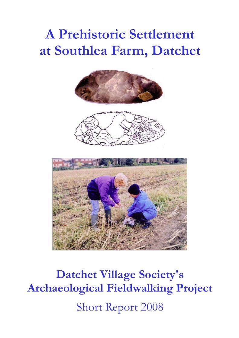
A Prehistoric Settlement
at Southlea Farm, Datchet
Datchet Village Society's
Archaeological Fieldwalking Project
Short Report 2008

Hugh, Mike and John laying out the 10 metre grid in Field 2, plus Emma and Sam with Bronze and Iron Age pottery sherds. Photo by the Windsor & Eton Express in the first weeks of fieldwalking.
Front cover: ceremonial Neolithic flint knife, drawing by Gill Crane; Brenda and Lesley in Field 2 after maize harvest.

(photo Rob Gordon) Project Personnel and Acknowledgements
Report by: Janet Kennish and Julia Martin Contributors: Leigh Allen, Alistair Barclay, Edward Biddulph, Philippa Bradley, Emma-Jayne Evans
Emma Sharman, Ruth Shaffrey, Dr David Yates Graphics: MoLAS, Julia Martin, Colin Berks Illustrators: Tanya Berks, Gillian Crane, David Hopkins
Acknowledgments: The Datchet Village Society Archaeology Group would like to thank the following for making this project possible; the farmer Nigel Berryman; the landowners Crown Estates; the Barker Bridge House Trust, Datchet, and the Prince Philip Trust for Windsor & Maidenhead for their financial support; the DVS Committee; Colin Berks for survey expertise, and all the volunteers involved in fieldwork and administration. We would particularly like to thank Phil Catherall for his invaluable support and advice.
Datchet Village Society Committee
Chairman: Janet Kennish Treasurer: Tony Wells Secretary: Marjorie Clasper Membership: Helen Jenkins Finance: Angus Cameron Planning: Tony Griffiths Members: Barbara Street Rob Gordon Percy Whitford Datchet Village Society Archaeology Group
Co-ordinators: Janet Kennish, Emma Sharman, Julia Martin
Surveying: Sam Philo-Gill, Julia Martin
Storage of finds: Janet Kennish
Lottery application: Angus Cameron
Artist: Gillian Crane
Fieldwalkers: Emma Sharman Debbie Putnam Sam Philo-Gill Derek Trumper Julia Martin Rob Beach Mike O’Brien Gaynor Norman Glenda Croft Anne Thomas Kaye Knight Mike & Judy Terry John Harvey Val Hannington David Gautrey Julia & Nick Hardy Adrian and Lesley Giddins Bill Grose Colin and Mary Day Shirley & Ray Booker Maureen and Rebekah Scott Peter Knowles Helen and Mary Dalton Harry & Marjorie Clasper Roy and Linda Cecil Hugh Bethell Rob & Brenda Gordon Janet Kennish All of the above took part at various times during the project Excavators:
Julia Martin David Gautrey Emma Sharman Derek Trumper Sam Philo-Gill Glenda Croft Angus Cameron Lesley Giddins Rob Beach A full archaeological report is available at Reading Museum or contact Julia Martin 01628 788771 Publication of this short report was generously funded by the Barker Bridge House Trust, Datchet
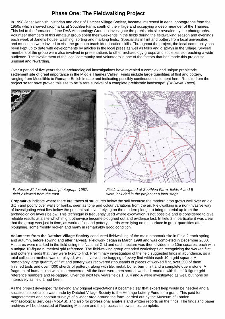
Phase One: The Fieldwalking Project In 1998 Janet Kennish, historian and chair of Datchet Village Society, became interested in aerial photographs from the 1950s which showed cropmarks at Southlea Farm, south of the village and occupying a deep meander of the Thames. This led to the formation of the DVS Archaeology Group to investigate the prehistoric site revealed by the photographs. Volunteer members of this amateur group spent their weekends in the fields during the fieldwalking season and evenings each week at Janet’s house, washing, sorting and marking finds. Specialists in flint and pottery from local universities and museums were invited to visit the group to teach identification skills. Throughout the project, the local community has been kept up to date with developments by articles in the local press as well as talks and displays in the village. Several members of the group were also involved in presentations to other archaeology groups and societies, so reaching a wide audience. The involvement of the local community and volunteers is one of the factors that has made this project so unusual and rewarding. Over a period of five years these archaeological investigations have revealed a complex and unique prehistoric settlement site of great importance in the Middle Thames Valley. Finds include large quantities of flint and pottery, ranging from Mesolithic to Romano-British in date and indicating possibly continuous settlement here. Results from the project so far have proved this site to be 'a rare survival of a complete prehistoric landscape'. (Dr David Yates)
Professor St Joseph aerial photograph 1957; Fields investigated at Southlea Farm; fields A and B field 2 viewed from the east were included in the project at a later stage
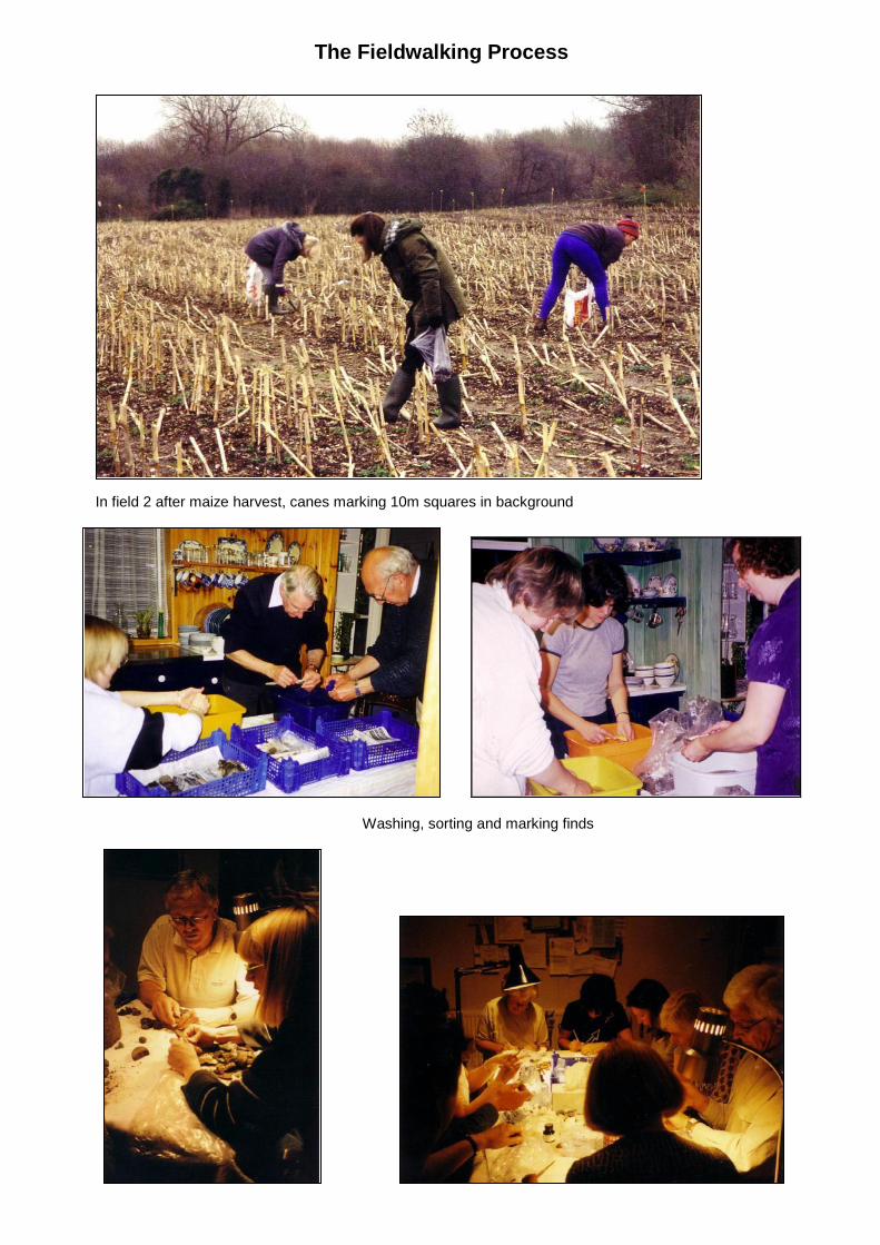
Cropmarks indicate where there are traces of structures below the soil because the modern crop grows well over an old ditch and poorly over walls or banks, seen as tone and colour variations from the air. Fieldwalking is a non-invasive way of investigating what lies below the present soil level, relying on the modern plough to bring material up from the archaeological layers below. This technique is frequently used where excavation is not possible and is considered to give reliable results at a site which might otherwise become ploughed out and evidence lost. In field 2 in particular it was clear that the group was just in time, as worked flint and pottery sherds were lying on the surface in great quantities after ploughing, some freshly broken and many in remarkably good condition. Volunteers from the Datchet Village Society conducted fieldwalking of the main cropmark site in Field 2 each spring and autumn, before sowing and after harvest. Fieldwork began in March 1998 and was completed in December 2000. Hectares were marked in the field using the National Grid and each hectare was then divided into 10m squares, each with a unique 10-figure numerical grid reference. The fieldwalking group attended workshops on recognizing the worked flint and pottery sherds that they were likely to find. Preliminary investigation of the field suggested finds in abundance, so a total collection method was employed, which involved the bagging of every find within each 10m grid square. A remarkably large quantity of flint and pottery was recovered (thousands of pieces of worked flint, over 250 of them finished tools and over 4000 sherds of pottery), along with tile, metal, bone, burnt flint and a complete quern stone. A fragment of human ulna was also recovered. All the finds were then sorted, washed, marked with their 10-figure grid reference numbers and re-bagged. Over the next few years fields 1, 3, 4 and A were investigated as well, but none so intensively as field 2 had been. As the project developed far beyond any original expectations it became clear that expert help would be needed and a successful application was made by Datchet Village Society to the Heritage Lottery Fund for a grant. This paid for magnetometer and contour surveys of a wider area around the farm, carried out by the Museum of London Archaeological Services (MoLAS), and also for professional analysis and written reports on the finds. The finds and paper archives will be deposited at Reading Museum and this process is now almost complete.
The Fieldwalking Process
In field 2 after maize harvest, canes marking 10m squares in background
Washing, sorting and marking finds

Magnetometer Surveys Phil Catherall of the Environment Agency was the first professional archaeologist to advise the group. His magnetometer survey of the initial field 2 clarifies the features identified by crop marks. This technique uses the small local anomalies in the earth's magnetic field which result from the contrasting levels of magnetic susceptibility existing between infilled 'cut' features or structures and the local substrate or bedrock. These areas of disturbance sometimes produce remarkably clear images, as shown below. (Phil used a Geoscan FM36, with Insite and Geoplot processing software. Two readings per meter were taken, across traverses set at 1m intervals over units of 30 square meters.) Later in the project Phil also carried out magnetometer surveys of field A, details of which are reproduced in Phase II of this report. Under the survey contract with MoLAS, Alistair Bartlett of the Bartlett-Clark Consultancy carried out a further geophysical study of the remaining fields using a Geoscan fluxgate magnetometer. Readings were taken at 27.77cm intervals along transects 1m apart.
Field 2 magnetometer survey by Phil Catherall (for interpretation see next page)
Aerial photo of project area with magnetometer surveys overlaid: Phil Catherall's in blue, Alistair Bartlett's in red
.
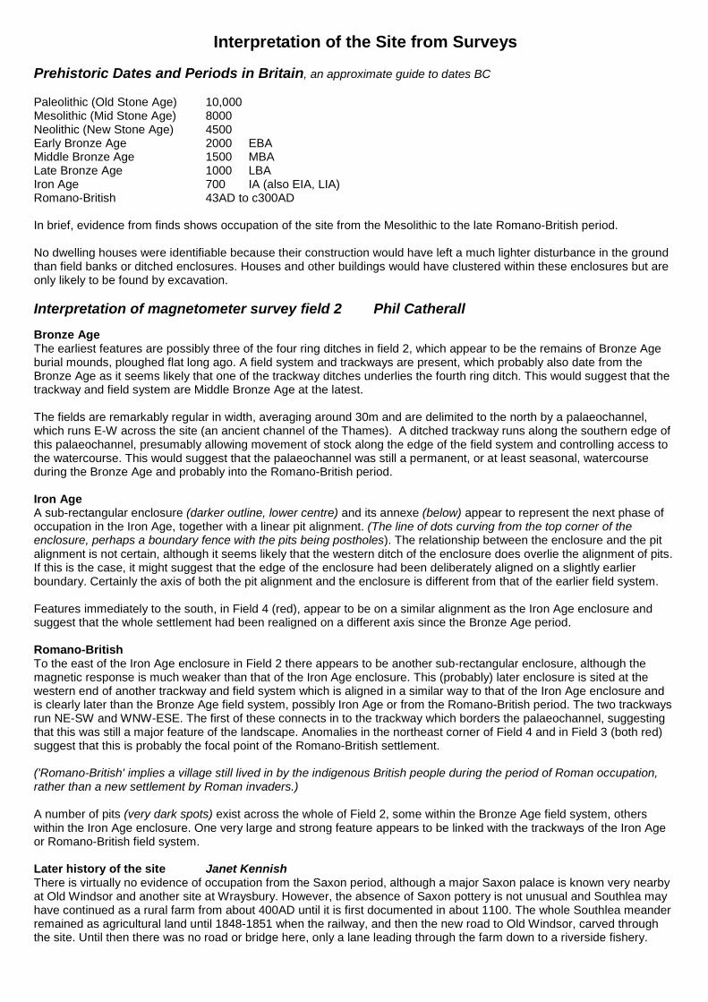
Interpretation of the Site from Surveys Prehistoric Dates and Periods in Britain, an approximate guide to dates BC Paleolithic (Old Stone Age) 10,000 Mesolithic (Mid Stone Age) 8000 Neolithic (New Stone Age) 4500 Early Bronze Age 2000 EBA Middle Bronze Age 1500 MBA Late Bronze Age 1000 LBA Iron Age 700 IA (also EIA, LIA) Romano-British 43AD to c300AD In brief, evidence from finds shows occupation of the site from the Mesolithic to the late Romano-British period. No dwelling houses were identifiable because their construction would have left a much lighter disturbance in the ground than field banks or ditched enclosures. Houses and other buildings would have clustered within these enclosures but are only likely to be found by excavation. Interpretation of magnetometer survey field 2 Phil Catherall Bronze Age The earliest features are possibly three of the four ring ditches in field 2, which appear to be the remains of Bronze Age burial mounds, ploughed flat long ago. A field system and trackways are present, which probably also date from the Bronze Age as it seems likely that one of the trackway ditches underlies the fourth ring ditch. This would suggest that the trackway and field system are Middle Bronze Age at the latest. The fields are remarkably regular in width, averaging around 30m and are delimited to the north by a palaeochannel, which runs E-W across the site (an ancient channel of the Thames). A ditched trackway runs along the southern edge of this palaeochannel, presumably allowing movement of stock along the edge of the field system and controlling access to the watercourse. This would suggest that the palaeochannel was still a permanent, or at least seasonal, watercourse during the Bronze Age and probably into the Romano-British period. Iron Age A sub-rectangular enclosure (darker outline, lower centre) and its annexe (below) appear to represent the next phase of occupation in the Iron Age, together with a linear pit alignment. (The line of dots curving from the top corner of the enclosure, perhaps a boundary fence with the pits being postholes). The relationship between the enclosure and the pit alignment is not certain, although it seems likely that the western ditch of the enclosure does overlie the alignment of pits. If this is the case, it might suggest that the edge of the enclosure had been deliberately aligned on a slightly earlier boundary. Certainly the axis of both the pit alignment and the enclosure is different from that of the earlier field system. Features immediately to the south, in Field 4 (red), appear to be on a similar alignment as the Iron Age enclosure and suggest that the whole settlement had been realigned on a different axis since the Bronze Age period. Romano-British To the east of the Iron Age enclosure in Field 2 there appears to be another sub-rectangular enclosure, although the magnetic response is much weaker than that of the Iron Age enclosure. This (probably) later enclosure is sited at the western end of another trackway and field system which is aligned in a similar way to that of the Iron Age enclosure and is clearly later than the Bronze Age field system, possibly Iron Age or from the Romano-British period. The two trackways run NE-SW and WNW-ESE. The first of these connects in to the trackway which borders the palaeochannel, suggesting that this was still a major feature of the landscape. Anomalies in the northeast corner of Field 4 and in Field 3 (both red) suggest that this is probably the focal point of the Romano-British settlement. ('Romano-British' implies a village still lived in by the indigenous British people during the period of Roman occupation, rather than a new settlement by Roman invaders.) A number of pits (very dark spots) exist across the whole of Field 2, some within the Bronze Age field system, others within the Iron Age enclosure. One very large and strong feature appears to be linked with the trackways of the Iron Age or Romano-British field system. Later history of the site Janet Kennish There is virtually no evidence of occupation from the Saxon period, although a major Saxon palace is known very nearby at Old Windsor and another site at Wraysbury. However, the absence of Saxon pottery is not unusual and Southlea may have continued as a rural farm from about 400AD until it is first documented in about 1100. The whole Southlea meander remained as agricultural land until 1848-1851 when the railway, and then the new road to Old Windsor, carved through the site. Until then there was no road or bridge here, only a lane leading through the farm down to a riverside fishery.
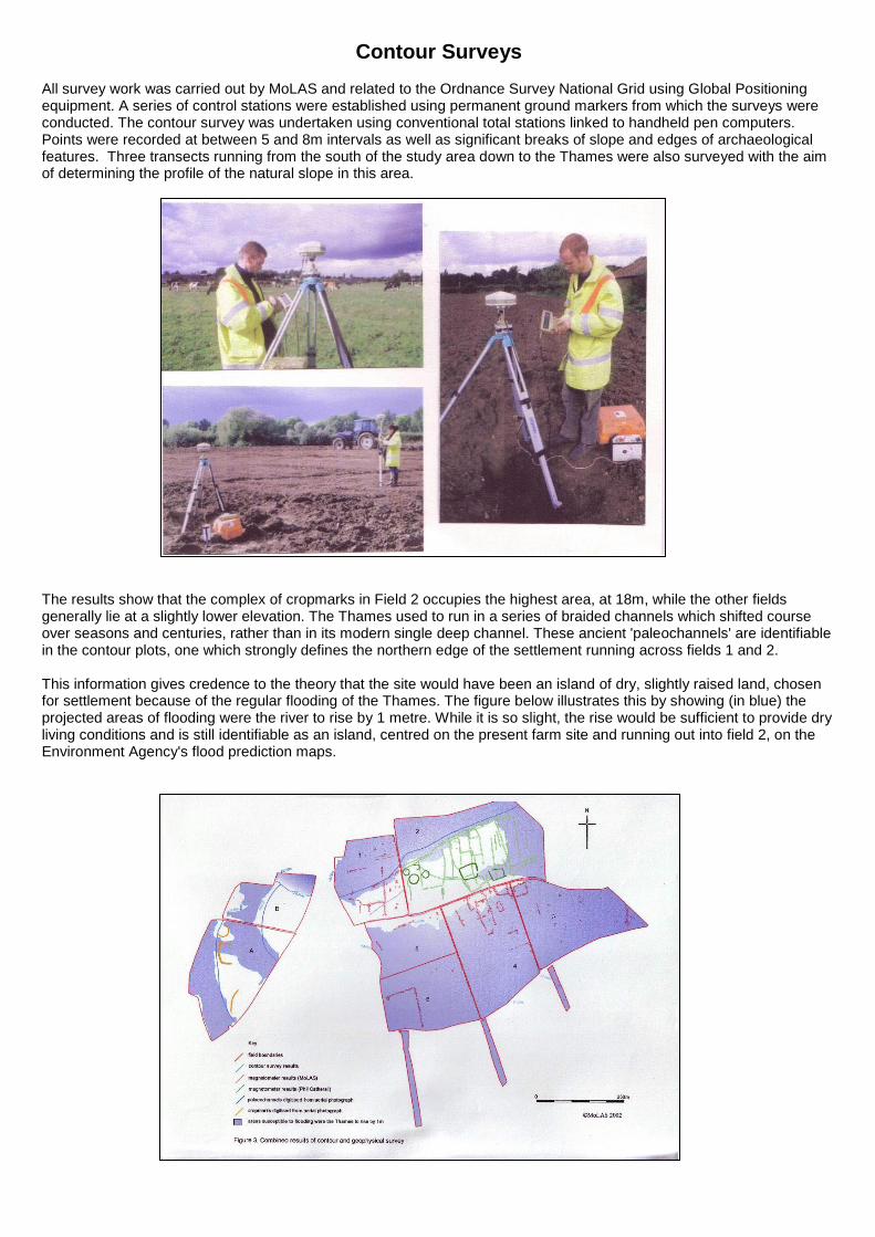
Contour Surveys All survey work was carried out by MoLAS and related to the Ordnance Survey National Grid using Global Positioning equipment. A series of control stations were established using permanent ground markers from which the surveys were conducted. The contour survey was undertaken using conventional total stations linked to handheld pen computers. Points were recorded at between 5 and 8m intervals as well as significant breaks of slope and edges of archaeological features. Three transects running from the south of the study area down to the Thames were also surveyed with the aim of determining the profile of the natural slope in this area.
The results show that the complex of cropmarks in Field 2 occupies the highest area, at 18m, while the other fields generally lie at a slightly lower elevation. The Thames used to run in a series of braided channels which shifted course over seasons and centuries, rather than in its modern single deep channel. These ancient 'paleochannels' are identifiable in the contour plots, one which strongly defines the northern edge of the settlement running across fields 1 and 2. This information gives credence to the theory that the site would have been an island of dry, slightly raised land, chosen for settlement because of the regular flooding of the Thames. The figure below illustrates this by showing (in blue) the projected areas of flooding were the river to rise by 1 metre. While it is so slight, the rise would be sufficient to provide dry living conditions and is still identifiable as an island, centred on the present farm site and running out into field 2, on the Environment Agency's flood prediction maps.
Finds 1: Pottery from Fields 2 and 4
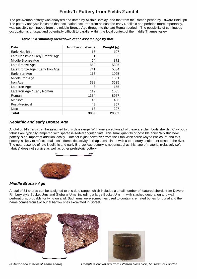
The pre-Roman pottery was analysed and dated by Alistair Barclay, and that from the Roman period by Edward Biddulph. The pottery analysis indicates that occupation occurred from at least the early Neolithic and perhaps more importantly, was possibly continuous from the middle Bronze Age through to the late Roman period. The possibility of continuous occupation is unusual and potentially difficult to parallel within the local context of the middle Thames valley. Table 1: A summary breakdown of the assemblage by date Date Number of sherds Weight (g) Early Neolithic 13 107 Late Neolithic / Early Bronze Age 1 3 Middle Bronze Age 54 872 Late Bronze Age 859 5396 Late Bronze Age / Early Iron Age 741 5834 Early Iron Age 113 1025 Middle Iron Age 100 1351 Iron Age 398 3535 Late Iron Age 8 155 Late Iron Age / Early Roman 112 1035 Roman 1384 8977 Medieval 45 488 Post-Medieval 48 857 Misc 13 227 Total 3889 29862
Neolithic and early Bronze Age A total of 14 sherds can be assigned to this date range. With one exception all of these are plain body sherds. Clay body fabrics are typically tempered with sparse ill-sorted angular flints. This small quantity of possible early Neolithic bowl pottery is an important addition locally. Datchet is just downriver from the Eton Wick causewayed enclosure and this pottery is likely to reflect small-scale domestic activity perhaps associated with a temporary settlement close to the river. The near absence of late Neolithic and early Bronze Age pottery is not unusual as this type of material (relatively soft fabrics) does not survive as well as other prehistoric pottery.
Middle Bronze Age A total of 54 sherds can be assigned to this date range, which includes a small number of featured sherds from Deverel-Rimbury style Bucket Urns and Globular Urns, including a large Bucket Urn rim with slashed decoration and wall perforations, probably for tying on a lid. Such urns were sometimes used to contain cremated bones for burial and the name comes from two burial barrow sites excavated in Dorset.
(exterior and interior of same shard) Complete bucket urn from Littleton Reservoir, Museum of London
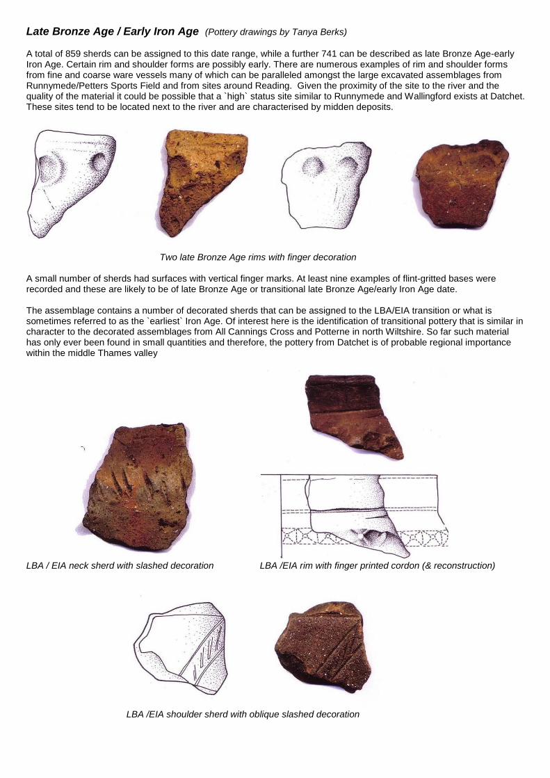
Late Bronze Age / Early Iron Age (Pottery drawings by Tanya Berks) A total of 859 sherds can be assigned to this date range, while a further 741 can be described as late Bronze Age-early Iron Age. Certain rim and shoulder forms are possibly early. There are numerous examples of rim and shoulder forms from fine and coarse ware vessels many of which can be paralleled amongst the large excavated assemblages from Runnymede/Petters Sports Field and from sites around Reading. Given the proximity of the site to the river and the quality of the material it could be possible that a `high` status site similar to Runnymede and Wallingford exists at Datchet. These sites tend to be located next to the river and are characterised by midden deposits.
Two late Bronze Age rims with finger decoration A small number of sherds had surfaces with vertical finger marks. At least nine examples of flint-gritted bases were recorded and these are likely to be of late Bronze Age or transitional late Bronze Age/early Iron Age date. The assemblage contains a number of decorated sherds that can be assigned to the LBA/EIA transition or what is sometimes referred to as the `earliest` Iron Age. Of interest here is the identification of transitional pottery that is similar in character to the decorated assemblages from All Cannings Cross and Potterne in north Wiltshire. So far such material has only ever been found in small quantities and therefore, the pottery from Datchet is of probable regional importance within the middle Thames valley
LBA / EIA neck sherd with slashed decoration LBA /EIA rim with finger printed cordon (& reconstruction)
LBA /EIA shoulder sherd with oblique slashed decoration

Iron Age A total of 619 sherds can be described as Iron Age. Early Iron Age forms include classic angular jars and bowl of tripartite form some of which carry finger tip or linear decoration. There are also a number of heavier rims, out-turned rims and ones with finger-tip or slashed decoration. Unlike the predominantly flint-tempered fabrics of the late Bronze Age there is an increase in the use of sand and entirely sandy fabrics; shell is also used but is rare. The middle Iron Age is represented by a number of diagnostic fabrics, which appear to contain naturally occurring inclusions (eg. ferruginous pellets and shell). Forms include globular jars and bowls and more straight sided vessels. Decorated vessels are relatively rare. There are also a small number of late Iron Age rim and neck sherds in flint, sand and grog fabrics. In addition some 112 grog-tempered sherds can be described as late Iron Age / early Roman. The presence of early, middle and late Iron Age as well as grog-tempered late Iron Age and early Roman, early and late Roman pottery is significant. It is unusual to find evidence for possible continuity on one site and this could be the most unusual aspect of the site at Datchet.
Middle Iron Age decorated globular bowl Middle Iron Age globular bowl; rim, base & body sherds same pot Roman The site was occupied throughout the Roman period. This phase of activity commenced in the late Iron Age or mid 1st century AD, and probably continued through the early Roman period. Occupation continued through the early 2nd to mid 3rd century and it is worth noting that a substantial proportion of the assemblage (9% by weight) was broadly dated from the 2nd to the 4th century. The ceramic assemblage paints a variable picture of site status, but in general suggests that pottery supply was focused largely on local producers. The paucity of finewares is noteworthy, while the presence of only one piece of central Gaulish samian, usually the commonest of the samian wares in mid Roman occupation, suggests that the settlement remained generally outside wider trade networks. This situation may have continued until the end of the Roman period. Although the outlook of the settlement was apparently local and the dominant pottery types are greyware, its inhabitants were nevertheless conversant with the developed, Roman-style, pottery uses enjoyed by the residents of towns like Silchester. Basic rural settlements such as Datchet tend to have much higher proportions of jars compared with bowls and dishes. In higher status sites, such as towns and villas, the ratio is much closer. The Datchet assemblage reveals a ratio of almost 1:1. It is, in fact, slightly biased towards jars, but this nevertheless suggests that the inhabitants of the settlement were reasonably sophisticated in terms of pottery use, despite a dependency to rely on local supply.
Imported South Gaulish samian ware; rim of shallow dish
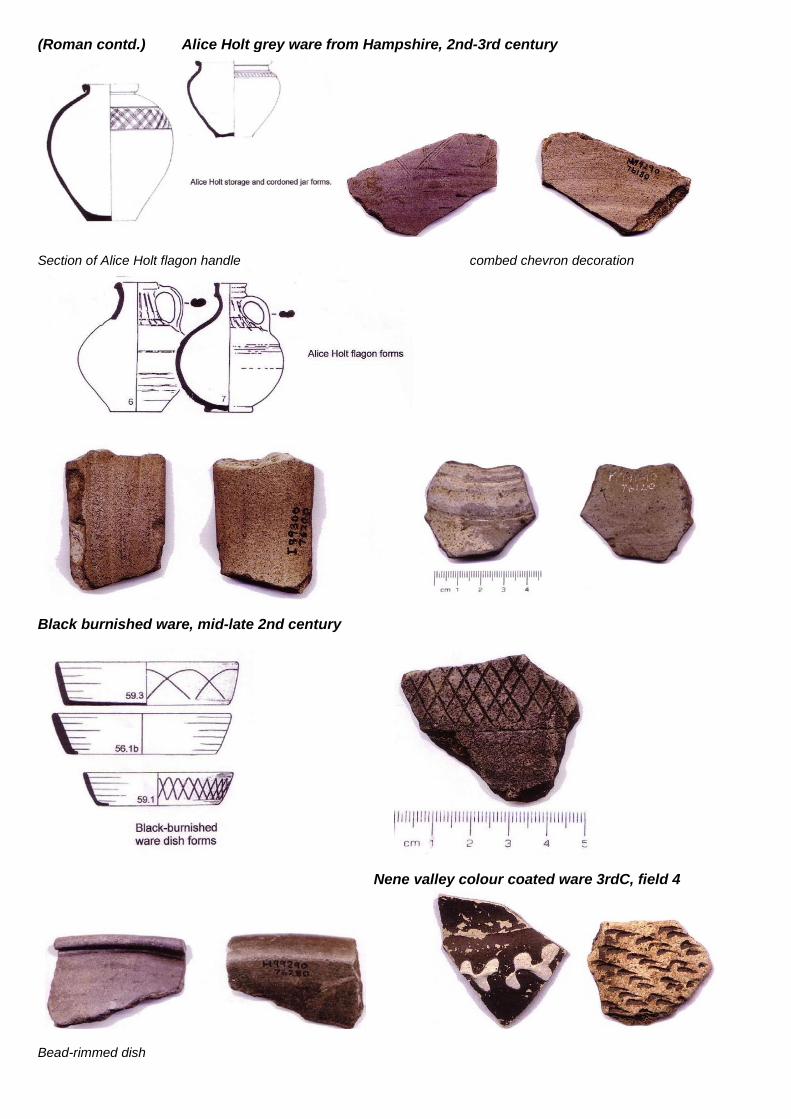
(Roman contd.) Alice Holt grey ware from Hampshire, 2nd-3rd century
Section of Alice Holt flagon handle combed chevron decoration
Black burnished ware, mid-late 2nd century
Nene valley colour coated ware 3rdC, field 4
Bead-rimmed dish
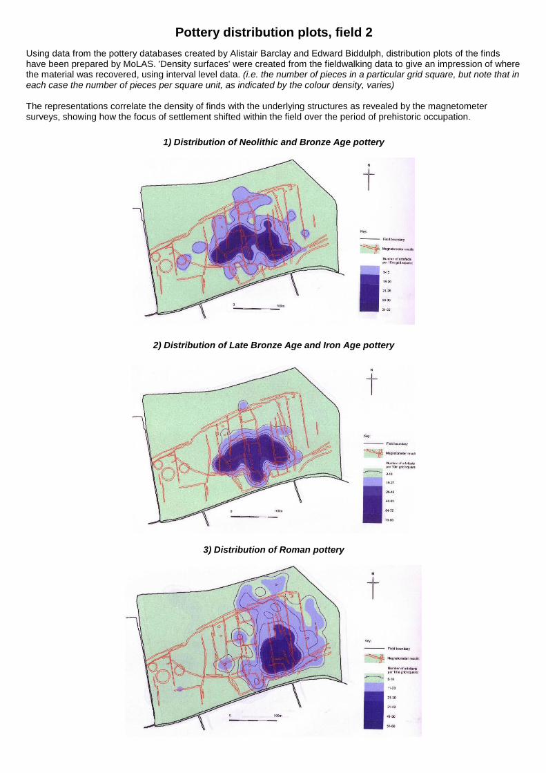
Pottery distribution plots, field 2 Using data from the pottery databases created by Alistair Barclay and Edward Biddulph, distribution plots of the finds have been prepared by MoLAS. 'Density surfaces' were created from the fieldwalking data to give an impression of where the material was recovered, using interval level data. (i.e. the number of pieces in a particular grid square, but note that in each case the number of pieces per square unit, as indicated by the colour density, varies) The representations correlate the density of finds with the underlying structures as revealed by the magnetometer surveys, showing how the focus of settlement shifted within the field over the period of prehistoric occupation.
1) Distribution of Neolithic and Bronze Age pottery
2) Distribution of Late Bronze Age and Iron Age pottery
3) Distribution of Roman pottery
Finds 2: Worked Flint from field 2
An extremely large collection of flint was recovered from the fieldwalking programme. Finished and recognisable tools were (as would be expected) outnumbered by flakes and blades which had been struck from a flint nodule by the tool maker. These may have had a useable edge but had not been modified or 'retouched' to create a specific tool. Together with the final 'core' (like an apple core, left when all useful flint shapes have been removed), these by-products from the flint-knapping process are called debitage and are important diagnostic features for the experts in flint types and dating.
Members of the Fieldwalking Group worked through this collection sorting into lithic types (flakes, cores, scrapers etc) before Pippa Bradley assessed all the retouched tools and a proportion of the debitage, and provided the following analysis.
Flint Analysis (drawings by Gillian Crane) The flint varies in quality from very good dark brown-black material with a buff or whitish cortex (outside of the flint pebble) to poor quality flint that does not flake well and has cherty or crystalline inclusions. Much of the latter material is what could be described as pebble flint, small nodules with a thin abraded dark brown-black cortex. A few pieces of Bullhead flint, a distinctive flint with orange staining underneath a black cortex were recovered. It is likely that the majority of this flint came from relatively locally; flint is available from the Chilterns. A single piece from a polished flint axe was recovered; It is a good quality grey flint which may have been imported into the area. As would be expected from a fieldwalked collection there is considerable edge damage from plough action. However, some pieces are in surprisingly good condition, for example the bifacially flaked knife and some of the scrapers. It is possible that some of these pieces have only relatively recently joined the ploughzone and have thus not been subjected to extensive plough action.
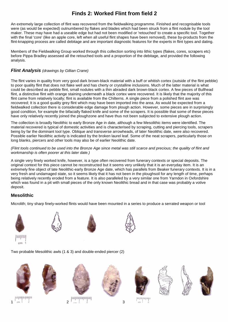
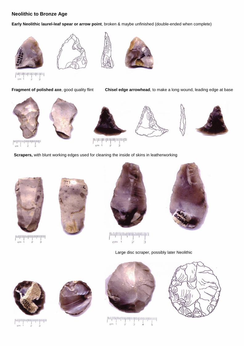
The collection is broadly Neolithic to early Bronze Age in date, although a few Mesolithic items were identified. The material recovered is typical of domestic activities and is characterised by scraping, cutting and piercing tools, scrapers being by far the dominant tool type. Oblique and transverse arrowheads, of later Neolithic date, were also recovered. Possible earlier Neolithic activity is indicated by the broken laurel leaf. Some of the neat scrapers, particularly those on long blanks, piercers and other tools may also be of earlier Neolithic date. (Flint tools continued to be used into the Bronze Age since metal was still scarce and precious; the quality of flint and workmanship is often poorer at this later date.) A single very finely worked knife, however, is a type often recovered from funerary contexts or special deposits. The original context for this piece cannot be reconstructed but it seems very unlikely that it is an everyday item. It is an extremely fine object of late Neolithic-early Bronze Age date, which has parallels from Beaker funerary contexts. It is in a very fresh and undamaged state, so it seems likely that it has not been in the ploughsoil for any length of time, perhaps being relatively recently eroded from a feature. It is also paralleled by a very similar one from Yarndon in Oxfordshire which was found in a pit with small pieces of the only known Neolithic bread and in that case was probably a votive deposit. Mesolithic Microlith; tiny sharp finely-worked flints would have been mounted in a series to produce a serrated weapon or tool
Two probable Mesolithic awls (1 & 3) and double-ended piercer (2)
1 2 3
Neolithic to Bronze Age
Early Neolithic laurel-leaf spear or arrow point, broken & maybe unfinished (double-ended when complete)
Fragment of polished axe, good quality flint Chisel edge arrowhead, to make a long wound, leading edge at base
Scrapers, with blunt working edges used for cleaning the inside of skins in leatherworking
Large disc scraper, possibly later Neolithic
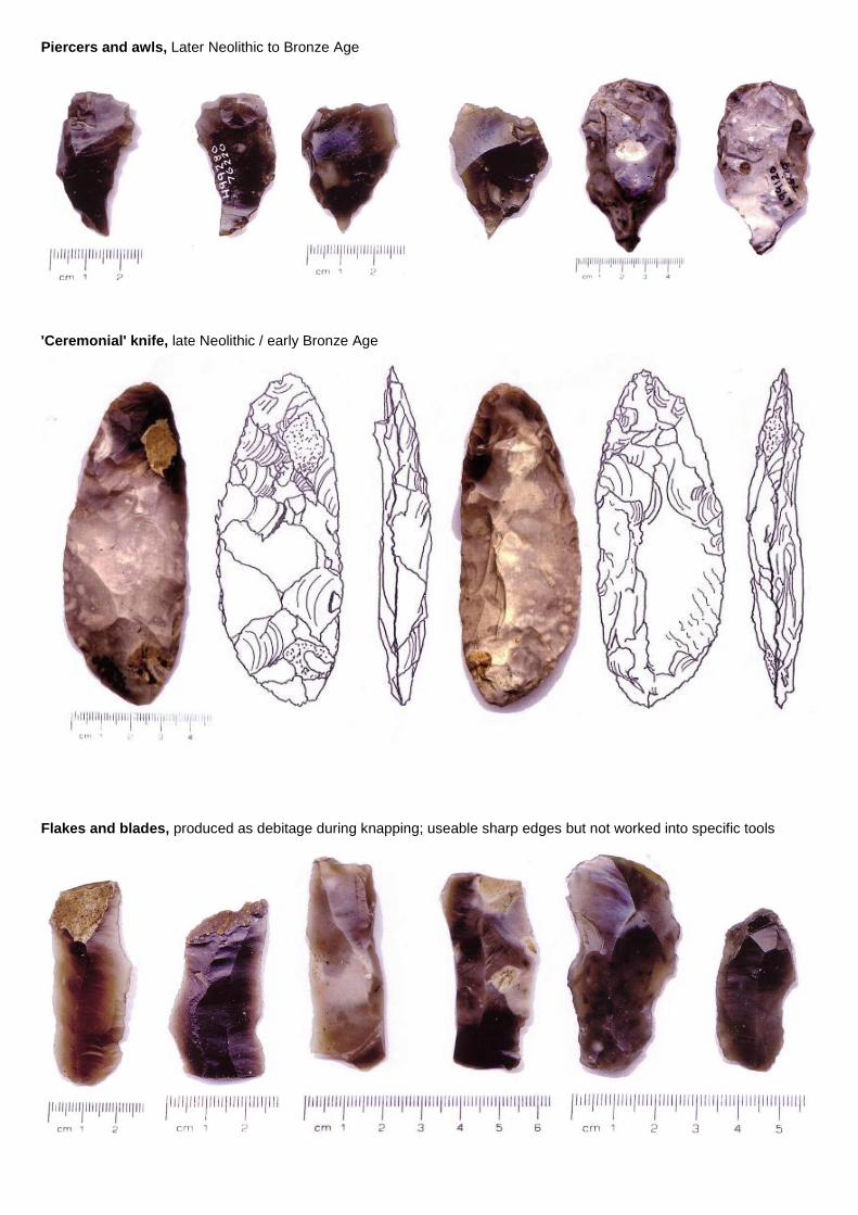
Piercers and awls, Later Neolithic to Bronze Age
'Ceremonial' knife, late Neolithic / early Bronze Age
Flakes and blades, produced as debitage during knapping; useable sharp edges but not worked into specific tools
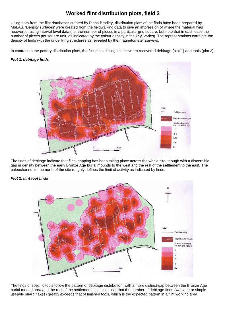
Worked flint distribution plots, field 2 Using data from the flint databases created by Pippa Bradley, distribution plots of the finds have been prepared by MoLAS. 'Density surfaces' were created from the fieldwalking data to give an impression of where the material was recovered, using interval level data (i.e. the number of pieces in a particular grid square, but note that in each case the number of pieces per square unit, as indicated by the colour density in the key, varies). The representations correlate the density of finds with the underlying structures as revealed by the magnetometer surveys.
In contrast to the pottery distribution plots, the flint plots distinguish between recovered debitage (plot 1) and tools (plot 2). Plot 1, debitage finds
. The finds of debitage indicate that flint knapping has been taking place across the whole site, though with a discernible gap in density between the early Bronze Age burial mounds to the west and the rest of the settlement to the east. The paleochannel to the north of the site roughly defines the limit of activity as indicated by finds. Plot 2, flint tool finds
The finds of specific tools follow the pattern of debitage distribution, with a more distinct gap between the Bronze Age burial mound area and the rest of the settlement. It is also clear that the number of debitage finds (wastage or simple useable sharp flakes) greatly exceeds that of finished tools, which is the expected pattern in a flint working area.
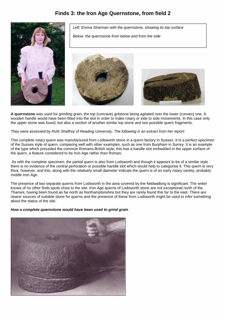
Finds 3: the Iron Age Quernstone, from field 2
A quernstone was used for grinding grain, the top (concave) gritstone being agitated over the lower (convex) one. A wooden handle would have been fitted into the slot in order to make rotary or side to side movements. In this case only the upper stone was found, but also a section of another similar top stone and two possible quern fragments. They were assessed by Ruth Shaffrey of Reading University. The following is an extract from her report: This complete rotary quern was manufactured from Lodsworth stone in a quern factory in Sussex. It is a perfect specimen of the Sussex style of quern, comparing well with other examples, such as one from Burpham in Surrey. It is an example of the type which preceded the common Romano-British style; this has a handle slot embedded in the upper surface of the quern, a feature considered to be Iron Age rather than Roman, As with the complete specimen, the partial quern is also from Lodsworth and though it appears to be of a similar style there is no evidence of the central perforation or possible handle slot which would help to categorise it. This quern is very thick, however, and this, along with the relatively small diameter indicate the quern is of an early rotary variety, probably middle Iron Age. The presence of two separate querns from Lodsworth in the area covered by the fieldwalking is significant. The writer knows of no other finds spots close to the site. Iron Age querns of Lodsworth stone are not exceptional north of the Thames, having been found as far north as Northamptonshire but they are rarely found this far to the east. There are nearer sources of suitable stone for querns and the presence of these from Lodsworth might be used to infer something about the status of the site. How a complete quernstone would have been used to grind grain
Left: Emma Sharman with the quernstone, showing its top surface Below: the quernstone from below and from the side
Conclusions: Site One, Fields 2 & 4 Julia Martin Neolithic The earliest phase of human occupation on this site appears to be Neolithic. Although a few Mesolithic flints were recovered, the bulk of the flint finds were identified as Neolithic to Early Bronze Age. Forms such as scrapers, piercers and awls suggest that activities carried out here were mainly domestic. No landscape features survive from this period. Bronze Age The ring ditches have been interpreted as Bronze Age round barrows, flattened by centuries of ploughing. In the middle Thames Valley such burial mounds usually appear in groups of two or four and date from c2500BC to c1500BC. As at Eton Rowing Lake, the mounds were situated close to the edge of the prehistoric River Thames, indicating that they were positioned for high visibility to passers-by along the river. EBA flint finds suggest that the settlement may originate from c2000BC. Their existence, as ancestor burials, would also have laid claim to the territory for later generations. The geophysics results suggest that one of the trackway ditches underlies one of the ring ditches, dating the trackway and associated field system to MBA at the latest. Ditched field systems begin to appear in the Thames Valley during the MBA and pottery evidence from Field 2 indicates that the settlement was established by this date. The field system is aligned northeast / southwest, making use of the barrow cemetery as its key reference point. This distinctive orientation appears to be common practice and can also be seen at similar sites in the region (eg Eton Rowing Lake), which have been dated to the middle to late Bronze Age. The remarkably regular 30m wide field dimensions also have regional parallels: Weir Bank Farm Bray, Wallingford Road Didcot and Corporation Farm Abingdon. By the LBA, the landscape around the middle Thames had been divided up on an substantial basis. Yates suggests that this site could be part of an extensive system of fields that border the Thames. Southlea is classified as part of the ‘Runnymede-Petters’ group, including Eton Wick, Eton Rowing Lake, Bray, Marsh Lane East and Lake End Road, Dorney (all excavated sites). Yates also suggests that the layout of these field systems and their associated droveways is consistent with the practice of stockraising and that herd size may have been an indication of wealth and status. Assessment of the LBA pottery hints at a high status site at Southlea, similar to Runnymede and Wallingford. Iron Age The next phase of occupation at Southlea is represented by the pit alignment and sub-rectangular enclosure and annex. Pottery distribution clearly dates these features to the IA, by which time it appears that the settlement had been reconstructed and realigned on a different axis. The identification of transitional LBA/EIA pottery in such large quantities is unusual along the Thames, as excavations elsewhere have noted extensive dislocation at the end of the Bronze Age. At other sites the level of early Iron Age activity declines dramatically compared with the intensity of developments that had taken place during the Bronze Age. Generally speaking, most of the Bronze Age fields are abandoned and field construction is often not matched again on this scale until the Romans arrived. This makes Southlea a particularly interesting site of regional importance. Romano-British The focal point of the settlement appears to have shifted again during the Romano-British period. The main concentration of Roman pottery was found further to the east in Field 2 and in the north of Field 4, centred on the second rectangular ditched enclosure. Assessment of pottery from Fields 2 and 4 suggest that, although there was a settlement at Southlea throughout the Roman period, it was of relatively low status. Only one sherd of samian was recovered, indicating that the settlement remained outside wider trade networks and was dependent on essentially local pottery supplies. Post-Roman The majority of post-roman pottery was medieval or post medieval, with only one sherd of probable Saxo-Norman date recovered from Field 4. There is documentary evidence that the Southlea site has been farmed and occupied since 1100, and it may be that occupation was continuous here from prehistoric times.
Southlea Farmhouse dating from Tudor period, now demolished
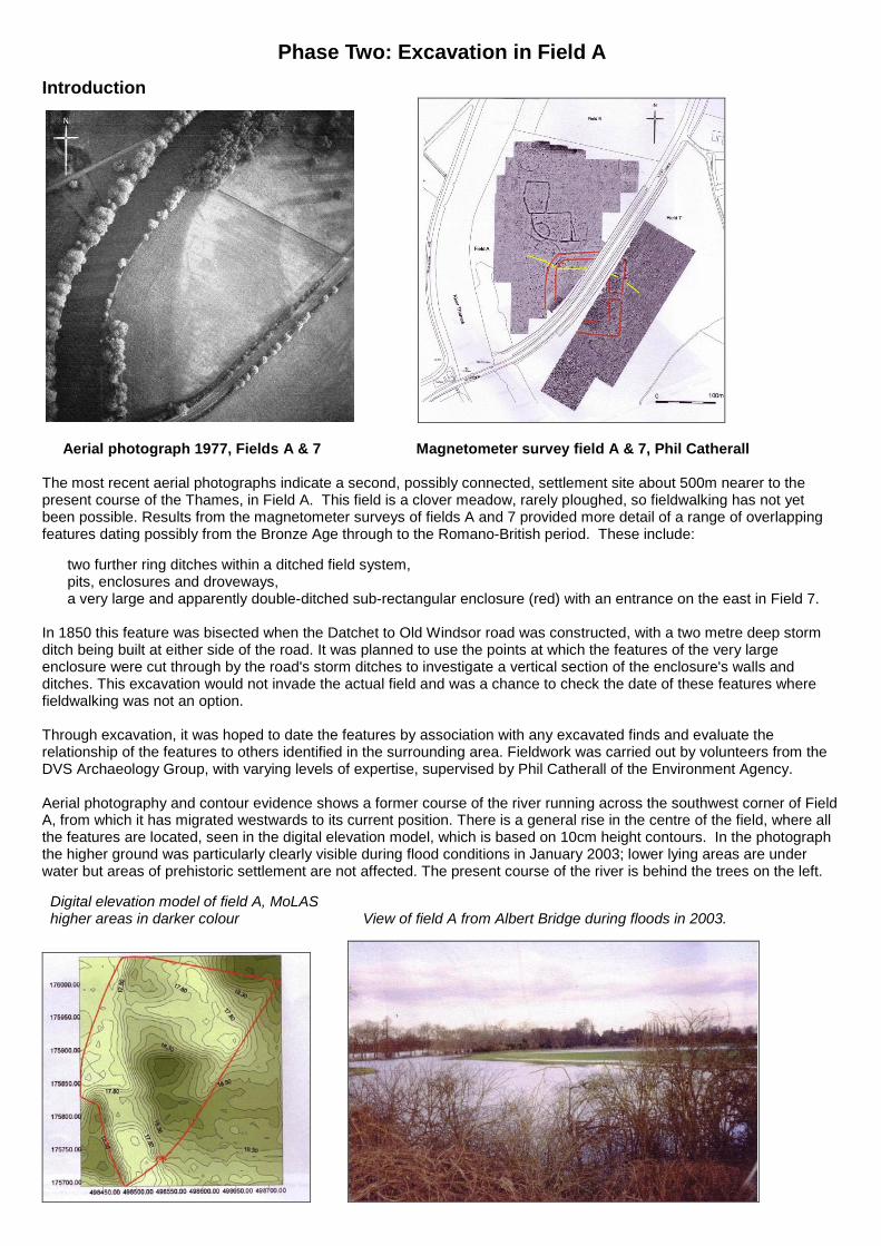
Phase Two: Excavation in Field A
Introduction
Aerial photograph 1977, Fields A & 7 Magnetometer survey field A & 7, Phil Catherall The most recent aerial photographs indicate a second, possibly connected, settlement site about 500m nearer to the present course of the Thames, in Field A. This field is a clover meadow, rarely ploughed, so fieldwalking has not yet been possible. Results from the magnetometer surveys of fields A and 7 provided more detail of a range of overlapping features dating possibly from the Bronze Age through to the Romano-British period. These include: two further ring ditches within a ditched field system, pits, enclosures and droveways, a very large and apparently double-ditched sub-rectangular enclosure (red) with an entrance on the east in Field 7. In 1850 this feature was bisected when the Datchet to Old Windsor road was constructed, with a two metre deep storm ditch being built at either side of the road. It was planned to use the points at which the features of the very large enclosure were cut through by the road's storm ditches to investigate a vertical section of the enclosure's walls and ditches. This excavation would not invade the actual field and was a chance to check the date of these features where fieldwalking was not an option. Through excavation, it was hoped to date the features by association with any excavated finds and evaluate the relationship of the features to others identified in the surrounding area. Fieldwork was carried out by volunteers from the DVS Archaeology Group, with varying levels of expertise, supervised by Phil Catherall of the Environment Agency. Aerial photography and contour evidence shows a former course of the river running across the southwest corner of Field A, from which it has migrated westwards to its current position. There is a general rise in the centre of the field, where all the features are located, seen in the digital elevation model, which is based on 10cm height contours. In the photograph the higher ground was particularly clearly visible during flood conditions in January 2003; lower lying areas are under water but areas of prehistoric settlement are not affected. The present course of the river is behind the trees on the left. Digital elevation model of field A, MoLAS higher areas in darker colour View of field A from Albert Bridge during floods in 2003.
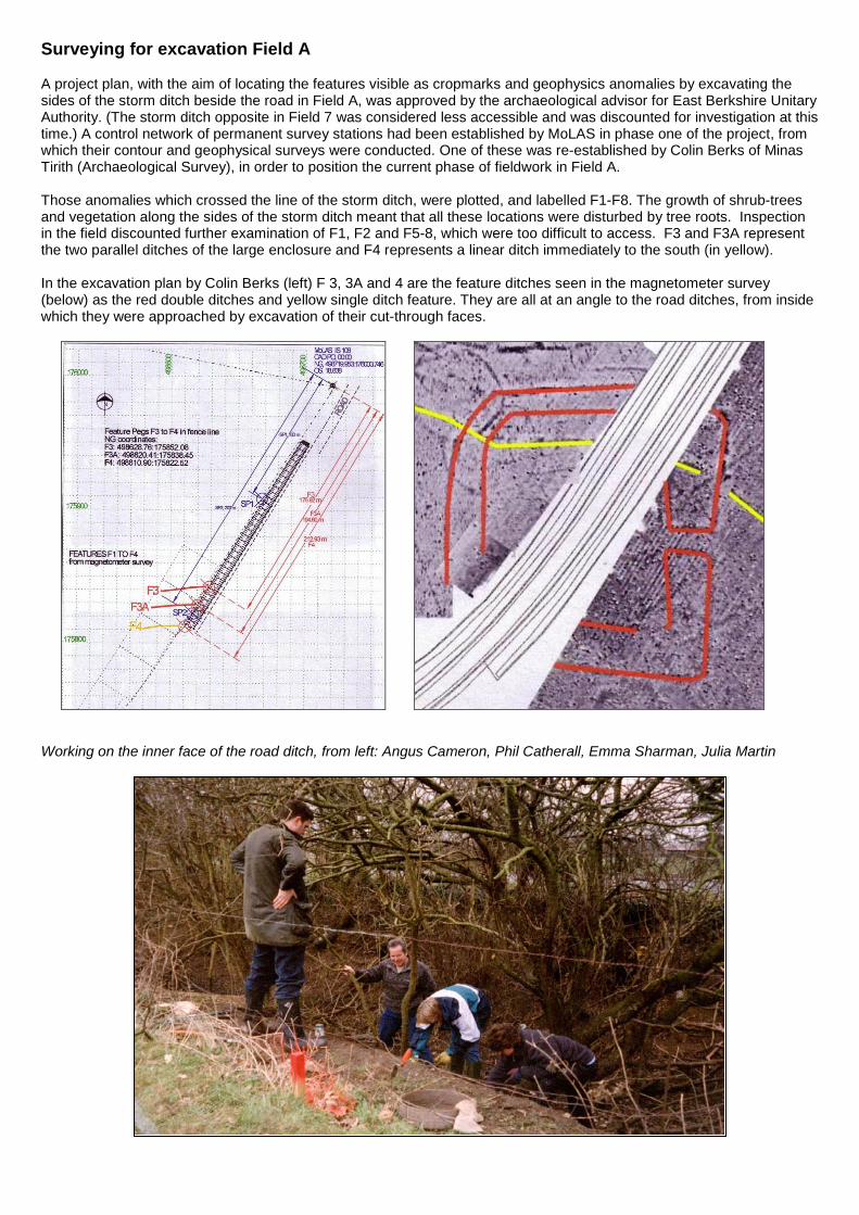
Surveying for excavation Field A A project plan, with the aim of locating the features visible as cropmarks and geophysics anomalies by excavating the sides of the storm ditch beside the road in Field A, was approved by the archaeological advisor for East Berkshire Unitary Authority. (The storm ditch opposite in Field 7 was considered less accessible and was discounted for investigation at this time.) A control network of permanent survey stations had been established by MoLAS in phase one of the project, from which their contour and geophysical surveys were conducted. One of these was re-established by Colin Berks of Minas Tirith (Archaeological Survey), in order to position the current phase of fieldwork in Field A. Those anomalies which crossed the line of the storm ditch, were plotted, and labelled F1-F8. The growth of shrub-trees and vegetation along the sides of the storm ditch meant that all these locations were disturbed by tree roots. Inspection in the field discounted further examination of F1, F2 and F5-8, which were too difficult to access. F3 and F3A represent the two parallel ditches of the large enclosure and F4 represents a linear ditch immediately to the south (in yellow). In the excavation plan by Colin Berks (left) F 3, 3A and 4 are the feature ditches seen in the magnetometer survey (below) as the red double ditches and yellow single ditch feature. They are all at an angle to the road ditches, from inside which they were approached by excavation of their cut-through faces.
Working on the inner face of the road ditch, from left: Angus Cameron, Phil Catherall, Emma Sharman, Julia Martin
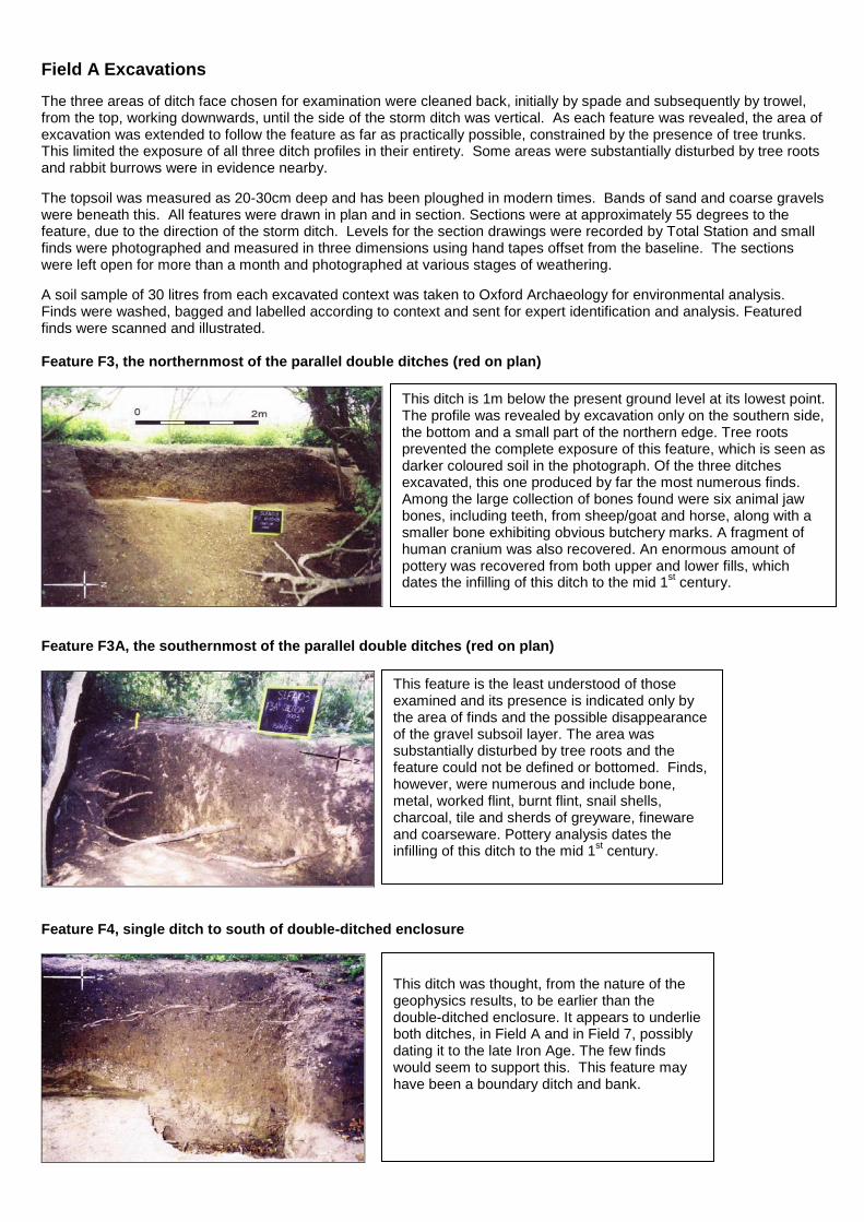
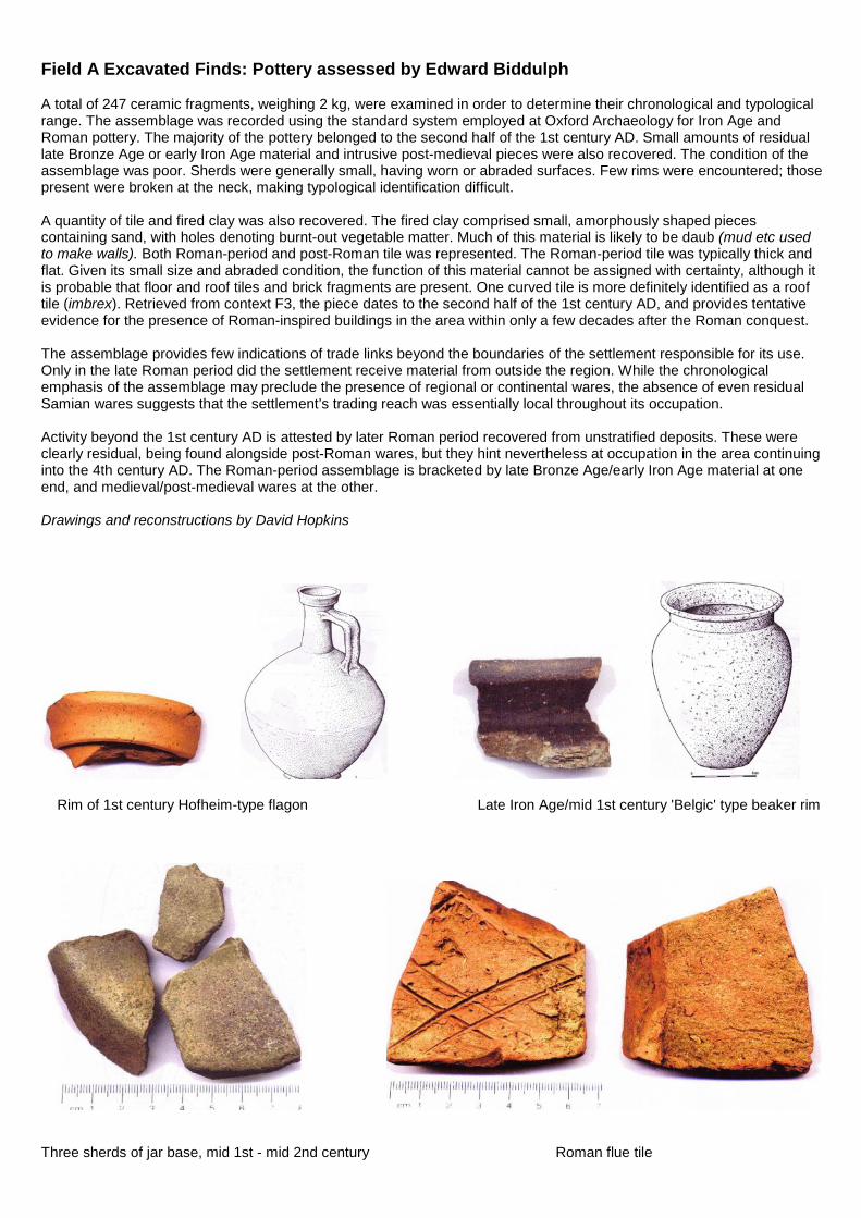
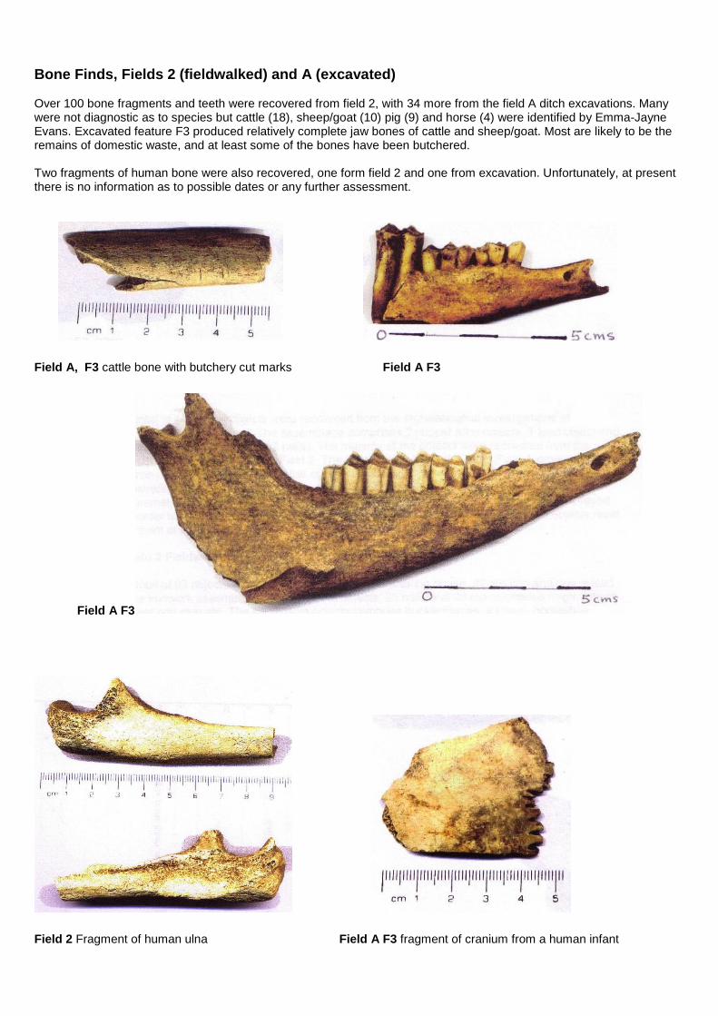
Field A Excavations The three areas of ditch face chosen for examination were cleaned back, initially by spade and subsequently by trowel, from the top, working downwards, until the side of the storm ditch was vertical. As each feature was revealed, the area of excavation was extended to follow the feature as far as practically possible, constrained by the presence of tree trunks. This limited the exposure of all three ditch profiles in their entirety. Some areas were substantially disturbed by tree roots and rabbit burrows were in evidence nearby. The topsoil was measured as 20-30cm deep and has been ploughed in modern times. Bands of sand and coarse gravels were beneath this. All features were drawn in plan and in section. Sections were at approximately 55 degrees to the feature, due to the direction of the storm ditch. Levels for the section drawings were recorded by Total Station and small finds were photographed and measured in three dimensions using hand tapes offset from the baseline. The sections were left open for more than a month and photographed at various stages of weathering. A soil sample of 30 litres from each excavated context was taken to Oxford Archaeology for environmental analysis. Finds were washed, bagged and labelled according to context and sent for expert identification and analysis. Featured finds were scanned and illustrated. Feature F3, the northernmost of the parallel double ditches (red on plan)
Feature F3A, the southernmost of the parallel double ditches (red on plan)
Feature F4, single ditch to south of double-ditched enclosure
This ditch is 1m below the present ground level at its lowest point. The profile was revealed by excavation only on the southern side, the bottom and a small part of the northern edge. Tree roots prevented the complete exposure of this feature, which is seen as darker coloured soil in the photograph. Of the three ditches excavated, this one produced by far the most numerous finds. Among the large collection of bones found were six animal jaw bones, including teeth, from sheep/goat and horse, along with a smaller bone exhibiting obvious butchery marks. A fragment of human cranium was also recovered. An enormous amount of pottery was recovered from both upper and lower fills, which dates the infilling of this ditch to the mid 1st century.
This feature is the least understood of those examined and its presence is indicated only by the area of finds and the possible disappearance of the gravel subsoil layer. The area was substantially disturbed by tree roots and the feature could not be defined or bottomed. Finds, however, were numerous and include bone, metal, worked flint, burnt flint, snail shells, charcoal, tile and sherds of greyware, fineware and coarseware. Pottery analysis dates the infilling of this ditch to the mid 1st century.
This ditch was thought, from the nature of the geophysics results, to be earlier than the double-ditched enclosure. It appears to underlie both ditches, in Field A and in Field 7, possibly dating it to the late Iron Age. The few finds would seem to support this. This feature may have been a boundary ditch and bank.
Field A Excavated Finds: Pottery assessed by Edward Biddulph A total of 247 ceramic fragments, weighing 2 kg, were examined in order to determine their chronological and typological range. The assemblage was recorded using the standard system employed at Oxford Archaeology for Iron Age and Roman pottery. The majority of the pottery belonged to the second half of the 1st century AD. Small amounts of residual late Bronze Age or early Iron Age material and intrusive post-medieval pieces were also recovered. The condition of the assemblage was poor. Sherds were generally small, having worn or abraded surfaces. Few rims were encountered; those present were broken at the neck, making typological identification difficult. A quantity of tile and fired clay was also recovered. The fired clay comprised small, amorphously shaped pieces containing sand, with holes denoting burnt-out vegetable matter. Much of this material is likely to be daub (mud etc used to make walls). Both Roman-period and post-Roman tile was represented. The Roman-period tile was typically thick and flat. Given its small size and abraded condition, the function of this material cannot be assigned with certainty, although it is probable that floor and roof tiles and brick fragments are present. One curved tile is more definitely identified as a roof tile (imbrex). Retrieved from context F3, the piece dates to the second half of the 1st century AD, and provides tentative evidence for the presence of Roman-inspired buildings in the area within only a few decades after the Roman conquest. The assemblage provides few indications of trade links beyond the boundaries of the settlement responsible for its use. Only in the late Roman period did the settlement receive material from outside the region. While the chronological emphasis of the assemblage may preclude the presence of regional or continental wares, the absence of even residual Samian wares suggests that the settlement’s trading reach was essentially local throughout its occupation. Activity beyond the 1st century AD is attested by later Roman period recovered from unstratified deposits. These were clearly residual, being found alongside post-Roman wares, but they hint nevertheless at occupation in the area continuing into the 4th century AD. The Roman-period assemblage is bracketed by late Bronze Age/early Iron Age material at one end, and medieval/post-medieval wares at the other. Drawings and reconstructions by David Hopkins
Rim of 1st century Hofheim-type flagon Late Iron Age/mid 1st century 'Belgic' type beaker rim
Three sherds of jar base, mid 1st - mid 2nd century Roman flue tile
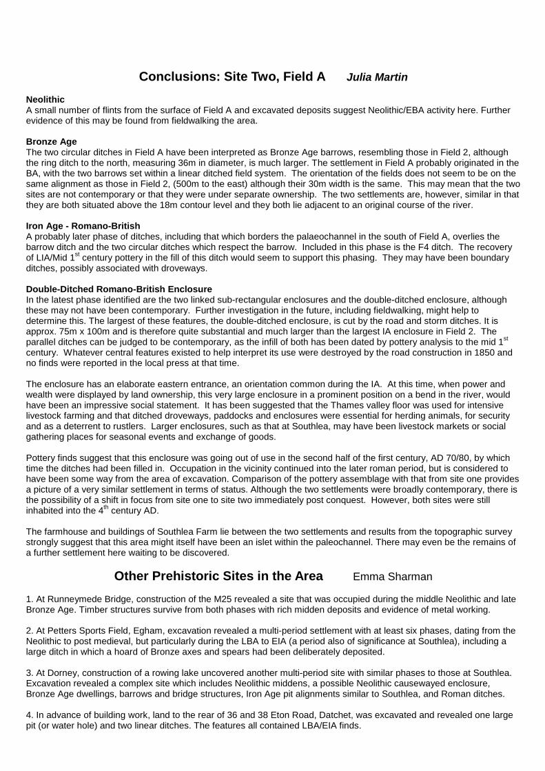
Bone Finds, Fields 2 (fieldwalked) and A (excavated) Over 100 bone fragments and teeth were recovered from field 2, with 34 more from the field A ditch excavations. Many were not diagnostic as to species but cattle (18), sheep/goat (10) pig (9) and horse (4) were identified by Emma-Jayne Evans. Excavated feature F3 produced relatively complete jaw bones of cattle and sheep/goat. Most are likely to be the remains of domestic waste, and at least some of the bones have been butchered. Two fragments of human bone were also recovered, one form field 2 and one from excavation. Unfortunately, at present there is no information as to possible dates or any further assessment.
Field A, F3 cattle bone with butchery cut marks Field A F3
Field A F3
Field 2 Fragment of human ulna Field A F3 fragment of cranium from a human infant
Conclusions: Site Two, Field A Julia Martin
Neolithic A small number of flints from the surface of Field A and excavated deposits suggest Neolithic/EBA activity here. Further evidence of this may be found from fieldwalking the area. Bronze Age The two circular ditches in Field A have been interpreted as Bronze Age barrows, resembling those in Field 2, although the ring ditch to the north, measuring 36m in diameter, is much larger. The settlement in Field A probably originated in the BA, with the two barrows set within a linear ditched field system. The orientation of the fields does not seem to be on the same alignment as those in Field 2, (500m to the east) although their 30m width is the same. This may mean that the two sites are not contemporary or that they were under separate ownership. The two settlements are, however, similar in that they are both situated above the 18m contour level and they both lie adjacent to an original course of the river. Iron Age - Romano-British A probably later phase of ditches, including that which borders the palaeochannel in the south of Field A, overlies the barrow ditch and the two circular ditches which respect the barrow. Included in this phase is the F4 ditch. The recovery of LIA/Mid 1st century pottery in the fill of this ditch would seem to support this phasing. They may have been boundary ditches, possibly associated with droveways. Double-Ditched Romano-British Enclosure In the latest phase identified are the two linked sub-rectangular enclosures and the double-ditched enclosure, although these may not have been contemporary. Further investigation in the future, including fieldwalking, might help to determine this. The largest of these features, the double-ditched enclosure, is cut by the road and storm ditches. It is approx. 75m x 100m and is therefore quite substantial and much larger than the largest IA enclosure in Field 2. The parallel ditches can be judged to be contemporary, as the infill of both has been dated by pottery analysis to the mid 1st century. Whatever central features existed to help interpret its use were destroyed by the road construction in 1850 and no finds were reported in the local press at that time. The enclosure has an elaborate eastern entrance, an orientation common during the IA. At this time, when power and wealth were displayed by land ownership, this very large enclosure in a prominent position on a bend in the river, would have been an impressive social statement. It has been suggested that the Thames valley floor was used for intensive livestock farming and that ditched droveways, paddocks and enclosures were essential for herding animals, for security and as a deterrent to rustlers. Larger enclosures, such as that at Southlea, may have been livestock markets or social gathering places for seasonal events and exchange of goods. Pottery finds suggest that this enclosure was going out of use in the second half of the first century, AD 70/80, by which time the ditches had been filled in. Occupation in the vicinity continued into the later roman period, but is considered to have been some way from the area of excavation. Comparison of the pottery assemblage with that from site one provides a picture of a very similar settlement in terms of status. Although the two settlements were broadly contemporary, there is the possibility of a shift in focus from site one to site two immediately post conquest. However, both sites were still inhabited into the 4th century AD. The farmhouse and buildings of Southlea Farm lie between the two settlements and results from the topographic survey strongly suggest that this area might itself have been an islet within the paleochannel. There may even be the remains of a further settlement here waiting to be discovered.
Other Prehistoric Sites in the Area Emma Sharman 1. At Runneymede Bridge, construction of the M25 revealed a site that was occupied during the middle Neolithic and late Bronze Age. Timber structures survive from both phases with rich midden deposits and evidence of metal working. 2. At Petters Sports Field, Egham, excavation revealed a multi-period settlement with at least six phases, dating from the Neolithic to post medieval, but particularly during the LBA to EIA (a period also of significance at Southlea), including a large ditch in which a hoard of Bronze axes and spears had been deliberately deposited. 3. At Dorney, construction of a rowing lake uncovered another multi-period site with similar phases to those at Southlea. Excavation revealed a complex site which includes Neolithic middens, a possible Neolithic causewayed enclosure, Bronze Age dwellings, barrows and bridge structures, Iron Age pit alignments similar to Southlea, and Roman ditches. 4. In advance of building work, land to the rear of 36 and 38 Eton Road, Datchet, was excavated and revealed one large pit (or water hole) and two linear ditches. The features all contained LBA/EIA finds.
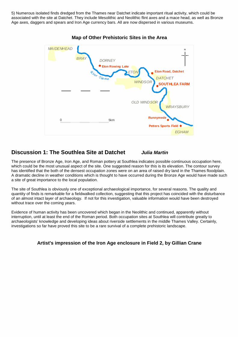
5) Numerous isolated finds dredged from the Thames near Datchet indicate important ritual activity, which could be associated with the site at Datchet. They include Mesolithic and Neolithic flint axes and a mace head, as well as Bronze Age axes, daggers and spears and Iron Age currency bars. All are now dispersed in various museums.
Map of Other Prehistoric Sites in the Area
SOUTHLEA FARM
Runnymede
Petters Sports Field
Eton Rowing Lake
ETON
MAIDENHEAD
BRAY DORNEY
WRAYSBURY
EGHAM
DATCHET
Eton Road, Datchet
WINDSOR
River Thames
5km0
OLD WINDSOR
Discussion 1: The Southlea Site at Datchet Julia Martin
The presence of Bronze Age, Iron Age, and Roman pottery at Southlea indicates possible continuous occupation here, which could be the most unusual aspect of the site. One suggested reason for this is its elevation. The contour survey has identified that the both of the densest occupation zones were on an area of raised dry land in the Thames floodplain. A dramatic decline in weather conditions which is thought to have occurred during the Bronze Age would have made such a site of great importance to the local population. The site of Southlea is obviously one of exceptional archaeological importance, for several reasons. The quality and quantity of finds is remarkable for a fieldwalked collection, suggesting that this project has coincided with the disturbance of an almost intact layer of archaeology. If not for this investigation, valuable information would have been destroyed without trace over the coming years. Evidence of human activity has been uncovered which began in the Neolithic and continued, apparently without interruption, until at least the end of the Roman period. Both occupation sites at Southlea will contribute greatly to archaeologists’ knowledge and developing ideas about riverside settlements in the middle Thames Valley. Certainly, investigations so far have proved this site to be a rare survival of a complete prehistoric landscape.
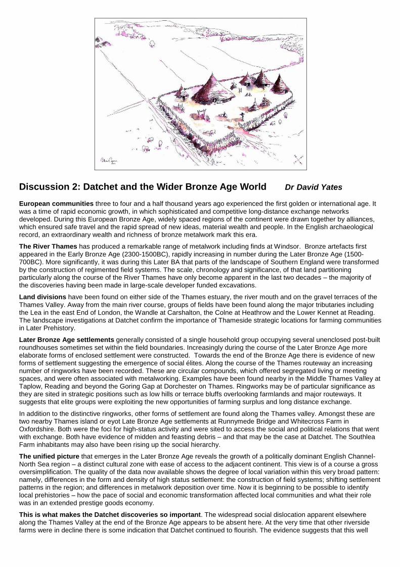
Artist's impression of the Iron Age enclosure in Field 2, by Gillian Crane
Discussion 2: Datchet and the Wider Bronze Age World Dr David Yates European communities three to four and a half thousand years ago experienced the first golden or international age. It was a time of rapid economic growth, in which sophisticated and competitive long-distance exchange networks developed. During this European Bronze Age, widely spaced regions of the continent were drawn together by alliances, which ensured safe travel and the rapid spread of new ideas, material wealth and people. In the English archaeological record, an extraordinary wealth and richness of bronze metalwork mark this era.
The River Thames has produced a remarkable range of metalwork including finds at Windsor. Bronze artefacts first appeared in the Early Bronze Age (2300-1500BC), rapidly increasing in number during the Later Bronze Age (1500-700BC). More significantly, it was during this Later BA that parts of the landscape of Southern England were transformed by the construction of regimented field systems. The scale, chronology and significance, of that land partitioning particularly along the course of the River Thames have only become apparent in the last two decades – the majority of the discoveries having been made in large-scale developer funded excavations.
Land divisions have been found on either side of the Thames estuary, the river mouth and on the gravel terraces of the Thames Valley. Away from the main river course, groups of fields have been found along the major tributaries including the Lea in the east End of London, the Wandle at Carshalton, the Colne at Heathrow and the Lower Kennet at Reading. The landscape investigations at Datchet confirm the importance of Thameside strategic locations for farming communities in Later Prehistory.
Later Bronze Age settlements generally consisted of a single household group occupying several unenclosed post-built roundhouses sometimes set within the field boundaries. Increasingly during the course of the Later Bronze Age more elaborate forms of enclosed settlement were constructed. Towards the end of the Bronze Age there is evidence of new forms of settlement suggesting the emergence of social élites. Along the course of the Thames routeway an increasing number of ringworks have been recorded. These are circular compounds, which offered segregated living or meeting spaces, and were often associated with metalworking. Examples have been found nearby in the Middle Thames Valley at Taplow, Reading and beyond the Goring Gap at Dorchester on Thames. Ringworks may be of particular significance as they are sited in strategic positions such as low hills or terrace bluffs overlooking farmlands and major routeways. It suggests that elite groups were exploiting the new opportunities of farming surplus and long distance exchange.
In addition to the distinctive ringworks, other forms of settlement are found along the Thames valley. Amongst these are two nearby Thames island or eyot Late Bronze Age settlements at Runnymede Bridge and Whitecross Farm in Oxfordshire. Both were the foci for high-status activity and were sited to access the social and political relations that went with exchange. Both have evidence of midden and feasting debris – and that may be the case at Datchet. The Southlea Farm inhabitants may also have been rising up the social hierarchy.
The unified picture that emerges in the Later Bronze Age reveals the growth of a politically dominant English Channel-North Sea region – a distinct cultural zone with ease of access to the adjacent continent. This view is of a course a gross oversimplification. The quality of the data now available shows the degree of local variation within this very broad pattern: namely, differences in the form and density of high status settlement: the construction of field systems; shifting settlement patterns in the region; and differences in metalwork deposition over time. Now it is beginning to be possible to identify local prehistories – how the pace of social and economic transformation affected local communities and what their role was in an extended prestige goods economy.
This is what makes the Datchet discoveries so important. The widespread social dislocation apparent elsewhere along the Thames Valley at the end of the Bronze Age appears to be absent here. At the very time that other riverside farms were in decline there is some indication that Datchet continued to flourish. The evidence suggests that this well
drained strategic settlement site has been continually occupied for over three and a half thousand years – and was particularly important towards the end of the Bronze Age.
And finally …
Sam and Janet pack the finds in bags and boxes for depositing at the Museum of Reading.
Published by Datchet Village Society, April 2008 [email protected] 01273 204330