Embed Size (px)
Citation preview
A public consultation on the future design of the National Travel Survey (DFT-2011-16)’ Contents
Foreword from the Head of Statistics 2 Executive Summary 3 How to respond 4 Freedom of Information 4 The Consultation Criteria 5 What will happen next 5 The proposals 6 Consultation questions 28 Question and Answer Brief 30 Annexes:
A - List of those consulted 35 B - List of Consultation Criteria 37
1
Foreword from the Head of Statistics This consultation about the future of the National Travel Survey is an important step forward with regard to the measurement of both how and why people travel. It demonstrates the commitment of statisticians within the Department for Transport to continue to produce high-quality statistics in the public interest and which meet the needs of users.
I welcome the innovative use of technology outlined in the consultation which could improve the statistical data from the survey. The consultation also explicitly explores options to reduce costs. It is important for us to understand how these proposed changes in the survey scope and design would affect users, and the Department for Transport would welcome responses to our proposals.
Anthony Boucher Head of Profession for Statistics Department for Transport
2
Executive Summary The National Travel Survey (NTS) is one of the Department for Transport’s (DfT’s) most essential and fundamental evidence sources. It has been run continuously since 1988. It is the primary source of data on the personal travel patterns of British households and as such it is used extensively both within DfT and across the wider transport sector. The current contract for the NTS covers fieldwork to the end of 2012. We will therefore need to put new arrangements in place for data collection in 2013 and beyond. This consultation is being carried out to inform the detail of these arrangements. It aims to ensure that, while delivering the department’s objectives in relation to the NTS, we take full account of the needs and interests of the wider NTS user community. DfT statisticians are always seeking to develop and innovate in order to get the greatest possible value from the NTS. In recent years, our development work has been focused on the potential use of personal Global Positioning System (GPS) devices to collect the personal travel data that is currently collected via a written travel diary. GPS devices offer major potential advantages, but also present a number of challenges and risks. These are discussed in section 1, which seeks users’ views on whether the future design of the NTS, from 2013 onwards, should be based on the use of GPS devices instead of the written travel diary. In parallel with this consultation, we are undertaking a full pilot of the use of GPS devices within the current NTS. The pilot’s fieldwork ended in May 2011 but the full pilot findings will not be available until autumn 2011, after this consultation has closed. We will therefore base our decision (on whether or not we adopt GPS data collection in the design of the NTS) on both the findings from the pilot and from responses to this consultation. While exploring potential innovation, it is also critically important that the department collects the data delivered by the NTS as cost-effectively as possible. We are therefore explicitly seeking to reduce the cost of NTS data collection to the department and are putting forward a number of proposals with this objective in mind. We are seeking users’ views on which could most sensibly be pursued. The proposals include:
Removing groups of relatively lower-value questions from the NTS questionnaires in order to reduce the average interview duration (section 2);
Reducing the geographic coverage of DfT-funded survey fieldwork from Great Britain to England, reflecting the devolution of many areas of transport policy in Scotland and Wales (section 3);
Other, wider potential changes to aspects of the data collection (section 4). This consultation is directed at NTS users and stakeholders. When providing feedback on the four areas of proposals, those responding are encouraged to focus upon the key questions set out in section 5. These include whether respondents support the proposals, and how the proposals (or features of them) would affect their work either positively or negatively. There is also a more open invitation to suggest changes to the data items collected or the data collection methods used that this consultation may not have explicitly considered. Section 6 contains Q&A briefing on issues relating to the proposals put forward for consultation.
3
How to Respond The consultation period began on 9 June 2011 and will run until 5 September 2011, please ensure that your response reaches us by that date. If you would like further copies of this consultation document it has also been published on the Department’s website and can be found at http://www.dft.gov.uk/consultations or you can contact us using the contact details below, if you would like alternative formats (Braille, audio CD, etc). Please send consultation responses to National Travel Survey Consultation The Department for Transport 2/13 Great Minster House 76 Marsham Street London SW1P 4DR Tel: 020 7944 3097 Fax: 020 7944 2166 Email: [email protected] If you would prefer to respond to the consultation online, it is possible to do so at Citizen Space at https://consultation.dft.gov.uk. When responding, please state whether you are responding as an individual or representing the views of an organisation. If responding on behalf of a larger organisation please make it clear who the organisation represents, and where applicable, how the views of members were assembled. DfT has scheduled a stakeholder meeting to discuss this consultation at 10.00 on 14 July 2011. This will be held at the Royal Statistical Society 12 Errol Street, London, EC1Y 8LX. If you would be interested in attending this event, please use the above contact details to register your interest. A list of those consulted is attached at Annex A. If you have any suggestions of others who may wish to be involved in this process please contact us. We would like to thank those who respond to our consultation in advance. We do not intend to acknowledge individual responses unless by request. Freedom of Information Information provided in response to this consultation, including personal information, may be subject to publication or disclosure in accordance with the Freedom of Information Act 2000 (FOIA) or the Environmental Information Regulations 2004. If you want information that you provide to be treated as confidential, please be aware that, under the FOIA, there is a statutory Code of Practice with which public authorities must comply and which deals, amongst other things, with obligations of confidence.
4
In view of this it would be helpful if you could explain to us why you regard the information you have provided as confidential. If we receive a request for disclosure of the information we will take full account of your explanation, but we cannot give an assurance that confidentiality can be maintained in all circumstances. An automatic confidentiality disclaimer generated by your IT system will not, of itself, be regarded as binding on the Department. The Department will process your personal data in accordance with the Data Protection Act (DPA) and in the majority of circumstances this will mean that your personal data will not be disclosed to third parties. The Consultation criteria The consultation is being conducted in line with the Government's Code or Practice on Consultation. The criteria are listed at Annex B; a full version of the Code of Practice on Consultation is available on the Better Regulation Executive web-site at: http://www.bis.gov.uk/files/file47158.pdf There is no accompanying Regulatory Impact Assessment for this consultation as the National Travel Survey is non-Regulatory.
If you consider that this consultation does not comply with the criteria or have comments about the consultation process please contact:
Consultation Co-Ordinator Department for Transport Zone 2/25 Great Minster House London SW1P 4DR Email address [email protected] What will happen next? A summary of responses, including the next steps will be published by 31 October 2011 on the DfT web site; paper copies will be available on request.
5
The Proposals Background The National Travel Survey (NTS) is one of the Department for Transport’s (DfT’s) most essential and fundamental evidence sources. It has been run continuously since 1988. It is our primary source of data on:
overall levels of personal travel in Britain, across all transport modes; how and why people travel; how travel patterns change over time, and how travel patterns vary by individual and household circumstances.
The department’s uses of NTS data are wide and varied. Alongside a great many ad-hoc and issue-specific uses, our more significant and ongoing uses of the data include:
calibrating and maintaining the National Transport Model and the associated National Trip End Model dataset and WebTAG. These are standard tools used by transport planners in developing and appraising business cases;
monitoring one of the eight impact indicators in the DfT Business Plan 2011-2015;
evaluating the potential distributional impact of transport policies (through quantitative data on the travel patterns of different social and economic groups), and
estimating the total number of road accidents in Great Britain, including those accidents that are not reported to the police.
The department has a clear and continuing need for the data that the NTS provides. We require data on personal travel behaviour that, as far as reasonably possible:
is accurate and robust to the standard required of an official statistic; covers all domestic transport modes; covers all sectors of the resident household population; is comparable over time, and allows analysis of travel behaviour according to personal circumstances (e.g.
age, income, employment status, car ownership, etc.) However, in addition to its applications within DfT, the NTS also has a very wide range of external users. An annual statistical release, with accompanying topic reports and statistical tables, is published by DfT as a National Statistic and is widely used. The DfT also makes an anonymised version of the NTS data set available to researchers, and answers many ad-hoc requests from external enquirers for NTS data and statistics. All NTS fieldwork is currently contracted out to the National Centre for Social Research (NatCen), a not-for-profit social research institution. This contract expires upon completion of fieldwork for the 2012 survey year. We will therefore need to put new arrangements in place for data collection in 2013 and beyond. This consultation is being carried out to inform the detail of these arrangements. It aims to ensure that, while delivering the department’s objectives in relation to NTS data, we take full account of the needs and interests of the wider NTS user community.
6
1. Replacing the travel diary with personal GPS devices Introduction 1.1 The NTS currently uses a seven-day travel diary1 to collect personal travel data. This is a structured paper booklet completed by hand by individual survey participants, beginning on a pre-determined date after the main survey interview has been conducted. On completion, it is collected by the original interviewer who conducts a brief ‘pick up’ interview. The diary has been in place since the NTS was created and, for most of the survey’s lifetime, it has been the only feasible method of collecting data on actual journeys made. However, it has several key weaknesses, including:
the instructions for completion are complex and subject to misinterpretation;
it yields data that is sensitive to minor changes in diary design, whose effects can be difficult to predict;
it is lengthy and places a heavy burden on respondents; it is very difficult to collect data from people with literacy problems or limited
English language knowledge; some journeys have to be excluded for reasons of basic practicality (e.g.
business journeys of delivery drivers and people in similar jobs); the complexity of the diaries, and the ‘free text’ nature of some of the data
fields, means that it is not feasible to process them automatically. They therefore require manual coding and data entry, which is a significant ongoing cost, and
it is heavily reliant on complete and accurate respondent recall, meaning that there is a potential (but unknown) ‘human error’ affecting the quality of all data collected.
1.2 In 2006, the Department commissioned and published a review of the scope for using technology to improve the quality and reliability of NTS diary data2. Personal GPS devices were considered the most suitable option to deliver affordable and practical improvement. In January 2010, DfT published the findings of a feasibility study, undertaken during 2008 and 2009, which explored the scope for using personal GPS devices in the NTS3. This confirmed that GPS technology has real promise for use within the NTS and did not uncover any fundamental barriers of feasibility or public acceptability. 1.3 A key reason for its acceptability is that the British public is becoming increasingly familiar with GPS technology. GPS chips are a core component of ‘SatNav’ devices and many higher-specification mobile phones. The continued use of a paper diary to collect travel data therefore risks appearing increasingly antiquated 1 Adult travel diary: http://www.dft.gov.uk/pgr/statistics/datatablespublications/nts/technical/adulttrcrd.pdf Children’s travel diary: http://www.dft.gov.uk/pgr/statistics/datatablespublications/nts/technical/youngtrcrd.pdf 2 Review of the Potential Role of 'New Technologies' in the National Travel Survey http://webarchive.nationalarchives.gov.uk/+/http://www.dft.gov.uk/pgr/statistics/datatablespublications/personal/methodology/ntsreports/ntsreviewtechnologies.pdf 3 National Travel Survey GPS Feasibility Study http://webarchive.nationalarchives.gov.uk/+/http://www.dft.gov.uk/pgr/statistics/datatablespublications/personal/methodology/ntsreports/ntsgpsstudy.pdf
7
and potentially off-putting to the growing proportion of survey respondents who are comfortable and confident users of technology. 1.4 The UK is not the only country that has been exploring the potential use of GPS technology in personal or household travel surveys. Pilot studies have already been undertaken by Israel, France and the Netherlands, and in several US states and cities. There have also been a number of smaller-scale projects and studies in the academic sector. We have kept in touch with the work of international and academic colleagues in planning and designing our own fuller and more detailed pilot of the use of GPS devices in the British NTS, building on the positive initial findings of the feasibility study. 1.5 The GPS ‘option’ proposed in this document would constitute a permanent switch from solely using travel diaries to collect personal travel data, to solely using GPS devices. While there may be scope to undertake dual running of the two data collection methods over a transitional period, this would be a time limited exercise, after which data collection would be collected solely using GPS devices. The NTS GPS pilot survey 1.6 Following a brief review of the GPS devices available on the market, carried out in order to ensure that we were fully exploiting the available technology, a full GPS pilot project commenced in September 2010. Data collection is being carried out by the current NTS contractor (NatCen), using existing NTS interviewers and following established NTS methodology wherever sensible and feasible. 1.7 A key feature in the design of the pilot was that the GPS devices used had to be as ‘passive’ as possible (i.e. requiring no user input other than overnight charging of the device battery). This was considered essential in order to eliminate the ‘human error’ component as far as possible, and thereby ensure that data from all devices could be processed in a standardised and automated fashion. 1.8 The pilot used personal GPS devices that are equipped with three accelerometers (arranged in three dimensions, one for each of the X, Y and Z axes). These measure change in acceleration on each axis, effectively acting as ‘vibration sensors’ and recording the pattern of vibration generated as the device holder moves around by various means. The accelerometer data is potentially extremely useful in deriving mode of travel for a particular journey stage, as different modes of transport generate distinctly different patterns of vibration (see below) in the accelerometer data streams. 1.9 The pilot also used an adapted version of the standard NTS interview questionnaire, Information on frequently-visited addresses was collected for each respondent, so that this could be used in conjunction with the recorded GPS data to derive the purpose of a particular journey. (For example, a trip from a respondent’s home to their reported usual place of work is highly likely to be for the purpose of commuting.) 1.10 The pilot has been designed to deliver a target sample of interviews with approximately 800 individuals in 450 households, along with GPS data for all participating individuals aged 12 and over. Fieldwork commenced in February 2011, and was completed in May 2011, at which point the GPS ‘traces’ and supporting
8

1.11 DfT will then undertake summary analysis of the GPS data, comparing GPS outputs to the un-weighted results for the main NTS travel diary data for the same period. Outputs will include a summary report of the analysis, and technical reports from NatCen and TU/e on the data collection and processing. These outputs will be used, alongside the responses to this public consultation, to support DfT’s decision-making on the future data collection methodology to be used in the NTS beyond 2012. 1.12 As the NTS GPS pilot is still ongoing, with the data analysis and processing stages still to be completed, it is not possible to give a final assessment of the benefits and risks of switching to GPS data collection in the NTS. The remainder of this section therefore represents our best understanding at the time of writing (May 2011), but this may change in the light of the full pilot findings. The potential benefits of a GPS methodology 1.13 Using accelerometer equipped GPS devices instead of paper travel diaries would significantly reduce the burden on respondents. GPS would be easy to use and unlike the diary does not pose a problem for certain groups such as those with sight impairments, literacy problems or poor knowledge of the English language. 1.14 Given a stable signal, the data collected by GPS devices would be more accurate than that collected by diaries: providing actual length of journey (distance and time) rather than estimates, precise start and end points, data for all walking trips (rather than short walks on day seven only) and data from which we could also derive speed of travel and acceleration. 1.15 GPS devices can also be used to collect a range of new data items which, for practical reasons, could not be obtained via a written diary. This includes data on all travel activities, including walking, running and cycling trips regardless of distance, and travel ‘off network’ (e.g. in parks or on open land). This would provide a much richer dataset for estimating total ‘active travel’. We would also have collected detailed information on:
actual routes taken (not simply origin / destination) at very detailed street-by-street or stop-by-stop level;
how long respondents spend waiting for public transport. business travel by delivery drivers, etc. average speeds.
1.16 GPS route ‘trace’ data would enable new and innovative approaches to the analysis of personal travel patterns. For example, it would be possible to make meaningful use of Geographic Information System (GIS) software for the first time. Linkage between GPS ‘traces’ and industry-standard mapping data could provide new insight on the proportion of car trips / travel time / distance travelled by the type of road travelled upon (A road, B road, motorway). In addition, all of the above data could be analysed according to standard survey demographic variables (age, gender, income, household composition, etc.). There would therefore be very considerable scope for generating new insight and intelligence about personal travel behaviour,
9

1.17 Some savings may be achieved by replacing the printing and manual coding of some 22,000 travel diaries with automated GPS collection. Manual coding in particular is time-consuming and represents a significant ongoing cost in the current NTS design. The exact scope for savings is not yet clear, and they would obviously be offset by initial purchase cost of the GPS devices, and the need to maintain them and replace lost or broken units as fieldwork progresses. However, it is feasible that a net saving could be achieved over the course of a multi-year contract by switching from diaries to GPS.
10

Collection of existing travel diary items using GPS methodology 1.18 As noted above, GPS collection of personal travel data would yield a number of new data fields which could never practically be collected via a written diary. However, much NTS output is founded on the current diary data fields. The following table outlines how these fields would be affected by a change from diary to GPS. Key items are discussed in more detail below the table. Table 1.1: Collection of existing travel diary items using GPS methodology Item Description Collected
directly by GPS
Not collected, but can be
inferred from GPS
A What was the purpose of the journey? X B What time did you leave? - C What time did you arrive - D Where did you start your journey? - E Where did you go to? - F What method of travel did you use for each stage
of your journey? X
G How far did you travel? (Miles) - H How long did you spend travelling? (Minutes) - I How many people travelled including you? X X J Which car or other motor vehicle did you use? X X K Were you the driver or passenger? X X L How much did you pay for parking? X X M How much did you pay for road tolls/ congestion
charges? X X
N What type of ticket did you use? X X O How much did your ticket cost? X X P How many times did you board? X Q How much did your share of the taxi cost? X X Purpose of journey (A) 1.19 In the current NTS, address data is collected for a limited range of locations such as home and work. However, in the GPS pilot respondents have been asked to identify additional key addresses visited during the travel week (school, supermarkets, etc.). By scanning the GPS data ‘trace’ for trips to these ‘key address’ locations, it is a straightforward task to infer the purpose of many trips. The pilot will help to refine this approach (e.g. by identifying which types of addresses are commonly listed in standard GIS ‘Points of Interest’ data sets, and how and when the address information can best be obtained from the respondent). 1.20 Even where no relevant ‘key address’ information is available, there may still be scope to infer the purpose of many trips by simple reference to GIS ‘Points of Interest’ data. For example, where a respondent visits a retail park (and has not indicated that they work there) it would be reasonable to infer ‘Shopping’ as the most likely trip purpose.
11
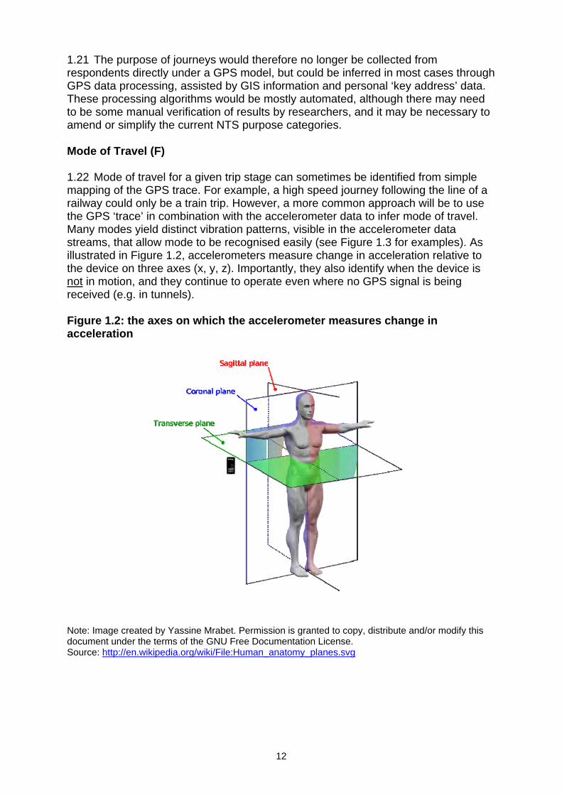
1.21 The purpose of journeys would therefore no longer be collected from respondents directly under a GPS model, but could be inferred in most cases through GPS data processing, assisted by GIS information and personal ‘key address’ data. These processing algorithms would be mostly automated, although there may need to be some manual verification of results by researchers, and it may be necessary to amend or simplify the current NTS purpose categories. Mode of Travel (F) 1.22 Mode of travel for a given trip stage can sometimes be identified from simple mapping of the GPS trace. For example, a high speed journey following the line of a railway could only be a train trip. However, a more common approach will be to use the GPS ‘trace’ in combination with the accelerometer data to infer mode of travel. Many modes yield distinct vibration patterns, visible in the accelerometer data streams, that allow mode to be recognised easily (see Figure 1.3 for examples). As illustrated in Figure 1.2, accelerometers measure change in acceleration relative to the device on three axes (x, y, z). Importantly, they also identify when the device is not in motion, and they continue to operate even where no GPS signal is being received (e.g. in tunnels). Figure 1.2: the axes on which the accelerometer measures change in acceleration
Note: Image created by Yassine Mrabet. Permission is granted to copy, distribute and/or modify this document under the terms of the GNU Free Documentation License. Source: http://en.wikipedia.org/wiki/File:Human_anatomy_planes.svg
12

Figure 1.3: accelerometer mode ‘signatures’ (change in acceleration relative to the device, kHz)
Walking
0
50
100
150
200
250
16:5
3:00
16:5
3:30
16:5
4:00
16:5
4:30
16:5
4:20
16:5
4:50
16:5
5:20
16:5
5:50
16:5
6:20
16:5
6:50
16:5
7:20
16:5
7:50
16:5
8:20
16:5
8:50
16:5
9:20
16:5
9:50
17:0
0:20
17:0
0:50
17:0
1:20
17:0
1:50
17:0
2:20
17:0
2:50
XACC YACC ZACC
Cycling
0
50
100
150
200
250
8:50
:00
8:50
:30
8:51
:00
8:51
:30
8:52
:00
8:52
:29
8:52
:59
8:53
:29
8:53
:59
8:54
:29
8:54
:59
8:55
:29
8:55
:59
8:56
:29
8:56
:59
8:57
:29
8:57
:59
8:58
:29
8:58
:59
8:59
:29
8:59
:59
Tube
0
50
100
150
200
250
17:1
1:00
17:1
1:30
17:1
2:00
17:1
2:30
17:1
3:00
17:1
3:30
17:1
4:00
17:1
4:30
17:1
5:00
17:1
5:30
17:1
6:00
17:1
6:30
17:1
7:00
17:1
7:30
17:1
8:00
17:1
8:30
17:1
9:00
17:1
9:30
17:2
0:01
17:2
0:31
Local bus (in slow moving traffic)
0
50
100
150
200
250
17:5
5:00
17:5
5:30
17:5
6:00
17:5
6:30
17:5
7:00
17:5
7:30
17:5
8:00
17:5
8:30
17:5
9:00
17:5
9:30
18:0
0:00
18:0
0:30
18:0
1:00
18:0
1:30
18:0
2:00
18:0
2:30
18:0
3:00
18:0
3:30
18:0
4:00
18:0
4:30
18:0
5:00
18:0
5:30
18:0
6:00
13
1.23 The distinction between similar modes can be more difficult to assign. For example, it is difficult to distinguish between motorised road transport modes (buses, taxis and cars) from accelerometer data alone. However, analysis of the GPS trace, and comparison with GIS information, can improve matters. For example, bus stop locations are known, and if the GPS trace shows frequent pauses in movement, coinciding with bus stops, the mode is very likely to be a bus. Slow moving urban traffic can make the identification of modes more difficult, as all motorised vehicles will pause frequently, and it may be that it is not possible to distinguish taxis from private cars without additional information from the respondent. The current pilot will shed more light on these issues, and will allow our approach to be refined if required. 1.24 The mode of travel would therefore no longer be collected from respondents directly under a GPS model, but could be inferred in most cases through GPS data processing, assisted by accelerometer data and GIS information. These processing algorithms would be mostly automated, although there may need to be some manual verification of results by researchers. How many people travelling including you? (I) 1.25 We would not collect this directly, but car occupancy (one of the key resulting statistics) could be alternatively estimated using questions in the interview asking respondents how many people were in the vehicle last time they made a trip by car or van. Which car or other vehicle was used for the journey? (J) 1.26 The GPS data will not allow us to determine which vehicle was used for trips. It is possible we could probe further in the interview about who uses which car(s) in the household and to what extent, which may help indicate which vehicle is being used for some, but not necessarily all trips. Were you the driver or a passenger? (K) 1.27 The GPS data will not allow us to determine who is driving and who is passenger. Knowledge of who typically drives which car(s) in the household may allow us to infer some information about this but it will not be complete for all journeys. This could be estimated using questions in the interview asking respondents whether they were the driver or passenger when they last made a trip by car or van. How much did you pay for parking (L) / How much did you pay in road tolls or congestion charges? (M) 1.28 This data would no longer be collected. However, informal observations indicate that there is little demand for this data, and it is not used in the current annual NTS publication. In general, data items relating to costs and ticketing are among the most complex in the current NTS diary, and the data quality is therefore uncertain. The sample of trips on which the road toll and congestion charge data is small and therefore lacks statistical robustness.
14
1.29 Parking, road toll and congestion charge costs are collected in other surveys such as the Living Costs and Food survey (Office for National Statistics) and results are published as average household expenditure (Item 7.2.4.3 - Parking fees, tolls, and permits)4. However, this source does not allow linkage with trip data. What type of ticket did you use? (N) / How much did your ticket cost? (O) 1.30 We would no longer collect this. As noted above, ticketing data items are among the most complex in the current NTS diary, and the data quality is therefore uncertain. Furthermore, as ‘smart’ and integrated ticketing products become commonplace nationwide (e.g. TfL Oyster cards and other similar schemes) it is likely that there will be less demand for this information, as ticketing data itself will provide more insight. How many times did you board? (P) 1.31 We would be able to identify the number of different trains or buses that were used during each trip from the processed GPS data. How much did your share of the taxi cost? (Q) 1.32 We would not collect this data. As with other cost-related data, the quality of information on taxi fares is not particularly robust due to small sample sizes and contains uncertainties due to its complexities. It would be possible to put a small number of new questions about taxi usage into the ‘pick up’ interview (this may also help with GPS trace processing to infer mode of travel). 1.33 Taxi costs are collected in the Living Costs and Food survey and results are published as average household expenditure (Item 7.3.4.4 - Taxis and hired cars with drivers). However, using this alternative source would not allow linkage with the trip data. The potential challenges of a GPS methodology 1.34 This section discusses a number of specific survey design challenges concerning the practical application of GPS to the NTS. Among the more substantial challenges are:
Inclusion of children in GPS data collection; Criteria for use of GPS data (partial households and partial travel weeks); Time series comparability (differing coverage of diary and GPS travel
datasets) Confidentiality and security of GPS data, and Publishing GPS trace data for research use.
4 Living Costs and Food Survey - Appendix a1: http://www.statistics.gov.uk/downloads/theme_social/family-spending-2009/a1-final.xls
15
Inclusion of children in GPS data collection 1.35 Although parental permission is always sought, there are some practical difficulties in asking children, particularly younger children, to carry GPS devices. Most fundamentally, the devices used in the pilot cost approximately £250 each so there is a definite financial consequence of loss or damage of devices due to careless handling. Carrying a device may be an unwanted distraction for a child, and it is possible that children may lend devices to friends to ‘have a go’ and thus produce inaccurate data. Furthermore, some secondary schools do not allow mobile phones and other personal electrical items to be taken onto the premises and may not welcome pupils being encouraged to carry GPS devices (although discreet, passive devices such as those used in the pilot could mitigate some concerns). 1.36 The 2011 GPS pilot survey collected GPS data for children aged 12-15 and asked all parents whether their children had any problems using GPS devices. Children aged under 12 were not asked to carry a device. The pilot results will reveal how successful this design was, and there may be some scope for varying it, but it seems very likely that there would need to be some minimum threshold age below which a child would not be asked to carry a GPS device. Criteria for use of GPS data (partial households and partial travel weeks) 1.37 In the present NTS, each member of a participating household receives a £5 voucher by post if all household members complete a placement interview and a full one-week travel record. This encourages respondents to ensure that everybody in the household participates and fills in their diary completely. Such households are described as ‘fully productive’. A ‘partially productive’ household is one where some but not all household members have completed their full week travel diaries. At present such households are excluded from the core NTS personal travel dataset, which by long-standing convention is based on responses from fully-productive households only. 1.38 Interviewers note that sometimes it is evident that one person in the household has taken responsibility for the whole household’s diaries, with the ‘all or nothing’ aspect of the incentive scheme in mind. They will strive to ensure full participation and may even complete the set of diaries on behalf of the household. With GPS data collection, a similar arrangement would not be possible. One member of the household could not record another household member’s GPS data on their behalf (unless they make exactly the same set of trips during the travel week). Each participating individual would need to take independent responsibility for carrying their device each day. Introducing GPS devices could therefore lead to an increase in the number of households where only ‘part week’ data is available, or where data has been collected for some but not all household members. Under the current incentive scheme, such households would receive no payment.
16
1.39 Possible responses to this challenge could include: Adapting the incentive scheme to ensure that there is no encouragement
to create ‘fake’ GPS data (e.g. by one individual carrying multiple devices around with them) and/or
Adapting the criteria for inclusion in the NTS personal travel dataset, so that ‘partially productive’ households are accepted. This would maximise the total sample size, but would introduce a new and more complex set of response biases which would need careful investigation and corrective weighting.
Time series comparability (differing coverage of diary and GPS travel datasets) 1.40 The 2008/09 feasibility study indicated that diary methods and GPS methods do not create perfectly aligned data. Both methods are capable of recording trips that the other method misses. Overall (excluding short walks) there were eight per cent more trips recorded in the GPS dataset than in the diary dataset. This suggests that, of the two, the GPS data may be marginally more complete. However, there are circumstances where the GPS devices will omit trips that the diary would have recorded (28 per cent of diary trips excluding short walks were not ‘matched’ in the equivalent GPS trace in the feasibility study). Most commonly, this omission will happen where the respondent simply fails to take the device with them when they travel, but other circumstances can cause the same problem (e.g. no GPS signal, ‘cold starting’ device not locating a signal by the end of a short trip, etc.). 1.41 For these and many other reasons, diary-based and GPS-based data would not be directly comparable. A switch from diary to GPS would therefore introduce a discontinuity into many NTS time series. 1.42 In order to use diary-derived back data in conjunction with new GPS-derived data under this scenario, some basic assumptions would need to be made about the systematic differences between the two methodologies. This would necessitate comparative analysis of the GPS pilot data and main-sample NTS diary data for the 2011 ‘dual running’ period or a future period of dual running once a GPS methodology was introduced. Dual running the proposed GPS methodology and the existing travel diary methodology for a limited period (say 6-12 months) could help bridge the transition from diary to GPS and preserve the relevance of the back data, but this would have resource implications. Confidentiality and security of GPS data 1.43 There is a sound culture of confidentiality and privacy protection around the current NTS. The survey is run under contract to NatCen, which operates in accordance with Social Research Association Ethical Guidelines. NatCen provide an explicit assurance of confidentiality to all respondents, and in line with this they do not share any personally-identifiable data (e.g. names, addresses, specific trip-end points) with DfT. Such information is held securely on ISO-accredited systems and is never published. The only identifiable information that is shared in DfT (vehicle registration number, which allows DfT to look up vehicle particulars from administrative records) is done so only with the respondent’s explicit permission. 1.44 Survey respondents are rightly concerned about the confidentiality of the information they provide. Strong, clear assurances of privacy are therefore key to
17
Publishing GPS trace data for research use 1.45 At present, data from the NTS is deposited in the Essex University UK Data Archive approximately one year after publication. NTS data is currently anonymised to region and area type (urban/rural), an approach which (within the design constraints of the current NTS) meets the needs of most research users. 1.46 However, if GPS-derived travel data were collected, it is likely that many researchers would want access to data to a much finer level of detail than is currently released – potentially ‘micro data’ down to the level of individual GPS route traces. Such data would clearly have great research potential, but it would not be possible to release the data publicly in raw form, as the privacy of survey participants would clearly be compromised (the data would reveal where they sleep at night, their exact commuting routes, etc.). 1.47 Some form of robust anonymisation would therefore be necessary before any ‘trace level’ data could be released (e.g. cutting out short trips, truncating a section of small but randomly-varying length from the start and end of each trip trace). We could also explore a ‘data lab’ model, where accredited researchers are given access to the data under controlled conditions at a secure location. If a GPS methodology is adopted for the future NTS, DfT would need to investigate these issues more fully, in order to ensure that the dataset delivers maximum research value without compromising the privacy of survey participants.
18
2. Reviewing the content of the NTS questionnaire and diary Introduction 2.1 As noted in the executive summary, it is important that DfT delivers the objectives of the NTS as cost effectively as is possible. We are therefore explicitly seeking to reduce the cost of NTS data collection to the department. 2.2 One way to reduce both the financial cost of the NTS, and the burden imposed upon individual NTS respondents, would be to reduce the lengths of the placement interview and pick-up interview questionnaires. This objective can be pursued regardless of whether GPS collection of personal travel data is adopted. We could also look to reduce the number of items collected via the paper diary if it is retained. 2.3 The NTS questionnaire is extremely long in comparison to other social surveys. The average main interview duration was 48 minutes in 2008. The full 2011 NTS questionnaire (which has been subject to only minor amendment since 2008) is available: at http://www.dft.gov.uk/pgr/statistics/datatablespublications/nts/technical/ntsquestions2011.pdf 2.4 There follows a summary list of question sections of the current placement and pick-up interview scripts. It would be extremely valuable to the DfT if those responding to this consultation would indicate which sections of questions are essential to their ongoing work. This will help us identify any unused or underused areas of questions that could be deleted or asked less frequently.
19

Table 2.1: Summary of questionnaire sections Section Proposals Essential
to my work
Desirable Not used
Household questionnaire: Demographics Accommodation Local transport services Stop collecting Accessibility of services Stop collecting Attitudes to local services Stop collecting Children’s travel to school Vehicle grid Individual Questionnaire: Disabilities that affect travel Methods of transport used Cycling Children as front/rear passengers
Driving licence Education, paid work and journey planning
Transport related barriers to work
Last paid job Main job details Income Location of work Travel to work Working at home Ease/difficulty of travelling to work
Shopping Transport difficulties Road accidents involving adults Road accidents involving children
Special tickets/passes Long distance journeys Playing in the street Stop collecting Vehicle questionnaire: Vehicle details Parking Company car Reduce Mileage Fuel and mileage chart5: Fuel consumption
Stop collecting
7 Fuel and mileage chart: http://www.dft.gov.uk/pgr/statistics/datatablespublications/nts/technical/ntsfmchart.pdf
20
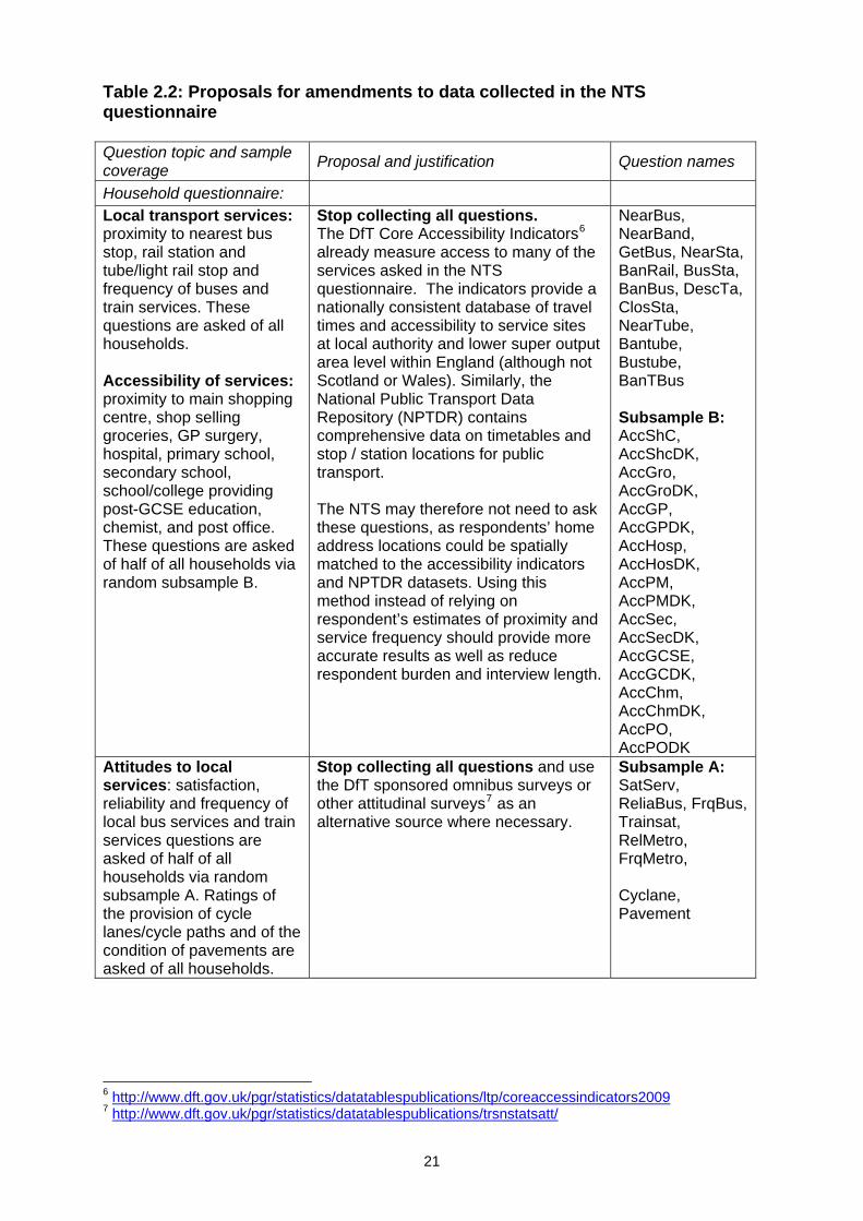
Table 2.2: Proposals for amendments to data collected in the NTS questionnaire Question topic and sample coverage
Proposal and justification Question names
Household questionnaire:
Local transport services: proximity to nearest bus stop, rail station and tube/light rail stop and frequency of buses and train services. These questions are asked of all households. Accessibility of services: proximity to main shopping centre, shop selling groceries, GP surgery, hospital, primary school, secondary school, school/college providing post-GCSE education, chemist, and post office. These questions are asked of half of all households via random subsample B.
Stop collecting all questions. The DfT Core Accessibility Indicators6 already measure access to many of the services asked in the NTS questionnaire. The indicators provide a nationally consistent database of travel times and accessibility to service sites at local authority and lower super output area level within England (although not Scotland or Wales). Similarly, the National Public Transport Data Repository (NPTDR) contains comprehensive data on timetables and stop / station locations for public transport. The NTS may therefore not need to ask these questions, as respondents’ home address locations could be spatially matched to the accessibility indicators and NPTDR datasets. Using this method instead of relying on respondent’s estimates of proximity and service frequency should provide more accurate results as well as reduce respondent burden and interview length.
NearBus, NearBand, GetBus, NearSta, BanRail, BusSta, BanBus, DescTa, ClosSta, NearTube, Bantube, Bustube, BanTBus Subsample B: AccShC, AccShcDK, AccGro, AccGroDK, AccGP, AccGPDK, AccHosp, AccHosDK, AccPM, AccPMDK, AccSec, AccSecDK, AccGCSE, AccGCDK, AccChm, AccChmDK, AccPO, AccPODK
Attitudes to local services: satisfaction, reliability and frequency of local bus services and train services questions are asked of half of all households via random subsample A. Ratings of the provision of cycle lanes/cycle paths and of the condition of pavements are asked of all households.
Stop collecting all questions and use the DfT sponsored omnibus surveys or other attitudinal surveys7 as an alternative source where necessary.
Subsample A: SatServ, ReliaBus, FrqBus, Trainsat, RelMetro, FrqMetro, Cyclane, Pavement
6 http://www.dft.gov.uk/pgr/statistics/datatablespublications/ltp/coreaccessindicators2009 7 http://www.dft.gov.uk/pgr/statistics/datatablespublications/trsnstatsatt/
21
Question topic and sample coverage
Proposal and justification Question names
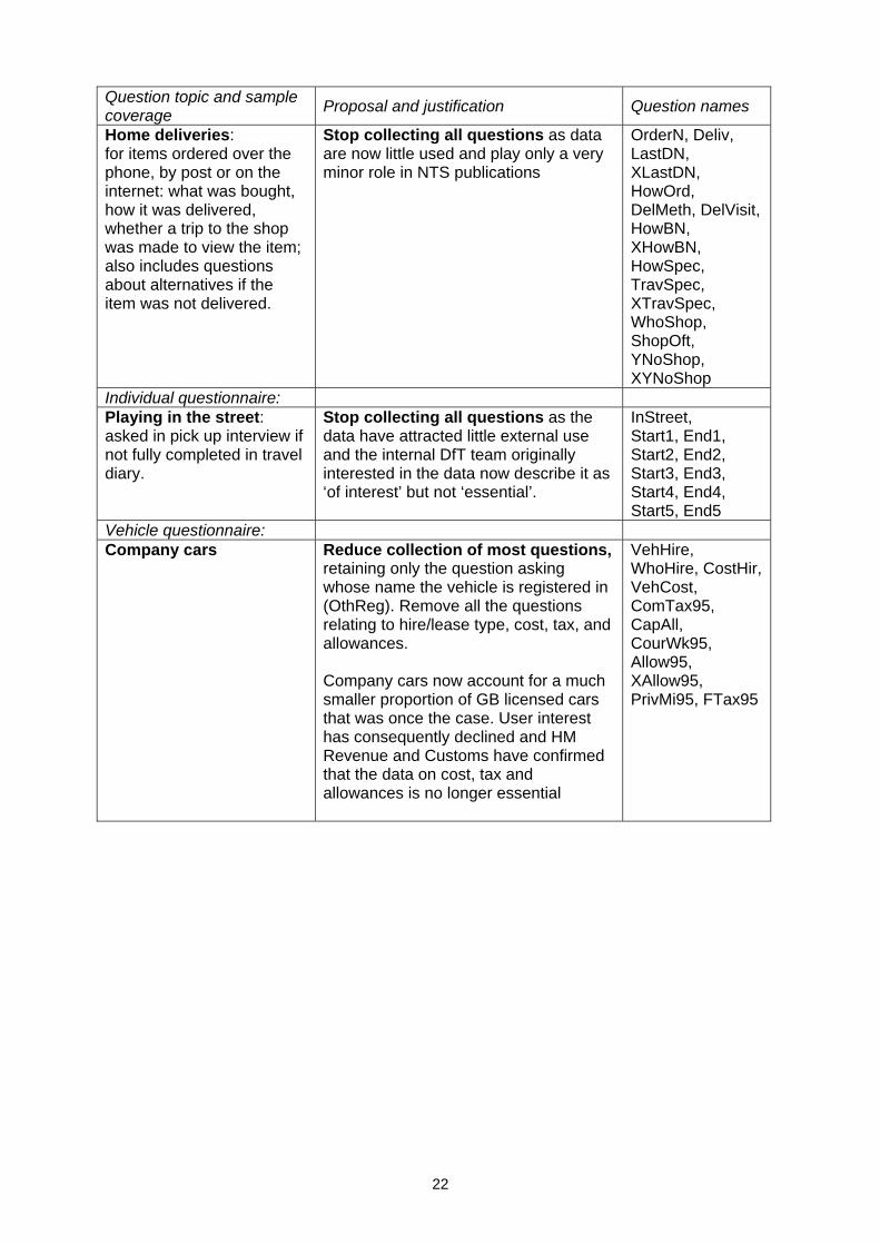
Home deliveries: for items ordered over the phone, by post or on the internet: what was bought, how it was delivered, whether a trip to the shop was made to view the item; also includes questions about alternatives if the item was not delivered.
Stop collecting all questions as data are now little used and play only a very minor role in NTS publications
OrderN, Deliv, LastDN, XLastDN, HowOrd, DelMeth, DelVisit, HowBN, XHowBN, HowSpec, TravSpec, XTravSpec, WhoShop, ShopOft, YNoShop, XYNoShop
Individual questionnaire: Playing in the street: asked in pick up interview if not fully completed in travel diary.
Stop collecting all questions as the data have attracted little external use and the internal DfT team originally interested in the data now describe it as ‘of interest’ but not ‘essential’.
InStreet, Start1, End1, Start2, End2, Start3, End3, Start4, End4, Start5, End5
Vehicle questionnaire: Company cars Reduce collection of most questions,
retaining only the question asking whose name the vehicle is registered in (OthReg). Remove all the questions relating to hire/lease type, cost, tax, and allowances. Company cars now account for a much smaller proportion of GB licensed cars that was once the case. User interest has consequently declined and HM Revenue and Customs have confirmed that the data on cost, tax and allowances is no longer essential
VehHire, WhoHire, CostHir, VehCost, ComTax95, CapAll, CourWk95, Allow95, XAllow95, PrivMi95, FTax95
22
Question topic and sample coverage
Proposal and justification Question names
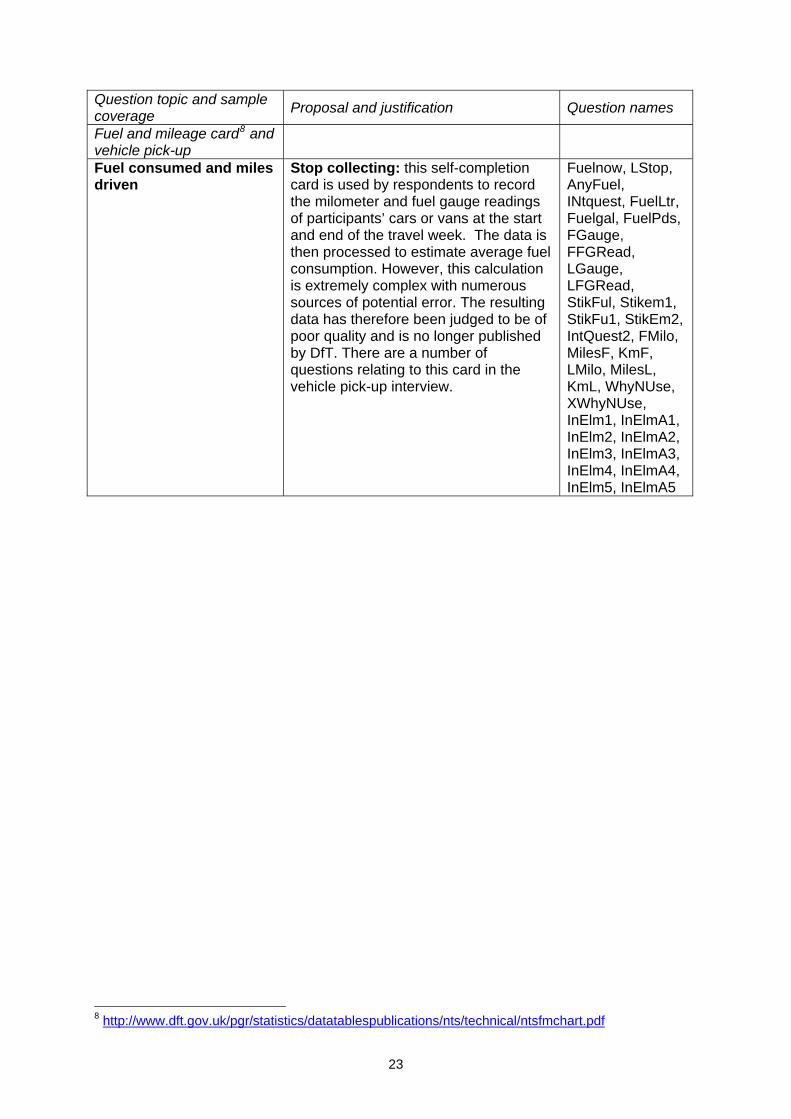
Fuel and mileage card8 and vehicle pick-up
Fuel consumed and miles driven
Stop collecting: this self-completion card is used by respondents to record the milometer and fuel gauge readings of participants’ cars or vans at the start and end of the travel week. The data is then processed to estimate average fuel consumption. However, this calculation is extremely complex with numerous sources of potential error. The resulting data has therefore been judged to be of poor quality and is no longer published by DfT. There are a number of questions relating to this card in the vehicle pick-up interview.
Fuelnow, LStop, AnyFuel, INtquest, FuelLtr, Fuelgal, FuelPds, FGauge, FFGRead, LGauge, LFGRead, StikFul, Stikem1, StikFu1, StikEm2, IntQuest2, FMilo, MilesF, KmF, LMilo, MilesL, KmL, WhyNUse, XWhyNUse, InElm1, InElmA1, InElm2, InElmA2, InElm3, InElmA3, InElm4, InElmA4, InElm5, InElmA5
8 http://www.dft.gov.uk/pgr/statistics/datatablespublications/nts/technical/ntsfmchart.pdf
23

2.5 The 2011 NTS adult’s diary is available at http://www.dft.gov.uk/pgr/statistics/datatablespublications/nts/technical/adulttrcrd.pdf and the children’s diary is available at http://www.dft.gov.uk/pgr/statistics/datatablespublications/nts/technical/youngtrcrd.pdf. There follows a list of diary data items that are currently recorded for each trip. Again, it would be extremely valuable to the DfT if those responding to this consultation would indicate which data items are essential to their ongoing work. Table 2.3: Diary sections Item Description Proposal Essential
to my work
Desirable
Not used
A What was the purpose of the journey?
B What time did you leave? C What time did you arrive D Where did you start your
journey?
E Where did you go to? F What method of travel did you
use for each stage of your journey?
G How far did you travel? (Miles) H How long did you spend
travelling? (Minutes)
I How many people travelled including you?
J Which car or other motor vehicle did you use?
K Were you the driver or passenger?
L How much did you pay for parking?
M How much did you pay for road tolls/ congestion charges?
Stop collecting
N What type of ticket did you use?
O How much did your ticket cost? P How many times did you
board?
Q How much did your share of the taxi cost?
Stop collecting
Time spent in the street (children’s diary: day 7)
Stop collecting
24
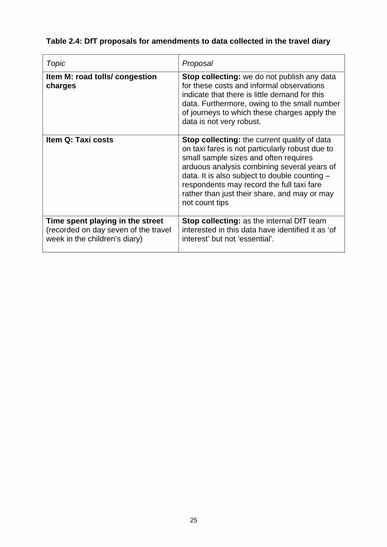
Table 2.4: DfT proposals for amendments to data collected in the travel diary
Topic Proposal
Item M: road tolls/ congestion charges
Stop collecting: we do not publish any data for these costs and informal observations indicate that there is little demand for this data. Furthermore, owing to the small number of journeys to which these charges apply the data is not very robust.
Item Q: Taxi costs Stop collecting: the current quality of data on taxi fares is not particularly robust due to small sample sizes and often requires arduous analysis combining several years of data. It is also subject to double counting – respondents may record the full taxi fare rather than just their share, and may or may not count tips
Time spent playing in the street (recorded on day seven of the travel week in the children’s diary)
Stop collecting: as the internal DfT team interested in this data have identified it as ‘of interest’ but not ‘essential’.
25
3. Reducing the geographic coverage of DfT-funded survey fieldwork from Great Britain to England 3.1 Since its inception, the NTS has covered the whole of Great Britain and has been funded solely by DfT and its predecessor departments. However, many policy and operational issues relating to day-to-day travel (the primary focus of the NTS) are now devolved in both Scotland and Wales, with DfT retaining responsibility for these matters in England only. 3.2 DfT is therefore considering reducing the geographic coverage of the fieldwork that it funds from Great Britain to England upon expiry of the current contract. We have already written to officials in the Scottish and Welsh governments to inform them of the inclusion of this proposal in our public consultation, and to offer bilateral discussion. 3.3 In 2009, nine per cent of NTS households were in Scotland and five per cent were in Wales. If DfT were to cease funding NTS fieldwork in these countries, we would not increase the level of the England-based sample in order to compensate. The total size of the DfT-funded NTS survey household sample would therefore decrease by around one-seventh (14 per cent), ignoring any impacts of other design changes. 3.4 If we were to cease funding NTS fieldwork in Scotland and Wales beyond 2012, these countries’ governments would be given the opportunity to fund their nations’ fieldwork from 2013 onwards as part of the DfT’s successor arrangements. This would allow all nations to realise economies of scale in procurement, and to obtain fully-comparable data. If the Scottish and Welsh governments both took up this offer, the NTS would continue as a Great Britain wide survey.
26
4. Wider potential changes for the collection of NTS data 4.1 In 2010/11, DfT spent approximately £2.7m on the NTS. While the data it yields is of clear and continuing value to the department, this is a considerable sum which we are seeking to reduce significantly under the new, post-2012 arrangements. 4.2 Sections 2 and 3 set out two specific proposals (reducing questionnaire lengths and restricting DfT-funded fieldwork to England) that are explicitly designed to reduce the annual cost of the NTS. However, we are also inviting wider and potentially more radical proposals that would reduce the cost of data collection while retaining the key attributes that make the dataset so valuable to DfT and others. Ideas that have been put to the NTS team thus far include: Sharing fieldwork with another government social survey in order to split the fixed
costs of survey management and optimise the time spent with respondents. We have already written to government departmental Heads of Profession for Statistics with a brief proposal to this effect, and are awaiting responses.
Using cheaper methods of data collection9, possibly as part of a ‘mixed’ design.
For example, it may be possible to offer respondents the option to complete the survey questionnaire on-line, while continuing to offer a traditional face-to-face interview to those who are unwilling to take this route or who do not have internet access.
Making greater use of data sources based on developing technology (e.g. ‘smart’
ticketing data, mobile phone data, etc.) which could, in time, replace certain aspects of the NTS.
4.3 We would be extremely grateful for comment on these ideas, and invite other proposals that have the potential to save costs. 4.4 We recognise that not all such proposals will be fully proven, and some may not be suitable for immediate introduction into the NTS from 2013. While we are keen to explore radical suggestions, we recognise that fundamental survey design changes bring an obvious risk of disruption to well-established NTS time-series, which we know are highly-valued by users. We would therefore not introduce any major design change without having fully evaluated its viability and robustness (via piloting where feasible), and in doing so having understood its likely effect on time series.
9 The GSS report, The application of alternative modes of data collection in UK Government social surveys, May 2010 concluded that cost savings may be achievable by maximising the use of cheaper modes of data collection. http://www.ons.gov.uk/about/who-we-are/our-services/data-collection-methodology/reports-and-publications/alternative-modes-of-data-collection/a-report-for-the-government-statistical-service.pdf
27
5. Consultation Questions 5.1 DfT has scheduled a stakeholder meeting to discuss this consultation at 10.00 on 14 July 2011. This will be held at the Royal Statistical Society 12 Errol Street, London, EC1Y 8LX. If you would be interested in attending this event, please use the above contact details to register your interest. Specific points for consultation on (1) Q1.1 Do you support or oppose the proposed move from diaries to GPS? Why? Q1.2 Is there any information that would be lost in the move to GPS that is vital to your work? What is this? Q1.3 Is there any new information that could be derived from the GPS data that you would find particularly useful to your work, or any opportunities that a GPS dataset would present? What are these? Q1.4 What impact would a break in the NTS time series have on your work? Q1.5 If the move to GPS is made, should DfT undertake dual running of both methods? For how long? If it were only possible to undertake by halving the sample for both methods for the dual running period, would the reduction in sample numbers be an acceptable compromise? Specific points for consultation on (2) Q2.1 Are there any interview questions or diary items that we are proposing to stop or reduce that you still require? What are these? Q2.2 Are there any interview questions or diary items that we are not proposing to stop or reduce that are of little or no value to you, and that could be stopped or reduced without adversely affecting you? What are these? Q2.3 What interview questions or diary items from the NTS are most important and critical to your work? Q2.4 Bearing in mind the current pressure on public resources and the need to reduce the costs of the NTS, are there any new interview questions or diary items that you think need adding to the survey?
28

Specific points for consultation on (3) Q3.1 Which of the following analyses do you undertake using NTS data? (Please mark all that apply.)
England only Wales only Scotland only Comparison of at least two of the nations (England, Wales, Scotland) Great Britain as a single entity
Q3.2 If the scope of DfT-funded fieldwork was reduced from Great Britain to England, future NTS fieldwork in Scotland and Wales would depend on funding from the devolved governments in those nations. On this basis, if NTS data currently available on a Great Britain basis were available on an England-only basis in future, would your work be adversely affected? If so, please describe how. Specific points for consultation on (4) Q4.1 What are your views on the three specific outline proposals to reduce future NTS costs (shared fieldwork, mixed-mode data collection, greater use of technology-related datasets?) Q4.2 Do you have any other suggestions as to how the NTS data collection costs could be reduced in the future?
29

6. Question and Answer Brief 6.1 Below is a list of frequently asked questions about these proposals. If you still have questions after you have read this section please contact us at the address given in the ‘How to Respond’ section. Q&A on the NTS Who conducts the survey? 6.2 Since January 2002, the Department for Transport (DfT) has commissioned the National Centre for Social Research (NatCen), an independent social research institute, as the contractor for the NTS. NatCen is responsible for questionnaire development, sample selection, data collection and editing and data file production. The DfT is responsible for building the database, data analysis, publication and archiving. Results are published by DfT annually. The DfT’s current contract with NatCen expires upon completion of the 2012 survey year. How is the data collected? 6.3 NTS data is collected via two main sources. Households are sampled for participation by NatCen (please see published NTS technical reports for details of the sampling method). All sampled households are sent an advance letter followed by personal visits from NatCen interviewers who aim to secure the household’s participation. Once a household agrees to participate, face to face interviews are carried out to collect information on the households themselves, all individual members within the household and all vehicles to which they have access. Each household member is then asked to record details of all their trips over a seven day period in a travel diary, allowing travel patterns to be linked with individual and household characteristics. The NTS covers travel by people in all age groups, including children. How many people participate in the survey? 6.4 In 2009, data was collected from just under 8,000 households, covering nearly 20,000 individuals. Achieved sample sizes have remained around this level since 2002. What data is collected by the NTS? 6.5 The NTS provides a rich source of information about personal travel on a range of socio-economic, demographic and travel characteristics such as age, gender, car ownership, driving licences, employment and income. The survey is primarily designed to track long term trends and shifts in travel behaviour, although short term changes can also be detected and measured, particularly where they affect a particular segment of the population or type of journey.
30
Where can I find detailed information about the survey methodology? 6.6 The NTS 2009 Technical Report can be found on the DfT website at: http://www.dft.gov.uk/pgr/statistics/datatablespublications/nts/technical/nts2009technical.pdf Q&A on the GPS proposal What is GPS? 6.7 The Global Positioning System (GPS) is a space-based global navigation satellite system (GNSS) that provides reliable location and time information where there is an unobstructed line of sight to four or more GPS satellites. It is owned and maintained by the United States Department of Defence USDOD) and is freely accessible by anyone with a GPS receiver. USDOD is required by law to maintain a Standard Positioning Service that will be available on a continuous, worldwide basis. There are currently 30 healthy GPS satellites in orbit of which 24-27 are typically in service at any time. What about the discontinuity in time series if you switch from travel diaries to GPS data collection? 6.8 All studies undertaken to date have concluded there are substantial differences in the data provided by the two methods. Many of these stem from user error – either forgetting to record journeys in the travel diary or to carry or charge the GPS device, or switching the device off etc. Other differences in records have been device related, such as device failure or a reset to incorrect configuration settings. 6.9 No matter how much care is taken, it seems inevitable that the data produced by one system will not match the other exactly. However, to decide that the requirement to maintain a time series outweighs the benefits of switching to modern data collection methods could undermine the future value of the NTS if we fail to respond to falling response rates and developing technologies. Even if the NTS were re-commissioned on exactly the same basis as it is now, it is likely that there would be some discontinuity effect if the survey were to move from NatCen to another contractor (a similar effect was observed following the last change of contractor in 2002). What about technological issues affecting GPS such as missing or random data points due to cold starts, ‘urban canyons’ or underground travel? 6.10 Ensuring we select the most sensitive and reliable devices available on the market should counter these issues. Using EGNOS-aided devices would improve the accuracy of the data (particularly on the vertical measurement). Our devices would also be fitted with accelerometers which provide traces of movement where GPS signals are not available. Once GPS traces are fitted to the GIS network it should then be possible to augment and validate them with the accelerometer traces. Where devices reappear on the network at a different location to where they disappeared we could track the direction, speed and distance of travel from the point where the GPS signal disappeared to where it reappears and confirm the route and mode used. How do you counter objections from respondents about carrying GPS devices (e.g. that they are uncomfortable / embarrassing / awkward to carry)
31
6.11 Respondents would be asked to carry the device with them (in a bag or pocket if desired) and ensure they understand that they need to charge the device as instructed. GPS devices have improved in recent years and we following a review of devices commissioned in spring 2010, have identified a passive device which is discreet, light-weight, has a LED to indicate it is in use, has a simple on-off switch and no screens or signal related audio alerts which could confuse, intimidate or embarrass the wearer. In multiple occupancy households, each device would be given a colour coded tag or sticker to avoid mix-ups. 6.12 Respondents would be advised to keep the device with their keys and/or mobile phone so that they remember to carry it with them at all times. It is likely that lanyards, belt pouches or arm bands (similar to those worn with MP3 players) would be provided so that wearers have a personal choice of how to wear the device depending on their preferences and what kind of activity they may be undertaking. What about response rates? 6.13 Our expectation is that overall response will remain broadly the same, holding other factors constant (questionnaire length, interviewer quality, etc.), but it is likely that non-response would increase for some groups and decrease for others. Furthermore, ‘partially productive’ household may increase which may necessitate a shift in the survey’s inclusion rules and weighting methods. Several papers have noted that older and poorer respondents are less likely to respond to GPS methods, however, consider the ageing population and the ease with which many older people now use PCs, mobile phones and the internet it is likely that this will pose less of a problem over time. Why use GPS devices when so many people have GPS enabled mobile phones? 6.14 The NTS is a random probability survey. Not everyone who would be selected would own a GPS enabled mobile phone. We could consider providing these but the costs would be high and their resale value / desirability may lead to a high number of lost units. Furthermore, not all mobile phones are fitted with accelerometers. There may be a point in the future when we could consider offering those with suitable phones a software application which would produce similar data, but there are numerous risks associated with this. For example, the software could corrupt or damage other files or prevent the device from receiving/sending messages and calls, run down the battery in a relatively short space of time. It is also possible that if given the opportunity to use their mobile phone respondents may find ways of amending or accidentally resetting the configurations and some phones may be incompatible. High-specification mobile phone technology and take-up is continuing to evolve, but as things stand we believe a standard device, configured explicitly and solely for the NTS, would be preferable.
32
Why do you want to switch from paper diaries to expensive technical devices? 6.15 Paper diaries are not a cheap alternative. They require lengthy explanations and guidance at set-up and extensive manual data entry, coding and validation once completed. Although there are obvious initial set-up costs of GPS data collection (mostly through purchase of the devices), the ‘steady-state’ running costs are anticipated to be comparable to the diary model at worst, and potentially a good deal lower. Furthermore, reducing the current heavy burden that diaries impose on survey respondents is a separate but important factor. Principle six (proportionate burden) of the National Statistics Code of Practice outlines that producers should
‘strive to develop methods that would reduce the costs to individual organisations or people.’
6.16 This underlines our need to reduce respondent burden wherever possible. How will you make sure any GPS devices you use are fit for purpose? 6.17 As with all technological devices the longer these products are present in the market, the faster they evolve. Many of the teething problems suffered by devices used in earlier exercises have now been addressed. 6.18 In spring 2010 we commissioned AECOM to identify and review available GPS devices. Five devices were shortlisted as having potential for use, three of which were made available for trial, one of which was an off the shelf product identified as fit-for-purpose and ready for use. In addition to extensive trial by DfT staff a pre-pilot to the GPS pilot survey was conducted in January 2011 with 20 respondents which did not encounter any unforeseen problems. Using algorithms to process GPS data streams into trip stages, journeys and deriving length of journey, purpose and mode is all very well but how would you validate the processed GPS data? 6.19 Our current thoughts are that processed data would be validated manually (possibly on a sampled basis or where the automated processing reports a high level of uncertainty). Whereas many pilot studies have relied upon internet based recall surveys we believe this would not be appropriate this places more, rather than less, burden on the respondent. At present, researchers invest considerable time validating diary contents. It is likely that we would use staff such as these to manually validate those processed trips whose key attributes appear uncertain. This would be done by using a map displaying each journey to ‘sense check’ the automatically-assigned purpose or mode. A large proportion of trips could be described as ‘standard trips’ for which we can collect address data and easily derive the purpose such as commuting, grocery shopping, trips to school/being escorted to school, visiting the local gym/ church/ night college. Any corrections made through verification could then be fed back into the system to improve any algorithms used to estimate these factors.
33

Are respondents really willing to carry the devices? What about the perception that they are being ‘tracked’? 6.20 Experience to date (feasibility study and pilot) shows that the respondents were generally willing to carry the devices upon receipt of a clear explanation of their purpose, and standard assurances of privacy and confidentiality. Respondents are all volunteers, and indeed are paid an incentive for their participation in the NTS. Some respondents did report concern about being ‘tracked’ but interviewers were trained to explain that the devices merely record data for later use, and do not have the capability to transmit data as an individual moves around.
34

Annex A: Organisations consulted This section lists the organisations who have been directly invited to respond to this consultation:
AA Driving School AECOM ARUP Atkins Audit Scotland Bain Barclays Capital Best Foot Forward Ltd Bestfootforward.com BLOOMBERG BRB (Residuary) Ltd Bristol City Council British Vehicle Rental and Leasing
Association Bus Users UK Campaign for Better Transport Centre for Sustainable Energy Centre for Transport Studies,
Loughborough University Centro Committee on Climate Change Competition Commission Cornwall County Council Cundall Department for Business,
Innovation & Skills (BIS) Department for Environment, Food
and Rural Affairs (Defra) Devon County Council Edinburgh College of Art Energy Saving Trust Essex County Council EUROSTAT Ford Motor Company Ltd Frontier Economics Geogoer Ltd Transport for Greater Manchester
(formerly GMPTE) Greater Manchester
Transportation Unit Hampshire County Council Hertfordshire County Council HM Revenue & Customs (HMRC)
Imperial College International Air Rail Organisation i-transport IVT Jacobs Kent University Kings College Kingsturge L.E.K. Consulting Leeds University Leicestershire Constabulary Lincolnshire County Council Living Streets Local Transport Today London First London School of Hygiene &
Tropical Medicine London TravelWatch Mayer Brown McKinsey Motor Cycle Industry Association Mott MacDonald MVA Consultancy National Centre for Social
Research (NatCen) Network Rail New Economics Foundation (nef) Nottingham City Council Office for National Statistics Open University Ox Retail Oxfordshire County council Parliament Parliamentary Advisory Council
for Transport Safety (PACTS) Passenger Focus Passenger Transport Executive
Group (pteg) Peter Davidson Consultancy Peterborough City Council Plymouth City Council Policy Exchange Policy Studies Institute
35

36
RAC Foundation Robertson Transport Consulting Royal Veterinary College Scottish Government SK Transport Planning South West Observatory South Yorkshire Passenger Transport Executive Staffordshire County Council Stagecoach bus Stagecoach Group PLC Steer Davies Gleave Strathclyde Partnership for Transport Suffolk County Council Sustrans TNS TrafficMaster Transport for London Transport Research Institute, Napier University Transport Research Laboratory (TRL) Transport Statistics User Group Transport Studies Unit, University of Oxford UK Statistics Authority University College London University of Edinburgh University of Manchester University of Reading University of Sheffield University of Southampton University of Strathclyde University of the West of England University of Westminster Welsh Assembly Government WSP Group
Annex B - Consultation criteria Criterion 1 When to consult Formal consultation should take place at a stage when there is scope to influence the policy outcome. Criterion 2 Duration of consultation exercises Consultations should normally last for at least 12 weeks with consideration given to longer timescales where feasible and sensible. Criterion 3 Clarity of scope and impact Consultation documents should be clear about the consultation process, what is being proposed, the scope to influence and the expected costs and benefits of the proposals. Criterion 4 Accessibility of consultation exercises Consultation exercises should be designed to be accessible to, and clearly targeted at, those people the exercise is intended to reach. Criterion 5 The burden of consultation Keeping the burden of consultation to a minimum is essential if consultations are to be effective and if consultees’ buy-in to the process is to be obtained. Criterion 6 Responsiveness of consultation exercises Consultation responses should be analysed carefully and clear feedback should be provided to participants following the consultation. Criterion 7 Capacity to consult Officials running consultations should seek guidance in how to run an effective consultation exercise and share what they have learned from the experience.
37