Embed Size (px)
Citation preview

A Rapid Biological and Ecological Inventory andAssessment of the Cajon Bonito Watershed,
Sonora, Mexico. PartII: Using the Variable Transect
Item Type Article
Authors Hunt, Robert; Anderson, Walter
Publisher University of Arizona (Tucson, AZ)
Journal Desert Plants
Rights Copyright © Arizona Board of Regents. The University of Arizona.
Download date 03/06/2018 11:08:09
Link to Item http://hdl.handle.net/10150/555882

Variable Transect Hunt and Anderson 3
A Rapid Biological and Ecological Inventory and Assessment of the Cajon Bonito Watershed, Sonora, Mexico. Part II: Using the Variable Transect
Robert Hunt M.A. Environmental Studies Prescott College Prescott, Arizona 86303
Walt Anderson Environmental Studies Program Prescott College Prescott, Arizona 86303
Abstract The variable transect is an abbreviated, simplified version of a standard belt transect used in floristic analysis. Developed by the Rapid Assessment Program of Conservation International as part of a suite of "emergency field ecology" methods, it allows scientists to quickly inventory and assess habitats with high biodiversity values that are threatened by imminent development or other human activities. This alternate method was utilized in a study of Cajon Bonito in Sonora, Mexico. Assessment of the variable transect's value as both a convenient qualitative and quantitative tool for field studies and observations in the plant communities of the Southwest is reflected in the resulting database. The method proved flexible enough to vary the suite of floristic data to be sampled with little significant variation in the time spent applying the transect. The relatively quick sampling of flora, combined with easily characterized environmental observations, yields a wealth of information with less effort than most standard field methods.
Introduction The time, effort and cost of conducting floral community studies using rigorous methods can limit the opportunities for researchers to increase effective sample sizes with additional surveys. Landscapes and ecosystems that may be unique sites for biodiversity or opportunities for conservation go unstudied and undescribed in the literature.
Alternative field methods have been developed recently that allow researchers to quickly inventory and assess ecosystems that are in the path of some form of development. Conservation International and the Field Museum ofNatural History conservation science programs have led the way in developing newer, faster means of biotic inventory and assessment with their Rapid Assessment Program [RAP]
(Tenneson 1998; CI 1997) and Rapid Biological Inventories [RBI] (FMNH 2004). One of these new field methods, the variable transect, has been used for inventories in neotropical forests with very high biodiversity values and complex arrays of habitats. The variable transect requires few tools and equipment. Unlike many area-based plot methods, the variable transect's size dimensions are determined by a set number of individuals to be sampled in predetermined plant classes. It can provide a high-quality snapshot of a plant community, its species and its community structure. These data are enough to describe richness, abundance, and diversity and to make comparisons among different sites.
A rapid inventory and assessment was conducted in the Cajon Bonito watershed in northeast Sonora, Mexico, using variable transects for the plant inventories. The method was employed in its original form as related by its developer, Robin Foster of the Field Museum of Natural History (personal communication 1998).
Origin of the Variable Transect The variable transect is one of several rapid field methods developed by the environmental advocacy group Conservation International [ CI]. It is part of a suite of field activities that collectively could be called "emergency field ecology" (CI 1997). CI and the Field Museum teams focus their conservation efforts on high-biodiversity wilderness habitats in . the tropical regions of the world, especially Central and South America (Parker and Bailey 1991; Parker and Carr 1992; Parker et al. 1993; Schulenberg and Aubrey 1997). Usually these sites are relatively untouched, but they often face imminent pressure for development. CI and FMNH pursue protocols that include intensive field inventories, along with training and education of local and indigenous people, and coordination with local government agencies and non-government groups for protection of the sites.
The Rapid Assessment Program (RAP) puts teams of scientists from Conservation International onto sites they have predetermined are at risk in order to conduct quick, intensive surveys. CI refers to their field personnel as scientific "swat teams." These teams are composed of some of the most experienced and expert tropical field researchers in the world. Since their formation in 1990 through the inspiration of Ted Parker and under the co-leadership of Alwyn Gentry (both now deceased), they have conducted dozens of surveys and assessments throughout the world. They have also trained local naturalists and students in their field methods and the follow-up software programs so that they can continue longer term monitoring studies and conservation activities.
Initially, the RAP team's strategy was to survey as quickly and intensively as possible using standard field methods. The RAP team's primary objectives were to identify species at the site, assess the ecosystem qualities of the area, and then disseminate the information immediately. As such

4 Desert Plants 2004
surveys continued over the next several years, the RAP methods were refined and streamlined. Practical shortcuts grew from real field experience. The variable transect is one of those shortcuts.
The Variable Transect: Descriptions and Applications The variable transect is a version of the belt transect, but its dimensions are determined by the number of individual plants to be counted (Foster, pers. comm. 1998). It is not a standard area-based plot method. In habitats and communities that have been identified for inventory and assessment, the plant species that are expected are divided into classes by size (e.g.,> 30 em diameter at breast height-dbh), height (e.g., 8-25 m), taxon (e.g., Pinus ponderosa or all adult conifer species). or other ecological and physiological classes that will provide the sought-after data. In forests and other complex communities, canopy trees could be used as a class that defines the ultimate dimensions ofthe transect. The first 50 or I 00 individuals of a class that are encountered within a predetermined width determine the length.
Subdividing the plot into five or ten equal segments can aid in subplot sampling for the other classes, especially for those with more species and more individuals, such as in the shrub or herbaceous class. To sample 100 shrub individuals. the centerline can be divided into ten equidistant points. At each point sampling for five individuals on both sides can be done along a perpendicular line-intercept.
Width is a very important decision and relies on the experience and expertise of the investigators. The transects need not be straight; they can follow contours of slopes or features in a floodplain and they can be run across more than one habitat or plant community type. They can be as discontinuous as the ecosystems they are measuring. The method is quantitative enough to measure species richness and abundance, determine diversity indices. and conduct diversity comparisons.
Modifications of the Variable Transect The minimum amount of data that can be collected with a variable transect in its simplest form includes the following:
l. Number of species (richness) in each plant class occurring within the transect. 2. Number of occurrences of each species (abundance) out of a predetermined total to be sampled for each class. 3. Classes of plants to be inventoried. 4. Cover percentage for various classes of plants. 5. Any structural or other physical characteristics that the surveyor feels can be added to the inventory without significantly slowing the process (e.g., dbh, height, crown size. number of stems, etc.).
Southwestern plant communities do not host the biodiversity levels of most of the tropical communities. Yet. the region in which Cajon Bonito is located. the Madrean Sky Islands
or Madrean Archipelago, is considered a regional '"megacenter" of biodiversity on a global scale (Felger and Wilson 1995). Much ofthis diversity is due to the interactions between a complex landscape and topography and the regional bimodal climate.
For the rapid inventory and assessment of Cajon Bonito, significant adjustments to the original intended protocol were made. Since the field surveys were in the late fall and winter, sampling was limited to trees and shrubs and was conducted prior to leaf drop. Woody lianas, vines and succulents were included in the shrub class. Eventually, many identifications were conducted using only stems and other cryptic features.
Field Studies in Cajon Bonito Natural History and Ecology of the Cajon Bonito Region Natural history and ecology were covered in Part I in Desert Plants Volume 18, Number 2, December 2002. A brief summary follows. Cajon Bonito is part of the Rio Yaqui watershed, which drains the western and northwestern slopes of the Sierra Madre Occidental in the state of Sonora, Mexico. Like many ofthe tributaries of the upper Rio Yaqui, Cajon Bonito describes a long 180Y arc. It flows north to within several miles of the U.S.-Mexico border; then reverses course and flows south towards the Rio Bavispe. The Bavispe describes a similar course before its confluence with the Rio Yaqui. Other regional drainages that describe similar arcing courses include the Rios Fronteras and Agua Prieta. Collectively the streams of the region describe a sub-trellis pattern that appears to be controlled by the horst-graben geology of the Madrean Archipelago.
During its northward flow, Cajon Bonito drains a rugged, high-elevation basin (- 4,000-5.000 feet elevation) bounded by the Sierra San Luis (east). the Sierras Los Embudos and Minitas (west), Sierra Pan Duro (south), and the Guadalupe Mountains (north, U.S.). The Sierra San Luis straddles the continental divide; thus the waters of Cajon Bonito ultimately flow west to the Sea of Cortes. The Cajon's closest approach to the international border lies several miles south of the border comer between Arizona and New Mexico. Rancho Los Ojos, the study site. occupies this northern extreme of the drainage.
Little geological literature exists specifically for the basin and surrounding mountains. but reasonable inferences can be made from studies in adjacent areas, general regional tectonic histories, and field observations. Drewes ( 1981 and 1991) has produced two regional studies for the tectonic history of the Southern Cordillera and for southeastern Arizona. Imlay ( 1939) and Hayes ( 1972) worked out the basic stratigraphy for some of the areas adjacent to Cajon Bonito. Gans ( 1997) and others have described regional and nearby tectonics that have capped the region in Tertiary volcanics and produced the dominant block-faulted topography. The course and configuration of Cajon Bonito appears to be controlled by local faults created in the mid-
Variable Transect Hunt and Anderson 5
to late-Tertiary. Secondary faults and fractures have created numerous, smaller tilted blocks, particularly in the northern extremes of Cajon Bonito in the Sierra Los Embudos. The canyon describes an angular zigzag pattern around these micro-blocks.
The lowest, apparently oldest stratigraphic sequence observed in Cajon Bonito consists of vertical and sub-vertical limestone layers, probably the Paleozoic El Paso Formation (extrapolated from Hayes 1972). Its texture suggests that it has undergone some low-grade alteration. Where the layer dominates the substrate, as in the upper, southern portions of the canyon, the stream flow is unsurprisingly intermittent. There is an igneous dike or sill of unknown age that surfaces occasionally, and its apparent impermeability allows for stretches of perennial flow and springs. Overtopping the limestone are deep layers of Tertiary volcanics, mainly rhyolite and ash. Where the faulting has positioned this semiimpermeable layer to become the substrate for Cajon Bonito, there is perennial flow. Numerous springs issue from fractures in this formation in the Cajon's tributaries in this lower, northern portion of the canyon. Minor outcrops of conglomerate may indicate a thinning facies of the Baucarit Formation (Moran-Zentano 1994), which is considerably thicker to the south in the Rio Bavispe drainage.
Fractured cliffs Cajon Bonito. (W. Anderson)
The initial fieldwork was conducted along the apex of the northern loop of the Cajon within the zigzagging portion of the canyon. This configuration of the canyon produces a complex pattern of habitats based on rapidly changing slope percentages in the bounding uplands and shifting aspects within the bottomlands. Studies of terrain roughness, canyonness, (Bennett and Kunzmann 1992) found that floral richness was higher for several of the local sky islands as that measure increased. Data recorded in Cajon Bonito may extend that correlation to the great variety of expressions of the various habitats within the twisting, winding canyon.
Though Cajon Bonito is shaped by the angular geometry of the faults and fractures, the floor is wide enough to allow for subtler physical stream features. Using the Rosgen classification system (Rosgen 1994), the portion of Cajon Bonito in the vicinity of Rancho Los Ojos varies between a "B" and "C" type stream. Dominant bed materials grade from cobbles to sands. There are only rare bedrock exposures and boulders between the enclosing vertical to sub-vertical cliffs. The pool-riffle arrangement of the stream seems to be only lightly impacted by the presence of the seldom-used road that crosses it 20 to 30 times in the study area. Conditions therefore have allowed for the development of a substantial riparian gallery woodland near and along the channel as well as on the intermittent terraces.
The riparian community is an "interior riparian deciduous forest and woodland" (Brown et al. 1979) situated within the Apachian Biotic Province (Felger and Wilson 1995). It is composed of an interesting mix oflush, mid-successional, mid-elevation tree and shrub species. A discontinuous canopy of Populus fremontii and Platanus wrightii averages 20-30+ m in height. Immediately beneath this layer is a second story that averages 8-20 m. It is dominated by Fraxinus velutina, Juglans major and P. wrightii. A third short-tree layer, 2-8 m, is composed of Juniperus coahuilensis, Quercus species, Fraxinus and Juglans. The shrub layer, including young tree species, is at least as complex as the overstories, and it varies from thin and scattered to dense. Finally, the herbaceous layer is patchy and sometimes dominated by three nonnatives, Cynodon dactylon and scattered patches of Marrubium vulgare and Melilotus alba. Near the confluences with north-draining tributaries and along the toe-slopes of steep, north-aspect cliffs are scattered stands of Acer grandidentatum, sometimes in association with relatively uncommon (in this portion of the Cajon) Cupressus arizonica.
Until a few years ago, the former owner heavily grazed most sites of this part of the Cajon Bonito. The current owner has opted to remove cattle from the land and allow it to rest and restore itself. Released from the burdens of grazing, riparian vegetation has proliferated very quickly. Cajon Bonito has been referred to as one of the most intact ecosystems in the Southwest, particularly for native fishes (Rinne and Minckley 1991 ). Certainly the bank of native species and the ecosystem
Desert Plants 2004
dynamics are still robust. The riparian community is still adjusting. Though there is a welcome absence of tamarisk, there is an obvious missing generation for many native tree species.
Older, taller cottonwood, ash, and walnut trees tower over a profusion of seedlings, saplings, and young trees. Many shrub species occur in relatively dense, scattered patches. Some shrubs, Frangula betulifolia in particular, occur as a near monoculture no more than one to two meters tall. Toxicodendron radicans is profuse. Along with Vitis arizonica and Clematis ligusticifolia, it contributes its vines to still another noteworthy structural element in this lush portion of Cajon Bonito.
Classification of Physical Features The region's floral communities have been mapped in a general way (Brown and Lowe 1994). The personnel of the boundary survey of 1893 (Mearns 1907) conducted a few floral and faunal collections and surveys in Cajon Bonito and the nearby Sierra San Luis. Though short on species lists, the data give glimpses of conditions in the area that are valuable as historical reference points. Marshall (1957) conducted another study in the upper reaches of the side canyons in the Sierra San Luis in the 1950s. Though he was primarily concerned with avifauna of the pine-oak woodlands, his plant species lists are valuable resources for previews of some of the local plant assemblages.
During reconnaissance ofthe stretch of Cajon Bonito within Rancho Los Ojos, several distinct plant combinations or
communities that could be surveyed with relative ease within the vicinity of the ranch quarters were identified. These identifications were based upon recognizable plant communities and/or abiotic factors that helped to delineate them. Many of the physical features described follow a general classification for uplands topography for the Basin and Range Province (Peterson 1981) and stream channel features developed by Rosgen (1994) and Harrelson et al. (1994).
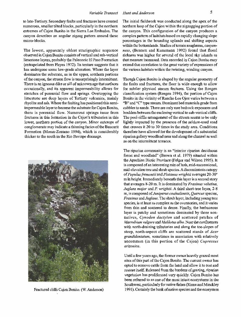
Riparian: Referred to in the remainder of this report as the bottomland. This is the canyon/ drainage floor bounded by cliffs, steep hills and their toe-slopes. This macrohabitat consists of channels, floodplains, and terraces. Bankfull features, the depositional boundary adjacent to the predominantly erosive channel environment, were chosen as channel boundaries. There is a marked difference in the vegetation along this boundary.
Upland: Lower slopes and cliff toe-slopes immediately adjacent to the bottomlands often host ecotones between riparian communities and upland communities. They also tend to have greater soil moisture than higher slopes or ridge tops, so they can support a unique combination of upland species and a richer assemblage. The relatively uncommon maple/sycamore/oak and more rare maple/oak/cypress associations are found in those habitats with northerly aspects. Southerly aspects host hackberry/mimosa/succulent associations. In this anfractuous section of Cajon Bonito, the bottomland and lower slope habitats form a very complex mosaic of small habitat parcels.
Lush riparian area amidst juniper-studded hills. Nice contrast between riparian and upland. Cajon Bonito. June 1999. (W. Anderson)
Variable Transect Hunt and Anderson 7
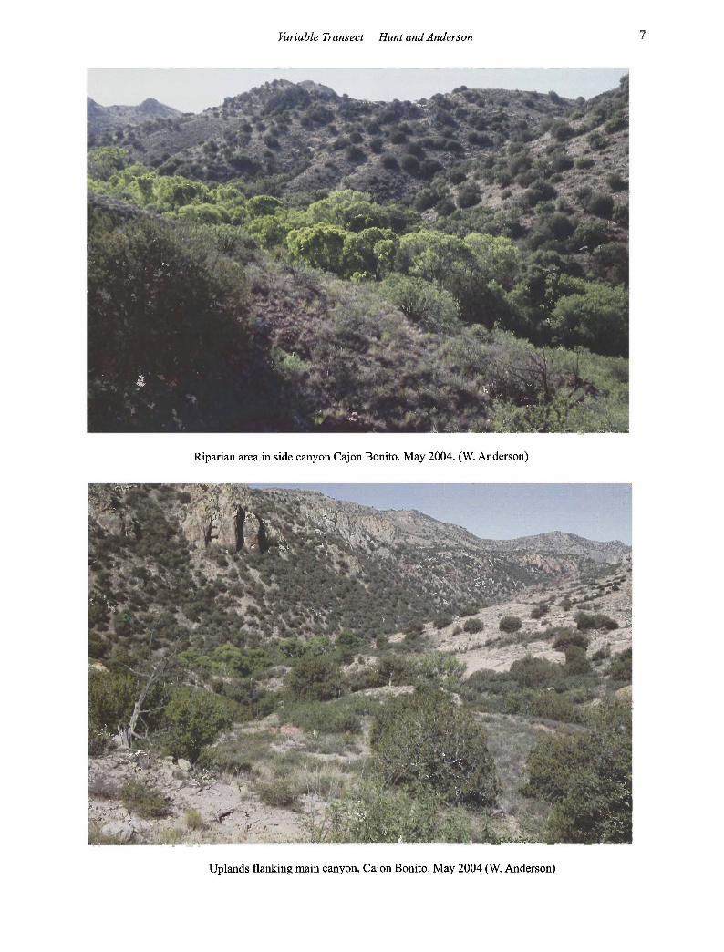
Riparian area in side canyon Cajon Bonito. May 2004. (W. Anderson)
Uplands flanking main canyon. Cajon Bonito. May 2004 (W. Anderson)

8 Desert Plants 2004
Above Cajon Bonito are the middle slope or backs lope and summit habitats. Though much broader in area than the canyon habitats, they are often interrupted by massive cliffs, buttes, spires and other bedrock outcrops. The soils are generally thin, stony and patchy. Some of the associations found here include mimosa/succulent spp./grass spp. and oak/ juniper/Little leaf Sumac/ grass species.
Tributary drainages, many with flowing water and significant springs, host both facultative and obligate species that match much of the composition of the main drainage with less species diversity.
Southern drainages feature willows, cottonwoods, sycamores, Baccharis, and south-aspect upland species such as Rhus microphylla and Lycium pallidum. Northern drainages were just as mesic and perhaps cooler than the tributaries on the opposite side because of their aspects. Their floristic compositions are quite distinct from the drainages on the opposite side of the canyon. Sycamores tower over small dense stands of maples (Acer grandidentatum) and Skunkbush (Rhus trilobata). It is in these sites that upper-elevational species shelter in nodes along this portion of the Cajon.
Methods Transect OJ The first transect was set up on a relatively large terrace area with rich, dark soils and a thick humus and litter layer adjacent to the ranch headquarters. Based upon the community structure at this site and along much ofthe Cajon in this area, trees >20m tall were chosen as the canopy class. The first 50 trees encountered within the 20m-wide transect would define its length. Twenty meters seemed wide enough for sampling the immediate plant community while making the transect long enough to include most ofthe tree and shrub species found there. This was a qualitative judgment meant to eliminate the time-consuming method of using nested quadrats and finding a species-area curve (Smith 1990).
Diameters-at-breast-height ( dbh) were measured for the first fifty overstory trees within 10 em subclasses. The edge of the terrace was reached by the 40th canopy tree, so I skipped over to the terrace diagonally opposite across the channel to extend the transect to a 50th tree. Discontinuous transects in response to disjunct community parcels are encouraged by the method's developers as long as these discontinuations are noted.
Most sycamores are multi-trunked, and some have as many as six or seven large trunks. Often these individual trunks can have as much influence on the structure of the canopy and understory as smaller trees of other species. Individual trees were recorded as multi-trunked each trunk's dbh was measured. Several shrub species grew stems in profusion. Dense and expansive clusters of stems might represent the same individual plant. This was especially true of poison ivy (Toxicodendron radicans). The first five individuals of any species were counted, thus over-representation of some
Sycamore Cajon Bonito (W. Anderson)
Poison ivy with Fremont cottonwood trunks, Cajon Bonito. May 2004. (W. Anderson)

Variable Transect Hunt and Anderson 9
species could be expected. Such data might give a rough characterization of a species' structural and biomass contributions along the line-intercept. For this transect each stem was treated as an individual.
Fifty understory trees (2-20m), 100 shrubs and 100 sapling/ seedling individuals were recorded. There were not enough individual understory trees to subdivide beyond a 2-20m class. The seedling/sapling class was measured as such data might help to decipher the early successional dynamics of the understories (Foster, pers. comm. 1998).
The resulting dimensions of this transect were 20H400 m. The transect was subdivided according to a formula that could give a good representation of understory species richness and abundance. For the 2-20m class, the transect was divided into five sections at each 80 m point on the centerline. Attempts were made to use a perpendicular lineintercept method on either side to tally the first five individuals. This usually proved impossible before reaching the lateral limits of the transect. The measurement was begun with these perpendicular lines, but if necessary, I would sweep them forward and record the first five hits on both sides.
For the 100 individuals to be inventoried for the shrub and the seedling/sapling classes, the sweeping line-intercept method would start at every 40 m point along the centerline. Some of the new bilateral intercept-sweeps were of unequal length and this needed to be addressed in the fmal assessment. The most problematic areas of TO 1 were those where Cynodon dactylon dominated the terrace floor. Here few shrubs and seedlings grew, and the sweeps threatened to overtake the next 40 m-point. Several unidentified shrub species were encountered, labeled with sample codes, and specimens collected for identification back at the field station or in Prescott. In fact by the end of this trip, 27 such samples were collected.
For each class, Daubenmire's (1959) cover percentage classes were used: 1 (0%- 1 %), 2 (1-5%), 3 (5-25%), 4 (25-50% ), 5 ( 50-7 5% ), 6 (7 5-100% ), and unknown. Each species was assigned a spacing code, "C" for clustered and "R" for random. Elevations were recorded at the beginning and end of the transect. Slope percents and aspects were recorded along with landform types, substrate, soil characteristics, any signs of disturbance at the site and any significant or obvious natural or human-made features that were adjacent to the transect. The qualitative assessments ofthe plant community included a general description of the composition and structure. The time it took to complete each transect was noted. TO 1 took eight hours to finish.
Transect 02 One-halfkilometer upstream of the Rancho Los Ojos quarters is a narrow constriction of the canyon that is unique enough to earn its own habitat designation, canyon narrows. There
are many such gorges throughout Cajon Bonito with vertical and sub-vertical walls that constrict the drainage bottom. In the upper reaches of the Cajon, 10 miles upstream of Rancho Los Ojos, the gorges become numerous and spectacular. Many have sheer walls that vary from 50 to over 150 meters in height and constrict the canyon in some places to as narrow as 10 meters. Unique expressions of the local riparian community can be found in these sites. Habitats in this environment are controlled by constricted flood flows. Diversity along the bottoms may be reduced to those species adapted to endure or thrive in a flood environment.
The short narrows ( ,...,500 m) identified for measurements would be a good test of the variable transect in an extreme expression of Southwestern riparian habitats where flood events are exaggerated compared to those of more open flood plains. Narrow bedrock walls that vary in height from five to thirty meters mostly enclose the gorge itself. The width of the floor varies from fifteen to thirty meters. There are few terraces. The only one of any size lies at the base of a short, steep, north-facing cliff. A tiny stand of Cupressus arizonica and Acer grandidentatum has found purchase on one of the few apparently stable substrates in the gorge. Elsewhere the channel and small floodplains take up the entire drainage floor, and the channel itself often creates discontinuities in the thin, dense stringers of vegetation. Often the stream meanders back and forth against both walls so that available substrate for plants occurs in small alternating patches. Despite this, the stream channel was chosen as the centerline.
Riparian Ecosystem: Narrows in afternoon shadow, Cajon Bonito. May 2004. (W. Anderson)

10 Desert Plants 2004
Based on the available plants and the nature of the community, three classes were measured: trees >4 m, seedlings and saplings <4 m, and shrubs. The paucity of plants in many sections and the structure of the community and habitat forced the expansion of the width to 30m where possible. Beginning at the mouth of the narrows the first 50 large trees were inventoried. The transect length was 420 m. To characterize the profuse seedling and sapling growth along the margins of the water, 100 individuals in that class were inventoried. Shrubs were inventoried in the same manner, expecting that at least half would be Baccharis salicifolia and at least some of the more rare species such as Senecio douglasii would be picked up.
The variable transect method was "flexed". At every 42 m point, a line to either side (when possible) was visually extended and swept forward counting the first ten individuals beyond it for, most of the individuals might be picked up on one side of the "centerline." At some of these 42 m points, I had to walk almost up to the next point to get ten individual plants. Salix "seedlings" and saplings, like the poison ivy in TO 1, required a judgment call to determine what constituted an individual plant. Where several were crowded together, and no direct connection between them was obvious, I dug
Riparian Ecosystem: Willow, cottonwood, seep willow. Cajon Bonito. May 2004. (W. Anderson)
into the alluvium to find connections. When this was not possible, they were counted as one, if they were crowded enough for a connection beneath to be plausible. Poison ivy was treated similarly in other transects. The forward sweep methods for understory classes reinstated a greater measure of consistency for applying the variable transect method. This transect took five hours to complete.
During the reconnaissance and initial assessment of this portion of Cajon Bonito, I was impressed with how rapid and robust the early successional dynamics ofthe understory layers of the community were. In TO 1 the absence of the early-mature and middle-aged cohorts of the larger tree species and the presence of many upland trees such as junipers, mesquites and hackberries on relatively mesic terraces suggested that, ifleft ungrazed, the composition and appearance of the bottomlands community was going to change significantly. Many species that_ thrived in this site under the old grazing regime may be supplanted as other more obligate and facultative species revived their roles in the riparian community. In T02, the seedlings and saplings were an important expression of a flashflood environment and community in recovery. In such an environment as the narrows, adult cottonwoods and willows rarely reach the same sizes and heights as they have upstream and downstream of this site. The immature species are an important measure of that habitat's health, even if the majority of these individuals never reach recruitment size.
Transect 03 Channels, floodplains, terraces and toe-slopes were interwoven in a complex mosaic, none of the habitat parcels being large enough and close enough to each other to splice together a convenient transect. This portion of the canyon is a relatively narrow and frequently zigzagging macro habitat. Angular turns in the drainage combine with an equally wide variety of bounding slopes and cliffs to create innumerable repetitions of small to moderate parcels of all four habitats. Changing slope aspects increased the variety of plant associations by an order of magnitude.
Rancho Los Ojos is connected to the upstream Ranchos Nuevo and El Pinito by means of a rarely used dirt road along the bottom of Cajon Bonito. This road crosses the creek as often as twenty times in just three to four kilometers and even stays in the channel several times for as long as 50-100m. Downstream ofRancho Los Ojos, the road is no longer used and has become overgrown, but it repeats the winding course of the upstream section. In either direction it crosses or runs adjacent to every habitat designated for the bottomlands, and it does so often enough that a transect using the road as a centerline would include every habitat several times over a distance of less than a kilometer.
Although the road had some maintenance this survey year (it is now abandoned and nearly eradicated by stream action), it was seldom used. Its influence on the vegetation and
Variable Transect Hunt and Anderson 11
substrate immediately adjacent to it was minimal. The abandoned road downstream of the ranch looked as if its bed had been in recovery for as long as the rest of the riparian area around the ranch. Only seedlings and saplings grew there. and shrub recovery lagged just enough to make the understory trees discernible. The currently used roadbed in the upper Transect 03 was not counted. Rather. l 0-meter belts on both sides were inventoried as the road wound its way through all habitats.
The first 50 trees > 20 m height were chosen as the canopy and transect length-defining class. Since the road wound through all of the bottomlands habitats, the already fragmented canopy of the canyon might be even more discontinuous along the road transect. Significant canopy discontinuations were noted. These trees were recorded in groups as they were encountered. For this and all other classes, a two-letter code was assigned for every individual • .. C .. and "T'' depending on whether they were found in the channel and floodplain or on the terrace. All stem dbhs for multi-trunked trees were recorded. Other classes included understory trees 8-20 m. tree species 2-8 m. shrubs and saplings/seedlings. Any species in these classes that did not make it into the normal inventory was noted. Total length of the transect was approximately one kilometer. Over that length. the road (centerline) crossed the stream and the channel habitat seven times. It crossed terrace habitats six times swinging to the extreme outside on at least three occasions. Transect lengths on the terraces varied from 20-210 m. Distance in the channel/floodplain habitat ranged from 15-100 m.
Recording understory classes would again require using a forward-sweeping line intercept. as in the other transects. In some cases the road went right to the edge of the bottomlands habitat. which meant the sweeping line necessarily emphasized one side of the road over another. Despite this "convenient" flexing of the variable transect. the data recorded at all of the transects portray the composition and abundance ofthe recorded species. Most species not making it into the data set for the transect were noted.
Poison ivy was counted only once per side per sweepintercept. As in T02 judgment calls were made on what constituted a single willow sapling. It became apparent that recording a seedling/sapling class may only be necessary in a fraction of transects to characterize that aspect of successional structure. Recording that class did pick up some species that might not have been noticed at all. such as a low-growing Quercus hypoleucoides hidden beneath a juniper. This transect took six hours to complete.
Transect 04 Transect 04 was set up two kilometers downstream of the ranch using the same methodology as T03. A seedling/sapling class was not recorded. however. the first ten were recorded. More species were recorded in this site that was structurally
and compositionally less complex than the site upstream at T03.
The understory was lighter. so the intercept-sweep was utilized. As in the other transects, the distance each sweep moved forward from each transect subsection varied widely. If inventory is the only object. then this seems to be no problem. Abundance values. though. could be overemphasized for less common species. This might be overcome if several transects were run contiguously. The two immediate benefits were a more thorough inventory of the species within the transect and less time to conduct the inventory. This sample took four hours to complete.
Notes on Subsequent Transect Ten transects were set up along approximately a tenkilometer length of middle Cajon Bonito. The number of new species that were recorded per transect leveled out at two or three. and most of these were found outside of the transect boundaries. Opportunistic searches in and around the transect sites in follow-up trips in late winter and spring 1999 added even more species to the inventory total. Most likely even more species in some of the plant classes (e.g .• shrubs. succulents and woody vines) could be found on subsequent visits. Cajon Bonito is in a state of relatively rapid change after the exclusion of cattle and the inception of a recovery program by the new owners. The total species bank for the study area may not yet be fully expressed and awaits the completion of various environmental and ecological cycles.
Six transects were run on opposing upland slopes: two on lower slopes just above the canyon walls and toe slopes; two along mid- to upper-level slopes: and two along ridge tops on either side of the Cajon that hosted assemblages that were relatively distinct from each other. Time restrictions prevented expanding the study into the wide variety of upland vegetation associations that create a mosaic across the hills and mountains.
There was as much plant community variability in the uplands as in the canyon bottoms. Different classes of plants were utilized for sampling in each of the six transects. One ridge top transect had only one class, shrubs of all sizes. The density of the small shrubs was such that a very narrow. twometer transect was used. The ridge top on the opposite side of the valley to the north had scattered trees and was therefore longer and wider. Soil moisture increases downhill on most hills. and this was reflected in an increasing abundance of trees at lower elevations. particularly on the lower and upper slope of north-facing transects. The upper transect on the south-facing side of the valley hosted many of the same plants as the opposite side. but they were restricted to small. favorable aspects and the bottoms of small drainages. The lower transect on the south-facing slope just above the Cajon not only differed in aspect but also in substrate. Massive bedrock exposures. small cliffs and scattered thin. stony soils allowed elements of juniper-grassland to mix with desert flora.
12 Desert Plants 2004
As in the riparian zone. the uplands are recovering from heavy grazing. Range-increaser species for this region, such as mimosa. mesquite and snakeweed, dominate slopes, particularly those with south aspects. These areas are often mapped juniper-grassland but are actually scrub mesquite grassland with scattered junipers. Juniper and mesquite were notorious range-increasers, and these cooler slopes were even more attractive for cattle.
Summary of Data and Observations Riparian Plant Community Structure and Composition The riparian community structure was divided into seven horizontal layers for most of the transects. Each of these layers was treated as plant classes to be sampled. These included the following layers from top to bottom:
Canopy or overstory layer. For purposes of sampling with the variable transect, this was the control. the class that determined the dimensions of each variable transect. For eight of the ten riparian transects, the minimum height was set at >20m. Generally. this layer was dominated by Populus fremontii (0.64) and Platanus wrightii (0.30). There were rare Cupressus ari=onica that rose majestically in the shaded lee of streamside cliffs and hinted at the cooler, higher elevations miles upstream. This visually and structurally dominant layer was discontinuous. The breaks usually occurred where the fullest forces of flood and erosion by the stream were expressed, such as where the canyon walls constricted tightly to allow room only for the stream channel and scattered, tiny terraces and floodplains. This layer produced a stately, cathedral-like atmosphere with inviting shade.
First understory (8-20 m height). The sycamores that could not match the cottonwoods in height in the overstory dominated this layer (0.53). However, this percentage significantly underestimates the structural contributions by this species to the overall appearance in the upper layers. About 90% of the individuals sported from two to twelve often massive and tall trunks, each with the structural impact of a single individual of another species. As mentioned earlier. the paucity of cottonwoods in these taller understory layers may reflect the impacts of the old grazing regime. The result is a largely missing generation of cottonwoods. Virtually all of the cottonwoods in this and the next class were old trees like those in the understory that had collapsed. been snapped off by storms, or had tilted. The data show that their dbhs fall into the same range as those of the overstory. The largest of the Fraxinus velutina (0.13) and Juglans major (0.09) individuals add significantly to the color and structure of this layer. Although the species numbers jump from six to fourteen in this class. most species are represented by rare examples of their tallest individuals.
Second understory (2-8 m). The number of species in this class jumps dramatically to 24. Abundances are more evenly distributed. The most common species. as measured with
the variable transect, are Juniperus coahuilensis (0.23), Prosopis velutina (0.15), Salix bonplandiana (0.15), Juglans major (0.08), Quercus grisea (0.07), Platanus wrightii (0.06) and Celtis reticulata (0.05). Salix spp. andPopulusfremontii (0.04) are under-represented since the centerline of the transect did not follow along the stream channel. Cottonwood and willow saplings there sometimes forming a nearly impenetrable curtain along the stream banks.
Shrubs. This class includes woody and suffrutescent shrubs, lianas and vines, and succulents. Epiphytes such as Phoradendron spp. and Tillandsia recurvata were noted as "present." Equisetum hyemale was listed with shrubs because it is the most significant perennial in the mesoriparian area and dominates streamside habitats. Vines will be discussed separately. The shrub class was the most problematic during surveys. Identifications were difficult during the winter. Return trips in the spring added many new species.
Some species, though relatively uncommon or even rare in the transects, such as Ceanothus fendleri, C. greggii and Anisacanthus thurberi. occurred at regular intervals in microsites such as the cool. well-shaded north-flowing tributaries to Cajon Bonito and in hanging gardens and grottos. Others such as EIJ'flll·ina jlabelliformis could be found frequently along the edges of the riparian woodlands in bedrock and rocky substrates. Species such as Arctostaphylos pungens and Cercocarpus montanus were rare at that elevation. Desmodium psylophyllum and Parthenocissus vitacea were noted.
While many species were distributed randomly throughout the understory, such as the Senecio spp., others. such as Frangula betulifolia and Toxicodendron radicans could occur as dense monocultures of uniform height. Some shrubs. like Agave palmeri andAgare schottii. were found in clusters. Other shrubs. such as all of the Baccharis species except for B. sarothroides. were narrowly distributed indicating strict habitat requirements. In general. the distribution of shrubs varied, and that may have had as much to do with the old grazing regime as with environmental needs and tolerances. In some places the shrub growth was quite dense and complex, and in other places the spacing was much more open. There were whimsical occurrences of Opuntia phaeacantha and Agave growing in the crotches of tree trunks.
Vines. Several vine species added to the structural complexity that went beyond their numbers as individual plants. One species in particular. poison ivy. was both incredibly prolific and in many places dominant in the understory. Toxicodendron even added an interesting structural modification: thick. persistent and long tendrils crawled up cliff sides and made numerous green bridges from trees to canyon walls. Some of the vines were several inches thick and climbed as much as 50-1 00 feet up the rock walls.

Variable Transect Hunt and Anderson 13
Epiphytes. Several species of Phoradendron added to both the vertical and horizontal complexity of the riparian woods. Tillandsia recurvata was the only flowering and obligate epiphytic species and bromeliad observed.
Uplands Plant Community Structure and Composition Substrate and aspect seem to be the two major factors determining both composition and structure among the upland sites. Several sites had similar species composition, but abundances shifted dramatically, resulting in assemblages of quite different appearance.
Many abundant species may have increased during the earlier grazing regime. Shrub species that occurred in greater numbers and more openly beneath the tall canopies of the riparian area could still be found beneath junipers and oaks in the uplands, even on southerly aspects. Some relatively rare species such as Fraxinus cuspidata and F greggii could be found at the base of north-facing cliffs where the soil was deep and its moisture protected from the direct rays of the sun for most of the year. Larrea was extremely rare, and it was probably at its extreme elevational range.
Other Plant Communities: Hot Springs Cienega. The small valley that was the site of the hot springs also hosted dozens of other small to large cool water springs. All of these springs flowed beneath dense, tall grasses and sedges. They eventually flowed into the main tributary, which hosted a dense mesoriparian woodland and shrub land. Even in these years of prolonged drought, the flow from these hillside springs is stable. The grassy swales are large and stand out distinctly from the gallery woodland. This cienega habitat is perhaps the most intact, healthy and robust of any throughout the Madrean Archipelago.
Hanging gardens. Though these microhabitats host few shrub species, they are the green jewels of Cajon Bonito and are located at the head of small tributaries to the Cajon. Within the grottos, lush, dense riparian forests tower above the hanging gardens. Even small seeps will host monkey flowers and honeysuckle, sometimes in dense growth.
Cliff Bases (Uplands and Canyon Bottoms). Within the canyon itself, especially cool, moist and shaded habitats at the cliff bases can host disjunct patches of montane riparian woods. Acer grandidentatum and Cupressus arizonica overshadow other higher elevation adapted plant species such as Rhus trilobata, Quercus grisea and Q. rugosa. Soils in these sites remain moist throughout the year. Cumulatively these moist, cool sites lie scattered like beads throughout middle Cajon Bonito to form an attenuated montane riparian stringer.
Further Research For the study conducted in Cajon Bonito, inventory and qualitative assessments in a relatively short time were the goals. The region is little known, and no existing general
description does a comprehensive job. Any data gained from an experimental method is valuable. Several more transects will be run through both lower and higher elevation portions of Cajon Bonito that undoubtedly differ in community composition from the mid-elevation study site described in this report.
Fern grotto and falls, Cajon Bonito. (W. Anderson)
Literature Cited Bennett, P. S., and M. R. Kunzmann. 1992. Terrain rough
ness, a feature related to high plant species richness in the Madrean biogeographic region. 5th U.S.-Mexico border states conference on recreation, parks and wildlife. Sep. 17-19, 1992. Las Cruces, NM. 8 p.
Benson, Lyman. 1969. The cacti of Arizona. The University of Arizona Press, Tucson. 218 p.
Benson, Lyman, and Robert Darrow.1981. Trees and shrubs of the southwestern deserts. The University of Arizona Press, Tucson. 416 p.
Brown, David E., Charles H. Lowe, and Charles P. Pase. 1979. A digitized classification system for the biotic communities ofNorthAmerica, with community (series) and association examples for the Southwest. Journal of the Arizona-Nevada Academy of Science 14 (Suppl. 1): 1-16.
Brown, David E., and Charles H. Lowe. 1994. Biotic communities of the Southwest. The University of Utah Press, Salt Lake City. 1 p. map.
14 Desert Plants 2004
Carter, Jack L. 1997. Trees and shrubs of New Mexico. Mimbres Publishing, Silver City, New Mexico. 534 p.
Conservation International ( Cl). 1997. Conservation International: the first decade. CI, Washington, D.C. 64 p.
Daubenmire, R. F. 1959. Plants and environment. Second edition. John Wiley and Sons, New York.
Drewes, Harald D. 1981. Tectonics of southeastern Arizona. Geological Survey Professional Paper 1144. United States Government Printing Office, Washington, D.C. 96 p.
Drewes, Harald. 1991. Description and development of the Cordilleran Orogenic Belt in the southwestern United States and northern Mexico. U.S. Geological Survey Professional Paper 1512. United States Government Printing Office, Washington, D.C. 92 p.
Felger, RichardS., and Michael F. Wilson. 1995. Northern Sierra Madre Occidental and its Apachian outliers: a neglected center of biodiversity. Pages 36-51 In DeBano, Leonard F., Peter F. Ffolliott, Alfredo Ortega-Rubio, Gerald J. Gottfried, Robert H. Hamre, and Carleton B. Edminster, tech. coords. 1995. Biodiversity and management of the Madrean Archipelago: the sky islands of southwestern United States and northwestern Mexico. 1994 Sept. 19-23; Tucson, AZ. Gen. Tech. Rep. RMGTR-264. U.S. Department of Agriculture, Forest Service, Rocky Mountain Forest and Range Experiment Station, Fort Collins, CO.
[FMNH] Field Museum of Natural History. 2004. Rapid Biological\lnventories. www. fieldmuseum. org/ research_ collections/ecp/ecp _ sites/rapidinventories/
Gans, P. B. 1997. Large-magnitude Oligo-Miocene extension in southern Sonora: implications for the tectonic evolution of northwest Mexico. Tectonics 16(3): 388-408.
Grieg-Smith, P. 1983. Quantitative plant ecology. Studies in Ecology, vol. 9. 3rd edition. University of California Press, Berkeley.
Hayes, Philip T. 1972. Stratigraphic nomenclature of Cambrian and Lower Ordovician rocks of easternmost southern Arizona and adjacent westernmost New Mexico. Geological Survey Bulletin 1372-B. United States Government Printing Office, Washington, D.C. 21 p.
Harrelson, Cheryl C., C. L. Rawlins, and John P. Potyondy. 1994. Stream channel reference sites: an illustrated guide to field technique. USDA Forest Service. Gen. Tech. Rep. RM-245. Rocky Mountain Forest and Range Experiment Station, Fort Collins, CO. 61 p.
Hickman, J. C., editor. 1993. The Jepson manual: higher plants of California. University of California Press, Berkeley. 1400 p.
Imlay, Ralph W. 1939. Paleogeographic studies in northeastern Sonora. Bulletin of the Geological Society of America 50: 1723-1744.
Kearney, T. H., and R. H. Peebles. 1960. Arizona flora. University of California Press, Berkeley. I 085 p.
Marshall, Joe T., Jr. 1957. Birds of the pine-oak woodland in southern Arizona and adjacent Mexico. Cooper Ornithological Society. Pacific Coast Avifauna, 32: 1-125.
Mearns, Edgar Alexander. 1907. Mammals of the Mexican
boundary of the United States. Smithsonian Institution, United States National Museum Bulletin 56.
Moran-Zentano, Dante. 1997. Geology of the Mexican Republic. AAPG Studies in Geology #39. American Association of Petroleum Geologists, Tulsa, OK.
Parker, T. A., III, and B. Bailey, eds. 1991. A biological assessment of the Alto Madidi region and adjacent areas of northwest Bolivia, May 18- June 15, 1990. RAP Working Papers 1. Conservation International, Washington, D.C. 108 p.
Parker, T. A., Ill, and J. L. Carr, eds. 1992. Status of forest remnants in the Cordillera de la Costa and adjacent areas of southwestern Ecuador. RAP Working Papers 2. Conservation International, Washington, D.C. 172 p.
Parker, T. A., III, B. K. Holst, L. H. Emmons, and J. R. Meyer. 1993. A biological assessment ofthe Columbia River Reserve, Toledo District, Belize. RAP Working Papers 3. Conservation International, Washington, D.C. 81 p.
Parker, T. A., III, A. H. Gentry, R. B. Foster, L. H. Emmons, and J. V. Remsen, Jr. 1993. The lowland dry forests of Santa Cruz, Bolivia: a global conservation priority. RAP Working Papers 4. Conservation International, Washington, D.C. 104 p.
Peterson, Frederick F. 1981. Landforms of the Basin and Range Province defined for soil survey. Technical Bulletin 28. Nevada Agricultural Experiment Station, University of Nevada, Reno. 52 p.
Rinne, John N., and W. L. Minckley. 1991. Native fishes of arid lands: a dwindling resource of the desert Southwest. Gen. Tech. Rep. RM-206. U.S. Department of Agriculture, Forest Service, Rocky Mountain Forest and Range Experiment Station, Fort Collins, CO: 45 p.
Rosgen, D. L. 1994. A classification of natural rivers. Catena Kim Awbrey. l997a. The Cordillera del Condor Region of Ecuador and Peru: a biological assessment. RAP Working Papers 7. Conservation International, Washington, D.C. 231 p.
Schulenberg, Thomas S., and Kim Awbrey. 1997. A rapid assessment of the humid forests of south central Chuquisaca, Bolivia. RAP Working Papers 8. Conservation International, Washington, D.C. 84 p.
Smith, Robert Leo. 1990. Student resource manual to accompany Ecology and Field Biology. 41h edition. Harper and Row Publishers, New York. 114 p.
Tennesen, Michael. 1998. Expedition: what it's like to search for a new species. International Wildlife 28(2): 22-29.
Turner, R. M., J. E. Bowers. and T. L. Burgess. 1995. Sonoran Desert plants: an ecological atlas. University of Arizona Press, Tucson. 504 p.
USDA, NRCS. 2004. The PLANTS Database, Version 3.5 (http://plants.usda.gov). National Plant Data Center, Baton Rouge, LA 70874-4490 USA.
Variable Tn.msect Hum and Ander:wn
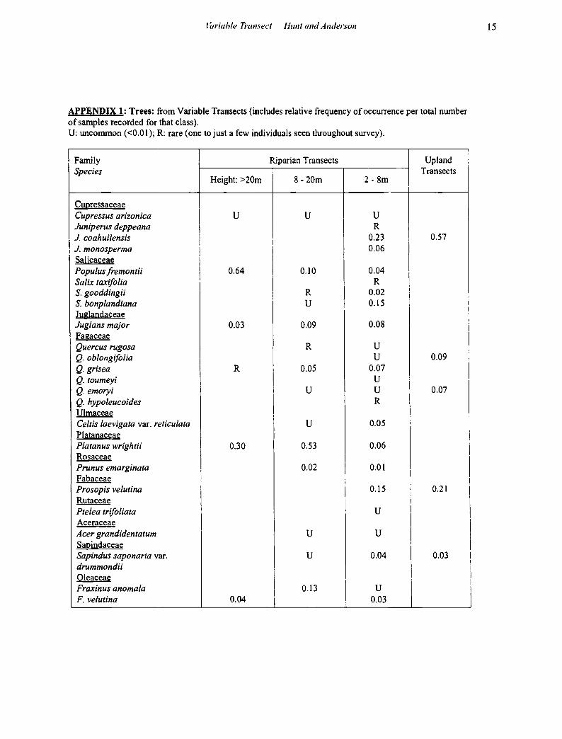
APPENDIX 1: Trees: from Variable Transects (includes relative frequency of occurrence per total number of samples recorded for that class). U: unconunon (<0.01); R: rare (one to just a few individuals seen throughout survey).
Family Riparian Transects Upland Species Transects
Height: >20m 8- 20m 2-8m
Cupressaceae Cupressus arizonica u u u Juniperus deppeana R J. coahuilensis I 0.23 0.57
I i J. monosperma I I
0.06 Salicaceae I
I Populus fremontii I 0.64 I 0.10 0.04 Salix taxifo/ia I
I R
S. gooddingii I R I
0.02 I S. bonplandiana u 0.15
I J uglandaceae Juglans major 0.03 0.09 0.08 Fagaceae Quercus rugosa R u Q. oblongifolia u 0.09 Q. grisea R I 0.05 0.07 Q. toumeyi I u :
Q. emoryi i u u 0.07 Q. hypoleucoides
I R
Ulmaceae Celtis laevigata var. reticulata I u 0.05 i
Platanaceae I Platanus wrightii 0.30 0.53 0.06
Rosaceae I Prunus emarginata 0.02 0.01
I Fabaceae !
I !
Prosopis velutina I 0.15 i 0.21 I I
Rutaceae i Ptelea trifo/iata u I
I Aceraceae I Acer grandidentatum u u I Sapindaceae I
I
Sap indus saponaria var. u 0.04 0.03 drummond it Oleaceae
I
Fraxinus anomala 0.13 u F. velutina 0.04 0.03
15
:
I
I I
I I
I I
I I I
I
i

16 Desert Plants 2004
APPENDIX 2: Woody and Suffrutescent Shrubs, Succulents and Epiphytes.
Taken from Variable Transects (includes relative frequency of occurrence). U: uncommon(< 0.01 ~ 4-6 individuals); R: rare (one to just a few individuals seen throughout survey); X: found outside of transects, or not counted within transects). V: vines or shrubs that also grew as woody vines/lianas. Spacing code: Cl: clustered (horizontally, or, as in the case of epiphytes, vertically also). R: all other species assessed as randomly spaced. 900 individuals counted in riparian area; 600 in uplands.
Shrubs Family Riparian Uplands Species Equisetaceae E_guisetum hyemale 0.02 c Ulmaceae Celtis pallida 0.01 Moraceae Morus microphy/la 0.02 u Polygonaceae Eriogonum wrightii R 0.02 Chenopodiaceae Atriplex confertifolia u A. canescens R Krasheninnikovia /anata R Ranunculaceae Clematis drummondii V u Clematis /igusticifolia V u Berberidaceae Berberis haematocarpa 0.07 u Saxifragaceae Philadelphus argentus R X Fend/era rupicola R u Rosaceae Fallugia paradoxa RC Purshia stansburiana XC Fabaceae Cal/iandra eriophylla 0.02 Acacia gregg it R 0.02 A. constricta uc Mimosa dysocarpa R 0.02 M. biuncifera 0.05 0.02 Amorpha fruticosa R Eysenhardtia polystachya u u Dalea neomexicana R D. formosa 0.01 D. versicolor ssp. versicolor var. sessilis u D. albiflora R D. tentacu/oides 0.01 Desmodium psylophyllum V 0.03 Erythrina jlabel/iformis XC u Zygophyllaceae Larrea tridentata X Malohil!iiaceae
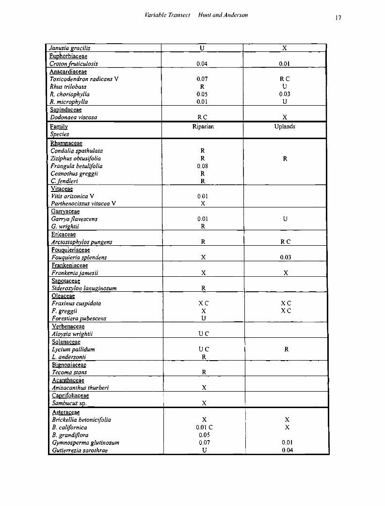
J~wiahle Transect Hum and Anderson 17
Janusia gracilis u X Euphorbiaceae Croton fruticulosis 0.04 0.01 Anacardiaceae Toxicodendron radicans V 0.07 RC Rhus tri/obata R u R. choriophyl/a 0.05 0.03 R. microphyl/a 0.01 u Sapindaceae Dodonaea viscosa RC X Family Riparian Uplands Species Rhamnaceae Condalia spathulata R Ziziphus obtusifo/ia R R Frangula betulifolia 0.08 Ceanothus greggii R C.fendleri R Vitaceae Vitis arizonica V 0.01 Parthenocissus vitacea V X Garrvaceae Garrya flavescens 0.01 u G. wrightii R Ericaceae Arctostap_hylos p_ungens R RC Fouquieriaceae Fouquieria splendens X 0.03 Frankeniaceae Frankenia jamesii X X Sapotaceae Sideroxylon /anuginosum R Oleaceae Fraxinus cuspidata XC XC F. greggii X XC Forestiera pubescens u Verbenaceae Aloysia wrig_htii uc Solanaceae Lycium pallidum uc R L. andersonii R Bignoniaceae Tecoma stans R Acanthaceae Anisacanthus thurberi X Caprifoliaceae Sambucus sp. X Asteraceae Brickel/ia betonicifo/ia X
I X
B. ca/ifornica 0.01 c X B. grandiflora 0.05
\
i Gymnosperma glutinosum 0.07
I 0.01
Gutierrezia sarothrae u 0.04

18 Desert Plants 2004
Ericameria laricifo/ia 0.08 0.09 lsocoma plurijlora R u Baccharis pterinoides R B. sa/icifo/ia R B. sarothroides 0.11 c B. thesioides uc R Zinnia acerosa X X Artemesia ludoviciana R Senecio jlaccidus var. jlaccidus R S. longjlobus R Family Riparian Uplands Species Asteraceae Senecio salignus 0.05 Agavaceae Yucca baccata u uc Y. schottii 0.01 0.01 No/ina microcarpa R 0.10 Dasylirion whee/eri u 0.03 Agave palmeri 0.03
I 0.05
A. schottii XC 0.07 c Cactaceae I Echinocereus pectinatus R I 0.04 E.fendleri X
I X
Mammilaria microcarpa X 0.01 Opuntia santa-rita RC i 0.01 c 0. violacea XC I uc 0. phaeacantha var. laevis R !
0. phaeacantha var. major R i 0.02 0. phaeacanthe var. dis~ata 0.01 I 0.01
I 0. spinosior 0.04 ! 0.06
APPENDIX 3: Epiphytes Only the presence of epiphytes was noted for each transact.
Family, Species
Bromeliaceae Tillandsia recurvata Clustered
Viscaceae Phoradendron californicum P. juniperum P. jlavescens
P. coryae
Host Trees
Juniperus spp., Cupressus arizonica, Quercus spp.
Prosopis velutina Juniperus spp. Populus fremontii, Platanus wrightii, Celtis reticula/a, Juglans major, Fraxinus velutina, Prosopis velutina Quercus spp.