Embed Size (px)
Citation preview

Current Research (2008) Newfoundland and Labrador Department of Natural ResourcesGeological Survey, Report 08-1, pages 35-44
A RE-EVALUATION OF THE COASTAL STRATIGRAPHYALONG THE SOUTHWESTERN BURIN PENINSULA
T. Bell, M. Batterson1 and P. BlundonDepartment of Geography, Memorial University, St. John's, NL A1B 3X9
ABSTRACT
Quaternary sections exposed along the southwest coast of the Burin Peninsula, Newfoundland, have yielded criticalinformation for prevailing ideas on regional glacial history, including multiple glaciations predating the Wisconsinan, Sang-amonian marine transgression, and restricted late Wisconsinan ice extent. New field observations on these coastal sectionsindicate much greater stratigraphic and sedimentological complexity than described by previous researchers, the occurrenceof fossiliferous tills and a more substantial deglacial sedimentary record associated with onshore ice flow. A preliminary inter-pretation suggests that the entire sedimentary sequence exposed in coastal bluffs postdates the mid-Wisconsinan and wasdeposited in a deglacial tidewater environment associated with several ice-flow events.
INTRODUCTION
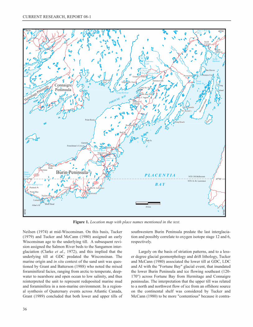
This paper describes preliminary results of a multi-yearproject to re-evaluate the Quaternary stratigraphy exposedin coastal sections along the southwestern Burin Peninsula,Newfoundland. Three sites were visited in 2007 – GreatDantzic Cove, Little Dantzic Cove and Allan's Island (Fig-ure 1). These sites were reported by both Grant (1975) andVanderveer (1977), and later documented in more detail byTucker (1979) and a related publication (Tucker andMcCann, 1980). Later, Grant and Batterson (1988) providedadditional details in a local field guide. These sites haveattracted research attention because they expose some of themost extensive Quaternary sections in Newfoundland andare interpreted to represent one of only two documentedsites where evidence for multiple late Quaternary glacia-tions is preserved. The sedimentological and stratigraphicalinterpretations provided by these authors have remaineduntested in the literature, even though our understanding ofglacial and glaciomarine depositional models haveadvanced in the interim. This project proposes to addressthis issue and test the interpretations.
The Quaternary sections described from the southwest-ern Burin Peninsula have generated critical insights to theregional glacial history, including the recognition of pre-lastglacial episodes and the non-glaciation of much of thepeninsula during the late Wisconsinan. Given the rarity ofpre-last glacial deposits in Newfoundland (cf., Grant, 1989)
and the growing recognition that insular Newfoundland wascompletely inundated by late Wisconsinan ice (Shaw et al.,2006), including coastal mountains (Gosse et al., 2006), it isimportant to re-evaluate the original data and interpretationson which these important conclusions were based.
PREVIOUS INVESTIGATIONS
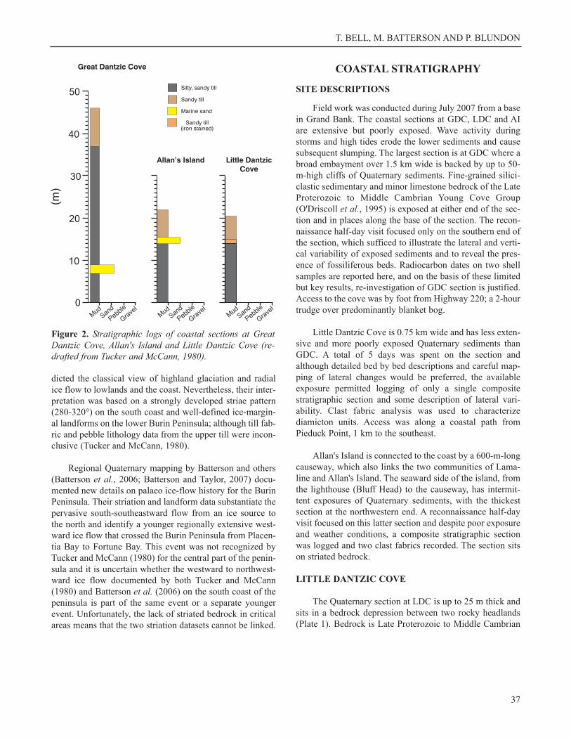
The sediments exposed in coastal sections at GreatDantzic Cove (GDC), Little Dantzic Cove (LDC) andAllan's Island (AI) are central to the chronology of regionalglacial events. Two till units were described by Tucker(1979) and Tucker and McCann (1980) at all three sites(Figure 2) and consisted of a lower compact grey-pink siltytill between 14 and 37 m thick and an upper brown sandy tillbetween 7 and 9 m thick, which was substratified at GDCand iron-stained in its lowermost 2 m at LDC. The two tillswere separated by a 4-m-thick, crossbedded sand unit at AI,and a similar bed (faulted and crossbedded fine sand and siltwithin the lower till, 26 m below the contact of the two tillunits) was described at GDC (Tucker, 1979; Tucker andMcCann, 1980).
The sand unit was only fossiliferous at GDC where itcontained a diverse marine foraminiferal assemblage, on thebasis of which it was interpreted to represent marine overlapof the lower Burin Peninsula to at least 15 m above presentsea level and "tenuously" correlated by Tucker and McCann(1980) with the Salmon River Sand of Nova Scotia, dated by
35
1Geochemistry, Geophysics and Terrain Sciences Section
CURRENT RESEARCH, REPORT 08-1
Neilsen (1974) at mid-Wisconsinan. On this basis, Tucker(1979) and Tucker and McCann (1980) assigned an earlyWisconsinan age to the underlying till. A subsequent revi-sion assigned the Salmon River beds to the Sangamon inter-glaciation (Clarke et al., 1972), and this implied that theunderlying till at GDC predated the Wisconsinan. Themarine origin and in situ context of the sand unit was ques-tioned by Grant and Batterson (1988) who noted the mixedforaminiferal facies, ranging from arctic to temperate, deep-water to nearshore and open ocean to low salinity, and thusreinterpreted the unit to represent redeposited marine mudand foraminifera in a non-marine environment. In a region-al synthesis of Quaternary events across Atlantic Canada,Grant (1989) concluded that both lower and upper tills of
southwestern Burin Peninsula predate the last interglacia-tion and possibly correlate to oxygen isotope stage 12 and 6,respectively.
Largely on the basis of striation patterns, and to a less-er degree glacial geomorphology and drift lithology, Tuckerand McCann (1980) associated the lower till at GDC, LDCand AI with the "Fortune Bay" glacial event, that inundatedthe lower Burin Peninsula and ice flowing southeast (120-170°) across Fortune Bay from Hermitage and Connaigrepeninsulas. The interpretation that the upper till was relatedto a north and northwest flow of ice from an offshore sourceon the continental shelf was considered by Tucker andMcCann (1980) to be more "contentious" because it contra-
36
Figure 1. Location map with place names mentioned in the text.
T. BELL, M. BATTERSON AND P. BLUNDON
dicted the classical view of highland glaciation and radialice flow to lowlands and the coast. Nevertheless, their inter-pretation was based on a strongly developed striae pattern(280-320°) on the south coast and well-defined ice-margin-al landforms on the lower Burin Peninsula; although till fab-ric and pebble lithology data from the upper till were incon-clusive (Tucker and McCann, 1980).
Regional Quaternary mapping by Batterson and others(Batterson et al., 2006; Batterson and Taylor, 2007) docu-mented new details on palaeo ice-flow history for the BurinPeninsula. Their striation and landform data substantiate thepervasive south-southeastward flow from an ice source tothe north and identify a younger regionally extensive west-ward ice flow that crossed the Burin Peninsula from Placen-tia Bay to Fortune Bay. This event was not recognized byTucker and McCann (1980) for the central part of the penin-sula and it is uncertain whether the westward to northwest-ward ice flow documented by both Tucker and McCann(1980) and Batterson et al. (2006) on the south coast of thepeninsula is part of the same event or a separate youngerevent. Unfortunately, the lack of striated bedrock in criticalareas means that the two striation datasets cannot be linked.
COASTAL STRATIGRAPHY
SITE DESCRIPTIONS
Field work was conducted during July 2007 from a basein Grand Bank. The coastal sections at GDC, LDC and AIare extensive but poorly exposed. Wave activity duringstorms and high tides erode the lower sediments and causesubsequent slumping. The largest section is at GDC where abroad embayment over 1.5 km wide is backed by up to 50-m-high cliffs of Quaternary sediments. Fine-grained silici-clastic sedimentary and minor limestone bedrock of the LateProterozoic to Middle Cambrian Young Cove Group(O'Driscoll et al., 1995) is exposed at either end of the sec-tion and in places along the base of the section. The recon-naissance half-day visit focused only on the southern end ofthe section, which sufficed to illustrate the lateral and verti-cal variability of exposed sediments and to reveal the pres-ence of fossiliferous beds. Radiocarbon dates on two shellsamples are reported here, and on the basis of these limitedbut key results, re-investigation of GDC section is justified.Access to the cove was by foot from Highway 220; a 2-hourtrudge over predominantly blanket bog.
Little Dantzic Cove is 0.75 km wide and has less exten-sive and more poorly exposed Quaternary sediments thanGDC. A total of 5 days was spent on the section andalthough detailed bed by bed descriptions and careful map-ping of lateral changes would be preferred, the availableexposure permitted logging of only a single compositestratigraphic section and some description of lateral vari-ability. Clast fabric analysis was used to characterizediamicton units. Access was along a coastal path fromPieduck Point, 1 km to the southeast.
Allan's Island is connected to the coast by a 600-m-longcauseway, which also links the two communities of Lama-line and Allan's Island. The seaward side of the island, fromthe lighthouse (Bluff Head) to the causeway, has intermit-tent exposures of Quaternary sediments, with the thickestsection at the northwestern end. A reconnaissance half-dayvisit focused on this latter section and despite poor exposureand weather conditions, a composite stratigraphic sectionwas logged and two clast fabrics recorded. The section sitson striated bedrock.
LITTLE DANTZIC COVE
The Quaternary section at LDC is up to 25 m thick andsits in a bedrock depression between two rocky headlands(Plate 1). Bedrock is Late Proterozoic to Middle Cambrian
37
Figure 2. Stratigraphic logs of coastal sections at GreatDantzic Cove, Allan's Island and Little Dantzic Cove (re-drafted from Tucker and McCann, 1980).

CURRENT RESEARCH, REPORT 08-1
fine-grained siliciclastic sedimentary rock and minor lime-stone of the Young Cove Group (O'Driscoll et al., 1995).Glacial striations are preserved on resistant bedrock surfacesbetween LDC and Pieduck Point and indicate a consistentsouthward ice flow (170 to 175°). Within LDC the bedrocksurface is largely exposed in the intertidal zone. Where itrises above high tide, it is severely weathered and shattered,and has a transitional contact with the overlying diamicton.The colour of this diamicton closely reflects the local clastcontent and underlying bedrock, ranging from bluish grey topinkish brown. With height above the bedrock contact, thediamicton is less stony and had greater variability in clastlithology.
A composite stratigraphic log (Figure 3) based mostlyon discontinuous exposures near the centre of the sectionrevealed three main sedimentary units: basal diamicton,stratified sandy gravel with interbedded diamicton, andupper diamicton. These units are described briefly below.
Basal Diamicton
The lower 10 to 12 m of the section rests directly onbedrock and is composed of a matrix-dominated compactdiamicton ranging from reddish to brownish grey (Munsellcolour 2.5YR 5/1 to 5/2). The matrix is silt dominated butbecomes sandier and contains thin lenses of pebble graveltoward the upper contact. It displays a fissile structure. Clastcontent ranges from 30 to 60% and consists of subangular tosubrounded pebbles, cobbles and boulders. Cobbles andboulders are facetted and striated. Three of four clast fabricsdisplay weak to moderately strong clusters (S1 = 0.6-0.64; K= 1.1-1.5), with shallow mean plunge angles (2-14°) andmean orientations ranging from northwest to northeast (17°,46°, 310°). The basal diamicton is interpreted to represent asubglacial till deposited by ice moving generally southwardacross the coast (Hicock et al., 1996).
Stratified Sand and Gravel
The middle unit at LDC is highly variable, ranging incomposition from a diamicton to clast-supported cobble andboulder gravel, to finely laminated sand and silt (Plate 2).The lowermost 2 m consists of interbedded sandy gravel anddiamicton. A pebble to cobble, poorly sorted sandy gravelrests on the basal diamicton along an abrupt and wavy con-tact. Gravel clasts are iron-stained on their undersides.Diamicton beds are of variable thickness and geometry andrange in matrix texture from sandy silt to silty sand. Inplaces, thin (1 to 2 mm) sand lenses appear beneath largercobbles within diamicton, and clasts of diamicton occurredwithin gravel.
At 14 m above sea level (asl) there is a 30- to 40-cm-thick bed of cobble-supported gravel with an indistinct lineof boulders and large cobbles. The unit is abruptly and con-formably overlain by 30-cm-thick interbedded medium- tofine-sand and sandy silt with some individual beds finingupward to silt. Above a 2-m-high obscured section there is a1.5-m-thick exposure of predominantly laminated fine sandand silt. The lowermost part of the unit is highly compactand deformed with faulted, folded and brecciated laminae.
38
Plate 1. View looking south across the coastal section at Lit-tle Dantzic Cove. The stratigraphic log in Figure 3 wascomposed from discontinuous exposures in the central partof the section, where wave action is eroding the base of thecoastal cliff. Note person in foreground for scale.
Figure 3. Composite stratigraphic logs of coastal sectionsat Little Dantzic Cove and Allan's Island based on newobservations from fieldwork in 2007.

T. BELL, M. BATTERSON AND P. BLUNDON
At 18 m asl the laminated fine sediment is abruptly overlainby clast-supported, grading upward to matrix-supported,cobble to boulder gravel having a distinct boulder lineoccurring near the contact. A 10-cm-thick, brownish, siltydiamicton bed overlays the gravel along an abrupt and irreg-ular contact and underlaid a second clast-supported pebbleto cobble gravel bed, which is faintly stratified and containsrafts of brown diamicton near its base. Clasts in both gravelbeds are iron-stained.
The middle unit at LDC is interpreted to represent sub-aqueous outwash deposition near a meltwater outlet along atidewater glacier front. The interbedded sandy gravel anddiamicton beds are typical of a grounding line environmentwhere meltwater-transported sand and gravel deposited onlocal subaqueous fans alternates with debris-flow sedimen-tation along the grounding-line front (Benn, 1996). Suspen-sion settling from turbid overflow plumes, along the tidewa-ter margin, results in laminated fine sand and silt, and mayabruptly alternate with coarse, clast-supported gravel wherehigh-energy meltwater jets issuing from ice-front portalsshift orientation across the subaqueous fan and depositcoarse bedload (Benn, 1996; Lønne, 1995). Iron staining ofclasts is interpreted to represent fluctuations in the watertable within gravel beds, rather than evidence for major ice-free periods during deposition of the middle unit.
Upper Diamicton
The 5-m-thick unit that, for the most part, caps the LDCsection is composed of a pinkish grey to brown diamicton(Munsell colour 5YR 5/2 to 7.5YR 5/2) with beds, stringersand lenses of both gravelly (granule) sand and silt with gran-ules and pebbles. The contact with the underlying unit variesfrom gradational to abrupt between gravelly sand and siltysand diamicton. The diamicton contains 20 percent clastsbetween pebble and cobble size, with faceting and iron-staining. Two of three clast fabrics display moderatelystrong girdles (S1 = 0.58-0.66; K = 0.8-0.9) with low meanplunge angles (3° and 8°) and diagonally opposite plungedirections (21° and 227°). A third fabric has a moderatelystrong cluster with a plunge direction of 19° and a meanplunge angle of 5°.
The upper diamicton is tentatively interpreted to beremobilized subglacial till. The interbedded diamicton andgravelly sand and silt layers are characteristic of stackedsubaqueous debris flows originating at a grounding-linemargin, and the two girdle clast fabrics are consistent withdebris-flow movement (Benn, 1994). In addition, the grada-tional lower contact suggests a transition from subaqueousfan to ice-contact or ice-proximal deposition. The moderate-ly strong cluster fabric with low plunge angles, however, is
39
Plate 2. A) Photograph of finely bedded medium to finesand and silt abruptly overlying sandy gravel from the mid-dle unit at Little Dantzic Cove. Note iron staining on someof the cobble gravel. B) Photograph of coarse gravel bedsunderlying the upper diamicton at Little Dantzic Cove. Thegravel is poorly sorted, faintly stratified and clast-support-ed in places. A metre-rule is present for scale.
A
B

CURRENT RESEARCH, REPORT 08-1
typical of a subglacial meltout process (Shaw, 1982), whichsuggests a subglacial origin for some components of thediamicton. There is no clear ice-flow direction preserved inthe fabric as the low plunge angles may imply either north-northeast or south-southwest ice movement.
ALLAN’S ISLAND
The discontinuous exposure logged at AI (Figure 3)thickened from 17 to 29 m along the coast (Plate 3) and con-sisted of three sedimentary units – an upper and lowerdiamicton and intervening gravel, sand and mud. The upperdiamicton was only observed where the section thickened tothe north. Rhyolite ash-flow tuff bedrock of the Neoprotero-zoic Marystown Group that underlies the basal diamictonwas striated with two primary ice-flow directions (Plate 4a);the oldest set was pervasive on the bedrock surface andrecorded ice movement toward the south (187°), whereasthe younger set occurred only on the uppermost surface ofthe outcrop and indicated an ice movement toward thenorth-northwest (337°).
Basal Diamicton
The diamicton overlying bedrock is a uniform, stony(40 percent clast content), matrix-supported, reddish browndiamicton (no Munsell colour code available) with a mostlysilty matrix. It displays a fissile structure and is dominatedby a few local rock types that impart a pinkish hue. Thediamicton has variable thickness, up to 3 to 4 m in places.Clasts preserve striations and faceting. One clast fabricrecorded a moderately strong primary eigenvalue but wasclassified as a weak girdle (S1 = 0.65; K = 0.9; E = 332°).The fissile structure of the diamicton and the striatedbedrock on which it rests tentatively suggests a subglacialorigin.
Gravel, Sand and Mud
Weakly stratified gravelly sand ca. 4 m thick, withintrabeds of well-sorted medium sand (Plate 4b), overlay thebasal diamicton along a sharp contact. A several metre-thick, compact mud rests directly on the gravelly sand alonga conformable, sharp contact. The mud appears to coarsenupward into compact fine sand with stringers of coarse sandand granule/pebble gravel. Slumped material obscures muchof the section between 13 and 19 m asl, and although theexposure typically resumes with the upper diamicton, in oneplace it is underlain by well-sorted sand at 21 m asl. Thesand appears similar to the bed exposed at 13.5 m and there-fore it may compose much of the section between 8 and 21m asl. Farther south along the section, however, a poorlysorted pebble to boulder gravel is exposed between 10 m asland the section surface at 17 m asl. Some of the boulderswere 1 to 2 m in diameter. Farther north, the mud and sand
are not seen in section and the lower sandy gravel is over-lain by almost 5 m thickness of steeply dipping (30–40°)well-sorted to poorly sorted sandy gravel. The gravel bedsappears to dip northward into the section.
The middle unit at AI is interpreted to be subaqueousoutwash, with abrupt changes in grain size representingfluctuations in energy and/or sediment supply at a tidewaterglacier margin (Benn, 1996; Lønne, 1995). Similar to themiddle unit at LDC, depositional processes likely rangedfrom suspension settling of fine sand and mud from turbidplumes to rapid deposition of gravel and coarse sand frommeltwater jets (cf., Bell et al., 2001).
Upper Diamicton
A highly compact, silty diamicton with recurringstringers of gravelly sand caps the northern end of the sec-tion at AI. The clast content is between 30 and 40 percentwith subrounded cobbles and pebbles most common. It is upto 9 m thick in places. One clast fabric produced a weak tomoderately strong cluster (S1 = 0.62; K = 2.2) with a princi-pal plunge direction of 248°. The diamicton structure resem-bles stacked debris flows (Hicock et al., 1996) and its dis-continuous lateral extent may suggest a local lense only. Thesingle clustered clast fabric was not consistent with a debris-flow origin and further data collection is needed to resolvethe apparent contradiction.
40
Plate 3. Low aerial view of northern end of coastal expo-sure at Allan's Island. The community of Allan's Islandappears in the left background. The section rests on striatedbedrock (Plate 4a) and is capped by diamicton at this end ofthe exposure. Brown mud and sand beds overlying the lowerdiamicton are visible in the right middle ground.

T. BELL, M. BATTERSON AND P. BLUNDON
GREAT DANTZIC COVE
A one-half day reconnaissance visit to the coastal sec-tion at GDC revealed some important new information onsite stratigraphy and sediment characteristics and justifiesmore detailed fieldwork in 2008. Key findings include:
1) There was a greater range of sediment types exposed(Plate 5) than previously described, including multiplediamictons, two separate stony mud units, and stratifiedgravel, and there is much greater horizontal and verticalvariability in sediment units (Figure 3).
2) At least three distinct diamicton beds are observed inexposures; one basal unit overlying stony mud, one diamic-ton capping the section, and at least one other diamicton inmid section (Figure 3). They are initially distinguished bycolour and textural characteristics.
3) Two diamictons are fossiliferous, containing fragments ofmarine shells. A single fragment from the basal diamictonprovided a radiocarbon date of 39 810±470 BP (Beta237892), whereas another fragment from a diamicton morethan 30 m higher in the section provided a date of 39370±450 BP (Beta 237891). The two age ranges overlap andsuggest that much of the GDC section was deposited duringa short interval sometime after 40 000 BP, likely during thelate Wisconsinan glacial stadial.
4) The occurrence of two stony mud units is interestingbecause, assuming they represent relatively low-energymarine environments, it suggests that the GDC sectionrecords two marine transgressions, the highest of which maybe more than 35 m asl and late Wisconsinan.
Detailed stratigraphic mapping and sedimentologicalanalysis are planned for the extensive section at GDC in
41
Plate 4. A) Photograph of striated bedrock underlying glacial diamicton at the base of Allan's Island section. The pick axehandle is oriented parallel to the pervasive striation set (187°) on the bedrock surface, whereas the metre-rule parallels theyounger striation set (337°) preserved only on the uppermost surface of the outcrop. B) Photograph of steeply dipping bedsof gravelly sand at Allan's Island. Gravel clasts vary from subangular to subrounded and range in grain size from pebbles toboulders. The beds represent fluctuating discharge on a subaqueous fan in a tidewater glacier environment. Note yellow 10-cm-long pencil for scale.
BA

CURRENT RESEARCH, REPORT 08-1
2008. In particular, lateral and vertical tracing of fossilifer-ous diamictons is required, together with a fuller under-standing of the relationships between the regional ice-flowhistory deciphered from the bedrock striation record and theclast-fabric and erratic content of multiple diamictonsexposed in section. The possibility that GDC preserves arecord of at least two marine transgressions is intriguing andpresents potential new insights to the glaciomarine historyof the region.
DISCUSSION
Reconnaissance mapping of sedimentary exposures atGDC, LDC and AI illustrates much greater stratigraphiccomplexity than described by previous researchers. Thepublished stratigraphic model of two tills, in places bracket-ing a sand unit (GDC, AI), oversimplifies the sedimentarysequences exposed along the coastal bluffs and demands are-evaluation of the glacial and marine events that were pro-posed on the basis of this model. For example, the revisedstratigraphic log for LDC suggests that the entire sedimen-tary sequence may represent a single deglacial cycle; fromsubglacial till deposition to grounding-line and subaqueousfan accumulation at a tidewater glacier margin. The pres-ence of a second diamicton at the top of the section, in thiscase interpreted to be of debris-flow origin, may simplyimply a fluctuating tidewater margin, as has been proposedfor St. George's Bay, Newfoundland (Bell et al., 2001), andnot necessarily a discrete glacial event from an opposing tra-jectory (Tucker and McCann, 1980). Ice-flow directional
indicators from the lower till are consistent with the region-ally pervasive Fortune Bay glacial event, which originatedfrom a Newfoundland-centred ice source.
The two radiocarbon dates on shell fragments fromdiamictons at GDC provide another example of how newdata, albeit at a reconnaissance level, allow the establishedglacial history of the region to be questioned. The mid-Wis-consinan age of ice-transported shells suggests that theywere eroded and transported by late Wisconsinan ice. Theiroverlapping ages suggest that a substantial thickness of theGDC section was deposited over a very short period of time.Both interpretations contradict the established glacialchronology, which asserts that the lowest till in coastalbluffs is at least pre-Wisconsinan and may be oxygen iso-tope stage 12 and that each till unit is separated by at leastone interglaciation (Grant, 1989). This chronology is based,in large part, on the correlative age of foraminiferal assem-blages from a mid-section sand unit that commonly outcropsalong the coast. Sand samples collected from LDC and AIin 2007 will be analyzed for foraminiferal content to sub-stantiate (or refute) this argument.
Finally, the new observations from AI question both thesimple tripartite sedimentary sequence described by Tuckerand McCann (1980) and the origin of glacial events respon-sible for local deposits. A comparison of Figures 2 and 3reveals that the middle unit is much more complex anddiverse than originally described and may be more readilyinterpreted in terms of a deglacial glaciomarine sequencethan a non-glacial, marine transgression. Furthermore, therecognition that the sedimentary sequence at AI sits onbedrock preserving two sets of striations, the younger ofwhich records a northward ice flow, implies that the overly-ing sediments are unrelated to the Fortune Bay glacial eventand solely record the deglaciation of an ice advance origi-nating offshore. Such an ice advance has previously beenpostulated on the basis of bedrock striations along the southcoast of the peninsula, which have been recorded as far westas Point May (Taylor, 2001) and has been tentatively asso-ciated with the upper till in coastal sections, although ice-directional indicators in the till were inconclusive (Tuckerand McCann, 1980). The recognition that coastal sectionscomprising a range of sediments from diamicton to mud tostratified sand and gravel may be associated with this glacialepisode provides new opportunities to investigate the con-figuration and timing of a contentious event in the glacialhistory of the region (cf., Batterson et al., 2006; Brushett etal., 2007).
ACKNOWLEDGMENTS
The authors would like to thank Dr. David Liverman forhis constructive comments on the paper. Terry Sears (Geo-
42
Plate 5. A view of one small area of the coastal section atGreat Dantzic Cove. It is shown here to illustrate the vari-ability in sedimentary units and complex stratigraphyobserved during a reconnaissance visit to this site. A lowerdiamicton (at person level) is overlain by seaward-dippinggravelly sand (most clearly visible in right middle ground),a second diamicton (dark brown unit) and a coarse, poorlysorted gravel capping the section. Note the interfingering ofthe coarse gravel and second diamicton in the upper leftside of section.

T. BELL, M. BATTERSON AND P. BLUNDON
logical Survey) and Charles Conway (Geography Depart-ment, Memorial University) assisted in drafting the figures.Funding for this project was provided by the Natural Sci-ences and Engineering Research Council of Canada.
REFERENCES
Batterson, M., Taylor, D., Bell, T., Brushett, D. and Shaw, J. 2006: Regional ice-flow mapping, surficial geology andtill geochemistry of the northern Burin Peninsula andadjacent Placentia Bay. In Current Research. New-foundland and Labrador Department of NaturalResources, Geological Survey, Report 06-1, pages 161-176.
Batterson, M. and Taylor, D.M. 2007: Till geochemistry surveys and preliminary Qua-ternary mapping of the Burin Peninsula and adjacentareas. In Current Research. Newfoundland andLabrador Department of Natural Resources, GeologicalSurvey, Report 07-1, pages 197-214.
Bell, T., Liverman, D.G.E., Batterson, M.J. and Sheppard, K. 2001: Late Wisconsinan stratigraphy and chronology ofsouthern St. George's Bay, southwest Newfoundland: are-appraisal. Canadian Journal of Earth Sciences, Vol-ume 38, pages 851-869.
Benn, D.I.1994: Fabric shape and the interpretation of sedimenta-ry fabric data. Journal of Sedimentary Research, Vol-ume 64A, pages 910-915.
1996: Subglacial and subaqueous processes near a gla-cier grounding line: sedimentological evidence from aformer ice-dammed lake, Achnasheen, Scotland. Bore-as, Volume 25, pages 23-36.
Brushett, D., Bell, T., Batterson, M.J. and Shaw, J.2007: Ice-flow history of Placentia Bay, Newfound-land: multibeam seabed mapping. In Current Research.Newfoundland and Labrador Department of NaturalResources, Geological Survey, Report 2007-1, pages215-228.
Clarke, A.H., Jr., Grant, D.R. and Macpherson, E.1972: The relationship of Atractodon stonei (Pilsbry)(Mollusca, Buccinidae) to the Pleistocene stratigraphyand paleoecology of southwestern Nova Scotia. Cana-dian Journal of Earth Sciences, Volume 9, pages 1030-1038.
Gosse, J.C., Bell, T., Gray, J.T., Klein, J., Yang, G., andFinkel, R.
2006: Using cosmogenic isotopes to interpret the land-scape record of glaciation: Nunataks in Newfoundland.In Glacier Science and Environmental Change. Editedby P.G. Knight. Blackwell Publishing Ltd., pages 442-446.
Grant, D.R.1975: Glacial features of the Hermitage-Burin Peninsu-la area, Newfoundland. In Current Research, Part C.Geological Survey of Canada, Paper 75-1, pages 333-334.
1989: Quaternary geology of the Atlantic Appalachianregion of Canada. In Quaternary Geology of Canadaand Greenland. Edited by R.J. Fulton. Geological Sur-vey of Canada, Geology of Canada no. 1, pages 393-440.
Grant, D.R. and Batterson, M.J.1988: Guidebook for CIM field trip to the Burin Penin-sula. Unpublished report, 19 pages.
Hicock, S.R., Goff, J.R., Lian, O.B. and Little, E.C.1996: On the interpretation of subglacial till fabric.Journal of Sedimentary Research, Volume 66, pages928-934.
Lønne, I.1995: Sedimentary facies and depositional architectureof ice-contact glaciomarine systems. SedimentaryGeology, Volume 98, pages 13-43.
Neilsen, E.1974: A mid-Wisconsinan glacio-marine deposit fromNova Scotia. In Quaternary Environments. Edited byW.C. Mahaney. York University-Atkinson College,Toronto, Ontario, Geographical Monographs No. 5,pages 59-60.
O'Driscoll, C.F., Stapleton, G.J. and King, D.W. 1995: Mineral Occurrence Map, Belleoram/St.Lawrence, Newfoundland. Map 95-16. Scale 1:250000. Newfoundland Department of Natural Resources,Geological Survey.
Shaw, J.1982: Melt-out till in the Edmonton area, Alberta.Canadian Journal of Earth Sciences, Volume 19, pages1548-1569.
43
CURRENT RESEARCH, REPORT 08-1
Shaw, J., Piper, D.J.W., Fader, G.B., King, E.L., Todd, B.G.,Bell, T., Batterson, M.J. and Liverman, D.
2006: A conceptual model of the deglaciation ofAtlantic Canada. Quaternary Science Reviews, Volume25, pages 2059-2081.
Taylor, D.M. 2001: Newfoundland Striation Database. Newfound-land Department of Mines and Energy, Geological Sur-vey, Open File NFLD/2195, version 4.
Tucker, C.M.1979: Late Quaternary events on the Burin Peninsula,Newfoundland. Unpublished Ph.D. thesis, McMasterUniversity, Hamilton, Ontario, 282 pages.
Tucker, C.M. and McCann, S.B.1980: Quaternary events on the Burin Peninsula, New-foundland, and the islands of St. Pierre and Miquelon,France. Canadian Journal of Earth Sciences, Volume17, pages 1462-1479.
Vanderveer, D.G.1977: Surficial and glacial geology gravel resourceinventory, Burin Peninsula. Newfoundland Departmentof Mines and Energy, Mineral Development Division,Open File NFLD/958, 7 pages.
44