Embed Size (px)
Citation preview
A REVIEW OF
POINT CLOUDS SEGMENTATION AND CLASSIFICATION ALGORITHMS
E. Grilli, F. Menna, F. Remondino
3D Optical Metrology (3DOM) unit, Bruno Kessler Foundation (FBK), Trento, Italy
<grilli><menna><remondino>@fbk.eu
Commission II
KEY WORDS: Point Clouds, Segmentation, Classification, Photogrammetry, Laser Scanning
ABSTRACT:
Today 3D models and point clouds are very popular being currently used in several fields, shared through the internet and even accessed
on mobile phones. Despite their broad availability, there is still a relevant need of methods, preferably automatic, to provide 3D data
with meaningful attributes that characterize and provide significance to the objects represented in 3D. Segmentation is the process of
grouping point clouds into multiple homogeneous regions with similar properties whereas classification is the step that labels these
regions. The main goal of this paper is to analyse the most popular methodologies and algorithms to segment and classify 3D point
clouds. Strong and weak points of the different solutions presented in literature or implemented in commercial software will be listed
and shortly explained. For some algorithms, the results of the segmentation and classification is shown using real examples at different
scale in the Cultural Heritage field. Finally, open issues and research topics will be discussed.
1. INTRODUCTION
We are recently witnessing an increasing availability of not-
interpreted point clouds and 3D models, often shared online using
point-based rendering solutions (e.g. PoTree) of mesh-based
portals (e.g. Sketchfab). If we focus on point clouds, there is a
growing need of innovative methods for the treatment and
analysis of these data and for their classification, aimed
ultimately to exploit in-depth the informative value of these
surveys and representations. 3D point clouds are the simplest but
at the same time powerful collection of elementary geometrical
primitives able to represent shape, size, position and orientation
of objects in space. This information may be augmented with
additional contents obtained from other sensors or sources, such
as colours, multispectral or thermal information, etc. For a
successful exploitation of point clouds and to better understand
them, we must first proceed with segmentation and classification
procedures. The former refers to group points in subsets
(normally called segments) characterized by having one or more
characteristics in common (geometric, radiometric, etc.) whereas
classification means the definition and assignment of points to
specific classes (“labels”) according to different criteria.
Due to the complexity and variety of point clouds caused by
irregular sampling, varying density, different types of objects,
etc., point cloud classification and segmentation are very active
research topics. There are multiple research studies related to
these two topics, many driven by specific needs provided by the
field of application (building modelling, Heritage documentation
and preservation, robotics, etc.).
Most of the segmentation algorithms are tailored to work with a
2.5D surface model assumption, coming for example from a
LiDAR-based survey. Many algorithms require a fine-tuning of
different parameters depending upon the nature of data and
applications. Supervised methods are the majority with a training
phase mandatory and fundamental to guide the successive
machine learning classification solution. Some of the techniques
developed for segmenting point clouds generated from airborne
laser scanning can be applied or easily adapted to terrestrial point
clouds. The results are generally affected by noise and density of
the cloud as well as by the quality of the training data.
Different benchmarks were proposed in the research community,
the most comprehensive study being carried out by the previous
ISPRS Working Group III/3 “3D Reconstruction from Airborne
Laser Scanner and InSAR Data”’ with the aim to segment and
classify points in bare earth and object classes (Sithole &
Vosselman, 2003; Sithole & Vosselman, 2004). The study was
initiated to compare the performance of various automatic filters
with the purpose of (i) determining the comparative performance
of existing filters, (ii) understanding the influence of point
density on the filter performance and (iii) identifying directions
for future research on point clouds filtering algorithms. A more
recent benchmark is the “Large-Scale Point Cloud Classification
Benchmark” (www.semantic3d.net) that provides labelled
terrestrial 3D point cloud data on which people can test and
validate their algorithms (Fig. 1).
Figure 1: Example of a segmented and classified point cloud (www.semantic3d.net).
2. SEGMENTATION
A first attempt to group segmentation methods follows the works
of Sapkota (2008) and Nguyen (2013) and a schematic
representation is shown in Figure 2.
2.1 Edge-based segmentation
As described by Rabbani et al. (2006), edge-based segmentation
algorithms have two main stages: (i) edge detection to outlines
the borders of different regions and (2) grouping of points inside
the boundaries to deliver the final segments. Edges in a given
depth map are defined by the points where changes in the local
surface properties exceed a given threshold. The mostly used
local surface properties are normals, gradients, principal
curvatures or higher order derivatives. Methods based on edge-
The International Archives of the Photogrammetry, Remote Sensing and Spatial Information Sciences, Volume XLII-2/W3, 2017 3D Virtual Reconstruction and Visualization of Complex Architectures, 1–3 March 2017, Nafplio, Greece
This contribution has been peer-reviewed. doi:10.5194/isprs-archives-XLII-2-W3-339-2017
339
based segmentation techniques are reported by Bhanu et al.
(1986), Sappa and Devy (2001), Wani and Arabnia (2003).
Although such methods allow a fast segmentation, they may
produce not accurate results in case of noise and uneven density
of point clouds, situations that commonly occur in point cloud
data. In 3D space, such methods often detect disconnected edges
making the identification of closed segments difficult without a
filling or interpretation procedure (Castillo et al., 2013).
Figure 2: Synthetic representation of the segmentation methods.
2.2 Region growing segmentation
These methods start from one or more points (seed points)
featuring specific characteristics and then grow around
neighbouring points with similar characteristics, such as surface
orientation, curvature, etc. (Rabbani et al., 2006; Jagannathan and
Miller, 2007). Region-based methods can be divided into:
Bottom-up approaches: they start from some seed points and
grow the segments on the basis of given similarity criteria.
Seeded region approaches are highly dependent on selected
seed points. Inaccurate selection of seed points will affect the
segmentation process and can cause under- or over-
segmentation results.
Top-down approaches: they start by assigning all points to
one group and then fit a single surface to it. Where and how
to subdivide unseeded-region remain the main difficulty of
these methods.
Region-based algorithms includes two steps: identification of the
seed points based on the curvature of each point and growing
them based on predefined criteria such as proximity of points and
planarity of surfaces. The initial algorithm was introduced by
Besl et al. (1988) and then several variations were presented in
the literature. The region growing method proposed by
Vosselman et al. (2004) has introduced the use of colour
properties beside geometrical criteria. Surface normal and
curvatures constraints were widely used to find the smoothly
connected areas (Klasing et al., 2009; Belton and Lichti, 2006)
whereas Xiao et al. (2013) proposed to use sub window as the
growth unit. Ackermann and Troisi (2010) used a region growing
approach to segment planar pitched roofs in 3D point clouds for
automatic 3D modelling of buildings. Anh-Vu Vo et al. (2015)
presented an octree-based region growing approach for a fast
surface patch segmentation of urban environment 3D point
clouds.
A collection of region growing algorithms is available in the
Point Cloud Library (http://pointclouds.org). Figure 2 shows the
results of a segmentation done by a region growing algorithm
implemented in the pcl::RegionGrowing class. The purpose of
the algorithm is to merge/join similar points and deliver a set of
clusters with points belonging to the same smooth surface.
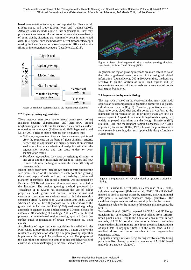
Figure 3: Point cloud segmented with a region growing algorithm
available in the Point Cloud Library (PCL).
In general, the region growing methods are more robust to noise
than the edge-based ones because of the using of global
information (Liu and Xiong, 2008). However, these methods are
sensitive to (i) the location of initial seed regions and (ii)
inaccurate estimations of the normals and curvatures of points
near region boundaries.
2.3 Segmentation by model fitting
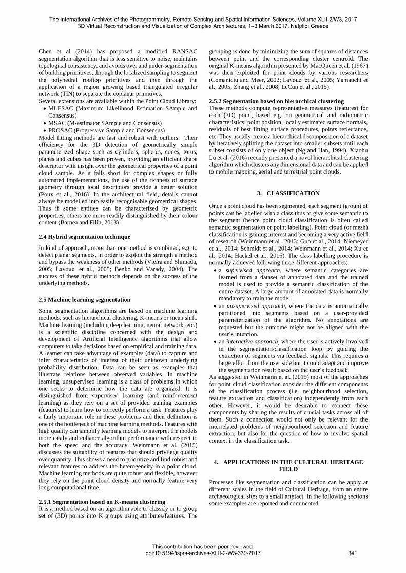
This approach is based on the observation that many man-made
objects can be decomposed into geometric primitives like planes,
cylinders and spheres (Fig. 3). Therefore, primitive shapes are
fitted onto point cloud data and the points that conform to the
mathematical representation of the primitive shape are labelled
as one segment. As part of the model fitting-based category, two
widely employed algorithms are the Hough Transform (HT)
(Ballard, 1981) and the Random Sample Consensus (RANSAC)
approach (Fischer and Bolles, 1981). In case the primitives have
some semantic meaning, then such approach is also performing a
classification.
Figure 4: Segmentation of 3D point cloud by geometric primitive
fitting.
The HT is used to detect planes (Vosselman et al., 2004),
cylinders and spheres (Rabbani et al., 2006). The RANSAC
method is used to extract shapes by randomly drawing minimal
data points to construct candidate shape primitives. The
candidate shapes are checked against all points in the dataset to
determine a value for the number of the points that represents the
best fit.
Tarsha-Kurdi et al. (2007) compared RANSAC and 3D Hough
transform for automatically detect roof planes from LiDAR-
based point clouds. Despite the limitation encountered in both
methods, RANSAC resulted the more efficient considering
segmented results and running time. It can process a large amount
of input data in negligible time. On the other hand, 3D HT
resulted slower and more sensitive to the segmentation
parameters values.
A popular strategy in reverse engineering involves locally fitting
primitives like planes, cylinders, cones using RANSAC based
methods (Schnabel et al. 2009).
The International Archives of the Photogrammetry, Remote Sensing and Spatial Information Sciences, Volume XLII-2/W3, 2017 3D Virtual Reconstruction and Visualization of Complex Architectures, 1–3 March 2017, Nafplio, Greece
This contribution has been peer-reviewed. doi:10.5194/isprs-archives-XLII-2-W3-339-2017
340
Chen et al (2014) has proposed a modified RANSAC
segmentation algorithm that is less sensitive to noise, maintains
topological consistency, and avoids over and under-segmentation
of building primitives, through the localized sampling to segment
the polyhedral rooftop primitives and then through the
application of a region growing based triangulated irregular
network (TIN) to separate the coplanar primitives.
Several extensions are available within the Point Cloud Library:
MLESAC (Maximum Likelihood Estimation SAmple and
Consensus)
MSAC (M-estimator SAmple and Consensus)
PROSAC (Progressive Sample and Consensus)
Model fitting methods are fast and robust with outliers. Their
efficiency for the 3D detection of geometrically simple
parameterized shape such as cylinders, spheres, cones, torus,
planes and cubes has been proven, providing an efficient shape
descriptor with insight over the geometrical properties of a point
cloud sample. As it falls short for complex shapes or fully
automated implementations, the use of the richness of surface
geometry through local descriptors provide a better solution
(Poux et al., 2016). In the architectural field, details cannot
always be modelled into easily recognisable geometrical shapes.
Thus if some entities can be characterized by geometric
properties, others are more readily distinguished by their colour
content (Barnea and Filin, 2013).
2.4 Hybrid segmentation technique
In kind of approach, more than one method is combined, e.g. to
detect planar segments, in order to exploit the strength a method
and bypass the weakness of other methods (Vieira and Shimada,
2005; Lavoue ́ et al., 2005; Benko and Varady, 2004). The
success of these hybrid methods depends on the success of the
underlying methods. 2.5 Machine learning segmentation
Some segmentation algorithms are based on machine learning
methods, such as hierarchical clustering, K-means or mean shift.
Machine learning (including deep learning, neural network, etc.)
is a scientific discipline concerned with the design and
development of Artificial Intelligence algorithms that allow
computers to take decisions based on empirical and training data.
A learner can take advantage of examples (data) to capture and
infer characteristics of interest of their unknown underlying
probability distribution. Data can be seen as examples that
illustrate relations between observed variables. In machine
learning, unsupervised learning is a class of problems in which
one seeks to determine how the data are organized. It is
distinguished from supervised learning (and reinforcement
learning) as they rely on a set of provided training examples
(features) to learn how to correctly perform a task. Features play
a fairly important role in these problems and their definition is
one of the bottleneck of machine learning methods. Features with
high quality can simplify learning models to interpret the models
more easily and enhance algorithm performance with respect to
both the speed and the accuracy. Weinmann et al. (2015)
discusses the suitability of features that should privilege quality
over quantity. This shows a need to prioritize and find robust and
relevant features to address the heterogeneity in a point cloud.
Machine learning methods are quite robust and flexible, however
they rely on the point cloud density and normally feature very
long computational time.
2.5.1 Segmentation based on K-means clustering
It is a method based on an algorithm able to classify or to group
set of (3D) points into K groups using attributes/features. The
grouping is done by minimizing the sum of squares of distances
between point and the corresponding cluster centroid. The
original K-means algorithm presented by MacQueen et al. (1967)
was then exploited for point clouds by various researchers
(Comaniciu and Meer, 2002; Lavoue ́ et al., 2005; Yamauchi et
al., 2005, Zhang et al., 2008; LeCun et al., 2015).
2.5.2 Segmentation based on hierarchical clustering These methods compute representative measures (features) for
each (3D) point, based e.g. on geometrical and radiometric
characteristics: point position, locally estimated surface normals,
residuals of best fitting surface procedures, points reflectance,
etc. They usually create a hierarchical decomposition of a dataset
by iteratively splitting the dataset into smaller subsets until each
subset consists of only one object (Ng and Han, 1994). Xiaohu
Lu et al. (2016) recently presented a novel hierarchical clustering
algorithm which clusters any dimensional data and can be applied
to mobile mapping, aerial and terrestrial point clouds.
3. CLASSIFICATION
Once a point cloud has been segmented, each segment (group) of
points can be labelled with a class thus to give some semantic to
the segment (hence point cloud classification is often called
semantic segmentation or point labelling). Point cloud (or mesh)
classification is gaining interest and becoming a very active field
of research (Weinmann et al., 2013; Guo et al., 2014; Niemeyer
et al., 2014; Schmidt et al., 2014; Weinmann et al., 2014; Xu et
al., 2014; Hackel et al., 2016). The class labelling procedure is
normally achieved following three different approaches:
a supervised approach, where semantic categories are
learned from a dataset of annotated data and the trained
model is used to provide a semantic classification of the
entire dataset. A large amount of annotated data is normally
mandatory to train the model.
an unsupervised approach, where the data is automatically
partitioned into segments based on a user-provided
parameterization of the algorithm. No annotations are
requested but the outcome might not be aligned with the
user’s intention.
an interactive approach, where the user is actively involved
in the segmentation/classification loop by guiding the
extraction of segments via feedback signals. This requires a
large effort from the user side but it could adapt and improve
the segmentation result based on the user’s feedback.
As suggested in Weinmann et al. (2015) most of the approaches
for point cloud classification consider the different components
of the classification process (i.e. neighbourhood selection,
feature extraction and classification) independently from each
other. However, it would be desirable to connect these
components by sharing the results of crucial tasks across all of
them. Such a connection would not only be relevant for the
interrelated problems of neighbourhood selection and feature
extraction, but also for the question of how to involve spatial
context in the classification task.
4. APPLICATIONS IN THE CULTURAL HERITAGE
FIELD
Processes like segmentation and classification can be apply at
different scales in the field of Cultural Heritage, from an entire
archaeological sites to a small artefact. In the following sections
some examples are reported and commented.
The International Archives of the Photogrammetry, Remote Sensing and Spatial Information Sciences, Volume XLII-2/W3, 2017 3D Virtual Reconstruction and Visualization of Complex Architectures, 1–3 March 2017, Nafplio, Greece
This contribution has been peer-reviewed. doi:10.5194/isprs-archives-XLII-2-W3-339-2017
341
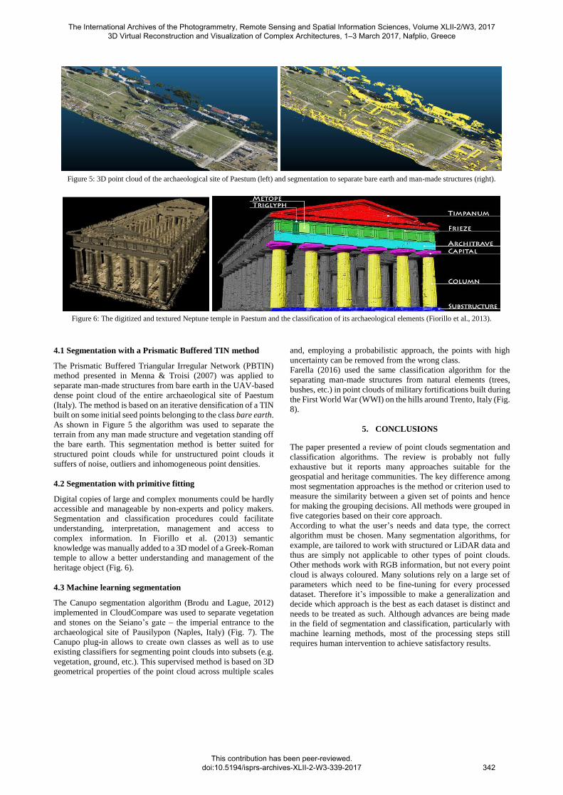
Figure 5: 3D point cloud of the archaeological site of Paestum (left) and segmentation to separate bare earth and man-made structures (right).
Figure 6: The digitized and textured Neptune temple in Paestum and the classification of its archaeological elements (Fiorillo et al., 2013).
4.1 Segmentation with a Prismatic Buffered TIN method
The Prismatic Buffered Triangular Irregular Network (PBTIN)
method presented in Menna & Troisi (2007) was applied to
separate man-made structures from bare earth in the UAV-based
dense point cloud of the entire archaeological site of Paestum
(Italy). The method is based on an iterative densification of a TIN
built on some initial seed points belonging to the class bare earth.
As shown in Figure 5 the algorithm was used to separate the
terrain from any man made structure and vegetation standing off
the bare earth. This segmentation method is better suited for
structured point clouds while for unstructured point clouds it
suffers of noise, outliers and inhomogeneous point densities.
4.2 Segmentation with primitive fitting
Digital copies of large and complex monuments could be hardly
accessible and manageable by non-experts and policy makers.
Segmentation and classification procedures could facilitate
understanding, interpretation, management and access to
complex information. In Fiorillo et al. (2013) semantic
knowledge was manually added to a 3D model of a Greek-Roman
temple to allow a better understanding and management of the
heritage object (Fig. 6).
4.3 Machine learning segmentation
The Canupo segmentation algorithm (Brodu and Lague, 2012)
implemented in CloudCompare was used to separate vegetation
and stones on the Seiano’s gate – the imperial entrance to the
archaeological site of Pausilypon (Naples, Italy) (Fig. 7). The
Canupo plug-in allows to create own classes as well as to use
existing classifiers for segmenting point clouds into subsets (e.g.
vegetation, ground, etc.). This supervised method is based on 3D
geometrical properties of the point cloud across multiple scales
and, employing a probabilistic approach, the points with high
uncertainty can be removed from the wrong class.
Farella (2016) used the same classification algorithm for the
separating man-made structures from natural elements (trees,
bushes, etc.) in point clouds of military fortifications built during
the First World War (WWI) on the hills around Trento, Italy (Fig.
8).
5. CONCLUSIONS
The paper presented a review of point clouds segmentation and
classification algorithms. The review is probably not fully
exhaustive but it reports many approaches suitable for the
geospatial and heritage communities. The key difference among
most segmentation approaches is the method or criterion used to
measure the similarity between a given set of points and hence
for making the grouping decisions. All methods were grouped in
five categories based on their core approach.
According to what the user’s needs and data type, the correct
algorithm must be chosen. Many segmentation algorithms, for
example, are tailored to work with structured or LiDAR data and
thus are simply not applicable to other types of point clouds.
Other methods work with RGB information, but not every point
cloud is always coloured. Many solutions rely on a large set of
parameters which need to be fine-tuning for every processed
dataset. Therefore it’s impossible to make a generalization and
decide which approach is the best as each dataset is distinct and
needs to be treated as such. Although advances are being made
in the field of segmentation and classification, particularly with
machine learning methods, most of the processing steps still
requires human intervention to achieve satisfactory results.
The International Archives of the Photogrammetry, Remote Sensing and Spatial Information Sciences, Volume XLII-2/W3, 2017 3D Virtual Reconstruction and Visualization of Complex Architectures, 1–3 March 2017, Nafplio, Greece
This contribution has been peer-reviewed. doi:10.5194/isprs-archives-XLII-2-W3-339-2017
342
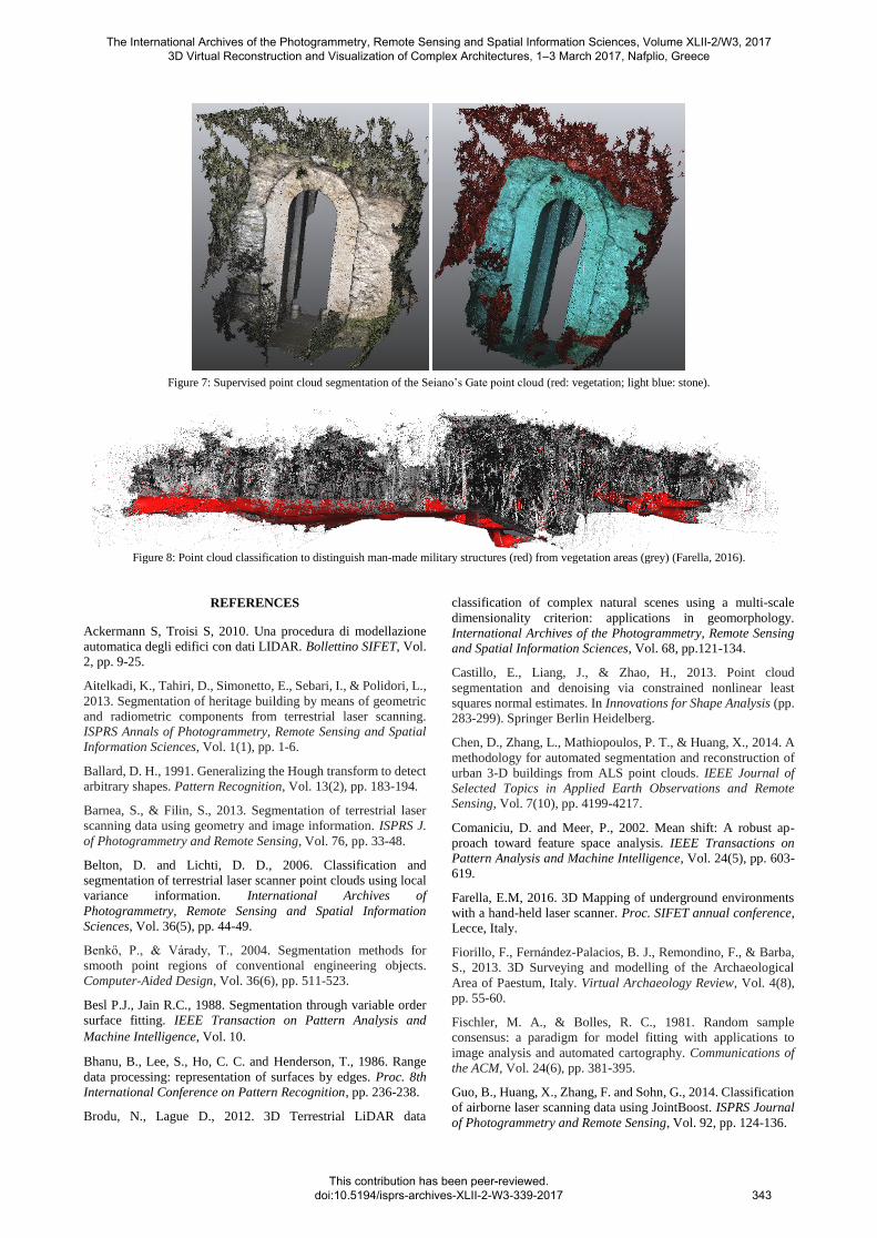
Figure 7: Supervised point cloud segmentation of the Seiano’s Gate point cloud (red: vegetation; light blue: stone).
Figure 8: Point cloud classification to distinguish man-made military structures (red) from vegetation areas (grey) (Farella, 2016).
REFERENCES
Ackermann S, Troisi S, 2010. Una procedura di modellazione
automatica degli edifici con dati LIDAR. Bollettino SIFET, Vol.
2, pp. 9-25.
Aitelkadi, K., Tahiri, D., Simonetto, E., Sebari, I., & Polidori, L.,
2013. Segmentation of heritage building by means of geometric
and radiometric components from terrestrial laser scanning.
ISPRS Annals of Photogrammetry, Remote Sensing and Spatial
Information Sciences, Vol. 1(1), pp. 1-6.
Ballard, D. H., 1991. Generalizing the Hough transform to detect
arbitrary shapes. Pattern Recognition, Vol. 13(2), pp. 183-194.
Barnea, S., & Filin, S., 2013. Segmentation of terrestrial laser
scanning data using geometry and image information. ISPRS J.
of Photogrammetry and Remote Sensing, Vol. 76, pp. 33-48.
Belton, D. and Lichti, D. D., 2006. Classification and
segmentation of terrestrial laser scanner point clouds using local
variance information. International Archives of
Photogrammetry, Remote Sensing and Spatial Information
Sciences, Vol. 36(5), pp. 44-49.
Benkő, P., & Várady, T., 2004. Segmentation methods for
smooth point regions of conventional engineering objects.
Computer-Aided Design, Vol. 36(6), pp. 511-523.
Besl P.J., Jain R.C., 1988. Segmentation through variable order
surface fitting. IEEE Transaction on Pattern Analysis and
Machine Intelligence, Vol. 10.
Bhanu, B., Lee, S., Ho, C. C. and Henderson, T., 1986. Range
data processing: representation of surfaces by edges. Proc. 8th
International Conference on Pattern Recognition, pp. 236-238.
Brodu, N., Lague D., 2012. 3D Terrestrial LiDAR data
classification of complex natural scenes using a multi-scale
dimensionality criterion: applications in geomorphology.
International Archives of the Photogrammetry, Remote Sensing
and Spatial Information Sciences, Vol. 68, pp.121-134.
Castillo, E., Liang, J., & Zhao, H., 2013. Point cloud
segmentation and denoising via constrained nonlinear least
squares normal estimates. In Innovations for Shape Analysis (pp.
283-299). Springer Berlin Heidelberg.
Chen, D., Zhang, L., Mathiopoulos, P. T., & Huang, X., 2014. A
methodology for automated segmentation and reconstruction of
urban 3-D buildings from ALS point clouds. IEEE Journal of
Selected Topics in Applied Earth Observations and Remote
Sensing, Vol. 7(10), pp. 4199-4217.
Comaniciu, D. and Meer, P., 2002. Mean shift: A robust ap-
proach toward feature space analysis. IEEE Transactions on
Pattern Analysis and Machine Intelligence, Vol. 24(5), pp. 603-
619.
Farella, E.M, 2016. 3D Mapping of underground environments
with a hand-held laser scanner. Proc. SIFET annual conference,
Lecce, Italy.
Fiorillo, F., Fernández-Palacios, B. J., Remondino, F., & Barba,
S., 2013. 3D Surveying and modelling of the Archaeological
Area of Paestum, Italy. Virtual Archaeology Review, Vol. 4(8),
pp. 55-60.
Fischler, M. A., & Bolles, R. C., 1981. Random sample
consensus: a paradigm for model fitting with applications to
image analysis and automated cartography. Communications of
the ACM, Vol. 24(6), pp. 381-395.
Guo, B., Huang, X., Zhang, F. and Sohn, G., 2014. Classification
of airborne laser scanning data using JointBoost. ISPRS Journal
of Photogrammetry and Remote Sensing, Vol. 92, pp. 124-136.
The International Archives of the Photogrammetry, Remote Sensing and Spatial Information Sciences, Volume XLII-2/W3, 2017 3D Virtual Reconstruction and Visualization of Complex Architectures, 1–3 March 2017, Nafplio, Greece
This contribution has been peer-reviewed. doi:10.5194/isprs-archives-XLII-2-W3-339-2017
343
Hackel, T., Wegner, J.D., Schindler, K., 2016: Fast semantic
segmentation of 3d point clouds with strongly varying density.
ISPRS Annals of Photogrammetry, Remote Sensing and Spatial
Information Sciences, Vol. III(3), pp. 177-184.
Jagannathan, A. and Miller, E. L., 2007. Three-dimensional
surface mesh segmentation using curvedness-based region
growing approach. IEEE Transactions on Pattern Analysis and
Machine Intelligence, Vol. 29(12), pp. 2195-2204.
Klasing, K., Althoff, D., Wollherr, D. and Buss, M., 2009. Com-
parison of surface normal estimation methods for range sensing
applications. Proc. IEEE International Conference on Robotics
and Automation, pp. 3206–3211.
Lavoue’, G., Dupont, F. and Baskurt, A., 2005. A new CAD mesh
segmentation method, based on curvature tensor analysis.
Computer-Aided Design, Vol. 37(10), pp. 975-987.
LeCun, Y., Bengio, Y. & Hinton, G., 2015. Deep learning.
Nature, Vol. 521, pp. 436-444
Liu, Y. and Xiong, Y., 2008. Automatic segmentation of unorga-
nized noisy point clouds based on the gaussian map. Computer-
Aided Design, Vol. 40(5), pp. 576-594.
Lu, X., Yao, J., Tu, J., Li, K., Li, L., & Liu, Y. , 2016. Pairwise
Linkage for Point Cloud Segmentation. ISPRS Annals of
Photogrammetry, Remote Sensing and Spatial Information
Sciences, Vol.III(3), pp. 201-208.
MacQueen, J. et al., 1967. Some methods for classification and
analysis of multivariate observations. Proc. 5th Berkeley
symposium on mathematical statistics and probability.
Menna, F. and Troisi, S., 2007. PBTIN: Prismatic Buffered TIN un algoritmo di filtraggio per dati ALS. Bollettino SIFET, Vol. 1.
Ng, R. T. and Han, J., 1994. Efficient and effective clustering
methods for spatial data mining. Proc. 20th Int. Conference on
Very Large Databases.
Nguyen, A. and Bac Le, 2013. 3D Point Cloud Segmentation: A
survey. Proc. IEEE 6th International Conference on Robotics,
Automation and Mechatronics.
Niemeyer, J., Rottensteiner, F. and Soergel, U., 2014. Contextual
classi- fication of lidar data and building object detection in urban
areas. ISPRS Journal of Photogrammetry and Remote Sensing,
Vol. 87, pp. 152-165.
Poux F., Hallot P., Neuville R., R. Billen, 2016. Smart point
cloud: definition and remaining challenge. Proc. 11th 3D Geoinfo
Conference, 20–21 October 2016, Athens, Greece
Rabbani, T., Van Den Heuvel, F., & Vosselmann, G., 2006.
Segmentation of point clouds using smoothness constraint.
International Archives of Photogrammetry, Remote Sensing and
Spatial Information Sciences, Vol. 36(5), pp. 248-253.
Sapkota, P. P., 2008. Segmentation of Coloured Point Cloud
Data. PhD Thesis, International Institute for Geo-Information
Science and Earth Observation, Enschede, The Netherlands.
Sappa, A. D., & Devy, M. , 2001. Fast range image segmentation
by an edge detection strategy. Proc. IEEE 3rd 3-D Digital
Imaging and Modeling, pp. 292-299
Schnabel, R., Degener, P. and Klein, R., 2009. Completion and
reconstruction with primitive shapes. CGF Eurographics, Vol.
28(2), pp. 503-512.
Sithole, G. and Vosselman, G., 2003. Report: ISPRS comparison
of filters. ISPRS Commission III - WG3.
Sithole, G. and Vosselman, G., 2004. Experimental comparison
of filter algorithms for bare-Earth extraction from airborne laser
scanning point clouds. ISPRS Journal of Photogrammetry and
Remote Sensing, Vol. 59(1), pp.85-101.
Tarsha-Kurdi, F., Landes, T., & Grussenmeyer, P., 2007. Hough-
transform and extended ransac algorithms for automatic
detection of 3d building roof planes from lidar data. Proc. ISPRS
Workshop on Laser Scanning, Vol. 36, pp. 407-412
Vieira, M., & Shimada, K., 2005. Surface mesh segmentation and
smooth surface extraction through region growing. Computer
aided geometric design, Vol. 22(8), pp. 771-792.
Vo, A. V., Truong-Hong, L., Laefer, D. F., & Bertolotto, M.,
2015. Octree-based region growing for point cloud segmentation.
ISPRS Journal of Photogrammetry and Remote Sensing, Vol.
104, pp. 88-100.
Vosselman, M.G., Gorte, B.G.H., Sithole, G. and Rabbani, T.,
2004. Recognising structure in laser scanning point clouds.
International Archives of Photogrammetry, Remote Sensing and
Spatial Information Sciences, Vol. 36(8/W2).
Wani, M. A., & Arabnia, H. R. , 2003. Parallel edge-region-based
segmentation algorithm targeted at reconfigurable multiring
network. The Journal of Supercomputing, Vol. 25(1), pp. 43-62.
Weinmann, M., 2016. Reconstruction and Analysis of 3D
Scenes. Springer International Publishing, ISBN 978-3-319-
29246-5, 233 pages.
Weinmann, M., Schmidt A., Mallet C., Hinz S., Rottensteiner F.,
Jutzi
B., 2015. Contextual classification of point cloud data by
exploiting individual 3D neighbourhoods. ISPRS Annals of
Photogrammetry, Remote Sensing and Spatial Information
Sciences, Vol. II(3-W4).
Weinmann, M., Jutzi, B. and Mallet, C., 2014. Semantic 3D
scene interpretation: a framework combining optimal
neighborhood size selection with relevant features. ISPRS Annals
of the Photogrammetry, Remote Sensing and Spatial Information
Sciences, Vol. II-3, pp. 181-188.
Weinmann, M., Jutzi, B. and Mallet, C., 2013. Feature elevance
assessment for the semantic interpretation of 3d point cloud data.
ISPRS Annals of Photogrammetry, Remote Sensing and Spatial
Information Sciences, Vol. II(5-W2)
Xiao, J., Zhang, J., Adler, B., Zhang, H. and Zhang, J., 2013.
Three-dimensional point cloud plane segmentation in both struc-
tured and unstructured environments. Robotics and Autonomous
Systems 61, pp. 1641-1652.
Xu, S., Vosselman, G. and Oude Elberink, S., 2014. Multiple-
entity based classification of airborne laser scanning data in
urban areas. ISPRS Journal of Photogrammetry and Remote
Sensing, Vol. 88, pp. 1-15
Yamauchi, H., Lee, S., Lee, Y., Ohtake, Y., Belyaev, A., &
Seidel, H. P., 2005. Feature sensitive mesh segmentation with
mean shift. Proc. IEEE Shape Modeling and Applications
International Conference, pp. 236-243.
Zhang, X., Li, G., Xiong, Y., & He, F., 2008. 3D mesh
segmentation using mean-shifted curvature. Proc. Int.
Conference on Geometric Modeling and Processing, pp. 465-
474.
The International Archives of the Photogrammetry, Remote Sensing and Spatial Information Sciences, Volume XLII-2/W3, 2017 3D Virtual Reconstruction and Visualization of Complex Architectures, 1–3 March 2017, Nafplio, Greece
This contribution has been peer-reviewed. doi:10.5194/isprs-archives-XLII-2-W3-339-2017
344