Embed Size (px)
Citation preview
M.G.C. WILSON, G. HENRY AND T.R. MARSHALL
SOUTH AFRICAN JOURNAL OF GEOLOGY, 2006, VOLUME 109 PAGE 301-314
301
IntroductionThe liberalization of the diamond marketing systemresulted in higher prices being paid for diamonds andthis, coupled with the significant devaluation of theRand during late 2001 and 2002, offered a window ofopportunity for increased alluvial diamond mining inSouth Africa. As a result, there was a noticeable increase in inland alluvial diamond production, whichrose to over 1.0 million carats in 2002 and 1.23 millioncarats in 2003. In addition, implementation of theMineral and Petroleum Resources Development Act(MPRDA) in 2004 has freed up additional ground for new entrants. Consequently, it is appropriate toreview the present status of knowledge of South Africa’s alluvial diamond deposits in order to make high quality information more easily available toentrepreneurs and potential investors alike. This paper concentrates on what were known for manyyears as the alluvial diamond fields of the western andsouthwestern Transvaal and which now mostly fallwithin the North West Province of South Africa (Figure 1).
The discovery of the Lichtenburg alluvial diamondfield in 1926 was, at the time, the most significant inSouth Africa in terms of alluvial diamond production (de Wit, 1996). The >10 million carats recovereddramatically increased the country’s and, indeed, theworld’s diamond production between 1926 and 1930.The rapid decrease of production after 1930 was largelythe result of a dramatic decline in global demand for diamond during the Great Depression. Manyotherwise viable diggings closed and it is likely thatsome of these never re-opened. Of those that did re-open, many ceased operations when they reached thewater-table. Thus there may be further potential forproduction in some of the older, abandoned operations.In fact, some of these may not even have reached themost productive, basal gravel horizons, because thesewere often difficult to access. The artisanal diggers ofthat time generally exploited the richer, more easilyaccessible deposits and left what were considered lower,more marginal grade ones. Often in the Southern Field,(Figure 1) only the colluvial and eluvial (Rooikoppie)gravels were worked, while the underlying alluvial units
A review of the alluvial diamond industryand the gravels of the North West Province,
South Africa
M.G.C. Wilson and G. HenryCouncil for Geoscience, P/Bag X112 Pretoria, 0001
e-mail: [email protected]; [email protected]
T.R. MarshallExplorations Unlimited, P.O. Box 6578, Homestead, 1412
e-mail: [email protected]
© 2006 September Geological Society of South Africa
ABSTRACT
The liberalization of the diamond marketing system led to increased diamond prices and this, coupled with the devaluation of the
Rand against the US$ during late 2001 and 2002, resulted in a significant increase in onshore alluvial diamond production in South
Africa. Inland, alluvial diamond production reached a recent peak of 1.23 million carats in 2003, providing employment for an
estimated 25,000 people which then dropped to a disappointing 6,000 people in 2005. The discovery of the Lichtenburg diamond
field in 1926 made a huge, short term impact on South Africa’s diamond production but this impact was short-lived due to the
global decline in diamond sales that resulted from the Great Depression.
In recent years, there have been important advances in the techniques used in the exploration for alluvial diamonds, enhancing
the ability to locate new deposits. These include improvements in the remote sensing techniques of aerial photography and satellite
image interpretation, as well as various airborne and ground geophysical methods. The extremely low concentrations of diamond
in most alluvial deposits and the almost random distribution of the diamonds within the gravels, necessitate the taking of large
samples in order to evaluate the commercial potential of a deposit.
In the southern, Schweizer-Reneke diamond field, five ages of diamondiferous gravels occur, ranging from late Cretaceous to
Pleistocene. Post-depositional modification has resulted in the formation of colluvial and eluvial “Rooikoppie” deposits, which were
preferentially mined by the artisanal diggers of the previous century.
The northern Lichtenburg, and eastern Ventersdorp diamond fields are largely underlain by dolomitic horizons that have
undergone at least four phases of karst development. Even though several phases of gravel deposition have occurred, the
distribution of the diamondiferous gravels is influenced by weathering features in the dolomite and these now occur as pothole-
fill, sinuous, discontinuous, narrow, steep-sided alluvial channels or laterally more continuous, yet thin sheet-like gravels, assumed
to be younger reworked material. The pot holes (or sinkholes) have formed excellent trap sites for diamonds and enormous
quantities of diamonds have been recovered from some of these.

went unrecognised and, hence, unmined (Marshall,1990a). The exploration potential in the underlyingalluvial deposits thus remains untested.
The economic viability of deeper or previouslyunrecognised gravel units began being evaluated in allthe inland alluvial diamond fields during the 1970s,resulting from technological advances in heavyearthmoving machinery, gravel processing and diamondrecovery equipment. Later, during 2002, the rapiddecline in the value of the Rand against the US$ madelower grade, high volume deposits profitable to mine(de Meillon and Bristow, 2002) and a rapid resurgenceof alluvial diamond mining ensued with productionreaching 1.23 Million carats in 2003 (Damarupurshad,2004). The South African Diamond ProducersOrganisation (SADPO) had a record 1 000 members in2002, each employing an average of 25 people(Mineweb, 09/11/2004).
The subsequent strengthening of the Rand againstthe US$ significantly decreased operating margins andhence a better understanding of the controls affectingthe deposits was required to locate and exploit thesedeposits profitably. Such research is additionallywarranted, because it has the potential to grow thesmall-scale mining industry and assist black economic
empowerment in South Africa. However, the strongRand, increased cost of fuel, added costs of complyingwith new legislation affecting the mining sector andslow pace at which new prospecting and mining rights are being issued, have all contributed to a sharpdecline in alluvial diamond production since mid 2004, in spite of increasing diamond prices. SADPOrecently announced that its membership had dropped to164 (Mining News, 2005).
Previous geological investigationsVarious theories have been put forward to explain thenature and origin of both the alluvial diamond depositsand, later, kimberlitic occurrences. In 1914, Wagnersystematically compiled all available data on both thekimberlitic and alluvial diamond fields known up to thattime. Draper (1928) noted the unique dolomiticsubstratum of the Lichtenburg deposits. Williams (1930)published an account of all the inland and coastalalluvial diamond deposits in southern Africa andexpounded his views on the origin of the Lichtenburgdeposits. Du Toit (1951) comprehensively described theLichtenburg field, based on his field work carried out in the 1930s when sporadic diggings were stilltaking place. Retief (1960) mapped the gravels and gave
SOUTH AFRICAN JOURNAL OF GEOLOGY
THE ALLUVIAL DIAMOND INDUSTRY AND THE GRAVELS OF THE NORTH WEST PROVINCE302
Figure 1. Locality of the North West Province diamondiferous gravel fields. Modified after Marshall (1990a). Area 1 is the Mafikeng-Molopo,
or Northwestern Field; Area 2 is the Lichtenburg-Bakerville, or Northern Field; Area 3 is the Ventersdorp-Potchefstroom-Klerksdorp,
or Eastern Field and Area 4 is the Christiana-Schweizer-Reneke-Wolmaransstad-Bloemhof, or Southern Field.
M.G.C. WILSON, G. HENRY AND T.R. MARSHALL
SOUTH AFRICAN JOURNAL OF GEOLOGY
303
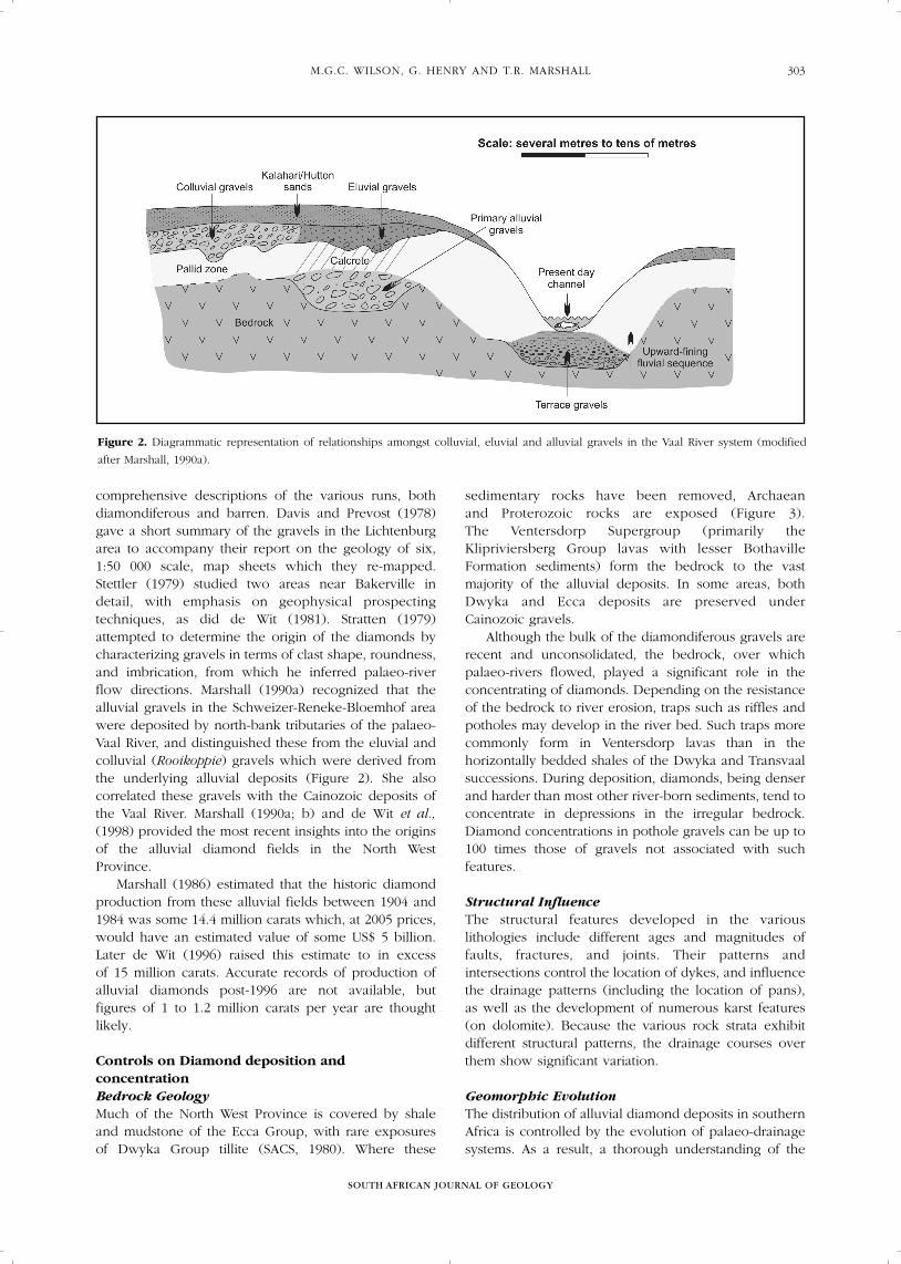
comprehensive descriptions of the various runs, bothdiamondiferous and barren. Davis and Prevost (1978)gave a short summary of the gravels in the Lichtenburgarea to accompany their report on the geology of six,1:50 000 scale, map sheets which they re-mapped.Stettler (1979) studied two areas near Bakerville indetail, with emphasis on geophysical prospectingtechniques, as did de Wit (1981). Stratten (1979)attempted to determine the origin of the diamonds bycharacterizing gravels in terms of clast shape, roundness,and imbrication, from which he inferred palaeo-riverflow directions. Marshall (1990a) recognized that thealluvial gravels in the Schweizer-Reneke-Bloemhof areawere deposited by north-bank tributaries of the palaeo-Vaal River, and distinguished these from the eluvial andcolluvial (Rooikoppie) gravels which were derived fromthe underlying alluvial deposits (Figure 2). She alsocorrelated these gravels with the Cainozoic deposits ofthe Vaal River. Marshall (1990a; b) and de Wit et al.,(1998) provided the most recent insights into the originsof the alluvial diamond fields in the North WestProvince.
Marshall (1986) estimated that the historic diamondproduction from these alluvial fields between 1904 and1984 was some 14.4 million carats which, at 2005 prices,would have an estimated value of some US$ 5 billion.Later de Wit (1996) raised this estimate to in excess of 15 million carats. Accurate records of production ofalluvial diamonds post-1996 are not available, butfigures of 1 to 1.2 million carats per year are thoughtlikely.
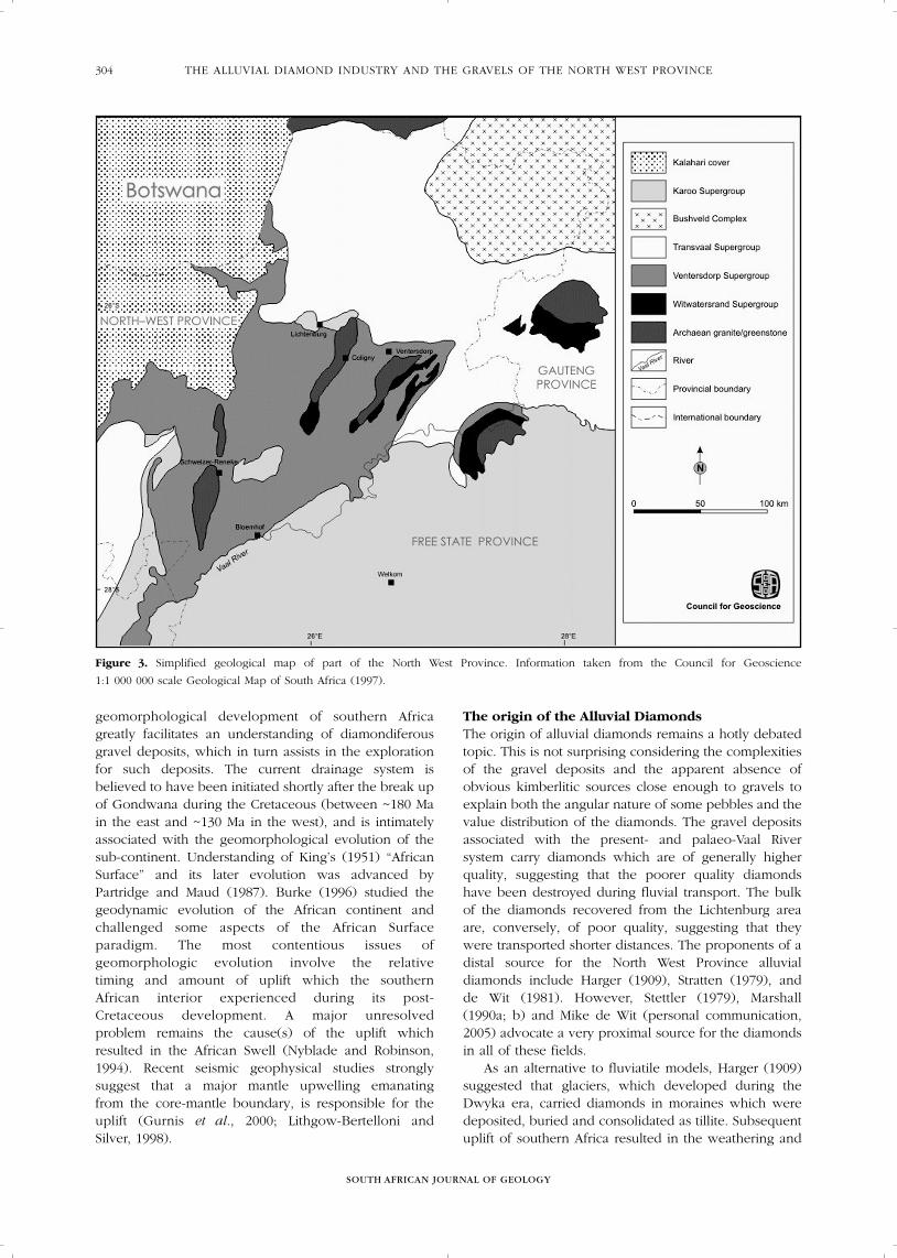
Controls on Diamond deposition andconcentrationBedrock GeologyMuch of the North West Province is covered by shaleand mudstone of the Ecca Group, with rare exposures of Dwyka Group tillite (SACS, 1980). Where these
sedimentary rocks have been removed, Archaean and Proterozoic rocks are exposed (Figure 3). The Ventersdorp Supergroup (primarily theKlipriviersberg Group lavas with lesser BothavilleFormation sediments) form the bedrock to the vastmajority of the alluvial deposits. In some areas, bothDwyka and Ecca deposits are preserved underCainozoic gravels.
Although the bulk of the diamondiferous gravels arerecent and unconsolidated, the bedrock, over whichpalaeo-rivers flowed, played a significant role in theconcentrating of diamonds. Depending on the resistanceof the bedrock to river erosion, traps such as riffles andpotholes may develop in the river bed. Such traps morecommonly form in Ventersdorp lavas than in thehorizontally bedded shales of the Dwyka and Transvaalsuccessions. During deposition, diamonds, being denserand harder than most other river-born sediments, tend toconcentrate in depressions in the irregular bedrock.Diamond concentrations in pothole gravels can be up to100 times those of gravels not associated with suchfeatures.
Structural InfluenceThe structural features developed in the variouslithologies include different ages and magnitudes offaults, fractures, and joints. Their patterns andintersections control the location of dykes, and influencethe drainage patterns (including the location of pans), as well as the development of numerous karst features (on dolomite). Because the various rock strata exhibitdifferent structural patterns, the drainage courses overthem show significant variation.
Geomorphic EvolutionThe distribution of alluvial diamond deposits in southernAfrica is controlled by the evolution of palaeo-drainagesystems. As a result, a thorough understanding of the
Figure 2. Diagrammatic representation of relationships amongst colluvial, eluvial and alluvial gravels in the Vaal River system (modified
after Marshall, 1990a).
geomorphological development of southern Africagreatly facilitates an understanding of diamondiferousgravel deposits, which in turn assists in the explorationfor such deposits. The current drainage system isbelieved to have been initiated shortly after the break upof Gondwana during the Cretaceous (between ~180 Main the east and ~130 Ma in the west), and is intimatelyassociated with the geomorphological evolution of thesub-continent. Understanding of King’s (1951) “AfricanSurface” and its later evolution was advanced byPartridge and Maud (1987). Burke (1996) studied thegeodynamic evolution of the African continent andchallenged some aspects of the African Surfaceparadigm. The most contentious issues ofgeomorphologic evolution involve the relative timing and amount of uplift which the southern African interior experienced during its post-Cretaceous development. A major unresolved problem remains the cause(s) of the uplift whichresulted in the African Swell (Nyblade and Robinson,1994). Recent seismic geophysical studies stronglysuggest that a major mantle upwelling emanating from the core-mantle boundary, is responsible for theuplift (Gurnis et al., 2000; Lithgow-Bertelloni and Silver, 1998).
The origin of the Alluvial DiamondsThe origin of alluvial diamonds remains a hotly debatedtopic. This is not surprising considering the complexitiesof the gravel deposits and the apparent absence ofobvious kimberlitic sources close enough to gravels toexplain both the angular nature of some pebbles and thevalue distribution of the diamonds. The gravel depositsassociated with the present- and palaeo-Vaal Riversystem carry diamonds which are of generally higherquality, suggesting that the poorer quality diamondshave been destroyed during fluvial transport. The bulkof the diamonds recovered from the Lichtenburg areaare, conversely, of poor quality, suggesting that theywere transported shorter distances. The proponents of adistal source for the North West Province alluvialdiamonds include Harger (1909), Stratten (1979), and de Wit (1981). However, Stettler (1979), Marshall (1990a; b) and Mike de Wit (personal communication,2005) advocate a very proximal source for the diamondsin all of these fields.
As an alternative to fluviatile models, Harger (1909)suggested that glaciers, which developed during theDwyka era, carried diamonds in moraines which weredeposited, buried and consolidated as tillite. Subsequentuplift of southern Africa resulted in the weathering and
SOUTH AFRICAN JOURNAL OF GEOLOGY
THE ALLUVIAL DIAMOND INDUSTRY AND THE GRAVELS OF THE NORTH WEST PROVINCE304
Figure 3. Simplified geological map of part of the North West Province. Information taken from the Council for Geoscience
1:1 000 000 scale Geological Map of South Africa (1997).

M.G.C. WILSON, G. HENRY AND T.R. MARSHALL
SOUTH AFRICAN JOURNAL OF GEOLOGY
305
erosion of the Dwyka tillite which released both gravelclasts and diamonds into the prevailing drainagesystems. Maree (1987) expanded considerably on theDwyka origin for the southern African alluvial diamondsas have Moore and Moore (2004).
With the exception of Harger (1909), who advocateda Ventersdorp lava origin for the diamonds, mostresearchers ascribe a kimberlitic source to the diamonds.The majority of the productive kimberlite intrusions insouthern Africa are Cretaceous in age (Smith, et al.,1985; Lynn et al., 1998). This argues against the Dwyka glaciation model which requires a pre-Permianage for the diamonds. However, numerous olderdiamondiferous kimberlite clusters are also known toexist (e.g. Jwaneng (± 250 Ma), Venetia (± 520 Ma),Premier (± 1200 Ma)) or are inferred to have existed(diamonds in >2.7 Ga Witwatersrand Supergroupauriferous reefs). These older deposits may also havecontributed to the alluvial diamond budget.
With regard to the Lichtenburg field, de Wit et al.(1998) and de Wit (personal communication,2002/2004/2005)) reported preliminary indications thatkimberlitic dykes/fissures may have intruded thedolomitic karst terrane and were subsequently erodedand infilled with gravel, in some cases formingdiamondiferous gravel “runs”. A zircon grain recoveredfrom highly decomposed ultrabasic, ultramafic materialfrom deep within one of the potholes was dated at ~500 Ma, implying a pre-Karoo age for the possiblekimberlite fissure. Further exploration for these potentialkimberlite intrusions has been limited due to the lowvalue of the diamonds recovered from the Lichtenburgalluvial deposits as well as the limited expected size ofthe intrusions that remain after the significant erosionthat has taken place since emplacement.
In the Schweizer-Reneke and Bloemhof districts,evidence for a kimberlitic origin of the diamonds isfound in the results of the analysis of numerous heavyminerals. For example, analysis of garnets from alluvialdiamond diggings on the farm Goudplaats 96 HO in theSchweizer-Reneke district, indicated that 35% were fromkimberlitic sources (de Bruin and Kiefer, 2004) andgarnets from alluvial diamond workings on the farmVaalbank 355 HO, north of the Bloemhof Dam, revealedthat 67% were from kimberlitic sources (de Bruin, 2005).See also mineral chemical analyses presented byMarshall (1990b).
Diamond exploration techniquesThe initial discoveries of alluvial diamonds were madeby old fashioned prospecting using keen observation ofdrainage channels and opening up with a pick andshovel. Shortly after the initial discoveries, most surficialgravels were tested for payability, with the richer runsbeing exploited immediately.
Marshall and Baxter-Brown (1995) outlined the basicprinciples of modern, grassroots alluvial diamondexploration. They emphasize that there is no single,universally applicable method of target selection for
alluvial diamond deposits. However, a number ofexploration techniques are available and include remotesensing, geophysical surveys, drilling/pitting and bulk-sampling (Marshall, 2003).
Remote Sensing MethodsLandsat TM, Aster, RadarSat, DEM, IR-thermal images areall extremely useful for regional interpretation and targetgeneration, but may have limited use in detailed farmscale applications. SPOT images offer better resolutionbut can be costly for the smaller operator. Aerialphotographs are essential for any exploration operation.Black and white photos are easy and cheap to acquireand are useful for mine planning as well as prospecting.Colour photos are even more useful, but since they haveto be specially commissioned, they can work out quiteexpensive for the smaller operator. In dolomitic terrains,colour infra-red photos have proved very useful butagain they have to be specially commissioned and arecostly. All remote sensing techniques can be extremelyuseful when combined with geophysical or geologicaldata in one or other of the commercially availableexploration/mining software programmes. However,ground verification and mapping are essential.
Geophysical MethodsWhilst carefully selected geophysical techniques provideuseful information, it is essential that these surveys aresupplemented by some combination of drilling, pittingand trenching, in order to determine the true nature ofthe anomalies located, as well as to confirm anyvolumetric estimation. Diamond grade and value canonly be determined by completing a bulk-samplingprogramme.
Gravity A variety of geophysical techniques have been appliedwith mixed success to locate and evaluate the extent ofalluvial diamond deposits. The most useful methodshave been gravity (both ground and airborne) and avariety of electro-magnetic methods. Stettler (1979), de Wit (1981) and Stettler et al., (1995) have shown that ground gravimetrics can be applied to locatepotholes and similar features buried beneath sand andsoil cover, particularly in dolomitic terrains. Morerecently the technology to produce airborne gravitysurveys has been developed by BHP Billiton (Falcon™)and Bell Geospace (3D Air FTG®). In late 2003 the Air FTG® was used successfully to identify, characterise and map known palaeochannel depositssurrounding the Tirisano Mine, near Ventersdorp(http://www.etruscan.com).
Electro-magneticsExtensive practical experience in the southern,Schweizer-Reneke Field, has shown that EM31 surveysare particularly effective at locating shallow graveldeposits, especially the “Rooikoppie” type gravels. Fordeeper deposits and those associated with calcretized

palaeochannels ERT (electro-resistivity tomography) hasalso been shown to be effective. One of the advantagesof this system is that a pseudosection can be createdfrom the data, giving an approximate picture of the truesubsurface resistivity distribution (Loke, 1999). Sinceground resistivity is closely related to various geologicalparameters, resistivity pseudosections can be viewed asapproximating geological sections.
Airborne electromagnetics is a technique whichincreasingly is playing an important role in locating new gravel deposits. It is, however, generally veryexpensive. The Council for Geoscience of South Africais currently developing its own, hopefully moreaffordable system which is scheduled to be ready for usein 2006.
Ground Penetrating Radar (GPR)GPR is another high resolution method which can beused for imaging the subsurface structure. Resolution iscontrolled by the wavelength of the propagatingelectromagnetic wave in the ground and increases withincreasing frequency. The depth of investigationincreases with decreasing frequency but is accompaniedby a decrease in resolution. The depth of investigationranges from less than a metre in clay rich soils to some30 m in fresh-water saturated, clay-free sands.
Drilling/PittingDepending on the various characteristics of a deposit,auger, percussion and reverse circulation (RC) drilling,can all be useful. In most cases, RC drilling gives a muchclearer definition of gravel thicknesses and types, but itshigher cost may mitigate against its use. In dolomiteterrains, where manganese wad presents a problem, RC drilling is indispensable. In shallow gravels, it is oftenmore cost-effective simply to proceed directly to thepitting phase and complete the entire programme with asmall excavator or tractor-loader-backhoe.
Bulk-SamplingIn alluvial deposits, diamonds occur in clusters withinnatural traps such as gullies, potholes and gravel barsand are unevenly distributed within such trapsites. In addition, the individual diamonds themselvesconstitute discrete units of varying size and weight andare not evenly or uniformly distributed throughout analluvial deposit. The clusters are not only randomlydistributed in space, but the point density of each clusteris also random (Rombouts, 1987).
Consequently, in order for the estimated diamondgrade of a prospect to be reliable, sample sizes need tobe relatively large. Due to the nature of the distributionof diamonds throughout a deposit, the grade estimatedfrom any individual sample can vary widely. A singlesample provides only a limited amount of informationand the conclusions drawn from a single sample are,correspondingly, uncertain.
In diamondiferous gravel deposits where the averagegrade is measured in carats per hundred tonnes and
where individual stone sizes are in the order of 1 caratper stone, then it is necessary to process manythousands of tonnes of sample material (compositedfrom numerous individual samples) to obtain astatistically meaningful sample grade and representativeinformation relating to diamond size distribution andvalue. Such large samples, however, also allow for thedetermination of treatment plant specifications neededin the trial mining phase and what stripping ratios willbe economic. In the future, the sizes and number ofsamples may be dependent on guidelines from theSAMREC code that has been devised by the SouthAfrican Mineral Resources Evaluation Committee(http://www.saimm.co.za). Until this code is fullyoperational, however, as a rule of thumb, one wouldlike to see at least a 5% sample for an inferred resourcewith a preferred minimum of some 50 000 tonnes, bulkedfrom at least 4 or 5 individual samples. Obviously,significantly larger samples would be required for betterlevels of resource and reserve estimation.
Details of the mining, processing and beneficiationof alluvial diamond deposits, although of enormouspractical importance, are outside the scope of thisdiscussion and the interested reader is referred to theAbstract Volume of the “Diamonds: Source to Use(2005)” Symposium, organized by the South AfricanInstitute of Mining and Metallurgy (SAIMM).
Detailed descriptions of the geology of the graveldepositsAn alluvial fill is a record of a set of superimposedfloodplains, reflecting an interval of net, but notnecessarily continuous or homogeneous, depositionalong a river valley. Unconformities between alluvial fillsrecord erosional phases when the main stream and itslocal tributaries incised earlier alluvium and bedrocksurfaces, destroying earlier terraces and removing part ofthat alluvial record, leaving behind limited, and usuallytransitory, fill on eroded surfaces. All alluvial sequencesrecord many such erosional and depositional phases.The interpretation of complex alluvial fills is difficultbecause the processes of sediment supply and those oferosion and transport are interrelated, not only to eachother, but also to other factors in the wider geomorphicenvironment. In addition, the processes responsible fora cumulative history of incision and floodplainaggradations have variable magnitude, frequency, spatiallocation and temporal context. Such changes do notoccur with constant intensity through time; may havebeen accomplished by an assortment of events withvariable magnitudes, durations and frequencies; andmay not be uniformly distributed across the river valleyat any particular time.
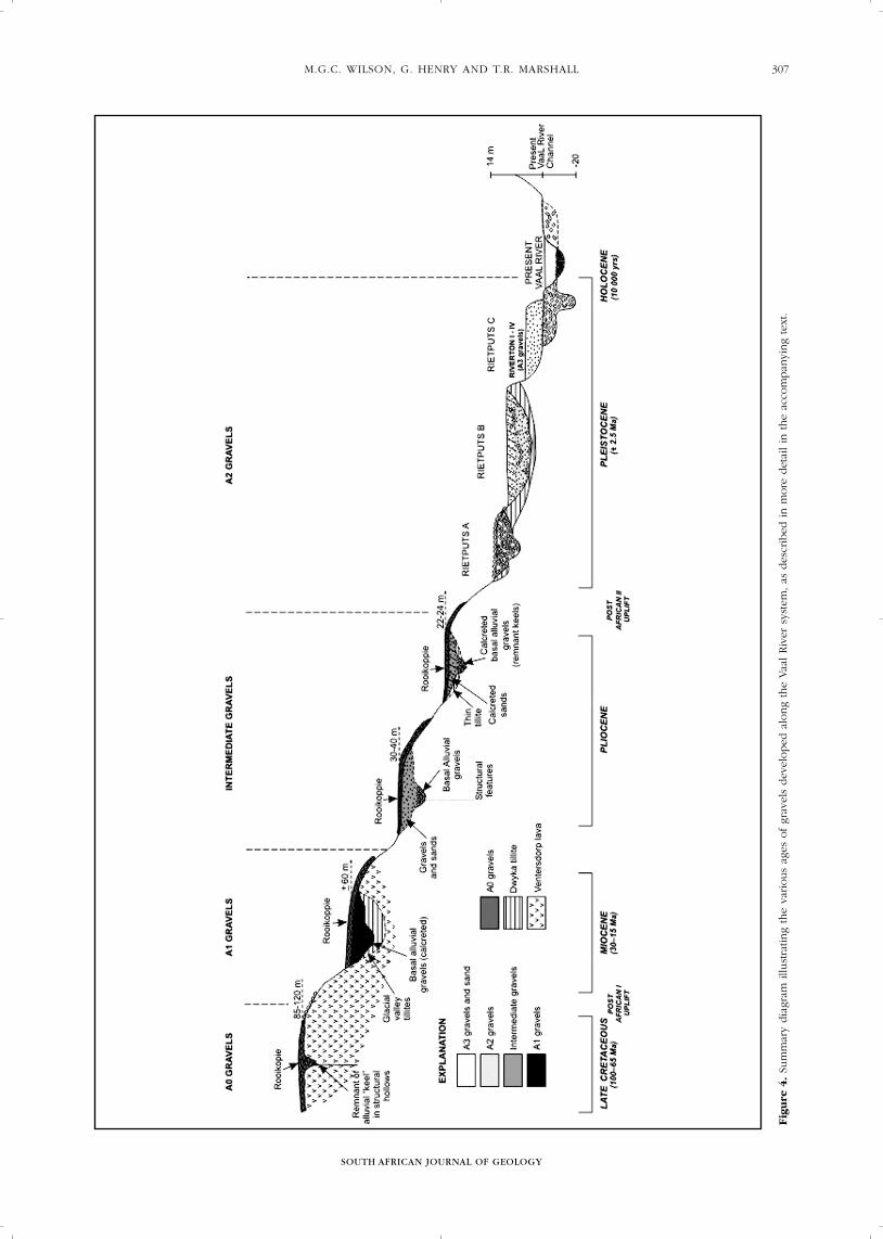
The Upper Vaal River SystemIn the Schweizer-Reneke, Wolmaransstad, Christiana andBloemhof districts of the North West Province (Figure 1),a sequence of five alluvial units and multiple colluvialand eluvial units have been identified (Table 1).
SOUTH AFRICAN JOURNAL OF GEOLOGY
THE ALLUVIAL DIAMOND INDUSTRY AND THE GRAVELS OF THE NORTH WEST PROVINCE306
M.G.C. WILSON, G. HENRY AND T.R. MARSHALL
SOUTH AFRICAN JOURNAL OF GEOLOGY
307
Fig
ure
4.Su
mm
ary
dia
gram
illu
stra
ting
the
various
ages
of
grav
els
dev
eloped
alo
ng
the
Vaa
l Riv
er s
yste
m, as
des
crib
ed in m
ore
det
ail in
the
acco
mpan
ying
text
.

SOUTH AFRICAN JOURNAL OF GEOLOGY
THE ALLUVIAL DIAMOND INDUSTRY AND THE GRAVELS OF THE NORTH WEST PROVINCE308
Figure 5. Plan showing the known diamondiferous alluvial gravels around Lichtenburg, modified after Du Toit (1951).

M.G.C. WILSON, G. HENRY AND T.R. MARSHALL
SOUTH AFRICAN JOURNAL OF GEOLOGY
309

Table 1. Simplified stratigraphy of the Vaal River Gravels (Modified
after SACS, 1980; de Wit et al., 2000).
Mesozoic–Cainozoic Deposits
Upper Pleistocene A3 Gravels (River alluvial gravels)
(Riverton Gravels)
Middle Pleistocene A2 Gravels (Terrace alluvial gravels)
(Rietputs A, B & C Gravels)
Pliocene Intermediate Gravels (alluvial and derived
deposits)
(Proksch Koppie & Wedburg Gravels)
Miocene Extensive Calcretization
A1 Gravel (Primary alluvial gravels and
derived (eluvial) deposits)
(Holpan Gravels)
Upper Cretaceous A0 Gravels (Oldest alluvial gravels and
derived (colluvial) deposits)
(Nooitgedacht Gravels)
A0 GravelsThe oldest A0 gravels are believed to represent a lateCretaceous to early Tertiary drainage net that flowedgenerally southwards to the Vaal River during theAfrican cycle of landscape erosion (de Wit, 1996;Bamford, 2000; de Wit et al., 2000). They are generallyshallow, covered only by 1 to 2 m of windblownKalahari sand and Recent soil. Where the alluvial(channel) component is better preserved, it is composedof any number of oxidised, upward-fining successions.Because the landscape was lowered by weathering anddeflation resulting from more than one episode of post-Cretaceous uplift or sea-level lowering (Partridge and Maud, 1987), the alluvial gravels were eroded andspread out on the surrounding surface to form thin(usually less than 0.5 m), laterally extensive (oftencovering many square kilometres in extent) depositsformed or modified by colluvial or hill-slope processes(Botha and Partridge, 2000). These derived deposits arebest preserved as matrix-supported gravels in pocketswithin deeply weathered Ventersdorp lavas, where thepalaeosurface has produced pseudo-karst features bylaterization processes (Marshall, 1990a). Such gravels areknown locally as Rooikoppie Gravel (Marshall, 2004) dueto their generally reddish colour and location (Figure 4)on elevated terraces (up to 50 m above the presentstream levels).
Very few in-situ alluvial channels have survived post-Cretaceous uplift and the resulting erosion and thosethat have occur only as remnant patches under the moreextensive, derived (colluvial) gravels. Consequentlypalaeodrainage reconstructions are extremely difficult, ifnot impossible. The lithofacies and architecture of theA0 Alluvial deposits, along with the associatedlaterization, reflect the more humid late Cretaceousclimates during which they are thought to have beendeposited (Miall, 1996; Tyson and Partridge, 2000).
A1 GravelsThe African cycle of erosion ended by uplift around the
beginning of the Miocene (Partridge and Maud, 2000),when pre-existing A0 deposits were incised and, inplaces, reworked on the A1 braidplain (Figure 4). As aresult of intense calcretization during the arid Miocene(de Wit, 1993; de Wit and Bamford, 1993), derivedeluvial deposits often overlie the A1 alluvial gravels.These gravels are also termed Rooikoppie Gravels by thelocal diggers as they are shallow or outcroppingdeposits, although quite different in both origin andform from the derived gravels associated with the earlierA0 deposits. The derived gravels, formed by eluvialprocesses, are preserved in solution hollows(makondos) in the hardpan calcrete which frequentlycaps the underlying gravels and are similar to thosedescribed from the lower Vaal River basin (Partridge andBrink, 1967, Marshall, 2004).
Intermediate GravelsThe intermediate gravels occur some 20 to 40 m above,and up to 2 km from, the present river levels. They aremostly eluvial deposits overlying thin alluvial depositswith little or no depth extent, and have generally beenworked out by the artisanal diggers.
A2 GravelsThese are found along the length of the numerous dryspruits in the area and are locally termed “spruit gruis”.They consist generally of a basal diamondiferous gravel up to 2 m thick (deposited on an uneven floor of Ventersdorp lava), overlain by up to 20 m ofupward-fining alluvium and capped by 1 to 3 m of blackcotton soil. The entire sequence is cemented byimmature calcrete. These deposits are the upstreamequivalents of the Rietputs A, B, and C Formationgravels, described by Helgren (1979) from the middleVaal River.
A3 GravelsThe A3 gravels are less than 0.5 m thick and occurbeneath 7 to 20 m of upward-fining gravels, sands, andmuds. They are composed mostly of fine-grained unitsand are not generally commercially mineable. They arepresumed to be the equivalent of the Riverton (1 to 4)Formation deposits (Helgren, 1979).LichtenburgThe origin and processes which led to the depositionand concentration of diamondiferous gravels in theLichtenburg field (Figure 5) remain debatable withregard to the roles of glaciation and karstification.Stettler (1979) viewed these gravels as simple riverdeposits where the river courses were influenced bykarst features and dykes, and the gravel provenancestems from glacial sources. Based on the large numberof kimberlitic garnets found at, for example, Pienaar’sPothole on the farm Ruigtelaagte 353 JP, he originallypostulated that the diamonds originated from as yetundiscovered kimberlitic sources. On the other hand, de Wit and others propose that the gravels may comefrom eskers.
SOUTH AFRICAN JOURNAL OF GEOLOGY
THE ALLUVIAL DIAMOND INDUSTRY AND THE GRAVELS OF THE NORTH WEST PROVINCE310

Gravel StratigraphyIn the Lichtenburg area, the majority of the diamond-bearing gravel units occur as:(1) pothole-fill;(2) as sinuous, discontinuous, narrow, steep-sided
alluvial channels, locally termed runs (Stettler, 1979);or
(3) as laterally more continuous, yet thin sheet-likegravels, assumed to be younger reworked material(Figure 5; Wilson et al., 2005).
Generally the walls of the runs are formed bykaolinised, brecciated, chert and dolomite, or soliddolomite. The channels usually occur as verticallywalled troughs incised into the dolomite. In certainruns, small chert blades, at times in a boxwork form(similar to those that develop in phreatic caves), havebeen observed on the chert walls. Their presencesuggests that there has been minimal abrasion of thesidewalls of the open karst areas during graveldeposition and that the gravels have most likely beendumped into the cavities (as would happen duringcollapse), rather than deposited during transportation bya stream. The potholes in and adjacent to the runs showvarying morphologies ranging from collapse- tosubsidence- dolines, yamas (perpendicular or obliqueshafts leading to caves at depth), wells, lapies (solutionchannels) and buttresses.
SinkholesAccording to early studies (e.g. du Toit, 1951), thegravels in some of the deeper potholes appear to havea fourfold subdivision (Figure 6):• Basal layer (pale or white gravels, grits and clays)• Lower productive gravels (red gravels)• Intermediate unproductive zone (brown clay or sandy
layer)• Upper productive gravels (grey gravels).
Runs or ChannelsIn the runs, the upper gravels usually lie unconformablyabove the lower gravels without the intervening claylayer, although such clays may be present in smalllenses. Stettler (1979) described a gravel run ascomprising a central channel of massive, well-packedgravel with a soil or clay matrix, bounded on both sidesby loose rubble consisting of angular chert fragments,red-brown soil and sporadic rounded pebbles. There isa noticeable lack of definable, horizontal layering,bedding or sorting in both the upper and lower gravels.The contact between the central gravel and the marginalrubble is sharp, but not always erosional. In general the gravels are very coarse and material of pebble-to-boulder grade is common. All gradations exist fromextremely well-rounded to angular chert fragments.
Sheet GravelsSheet gravels (generally <1 m thick) commonly flank theruns and may mark the continuation of a run betweenisolated patches of alluvial deposits. Numerous ages ofthese reworked sheet-like gravels are known to exist;the older deposits are usually economically viable,while the younger sheet gravels are often poorlymineralised, or patchy, at best.
Chert, derived from the Malmani Group, constitutesa major portion of the pebbles found in the graveldeposits. Quartzite pebbles, as well as less abundantshale and petrified wood clasts have most likely beenderived from the Pretoria Group to the north and fromnearby deposits of Ecca and Dwyka tillite respectively.Agates usually occur in large concentrations, but aresporadically distributed. Although they do occur insome shallow alluvial gravel deposits, agates tend to beconcentrated in the lower gravels.
Analyses of the clays and clay-matrix material inmost potholes indicate that they contain kaolin and a
M.G.C. WILSON, G. HENRY AND T.R. MARSHALL
SOUTH AFRICAN JOURNAL OF GEOLOGY
311
Figure 6. Sketch cross-section through Pienaar’s Pothole on the farm Ruigtelaagte 353 JP in the Lichtenburg diamond field (after
Williams, 1930).

high percentage of iron-oxide, reminiscent of bauxite.However, clay compositions suggest an ultramaficprotolith in King’s Pothole (de Wit, personalcommunication, 2003), suggesting the presence ofkimberlitic source material in this case.
Ventersdorp AreaGravel StratigraphyIn the Ventersdorp area, numerous phases of graveldeposition have taken place, resulting in a complexstratigraphy of alluvial gravels and interbedded clays(Marshall, 1990b). Due to the karstic nature of thedolomitic terrain, the majority of the diamond-bearinggravel units occur primarily as sinuous, discontinuous,narrow, steep-sided alluvial channels, locally termedruns, along which potholes may occur (typically atstructural or lithological intersections) and overlain bylaterally more continuous, yet thin, sheet-like deflationgravels, assumed to be younger reworked material. The majority of the diamonds have been recovered from potholes, indicating that they have been anexceptionally effective trapping mechanism.
In profiles exposed in both old diggings andexcavations for current operations, the generalstratigraphy of these deposits is:
Deflation gravelsApproximately 1 m of sporadically developed, highlymanganiferous “float” gravel of variable thickness, froma few centimetres to > 1.5 m. Deflation or sheet gravelsusually occur in the vicinity of the original alluvials,commonly flanking the runs and may mark thecontinuation of a run between isolated patches ofalluvial deposits. Numerous ages of these reworkedgravels are known to exist; the older deposits are usuallyeconomic while the younger sheet gravels are oftenpoorly mineralised or patchy, at best;
Black GravelsUpper 2 m to 5 m of the Mixed Gravel package,intensely lateritised, normally constituted of largeboulders and pebbles of quartzite, chert and chertbreccia as well as vein quartz. These gravels containhigh concentrations of Mn and Fe oxides;
Red/yellow gravels: Cobble-boulder gravel that is moreoxidised at the surface, becoming more yellow withdepth. The oxidised red gravels appear to contain moreclay than the lower gravels. These gravels are theprimary mining target, they may be interbedded withclay (sand) layers, and show a large variation of bouldersize. They can be red in colour when oxidised;Cherty gravelsAlong the walls and bedrock, the gravels contain higherproportions of angular cherty clasts with an abundanceof very large chert boulders close to the bedrock floor.
SummaryThis study was undertaken to assess and verify the
information available on the alluvial diamond fields ofthe North West Province in order to stimulate furtherinterest and investment in this sector of the miningindustry. The liberalization of the diamond marketingsystem led to increased diamond prices and this,coupled with the devaluation of the Rand against theUS$ during late 2001 and 2002, resulted in a significantincrease in onshore alluvial diamond production inSouth Africa.
Though the discovery of the Lichtenburg diamondfield in 1926, made a huge impact on South Africa’sdiamond production, it was short-lived due to the effectsof the Great Depression. Many, otherwise viablediamond operations were forced to close and some ofthese never re-opened. The depth of many of the earlyworkings was limited by the lack of heavy equipmentand, in some instances not all the mineralised horizonswere identified and exploited. As a result it is possiblethat there remains some potential for commercial alluvial diamond mining in this area. The successfuldevelopment of the Tirisano Mine in the Ventersdorparea, adds credence to this assertion.
These diamond fields are largely underlain bydolomites that have undergone at least four phases of karst development. Even though several phases ofgravel deposition have occurred, the distribution of thediamondiferous gravels is influenced by weatheringfeatures in the dolomite and these now occur aspothole-fill, or as sinuous, discontinuous, narrow, steep-sided alluvial channels, or as laterally more continuous,yet thin sheet-like gravels, assumed to be youngerreworked material. Pot holes (or sinkholes) have formedexcellent trap sites for diamonds and enormousquantities of diamonds have been recovered from someof these.
There is a growing body of evidence which indicatesthat kimberlitic dykes may have intruded the dolomiticcountry rock in the Lichtenburg area and have beendeeply eroded, leaving channels which weresubsequently filled by diamondiferous gravels, formingsome of the mineralized “runs” in the area.
Research in the southern diamond field has definedand classified five ages of alluvial gravels (ranging fromlate Cretaceous to the Pleistocene). The primary alluvialgravels have been modified post-deposition, by eluvialand colluvial processes, forming the ubiquitous“Rooikoppie” deposits. The alluvial diamonds associatedwith the gravel deposits in the Christiana, Schweizer-Reneke, Wolmaransstad and Bloemhof districts aregenerally of high quality, as a result of the presence oflarger stones (50 to 200 ct).
In recent years there have been important advancesin the techniques used for the exploration of alluvialdiamond deposits. In addition to the traditional aerial photography, a number of different varieties ofhigh resolution satellite images are readily available and, along with digital elevation models, have proveduseful in delineating regional targets. Various airborne and ground geophysical techniques have been
SOUTH AFRICAN JOURNAL OF GEOLOGY
THE ALLUVIAL DIAMOND INDUSTRY AND THE GRAVELS OF THE NORTH WEST PROVINCE312
M.G.C. WILSON, G. HENRY AND T.R. MARSHALL
SOUTH AFRICAN JOURNAL OF GEOLOGY
313
used to great advantage in the defining of individualtargets.
The extremely low concentrations of diamondpresent in most alluvial deposits and the almost randomdistribution of the diamonds within the gravels,necessitate very large samples in order that the gradeand quality of the diamonds can be meaningfullyevaluated and commercial viability established.
AcknowledgementsDrs. Edgar Stettler, Mike de Wit, John Ward and Deon de Bruin, are thanked for commenting on earlierversions of this paper and for adding several importantobservations from their vast experience in these areas.Ms. K. Guzek drafted the figures. Tim Partridge andMike de Wit are thanked for their referee’s commentswhich helped improve the paper. Mike Wilson andGeorge Henry thank the Council for Geoscience forpermission to publish the paper.
References Bamford, M.K. (2000). Cenozoic Macro-plants. In: T.C. Partridge and
R.R. Maud (Editors). The Cenozoic of Southern Africa. Oxford Monographs
on Geology and Geophysics, Oxford University Press, New York, United
States of America, 40, 351-356.
Botha, G.A. and Partridge, T.C. (2000). Colluvial deposits. In: T.C. Partridge
and R.R. Maud (Editors), The Cenozoic of Southern Africa. Oxford
Monographs on Geology and Geophysics, Oxford University Press, New
York, United States of America, 40, 88-99.
Burke, K. (1996). The African Plate. South African Journal of Geology,
99, 341-409.
Damarupurshad, A. (2004). Diamonds. In: South African Minerals Industry
2003/4. Directorate: Mineral Economics, Department of Minerals and
Energy, 32-38.
Darracott, B.W. (1973). Preliminary results from gravity and magnetic
surveys of the diamondiferous deposits of the Lichtenburg-Bakerville
area. Unpublished Report of the Geological Survey of South Africa,
GH-1962. 8pp.
Davies, G. and Prevost, X.M. (1978). The geology and mineral resources of
an area around Lichtenburg. Report of the Geological Survey of South Africa,
1978-0137. 64pp.
De Bruin, D. (2005). The mineral chemistry of garnet xenocrysts recovered
during alluvial diamond mining on the farm Vaalbank situated in the
Wolmaransstad district in the Northwest Province, South Africa. Report of
the Council for Geoscience of South Africa, 2005-0033, 11pp.
De Bruin, D. and Kiefer, R. (2004). The mineral chemistry of garnet
xenocrysts recovered during alluvial diamond mining on the farm
Goudplaats situated in the Schweizer-Reneke district in the Northwest-
Cape Province, South Africa. Report of the Council for Geoscience of South
Africa, 2004-0198, 16pp.
De Meillon, L. and Bristow, J. (2002). The changing face of alluvial diamond
mining in South Africa and its relationship to the sedimentology of the
alluvial deposits. Abstracts of the 16th International Sedimentological
Congress, Rand Afrikaans University, Johannesburg, South Africa, 76.
De Wit, M.C.J. (1981). Geophysical investigation and geological
interpretation of part of the diamondiferous gravels on the Grasfontein
farm (356 JP), west of Bakerville. Unpublished MSc Thesis, University of
Pretoria, South Africa. 93pp.
De Wit, M.C.J. (1993). Cainozoic evolution of drainage systems in the
Northwestern Cape Province. Uunpublished PhD Thesis, University of Cape
Town, South Africa. 371pp.
De Wit, M.C.J. (1996). The distribution and stratigraphy of inland alluvial
deposits in South Africa. African Geoscience Reviews, 3, 175-189.
De Wit, M.C.J. and Bamford, M.K. (1993). Fossil wood from the Brandvlei
area, Bushmanland, as an indication of palaeoenvironmental changes
during the Cainozoic. Palaeontologia Africana, 30, 81-89.
De Wit, M.C.J., Morelli, C. and Skinner, C.P. (1998). A reinterpretation of the
Lichtenburg diamond deposits. Extended abstracts of the 7th International
Kimberlite Conference, Cape Town, South Africa. 195.
De Wit, M.C.J., Marshall, T.R. and Partridge, T.C. (2000). Fluvial deposits and
drainage evolution. In: T.C. Partridge and R.R. Maud (Editors), The
Cenozoic of Southern Africa. Oxford Monographs on Geology and
Geophysics, Oxford University Press, New York, United States of America,
40, 55-72.
Draper, D. (1928). On the occurrence of diamonds associated with the chert
beds of the Dolomite Series in the districts of Ventersdorp and Lichtenburg.
Transactions of the Geological Society of South Africa, 30, 57-68.
Du Toit, A.L. (1951). The diamondiferous gravels of Lichtenburg. Memoir of
the Geological Survey of South Africa, 44, 44pp.
Gurnis, M., Mitrovike, J.X., Ritsema, J. and van Heijst, H-J. (2000).
Constraining mantle density structure using the geological evidence of
surface uplift rates: The case of the African Superplume. Geochemistry
Geophysics Geosystems, Electronic Journal, 1, July 2000.
Etruscan Mining website: http://www.etruscan.com
Harger, H.S. (1909). The occurrence of diamonds in Dwyka conglomerate
and amygdaloidal lavas and the origin of the Vaal River conglomerates.
Transactions of the Geological Society of South Africa, 12, 139-158.
Helgren, D.M. (1979). River of diamonds: an alluvial history of the lower Vaal
Basin, South Africa. Research paper, Department of Geography, University
of Chicago, United States of America, 185pp.
King. L.C. (1951). South African Scenery. Oliver & Boyd, Edinburgh, United
Kingdom, 379pp.
Lithgow-Bertelloni, C. and Silver, P.G. (1998). Dynamic topography, plate
driving forces and the African Superwell. Nature, 395, 269-272.
Loke, M.H. (1999). Electrical imaging studies for environmental and
engineering studies. A practical guide to 2-D and 3-D surveys. Loke,
Panang, Malaysia, 49pp.
Lynn, M.D., Wipplinger, P.E. and Wilson, M.G.C. (1998). Diamonds.
In: M.G.C. Wilson and C.R. Anhaeusser (Editors), The Mineral Resources of
South Africa. Handbook of the Council for Geoscience of South Africa,
16, 232-258.
Maree, D.B. (1987). Die afsetting en verspreiding van spoel diamante in Suid
Afrika. South African Journal of Geology, 90, 428-447.
Marshall, T.R. (1986). The alluvial diamond fields of the western Transvaal.
Information Circular of the Economic Geology Research Unit, University of
the Witwatersrand, Johannesburg, South Africa. 188, 13pp.
Marshall, T.R. (1990a). The nature, origin and evolution of the
diamondiferous gravels of the southwestern Transvaal. Unpublished
PhD Thesis, University of the Witwatersrand, Johannesburg, South Africa,
211pp.
Marshall, T.R. (1990b). The nature, origin and evolution of the Lichtenburg-
Ventersdorp alluvial diamond field. Unpublished Report of Gold Fields of
South Africa, 100pp.
Marshall, T.R. (2003). The prospecting and evaluation of alluvial diamond
deposits. In, Diamonds – Source to use, Abstract, South African Institute of
Mining and Metallurgy Conference, 29-30 October, 2003, 4pp.
Marshall, T.R. (2004). Rooikoppie deposits of South Africa. Rough Diamond
Review, September 2004, 21-25.
Marshall, T.R. and Baxter-Brown, R. (1995). Basic principles of alluvial
diamond exploration. Journal of Geochemical Exploration, 53, 277-292.
Mayer, J.J. (1979). Morphotectonic development of the Harts River Valley in
relation to the Griqualand-Transvaal axis and the Vaal and Molopo River.
Transactions of the Geological Society of South Africa, 73, 183-194.
Miall, A. D. (1996). The Geology of Fluvial Deposits. Sedimentary facies,
Basin analysis and Petroleum geology. Springer-Verlag, Berlin, Germany,
582pp.
Mineweb (2004). South African government, small-scale miners tussle.
09/11/2004. http://www.mineweb.com
Mining News (2005). SA Diamond Diggers Desperate. March, 2005.
http://www.infomine.com .
Moore, J.M. and Moore, A.E. (2004). The roles of primary kimberlitic
and secondary Dwyka glacial sources in the development of alluvial and
marine diamond deposits in Southern Africa. Journal of African Earth
Sciences, 38, 115-134.
Nyblade, A.A. and Robinson, S.W. (1994). The African Superswell.
Geophysical Research Letters, 21, 765-768.
Partridge, T.C. and Brink, A.B.A. (1967). Gravels and terraces of the lower
Vaal basin. South African Geographical Journal, 49, 21-38.
Partridge, T.C. and Maud, R.R. (1987). Geomorphic evolution of southern
Africa since the Mesozoic. South African Journal of Geology, 90, 179-208.
Partridge, T.C. and Maud, R.R. (Editors) (2000). The Cenozoic of southern
Africa. Oxford Monographs on Geology and Geophysics, Oxford University
Press, New York, United States of America, 40, 406pp.
Retief, E.A. (1960). The diamondiferous gravels in the Lichtenburg-
Ventersdorp area. Report of the Geological Survey of South Africa,
1960-0004, 68pp.
Rombouts, L. (1987). Evaluation of Low Grade/High Value Diamond
Deposits. Mining Magazine (September, 1987), 217-220.
Smith, C.B., Allsop, H.L., Kramers, J.D., Hutchinson, G. and Roddick, J.C.
(1985). Emplacement ages of Jurassic-Cretaceous South African kimberlites
by the Rb-Sr method on phlogopite and whole rock samples: Transactions
of the Geological Society of South Africa, 88, 249-266.
Stettler, E.H. (1979). A geological and geophysical investigation of the
diamond runs on Ruigtelaagte and vicinity, in the Bakerville area,
Lichtenburg District. Unpublished MSc Thesis, University of Pretoria, South
Africa, 112pp.
Stettler, E.H., Kleywegt, R.J. and de Wit, M.C.J. (1995). Geophysical
prospecting for diamonds in the Lichtenburg District, western Transvaal.
Southern African Geophysical Review, 1, 55-69.
Stratten, T. (1979). The origin of the diamondiferous alluvial gravels in the
southwestern Transvaal. In: A.M. Anderson and W.J. van Biljon (Editors).
Some sedimentary basins and associated ore deposits of South Africa.
Special Publication of the Geological Society of South Africa, 6, 219-228.
SACS (South African Committee for Stratigraphy) (1980). Stratigraphy of
South Africa. Part 1. Lithostratigraphy of the Republic of South Africa, South
West Africa/Namibia, and the Republics of Bophuthatswana, Transkei and
Venda. L. E. Kent (Compiler). Handbook of the Geological Survey of South
Africa, 8, 690pp.
Tyson, P.D. and Partridge, T.C. (2000). Evolution of Cenozoic climates.
In: T.C. Partridge and R.R. Maud (Editors). The Cenozoic of Southern
Africa. Oxford Monographs on Geology and Geophysics, Oxford University
Press, New York, United States of America, 40, 371-387.
Wagner, P.A. (1914). The Diamond Fields of South Africa. Transvaal Leader,
Johannesburg, South Africa, 347pp.
Williams, A.F. (1930). Diamond-bearing alluvial gravels of the Union of South
Africa. 3rd Empire Mining and Metallurgical Congress, South Africa,
21-189.
Wilson, M.G.C., Henry, G. and Marshall, T.R. (2005). Alluvial Diamonds of
the Northwest Province. Report of the Council for Geoscience of South
Africa, 2005-0096, 50pp.
Editorial handling: J. M. Barton Jr
SOUTH AFRICAN JOURNAL OF GEOLOGY
THE ALLUVIAL DIAMOND INDUSTRY AND THE GRAVELS OF THE NORTH WEST PROVINCE314