Embed Size (px)
Citation preview
A Robust Noise Resistant Algorithm for POI Identification from Flickr Data∗
Yiyang Yang? Zhiguo Gong§† Qing Li¶ Leong Hou U§ Ruichu Cai? Zhifeng Hao‡
?Faculty of Computer, Guangdong University of Technology, Guangzhou, China§Department of Computer and Information Science, University of Macau, Macau SAR¶Department of Computer Science, City University of Hong Kong, Hong Kong SAR
‡School of Mathematics and Big Data, Foshan University, Foshan, China
Abstract
Point of Interests (POI) identification using socialmedia data (e.g. Flickr, Microblog) is one of themost popular research topics in recent years. How-ever, there exist large amounts of noises (POI irrel-evant data) in such crowd-contributed collection-s. Traditional solutions to this problem is to set aglobal density threshold and remove the data pointas noise if its density is lower than the threshold.However, the density values vary significantly a-mong POIs. As the result, some POIs with relative-ly lower density could not be identified. To solvethe problem, we propose a technique based on thelocal drastic changes of the data density. First wedefine the local maxima of the density function asthe Urban POIs, and the gradient ascent algorithmis exploited to assign data points into different clus-ters. To remove noises, we incorporate the Lapla-cian Zero-Crossing points along the gradient ascentprocess as the boundaries of the POI. Points locat-ed outside the POI region are regarded as noises.Then the technique is extended into the geographi-cal and textual joint space so that it can make use ofthe heterogeneous features of social media. The ex-perimental results show the significance of the pro-posed approach in removing noises.
1 IntroductionFlickr contains more than 8 billions photos from 8.7 millionusers; in addition, 3.5 million new photos are uploaded toFlickr daily where a substantial number of these photos come
∗We thank the anonymous reviewers for their many insight-ful comments and suggestions. This work was supported inpart by: NSFC-Guangdong JF (U1501254), NSFC (61603101,61472089, 61472337), NSF-Guangdong (2014A030306004,2014A030308008), STPP of Guangdong (2015B010108006,2015B010131015), FDCT of Macau Government (FDC-T/116/2013/A3, FDCT/007/2016/AFJ), UMAC RC (MYRG2015-00070-FST, MYRG2017-00212-FST, MYRG2016-00182-FST),GuangdongHPSSP(2015TQ01X140), TPP of Guangzhou(201610010101, 201604016075)†Corresponding Author: [email protected]
A
B C
D(a) Low Noise Filtering
AB C
(b) High Noise Filtering
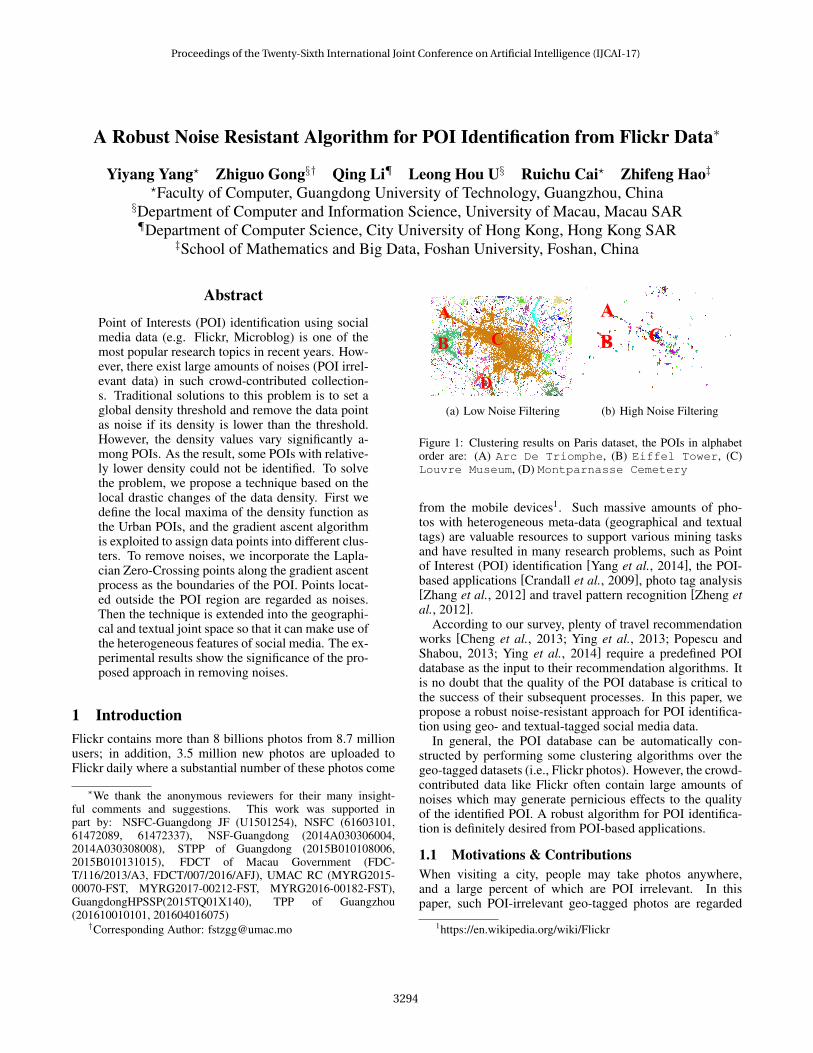
Figure 1: Clustering results on Paris dataset, the POIs in alphabetorder are: (A) Arc De Triomphe, (B) Eiffel Tower, (C)Louvre Museum, (D) Montparnasse Cemetery
from the mobile devices1. Such massive amounts of pho-tos with heterogeneous meta-data (geographical and textualtags) are valuable resources to support various mining tasksand have resulted in many research problems, such as Pointof Interest (POI) identification [Yang et al., 2014], the POI-based applications [Crandall et al., 2009], photo tag analysis[Zhang et al., 2012] and travel pattern recognition [Zheng etal., 2012].
According to our survey, plenty of travel recommendationworks [Cheng et al., 2013; Ying et al., 2013; Popescu andShabou, 2013; Ying et al., 2014] require a predefined POIdatabase as the input to their recommendation algorithms. Itis no doubt that the quality of the POI database is critical tothe success of their subsequent processes. In this paper, wepropose a robust noise-resistant approach for POI identifica-tion using geo- and textual-tagged social media data.
In general, the POI database can be automatically con-structed by performing some clustering algorithms over thegeo-tagged datasets (i.e., Flickr photos). However, the crowd-contributed data like Flickr often contain large amounts ofnoises which may generate pernicious effects to the qualityof the identified POI. A robust algorithm for POI identifica-tion is definitely desired from POI-based applications.
1.1 Motivations & ContributionsWhen visiting a city, people may take photos anywhere,and a large percent of which are POI irrelevant. In thispaper, such POI-irrelevant geo-tagged photos are regarded
1https://en.wikipedia.org/wiki/Flickr
Proceedings of the Twenty-Sixth International Joint Conference on Artificial Intelligence (IJCAI-17)
3294
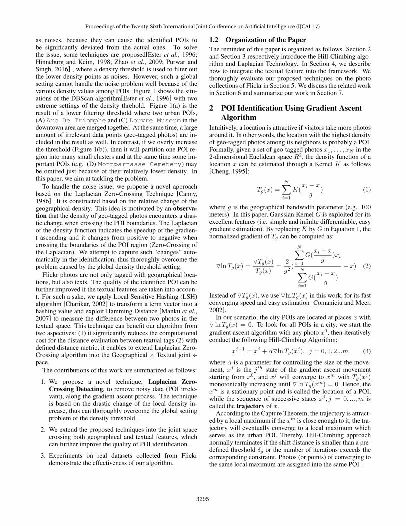
as noises, because they can cause the identified POIs tobe significantly deviated from the actual ones. To solvethe issue, some techniques are proposed[Ester et al., 1996;Hinneburg and Keim, 1998; Zhao et al., 2009; Purwar andSingh, 2016] , where a density threshold is used to filter outthe lower density points as noises. However, such a globalsetting cannot handle the noise problem well because of thevarious density values among POIs. Figure 1 shows the situ-ations of the DBScan algorithm[Ester et al., 1996] with twoextreme settings of the density threhold. Figure 1(a) is theresult of a lower filtering threshold where two urban POIs,(A) Arc De Triomphe and (C) Louvre Museum in thedowntown area are merged together. At the same time, a largeamount of irrelevant data points (geo-tagged photos) are in-cluded in the result as well. In contrast, if we overly increasethe threshold (Figure 1(b)), then it will partition one POI re-gion into many small clusters and at the same time some im-portant POIs (e.g. (D) Montparnasse Cemetery) maybe omitted just because of their relatively lower density. Inthis paper, we aim at tackling the problem.
To handle the noise issue, we propose a novel approachbased on the Laplacian Zero-Crossing Technique [Canny,1986]. It is constructed based on the relative change of thegeographical density. This idea is motivated by an observa-tion that the density of geo-tagged photos encounters a dras-tic change when crossing the POI boundaries. The Laplacianof the density function indicates the speedup of the gradien-t ascending and it changes from positive to negative whencrossing the boundaries of the POI region (Zero-Crossing ofthe Laplacian). We attempt to capture such “changes” auto-matically in the identification, thus thoroughly overcome theproblem caused by the global density threshold setting.
Flickr photos are not only tagged with geographical loca-tions, but also texts. The quality of the identified POI can befurther improved if the textual features are taken into accoun-t. For such a sake, we apply Local Sensitive Hashing (LSH)algorithm [Charikar, 2002] to transform a term vector into ahashing value and exploit Hamming Distance [Manku et al.,2007] to measure the difference between two photos in thetextual space. This technique can benefit our algorithm fromtwo aspectives: (1) it significantly reduces the computationalcost for the distance evaluation between textual tags (2) withdefined distance metric, it enables to extend Laplacian Zero-Crossing algorithm into the Geographical × Textual joint s-pace.
The contributions of this work are summarized as follows:
1. We propose a novel technique, Laplacian Zero-Crossing Detecting, to remove noisy data (POI irrele-vant), along the gradient ascent process. The techniqueis based on the drastic change of the local density in-crease, thus can thoroughly overcome the global settingproblem of the density threshold.
2. We extend the proposed techniques into the joint spacecrossing both geographical and textual features, whichcan further improve the quality of POI identification.
3. Experiments on real datasets collected from Flickrdemonstrate the effectiveness of our algorithm.
1.2 Organization of the PaperThe reminder of this paper is organized as follows. Section 2and Section 3 respectively introduce the Hill-Climbing algo-rithm and Laplacian Technology. In Section 4, we describehow to integrate the textual feature into the framework. Wethoroughly evaluate our proposed techniques on the photocollections of Flickr in Section 5. We discuss the related workin Section 6 and summarize our work in Section 7.
2 POI Identification Using Gradient AscentAlgorithm
Intuitively, a location is attractive if visitors take more photosaround it. In other words, the location with the highest densityof geo-tagged photos among its neighbors is probably a POI.Formally, given a set of geo-tagged photos x1, . . . , xN in the2-dimensional Euclidean space R2, the density function of alocation x can be estimated through a Kernel K as follows[Cheng, 1995]:
Tg(x) =
N∑i=1
K(xi − xg
) (1)
where g is the geographical bandwidth parameter (e.g. 100meters). In this paper, Gaussian Kernel G is exploited for itsexcellent features (i.e. simple and infinite differentiable, easygradient estimation). By replacing K by G in Equation 1, thenormalized gradient of Tg can be computed as:
OlnTg(x) =OTg(x)Tg(x)
=2
g2(
N∑i=1
G(xi − xg
)xi
N∑i=1
G(xi − xg
)
− x) (2)
Instead of OTg(x), we use OlnTg(x) in this work, for its fastconverging speed and easy estimation [Comaniciu and Meer,2002].
In our scenario, the city POIs are located at places x withO lnTg(x) = 0. To look for all POIs in a city, we start thegradient ascent algorithm with any photo x0, then iterativelyconduct the following Hill-Climbing Algorithm:
xj+1 = xj + αOlnTg(xj), j = 0, 1, 2...m (3)
where α is a parameter for controlling the size of the move-ment, xj is the jth state of the gradient ascent movementstarting from x0, and xj will converge to xm with Tg(x
j)monotonically increasing until O lnTg(x
m) = 0. Hence, thexm is a stationary point and is called the location of a POI,while the sequence of successive states xj , j = 0, ...,m iscalled the trajectory of x.
According to the Capture Theorem, the trajectory is attract-ed by a local maximum if the xm is close enough to it, the tra-jectory will eventually converge to a local maximum whichserves as the urban POI. Thereby, Hill-Climbing approachnormally terminates if the shift distance is smaller than a pre-defined threshold δg or the number of iterations exceeds thecorresponding constraint. Photos (or points) of converging tothe same local maximum are assigned into the same POI.
Proceedings of the Twenty-Sixth International Joint Conference on Artificial Intelligence (IJCAI-17)
3295
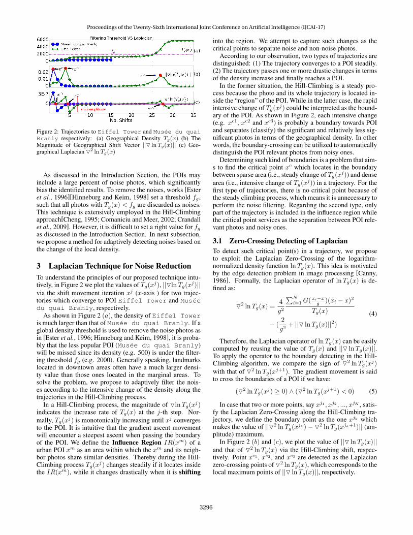
Figure 2: Trajectories to Eiffel Tower and Musee du quaiBranly respectively: (a) Geographical Density Tg(x) (b) TheMagnitude of Geographical Shift Vector ||O lnTg(x)|| (c) Geo-graphical Laplacian O2 lnTg(x)
As discussed in the Introduction Section, the POIs mayinclude a large percent of noise photos, which significantlybias the identified results. To remove the noises, works [Esteret al., 1996][Hinneburg and Keim, 1998] set a threshold fg ,such that all photos with Tg(x) < fg are discarded as noises.This technique is extensively employed in the Hill-Climbingapproach[Cheng, 1995; Comaniciu and Meer, 2002; Crandallet al., 2009]. However, it is difficult to set a right value for fgas discussed in the Introduction Section. In next subsection,we propose a method for adaptively detecting noises based onthe change of the local density.
3 Laplacian Technique for Noise ReductionTo understand the principles of our proposed technique intu-tively, in Figure 2 we plot the values of Tg(xj), ||OlnTg(xj)||via the shift movement iteration xj (x-axis ) for two trajec-tories which converge to POI Eiffel Tower and Museedu quai Branly, respectively.
As shown in Figure 2 (a), the density of Eiffel Toweris much larger than that of Musee du quai Branly. If aglobal density threshold is used to remove the noise photos asin [Ester et al., 1996; Hinneburg and Keim, 1998], it is proba-bly that the less popular POI (Musee du quai Branly)will be missed since its density (e.g. 500) is under the filter-ing threshold fg (e.g. 2000). Generally speaking, landmarkslocated in downtown areas often have a much larger densi-ty value than those ones located in the marginal areas. Tosolve the problem, we propose to adaptively filter the nois-es according to the intensive change of the density along thetrajectories in the Hill-Climbing process.
In a Hill-Climbing process, the magnitude of OlnTg(xj)indicates the increase rate of Tg(x) at the j-th step. Nor-mally, Tg(xj) is monotonically increasing until xj convergesto the POI. It is intuitive that the gradient ascent movementwill encounter a steepest ascent when passing the boundaryof the POI. We define the Influence Region IR(xm) of aurban POI xm as an area within which the xm and its neigh-bor photos share similar densities. Thereby during the Hill-Climbing process Tg(xj) changes steadily if it locates insidethe IR(xm), while it changes drastically when it is shifting
into the region. We attempt to capture such changes as thecritical points to separate noise and non-noise photos.
According to our observation, two types of trajectories aredistinguished: (1) The trajectory converges to a POI steadily.(2) The trajectory passes one or more drastic changes in termsof the density increase and finally reaches a POI.
In the former situation, the Hill-Climbing is a steady pro-cess because the photo and its whole trajectory is located in-side the “region” of the POI. While in the latter case, the rapidintensive change of Tg(xj) could be interpreted as the bound-ary of the POI. As shown in Figure 2, each intensive change(e.g. xc1, xc2 and xc3) is probably a boundary towards POIand separates (classify) the significant and relatively less sig-nificant photos in terms of the geographical density. In otherwords, the boundary-crossing can be utilized to automaticallydistinguish the POI relevant photos from noisy ones.
Determining such kind of boundaries is a problem that aim-s to find the critical point xc which locates in the boundarybetween sparse area (i.e., steady change of Tg(xj)) and densearea (i.e., intensive change of Tg(xj)) in a trajectory. For thefirst type of trajectories, there is no critical point because ofthe steady climbing process, which means it is unnecessary toperform the noise filtering. Regarding the second type, onlypart of the trajectory is included in the influence region whilethe critical point services as the separation between POI rele-vant photos and noisy ones.
3.1 Zero-Crossing Detecting of LaplacianTo detect such critical point(s) in a trajectory, we proposeto exploit the Laplacian Zero-Crossing of the logarithm-normalized density function lnTg(x). This idea is motivatedby the edge detection problem in image processing [Canny,1986]. Formally, the Laplacian operator of lnTg(x) is de-fined as:
O2 lnTg(x) =4
g2
∑Ni=1G(
xi−xg )(xi − x)2
Tg(x)
− (2
g2+ ||O lnTg(x)||2)
(4)
Therefore, the Laplacian operator of lnTg(x) can be easilycomputed by reusing the value of Tg(x) and ||O lnTg(x)||.To apply the operator to the boundary detecting in the Hill-Climbing algorithm, we compare the sign of O2 lnTg(x
j)with that of O2 lnTg(x
j+1). The gradient movement is saidto cross the boundaries of a POI if we have:
(O2 lnTg(xj) ≥ 0) ∧ (O2 lnTg(x
j+1) < 0) (5)
In case that two or more points, say xj1 , xj2 , ..., xjK , satis-fy the Laplacian Zero-Crossing along the Hill-Climbing tra-jectory, we define the boundary point as the one xjk whichmakes the value of ||O2 lnTg(x
jk)− O2 lnTg(xjk+1)|| (am-
plitude) maximum.In Figure 2 (b) and (c), we plot the value of ||O lnTg(x)||
and that of O2 lnTg(x) via the Hill-Climbing shift, respec-tively. Point xc1 , xc2 , and xc3 are detected as the Laplacianzero-crossing points of O2 lnTg(x), which corresponds to thelocal maximum points of ||O lnTg(x)||, respectively.
Proceedings of the Twenty-Sixth International Joint Conference on Artificial Intelligence (IJCAI-17)
3296
Algorithm 1 Detection Influence Region By LaplacianInput: POI set P with trajectories.Output: POI set P ∗ with pruned trajectories
1: for each POI p in P do2: for each trajectory t of p do3: compute normalized Laplacian O2 lnTg(x)
′ by Equa-tion 4
4: compute the zero-crossing points of normalized Lapla-cian by Equation 5
5: if there exists one or more zero-crossing points then6: find the zero-crossing point with maximum ampli-
tude xcmax
7: prune the trajectory t from xcmax to the end as t∗
and add t∗ as trajectory of p8: else9: add t as trajectory of p without pruning
Algorithm 1 demonstrates how to find the Influence Re-gion by the Laplacian. The normalized Laplacian is comput-ed (line 3), according to which the zero-crossing points aredetected. In Line 4 the critical point with maximum ampli-tude is retained as the boundary point since it indicates themost drastic change in density increment. An example is giv-en in Figure 2 (c), the trajectory to Eiffel Tower has twocritical points xc2 and xc3 , and the xc2 with maximum ampli-tude is selected to tune the trajectory (Line 6).
4 Extending the Techniques into the JointSpace
Besides the geographical feature, Flickr photos are taggedwith rich texts too. Recently, works [Bui et al., 2015;Vu and Shin, 2015] attempt to identify POI boundaries us-ing texts, in which the POI boundaries are determined bythe drastic change of the text similarity between the detectingpoint and the POI center. However, both works require thatthe POI database, including the POI center (exact location)and its textual description (extracted from Wikipedia), shouldbe available in advance. In this work, we extend the proposedLaplacian Zero-Crossing technique to the joint space of geo-graphical and textual dimensions. This idea is motivated bythe observation that the photos (or other geo-textual-taggedsocial media like Tweeter) are often described using similartexts within the same region of a POI. These two features to-gether can further improve the quality of the identified POIs.
In the joint space of G× S (G: the geographical space; S:the textual space), let x = (x:g, x:s) denote the point in thespace. Similar to works[Comaniciu and Meer, 2002; Yilmaz,2007], we define the Multi-Variate Kernel in the joint spaceas:
Gg,s(xi − x) = Gg(xi:g − x:g
g)Gs(
xi:s − x:ss
) (6)
where g and s are the bandwidth parameters in the two spacesrespectively, xi = (xi:g, xi:s) and x = (x:g, x:s) are the jointvectors of the geographical and textual features.
A joint vector x = (x:g, x:s) is of length 2 + d, wherethe first two dimensions consist of the latitude and longitudeof the geo-tagged photos and the last d dimensions repre-sent the total number of terms in the vocabulary. The x:s
records the TF · IDF 2 values of the tags in x. So, thetextual feature of a photo is represented as a d-dimensionalvector of terms. The distance of two text vectors xi:s − x:sis defined as the Hamming Distance. Before computing theHamming Distance, it is necessary to convert the text vec-tor into a Local Sensitive Hash (LSH) [Charikar, 2002;Manku et al., 2007] string: a binary hashing value of lengthl (l � d). Hamming Distance between the hashing valuesgives the approximative textual difference between the re-spective vectors (photos). LSH technique is adopted for sev-eral reasons: (1) the cost to textual distance computation isreduced: only l bits comparison; (2) LSH considers the sig-nificance (weight) of the textual tag as well; and (3) the timeof neighborhood search in textual space can be further re-duced if the corresponding indexing technology is employed.
With the Multi-Variant Kernel (c.f. Equation 6), the densityfunction in the joint space is defined as:
Tg,s(x) =N∑i=1
Gg,s(xi − x) (7)
With the Equation 7, we correspondingly have the normal-ized gradient in the joint space as:
O lnTg,s(x) = (OxglnTg,s(x),Oxs
lnTg,s(x)) (8)where Oxg lnTg,s(x) is derived as:
2
g2(
N∑i=1
Gg(xi:g − x:g
g)Gs(
xi:s − x:ss
)xi:g
N∑i=1
Gg(xi:g − xg
g)Gs(
xi:s − x:ss
)
− x:g) (9)
and OxslnTg,s(x) is derived as:
2
s2(
N∑i=1
Gg(xi:g − x:g
g)Gs(
xi:s − x:ss
)xs:i
N∑i=1
Gg(xi:g − xg
g)Gs(
xi:s − x:ss
)
− x:s) (10)
The Laplacian of the joint density function can be easilycomputed as:
O2 lnTg,s(x) = O2xg
lnTg,s(x) + O2xs
lnTg,s(x) (11)
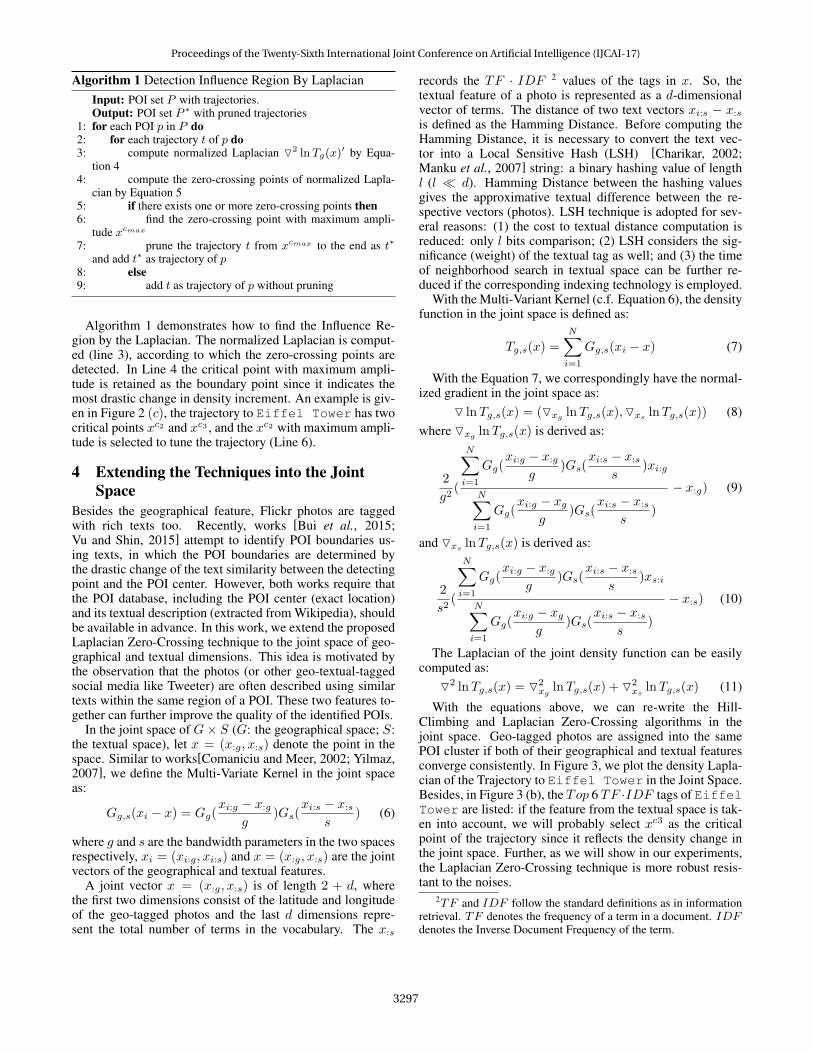
With the equations above, we can re-write the Hill-Climbing and Laplacian Zero-Crossing algorithms in thejoint space. Geo-tagged photos are assigned into the samePOI cluster if both of their geographical and textual featuresconverge consistently. In Figure 3, we plot the density Lapla-cian of the Trajectory to Eiffel Tower in the Joint Space.Besides, in Figure 3 (b), the Top 6 TF ·IDF tags of EiffelTower are listed: if the feature from the textual space is tak-en into account, we will probably select xc3 as the criticalpoint of the trajectory since it reflects the density change inthe joint space. Further, as we will show in our experiments,the Laplacian Zero-Crossing technique is more robust resis-tant to the noises.
2TF and IDF follow the standard definitions as in informationretrieval. TF denotes the frequency of a term in a document. IDFdenotes the Inverse Document Frequency of the term.
Proceedings of the Twenty-Sixth International Joint Conference on Artificial Intelligence (IJCAI-17)
3297
Figure 3: Trajectory to Eiffel Tower in the Geographical ×Textual Joint Space: (a) Joint Laplacian O2 lnTg,s(x) (b) Top 6Textual Tags in terms of the TF · IDF value
Table 1: Photos collections and MBRs dataset
City No. photosNo. points
Latitude andLongitude
No.MBRs
Paris 796,427216,300
[48.815 48.9032.223 2.474
]989
NewYork
1,067,964274,428
[40.499 40.931−74.258 −73.713
]492
Rome 343,91796,738
[41.790 41.98912.368 12.624
]254
5 EvaluationIn this section, we extensively evaluate our proposed tech-niques using three photo datasets collected from Flickr. Weuse the Flickr API3 to collect the photos (including geograph-ical locations, textual tags, and taken time) of a city. Specifi-cally, we use the name of a city as the search query and keeponly relevant photos (i.e., the geo-location is inside of theboundary of city) in our collection. The statistic of our datasetcollections is listed in Table 1. We select three representativecities: New York, Paris and Rome. It should be noticed thatthe number of photos is much more than the number of points,because several photos might be taken at a single point.
In order to evaluate the identified Influence Region (IR),we use the POI information extracted from OpenStreetMap4
as the ground truth: the POIs are retrieved if labeled with“tourism”5. For each POI in the ground truth, we use its Min-imum Bounding Rectangle (MBR) as the actual region. Thenumber of MBRs is shown in fourth column of the Table 1.
The objective of evalution is to measure the similarity be-tween identified Influence Region (IR) and the ground truthMBR. To achieve it, it is necessary to define metrics: (1) F1
score: P = TPTP+FP , R = TP
TP+FN , F1 = P∗R∗2P+R where P
and R denotes the precision and recall respectively. (2) Nor-malized Mutual Information (NMI): NMI(MBR, IR) =
3http://www.flickr.com/services/api/4www.openstreetmap.org5visited on 2016/11/01
I(MBR;IR)[H(MBR)+H(IR)]/2 , where I is the mutual information andH is the entropy. Readers may refer to [Manning et al., 2008]for the detail of the metrics. For both metrics, a higher valueindicates the better identification quality.
In this paper, several baseline approaches are evaluated inour experiments (G : geographical space, S : textual space):
1. DBScan[Ester et al., 1996] is evaluated as well sinceit is widely used in geographic based mining tasks[Esteret al., 1996; Zheng et al., 2009; 2012; Ying et al., 2014;Purwar and Singh, 2016].
2. HC refers to the Mean Shift approach[Cheng, 1995;Hinneburg and Keim, 1998; Crandall et al., 2009; Zhaoet al., 2009]. HCg (Equation 2) andHCg,s (Equation 8)refer to the Mean Shift in theG space and theG×S jointspace respectively.
3. Laplacian refers to our proposed noise resistent frame-work. It is feature independent where Laplaciang andLaplaciang,s denote its applications to the G space andthe G× S joint space respectively.
For all approaches, we select five different values for thegeographical setting: 10, 30, 50, 80, 100 (g in meter). For theG×S joint space based approachesHCg,s andLaplaciang,s,since we adopt Local Sensitive Hash (LSH) to accelerate thetextual distance computation, the length of Hash value (l) isset to 128, while the textual bandwidth (s in Hamming Dis-tance) varies among 30, 50, 60, 80, 100. The global thresh-old (for min phts in DBScan and fg in HC) are set to 50through our preliminary experiment.
In our implementation, R*tree is used as the index andcosts O(logN) for each geographical range query whereN is the number of points, thus the complexity of DB-Scan is O(NlogN). The complexity of Hill-Climbing isO(NMlogN) whereM is the number of average steps (shift-s) for a point to coverage. The complexity of our approach isO(NMlogN + NM), it incurs an additional cost of NMbecause of the zero-crossing detection in each trajectory.
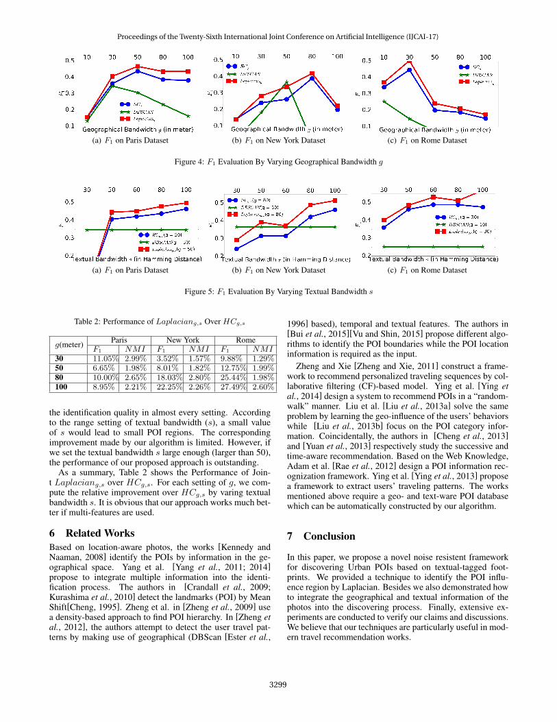
First, we evaluate the approaches in the geographical s-pace. By varying the geographical parameter g, the perfor-mances of the approaches in terms of F1 on three Urbandatasets are shown as in Figure 4. Laplaciang is better thanHCg in all settings because it can automatically find the cen-tral area of the POI while the less significant points are la-beled as noises. Compared to HCg , our Laplaciang gains12% improvement on average in terms of F1 over the threedata collections. In NMI comparison, Laplaciang outper-formsHCg andDBScan in all settings. On average, 3% im-provement can be achieved if Laplacian Technique is appliedto HCg . The detail of NMI comparison is not listed becauseof the space limitation. The experiments on the geographicalspace demonstrate that the proposed Laplacian Technique isan effective approach against noises.
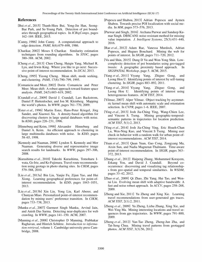
Second, for HCg and DBScan we fix the geographicalparameter g to the setting which leads to the best F1: e.g.Paris g = 50meters, New York g = 80meters, Rome g =30 meters, and further evaluate the performance by varyingthe value of s (textual bandwidth). In the G × S joint space,in terms of the metric F1 (Figure 5), our approach improves
Proceedings of the Twenty-Sixth International Joint Conference on Artificial Intelligence (IJCAI-17)
3298
(a) F1 on Paris Dataset (b) F1 on New York Dataset (c) F1 on Rome Dataset
Figure 4: F1 Evaluation By Varying Geographical Bandwidth g
(a) F1 on Paris Dataset (b) F1 on New York Dataset (c) F1 on Rome Dataset
Figure 5: F1 Evaluation By Varying Textual Bandwidth s
Table 2: Performance of Laplaciang,s Over HCg,s
g(meter) Paris New York RomeF1 NMI F1 NMI F1 NMI
30 11.05% 2.99% 3.52% 1.57% 9.88% 1.29%50 6.65% 1.98% 8.01% 1.82% 12.75% 1.99%80 10.00% 2.65% 18.03% 2.80% 25.44% 1.98%100 8.95% 2.21% 22.25% 2.26% 27.49% 2.60%
the identification quality in almost every setting. Accordingto the range setting of textual bandwidth (s), a small valueof s would lead to small POI regions. The correspondingimprovement made by our algorithm is limited. However, ifwe set the textual bandwidth s large enough (larger than 50),the performance of our proposed approach is outstanding.
As a summary, Table 2 shows the Performance of Join-t Laplaciang,s over HCg,s. For each setting of g, we com-pute the relative improvement over HCg,s by varing textualbandwidth s. It is obvious that our approach works much bet-ter if multi-features are used.
6 Related WorksBased on location-aware photos, the works [Kennedy andNaaman, 2008] identify the POIs by information in the ge-ographical space. Yang et al. [Yang et al., 2011; 2014]propose to integrate multiple information into the identi-fication process. The authors in [Crandall et al., 2009;Kurashima et al., 2010] detect the landmarks (POI) by MeanShift[Cheng, 1995]. Zheng et al. in [Zheng et al., 2009] usea density-based approach to find POI hierarchy. In [Zheng etal., 2012], the authors attempt to detect the user travel pat-terns by making use of geographical (DBScan [Ester et al.,
1996] based), temporal and textual features. The authors in[Bui et al., 2015][Vu and Shin, 2015] propose different algo-rithms to identify the POI boundaries while the POI locationinformation is required as the input.
Zheng and Xie [Zheng and Xie, 2011] construct a frame-work to recommend personalized traveling sequences by col-laborative filtering (CF)-based model. Ying et al. [Ying etal., 2014] design a system to recommend POIs in a “random-walk” manner. Liu et al. [Liu et al., 2013a] solve the sameproblem by learning the geo-influence of the users’ behaviorswhile [Liu et al., 2013b] focus on the POI category infor-mation. Coincidentally, the authors in [Cheng et al., 2013]and [Yuan et al., 2013] respectively study the successive andtime-aware recommendation. Based on the Web Knowledge,Adam et al. [Rae et al., 2012] design a POI information rec-ognization framework. Ying et al. [Ying et al., 2013] proposea framework to extract users’ traveling patterns. The worksmentioned above require a geo- and text-ware POI databasewhich can be automatically constructed by our algorithm.
7 Conclusion
In this paper, we propose a novel noise resistent frameworkfor discovering Urban POIs based on textual-tagged foot-prints. We provided a technique to identify the POI influ-ence region by Laplacian. Besides we also demonstrated howto integrate the geographical and textual information of thephotos into the discovering process. Finally, extensive ex-periments are conducted to verify our claims and discussions.We believe that our techniques are particularly useful in mod-ern travel recommendation works.
Proceedings of the Twenty-Sixth International Joint Conference on Artificial Intelligence (IJCAI-17)
3299
References[Bui et al., 2015] Thanh-Hieu Bui, Yong-Jin Han, Seong-
Bae Park, and Se-Young Park. Detection of poi bound-aries through geographical topics. In ICBigComps, pages162–169. IEEE, 2015.
[Canny, 1986] John Canny. A computational approach toedge detection. PAMI, 8(6):679–698, 1986.
[Charikar, 2002] Moses S Charikar. Similarity estimationtechniques from rounding algorithms. In STOC, pages380–388. ACM, 2002.
[Cheng et al., 2013] Chen Cheng, Haiqin Yang, Michael R.Lyu, and Irwin King. Where you like to go next: Succes-sive point-of-interest recommendation. In IJCAI, 2013.
[Cheng, 1995] Yizong Cheng. Mean shift, mode seeking,and clustering. PAMI, 17(8):790–799, 1995.
[Comaniciu and Meer, 2002] Dorin Comaniciu and PeterMeer. Mean shift: A robust approach toward feature spaceanalysis. PAMI, 24(5):603–619, 2002.
[Crandall et al., 2009] David J. Crandall, Lars Backstrom,Daniel P. Huttenlocher, and Jon M. Kleinberg. Mappingthe world’s photos. In WWW, pages 761–770, 2009.
[Ester et al., 1996] Martin Ester, Hans-Peter Kriegel, JorgSander, and Xiaowei Xu. A density-based algorithm fordiscovering clusters in large spatial databases with noise.In KDD, pages 226–231, 1996.
[Hinneburg and Keim, 1998] Alexander Hinneburg andDaniel A. Keim. An efficient approach to clustering inlarge multimedia databases with noise. In KDD, pages58–65, 1998.
[Kennedy and Naaman, 2008] Lyndon S. Kennedy and MorNaaman. Generating diverse and representative imagesearch results for landmarks. In WWW, pages 297–306,2008.
[Kurashima et al., 2010] Takeshi Kurashima, Tomoharu I-wata, Go Irie, and Ko Fujimura. Travel route recommenda-tion using geotags in photo sharing sites. In CIKM, pages579–588, 2010.
[Liu et al., 2013a] Bin Liu, Yanjie Fu, Zijun Yao, and HuiXiong. Learning geographical preferences for point-of-interest recommendation. In KDD, pages 1043–1051,2013.
[Liu et al., 2013b] Xin Liu, Yong Liu, Karl Aberer, andChunyan Miao. Personalized point-of-interest recommen-dation by mining users’ preference transition. In CIKM,pages 733–738, 2013.
[Manku et al., 2007] Gurmeet Singh Manku, Arvind Jain,and Anish Das Sarma. Detecting near-duplicates for webcrawling. In WWW, pages 141–150. ACM, 2007.
[Manning et al., 2008] Christopher D Manning, PrabhakarRaghavan, and Hinrich Schutze. Introduction to informa-tion retrieval, volume 1. Cambridge university press Cam-bridge, 2008.
[Popescu and Shabou, 2013] Adrian Popescu and AymenShabou. Towards precise POI localization with social me-dia. In MM, pages 573–576, 2013.
[Purwar and Singh, 2016] Archana Purwar and Sandeep Ku-mar Singh. DBSCANI: noise-resistant method for missingvalue imputation. J. Intelligent Systems, 25(3):431–440,2016.
[Rae et al., 2012] Adam Rae, Vanessa Murdock, AdrianPopescu, and Hugues Bouchard. Mining the web forpoints of interest. In SIGIR, pages 711–720, 2012.
[Vu and Shin, 2015] Dung D Vu and Won-Yong Shin. Low-complexity detection of poi boundaries using geo-taggedtweets: A geographic proximity based approach. InSIGSPATIAL Workshop, page 5. ACM, 2015.
[Yang et al., 2011] Yiyang Yang, Zhiguo Gong, andLeong Hou U. Identifying points of interest by self-tuningclustering. In SIGIR, pages 883–892, 2011.
[Yang et al., 2014] Yiyang Yang, Zhiguo Gong, andLeong Hou U. Identifying points of interest usingheterogeneous features. ACM TIST, 2014.
[Yilmaz, 2007] Alper Yilmaz. Object tracking by asymmet-ric kernel mean shift with automatic scale and orientationselection. In CVPR, pages 1–6. IEEE, 2007.
[Ying et al., 2013] Josh Jia-Ching Ying, Wang-Chien Lee,and Vincent S. Tseng. Mining geographic-temporal-semantic patterns in trajectories for location prediction.ACM TIST, 5(1):2, 2013.
[Ying et al., 2014] Josh Jia-Ching Ying, Eric Hsueh-ChanLu, Wen-Ning Kuo, and Vincent S Tseng. Mining usercheck-in behavior with a random walk for urban point-of-interest recommendations. ACM TIST, 2014.
[Yuan et al., 2013] Quan Yuan, Gao Cong, Zongyang Ma,Aixin Sun, and Nadia Magnenat-Thalmann. Time-awarepoint-of-interest recommendation. In SIGIR, pages 363–372, 2013.
[Zhang et al., 2012] Haipeng Zhang, Mohammed Korayem,Erkang You, and David J. Crandall. Beyond co-occurrence: discovering and visualizing tag relationship-s from geo-spatial and temporal similarities. In WSDM,pages 33–42, 2012.
[Zhao et al., 2009] Qi Zhao, Zhi Yang, Hai Tao, and Wen-tai Liu. Evolving mean shift with adaptive bandwidth: Afast and noise robust approach. In ACCV, pages 258–268,2009.
[Zheng and Xie, 2011] Yu Zheng and Xing Xie. Learningtravel recommendations from user-generated gps traces.ACM TIST, 2(1):2, 2011.
[Zheng et al., 2009] Yu Zheng, Lizhu Zhang, Xing Xie, andWei-Ying Ma. Mining interesting locations and travel se-quences from gps trajectories. In WWW, pages 791–800,2009.
[Zheng et al., 2012] Yan-Tao Zheng, Zheng-Jun Zha, andTat-Seng Chua. Mining travel patterns from geotaggedphotos. ACM TIST, 3(3):56, 2012.
Proceedings of the Twenty-Sixth International Joint Conference on Artificial Intelligence (IJCAI-17)
3300