Embed Size (px)
Citation preview
l l l l l l l l l l l l l l l l l l l
42E12NW81S2 2.11825 SANDRA
A Report of the Property of
GLEN AUDEN RESOURCES LIMITED
Dorthea and Eva Townships, Thunder Bay Mining Division,
Ontario
by
R.P. Bowen, P.Eng.
and
Harold Bent
010
l 1988
R.P. BOWEN ENGINEERING INC. P.O. Box 5010, PMS, South Porcupine, Ontario PON 1KO
(705)235-5139
30 September 1988
M-316
lllllllllllllllllll
TABLE OF C* 4aEi2NwatS2 a.ness SANDRA
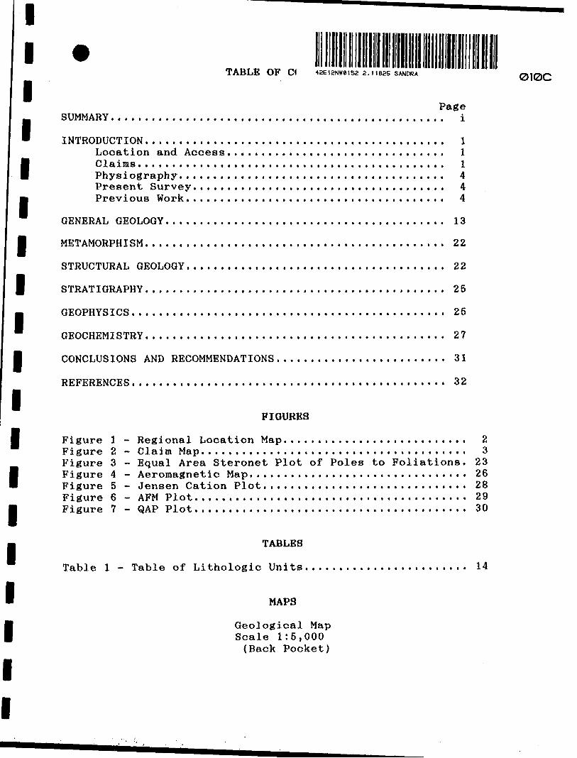
Page SUMMARY................................................. i
INTRODUCTION . . . . . . . . . . . . . . . . . . . . . . . . . . . . . . . . . . . . . . . . . . . . lLocation and Access,..,,.........,.,.....,......... lClaims........................................ . . . . . lPhysiography....,................,.,......,........ 4Present Survey..,...........,.............,........ 4Previous Work.....,........................... . . . . . 4
GENERAL GEOLOGY........................... . ,. . . .,. . ,. . . , 13
METAMORPHISM.....................,.................. . ... 22
STRUCTURAL GEOLOGY...................................... 22
STRATIGRAPHY. . . . . . . . . . . . . . . . . . . . . . . . . . . . . . . . . . . . . . . . . . . . 25
GEOPHYSICS.......................................... . . . . 25
GEOCHEMISTRY............................................ 27
CONCLUSIONS AND RECOMMENDATIONS......................... 31
REFERENCES.............................................. 32
FIGURES
Figure l - Regional Location Map........................... 2Figure 2 - Claim Map. . . . . . . . . . . , . . . . . . . . . . . . . . . . . . . . . . . . . . . 3Figure 3 - Equal Area Steronet Plot of Poles to Foliations. 23Figure 4 - Aeromagnetic Map................................ 26Figure 5 - Jensen Cation Plot.............................. 28Figure 6 - AFM Plot....,...,...................,........... 29Figure 7 - QAP Plot..........................,............. 30
TABLES
Table l - Table of Lithologic Units........................ 14
MAPS
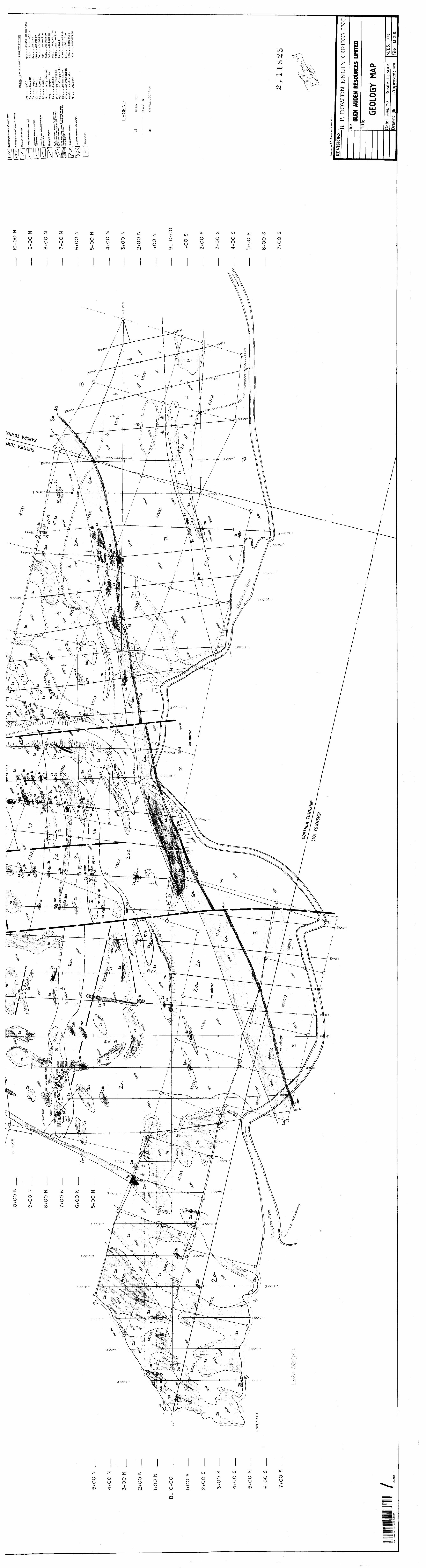
Geological Map Scale 1:5,000 (Back Pocket)
010C
l l l l l l l l l l l l l l l l l l l
SUMMARY
The Glen Auden property comprised of some 63 staked and leased mining claims in Dorthea and Eva Townships, Thunder Bay Mining Division of Ontario is located on the east shore of Lake Nipigon about 180 km northeast of Thunder Bay.The area is underlain by Precambrian metavolcanic and metasedimentary rocks that have been intruded by plutonic plugs and dikes. The metavolcanic rocks are are primarily intermediate to felsic pyroclastic breccias and lesser mafic massive flows. The metasedimentary rocks are made up of polymictic orthoconglomerates, arkose and wackes, siltstones and argillites and some banded oxide affinity iron rich units. Both felsic (quartz feldspar porphyry) and mafic (gabbro) bodies intrude the metavolcanic and metasedimentary units. Cutting all rock units are Middle to Late Precambrian diabase dikes.Gold mineralization has been reported in a number of settings and on the property appears to be most commonly associated with narrow quartz stringers in altered (pyrite-sericite) sheared volcanic breccia in close proximity to felsic plugs. Base metal mineralization (chalcopyrite-molybdenite) has been described associated with quartz stringers and fractures in a granodiorite plug on the property. The oxide affinity iron rich rocks are too narrow and not high enough in iron content to be economic at the present time.While some diamond drill targets have been selected on past information and recent IP/Resistivity surveys further geophysical surveys on a more detailed grid and soil and primary geochemical data could perhaps provide additional targets.
11111
1
*INTRODUCTION
Location and Access
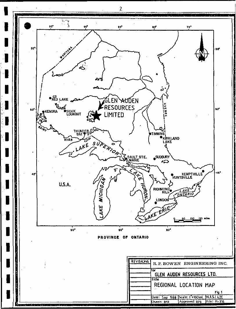
The property is on the east shore of Lake Nipigon, Thunder Bay
Mining Division, Ontario, Figure 1.
Access to the property is gained from Beardmore via Highway 580
1
1
1
1
1
to the mouth of the Sturgeon River then
shore of the river onto the property.
of access would be to turn off Highway
from Highway 11 then to travel north to
River about 5 miles from the river mouth
property may be accessed from the river.
Claims
by boat along the north
An alternative method
580 about 6 kilometers
a point on the Sturgeon
The full length of the
The Glen Auden property consists of 54 staked mining claims and 9
1
1
1
1
1
1
1
1
1
leased mining claims held by Glen Auden Resources Limited mining
license T-1915 in Dorthea, Sandra and Summers Townships, Thunder
Bay Mining Division, Ontario, Figure 2.
Leased Claims
TB 20190 TB 20194TB 20191 TB 20196TB 20193 TB 20197
Staked Claims No.
867026-867030 inclusive 5872223-872241 inclusive 19872244-872245 inclusive 2872247-872249 inclusive 3878381-878401 inclusive 211009078-1009081 inclusive .J.
Total 54
TB 20199TB 20200TB 20201
l l l l l l l l l l lll l l l l l l
SAULT STE. -SUDBURY MARIE
o'
PROVINCE OP ONTARIO
REVISIONS
for
R. P. BOWEN ENGINEERING INC.
GLEN AUDEN RESOURCES LTD.Title
REGIONAL LOCATION MAP
Dale: Sep 1988Driwn: RPB
Scale: l - 160ml.Approved:
Ftg.1N.T.S.: 42EFile: H-316
GLEN AUDEN RESOURCES LIM
878385 j 878388
'878384 !"8389 ' 87839i ' ....4——— -4——— --4--~
Lake
Nipigon
878383 .878390 j 878393 . j 878400
' X ' f4.———— -l J-——-——1/72232
/j X^ j "7223S 1 - — -f-ft-"-t——- ——
SANDRA TWP SUMMERS,JWP/867029 iWrOi R. P. BOWEN ENGINEERING INC
GLEN AUDEN RESOURCES LTD
CLAIM MAPFrom Map 6-116
l l
Physiography
l The claim block is largely drained by the Sturgeon River or
directly into Lake Nipigon. Relief on the property is roughly
B 300 feet. Glacial drift is generally shallow, less than l meter
B and outcrop is common though generally moss covered. The whole
area is tree covered with spruce, cedar t poplar and birch being
l the most common with jackpine, alder and scrub maple less common.
l Present Survey
The present survey was initiated to complement an induced
l polarization/resistivity survey and to re-examine several old
pits and trenches on the property that had returned fairly
significant gold assays, e.g. from pits on claim 20201 Janbekelo
l Investments reported in 1972 assays of 0.179 ounces of gold/ton
over 12 feet, 0.172 ounces of gold/ton over 2 feet and 0.186
f ounces of gold/ton over 2 feet.
. The method used to survey the property was to traverse grid lines
spaced at 200 meter intervals and to trace outcrop off the grid
l lines where it was found. Old trenches were examined and sampled
in an attempt to verify previous results and to gain first hand
f knowledge of the mineralization and setting.
l Previous Work
Using references from the latest government geological work in
8 the area, Mackasey (1975), a fairly complete mineral exploration
B can be put together.
The earliest recorded work in the area is that of Robert Bell in
l 1869 during his exploration of the Lake Superior region for the
l
l l l l l l l l l l l l l l l l l l l
fledgling Geological Survey of Canada. The GSC sent a number of
workers into the area at various times such as Mcinnes in 1894,
Dowling in 1898 and Parks in 1901. The Ontario Bureau of Mines
conducted studies under Coleman (1907) and Coleman and Moore
(1908). The first comprehensive study was conducted by the GSC
under A.W.G. Wilson in 1908 and published as Memoir l in 1910.
With the laying down of the railroad access to the area was
easier and the Ontario Bureau of Mines conducted a survey in
1916, Burrows (1917). Tanton (1921) continued the GSC mapping of
the area and was followed by Langford (1929).
E,L. Bruce (1936) and H.C. Laird (1936) contributed to ntario
Department of Mines Volume 45, Part II which formed the most
comprehensive report on the area up until that time and describes
the mineral deposits in the area at that time. More recently
Peach (1951), Pye (1951) and Horwood and Pye (1955) compiled
detailed information culminating in the geological compilation
Map 2102 by Pye et al (1966). Mackasey (1975) mapped Dorthea,
Sandra and Irwin Townships as part of a concerted effort by the
Ontario Division of Mines to provide detailed basic geological
map coverage of economically important areas.
The Ontario Geological Survey put together a regional compilation
of the Lake Nipigon area at 1:50,000 scale, Sutcliffe (1982).
Airborne magnetic surveys were flown as part of the joint ODM/GSC
program in the 1960's, OGS/GSC (1962).
Funding under the Canada-Ontario Mineral Development Agreement
allowed for a widely spaced overburden drill program to assess
the distribution of gold grains in basal till, Thorleifson and
l l l l l l l l l l l l l l l l l l l
Kristjansson (1987) and (1988). For the most part this study did
not investigate the down ice area from the property concerned in
this report.
Mineral Investigations
Figure 3 shows the locations of the various former producing
mines and showings in the area. From an examination of the
geological maps and according the Mackasey (1975) gold is
associated with (1) narrow high grade quartz veins associated
with diorite intrusives such as at the Leitch, Sand River,
Brenbar, and Quebec Sturgeon Mines, (2) gold mineralization
associated with carbonate zones and shearing in metavolcanic
rocks, (3) gold mineralization accompanying chalcopyrite-pyrite
veins cutting intermediate to felsic rocks and 4) gold
mineralization in quartz carbonate veins hosted within iron
formations.
The Leitch and Sand River Gold Mine (l ft, 2)
The Leitch Gold Mine, a past producer from 1936-65, lies on
the border of Eva and Summers Townships. At this mine, high-
grade ore was mined from quartz veins associated with diabase and
diorite dikes, intrusive into graywacke and conformable with
bedding which dips steeply to the north. At the neighboring Sand
River Mine, which was operated by Leitch and which was
interconnected to the Leitch by underground workings, gold
occurred directly above a diabase sheet within a shear zone.
Six different veins within shears and drag folds associated with
the folding are recognized. The veins plunge approximately 75'
to the southwest, averaged 1-2 feet in width and maintained a
l l
remarkable regularity of one to the other throughout the mined
im area.
Mineralization consists of gold, pyrite, scheelite and minor
l amounts of tetrahedrite, sphalerite and bornite (Mason and
Mcconnell, 1983). Sericitization and carbonatization accompany
l the veining. Two of the veins plunge into the Sand River Mine
M immediately to the west (Ferguson, 1967).
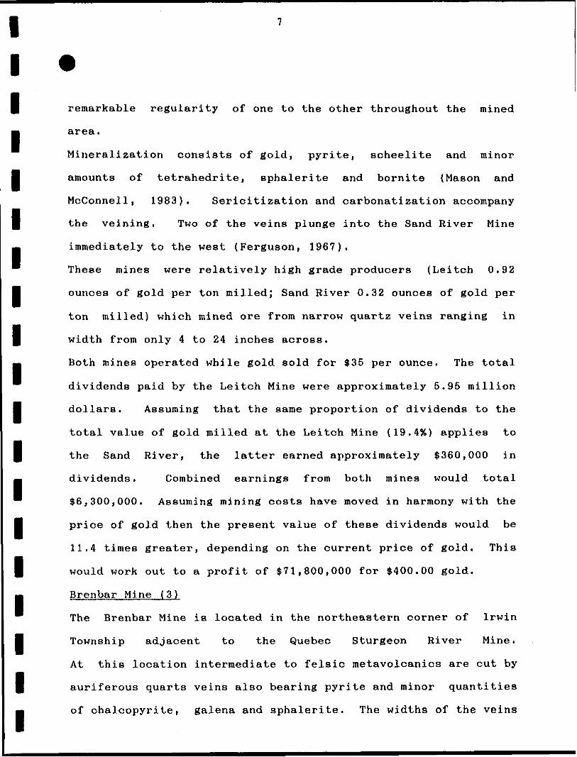
These mines were relatively high grade producers (Leitch 0.92
l ounces of gold per ton milled; Sand River 0.32 ounces of gold per
ton milled) which mined ore from narrow quartz veins ranging in
l width from only 4 to 24 inches across.
M Both mines operated while gold sold for $35 per ounce. The total
dividends paid by the Leitch Mine were approximately 5.95 million
l dollars. Assuming that the same proportion of dividends to the
total value of gold milled at the Leitch Mine (19.494) applies to
f the Sand River, the latter earned approximately $360,000 in
M dividends. Combined earnings from both mines would total
* $6,300,000. Assuming mining costs have moved in harmony with the
l price of gold then the present value of these dividends would be
11.4 times greater, depending on the current price of gold. This
l would work out to a profit of $71 I 800,000 for $400.00 gold.
M Brenbar Mine ( 3)
The Brenbar Mine is located in the northeastern corner of Irwin
l Township adjacent to the Quebec Sturgeon River Mine.
At this location intermediate to felsic metavolcanics are cut by
M
auriferous quarts veins also bearing pyrite and minor quantities
of chalcopyrite, galena and sphalerite. The widths of the veins
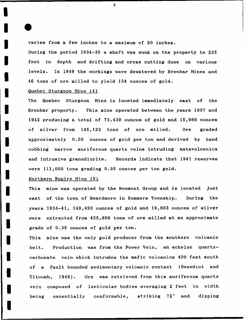
l ll varies from a few inches to a maximum of 50 inches.
During the period 1934-35 a shaft was sunk on the property to 225
f feet in depth and drifting and cross cutting done on various
^ levels. In 1949 the workings were dewatered by Brenbar Mines and
* 46 tons of ore milled to yield 134 ounces of gold.
l Quebec Sturgeon Mine (4)
The Quebec Sturgeon Mine is located immediately east of the
l Brenbar property. This mine operated between the years 1937 and
1942 producing a total of 73,438 ounces of gold and 15,988 ounces
" of silver from 145,123 tons of ore milled. Ore graded
l approximately 0.50 ounces of gold per ton and derived by hand
cobbing narrow auriferous quartz veins intruding metavolcanics
l and intrusive granodiorite. Records indicate that 1941 reserves
were 111,000 tons grading 0.35 ounces per ton gold.
Northern Empire Mine (5)
l This mine was operated by the Newmont Group and is located just
east of the town of Beardmore in Summers Township. During the
l years 1934-41, 149,493 ounces of gold and 19,803 ounces of silver
were extracted from 425,866 tons of ore milled at an approximate
" grade of 0.35 ounces of gold per ton.
l This mine was the only gold producer from the southern volcanic
belt. Production was from the Power Vein, an echelon quartz-
I carbonate vein which intrudes the mafic volcanics 400 feet south
* of a fault bounded sedimentary volcanic contact (Benedict and
* Titcomb, 1948). Ore was retrieved from this auriferous quartz
l vein composed of lenticular bodies averaging 2 feet in width
being essentially conformable, striking 72* and dipping
l
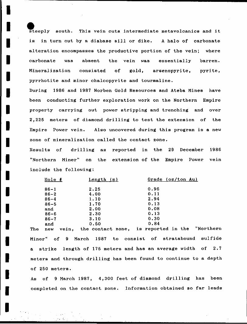
l l steeply south. This vein cuts intermediate metavolcanics and it
l is in turn cut by a diabase sill or dike. A halo of carbonate
alteration encompasses the productive portion of the vein; where
l carbonate was absent the vein was essentially barren.
Mineralization consisted of gold, arsenopyrite, pyrite,
pyrrhotite and minor chalcopyrite and tourmaline.
l During 1986 and 1987 Norben Gold Resources and Ateba Mines have
been conducting further exploration work on the Northern Empire
l property carrying out power stripping and trenching and over
2,225 meters of diamond drilling to test the extension of the
Empire Power vein. Also uncovered during this program is a new
B zone of mineralization called the contact zone.
Results of drilling as reported in the 29 December 1986
l "Northern Miner" on the extension of the Empire Power vein
include the following:
' Hole # Length (m) Grade (oz/ton Au)
l
l
l
l
l
l
l
l
86-1 2.25 0.9686-2 4.00 0.1186-4 1.10 2.9486-5 1.70 0.13and 2.00 0.0886-6 2.30 0.1386-7 3.10 0.30and 0.50 0.84
The new vein, the contact zone, is reported in the "Northern
Miner" of 9 March 1987 to consist of stratabound sulfide
a strike length of 175 meters and has an average width of 2.7
meters and through drilling has been found to continue to a depth
of 250 meters.
As of 9 March 1987, 4,300 feet of diamond drilling has been
completed on the contact zone. Information obtained so far leads
lllllllllllllllllll
Ateba to believe that the contact zone contains a possible
111,000 tons of 9.56 grams of gold uncut,
Spooner Prospect (6)
This property is located in Summers Township east of the Northern
Empire Mine. An assay of 0.43 ounces of gold per ton is reported
to have been exposed in an underground working on this property
which is underlain by mafic metavolcanic rocks.
Dorthea Prospect (10) The subject of this report
This property was previously known as the Hopkins claims and
consists of 9 patented claims north of the Namewamikan River
(Sturgeon) in Dorthea Township adjacent to Bish Bay on Lake
Nipigon. The Dorthea property is the location of two major gold
occurrences: (a) narrow high-grade auriferous quartz veins which
have returned assays of several ounces per ton gold; and b) gold-
bearing pyritic dacite which has yielded assays in the range of
0.1 to 0.3 ounces of gold per ton over several feet in width.
The Tyson Property (8)
The Tyson property originally consisted of 36 claims located east
of Bish Bay in Dorthea Township directly northeast of the Dorthea
property. The Tyson claims are the site of quartz veins cross
breccias and small to medium grained mineralized lens. These
quartz veins are principally mineralized with molybdenite
although some gold has made them the subject of sporadic
exploration since the 1930's.
The chief attraction on the Tyson property is the "No. 3" quartz
vein and associated structures which have been traced for several
hundred feet and are molybdenite bearing. In the late 1950's a
l l
B
U
sulfide vein ranging 50-70 feet in width and over 400 feet in
length containing copper and gold was stripped and sampled by
Nortoba Mines.
Subsequent optionees drilled the "No. 3" molybdenite vein and
planned to mine it by a decline, but, a shortage of funds
l terminated the project. This vein reportedly contains 7 } 500 tons
of material grading 1.596 molybdenite.
B In 1964 147.5 tons of material was collected from two quartz
B veins on the Tyson Property and sent to the Leitch mill near
Geraldton and was reported by Tyson to have assayed greater than
l l ounce per ton gold. The Mines Branch in Ottawa analyzed a
select composite sample taken from the same sources as the bulk
m sample and returned assays of 11.99 ounces per ton gold and 3.52
M ounces per ton silver.
Shango Resources Ltd. contracted Terraquest Ltd. to conduct an
l airborne magnetic and VLF-EM survey over the subject property in
1987, Barrie (1987).
l Witwer Property (9)
H The Witwer claim group is located on the boundary of Sandra and
Meader Townships in the vicinity of Musca and Pirum Lakes.
l This property consists of 2 small sulfide veins occupying
intermediate to felsic metavolcanics separated by a distance of
B six hundred feet. The southern, or 4 zone, has been exposed in
U trenches and consists of chalcopyrite and pyrite with minor
amounts of subrounded quartz fragments. The vein measures
l approximately 3 to 4 inches across and can be traced for about 50
feet. Channel samples submitted to the Minerals Research Branch,

l
l
12
I Ontario Division of Mines yielded assays up to IG.8% copper and
0.09 ounces gold per ton and 3.55 ounces silver per ton.
l The B zone" located north of Pirum Lake has similar geology.
*m Several companies have examined the subject claims over the years
and have done considerable work on them. Kimberley Copper Mines
l Limited prepared some notes on the property in 1959. Erie
Canadian Mines in conjunction with the Hopkins-Tyson syndicate
f completed reports (1936), stripping and trenching (1937) and
B Nortoba Mines Limited undertook geophysical surveys, stripping
* and trenching and some drilling in the 1950' s. Further work by
l the Canpac-Tombill-Gunnex Joint Venture was done in the I960* s.
This work is summarized in GDIF 186 by Speed and Perry (1986).
l A small showing was reported on the eastern part of the property
. just south of the northern boundary by Laird (1936) called the
* Lawrence-McKirdy Syndicate. This showing was in a 2m x 8m shear
l with ankerite stringers, quartz and silicified veins and zones
with arsenopyrite, pyrite and galena mineralization. One grab
l sample assayed 0.08 oz/ton Au.
* The geological report by Mackasey (1975) contains further
* information on less important showings in the general area.
l
l
l
l
l
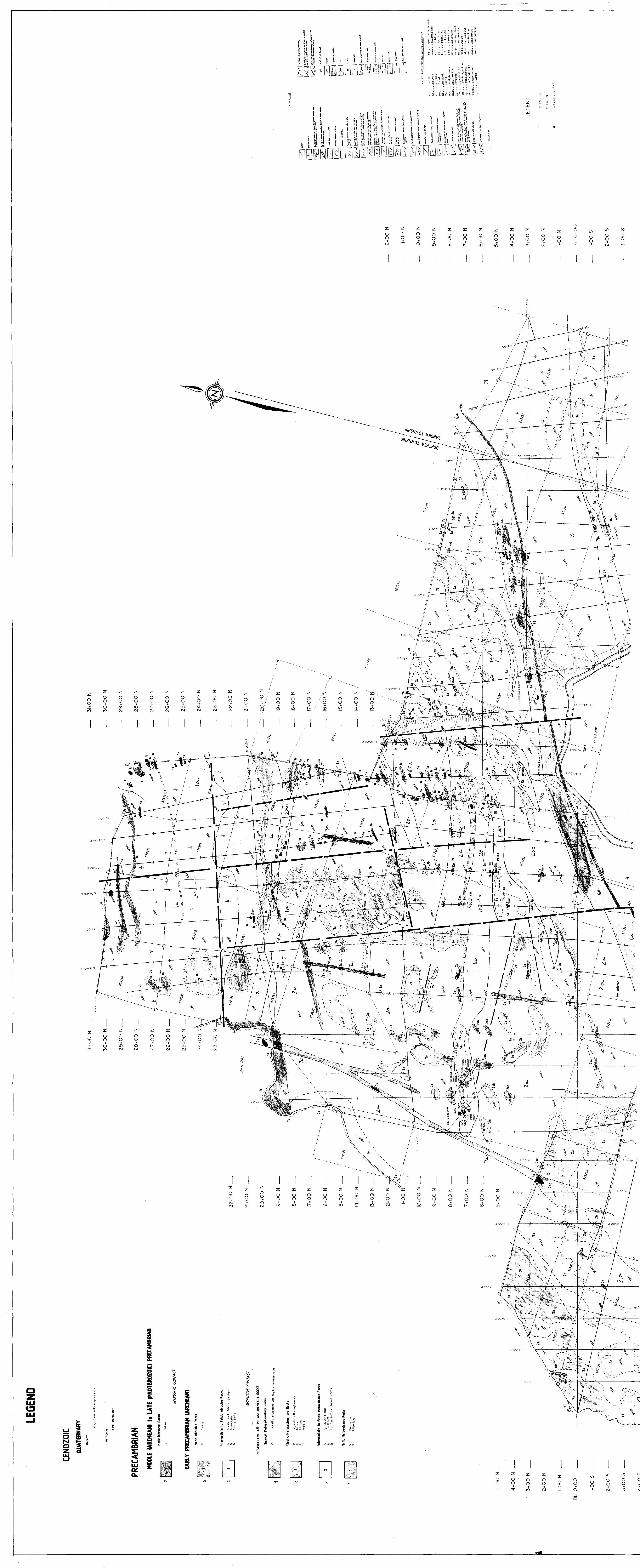
GENERAL GEOLOGY
l l
The rocks underlying the map area are generally of Archean age
l and are generally an east trending folded and faulted sequence of
metavolcanic and metasedimentary rocks. The metavolcanics are
l mafic massive lavas and intermediate pyroclastic breccias and
m tuffs while the metasediments are polymictic
orthoconglomerates, arkoses and siltstones with lesser magnetite
l rich units interbedded with argillites and siltstones.
The metavolcanic and metasedimentary rocks are intruded by
l east trending lenticular bodies of gabbro and granite quartz
m feldspar porphyry. Diabase dikes of Middle to Late Precambrian
(Proterozoic) Age cut all rock units.
l Pleistocene and recent deposits mantle the area in varying
thicknesses from O to well over 50 meters thick. The geological
l history is summarized in Table 1.
l
l
l
l
l
l
l
l
l l
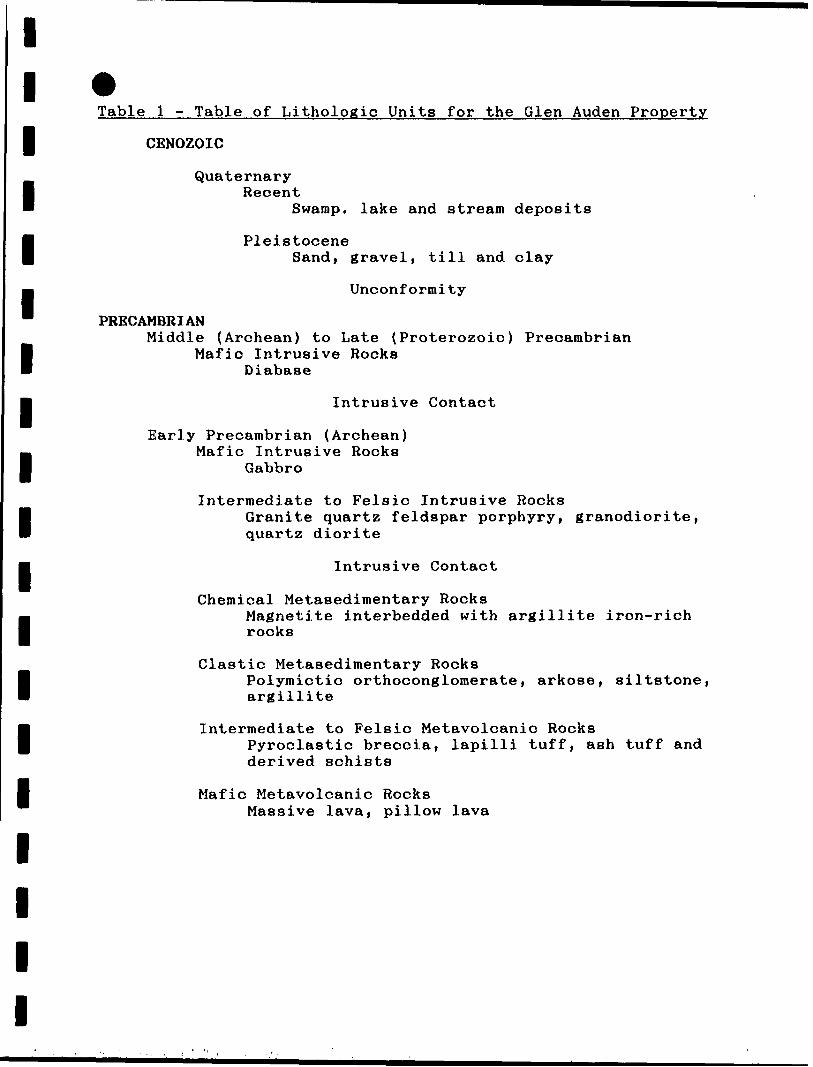
Table l - Table of Lithologic Units for the Glen Auden Property
J CENOZOIC
Quaternary l Recent
l
l
l
l
l
l
l
Swamp, lake and stream deposits
PleistoceneSand, graveli till and clay
Unconformity
* PRECAMBRIANMiddle (Archean) to Late (Proterozoic) Precambrian
Mafic Intrusive Rocks Diabase
Intrusive Contact
Early Precambrian (Archean)
I Mafic Intrusive Rocks
Gabbro
Intermediate to Felsic Intrusive Rocks Granite quartz quartz diorite
Intrusive Contact
l Granite quartz feldspar porphyryi granodiorite,
lChemical Metasedimentary Rocks
Magnetite interbedded with argillite iron-rich rocks
Clastic Metasedimentary Rocks Polymictic argillite
l Polymictic orthoconglomerate, arkose, siltstone,
Intermediate to Felsic Metavolcanic Rocks Pyroclastic breccia, lapilli tuff, ash tuff and derived schists
Mafic Metavolcanic RocksMassive lava, pillow lava

l l
EARLY PRECAMBRIAN (ARCHEAN)
B METAVOLCANIC ROCKS
B Mafic Metavolcanic Rocks
Mafic metavolcanic rocks underlie the northern part of the
property and are composed mainly of massive to pillowed flows
l with lesser amygdaloidal and porphyritic flows and tuffs that
chemically, are iron tholeiite basalts. The whole rock analyses
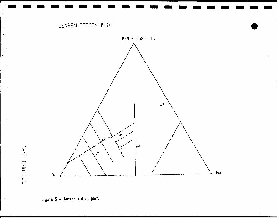
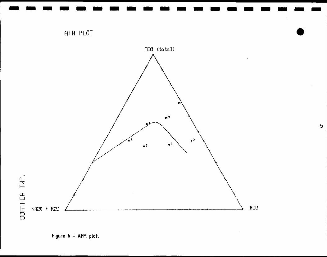
J presented by Mackasey (1975) were plotted on the Jensen Cation
Plot, Jensen (1975) and the AFM Diagram of Irving and Baragar
(1970) to obtain rock classifications. The computer program used
l to construct the plots was developed by the Ontario Geological
Survey, Ambrose et al (1986).
l The mafic metavolcanic rocks are greenish black on the fresh
surface and weather moderate brown. Most are aphanitic and
rarely are individual minerals discerned at the macroscopic
l scale. Subhedral to euhedral plagioclase crystals l to 2 mm in
size are visible in the porphyritic flow units. Amygdules of
J quartz, calcite and chlorite, l to 3 mm in size are generally
oval in shape indicating some post depositional deformation. The
tuffaceous units are generally thin ^2 m) and are most generally
l sheared. Some secondary minerals can be easily recognized such as
quartz, calcite, ankerite, pyrite, epidote and chlorite.
f Massive mafic lavas were most representative in this group of
. rocks. The units are fine to medium grained and outcrop
exposures are often rounded in a whale-back fashion. The more
l coarse grained flows are thought to be the cores of thicker flows
although Laird (1936) believed them to be intrusive. Indeed,
l
l l l
l
there are some intrusive mafic rocks that will be described under
that heading below, however, no intrusive contacts in the mafic
l metavolcanic units were noted in this survey. It is generally
known that synvolcanic sills and dikes do occur within any
l volcanic pile and there may indeed be many that have not been
recognized in this and previous surveys. The gabbroic bodies may
even be related to mafic volcanism,
l Amygdaloidal lava flows are less common than massive flows and
these units were not traced over any considerable distance. They
l may be just phases in the larger flows or they may have been
m missed under thick moss and other overburden.
Pillow lavas were rare in the overall mafic package and may have
l occurred as zones within the large flow units. Most pillows were
less than 30 cm in the long axis by 10 to 15 cm in the short
l axis. Tops were not reliably noted. Selvages were moderate to
m dark brown in color indicating the presence of iron. The long
axis is generally parallel to the regional foliation.
l Porphyritic flows or portions were noted in several places and
these are though to be phases rather that separate flow units,
l The phenocrysts are l to 3 mm plagioclase crystals that are light
jm gray to grayish yellow in color and generally they are aligned
parallel to the foliation,
l The zones thought to have been of a tuffaceous origin were
generally quite sheared and were generally composed of chlorite
l and sericite with varying degrees of hematite and carbonate
l
l
staining.
l l l l l l l l l l l l l l l l l l l
The mafic metavolcanic rock units are confined largely to the
northern part of the map area.
Intermediate to Felsic Metavolcanio Rocks
The bulk of the rocks outcropping on the property fall into this
class and are mainly pyroclastic breccias. This unit or units
strikes on the order of 65* and dips steeply north to vertical.
The rock type underlies the central portion of the property and
has a true thickness of approximately 1.5 km thinning to the
east.
The fragments are very angular and range in size from O mm to
^0 cm. The composition is intermediate to felsic. The matrix
is somewhat darker probably due to the fact the it was less
consolidated than the fragments and therefore more susceptible to
chloritic alteration.
On fresh surface the fragments are light greenish gray and the
matrix is dark greenish black. On weathering the fragments
become greenish white to light brown and the matrix becomes
slightly less dark.
The exposures are most spectacular along the shore of Lake
Nipigon where the wave action has washed the outcrops clean. The
fragments are very visible and layering is evident. Some lapilli
and ash layers are present, however, grading is not. The
fragments are porphyritic with l to 2 mm quartz and feldspar
phenocrysts. Inland the fragmental nature of the unit is less
evident. The moss cover appears to prevent oxidation of the
iron-rich minerals and the matrix and fragments are not readily
discerned.
l
l
18
l Massive, porphyritic and tuffaceous units occur within the
pyroclastic sequence, however, they are not traceable over great
J lengths or widths and are not thought to be extensively developed
on the property.
* Several small felsic pods were mapped. These were often
l associated with sulfide mineralization and could possibly be due
to alteration. Opalescent quartz eyes were generally present as
l was sericite and evidence of shearing.
l MBTASEDIMENTARY ROCKS
Clastic Metasedimentary Rocks
l Clastic metasedimentary rocks underlie the southwestern and south
j central part of the property. These rock types range from
polymictic clast and lesser matrix supported conglomerates
l to sandstones, siltstones and argillites.
l Conglomerates
Traverses over the eastern part of the property crossed a
l polymictic clast supported conglomerate on lines 56 East, 58
East, 60 East and 66 East. This appears to be a bed
" approximately 200 meters thick within a larger metasedimentary
l package and sandwiched between quartzo-feldspathic sandstone
(arkose) to wacke. Some conglomerate was also noted associated
l with the magnetite iron rich unit near the northern boundary of
the sequence. The quartzo-feldspathic material forms the matrix
" of the conglomerates. Clasts range in size from 5 to > 250 mm and
B include felsic plutonic and hypabyssal material with lesser mafic
metavolcanic clasts and quartz, chert and magnetite iron rich
l
lllllllllllllllllll
rock. The conglomerate makes up about 20& of the clastic
metasedimentary package.
Sandstones
The sandstones are primarily arkose to wacke in composition.
Silica may range as high as 70?6. Grading was not evident in the
conglomerates and sandstones. The fresh surfaces are moderate
greenish gray and weather to moderate brown. These units make up
over 65% of the metasedimentary rocks in the map area.
Siltstones and Argillites
Siltstones and argillites near both the conglomerates and to a
larger degree associated with the magnetite iron rich units.
Siltstone and argillite forms bands within the iron rich units
making for what previous authors named "dirty or lean iron
formations". The fine grained metasediments comprise about 15% of
the clastic units. They occur as units up to 50 meters thick and
were noted in close proximity to the conglomerates and associated
with the magnetite iron rich unit that occurs near the north
contact of the metasedimentary sequence.
Chemical Metasedimentary Rocks
This unit is a thin ( <l to 15 meters) bed or several beds
separated by siltstone and argillite, this latter material also
forms beds with the magnetite rich material. This suggests that
the unit may be of sedimentary origin as suggested by Pye (1951)
for the unit near Watson Lake. Some jasper is noted as thin beds
and the units is located within a conglomerate. Quite possibly
lllllllllllllllllll
the iron rich unit could represent a hiatus in the sedimentary
accumulation.
INTRUSIVE ROCKS
Intermediate to Felsic Intrusive Rocks
Several bodies of intermediate to felsic intrusive material were
noted during mapping as well as numerous dikes cutting the
intermediate pyroclastic units. The intrusive is thought to be
hypabyssal in nature due to it's porphyritic nature, however,
there are portions that are not porphyritic. This may indicate a
thicker portion of the body and a slower cooling time. There
were some differences in appearance and mineral content noted and
this suggests multiple intrusive activity if not completely
separate bodies. Alteration of certain parts of the intrusive
also suggest that significant hydrothermal activity accompanied
the emplacement and that this activity continued for some time
after emplacement. The compositions range from granite quartz
feldspar porphyry to granodiorite to quartz diorite,
Mafic Intrusive Rocks
Associated with the magnetite iron rich rocks are gabbro
intrusives. These bodies intrude along the contact between the
clastic metasedimentary sequence and the intermediate pyroclastic
sequence to the north. Mackasey (1975) shows two discrete
gabbroic bodies, however, it is the opinion of this author from
the examination of aeromagnetic data that there is but one
gabbroic body. This body is approximately 75 meters wide and
4,800 meters long. The gabbro is medium grained, l to 3 mm,
l
lmagnetic in places and not in others. It is dark greenish black
P on the weathered surface weathering moderate brown. There is a
m possibility that this unit is a thicker basaltic flow as it does
appear to be conformable to the metasediments and metavolcanics
l and no intrusion breccia units were noted along the contacts. The
l
l
l
coarser grain size could have been the result of metamorphism.
The mafic minerals, amphibole and chlorite compose over 5096 of
the rock with devitrified plagioclase making up the balance of
the rock .
MIDDLE (ARCHEAN) TO LATE PRECAMBRIAN (PROTEROZOIC)
Diabase Sheets and Dikes
Diabase sheets were not found in the map area. At least two
l diabase dikes were noted cutting rock sequences in the map area.
The diabase is generally medium grained (1-3 mm) except at
B contacts. The dikes are usually 50 meters or so in width and of
B varying lengths. Fault offsets are common. Mafic minerals make
up over 5096 of the diabase and are pyroxene, magnetite, and
l lesser amounts of biotite and sulfides, generally pyrite and
pyrrhotite.
l
l
l
l
l
22
l
lCENOZOIC
l QUATERNARY
B Pleistocene and Recent
The outcrop in the map area is largely covered with a thin {l to
l 5 meter) cover of glacial clay, silt and sand. Most of the
outcrop is found south of Tie Line 20+00 East north of which is a
8 broad swamp largely devoid of outcrop, although cover is thought
m to be shallow, until about 200 meters south of the northern
boundary of the claims where outcrop is once again noted. Near
l the Sturgeon River thick deposits of stratified sand and gravel
can be seen. These were measured by Coleman (1907) and found to
8 be on the order of 30 meters of silt overlain by 4 meters of sand
M and gravel just east of the property.
METAMORPHISM
Metamorphic rank is greenschist for the older rocks. The diabase
l is largely unaltered. The chlorite content and the devitrified
nature of the feldspars are the main indicators of metamorphic
l activity and rank.
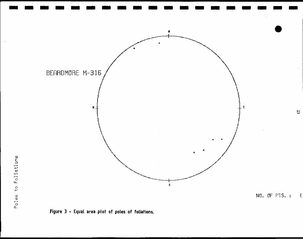
l STRUCTURAL GEOLOGY
The package of rocks underlying the property in in the Wabigoon
8 Subprovince, Goodwin (1970). This subprovince is composed
m primarily of metavolcanic and granitic rocks. The rock sequence
has been isoclinally folded about and east-west axis and tops are
B generally to the north. Regional foliation is just north of east
and dips are generally steeply to the north. Minor folds are
8 noted and as are minor faults and joints. These are most evident
l
BEflRDMQRE M-316
01 C O
O LL-
O
01•11o a.
--Ero u)
NO. OF PTS. : e
figure 3 - Equal area plot of poles of foliations.
l lg in the iron rich units. Lineation parallel to foliation is the
™ greatest with that down dip and slightly to the west of secondary
l intensity with compression perpendicular to the foliation noted.
Numerous northwest trending cross faults were noted where
f lithologic units were offset. These were generally on the order
— of less than 100 meters. Strike slip faults were not noted on
" the property, however, there may be a suggestion of one such
B fault along the contact between the intermediate pyroclastic unit
and the metasedimentary sequence.
l Various authors, Goodwin (1951), Pye (1951) and Mackasey (1975)
have proposed that the Wabigoon-Quetico subprovince boundary be
™ the Paint Lake Fault which passes approximately 4 km north of the
B north boundary of the property. Recent work by Williams (1986)
proposes an accretionary prism model for the Beardmore-Geraldton
l Greenstone Belt. This model defines a prism made up of trench
— and fore-arc sedimentary material interleaved with layers of
™ mafic volcanics and gabbros, cut by mildly discordant gabbros and
B granitic major and minor intrusions. The boundary between the
Wabigoon and Quetico subprovinces is marked by a zone of ductile
l and brittle shear.
l
l
l
l
l
l
l
ll *
STRATIGRAPHY
B Based strictly on top directions and surface mapping it would
B suggest that the metasedimentary sequences are the oldest rocks
and the metavolcanic sequences are younger. Examination of the
l conglomerates indicates both metavolcanic and metasedimentary
clasts as well as a considerable percentage of mafic and felsic
8 plutonic clasts. Laird (1936) indicates the lavas to be the
m older while Mackasey (1975) indicates that the Metasediments are
older with a disclaimer that sequence does not imply age
l relationship. Age dates reported by Williams (1986) relate to
the age of metamorphism and indicate the metamorphic event was
B caused by late stage felsic plutons to the south well within the
B Quetico Subprovince. Until further detailed age dating
information is available conventional stratigraphic indicators
will have to be relied on.
GEOPHYSICS
Airborne geophysical surveys by the government OGS/GSC (1962a ft
g b), Figure 3, indicate the general stratigraphic trend. More
^ detailed airborne surveys for Shango Resources Ltd., Barrie
™ (1987) show increased detail and color enhancement and vertical
8 derivative calculations provide further enhancement of the data.
This detail defines the diabase dike trends and indicates that
l the gabbro accompanies the magnetite iron rich rocks over a
B considerable length but do not continue throughout the full
length of the unit east of the property and that the gabbro
l appears to terminate near the mouth of the Sturgeon River.
An IP survey was conducted by Glen Auden and will be reported on
l
IRWfN
RBalllsi**:
Scale: One Inch to One Mile =
GEOPHYSICS P
SHAKESPEARE REVIS1ONS\ R.P. BOWEN. ENGINEERING INC
SUMMERS GLEN AUDEN RESOURCES LTD.
AEROMAGNETIC MAPOGS/GSC 1962a fc b
Oafg:Seo m8\Drawn;RPB \SczfrT'r1 mile
l l l l l l l l l l l l l l l l l l l
separately in another report. This survey delineated a number of
chargeable zones and trends that do not merely appear to be
associated with zones of known mineralization thereby increasing
the targets tagged for follow-up work.
GEOCHEMISTRY
There were no whole rock analyses made of samples on the subject
claims nor were any soil or other geochemical surveys performed.
Whole rock data was taken from Mackasey (1975) and plotted on
ternary plots using programs developed by the Ontario Geological
Survey, Ambrose et al (1986), Figures 6 and 7. Samples 2 and 3
are from the subject claims and plot as magnesium tholeiite and
basaltic komatiite respectively. Sample 4 is from the
intermediate pyroclastic breccia unit and plots as a tholeiitic
andesite although it is very close to the boundary of the calc
alkaline basalt.
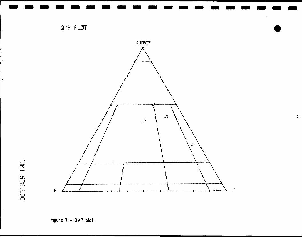
Figure 7 is a QAP plot and sample 5 is a granite quartz feldspar
porphyry west of Pirum Lake in the north part of Sandra Township
and sample 7 was a granodiorite from the Quebec Sturgeon Mine in
northeast Irwin Township. The author believes that the felsic to
intermediate plutonic rocks mapped on the property would be of
similar composition.
The relatively thin mantle of overburden would perhaps make
geochemical surveys a practical method of exploration in this
area and should perhaps be tried using gold as the main
pathfinder with perhaps arsenic and silver as associated trace
indicators. Primary rock geochemistry should be used as an
JENSEN CRT ION PLOT
Fe3 * Fe2 * Ti
CL.
acLU
DC O O
Mg
Figure 5 - Jensen cation plot.
l l l l l l l l l l l l l l l l l l l
29
D
cd -P
-OOLU
o
d.IL.
CE
rLL.
au
*C4-OJ
CC
nnRT
HFfl TWP
l p > -o
D ID r~ o
l l l l l l l l l l l l l l l l l l l
31
l
lexploration tool over areas of felsic to intermediate intrusives
m and altered and mineralized zones.
l CONCLUSIONS AND RECOMMENDATIONS
^ Some targets already present themselves such as the Low and High
™ Grade showings which should be tested by diamond drilling
l underneath the showings. Induced polarization/resistivity
targets coinciding with felsic to intermediate intrusives should
l also be tested by diamond drilling. Soil geochemical surveys
— would help define zones for stripping and trenching and primary
' geochemical surveys would provide more data on host rock and
B alteration which might lead to additional stripping and diamond
drill targets. A close spaced geophysical survey program should
l be done consisting of magnetometer and horizontal loop surveys
— which would assist in further defining stratigraphy and perhaps
™ providing areas for further IP work.
l
l
l
l
l
l
l
l
1111111111111111111
9
32
REFERENCES
Ambrose, E., Wright, D., Volk, W. P.1986:
Barrie, C. Q.1987:
Benedict, P. C.1948:
Bruce, E. L.1936:
Burrows, A. G.1917:
Coleman, A. P.1907
Coleman, A, P. ,1908
Energy, Mines
1988:
Ferguson, S. A.1967:
Krez, D.1987
STRNET, TERNARY Plots; Computer Programs Availableto the Precambrian Section, Ontario GeologicalSurvey.
Report on an Airborne Magnetic and VLF-EM Survey,Dorthea, Eva and Sandra Townships, Thunder BayMining Division, Ontario; Report for ShangoResources Ltd. by Terraquest Ltd.
, and Titcombe, J. A.The Northern Empire Mine; p. 389-399 in StructuralGeology of Canadian Ore Deposits, CanadianInstitute of Mining and Metallurgy Jubilee Volume,948 P.
The Eastern Part of the Sturgeon River Area;Ontario Department of Mines, Vol. 45, Pt. 2, P. 1-59 (published 1937). Accompanied by Map 45a,scale 1 inch to 1 mile.
Longuelac to Jellicoe and Orient Bay; OntarioBureau of Mines, Vol. 26, p. 227-247. Accompaniedby Map 26b, scale 1 inch to 2 miles.
Iron Ranges East of Lake Nipigon; Ontario Bureauof Mines, Vol. 16, Pt. 1, p. 105-135.
and Moore, E. S.Iron Ranges East of Lake Nipigon; Ontario Bureauof Mines, Vol. 17, p. 136-169.
and Resources
First Vertical Derivative of Total Field MagneticData in the Beardmore-Geraldton Area.
Leitch Gold Mines Limited, Surface Plan of EasternPart of Property, parts of Eva and SummersTownships, District of Thunder Bay; OntarioDepartment of Mines, Preliminary Geological MapP. 484, scale 1 inch to 500 feet.
Geology of Barbara, Meader and Pifher Townships,District of Thunder Bay; Ontario GeologicalSurvey, Preliminary Map, scale 1 inch to J mile.
l l l l l l l l l l l l l l l l l l l
33
Laird, H.C. 1936:
Langford, G.B, 1928:
The Western Part of the Sturgeon River Area {Sturgeon River-Beardmore Section); Ontario Department of Mines, Vol. 45, Pt. 2, p. 60-117 (published 1937). Accompanied by Map No. 45a, scale l inch to l mile.
Geology of the Beardmore-Nezah Gold Area, Thunder Bay District; Ontario Department of Mines, Vol. 37, Pt. 4, p. 83-108 (published 1929). Accompanied by Map 37k, scale l inch to l mile.
Macdonald, A.J.1983a: The Iron Formation - Gold Association: Evidence
from Geraldton Area; p. 75-83 in the Geology of Gold in Ontario, edited by A.C. Colvine, Ontario Geological Survey, Miscellaneous Paper 110, 278 p.
1983b A reappraisal of the Geraldton Camp; p. 194-197 in Summary of Field Work, 1983, by the Ontario Geological Survey, edited by John Wood, Owen L. White, R.B. Barlow and A.C. Colvine, Ontario Geological Survey, Miscellaneous Paper 116, 313 p.
Mackasey, W.O.1975: Geology of Dorthea, Sandra and Irwin Townships,
District of Thunder Bay; Ontario Division of Mines, GR 122, 83 p. Accompanied by Map 2294, scale l inch to i mile.
Mason, J.K. and Mcconnell, C.D.1983: Gold Mineralization in the Beardmore-Geraldton
Area; p. 84-97, in The Geology of Gold in Ontario, edited by A.C. Colvine, Ontario Geological Survey, Miscellaneous Paper 110, 278 p.
OGS/GSC1962a:
1962b:
Peach, P,A, 1951:
Aeromagnetic Map of the Beardmore, Ontario Area, Geophysical Paper 2135, scale l inch to l mile.
Aeromagnetic Map of the Shakespeare Island, Ontario Area, Geophysical Paper 2128, scale l inch to l mile.
Preliminary Report on the Geology of the Blackwater-Beardmore Area; Ontario Department of Mines, Preliminary Report 1951-7, 6 p.
l
l
l
l
l
l
l
l
l
l
l
l
l
l
l
l
l
l
l
Pye, E.G.1951: Geology of Errington Township, Little Long Lac
Area; Ontario Department of Mines, Vol. 60, Pt. 6, 140 p. (published 1952). Accompanied by Map 1951- 7, scale l inch to 1,000 feet.
1965: Georgia Lake Area; Ontario Department of Mines, GR 31, 113 p. Accompanied by Map 2056, scale l inch to l mile.
1968: Lac des Iles Area; Ontario Department of Mines, GR 64, 47 p. Accompanied by Map 2135, 2136, scale l inch to i mile.
Pye, E.G., Harris, H.R., Fenwick, K.G., and Bailie, J.1966: Tashota-Geraldton Sheet; Ontario Department of
Mines, Map 2102, scale l inch to 4 miles.
Skimming, T.1982: Report on the Property of Janbekelo Investments
Limited, Dorthea Township, District of Thunder Bay; Qualifying Report for Janbekelo Investments Limited.
Stott, G.M.1983: Gold Mineralization in the Shebandowan Belt and
its Relation to Regional Deformation Patterns; p. 181-193 in The Geology of Gold in Ontario, edited by A.C. Colvine, Ontario Geological Survey, Miscellaneous Paper 110, 278 p.
Sutcliffe, R.H.1982: Precambrian Geology of the Wabigoon-Quetico
Subprovince Boundary, Grand Bay Sheet, Map P.2528, Shakespeare Island Sheet, Map P.2529, Orient Bay Sheet, Map P.2530 and Black Sturgeon Lake Sheet, Map P.2531, Geological Series Preliminary Maps, scale 1:50,000. Geology 1981.
Tanton, T,L.1921: Canadian National Railway between Long Lac and
Nipigon; Geological Survey of Canada Summary Report 1917, Pt. E, p. 1-16.
Thorleifson, L.H. and Kristjansson, F.J.1987: Gold Grains in Surface Till Samples, Beardmore-
Geraldton Area, District of Thunder Bay; Ontario Geological Survey, Map P.3105, Geological Series Preliminary Map, scale 1:100,000. Geology 1986, 1987.
l
l
l
l
l
l
l
l
l
l
l
l
l
l
l
l
l
l
l
Thorleifson, L.H. and Kristjansson, F.J.1988: Visible Gold Content and Lithology of Till From
Overburden Drillholes, Beardmore-Geraldton Area, District of Thunder Bay, Northern Ontario; Geological Survey of Canada Open File Report 1756.
von Hessert, C.1986: A Summary Report to Canergy Resources Ltd. on
their 1986 Staking, Dorthea Township, District of Thunder Bay, Ontario; Report for Canergy Resources Ltd., by C. von Hessert fc Associates Ltd.
Williams, H.R.1986: Structural Studies in the Beardmore-Geraldton
Belt, Northern Ontario; Grant 242, p. 138-146 in Geoscience Research Grant Programs, Summary of Research, 1985-1986, edited by V.G. Milne, Ontario Geological Survey, Miscellaneous Paper 130, 235 p.
Wilson, A.G.W.1910: Geology of the Nipigon Basin, Ontario; Geological
Survey of Canada, Memoir l, 152 p.
l l l l l l l l l l l l l l l l l l l
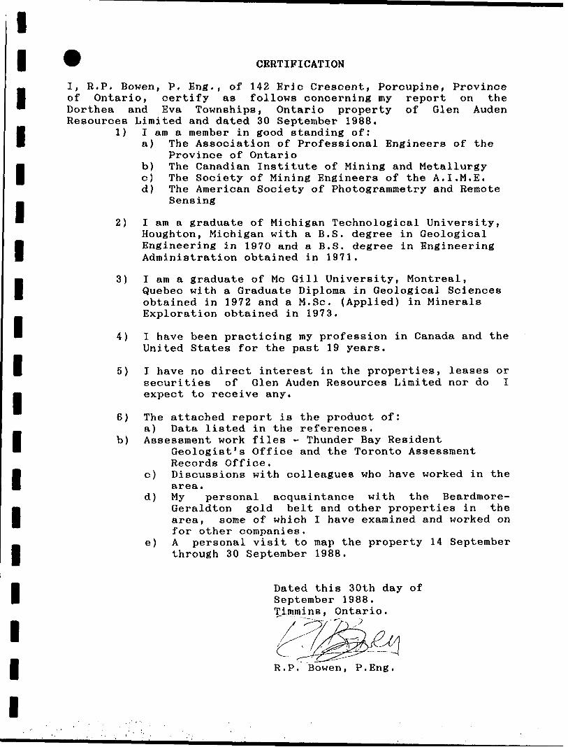
CERTIFICATION
I, R.P. Bowen, P. Eng., of 142 Eric Crescent, Porcupine, Province of Ontario, certify as follows concerning my report on the Dorthea and Eva Townships, Ontario property of Glen Auden Resources Limited and dated 30 September 1988.
1) I am a member in good standing of:a) The Association of Professional Engineers of the
Province of Ontariob) The Canadian Institute of Mining and Metallurgyc) The Society of Mining Engineers of the A.I,M.E.d) The American Society of Photogrammetry and Remote
Sensing
2) I am a graduate of Michigan Technological University, Houghton, Michigan with a B.S. degree in Geological Engineering in 1970 and a B.S. degree in Engineering Administration obtained in 1971,
3) I am a graduate of Me Gill University, Montreal,Quebec with a Graduate Diploma in Geological Sciences obtained in 1972 and a M.Se. (Applied) in Minerals Exploration obtained in 1973.
4) I have been practicing my profession in Canada and the United States for the past 19 years.
5) I have no direct interest in the properties, leases or securities of Glen Auden Resources Limited nor do I expect to receive any.
6) The attached report is the product of:a) Data listed in the references,
b) Assessment work files - Thunder Bay ResidentGeologist's Office and the Toronto Assessment Records Office.
c) Discussions with colleagues who have worked in the area.
d) My personal acquaintance with the Beardmore- Geraldton gold belt and other properties in the area, some of which I have examined and worked on for other companies.
e) A personal visit to map the property 14 September through 30 September 1988.
Dated this 30th day of September 1988. Timmins, Ontario.
R.P. Bowen, P.Eng,
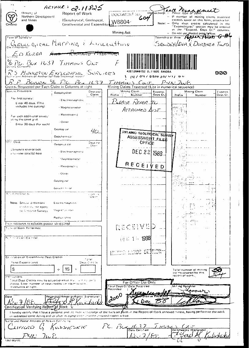
Minis'.ry Ot Northern and Mines
Report of Work
(Geophysics!, Geoloijical, Geochi.'inica! and
Mining Act
Please type or-- II numl)cr ol mining claims liiivcrsud
exceeds space on this form, attach a list.Mote: — Only d;iys credits calculated lit l hi:
"Expenditures" section may lie enteredin the "Expend. Days Cr." columns.
— Do not useshaded areaj^ ttflow.eas Itflow. f\JL*Jb G 'r y l)*: ol Survey's'
.^^^VCrjl C
Townsh.por Area
^o p-o- 6c-x /637 T t rf H i r* s Ct^roir '.''V Compiiny
f\ ^) / .///'•V ?CCr f C'A,' >^ •*V'iLO*\*H ' i OV- ' ^^/\•V." .- ;m'i Adflr^s 1. O* Author (of Gco-1 fJcnnir.nt rcpoi t'
-*~^ -^ —) ^ ^, x ,^—j ^ —j
42E12NW0152 2.11825 SANDRA
i l ^f / o^ / c&ro i)o/ ^7 / 13900
Cftjdiis Requested per Each Claim in Columns at liyhtSp".. ',il Provisions
Mining Claims Traversed (List in numerical sequence)
Date
A?v?7P^t f " ' -f f f f ———— —— V —---- r------ —— -
Certification Verifying RepprTpf j/Vork——————————— s — * —— -^tL-^ ——————————————————— 1 hereby certify that 1 have a personal and ;n: r-vit- : K-r-v-.'ieri.io of the f;i or witnessed same ilumici and 01 ;ifli?r us iiomp i-;i-.- . ; --u tlu ."•ni.'xt-ii "
\.I-M! Hntl Costal Arlurcss ol Po'i.m Ci"'''v -")
PV/J 7^ P,
:*.s set /onh .r. the Report of Work annexed ^-?reio, having performed ooi t is ti ue.
/•?r^ /^. V? 7/^;-^; S f x-r
the work
Oaiu Cer^.fied C*rt*fvi^xt)V (Signjtutc) ,
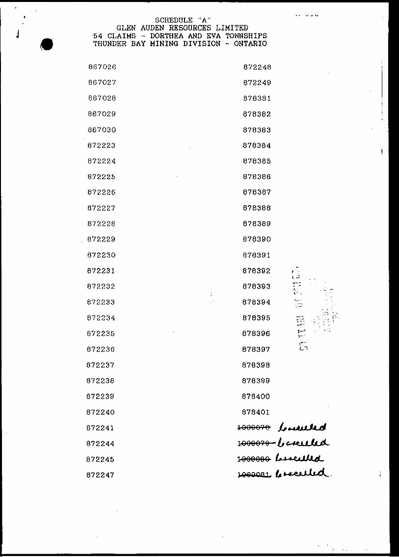
' SCHEDULE "A" GLEN AUDEN RESOURCES LIMITED
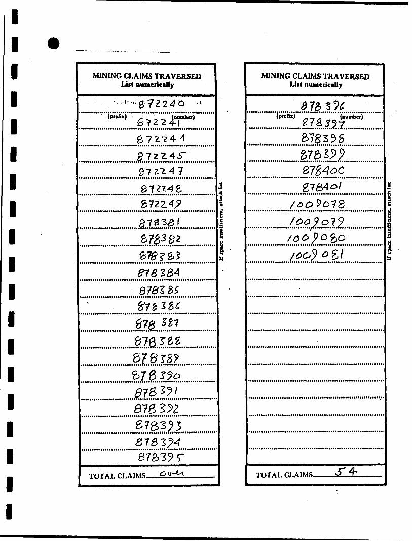
J 54 CLAIMS - DORTHEA AND EVA TOWNSHIPS A THUNDER BAY MINING DIVISION - ONTARIO
867026
867027
867028
867029
867030
872223
872224
872225
872226
872227
872228
872229
872230
872231
872232
872233
872234
872235
872236
872237
872238
872239
872240
872241
872244
872245
R79947
872248
872249
878381
878382
878383
8783841
878385
878386
878387
878388
878389
878390
878391
878392 r r:
878393 :t': '; ^
878394 ^ : ;
878395 r?. . - :: :.": rv.
878396 Jr.! ' :
878397 ^
878398
878399
878400
878401
i00007fr k^UtJLMji
i^on o? n— j[f 6***tjjltjL.
1-000000 6^*^xJL^U)L
l l l l l l l l l l l l l l
1oll l
Ministry ofNorthern Developmentand Mines
Geophysical-Geological-Geochemical Technical Data Statement
ntario
TO BE ATTACHED AS AN APPENDIX TO TECHNICAL REPORTFACTS SHOWN HERE NEED NOT BE REPEATED IN REPORT
TECHNICAL REPORT MUST CONTAIN INTERPRETATION, CONCLUSIONS ETC.
Type of Survey(s) LJnecuttlng - GeologicalTownship or Area Do r t h ea, Sandra, Eva (Poplar Point) Claim Holder(s) Glen Auden Resources Limited————
Survey Company H.P. Bowen Engineering; Inc.——^—Author of Report B. P. Bowen—-—————^—^^^.———-Address of Author P.O. Box 5010, PMS, S. Pornuplna
Covering Dates of Survey 3-35 P^b- ft lj^-30 Sep. 1 Qftft
Total Miles of Line Cut^(line cutting to office)
53-5 miles
SPECIAL PROVISIONS CREDITS REQUESTED
ENTER 40 days (includes line cutting) for first survey.
ENTER 20 days for each additional survey using same grid.
Geophysical --Electromagnetic.
DAYSper claim
Geological 20
AIRBORNE CREDITS (Special provision credits do not apply to airborne surveys)
Magnetometer. .Electromagnetic(enter days per claim)
DATE:—C'
Res. Geol. . Qualifications (7\ ~ 0(04. D fPrevious Surveys
File No. Type Date Claim Holder
MINING CLAIMS TRAVERSED List numerically
'(prefix) (number)
867
8722
31
...........1L?.?.ZilL?I g? "ilia
&7Z2-17
TOTAL CLAIMS-
837
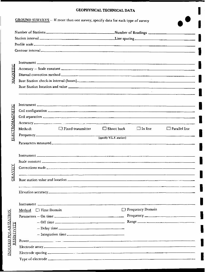
GEOPHYSICAL TECHNICAL DATA
GROUND SURVEYS- If more than one survey, specify data for each type of survey
Number of Stations
l
INDUCED POLARIZATION
ppcTCTTVTTV GRAVITY ELECTROMAGNETIC MAGNETIC
Station interval Line spacing
Profile scale
Contour interval
Instrument
Accurary — Scale constant
Diurnal correction method
Rase Station check-in interval (hours)
Rase Station location and value .
Instrument
Coil ronfiguration
Coil reparation
AccuracyMethod: O Fixed transmitter O Shoot back CD In line Frequency
{specify V.L.F. station)
Parameters measured
Instrument
Scale constantCorrertions made
Base station value and location
Elevation accuracy . ... ...,~
Instniment —————————————————————————— — ——
Method D Time Domain D Frequency DomainP3r3mf*tcrs On time rrccjucncy.
, Off time Range(! Delay time4
l — Integration timeJ D
5 Power ____ - —— - ————————— - ————————————————————— - ———————li 4
Electrode array ———————————————— - ————————————————————— - ———————
Electrode spacing . ———— . ———————————————————————————————— - ———————
Type of electrode _____ ———— . ——— - ———————————————————————————————————————
11111I
1CD Parallel line —
1
1
1
1
1
1
1
1
1 1 1 1 1 1 1 1 1 1 1 1 1 1 1 1 1 1 1
SELF POTENTIALInstrument.,
Survey Method
Corrections made
RADIOMETRICInstrument.
Values measured
Energy windows (levels)
Height of instrument
Size of detector
Overburden
Range
Background Count
(type, depth — include outcrop map)
OTHERS (SEISMIC, DRILL WELL LOGGING ETC.)Type of survey
Instrument
Accuracy
Parameters measured
Additional information (for understanding results).
AIRBORNE SURVEYSType of survey(s)Instrument(s) —————————————————————— — — - ————————
(specify for each type of survey) Accuracy
(specify for each type of survey) Aircraft used
Sensor altitude.Navigation and flight path recovery method
Aircraft altitude
Miles flown over total area
Line Spacing
Over claims only
GEOCHEMICAL SURVEY
Numbers nf rlaims from whirh samples taken
Total Number nf Samples
Type nf Sample(Nature of Material)
Average Sample Weight.O I U
Method of Collection,
Snjl Horizon SamplpH
Horizon DevelopmentSample Depth
Terrain
Drainage D^vH^pmentEstimated Ranpp nf Overburden Thirkness
SAMPLE PREPARATION(Includes drying, screening, crushing, ashing)
Mesh size nf fraction used for analysis.
(General
- PROCEDURE RECORD A ™
A NI AT VTIP A T MPTUnnc
Values expressed in: per cent d p. p. m. d p.p. b. d
Cu, Pb, Zn, Ni, Co, Ag, Mo, As.-(circle)
OthersFielrl Analysis (. tests)
Extrartion Method
Analytiral Methnrl
Reagents Used
Field Laboratory AnalysisNo. ( tests)
Extraction Method
Analytical Method .,,Reagents Used
rnmmerrral Laboratory ( tests)
Name of Laboratory.
F.vtrartinn Methnd
Analytical Method,,,Reapents Used
General . —————————————————————————
1
1
1
1
1
1
1
1
1
1
1
1
1
1
1
1
1
1
1
11 *
1
1
1
1
1
1
1
1
1
1
1
1
1
1
1
1
1
MINING CLAIMS TRAVERSED Lost numerically
; ' '-'#72.246 "(prefix) - ' jlnumbet)
#72-^4-4
27ZZ4.T27Z-Z47
C) Tl 5 7 ̂ 4 C^* | C- C. "^ LJ
6?az47#723^1
a?^a2e^?g.?f*^2 ^? ? ^? j9
878285-?7^3^^
87^ ^7
(5 t fj ^ ^ ̂ *o? "jjT C? 7^ C ^\^ l ^? J C* r
ZfgZJoat&^i818 ^lB7S3^53763^487^19 T
T/^T AI fi AIMC ^ \T~*^\
-
1
\i
uria
MINING CLAIMS TRAVERSED List numerically
Cf ry o t? ^o/ c? T ^5 5 s fa(prefix) - (number)
gj"3O J 9 C
970\ ?^) 0 C?' t) &S S
@7f\4oQg754o/
/^o9o7S/^^o?9/O^^OSO/^o^ 0g/
TOTAF.CI.AIMS *5" 4*
*
l rt1rfIuia
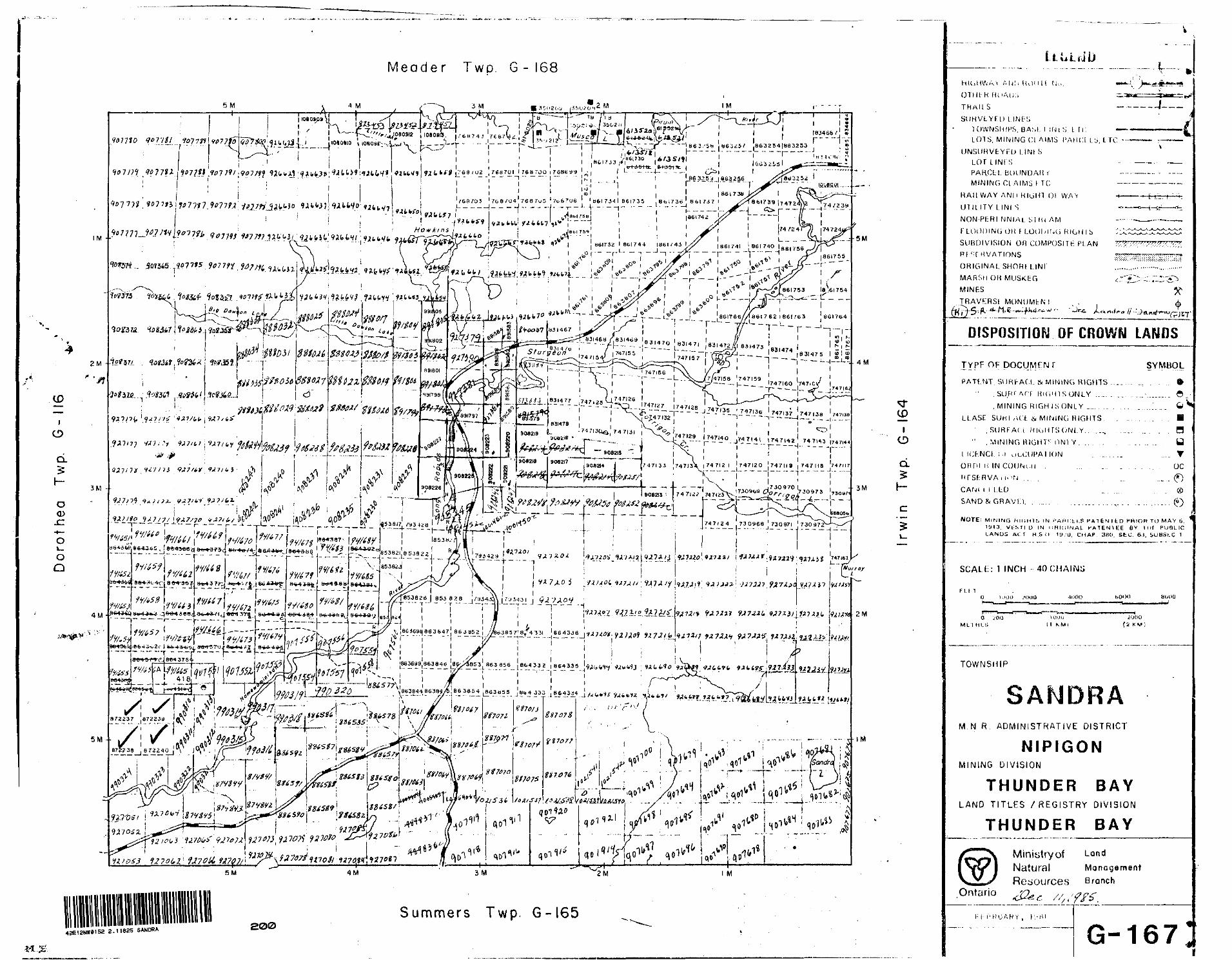
Meader Two. G - 168
- ,- - 5 M
901110 writ i 107771H6^^f , B632541883233
u^M'iwt\n"^ i^jg&iijP*?(Cr^"X^y r"^ y i i —
^afeiw.'nfc^'wW/i^wfcfcfc, ^tn-min^U* X^y0 ''*b'•i y .——- , t—— ..~-, .-.. ..^ . . . -i.. ,. .. .j ̂ .. i ^ IM — ...
H6I732 1 861744 1861 i* 43
86l76e7xl86l 7621661763 661764
l "- — --l— 1---. 4 M
J4JI40 J747I4I 1747I4Z 747.43 1/47,44r™ — *— —-J— *— i f T 11
1/47121 747120 747119 |747IIB 747117 -—---——-————-----""-----
7 X
V7v^7 ^^ ;7 i '"'t i
SM 1M
42E12NW8152 2.11825 SANDRA200
Summers Twp. G-165
CD
O
cL
h-
c
—.|L..
OTIU K H oAUi
T H A U S — -
SUHVfcYtl) t I Nt: !iTOWNSHIPS, B ASL l INtS, t li: —— -LOTS, M INING CI AIMS. PARC! L b, 1 1C - --
UNSUHVtYKU l.INI SLOT L INI SPARCU. BOUNOAHYMINING CI AIMS \ T C
RAII W AY ANIl R IGHT Ol WAV H——
UTILITY L INI S ^~
NON-P[:RI N NIAI b ] H I AM
FLOODING OR f LOUMNG H (GUI S : .^
SUBDIVISION OH COMPOSITE PLAN 77?'
Rf * ; fRVATIONS mZT.
ORIGINAL SHORt LINI .......
MARSH O H MUSKEG c ^*-
MINES
TRAVKRSI MONUMbN!
DISPOSITION OF CROWN LANDS
TYPF OF DOCUMENTPATF.NT, StJRF-ACI. tt. MINING RIGHTS
, SUM f AfT HlliHlSONLY
, MINING RIGHISONLY .... .
LLASE SUHI AU: .S/ MINING RIGHTS
, SURFAt i HluHTSONt Y. .^...
" . MINING MIGHTS ONI Y. .. . ..
l IChNCl. i.i uLCUPA! ION . .. .
onni ii IN
SYMBOL
a u v
oc
CAM i i l.LO
SAND^ GRAVLL
NOTE: M iNiN(i H inn i;. IN HAHCLLS P ATENTED fRiOH T O M AY 6.iyi3. V t-SfID IN MHIC.INAL H ATENIEE B V l M! P UQLIC LANDS A CT H.S.Ci 1 U/U, CHAP 3HO. S EC 6 -1. SUBSl.C 1
SCAU:: 1 INCH - 40 CHAINS
FU lO UK) D 4i)00 hOOO
——^——————————T*———UIKKJ
O I'OO ML l H t. a
Hl'.iu l KMi
J (JOG'z K M;
TOWNSHIP
SANDRAM.N R. ADMINISTRATIVE DISTRICT
NIPIGONMINING DIVISION
THUNDER BAYLAND TITLES /REGISTRY DIVISION
THUNDER BAY
Ministryof LandNatural ManagementResources Branch
Ontario
G-167Jm UKIK 'i' If n mar mm iimm-—
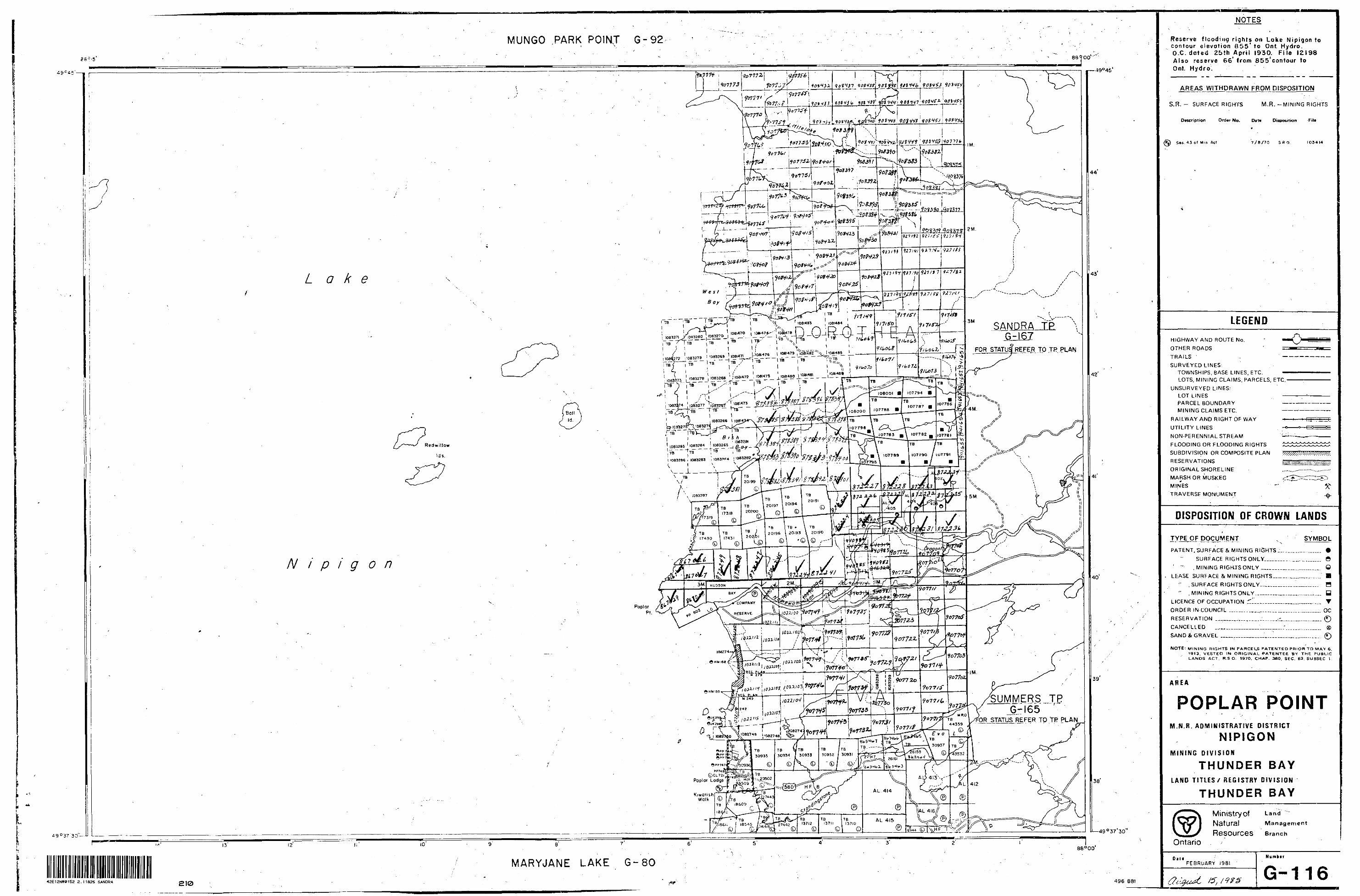
NOTES
MUNGO PARK POINT G-92
. r^r
Lake
IQBI4BS 1081484l -t*^, ""^ """"^ ' '——** ^
IOB1470 [ 1 08147^' IOdM7BSANDRA TPB4i
FOR STATU REFER TO TP
IO832&1 IDB32B5 ' 1063284 1 063265^ ^~ TB
107789 107790 IU779I1063286 1083263 1 083W*
'mMmww.
N i p i g on
UMMERS, TP-i 65
STATUS REFER TO TP PLAN————— ——. ——— -. ^ ., . .
Poplar Lodge T "W1"^*^*02 3 l- i^^nft T ^^-,
^7"f42 l 13712 l I37H l faTJO
©I ©j © (D
MARYJANE LAKE42E12NWei52 2.11825 SANDRA 496 8BI
Reserve flooding rights on Lake Nipigon to contour elevation 855* to Ont. Hydro. O.C. dated 25th April 1930. File 12198 Also reserve 66* from 855'contour to Ont. Hydro.
AREAS WITHDRAWN FROM DISPOSITION
S.R. - SURFACE RIGHTS M.R. -MINING RIGHTS
Description Order No. Di** Disposition F ile
Sac. 43 of Mm Act 7/8/70 SRO 103414
LEGEND
HIGHWAY AND ROUTE No.
OTHER ROADS
TRAILS -
SURVEYED LINES:TOWNSHIPS, BASE LINES, ETC.LOTS, MINING CLAIMS, PARCELS, ETC.
UNSURVEYED LINES:LOT LINESPARCEL BOUNDARYMINING CLAIMS ETC.
RAILWAY AND RIGHT OF WAY -*
UTILITY LINES
NON-PERENNIAL STREAM ~
FLOODING OR FLOODING RIGHTS
SUBDIVISION OR COMPOSITE PLAN
RESERVATIONS
ORIGINAL SHORELINE
MARSH OR MUSKEG
MINES
TRAVERSE MONUMENT
DISPOSITION OF CROWN LANDS
TYPE OF DOCUMENT SYMBOL
PATENT, SURFACE 6 MINING RIGHTS J...— ..™——. *
SURFACE RIGHTS ONLY.—-----™-™.—-. O
! " .MINING RIGHTS ONLY ____.._..M.......... O
LEASE SURFACE fc MINING R IGHTS —— —.-.-™.™™" H
" .SURFACE RIGHTS ONLY..l..-.......-M....... H
" , MINING RIGHTS ONLY.......__r..m.^,......^. y
LICENCE OF OCCUPATION ^1..._._.^.-......—-^. T
ORDER IN COUNCIL ........._^.......— ..,......-^—. OC
RESERVATION ___-,^-T _..'....—-r.._.—......_. ©
CANCELLED ___.^——.__—..^-...^............—., ®
SAND A GRAVEL ___....____^,..l—_.^.......^... ©
NOTE: M INING RIGHTS IN PARCELS PATE NTED PH IOR TO MAY 6, 19t3. VESTED IN ORIGINAL PATENTEE BY THE PUBLIC LANDS ACT. R.SO- 1970, CHAP. 380, SEC. 63, SUBSEC l
AREA
POPLAR POINTM.N.R. ADMINISTRATIVE DISTRICT
NIPIGONMINING D IVISION
THUNDER BAYLAND T ITLES/ REGISTRY DIVISION
THUNDER BAY
Ministry ofNaturalResources
Land
Management
BranchOntario
DadFEBRUARY 1981
15, f 9 f S
Numb ir
G-116
LEGE
ND
CENO
ZOIC
OUAT
ERNA
RYRe
cent
Lake
, st
ream
and
swa
mp
depo
sits
Plei
stoc
ene Sa
nd,
grav
el,
clay
PREC
AMBR
IAN
HDOL
E (A
RCHE
AN)
to U
TE (P
ROTE
ROZO
IC)
PREC
AMBR
IAN
Maf
ic In
trusiv
e Ro
cks.
7a
Diab
ase
INTR
USI
VE C
ON
TAC
T
EARL
Y PR
ECAM
BRIA
N (A
RCHE
AN)
5+00
N
4+00
N
3+00
N
2+00
N
00 N
BL
0+
00
1+00
S
2+00
S
3+00
S
4+
00 S
Maf
ic In
trusiv
e Ro
cks
6a
Gabb
ro
55a 5b C
.rInte
rmed
iate
to
Felsi
c In
trusiv
e Ro
cks
Gra
nite
qua
rtz f
elds
par
porp
hyry
Gra
nodi
orite
GLu
artz
di
orite
INTR
US
IVE
CO
NTA
CT
MET
AVOL
CANI
C Af
ib M
ETAS
EDIM
ENTA
RY R
OCKS
Chem
ical
Met
ased
imen
tary
Roc
ks
^
Mag
netit
e in
terb
edde
d w
ith a
rgill
ite i
ron-
rich
rock
s
Clas
tic M
etas
edim
enta
ry R
ocks
3a
3b
3c
3d
Poly
mic
tic o
rthoc
ongl
omer
ate
Ark
ose
Silt
ston
eA
rgill
ite
Inte
rmed
iate
to
Felsi
c M
etav
okan
ic Ro
cks
2a
2b
2c
Pyr
ocla
stic
bre
ccia
Lapi
lli tu
ffAs
h flo
w t
uff a
nd d
eriv
ed
schi
sts
Maf
ic M
etav
olca
nic
Rock
s
'a
Mas
sive
lav
aIb
Pi
llow
lav
a
31+0
0 N
30+
00 N
31+0
0 N
30+
00 N
22+
00 N
21+0
0 N
20+
00 N
19+0
0 N
18+0
0 N
17+0
0 N
Xw
'Xl
i* •u-
^*,
1a
HIGH
GRA
DE12
6227
1262
2862
29
1262
1812
6219 V1
2621
2 12
6213
12
62U
Aqv,
py,
cpg""
'
TL
3 + 2
5
N
12+0
0 N
1+00
N
10+0
0 N
9+00
N
8+00
N
7+00
N
6+00
N
5+00
N
4+
00
N
3+00
N
2+00
N
00 N
BL
0+
00
+00
S
2+00
S
3+00
S
SY
MB
OL
S
/'
c
feu
0•\
f x*S
^
d* m O +
ir/
s
yyx* y?x~
yyx. y* L
y\7
/
-t-7-
X
i**r
.
UtM
Vt/
l \V
\.
tot H r.^
^i^T'.
sjr"11 h
*1* u-
. dd
hiuU
wfcM
t *t t
t**
-**^
Ktli
^ ^
*"dt
rt dw
*M. *
ta*"
ta v
tor
——
*rM
Pto
MK
flM
Mri
M.
Sm*/
/ bed
rock
out
crop
.
ATM
of b
edro
ck tu
tere
p.
Bedd
ing,
hor
ltont
tl.
Bedd
ing,
top
unkn
own;
(Inc
lined
, r*
rtic*
l).
Bedd
ing,
(op
Inci
ted
bf i
"w;
(incl
ined
, nrH
ctl,
wffi
urne
d).
Bedd
ing,
top
(t"*
**) fro
m p
ct/n
ot*
d-
ttion
; (In
clin
ed, f
ertfc
^. o
rtrjy
rrwrf)
.
Bedd
ing,
top (
nrow
)fnm
cro
u be
ddin
g;
(Incl
ined
, r*f
1*c*
/. Br*
rfwfn
**J.
SetW
inff,
(op
(*"
owj
f"wn
rel
ethn
shlp
of
clet
vta*
*na
bed
dino
; (in
clin
ed o
ver
turn
ed).
ltve
(to*;
top (
ffow
) fio
m pi
llows
shtp
emn
d po
ckin
g.
Schi
stos
ity; (
honi
ontm
l, in
clin
ed,
verti
cil).
Mot
ion;
(hw
'iool
t/. in
clin
ed,
rerti
ceJ)
.
t-H
^X
4XX
*rx
Gne
issos
ity, (
nvim
niv,
intiw
™,
rtri
tctt)
.
Bind
lno;
(Apr
tow
W. '
nc'"
^' "
rtte*
7)l
Join
ting;
(hw
InnW
* In
clin
ed, v
ertic
il).
Xlin
eatio
n w
ith p
lung
e.
^*—
~^~
—
~ G
toto
etci
t bo'
-ndt
ry, o
bser
ved.
.^
Geof
oC'ca
' boo
ndvf
. pos
ition
in
terp
rete
d.
——
——
7Z3
Geot
ooic
tloou
ndvy
. ded
uced
from
-*
' \
oeop
hr*i
c*-
s*Li
neim
ent o
f fmu
tt.
•.
f,,,*;
fob
s""*
. •W
U"*
").
5pj*
/nr
fj-^f^
Ol
cite
s Jo
wn
Iftre
* iW
e. -"
O""
(no'
c''"
^ *
j ho
rlio
nW n
w*m
*nf.
^s K
wss±
s !Tt4"
Jsatw-
"ax-
fiE
r1 H
bi
ll tr
t H
Iw
M-
1 "-
~^u ^
y
OrlO
fold
s wX
h pl
unge
.
^*~
An
ticlin
e. s
rncl
ine,
w.th
plu
nge,
•i*
[o-c
X
c^"^
c r̂ o
Sii
r
a,*r
a"'
}OTr
*ncK
M
MET
AL
^A
*" * X
&"*"
1*"
tQ
uif
fjf
Df III
koto
; (ve
rticd
. inc
lined
).
Drill
hole;
(pro
fecled
ver
lkttf
f, pr
ojec
ted
up d
ip).
Over
burd
en tn
owfl.
Drill
hole
; (pr
ojec
ted
vert/
celtf
, fro
ject
rt
up d
ip).
Ove
rto/rl
en t
/ww
n.
5/it/
I; de
pth
In fe
et.
Tntp
tt.
tiplw
iUo*
Innt
hlnC
-
Adit
Ouu
ry.
Grt
vtl p
it-
OPM
of,
f M
rv t U
W f
neto
*.
NiM
*^*
t- U
M.
7 lf
*
* *.
— ̂
* ^*
; H
umm
txky
(opo
p'"^
y.ik
Sw
imp
.
F-̂
Mot
or to
ad.
—
Oth
er t
oed.
-
.,
1r*i
l. po
rtmpe
. win
ter
/OK*
.
AN
D
MIN
ER
AL
A
BB
RE
VIA
TIO
NS
Au
go
ld
qc .
. . .
.qu
atz-
carb
on
ate
Aq
. . .
- .si
lver
tour
. . .
tourm
alin
e C
u. .
- . .
copper
al
. . .
. .alb
ite
Pb.
. . .
.le
ad
ep.
. . .
.ep
ido
te
Ni.
. . .
.nic
kel
fu.
. . .
.fuchsi
te
Zn.
. . .
.zi
nc
ank
. . .
.ankeri
te
Mo.
. . .
.m
olyb
denu
m
sid.
. ..s
ideri
te
mag.... m
agn
etit
e d
ol.
. . -
do
lom
ite
py .
. . .
.py
rite
se
rp.
. .se
rpen
tin
e
po .
. . .
.py
rrh
oti
te
mgs
t . .
.mag
nes
ite
cp.
. . .
.chalc
opyri
te
talc
. . .
talc
i
sp
sph
ale
rite
sh
ee.
. .sc
heeli
te
mo
. . .
. .m
oly
bd
enit
e eh
. . .
. .c
hlo
rite
ca
rb.
. .ca
rbonat
e as
b.
. . .
asbes
tos
q quar
tz
rous
. . .
.m
usc
ov
ite
LEG
EN
D
CLA
IM
PO
ST
10+0
0 N
5+00
N
4+
00
N
3+00
N
2+
00
N
00
N
BL
0+
00
1+00
S
2+00
S
3+00
S
4+
00 S
5+00
S
6+
00
S
7+00
S
42E12NW0152 2.11825 SANDRA
* 2
20
LJ
PO
PLA
R P
T.
10+0
0 N
9+00
N
8+00
N
7+00
N
6+00
N
5+00
N
4+
00 N
3+00
N
2+00
N
00 N
BL
0+
00
+00
S
9+
00
N
8+00
NJ2
a
HIGH
GRA
DE Z
OI&
1
1262
27
' 12
6228
62
29.X
*
53
12
6226
1262
2212
6223
^ - -~
T
I262
2;
1262
25
19
53*5^
*421^
•"
ita^
Y*
•i*^*
**
—ii
^.y
'
"T—
1262
1812
6219
1262
1212
6213
1262
14
7+
00 N
6+00
N
5+00
N
Stur
geon
2+00
S
3+00
S
4+
00 S
5+00
S
6+00
S
7+00
S
, Inc
linfd
, rt
rtktl).
METAL AND MINERAL ABBREVIATIONS
Lin
tmlio
n w
ji
Geo
hfka
t bo
-'nd*
ry, o
bttiv
ed.
Geo
hvic
e! b
ound
ary,
pos
ition
l/nca
mtn
f
FauH
; (o
bser
vtd,
tuu
med
). S
pot
Indi
ca
tes
dow
n (ft
fow
sid
e, t
now
s ho
rizon
tal m
wtfntn
t.
bat
foW
j wftf
t p/u
np*.
, syn
clin
e, tv
/lfj p
lung
e-
f^U .
* *
Ag.
. .
Cu.
. .
Pb..
.Ni
. .
.Zn
.. .
Mo.
-.ma
g .
.py
...
po..
.cp
. .
.sp
...
mo.
. .ca
rb.
q... -
j
. .s
ilver
. .c
opper
..le
ad. .n
ickel
. .z
inc
. .mo
lybd
enum
. .magnetite
. .p
yrite
. .py
rrho
tite
. .c
halcop
yrit
e. .
spha
leri
te. .
molybdenite
. .carbonate
. .qu
artz
tour
al..
ep..
fu..
ank.
sid.
dol.
serp
mgst
talc
shee
eh.
.as
b.mu
s .
. .qu
atz-
carb
onat
e. .tourmaline
..al
bite
..ep
idot
e..
fuch
site
..ankerite
..si
derite
..do
lomite
. .s
erpent
ine
..ma
gnesit
e. .talc
. .s
chee
lite
..ch
lorite
..as
bestos
..muscovite
LZ:
LEG
END
DC
LAIM
P
OS
T
"S l
o* l
JL o
Geo
logy
by
R.P.
Bow
en
REVI
SIO
NSHa
rotd
Ben
t
N E
NG
INE
ER
ING
IN
C
&EN
AUDE
N RE
SOUR
CES
LIMITE
D
GEOL
OGY
MAP
Dat
e:
Aug
. 88
Scal
e: l
: 500
0 A
onro
ved;
RPB
Dra
wn:
jib