Embed Size (px)
Citation preview

Subterranean Journeys A Springfield Plateau Grotto Publication
Volume 11 Issue 1

2
Page
President’s Column 3
Sequiota Cave Water Quality Report 4
Dripping Cave 6
Cannady Cave 12
SPG Public Outreach Programs 16
The Genesic Dome 20
About the Springfield Plateau Grotto 21
Contents
Cover Photo: Stephens Gap Sun Rays
By taking an unusual stance, Matt Bumgardner was able to capture an original image of sun rays inside the pit entrance to Stephens Gap Cave, Jackson County, Alabama. The Stephens Gap Callahan Cave Preserve is a 123 acre Southeastern Cave Conservancy property.
Volume 11 Issue 1
Subte
rranean J
ourn
eys

3
President’s Column
Spring is here! As I’ve mentioned before, Spring and Fall are my favorite seasons for ridge walking and searching for new caves. In the next few weeks everything will be blooming and turning green. It’s a great time to be out in the woods making new discoveries. I hope some of our newest members will join us on the upcoming Barry County trips. Lately, with the help of various grotto members, we’ve pushed the Barry County cave count past the 200-mark. Let’s try to hit 300 by 2018! I’m relatively sure we can hit that number with new caves on National Forest land alone.
We’ve already got a lot going on this year. As always, Jon Beard is working on completing multiple surveys. He’s always looking for help with these since we tend to keep his weekends pretty booked with other activities. If you happen to have weekdays free, you should touch base with Jon and get some trips planned. I know he would appreciate the help.
We will have a trip to Round Spring Cave the weekend of May 7th to repair some of the tour trails in the cave that were damaged from heavy rains last year. This is a GREAT opportunity to see one of the best show caves around. For those of you who haven’t been to Round Spring, the trip is a must. Not to mention the fact that we will have use of Powder Mill Research Center, which has room for plenty of people to sleep, a full kitchen/bathroom/etc. The Research center is within walking distance of both the Current River and Blue Spring. Two weekends later, we will be back down at Powder Mill for the MSS/MCKC meetings. There will be cave trips Friday, Saturday and possibly Sunday. It’s also a great chance to meet cavers from all over the state.
Hopefully. we can get another trip into Garrison #2 planned — always a fun trip and a good introduction to caving with a wetsuit. In addition, we would like to put together a photo trip to add to our schedule.
If you’ve got a cave you really want to visit, let me know and I’ll see what we can arrange. It’s always nice to be able to plan a trip that I know others are interested in versus trying to come up with trips I think others would enjoy.
Also, don’t forget about the NSS Convention, which is in Ely, Nevada this year. From the looks of it, even though Ely is smack dab in the middle of nowhere, there won’t be a shortage of things to see and do. I’m going to be jealous of those of you that make to the convention. This year, I will be using my vacation to visit Postojna Cave and the Škocjan Caves in Slovenia and maybe get some non-commercial caving in as well. I’ll make sure to bring back plenty of photos and video as long as those of you who are going to convention promise to do the same. Who am I kidding? I’ll bring back plenty of photos and video, regardless.
I hope everyone enjoys this issue of Subterranean Journeys. Remember, we can always use more articles. Whether it is a full-blown story or just a report from a recent trip, anything and everything is welcome!
Matt Bumgardner

4
2016 Sequiota Cave Water Quality Sampling
By Bobbilynne Koepke, RG
The Springfield Plateau Grotto has been testing the water quality in Sequiota Cave since 2008.
Testing was initiated following a major siltation event in December 2006, which was the result
of a broken water main southeast of the cave system. In 2007, the silt was up to 36 inches
deep in the East passage, essentially annihilating the ecosystem within this passage. Today
the silt, often referred to as “peanut buttery pudding” in consistency, has decreased to an
average of 7 inches thick, having been compacted and partially flushed out of the stream over
time. The ecosystem within this passage is very slowly making a comeback, with isopods and
bristly crayfish being sporadically observed during the annual biota counts.
The cave stream has two sources: North Creek in the North passage, which is a piracy of
Galloway Creek and East Creek in the East passage, which is diffusely recharged by shallow
groundwater and surface water runoff infiltrating the bedrock. These two water sources meet
near the rimstone dam approximately 1000 feet back in the cave. Samples are collected
upstream in each passage before the dam so that the quality of each water source can be
evaluated separately.
North Passage Sampling
During this year’s sampling, the North passage stream exhibited a water temperature of 13.9
degrees Celsius, conductivity of 506 uS/cm, total dissolved solids (TDS) of 263 ppm, pH of 6.5
(lower than usual) and dissolved oxygen of 6.5 mg/L. These readings were within the historical
range for this stream and indicate generally good water quality ideal for a variety of aquatic
animals. Detected nitrates and phosphates in the passage were 2.9 mg/L and 0.22 mg/L,
respectively. This value for nitrates is within a good range (drinking water is allowed to have
up to 10 mg/L, for comparison); however, the phosphate concentration is higher than what is
considered ideal for freshwater streams (<0.1mg/L). Sources of phosphate include animal
wastes, sewage, detergent, fertilizer, disturbed land and road salts used in the winter; high
phosphates can result in algal blooms. Microbial counts were within a normal range and no E.
coli was detected.
East Passage Sampling
Meanwhile in the East passage, the water temperature was 14.7 C and the stream exhibited a
conductivity of 617 uS/cm (slightly high—ideal is <500 uS/cm for freshwater streams), TDS of
321 ppm, pH of 6.4 (lower than usual) and dissolved oxygen of 7.6 mg/L. Phosphates and
nitrates were detected at 0.12 mg/L and 1 mg/L, respectively. Microbial counts were lower
than normal and no E. coli was detected.

5
Carbon dioxide levels in both passages have been unusually high for the past two sampling
events (2015 & 2016). This year, CO2 concentrations were detected at 125 mg/L in the North
passage and 230 mg/L in the East passage. These values correlate to the slightly more acidic
pH’s noted in both streams (typical pH for the cave is 7.3-7.8). Generally, CO2 concentrations
in the cave range from 15-35 mg/L, which is within a “normal” range of about 20 mg/L. The
reason for this change in acidity is unknown.
In Summary
The cave’s location within a residential area provides numerous possibilities for potential
pollutants; however, the historical biodiversity of Sequiota Cave and its associated streams
show how ecosystems can thrive even within urbanized areas. The annual water quality
sampling, completed in conjunction with the annual bioinventory, affords an opportunity to
monitor how this microcosm is recovering since the 2006 siltation event and provides valuable
data over time to quantify the improvement. Correlating data from the water sampling events
can be used to evaluate changes in species diversity and numbers from year to year.
About the author: Ms. Koepke is a registered geologist and is employed by Environmental
Works, Inc., Springfield, MO as a Project Manager. She acts as the SPG’s water quality
specialist, conducting water quality testing periodically at the various springs and cave streams
across the region. When not sampling water, she is most likely spending time with her
adorable new infant son, Josiah.
March 13, 2016 Sequiota Cave Bioinventory team. Front: Left to right: Luke Buzzard, Kate Moran, Bobbilynne Koepke, Clayton Russell, Cynthia Spoering, Treavor Bussard, Charity Hertzler Back row: Brandon Van Dalsem, Paul Folbré, Andrew Westmaas, Jonathan Beard, Sheryl Galvin, Eric Hertzler, Olivia Graves, Josh Harmon. Photo: Charity Hertzler

6
Dripping Cave
By Jonathan B. Beard, NSS 21308RL (CO-FE)
Former MCKC president Hal Baker was a geologist for the Missouri Geological Survey who,
among his many duties, conducted geological mapping in specific places. One of those
places is situated in Christian County. While doing field work a few decades ago in the
rugged Eureka Springs Escarpment, he found a cave entrance. Although an avid caver once,
his assignment dealt with the surface, so he made note of the entrance and continued on.
Fast forward to 2015. Hal is now retired and living in Texas, but still enjoys the occasional
float trip on a Missouri stream, so he continues to be no stranger to the Ozarks. He
contacted me and asked if I wanted to join him in the rediscovery of that cave entrance. I
agreed, and on May 15, 2015, I met him and his companion in Mark Twain National Forest.
Our objectives were to hike the hollow, find his cave and document it for the Missouri cave
database as part of Cave Research Foundation (CRF) data monitoring project for the U.S.
Forest Service.
Hal was sure of the hollow and he was sure the entrance was on the south side of the
hollow, not far from where we parked our Ford Explorers (his white, mine black). The three
of us set out down the steep slope very near the maximum angle of repose, fanned out and
began searching for limestone outcrops. The Pierson Limestone is especially noted for its
vertical scarps on the slopes, breaking off in dramatic vertical joint planes while other rocks
do not as they form soil and vegetation covered slopes. The rock outcrops were few and
very disappointing as we hiked the slope down the hollow. We must have hiked a mile as we
realized the entrance was not easy to find. We had all-but-given up—maybe it wasn’t in this
hollow after all. Hal was still insistent that it was in this hollow. But, where? Hal hiked
further down the hollow while I hiked back to the vehicles by way of the north slopes of the
hollow, just to see if there might be a cave opening of some kind there.
At the bottom of the hollow, I found a cave opening. Not Hal’s cave by any means, but there
was a low, wide opening to something. It was in the Cotter Dolomite where caves are
usually few and far between. I crawled in and very quickly found its end. It has a small
chamber there, just to give it enough length to qualify as a minimal cave. I obtained a GPS
reading, recorded it and knew it wasn’t the cave Hal had found a few decades ago.
Therefore, the cave was but a small consolation for failing to find a more substantial one.
I hiked up the slope until I found the elevation housing the Pierson Limestone and hiked up
the hollow, finding a small trickle spring cascading down the hill. Could this be the runoff
from Hal’s cave? Caves in the Pierson have obvious trenches below them, but this wasn’t
cascading down much of a trench.
Nope, not a cave. The water was issuing from a narrow crack in the rock. There is probably a
cave behind it, but without an entrance, I could not see it. I kept hiking the Pierson for a
while, and a large notch in the bluff revealed a walk-in cave entrance! I yelled for the others,
and eventually Hal heard my call and hiked up to where I was waiting. Hal shook his

7
his head in disbelief. Yep, it was his cave, but it had relocated itself to the north side of
the hollow! This throws the whole concept of caves being inanimate objects out the
window. They move! While Hal waited on a large breakdown block, trying to cool down, I
entered the cave. Even from the entrance, I could hear the reverberations of a loud
dripping sound, so I was soon to call it Dripping Cave. The walk-in entrance height soon
lowered significantly to a crouch, but the passage continued straight north along an
obvious joint control with the minutest trickle of a stream meandering its way around
occasional cobble on an otherwise bedrock floor. A nice, clean Pierson cave as usual,
without any Missouri cave mud to mess with. I arrived at an abrupt 90-degree turn to the
right, followed shortly by a sharp turn to the left, all joint-determined with gradually
diminishing height requiring me to crawl on hands and knees.
I had traveled about 90 feet when I was stopped by a wet drip from a stalactite that
plopped onto a shallow pool—the source for the echoing dripping sound heard
throughout the cave. The space under the drip was low and wet and I decided, caving
solo, that I had seen enough for now.
I returned to the entrance and a
partially cooled Hal. After a
couple of entrance photos and a
GPS reading, we regrouped back
at the vehicles, requiring a steep
hike down to the floor of the
hollow and back up the other
side to the top of the ridge.
Hal generously offered lunch, so
we sat and discussed the world’s
problems and caves in general.
After this, we parted ways.
Off to Fry Bigger Fish
A few months flew by, and although I reminisced occasionally about Dripping Cave, it was a
minor cave, I thought, and there were bigger fish to fry, mainly SPG’s CRF survey of Lowell
Cave in Wright County, a whale of a cave at nearly 7,000 feet, which took multiple survey
trips to finish. I was quite relieved to finish that one!
Return to Dripping Cave
After the Lowell survey was completed, Eric Hertzler called and asked if I wanted to go caving
in Christian County as a finish to the Thanksgiving holiday weekend. I suggested Dripping
Cave as part of the potential itinerary. So, on November 29th, he picked me up and we drove
to the area. The plan was to start with Dripping Cave and if we had time left, we’d check out
a neighboring hollow for other possibilities.
Hal Baker at the Dripping Cave entrance . Photo: Jon Beard

8
With the temperature around 45 degrees, it was a cold, damp weekend following more than
two inches of rain on saturated ground. The creeks were running, wet-weather springs were
rejuvenated, the ground was mushy and it was drizzling just enough to make us wear rain
gear.
We opted for the small shelter I had found. Eric had hiked all over the area and couldn’t
believe he had somehow missed a couple of cave entrances. I thought it was easy to miss
them—even when Hal knew there was a cave there, it took half a day to find any. After
eyeballing the shelter, we hiked up the hill and found the cascading water issuing from the
small crack in the rock. It was a more impressive cascade than on my previous visit, but still
no cave entrance. We easily found Dripping Cave, only this time, it was ponded throughout
the cave. The “drip” was much noisier this time, more like a waterfall noise with lots of
other drips all over the place. Hardly a dry spot to stand under. We removed our rain gear
and prepared ourselves for the drippy cave.
A Few Survey Shots Conquer the Cave
No matter, it would only take a few survey shots to conquer this insignificant little cave I
thought, so we began to survey. Eric stretched the first shot 55 feet to the first turn and
after checking, figured it would take only a couple more shots to go as far as he could see. It
took me a while to sketch this first shot, but after that the cave’s features were fewer and
sketching was simplified. We counted a few salamanders along the way and we carefully
switched places in order for me to sketch the last footage up to the dripping—er, I mean
waterfalling —stalactite over the shallow pool of water.
The End or Not?
Eric begged to differ with my earlier assessment that the cave ended here, became too
small. He was right—there was a clear 12 inches of air over 4 inches of water beneath that
waterfall. Should we wait to see what was beyond—my distometer showed at least 22 feet
beyond the falls—or should I take the plunge and see for myself now? I didn’t want to take
another trip to the cave if it ended just ten feet beyond where my disto could measure—if
so short, we’d finish it then. Still, it was only 45 outside and the waterfall would drench any
part of me that faced the ceiling even if I could finger-and-toe my way through the
constriction to keep my belly dry.
I crouched there in full contemplation mode. It would be ugly, but I had done plenty of ugly
before in my life. I set my clipboard to the side, placing my compass and distometer on it. I
even managed to wriggle my way out of my sweatshirt, which had been inside of my
coveralls. The idea was, no matter how wet I got, I could always wear my sweatshirt back to
the truck, under my rain suit, to keep relatively warm afterwards. Eric offered to place it in a
dry space behind me.
I stared at the ugly scene one more time before taking the plunge. Arms and thighs were
immersed even before I slithered through the waterfall. The only parts of me that didn’t get
wet immediately were my face and feet. My face was facing forward, my torso was just
above the pool and my feet were in rubber boots, but the waterfall easily soaked whatever

9
parts of me weren’t immersed in the pool. The constriction lasted for five feet. On the other
side of the finger-and-toe section was another, smaller waterfall. My belly and chest had
stayed dry somehow, but my back was saturated.
Returning to the stream, I crawled
further, arriving at a gravelly streambed
I would have to bellycrawl through. So
much for my stomach staying dry—as if
it mattered anyway!
Remembering Other Caves in Pierson Limestone
So many caves in the Pierson formation
have miserable wet bellycrawls in
gravelly water issuing from impressive
domes. Would this cave be similar?
I bellycrawled into the wet mess and
shouted “HEY!” It echoed! Yes, a dome
lay ahead!
The ceiling height went from 12 inches
to 18 feet immediately. Standing up, I
gazed at the thick chert lenses that
capped the elongated room.
Right: Brandon Van Dalsem in the Dripping
Cave genesis dome.
Dripping Cave orange-red flowstone. Photo: Jon Beard
More Hands and Knees Crawling
About 20 feet ahead was a nice
couple of orange-red flowstone
formations, perhaps the most
picturesque in the cave. On the
upper walls of the crawl were two
pipistrelles; I guess they flew through
the constriction during drier times!
Past the formations was more of the
same crawlway. Soon the ceiling
lowered to the water line, but there
was a convenient, dry meander crawl
that circumvented the low water.
The thick chert lens was the Reeds Spring Formation’s way of saying, “Hello! Here I am!” Yes,
another genesic dome greeted me. First, I looked left and found the left end of the room in 15
feet. I walked to the right, marveling at the fluted walls that betrayed the secret of the room’s
origin, finding about 45 feet to where the opposite side of the 15-foot wide room pinched out.
End of cave or more to the point, the beginning of the cave-making process.
Photo: Jonathan Beard

10
I noted another pipistrelle hanging out on one of the walls, then found a few stalactites
above that had been vandalized long ago, their broken tips being replaced by one-inch long
soda straws. I took a few photos and then crawled back in Eric’s direction to tell him the
news.
After a few more photographs, I sloshed through the waterfall again, this time not caring
how wet it would get me—I had no dry places remaining on me anyway.
Homeward Bound
Eric was as happy as I was about the discovery of the genesic dome and probably relieved he
could stay dry, at least this time. I followed Eric out of the cave, whereupon I stuffed my
belongings into my small backpack. We hiked up the gravel-strewn, leaf-covered slope back
to the truck, with expected difficulty, huffing and puffing. With welcome relief, I changed
into dry clothing at the truck for the trip home.
2016 Return to Complete Survey
On January 16, 2016, Brandon Van Dalsem and I returned to finish the survey. We carried a
dry change of clothing with us to the cave entrance, knowing we’d need them for the return
hike to the car on a cold, wintery day.
Quickly we crawled to the end of the previous survey at The Drip, which wasn’t a waterfall
this time, but it was still an active drip over a bellycrawl in over two inches of water. We
surveyed some 100 feet of mostly wet crawlway to the genesic dome that ends further
penetration. Expecting a narrow dome, Brandon was pleasantly surprised to find it 50 feet
long, a third as wide and as a distometer revealed, up to 35 feet tall.
Jon Beard prepares for the day’s survey work. Photo: Brandon Van Dalsem
11
An Increase in the Bat Population
We found a somewhat surprising number of bats in the domed room, many more than I had
observed just a month before. We found two small clusters of bats among the many solitary
bats. Close observation of photographs later led me to believe they were little brown bats,
increasingly more difficult to find in the Ozarks in the wake of WNS.
I finished the sketch none too soon as we were getting chilled in the dripping dome. Dripping
Cave has 257 feet of cave; perhaps an average length cave overall in Missouri, but in the
Pierson formation, 257 feet makes it significant. Like so many, Pierson inner sanctums are
domes formed by falling water courtesy of the cherty Reeds Spring Formation above. Then,
once ending its vertical journey at or near the Northview Shale below, water finds an exit by
way of a modest, low, horizontal tube. After I completed my sketch work, we made rapid progress, crawling back to the cave entrance to change into something dry.
In Search of More Caves
After reaching the car, Brandon contacted Eric who was waiting not far away. The three of us
spent the rest of the day ridgewalking. We, found two small undocumented caves that we
named Crawl Falls and Shagbark Caves. Crawl Falls is minimal, but Shagbark, in drier times,
might lead somewhere, if it doesn’t get too narrow.
Thanks to Hal for directing the project in the right direction (well, sort of) and to Eric and Brandon for assisting with the survey.
Surveying a passage in Dripping Cave. Photo: Brandon Van Dalsem

12

13
Cannady Cave at Last
By Jonathan Beard, NSS 21408-RL (FE)
Ever since I helped the late Bob Taylor survey Breakdown Cave and looked at the old 1970
map of Cannady Cave, I saw an amazing resemblance in character between the Main Room
of Breakdown and Cannady. Both had multiple entrance passages, lots of breakdown, loop
crawls and mud. I wanted to see Cannady Cave for myself, but never could reach the
landowner. The gate to the property was always closed.
The house on the property has a lot of history. Springfield area residents are well aware of
the old Heer’s Building on the city square, a luxury department store for decades, recently
refurbished. The Heer Family built a field stone house, a small castle really, overlooking the
river below. What a magnificent house it is, later owned by the Weaver Family who were
vaudevillians (The Weaver Brothers & Elivry) nine months of the year, living in the stately
mansion for three months. It would later be owned by the Cannady Family for which the
cave is named.
Scott Tillman purchased the property recently with the intent to refurbish the mansion and
keep it alive after hearing a potential buyer intended to demolish the castle and build
something else there, which would have been a travesty.
Through SPG member Paul Folbré, who works with Scott’s son Paul, I finally made use of the
opportunity to see the cave that seemed to have a likeness to Breakdown Cave’s Main Room.
On Saturday, March 19, 2016, I met Scott, Paul T. and Paul F. We dressed in our cave gear
and entered the east entrance to the cave, which has a locked gate. The entrance is modest,
but happens to be the largest entrance in the bluff that also contains Fox and Mud caves. A
joint determined hall greeted us and after 60 feet or so, we arrived at a junction of passages
and breakdown that defined much of the rest of the cave.
We chose to go to the right in apparent
walking passage some 100 feet to a
humongous breakdown block, the kind you’d
see in the Main Room of Breakdown Cave. We
climbed down from it into walking passage on
a slanted, slippery muddy floor. Occasionally
we’d see some flowstone worthy of
photography. After another 100 feet, the
passage ended in a short bellycrawl. No, it
would not connect to Fox Cave, at least, not by
humans.
Right: One example of the variety of flowstone in
Cannady Cave. Photo: Jon Beard
14
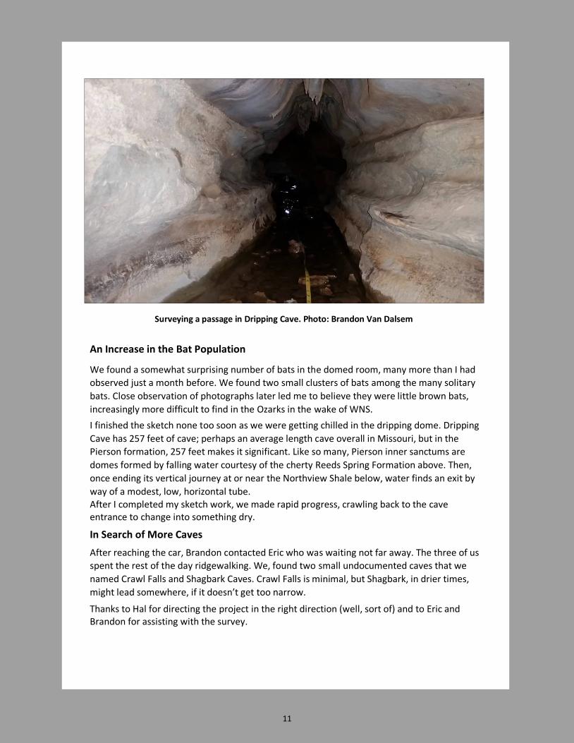
Backtracking to the Big Breakdown
Block
We backtracked to the big breakdown
block where Paul Folbré crawled under and
found a low wide passage with a ceiling of
dozens of limestone pendants. By choosing
our way, we ended up back at the junction
just inside the entrance. From here we
turned right, up a steep slippery slope to a
large room with breakdown boulders. At
the end of the room, there was a climb
upward and over another tremendous
breakdown block where we found a nice
flowstone mound with dozens of soda
straws above it. The formation is named
Sugarloaf Mountain on the 1970 map by
Bill Bockstiegel.
Right: Sugarloaf Mountain. Photo: Jon Beard
Other forms of wall flowstone found in Cannady Cave. Photos: Jonathan Beard

15
Shortly after Sugarloaf Mountain, the passage ends, so we returned to the breakdown
room. From here, we slipped down into a low wide room with a flat floor. To the east, the
passage soon pinched into a terminal bellycrawl, but to the west Paul F. urged me to try a
tight bellycrawl. Like an idiot, I accepted the challenge, only to find out that it looped right
back to the breakdown room. After this, we butt-surfed back down to the junction just
inside the entrance. So much for the eastern “half” of the cave.
From here, we walked westward, briefly checked a terminal crawl on the left before
entering a tight bellycrawl. Scott stayed back while the Pauls and I continued on, choosing
to go left at an intersection, briefly enjoying walking passage in a well-decorated area.
The passage turns left, at this point, into a passage that leads to the second entrance. By
returning to the junction, we went right for 40 feet, leading to the tight bellycrawl to the
cave’s third entrance. The latter two entrances are on the Tillman’s neighbor’s property.
We counted 64 bats, a cave salamander and gathered as much old cans and bottles as we
could and took many photos.
After we exited Cannady Cave, we visited nearby Fox Cave, a small 150 foot long cave that
was documented much later than Cannady. Fox Cave has a small bellycrawl entrance that
leads to an irregular room, a climb down and to a nicely decorated area. By climbing
above the speleothems, we could access a low wide area, and then an area below that.
Although only 150 feet long, it is complicated. In the lower area, we found some bats, one
of which had visible WNS, no surprise with the continued spread of the disease.
We talked caves for a while, thanked the Tillmans for their hospitality before Paul Folbré and I departed. It had been a great day.
So, my wish to see Cannady Cave came true. We made a tentative plan to have the caves remapped to modern standards. which will give me added opportunity to learn about the caves.
Scott and Paul Tillman at the Cannady Cave Entrance. Photo: Jon Beard

16
SPG Public Outreach Programs by Jonathan B. Beard
Cave and karst conservation lie at the core of SPG’s public outreach programs, which create
awareness and understanding through education and serve as the first line of defense to
protect caves and karst resources and prevent cave vandalism.
As a grotto, we believe it is important to define reasons for conducting public outreach
efforts, namely protecting geological and biological resources and the quality of
groundwater , which is vital to both cave biota and humans.
Because caves are time capsules of geological and biological history, conservation begins
with protecting both geological and biological resources.
One example of a cave as a time capsule is Lon Odell Memorial Cave. The cave has 22 bear
denning beds and the walls are quite literally wallpapered in bear claw marks throughout
much of the cave. The cave has prehistoric human footprints, torch remains on walls and
floors as well as petroglyphs scratched on the walls and ceilings. As soon as we discovered
what this very special cave contained, we gated it. Watch a professional half-hour
documentary about this cave, entitled Footsteps into the World Beneath.
Protecting Biological Resources in Caves
Protecting biological resources is yet another aspect of cave conservation. Most Missouri
bats utilize caves seasonally or all year in order to survive harsh winters and predators. They
don’t hang upside-down from ceilings for nothing! In additions to bats, numerous other
species , some rare and endangered, rely on healthy cave environments.
Brimming with delicate, fragile ecosystems , caves must not be harmed, by water pollution
from the surface nor abuse from human visitors. Disrupting just one link in the cave’s food
chain could disrupt the entire ecosystem. Some cave species are found in just one cave!
Focus on Quality of Groundwater
Karst conservation also means protecting the quality and quantity of groundwater. Take too
much from one place and wells go dry. Anything dumped on the surface of the land will
leach into the groundwater sooner or later. Want to drink polluted water? No? Want your
family or neighbors to drink or bathe in polluted water?
As it turns out, water quality is important not only for humans, but also for the ecosystems
in caves that depend on groundwater. Most municipal and urban water sources are
dependent, directly or indirectly on quality groundwater. One of Springfield’s original water
sources, Fulbright Spring, is still one of the city’s sources of water some 100 years later!
Thus, we want city officials to keep a watchful eye on the recharge area for Fulbright Spring.

17
Public Outreach Through Many
Mediums
Presentations are one method to
reach the public and convey
awareness of the importance of wise
use and conservation of karst
resources.
SPG members have made annual
presentations to school students,
scouts and other civic groups.
Right: Melvin Johnson talks to Missouri
Master Naturalists about bats.
SPG member, Roy Gold produced a CD showcasing the superb cave photographs taken by
SPG’s platoon of photographers including Lloyd Morrison, Charley Young, Bob Harvey, Roy
and others. The CD was first used in a presentation shown to the general public at the
Springfield Conservation Nature Center auditorium on March 20, 2014 and has been utilized
on many occasions to date. We have also presented in Springfield area schools (Pipkin
Middle School, Delaware School and schools in Fordland, Marshfield and other locations). In
most cases, we use the SPG’s laptop, its accessories and digital projector.
Display booths at area events are an SPG tradition. The grotto is an annual participant in
Great Outdoors Days sponsored by Bass Pro and Wonders of Wildlife. We install our
display tent, display tables, display boards, pamphlets. Indoor venues happen
occasionally and here instead of a display tent, we include our 32-inch monitor and show
photos of caves, bats and features. Once a year, the National Park Service sponsors Junior
Ranger Day Alley Spring on the Ozark National Scenic Riverways. At the event, we
present a 10-minute program to a dozen or more classes of third graders from regional
schools, reaching 300-400 kids each year.

18
Educational field trips are yet another means to reach the public. From April 1 to
November 15, Breakdown Cave has been the site of numerous trips through the years for
more than 6,000 students. We give them opportunities to get muddy, but mostly we teach
them about caves, caving safety and cave conservation. Scouts, elementary school kids,
middle and high school students as well as college students have been taught about caves,
each trip tailored to the specific target group. Occasionally, we also use nearby Fitzpatrick
Cave and Pearson Creek Cave for guided trips, especially if there are folks who are a bit
squeamish about bellycrawling! Breakdown Cave has been used for guided field trips since
1983.
Charity Hertzler guides a group of students on a trip through Breakdown Cave.
Publications. For many years, it was a
dream to produce a booklet for
landowners that defined karst and
explained how to manage it to prevent
our groundwater—our drinking water—
from becoming polluted, to prevent
vandalism in caves and maintain healthy
cave ecosystems. In 2009, SPG published
its first edition of 11,200 full-color copies
of Caring for Your Karst. In 2014, we
published a second edition of 9,800
copies. Both editions were published
thanks to generous donations from the L-
A-D Foundation, MCKC, MCHF, MSS and
CRF as well as a great publishing deal
from McCann Printing Co. in Springfield,
Missouri.
19
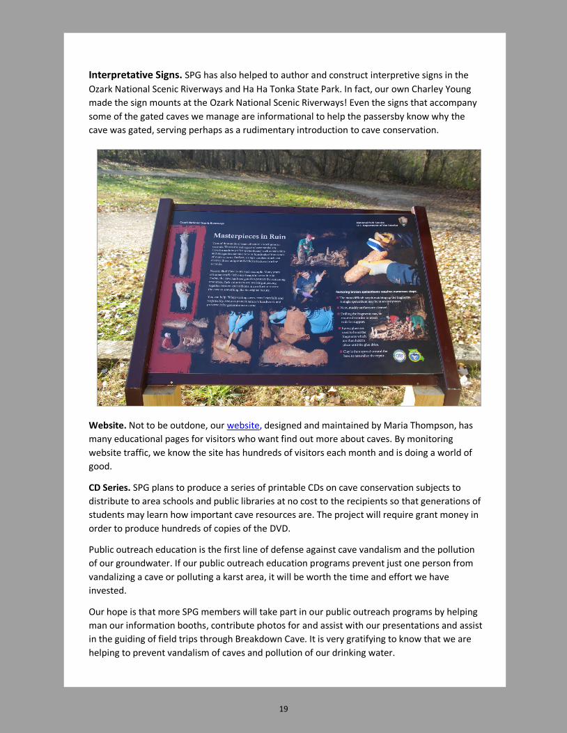
Interpretative Signs. SPG has also helped to author and construct interpretive signs in the
Ozark National Scenic Riverways and Ha Ha Tonka State Park. In fact, our own Charley Young
made the sign mounts at the Ozark National Scenic Riverways! Even the signs that accompany
some of the gated caves we manage are informational to help the passersby know why the
cave was gated, serving perhaps as a rudimentary introduction to cave conservation.
Website. Not to be outdone, our website, designed and maintained by Maria Thompson, has
many educational pages for visitors who want find out more about caves. By monitoring
website traffic, we know the site has hundreds of visitors each month and is doing a world of
good.
CD Series. SPG plans to produce a series of printable CDs on cave conservation subjects to
distribute to area schools and public libraries at no cost to the recipients so that generations of
students may learn how important cave resources are. The project will require grant money in
order to produce hundreds of copies of the DVD.
Public outreach education is the first line of defense against cave vandalism and the pollution
of our groundwater. If our public outreach education programs prevent just one person from
vandalizing a cave or polluting a karst area, it will be worth the time and effort we have
invested.
Our hope is that more SPG members will take part in our public outreach programs by helping
man our information booths, contribute photos for and assist with our presentations and assist
in the guiding of field trips through Breakdown Cave. It is very gratifying to know that we are
helping to prevent vandalism of caves and pollution of our drinking water.

20
Charley Young
Charley Young
Crossing the Stream Dry!
The Barrier Crawl
Photo: Brandon Van Dalsem
The Barrier Crawl
Photo: Brandon Van Dalsem
The Lowell Cave Stream
Photo: Charley Young
The Genesic Dome
By Jonathan B. Beard
In your beating hearts you wonder
Where does this breeze blow from?
You press yourselves into the crawl down under,
Your gloved, wet fingers cold and numb.
You squeeze your form through the crack,
The tiny dust blowing in your face.
The serrated limestone gnaws at your back;
All this bother slows not your pace.
Your caving buddy is right at your heels,
Faithfully following your bold lead.
All the discomforts you have he, too, feels,
Your call to continue he will heed.
The constricted passage turns but opens not.
Your will to discover and learn drives you on.
The persistent wind plants the seeds of thought;
Any doubts to continue are gone.
You shout to see if there might be an echo,
A reverberating sound to tell of a great hall;
Or will it be the muffled sound to say “no go,”
The dead end of a terminal crawl?
You slosh through the heat-sapping water,
What a gawd-awful place this is.
Your body wriggling through as if you’re an otter,
Is that echoing grunting noise yours or his?
At last you reach the hallowed dome,
That raining room you yearned to find.
You stand to view this myotine home,
You imagined so clearly in your mind.
The dome is from where the cave begins,
The rock cored outward from a crack.
The flutes protrude like long, tall fins,
You’re awestruck as you and friend stand back.
Whereas your squirming forms filled the crawl,
You feel so small in this vaulted room.
It is indeed a magnificent hall,
It is a priceless sight, but for whom?
Just another look, perhaps one more photo,
Your feet were fixed, you did not roam.
The memory leaves one lasting glow
As you depart this genesic dome.

21
Subterranean Journeys is a
Springfield Plateau Grotto (SPG)
quarterly journal published in
Springfield, Missouri.
Editor: Maria Thompson
Email: [email protected]
Assistant Editor: Jonathan Beard
Email: [email protected]
Springfield Plateau Grotto Officers
President Matt Bumgardner
Vice President Melvin Johnson
Secretary/Treasurer Jonathan Beard
MSS Director Max White
About SPG
Springfield Plateau Grotto (SPG) is a 501(c)(3) non-profit organization made up
primarily of southwest Missourians who share a common interest in cave conservation,
surveying and management. Project-oriented, the group works in tandem with public
agencies and private landowners to enhance understanding of caves and foster
awareness of the importance of conserving the cave environment. SPG works in
cooperation with the Missouri Speleological Survey to document, map and study caves
and is a cooperating member of the Missouri Caves & Karst Conservancy.
SPG is very serious about our commitment to the well being of Missouri's caves and the
cavers who visit them. Our members are active in cave exploration, mapping,
restoration, gating and management.
SPG membership in the organization is not automatic upon payment of the dues. If you
are interested in exploring membership with us, please visit the SPG website and attend
our monthly meetings.