Embed Size (px)
Citation preview
2
A. Statement of Problem Being Addressed
This guidance provides clarity for Wisconsin Department of Natural Resources (DNR) Runoff
Management staff and external partners in identifying wetland protective area susceptibility per
ch. NR 151, Wisconsin Administrative Code. A wetland’s susceptibility to pollutants in runoff
and the placement of storm water best management practices are considered in determining the
protective area. This guidance is intended to assist the DNR and external partners in making
protective area determinations.
B. Background
This guidance was developed to clarify the requirements of ss. NR 151.125 and 151.245, Wis.
Adm. Code, pertaining to the establishment of protective areas with respect to wetlands.
C. Discussion
This guidance summarizes the rule requirements of ss. NR 151.125 and 151.245, Wis. Adm.
Code, regarding wetland protective area performance standards for non-agricultural and
transportation facility post-construction sites while also providing additional information on
wetlands with different degrees of susceptibility and their respective protective areas. Refer to
Attachment 1 for definitions and references.
D. Guidance
Protective Areas
Protective areas are established to minimize impacts from runoff coming from developed areas
before it reaches sensitive resources. The protective area begins at the delineated boundary of the
wetland. The width of the protective area is measured horizontally from the nearest edge
(delineated boundary) of the wetland to the nearest edge of an impervious surface. For wetlands,
the width of the protective area is based upon the attributes of the wetland:
Highly Susceptible: 75 feet
A protective area width of 75 feet pursuant to ss. NR 151.125(1)(e) and 151.245(1)(e), Wis.
Adm. Code, is established for “highly susceptible” wetlands. “Highly susceptible” wetlands
include the following wetland plant community types: calcareous fens, sedge meadows, open
and coniferous bogs, low prairies, coniferous swamps, lowland hardwood swamps, and
ephemeral ponds. Outstanding and exceptional resource waters are also considered “highly
susceptible”.
Neither Highly or Less Susceptible (“Moderately”): 50 feet
A protective area width of 50 feet pursuant to ss. NR 151.125(1)(d) and 151.245(1)(d), Wis.
Adm. Code, is established for wetland plant communities that fall between “highly
susceptible” and “less susceptible”. These wetlands include, but are not limited to: shrub
wetlands, floodplain forests, fresh wet meadows, deep/shallow marshes, and forested
3
wetlands (i.e., forested wetlands dominated by early successional species such as box elder,
trembling aspen, or cottonwood) not fitting the wetland types described under “highly
susceptible” or “less susceptible”. Perennial and intermittent streams and lakes also fit in this
protective area designation. Perennial and intermittent streams are identified on a U.S.
geological survey 7.5-minute series topographic map, or a county soil survey map, whichever
is more current (NR 151.125(1)(b), Wis. Adm. Code.).
Less Susceptible: 10% of the Average Wetland Width – Ranging from 10 to 30 feet
“Less susceptible” wetlands require a protective area width of 10 percent of the average
wetland width, but not less than 10 feet nor more than 30 feet pursuant to ss. NR
151.125(1)(f) and 151.245(1)(f), Wis. Adm. Code. “Less susceptible” wetlands are degraded
wetlands dominated by invasive species. Common invasive species found in “less
susceptible” wetlands include, but are not limited to: reed canary grass (Phalaris
arundinacea), common buckthorn (Rhamnus cathartica), glossy buckthorn (Frangula alnus),
purple loosestrife (Lythrum salicaria) and non-native strains of common reed grass
(Phragmites australis). A wetland is considered to be dominated by invasive species if it
contains over 90 percent invasive species as measured by percent absolute vegetative cover.
Wetlands dominated by invasive species not listed above would also be considered “less
susceptible”. (For more information on invasive species, see Attachment 1.) Wetlands in
cultivated hydric soils, gravel pits, or dredged material or fill material disposal sites are also
considered “less susceptible”.
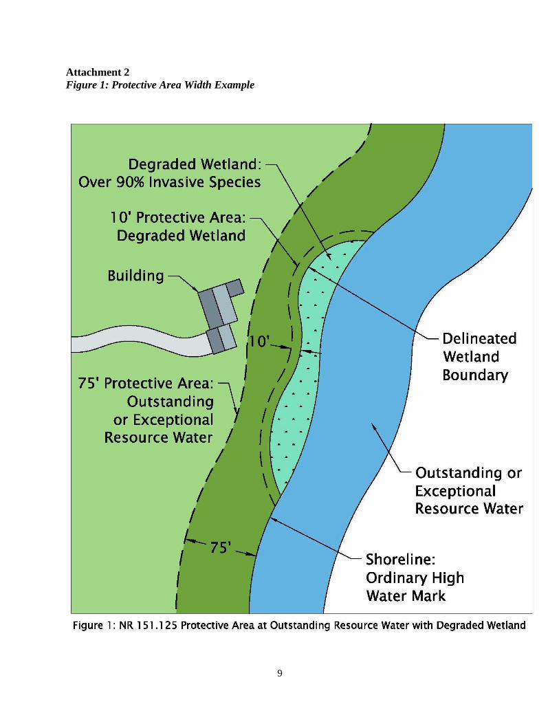
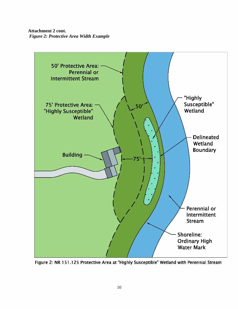
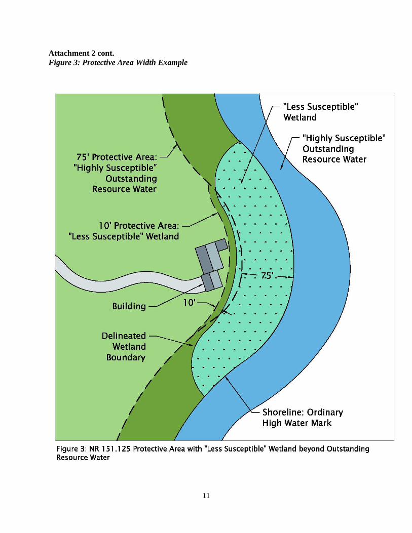
Where a “less susceptible” wetland is contiguous with a river, stream, or lake, the greatest
protective area width shall always apply pursuant to s. NR 151.125(1)(j), provided that the
greatest width does not fall within the wetland area. See Attachment 2, Figures 1-3, for
examples of NR 151.125(1)(j), Wis. Adm. Code. For example, in Figure 1 the greatest width
does not fall within the wetland area but encompasses it as well as the “less susceptible”
wetland protective area; so the applicable protective area is the protective area from the
outmost boundary of the exceptional resource water. However, in Figure 3 the greatest width
does fall within the wetland area, so the applicable protective area of the “less susceptible”
wetland’s outmost boundary applies.
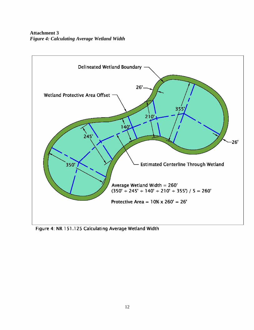
Average Wetland Width
The following procedure is recommended for calculating the average width of a wetland
(See Attachment 3, Figure 4, an example wetland width calculation.):
Step 1. Draw a center line that runs across the long axis of the wetland. This is not
necessarily a straight line but one where half the wetland area is located on each side of
the centerline.
Step 2. Make at least 5 individual measurements across the wetland perpendicular to the
centerline established under Step 1. Enough measurements shall be taken to establish a
representative average wetland width. These measurements shall be made equidistant
apart along the centerline established under Step 1. If the wetland has a configuration
with a relatively long narrow strip that is connected to a much broader area, then the
wetland area calculation may be broken up into separate areas with the average wetland
4
width established for each separate area.
Step 3. The wetland’s average width shall be the arithmetic average of the individual
measurements taken under Step 2.
Determining the Wetland Protective Area
An accurate wetland delineation is essential to establishing the starting point for all protective
areas. The final width of the protective area will be determined based upon a given wetland’s
plant community. Plant community descriptions may be included as part of a wetland delineation
report or a supplemental “Plant Community Description Report” can be completed. Regardless
of the reporting method used, plant community designations must be based upon data that is
collected in the field and presented in the report. Wetland community types can be determined by
using guides such as Wetland Plants and Plant Communities of Minnesota & Wisconsin version
3.1, US Army Corps of Engineers St. Paul District, 2014, which further describes wetland plant
communities and typical plants found within those communities and are helpful in classifying
wetland types. Additionally, the DNR provides wetland community information on their website,
Wetland communities of Wisconsin. When two or more wetland susceptibility classifications are
identified within the same contiguous wetland boundary, the final protective area boundary is to
be established using the outermost boundary of each protective area category (highly susceptible
wetland, less susceptible wetland, USGS stream, ORW/ERW, etc.). See Attachment 2.
“Highly Susceptible” wetland plant community types include calcareous fens, sedge
meadows, open and coniferous bogs, low prairies, coniferous swamps, lowland hardwood
swamps, and ephemeral ponds.
a. Calcareous fens: a type of wetland plant community found in areas of upwelling,
mineral-rich water. These wetlands are rare and can be identified by the
vegetative species found growing in them. Examples of common plants that
occupy calcareous fens include shrubby cinquefoil (Pentaphylloides floribunda),
wild timothy (Muhlenbergia glomerata), Ohio goldenrod (Solidago ohioensis)
and lesser fringed gentian (Gentianopsis procera). Other common fen species are
described here: http://www.npwrc.usgs.gov/resource/plants/mnplant/fens.htm.
b. Sedge meadows: a type of open (non-treed) wetland in which sedges and
bulrushes make up a significant component of the plant community. At least one
of the dominant plants species are in the genus Carex or Scirpus (does not include
the genus Schoenoplectus or Bolboschoenus). Invasive species make up less than
50 percent of the absolute percent vegetative cover.
c. Open and coniferous bogs: A wetland type in which sphagnum moss is the
dominate substrate. Bogs can be open (non-treed), shrubby, or treed. The primary
determinant is the presence of sphagnum moss.
d. Low prairies: an open (non-treed) wetland community that applies only to areas
south of Wisconsin’s vegetative tension zone. Typical soils in these wetland types
have a thick mineral topsoil (> 8 inches) although variance in soil thickness
exists. Dominant plants include prairie grass components and various forbs.
Dominate species include big blue stem (Andropogon gerardii), prairie cord grass
(Spartin pectinata), and Canada blue joint (Calamagrostis canadensis). Invasive
species make up less than 50 percent of the absolute percent vegetative cover.
5
e. Coniferous swamps: a forested wetland (whereby the wetland community
contains at least 50 percent canopy coverage of coniferous species) in which
sphagnum moss is not the dominate substrate. Dominant woody species include
white cedar (Thuja occidentalis), tamarack (Larix laricina) or balsam (Abies
balsamea). Invasive species make up less than 50 percent of the absolute percent
vegetative cover.
f. Lowland hardwood swamps: a forested wetland (whereby the wetland community
contains at least 50 percent canopy coverage of deciduous species) in which
sphagnum moss or alluvial soils are not the dominate substrate. Deciduous species
include red maple (Acer rubrum), green ash (Fraxinus pennsylvanica), black ash
(Fraxinus nigra), and yellow birch (Betula alleghaniensis). Silver maple (Acer
saccharinum) may be a co-dominant south of the vegetative tension zone. This
wetland community excludes early successional species such as cottonwood, box
elder, or trembling aspen). Floodplain forests are not included in this wetland
community. Invasive species make up less than 50 percent of the absolute percent
vegetative cover.
g. Ephemeral pond: a closed depression found in a forested setting, that holds water
following snowmelt and spring rains, but typically dries out by mid-summer. The
key traits of these wetlands are: 1) located in a forested setting, 2) isolated, 3)
small size - usually less than an acre, 4) seasonal hydrology – dry out most years
by mid-summer, and 5) supports a biologic community adapted to an absence of
fish as a permanent predator (wood frogs, spring peepers, fairy shrimp, etc.).
“Moderately susceptible” wetlands include shrub wetlands, forested wetlands, floodplain
forests, fresh wet meadows, deep/shallow marshes, and other wetland types that fall between
“highly susceptible” and “less susceptible”.
a. Shrub wetlands can be alder thickets, shrub-carr, or scrub-shrub dominated.
b. Forested wetlands are dominated by early successional deciduous species such as
cottonwood, box elder, and trembling aspen.
c. Floodplain forests include deciduous forests growing on alluvial soil.
d. Fresh wet meadows are dominated by a variety of grasses and forbs. Sedges
(Carex spp.) and bulrushes (Scipus spp.) are not one of the dominant plant species
in a fresh wet meadow. North of the vegetative tension zone, Canada Bluejoint
may be one of the dominant species in a fresh wet meadow. South of the
vegetative tension zone, Canada Bluejoint will not be one of the dominant species
(considered a wet prairie species south of the tension zone).
“Less susceptible” wetlands are those which consist of invasive species that make up over
90 percent of the absolute vegetative cover. Common invasive wetland species include reed
canary grass (Phalaris arundinacea), common buckthorn (Rhamnus cathartica), glossy
buckthorn (Frangula alnus), purple loosestrife (Lythrum salicaria), and non-native strains of
common reed grass (Phragmites australis). Additional species may be considered invasive.
Information on invasive species can found by checking the DNR Wetland Invasive Species,
Wisconsin State Herbarium, Freckmann Herbarium websites or other similar source (See
Attachment 1).
W:\Storm_Water\Guidance\Wetland Protective Area\Wetland Protective Area Final
7
Attachment 1
Resources: Definitions and References
Definitions
"Artificial wetland" means a landscape feature where hydrophytic vegetation may be present as a
result of human modifications to the landscape or hydrology and for which there is no
prior wetland or stream history.
"Impervious surface" means an area that releases as runoff all or a large portion of the
precipitation that falls on it, except for frozen soil. Rooftops, sidewalks, driveways,
gravel or paved parking lots, and streets are examples of surfaces that typically are
impervious.
“Invasive species” means nonindigenous species whose introduction causes or is likely to cause
economic or environmental harm or harm to human health.
“Protective area” means an area of land that commences at the top of the channel of lakes,
streams and rivers, or at the delineated boundary of wetlands, and that is the greatest of
the following widths, as measured horizontally from the top of the channel or delineated
wetland boundary to the closest impervious surface.
“Vegetative tension zone” means an area of climatic transition running from northwest
Wisconsin to southeast.
References
Identifying Wetlands Wetland Communities of Wisconsin
Wisconsin Department of Natural Resources.
Wetland Plants and Plant Communities of Minnesota and Wisconsin – III. D. Calcareous Fens
United States Geological Survey, Northern Prairie Wildlife Research Center.
Wetland Plants and Plant Communities of Minnesota and Wisconsin, Version 3.1 – May 2014 by Steve
D. Eggers and Donald M. Reed
U.S. Army Corps of Engineers, St. Paul District.
Invasive Species Robert W. Freckman Herbarium
University of Wisconsin – Stevens Point.
Wisconsin Botanical Information System
University of Wisconsin – Madison, Wisconsin State Herbarium.
Wetland Invasive Species
Wisconsin Department of Natural Resources.
Chapter NR 40, Wis. Adm. Code (Invasive Species Identification, Classification and Control)
Wisconsin State Legislature
8
Attachment 1 cont.
Resources: Definitions and References
References
Wetland Boundary Delineation Guidance for Submittal of Delineation Reports to the St. Paul District Army Corps of Engineers and the
Wisconsin Department of Natural Resources
Wisconsin Department of Natural Resources.
Wetland Delineation Professional Assurance Initiative
Wisconsin Department of Natural Resources.
Wetland Identification Program
Wisconsin Department of Natural Resources
Wetlands Delineation Manual, Wetlands Research Program Technical Report Y-87-1 – January 1987
U.S. Army Corps of Engineers, Waterways Experiment Station.
9
Attachment 2
Figure 1: Protective Area Width Example
10
Attachment 2 cont.
Figure 2: Protective Area Width Example
11
Attachment 2 cont.
Figure 3: Protective Area Width Example
12
Attachment 3
Figure 4: Calculating Average Wetland Width


![Statement of Problem and Substantiation for Public Input ...€¦ · Committee Statement Resolution: The issue has been addressed in ... Simulator [2], FLUENT [3], CFX [4], Star-CD](https://img.pdfslide.net/doc/110x75/60204bd3567dfd683d2ecd75/statement-of-problem-and-substantiation-for-public-input-committee-statement.jpg)