Embed Size (px)
Citation preview

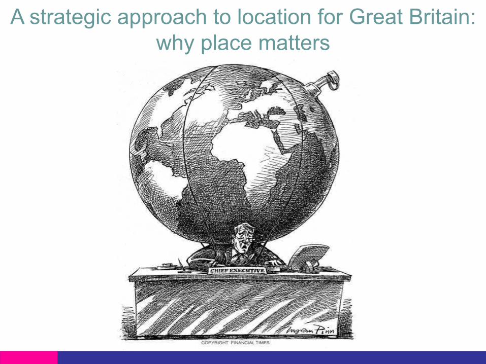
A strategic approach to location forGreat Britain: why place matters
Vanessa LawrenceDirector General and CEO, Ordnance Survey Great Britain18 June 2007
Toward more transparent government: Workshop on eGovernment and the webUnited States National Academy of Sciences, Washington

Decision making
Revenue Time
CostLo
catio
n
Location is the fourth driver to decision-making inboth the public and the private sector

The world is changing…..


New views of the world – merging of ideas

Local Search

Creation and provision of free data…
This map was generated by OpenStreetmap contributors using GPS data, and are licensed as Creative Commons CC-BY-SA 2.0

Geography has gone mobile

Geography has gone mobile
© Disney Mobile

• Ordnance Survey is 216 years old• Civilian organisation since 1983; 1448 staff• Independent Government Department and Executive
Agency reporting directly to a Government Minister• Trading Fund since April 1999• Annual Report for 2005/06: operating turnover of
£118.4m; profit before dividend and interest £7.9M• 100% owned by Government and we pay a dividend
to the Government equivalent to 5.5% ROCE• Less than 50% of our trading revenue is sourced from
the public sector• At most only 27% of Great Britain is profitable to map;
however Ordnance Survey maps the whole of GreatBritain
Ordnance Survey Great Britain

• Creates and maintains the ‘master map’ of GreatBritain from which others derive benefit
• Manages complete national large scale digital datadown to building level detail
• Maintains a database of 440 million features withapproximately 5,000 changes made daily
• In 2006/07, 99.86% of real world features wererepresented in the database within six months ofcompletion on the ground
• From the database, Ordnance Survey produces arange of digital data and paper maps for business,leisure, educational and administrative use
Provides the underpinning geographic framework forGreat Britain
Ordnance Survey today

Online
Data Collection
Data Maintenance
Data Integration/Processing
Data Supply
Digital Media Graphic Media
Customers/Partners
Ordnance Survey’s business


Bill Bryson, the new President of the Campaign for theProtection of Rural England, speaking on BBC Radio 5 Live,Wednesday 1st May, 2007.
“Looking at an Ordnance Surveymap is one of the most satisfyingthings in life. Every littlewoodland has got a name.Everything on the landscape isnamed.”

The growing value of geographic information• Geography (in disguise) is becoming a working tool in
wider markets• Public sector information is a huge untapped asset (OFT;
2006)• Geographic information from Ordnance Survey alone is
said to underpin in excess of $200bn of GDP per annum(OXERA 1999; 2004)
• Information-rich sectors of the UK economy are fastergrowing than the rest of the economy over the past fiveyears (The Economist; 2006)
• US economists have identified location information as oneof the fastest growing sectors of the economy abovebiotechnology and at least the third largest growth sectorfor employment (US Bureau of Labor; 2006)
• Geographic information is an essential ingredient totackling the nation’s grand challenges
• Many major companies, such as Microsoft, Google andYahoo!, are realizing the benefit of using geographicinformation.

First map of Kent in 1801

OS MasterMap® 2007


Changing models of geospatial information
Paper maps
1791-1971
Digital data files
1971-2001
Spatial database
2001-
Web service
near future

OS MasterMap current layers
Topography
Address
Integrated Transport Network Layer
Imagery

Topography
Addresses
IntegratedTransportNetwork
Imagery
Layers of OS MasterMap

Translated by Dotted Eyes®

Unique identifier0409 2000 1706 1951

Open Geospatial Consortium
• The Open Geospatial Consortium (1994) is an internationalindustry consortium of 339 companies, government agenciesand universities
• OpenGIS® Specifications support interoperable solutionsthat "geo-enable" the Web, wireless and location-basedservices, and mainstream IT
• Consensus process to develop interface standards (i.e.GML, WMS, WFS, …)
• Liaisons with other standards, professional and educationalorganizations
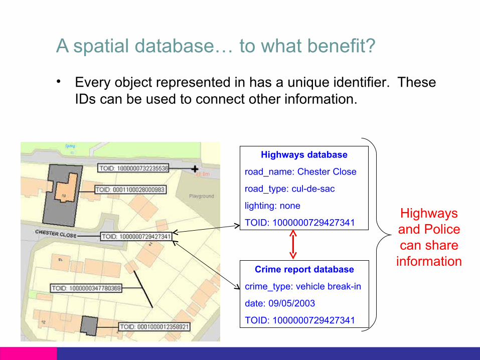
A spatial database… to what benefit?
• Every object represented in has a unique identifier. TheseIDs can be used to connect other information.
Highways database
road_name: Chester Close
road_type: cul-de-sac
lighting: none
TOID: 1000000729427341
Crime report database
crime_type: vehicle break-in
date: 09/05/2003
TOID: 1000000729427341
Highwaysand Policecan shareinformation
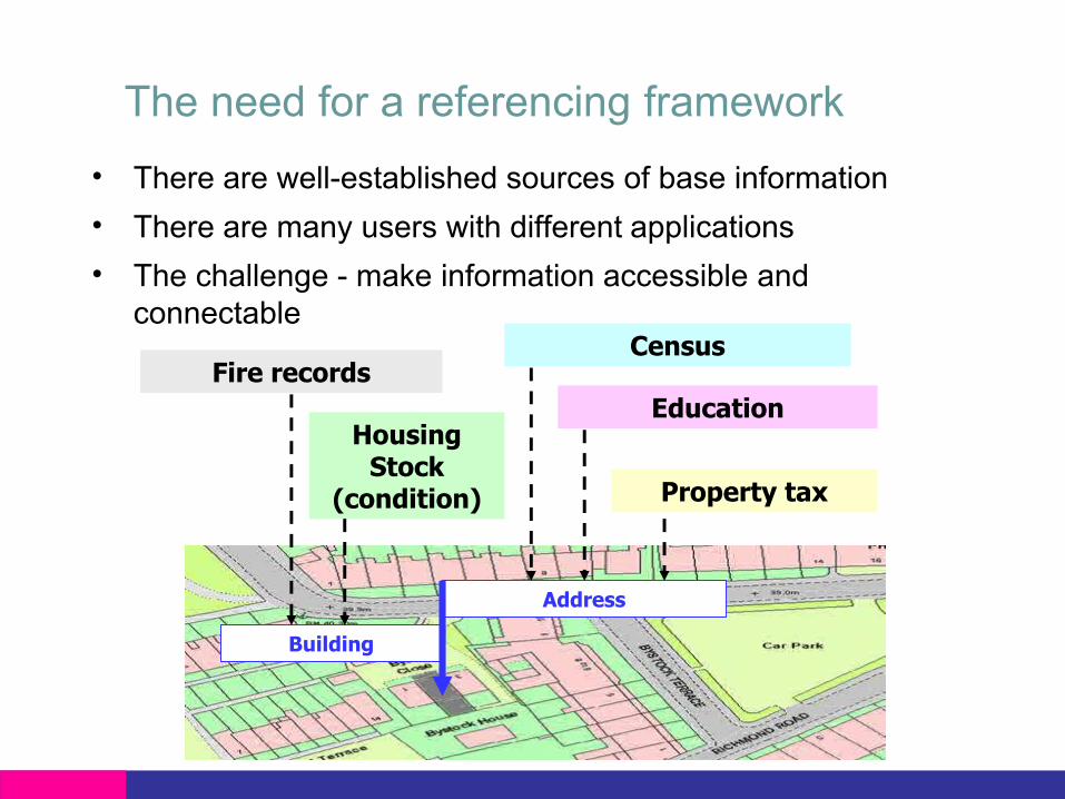
The need for a referencing framework• There are well-established sources of base information• There are many users with different applications• The challenge - make information accessible and
connectable
Address
Building
Fire recordsCensus
EducationHousingStock
(condition) Property tax

Framework
Information}User
Information}
Digital National Framework

DNF for managing buried services• The cost of not knowing precisely where pipelines and
cables are buried is extremely high• There are 4 million road excavations every year• The Institution of Civil Engineers has recommended that all
buried services should from now on be captured to DNFstandards and principles

Georeferencing of Statistics
Georeferencing:At point levelEither: Addressor map featureetc - are linkedto the feature
[TOID]
Aggregateddata
Drilldown
Geographicalarea e.g. byOutput Area
Geographicalarea e.g. bySuper Output
Area
Geographical areai.e by District
Geographical areai.e Region
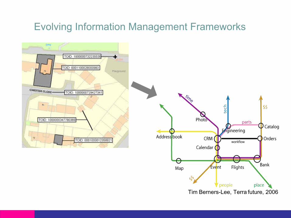
Evolving Information Management Frameworks
Tim Berners-Lee, Terra future, 2006

GeoSemantics: interoperability and semanticinformation
In Swindon
Address:22 Pine Street
Swindon
+ Navigation Application
Church (building)A Place of worship
Roundabouta road junction at
which traffic streamscircularly around a
central island
Query: Show methe addressfor a Churchat a roundabout inSwindon
GPS
Data-base

GI trends: Web services as a window

GI trends: Augmented reality
Managing service infrastructure by adding computer graphics tothe engineers view of the real world
Real world Augmented world

GI trends: Participatory model
BBC – Buncefield Oil Depot Coverage

GI trends: Participatory model

Social trends: Social networking

Social trends: Social networking

E-Government: the landscape has changed
• Information is now generated, mashed up and consumed in the:• Public sector• Private sector• ….and the community….where users create and use content to
generated services useful to that community
• There is huge potential for government and society to utilise allthree sectors to address grand challenges• for eg: Climate change – being addressed by global, regional,
national, local, governments, private sector, communities andindividuals
• for eg: Neighbourhoodfixit.com addressing community basedissues

E-Government and Social Networking

Consumer Web Channel

You too can participate…

The Power of InformationIndependent review, underconsideration by UKGovernment
The report calls for opennessand ease of access to publicsector information to stimulateinteraction between theGovernment and the Citizen
“Recommendation 5. To promoteinnovation, Ordnance Survey should,by the end of December 2007, launchits OpenSpace project to allow non-commercial experimentation withmapping data.”

OpenSpace: platform for innovationOpenSpace aims toencourage, innovate andsupport users withmap-based ideas to buildnon-commercial sites
• The focus is on innovation• There will be an Open API
for ‘Mash Up’ websites• Ordnance Survey data will
be available to OpenSpaceusers
• Non-commercial use only• Commercial use of API will
be possible

Open Space

A weekend’s work:
Just good enough is goodenough…..
but …
In a world where everybody cancreate information, who do youtrust?
Copyright OpenStreetMap

On-demand
Customer Focused Supply Models
Paper
CustomGenerated
Pre-generated
DVD FTP HTTP
SVG
GML
Media
Content
Format
GIF
NTF
Paper
Offline
Online

• 96,000 potential users.• Application sent between
60,000 and 74,000 requests permonth and often more than5,000 requests per day for mapimages from the productsavailable.
• Service available for 100% ofthis time - no single requestfailed as a result of our serversbeing unavailable when a userneeded a map.
• Average response time for amap image to be returned to auser was less than 0.6 secondswith even the most detailed OSMasterMap images returned inlittle over a second.
Ordnance Survey – on demand

OS MasterMapDNF compliantdatabase
Pro
duct
sS
ervi
ces
Increasing value/trust
“Data is the new Intel Inside” (Tim O'Reilly)
OSNet
OpenStreetMap
OS On DemandGoogle Maps

Geographic Information Panel: aims• To give high-level advice to Ministers on geographic
information issues of national importance for the UnitedKingdom, in particular to:• Identify the key medium to long-term geographic
information issues and advise Government throughregular short reports to Ministers;
• Encourage more effective, extensive and systematicuse of geographic information, led by the example ofGovernment Departments and other public bodieswhere appropriate;
• Facilitate a co-ordinated position on potentiallegislation, both national and international, that mightimpact on the geographic information market ;
• To promote a coherent approach to the managementof geographic information in the United Kingdom.

Location strategy for the UnitedKingdom: the results
• A document is being finalised entitled ‘A Location Strategyfor the United Kingdom – Why Place matters’. It will bethe submission for the Transformational GovernmentAgenda
• Will assist the analysis to support the ‘place-based’agenda
• Will meet the needs of the data users as there will beincreased knowledge on the collection standards, themaintenance standards and the availability of the data
• Will drive interoperability standards throughout the widerpublic sector; every indication is that these in turn willensure these standards are adopted by the private sector
• Will drive cost out of the collection and maintenance ofdata collection by reducing duplication across and withindepartments
• Will ensure that the United Kingdom can implement theINSPIRE Directive appropriately and within timescale

A strategic approach to location for GreatBritain: Ordnance Survey’s role
• Department of trusted relied upon information on location andplace
• Location Information is similar to a nation’s insurance policy as itunderpins the planning process, the land registration process,the emergency services, the security services etc
• Delivering solutions through over 500 partners• Actively encourage community participation and, social networks
to build communities, social value and deliver community tocommunity, citizen to citizen information and services
• An essential ingredient to tackling the (Government’s) GrandChallenges e.g. criminal justice, climate change
• Underpinning the semantic web and data integration
A strategic approach to location for Great Britain:why place matters