Embed Size (px)
Citation preview

A Topographical Memoir on East and West Florida with Itineraries of General Jackson'sArmy, 1818Author(s): Hugh YoungSource: The Florida Historical Society Quarterly, Vol. 13, No. 3 (Jan., 1935), pp. 129-164Published by: Florida Historical SocietyStable URL: http://www.jstor.org/stable/30150186 .
Accessed: 16/06/2014 14:57
Your use of the JSTOR archive indicates your acceptance of the Terms & Conditions of Use, available at .http://www.jstor.org/page/info/about/policies/terms.jsp
.JSTOR is a not-for-profit service that helps scholars, researchers, and students discover, use, and build upon a wide range ofcontent in a trusted digital archive. We use information technology and tools to increase productivity and facilitate new formsof scholarship. For more information about JSTOR, please contact [email protected].
.
Florida Historical Society is collaborating with JSTOR to digitize, preserve and extend access to The FloridaHistorical Society Quarterly.
http://www.jstor.org
This content downloaded from 195.34.79.223 on Mon, 16 Jun 2014 14:57:26 PMAll use subject to JSTOR Terms and Conditions

A TOPOGRAPHICAL MEMOIR ON EAST AND WEST FLORIDA WITH ITINERA- RIES OF GENERAL JACKSON'S ARMY,
1818 By Captain Hugh Young, U. S. A. With Notes by
Mark F. Boyd and Gerald M. Ponton PART II. ITINERARIES
This part of the report contains sketches of the routes of the Army from Hartford, Georgia to Fort Scott, and thence through east and west Florida to Fort Montgomery in the Alabama territory with hints for the construction and improvement of roads through the more difficult parts of the coun- try. It was thought best to give the Itineraries the last place in the report, as the particular descrip- tion of the routes is made more intelligible and sat- isfactory by the general account of the country (p. 323) which preceded it.
From Hartford to Ft. Early Hartford is situated in a pine flat on the east
bank of Oakmulgee twenty-seven miles from Marion and forty-seven miles east of south from Ft. Hawkins. Some of the river lands in the neighbor- hood are good-and even the pine lands are made productive by industry but the whole aspect of the surrounding country is dreary, barren and inhos- pitable. The Oakmulgee is navigable this far for river craft but is narrow and somewhat obstructed. It is however the only advantage that Hartford possesses and even with it the town is far from flourishing.'
'To initiate his Seminole Campaign, General Jackson left Nash- ville with his "guard" of two companies of Tennessee militia on January 22, 1818. After 20 days marching he reached Hartford, Georgia, where he met General Gaines with a brigade of 700 newly-raised Georgia militia. Difficulties from an insufficiency of rations were already foreseen, as reports indicated that the regular garrison at Fort Scott was in a starving condition, due to failure of the contractors to supply provisions.
This content downloaded from 195.34.79.223 on Mon, 16 Jun 2014 14:57:26 PMAll use subject to JSTOR Terms and Conditions
130
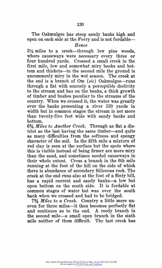
The Oakmulgee has steep sandy banks high and open on each side at the Ferry and is not fordable-
Hence 31/2 miles to a creek-through low pine woods, where causeways were necessary every three or four hundred yards. Crossed a small creek in the first mile, low and somewhat miry banks and bot- tom and thickets-in the second mile the ground is uncommonly miry in the wet season. The creek at the end is a branch of Om (sic) Oakmulgee-runs through a flat with scarcely a perceptible declivity to the stream and has on the banks, a thick growth of timber and bushes peculiar to the streams of the country. When we crossed it, the water was greatly over the banks presenting a river 150 yards in width but in common stages the stream is not more than twenty-five feet wide with sandy banks and bottom. 6%/4 Miles to Another Creek. Through as flat a dis- trict as the last having the same timber-and quite as many difficulties from the softness and spongy character of the soil. In the fifth mile a mixture of red clay is seen at the surface but the spots where this is visible instead of being firmer are more miry than the sand, and sometimes needed causeways in their whole extent. Cross a branch in the 6th mile running at the foot of the hill on the side of which there is abundance of secondary Siliceous rock. The creek at the end runs also at the foot of a flinty hill, has a rapid current and sandy banks-a low but open bottom on the south side. It is fordable at common stages of water but was over the south bank when we crossed and had to be bridged.
73 Miles to a Creek. Country a little more un- even for three miles-it then becomes perfectly flat and continues so to the end. A reedy branch in the second mile-a small open branch in the sixth mile neither of them difficult. The last creek has
This content downloaded from 195.34.79.223 on Mon, 16 Jun 2014 14:57:26 PMAll use subject to JSTOR Terms and Conditions

131
some red clay on its banks which are high and open -fordable and not difficult.
181/2 Miles to Cedar Creek. No change in the face of the country until ascending the dividing ridge between the gulf and Atlantic waters-there the land ascends and presents a hill of moderate height covered with pine and scrubby oak with a sand and gravel soil and resting on irregular masses of secondary flint. The acclivity on the north side of the ridge is steep-on the south, there is scarcely any descent and the land soon assumes its old character of loose rotten quicksand with oc- casional spots of red and yellow clay. The slope of the ridge on both sides marshy wherever the flint and gravel is not visible-sometimes spreading into thickety ponds and giving rise to innumerable little miry branches-the road continues on the ridge two miles-it then crosses the hollows of Flint which are always miry in winter even where per- fectly dry at the surface. From the ridge, the route is through flat pine woods for six miles crossing one small but miry creek generally fordable. At this point the ponds become more numerous (p. 324) speckling the pine barrens in a manner similar to those already described in Florida. Thence to Cedar Creek--down which the road runs for three miles-the country is a little more rolling, having near the creek, a more uneven appearance than any seen yet. In this part the view is diversified by many open lakes in the intervals of the hills-and occasionally little islets of evergreens, among which the magnolia is conspicuous, spread out near the heads of branches and enliven the monotony of the scene Cedar Creek rises E. S. E. from Fort Early and enters Flint six miles above the Fort. When we crossed it, the rains had swelled it into a formid- able river obstructed by bushes and logs and with a current of dangerous rapidity. Where the old
This content downloaded from 195.34.79.223 on Mon, 16 Jun 2014 14:57:26 PMAll use subject to JSTOR Terms and Conditions

132
road crosses it the swamp is almost impervious and the creek at high water impassable. But at the ford below, the banks are open and altho miry-the army was enabled by felling trees over the deeper parts of the stream, to cross in one night. When low, Cedar Creek cannot be more than thirty feet wide at this point and has sandy bottom and banks.
6 Miles to Fort Early. Through a pine country little rolling-with several branches some of which are extremely miry. Fort Early is situated on the east side of Flint river, on a high hill. It is simply a picketed square with two block houses, the water is excellent and the country healthy.-The most singular features of the country between Hartford and Fort Early is the extreme rottenness of the soil during the winter months. This character extends even to the top of the hills, and frequently when the surface is perfectly dry and seemingly hard a wagon will sink to the body. This quality of the soil arises from the detritus of the pines forming a thin mould which mixed with the sand and red clay prevents the soil from ever becoming hard except in per- fectly dry seasons. When the rainy months com- mence the falling water easily penetrates the sur- face but is stopped at the depth of a few feet by a bed of clay on which it remains pervading and swelling the sandy soil above and giving it that spongy penetrable character so destructive of the roads.
To make good winter roads through this country for wheel carriages it would be necessary to dig ditches and throw the earth into the center at all places where there is no appearance of stone or gravel. The low banks of the creeks and branches should be causewayed by a tier of logs and covered with earth taken also from ditches on either side. The logs should be well secured by bands, as the weight of the earth would not be sufficient to keep
This content downloaded from 195.34.79.223 on Mon, 16 Jun 2014 14:57:26 PMAll use subject to JSTOR Terms and Conditions

133
them down when covered with water.-Neither of these would require much labour and expense, for the abundance of straight pines gives ample mate- rials for causeways whilst the looseness of the soil makes diging very trifling labour. The general course of the road from Hartford to Fort Early is SSW, the distance forty-one miles.2
2. From Fort Early to Ft. Scott. There is much variety in the country between
these points. The (p. 325) changes from sand and pine to fertile red soil are frequent altho' the for- mer greatly predominates. From Fort Early the path runs through sand and pine to the Flint which it intersects four and a half miles below the fort crossing a creek with sandy banks in the second mile and a small thickety branch one-quarter of a mile farther. Hence, to the crossing place through high but flat pine woods not so miry as the country north of Cedar Creek and with an occasional mix- ture of scrubby oak. The Flint, at the ferry, is one hundred and eighty yards wide, with a low pine bluff on the east side and a thicket on the west. Steep sandy banks. From the crossing place the path goes up the river one quarter of a mile to a place where the open pine woods are near the bank -but separated from it by a bayou with a deep rapid current and a width of twenty yards. This had to be bridged. The land on Flint is second rate, that on the west side the best with a mixed growth of pine and the varieties of oak.
2The General reached Fort Early on the 26th of February. The excessive rains had made the road so bad that the wagons were abandoned en route. The troops were practically destitute of provisions. Here reports were received that the commandant at Fort Scott threatened to evacuate the fort unless a supply of provisions was received in a few days. To forestall such an event, General Gaines embarked a small force and proceeded down the Flint river. In his passage down the river the boat was wrecked and three men drowned. Gaines and his detachment reached Fort Scott on foot in a destitute condition after the arrival of the General.
This content downloaded from 195.34.79.223 on Mon, 16 Jun 2014 14:57:26 PMAll use subject to JSTOR Terms and Conditions

134
From Flint to Chehaw Town. Flat land (sand and pine) with numerous miry ponds and some flint rock at the surface. This tract is very similar to some of the miry districts between Hartford and Early and would require the same kind and degree of labour to make the route at all times practicable. The Chehaw village was situated on Makolla creek eight miles from where it enters Flint (river) and in a body of second rate hammock land.3 It con- sisted of fifteen or twenty cabbins with a large coun- cil house in the center which on our arrival was decorated with the white flag. The creek at the town is eighty-five feet wide with a swamp on the west side one-quarter of a mile wide and a high open bank on the east. The banks and bottom are firm and sandy. The swamp is not miry except near the highland where for one hundred yards there is a mixture of stiff white clay. It has the usual varie- ties of bottom growth of Palmetto. There are two bayous between the creek and high ground, one of which is not fordable in freshes-five and a half miles to another large creek on which Canards Vil- lage is situated three and a quarter miles above the point where we crossed it. The creek is ninety feet wide-sand and rock on the north side and a little miry on the south, open on both sides. From this point the route lies for twenty-five miles through the finest body of land I had seen since leaving Monticello, Georgia. The country well watered and with a surface sufficiently iregular for beauty and not too much so for easy culture. The branches are numerous and some small lakes with high fertile banks afford charming sites for towns or villages.- Fowl Creek is three miles from Canards Creek- shallow but wide with a thick undergrowth of ever- greens. On the south side are the remains of an
aEn route to Fort Scott the army was re-enforced by warriors from the Chehaw villages lead by Colonel Canard.
This content downloaded from 195.34.79.223 on Mon, 16 Jun 2014 14:57:26 PMAll use subject to JSTOR Terms and Conditions

135
ancient and very large town, large trees are growing on innumerable little mounds disposed with some regularity and on which the houses were probably built. Eighteen miles from Fowl creek there is a small Indian village situated among some hand- some branches and ponds with good land under cul- tivation.-Four miles from this point the fertile country terminates and thence six and a fourth miles to Echenoche creek through sand and pine higher and firmer than any of the pine-barren crossed before-struck the creek five miles from its junction with Flint-its general course S. 300 E. open woods attend to the banks on each side and the ground near the creek is high and tolerably firm. Echenoche at the crossing place is eighty-seven feet with high sandy banks-the water twenty-two feet deep-in summer five or six. In four and a half miles the road crosses another creek, a branch of Echenoche, entering near its mouth. (p. 326) It is one-third the size of the main stream and the banks are equally high and open-fordable-Struck the river in one and a half mile further the road go- ing down the last creek. From this point the route continues down the river-generally in sight of it to Fort Scott. The country gets more uneven and altho' the soil and timber differ but little from the flatter districts, the ground is much firmer and bet- ter adapted to roads. Flint rock is here very abun- dant-the path intersects the road from Fort Hughes, nine and a half miles from Fort Scott. In the mineralogy of the country thus far there is little variety. The secondary formation continues of a siliceous character but there is some secondary limestone and on the tops of the higher eminences sandstone is found with the different varieties of ferruginous colouring. The limestone is found near- est the water, and is probably the basis of the flint. The general course of the creeks entering the Flint
This content downloaded from 195.34.79.223 on Mon, 16 Jun 2014 14:57:26 PMAll use subject to JSTOR Terms and Conditions

136
is S.S.E. and of their extent but little is known. Oc- casionally they have wide swamps, but on all of them points have or may be found, where the open ground comes to the bank on both sides.
Fort Scott is situated on the west bank of Flint eight miles above the mouth of Chattahoochee-and on a high flat of sandy second rate soil. It was for- merly only a cantonment and was afterwards irregu- larly enclosed by a quadrangular picketing.4
3. From Fort Scott to Fort Gadsden. (Map 1) The ferry is one-quarter of a mile below the Fort,
where the river has a width of 190 yards and a rapid current. Bank high and open on the west-on the east a low open bluff two hundred yards below. Thence one-half a mile through miry pine woods to the hills.
Thence 101/2 miles to Musquito Creek. Through high sand hills with mixed growth of oak and pine and abundance of moss. These hills are described in the first part of the report-Cross a small branch of good water in the fourth mile and one fourteen feet wide in the sixth mile, both branches of Musqui- to Creek on the east, the road running at this point on the hills between that creek and the river.5 Some second rate land near the last creek-Musquito Creek is twenty-five feet wide at the crossing place, has sandy banks-a bottom of argillaceous rock and no swamp. The main branch of Musquito Creek
'Fort Scott was reached on the evening of March 9th. There were now about two thousand men at the fort with provisions equalling but one quart of corn per man and fresh meat for three days. Learning that two expected sloops loaded with provisions were off the mouth of the Apalachicola river, Jackson, determined to meet them with his force. The tenth was spent in crossing the Flint river to the south bank. On the following day the line of march was resumed. On the 13th contact was made with a provi- sion laden keel boat which was ascending the river. The site of the negro fort on the east bank of the Apalachicola was reached on the morning of the 16th.
5Descriptive of the land where the present town of Chatta- hoochee is located.
This content downloaded from 195.34.79.223 on Mon, 16 Jun 2014 14:57:26 PMAll use subject to JSTOR Terms and Conditions

137
GEORGIA
9r
k1G
\AAA
*
S SPALAG
II
v ln
00
/
I
1LFF
L.
3?J
Vm/kol.o
see 2Food
I
I,
ON T ST. MONA3
S
..
r a
)0
.
% 0 -
4,
GULF
OF
MEXICO
o
-
:I i
I
/
-,,
'
Iu
I
4-.a~
*
'-9,
GUL
OF
[erC
o
Map
1 Young
(Boyd
and
Ponton)
Jackson's
Route
in
East
Florida,
1818.
This content downloaded from 195.34.79.223 on Mon, 16 Jun 2014 14:57:26 PMAll use subject to JSTOR Terms and Conditions

138
runs nearly parallel with the Flint to the crossing place" when it turns nearly west, and enters the Apalachicola one mile below the junction of Flint and Chattahoochee.
6 miles to termination of the hills. In half a mile the path crosses a creek7 nearly as large as Mus- quito, entering it a short distance below. This stream is twenty feet wide with sandy bottom, and banks a little miry. It has a narrow swamp with a miry lagoon on the north side. In the second mile, there is some good land with a number of small In- dian mounds similar to those on Fowl creek above Fort Scott. In the third mile the path goes over the point of a ridge which stretches down to the river and forms a high bluff opposite to the upper settle- ment of Yellow Hair. The top of the ridge is red sand stone, but at the (p. 327) water edge there is a stratum of porous limestone with a siliceous mix- ture. Thence over long high ridges with reed in the intervals three miles to the Ochese path coming on the right. Along this path it is about three miles to the Ochese Bluff (56) over broken sand hills8 near the river the hills are entire masses of sand rock cut by the rains into fantastic shapes of many colours from the metalic oxides with which the stone is va- riously mineralized.
9 Miles to Provision Bluff. For this distance, the road runs round the head of several small branches of the Apalachicola which suddenly emerge from deep indentations in the high pine flat forming the ridge if it may be called, between the Apalachicola waters and those of Okloknee and New River. Those springs, and the singular barren flat from which they rise have been noticed before. The
6Mosquito cr. Crossing about the same as that of Florida Rd. 1. 'South Mosquito cr. 8Aspalaga Bluff.
This content downloaded from 195.34.79.223 on Mon, 16 Jun 2014 14:57:26 PMAll use subject to JSTOR Terms and Conditions

139
Bluff9 on the river has also been mentioned. The river is here two hundred and ten yards wide with a deep cane brake on the west side. 1114 miles to another Bluff.10 Very flat and desert the first mile the timber then gets larger and the thickety ponds more numerous. In the sixth mile the path winds around a beautiful little lake with high open banks. Thence for two miles the land is a little higher and some branches are headed similar to those north of Provision Bluff. Cross a small branch with high open banks in the seventh mile and another similar one half a mile further-a third in the ninth mile with a miry thicket. Thence, the path winds among ponds and thickets of great intricacy-the land get- ting lower and the declivity towards the gulf becom- ing very perceptible-three miles of these flats to the Bluff which has already been mentioned. The river is here 250 yards wide.
18/4 Miles to Big Creek." After leaving the last Bluff, the road enters the palmetto flats and con- tinues in them to the end. Cross a bad branch in the first mile, and an open branch in the fourth, an- other open branch in the fifth-a thickety and miry branch in the seventh and one of the same character in the eight mile. Thence to the creek, a succession of dry flats and glades checquered by ponds and thickets round which the path is sometimes obliged to make considerable windings. Big Creek is twelve feet wide-steep open sandy banks and sandy bot- tom.
9Alum Bluff. This was called Provision Bluff from the circum- stance that the army there met the supplies ascending the river.
'oEstiffanulga Bluff. 11Black creek (on some maps Owl creek). This is at or near
the northwest corner of Franklin county.
This content downloaded from 195.34.79.223 on Mon, 16 Jun 2014 14:57:26 PMAll use subject to JSTOR Terms and Conditions

140
61/4 Miles to Fort Gadsden.12 13 No difference between this part of the route and that described last -a succession of glades and palmetto flats with one or two small branches dry in summer.
4. From Fort Gadsden14 to Mikosukey. To Okalockina River, N. 321/2 E. 38 miles-Six
and a half miles to Big Creek15 branch of Apalachi- cola (last creek of the preceding itinerary).
Five and a half miles to Juniper Creek16--branch of new river through a thickety flat, and wet dis- trict with bay galls. Cross two branches one in the
12Fort Gadsden Landing just north of Ft. Gadsden creek mouth and about 2 miles west of Ft. Gadsden on the Apalachicola North- ern RR. Situated on Prospect Bluff.
"The so-called "negro fort" on the Apalachicola river was con- structed on Spanish territory by Colonel Nicholls of the British Army in the fall of 1814, during the war of 1812, after Jackson had compelled the British to evacuate Pensacola. On Nicholls' return to England in 1815, he turned the fort and its munitions over to the Seminoles. It actually was soon occupied by negroes, largely escaped slaves from Georgia and their descendants, who lived in close association with the Indians. Using this as a base, marauding bands of negroes ventured as far as the Georgia frontier on plundering expeditions. Despite remonstrances made to the Spanish authorities, the latter made no effort to abate this nuisance. The situation finally lead General Gaines to construct in 1816 a fort on the Flint river near its junction with the Chatta- hoochee, which was named Fort Scott. A convoy of naval vessels carrying stores for Ft. Scott, attacked it on July 27, 1816. A hot shot from one of the vessels struck the major magazine, causing a terrible explosion which killed 270 of the 334 inmates of the fort. It was found that Nicholls had left large quantities of military supplies in the fort, which, with considerable lack of judgment, were turned over to the Indians.
'4Impressed with the eligibility of the site, the General directed Lieutenant Gadsden to design and construct a suitable fortification to serve as a provision base. Pleased with the talents and zeal the lieutenant exercised, the general named the fortification Fort Gadsden. On the 23rd word was received that the flotilla which left New Orleans on the 12th of February had arrived in the bay. The expected Tennessee volunteers had not yet arrived, having, from the news received, deviated from their expected course via Fort Gaines, to secure provisions.
"The army left Fort Gadsden on the 26th with eight days rations. Before leaving arrangements were made for the trans- portation of supplies to the bay of St. Marks by the naval force.
"sJuniper creek.
This content downloaded from 195.34.79.223 on Mon, 16 Jun 2014 14:57:26 PMAll use subject to JSTOR Terms and Conditions

141
first-another in the sixth mile-small but with bad thickets- dry in summer. The creek is from fifty to sixty feet wide in winter but in summer is nearly without water-bottom and banks a mixture of sand and mud-four and a half miles to the main branch of New river.17 In this distance the stream is close on the right of the path-the soil similar to that just described with six small thickety branches--dry in summer. New river is nearly dry in summer but in winter is sometimes swelled so as to be impass- able-bottom sandy-banks somewhat miry. Five and a half miles to a large branch entering N(ew) river with a bad thicket-(p. 328). Country like the last Cross one bad branch in the second mile with a thicket on the east side a quarter of a mile wide- dry in summer. Seven and a half miles to Toloche creeks--a branch of Okalokina. Swamp one quar- ter of a mile wide on the west side and a half a mile on the east. Banks and bottom sandy-width fifty feet depth four feet-country same as last with numerous thickets which make the path in many places very intricate. Two branches, one in the third, the other in the fourth mile-dry in summer with bad thickets--somewhat miry. Eight and three quarter miles to Okalokina river"--through a country rather higher than the last presenting in places a little inequality of surface and a mixture of small oak with the pine several small miry branches with thickets-dry in summer. The Oka- lokina fifty-six yards wide-usual depth from six to nine feet-banks and bottom sandy. A bluff on
"7New river. "Toloche creek equals Taluga, Telogia, Teluca, Taloggee Creek
of various maps. 19Ochlocknee river.
This content downloaded from 195.34.79.223 on Mon, 16 Jun 2014 14:57:26 PMAll use subject to JSTOR Terms and Conditions
142
each side-that20 on the east of considerable height. To Mikosukey N. 68 E. 37 miles. Six and a fourth miles to a branch21 of Okalokina-country high and open-crossing three small branches22 different in character from those of Okalokina, being clear run- ning streams with steep banks and hemmed in by hills of moderate height-growth a mixture of pine with scrubby oak-Five and a half miles cross an Indian path23 leading to St. Marks branch at the end exactly like the others with a bottom of soft rock and sandy banks. Hill on each side-eleven and a quarter miles to pond24--country assumes a less mo- notonous character-the surface becomes more un- even and the growth more mixed. In the ninth mile, the ground becomes quite elevated with a mixture of large oak indicating a favorable change of soil-in the fifth mile, passed an open pond on the right with high banks. In the tenth mile the soil becomes fer- tile with a growth of oak and hickory-three branches-one in the second mile-sandy bottom and reedy thicket-the other two in the tenth mile- small. Four miles to Tallehassa T.25 through an ex-
"Jackson Bluff on the Ocklochnee river in the western part of Leon county. "* * * at Ockloknee river, where nineteen canoes were made, and the principal part of the army crossed by eight o'clock, P. M., the residue next morning; when the march was resumed at eleven o'clock A. M." Adj. Gen. Butler to Brig. Gen. Parker, Fort Gadsden, May 3, 1818. Am. St. Papers, Mil. Aff. Vol. I, p. 703.
'Harvey creek, near old Yankeetown. "First creek is Freeman creek and third is Double branch. 23This is the path by which they returned from St. Marks
(see 53). 'Probably pond near Tallahassee Air Port. 'Probably at or near Levy's spring north of Tallahassee * * *
"On this evening (March 30th) Brevet Major Twiggs of the 7th Infantry was detached with one company and about two hundred warriors, with orders to advance on an Indian village called Tallahassee, and surprise it at daybreak. On his near approach, he despached a party to ascertain its situation, who reported it evacuated some days before. On the morning of the 31st he entered the village, having previously sent out parties to recon- noiter. Two of the enemy were made prisoners, one of whom made his escape before he was brought into camp. The army passed the village about twelve o'clock, and encamped near Mika- sukey* * * *". Butler to Parker, ibid.
This content downloaded from 195.34.79.223 on Mon, 16 Jun 2014 14:57:26 PMAll use subject to JSTOR Terms and Conditions

143
cellent body of land, the soil adapted to any kind of culture growth, oak and hickory. A small miry branch near the village-entering Okalokina. The town was handsomely situated on a hill and con- sisted of ten or twelve houses with a large clearing cultivated in common. Sixteen miles to Mikosukey Towns26 through land resembling with very little variation that just described.27 In places it assumes
zOn the west shore of Lake Miccosukey about 21/4 miles east of the present village of Miccosukey. "The Mickasukey Towns are situated on the margin of a large shallow pond extending NNW and SSE ten miles, filled with high grass, and surrounded by high and mostly fertile land-particularly on the west side, where the soil is equal to any in the southern country." (Young).
27Their course probably passed through the northern part of Tallahassee, thence northeast in the vicinity of the "old" Micco- sukey road.
On the 1st of April, the army was re-inforced by the arrival of a detachment of Tennessee volunteers under Colonel Elliott, and friendly Creek warriors under General McIntosh. On the same day, one and one-half miles from the Miccosukey towns a party of hostile Indians was discovered located on a point of land project- ing into an extensive marshy pond. They dispersed in every direc- tion on being flanked. In this affair one American and fourteen Indians were killed. Pursuit was continued in every direction through the groups of scattered houses. Raiding parties were sent out the next day which consumed nearly three hundred houses and brought in an abundance of corn and cattle. In the center of the public square of Kenhagee's (Kinhega) town, a red pole was discovered to which were affixed scalps recognized as belonging to members of the Scott party. It was Kenhagee who stopped Mr. Ellicott in 1800 at the junction of the Flint and Chattahoochie when he was preparing to run the line from that point to the head of St. Mary's.
"* * On the morning of the first of April * * The army now ad- vanced within a mile and a half of Kinhajah's town, when a number of Indians were discovered herding cattle on the margin of a large pond. (After the engagement) * * the army now advanced upon the town which was found deserted by the enemy; * * The army continued the pursuit to a large pond of water which is eight miles in length, varying in width from six hundred to four thousand yards, and from two to five feet deep, through which the army passed, when the approach of night induced the commanding general to draw off the troops. On the succeeding morning, Brevet Major General E. P. Gaines, with a large command, was ordered to pass the lake or pond, and attack the other towns, but which he found abandoned by the enemy. The red pole was found planted in the square of Fowltown,* * * The army remained at this point until the morning of the 5th, when the march was resumed for St. Marks, * * *". Butler to Parker, ibid.
This content downloaded from 195.34.79.223 on Mon, 16 Jun 2014 14:57:26 PMAll use subject to JSTOR Terms and Conditions

144
quite a broken appearance but even on the higher hills, the soil is rich. In this distance there are but two small branches-one in the seventh, the other in the twelfth mile. Of course the country is badly watered. But water can no doubt be anywhere pro- cured by digging. The path crosses Savannas or wet glades in the third, fifth, fourteenth and fif- teenth miles. That in the fourteenth is the largest extending to the south further than the eye can reach.
5. Miles from Mikasukey to St. Mark. S. 161/2 W. 30 Miles. Eleven miles and a quarter
to a reedy branch. Good land for one mile then wet with thickets for the second when the country rises with a growth of large oak and hickory and a soil sandy but cultivatable. This continues two miles, and thence to the branch at the end-the flat pine land continues (p. 329) only interrupted at long in- tervals by small spots of good land in the neighbor- hood of thickety ponds-Four branches-one large, in the second mile-one in the fifth mile with high open banks, and sandy bottom-the others inconsid- erable and no doubt dry in summer.
Nineteen Miles to St. Marks.28 Little variety in this distance. The soil, growth and branches simi- lar with little exception to the low flat country be- fore described. Eight miles from the Fort, the land rises and presents some inequality of surface with
"The vicinity of St. Marks was reached on the 6th of April and the army encamped at the distance of a mile from the fort. After a demand for surrender was presented to the commandant of the fort, Don Francisco Caso y Luengo, by Lieutenant Gadsden, which was refused, the fort was seized without resistance by Captain Twiggs on the morning of the 7th. On this occasion Arbuthnot was arrested on the moment of attempted escape. The naval force arrived a few hours before the army, displaying English colors. Deceived by this circumstance, the chiefs Francis (Hillis Hadjo) and Homathlemico (Himathlemico), the latter in command of the band which massacred the Scott party, came on board hoping to receive munitions with which to attack the army. They were promptly seized and were hanged the next day.
This content downloaded from 195.34.79.223 on Mon, 16 Jun 2014 14:57:26 PMAll use subject to JSTOR Terms and Conditions

145
abundance of secondary limestone.29 In the second mile, passed the Sahwannee path coming30 in on the left. North of this there is good land, relieving a little the savannas of the pine country. One small branch in the fourth mile open and a little miry.31
6. From St. Marks32 to Sahwanne.
2"Good description of region at road near the Natural Bridge. It would not appear that the army passed down the east side of the St. Mark's river, crossing at the Natural Bridge, but that rather it went down on the west side the entire distance, probably closely following the line of what was later the old plank road. Young elsewhere gives a fair account of the natural bridges over the St. Mark's and lower streams. That over the St. Mark's he states to be two and one-half miles from the fork and nearly three miles in extent, covered with thickets and heavy swamp timber. The raft or bridge is swampy and almost impervious.
"3Approximately on the course of the old St. Augustine road. This was laid out on the middle trail. After reaching the vicinity of Lamont the army cut across to the lower trail which was fol- lowed to the Suwannee.
31"The fort of St. Mark's is situated at the junction of the rivers St. Marks and Wakally and nine miles from the bay. The land about the fort is open prairie for one mile when the pine woods commence. The prairie is swampy and has a thin covering of rich mould on a base of firm white sand". (Young's preliminary report.)
32With 8 days rations the army departed from St. Marks on the morning of the 9th leaving behind a strong garrison. On the evening of the 10th it was joined by the rear of the Tennessee volunteers, and the Indians under General McIntosh who had been left at Miccasukey to scour the region. Although the weather was dry, the swampy character of the line of march kept the men wet to the middle, and large numbers of horses gave out daily.
Letter of Capt. David E. Burch to Brig. Gen. T. L. Jesup dated Pensacola June 5, 1823 * * "my information of the country east of this river (Appalachicola) is not so perfect as west of it, but having been with Gen. Jackson's army throughout the Seminole war, I acquired a general knowledge of it, as far as the Suwan- nee, * * Gen. Jackson's army marched * * thence (St. Mark's) to Suwannee on what is called the lower trail (being the one nearest the sea-coast) 110 miles. The route to Suwannee from St. Marks on this trail is low, with ponds, but the army was accompanied with a 6 pounder and an ammunition cart, and which did not delay our march materially, although these ponds were frequently for 5 or 600 yards near waist deep; they were not however miry or boggy. * * I was informed at the time by Indians and by Hambly that the upper trail (probably rather the middle trail, the approximate site of the later Pensacola-St. Augustine road, Young elsewhere speaks of an upper, center and lower path from Mikosukey to Sahwanne) was not more than 10 or 15 miles north of us and parallel to the one we were marching on; also that it was on a more elevated country." * *
This content downloaded from 195.34.79.223 on Mon, 16 Jun 2014 14:57:26 PMAll use subject to JSTOR Terms and Conditions

146
To Assilla creek, N. 59 E. 34 miles-Sixteen miles to the Sahwanne path described before-eighteen miles to Assilla through excellent land with little interruption-tolerably well watered. Sufficiently broken for beauty of aspect and not too much for facility of culture. The branches are small but miry with reedy thickets and without perceptible cur- rents--probably feeding the ponds north of St. Mark and uniting subterraneously with that river. At the end,33 the path from Mikosukey comes in on the left -then to Assilla,34 seven miles through a flat low pine country with a number of small miry and thickety branches without current-and in spots a good deal of limestone on the surface. Assilla cr. has high banks open on the east but fenced in by a difficult thicket on the west-width fifty and depth five feet-sandy bottom.
To Slippery Log Cr., S. 49 E. 18 miles-Eight miles and a quarter to natural bridge creek.35 Low and flat for three miles with glades covered with water-and a mixture of cabbage palmetto among the swamp timber. At this point the path crosses a large but shallow branch with a thicket-thence two miles to another and similar branch with abundance of cypress and vines-thence through the same kind of country three miles and a quarter to the creek which has high open sandy banks, a width of thirty- five feet, depth of five feet and a sandy bottom. Its name is derived from a ledge of limestone rock which forms over the creek a dry and secure bridge of twenty-five feet width. This curiosity is a short
S3One and one-half miles to two and one-half miles west of Lamont on the old St. Augustine road.
"4Crossing of the Aucilla river just below Walker Springs. 85Econfina, Econfenee, Econfena river. (Indian word for Natu-
ral Bridge).
This content downloaded from 195.34.79.223 on Mon, 16 Jun 2014 14:57:26 PMAll use subject to JSTOR Terms and Conditions

147
distance above the path.36 Nine and three-quarters miles to Slippery Log Creek37 through a country with great sameness of character-flat, low and wet with occasional cypress and bay thicket on either side and with pine, wiregrass, saw-palmetto and some cabbage tree-in the fourth mile cross a branch and bad thicket and two others similar in character in the sixth mile. The creek has open high banks, a width of fifty feet, depth of four and a half feet and a rocky bottom.
To Live Oak Swamp, S. 49 E. 231/2 miles-The same description applied to the route in this dis- tance as in the last, except that the country becomes still lower and the wet glades more frequent. In the seventh and eight miles38 these ponds assume the appearance of large prairies, and in very wet seasons must be nearly impassable from depth of water. Four branches in the ninth,39 nineteenth and twentieth, and twenty-fourth miles40-the last the largest on the edge of the swamp. The others are probably dry in summer when they present no other obstructions but their thickets. The live oak swamp is one-half a mile wide covered with water
"During the night of the 11th sentinels heard the lowing of cattle and the barking of dogs. Local search failing to reveal Indians, the scouts on the morning of the 12th near Econfinah or Natural Bridge, discovered a party of Indians on the edge of the swamp. They were attacked by the Creeks under General McIntosh and about fifty Tennessee volunteers, who routed them in a running fight over 3 miles. Thirty-seven warriors were killed, and, in addition there were captured six men and ninety- seven women and children. On the same occasion there was re- captured a white woman, the only survivor of the Scott party. They proved to be of Peter McQueen's band. The American force lost three killed and five wounded. Several hundred head of cattle were also secured. On the morning of the 15th, the scouts overtook a small party of Indians, killing one man and capturing one man, one woman and two children.
37Fenholloway river. Crossing likely below Hampton spring. "Ponds west of Athena. "Warrior creek. '"Dallus creek.
This content downloaded from 195.34.79.223 on Mon, 16 Jun 2014 14:57:26 PMAll use subject to JSTOR Terms and Conditions

148
except in the warmest months-and from the marks of inundation (p. 330) must after heavy rains be past fording.
To Sahwannee," S. 61 E. 29 miles-Four miles and three-quarters to Histenhatche Cr.4' through flat sandy country covered thickly with palmetto- and with intervals of small prairie hemmed in by picturesque thickets of evergreens among which the live oak is conspicuous. Abundance of rock curi- ously drilled by the action of water is seen on the surface near Histenhatche and through the prairies. The creek has high open banks a width of fifty feet and a rocky bottom. The depth in the rock is from two to three feet but immediately above there is an abrupt change of depth to nine feet and below there is a considerable fa1142-the rock forming a narrow ford or bridge under as well as over which the cur- rent obviously runs from the ebullition above the ford.
Eighteen miles to a large pond.43 The branches become more numerous and less accessible from the closeness of their thickets and the muddiness of their banks. There is rather more cypress in the thickets than seen heretofore-in other respects, the appearance of soil, timber, etc., is similar to that before described. In the eleventh mile, the country begins to rise a little with a mixture of scrubby oak and towards the pond it becomes quite elevated. The pond runs north and south. Cross path in the seventeenth mile-five and a half miles to Sahwanne
"Steinhatchee river. 4Falls on Steinhatchee river about 21/2 miles below crossing of
Florida Rd. No. 19. '4Twin Lakes at Eugene. "Suwannee river. The Spaniards called it the Little San Juan.
Elsewhere Capt. Young suggests that Suwannee is a corruption of San Juan rather than an Indian word.
This content downloaded from 195.34.79.223 on Mon, 16 Jun 2014 14:57:26 PMAll use subject to JSTOR Terms and Conditions

149
towns46 through a country a little rolling with a large mixture of oak for three miles47 when the path enters the thicket bounding the towns on the N. W.- Thence to the first cabin is half a mile from which to Bow-leg's town where the camp was established is one mile and three-quarters.45
"Supposing the army to be within striking distance of Suwan- nee, an early start was made on the 16th, but after marching 16 miles and reaching a remarkable pond, which the guide recollected as 6 miles from Suwannee, the General would have camped had not six mounted spies been encountered, who escaped. This cir- cumstance determined a forced movement, to prevent if possible the escape of the Indians and the removal of their supplies, as the rations of the American army were exhausted. Lines of attack were formed and the army put in motion. The left column was composed of the second Tennessee regiment under Colonel Williamson and an Indian party under Colonel Canard (Kinard), (an Indian whose village is mentioned as visited en route from Fort Early to Fort Scott), the center was composed of the regu- lars, Georgia militia, and the General's personal Tennessee guards, while the right consisted of the first Tennessee regiment under Colonel Dyer and General McIntosh's Indians. The attack was begun by the left column while the right endeavored to pre- vent escape across the river. Due to the previous alarm given by Arbuthnot, they soon crossed the river leaving nine negroes and 2 Indians dead. Thirteen of Colonel Kinard's party were wounded. Foraging parties were out on the 17th, and on the 18th a strong detachment under General Gaines was sent across the river. Only nine Indians and 5 negro prisoners were secured. During the night of the 18th, Ambrister was captured as he blundered into the camp. This ended the campaign. On the 20th the Georgia militia marched homewards to be disbanded. The sick were despatched down the river to be conveyed to St. Marks by sea in Arbuthnot's captured schooner. With the regulars and Tennessee troops, the General returned to St. Marks on the 21st, which was reached on the 25th. The previous day General Mc- Intosh and his Creek Indians were dismissed. Encampment was made four miles north of St. Marks.
"4Near the present village of Old Town but on the west bank of the River east of the present village.
47Descriptive of the southern end of Old Town Hammock.
This content downloaded from 195.34.79.223 on Mon, 16 Jun 2014 14:57:26 PMAll use subject to JSTOR Terms and Conditions

150
7. From St. Mark's48 to Okalokina. Eight and one-half miles to thicket at the head of
Wakally49-The first three and a half miles through flat pine wood, with abundance of limestone on the surface and some thickets-a little miry. The next five miles, the path runs not far from Wakally50 and sometimes on the edge of the swamp, passing occa- sionally through second-rate land with a little oak and hickory. The thicket, which is an extensive dry hammock is three-quarters of a mile wide and full of sinks-described before.
Eight miles to Reedy Branch, head of Sok- Choppe51-Soon after leaving the large hammock, the country ascends a little, and assumes a more rolling appearance with an occasional mixture of scrubby oak bushes with the pines-some good land in the second mile.
Eleven and one-half miles to Mikasukey road, from Fort Gadsden--Country high, but nearly flat with scrubby oak bushes and pine without palmetto. Soil, white sand and very firm. Crosses a miry branch at the end of the third mile and a reedy hol- low in the ninth mile-in the eleventh52 came to a
'On the morning of April 29, leaving behind an American garri- son in the fort, the General and his remaining troops were in march for Fort Gadsden, which was reached the 2nd of May. After resting here until the 7th, the army proceeded to Ochese bluff, where the Apalachicola river was crossed near the village of that name on the 10th. Strong garrisons of regulars were left in Fort Scott and Fort Gadsden. The force crossing the river consisted of a small detachment of infantry, one company of artillery and the effectives of the Tennessee volunteers (600) the whole not exceeding twelve hundred men.
"* * the general having previously detached a garrison of two hundred men, under the command of Brevet Major Fanning, to occupy Fort St. Marks." Butler to Parker, ibid.
"Wakulla spring. "Wakulla river. nSokchoppe equals Sopchoppy river. It is fairly definite that
this is not the head of what is now known as the Sopchoppy river. This is likely Lost creek on the soil survey map of Leon county.
"This is likely Harvey creek.
This content downloaded from 195.34.79.223 on Mon, 16 Jun 2014 14:57:26 PMAll use subject to JSTOR Terms and Conditions

151
handsome branch-a water of Okalokina, with steep banks, a sandy bottom and a hill on each side. One mile thence to the road which the path53 from St. Marks intersects five and a half miles from Okalokina.
WEST FLORIDA (p. 331) No materials having been obtained for a correct
general view of West Florida, it was thought best to give only the itineraries through the country, comprehending the routes from Apalachicola to Pensacola and thence to Fort Montgomery and com- prising such other information as could be collected. From these, a pretty accurate idea may be had of the general face of the country's soil and produc- tions.71 (Map 2)
1. From Ocheese to Escambia R.54 To Big Spring,55 N. 45 W. 18 miles-The Ocheese
Bluff56 has been already described-thence the path runs through second-rate land with oak and hickory for one mile-then a pine flat for three miles, then rolling for four miles-then flat but high, for two miles-then a little uneven for six miles-and thence two miles through a rolling country to the spring... Good pine land with reddish soil in the sixth, sev- enth, eighth, eleventh, twelfth and thirteenth miles. The path then enters an excellent body of land with
"Probably the path referred to in note 23. ""After a fatiguing, tedious and circuitous march of twelve days,
mis-lead by the ignorance of our pilots and exposed to the severest of privations, we finally reached and effected a passage over the Escambia". (Jackson)
"SBlue spring. "Bluff opposite Aspalaga bluff. (See notation No. 8) "The campaign in West Florida was stimulated by news that
the Governor was feeding a party of 450 Indians in Pensacola that had been dispersed from east of the Apalachicola, who were engaged in plundering and murdering Americans. In addition, supplies destined for Fort Crawford, shipped on the schooner Amelia via the Conecuh river had been seized and held at Pensacola.
This content downloaded from 195.34.79.223 on Mon, 16 Jun 2014 14:57:26 PMAll use subject to JSTOR Terms and Conditions

152
, - -
,
to
od
41
a
A(
77
a
e
/8Z<4
,,
It I
- , ----e-e-
Map
2' Young
(Boyd
and
Ponton)
Jackson's
Route
In West
Florida,
1818
This content downloaded from 195.34.79.223 on Mon, 16 Jun 2014 14:57:26 PMAll use subject to JSTOR Terms and Conditions

153
a growth of oak and hickory-somewhat similar to the pine land in East Florida, and continues to the end-crossed a path in the first, and two in the sec- ond mile-one small branch at the end of the tenth mile. In this distance there are no obstructions to the march of an Army. The country even where flat is high and dry-and where it becomes hilly, a mix- ture of sandstone gravel makes the route excellent- the Big Spring55 which is tributary to Chapulle57 is forty yards in diameter and of considerable depth with a rock bottom and a clean and rapid current.
To Choctahatche River,58 N. 83 W. 45 miles-Six and a quarter miles to the natural bridge"9 of Chapulle creek through the same body of good land with soil and timber exactly similar. In the fourth mile, the road runs on a gravelly ridge but the hick- ory and oak continue-some limestone in the second mile. In the sixth a path comes in one the right near a thicket and a small branch. The Natural Bridge is in the center of a large swamp and ap- pears to be a deposit of earth on a raft or some simi- lar obstruction. The passage is narrow and the creek, wtih a rapid current is visible both above and
"'Chipola river. 58Choctawhatchee river. "5Natural Bridge about 2 miles above Marianna on the Chipola
river. This has been more or less destroyed in letting logs through and in the mining of limestone. "Near the north end of the bridge is a limestone cave, a quarter of a mile in length. In this cave a number of Indians had taken refuge while Jackson and a divi- sion of the army marched overhead on the bridge. Another division of the army had arrived at the river to the north of the bridge, and was delayed in making rafts and bridges in order that the wagons and artillery might cross. Jackson waited impa- tiently for them to come up, and was very angry when they ac- counted for the delay by the difficulty in crossing the river. He had seen no river, and would not believe in the existence of one until the guides explained the matter." Brevard, History of Florida Vol 1, p. 54. Evidently the cave referred to in Brevard's anecdote is the Rock Arch cave to which Young later refers. An almost contemporary description of this is found in William's View of West Florida, page 35.
This content downloaded from 195.34.79.223 on Mon, 16 Jun 2014 14:57:26 PMAll use subject to JSTOR Terms and Conditions

154
below. The Chapulle rises west of Fort Gaines on Chatahouchie and enters Apalachicola eight miles above Fort Gadsden. Springs, like the one above described are numerous in the neighborhood of this creek. Sometimes their streams run subterrane- ously and they are then seen in transparent pools at the bottom of deep sinks, but generally the larger ones unite with Chapulle above ground. The good land extends down this creek six or eight miles be- low the spring and is part of the extensive tract which has been several times alluded to extending on the west side of Chatahouchie to Fort Gaines and thence, westwardly to Escambia across the waters of Choctahatche and Pea river-where the pine pre- dominates in this district the soil only differs from that of the oak and hickory growth in having a greater mixture of sand-but the foundation a red- dish marly clay-is equally good, and the sandy proportions only promotes facility of culture. The limestone seen occasionally has a partial siliceous mixture. On the high hills is seen ferruginous sand- stone ponderous from the predominance of the me- tallic oxide-some gravel of the sandstone kind is scattered through the more elevated ridges of the good land.
To Okchiahatche Cr.60 twenty-one miles-Ex- cellent land to Rockarch (P. 332) spring five miles with a mixed growth of oak, pine and hickory with several sinks affording abundance of excellent water. Limestone visible in one or two places-the spring is in curious rocky cavern in the middle of a thicket and surrounded by excellent land. Thence three miles through good pine land a little rolling-then, after passing an oak and hickory flat-leaving a thickety pond on the right the soil changes to a gray-
'"Holmes creek at a point about 5 miles south of the Alabama- Florida line.
This content downloaded from 195.34.79.223 on Mon, 16 Jun 2014 14:57:26 PMAll use subject to JSTOR Terms and Conditions

155
ish mixture of sand and white clay-the surface be- comes flat and glady and the scrubby pine and wire- grass indicate the worst kind of soil. This con- tinues five miles. The soil then changes again to a deep yellow rather better than the gray but scarcely cultivatable-same for two miles-then flat with scrubby thickets for two miles-then poor, but a lit- tle higher, for two miles to the creek. A great deal of this tract after leaving the good land of Chapulle is a little similar to the flat glady land east of St. Mark; but is more varied by partial inequalities of surface. It is also without palmetto, none being yet seen west of Apalachicola. The thickets have much cypress but are without that luxuriant variety of evergreens which cover the baygalls of East Florida.
Okchiahatche is a branch of Choctahatche, is thirty feet wide at the crossing place-with sandy bottom and banks and a narrow thicket. It crosses the Florida line thirty-nine miles west of Chatahouchie, and five miles west of Chapulle. A cross path in the fifth mile-a small branch in the thirteenth and one in the nineteenth mile-glades in the tenth, eleventh, thirteenth, sixteenth and nineteenth miles. Seven- teen and a half miles to Choctahatche through a country alternately flat and a little rolling-present- ing reedy branches in the flatter and pine and wire- grass in the higher parts-a small reedy branch in the fourth mile-creek in the fifth mile twenty-five feet wide, high open banks, and sandy bottom- small open branch in the same mile-small reedy branch in the sixth mile--branch in the seventh mile and a creek twenty-five feet wide, sandy bottom and miry on the west bank-several miry spots in the
eighth mile-two branches in the ninth and abund- ance of fine reed in the tenth mile. A miry reed branch in the eleventh mile-same in the twelfth mile-a small creek in the fifteenth mile-twelve feet wide and with open banks. The soil of the pine land
This content downloaded from 195.34.79.223 on Mon, 16 Jun 2014 14:57:26 PMAll use subject to JSTOR Terms and Conditions

156
in this district differs a good deal from that of the pine country east of Apalachicola. Here it is based on clay of a light yellow color with a mixture of sand and thin vegetable mould-and in the higher part, sprinkled at the surface with small rounded sand- stone like gravel with a mineralization of iron and manganese oxides--quartez pebbles are very rare. The yellow and red soil is only seen in the rolling country. In the flat and glady districts the soil is greyish from the mixture of white clay with greater or less degree of blackness, in proportion to the thin- ness or luxuriance of the vegetable covering. In the hollows between the hills there is abundance of small reed affording excellent and durable pasturage- and on the larger creeks there is some cane-(p. 333). Choctahatchie rises about fifty miles above the Florida line. It has two branches-the eastern one of which, called Pea river unites with the main prong two miles above the boundary. Thence its course is a little west of south to its mouth at the east end of St. Roses Bay. South of the boundary there is not much first rate land on Choctahatchie but in the Terr. Y. (sic) both its branches run through a tract of fine land that commences on the Alibama and the head of Escambia. At the crossing place,6' Choctahatchie is 150 yards wide and not fordable. The bank is high and open on the east- side, and on the west, there is a thicket three-quar- ters of a mile wide with a growth of cane but sandy and dry.
To Red Ground Trail. S. (sic) 811/2 W. 36 6'The crossing place was one or two miles south of the Alabama-
Florida line.
This content downloaded from 195.34.79.223 on Mon, 16 Jun 2014 14:57:26 PMAll use subject to JSTOR Terms and Conditions

157
miles62-Two miles and three-quarters wet and flat -the guide then left the trail and piloted us through the woods-twenty miles through a rolling pine country with numerous little reedy branches between the hills, the heads of small streams entering Choc- tahatchie, the greater part of this distance on a ridge. For the last four miles the hills are covered with scrubby oak bushes indicating the poorest kind of land. The soil generally resembling the yellowish sand and clay described before. Sandstone gravel is abundant on the hills, and on one or two of the higher ridges, the whole mass seems from indication at the surface to be ferruginous sand rock. The reedy branches crossed are generally miry--one in the third, fifth, tenth, fifteenth and the twentieth mile respectively. A large reed brake on the south side of the path in the eighteenth mile. The next six- teen miles are through a similar country-two miles over a wide ridge, with small pines-then flat for one mile, then rolling to the end-one bad branch in the fourth mile-one in the seventh, two in the tenth -one in the thirteenth and one in the fourteenth. A cross path in the twenty-ninth mile. Entered a trail in the thirty-fourth mile which gave out at a branch at the thirty-sixth-good pine land at the first path.
62The bearing of S. 811/ W. given is obviously in error. It should be N.W. Actually it would appear that the first 20 miles traversed were in Florida, more or less parallel to the boundary. In the second stretch of 18 miles they crossed the boundary to a point in Alabama somewhere in the vicinity of Florala where the Red Ground trail was intersected. Most portions of the pre- ceding routes had been along Indian trails, it would appear that the greater part of the traverse between the Choctawhatchee and the point where they intersected the Red Ground trail was through the untracked woods. This probably explains the uncer- tainty of the guides and the general's exasperation (M). (See Searcy's Map of Florida, 1829). The Red Ground Trail is shown on Roman's Map of 1775 (Lib. Cong.) as the "Road to the Upper Creek Nation", the southern terminous was at the head of Escam- bia Bay, east of the mouth of the Escambia river.
This content downloaded from 195.34.79.223 on Mon, 16 Jun 2014 14:57:26 PMAll use subject to JSTOR Terms and Conditions
158
To Pensacola Bay, S. 50 W. 53 miles-Eleven miles to yellow water63 along a high pine ridge divid- ing two of its tributary creeks. Near the creek the land improves with a growth of pine, oak and small hickory.
Yellow Water rises about thirty miles north of the boundary, which it crosses thirty-five miles east of the Conecah. Its course thence, is S. W. to the head of Yellow Water bay, into which it empties, after being swelled to a considerable size by the accession of many large and rapid creeks of the finest water. Yellow Water is twenty-five yards at the crossing place-has a bluff on the east side and a swamp a quarter of a mile wide on the west-the current is rapid and deep-the banks and bottoms sandy. Two and a half miles to a small creek with steep banks and very miry on the west side-a miry branch in the first mile. The country is then rolling, the path running on a ridge for five miles to a creek twelve feet wide with open high banks and sandy bottom. Thence four miles along another ridge to a creek thirty feet wide64a-without swamp-with sandy bottom and banks, and a glady flat on the western side. Two miles a small miry branch--quarter of a mile a large branch with open but miry banks, three- quarters of a mile a large branch of the same char- acter; six and a half miles to a large creek64b with high steep hills on the east side and a palmetto flat on the west,-one mile and a quarter a branch of ten feet wide and sandy bottom.
(P. 334.) Five and a quarter miles a large creek4ce sixty feet wide, open on the east side and with a narrow thicket on the west-a good ford was found
"6They probably re-entered Florida somewhere near Svea station on a branch of the L. and N. RR. The Yellow river was probably crossed in the vicinity of the village of Oak Grove.
"a Head-waters of Blackwater river. "b. Sweetwater creek in the vicinity of Fentress. "c Coldwater river.
This content downloaded from 195.34.79.223 on Mon, 16 Jun 2014 14:57:26 PMAll use subject to JSTOR Terms and Conditions

159
a quarter of a mile below the path. Two and a half miles another creek with low open banks and sandy bottom-the bottom uneven and somewhat ob- structed at the ford by logs-five and three-quarter miles to a creek64d twenty feet wide with high open banks and sandy bottom and a high hill with red sandstone on the east side and a flat with some pal- metto on the west.
All these streams are tributaries65 of Yellow Water and are very similar in character and ap- pearance. Their currents are rapid-beautifully clear and run in wide channels of the whitest sand. The banks mostly open and low with commonly a hill on one side and a glady flat stretching to a small distance on the other.
From the crossing place of the main stream the course of the path is nearly parallel with it to the bay. Four and a half miles from the last creek to the bay66 over a flat district with a few miry spots. Near the Bay, there is some second rate land and a hammock one-fourth of a mile wide. Settlements are scattered along the shore from this point to the mouth of Yellow Water Bay and among them are some handsome and productive plantations of sec- ond rate land. The soil on the hills among these creeks is alternately yellow, white and reddish sand and clay. The hills are based on a reddish sand-rock which in many places is seen on the surface in a semi-indurated state. West of Yellow Water this concrete has an argillaceous mixture, which renders it friable and when found pulverized on the surface mixed with a little vegetable mould would probably
"d Pond creek. "Their course must have been far enough west of the Black-
water river so that the presence of this stream between their position and the Yellow river was unsuspected, and the head waters of the Blackwater were believed to be tributaries of the Yellow.
"Escambia bay in the vicinity of Floridatown.
This content downloaded from 195.34.79.223 on Mon, 16 Jun 2014 14:57:26 PMAll use subject to JSTOR Terms and Conditions

160
be productive. The timber is altogether pine except in the swamps and thickets.
To Escambia River,67 N. 50 W. 133/4 miles- Three miles of this distance over the edge of the high ground, the remaining ten through the glady flats intervening between the hills and the river swamp. Crossed twelve branches-all with miry banks-but having generally hard sandy bottoms-one in the seventh mile has a very close thicket on the north side-one also very intricate in the twelfth. Here the path terminated at a Bayou entering the Escam- bia one mile and a half below-forty yards wide with a swampy island between it and the main stream of one mile and a half in width. The Escambia at this point is eighty yards wide with steep banks and a low pine bluff on the west side. The swamp of the island is covered for two-thirds of the way from the Bayou with water to a depth of from two to five feet and obstructed by undergrowth and cypress knees -soil stiff white clay.
The Escambia is properly but a smaller branch of a much larger stream called the Conecah with which it unites not far below the boundary. The Conecah rises near sixty miles above the line and interlocks with some stream running nearly north into the Alibama. There is excellent land near its head waters, but for some distance above the line and to its entrance into the bay its upland is of poor pine sand hills with bottoms of second rate soil but subject to inundation. It (p. 335) enters the Bay by two mouths of which the western one is the larger and its small delta is cut up by bayous running through numerous sedge islands. The shores of the Bay near the mouth are overhung with high red sand-stone bluff-the river is easily navigable to
"*The Escambia river appears to have been crossed at a point to the east of the station of Cantonment on the L. and N. R.R.
This content downloaded from 195.34.79.223 on Mon, 16 Jun 2014 14:57:26 PMAll use subject to JSTOR Terms and Conditions

161
Fort Crawford-six or eight miles above the bound- ary and in common stages of water small boats can ascend much higher.s8 To Pensacola.
Sixteen miles to a spring on the west side of the road through a rolling country for eleven miles, when it becomes gradually flatter till towards the end when it again becomes a little uneven-the spring is at the head of one of the thickety hollows so common in this country. From the bluff on Es- cambia the route is along a ridge four miles to the road from Fort Montgomery then on the main ridge between Perdido and Escambia to the end.69 From the spring five miles to Pensacola through a level but high sand and pine district. To the Barancas70 14 Miles.
Through a high sandy country with scrubby pines and low oak bushes for four miles-then flat with glades and occasional miry spots to the end. Crossed a Bayou with a bridge at the end of the fourth mile -plantations at the Bayou-old plantation in the sixth mile-a branch with a small bridge in the ninth mile. Struck the Perdido road in the tenth mile--- miry branch and bridge in the twelfth mile. In the fourteenth mile there is a swell of ground forming a
68On the 23rd, after crossing the Escambia, a vigorous protest was received from the governor of Pensacola. This was sufficient to indicate the required procedure to the General. Pensacola was entered without resistance on the 24th of May.
"The route was apparently west or southwest for four miles, and then south 17 miles to Pensacola. It is likely that camp on the 23rd was made near the village of Cantonment, a station on the L. and N. R.R. The name is a relic of Jackson's time. The trail southward to Pensacola was familiar to Jackson as he had traversed it in 1814. It is likely that the spring was in the vicinity of Olive station.
"TThe fort at Barrancas was invested on the evening of the 25th. Preparations for attack were actively pushed. Defensive firing from the fort was active on the 26th and 27th. The fort capitulated on the 28th and the garrison was granted honorable terms of surrender.
This content downloaded from 195.34.79.223 on Mon, 16 Jun 2014 14:57:26 PMAll use subject to JSTOR Terms and Conditions

162
low ridge which nearly encircles the Barancas on the land side and at a distance of from six to seven hundred yards from the work. This route to Baran- cas gdes around the head of the Bayous entering the bay below the town. The small branches are miry but may easily be bridged for temporary pur- pbses. There is another and much shorter way by the beach. Crossing the bayous at their mouths,
wltere the sand bars afford shallow fording, the
diSt4nce by this route is about nine miles. Pensa- cola stands upon the west side of the bay and about eleven miles from its entrance. It is situated on the sandy flat extending from the foot of the high hills in its rear to the beach and is separated from the higher ground by a thickety marsh in which rise innumerable springs of the purest water. This marsh is crossed in coming from the interior by two causeways of sand with ditches on each side and is accessible by the beach at both the extremities of the town, each of these four passes is defended by a blockhouse now out of repair. The town is com- manded by the high ground in its rear on which are the ruins of two forts that formerly defended the approaches along the eminence. The streets are wide and have side pavements of brick--but the cen- ter part is pure sand which in the summer season and after a drought becomes so pulverised as to rise in suffocating clouds with the slightest wind. The Government House stands on the beach near the center of the town and is surrounded by a handsome garden. A large building intended for barracks stands in the square near the Government House-it is now in ruins. There are several block houses in town commanding the principal streets, intended for protection against the Indians. The commerce of Pensacola has hitherto been inconsid- erable and was engrossed by the house of Panton Leslie and Company, now Forbes and Company.
This content downloaded from 195.34.79.223 on Mon, 16 Jun 2014 14:57:26 PMAll use subject to JSTOR Terms and Conditions

163
Should the Americans retain the Floridas it must greatly increase when the lower part of the Ali- bama territory is settled and the fine land in that quarter is cultivated. The harbor of Pensacola has a depth (p. 336) of water sufficient for the largest vessels-but such as draw more than twenty feet water get over the bar at the entrance with diffi- culty. The water at the town is shoal for some distance from the land and would make it necessary to project wharves of considerable length from the shore. For the construction of these wharves, no wood has been found, sufficiently durable, besides the ironwood tree and cabbage palmetto-and these are not to be had west of Apalachicola. The iron- wood is now almost all cut from the keys west of Floridas point. But the principal objection to this as well as the other Florida harbors is the number of worms which are so destructive as sometimes to ruin a vessel's bottom completely in a few months. Copper bottoms are indispensable if ship owners would save much labor and expense in frequently heaving down, cleaning and paying. To Fort Montgomery.
Seventeen miles to the fork of the path from Es- cambia-along the same route traveled before- thence-Seventeen miles to pine barren creek through sand hills with pine and some scrubby oak. Land tolerable in the fourteenth, fifteenth and six- teenth miles-soil reddish clay and sand. Pine Bar- ren is a branch of the Escambia and at the cross- ing place is thirty feet wide with sandy bottom and low open banks. A high hill on the south side. The road runs on the ridge between the Escambia and Perdido, crossing sometimes the hollows of the one -sometimes of the other-crossed two small branches-one in the first, the other in the tenth mile. The land is flat where the soil improves.
This content downloaded from 195.34.79.223 on Mon, 16 Jun 2014 14:57:26 PMAll use subject to JSTOR Terms and Conditions

164
Abundance of quartz pebbles on the hills. Twenty- nine and a half miles to Fort Montgomery-through nearly a level country for fourteen miles-then over gently swelling ridges for four miles when the path ascends a high ridge and continues to the Fort. In the level pine woods there is much second rate land. Crossed a small creek, the main prong of Perdido in the thirteenth mile shallow but miry. Passed a deep spring in the seventeenth mile-a water of Alibama -the flat land before reaching this point is of grey- ish soil from the large mixture of white clay. Here it changes to a reddish sand without clay mixed with sandstone, gravel and in places large quantities of heavy sand-rock. After mounting the higher part of the ridge the path divides the water of Little River from some other waters of Alibama on the south. Fort Montgomery, now dismantled is situ- ated two and a half miles from the Alibama on a high sand hill-abundantly supplied with water by fine springs issuing from the sides of the hill.
The country is healthy. The Fort is 48 miles from St.. Stephens, 60 miles from Mobile and 63/4 from Pensacola.
This content downloaded from 195.34.79.223 on Mon, 16 Jun 2014 14:57:26 PMAll use subject to JSTOR Terms and Conditions