Embed Size (px)
Citation preview
Characteristics of Temperature and Rainfall in Bangladesh: A historical Perspective 1948-2011
Dhaka University Journal of Earth and Environmental Sciences, Vol. 4, December 2015
Abu Hena Muhammad Yousuf1* Md. Kawser Ahmed1 Goutam K. Kundu2
Sadia Hoque3
Characteristics of Temperature and Rainfall in Bangladesh: A historical Perspective 1948-2011
Manuscript Received: 02.08.2015 Accepted: 14.09.2016 1. Environment and Climate Change Lab.,
Department of Oceanography, University of Dhaka, Dhaka-1000, Bangladesh
2. Department of Fisheries, University of
Dhaka, Dhaka-1000, Bangladesh 3. Annesa Research Center, Dhaka-1216,
Bangladesh * Corresponding author: [email protected]
Abstract Climate change is regarded as the greatest long-term threat to the development of Bangladesh. The article provides an assessment of climate change and variability based on analysis of historical data of temperature and rainfall recorded at 34 meteorological stations located at seven regions in Bangladesh for the period of 1948-2011. Analysis of temperature data showed an increasing trend in the yearly average temperature at majority of these stations. During this period, the yearly average temperature in the country increased by 0.52°C at a rate of 0.01°C per year. The magnitude of increase in monthly average temperature from 1976 to 20011 of the total study period was sharply higher than the average. Moreover, significant increase of maximum temperature was observed in Khulna and Barishal, whereas, minimum temperature was recorded in Sylhet and Rangpur. The rainfall difference from 1953 to 2011 was -107.71 mm. Post-monsoon rainfall showed an increasing trend during
the period of 1953-2011 in majority of regions. In contrast, there was a decreasing trend in total rainfall during monsoon. There was no significant change in pre-monsoon total rainfall. In general, these trends are consistent with the general climate change predictions. The maximum rainfall significantly increased in Sylhet and Chittagong while minimum rainfall was recorded in Khulna and Rajshahi regions. The temperature and rainfall patterns are of great importance for an agro-based economy like Bangladesh. Moreover, these changes will threaten the significant achievements. There was an inverse and positive relationship between the average temperature and values of SOI and IOD. These observations are particularly significant in the context of Bangladesh where agriculture is heavily dependent on temperature and rainfall patterns. Keywords Climate change, Temperature, Rainfall, SOI, IOD
Introduction Bangladesh geographically extending from 20°34′N to 26°38′N latitude and from 88°01′E to 92°41′E longitude occupies an area of 143,998 km2. Except the hilly southeast, most of the country is a low-lying plain land. The country has a subtropical humid climate characterized by wide seasonal variations in rainfall, moderately warm temperatures, and high humidity. The temperature regimes throughout the country are similar, with the highest temperature in the month of July and the lowest in January. The average temperature of the country ranges from 18.5°C to 21.0°C during winter and 27.8°C to 29.0°C during summer (Rashid, 1991).The average relative humidity for the whole year ranges from 70.5% to 78.1% with a maximum in September and a minimum in March (Rashid, 1991). Rainfall in Bangladesh mostly occurs in monsoon, caused by weak tropical depressions that are brought from the Bay of Bengal into Bangladesh by the wet monsoon winds. The rainfall of Bangladesh is mainly governed by the activities of southwest summer monsoon system (i.e. position and intensity
of monsoon trough), local land origin weather systems (land depressions, meso-scale convective systems and thunderstorms), tropical cyclonic and western disturbances. The Khasi-Jaintia-Garo hill complex and the plateau of Shillong (Arakan Mountains and Mizo hills) play an important role in modifying the rainfall pattern in north east part of the country.
It is now unequivocally established that climate
change is reality, and the adversities of climate
transformations pose of the greatest challenges facing
humanity today (IUCN, 2011). Intergovernmental
Panel on Climate Change (IPCC) has identified South
Asia as the most susceptible region in the world to
climate change. Bangladesh is one of the countries of
the world most vulnerable to climate change
(Harmeling, 2008) due to its least capacity to address
the devastating impacts. The country is situated at
the interface of two different environments, i.e. The
Bay of Bengal to the South and Himalayas to the
22 Yousuf et. al.
north. Due to its geographical position Bangladesh
experiences highest amount of country average
monsoon and annual rainfall among SAARC
countries (SMRC, 2006). The climate of Bangladesh
has changed significantly in recent years (Shahid and
Khairulmaini, 2009; Shahid, 2010b; Shahid 2010c).
It has been observed that the annual rainfall and daily
mean temperature of Bangladesh has increased by an
amount of 5.2 mm/year and 0.9°C/decade
respectively (Shahid, 2010c). Modeling studies by
Haqueet al. (1992) indicated that the average increase
in temperature would be 1.3°C and 1.5°C for the
projected years of 2030 and 2075, respectively.
Studies have shown that the rainfall of Bangladesh has
been increasing during the recent decades
(Chowdhury et. al., 1997 and Karmaker et al. 2000).
Nehrin et al. (1998) reported the existence of
temporal oscillations with timescales of 2-3 years, 4-7
years and around 20 years. The variability of rainfall
(>22 mm/day) for summer has been studied by
Mannan and Karmakar (2008).Providing Regional
Climates for Impacts Studies (PRECIS) generated
rainfall scenario is calibrated with ground-based
observed rainfall during baseline period (1961-1990)
in Bangladesh and after performing calibration,
acceptable result is obtained in changing of rainfall is
forecasted from -0.99% (2013) to 5.3% (2018) for
Bangladesh during 2010 – 2020 (Islam, 2009).
Agriculture is the mainstay of the economy in
Bangladesh which is heavily dependent on the
activities of monsoon. The summer monsoon is the
main rainy season in Bangladesh which accounts for
about 72%of the annual rainfall (Ahasan et al., 2008).
The fertility of farmland as well as the stability of land
resources depends heavily upon the activities of the
summer monsoon. Moreover, most of development
endeavors, especially physical infrastructures like
roads, flood control dams, irrigation canals and so on
are dictated by the monsoon as most of natural
disasters are also associated with the behavior of the
monsoon.
Thus the economy of the country and fate of the
people are closely tied up with the good monsoon rain
between June to September and it acts as a life line to
the agrarian society of the region. Therefore, a better
understanding of precipitation variations has
important implications for the economy and society of
Bangladesh. Nevertheless, many regions of this
country remain outside the ambit of climate change
related actions (Titumir and Basak, 2012). Thus,
immediate actions by employing innovative
approaches on climate change adaptation and
community resilience are of utmost importance that
simultaneously would ensure food security and
livelihood stability (Basak, 2011). Hence, the present
study focuses on the temporal (intra-seasonal and
inter-annual) variability and trends of temperature
and rainfall in more details over Bangladesh by using
up-to date data sets covering the period 1953 to2011.
Methodology
Rainfall and Temperature Data
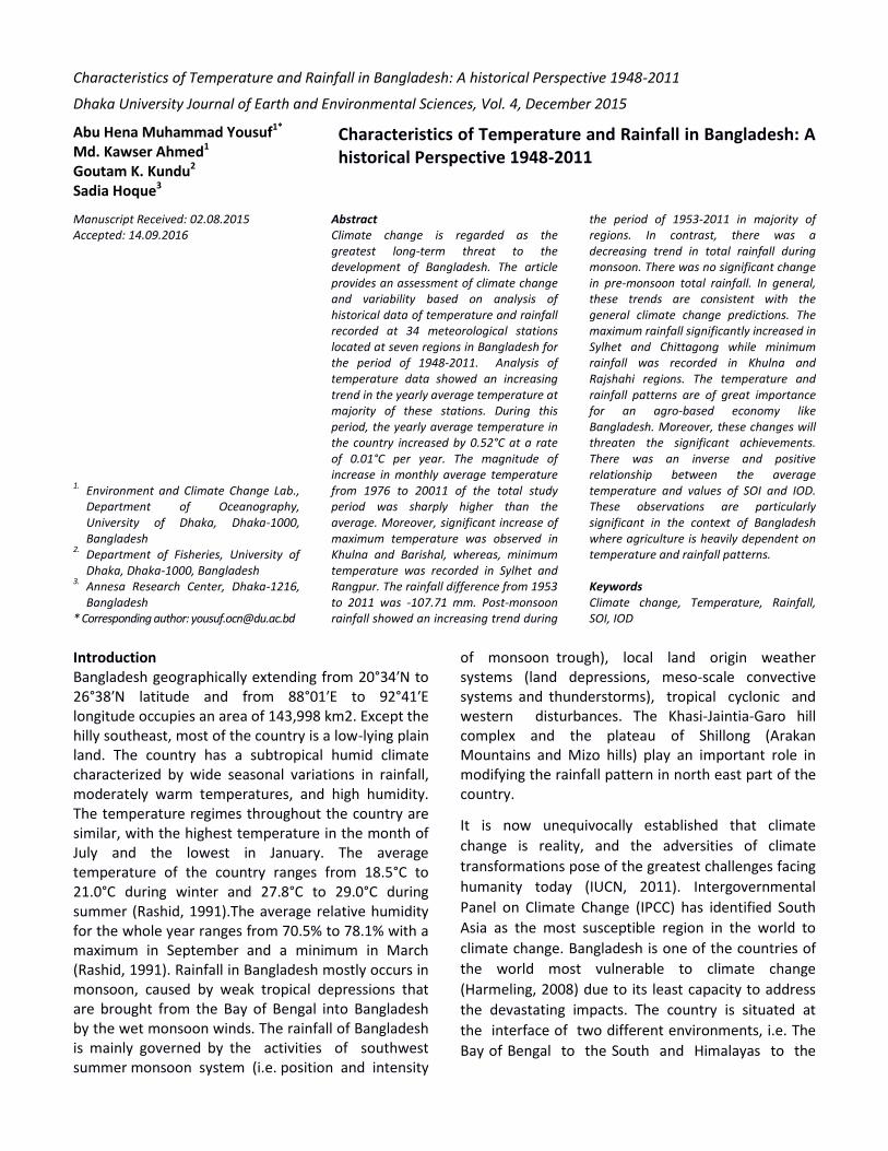
The rainfall and temperature data for the time period
of 1948 to 2011 were obtained from Storm Warning
Centre (SWC), Dhaka of Bangladesh Meteorological
Department (BMD) on the basis of its 34 observation
stations (Fig. 1) namely Dhaka, Tangail, Mymensingh,
Faridpur, Madaripur, Srimongal, Sylhet, Bogra, Ishurdi,
Rajshahi, Dinajpur, Rangpur, Sayedpur, Chuadanga,
Jessore, Khulna, Mongla, Satkhira, Barisal, Bhola,
Khapupara, Patuakhali, Chandpur, Chittagong,
Comilla, Cox`s Bazar, Feni, Hatia, Kutubdia, Maijdi
Court, Rangamati, Teknaf, Sandwip and Sitakunda. In
some instances there were some missing data which
were filled by the long term monthly mean of the
respective months. The time series of yearly rainfall
and temperature were obtained from the time series
of monthly data as the total of 12 months rainfall and
temperature for the individual years. The temperature
and rainfall pattern of the year round and during
monsoon (i.e. June to September) were analyzed on
the average of per year and every five years as well as
ten years basis for the time scales as mentioned
above. In addition that the analyses were done on the
basis of two segments which were in the whole
Bangladesh and among the seven regions, i.e.
Rajshahi, Barisal, Khulna, Rangpur, Dhaka, Chittagong,
and Sylhet divisions. For regional analysis Khulna,
Rajshai, Rangpur and Barisal divisions were considered
as the west region while Dhaka, Chittagong, and
Sylhet divisions were considered as east region.
Characteristics of Temperature and Rainfall in Bangladesh: A historical Perspective 1948-2011 23
Figure 1: 34 meteorological stations of BMD
Results and Discussion
Temperature patterns in Bangladesh
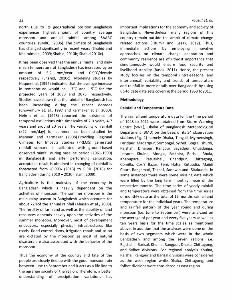
The distribution of temperature demonstrated a distinct seasonal regime and a gradual increase from east to west region (Fig. 2). Thus, the maximum average annual temperature (Tmax) from 1948 to 2011 was in Barisal (25.85°C)followed by Khulna(25.83°C), Rajshahi(25.25°C), Chittagong (25.57°C) and Dhaka (25.48°C)respectively. On the other hand, the minimum annual average temperature (Tmin) was in Sylhet(24.20°C0)and Rangpur (24.61°C).
Figure 2:Average Temperature (°C) in 7 Divisions from 1948 to 2011
The mean temperature difference from 1948 to 2011 was 0.52°C which is similar to the findings of Warrick et al. (1994) who studied mean-annual temperatures departures from the reference period 1951-1980.In
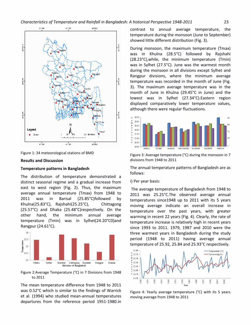
contrast to annual average temperature, the temperature during the monsoon (June to September) showed little different distribution (Fig. 3).
During monsoon, the maximum temperature (Tmax) was in Khulna (28.5°C) followed by Rajshahi (28.23°C),while, the minimum temperature (Tmin) was in Sylhet (27.5°C). June was the warmest month during the monsoon in all divisions except Sylhet and Rangpur divisions, where the minimum average temperature was recorded in the month of June (Fig. 3). The maximum average temperature was in the month of June in Khulna (29.45°C in June) and the lowest was in Sylhet (27.34°C).Eastern region displayed comparatively lower temperature values, although there were regular fluctuations.
Figure 3: Average temperature (°C) during the monsoon in 7 divisions from 1948 to 2011
The annual temperature patterns of Bangladesh are as follows:
i) Per year basis:
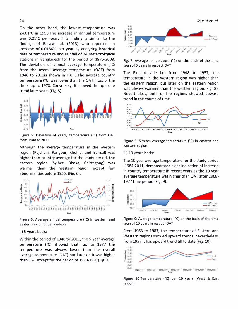
The average temperature of Bangladesh from 1948 to 2011 was 25.25°C.The observed average annual temperatures since1948 up to 2011 with its 5 years moving average indicate an overall increase in temperature over the past years, with greater warming in recent 22 years (Fig. 4). Clearly, the rate of temperature increase is relatively high in recent years since 1993 to 2011. 1979, 1987 and 2010 were the three warmest years in Bangladesh during the study period (1948 to 2011) having average annual temperature of 25.92, 25.84 and 25.93°C respectively.
Figure 4: Yearly average temperature (°C) with its 5 years moving average from 1948 to 2011
24 Yousuf et. al.
On the other hand, the lowest temperature was 24.61°C in 1950.The increase in annual temperature was 0.01°C per year. This finding is similar to the findings of Basaket al. (2013) who reported an increase of 0.0186°C per year by analyzing historical data of temperature and rainfall of 34 meteorological stations in Bangladesh for the period of 1976-2008. The deviation of annual average temperature (°C) from the overall average temperature (OAT) from 1948 to 2011is shown in Fig. 5.The average country temperature (°C) was lower than the OAT most of the times up to 1978. Conversely, it showed the opposite trend later years (Fig. 5).
Figure 5: Deviation of yearly temperature (°C) from OAT from 1948 to 2011
Although the average temperature in the western region (Rajshahi, Rangpur, Khulna, and Barisal) was higher than country average for the study period, the eastern region (Sylhet, Dhaka, Chittagong) was warmer than the western region except few abnormalities before 1955. (Fig. 6).
Figure 6: Average annual temperature (°C) in western and eastern region of Bangladesh
ii) 5 years basis:
Within the period of 1948 to 2011, the 5 year average temperature (°C) showed that, up to 1977 the temperature was always lower than the overall average temperature (OAT) but later on it was higher than OAT except for the period of 1993-1997(Fig. 7).
Fig. 7: Average temperature (°C) on the basis of the time span of 5 years in respect OAT
The First decade i.e. from 1948 to 1957, the temperature in the western region was higher than the eastern region, but later on the eastern region was always warmer than the western region.(Fig. 8). Nevertheless, both of the regions showed upward trend in the course of time.
Figure 8: 5 years Average temperature (°C) in eastern and western region.
iii) 10 years basis:
The 10 year average temperature for the study period (1984-2011) demonstrated clear indication of increase in country temperature in recent years as the 10 year average temperature was higher than OAT after 1968-1977 time period (Fig. 9).
Figure 9: Average temperature (°C) on the basis of the time span of 10 years in respect OAT
From 1963 to 1983, the temperature of Eastern and Western regions showed upward trends, nevertheless, from 1957 it has upward trend till to date (Fig. 10).
Figure 10:Temperature (°C) per 10 years (West & East region)
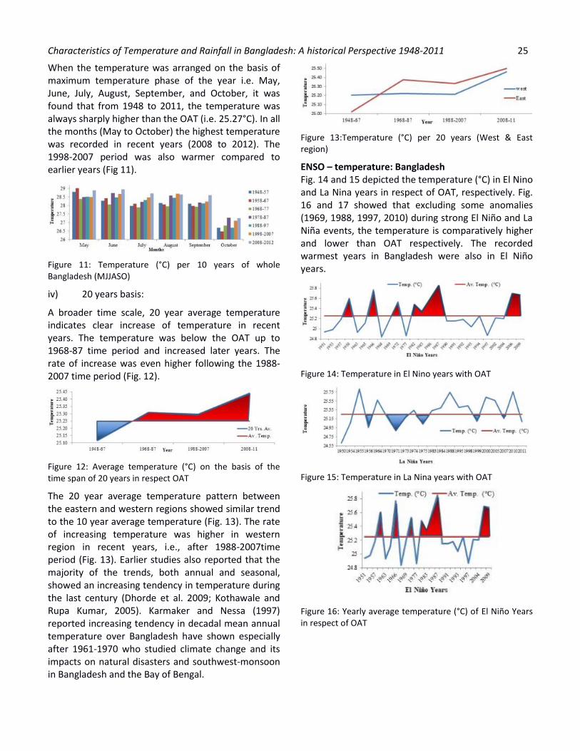
Characteristics of Temperature and Rainfall in Bangladesh: A historical Perspective 1948-2011 25
When the temperature was arranged on the basis of maximum temperature phase of the year i.e. May, June, July, August, September, and October, it was found that from 1948 to 2011, the temperature was always sharply higher than the OAT (i.e. 25.27°C). In all the months (May to October) the highest temperature was recorded in recent years (2008 to 2012). The 1998-2007 period was also warmer compared to earlier years (Fig 11).
Figure 11: Temperature (°C) per 10 years of whole Bangladesh (MJJASO)
iv) 20 years basis:
A broader time scale, 20 year average temperature indicates clear increase of temperature in recent years. The temperature was below the OAT up to 1968-87 time period and increased later years. The rate of increase was even higher following the 1988-2007 time period (Fig. 12).
Figure 12: Average temperature (°C) on the basis of the time span of 20 years in respect OAT
The 20 year average temperature pattern between the eastern and western regions showed similar trend to the 10 year average temperature (Fig. 13). The rate of increasing temperature was higher in western region in recent years, i.e., after 1988-2007time period (Fig. 13). Earlier studies also reported that the majority of the trends, both annual and seasonal, showed an increasing tendency in temperature during the last century (Dhorde et al. 2009; Kothawale and Rupa Kumar, 2005). Karmaker and Nessa (1997) reported increasing tendency in decadal mean annual temperature over Bangladesh have shown especially after 1961-1970 who studied climate change and its impacts on natural disasters and southwest-monsoon in Bangladesh and the Bay of Bengal.
Figure 13:Temperature (°C) per 20 years (West & East region)
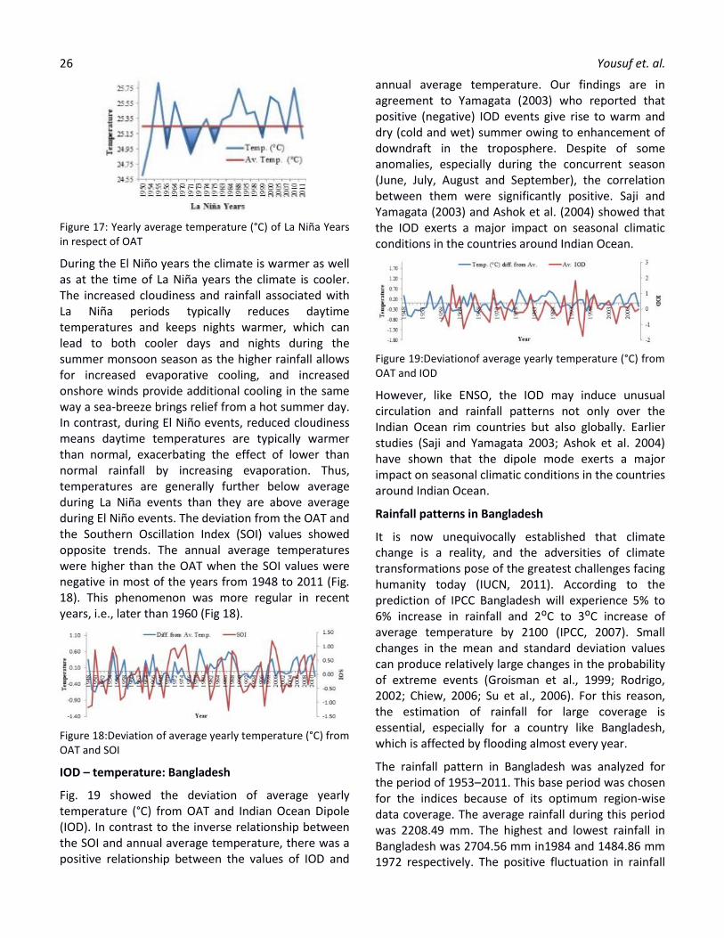
ENSO – temperature: Bangladesh Fig. 14 and 15 depicted the temperature (°C) in El Nino and La Nina years in respect of OAT, respectively. Fig. 16 and 17 showed that excluding some anomalies (1969, 1988, 1997, 2010) during strong El Niño and La Niña events, the temperature is comparatively higher and lower than OAT respectively. The recorded warmest years in Bangladesh were also in El Niño years.
Figure 14: Temperature in El Nino years with OAT
Figure 15: Temperature in La Nina years with OAT
Figure 16: Yearly average temperature (°C) of El Niño Years in respect of OAT
26 Yousuf et. al.
Figure 17: Yearly average temperature (°C) of La Niña Years in respect of OAT
During the El Niño years the climate is warmer as well as at the time of La Niña years the climate is cooler. The increased cloudiness and rainfall associated with La Niña periods typically reduces daytime temperatures and keeps nights warmer, which can lead to both cooler days and nights during the summer monsoon season as the higher rainfall allows for increased evaporative cooling, and increased onshore winds provide additional cooling in the same way a sea-breeze brings relief from a hot summer day. In contrast, during El Niño events, reduced cloudiness means daytime temperatures are typically warmer than normal, exacerbating the effect of lower than normal rainfall by increasing evaporation. Thus, temperatures are generally further below average during La Niña events than they are above average during El Niño events. The deviation from the OAT and the Southern Oscillation Index (SOI) values showed opposite trends. The annual average temperatures were higher than the OAT when the SOI values were negative in most of the years from 1948 to 2011 (Fig. 18). This phenomenon was more regular in recent years, i.e., later than 1960 (Fig 18).
Figure 18:Deviation of average yearly temperature (°C) from OAT and SOI
IOD – temperature: Bangladesh
Fig. 19 showed the deviation of average yearly temperature (°C) from OAT and Indian Ocean Dipole (IOD). In contrast to the inverse relationship between the SOI and annual average temperature, there was a positive relationship between the values of IOD and
annual average temperature. Our findings are in agreement to Yamagata (2003) who reported that positive (negative) IOD events give rise to warm and dry (cold and wet) summer owing to enhancement of downdraft in the troposphere. Despite of some anomalies, especially during the concurrent season (June, July, August and September), the correlation between them were significantly positive. Saji and Yamagata (2003) and Ashok et al. (2004) showed that the IOD exerts a major impact on seasonal climatic conditions in the countries around Indian Ocean.
Figure 19:Deviationof average yearly temperature (°C) from OAT and IOD
However, like ENSO, the IOD may induce unusual circulation and rainfall patterns not only over the Indian Ocean rim countries but also globally. Earlier studies (Saji and Yamagata 2003; Ashok et al. 2004) have shown that the dipole mode exerts a major impact on seasonal climatic conditions in the countries around Indian Ocean.
Rainfall patterns in Bangladesh
It is now unequivocally established that climate change is a reality, and the adversities of climate transformations pose of the greatest challenges facing humanity today (IUCN, 2011). According to the prediction of IPCC Bangladesh will experience 5% to 6% increase in rainfall and 2ᴼC to 3ᴼC increase of average temperature by 2100 (IPCC, 2007). Small changes in the mean and standard deviation values can produce relatively large changes in the probability of extreme events (Groisman et al., 1999; Rodrigo, 2002; Chiew, 2006; Su et al., 2006). For this reason, the estimation of rainfall for large coverage is essential, especially for a country like Bangladesh, which is affected by flooding almost every year.
The rainfall pattern in Bangladesh was analyzed for the period of 1953–2011. This base period was chosen for the indices because of its optimum region-wise data coverage. The average rainfall during this period was 2208.49 mm. The highest and lowest rainfall in Bangladesh was 2704.56 mm in1984 and 1484.86 mm 1972 respectively. The positive fluctuation in rainfall
Characteristics of Temperature and Rainfall in Bangladesh: A historical Perspective 1948-2011 27
from the overall annual average rainfall (mm) for the time period of 1953 to 2011 indicates an increasing trend in the annual average rainfall (Fig. 20 and 21).The amount of rainfall depends upon the supply of moist air from the Bay of Bengal. Atmospheric moisture amounts have been observed to be increasing after about 1973 (Ross and Elliott 2001).
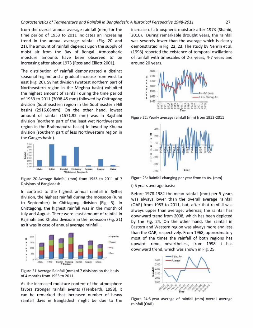
The distribution of rainfall demonstrated a distinct seasonal regime and a gradual increase from west to east (Fig. 20). Sylhet division (wettest northern part of Northeastern region in the Meghna basin) exhibited the highest amount of rainfall during the time period of 1953 to 2011 (3098.45 mm) followed by Chittagong division (Southeastern region in the Southeastern Hill basin) (2916.68mm). On the other hand, lowest amount of rainfall (1571.92 mm) was in Rajshahi division (northern part of the least wet Northwestern region in the Brahmaputra basin) followed by Khulna division (southern part of less Northwestern region in the Ganges basin).
Figure 20:Average Rainfall (mm) from 1953 to 2011 of 7 Divisions of Bangladesh
In contrast to the highest annual rainfall in Sylhet division, the highest rainfall during the monsoon (June to September) in Chittagong division (Fig. 5). In Chittagong, the highest rainfall was in the month of July and August. There were least amount of rainfall in Rajshahi and Khulna divisions in the monsoon (Fig. 21) as it was in case of annual average rainfall. .
Figure 21:Average Rainfall (mm) of 7 divisions on the basis of 4 months from 1953 to 2011
As the increased moisture content of the atmosphere favors stronger rainfall events (Trenberth, 1998), it can be remarked that increased number of heavy rainfall days in Bangladesh might be due to the
increase of atmospheric moisture after 1973 (Shahid, 2010). During remarkable drought years, the rainfall was severely lower than the average which is clearly demonstrated in Fig. 22, 23. The study by Nehrin et al. (1998) reported the existence of temporal oscillations of rainfall with timescales of 2-3 years, 4-7 years and around 20 years.
Figure 22: Yearly average rainfall (mm) from 1953-2011
Figure 23: Rainfall changing per year from to Av. (mm)
i) 5 years average basis:
Before 1978-1982 the mean rainfall (mm) per 5 years was always lower than the overall average rainfall (OAR) from 1953 to 2011, but, after that rainfall was always upper than average; whereas, the rainfall has downward trend from 2008, which has been depicted by the Fig. 24. On the other hand, the rainfall in Eastern and Western region was always more and less than the OAR, respectively. From 1968, approximately most of the times the rainfall of both regions has upward trend, nevertheless, from 1998 it has downward trend, which was shown in Fig. 25.
Figure 24:5-year average of rainfall (mm) overall average rainfall (OAR)
28 Yousuf et. al.
Figure 25: Rainfall (mm) per 5 years (West & East region) and OAR
ii) 10 years average basis:
Before 1973-1982 the mean rainfall (mm) per 10 years was always lower than OAR, but, after that rainfall was always upper than average; whereas, the overall rainfall has downward trend from 1983-92, which is demonstrated in Fig. 26. From 1963 to 1983, the rainfall of Eastern and Western regions have upward trends, nevertheless, from 1983 it has downward trend (Fig. 27).
Figure 26: 10-year average of rainfall (mm) & overall average rainfall (OAR)
Figure 27: Rainfall (mm) per 10 years (West & East region) and OAR
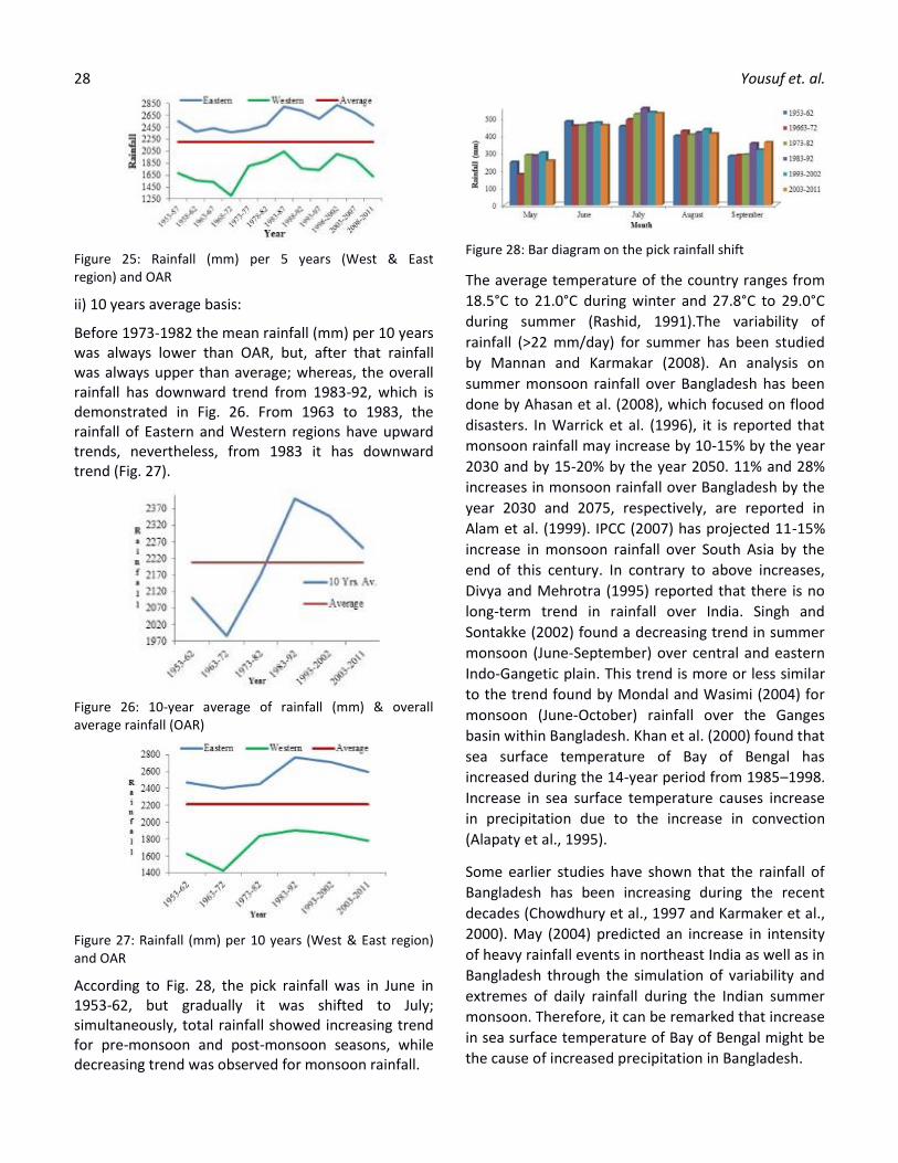
According to Fig. 28, the pick rainfall was in June in 1953-62, but gradually it was shifted to July; simultaneously, total rainfall showed increasing trend for pre-monsoon and post-monsoon seasons, while decreasing trend was observed for monsoon rainfall.
Figure 28: Bar diagram on the pick rainfall shift
The average temperature of the country ranges from
18.5°C to 21.0°C during winter and 27.8°C to 29.0°C
during summer (Rashid, 1991).The variability of
rainfall (>22 mm/day) for summer has been studied
by Mannan and Karmakar (2008). An analysis on
summer monsoon rainfall over Bangladesh has been
done by Ahasan et al. (2008), which focused on flood
disasters. In Warrick et al. (1996), it is reported that
monsoon rainfall may increase by 10-15% by the year
2030 and by 15-20% by the year 2050. 11% and 28%
increases in monsoon rainfall over Bangladesh by the
year 2030 and 2075, respectively, are reported in
Alam et al. (1999). IPCC (2007) has projected 11-15%
increase in monsoon rainfall over South Asia by the
end of this century. In contrary to above increases,
Divya and Mehrotra (1995) reported that there is no
long-term trend in rainfall over India. Singh and
Sontakke (2002) found a decreasing trend in summer
monsoon (June-September) over central and eastern
Indo-Gangetic plain. This trend is more or less similar
to the trend found by Mondal and Wasimi (2004) for
monsoon (June-October) rainfall over the Ganges
basin within Bangladesh. Khan et al. (2000) found that
sea surface temperature of Bay of Bengal has
increased during the 14-year period from 1985–1998.
Increase in sea surface temperature causes increase
in precipitation due to the increase in convection
(Alapaty et al., 1995).
Some earlier studies have shown that the rainfall of
Bangladesh has been increasing during the recent
decades (Chowdhury et al., 1997 and Karmaker et al.,
2000). May (2004) predicted an increase in intensity
of heavy rainfall events in northeast India as well as in
Bangladesh through the simulation of variability and
extremes of daily rainfall during the Indian summer
monsoon. Therefore, it can be remarked that increase
in sea surface temperature of Bay of Bengal might be
the cause of increased precipitation in Bangladesh.
Characteristics of Temperature and Rainfall in Bangladesh: A historical Perspective 1948-2011 29
Conclusions
The current study concludes that both the temperature and rainfall in Bangladesh is increasing with noticeable alterations in their spatial distribution. The temporal and spatial variation in temperature and rainfall found in the present study enhances the necessity to address the issue of climate change in Bangladesh. This should be considered in setting and implementing the mitigation and adaptation strategies to meet the challenge of climate change.
Acknowledgements
The authors express their profound gratitude to Bangladesh Meteorological Department (BMD) for its generous support by providing the essential data. Annesa Research Center (ARC) is also acknowledged for funding this research project and also for kind assistance by delivering the facilities for the fulfillment of the research.
References
Ahasan, M. N., Chowdhury, M. A., and Quadir, D. A. (2008), Few aspects of the flood disaster caused by heavy rainfall over Bangladesh, Proceedings of SAARC Seminar on Application of Weather and Climate Forecasts in the Socio-economic Development and Disaster Mitigation, 05-07 August, 2007, Dhaka, Bangladesh, pp. 79-94.
Ajayamohan, RS., and Rao, SA. (2008), Indian Ocean dipole modulates the number of extreme rainfall events over India in a warming environment, J Meteor Soc Japan, 86:245–252.
Alapaty, K., Raman, S., Mohanty, UC. And Madala, RV.(1995), Sensitivity of monsoon circulations to changes in sea surface temperatures. Atmos Environ. 29(16):2139–2156.
Allan, R., Chambers, D., Drosdowsky, W., Hendon, H., Latif, M., Nicholls, N., Smith, I., Stone, R. andTourre, Y. (2001), Is there an Indian Ocean Dipole and is it independent of the El Nino–Southern Oscillation. CLIVAR Exch. 6:18–22.
Alam, M., Nishat, A. and Siddiqui, S. M. (1999), Water resources vulnerability to climate change with special reference to inundation, In Vulnerability and adaptation to climate change for Bangladesh, S. Huq, Z. Karim, M. Asaduzzaman, and F. Mahtab (eds.), Kluwer Academic Publishers, Dordrecht, The Netherlands.
Ashok, K., Guan, Z., Saji, NH. and Yamagata, T. (2004), Individual and combined influences of ENSO and the Indian Ocean dipole on the Indian summer monsoon, J Clim.17:3141–3155.
Ashok, K., Guan, Z. and Yamagata, T. (2001), Impact of the Indian Ocean dipole on the relationship between the Indian monsoon rainfall and ENSO, Geophys Res Lett. 28:4499–4502.
BWDB, French Engineering Consortium and Bets Consulting study for flood control in Bangladesh, Government of Bangladesh, 2, II.2–6.
Basak, JK., Titumir, RAM. and Dey, NC. (2013), Climate Change in Bangladesh: A Historical Analysis of Temperature and Rainfall Data, J. Env. 02(02), pp. 41-46.
Basak, J.K. (2011), Implications of Climate Change on Crop Production in Bangladesh and Possible Adaptation Techniques, In: International Conference on United Nations Framework Convention on Climate Change (UNFCCC), Durban Exhibition Centre, Durban, COP 17,UnnayanOnneshan - The Innovators, Dhaka-1215, Bangladesh.
Behera, SK. and Yamagata, T. (2001), Subtropical SST dipole events in the southern Indian Ocean, Geophys Res Lett. 28:327–330.
Behera, S. K., Krishnan, R. and Yamagata, T. (1999), Unusual ocean-atmosphere conditions in the tropical Indian Ocean during 1994, Geophy. Res. Letter, 26, 3001-3004.
Behera, SK., Luo,JJ., Masson, S., Rao, SA., Sakuma, H. and Yamagata, T. (2006), A CGCM study on the interactions between IOD and ENSO,J Clim.19:1688–1705.
Chang, C. P., Harr, P. and Ju, J.(2001), Possible roles of Atlantic circulations on the weakening Indian Monsoon rainfall – ENSO relationship, J. Climate,14: 2376–2380.
Chiew, FHS. (2006), Estimation of rainfall elasticity of stream flow in Australia, Hydrol Sci J. 51(4):613–625.
Chowdhury, MR., Ward, N. (2003), Seasonal rainfall and stream-flow in the Ganges-Brahmaputra Basins of Bangladesh: Variability and predictability, Proceedings of ASCE, World Water & Environmental Resources Congress – Special Volume, http://www.asce.org/conferences/ewri2003.
30 Yousuf et. al.
Chowdhury, AM. (1994), Bangladesh floods, cyclones and ENSO, Paper presented at the International Conference on Monsoon Variability and Prediction, International Center for Theoretical Physics (ICTP), Italy, 9–13 May, 1994.
Chowdhury, M.H.K., Pramanik, M.A.H., Quadir, D.A., and Ferdousi, N.(1997), Study of meteorological parameter related to climate variability in Bangladesh, The Atmosphere, 3, 71-88.
Chowdhury, MR., Sato, Y. (1996), Flood monitoring in Bangladesh: Experience from normal and catastrophic floods, Hydrology (J. Jpn. Assoc. Hydrol. Sci.), 26(4):241–152.
Clark, T. (2003), Delta Blues, Nature, 422: 254–256.
Clark, C. O., Cole, J. E. and Webster, P. J.(2000), Indian Ocean SST and Indian Summer rainfall: predictive relationships and their decadal Variability, J. Climate,13: 2503–2519.
Dhorde, A., Dhorde, A. and Gadgil, AS. (2009), Long-term temperature trends at four largest cities of India during the twentieth Century, J Ind Geophys Union, 13(2):85–97.
Divya and Mehrotra, R. (1995), Climate change and hydrology with emphasis on the Indian Subcontinent, Hydrological Sciences Journal, 40(2), 231-242.
Douglas, WW., Wasimi, SA. and Islam, S. (2001), The El Nino–Southern oscillation and long-range forecasting of flows in the Ganges, Int J Climatol. 21: 77–87.
Fischer, AS., Terray, P., Guilyardi, E., Gualdi, S. and Delecluse, P. (2005), Two independent triggers for the Indian Ocean dipole/zonal mode in a coupled GCM, J Clim. 18:3428–3449.
Groisman, PY., Karl, TR., Easterling, DR., Knight, RW., Jameson, PF., Hennessy, KJ., Suppiah, R., Page, CM., Wibig, J., Fortuniak, K., Razuvaev, VN., Douglas, A., Forland, E. and Zhai, PM. (1999), Changes in the probability of heavy precipitation: important indicators of climatic change, Clim Change, 42:243–283.
Han, W. and Webster, P. (2002), Forcing mechanisms of sea level inter-annual variability in the Bay of Bengal, J Phys Oceanogr. 32:216–239.
Haque, M.Z., Quayyam, H.A., Hossian, M.M., and Islam, M.S. (1992), Occurrence of grain sterility in different rice crops, In: Islam, A.K.M.N., Fattah, Q.A., Muttaqi, I.A., and Aziz, A. (eds.), Plant
Science and Man: problems and Prospects. Proc. Intl. Bot. Conf., January 10-12, 1991, Bangladesh Bot. Soc., Dhaka, Bangladesh. Dhaka, Bangladesh Bureau of Statistics (BBS), pp. 117-124.
Harmeling, S. (2008), Global Climate Risk Index 2009, Weather-related loss and Their Impacts on Countries in 2007 and in a Long Term Comparison, Kaiserstr 201, Bonn, Germanwatche.V., pp. 5-8.
Hashizume, M., Armstrong, B., Hajat, S., Wagatsuma, Y., Faruque, AS., Hayashi, T., et al., (2008),The effect of rainfall on the incidence of cholera in Bangladesh, Epidemiology, 19:103–110.
Hong, C-C., Lu, M-M., Kanamitsu, M. (2008), Temporal and spatial characteristics of positive and negative Indian Ocean dipole with and without ENSO, J Geophys Res.113:D08107. doi: 10.1029/2007JD009151. [Online 18 April 2008]
Hossain, E., Alam, SS., Imam, KH., Hoque, MM. (2001), Bangladesh country case study: Impacts and response to the 1997–98 El Nino event, In: Glantz MH (ed) Once burned twice shy? United Nations University Press, pp 44–50.
IPCC (2007), Climate Change 2007: the physical science basis, Summary for policymakers, Contribution of the Working Group I to the Fourth Assessment Report of the Intergovernmental Panel on Climate Change. Cambridge University Press, Cambridge.
Islam, MN. (2009),Rainfall and Temperature Scenario for Bangladesh, The Open Atmosp. Sci. J. 3:93-103.
IUCN, Bangladesh (2011), Protocol for Monitoring of Impacts of Climate Change and Climate Variability in Bangladesh, Dhaka, Bangladesh, IUCN (International Union for Conservation of Nature), pp. xiv + 182.
Jensen, TG. (2007), Introduction: special issue on Indian Ocean climate, J Clim. 20:2869–2871.
Kane, RP. (1998), Extremes of the ENSO phenomenon and Indian summer monsoon rainfall, Int J Climatol. 18: 775–791
Kaplan, A., Cane, M., Kushnir, Y., Clement, A., Blumenthal, M. and Rajagopalan, B. (1998), Analyses of global sea surface temperature 1856–1991, J Geophys Res. 103:18567–18589.
Karmakar, S. and Khatun, A. (2000), Variability and probabilistic estimates of rainfall extremes in Bangladesh during the southwest monsoon season, Mausam, 46(1):47–56.
Characteristics of Temperature and Rainfall in Bangladesh: A historical Perspective 1948-2011 31
Karmakar, S., and Nessa, J. (1997), Climate change and its impacts on natural disasters and south-west monsoon in Bangladesh and the Bay of Bengal, Journal of Bangladesh of Academy of Sciences, 21(2), pp. 127-136.
Khan,TMA., Singh, OP. and Rahman, MS. (2000), Recent sea level and sea surface temperature trends along the Bangladesh Coast in relation to the frequency of intense cyclones, Mar Geodesy, 23(2):103–116.
Kinter, JL. III, Miyakoda, Y. and Yang, S. (2002), Recent change in the connection from Asian monsoon to ENSO, J Climate, 15: 1203–1215.
Kripalani, RH,, and Kumar, P. (2004), Northeast monsoon rainfall variability over south peninsular India vis-à-vis Indian Ocean Dipole mode, Int. J. Climatol, 24, 1267-1282.Krishnamurthy, V., Kirtman, BP. (2003), Variability of the Indian Ocean: relation to monsoon and ENSO, Q J R Meteorol Soc. 129:1623–1646.
Kothawale, DR. and Rupa Kumar, K. (2005), On the recent changes in surface temperature trends over India, Geophysi Res Lett. 32: L18714. doi:10.1029/2005GL023528
Kumar,KK., Rajagopalan, B. and Cane, MA. (1999), On the weakening relationship between the Indian monsoon and ENSO, Science, 284: 2156–2159.
Kumar, KK., Soman, MK. and Kumar, RK. (1995), Seasonal forecasting of Indian Summer monsoon rainfall: A review, Weather, 50(12): 449–467.
Mallick, DL. (2008), Growing environmental and climate refugees in Bangladesh: urgent actions are required, C40 Tokyo Conference on Climate Change—adaptation measures for sustainable low carbon cities, 22–24 October 2008, Tokyo.
Mannan, Md. Abdul and Karmakar, S. (2008), Proceedings of SAARC Seminar on Application of Weather and Climate Forecasts in the Socio-economic Development and Disaster Mitigation, 05-07 August, 2007, Dhaka, Bangladesh, 95-115.
May, W. (2004), Simulation of the variability and extremes of daily rainfall during the Indian summer monsoon for present and future times in a global time-slice experiment, Clim Dyn. 22(2–3):183–204.
Mirza, MQM. (2002), Global warming and changes in the probability of occurrence of floods in
Bangladesh and implications, Glob Environ Change, 12(2):127–138.
Mondal, M.S. and Wasimi, S.A. (2004), Impact of climate change on dry season water demand in the Ganges Delta of Bangladesh, In Contemporary Environmental Challenges , M.M. Rahman, M.J.B., Alam, M.A. Ali, M. Ali and K. Vairavamoorthy, (eds.), CERM and ITN, BUET and WEDC, IDE, Loughborough University, UK, 63-83.
Nehrin, Z., Munim, A.A., Begum, Q.N., and Quadir, D.A. (1998), Studies of periodicities of rainfall over Bangladesh, J. of Remote Sensing and Environment, 1, 43-54.
Palmer, TN. And Raisanen, J. (2002), Quantifying the risk of extreme seasonal precipitation events in a changing climate, Nature, 415(6871):512–514.
Parthasarathy, B. and Pant, GB. (1985), Seasonal relationships between Indian Summer Monsoon rainfall and the Southern Oscillation. Int J Climatol. 5: 369–378.
Rana, M., Shafee, S. and Karmakar, S. (2007), Estimation of rainfall in Bangladesh by using southern oscillation index, Pak J Meteorol. 4 (7): 1-23.
Rao, SA., Behera, SK., Masumoto, Y. and Yamagata, T. (2002), Inter-annual variability in the subsurface tropical Indian Ocean, Deep Sea Res, Part II, 49:1549–1572.
Rashid, HR. (1991), Geography of Bangladesh, University Press Ltd, Dhaka.
Rasmusson, E.M. and Carpenter, T.H. (1983), The relationship between eastern equatorial Pacific Sea Surface Temperatures and Rainfall over India and Srilanka, Monthly Weather Review, 111, 517-528.
Rodrigo, FS. (2002), Changes in climate variability and seasonal rainfall extremes: a case study from San Fernando (Spain), 1821–2000, Theor Appl Climatol. 72:193–207.
Ropelewski, CF. and Halpert, M. (1996), Quantifying Southern Oscillation – precipitation relationship, J Climate, 9(5):1043–1059.
Ross, RJ. and Elliott, WP. (2001), Radiosonde-based northern hemisphere tropospheric water vapor trends, J Climate, 14:1602–1612.
Sabbir Ahmed, A.S.M., Munim, A.A., Begum, Q.N. and Choudhury, A.M. (1996), El Nino Southern Oscillation and Rainfall Variation over Bangladesh, Mausam, 47, 2 pp. 157-162.
32 Yousuf et. al.
Saji, NH. and Yamagata, T. (2003), Possible roles of Indian Ocean dipole mode events on global climate, Clim Res. 25:151–169.
Saji N. H., and Yamagata, T. (2003), A view of the tropical Indian Ocean climate system from the vantage point of Dipole Mode events, J. Climate (submitted). Clim Res. Vol. 25: 151–169.
Saji, N. H., Goswami, B. N., Vinayachandran, P. N. and Yamagata, T. (1999), A dipole mode in the tropical Indian Ocean, Nature, 401, 360-363.
Sadhuram, Y., Murthy, T. and Ramana, V. (2007), Simple Multiple Regression Model for long range forecasting of Indian Summer Monsoon Rainfall, Meteorol. Atmos. Phys. DOI:10.1007/s00703-007-0277.
Shahid, S., Chen, X. and Hazarika, MK. (2005), Assessment aridity of Bangladesh using geographic information system, GIS Development, 9 (12): 40–43.
Shahid, S. (2011), Trends in extreme rainfall events of Bangladesh, Theor Appl Climatol. 104:489-499.
Shukla, J. and Paolino, D.A. (1983), The southern Oscillation and long range forecasting of the summer monsoon rainfall over India, Mon. Waether Rev.115, 695-703.
Singh, N. and Sontakke, N. A. (2002), On climatic fluctuations and environmental changes of the Indo-Gangetic plains, India, Climate Change, 52, 287-313.
Smith, TM. and Reynolds, RW. (2004), Improved extended reconstruction of SST (1854–1997), J Clim. 17:2466–2477.
SMRC, (2006), Rainfall over SAARC region with special focus on tele-connections and long range forecasting of Bangladesh monsoon rainfall, monsoon forecasting with a limited area numerical weather prediction system, SMRC Report No-19.
Su, BD., Jiang, T. and Jin, WB. (2006), Recent trends in observed temperature and precipitation extremes in the Yangtze River basin, China, Theor Appl Climatol. 83:139–151.
Titumir, R.A.M. and Basak, J.K. (2012), Effects of Climate Change on Crop Production and Climate Adaptive Techniques for Agriculture in Bangladesh, Social Science Review, The Dhaka University Studies, Part-D, 29(1), pp. 215-232.
Torrence, C. and Webster, PJ. (1999), Inter-decadal changes in the ENSO-Monsoon system, J Climate, 12:2679–2690.
Trenberth, KE. (1998), Atmospheric moisture residence times and cycling: implications for rainfall rates with climate change, Clim Change, 39:667–694.
Walker, GT. and Bliss, EW. (1932), World Weather V. Memories of the Royal Meteorological Society, 4: 53–84.
Warrick, R.A., Bhuiya, A.H. and Mirza, M.Q. (1994), The Greenhouse Effect and Climate Change: Briefing Document No. 1, Dhaka, Bangladesh Unnayan Parishod (BUP), pp. 17-20.
Warrick, R. A., Bhuiya, A. H. and Mirza, M. Q. (1996), The greenhouse effect and climate change, In The implications of climate and sea-level change for Bangladesh, R. A. Warrick and Q. K. Ahmad, (eds.), Kluwer Academic Publishers, Dordrecht, The Netherlands.
Webster, P. J., Moore, A.M., Loschnigg, J.P. and Leben, R.R. (1999), The great Indian Ocean warming of 1997-98: Evidence of coupled oceanic-atmospheric instabilities, Nature, 401,356-360.
Whitaker, D.W., Wasimi, S.A. and Islam, S. (2001), The El Nino Southern Oscillation and longrange forecasting of flows in the Ganges, International Journal of Climatology, 21, 77 – 87.
Xie, S-P., Annamalai, H., Schott, FA. and McCreary, JP. (2002), Structure and mechanism of south Indian Ocean climate variability, J Clim. 15:864–878.
Yamagata, T., Behera, SK., Luo, J-J., Masson, S., Jury, MR. and Rao, SA. (2004), Coupled ocean-atmosphere variability in the tropical Indian Ocean, In: Wang C, Xie S-P, Carton JA, editors, Earth Climate: The Ocean–Atmosphere Interaction, Geophys Monograph 147, Washington, DC: American Geophysical Union, pp. 189–211.
Zubair, Lareef, and C. F. Ropelewski, (2006), The Strengthening Relationship between ENSO and Northeast Monsoon Rainfall over Sri Lanka and Southern India, J. Climate, 19, 1567–1575. doi: http://dx.doi.org/10.1175/JCLI3670.1