Embed Size (px)
Citation preview
Accelerated Climate Model for Energy
Translating Process Understanding to Improve Climate Models
GFDL, October 15, 2015
Atmosphere: Phil Rasch, Shaocheng Xie
Ocean, Cryosphere: Todd Ringler, Steve Price, Phil Jones
Land: Peter Thornton, Bill Riley, Charlie Koven
Dave Bader (ACME PI) (Dorothy Koch, DOE PM)
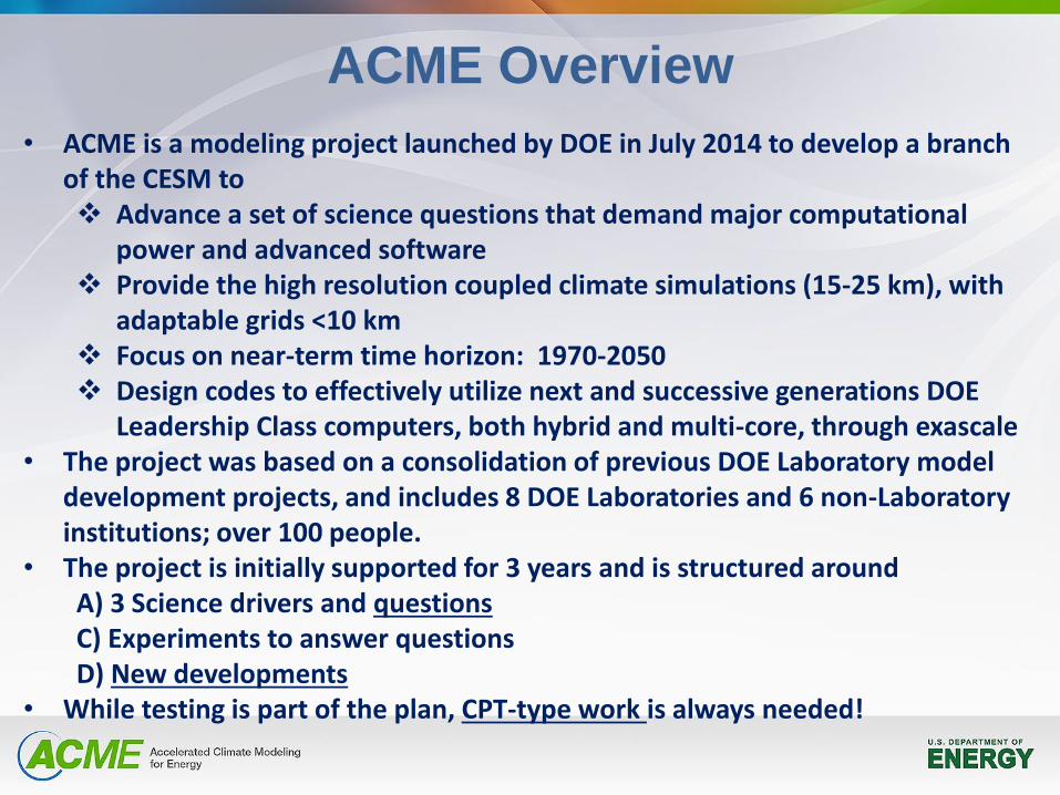
• ACME is a modeling project launched by DOE in July 2014 to develop a branch of the CESM to Advance a set of science questions that demand major computational
power and advanced software Provide the high resolution coupled climate simulations (15-25 km), with
adaptable grids <10 km Focus on near-term time horizon: 1970-2050 Design codes to effectively utilize next and successive generations DOE
Leadership Class computers, both hybrid and multi-core, through exascale • The project was based on a consolidation of previous DOE Laboratory model
development projects, and includes 8 DOE Laboratories and 6 non-Laboratory institutions; over 100 people.
• The project is initially supported for 3 years and is structured around A) 3 Science drivers and questions C) Experiments to answer questions D) New developments
• While testing is part of the plan, CPT-type work is always needed!
ACME Overview
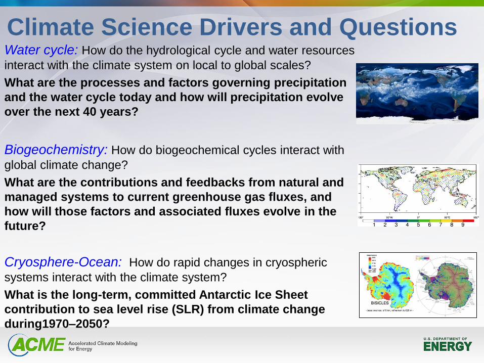
Climate Science Drivers and Questions Water cycle: How do the hydrological cycle and water resources
interact with the climate system on local to global scales?
What are the processes and factors governing precipitation
and the water cycle today and how will precipitation evolve
over the next 40 years?
Biogeochemistry: How do biogeochemical cycles interact with
global climate change?
What are the contributions and feedbacks from natural and
managed systems to current greenhouse gas fluxes, and
how will those factors and associated fluxes evolve in the
future?
Cryosphere-Ocean: How do rapid changes in cryospheric
systems interact with the climate system?
What is the long-term, committed Antarctic Ice Sheet
contribution to sea level rise (SLR) from climate change
during1970–2050?
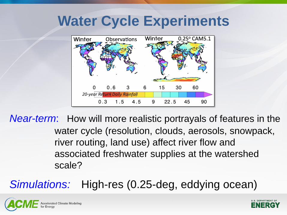
Water Cycle Experiments
Near-term: How will more realistic portrayals of features in the
water cycle (resolution, clouds, aerosols, snowpack,
river routing, land use) affect river flow and
associated freshwater supplies at the watershed
scale?
Simulations: High-res (0.25-deg, eddying ocean)
20-year Return Daily Rainfall
Biogeochemical Experiments
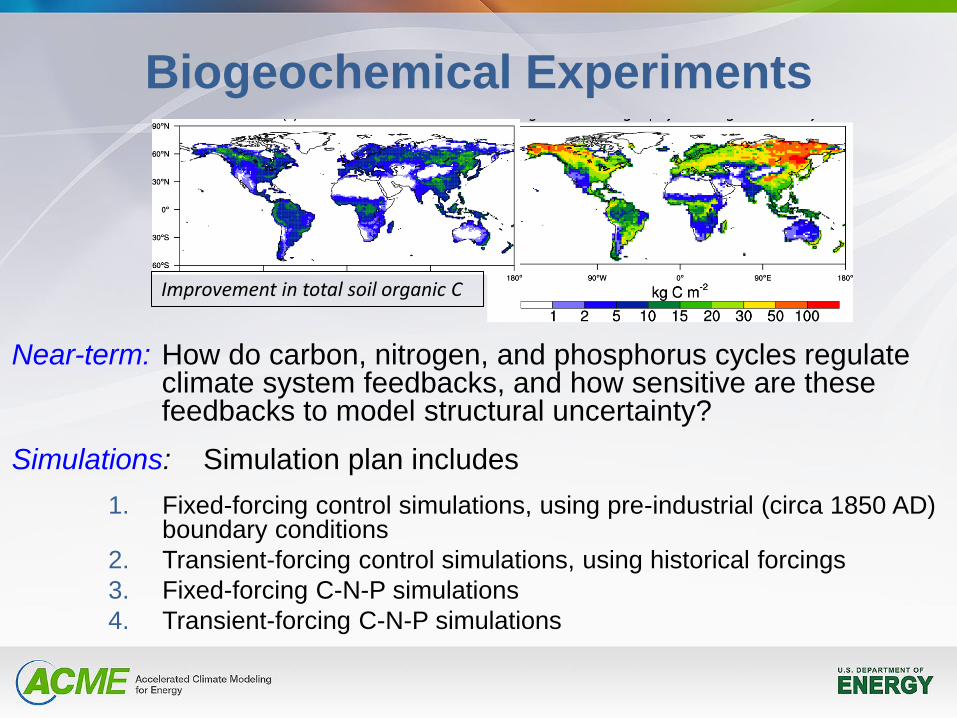
Near-term: How do carbon, nitrogen, and phosphorus cycles regulate climate system feedbacks, and how sensitive are these feedbacks to model structural uncertainty?
Simulations: Simulation plan includes
1. Fixed-forcing control simulations, using pre-industrial (circa 1850 AD) boundary conditions
2. Transient-forcing control simulations, using historical forcings
3. Fixed-forcing C-N-P simulations
4. Transient-forcing C-N-P simulations
Improvement in total soil organic C
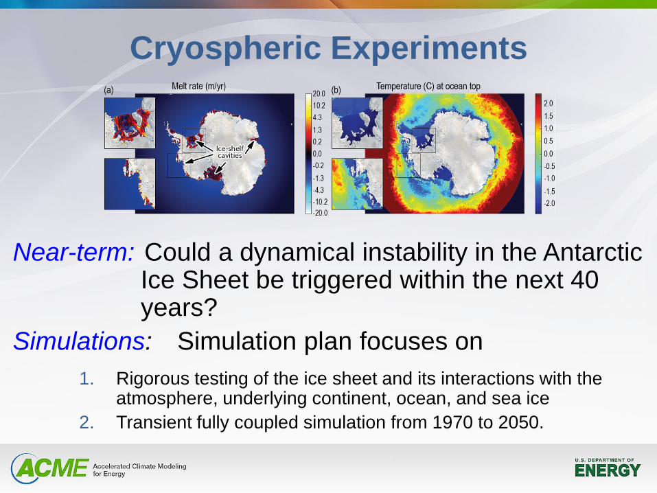
Cryospheric Experiments A C C E L E R A T E D C L I M A T E M O D E L I N G F O R E N E R G Y
87
Figure 5.8.2-1: Snapshot from a high-resolution (~5 km), Southern ocean simulation using POP2x (Asay-Davis, 2013) under Core 2, normal year forcing. Shown are simulated submarine melting rates (upper-left), temperatures in the upper- and lower-most (ocean bottom) model layers (upper- and lower-right, respectively), and the velocity magnitude in the uppermost ocean layer (lower-left). Ongoing stand-alone and coupled simulations using POP2x and the CISM-BISICLES ice sheet model (Price et al., 2013) will be used for benchmarking ice-ocean simulations with MPAS Ocean and MPAS Land Ice.
5.8.3OtherLandIceDevelopment—Q5,Q10
InadditiontoMPAS-LIdevelopmentrelatedspecificallytodynamicalcores(anddiscussedabove),anumberofotherdevelopmenttasksinvolvingMPAS-LIwillneedtobecompleted,including:
§ Meshrefinementforicesheets,basedonobservationaldata(e.g.velocitygradients)§ GeneratestandardizedvariableresolutionmeshesforbothGreenlandandAntarctica§ SubglacialhydrologymodelcoupledtoCoulombfrictionslidinglaw(e.g.,leveraginginitialwork
byHoffmanandPrice(inpress)andM.PeregoofSNL,followingmethodsdiscussedinWerderetal.,2013).
5.8.4Optimization,UQ,andTest-bedIntegration
Unlikeotherpartsoftheclimatesystem,icesheetsretainamemoryoftheirinitialstatefor~104–105years(e.g.,Rogozhinaetal.,2011).Formaloptimizationtechniquesareessentialforderivingicesheetmodelinitialconditionsthatareconsistentwithbothpresent-dayobservations(e.g.,geometryandvelocity)andforcingfromclimatemodels.Thesetechniquesarecurrentlybeingdeveloped,tested,andappliedunderPISCEES(Peregoetal.,inprep.).Similarmethodsarealsobeingexploredforassigninguncertaintiestooptimizedmodelinputparameters(Petraetal.,2013),ideallyallowingfortheabilitytopropagatemodeluncertaintiesthroughforwardmodelrunsandassignuncertaintiesonimportantmodeloutputs,likeSLR.AdvancesintheseareasmadeunderPISCEESwillbefullyleveragedbytheACMEprojectandwillmakeuseoftheintegratedtestbed.
Near-term: Could a dynamical instability in the Antarctic Ice Sheet be triggered within the next 40 years?
Simulations: Simulation plan focuses on
1. Rigorous testing of the ice sheet and its interactions with the atmosphere, underlying continent, ocean, and sea ice
2. Transient fully coupled simulation from 1970 to 2050.
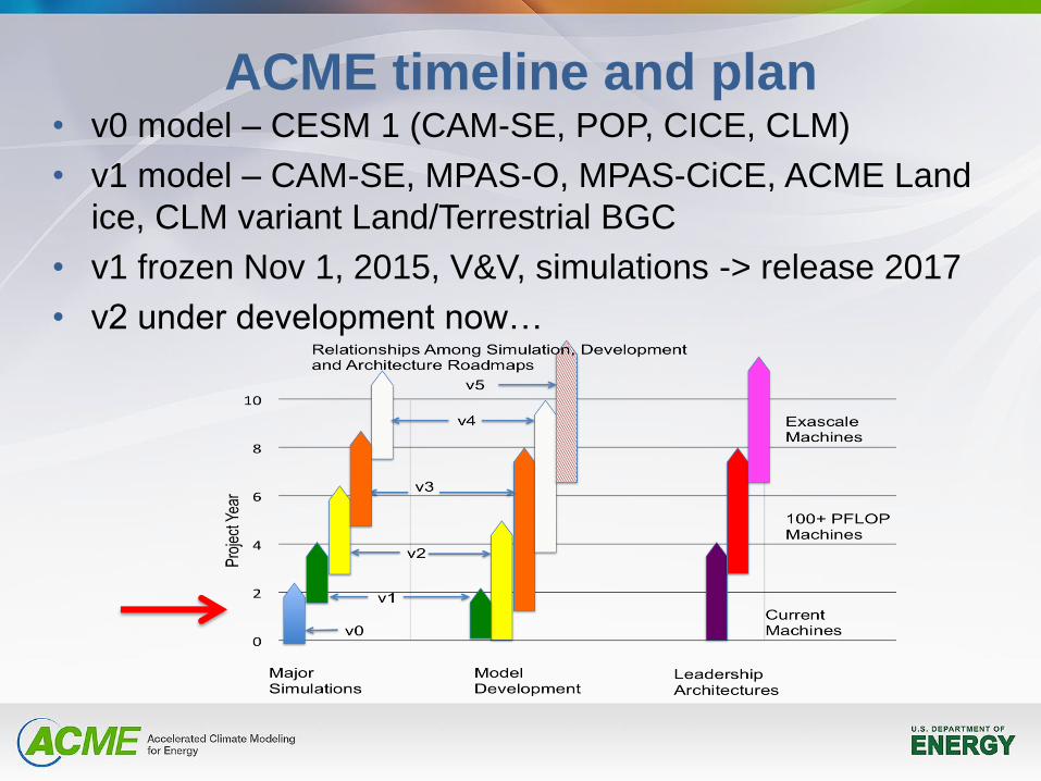
• v0 model – CESM 1 (CAM-SE, POP, CICE, CLM)
• v1 model – CAM-SE, MPAS-O, MPAS-CiCE, ACME Land
ice, CLM variant Land/Terrestrial BGC
• v1 frozen Nov 1, 2015, V&V, simulations -> release 2017
• v2 under development now…
ACME timeline and plan
Atmosphere
Developments
CPT ideas
DOE activities
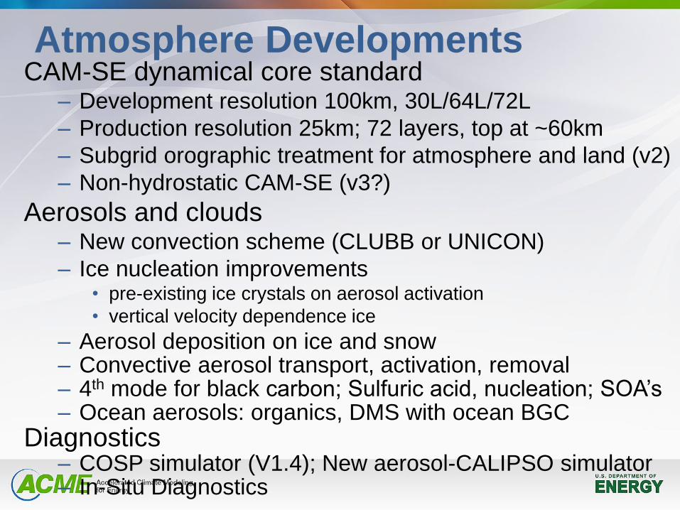
Atmosphere Developments CAM-SE dynamical core standard
– Development resolution 100km, 30L/64L/72L
– Production resolution 25km; 72 layers, top at ~60km
– Subgrid orographic treatment for atmosphere and land (v2)
– Non-hydrostatic CAM-SE (v3?)
Aerosols and clouds – New convection scheme (CLUBB or UNICON)
– Ice nucleation improvements • pre-existing ice crystals on aerosol activation
• vertical velocity dependence ice
– Aerosol deposition on ice and snow – Convective aerosol transport, activation, removal – 4th mode for black carbon; Sulfuric acid, nucleation; SOA’s – Ocean aerosols: organics, DMS with ocean BGC
Diagnostics – COSP simulator (V1.4); New aerosol-CALIPSO simulator – In-Situ Diagnostics
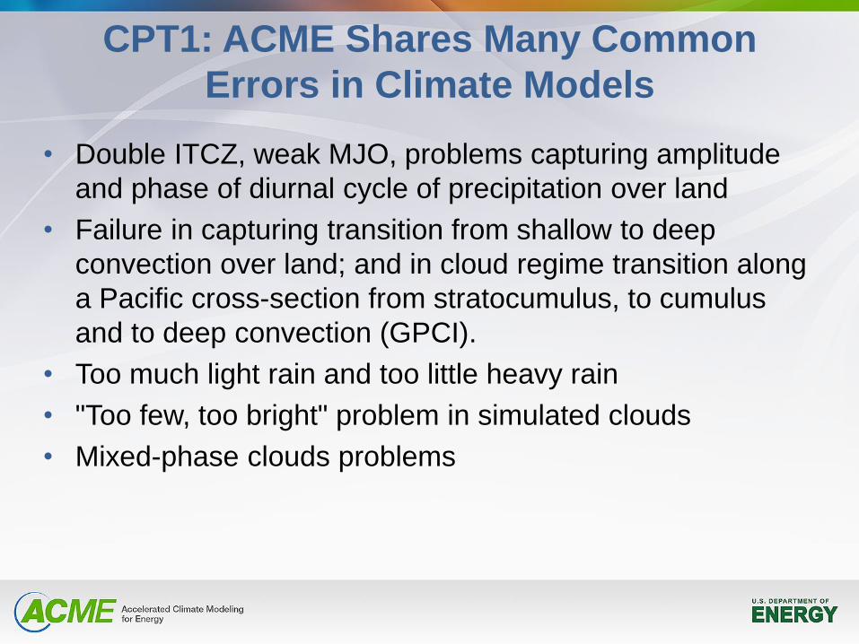
CPT1: ACME Shares Many Common
Errors in Climate Models
• Double ITCZ, weak MJO, problems capturing amplitude
and phase of diurnal cycle of precipitation over land
• Failure in capturing transition from shallow to deep
convection over land; and in cloud regime transition along
a Pacific cross-section from stratocumulus, to cumulus
and to deep convection (GPCI).
• Too much light rain and too little heavy rain
• "Too few, too bright" problem in simulated clouds
• Mixed-phase clouds problems
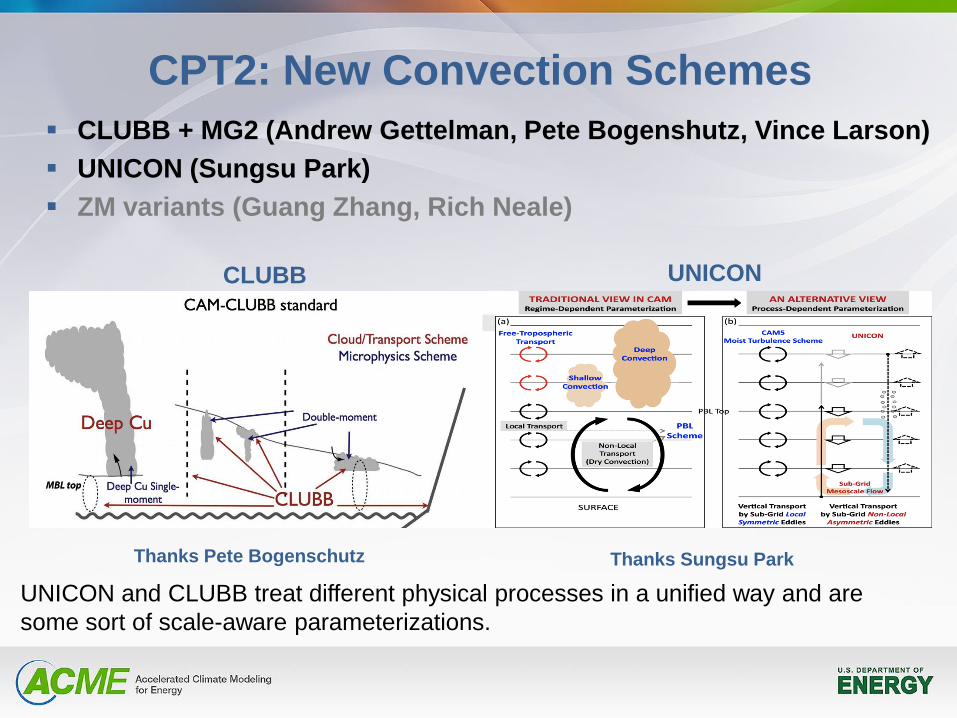
CPT2: New Convection Schemes
CLUBB + MG2 (Andrew Gettelman, Pete Bogenshutz, Vince Larson)
UNICON (Sungsu Park)
ZM variants (Guang Zhang, Rich Neale)
Thanks Pete Bogenschutz Thanks Sungsu Park
CLUBB UNICON
UNICON and CLUBB treat different physical processes in a unified way and are
some sort of scale-aware parameterizations.
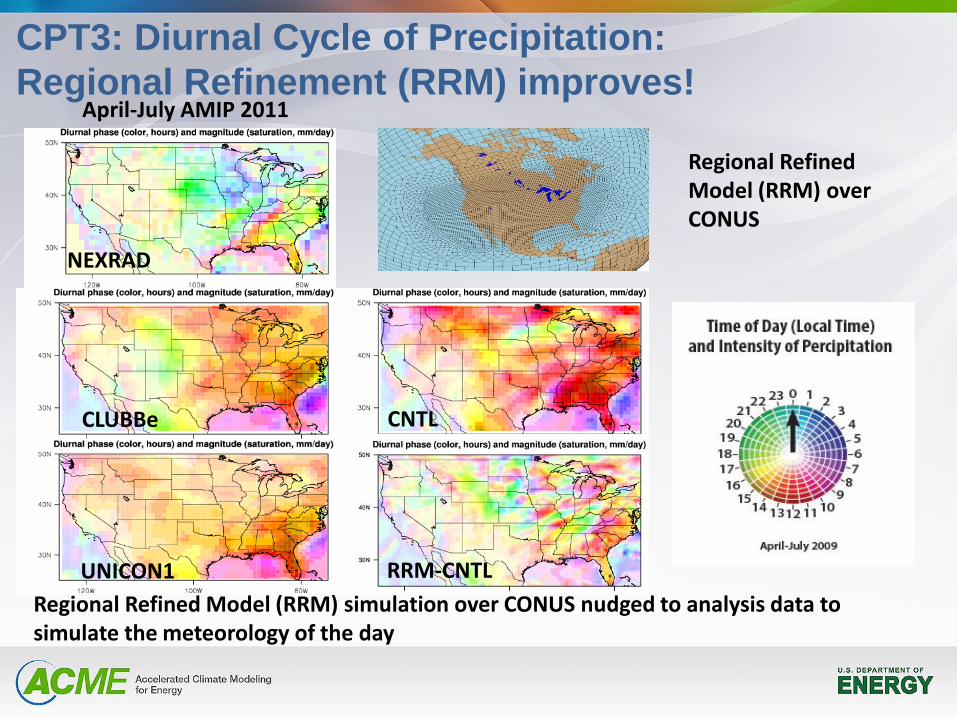
CPT3: Diurnal Cycle of Precipitation:
Regional Refinement (RRM) improves! April-July AMIP 2011
NEXRAD
CNTL
RRM-CNTL
Regional Refined Model (RRM) over CONUS
CLUBBe
UNICON1
Regional Refined Model (RRM) simulation over CONUS nudged to analysis data to simulate the meteorology of the day
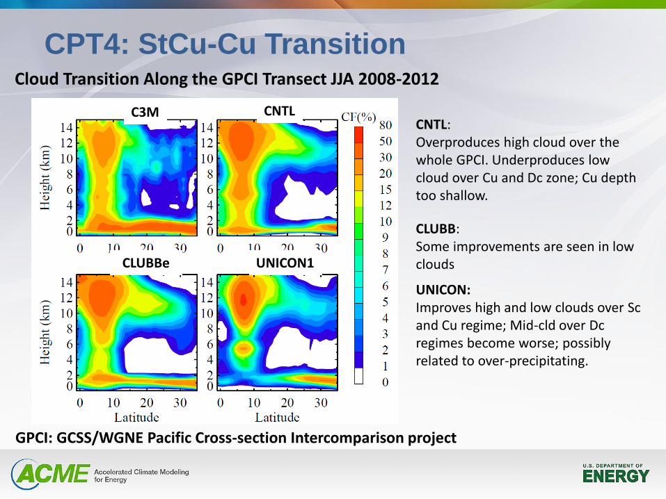
CPT4: StCu-Cu Transition Cloud Transition Along the GPCI Transect JJA 2008-2012
GPCI: GCSS/WGNE Pacific Cross-section Intercomparison project
CNTL: Overproduces high cloud over the whole GPCI. Underproduces low cloud over Cu and Dc zone; Cu depth too shallow.
CLUBB: Some improvements are seen in low clouds
UNICON: Improves high and low clouds over Sc and Cu regime; Mid-cld over Dc regimes become worse; possibly related to over-precipitating.
C3M CNTL
CLUBBe UNICON1
High Resolution: ne30L30 –> ne120L60+
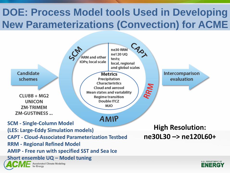
DOE: Process Model tools Used in Developing
New Parameterizations (Convection) for ACME
SCM - Single-Column Model (LES: Large-Eddy Simulation models) CAPT - Cloud-Associated Parameterization Testbed RRM - Regional Refined Model AMIP - Free run with specified SST and Sea Ice Short ensemble UQ – Model tuning
Ocean and Cryosphere
Developments
CPT ideas
DOE activity
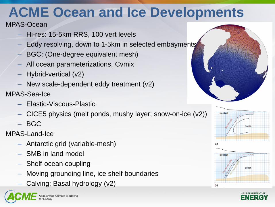
ACME Ocean and Ice Developments MPAS-Ocean
– Hi-res: 15-5km RRS, 100 vert levels
– Eddy resolving, down to 1-5km in selected embayments
– BGC: (One-degree equivalent mesh)
– All ocean parameterizations, Cvmix
– Hybrid-vertical (v2)
– New scale-dependent eddy treatment (v2)
MPAS-Sea-Ice
– Elastic-Viscous-Plastic
– CICE5 physics (melt ponds, mushy layer; snow-on-ice (v2))
– BGC
MPAS-Land-Ice
– Antarctic grid (variable-mesh)
– SMB in land model
– Shelf-ocean coupling
– Moving grounding line, ice shelf boundaries
– Calving; Basal hydrology (v2)
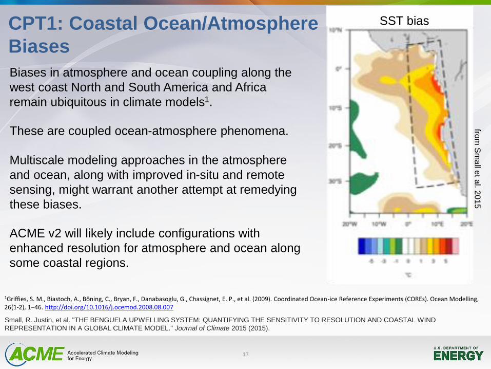
CPT1: Coastal Ocean/Atmosphere
Biases
17
Biases in atmosphere and ocean coupling along the
west coast North and South America and Africa
remain ubiquitous in climate models1.
These are coupled ocean-atmosphere phenomena.
Multiscale modeling approaches in the atmosphere
and ocean, along with improved in-situ and remote
sensing, might warrant another attempt at remedying
these biases.
ACME v2 will likely include configurations with
enhanced resolution for atmosphere and ocean along
some coastal regions.
1Griffies, S. M., Biastoch, A., Böning, C., Bryan, F., Danabasoglu, G., Chassignet, E. P., et al. (2009). Coordinated Ocean-ice Reference Experiments (COREs). Ocean Modelling, 26(1-2), 1–46. http://doi.org/10.1016/j.ocemod.2008.08.007
Small, R. Justin, et al. "THE BENGUELA UPWELLING SYSTEM: QUANTIFYING THE SENSITIVITY TO RESOLUTION AND COASTAL WIND
REPRESENTATION IN A GLOBAL CLIMATE MODEL." Journal of Climate 2015 (2015).
from
Sm
all e
t al. 2
01
5
SST bias
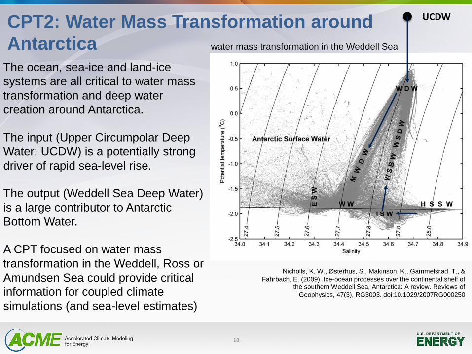
CPT2: Water Mass Transformation around
Antarctica The ocean, sea-ice and land-ice
systems are all critical to water mass
transformation and deep water
creation around Antarctica.
The input (Upper Circumpolar Deep
Water: UCDW) is a potentially strong
driver of rapid sea-level rise.
The output (Weddell Sea Deep Water)
is a large contributor to Antarctic
Bottom Water.
A CPT focused on water mass
transformation in the Weddell, Ross or
Amundsen Sea could provide critical
information for coupled climate
simulations (and sea-level estimates)
18
UCDW
Nicholls, K. W., Østerhus, S., Makinson, K., Gammelsrød, T., &
Fahrbach, E. (2009). Ice-ocean processes over the continental shelf of
the southern Weddell Sea, Antarctica: A review. Reviews of
Geophysics, 47(3), RG3003. doi:10.1029/2007RG000250
water mass transformation in the Weddell Sea
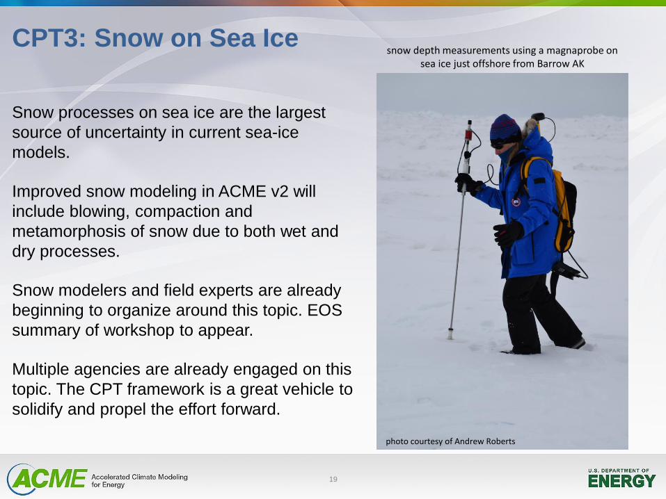
CPT3: Snow on Sea Ice
19
Snow processes on sea ice are the largest
source of uncertainty in current sea-ice
models.
Improved snow modeling in ACME v2 will
include blowing, compaction and
metamorphosis of snow due to both wet and
dry processes.
Snow modelers and field experts are already
beginning to organize around this topic. EOS
summary of workshop to appear.
Multiple agencies are already engaged on this
topic. The CPT framework is a great vehicle to
solidify and propel the effort forward.
snow depth measurements using a magnaprobe on sea ice just offshore from Barrow AK
photo courtesy of Andrew Roberts
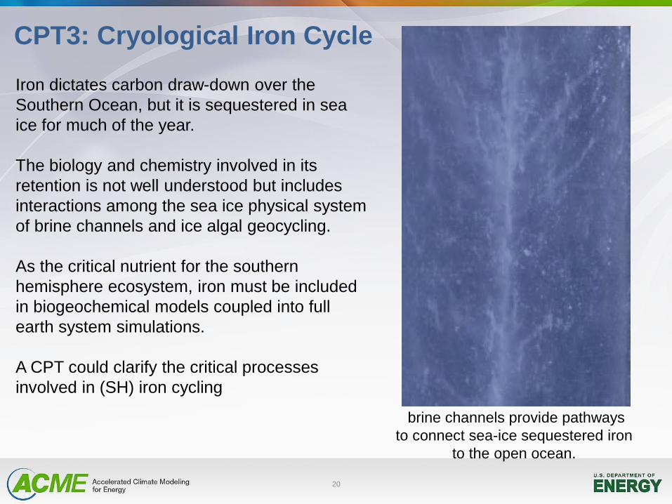
CPT3: Cryological Iron Cycle
20
Iron dictates carbon draw-down over the
Southern Ocean, but it is sequestered in sea
ice for much of the year.
The biology and chemistry involved in its
retention is not well understood but includes
interactions among the sea ice physical system
of brine channels and ice algal geocycling.
As the critical nutrient for the southern
hemisphere ecosystem, iron must be included
in biogeochemical models coupled into full
earth system simulations.
A CPT could clarify the critical processes
involved in (SH) iron cycling
brine channels provide pathways
to connect sea-ice sequestered iron
to the open ocean.
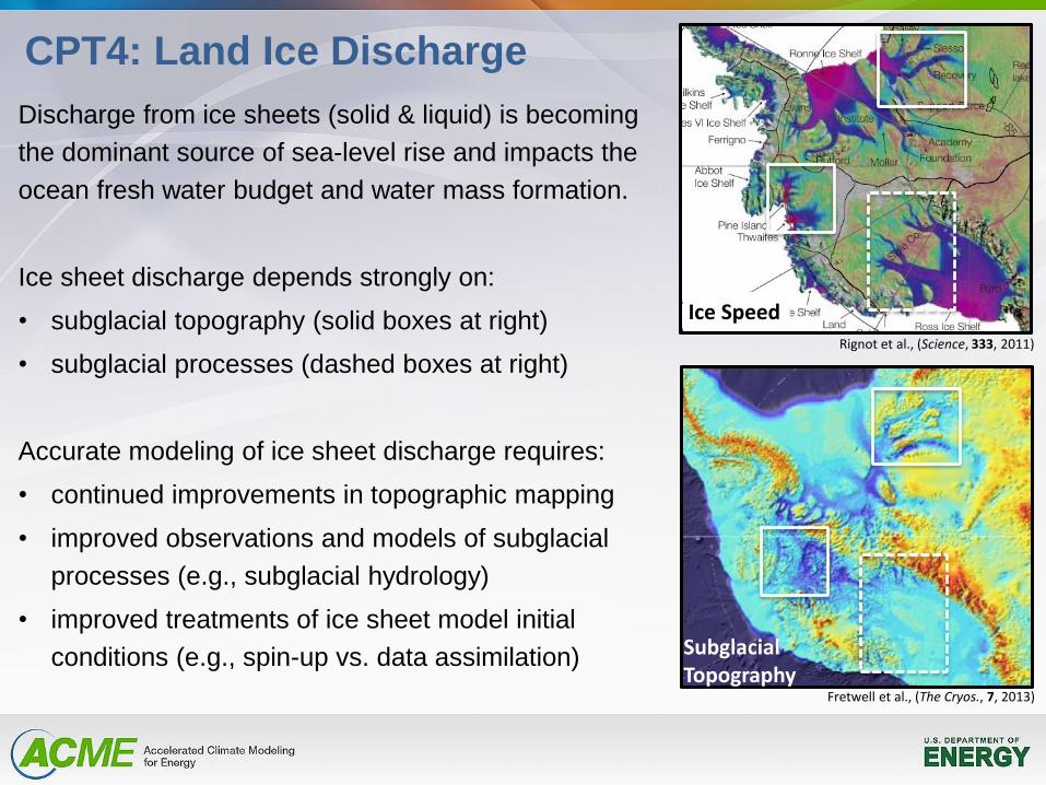
CPT4: Land Ice Discharge
Discharge from ice sheets (solid & liquid) is becoming
the dominant source of sea-level rise and impacts the
ocean fresh water budget and water mass formation.
Ice sheet discharge depends strongly on:
• subglacial topography (solid boxes at right)
• subglacial processes (dashed boxes at right)
Accurate modeling of ice sheet discharge requires:
• continued improvements in topographic mapping
• improved observations and models of subglacial
processes (e.g., subglacial hydrology)
• improved treatments of ice sheet model initial
conditions (e.g., spin-up vs. data assimilation)
Rignot et al., (Science, 333, 2011)
Fretwell et al., (The Cryos., 7, 2013)
Ice Speed
Subglacial Topography
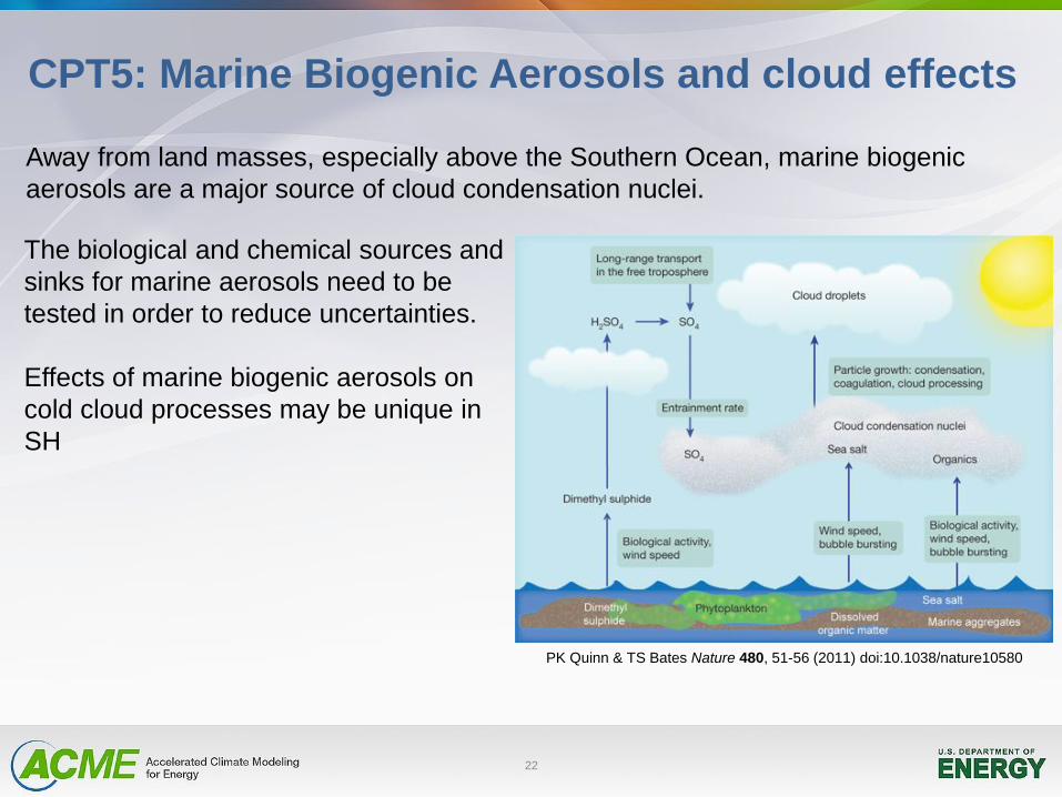
CPT5: Marine Biogenic Aerosols and cloud effects
22
The biological and chemical sources and
sinks for marine aerosols need to be
tested in order to reduce uncertainties.
Effects of marine biogenic aerosols on
cold cloud processes may be unique in
SH
Away from land masses, especially above the Southern Ocean, marine biogenic
aerosols are a major source of cloud condensation nuclei.
PK Quinn & TS Bates Nature 480, 51-56 (2011) doi:10.1038/nature10580
23
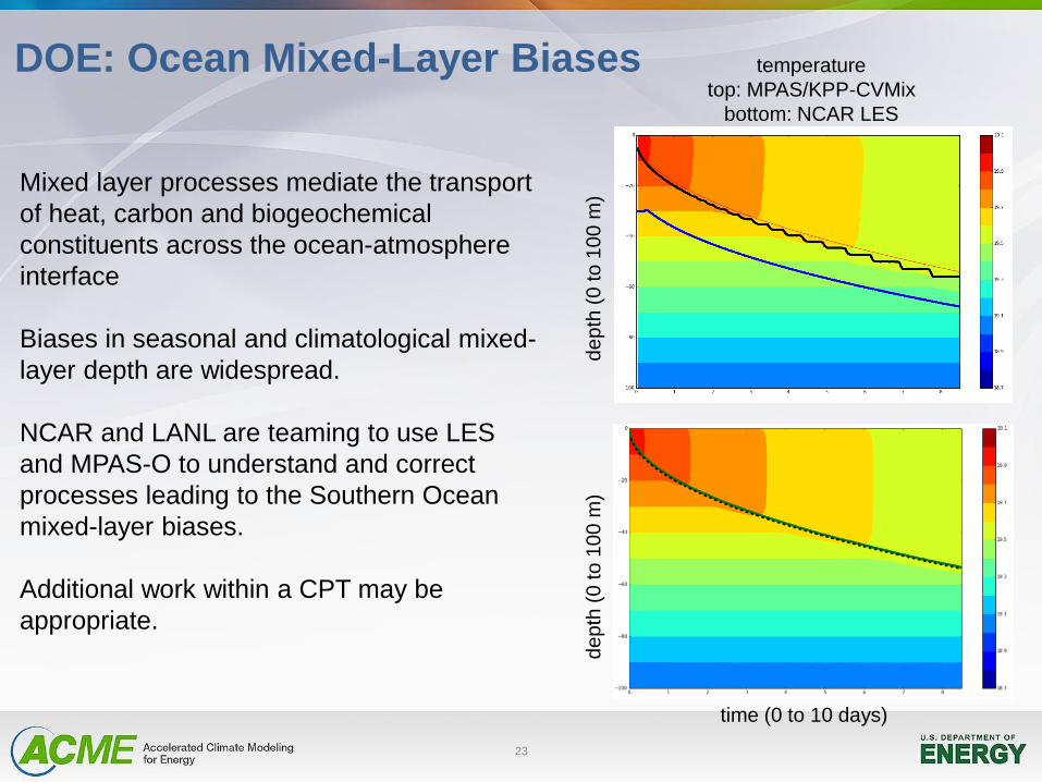
DOE: Ocean Mixed-Layer Biases
Mixed layer processes mediate the transport
of heat, carbon and biogeochemical
constituents across the ocean-atmosphere
interface
Biases in seasonal and climatological mixed-
layer depth are widespread.
NCAR and LANL are teaming to use LES
and MPAS-O to understand and correct
processes leading to the Southern Ocean
mixed-layer biases.
Additional work within a CPT may be
appropriate.
time (0 to 10 days)
de
pth
(0
to
10
0 m
)
de
pth
(0
to
10
0 m
)
temperature
top: MPAS/KPP-CVMix
bottom: NCAR LES
Land
Developments
CPT ideas
DOE activities
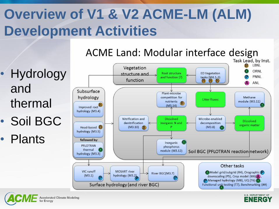
Overview of V1 & V2 ACME-LM (ALM)
Development Activities
• Hydrology
and
thermal
• Soil BGC
• Plants
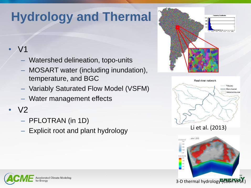
Hydrology and Thermal
• V1
– Watershed delineation, topo-units
– MOSART water (including inundation),
temperature, and BGC
– Variably Saturated Flow Model (VSFM)
– Water management effects
• V2
– PFLOTRAN (in 1D)
– Explicit root and plant hydrology
3-D thermal hydrology (Coon et al.)
Li et al. (2013)
CLM-PFLOTRAN (Yuan et al.)
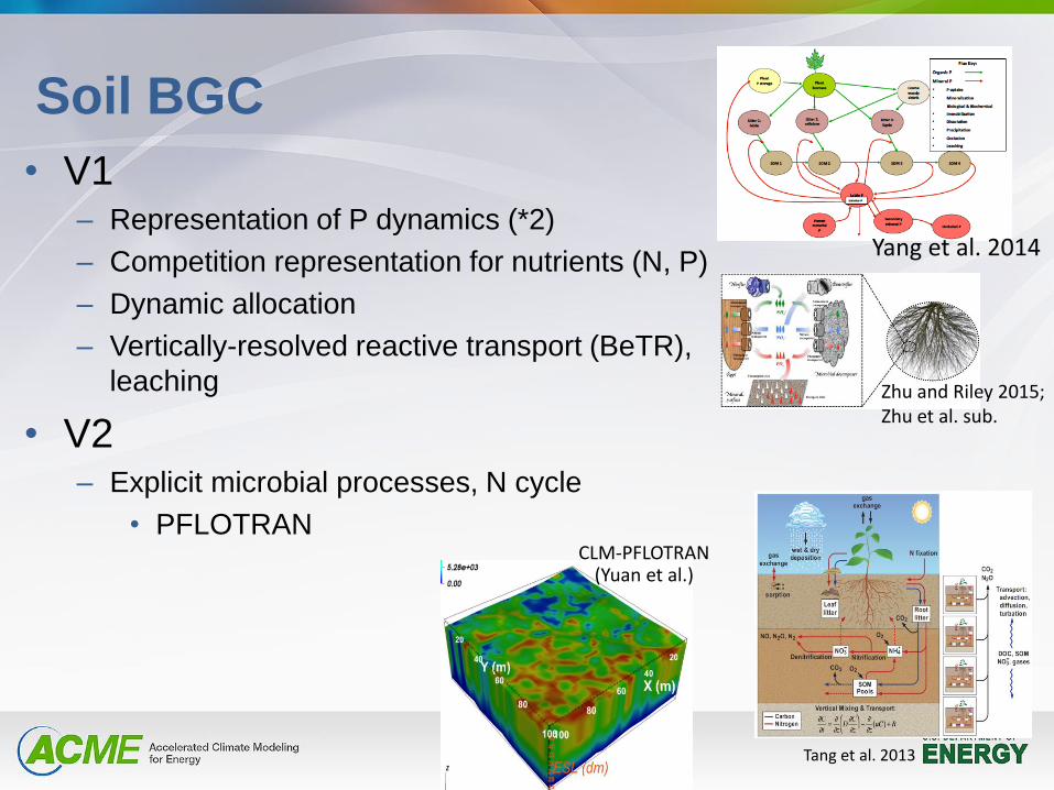
Soil BGC
• V1 – Representation of P dynamics (*2)
– Competition representation for nutrients (N, P)
– Dynamic allocation
– Vertically-resolved reactive transport (BeTR),
leaching
• V2 – Explicit microbial processes, N cycle
• PFLOTRAN
Zhu and Riley 2015; Zhu et al. sub.
Tang et al. 2013
Yang et al. 2014
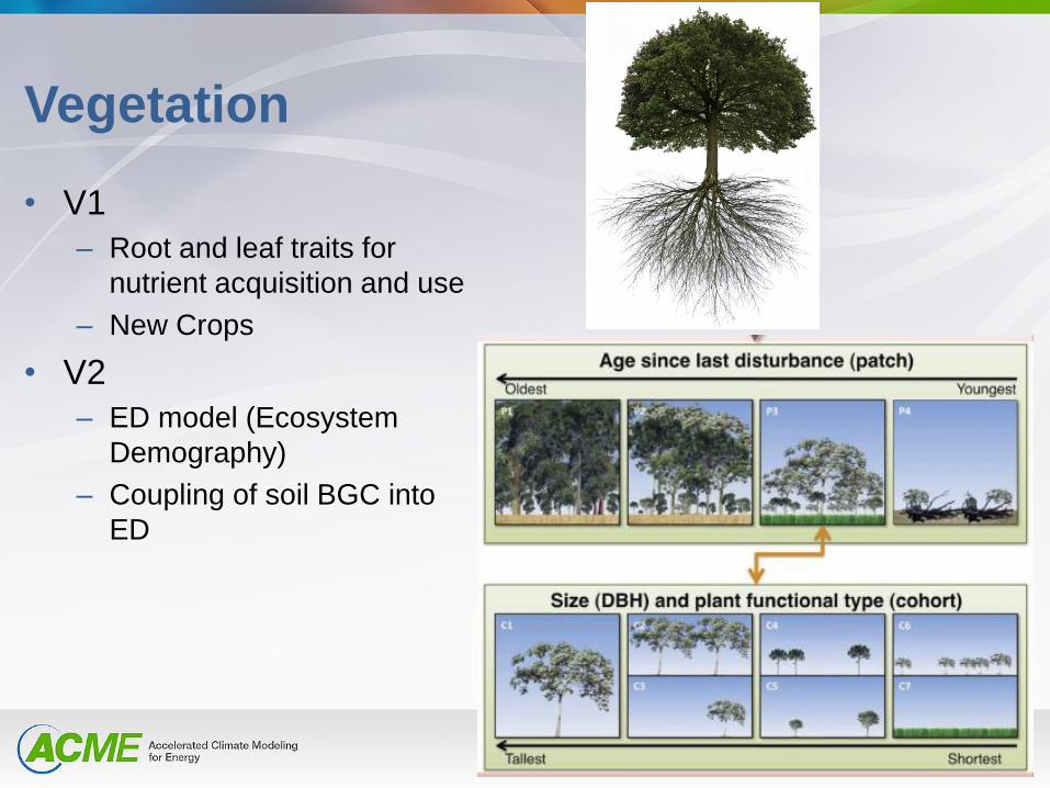
Vegetation
• V1
– Root and leaf traits for
nutrient acquisition and use
– New Crops
• V2
– ED model (Ecosystem
Demography)
– Coupling of soil BGC into
ED
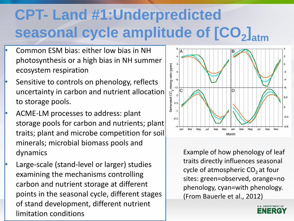
CPT- Land #1:Underpredicted
seasonal cycle amplitude of [CO2]atm • Common ESM bias: either low bias in NH
photosynthesis or a high bias in NH summer ecosystem respiration
• Sensitive to controls on phenology, reflects uncertainty in carbon and nutrient allocation to storage pools.
• ACME-LM processes to address: plant storage pools for carbon and nutrients; plant traits; plant and microbe competition for soil minerals; microbial biomass pools and dynamics
• Large-scale (stand-level or larger) studies examining the mechanisms controlling carbon and nutrient storage at different points in the seasonal cycle, different stages of stand development, different nutrient limitation conditions
Example of how phenology of leaf traits directly influences seasonal cycle of atmospheric CO2 at four sites: green=observed, orange=no phenology, cyan=with phenology. (From Bauerle et al., 2012)
CPT-Land #2 – Terrestrial-aquatic
interfaces
Estuaries and coastal hydrology and biogeochemistry
– Motivation
• Large carbon, N, and P fluxes from terrestrial systems to coastal
margins, affect ocean BGC and net GHG exchanges
– New and planned ACME work
• MOSART river hydrology (Li et al. 2013) and BGC
• Land leaching improvements (Riley and Zhu 2015), integration of
BeTR reactive transport to resolve fluxes into river (Tang et al.
2013; Tang et al. in prep)
• Coupling MOSART biogeochemistry with BeTR land fluxes
– CPT on coastal margin BGC processes
CPT-Land #3: Agriculture modeling
Motivation
• Large N2O and leaching sources, water use, soil C storage and net GHG
exchanges, biofuels
New and planned ACME work
• Improvements to the crop model (Drewniak at ANL)
• BeTR reactive transport for leaching and vertically-resolved soil C
transformations (Tang et al. 2013; Tang et al. in prep)
• Improvements to N and P cycling (Zhu and Riley 2015; Zhu et al. 2015;
Zhu and Riley submitted; Yang et al.)
CPT to test
• Multi-nutrient, multi-consumer competition
• More crops and phenotypes
• Field-scale heterogeneity, connections to groundwater and rivers
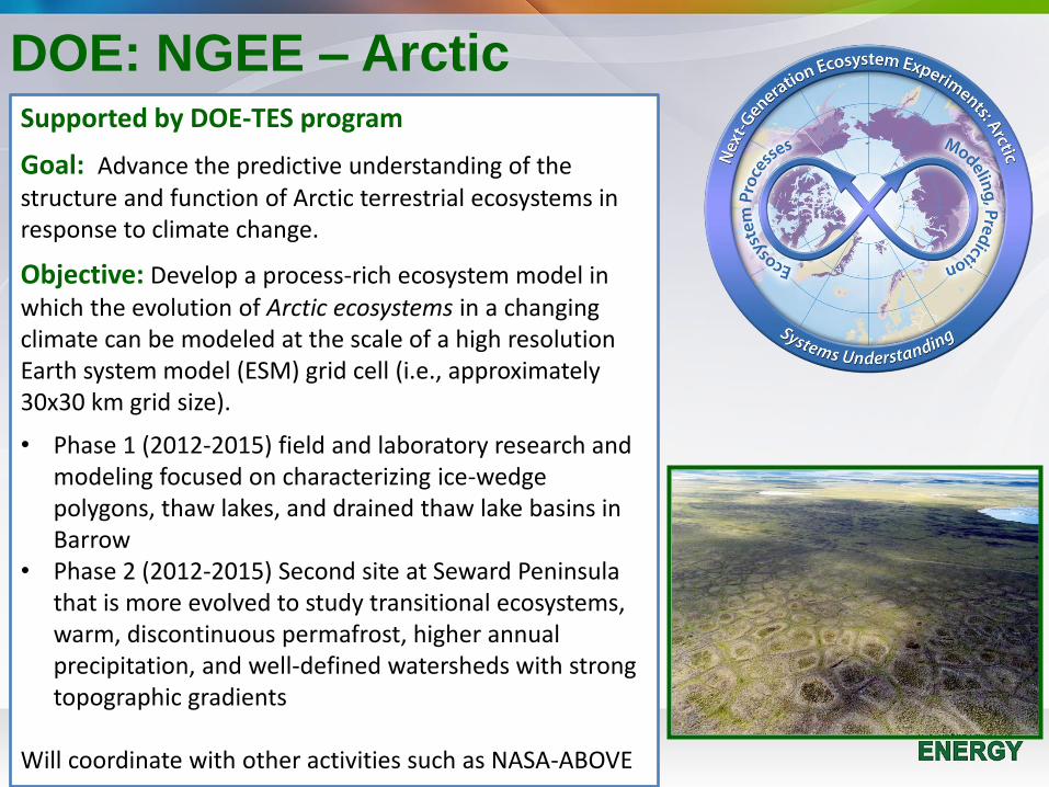
DOE: NGEE – Arctic Supported by DOE-TES program
Goal: Advance the predictive understanding of the structure and function of Arctic terrestrial ecosystems in response to climate change.
Objective: Develop a process-rich ecosystem model in which the evolution of Arctic ecosystems in a changing climate can be modeled at the scale of a high resolution Earth system model (ESM) grid cell (i.e., approximately 30x30 km grid size).
• Phase 1 (2012-2015) field and laboratory research and modeling focused on characterizing ice-wedge polygons, thaw lakes, and drained thaw lake basins in Barrow
• Phase 2 (2012-2015) Second site at Seward Peninsula that is more evolved to study transitional ecosystems, warm, discontinuous permafrost, higher annual precipitation, and well-defined watersheds with strong topographic gradients
Will coordinate with other activities such as NASA-ABOVE
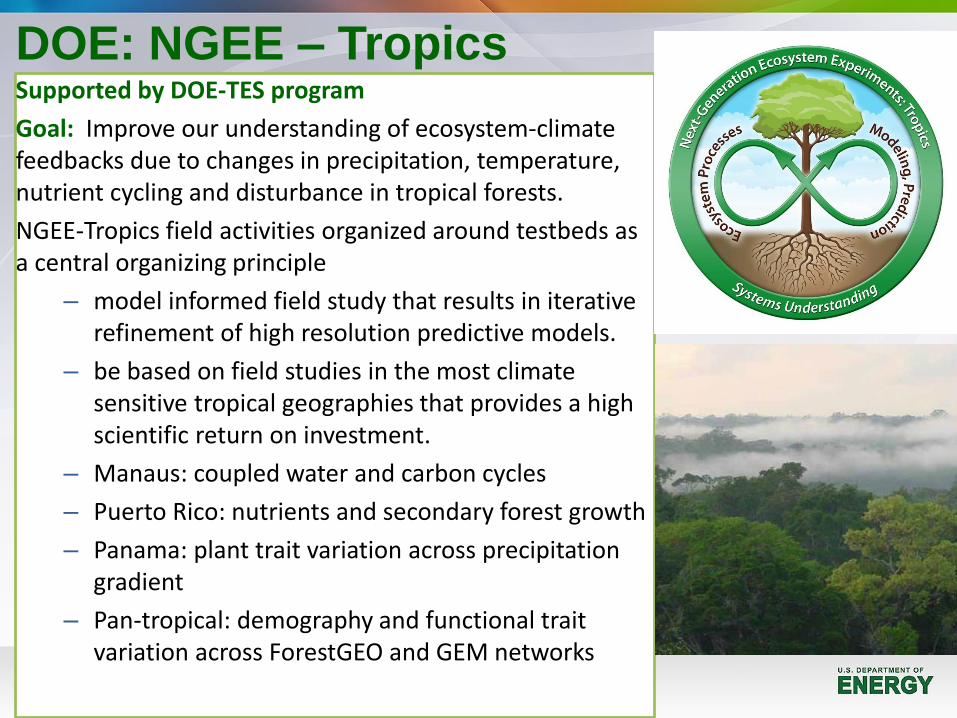
DOE: NGEE – Tropics Supported by DOE-TES program
Goal: Improve our understanding of ecosystem-climate feedbacks due to changes in precipitation, temperature, nutrient cycling and disturbance in tropical forests.
NGEE-Tropics field activities organized around testbeds as a central organizing principle
– model informed field study that results in iterative refinement of high resolution predictive models.
– be based on field studies in the most climate sensitive tropical geographies that provides a high scientific return on investment.
– Manaus: coupled water and carbon cycles
– Puerto Rico: nutrients and secondary forest growth
– Panama: plant trait variation across precipitation gradient
– Pan-tropical: demography and functional trait variation across ForestGEO and GEM networks
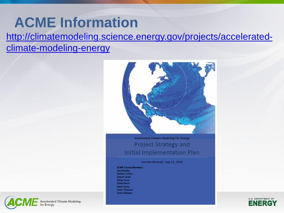
ACME Information http://climatemodeling.science.energy.gov/projects/accelerated-
climate-modeling-energy