Embed Size (px)
Citation preview

Access Control in Location-Based Services
C.A. Ardagna, M. Cremonini, S. De Capitani di Vimercati, P. Samarati
Dipartimento di Tecnologie dell’InformazioneUniversita degli Studi di MilanoVia Bramante, 65 - Crema, Italy
{claudio.ardagna,marco.cremonini,sabrina.decapitani,pierangela.samarati}@unimi.it
Abstract. Recent enhancements in location technologies reliability andprecision are fostering the development of a new wave of applications thatmake use of the location information of users. Such applications intro-duces new aspects of access control which should be addressed. On theone side, precise location information may play an important role and canbe used to develop Location-based Access Control (LBAC) systems thatintegrate traditional access control mechanisms with conditions based onthe physical position of users. On the other side, location information ofusers can be considered sensitive and access control solutions should bedeveloped to protect it against unauthorized accesses and disclosures. Inthis chapter, we address these two aspects related to the use and protec-tion of location information, discussing existing solutions, open issues,and some research directions.
1 Introduction
In the last decade, the diffusion and reliability achieved by mobile tech-nologies have revolutionized the way users interact with the externalworld. Today, most people always carry a mobile device and can stay on-line and connected from everywhere. Location information is then avail-able as a new class of users’ information that can be exploited to de-velop innovative and valuable services (e.g., customer-oriented applica-tions, social networks, and monitoring services). Several commercial andenterprise-oriented location-based services are already available and havegained popularity [1]. These services can be partitioned in different cat-egories [2]. For instance, there are services that provide information onthe position of the users or on the environment surrounding the locationof a user (e.g., point of interest, traffic alerts), or services which can helpin protecting human lives or highly sensitive information/resources. Asan example, the enhanced 911 in North America [3] can exploit locationinformation of users to immediately dispatch emergency services (e.g.,emergency medical services, police, or firefighters) where they are needed,reducing the margin of error. In an environment offering location-based

2
services (LBSs), users send a request for using such services to a LBSprovider. The provider collects the user personal information, possiblyinteracting with a location server (LS), to decide whether the service canbe granted and how it can be possibly personalized. The location serverworks as the positioning system that measures the location informationof users carrying mobile devices, and provides such information at differ-ent levels of granularity and with different Quality of Service (QoS). Thetypes of location requests that a Location Server can satisfy depend onthe specific mobile technology, the methods applied for measuring usersposition, and the environmental conditions.
Among the different issues that need to be addressed in the devel-opment of location-based services, access control is becoming increas-ingly important. Access control represents a key aspect to the success oflocation-based services, and can be radically changed by the availabil-ity of location information, which includes position and mobility of theusers. In this chapter, access control issues are analyzed from two differ-ent perspectives: 1) we analyze how current access control systems canintegrate and exploit location information in evaluating and enforcing ac-cess requests, thus introducing Location-Based Access Control (LBAC)systems; 2) we analyze how access control mechanisms should change forevaluating and enforcing access to location information, which might behighly sensitive.
In the first case, precise and accurate location information is used toenhance and strengthen access control systems by adding functionalitiesfor defining, evaluating, and enforcing location-based policies, i.e., accesscontrol restrictions based on the position of the users. LBAC extends ac-cess control to the consideration of contextual location information, inparticular the location of the user requesting access. Obtaining reliableand accurate location information with software applications reachablevia a telecommunication infrastructure (e.g., wireless network) is a chal-lenging aspect due to the intrinsic error of location measurements. Animportant requirement is then to provide a way to perform location ver-ification, meaning that the location of a user has to be securely verifiedto meet certain criteria (e.g., being inside a specific room or within ageographical area). A stable and reliable verification mechanism can rep-resent an important driver towards the development of a location-basedaccess control system. Once a user’s location has been verified using aprotocol for location verification, the user can be granted access to a par-ticular resource according to the desired policy. The location verificationprocess must be able to tolerate rapid context changes, since mobile users,

3
involved in transactions by means of their mobile devices, can wanderfreely and change their position in the network.
In the second case, location-based information is considered sensitiveand therefore needs to be protected against unregulated access anddisclosure. The unauthorized release of location information can resultin several privacy breaches (e.g., [4]), and make the users target offraudulent attacks [5] such as unsolicited advertising , when productsand services are advertised by exploiting the user position without herconsent; physical attacks or harassment , when the location of a user isused to carry physical assaults; and users profiling , when the locationof a user is used to infer other sensitive information. This scenarioposes a new set of requirements that need to be accomplished by accesscontrol systems for protecting location information. For instance, accesscontrol may be enriched with mechanisms that obfuscate the locationinformation before its release to other parties [6, 7]. Also, access controlsystems should be able to manage time-variant information, sincelocation of users can change over time.
The remainder of this chapter is organized as follows. Section 2 de-scribes the basic concepts of access control languages. Section 3 intro-duces the concept of location-based access control and describes somesolutions implementing LBAC. Section 4 provides an overview of exist-ing approaches to protect and manage access and disclosure of locationinformation. Section 5 presents open problems and future work. Finally,Section 6 gives our conclusions.
2 Access Control Languages
Access control systems are based on policies that define authorizationsconcerning access to data/services. Authorizations establish who can(positive authorizations), or cannot (negative authorizations), executewhich actions on which resources [8]. Recent advancements allow thespecifications of policies with reference to generic attributes/properties ofthe parties (e.g., name, citizenship, occupation) and the resources (e.g.,owner, creation date) involved [9–11]. A common assumption is that theseproperties characterizing users and resources are stored in profiles thatdefine the name and the value of the properties. Users may also supportrequests for certified data (i.e., credentials), issued and signed by au-thorities trusted for making statements on the properties, and uncertifieddata, signed by the owner itself. For instance, an authorization can state
4
that “a user of age greater than 18 and with a valid credit card number(requester) can read (action) a specific set of data (resource)”. When anaccess request is submitted to the access control system, it is evaluatedagainst the authorizations applicable to it.
From a modeling point of view, each authorization can be seen as atriple of the form 〈subject , object , actions〉, whose elements are genericboolean formulas over the subject requesting access, the object to whichaccess is requested, and the actions the subject wants to perform onthe object. The subject is an expression that allows referring to a setof subjects satisfying certain conditions, where conditions can evaluatethe user’s profile/properties, or the user’s membership in groups, activeroles, and so on. The object is an expression that allows referring to aset of objects satisfying certain conditions, where conditions evaluatemembership of the object in categories, values of properties on metadata,and so on. The conditions specified in the policies can be built overgeneric predicates that can evaluate the information stored at the siteor can evaluate state-based information (e.g., the role adopted insidean application, the number of access to a given object, time/daterestrictions). For instance, an authorization stating that “professors withage greater than 35 can read critical documents created before the 2008”can be expressed as:
– subject: equal(job,Professor) ∧ greater than(age,35 )
– object: equal(level,critical) ∧ less than(creation,2008/01/01 )
– actions: read
where we assume that equal, greater than, less than are pre-defined predicates used to evaluate information stored in the user and/orobject profiles, and whose semantic is self-explanatory. Access controlpolicies can then be implemented by using different languages, like logic-based languages (e.g., [12]), which are expressive and characterized by aformal foundation, or XML-based languages (e.g., [9, 11]), which are moresuited to the Internet context.
In the next section, we discuss how access control policies based onboolean formula of conditions can be enriched by adding location-basedconditions, which are expressed using ad-hoc location predicates. In thediscussion, we do not make any assumption about the specific languageused for implementing the policies and we refer to the abstract model justdescribed.

5
3 Location-based Access Control Systems
The diffusion and reliability reached by mobile technologies provide ameans to use location information for improving access control systemsin a novel way. Although, research on LBAC is a recent topic, the notionof LBAC is in itself not new. Some early mobile networking protocolsalready relied on linking the physical position of a terminal device withits capability of accessing network resources [13]. Extensive adoption ofwireless local networks has triggered new interests in this topic. Somestudies focused on location-based information for monitoring users move-ments on Wireless Lan [14] and 802.11 Networks [15]. Myllymaki andEdlund [16] describe a methodology for aggregating location data frommultiple sources to improve location tracking features. Other researchershave investigated a line closer to LBAC by describing the architectureand operation of an access server module for access control in wirelesslocal networks [1, 17, 18]. Controlling access to wireless networks, comply-ing with IEEE 802.11 family protocols, is principally aimed at strength-ening the well-known security weaknesses of wireless network protocolrather than at defining a general, protocol-independent model for LBAC.The need for a protocol-independent location technique has been high-lighted by a study exploiting heterogeneous positioning sources like GPS,Bluetooth, and WaveLAN for designing location-aware applications [18].Cho et al. [17] present a location-based protocol (Location-Based networkAccess Control) for authentication and authorization, in infrastructure-based WLAN systems based on IEEE 802.11. The protocol is used tosecurely authenticate the location claims released by wireless users, andexchange the keys shared for data encryption. The infrastructure is com-posed of three parties: the key server responsible for authentication, lo-cation claim verification, and key distribution, the access points, and themobile stations. The solution is based on the fact that a mobile stationis in a given location if and only if it receives all the relevant informationfrom the corresponding access points. The protocol uses a Diffie-Helmannalgorithm to authenticate location claims, authorize network access, andgenerate the shared keys for communications between mobile stations andaccess points. Location-based information and its management have beenalso the subject of a study by Varshney [1] in the area of mobile commerceapplications. This is a related research area that has strong connectionwith location systems and is a promising source of requirements for LBACmodels.

6
Other papers consider location information as a means for improvingsecurity. Sastry et al. [19] exploit location-based access control in sensornetworks. Zhang and Parashar [20] propose a location-aware extension toRole-Based Access Control (RBAC) suitable for grid-based distributedapplications. Atallah et al. [21] study the problem of key managementand derivation in the context of geospatial access control. In this work,a geographical space is modeled as a grid of m × n cells and policies areused to define whether users can access a given rectangular spatial areacomposed of one or more cells. Each cell is associated with a key andcontains information of interests for the users. When a user gains accessto an area, a set of keys is derived. Each key enables the user to accessa different cell in the area together with its information. Here, a userlocation is treated as a single point without explicitly considering the in-trinsic uncertainty of location measurements. Atluri et al. [22] considerthe problem of providing an efficient security policy enforcement for mo-bile environments. The authors briefly introduce an authorization modelbased on moving entities and spatio-temporal attributes, and considerthree types of authorizations: i) on moving subjects and static objects,ii) on static subjects and moving objects, and iii) on moving subjects andmoving objects. The paper concentrates on the enforcement of such au-thorizations by providing data structures suitable for the management ofmoving entities, and spatio-temporal authorizations. The paper presentsan index structure called SPPF that maintains past, present, and futurelocations of moving entities together with authorizations, using a par-tial persistent storage. An evaluation approach is then described whereauthorizations are compared with nodes modeling moving entities, byanalyzing the spatio-temporal extents of both authorizations and movingentities. This solution allows efficient evaluation of access requests thatalso include locate and track privileges.
While all these approaches have made significant steps in the develop-ment of models and systems supporting location-based information, thedefinition of a LBAC model that takes into consideration the special na-ture of location information is still an emerging research issue that hasnot been yet fully addressed by the security and access control researchcommunity. Only few works provides solutions for defining and evaluatinglocation-based policies. In the following, we first describe a solution pro-viding a LBAC infrastructure [23] (Section 3.1) and then an extension toXACML [11] for the definition of geospatial predicates [24] (Section 3.2).

7
Fig. 1. LBAC architecture
3.1 An Access Control System for LBAC Policies
Ardagna et al. [23] define a LBAC system that supports location-basedpolicies. Intuitively, a location-based policy exploits the physical loca-tion of users to define when they can access a service or a resource. Theauthors identify three main steps towards the development of a LBACsystem: i) the design of a reference LBAC architecture that can supportthe evaluation and enforcement of location-based policies; ii) the defini-tion of location-based conditions; and iii) the definition of a mechanismfor the evaluation and enforcement of location-based conditions.
3.1.1 LBAC Architecture
LBAC definition changes the conventional access control architecture,since there are more parties involved. Figure 1 presents a LBAC archi-tecture that involves four logical components.
User. The entity whose access request to a location server must be au-thorized by a LBAC system. Users carry terminals enabling authen-tication and some form of location verification.
Business application. Customer-oriented application that offers ser-vices whose release is regulated by location-based policies.
Access Control Engine (ACE). The entity that is responsible forevaluating access requests according to some location-based policies.The ACE communicates with one or more Location Providers for ac-quiring location information. The ACE does not have direct access to
8
the location information; rather, it sends requests to external servicesand waits for the corresponding answers.
Location Providers (LPs). The trusted entities that provide the lo-cation information (e.g., context data about location and timing,location-based predicate evaluation) by implementing Location Serverinterfaces.
Interactions among the User, the Business Application, the AccessControl Engine, and the Location Providers are carried out via re-quest/response messages (see Figure 1). The process is initiated by auser that submits an access request to a Business Application (step 1).A negotiation process between the two parties is then used to exchangethose data that are relevant to the policy evaluation (step 2). The requestis further forwarded to the ACE (step 3) that interacts (if needed) withthe Location Providers (steps 4-7), evaluates policies (step 8), and returnsan access decision (steps 9-10). Communications between the ACE andthe Location Providers may be driven by a service level agreement (SLA)negotiation phase (step 5). This negotiation is used to agree upon and setquality of services attributes and the corresponding service cost.
3.1.2 Location-Based Conditions
The location-based conditions that might be useful to include in accesscontrol policies and whose evaluation is possible with today’s technologiesfall within three main categories:
– position-based conditions on the location of the users (e.g., to evaluatewhether users are in a certain building or city, or in the proximity ofother entities);
– movement-based conditions on the mobility of the users (e.g., velocity,acceleration, or direction where users are headed);
– interaction-based conditions involving relationships among multipleusers or entities (e.g., the number of users within a given area).
Table 1 presents some specific predicates corresponding to the condi-tions of the kind identified by the classes above. In particular, predicatesinarea, disjoint, and distance are of type position and evaluate the locationof the users; velocity is of type movement and evaluates the mobility of theusers; density and local density are of type interaction and evaluate spatialrelationships between entities. Other predicates can be added as the needarises and technology progresses. Conditions are expressed as boolean

9
Table 1. Examples of location-based predicates
Type Predicate Description
Position inarea(user, area) Evaluate whether user is located within area.disjoint(user , area) Evaluate whether user is outside area.distance(user , entity ,min dist , max dist)
Evaluate whether distance between user andentity is within interval [min dist , max dist ].
Movement velocity(user , min vel ,max vel)
Evaluate whether user ’s speed falls withinrange [min vel , max vel ].
Interactiondensity(area, min num,max num)
Evaluate whether the number of users cur-rently in area falls within interval [min num,max num].
local density(user , area,min num, max num)
Evaluate the density within a ‘relative’ areasurrounding user .
queries of the form predicate(parameters,value), stating whether predi-cate over parameters has the specified value. The evaluation of a booleanquery returns a triple [bool value,confidence,timeout ] stating whether thepredicate is true or false (bool value), the time validity associated withthe assessment (timeout), and a confidence value expressing the relia-bility associated with the assessment. This confidence may depend ondifferent aspects such as the accuracy, environmental and weather condi-tions, granularity of the requested location, and measurement technique.
The language for location-based predicates assumes that each user,who is unknown to the location server responsible for location measure-ments, is univocally identified via a user identifier (UID). For instance,a typical UID for location-based applications is the SIM number linkingthe user’s identity to a mobile terminal. A unique identifier is also as-sociated with each object, and any physical and/or moving entity thatmay need to be located (e.g., a vehicle with an on-board GPRS card).Moreover, to simplify the specification of location-based conditions, a setof map regions identified either via a geometric model (i.e., a range in a n-dimensional coordinate space) or a symbolic model (i.e., with reference toentities of the real world such as streets, cities, or buildings) are assumedto be predefined in the system [25]. For instance, let alice be a useridentifier, and Manhattan NY and University Campus Secretary be twomap regions. Predicate inarea(alice,Manhattan NY) requests alice to belocated in Manhattan NY; predicate velocity(alice,0,10) requests aliceto be (semi-)static (speed included in [0,10]).
10
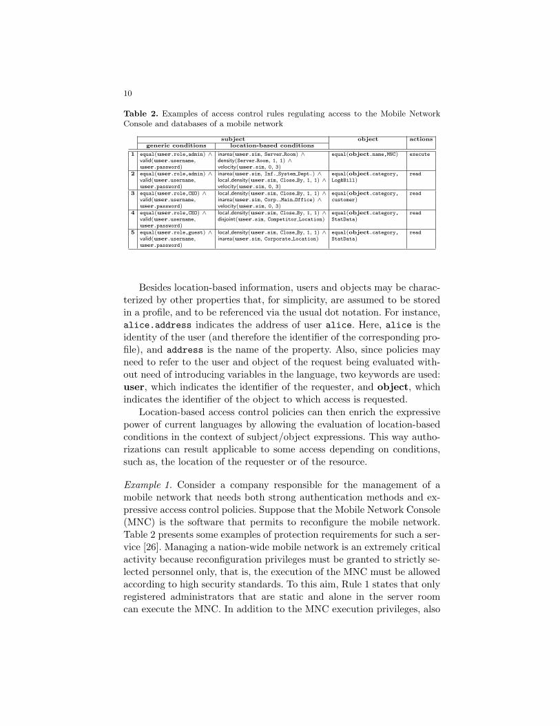
Table 2. Examples of access control rules regulating access to the Mobile NetworkConsole and databases of a mobile network
subject object actionsgeneric conditions location-based conditions
1 equal(user.role,admin) ∧ inarea(user.sim, Server Room) ∧ equal(object.name,MNC) execute
valid(user.username, density(Server Room, 1, 1) ∧user.password) velocity(user.sim, 0, 3)
2 equal(user.role,admin) ∧ inarea(user.sim, Inf. System Dept.) ∧ equal(object.category, read
valid(user.username, local density(user.sim, Close By, 1, 1) ∧ Log&Bill)user.password) velocity(user.sim, 0, 3)
3 equal(user.role,CEO) ∧ local density(user.sim, Close By, 1, 1) ∧ equal(object.category, read
valid(user.username, inarea(user.sim, Corp. Main Office) ∧ customer)user.password) velocity(user.sim, 0, 3)
4 equal(user.role,CEO) ∧ local density(user.sim, Close By, 1, 1) ∧ equal(object.category, read
valid(user.username,user.password)
disjoint(user.sim, Competitor Location) StatData)
5 equal(user.role,guest) ∧ local density(user.sim, Close By, 1, 1) ∧ equal(object.category, read
valid(user.username,user.password)
inarea(user.sim, Corporate Location) StatData)
Besides location-based information, users and objects may be charac-terized by other properties that, for simplicity, are assumed to be storedin a profile, and to be referenced via the usual dot notation. For instance,alice.address indicates the address of user alice. Here, alice is theidentity of the user (and therefore the identifier of the corresponding pro-file), and address is the name of the property. Also, since policies mayneed to refer to the user and object of the request being evaluated with-out need of introducing variables in the language, two keywords are used:user, which indicates the identifier of the requester, and object, whichindicates the identifier of the object to which access is requested.
Location-based access control policies can then enrich the expressivepower of current languages by allowing the evaluation of location-basedconditions in the context of subject/object expressions. This way autho-rizations can result applicable to some access depending on conditions,such as, the location of the requester or of the resource.
Example 1. Consider a company responsible for the management of amobile network that needs both strong authentication methods and ex-pressive access control policies. Suppose that the Mobile Network Console(MNC) is the software that permits to reconfigure the mobile network.Table 2 presents some examples of protection requirements for such a ser-vice [26]. Managing a nation-wide mobile network is an extremely criticalactivity because reconfiguration privileges must be granted to strictly se-lected personnel only, that is, the execution of the MNC must be allowedaccording to high security standards. To this aim, Rule 1 states that onlyregistered administrators that are static and alone in the server roomcan execute the MNC. In addition to the MNC execution privileges, also

11
the access to mobile network’s databases must be managed carefully andaccording to different security standards, depending on the level of riskof the data to be accessed. Access to logging and billing data is critical,because they include information about the position and movements ofmobile operator’s customers. Rule 2 is then defined and permits registeredadministrators that do not have other users in their proximity, static, andlocated in the information system department, to read logging and billingdata. Access to customer-related information is usually less critical butstill has to be handled in a highly secured environment and has to begranted only to selected personnel. Rule 3 states that registered CEOsthat do not have other users in their proximity, static, and located in thecorporate main office can read customer data. Finally, while statisticaldata about the network’s operation is at a lower criticality level, accessto them must be controlled, e.g., by preventing disclosure to competitors.To this aim, Rules 4 and 5 are defined: Rule 4 states that registered CEOsthat do not have other users in their proximity and that are not locatedin a competitor location can read statistical data; Rule 5 states that reg-istered guests that do not have other users in their proximity and locatedin the corporate location can read statistical data.
3.1.3 Location-Based Conditions Evaluation and Enforcement
The introduction of location-based conditions changes the usual way inwhich access control policies are evaluated and enforced. In particular,an ad-hoc solution must be designed to fully address both uncertaintyand time-dependency of location-based information. The solution pre-sented in [23] is based on two semantically uniform SLA parameters,confidence and timeout, returned by a LP to the ACE in response tothe evaluation of a boolean query. Before illustrating how the access con-trol process operates, we need to solve a basic problem: location-basedpredicates appear in rules as parts of a boolean formula (see Table 2),while the responses to boolean location queries are in the form of a triple[bool value,confidence,timeout ]. Then, to process a response from the Lo-cation Provider, the Access Control Engine will need to assign a truthvalue to the response. Intuitively, the transformation of a location pred-icate value into a boolean one requires the Access Control Engine todetermine whether or not the value returned by the Location Providercan be considered valid for the purpose of controlling access. Such anevaluation will depend on parameters timeout and confidence returnedby the Location Provider. Responses with a timeout that has already ex-

12
pired automatically trigger the re-evaluation of the predicate regardlessof the other parameter values because considered as unreliable for any de-cision. Responses with a timeout that has yet not expired are evaluatedwith respect to the confidence value. The confidence value is comparedwith a lower and upper thresholds, specified for each location predicate.According to the result of this comparison (i.e., whether the confidencevalue is greater than the upper threshold, less than the lower threshold,or between the two), the boolean value contained in the response to aboolean query will be treated differently. More precisely, for each pred-icate in Table 1, an Extended Truth Table (ETT) defines a lower andupper thresholds, and a MaxTries parameter. If the confidence level fora given predicate evaluation is greater than the preset upper threshold,then bool value returned by the LP is confirmed. If the confidence levelis below the lower threshold, the location-based condition is evaluated to¬bool value. Otherwise, if the confidence level is between lower and upperthresholds neither the returned value nor its negation can be consid-ered sufficiently reliable. Predicate re-evaluation is then triggered at theLP. In this case, the predicate is re-evaluated, at most MaxTries times,until the returned relevance is not between the thresholds. If after Max-Tries re-evaluations of the predicate the outcome remains unchanged, thelocation-based condition evaluates Undefined.
Example 2. Suppose that for inarea predicate the lower and upper thresh-olds are 0.2 and 0.8, respectively, and thatinarea(Alice,Manhattan NY) = [True,0.85,2009-01-20 9:00pm]is the triple returned by the LP to the ACE stating that Alice is locatedin Manhattan NY with confidence of 85%. Such an assessment is to beconsidered valid until 9:00pm of January 20th, 2009. The ACE evaluatesinarea(Alice,Manhattan NY) to True, since 0.85>0.80.
3.2 GeoXACML
The Geospatial eXtensible Access Control Markup Language (GeoX-ACML) [24] has been introduced by the Open Geospatial Consortium(OGC) as an extension to the XACML Policy Language [11], to sup-port the declaration and enforcement of predicates based on geographicinformation. GeoXACML, which becomes an OGC standard in Febru-ary 2008, defines ad-hoc extensions to XACML for including geometricattributes and spatial functions (predicates). The attributes introducedare derived from the Geographic Markup Language (GML) and defined

13
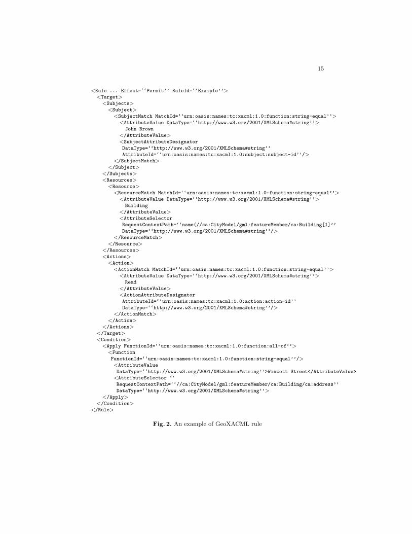
in the GeoXACML Core Geometry Model. Examples of geometric at-tributes are: Point, that models a single location; LineString, that rep-resents a curve with linear interpolation between Points; Polygon, thatidentifies a planar area defined by an exterior boundary, and zero or moreinterior boundaries; MultiPoint, MultiLineString, and MultiPolygon, thatrepresent a collection of Points, LineStrings, and Polygons, respectively.The GeoXACML predicates can be partitioned into different categories:topological, geometric, bag, conversion, and set. Table 3 presents somepredicates, which can be used for testing topological relations betweengeometries (we refer to the OGC proposal [24] for the complete set ofpredicates). A geometry provides a description of geographic character-istics (e.g., locations, shapes). The encoding of geometry depends on thecoordinate reference system (CRS) or spatial reference system (SRS) thatis used. It is important to note that some predicates provides supportingfunctionalities only. For instance, the predicates in the conversion cate-gory assist in the conversion of other measurement units in terms of metersor square meters (the only accepted by GeoXACML). The use of theseconversion functions should however be minimized to avoid unnecessarydelays in information processing. Another set of predicates providing sup-porting functionality, included in the geometric category, is used to verifyspecial characteristics of geometries. For instance, to verify whether ageometry has anomalous geometric points (e.g., self intersection, or selftangency).
GeoXACML, being an extension of XACML, has the same policy syn-tax of XACML. A GeoXACML policy is then composed of a set of Ruleelements, each one leading to a binary effect (i.e., Permit or Deny). Anauthorization decision is derived by first determining all the rules applica-ble to a given request. All matching rules are then combined according toa predefined algorithm to obtain the resulting effect of the policy. Whenmore policies are applicable, all resulting policy effects produced for agiven request must be combined to produce the final authorization deci-sion. The main difference between XACML and GeoXACML is that thelatter supports the declaration of spatial restrictions, which are expressedthrough the predicates above-mentioned. Figure 2 shows an example ofGeoXACML rule whose Effect is Permit. For simplicity, namespaces inthe rule element are omitted. The rule’s target (i.e., element Target) hasthree main elements: Subjects, which defines the rule’s subjects, that is,John Brown; Resources, which identifies the rule’s objects, that is, Build-ing ; and Actions, which specifies the actions that can be performed, thatis, Read. Element Condition introduces further matching conditions; in

14
Table 3. Examples of GeoXACML spatial functions
Type Function Description
Topological Contains(g1:Geometry,g2:Geometry) : Boolean
Returns a true value if and only if geometry g2lies in the closure (boundary union interior)of geometry g1.
Crosses(g1:Geometry,g2:Geometry) : Boolean
Returns a true value if and only if geome-tries g1 and g2 have some but not all interiorpoints in common, and the dimension of theintersection is less than that of both of thegeometries.
Disjoint(g1:Geometry,g2:Geometry) : Boolean
Returns a true value if and only if the geome-tries g1 and g2 have no points in common.
Equals(g1:Geometry,g2:Geometry) : Boolean
Returns a true value if and only if geometriesg1 and g2 are equal (geometrically contain ex-actly the same points).
Overlaps(g1:Geometry,g2:Geometry) : Boolean
Returns a true value if and only if geometriesg1 and g2 have some but not all points incommon, and the intersection has the samedimension as each geometry.
Within(g1:Geometry,g2:Geometry) : Boolean
Returns a true value if and only if geometryg1 is spatially within geometry g2, that is, ifevery point on g1 is also on g2.
Geometric Boundary(g:Geometry) :Bag
Returns a bag of geometry values representingthe combinatorial boundary of geometry g.
Centroid(g:Geometry) :Geometry
Returns the point that is the geometric centerof gravity of the geometry g.
Intersection(g1:Geometry,g2:Geometry) : Bag
Returns a bag of geometry values representingthe Point set intersection of geometry g1 andgeometry g2.
Union(g1:Geometry,g2:Geometry) : Bag
Returns a bag of geometry values represent-ing the Point set union of geometry g1 withgeometry g2.
Area(g:Geometry) : Dou-ble
Returns a value representing the area of ge-ometry g.
Distance(g1:Geometry,g2:Geometry) : Double
Returns a value representing the shortest dis-tance in meter between any two points in thetwo geometries g1 and g2.
our example, the fact that address has to be Wincott Street. The semanticof the rule is that “the user John Brown can Read the information objectof class Building, if the address is Wincott Street” [27].
15
<Rule ... Effect=‘‘Permit’’ RuleId=‘‘Example’’><Target>
<Subjects><Subject>
<SubjectMatch MatchId=‘‘urn:oasis:names:tc:xacml:1.0:function:string-equal’’><AttributeValue DataType=‘‘http://www.w3.org/2001/XMLSchema#string’’>
John Brown
</AttributeValue><SubjectAttributeDesignator
DataType=‘‘http://www.w3.org/2001/XMLSchema#string’’
AttributeId=‘‘urn:oasis:names:tc:xacml:1.0:subject:subject-id’’/></SubjectMatch>
</Subject></Subjects><Resources>
<Resource><ResourceMatch MatchId=‘‘urn:oasis:names:tc:xacml:1.0:function:string-equal’’>
<AttributeValue DataType=‘‘http://www.w3.org/2001/XMLSchema#string’’>Building
</AttributeValue><AttributeSelector
RequestContextPath=‘‘name(//ca:CityModel/gml:featureMember/ca:Building[1]’’
DataType=‘‘http://www.w3.org/2001/XMLSchema#string’’/></ResourceMatch>
</Resource></Resources><Actions>
<Action><ActionMatch MatchId=‘‘urn:oasis:names:tc:xacml:1.0:function:string-equal’’>
<AttributeValue DataType=‘‘http://www.w3.org/2001/XMLSchema#string’’>Read
</AttributeValue><ActionAttributeDesignator
AttributeId=‘‘urn:oasis:names:tc:xacml:1.0:action:action-id’’
DataType=‘‘http://www.w3.org/2001/XMLSchema#string’’/></ActionMatch>
</Action></Actions>
</Target><Condition>
<Apply FunctionId=‘‘urn:oasis:names:tc:xacml:1.0:function:all-of’’><Function
FunctionId=‘‘urn:oasis:names:tc:xacml:1.0:function:string-equal’’/><AttributeValue
DataType=‘‘http://www.w3.org/2001/XMLSchema#string’’>Wincott Street</AttributeValue>
<AttributeSelector ‘‘
RequestContextPath=‘‘//ca:CityModel/gml:featureMember/ca:Building/ca:address’’
DataType=‘‘http://www.w3.org/2001/XMLSchema#string’’></Apply>
</Condition></Rule>
Fig. 2. An example of GeoXACML rule
16
4 Protecting Location Information in UbiquitousComputing
Today ubiquitous technologies give the basis for accessing, mining, andmanaging large amount of location information. Such information, how-ever, can be extremely sensitive, and lack of its protection can resultin several attacks to the user’s personal sphere. Research has been ap-proaching the problem of protecting access to location information fromdifferent perspectives, such as the development of enhanced access controlarchitectures or the definition of new languages for protecting location in-formation. In the following, we illustrate some of these proposals.
4.1 Geopriv
IETF Geopriv working group [28] proposes a solution for protecting pri-vacy of location information, when it is transmitted and shared over theInternet. Geopriv’s main principles and considered threats have been for-malized in the IETF RFC 3693 and RFC 3694 [29, 30]. Geopriv considersa scenario in which a requester asks for location information of a targetto a location server. An architecture to manage such a scenario has beenintroduced and includes four main parties.
– Location Generator (LG) gathers location information of users andmakes it available to the Location Server.
– Location Server (LS) provides location services to Location Recipi-ents, and stores the location information of the users.
– Location Recipient (LR) subscribes for a location-based service pro-vided by the LS, and requests access to the location information storedby the LS.
– Rule Holder/Maker (RH/M) defines the privacy policies which regu-late the disclosure of location information to the LR. The policies areenforced by the LS.
Based on these logical components, different architectural layouts arepossible. For instance, LG and LS may coexist on the same mobile device(e.g., a GPS receiver) or could be distributed components communicatingremotely. The RH/M could be a centralized component managing privacyrules and communicating them to the corresponding LS, or it could beco-located with the LS.
The location information of users is part of a container, called Lo-cation Object [31]. In addition to the location information, a location

17
object includes privacy preferences (i.e., usage-rules), that remain at-tached to the location information for its entire life-cycle. In particular,usage-rules allow the definition of conditions that can: i) limit retransmis-sion (e.g., “retransmission-allowed”), ii) limit retention (e.g., “retention-expires” date), and iii) contain a reference to external rulesets.
Geopriv IETF RFC 4745 [32] defines the framework for creating pri-vacy policies that regulate the release of location information. A Geo-priv privacy policy, encoded in XML, is composed of a ruleset elementthat contains an unordered list of rules elements corresponding to posi-tive authorizations. Each rule has an element conditions, actions, andtransformations. The condition element is a set of expressions, each ofwhich evaluates to either true or false. A limited set of conditions can bespecified in the conditions element: identity, sphere, and validity.The identity element restricts the rule matching either to a single iden-tity, using the one element, or a group of identities, using the many ele-ment. In particular, the one element identifies exactly one authenticatedentity or user, while the many element represents a generic number ofusers in a domain (i.e., it matches the domain part of an authenticatedidentity). Moreover, the identity element can exclude individual usersor users belonging to a specific domain through the except element. Thesphere element can be used to match the state (e.g., work, home) a targetholds at the time of the access request evaluation. Finally, the validityelement is used to restrict the time validity of each rule. Additional condi-tion elements can be added by proposing extensions to the privacy policyspecification in RFC 4745. The actions element specifies actions to beapplied before the release of location information. The transformationselement specifies how the location information should be modified whena permission is granted; for instance, it can state that the original lo-cation should be made less precise. While conditions can be consideredas the ‘if’-part of the rules, which states whether the rule is applicable,actions and transformations form the ‘then’-part, which determines theoperations to be performed before disclosing information.
Figure 3 shows an example of Geopriv rule. The rule states that,during February 2009, the authenticated entity sip:[email protected] ormailto:[email protected] can access the location information, protectedby the rule, if target’s sphere is equal to “work”.
4.2 Protecting Location Information in Mobile Applications
Different works have addressed the problem of protecting location infor-mation in mobile applications.

18
<rule id=‘‘a7k55r7’’><conditions>
<identity><one id=‘‘sip:[email protected]’’/><one id=‘‘mailto:[email protected]’’/>
</identity><sphere value=‘‘work’’/><validity>
<from>2009-02-01T00:00:00.000-03:00</from><until>2009-02-28T23:59:59.000-03:00</until>
</validity></conditions><actions/><transformations/>
</rule>
Fig. 3. An example of Geopriv rule
A first line of research focuses on extending Platform for PrivacyPreferences (P3P) for protecting the secondary uses of location infor-mation [33–35]. P3P [36, 37] has been originally designed by the WorldWide Web Consortium (W3C) to address the need of users to assesswhether the privacy practices defined by a Web site comply with theirprivacy requirements, before the release of personal information. Privacyrequirements are expressed through A P3P Preference Exchange Lan-guage (APPEL) [38]. Starting from the work done in P3P, Langhein-rich [34] proposes a privacy awareness system (pawS) for ubiquitous andpervasive environments, where services collect users data. The main goalof pawS is to provide an infrastructure that allows users to protect theirprivacy and to keep track of all data released and of their subsequentmanagement at the service side. pawS uses P3P to encode data usagepolicies of the service and users define their preferences through APPEL.In pawS, a mobile user carries a mobile device with a privacy assistant.When a user enters a geographical area in which a number of services areavailable (e.g., location tracking service using video-camera), the privacyassistant is prompted with the data collection practices of the service.This communication happens on wireless channels. To save the batteryof the portable devices and make the system appealing also for mobileusers, data usage practices are delegated by the user to a personal pri-vacy proxy residing on the Internet, which is responsible for managing allnegotiations with the service. In particular, the personal privacy proxyasks the service proxy for service policies and then matches them withthe users’ preferences. If the matching is successful, the service is usedand data released, otherwise the service is disabled. Access control poli-

19
cies exploiting the location of the requesters are evaluated and enforced.Myles et al. [35] discuss a location-based scenario where applications re-quire location information of the users for service release. The main goalis, on the one side, to balance the need of mechanisms to protect users’privacy limiting service intrusiveness, and, on the other side, to minimizethe overhead given to the users. The proposed system architecture iscomposed of three main entities: i) a location server, that manages posi-tioning systems (e.g., GPS, cellular technologies) and answers to requestsfor location information; ii) several validators, that are responsible forevaluating the requests and determining whether the location informa-tion can be released, based on preferences of the users; iii) client applica-tions, that submit requests for location information. The authors assumetrust relationships between users, validators, and location servers. Usersare registered with at least one location server and store their require-ments within it. These requirements are implemented by the validators.When a client application needs to access the location of a user, it firstselects the relevant location server, and then submits the request. Such arequest also includes the privacy policies that specify how the client ap-plication will manage the data after their collection. The privacy policiescan be expressed through an extension of P3P that allows the modelingof requests initiated by the application. After receiving the request, theprivacy policies are matched with the privacy preferences stored by thevalidators. Such preferences can contain restrictions based on the time ofthe request and on geographical areas. Validators can implement a varietyof mechanisms for privacy preferences specifications (e.g., APPEL). Honget al. [33] provide an extension to P3P for representing user privacy pref-erences in context-aware applications. The authors add features to theP3P language to express the identifiers of the users whose locations arecollected, the time period in which the data can be accessed, and the lo-cation from which the data can be managed. They propose a centralizedarchitecture that includes a middleware responsible for matching pref-erences and policies. The middleware is enriched with a plug-in serviceto support context-aware applications, called privacy database mediator.The privacy database mediator provides functionality to automaticallygenerate privacy policies and user preferences according to the context.
Another line of research has addressed the definition of authorizationarchitectures, based on certificates and encryption, to protect locationinformation. Hauser and Kabatnik [39] address the problem of protect-ing the location information of the users by providing a privacy-awarearchitecture that allows users to define rules regulating the access to

20
their location information. The proposed solution relies on asymmetricencryption and authorization certificates. The requester asks the loca-tion server for the position of a given target (position query), by sendingthe authorization certificate released by the target. The certificate is achipertext encrypted with the public key of the location server and con-tains the pseudonym of the target. The location server, after decryptingthe chipertext, retrieves the target’s pseudonym, and satisfies the subjectrequest by releasing the target’s position. Note that the location serveris not aware of the real identity of the targets. A more complex solutionis also provided for queries that ask for a list of targets in a given area.In this case, a certificate specifying the privilege to query a specific areais not enough, but rather the requester has to send the authorizationsof all the users relevant for the query. Hengartner and Steenkiste [40,41] use digital certificates combined with rule-based policies to protectlocation information. They consider an environment in which users sub-mit requests to a “people locator”, which in turn collects the relevantlocation information through multiple positioning systems. The authorspropose an access control mechanism where policies are encoded as digitalcertificates using SPKI/SDSI. Location policies can specify the entitiesthat can access the location information, the granularity of the infor-mation returned to the requester, the location of the requester, and thetime allowed for each access. In case of forwarded requests, trust policiesare used to verify whether the intermediate service is trusted or not toforward a request and receive a response. Finally, delegation of right isallowed to grant access to other entities. Atluri and Chun [42] presentGeo-Spatial Data Authorization Model (GSAM), an authorization modelthat protects access to geospatial data. GSAM provides policies evaluat-ing geospatial and temporal characteristics of user’s credentials and dataobjects, and introduces different types of actions (e.g., zoom-in, view, anddownload). For instance, GSAM defines security and privacy policies thatallow access to low resolution images regardless of location coordinatesof users, whereas restrict access to high resolution images only for thoseusers located in a particular region.
5 Open Issues
We briefly describe some open issues that need to be taken into considera-tion in the future development of access control systems for location-basedservices.

21
– Reliable enforcement based on fine-grained context information. Asdiscussed, a key aspect to the success of location-based access controlsystems is the definition of a reliable enforcement solution, able to ver-ify information which is approximate and time-variant. In the near fu-ture, location servers will provide a wealth of additional environment-related knowledge (e.g., is the user sitting at her desk or walking to-ward the door? Is she alone or together with others?), that may givethe opportunity of defining and evaluating new classes of location-based conditions in the context of LBAC systems. LBAC systemshowever may be flawed by the intrinsic errors of location measure-ments, in calculating such fine-grained knowledge. Future access con-trol mechanisms should then try to enhance current approaches to themanagement of uncertain information, thus providing policy evalua-tion mechanisms able to support fine-grained location information.
– Privacy-aware LBAC. An important aspect to consider in today accesscontrol systems is the protection of the user privacy. Some solutionshave been presented in the past (e.g., [9]) which provide, on the oneside, access control functionality and, on the other side, privacy pro-tection. However, LBAC systems introduce new threats that shouldbe carefully considered. In particular, a fundamental issue to be ad-dressed considers the conflicting requirements of preserving users pri-vacy and of providing high quality LBAC. A suitable protocol shouldin fact balance the tradeoff between the level of location accuracyrequested by LBAC providers and the protection of the location in-formation requested by the users. A possible approach in develop-ing a privacy-aware LBAC may integrate access control with locationprivacy solutions (e.g., obfuscation [6, 7] and anonymity [43–46] tech-niques).
– Integration of different location sources. An important issue in thedevelopment of LBAC systems is represented by the availability ofseveral location servers, which support different positioning systemsfor measuring location of the users. In this context, a solution whichimplements communication and negotiation protocols between theLBAC system and multiple, functionally equivalent, location serversis needed. These protocols should provide an approach based onservice level agreement attributes which maximize the QoS and/orcost/benefit functions.
22
6 Conclusions
In this chapter, we discussed how the advent of location-based servicesand the availability of precise location information are changing tradi-tional access control systems. We considered two different scenarios: i)the definition of a location-based access control system, which integrates,evaluates, and enforces traditional access control policies enriched withconditions based on the physical position of users; ii) the development ofenhanced access control systems for protecting the location information.For both of them, we investigated recent proposals and ongoing work.Finally, we presented open issues that need further investigation.
Acknowledgments
This work was supported in part by the EU, within the 7th Frame-work Programme (FP7/2007-2013) under grant agreement no. 216483“PrimeLife”.
References
1. Varshney, U.: Location management for mobile commerce applications in wirelessinternet environment. ACM Transactions on Internet Technology (TOIT) 3(3)(December 2003) 236–255
2. Ardagna, C., Cremonini, M., Damiani, E., De Capitani di Vimercati, S., Samarati,P.: Privacy-enhanced location services information. In Acquisti, De Capitani diVimercati, Gritzalis, Lambrinoudakis, eds.: Digital Privacy: Theory, Technologiesand Practices. Auerbach Publications (2007)
3. Enhanced 911: Wireless Services. http://www.fcc.gov/911/enhanced/.4. Chicago Tribune: Rental firm uses GPS in speeding fine. July 2nd, p.9. Associated
Press: Chicago, IL, 2001.5. Duckham, M., Kulik, L.: Location privacy and location-aware computing. In
Drummond, J., Billen, R., Forrest, D., Joao, D., eds.: Dynamic & Mobile GIS:Investigating Change in Space and Time. CRC Press (2006) 34–51
6. Ardagna, C., Cremonini, M., Damiani, E., De Capitani di Vimercati, S., Samarati,P.: Location privacy protection through obfuscation-based techniques. In: Proc.of the 21st Annual IFIP WG 11.3 Working Conference on Data and ApplicationsSecurity, Redondo Beach, CA, USA (July 2007)
7. Duckham, M., Kulik, L.: A formal model of obfuscation and negotiation for locationprivacy. In: Proc. of the 3rd International Conference on Pervasive Computing(PERVASIVE 2005), Munich, Germany (May 2005)
8. Samarati, P., De Capitani di Vimercati, S.: Access control: Policies, models, andmechanisms. In Focardi, R., Gorrieri, R., eds.: Foundations of Security Analysisand Design. LNCS 2171. Springer-Verlag (2001)
9. Ardagna, C., Cremonini, M., De Capitani di Vimercati, S., Samarati, P.: A privacy-aware access control system. Journal of Computer Security 16(4) (2008) 369–392

23
10. De Capitani di Vimercati, S., Foresti, S., Samarati, P.: Recent advances in accesscontrol. In Gertz, M., Jajodia, S., eds.: Handbook of Database Security: Applica-tions and Trends. Springer-Verlag (2008)
11. eXtensible Access Control Markup Language (XACML): Version 2.0.(February 2005) http://docs.oasis-open.org/xacml/2.0/access control-xacml-2.0-core-spec-os.pdf.
12. Bonatti, P., Samarati, P.: A unified framework for regulating access and informa-tion release on the web. Journal of Computer Security 10(3) (2002) 241–272
13. Akyildiz, I., Ho, J., eds.: Dynamic mobile user location update for wireless PCSnetworks. Volume 1. Wireless Networks (1995)
14. Faria, D., Cheriton, D.: No long-term secrets: Location-based security in over-provisioned wireless lans. In: Proc. of the 3rd ACM Workshop on Hot Topics inNetworks (HotNets-III), San Diego, CA, USA (November 2004)
15. Garg, S., Kappes, M., Mani, M.: Wireless access server for quality of serviceand location based access control in 802.11 networks. In: Proc. of the 7th IEEESymposium on Computers and Communications (ISCC 2002), Taormina/GiardiniNaxos, Italy (July 2002)
16. Myllymaki, J., Edlund, S.: Location aggregation from multiple sources. In: Proc.of the 3rd IEEE International Conference on Mobile Data Management (MDM2002), Singapore (January 2002)
17. Cho, Y., Bao, L., Goodrich, M.: Secure access control for location-based applica-tions in WLAN systems. In: Proc. of the 3rd IEEE International Conference onMobile Adhoc and Sensor Systems, Vancouver, Canada (October 2006)
18. Nord, J., Synnes, K., Parnes, P.: An architecture for location aware applications.In: Proc. of the 35th Hawaii International Conference on System Sciences, Hawaii,USA (2002)
19. Sastry, N., Shankar, U., Wagner, S.: Secure verification of location claims. In:Proc. of the ACM Workshop on Wireless Security (WiSe 2003), San Diego, CA,USA (September 2003)
20. Zhang, G., Parashar, M.: Dynamic context-aware access control for grid appli-cations. In: Proc. of the 4th International Workshop on Grid Computing (Grid2003), Phoenix, AZ, USA (November 2003)
21. Atallah, M., Blanton, M., Frikken, K.: Efficient techniques for realizing geo-spatialaccess control. In: Proc. of the 2nd ACM Symposium on InformAtion, Computerand Communications Security (ASIACCS 2007), Singapore (March 2007)
22. Atluri, V., Shin, H., Vaidya, J.: Efficient security policy enforcement for the mobileenvironment. Journal of Computer Security 16(4) (2008) 439–475
23. Ardagna, C., Cremonini, M., Damiani, E., De Capitani di Vimercati, S., Samarati,P.: Supporting location-based conditions in access control policies. In: Proc. ofthe ACM Symposium on InformAtion, Computer and Communications Security(ASIACCS 2006), Taipei, Taiwan (March 2006)
24. Open Geospatial Consortium: Geospatial eXtensible Access Con-trol Markup Language (GeoXACML) Version 1.0. (February 2008)http://portal.opengeospatial.org/.
25. Marsit, N., Hameurlain, A., Mammeri, Z., Morvan, F.: Query processing in mobileenvironments: a survey and open problems. In: Proc. of the 1st InternationalConference on Distributed Framework for Multimedia Applications (DFMA’05),Besancon, France (February 2005)
26. Ardagna, C., Cremonini, M., De Capitani di Vimercati, S., Samarati, P.: Privacy-enhanced location-based access control. In Gertz, M., Jajodia, S., eds.: The Hand-book of Database Security: Applications and Trends. Springer-Verlag (2007)

24
27. Matheus, A.: Declaration and Enforcement of Access Restrictions for DistributedGeospatial Information Objects. PhD Thesis, 2005.
28. Geographic Location/Privacy (geopriv). http://www.ietf.org/html.charters/geopriv-charter.html.
29. Cuellar, J., Morris, J., Mulligan, D., Peterson, J., Polk, J.: Geopriv Requirements.IETF RFC 3693. (February 2004)
30. Danley, M., Mulligan, D., Morris, J., Peterson, J.: Threat Analysis of the GeoprivProtocol. IETF RFC 3694. (February 2004)
31. Cuellar, J.: A Presence-based GEOPRIV Location Object Format. IETF RFC4119. (December 2005)
32. Schulzrinne, H., Tschofenig, H., Morris, J., Cuellar, J., Polk, J., Rosenberg, J.:Common Policy: A Document Format for Expressing Privacy Preferences. IETFRFC 4745. (February 2007)
33. Hong, D., Yuan, M., Shen, V.Y.: Dynamic privacy management: a plug-in ser-vice for the middleware in pervasive computing. In: Proc. of the 7th InternationalConference on Human Computer Interaction with Mobile Devices & Services (Mo-bileHCI’05), Salzburg, Austria (2005)
34. Langheinrich, M.: Privacy by design-principles of privacy-aware ubiquitous sys-tems. In: Proc. of the 3rd International Conference on Ubiquitous Computing(Ubicomp 2001), Atlanta, GA, USA (September-October 2001)
35. Myles, G., Friday, A., Davies, N.: Preserving privacy in environments with location-based applications. IEEE Pervasive Computing 2(1) (2003) 56–64
36. Cranor, L.: Web Privacy with P3P. O’Reilly & Associates (2002)37. World Wide Web Consortium (W3C): Platform for privacy preferences (P3P)
project. (April 2002) http://www.w3.org/TR/P3P/.38. World Wide Web Consortium (W3C): A P3P Preference Exchange Language 1.0
(APPEL1.0). (April 2002) http://www.w3.org/TR/P3P-preferences/.39. Hauser, C., Kabatnik, M.: Towards Privacy Support in a Global Location Ser-
vice. In: Proc. of the IFIP Workshop on IP and ATM Traffic Management(WATM/EUNICE 2001), Paris, France (September 2001)
40. Hengartner, U., Steenkiste, P.: Protecting access to people location information.Security in Pervasive Computing (March 2003)
41. Hengartner, U., Steenkiste, P.: Implementing access control to people locationinformation. In: Proc. of the ACM Symposium on Access Control Models andTechnologies 2004 (SACMAT 2004), Yorktown Heights, New York, USA (2004)
42. Atluri, V., Chun, S.: An authorization model for geospatial data. IEEE Transac-tions on Dependable and Secure Computing 1(4) (2004) 238–254
43. Bettini, C., Wang, X., Jajodia, S.: Protecting privacy against location-based per-sonal identification. In: Proc. of the 2nd VLDB Workshop on Secure Data Man-agement (SDM’05), Trondheim, Norway (September 2005)
44. Ghinita, G., Kalnis, P., Skiadopoulos, S.: Prive: Anonymous location-based queriesin distributed mobile systems. In: Proc. of the International World Wide WebConference (WWW 2007), Banff, Canada (May 2007)
45. Gruteser, M., Grunwald, D.: Anonymous usage of location-based services throughspatial and temporal cloaking. In: Proc. of the 1st International Conference onMobile Systems, Applications, and Services, San Francisco, CA, USA (May 2003)
46. Mokbel, M., Chow, C.Y., Aref, W.: The new casper: Query processing for loca-tion services without compromising privacy. In: Proc. of the 32nd InternationalConference on Very Large Data Bases, Seoul, Korea (September 2006)