Embed Size (px)
Citation preview
ACCURACY ASSESSMENT OF DIGITAL HEIGHT MODELS DERIVED FROMAIRBORNE SYNTHETIC APERTURE RADAR
A. Kleusberg and H.G. KlaedtkeInstitut für Navigation, Universität Stuttgart
Geschwister-Scholl-Str. 24D, 70174 Stuttgart
KEYWORDS: Synthetic Aperture Radar, Radar Interferometry, Digital Height Models
ABSTRACTA digital height model (DHM) derived from airborne interferometric synthetic aperture Radar (InSAR)covering abou 140 km2 in the western part of the state of Baden-Württemberg, Germany, was compared tothe elevations of Trigonometric Points, the official DHM of the state of Baden-Württemberg (DHM Ba-Wü), and elevations derived from differential GPS measurements..The comparisons showed that the DHM derived from InSAR is about 1-2 m below the reference values,on average. The accuracy of the DHM Ba-Wü does not allow any further conclusions regarding theaccuracy of the InSAR DHM. The comparison with the elevations of 79 Trigonometric Points (in openterrain) showed a standard deviation of ±1,3 m about the average difference. The comparison with 44GPS derived elevations (in open terrain) showed a standard deviation of ±0,9 m about the averagedifference.The InSAR derived DHM represents the surface reflecting the Radar signal. Therefore the deviationbetween InSAR DHM and the reference values is much larger in built-up areas and in areas withsignificant vegetation (e.g. forest).
1. INTRODUCTION
Several American and European institutions havedeveloped airborne InSAR systems. One of theseis the Star-3i system operated by IntermapTechnologies Ltd of Nepean, Ontario. This systemcan provide DHMs at various accuracies andresolutions depending on flight altitude and dataprocessing complexity. The system operates in theX-band with a wavelength of about 3cm; suchmicrowaves do not penetrate vegetation orbuildings.
Therefore the resulting DHM is a model for the„surface of first return“ of the Radar signal, theenvelop of the vegetation and/or man madestructures over some averaging region. In additionto the DHM, the Star-3i system also provides aRadar reflection intensity image.A strip of Star-3i InSAR data was acquired in thestate of Baden-Württemberg in June 1997 from aLear-Jet 36 at an altitude of about 6,800m. At thisflight altitude, the InSAR covers a strip width ofabout 7km.� The length of the strip is about20km, and the data acquisition took about 3minutes. Together with precise aircraft navigationdata, the InSAR data was processed by Intermap
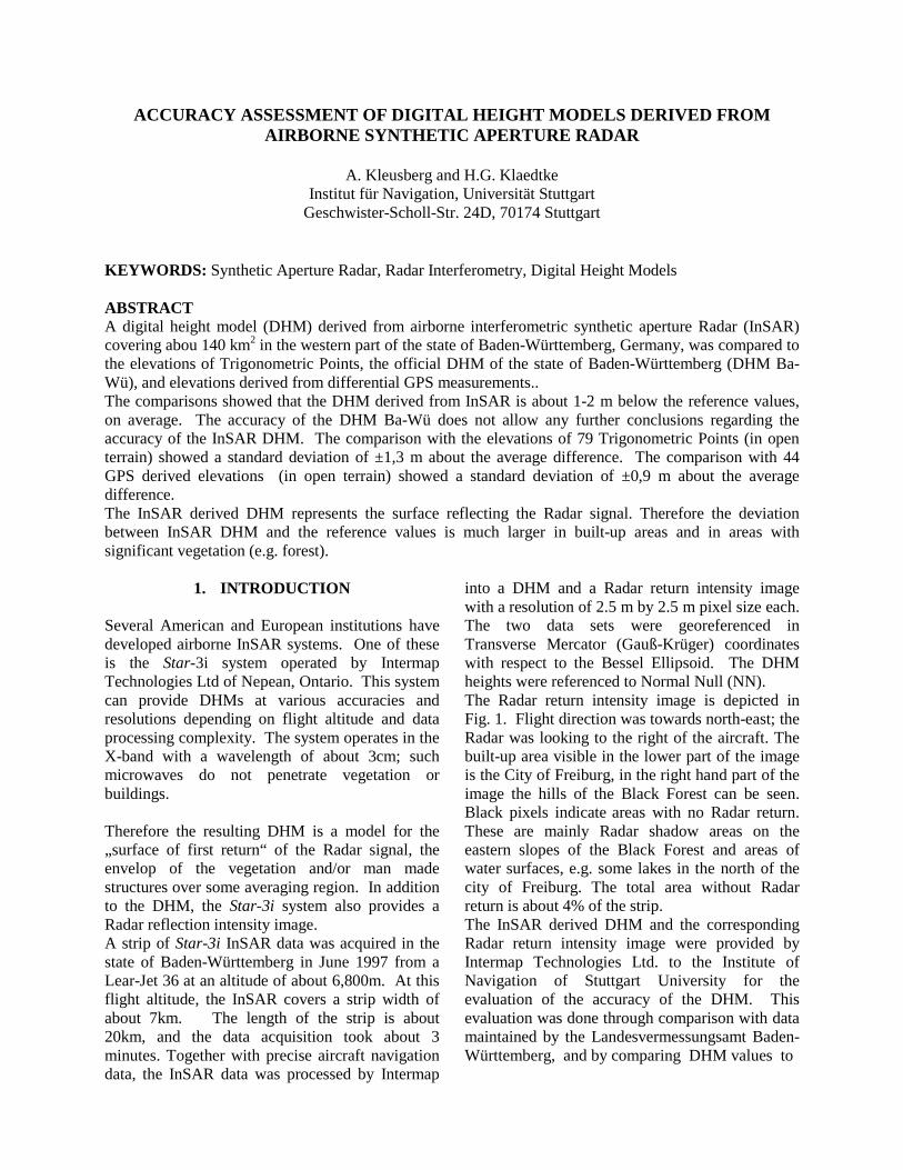
into a DHM and a Radar return intensity imagewith a resolution of 2.5 m by 2.5 m pixel size each.The two data sets were georeferenced inTransverse Mercator (Gauß-Krüger) coordinateswith respect to the Bessel Ellipsoid. The DHMheights were referenced to Normal Null (NN).The Radar return intensity image is depicted inFig. 1. Flight direction was towards north-east; theRadar was looking to the right of the aircraft. Thebuilt-up area visible in the lower part of the imageis the City of Freiburg, in the right hand part of theimage the hills of the Black Forest can be seen.Black pixels indicate areas with no Radar return.These are mainly Radar shadow areas on theeastern slopes of the Black Forest and areas ofwater surfaces, e.g. some lakes in the north of thecity of Freiburg. The total area without Radarreturn is about 4% of the strip.The InSAR derived DHM and the correspondingRadar return intensity image were provided byIntermap Technologies Ltd. to the Institute ofNavigation of Stuttgart University for theevaluation of the accuracy of the DHM. Thisevaluation was done through comparison with datamaintained by the Landesvermessungsamt Baden-Württemberg, and by comparing DHM values to
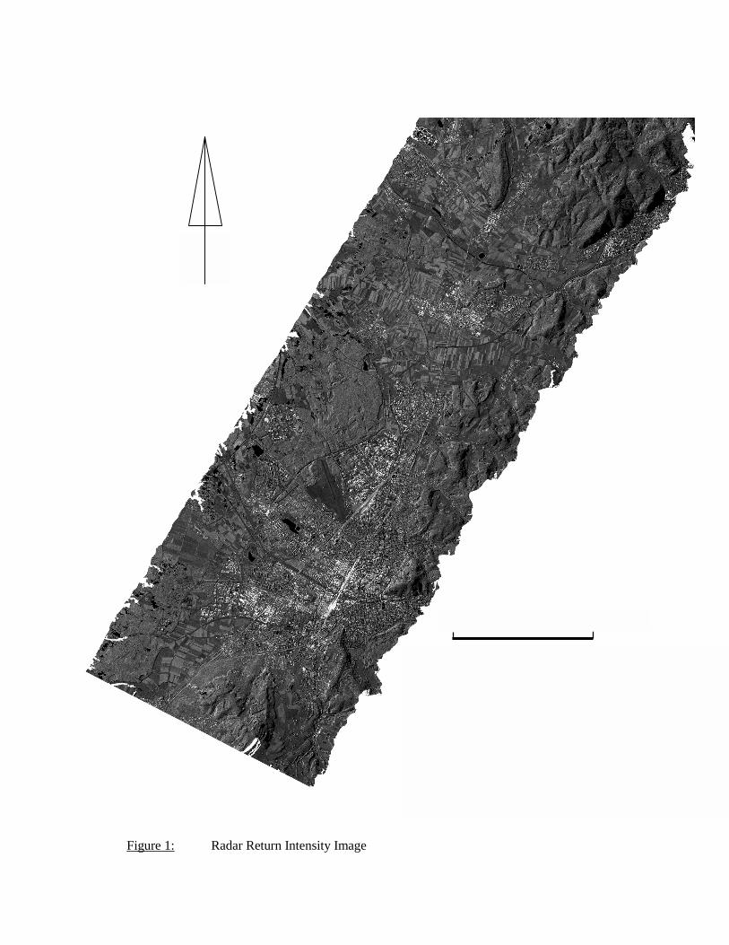
Figure 1: Radar Return Intensity Image
N
0 4 km
heights determined from Global PositioningSystem (GPS) measurements in various parts ofthe test area. Below we present a few aspects ofthis comparison; the complete evaluation can befound in (Kleusberg and Klaedtke, 1998).
2. COMPARISON TO HEIGHTS OFTRIGONOMETRIC POINTS (TP)
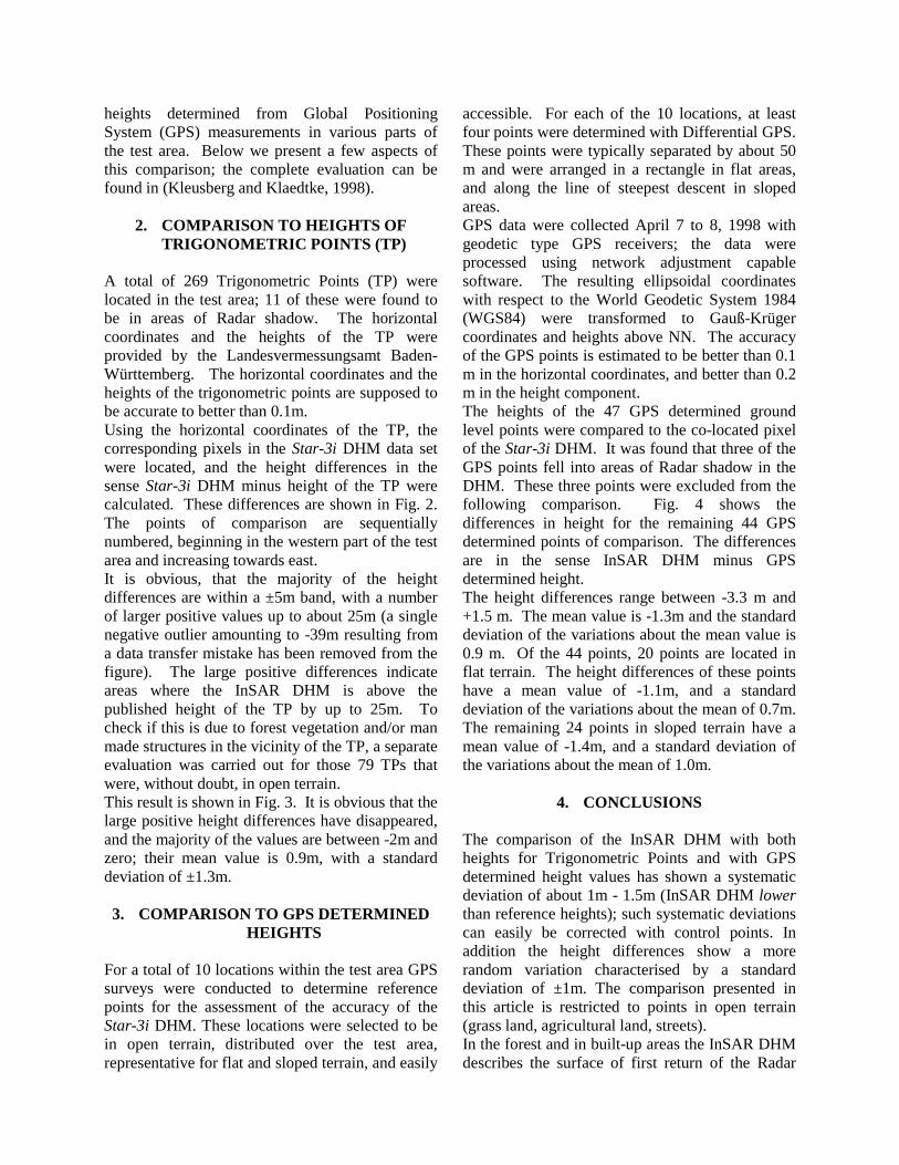
A total of 269 Trigonometric Points (TP) werelocated in the test area; 11 of these were found tobe in areas of Radar shadow. The horizontalcoordinates and the heights of the TP wereprovided by the Landesvermessungsamt Baden-Württemberg. The horizontal coordinates and theheights of the trigonometric points are supposed tobe accurate to better than 0.1m.Using the horizontal coordinates of the TP, thecorresponding pixels in the Star-3i DHM data setwere located, and the height differences in thesense Star-3i DHM minus height of the TP werecalculated. These differences are shown in Fig. 2.The points of comparison are sequentiallynumbered, beginning in the western part of the testarea and increasing towards east.It is obvious, that the majority of the heightdifferences are within a ±5m band, with a numberof larger positive values up to about 25m (a singlenegative outlier amounting to -39m resulting froma data transfer mistake has been removed from thefigure). The large positive differences indicateareas where the InSAR DHM is above thepublished height of the TP by up to 25m. Tocheck if this is due to forest vegetation and/or manmade structures in the vicinity of the TP, a separateevaluation was carried out for those 79 TPs thatwere, without doubt, in open terrain.This result is shown in Fig. 3. It is obvious that thelarge positive height differences have disappeared,and the majority of the values are between -2m andzero; their mean value is 0.9m, with a standarddeviation of ±1.3m.
3. COMPARISON TO GPS DETERMINEDHEIGHTS
For a total of 10 locations within the test area GPSsurveys were conducted to determine referencepoints for the assessment of the accuracy of theStar-3i DHM. These locations were selected to bein open terrain, distributed over the test area,representative for flat and sloped terrain, and easily
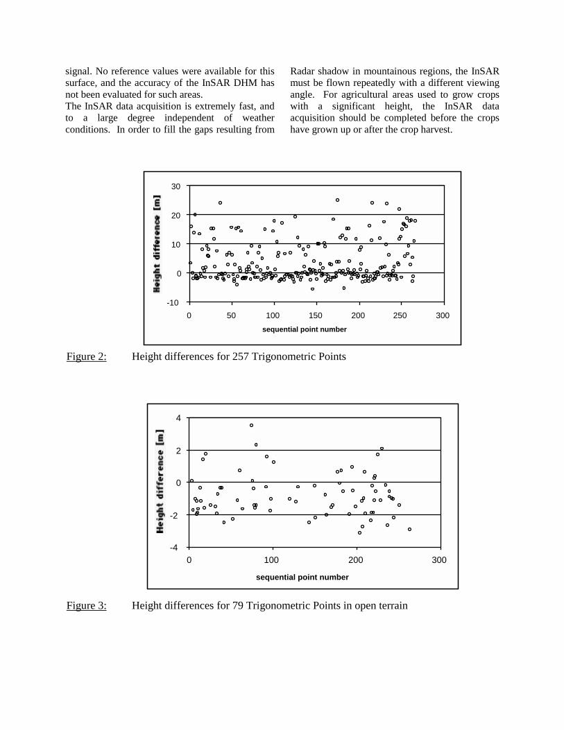
accessible. For each of the 10 locations, at leastfour points were determined with Differential GPS.These points were typically separated by about 50m and were arranged in a rectangle in flat areas,and along the line of steepest descent in slopedareas.GPS data were collected April 7 to 8, 1998 withgeodetic type GPS receivers; the data wereprocessed using network adjustment capablesoftware. The resulting ellipsoidal coordinateswith respect to the World Geodetic System 1984(WGS84) were transformed to Gauß-Krügercoordinates and heights above NN. The accuracyof the GPS points is estimated to be better than 0.1m in the horizontal coordinates, and better than 0.2m in the height component.The heights of the 47 GPS determined groundlevel points were compared to the co-located pixelof the Star-3i DHM. It was found that three of theGPS points fell into areas of Radar shadow in theDHM. These three points were excluded from thefollowing comparison. Fig. 4 shows thedifferences in height for the remaining 44 GPSdetermined points of comparison. The differencesare in the sense InSAR DHM minus GPSdetermined height.The height differences range between -3.3 m and+1.5 m. The mean value is -1.3m and the standarddeviation of the variations about the mean value is0.9 m. Of the 44 points, 20 points are located inflat terrain. The height differences of these pointshave a mean value of -1.1m, and a standarddeviation of the variations about the mean of 0.7m.The remaining 24 points in sloped terrain have amean value of -1.4m, and a standard deviation ofthe variations about the mean of 1.0m.
4. CONCLUSIONS
The comparison of the InSAR DHM with bothheights for Trigonometric Points and with GPSdetermined height values has shown a systematicdeviation of about 1m - 1.5m (InSAR DHM lowerthan reference heights); such systematic deviationscan easily be corrected with control points. Inaddition the height differences show a morerandom variation characterised by a standarddeviation of ±1m. The comparison presented inthis article is restricted to points in open terrain(grass land, agricultural land, streets).In the forest and in built-up areas the InSAR DHMdescribes the surface of first return of the Radar
signal. No reference values were available for thissurface, and the accuracy of the InSAR DHM hasnot been evaluated for such areas.The InSAR data acquisition is extremely fast, andto a large degree independent of weatherconditions. In order to fill the gaps resulting from
Radar shadow in mountainous regions, the InSARmust be flown repeatedly with a different viewingangle. For agricultural areas used to grow cropswith a significant height, the InSAR dataacquisition should be completed before the cropshave grown up or after the crop harvest.
Figure 2: Height differences for 257 Trigonometric Points
Hei
ght d
iffre
nce
[m]
Figure 3: Height differences for 79 Trigonometric Points in open terrain
Hei
ght d
iffre
nce
[m]
-10
0
10
20
30
0 50 100 150 200 250 300sequential point number
-4
-2
0
2
4
0 100 200 300
sequential point number

5. ACKNOWLEDGEMENTS
Mrs. Schleyer and Spohrer of the Landesver-messungsamt Baden-Württemberg areacknowledged for providing hard copies of therelevant base maps and the description of thetrigonometric points, and the horizontalcoordinates and height data for the trigonometricpoints. The GPS measurements were planned,executed and analysed with the help of D. Becker,D. Dettmering and O. Schiele. This support isgratefully acknowledged.The InSAR DHM data is property of IntermapTechnologies Ltd.
6. REFERENCES
Hartl, P., K.H. Thiel, X. Wu, und Y. Xia (1998):SAR-Interferometrie: Grundlagen undAnwendungs-beispiele. Petermanns GeographischeMitteilungen, Ergänzungsheft 287, Justus PerthesVerlag Gotha, 35-52
Kleusberg, A. and H.G. Klaedtke (1998): AccuracyAssessment of the Star-3i Derived DHM in Baden-Württemberg. Contract Report to IntermapTechno-logies Ltd., Institut für Navigation, Univ.Stuttgart
Schwäbisch, M. (1997): SAR-Interferometrie– Technik, Anwendungen, Perspektiven.Zeitschrift für Photogrammetrie undFernerkundung, 22-29
Figure 4: Height differences for 44 reference points determined with GPS
-4
-2
0
2
0 10 20 30 40 50
sequential point number