Embed Size (px)
Citation preview

The Carollo Engineers/Brown and Caldwell team wishes to extend its appreciation and gratitude to all of the City staff members who contributed their time and expertise to the success of this project:
Planning and Development 6
Department
Public Works Department/Engineering 6
Division
Municipal Utilities Department 6
Acknowledgements
Buildout & Beyond Buildout & Beyond...Master Plan Update provides for a... Flexible Reliable Sustainable
Water, Wastewater, and Reclaimed Water System incorporating... Interconnected water reclamation facilities.
Expanded/upgraded Ocotillo Water Reclamation Facility.
Integration of the Santan Vista Water Treatment Plant and Reservoir Supply System.
100% reclaimed water utilization.
Dual surface water source capabilities.
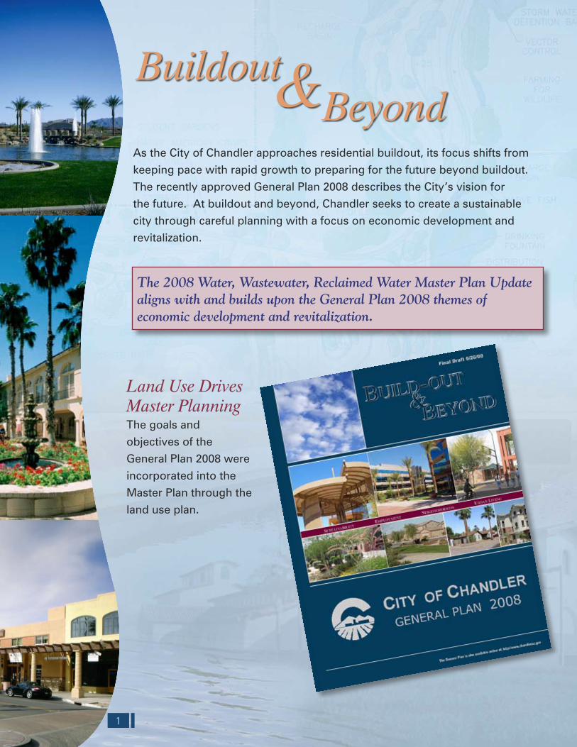
As the City of Chandler approaches residential buildout, its focus shifts from
keeping pace with rapid growth to preparing for the future beyond buildout.
The recently approved General Plan 2008 describes the City’s vision for
the future. At buildout and beyond, Chandler seeks to create a sustainable
city through careful planning with a focus on economic development and
revitalization.
Land Use Drives Master PlanningThe goals and
objectives of the
General Plan 2008 were
incorporated into the
Master Plan through the
land use plan.
1 14
The 2008 Water, Wastewater, Reclaimed Water Master Plan Update aligns with and builds upon the General Plan 2008 themes of economic development and revitalization.
ECONOMIC DEVELOPMENT CORRIDORSFigure 3.20
0 21
Miles
Economic Development Corridor
Redevelopment / Growth Area
City Limits
Pima Utilities Service Area
Land UseRural
Low Density Residential
Medium Density Residential
High Density Residential
Very High Density Residential
Mobile Home Park
Commercial
Regional / Community Commercial
Mixed Use
Office
School
Hotel
Church
Industrial
Major Industrial
WRF; WTP
Irrigation
Reclaimed Irrigation
SRP Urban Irrigation
No Water Service
City of Chandler Water, Wastewater, Reclaimed Water Master Plan Update
Printing Date: August 14, 2008File: M:\Client\Chandler\7792A00_MasterPlanUpdate\Reports\Draft Final Report\Maps\Fig 3_20.mxd
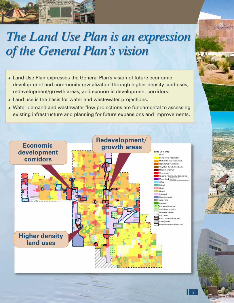
The Land Use Plan is an expressionof the General Plan’s vision
The Master Plan defines Chandler’s buildout CIP
Land Use Plan expresses the General Plan’s vision of future economic 6
development and community revitalization through higher density land uses, redevelopment/growth areas, and economic development corridors.
Land use is the basis for water and wastewater projections. 6
Water demand and wastewater flow projections are fundamental to assessing 6
existing infrastructure and planning for future expansions and improvements.
213
Proposed 2013-Buildout CIP Costs Totaling $228 M (escalated to time of construction)
Proposed 2008-2013 CIP Costs Totaling $400 M (escalated to time of construction)
Water Wastewater Reclaimed Water
$178 M
$39 M
$183 M
Redevelopment/ growth areasEconomic
development corridors
Water Wastewater Reclaimed Water
$35 M
$3 M
$190 M
Higher densityland usesBUILDOUT LAND USE PLAN FOR MASTER PLANNING PURPOSES
Figure 2.2
0 21
Miles
Land Use TypeRural
Low Density Residential
Medium Density Residential
High Density Residential
Very High Density Residential
Mobile Home Park
Commercial
Regional / Community Commercial
Mixed Use
Office
School
Hotel
Church
Industrial
Major Industrial
WRF; WTP
Irrigation
Reclaimed Irrigation
SRP Urban Irrigation
No Water Service
City Limits
Pima Utilities Service Area
County Island
Redevelopment / Growth Area
Printing Date: August 14, 2008File: M:\Client\Chandler\7792A00_MasterPlanUpdate\Reports\Draft Final\Fig 2_2.mxd
City of Chandler Water, Wastewater, Reclaimed Water Master Plan Update
30% Commercial, 10% Office, 60% Very High Density Residential( )

Key Features
Ocotillo WRF GRIC, 6
and recharge pump station expansion.Aquifer storage 6
and recovery well capacity expansion.Reconfigured 6
delivery system saves costs and improves operation.Chandler’s 6
recharge facilities provide for 100% reclaimed water utilization.System operation is 6
managed through scheduling of user deliveries.Locating recharge 6
and reuse facilities at the City’s multi-use sites provides for efficient use of land resources.
3 12
2008Master Plan
Reclaimed WaterSystem
WastewaterSystem
WaterSystem
WaterResources
The Master Plan
consists of strategies
to develop, manage,
and use Chandler’s
surface water,
groundwater, and
reclaimed water
resources.
The Master Plan
has been developed
utilizing an integrated
approach.
“Integration” is the process of planning and designing infrastructure in a coordinated manner to maximize the use of available water resources.
Tumbleweed Park Recharge and Recovery Facility
Pecos Rd1000 S
Frye Rd
Willis Rd
Germann Rd2000 S
4000
E
Lin
dsa
y R
d
Ryan Rd
Appleby Rd
Queen Creek Rd3000 S
Val
Vis
ta D
r50
00 E
Ocotillo Rd4000 S
Brooks Farm Rd
Chandler Heights Rd
7000 S
Riggs Rd
Hunt Hw
5000 S
6000 S
Cloud Rd
Doral Dr
Elli
st S
t
Pri
ce
Rd
3000
W
Dob
son
Rd
2000
W
Arr
owhe
ad D
r
Har
tford
St
Ham
ilton
St
1000
W
0Alm
a S
choo
l R
d
Ari
zon
a A
v
Coo
per
Rd
Gilb
ert
Rd
2000
E
3000
E
1000
EM
cQ
uee
n R
d
Ada
ms
Av
148t
h S
t
36''
24''
6''
30''
4''
8''
12''
24'' 12''
12''
12''
12''
12''
8''
12''
12''
12''
24''
12''
4''
12''
12''
12''
24''
24''
12''
24''
12''
12''
12''
12''
12''
24''
24''
24''
12''
24''
24''
12''
12''
12''12''
12''
4''
12''
12''
24''
12''
12''
12''
24''
12''
12''
12''
24''
12''
12''
24''
12''
24''
12''
24''
12''
12''
24''
12''
12''
24''
12''
12''
24''
12''
12''
24''
6''
12''
12''
12''
12''
12''
24''
12''
24''
8''
12''
12''
12''
8''
12''
12''
12''
12''
24''
12''
12''
12''
36''
12''
24''
24''
24''
12''
24''
24''
8''
12''
24''
12''
24''
12''
12''
24''
12''
12''
12''
12''
12''
12''
24''
12''
24''
12''
12'' 12''
24''
12''
24''
12''
24''
12''
36''36''
8''
24''
12''
24''
12''
24'' 24''
12''12''
12''
12''
12''
24''
12''
12''
12''
12''
12''
12''
24''
12''
24''
24''
12''12
''
12''
36''
12''
24''
12''
36''
12''
12''
12''
12''
24''
12''
24''
12''
24''
12''
24''
24''
12''
12''
12''
24''
RECLAIMED WATER SYSTEM INFRASTRUCTUREFigure 5.2
0 10.5
Miles
Large Users selection(Estimated MG/yr > 10)
Current UserAwaiting UserDeveloper-Installed Future Reclaimed Water Main
Small UsersCurrent UserAwaiting UserExisting Reclaimed Water MainFuture Reclaimed Water MainCity Limits
RoadsMileHalf MileResidentialWater Reclamation/Rechargeand Recovery Facilities
Printing Date: August 14, 2008File: M:\Client\Chandler\7792A00_MasterPlanUpdate\Reports\Draft Final Report\Maps\Fig 5_2.mxd
City of Chandler Water, Wastewater, Reclaimed Water Master Plan Update
11 4
Wastewater
Airport WaterReclamation Facility
Ocotillo WaterReclamation Facility
Gila River Indian Communityand
Ocotillo Management Group
Southeast ChandlerDirect Reuse
Recharge
Recovery
100% Management ofReclaimed Water
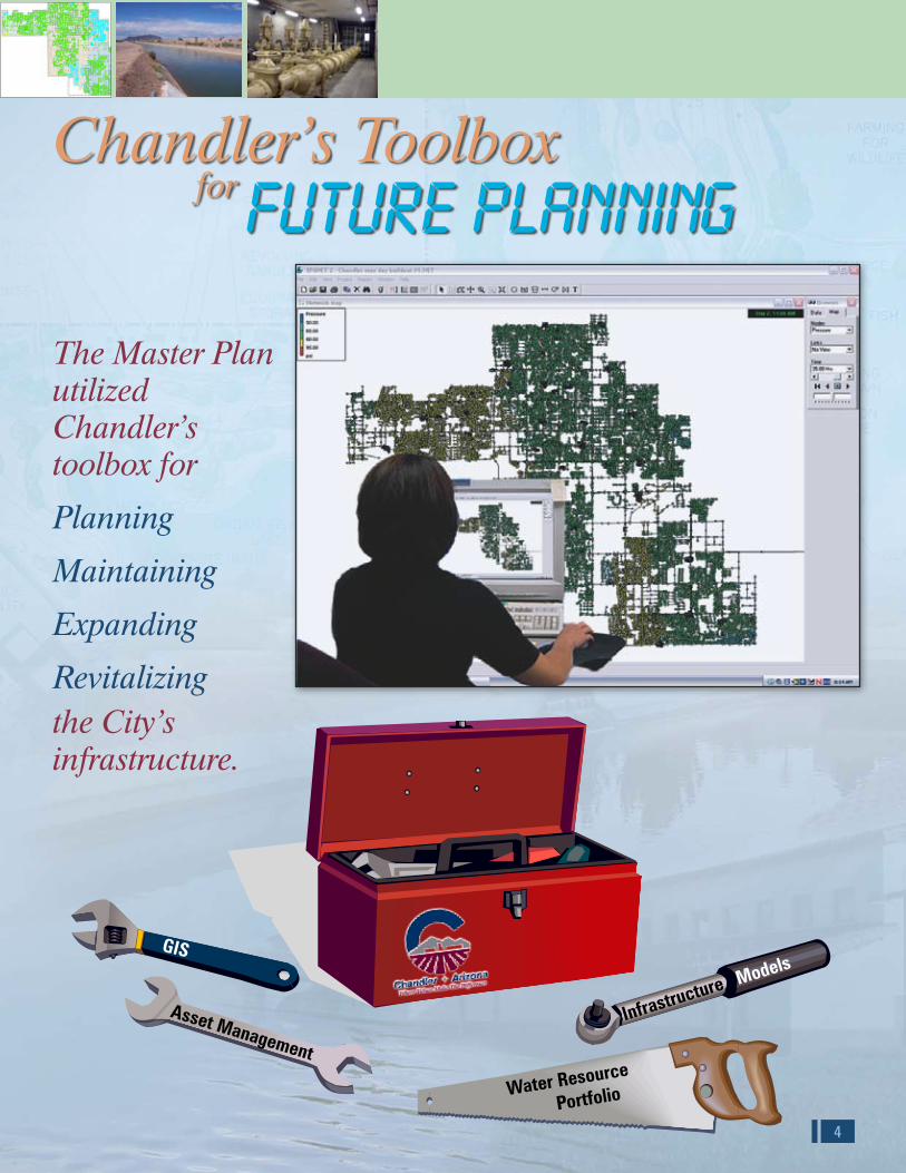
GIS
Asset Management
Water Resource
Portfolio
Infrastructure Models
Chandler’s Toolbox for Future Planning
The Master Plan utilized Chandler’s toolbox for
Planning
Maintaining
Expanding
Revitalizingthe City’s infrastructure.
Veterans Oasis Park
MAXIMUM DAY DEMAND MODELING RESULTSFigure 3.12City of Chandler Water, Wastewater, Reclaimed Water Master Plan Update
0 21
Miles
Pressure< 50 psi
50 - 70 psi
70 - 90 psi
90 - 100 psi
> 100 psi
Pipes
City Limits
Future Pressure Zones1 East
1 West
2
Printing Date: August 14, 2008File: M:\Client\Chandler\7792A00_MasterPlanUpdate\Reports\Draft Final Report\Maps\Fig 3_12.mxd
Reclaimed Water System Master Plan maximizes the utilization of a sustainable water resource
Pecos Rd1000 S
Frye Rd
Willis Rd
Germann Rd2000 S
4000
E
Lin
dsa
y R
d
Ryan Rd
Appleby Rd
Queen Creek Rd3000 S
Val
Vis
ta D
r50
00 E
Ocotillo Rd4000 S
Brooks Farm Rd
Chandler Heights Rd
7000 S
Riggs Rd
Hunt Hw
5000 S
6000 S
Cloud Rd
Doral Dr
Elli
st S
t
Pri
ce
Rd
3000
W
Dob
son
Rd
2000
W
Arr
owhe
ad D
r
Har
tford
St
Ham
ilton
St
1000
W
0Alm
a S
choo
l R
d
Ari
zon
a A
v
Coo
per
Rd
Gilb
ert
Rd
2000
E
3000
E
1000
EM
cQ
uee
n R
d
Ada
ms
Av
148t
h S
t
36''
24''
6''
30''
4''
8''
12''
24'' 12''
12''
12''
12''
12''
8''
12''
12''
12''
24''
12''
4''
12''
12''
12''
24''
24''
12''
24''
12''
12''
12''
12''
12''
24''
24''
24''
12''
24''
24''
12''
12''
12''12''
12''
4''
12''
12''
24''
12''
12''
12''
24''
12''
12''
12''
24''
12''
12''
24''
12''
24''
12''
24''
12''
12''
24''
12''
12''
24''
12''
12''
24''
12''
12''
24''
6''
12''
12''
12''
12''
12''
24''
12''
24''
8''
12''
12''
12''
8''
12''
12''
12''
12''
24''
12''
12''
12''
36''
12''
24''
24''
24''
12''
24''
24''
8''
12''
24''
12''
24''
12''
12''
24''
12''
12''
12''
12''
12''
12''
24''
12''
24''
12''
12'' 12''
24''
12''
24''
12''
24''
12''
36''36''
8''
24''
12''
24''
12''
24'' 24''
12''12''
12''
12''
12''
24''
12''
12''
12''
12''
12''
12''
24''
12''
24''
24''
12''12
''
12''
36''
12''
24''
12''
36''
12''
12''
12''
12''
24''
12''
24''
12''
24''
12''
24''
24''
12''
12''
12''
24''
RECLAIMED WATER SYSTEM INFRASTRUCTUREFigure 5.2
0 10.5
Miles
Large Users selection(Estimated MG/yr > 10)
Current UserAwaiting UserDeveloper-Installed Future Reclaimed Water Main
Small UsersCurrent UserAwaiting UserExisting Reclaimed Water MainFuture Reclaimed Water MainCity Limits
RoadsMileHalf MileResidentialWater Reclamation/Rechargeand Recovery Facilities
Printing Date: August 14, 2008File: M:\Client\Chandler\7792A00_MasterPlanUpdate\Reports\Draft Final Report\Maps\Fig 5_2.mxd
City of Chandler Water, Wastewater, Reclaimed Water Master Plan Update
Plant Capacity
5
Key Features
Recommendation for 6
10 mgd treatment expansion at the Ocotillo Water Reclamation Facility (WRF) for West Chandler, future growth, and committed industrial wastewater flows.
Ocotillo WRF Expansion 6
Preliminary Design/Feasibiliby Study.
Ocotillo WRF Short 6
Term Improvements.
West Chandler Lift 6
Station and Dual Force Main by 2017.
5 mgd expansion of 6
WRF capacity for future growth by 2017.
Committment to 6
ongoing asset management program for rehabilitation of facilities and sewer interceptors.
Force mains 6
interconnecting water reclamation facilities to transfer wastewater and reclaimed water increases redundancy and reliability.
Rehabilitation of 66-inch 6
sewer interceptor.
10
McK
emy
Av
Elm
St
Gal
axy
Dr
Cou
ntry
Clu
b W
y
Brooks Farm Rd
Appleby Rd
Willis Rd
Frye Rd
Galveston St
Knox Rd
Mesquite St
Western Canal
Ham
ilton
St
Har
tford
St
Arro
whe
ad D
r
Ellis
t St
Doral Dr
Cloud Rd
Ryan Rd
I-10
56th
St
Kyr
ene
Rd
Rur
al R
d
McC
linto
ck D
r
Pric
e R
d
Dob
son
Rd
Alm
a S
choo
l Rd
Ari
zona
Av
McQ
ueen
Rd
Coo
per
Rd
Gilb
ert
Rd
Lind
say
Rd
Val
Vis
ta D
r
Hunt Hw
Riggs Rd
Chandler Heights Rd
Ocotillo Rd
Germann Rd
Queen Creek Rd
Pecos Rd
Chandler Bl
Warner Rd
Ray Rd
Elliot Rd
7499
W
7000
W
6000
W
5000
W
4000
W
3000
W
2000
W
1000
W
0
1000
E
2000
E
3000
E
4000
E
5000
E
7000 S
6000 S
5000 S
4000 S
2000 S
3000 S
1000 S
200 N
2000 N
1000 N
3000 N
Ocotillo WRFAirport WRF
Riggs LS
Kyrene LS
Ocotillo LS
Sun Bird LS
Old Pecos LS
Golf Course LS
Pecos/McQueen LS
Manganaro LS
8''
48''
33''
27''
21''
42''
24''
30''
15''
12''
16''
18''
10''
6''
66''
39''
36''
4''
18''
18''
10''
12''21''
39''
15''
12''
8''
15''
33''
10''
12''
27''
15''
48''
24''
24''
8''
15''
12''
21''
10''
12''
66''
12''
21''
12''
27''
27''
8''
10''
18''
12''
12''
21''
12''
8''
10''
24''
15''
12''
21''
12''
12''
10''
12''
10''
12''
12''
24''
15''
15''
10''
12''
10''
10''
18''
24''
10''12''
18''
12''
18''18''
12''
15''
12''
12''
12''
10''
12''
12''
15''
18''
12''
12''
12''
27''
18''
24''
12''
18''
12''
10''
8''
12''
10''
15''
27''
12''
10''
12''
15''
12''
12''
18''
12''
18''
15''
30''
10''
10''
12''
10''
12''
18''
12''
12''
66''
10''
27''
10''
18''
48''
12''
12''
12''
15''
12''
12''
18''
12''
12''
10''
33''
8''
12''
18''
27''
12''
66''
18''
18''
21''
18''
48''
27''
18''
15''
18''
12''
18''
12''
24''
15''
12''
12''
27''
10''
18''
12''
10''
12''
12''
12''
6''
12''
15''
10''
10''
12''
15''
12''
12''
10''
10''
24''
24''
12''
12''
12''
12''
8''
27''
48''
10''
15''12''
10''
36''15''
12''
18''
18''
18''
10''
12''
12''18'' 12''
33''
15''
8''
15''
15''
10''
24''
30''
12''
12''
15''
48''
27''
10''
42''
10''
12''
10''
21''
12''
12''
30''
27''
36''
12''
15''
36''
12''
36''
10''
10''
12''
48''
10''
10''
15''
12''
6''
10''
12''
18''
10''
12''
10''
8''
8''
30''
10''
24''
8''
36''
18''
21''
12''
24''
12''
12''
42''
12''
10''
15''
10''
21''
36''
27''
12''
18''
10''
27''
10''
10''
15''
12''
27''
12''
10''
12''
12''
12''
10''
30''
18''
12''
12''
27''
10''
21''
10''
10''
18''
12''
8''
8''
18''
12''
12''
21''
15'' 27''
12''6''
27''
12''12''
24''
10''
18''
15''
12''
30''
10''
12''
10''
30''
30''
15''
27''
21''
12''
12''
18''
18''
12''
12''
12''
15''
24'' 12''
15''
24''
15''
12''
66''
21''
48''
15''
8''
12''
12''
18''
30''
30''
10''
10''
8''
24''
12''
12''
16''
8''
12''
33''
8''
12''
21''
12''
12''
12''
24''
10''
12''
36''
8''
48''
24''
42''
10''
12''
12''
66''
12''
10''
10''
8''
24''
30''
15''
12''
24''
8''
12''
8''
12''
15''
16''
18''
10''
BUILDOUT WASTEWATER COLLECTION SYSTEMFigure 4.22
Treatment Facility
Lift Station
Proposed West Chandler Lift Station
Buildout Wastewater Collection SystemGravity Pipe
Force Main
Proposed West Chandler Force Main
City Limits
Pima Utilities Service Area
TransportationRoads
Mile
Half Mile
Residential
Proposed West Chandler LS
City of Chandler Water, Wastewater, Reclaimed Water Master Plan Update
Printing Date: August 14, 2008File: M:\Client\Chandler\7792A00_MasterPlanUpdate\Reports\Draft Final Report\Maps\Fig 4_22.mxd
0 21
Miles
Airport WRF
McQueen
Price South #2
Basha #1
Basha #2
Basha #3
Alamosa Well #4
Alamosa Well #3
Alamosa Well #2
Layton Lakes
SWTP
Hunt
Frye
Erie
Knox
HahnColt
Warner
Airport
LindsayGilbert
Shawnee
Bush Way
Hightown
Monterey
Roosevelt
Arrowhead
Amberwood
West Pecos
Pennington
CAP Arizona
Golden Lane
CAP Hendrix
Dobson South
Desert Breeze
Price South #1
Alamosa Well #1
Brooks Crossing
JWTP
WATER SYSTEM CIP PROGRAM IMPLEMENTED BY BUILDOUTFigure 3.22City of Chandler Water, Wastewater, Reclaimed Water Master Plan Update
Proposed New CIP ImprovementsType
Booster Pump Station Improvement
Booster Pump Station Expansion
Additional Operational Storage
PRV
Water Facilities from FY 2008 - 2013 CIPType
WTP
Direct Discharge Well
Well Discharging to Storage
Booster Pump Station Improvements
PRV
Transmission Mains Diam
12"
16"
24" (Proposed to be Deleted)
Reservoir Supply System
Existing Water FacilitiesType
WTP
Reservoir
Booster Pump Station
Well Discharging to Storage
Direct Discharge Well
City Limits
Pima Utilities Service Area
Transmission Mains
Future Pressure Zones1
2
Rural
Apache
Printing Date: August 14, 2008File: M:\Client\Chandler\7792A00_MasterPlanUpdate\Reports\Draft Final Report\Maps\Fig 3_22.mxd
0 21
Miles
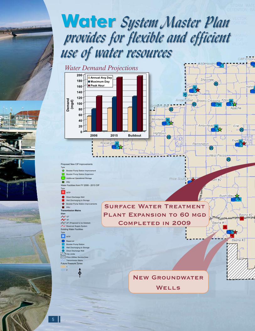
Water System Master Plan provides for flexible and efficient use of water resources
Surface Water Treatment Plant Expansion to 60 mgd
Completed in 2009
New Groundwater
Wells
0
20
40
60
80
100
Dem
and
(mgd
) 120
140
160
180
200
2006 2015 Buildout
Annual Avg DayMaximum DayPeak Hour
Water Demand Projections

Flow
(mgd
)
0
5
10
15
20
25
30
35
40
2007 2015 Buildout
Committed Industrial Flows
Economic Development
Land Use Base Flow
25.2
31.1
34.7
0
3.83.8 0.8
0.7
9
Projected Flows
0
2
4
6
8
10
12
14
16
18
20
2007
Cap
acity
(mgd
)
2015 Buildout
Lone Butte WWTPCapacity (outfall limited)Ocotillo WRF Treatment Capacity
Airport WRF Treatment Capacity
Plant CapacityOcotillo WRF
10 mgd Site Expansion
PRELIMINARYTREATMENTFACILITIES
AERATIONBASINS
ANOXICBASINS
ELECTRICALSUB-STATION
CHLORINECONTACTBASIN NO. 3
CHLORINECONTACTBASIN NO. 4
MBR TANKNO. 1
MBR TANKNO. 2
NEW CARBONFEED FACILITY
NEW SUBMERSIBLEPUMP
POTENTIALNEW ANOXIC
“SWING ZONES”
NEWCLARIFIER
NO. 4
McK
emy
Av
Elm
St
Gal
axy
Dr
Cou
ntry
Clu
b W
y
Brooks Farm Rd
Appleby Rd
Willis Rd
Frye Rd
Galveston St
Knox Rd
Mesquite St
Western Canal
Ham
ilton
St
Har
tford
St
Arro
whe
ad D
r
Ellis
t St
Doral Dr
Cloud Rd
Ryan Rd
I-10
56th
St
Kyr
ene
Rd
Rur
al R
d
McC
linto
ck D
r
Pric
e R
d
Dob
son
Rd
Alm
a S
choo
l Rd
Ari
zona
Av
McQ
ueen
Rd
Coo
per
Rd
Gilb
ert
Rd
Lind
say
Rd
Val
Vis
ta D
r
Hunt Hw
Riggs Rd
Chandler Heights Rd
Ocotillo Rd
Germann Rd
Queen Creek Rd
Pecos Rd
Chandler Bl
Warner Rd
Ray Rd
Elliot Rd
7499
W
7000
W
6000
W
5000
W
4000
W
3000
W
2000
W
1000
W
0
1000
E
2000
E
3000
E
4000
E
5000
E
7000 S
6000 S
5000 S
4000 S
2000 S
3000 S
1000 S
200 N
2000 N
1000 N
3000 N
Ocotillo WRFAirport WRF
Riggs LS
Kyrene LS
Ocotillo LS
Sun Bird LS
Old Pecos LS
Golf Course LS
Pecos/McQueen LS
Manganaro LS
8''
48''
33''
27''
21''
42''
24''
30''
15''
12''
16''
18''
10''
6''
66''
39''
36''
4''
18''
18''
10''
12''21''
39''
15''
12''
8''
15''
33''
10''
12''
27''
15''
48''
24''
24''
8''
15''
12''
21''
10''
12''
66''
12''
21''
12''
27''
27''
8''
10''
18''
12''
12''
21''
12''
8''
10''
24''
15''
12''
21''
12''
12''
10''
12''
10''
12''
12''
24''
15''
15''
10''
12''
10''
10''
18''
24''
10''12''
18''
12''
18''18''
12''
15''
12''
12''
12''
10''
12''
12''
15''
18''
12''
12''
12''
27''
18''
24''
12''
18''
12''
10''
8''
12''
10''
15''
27''
12''
10''
12''
15''
12''
12''
18''
12''
18''
15''
30''
10''
10''
12''
10''
12''
18''
12''
12''
66''
10''
27''
10''
18''
48''
12''
12''
12''
15''
12''
12''
18''
12''
12''
10''
33''
8''
12''
18''
27''
12''
66''
18''
18''
21''
18''
48''
27''
18''
15''
18''
12''
18''
12''
24''
15''
12''
12''
27''
10''
18''
12''
10''
12''
12''
12''
6''
12''
15''
10''
10''
12''
15''
12''
12''
10''
10''
24''
24''
12''
12''
12''
12''
8''
27''
48''
10''
15''12''
10''
36''15''
12''
18''
18''
18''
10''
12''
12''18'' 12''
33''
15''
8''15''
15''
10''
24''
30''
12''
12''
15''
48''
27''
10''
42''
10''
12''
10''
21''
12''
12''
30''
27''
36''
12''
15''
36''
12''
36''
10''
10''
12''
48''
10''
10''
15''
12''
6''
10''
12''
18''
10''
12''
10''
8''
8''
30''
10''
24''
8''
36''
18''
21''
12''
24''
12''12
''
42''
12''
10''
15''
10''
21''
36''
27''
12''
18''
10''
27''
10''
10''
15''
12''
27''
12''
10''
12''
12''
12''
10''
30''
18''
12''
12''
27''
10''
21''
10''10
''
18''
12''
8''
8''
18''
12''
12''
21''
15'' 27''
12''6''
27''
12''12''
24''
10''
18''
15''
12''
30''
10''
12''
10''
30''
30''
15''
27''
21''
12''
12''
18''
18''
12''
12''
12''
15''
24'' 12''
15''
24''
15''
12''
66''
21''
48''
15''
8''
12''
12''
18''
30''
30''
10''
10''
8''
24''
12''
12''
16''
8''
12''
33''
8''
12''
21''
12''
12''
12''
24''
10''
12''
36''
8''
48''
24''
42''
10''
12''
12''
66''
12''
10''
10''
8''
24''
30''
15''
12''
24''
8''
12''
8''
12''
15''
16''
18''
10''
BUILDOUT WASTEWATER COLLECTION SYSTEMFigure 4.22
Treatment Facility
Lift Station
Proposed West Chandler Lift Station
Buildout Wastewater Collection SystemGravity Pipe
Force Main
Proposed West Chandler Force Main
City Limits
Pima Utilities Service Area
TransportationRoads
Mile
Half Mile
Residential
Proposed West Chandler LS
City of Chandler Water, Wastewater, Reclaimed Water Master Plan Update
Printing Date: August 14, 2008File: M:\Client\Chandler\7792A00_MasterPlanUpdate\Reports\Draft Final Report\Maps\Fig 4_22.mxd
0 21
Miles
Wastewater System Master Plan solidifies future conveyance and treatment
New Pressure Zone Boundary Improves
Operation
New Reservoir Supply System Serves
Pressure Zone 2
Key Features
Santan Vista and Pecos 6
Water Treatment Plants provide 84 mgd treatment capacity and dual surface water sources for system reliability.
New pressure zone 6
boundary stabilizes system pressure and operation of Zone 1.
New groundwater 6
wells provide water supply reliability with a production capacity of 74.2 mgd.
Well capacity 6
maintenance.
Booster Pump Station 6
upgrades improve system operation and saves energy.
Alamosa WPF operational 6
storage.
Total water treatment 6
capacity will meet the annual average day demand during an emergency outage at either the Pecos or Santan Vista Water Treatment Plants. This amount of supply reliability will meet the basic needs for health, safety, and welfare of each household.
Future Asset 6
Management program.
Santan Vista Water Treatment Plant
Completed in 20096

LOOP 202
LOO
P10
1
RAY
RIGGS
PECOS
AR
IZO
NA
HUNT
CO
OPE
R
WARNER
CHANDLER
GIL
BER
T
GERMANN
ALM
ASC
HO
OL
ELLIOT
LIN
DSA
Y
56TH
VAL
VIST
A
CHANDLER HEIGHTS
MC
CLI
NTO
CK
MC
QU
EEN
RU
RA
L
PRIC
EO
LDPR
ICE
PRIE
ST
KYR
ENE
DO
BSO
N
MC
QU
EEN
QUEEN CREEK
PRIC
E
OCOTILLO
DO
BSO
N
K
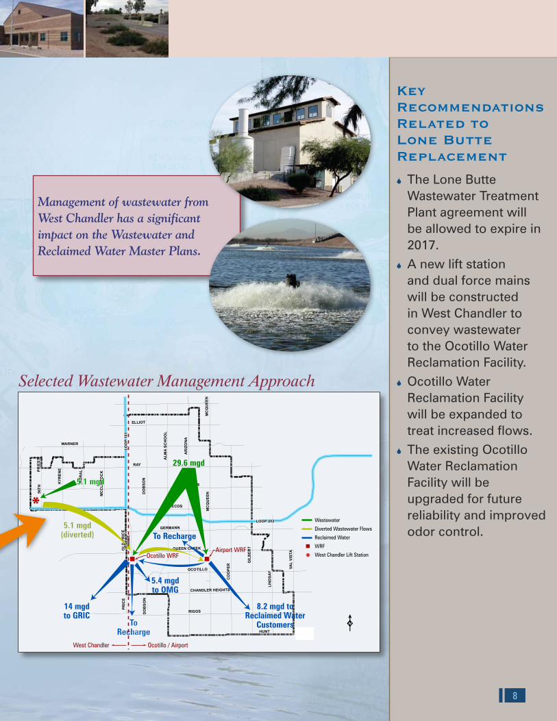
5.1 mgd
8.2 mgd toReclaimed Water
Customers
5.4 mgdto OMG
ToRecharge
5.1 mgd(diverted) To Recharge
14 mgdto GRIC
29.6 mgd
Ocotillo WRFAirport WRF
Wastewater
Diverted Wastewater Flows
Reclaimed Water
WRF
West Chandler Lift Station*
*
Ocotillo / AirportWest Chandler
Management of wastewater from West Chandler has a significant impact on the Wastewater and Reclaimed Water Master Plans.
Key Recommendations Related to Lone Butte Replacement
The Lone Butte 6
Wastewater Treatment Plant agreement will be allowed to expire in 2017.A new lift station 6
and dual force mains will be constructed in West Chandler to convey wastewater to the Ocotillo Water Reclamation Facility.Ocotillo Water 6
Reclamation Facility will be expanded to treat increased flows.The existing Ocotillo 6
Water Reclamation Facility will be upgraded for future reliability and improved odor control.
Selected Wastewater Management Approach
7 8
Decision Making Process Resolves Wastewater Management Approach
?Negotiate LoneButte WWTPAgreementIncludingReclaimedWater Credits?
?DraftAgreementIn Place?
2010 2012 2013 2014 20172008
Start Permits andRight-of-WayAcquisition
Feasibility Studyand CIP
Planning Update
Initial Cityof ChandlerCIP Planning
StartDesign
StartConstruction
WRF/ForceMain
Start-Up
T i m e l i n e
?FinalAgreement
Negotiated?
? Expand Ocotillo WRF or Airport WRF? To What Capacity?
? Expand Ocotillo WRF or Airport WRF? To What Capacity?
? Expand Ocotillo WRF or Airport WRF? To What Capacity?
6 mgd Lone Butte WWTP 14 mgd Ocotillo WRF (5 mgd conv. expansion) 15 mgd Airport WRF New Gravity Outfall from West Chandler to Lone Butte WWTP
6 mgd Lone Butte WWTP 10 mgd Ocotillo WRF 19 mgd Airport WRF (5 mgd conv. expansion) New Gravity Outfall from West Chandler to Lone Butte WWTP
6 mgd West Chandler WRF 14 mgd Ocotillo WRF (5 mgd conv. expansion) 15 mgd Airport WRF Reclaimed Water Force Main and Pumping from West Chandler WRF to Ocotillo WRF
6 mgd West Chandler WRF 10 mgd Ocotillo WRF 19 mgd Airport WRF (5 mgd conv. expansion) Reclaimed Water Force Main and Pumping from West Chandler WRF to Ocotillo WRF
20 mgd Ocotillo WRF (10 mgd MBR expansion) 15 mgd Airport WRF Raw Wastewater Force Main and Pumping from West Chandler to Ocotillo WRF
10 mgd Ocotillo WRF 25 mgd Airport WRF (10 mgd expansion) Raw Wastewater Force Main and Pumping from West Chandler to Ocotillo WRF Raw Wastewater Pumping from Ocotillo WRF to Airport WRF
Expand Ocotillo WRF
Expand Airport WRF
Expand Ocotillo WRF
Expand Airport WRF
Expand Ocotillo WRF
Expand Airport WRF
YES
YES
YESNO
NO
NO
NO
NO?Construct aWest ChandlerWRF?
35 mgdOcotillo/Airport
6 mgd WestChandler WRF29 mgd Ocotillo/Airport
Reclaimed Water ForceMain and Pumping fromWest Chandler WRFto Ocotillo WRF
Raw Wastewater ForceMain and Pumping fromWest Chandlerto Ocotillo WRF
6 mgd Lone Butte WWTP29 mgd Ocotillo/Airport
New GravityOutfall fromWest Chandler toLone Butte WWTP
P r o j e c tM i l e s t o n e s
The West Chandler Wastewater Management Study was a systematic approach to evaluating treatment alternatives for wastewater generated in West Chandler.The purpose of the study was to develop alternatives to the Lone Butte Wastewater Treatment Plant when the facility’s lease agreement expires in 2017.
Wastewater management alternatives were evaluated based upon technical/ institutional issues and estimated budgetary costs. The City used a weighting and ranking system to select the preferred wastewater management approach.
Evaluation Criteria Weighting Factor
Estimated Project Cost 20
Compatibility with Surrounding Community 20
Long-Term Operations and Maintenance Costs 15
Vulnerability to Catastrophic Failure (force mains, treatment facility, influent sewer, reclaimed water distribution)
10
Reclaimed Water Management 10
Operational Flexibility to Receive or Divert Wastewater
10
Right-of-Way/Easement/Permit Acquisition 5
Disruption to Community During Construction 5
Operational Control of Facilities 5
TOTAL 100
Ranking Description
6 Best alternative at satisfying the criterion
5 Much better at satisfying the criterion than the other alternatives
4 Better at satisfying the criterion than the other alternatives
3 Of equal satisfaction as the other alternatives
2 Less able to satisfy the criteria than the other alternatives
1 Much less able to satisfy the criteria than the other alternatives
Decision Matrix
LOOP 202
LOO
P10
1
RAY
RIGGS
PECOS
AR
IZO
NA
HUNT
CO
OPE
R
WARNER
CHANDLER
GIL
BER
T
GERMANN
ALM
ASC
HO
OL
ELLIOT
LIN
DSA
Y
56TH
VAL
VIST
A
CHANDLER HEIGHTS
MC
CLI
NTO
CK
MC
QU
EEN
RU
RA
L
PRIC
EO
LDPR
ICE
PRIE
ST
KYR
ENE
DO
BSO
N
MC
QU
EEN
QUEEN CREEK
PRIC
E
OCOTILLO
DO
BSO
N
K
5.1 mgd
8.2 mgd toReclaimed Water
Customers
5.4 mgdto OMG
ToRecharge
5.1 mgd(diverted) To Recharge
14 mgdto GRIC
29.6 mgd
Ocotillo WRFAirport WRF
Wastewater
Diverted Wastewater Flows
Reclaimed Water
WRF
West Chandler Lift Station*
*
Ocotillo / AirportWest Chandler
Management of wastewater from West Chandler has a significant impact on the Wastewater and Reclaimed Water Master Plans.
Key Recommendations Related to Lone Butte Replacement
The Lone Butte 6
Wastewater Treatment Plant agreement will be allowed to expire in 2017.A new lift station 6
and dual force mains will be constructed in West Chandler to convey wastewater to the Ocotillo Water Reclamation Facility.Ocotillo Water 6
Reclamation Facility will be expanded to treat increased flows.The existing Ocotillo 6
Water Reclamation Facility will be upgraded for future reliability and improved odor control.
Selected Wastewater Management Approach
7 8
Decision Making Process Resolves Wastewater Management Approach
?Negotiate LoneButte WWTPAgreementIncludingReclaimedWater Credits?
?DraftAgreementIn Place?
2010 2012 2013 2014 20172008
Start Permits andRight-of-WayAcquisition
Feasibility Studyand CIP
Planning Update
Initial Cityof ChandlerCIP Planning
StartDesign
StartConstruction
WRF/ForceMain
Start-Up
T i m e l i n e
?FinalAgreement
Negotiated?
? Expand Ocotillo WRF or Airport WRF? To What Capacity?
? Expand Ocotillo WRF or Airport WRF? To What Capacity?
? Expand Ocotillo WRF or Airport WRF? To What Capacity?
6 mgd Lone Butte WWTP 14 mgd Ocotillo WRF (5 mgd conv. expansion) 15 mgd Airport WRF New Gravity Outfall from West Chandler to Lone Butte WWTP
6 mgd Lone Butte WWTP 10 mgd Ocotillo WRF 19 mgd Airport WRF (5 mgd conv. expansion) New Gravity Outfall from West Chandler to Lone Butte WWTP
6 mgd West Chandler WRF 14 mgd Ocotillo WRF (5 mgd conv. expansion) 15 mgd Airport WRF Reclaimed Water Force Main and Pumping from West Chandler WRF to Ocotillo WRF
6 mgd West Chandler WRF 10 mgd Ocotillo WRF 19 mgd Airport WRF (5 mgd conv. expansion) Reclaimed Water Force Main and Pumping from West Chandler WRF to Ocotillo WRF
20 mgd Ocotillo WRF (10 mgd MBR expansion) 15 mgd Airport WRF Raw Wastewater Force Main and Pumping from West Chandler to Ocotillo WRF
10 mgd Ocotillo WRF 25 mgd Airport WRF (10 mgd expansion) Raw Wastewater Force Main and Pumping from West Chandler to Ocotillo WRF Raw Wastewater Pumping from Ocotillo WRF to Airport WRF
Expand Ocotillo WRF
Expand Airport WRF
Expand Ocotillo WRF
Expand Airport WRF
Expand Ocotillo WRF
Expand Airport WRF
YES
YES
YESNO
NO
NO
NO
NO?Construct aWest ChandlerWRF?
35 mgdOcotillo/Airport
6 mgd WestChandler WRF29 mgd Ocotillo/Airport
Reclaimed Water ForceMain and Pumping fromWest Chandler WRFto Ocotillo WRF
Raw Wastewater ForceMain and Pumping fromWest Chandlerto Ocotillo WRF
6 mgd Lone Butte WWTP29 mgd Ocotillo/Airport
New GravityOutfall fromWest Chandler toLone Butte WWTP
P r o j e c tM i l e s t o n e s
The West Chandler Wastewater Management Study was a systematic approach to evaluating treatment alternatives for wastewater generated in West Chandler.The purpose of the study was to develop alternatives to the Lone Butte Wastewater Treatment Plant when the facility’s lease agreement expires in 2017.
Wastewater management alternatives were evaluated based upon technical/ institutional issues and estimated budgetary costs. The City used a weighting and ranking system to select the preferred wastewater management approach.
Evaluation Criteria Weighting Factor
Estimated Project Cost 20
Compatibility with Surrounding Community 20
Long-Term Operations and Maintenance Costs 15
Vulnerability to Catastrophic Failure (force mains, treatment facility, influent sewer, reclaimed water distribution)
10
Reclaimed Water Management 10
Operational Flexibility to Receive or Divert Wastewater
10
Right-of-Way/Easement/Permit Acquisition 5
Disruption to Community During Construction 5
Operational Control of Facilities 5
TOTAL 100
Ranking Description
6 Best alternative at satisfying the criterion
5 Much better at satisfying the criterion than the other alternatives
4 Better at satisfying the criterion than the other alternatives
3 Of equal satisfaction as the other alternatives
2 Less able to satisfy the criteria than the other alternatives
1 Much less able to satisfy the criteria than the other alternatives
Decision Matrix

Flow
(mgd
)
0
5
10
15
20
25
30
35
40
2007 2015 Buildout
Committed Industrial Flows
Economic Development
Land Use Base Flow
25.2
31.1
34.7
0
3.83.8 0.8
0.7
9
Projected Flows
0
2
4
6
8
10
12
14
16
18
20
2007
Cap
acity
(mgd
)
2015 Buildout
Lone Butte WWTPCapacity (outfall limited)Ocotillo WRF Treatment Capacity
Airport WRF Treatment Capacity
Plant CapacityOcotillo WRF
10 mgd Site Expansion
PRELIMINARYTREATMENTFACILITIES
AERATIONBASINS
ANOXICBASINS
ELECTRICALSUB-STATION
CHLORINECONTACTBASIN NO. 3
CHLORINECONTACTBASIN NO. 4
MBR TANKNO. 1
MBR TANKNO. 2
NEW CARBONFEED FACILITY
NEW SUBMERSIBLEPUMP
POTENTIALNEW ANOXIC
“SWING ZONES”
NEWCLARIFIER
NO. 4
McK
emy
Av
Elm
St
Gal
axy
Dr
Cou
ntry
Clu
b W
y
Brooks Farm Rd
Appleby Rd
Willis Rd
Frye Rd
Galveston St
Knox Rd
Mesquite St
Western Canal
Ham
ilton
St
Har
tford
St
Arro
whe
ad D
r
Ellis
t St
Doral Dr
Cloud Rd
Ryan Rd
I-10
56th
St
Kyr
ene
Rd
Rur
al R
d
McC
linto
ck D
r
Pric
e R
d
Dob
son
Rd
Alm
a S
choo
l Rd
Ari
zona
Av
McQ
ueen
Rd
Coo
per
Rd
Gilb
ert
Rd
Lind
say
Rd
Val
Vis
ta D
r
Hunt Hw
Riggs Rd
Chandler Heights Rd
Ocotillo Rd
Germann Rd
Queen Creek Rd
Pecos Rd
Chandler Bl
Warner Rd
Ray Rd
Elliot Rd
7499
W
7000
W
6000
W
5000
W
4000
W
3000
W
2000
W
1000
W
0
1000
E
2000
E
3000
E
4000
E
5000
E
7000 S
6000 S
5000 S
4000 S
2000 S
3000 S
1000 S
200 N
2000 N
1000 N
3000 N
Ocotillo WRFAirport WRF
Riggs LS
Kyrene LS
Ocotillo LS
Sun Bird LS
Old Pecos LS
Golf Course LS
Pecos/McQueen LS
Manganaro LS
8''
48''
33''
27''
21''
42''
24''
30''
15''
12''
16''
18''
10''
6''
66''
39''
36''
4''
18''
18''
10''
12''21''
39''
15''
12''
8''
15''
33''
10''
12''
27''
15''
48''
24''
24''
8''
15''
12''
21''
10''
12''
66''
12''
21''
12''
27''
27''
8''
10''
18''
12''
12''
21''
12''
8''
10''
24''
15''
12''
21''
12''
12''
10''
12''
10''
12''
12''
24''
15''
15''
10''
12''
10''
10''
18''
24''
10''12''
18''
12''
18''18''
12''
15''
12''
12''
12''
10''
12''
12''
15''
18''
12''
12''
12''
27''
18''
24''
12''
18''
12''
10''
8''
12''
10''
15''
27''
12''
10''
12''
15''
12''
12''
18''
12''
18''
15''
30''
10''
10''
12''
10''
12''
18''
12''
12''
66''
10''
27''
10''
18''
48''
12''
12''
12''
15''
12''
12''
18''
12''
12''
10''
33''
8''
12''
18''
27''
12''
66''
18''
18''
21''
18''
48''
27''
18''
15''
18''
12''
18''
12''
24''
15''
12''
12''
27''
10''
18''
12''
10''
12''
12''
12''
6''
12''
15''
10''
10''
12''
15''
12''
12''
10''
10''
24''
24''
12''
12''
12''
12''
8''
27''
48''
10''
15''12''
10''
36''15''
12''
18''
18''
18''
10''
12''
12''18'' 12''
33''
15''
8''
15''
15''
10''
24''
30''
12''
12''
15''
48''
27''
10''
42''
10''
12''
10''
21''
12''
12''
30''
27''
36''
12''
15''
36''
12''
36''
10''
10''
12''
48''
10''
10''
15''
12''
6''
10''
12''
18''
10''
12''
10''
8''
8''
30''
10''
24''
8''
36''
18''
21''
12''
24''
12''
12''
42''
12''
10''
15''
10''
21''
36''
27''
12''
18''
10''
27''
10''
10''
15''
12''
27''
12''
10''
12''
12''
12''
10''
30''
18''
12''
12''
27''
10''
21''
10''
10''
18''
12''
8''
8''
18''
12''
12''
21''
15'' 27''
12''6''
27''
12''12''
24''
10''
18''
15''
12''
30''
10''
12''
10''
30''
30''
15''
27''
21''
12''
12''
18''
18''
12''
12''
12''
15''
24'' 12''
15''
24''
15''
12''
66''
21''
48''
15''
8''
12''
12''
18''
30''
30''
10''
10''
8''
24''
12''
12''
16''
8''
12''
33''
8''
12''
21''
12''
12''
12''
24''
10''
12''
36''
8''
48''
24''
42''
10''
12''
12''
66''
12''
10''
10''
8''
24''
30''
15''
12''
24''
8''
12''
8''
12''
15''
16''
18''
10''
BUILDOUT WASTEWATER COLLECTION SYSTEMFigure 4.22
Treatment Facility
Lift Station
Proposed West Chandler Lift Station
Buildout Wastewater Collection SystemGravity Pipe
Force Main
Proposed West Chandler Force Main
City Limits
Pima Utilities Service Area
TransportationRoads
Mile
Half Mile
Residential
Proposed West Chandler LS
City of Chandler Water, Wastewater, Reclaimed Water Master Plan Update
Printing Date: August 14, 2008File: M:\Client\Chandler\7792A00_MasterPlanUpdate\Reports\Draft Final Report\Maps\Fig 4_22.mxd
0 21
Miles
Wastewater System Master Plan solidifies future conveyance and treatment
New Pressure Zone Boundary Improves
Operation
New Reservoir Supply System Serves
Pressure Zone 2
Key Features
Santan Vista and Pecos 6
Water Treatment Plants provide 84 mgd treatment capacity and dual surface water sources for system reliability.
New pressure zone 6
boundary stabilizes system pressure and operation of Zone 1.
New groundwater 6
wells provide water supply reliability with a production capacity of 74.2 mgd.
Well capacity 6
maintenance.
Booster Pump Station 6
upgrades improve system operation and saves energy.
Alamosa WPF operational 6
storage.
Total water treatment 6
capacity will meet the annual average day demand during an emergency outage at either the Pecos or Santan Vista Water Treatment Plants. This amount of supply reliability will meet the basic needs for health, safety, and welfare of each household.
Future Asset 6
Management program.
Santan Vista Water Treatment Plant
Completed in 20096

Plant Capacity
5
Key Features
Recommendation for 6
10 mgd treatment expansion at the Ocotillo Water Reclamation Facility (WRF) for West Chandler, future growth, and committed industrial wastewater flows.
Ocotillo WRF Expansion 6
Preliminary Design/Feasibiliby Study.
Ocotillo WRF Short 6
Term Improvements.
West Chandler Lift 6
Station and Dual Force Main by 2017.
5 mgd expansion of 6
WRF capacity for future growth by 2017.
Committment to 6
ongoing asset management program for rehabilitation of facilities and sewer interceptors.
Force mains 6
interconnecting water reclamation facilities to transfer wastewater and reclaimed water increases redundancy and reliability.
Rehabilitation of 66-inch 6
sewer interceptor.
10
McK
emy
Av
Elm
St
Gal
axy
Dr
Cou
ntry
Clu
b W
y
Brooks Farm Rd
Appleby Rd
Willis Rd
Frye Rd
Galveston St
Knox Rd
Mesquite St
Western Canal
Ham
ilton
St
Har
tford
St
Arro
whe
ad D
r
Ellis
t St
Doral Dr
Cloud Rd
Ryan Rd
I-10
56th
St
Kyr
ene
Rd
Rur
al R
d
McC
linto
ck D
r
Pric
e R
d
Dob
son
Rd
Alm
a S
choo
l Rd
Ari
zona
Av
McQ
ueen
Rd
Coo
per
Rd
Gilb
ert
Rd
Lind
say
Rd
Val
Vis
ta D
r
Hunt Hw
Riggs Rd
Chandler Heights Rd
Ocotillo Rd
Germann Rd
Queen Creek Rd
Pecos Rd
Chandler Bl
Warner Rd
Ray Rd
Elliot Rd
7499
W
7000
W
6000
W
5000
W
4000
W
3000
W
2000
W
1000
W
0
1000
E
2000
E
3000
E
4000
E
5000
E
7000 S
6000 S
5000 S
4000 S
2000 S
3000 S
1000 S
200 N
2000 N
1000 N
3000 N
Ocotillo WRFAirport WRF
Riggs LS
Kyrene LS
Ocotillo LS
Sun Bird LS
Old Pecos LS
Golf Course LS
Pecos/McQueen LS
Manganaro LS
8''
48''
33''
27''
21''
42''
24''
30''
15''
12''
16''
18''
10''
6''
66''
39''
36''
4''
18''
18''
10''
12''21''
39''
15''
12''
8''
15''
33''
10''
12''
27''
15''
48''
24''
24''
8''
15''
12''
21''
10''
12''
66''
12''
21''
12''
27''
27''
8''
10''
18''
12''
12''
21''
12''
8''
10''
24''
15''
12''
21''
12''
12''
10''
12''
10''
12''
12''
24''
15''
15''
10''
12''
10''
10''
18''
24''
10''12''
18''
12''
18''18''
12''
15''
12''
12''
12''
10''
12''
12''
15''
18''
12''
12''
12''
27''
18''
24''
12''
18''
12''
10''
8''
12''
10''
15''
27''
12''
10''
12''
15''
12''
12''
18''
12''
18''
15''
30''
10''
10''
12''
10''
12''
18''
12''
12''
66''
10''
27''
10''
18''
48''
12''
12''
12''
15''
12''
12''
18''
12''
12''
10''
33''
8''
12''
18''
27''
12''
66''
18''
18''
21''
18''
48''
27''
18''
15''
18''
12''
18''
12''
24''
15''
12''
12''
27''
10''
18''
12''
10''
12''
12''
12''
6''
12''
15''
10''
10''
12''
15''
12''
12''
10''
10''
24''
24''
12''
12''
12''
12''
8''
27''
48''
10''
15''12''
10''
36''15''
12''
18''
18''
18''
10''
12''
12''18'' 12''
33''
15''
8''15''
15''
10''
24''
30''
12''
12''
15''
48''
27''
10''
42''
10''
12''
10''
21''
12''
12''
30''
27''
36''
12''
15''
36''
12''
36''
10''
10''
12''
48''
10''
10''
15''
12''
6''
10''
12''
18''
10''
12''
10''
8''
8''
30''
10''
24''
8''
36''
18''
21''
12''
24''
12''12
''
42''
12''
10''
15''
10''
21''
36''
27''
12''
18''
10''
27''
10''
10''
15''
12''
27''
12''
10''
12''
12''
12''
10''
30''
18''
12''
12''
27''
10''
21''
10''10
''
18''
12''
8''
8''
18''
12''
12''
21''
15'' 27''
12''6''
27''
12''12''
24''
10''
18''
15''
12''
30''
10''
12''
10''
30''
30''
15''
27''
21''
12''
12''
18''
18''
12''
12''
12''
15''
24'' 12''
15''
24''
15''
12''
66''
21''
48''
15''
8''
12''
12''
18''
30''
30''
10''
10''
8''
24''
12''
12''
16''
8''
12''
33''
8''
12''
21''
12''
12''
12''
24''
10''
12''
36''
8''
48''
24''
42''
10''
12''
12''
66''
12''
10''
10''
8''
24''
30''
15''
12''
24''
8''
12''
8''
12''
15''
16''
18''
10''
BUILDOUT WASTEWATER COLLECTION SYSTEMFigure 4.22
Treatment Facility
Lift Station
Proposed West Chandler Lift Station
Buildout Wastewater Collection SystemGravity Pipe
Force Main
Proposed West Chandler Force Main
City Limits
Pima Utilities Service Area
TransportationRoads
Mile
Half Mile
Residential
Proposed West Chandler LS
City of Chandler Water, Wastewater, Reclaimed Water Master Plan Update
Printing Date: August 14, 2008File: M:\Client\Chandler\7792A00_MasterPlanUpdate\Reports\Draft Final Report\Maps\Fig 4_22.mxd
0 21
Miles
McK
emy
Av
Elm
St
Gal
axy
Dr
Cou
ntry
Clu
b W
y
Brooks Farm Rd
Appleby Rd
Willis Rd
Frye Rd
Galveston St
Knox Rd
Mesquite St
Western Canal
Ham
ilton
St
Har
tford
St
Arro
whe
ad D
r
Ellis
t St
Doral Dr
Cloud Rd
Ryan Rd
I-10
56th
St
Kyr
ene
Rd
Rur
al R
d
McC
linto
ck D
r
Pric
e R
d
Dob
son
Rd
Alm
a S
choo
l Rd
Ari
zona
Av
McQ
ueen
Rd
Coo
per
Rd
Gilb
ert
Rd
Lind
say
Rd
Val
Vis
ta D
r
Hunt Hw
Riggs Rd
Chandler Heights Rd
Ocotillo Rd
Germann Rd
Queen Creek Rd
Pecos Rd
Chandler Bl
Warner Rd
Ray Rd
Elliot Rd
7499
W
7000
W
6000
W
5000
W
4000
W
3000
W
2000
W
1000
W
0
1000
E
2000
E
3000
E
4000
E
5000
E
7000 S
6000 S
5000 S
4000 S
2000 S
3000 S
1000 S
200 N
2000 N
1000 N
3000 N
Ocotillo WRFAirport WRF
Riggs LS
Kyrene LS
Ocotillo LS
Sun Bird LS
Old Pecos LS
Golf Course LS
Pecos/McQueen LS
Manganaro LS
8''
48''
33''
27''
21''
42''
24''
30''
15''
12''
16''
18''
10''
6''
66''
39''
36''
4''
18''
18''
10''
12''21''
39''
15''
12''
8''
15''
33''
10''
12''
27''
15''
48''
24''
24''
8''
15''
12''
21''
10''
12''
66''
12''
21''
12''
27''
27''
8''
10''
18''
12''
12''
21''
12''
8''
10''
24''
15''
12''
21''
12''
12''
10''
12''
10''
12''
12''
24''
15''
15''
10''
12''
10''
10''
18''
24''
10''12''
18''
12''
18''18''
12''
15''
12''
12''
12''
10''
12''
12''
15''
18''
12''
12''
12''
27''
18''
24''
12''
18''
12''
10''
8''
12''
10''
15''
27''
12''
10''
12''
15''
12''
12''
18''
12''
18''
15''
30''
10''
10''
12''
10''
12''
18''
12''
12''
66''
10''
27''
10''
18''
48''
12''
12''
12''
15''
12''
12''
18''
12''
12''
10''
33''
8''
12''
18''
27''
12''
66''
18''
18''
21''
18''
48''
27''
18''
15''
18''
12''
18''
12''
24''
15''
12''
12''
27''
10''
18''
12''
10''
12''
12''
12''
6''
12''
15''
10''
10''
12''
15''
12''
12''
10''
10''
24''
24''
12''
12''
12''
12''
8''
27''
48''
10''
15''12''
10''
36''15''
12''
18''
18''
18''
10''
12''
12''18'' 12''
33''
15''
8''
15''
15''
10''
24''
30''
12''
12''
15''
48''
27''
10''
42''
10''
12''
10''
21''
12''
12''
30''
27''
36''
12''
15''
36''
12''
36''
10''
10''
12''
48''
10''
10''
15''
12''
6''
10''
12''
18''
10''
12''
10''
8''
8''
30''
10''
24''
8''
36''
18''
21''
12''
24''
12''
12''
42''
12''
10''
15''
10''
21''
36''
27''
12''
18''
10''
27''
10''
10''
15''
12''
27''
12''
10''
12''
12''
12''
10''
30''
18''
12''
12''
27''
10''
21''
10''
10''
18''
12''
8''
8''
18''
12''
12''
21''
15'' 27''
12''6''
27''
12''12''
24''
10''
18''
15''
12''
30''
10''
12''
10''
30''
30''
15''
27''
21''
12''
12''
18''
18''
12''
12''
12''
15''
24'' 12''
15''
24''
15''
12''
66''
21''
48''
15''
8''
12''
12''
18''
30''
30''
10''
10''
8''
24''
12''
12''
16''
8''
12''
33''
8''
12''
21''
12''
12''
12''
24''
10''
12''
36''
8''
48''
24''
42''
10''
12''
12''
66''
12''
10''
10''
8''
24''
30''
15''
12''
24''
8''
12''
8''
12''
15''
16''
18''
10''
BUILDOUT WASTEWATER COLLECTION SYSTEMFigure 4.22
Treatment Facility
Lift Station
Proposed West Chandler Lift Station
Buildout Wastewater Collection SystemGravity Pipe
Force Main
Proposed West Chandler Force Main
City Limits
Pima Utilities Service Area
TransportationRoads
Mile
Half Mile
Residential
Proposed West Chandler LS
City of Chandler Water, Wastewater, Reclaimed Water Master Plan Update
Printing Date: August 14, 2008File: M:\Client\Chandler\7792A00_MasterPlanUpdate\Reports\Draft Final Report\Maps\Fig 4_22.mxd
0 21
Miles
Airport WRF
McQueen
Price South #2
Basha #1
Basha #2
Basha #3
Alamosa Well #4
Alamosa Well #3
Alamosa Well #2
Layton Lakes
SWTP
Hunt
Frye
Erie
Knox
HahnColt
Warner
Airport
LindsayGilbert
Shawnee
Bush Way
Hightown
Monterey
Roosevelt
Arrowhead
Amberwood
West Pecos
Pennington
CAP Arizona
Golden Lane
CAP Hendrix
Dobson South
Desert Breeze
Price South #1
Alamosa Well #1
Brooks Crossing
JWTP
WATER SYSTEM CIP PROGRAM IMPLEMENTED BY BUILDOUTFigure 3.22City of Chandler Water, Wastewater, Reclaimed Water Master Plan Update
Proposed New CIP ImprovementsType
Booster Pump Station Improvement
Booster Pump Station Expansion
Additional Operational Storage
PRV
Water Facilities from FY 2008 - 2013 CIPType
WTP
Direct Discharge Well
Well Discharging to Storage
Booster Pump Station Improvements
PRV
Transmission Mains Diam
12"
16"
24" (Proposed to be Deleted)
Reservoir Supply System
Existing Water FacilitiesType
WTP
Reservoir
Booster Pump Station
Well Discharging to Storage
Direct Discharge Well
City Limits
Pima Utilities Service Area
Transmission Mains
Future Pressure Zones1
2
Rural
Apache
Printing Date: August 14, 2008File: M:\Client\Chandler\7792A00_MasterPlanUpdate\Reports\Draft Final Report\Maps\Fig 3_22.mxd
0 21
Miles
Water System Master Plan provides for flexible and efficient use of water resources
Surface Water Treatment Plant Expansion to 60 mgd
Completed in 2009
New Groundwater
Wells
0
20
40
60
80
100
Dem
and
(mgd
) 120
140
160
180
200
2006 2015 Buildout
Annual Avg DayMaximum DayPeak Hour
Water Demand Projections

11 4
Wastewater
Airport WaterReclamation Facility
Ocotillo WaterReclamation Facility
Gila River Indian Communityand
Ocotillo Management Group
Southeast ChandlerDirect Reuse
Recharge
Recovery
100% Management ofReclaimed Water
GIS
Asset Management
Water Resource
Portfolio
Infrastructure Models
Chandler’s Toolbox for Future Planning
The Master Plan utilized Chandler’s toolbox for
Planning
Maintaining
Expanding
Revitalizingthe City’s infrastructure.
Veterans Oasis Park
MAXIMUM DAY DEMAND MODELING RESULTSFigure 3.12City of Chandler Water, Wastewater, Reclaimed Water Master Plan Update
0 21
Miles
Pressure< 50 psi
50 - 70 psi
70 - 90 psi
90 - 100 psi
> 100 psi
Pipes
City Limits
Future Pressure Zones1 East
1 West
2
Printing Date: August 14, 2008File: M:\Client\Chandler\7792A00_MasterPlanUpdate\Reports\Draft Final Report\Maps\Fig 3_12.mxd
Reclaimed Water System Master Plan maximizes the utilization of a sustainable water resource
Pecos Rd1000 S
Frye Rd
Willis Rd
Germann Rd2000 S
4000
E
Lin
dsa
y R
d
Ryan Rd
Appleby Rd
Queen Creek Rd3000 S
Val
Vis
ta D
r50
00 E
Ocotillo Rd4000 S
Brooks Farm Rd
Chandler Heights Rd
7000 S
Riggs Rd
Hunt Hw
5000 S
6000 S
Cloud Rd
Doral Dr
Elli
st S
t
Pri
ce
Rd
3000
W
Dob
son
Rd
2000
W
Arr
owhe
ad D
r
Har
tford
St
Ham
ilton
St
1000
W
0Alm
a S
choo
l R
d
Ari
zon
a A
v
Coo
per
Rd
Gilb
ert
Rd
2000
E
3000
E
1000
EM
cQ
uee
n R
d
Ada
ms
Av
148t
h S
t
36''
24''
6''
30''
4''
8''
12''
24'' 12''
12''
12''
12''
12''
8''
12''
12''
12''
24''
12''
4''
12''
12''
12''
24''
24''
12''
24''
12''
12''
12''
12''
12''
24''
24''
24''
12''
24''
24''
12''
12''
12''12''
12''
4''
12''
12''
24''
12''
12''
12''
24''
12''
12''
12''
24''
12''
12''
24''
12''
24''
12''
24''
12''
12''
24''
12''
12''
24''
12''
12''
24''
12''
12''
24''
6''
12''
12''
12''
12''
12''
24''
12''
24''
8''
12''
12''
12''
8''
12''
12''
12''
12''
24''
12''
12''
12''
36''
12''
24''
24''
24''
12''
24''
24''
8''
12''
24''
12''
24''
12''
12''
24''
12''
12''
12''
12''
12''
12''
24''
12''
24''
12''
12'' 12''
24''
12''
24''
12''
24''
12''
36''36''
8''
24''
12''
24''
12''
24'' 24''
12''12''
12''
12''
12''
24''
12''
12''
12''
12''
12''
12''
24''
12''
24''
24''
12''12
''
12''
36''
12''
24''
12''
36''
12''
12''
12''
12''
24''
12''
24''
12''
24''
12''
24''
24''
12''
12''
12''
24''
RECLAIMED WATER SYSTEM INFRASTRUCTUREFigure 5.2
0 10.5
Miles
Large Users selection(Estimated MG/yr > 10)
Current UserAwaiting UserDeveloper-Installed Future Reclaimed Water Main
Small UsersCurrent UserAwaiting UserExisting Reclaimed Water MainFuture Reclaimed Water MainCity Limits
RoadsMileHalf MileResidentialWater Reclamation/Rechargeand Recovery Facilities
Printing Date: August 14, 2008File: M:\Client\Chandler\7792A00_MasterPlanUpdate\Reports\Draft Final Report\Maps\Fig 5_2.mxd
City of Chandler Water, Wastewater, Reclaimed Water Master Plan Update

Key Features
Ocotillo WRF GRIC, 6
and recharge pump station expansion.Aquifer storage 6
and recovery well capacity expansion.Reconfigured 6
delivery system saves costs and improves operation.Chandler’s 6
recharge facilities provide for 100% reclaimed water utilization.System operation is 6
managed through scheduling of user deliveries.Locating recharge 6
and reuse facilities at the City’s multi-use sites provides for efficient use of land resources.
3 12
2008Master Plan
Reclaimed WaterSystem
WastewaterSystem
WaterSystem
WaterResources
The Master Plan
consists of strategies
to develop, manage,
and use Chandler’s
surface water,
groundwater, and
reclaimed water
resources.
The Master Plan
has been developed
utilizing an integrated
approach.
“Integration” is the process of planning and designing infrastructure in a coordinated manner to maximize the use of available water resources.
Tumbleweed Park Recharge and Recovery Facility
Pecos Rd1000 S
Frye Rd
Willis Rd
Germann Rd2000 S
4000
E
Lin
dsa
y R
d
Ryan Rd
Appleby Rd
Queen Creek Rd3000 S
Val
Vis
ta D
r50
00 E
Ocotillo Rd4000 S
Brooks Farm Rd
Chandler Heights Rd
7000 S
Riggs Rd
Hunt Hw
5000 S
6000 S
Cloud Rd
Doral Dr
Elli
st S
t
Pri
ce
Rd
3000
W
Dob
son
Rd
2000
W
Arr
owhe
ad D
r
Har
tford
St
Ham
ilton
St
1000
W
0Alm
a S
choo
l R
d
Ari
zon
a A
v
Coo
per
Rd
Gilb
ert
Rd
2000
E
3000
E
1000
EM
cQ
uee
n R
d
Ada
ms
Av
148t
h S
t
36''
24''
6''
30''
4''
8''
12''
24'' 12''
12''
12''
12''
12''
8''
12''
12''
12''
24''
12''
4''
12''
12''
12''
24''
24''
12''
24''
12''
12''
12''
12''
12''
24''
24''
24''
12''
24''
24''
12''
12''
12''12''
12''
4''
12''
12''
24''
12''
12''
12''
24''
12''
12''
12''
24''
12''
12''
24''
12''
24''
12''
24''
12''
12''
24''
12''
12''
24''
12''
12''
24''
12''
12''
24''
6''
12''
12''
12''
12''
12''
24''
12''
24''
8''
12''
12''
12''
8''
12''
12''
12''
12''
24''
12''
12''
12''
36''
12''
24''
24''
24''
12''
24''
24''
8''
12''
24''
12''
24''
12''
12''
24''
12''
12''
12''
12''
12''
12''
24''
12''
24''
12''
12'' 12''
24''
12''
24''
12''
24''
12''
36''36''
8''
24''
12''
24''
12''
24'' 24''
12''12''
12''
12''
12''
24''
12''
12''
12''
12''
12''
12''
24''
12''
24''
24''
12''12
''
12''
36''
12''
24''
12''
36''
12''
12''
12''
12''
24''
12''
24''
12''
24''
12''
24''
24''
12''
12''
12''
24''
RECLAIMED WATER SYSTEM INFRASTRUCTUREFigure 5.2
0 10.5
Miles
Large Users selection(Estimated MG/yr > 10)
Current UserAwaiting UserDeveloper-Installed Future Reclaimed Water Main
Small UsersCurrent UserAwaiting UserExisting Reclaimed Water MainFuture Reclaimed Water MainCity Limits
RoadsMileHalf MileResidentialWater Reclamation/Rechargeand Recovery Facilities
Printing Date: August 14, 2008File: M:\Client\Chandler\7792A00_MasterPlanUpdate\Reports\Draft Final Report\Maps\Fig 5_2.mxd
City of Chandler Water, Wastewater, Reclaimed Water Master Plan Update
Pecos Rd1000 S
Frye Rd
Willis Rd
Germann Rd2000 S
4000
E
Lin
dsa
y R
d
Ryan Rd
Appleby Rd
Queen Creek Rd3000 S
Val
Vis
ta D
r50
00 E
Ocotillo Rd4000 S
Brooks Farm Rd
Chandler Heights Rd
7000 S
Riggs Rd
Hunt Hw
5000 S
6000 S
Cloud Rd
Doral Dr
Elli
st S
t
Pri
ce
Rd
3000
W
Dob
son
Rd
2000
W
Arr
owhe
ad D
r
Har
tford
St
Ham
ilton
St
1000
W
0Alm
a S
choo
l R
d
Ari
zon
a A
v
Coo
per
Rd
Gilb
ert
Rd
2000
E
3000
E
1000
EM
cQ
uee
n R
d
Ada
ms
Av
148t
h S
t
36''
24''
6''
30''
4''
8''
12''
24'' 12''
12''
12''
12''
12''
8''
12''
12''
12''
24''
12''
4''
12''
12''
12''
24''
24''
12''
24''
12''
12''
12''
12''
12''
24''
24''
24''
12''
24''24
''
12''
12''
12''12''
12''
4''
12''
12''
24''
12''
12''
12''
24''
12''
12''
12''
24''
12''
12''
24''
12''
24''
12''
24''
12''
12''
24''
12''
12''
24''
12''
12''
24''
12''
12''
24''
6''
12''
12''
12''
12''
12''
24''
12''
24''
8''
12''
12''
12''
8''
12''
12''
12''
12''
24''
12''
12''
12''
36''
12''
24''
24''
24''
12''
24''
24''
8''
12''
24''12
''
24''
12''
12''
24''
12''
12''
12''
12''
12''
12''
24''
12''
24''
12''
12'' 12''
24''
12''
24''
12''
24''
12''
36''36''
8''
24''
12''
24''
12''
24'' 24''
12''12''
12''
12''
12''
24''
12''
12''
12''
12''
12''
12''
24''
12''
24''
24''12
''12''
12''
36''12
''
24''
12''
36''
12''
12''
12''
12''
24''
12''
24''
12''24
''
12''
24''
24''
12''
12''
12''
24''
RECLAIMED WATER SYSTEM INFRASTRUCTUREFigure 5.2
0 10.5
Miles
Large Users selection(Estimated MG/yr > 10)
Current UserAwaiting UserDeveloper-Installed Future Reclaimed Water Main
Small UsersCurrent UserAwaiting UserExisting Reclaimed Water MainFuture Reclaimed Water MainCity Limits
RoadsMileHalf MileResidentialWater Reclamation/Rechargeand Recovery Facilities
Printing Date: August 14, 2008File: M:\Client\Chandler\7792A00_MasterPlanUpdate\Reports\Draft Final Report\Maps\Fig 5_2.mxd
City of Chandler Water, Wastewater, Reclaimed Water Master Plan Update

ECONOMIC DEVELOPMENT CORRIDORSFigure 3.20
0 21
Miles
Economic Development Corridor
Redevelopment / Growth Area
City Limits
Pima Utilities Service Area
Land UseRural
Low Density Residential
Medium Density Residential
High Density Residential
Very High Density Residential
Mobile Home Park
Commercial
Regional / Community Commercial
Mixed Use
Office
School
Hotel
Church
Industrial
Major Industrial
WRF; WTP
Irrigation
Reclaimed Irrigation
SRP Urban Irrigation
No Water Service
City of Chandler Water, Wastewater, Reclaimed Water Master Plan Update
Printing Date: August 14, 2008File: M:\Client\Chandler\7792A00_MasterPlanUpdate\Reports\Draft Final Report\Maps\Fig 3_20.mxd
The Land Use Plan is an expressionof the General Plan’s vision
The Master Plan defines Chandler’s buildout CIP
Land Use Plan expresses the General Plan’s vision of future economic 6
development and community revitalization through higher density land uses, redevelopment/growth areas, and economic development corridors.
Land use is the basis for water and wastewater projections. 6
Water demand and wastewater flow projections are fundamental to assessing 6
existing infrastructure and planning for future expansions and improvements.
213
Proposed 2013-Buildout CIP Costs Totaling $228 M (escalated to time of construction)
Proposed 2008-2013 CIP Costs Totaling $400 M (escalated to time of construction)
Water Wastewater Reclaimed Water
$178 M
$39 M
$183 M
Redevelopment/ growth areasEconomic
development corridors
Water Wastewater Reclaimed Water
$35 M
$3 M
$190 M
Higher densityland usesBUILDOUT LAND USE PLAN FOR MASTER PLANNING PURPOSES
Figure 2.2
0 21
Miles
Land Use TypeRural
Low Density Residential
Medium Density Residential
High Density Residential
Very High Density Residential
Mobile Home Park
Commercial
Regional / Community Commercial
Mixed Use
Office
School
Hotel
Church
Industrial
Major Industrial
WRF; WTP
Irrigation
Reclaimed Irrigation
SRP Urban Irrigation
No Water Service
City Limits
Pima Utilities Service Area
County Island
Redevelopment / Growth Area
Printing Date: August 14, 2008File: M:\Client\Chandler\7792A00_MasterPlanUpdate\Reports\Draft Final\Fig 2_2.mxd
City of Chandler Water, Wastewater, Reclaimed Water Master Plan Update
30% Commercial, 10% Office, 60% Very High Density Residential( )

Buildout & Beyond Buildout & Beyond...Master Plan Update provides for a... Flexible Reliable Sustainable
Water, Wastewater, and Reclaimed Water System incorporating... Interconnected water reclamation facilities.
Expanded/upgraded Ocotillo Water Reclamation Facility.
Integration of the Santan Vista Water Treatment Plant and Reservoir Supply System.
100% reclaimed water utilization.
Dual surface water source capabilities.
As the City of Chandler approaches residential buildout, its focus shifts from
keeping pace with rapid growth to preparing for the future beyond buildout.
The recently approved General Plan 2008 describes the City’s vision for
the future. At buildout and beyond, Chandler seeks to create a sustainable
city through careful planning with a focus on economic development and
revitalization.
Land Use Drives Master PlanningThe goals and
objectives of the
General Plan 2008 were
incorporated into the
Master Plan through the
land use plan.
1 14
The 2008 Water, Wastewater, Reclaimed Water Master Plan Update aligns with and builds upon the General Plan 2008 themes of economic development and revitalization.
The Carollo Engineers/Brown and Caldwell team wishes to extend its appreciation and gratitude to all of the City staff members who contributed their time and expertise to the success of this project:
Planning and Development 6
Department
Public Works Department/Engineering 6
Division
Municipal Utilities Department 6
Acknowledgements


![Superior Tribunal de Justiça - O Tribunal da Cidadania · 0 > 0 0 0 < 0 > 0 0 Z -] E 0 > C 0 > rD c: 0 3 3 0 0 3 0 3 rD 3 (D 0z D c: 3 rD (D rD c: 0 0 3 (D (D 3 (D](https://img.pdfslide.net/doc/110x75/5f6af08cce5c6616bf72f9ce/superior-tribunal-de-justia-o-tribunal-da-0-0-0-0-0-0-0-z-.jpg)