Embed Size (px)
Citation preview
Acquisition of basic professional competence through initial experience
a short overview of tools developed for guiding the apprenticeship of junior geologists and of the process that led to the creation of these tools
October 2014
Mission The Ordre des géologues was created in 2001by the Geologist’s Act. The mission of the Ordre des géologues is to protect the public through the control of the practice of geologists and the surveillance of practice in geology. The Ordre accomplishes its mission by controlling the competency and practice of geologists and enforcing against illegal professional practice with the tools available under the Professional Code of Quebec.
The practice of geologists is aimed at:
• supporting the discovery and exploitation of the mineral, energy and hydraulic resources of the earth, and,
• improving the human environment and public safety through the siting of works and constructions, the prevention of natural hazards, and the prevention and rehabilitation of contamination of terrains and groundwater.
© Ordre des géologues du Québec.
All rights reserved. Permission for copying or distribution of this document is granted for non-commercial purposes on the condition that it be reproduced as a whole.
Contact: Alain Liard, géo., Secretary
Ordre des géologues du Québec 500, rue Sherbrooke Ouest – Bureau 900, Montréal (Québec) H3A 3C6 Email: [email protected]
Ordre des géologues du Québec guiding the apprenticeship of junior geologists
Acquisition of basic professional competence through initial experience: guiding the apprenticeship of junior geologists Summary The Ordre des géologues du Québec (OGQ) is implementing a compulsory apprenticeship (or guided
training) process for junior geologists (geologist or geoscientist-in-training, GIT). This process is
aimed at improving the acquisition of practical knowledge and skills by earth science graduates (in
the formative years of their first jobs) in order for them to consistently achieve the required level of
competence for independent professional practice.
This apprenticeship process is similar to that found in other professions (such as chartered
accountants). Under this process, the supervisor is charged with overseeing the professional
development of the GIT following guidance provided by OGQ.
The guidance provided for supervised apprenticeship was developed based on the Compendium of
competencies for entry level geologists adopted by OGQ in 2012.
This paper provides a summary description of the development and substance of the Compendium of
competencies and the Apprenticeship process that result1.
Background
Deliverance of professional geologist permit
Under Québec legislation, eligibility to professional licensure requires a diploma accredited2 for
admission to a specific profession. Accreditation of diplomas for entry into a regulated profession
(such as law, medicine or engineering) is the general practice in Canadian jurisdictions;
geology/geoscience is an exception to this general rule and Québec is the only jurisdiction with such
1 All activities and resulting reports and documents referred to in present article were done in French. Translation of some of these documents is underway or pending. 2 Accredited diplomas for all professions are listed in the Regulation respecting the diplomas issued by designated educational institutions which give access to permits or specialist's certificates of professional orders. Note that OGQ is party to the accreditation process in Québec. A person lacking an accredited diploma may be eligible after evaluation of equivalency of training. Geology diplomas from four Québec universities are presently accredited for admissions to a Geologist’s Permit.
1
Ordre des géologues du Québec guiding the apprenticeship of junior geologists
accreditation. Eligibility may also be dependent on specific additional conditions: for geologists, such
conditions include the requirement for minimal qualifying experience after studies3.
The challenges
The first challenge we face is the ever renewed difficulty of assessing the academic qualifications of
applicants who do not have an accredited degree (i.e., those trained outside Québec). It is always
challenging to evaluate the equivalency of degrees of persons of multiple origins, all the more so
when we are legally required to take into account the experience of the applicant if the academic
training is deemed insufficient.
The second challenge comes from the difficulty in ensuring the effective competence of applicants:
there is a clear consensus in the profession that minimal professional competence is only achieved
after a period of practice under the supervision of more experienced practitioners. However,
contrary to many professions (e.g., medicine, accounting or law), there is no structured system of
guided apprenticeship for geologists. As a consequence, organisations licensing geologists (including
OGQ) have relied on more or less formalized reviews of performance and behaviour by supervisors to
provide evidence of adequate competence of applicants. In practice, the acquisition of desired
competencies by junior geologists (GITs) is left to the initiatives of the individuals and their employer
with minimal guidance. In fact, GITs work for a great variety of employers who generally have no
specific programs for the apprenticeship of their junior employees. In the worse situations, the
employer takes no interest or responsibility for the professional development of their personnel.
Considering the reality of short term employment and the disappearance of commitments to
employee training by bottom line driven employers, combined with the increasing demands on
licensure, the traditional process is questioned.
The “competence path”
The Board of directors of OGQ recognized the dual challenges of assessing qualifications of persons of
multiple backgrounds and ensuring minimal competency for all persons being granted registration.
Two of the factors favouring a review of the traditional approach for admission to the profession
were: first, international agreements on labour mobility look at competence; second, the great
disparity in experience of applicants had been a source of concern for some time. In 2008, it was
3 The requirement for qualifying experience after academic training exists in other professions and is generally found at organisations licensing professional geologists or engineers.
2
Ordre des géologues du Québec guiding the apprenticeship of junior geologists
therefore decided to update the tools and approaches of the admissions process by introducing
competence based tools in order to achieve two goals:
1. Develop competence based assessment tools for applicants of all origins;
2. Develop methods and tools to ensure that GIT (and foreign trained applicants) achieve
consistent professional competence in their period of supervised practice.
3
Ordre des géologues du Québec guiding the apprenticeship of junior geologists
Development of a competence compendium
The concept of competence In technical terms, professional competence is the ability to conceptualize and act in order to
adequately respond to complex professional situations using an integrated set of resources
(knowledge, skills, behaviours, attitudes, values, etc.). In layman terms, competence for a
professional geologist is the ability to undertake a project on his (her) own and complete it
satisfactorily. Competence can be observed in action, it is “job related”.
For the purpose of discipline under the legal mandate of the Ordre des géologues, a definition of
competence has been adopted which is useful in the present context:
The professional competence of a member is measured by his or her:
• knowledge of geology as well as the applicable laws, regulations and standards in the field in
which he or she practises;
• ability to update his or her knowledge and to apply it and use it skillfully in various and
complex situations so as to avoid damage to the parties relying on his or her services and the
public in general;
• ability to determine the limitations of his or her expertise, to so inform those requesting his
or her services and to call on the appropriate professional resources, where required;
• ability to set up his or her records, ensure the confidentiality thereof and to carry out his or
her mandates successfully;
• ability to administer his or her professional practice appropriately;
• physical and psychological abilities in the practice of the profession.
The professional incompetence of a member is measured by the continuous or repeated failure
to meet any one of these criteria.
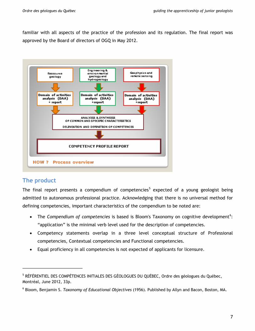
The process Development of the Competence compendium was achieved by a project team of consultants
supported by OGQ staff and nearly fifty seasoned geologists volunteering their opinions and
experience. The project was done in four stages:
1. Definition of broad areas of practice;
2. Construction of draft profile of tasks and skills in each area;
3. Validation and refinement of each profile in targeted workshops;
4. Preparation and validation of Competence compendium
4
Ordre des géologues du Québec guiding the apprenticeship of junior geologists
1. Areas of practice
Areas of practice, or domains, were delimited with the purpose of regrouping in a set area of
practice, all the professionals who generally work together for common objectives. This was done by
combining the common workplace environments and the common purpose of the professional work.
The areas of practice so defined are not meant to limit the areas of practice of individuals (who can
work in multiple areas) but these areas effectively constitute “silos” where practitioners can spend a
career.
It is understood that individual practitioners in any specific area work in many types of organisations
and that the practice of individual practitioners may overlap more than one area either at any one
time or in the span of a career. For practical reasons, three domains were retained which could have
been further divided:
a) Resource geology: this includes geology applied to mineral (metallic, industrial, and energy
minerals) exploration and exploitation. The work place environments include Junior exploration
companies, mining and hydrocarbon producers, and consultants servicing the industry.
Government surveys managing mineral titles and territorial mapping are also included in this
area.
b) Engineering & environmental geology and hydrogeology: this includes geology applied to
constructions (siting, foundations, materials, drainage, etc.) and natural hazards management,
site contamination assessment and remediation, and ground water protection and supply. The
work place environment is largely made up of consulting companies large and small and some
regulatory or planning agencies.
c) Geophysics and remote sensing: this includes all types of geophysical practice from small site
investigations to airborne surveys. Remote sensing is included in this area due to multiple
similarities in the practice. The work place environment is to a large degree found in firms
providing specialized services to different users.
2. Draft profile
In each domain, one expert was recruited to work with the project team so as to draft a profile of
the “entry level” practice of the profession with statements describing:
a) the nature of tasks performed by “junior geologists”;
b) the contexts and conditions of these tasks; and
c) the skills and personal attributes required to perform these tasks.
5
Ordre des géologues du Québec guiding the apprenticeship of junior geologists
This information was used to prepare working documents for the next step presenting:
• Domain definitions: summary statement with a listing of main tasks;
• Task descriptions: summary statements followed by detailed breakdown of activities in each
task plus additional details;
• Conditions of performance of tasks: autonomy, work environment, regulations, tools and
technology used, risks and stress factors, other requirements;
• Requirements for effective performance of tasks in terms of personal qualities and skills;
• The regulatory environment that has to be taken into account.
In addition, a table listing multiple (over 180) sets of knowledge and skills (obviously including
geoscience plus also other disciplines) was prepared to be rated by workshop participants with
respect to relative importance of for someone to be proficient in the domain (at the entry level).
3. Domain analysis workshop
For each domain, 8 to 12 senior representative specialists were recruited from active professionals
with supervisory responsibilities representing the various work place environments and specialties.
The specialists were convened for 2 day workshops of guided discussion aimed at validating and
fleshing out the draft profiles prepared in step 1. Representatives of universities and other
organizations were invited to attend the workshops as observers. Draft reports for each workshop
were validated by all participants with contributions of additional specialists who had not been able
to participate. After this validation, a “Domain analysis report” was prepared for each domain or
practice area defined before4.
4. Competencies compendium
The Domain analysis reports formed the bases for a draft Competencies compendium outlining the
common and distinct competencies for each domain. A validation workshop was convened to review
and refine the draft Competencies compendium. This workshop assembled over 20 professionals
4 Analyse de champ d’activité : GÉOLOGIE DU TERRITOIRE ET DES RESSOURCES MINÉRALES, PÉTROLIÈRES OU GAZIÈRES, Ordre des géologues du Québec, May 2012, 63p.
Analyse de champ d’activité : GÉOLOGIE DE L’ENVIRONNEMENT, DE L’AMÉNAGEMENT ET HYDROGÉOLOGIE, Ordre des géologues du Québec, May 2012, 73p.
Analyse de champ d’activité : GÉOPHYSIQUE ET TÉLÉDÉTECTION, Ordre des géologues du Québec, May 2012, 72p.
6
Ordre des géologues du Québec guiding the apprenticeship of junior geologists
familiar with all aspects of the practice of the profession and its regulation. The final report was
approved by the Board of directors of OGQ in May 2012.
The product The final report presents a compendium of competencies5 expected of a young geologist being
admitted to autonomous professional practice. Acknowledging that there is no universal method for
defining competencies, important characteristics of the compendium to be noted are:
• The Compendium of competencies is based is Bloom's Taxonomy on cognitive development6:
“application” is the minimal verb level used for the description of competencies.
• Competency statements overlap in a three level conceptual structure of Professional
competencies, Contextual competencies and Functional competencies.
• Equal proficiency in all competencies is not expected of applicants for licensure.
5 RÉFÉRENTIEL DES COMPÉTENCES INITIALES DES GÉOLOGUES DU QUÉBEC, Ordre des géologues du Québec, Montréal, June 2012, 33p. 6 Bloom, Benjamin S. Taxonomy of Educational Objectives (1956). Published by Allyn and Bacon, Boston, MA.
7
Ordre des géologues du Québec guiding the apprenticeship of junior geologists
• Methods for assessment of competencies are not defined in the Compendium though some
may be evident.
• The Compendium also deals specifically with background knowledge required to facilitate
workplace integration for internationally-trained persons (not covered herein).
This Compendium of competencies provides a frame of reference comprised of a set of competencies
divided into three categories, each highlighting key components of professional practice:
1. Professional competencies cover professional situations common to all geologists. Professional
competencies are based on context and inform on actions and activities specifically related to
the professional practice of geologists. These are listed in Table 1 with actions for one
competency listed in Table 1a.
2. Contextual competencies concern professional practice specific to each of the three domains.
Contextual competency takes into account contexts, practices, principles and specific knowledge
which govern professional practice in a given field of activity. These are listed in Table 2 with
key actions for one competency listed in Table 2a. It is important to understand that Contextual
competencies are defined at a relatively high level and refer to the capacity to undertake and
perform the various stages (in general five) of a task/project from planning, through project
start-up, data collection, interpretation and analysis and final reporting and archiving.
3. Functional competencies cover areas of common knowledge. Though they largely inform on
required knowledge, functional competencies provide the foundations for professional and
contextual competencies which are based on functional competencies. These also provide basic
indications to inform agencies and organizations which provide education in geology. These are
listed in Table 3.
8
Ordre des géologues du Québec guiding the apprenticeship of junior geologists
Guiding and assessing apprenticeship
Selection of what is to be assessed Professional competence can only be assessed by its components. In view of the large number of
components identified in the Compendium (see tables 1 - 3), and with their inherent partial overlap,
an assessment strategy was developed with the aim of focussing the assessment effort on job related
competencies. Taking into account the fact that the normal path to a professional license is an
accredited diploma, as a first step, faculty members from accredited institutions were asked to
identify the degree of attainment expected from their respective programs for each of the listed
competencies. As expected, the consensus was that the university programs essentially provide for a
large part of the Functional competencies but provide for limited to no Professional or Contextual
competencies.
Acquisition of knowledge in academic environments is subject to assessment through exams and
other means: verification of learning outcomes is thereby done in a controlled environment.
Again, academic training in geology does not equate with professional competence which requires a
minimal period of practical experience. This experience brings knowledge and skills that are not part
of the academic curriculum and also provides the means whereby a person can acquire and show
competence by “doing it”.
Therefore, the assessment effort is focussed on Contextual and Professional competencies.
Fundamental review of the factors affecting performance of individuals in complex tasks typical of
the work of geologists brought forward the need to also consider personal qualities when evaluating
professional competence.
There is a general reluctance and even justified barriers to reviewing personal qualities in an
academic environment. However, in a professional environment, personal qualities often make the
difference between success and failure. By including these in the professional development program
for junior geologists, the apprenticeship process provides the opportunity for the GIT to improve
personal qualities to the benefit of their future professional careers.
Assessment conundrum There are many challenges in assessing competencies acquired through work experience. Alternative
methods for assessing and documenting competencies include:
9
Ordre des géologues du Québec guiding the apprenticeship of junior geologists
1. Direct observation in real time: undoubtedly the most effective method of assessing work related
competencies. Unfortunately, it is unrealistic to try to perform direct observation of geologists
in a great variety of tasks and work environments.
2. Simulation: observing an individual performing a predefined task in a controlled environment.
This approach is not suitable for the practice of geology.
3. Examinations: exams cannot be used to assess many important skills nor can they be used to
assess personal attributes;
4. Documentation of work done in a Portfolio: this allows continuous documentation of tasks
undertaken and challenges met and, with proper controls, provide the means for assessing the
professional competence of a person in any domain.
It was therefore decided to develop a Portfolio based system for assessment of professional
competence.
The Portfolio
Benefits
A Portfolio based system was developed for the purpose of providing guidance both for junior
geologists and their training supervisors while at the same time providing the means to document the
progress of the junior geologist towards attaining professional competence sufficient for entry to
autonomous practice of the profession.
A portfolio provides three benefits:
1. The junior geologist is given the responsibility for his-her evaluation
2. It provides for a continuous and progressive assessment based on elements that are observable
and measurable in a real life context
3. It encourages reflective practice and auto regulation on the part of the junior geologist.
Objectives of apprenticeship program The junior geologist (GIT) is expected to develop and document 7 professional competencies (CP4
through CP10), 2 (out of 13) contextual competencies and 6 personal qualities (Interpersonal
relations, Adaptability, Responsibility, Leadership, Autonomy, Stress management) under the
direction of a training supervisor using guidance provided by OGQ.
With respect to contextual competencies, two levels of performance are defined:
• Level 1 corresponds to a broad exposure to the tasks involved and requires demonstration of
rigor and accuracy in data collection, management and reporting.
10
Ordre des géologues du Québec guiding the apprenticeship of junior geologists
• Level 2 corresponds to achieving effective autonomy in most tasks involved. The GIT is
expected, among others to show adequate capacities for logistics, judgment, interpretation,
reporting and communication.
The junior geologist is expected to attain level 2 in one competency and level 1 in another. On a
practical note, it is observed that many junior geologists approach level 1 in one competency at the
time of graduation due to summer work experience.
Structure and contents of Portfolio The portfolio guidance and tools provided to junior geologists and their supervisors includes a
number of different documents:
Guidance papers:
• An extensive guidance and instruction guide for junior geologists7
• A short guide for training supervisors8 and mentors
Reporting/assessment templates9
• Templates for each contextual competency
• A template for the professional competencies
• A template for personal qualities
Summary tables for the purpose of reporting on all objectives
The junior geologist is thereby provided with instructions and tools for building his/her portfolio in
accordance with stipulated objectives. In addition to the various reporting templates and tables, the
portfolio of the junior geologist will include “artefacts” safeguarded in electronic format and
available for examination by OGQ during the admissions process.
Artefacts
The junior geologist is expected to retain copies of notes, memos and reports produced on the
job so as to provide adequate documentation of the level of competence attained. The
training supervisor is to authorize the retention of these documents.
7 Durand, M.J., Nokam, N.T., Beaudry, P., Le guide du portfolio: outil de développement personnel et professionnel, Ordre des géologues du Québec, draft Octobre 2013, final March 2014, 35p. 8 Guide général à l’intention du maître de stage, Ordre des géologues du Québec, January 2014, 12p. 9 In total, 60 templates, tables and forms are made available for use by the GIT. Note that no more than 12 of these are used by any one GIT depending on the selection of the contextual competencies to be developed.
11
Ordre des géologues du Québec guiding the apprenticeship of junior geologists
Assessment by the supervisor The assessment of different competencies and personal attributes varies as follows:
• Contextual competencies are subject to evaluation by the supervisor according to a set of
criteria. The junior geologist is informed of the assessment of the progress achieved and
invited to continue development towards the set criteria.
• Professional competencies are subject to “coassessment” according to set criteria. In
practice, the junior geologist is expected to evaluate personal progress in relation to set
criteria. This personal assessment is presented to the supervisor who does an independent
evaluation before feedback to the GIT.
• Personal qualities are subject to “coassessment”. The junior geologist self-assesses and the
supervisor confirms or contradicts the opinion thereby expressed. The supervisor comments
upon the self-assessment and provides an appreciation of qualities developed. If a tangible
improvement is required, the supervisor suggests avenues for improvement. In case of
disagreement with the GIT, the supervisor refers to factual observations so as to help the GIT
understand.
Contextual competencies are truly “job related” and are therefore assessed with respect to the work
assigned to the junior geologist in accordance with general but fairly detailed criteria. Each subtask
is thereby assessed as to whether the product is satisfactory, and, if not, desired improvements are
outlined by the training supervisor. Tables 4 through 4c provide examples of task assessment
templates to be used by the supervisor showing task, criteria, indicators and artefacts.
Professional competencies are evaluated with respect to predefined fixed criteria at four levels of
performance:
Level A: performance not acceptable
Level B: performance expected of a recent graduate starting apprenticeship
Level C: performance expected of a junior geologist ready for autonomous practice
Level D: performance achieved by a seasoned professional.
At the end of a training period, a global assessment is made based on accrued documents and
reports.
12
Ordre des géologues du Québec guiding the apprenticeship of junior geologists
Management of the apprenticeship The apprenticeship process herein described is governed by regulation10. Under this regulation, the
junior geologist is responsible for his/her portfolio and for periodic reporting to the Ordre des
géologues. The junior geologist must register each occupation (or job) at the start and the training
supervisor concerned must be identified and assume responsibility for supervision.
Reporting is to be done at each change in occupation (or job) or at least yearly. All reports by the
GIT are to be vetted by the training supervisor. Periodic reports are to be assessed by OGQ with the
aim of ensuring that the junior geologist is effectively progressing towards minimal professional
competence expected of a licensed geologist. At the end of the prescribed training period, the GIT
may submit the collected reports and summary sheets in support of an application for licensure.
The role and responsibility of the training supervisor are:
1. To provide the junior geologist with opportunities to develop the required competencies;
2. To review and comment on work and documents prepared by the GIT;
3. To provide feedback to the GIT and complete the required evaluations.
Practical consequences and expected outcomes This new guided apprenticeship process will have three practical consequences:
1. The workload at OGQ is expected to increase with respect to managing the process and
reviewing the progress of geologists in training.
2. The GIT will be given clear objectives and tools for development while being placed in full
charge or responsibility for his/her personal progress.
3. The training supervisor will be given clear obligations with respect to a commitment to active
supervision which may entail a modest increase in workload. This may entail that some
geologists in such positions may have to develop new competences. The training supervisor will
also have to ensure that the apprenticeship process is integrated into the processes and policies
of the organisation.
The main expected outcome of this apprenticeship process will be that future candidates for
licensure will be better prepared for autonomous practice through consistent development of all
competencies required for such practice.
10 Regulation respecting the conditions and procedures for the issuance of permits by the Ordre des géologues du Québec
13
Ordre des géologues du Québec guiding the apprenticeship of junior geologists
Caveat This process is new to the profession, and though similar processes have existed in other professions
for a long time, it will be considered a minor revolution by some. There will therefore be some
resistance and the need for education. It is also evident that the tools developed are not perfect and
that these will be subject to improvement and refinement over the short and long term.
Notwithstanding the obvious difficulties in implementing such a process, there is clear support for
such action in the profession in Québec.
14
Ordre des géologues du Québec guiding the apprenticeship of junior geologists
Appendix: summary tables and examples of details
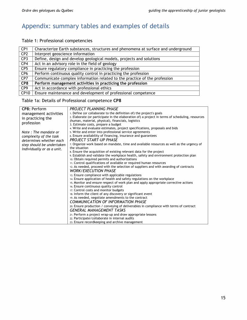
Table 1: Professional competencies
CP1 Characterize Earth substances, structures and phenomena at surface and underground CP2 Interpret geoscience information CP3 Define, design and develop geological models, projects and solutions CP4 Act in an advisory role in the field of geology CP5 Ensure regulatory compliance in practicing the profession CP6 Perform continuous quality control in practicing the profession CP7 Communicate complex information related to the practice of the profession CP8 Perform management activities in practicing the profession CP9 Act in accordance with professional ethics CP10 Ensure maintenance and development of professional competence
Table 1a: Details of Professional competence CP8
CP8: Perform management activities in practicing the profession Note : The mandate or complexity of the task determines whether each step should be undertaken individually or as a unit.
PROJECT PLANNING PHASE 1. Define (or collaborate to the definition of) the project's goals 2. Elaborate (or participate in the elaboration of) a project in terms of scheduling, resources (human, material, physical), financials, logistics 3. Estimate costs, prepare a budget 4. Write and evaluate estimates, project specifications, proposals and bids 5. Write and enter into professional service agreements 6. Ensure availability of financing, insurance and guarantees PROJECT START-UP PHASE 7. Organize work based on mandate, time and available resources as well as the urgency of the situation 8. Ensure the acquisition of existing relevant data for the project 9. Establish and validate the workplace health, safety and environment protection plan 10. Obtain required permits and authorizations 11. Control qualifications of available or required human resources 12. As needed, proceed with the selection of suppliers and with awarding of contracts WORK/EXECUTION PHASE 13. Ensure compliance with applicable regulations 14. Ensure application of health and safety regulations on the workplace 15. Monitor and ensure respect of work plan and apply appropriate corrective actions 16. Ensure continuous quality control 17. Control costs and monitor budgets 18. Inform the client of any discovery or significant event 19. As needed, negotiate amendments to the contract COMMUNICATION OF INFORMATION PHASE 20. Ensure production / conveying of deliverables in compliance with terms of contract GENERAL MANAGEMENT TASKS 21. Perform a project wrap-up and draw appropriate lessons 22. Participate/collaborate in internal audits 23. Ensure recordkeeping and archive management
15
Ordre des géologues du Québec guiding the apprenticeship of junior geologists
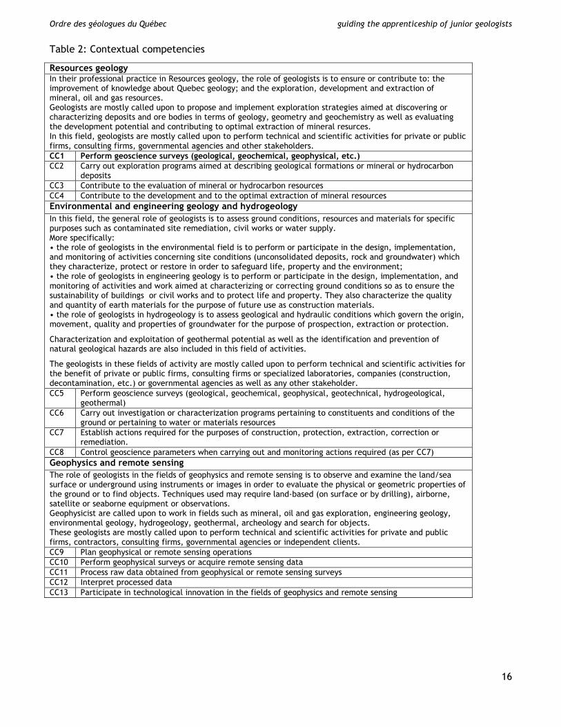
Table 2: Contextual competencies
Resources geology In their professional practice in Resources geology, the role of geologists is to ensure or contribute to: the improvement of knowledge about Quebec geology; and the exploration, development and extraction of mineral, oil and gas resources. Geologists are mostly called upon to propose and implement exploration strategies aimed at discovering or characterizing deposits and ore bodies in terms of geology, geometry and geochemistry as well as evaluating the development potential and contributing to optimal extraction of mineral resurces. In this field, geologists are mostly called upon to perform technical and scientific activities for private or public firms, consulting firms, governmental agencies and other stakeholders. CC1 Perform geoscience surveys (geological, geochemical, geophysical, etc.) CC2 Carry out exploration programs aimed at describing geological formations or mineral or hydrocarbon
deposits CC3 Contribute to the evaluation of mineral or hydrocarbon resources CC4 Contribute to the development and to the optimal extraction of mineral resources Environmental and engineering geology and hydrogeology In this field, the general role of geologists is to assess ground conditions, resources and materials for specific purposes such as contaminated site remediation, civil works or water supply. More specifically: • the role of geologists in the environmental field is to perform or participate in the design, implementation, and monitoring of activities concerning site conditions (unconsolidated deposits, rock and groundwater) which they characterize, protect or restore in order to safeguard life, property and the environment; • the role of geologists in engineering geology is to perform or participate in the design, implementation, and monitoring of activities and work aimed at characterizing or correcting ground conditions so as to ensure the sustainability of buildings or civil works and to protect life and property. They also characterize the quality and quantity of earth materials for the purpose of future use as construction materials. • the role of geologists in hydrogeology is to assess geological and hydraulic conditions which govern the origin, movement, quality and properties of groundwater for the purpose of prospection, extraction or protection.
Characterization and exploitation of geothermal potential as well as the identification and prevention of natural geological hazards are also included in this field of activities.
The geologists in these fields of activity are mostly called upon to perform technical and scientific activities for the benefit of private or public firms, consulting firms or specialized laboratories, companies (construction, decontamination, etc.) or governmental agencies as well as any other stakeholder. CC5 Perform geoscience surveys (geological, geochemical, geophysical, geotechnical, hydrogeological,
geothermal) CC6 Carry out investigation or characterization programs pertaining to constituents and conditions of the
ground or pertaining to water or materials resources CC7 Establish actions required for the purposes of construction, protection, extraction, correction or
remediation. CC8 Control geoscience parameters when carrying out and monitoring actions required (as per CC7) Geophysics and remote sensing The role of geologists in the fields of geophysics and remote sensing is to observe and examine the land/sea surface or underground using instruments or images in order to evaluate the physical or geometric properties of the ground or to find objects. Techniques used may require land-based (on surface or by drilling), airborne, satellite or seaborne equipment or observations. Geophysicist are called upon to work in fields such as mineral, oil and gas exploration, engineering geology, environmental geology, hydrogeology, geothermal, archeology and search for objects. These geologists are mostly called upon to perform technical and scientific activities for private and public firms, contractors, consulting firms, governmental agencies or independent clients. CC9 Plan geophysical or remote sensing operations CC10 Perform geophysical surveys or acquire remote sensing data CC11 Process raw data obtained from geophysical or remote sensing surveys CC12 Interpret processed data CC13 Participate in technological innovation in the fields of geophysics and remote sensing
16
Ordre des géologues du Québec guiding the apprenticeship of junior geologists
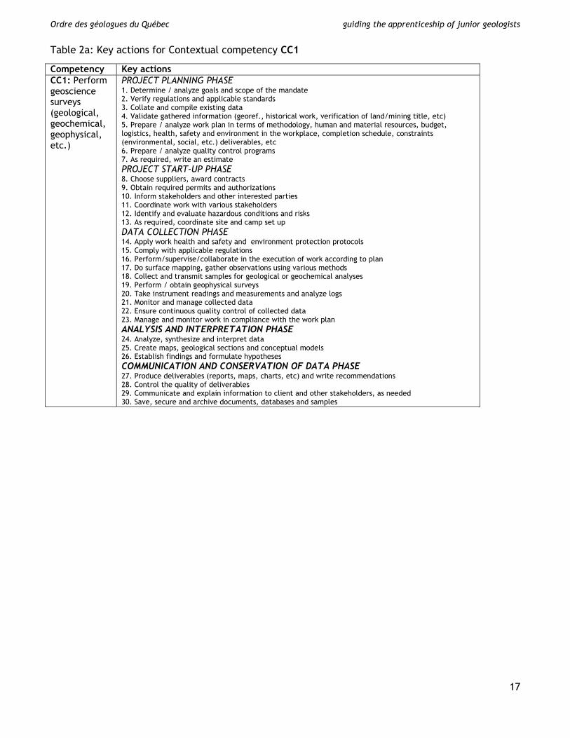
Table 2a: Key actions for Contextual competency CC1
Competency Key actions CC1: Perform geoscience surveys (geological, geochemical, geophysical, etc.)
PROJECT PLANNING PHASE 1. Determine / analyze goals and scope of the mandate 2. Verify regulations and applicable standards 3. Collate and compile existing data 4. Validate gathered information (georef., historical work, verification of land/mining title, etc) 5. Prepare / analyze work plan in terms of methodology, human and material resources, budget, logistics, health, safety and environment in the workplace, completion schedule, constraints (environmental, social, etc.) deliverables, etc 6. Prepare / analyze quality control programs 7. As required, write an estimate PROJECT START-UP PHASE 8. Choose suppliers, award contracts 9. Obtain required permits and authorizations 10. Inform stakeholders and other interested parties 11. Coordinate work with various stakeholders 12. Identify and evaluate hazardous conditions and risks 13. As required, coordinate site and camp set up DATA COLLECTION PHASE 14. Apply work health and safety and environment protection protocols 15. Comply with applicable regulations 16. Perform/supervise/collaborate in the execution of work according to plan 17. Do surface mapping, gather observations using various methods 18. Collect and transmit samples for geological or geochemical analyses 19. Perform / obtain geophysical surveys 20. Take instrument readings and measurements and analyze logs 21. Monitor and manage collected data 22. Ensure continuous quality control of collected data 23. Manage and monitor work in compliance with the work plan ANALYSIS AND INTERPRETATION PHASE 24. Analyze, synthesize and interpret data 25. Create maps, geological sections and conceptual models 26. Establish findings and formulate hypotheses COMMUNICATION AND CONSERVATION OF DATA PHASE 27. Produce deliverables (reports, maps, charts, etc) and write recommendations 28. Control the quality of deliverables 29. Communicate and explain information to client and other stakeholders, as needed 30. Save, secure and archive documents, databases and samples
17
Ordre des géologues du Québec guiding the apprenticeship of junior geologists
Table 3: Functional competencies
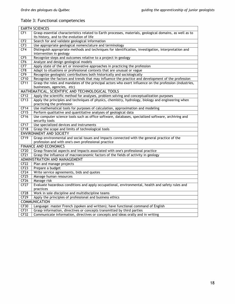
EARTH SCIENCES CF1 Grasp essential characteristics related to Earth processes, materials, geological domains, as well as to
its history, and to the evolution of life CF2 Search for and validate geological information CF3 Use appropriate geological nomenclature and terminology CF4 Distinguish appropriate methods and techniques for identification, investigation, interpretation and
intervention in geology CF5 Recognize steps and outcomes relative to a project in geology CF6 Analyze and design geological models CF7 Apply state of the art or innovative approaches in practicing the profession CF8 Adapt to situations or professional contexts that are unusual or vague CF9 Recognize geologists' contributions both historically and sociologically CF10 Recognize the factors and trends that may influence the practice and development of the profession CF11 Grasp the roles and mandates of the principal actors who exert influence on the profession (industries,
businesses, agencies, etc) MATHEMATICAL, SCIENTIFIC AND TECHNOLOGICAL TOOLS CF12 Apply the scientific method for analyses, problem solving and conceptualization purposes CF13 Apply the principles and techniques of physics, chemistry, hydrology, biology and engineering when
practicing the profession CF14 Use mathematical tools for purposes of calculation, approximation and modeling CF15 Perform qualitative and quantitative analyses of geological data CF16 Use computer science tools such as office software, databases, specialized software, archiving and
security tools CF17 Use specialized devices and instruments CF18 Grasp the scope and limits of technological tools ENVIRONMENT AND SOCIETY CF19 Grasp environmental and social issues and impacts connected with the general practice of the
profession and with one's own professional practice FINANCE AND ECONOMICS CF20 Grasp financial aspects and impacts associated with one's professional practice CF21 Grasp the influence of macroeconomic factors of the fields of activity in geology ADMINISTRATION AND MANAGEMENT CF22 Plan and manage projects CF23 Prepare a budget CF24 Write service agreements, bids and quotes CF25 Manage human resources CF26 Manage risk CF27 Evaluate hazardous conditions and apply occupational, environmental, health and safety rules and
practices CF28 Work in sole discipline and multidiscipline teams CF29 Apply the principles of professional and business ethics COMMUNICATION CF30 Language: master French (spoken and written); have functional command of English CF31 Grasp information, directives or concepts transmitted by third parties CF32 Communicate information, directives or concepts and ideas orally and in writing
18
Ordre des géologues du Québec guiding the apprenticeship of junior geologists
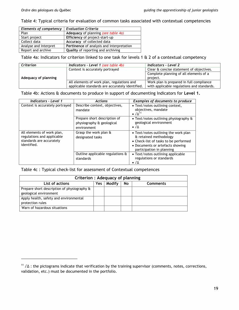
Table 4: Typical criteria for evaluation of common tasks associated with contextual competencies
Elements of competency Evaluation Criteria Plan Adequacy of planning (see table 4a) Start project Efficiency of project-start-up Collect data Accuracy of collected data Analyse and interpret Pertinence of analysis and interpretation Report and archive Quality of reporting and archiving
Table 4a: Indicators for criterion linked to one task for levels 1 & 2 of a contextual competency
Criterion Indicators - Level 1 (see table 4b) Indicators - Level 2
Adequacy of planning
Context is accurately portrayed Clear & concise statement of objectives. Complete planning of all elements of a project.
All elements of work plan, regulations and applicable standards are accurately identified.
Work plan is prepared in full compliance with applicable regulations and standards.
Table 4b: Actions & documents to produce in support of documenting Indicators for Level 1.
Indicators - Level 1 Actions Examples of documents to produce Context is accurately portrayed Describe context, objectives,
mandate • Text/notes outlining context,
objectives, mandate • √∆11
Prepare short description of physiography & geological environment
• Text/notes outlining physiography & geological environment
• √∆
All elements of work plan, regulations and applicable standards are accurately identified.
Grasp the work plan & designated tasks
• Text/notes outlining the work plan & retained methodology
• Check-list of tasks to be performed • Documents or artefacts showing
participation in planning Outline applicable regulations & standards
• Text/notes outlining applicable regulations or standards
• √∆
Table 4c : Typical check-list for assessment of Contextual competences
Criterion : Adequacy of planning List of actions Yes Modify No Comments
Prepare short description of physiography & geological environment
Apply health, safety and environmental protection rules
Warn of hazardous situations
11 √∆ : the pictograms indicate that verification by the training supervisor (comments, notes, corrections, validation, etc.) must be documented in the portfolio.
19