Embed Size (px)
Citation preview
ACTION PLAN FOR RESTORATION AT AMBOHILERO FOREST, MADAGASCAR, AND SIMILAR AREAS OF DEGRADATION Aug. 30, 2007
ACTION PLAN FOR RESTORATION AT AMBOHILERO FOREST, MADAGASCAR, AND SIMILAR AREAS OF DEGRADATION Aug. 30, 2007 Prepared by: Sarah Karpanty, Ph.D. Department of Fisheries and Wildlife Science Virginia Polytechnic Institute and State University, Blacksburg, VA, 24061 USA. Phone: (540) 231-4586. E-mail: [email protected] Theo Dillaha, Ph.D. SANREM CRSP, OIRED, Virginia Tech Virginia Polytechnic Institute and State University, Blacksburg, VA, 24061 USA. Phone: (540) 231-6813. E-mail: [email protected] Charles Welch, Research Scientist, Duke University Primate Center, 3705 Erwin Road, Durham, North Carolina 27705 USA. Phone: 919-489-3364. E-mail: [email protected] This publication was produced for review by the United States Agency for International Development and the generous support of the American people through USAID Cooperative Agreement No. EPP-A-00-04-00013-00. It was prepared by Sarah Karpanty and Theo Dillaha of Virginia Tech and Charles Welch of Duke University.
ACKNOWLEDGMENTS, TEAM MEMBERS
The authors would like to acknowledge USAID’s SANREM CRSP (USAID/EGAT/NRM Sustainable Agriculture and Natural Resource Management Collaborative Research Support Program) for funding this technical assistance mission and USAID’s MIARO program for funding the implementation of this action plan. Special thanks go to Lisa Gaylord, Chris Kosnik, Daniela Raik, Razafimahatratra Tiana, and Razakamanarina Ndrantomahefa of USAID EGAT/NRM and to USAID Madagascar for its facilitation of this technical assistance mission. Finally, thanks go to Keith Moore of SANREM CRSP for his helpful comments in preparation for this expedition.
In Madagascar, the team’s activities were greatly facilitated by collaborations with
USAID MIARO, Conservation International, WWF, and Centre ValBio, especially through interactions with Anna Feistner, Louise Holloway, Rambeloarisoa Gerard, Bruno Rajaspera, and Randrianarisoa Jeannicq.
Success would not have been possible without the exhaustive participation of every
member of the team. During the expedition, the team divided into three working groups, listed below. The first group was responsible for collecting data with respect to Objective 1, the second with Objectives 1-3, and the third with Objective 4.
Team 1: Objective 1, botany plots Barrier, Benardriarina, Antsevabe Pela, Auguste, Centre ValBio Rakotoarimanana, Roland, Antsevabe Randrianantenaina, Johny, Centre ValBio Razafindraibe, Dominique, Centre ValBio Razafindrakoto, Georges, Centre ValBio Welch, Charles, Duke University

Team 2: Objectives 1-3, photo plots, erosion analyses, reforestation site selection Andrianamatody, Antsevabe Boto, Eugene, Collaborateur CIREEF Dillaha, Theo, Virginia Tech and SANREM CRSP Etienne, Antsevabe Holloway, Louise, TAMS Karpanty, Sarah, Virginia Tech Lahitsara, Pierre, Centre ValBio Rambeloarisoa, Gerard, MIARO and WWF Randrianarisoa, Jeannicq, Conservation International Team 3: Objective 4, socioeconomic studies Marin, Victor, Chef Triage des Eaux et Foret Ramarjaona, Mamisoa, Team Leader, Centre ValBio Randriamiaramanana, Roger, Chef Quartier, Antsevabe
TABLE OF CONTENTS
I. INTRODUCTION.......................................................................................................... 1 II. OBJECTIVE 1: To assess occurrence of passive restoration since site visit by team, July 2005......................................................................................................................... 5 III. OBJECTIVE 2: To assess health of planted and nursery trees; and to develop recommendations for planting remaining trees ............................................................. 11 VI. OBJECTIVE 3: To evaluate successes and limitations of experimental techniques to control erosion and restore soil fertility; and to recommend additional practices........... 13 V. OBJECTIVE 4: To assess socioeconomic impacts of road on villages of Bemainty and Antsevabe .............................................................................................................. 17 VI. LOCATION-SPECIFIC ACTION PLAN FOR TREE PLANTING, EROSION CONTROL .................................................................................................................... 21 VII. CONCLUSIONS ..................................................................................................... 37 VIII. LITERATURE CITED ............................................................................................ 38 APPENDIX 1: GPS COORDINATES OF BOTANY PLOTS ......................................... 39 APPENDIX 2: PHOTO PLOT ID ................................................................................... 40 APPENDIX 3: WATER BAR ......................................................................................... 41
I. INTRODUCTION
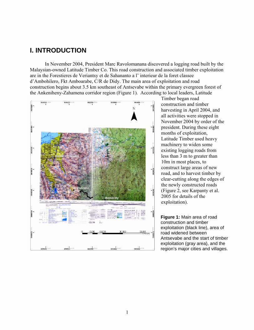
In November 2004, President Marc Ravolomanana discovered a logging road built by the Malaysian-owned Latitude Timber Co. This road construction and associated timber exploitation are in the Forestieres de Veriantsy et de Sahananto a l’ interieur de la foret classee d’Ambohilero, Fkt Amboarabe, C/R de Didy. The main area of exploitation and road construction begins about 3.5 km southeast of Antsevabe within the primary evergreen forest of
to local leaders, Latitude Timber began road construction and timber harvesting in April 2004, andall activities were stoppedNovember 2004 by order of thpresident. During these eight months of exploitation, Latitude Timber used heavymachinery to widen some existing logging roads from less than 3 m to greater tha10m in most places, to construct large areas of new road, and to harvest timclear-cutting along the edges the newly constructed roads (Figure 2, see Karpanty et al. 2005 for details of the exploitation).
the Ankeniheny-Zahamena corridor region (Figure 1). According
in
e
n
ber by of
Figure 1: oad construction and timber
of
r and the
Main area of r
exploitation (black line), area road widened between Antsevabe and the start of timbeexploitation (gray area), region’s major cities and villages.
1
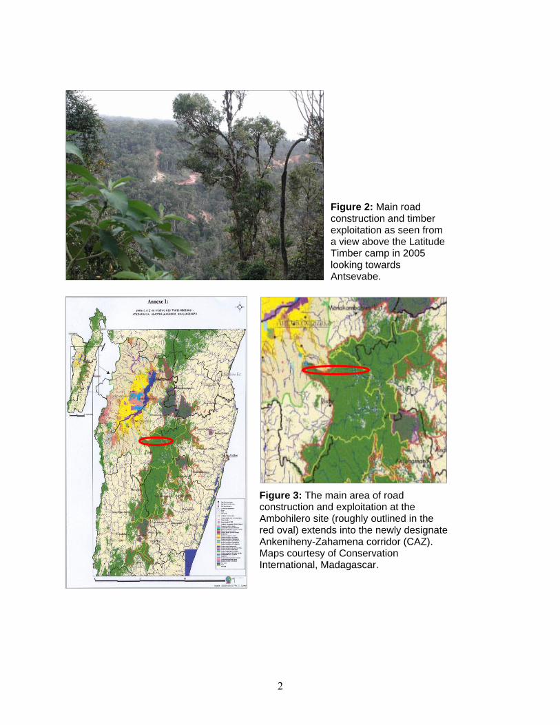
Figure 2: Main road construction and timber exploitation as seen from a view above the Latitude Timber camp in 2005 looking towards Antsevabe.
Figure 3: The main area of road construction and exploitation at the Ambohilero site (roughly outlined in the red oval) extends into the newly designate Ankeniheny-Zahamena corridor (CAZ). Maps courtesy of Conservation International, Madagascar.
2

Deforestation such as that caused by these logging-related activities threatens
biodiversity, watershed integrity, soil productivity, and the associated economic value of the land for local people. It is broadly accepted that the regrowth of forests removed from key areas such as this one will be necessary to make the Durban vision a reality. While the goal of regrowing forest stands is shared by many, the techniques for doing so are minimally developed in Madagascar. Many scientists feel that tropical deforested areas are unlikely to regenerate to pre-disturbance ecological or economic quality without active reforestation. However, much remains to be learned about regrowth in tropical forests. It would be a welcome surprise to discover that tropical moist forests have some capacity for self-regeneration. The road in Ambohilero Forest (sometimes called Didy Forest), while an unfortunate incursion into pristine forest in a new protected area under Durban vision activities (Figure 3), provides an opportunity to study rainforest regeneration and to compare natural regeneration capabilities with regeneration through active restoration over the long term.
In this report, we summarize activities at this site since logging activities stopped in 2004,
conduct an assessment of natural regeneration at the site since then, and develop an action plan for consideration by USAID’s MIARO program. USAID/Madagascar is currently supporting restoration and reforestation activities through its MIARO, ERI, and JARIALA programs. These efforts aim to complement the move to expand Madagascar’s protected area network from 1.7 million hectares to 6 million hectares by 2012. Reforestation of degraded landscapes is one component of this large plan to expand protected areas.
The aim is that the technical assistance described in this report will complement ongoing
USAID activities along the eastern escarpment of the country. Specifically, they should allow us to learn the potential costs and benefits associated with active restoration versus natural regeneration in the humid forest. Also, they should serve as a much-needed catalyst for reflecting on and improving restoration techniques across Madagascar.
The team described in this report was invited to provide technical assistance to assess the
situation and develop the action plan. USAID MIARO will provide $10,000 for implementation of the action plan. Actions from the cessation of logging activity to May 2007
In June 2005, the Malagasy government asked for the assistance of USAID/Madagascar in quantifying damage to the previously undisturbed Ambohilero Forest corridor by the logging operations. They also sought advice on the feasibility of an ecological restoration of the disturbed area.
In July 2005, the first expedition to the region (Karpanty et al., 2005), supported by
USAID’s MIARO program, quantified that 51.81 hectares of forest had been directly exploited during the logging operations and 184 to 600 additional hectares were indirectly affected by secondary impact such as soil erosion, altered water dynamics, introduction of non-native species, and effects on biodiversity.
3
In an out-of-court settlement in 2005, Latitude Timber was tasked with planting 21,000 native tree species in areas of forest affected by its logging operations. While the settlement was at least a step in the right direction, the requirement was significantly less than the minimum scenario of 56,000 trees recommended by Karpanty et al. after the 2005 planning expedition.
Another team of specialists collaborating with national experts visited the affected area
from Sept. 25 to Oct. 2, 2005, to assess the level of damage and to evaluate prospects for restoration (Aronson et al., 2005). The most severe impact was observed along an 11 km portion of the logging road where Latitude Timber carried out intensive exploitation and established numerous secondary tracks into the surrounding forest. Damage was less severe along a 6 km stretch of road extending farther into the forest. The road had been established in the 1990s by a Malagasy logging company following a footpath that dates from at least the 1950s; it was later widened by Latitude Timber, but adjacent forest was not harvested.
In March and November 2006, a MIARO team visited the site to assess progress related
to the recommendations from the September 2005 expedition. By this time, a tree farm with some of the required 21,000 native seedlings had been established, and reportedly 7,000 of these had been planted in high-priority areas in the disturbed region. The MIARO team trained the Latitude Timber consultant firm, Avotr’Ala, in additional stabilization and anti-erosion techniques as recommended by the September 2005 team, and erosion control structures were established in many areas.
Despite these activities by a diversity of stakeholders, several questions remained
regarding restoration and the best way to proceed, given the limited resources: The extent of natural revegetation? Where and how to plant the remaining seedlings started by Avotr’Ala? What species of additional seedlings are needed? How to maximize natural regeneration occurring in the least disturbed areas? Where to focus erosion control activities? The purpose of the May 2007 expedition detailed in this report was to bring together existing and new experts to answer some of these questions and to design a plan for MIARO’s activities at the site through September 2008. Specific expedition and report objectives follow. Objectives • To assess passive restoration since the last site visit by this team in July 2005 and the
cessation of logging activities in November 2004. • To assess the health of planted and nursery tree seedlings, and to develop recommendations
for planting the remaining seedlings to best provide habitat and movement corridors for key wildlife species.
• To evaluate the successes and limitations of restoration activities by MIARO and Avotr’Ala,
and to recommend additional practices as needed. • To assess the socioeconomic impact of the road on Bemainty and Antsevabe, the two villages
at opposite ends of the logging road.
4
II. OBJECTIVE 1: METHODS, RESULTS, GENERAL RECOMMENDATIONS • To assess the occurrence of passive restoration since the site visit by this team in July 2005
and the cessation of logging activities in November 2004.
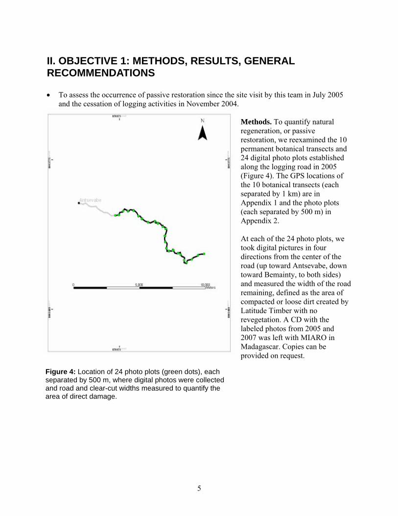
ethods. To quantify natural
d the 10
f
plots
t each of the 24 photo plots, we
the
d
he
Mregeneration, or passive restoration, we reexaminepermanent botanical transects and 24 digital photo plots established along the logging road in 2005 (Figure 4). The GPS locations othe 10 botanical transects (each separated by 1 km) are in Appendix 1 and the photo (each separated by 500 m) in Appendix 2. Atook digital pictures in four directions from the center ofroad (up toward Antsevabe, downtoward Bemainty, to both sides) and measured the width of the roaremaining, defined as the area of compacted or loose dirt created byLatitude Timber with no revegetation. A CD with tlabeled photos from 2005 and2007 was left with MIARO in Madagascar. Copies can be provided on request.
Figure 4: Location of 24 photo plots (green dots), each
separated by 500 m, where digital photos were collectedand road and clear-cut widths measured to quantify the area of direct damage.
5
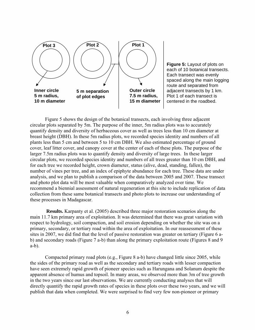
Outer circle 7.5 m radius, 15 m diameter
Plot 2 Plot 1
5 m separation of plot edges
Inner circle 5 m radius, 10 m diameter
Plot 3
Figure 5: Layout of plots on each of 10 botanical transects. Each transect was evenly spaced along the main logging route and separated from adjacent transects by 1 km. Plot 1 of each transect is centered in the roadbed.
Figure 5 shows the design of the botanical transects, each involving three adjacent
circular plots separated by 5m. The purpose of the inner, 5m radius plots was to accurately quantify density and diversity of herbaceous cover as well as trees less than 10 cm diameter at breast height (DBH). In these 5m radius plots, we recorded species identity and numbers of all plants less than 5 cm and between 5 to 10 cm DBH. We also estimated percentage of ground cover, leaf litter cover, and canopy cover at the center of each of these plots. The purpose of the larger 7.5m radius plots was to quantify density and diversity of large trees. In these larger circular plots, we recorded species identity and numbers of all trees greater than 10 cm DBH, and for each tree we recorded height, crown diameter, status (alive, dead, standing, fallen), the number of vines per tree, and an index of epiphyte abundance for each tree. These data are under analysis, and we plan to publish a comparison of the data between 2005 and 2007. These transect and photo plot data will be most valuable when comparatively analyzed over time. We recommend a biennial assessment of natural regeneration at this site to include replication of data collection from these same botanical transects and photo plots to increase our understanding of these processes in Madagascar.
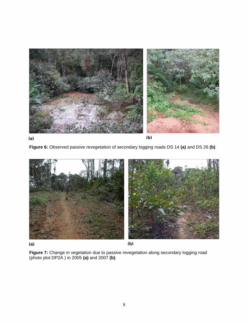
Results. Karpanty et al. (2005) described three major restoration scenarios along the
main 11.7 km primary area of exploitation. It was determined that there was great variation with respect to hydrology, soil compaction, and soil erosion depending on whether the site was on a primary, secondary, or tertiary road within the area of exploitation. In our reassessment of these sites in 2007, we did find that the level of passive restoration was greater on tertiary (Figure 6 a-b) and secondary roads (Figure 7 a-b) than along the primary exploitation route (Figures 8 and 9 a-b). Compacted primary road plots (e.g., Figure 8 a-b) have changed little since 2005, while the sides of the primary road as well as the secondary and tertiary roads with lesser compaction have seen extremely rapid growth of pioneer species such as Harungana and Solanum despite the apparent absence of humus and topsoil. In many areas, we observed more than 3m of tree growth in the two years since our last observations. We are currently conducting analyses that will directly quantify the rapid growth rates of species in these plots over these two years, and we will publish that data when completed. We were surprised to find very few non-pioneer or primary
6
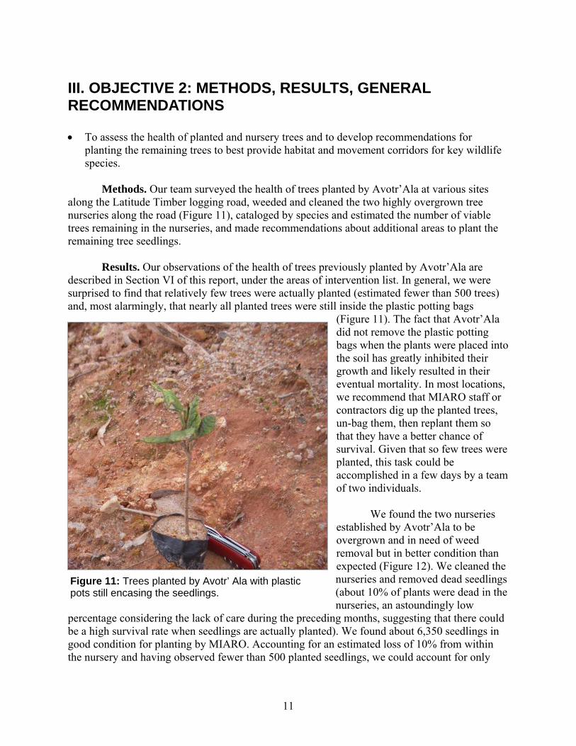
forest tree species regenerating on the sides of the main road or on the secondary and tertiary roads. We need to monitor these plots over time to ensure that there will not be a recession of this area if pioneer tree species are not replaced by secondary succession trees. We found that any natural mulch, whether zebu dung or organic plant material (Figure 10), greatly facilitated establishment and growth of tree species on the highly compacted main road. Given that large-scale plowing of the road to loosen the soil is unlikely (and not recommended due to the potential to increase erosion), we recommend encouraging natural mulching in as many areas as possible to facilitate passive restoration. Finally, we found little change in the third plots on each transect, which are generally off the road exploitation area and inside the primary forest. This was encouraging, as it indicates minimal exploitation of the forest resources since the cessation of logging activities. We describe the use of the road for gold mining, quartz mining, and other non-sustainable activities in Section V of this report and maintain that commercial exploitation of this forest area remains the biggest potential inhibitor of its recovery and passive restoration. Recommendations • Conduct a biennial assessment of passive restoration at the Ambohilero site by reevaluating
the botanical transects and photo plots. This will allow quantification of the process of passive restoration that will facilitate management of similar areas of degradation in Madagascar.
• Use our ongoing analyses of tree growth rates at this site to establish some parameters of
passive restoration in Ambohilero forest and similar instances of degradation, e.g., upcoming nickel mining activities.
• Plant remaining forest tree seedlings in Ambohilero nurseries at selected sites (see Section VI
of this report, recommended restoration sites) on the sides of the road underneath the existing regenerating Harungana and Solanum so that these pioneer species may provide shade for the primary and secondary forest tree plantings. It may be necessary to thin existing pioneer species trees on the sides of the road before planting.
• Encourage natural mulching, whether zebu dung or organic plant matter, along the primary
road to facilitate seedling establishment and tree growth.
7
(a) (b)
Figure 6: Observed passive revegetation of secondary logging roads DS 14 (a) and DS 26 (b).
(b) (a)
Figure 7: Change in vegetation due to passive revegetation along secondary logging road (photo plot DP2A ) in 2005 (a) and 2007 (b).
8
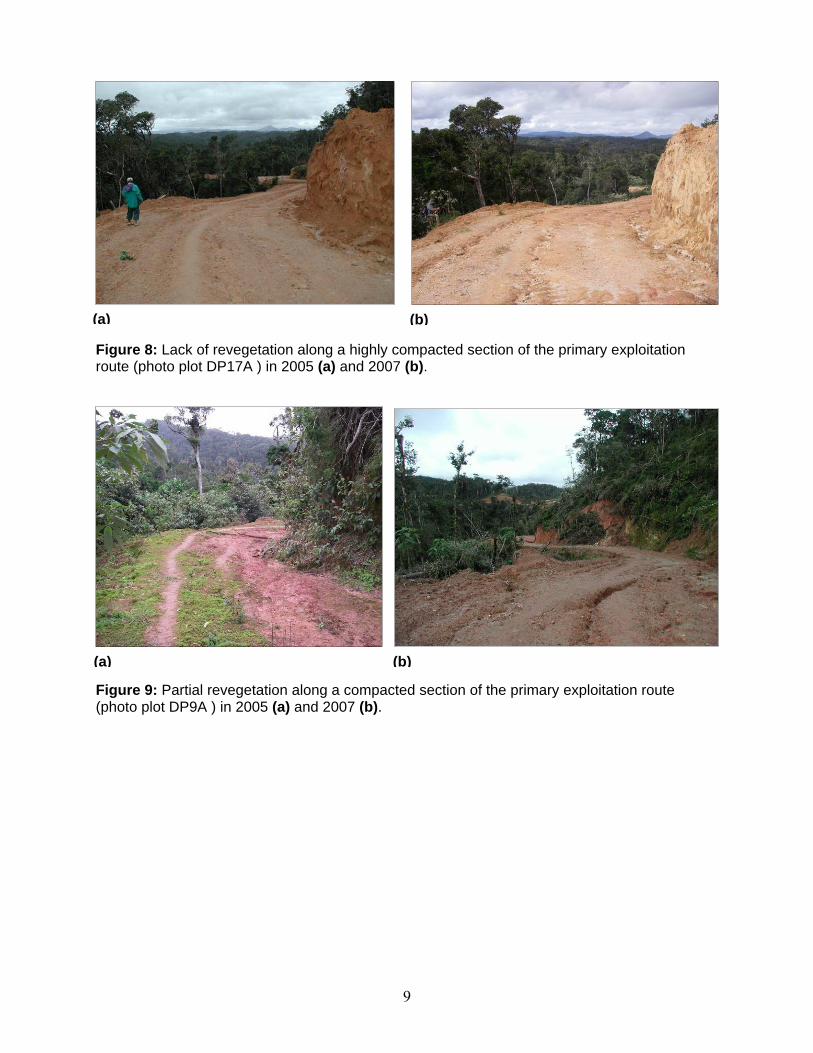
(a) (b)
Figure 8: Lack of revegetation along a highly compacted section of the primary exploitation route (photo plot DP17A ) in 2005 (a) and 2007 (b).
(a) (b)
Figure 9: Partial revegetation along a compacted section of the primary exploitation route (photo plot DP9A ) in 2005 (a) and 2007 (b).
9
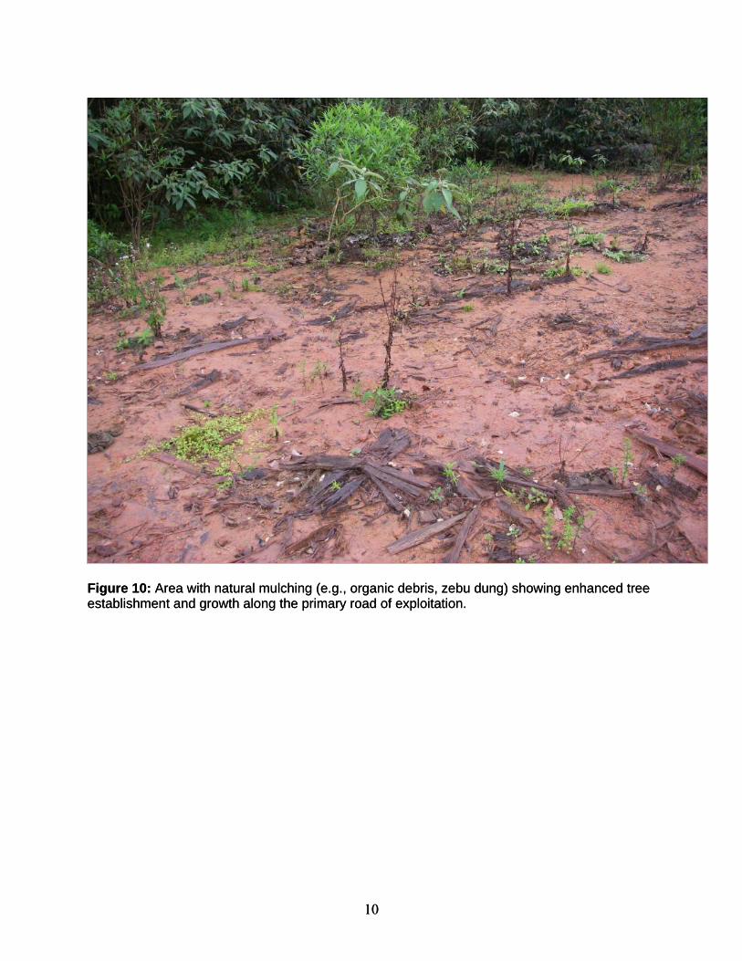
Figure 10: Area with natural mulching (e.g., organic debris, zebu dung) showing enhanced tree Figure 10: Area with natural mulching (e.g., organic debris, zebu dung) showing enhanced tree establishment and growth along the primary road of exploitation. establishment and growth along the primary road of exploitation.
10 10
III. OBJECTIVE 2: METHODS, RESULTS, GENERAL RECOMMENDATIONS • To assess the health of planted and nursery trees and to develop recommendations for
planting the remaining trees to best provide habitat and movement corridors for key wildlife species.
Methods. Our team surveyed the health of trees planted by Avotr’Ala at various sites along the Latitude Timber logging road, weeded and cleaned the two highly overgrown tree nurseries along the road (Figure 11), cataloged by species and estimated the number of viable trees remaining in the nurseries, and made recommendations about additional areas to plant the remaining tree seedlings. Results. Our observations of the health of trees previously planted by Avotr’Ala are described in Section VI of this report, under the areas of intervention list. In general, we were surprised to find that relatively few trees were actually planted (estimated fewer than 500 trees) and, most alarmingly, that nearly all planted trees were still inside the plastic potting bags
(Figure 11). The fact that Avotr’Ala did not remove the plastic potting bags when the plants were placed into the soil has greatly inhibited their growth and likely resulted in their eventual mortality. In most locations, we recommend that MIARO staff or contractors dig up the planted trees, un-bag them, then replant them so that they have a better chance of survival. Given that so few trees were planted, this task could be accomplished in a few days by a team of two individuals. We found the two nurseries established by Avotr’Ala to be overgrown and in need of weed removal but in better condition than expected (Figure 12). We cleaned the nurseries and removed dead seedlings (about 10% of plants were dead in the nurseries, an astoundingly low
percentage considering the lack of care during the preceding months, suggesting that there could be a high survival rate when seedlings are actually planted). We found about 6,350 seedlings in good condition for planting by MIARO. Accounting for an estimated loss of 10% from within the nursery and having observed fewer than 500 planted seedlings, we could account for only
Figure 11: Trees planted by Avotr’ Ala with plastic pots still encasing the seedlings.
11
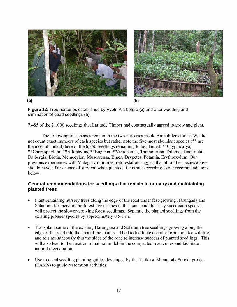
Figure 12: Tree nurseries established by Avotr’ Ala before (a) and after weeding and elimination of dead seedlings (b).
(a) (b)
7,485 of the 21,000 seedlings that Latitude Timber had contractually agreed to grow and plant.
The following tree species remain in the two nurseries inside Ambohilero forest. We did
not count exact numbers of each species but rather note the five most abundant species (** are the most abundant) here of the 6,350 seedlings remaining to be planted: **Cryptocarya, **Chrysophylum, **Allophylus, **Eugenia, **Abrahamia, Tambourissa, Dilobia, Tincitriata, Dalbergia, Blotia, Memecylon, Muscarensa, Bigea, Drypetes, Potamia, Erythroxylum. Our previous experiences with Malagasy rainforest reforestation suggest that all of the species above should have a fair chance of survival when planted at this site according to our recommendations below. General recommendations for seedlings that remain in nursery and maintaining planted trees • Plant remaining nursery trees along the edge of the road under fast-growing Harungana and
Solanum, for there are no forest tree species in this zone, and the early succession species will protect the slower-growing forest seedlings. Separate the planted seedlings from the existing pioneer species by approximately 0.5-1 m.
• Transplant some of the existing Harungana and Solanum tree seedlings growing along the
edge of the road into the area of the main road bed to facilitate corridor formation for wildlife and to simultaneously thin the sides of the road to increase success of planted seedlings. This will also lead to the creation of natural mulch in the compacted road zones and facilitate natural regeneration.
• Use tree and seedling planting guides developed by the Tetik'asa Manupody Saroka project
(TAMS) to guide restoration activities.
12
• Plant in the 10 specific sites (R1-R10, Section VI) identified by the team. These sites were selected to maximize the potential for habitat connectivity and because of their relatively minimal slope they should be areas of minimal erosion.
• Do not plant or disturb the 10 botany transect areas so that passive restoration progress can
be monitored over time (preferably every 2 years).
VI. OBJECTIVE 3: METHODS, RESULTS, GENERAL RECOMMENDATIONS
• To evaluate the successes and limitations of experimental techniques enacted by MIARO to control erosion and restore soil fertility, and to recommend additional practices as needed.
Methods. We surveyed the entire length of the primary, secondary, and tertiary routes of Latitude Timber exploitation to develop a realistic evaluation of erosion control needs. We recognized that there are very limited financial resources for active restoration work at this site, so we did not include mechanical techniques such as tillage or labor-intensive restoration techniques such as construction of structural sediment dams in our suggestions. We limited our recommendations to:
• Areas where erosion is directly affecting a water source (see Section VI of this report). • Areas of planned tree restoration (see Section VI of this report). • Existing areas of erosion control constructed by MIARO and partners (see Section VI of
this report). Results. In general, we do not recommend any activities to stabilize the road areas
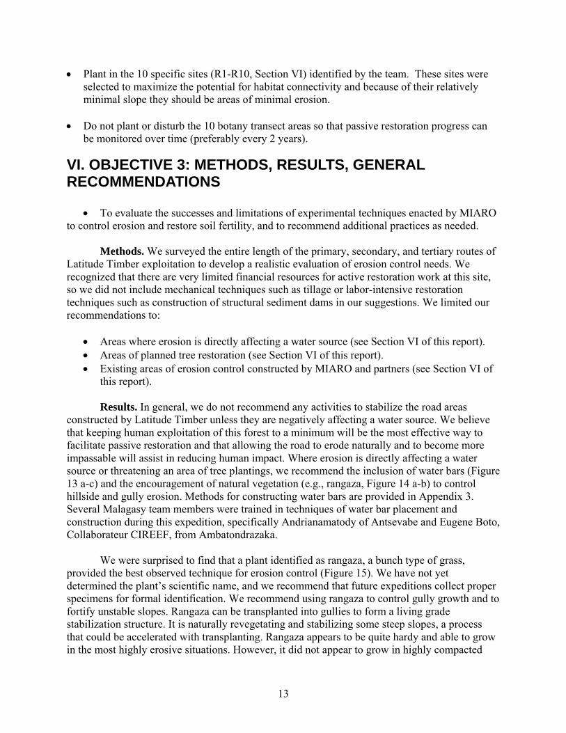
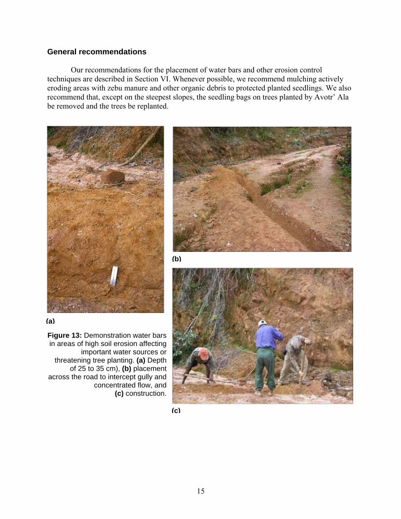
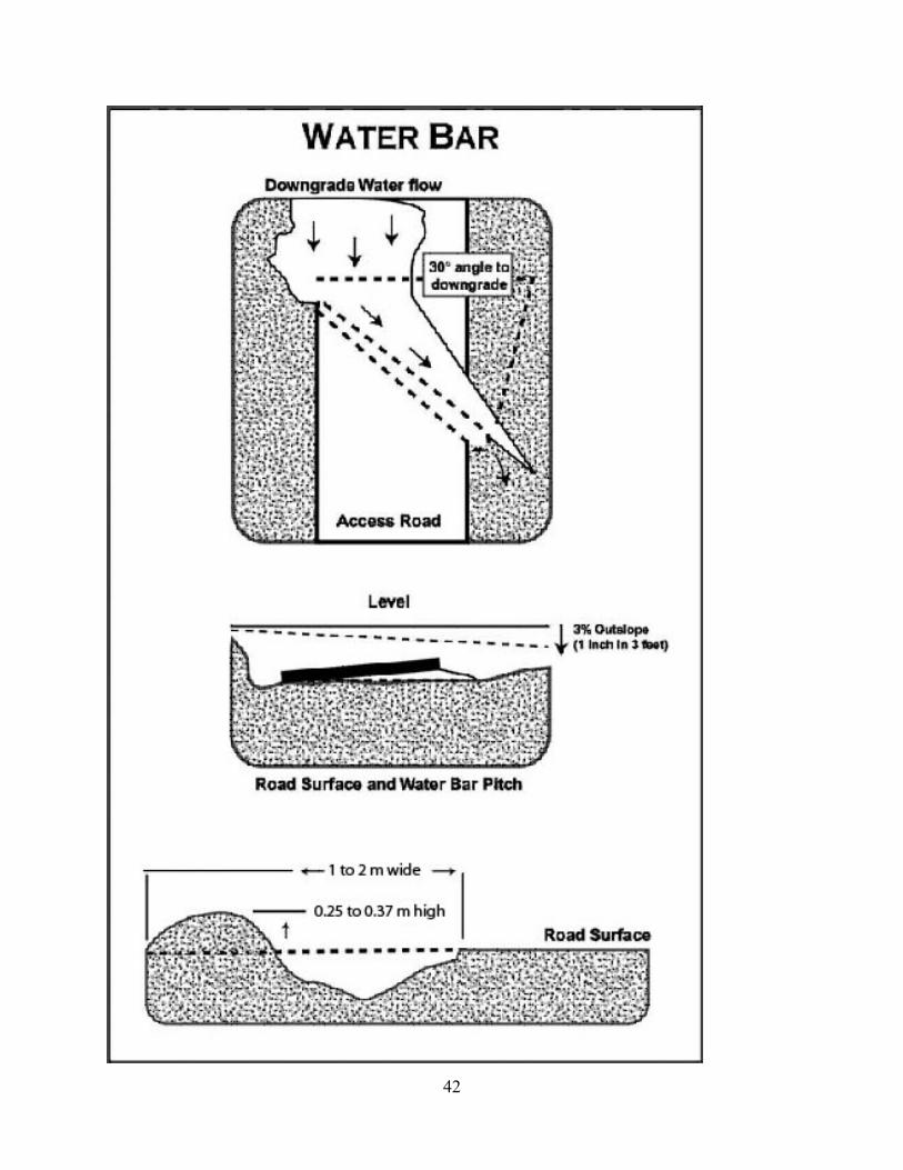
constructed by Latitude Timber unless they are negatively affecting a water source. We believe that keeping human exploitation of this forest to a minimum will be the most effective way to facilitate passive restoration and that allowing the road to erode naturally and to become more impassable will assist in reducing human impact. Where erosion is directly affecting a water source or threatening an area of tree plantings, we recommend the inclusion of water bars (Figure 13 a-c) and the encouragement of natural vegetation (e.g., rangaza, Figure 14 a-b) to control hillside and gully erosion. Methods for constructing water bars are provided in Appendix 3. Several Malagasy team members were trained in techniques of water bar placement and construction during this expedition, specifically Andrianamatody of Antsevabe and Eugene Boto, Collaborateur CIREEF, from Ambatondrazaka.
We were surprised to find that a plant identified as rangaza, a bunch type of grass,
provided the best observed technique for erosion control (Figure 15). We have not yet determined the plant’s scientific name, and we recommend that future expeditions collect proper specimens for formal identification. We recommend using rangaza to control gully growth and to fortify unstable slopes. Rangaza can be transplanted into gullies to form a living grade stabilization structure. It is naturally revegetating and stabilizing some steep slopes, a process that could be accelerated with transplanting. Rangaza appears to be quite hardy and able to grow in the most highly erosive situations. However, it did not appear to grow in highly compacted
13

areas. Large bunches of rangaza divide easily into sprigs that can be planted where needed. Our team has not observed this plant in other regions of Madagascar, but all local guides and assistants believe it to be native to Madagascar. The identification of rangaza is a priority.
14
General recommendations Our recommendations for the placement of water bars and other erosion control
techniques are described in Section VI. Whenever possible, we recommend mulching actively eroding areas with zebu manure and other organic debris to protected planted seedlings. We also recommend that, except on the steepest slopes, the seedling bags on trees planted by Avotr’ Ala be removed and the trees be replanted.
(b)
(a)
Figuin a
re 13: Demonstration water bars reas of high soil erosion affecting
important water sources or threatening tree planting. (a) Depth
of 25 to 35 cm), (b) placement across the road to intercept gully and
concentrated flow, and (c) construction.
(c)
15
(a) (b)
Figure 14: Natural rangaza growth. Site in 2005 (a), and the same site largely stabilized in 2007 with rangaza (b).
(b)
Figure 15: Natural rangaza establishment and erosion control in a gully (a). Rangaza sprigs for replanting (b).
(a)
16
V. OBJECTIVE 4: METHODS, RESULTS, GENERAL RECOMMENDATIONS • To assess the socioeconomic impact of the road on Bemainty and Antsevabe, villages at
opposite ends of the logging road.
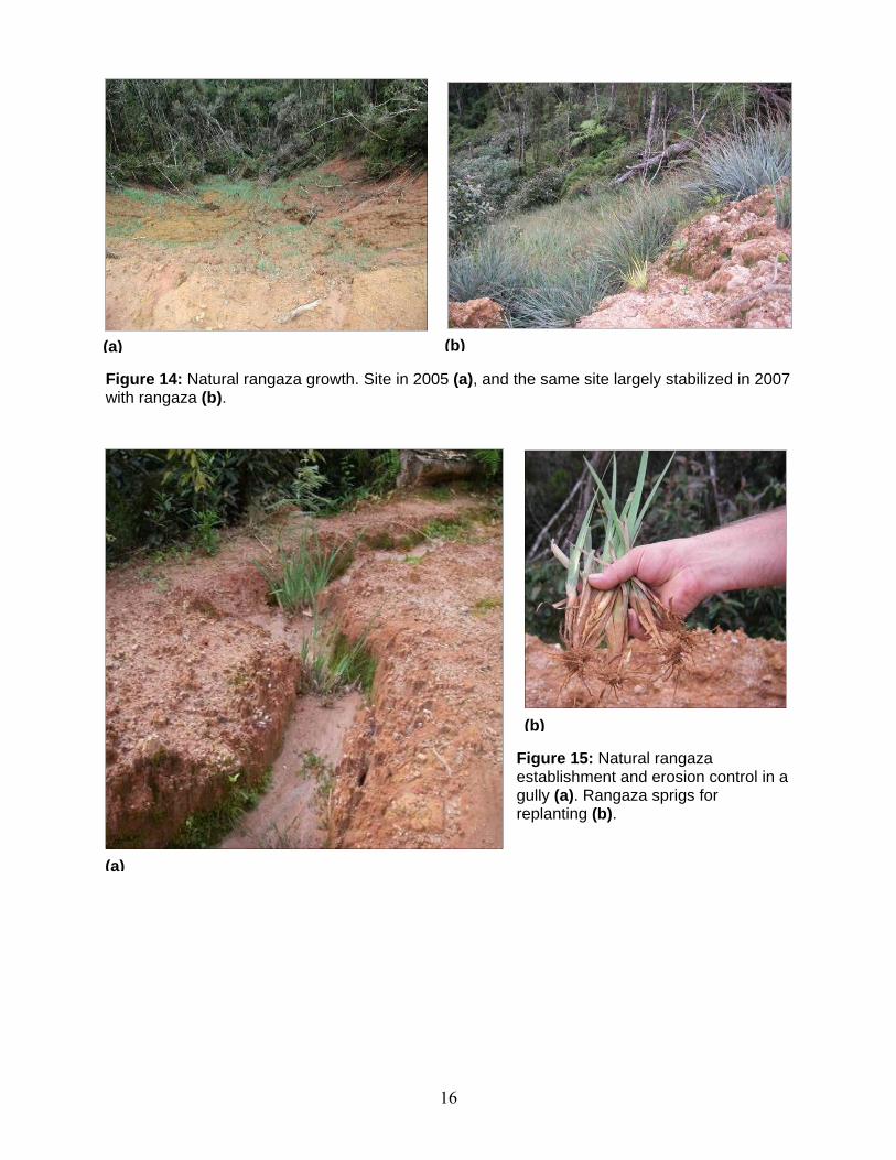
Methods. We conducted interviews separately with men and women from 10 households each in the villages of Antsevabe and Bemainty, which are at opposite ends of the area of exploitation (Figure 1). Antsevabe (S 17° 57.533΄, E 48° 31.214΄) is divided into three sections (Antsevabe center, Tanambao, and Andakazera) with about 3,089 inhabitants, most of the ethnic origin Sihanaka (Figure 16). Bemainty (S 17° 58.286΄, E 48° 34.899΄) is about 40 km by logging road and narrow trail from Antsevabe. It is divided into five sections. Sahananto and Sahambato are 9 km and 13 km, respectively, from the center of Bemainty (Sahavolosy); Ambodihazomena and Maromanagana are each about 1 km east of Bemainty center. In total, there are about 200 household in these five sections of Bemainty, and most individuals are ethnically Betsimisaraka (Figure 17).
Figure 16: The village of Antsevabe, about 25 km southeast of Ambatondrazaka.
Our questions were designed to explore comments made by Antsevabe villagers in 2005
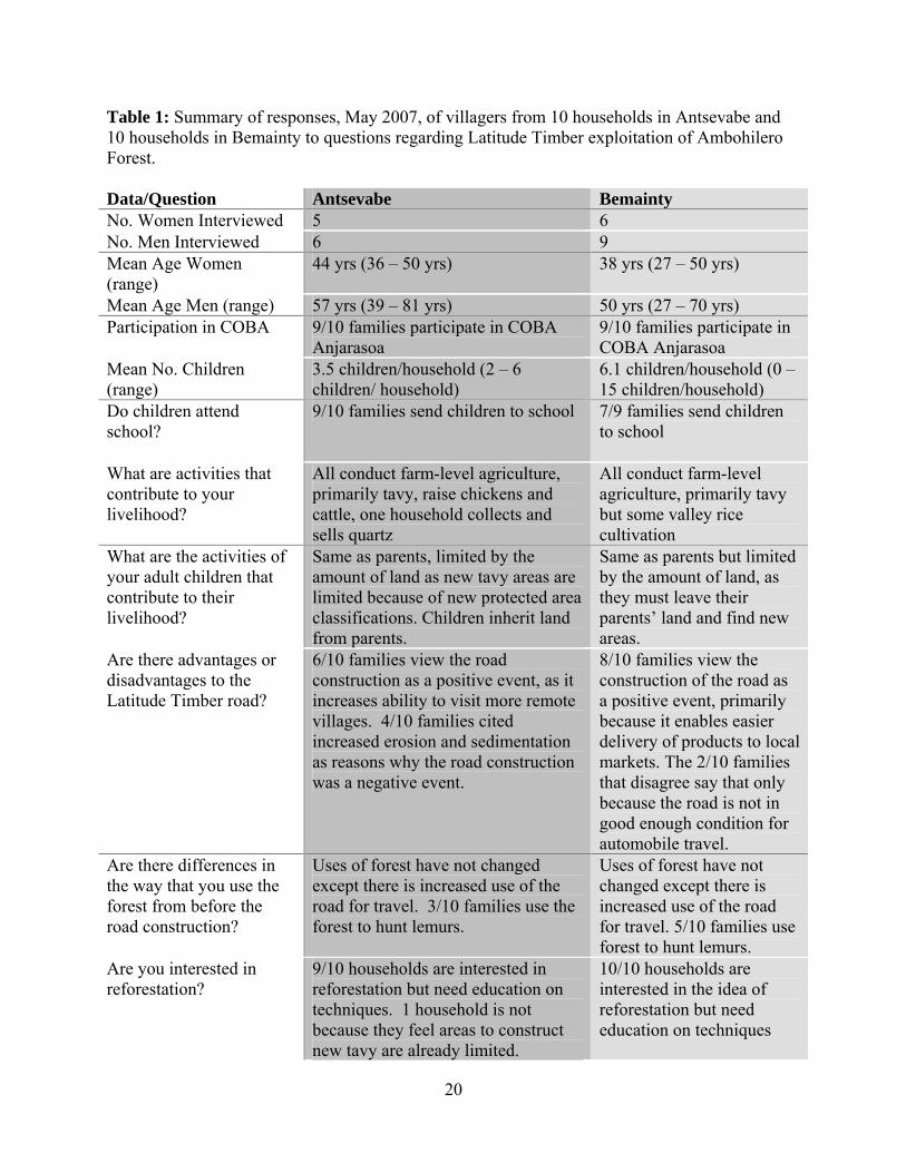
relating to the potential water-quality impact of the road construction, their loss of 8,000 planted Eucalyptus trees during the construction phase, and general impressions of the road and its effect on their daily lives. With men and women in each household interviewed separately, we discussed the following topics: 1) basic demographic information and origins; 2) values and uses of forest and region of road before and after Latitude Timber expansion; 3) land-use practices in the past, present, and future; 4) perceived effects and attitudes toward road construction; and 5) familiarity with the new protected-area plan and community-level forest association (COBA). Summary responses to these questions are in Table 1. Full responses by families and individuals can be provided on request.
Results. The two villages differed in their general impressions of the benefits and costs
of the Latitude Timber exploitation. All households in Bemainty viewed the road construction
17
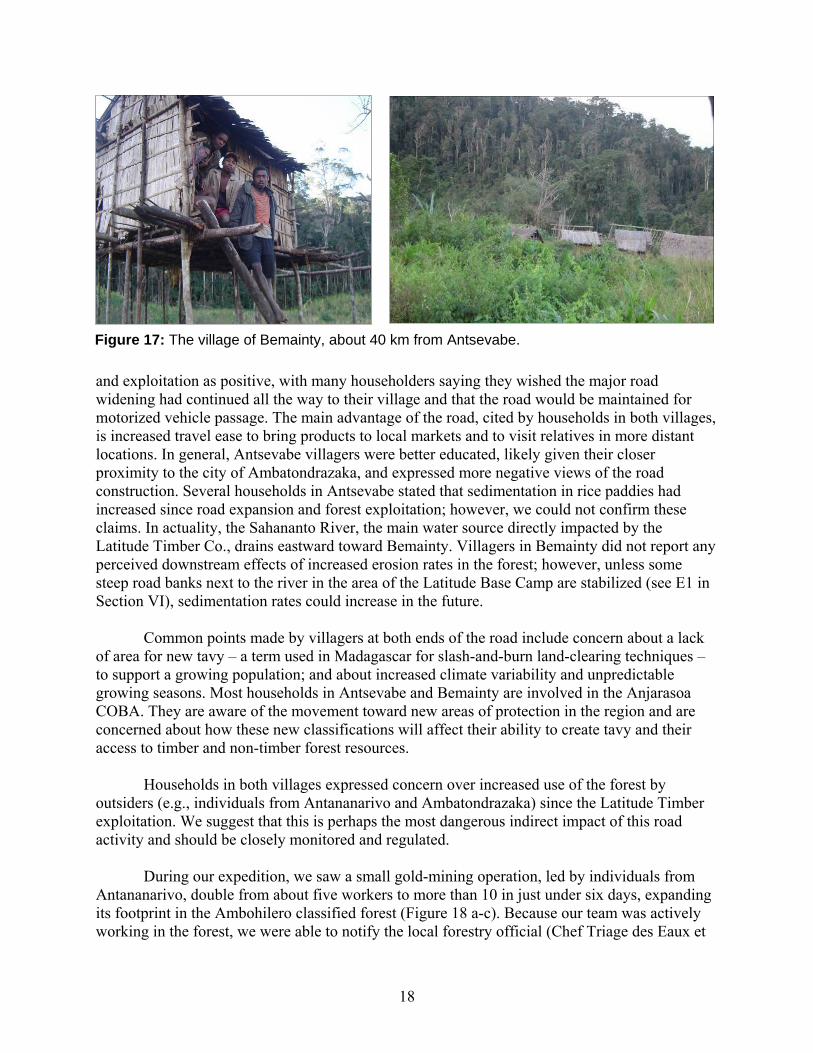
Figure 17: The village of Bemainty, about 40 km from Antsevabe.
and exploitation as positive, with many householders saying they wished the major road widening had continued all the way to their village and that the road would be maintained for motorized vehicle passage. The main advantage of the road, cited by households in both villages, is increased travel ease to bring products to local markets and to visit relatives in more distant locations. In general, Antsevabe villagers were better educated, likely given their closer proximity to the city of Ambatondrazaka, and expressed more negative views of the road construction. Several households in Antsevabe stated that sedimentation in rice paddies had increased since road expansion and forest exploitation; however, we could not confirm these claims. In actuality, the Sahananto River, the main water source directly impacted by the Latitude Timber Co., drains eastward toward Bemainty. Villagers in Bemainty did not report any perceived downstream effects of increased erosion rates in the forest; however, unless some steep road banks next to the river in the area of the Latitude Base Camp are stabilized (see E1 in Section VI), sedimentation rates could increase in the future.
Common points made by villagers at both ends of the road include concern about a lack
of area for new tavy – a term used in Madagascar for slash-and-burn land-clearing techniques – to support a growing population; and about increased climate variability and unpredictable growing seasons. Most households in Antsevabe and Bemainty are involved in the Anjarasoa COBA. They are aware of the movement toward new areas of protection in the region and are concerned about how these new classifications will affect their ability to create tavy and their access to timber and non-timber forest resources.
Households in both villages expressed concern over increased use of the forest by
outsiders (e.g., individuals from Antananarivo and Ambatondrazaka) since the Latitude Timber exploitation. We suggest that this is perhaps the most dangerous indirect impact of this road activity and should be closely monitored and regulated.
During our expedition, we saw a small gold-mining operation, led by individuals from
Antananarivo, double from about five workers to more than 10 in just under six days, expanding its footprint in the Ambohilero classified forest (Figure 18 a-c). Because our team was actively working in the forest, we were able to notify the local forestry official (Chef Triage des Eaux et
18
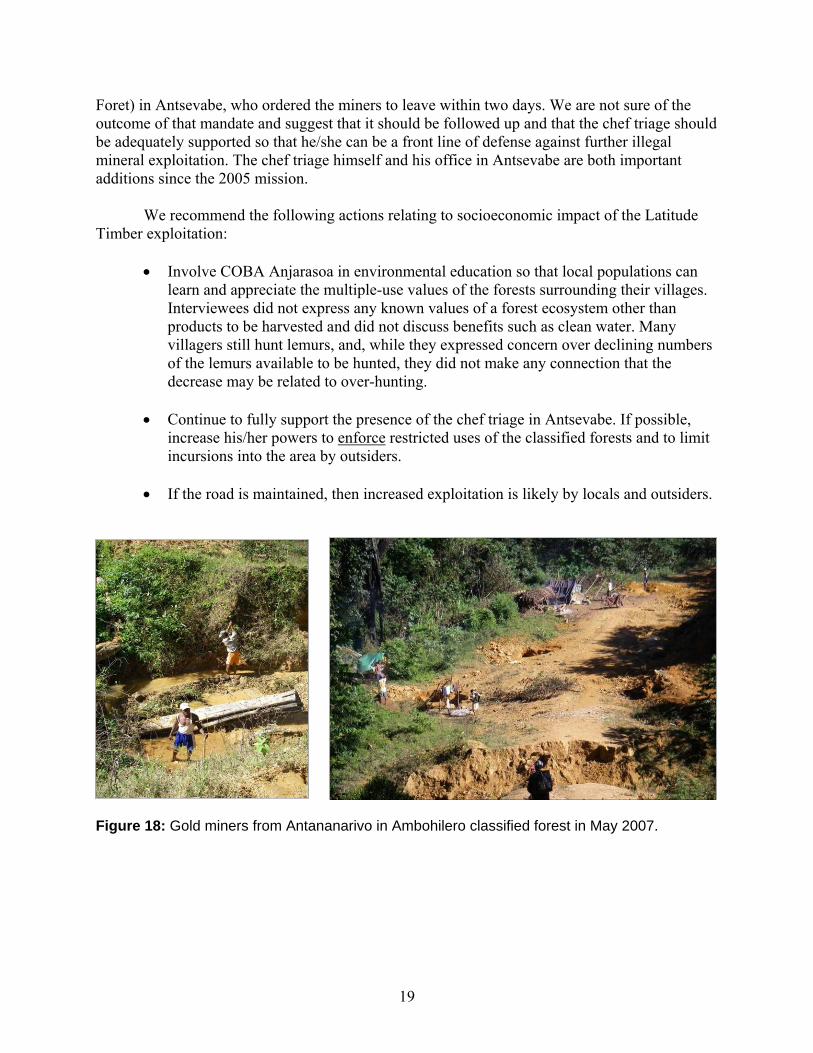
Foret) in Antsevabe, who ordered the miners to leave within two days. We are not sure of the outcome of that mandate and suggest that it should be followed up and that the chef triage should be adequately supported so that he/she can be a front line of defense against further illegal mineral exploitation. The chef triage himself and his office in Antsevabe are both important additions since the 2005 mission. We recommend the following actions relating to socioeconomic impact of the Latitude Timber exploitation:
• Involve COBA Anjarasoa in environmental education so that local populations can learn and appreciate the multiple-use values of the forests surrounding their villages. Interviewees did not express any known values of a forest ecosystem other than products to be harvested and did not discuss benefits such as clean water. Many villagers still hunt lemurs, and, while they expressed concern over declining numbers of the lemurs available to be hunted, they did not make any connection that the decrease may be related to over-hunting.
• Continue to fully support the presence of the chef triage in Antsevabe. If possible,
increase his/her powers to enforce restricted uses of the classified forests and to limit incursions into the area by outsiders.
• If the road is maintained, then increased exploitation is likely by locals and outsiders.
Figure 18: Gold miners from Antananarivo in Ambohilero classified forest in May 2007.
19
20
Table 1: Summary of responses, May 2007, of villagers from 10 households in Antsevabe and 10 households in Bemainty to questions regarding Latitude Timber exploitation of Ambohilero Forest. Data/Question Antsevabe Bemainty No. Women Interviewed 5 6 No. Men Interviewed 6 9 Mean Age Women (range)
44 yrs (36 – 50 yrs) 38 yrs (27 – 50 yrs)
Mean Age Men (range) 57 yrs (39 – 81 yrs) 50 yrs (27 – 70 yrs) Participation in COBA
9/10 families participate in COBA Anjarasoa
9/10 families participate in COBA Anjarasoa
Mean No. Children (range)
3.5 children/household (2 – 6 children/ household)
6.1 children/household (0 – 15 children/household)
Do children attend school?
9/10 families send children to school 7/9 families send children to school
What are activities that contribute to your livelihood?
All conduct farm-level agriculture, primarily tavy, raise chickens and cattle, one household collects and sells quartz
All conduct farm-level agriculture, primarily tavy but some valley rice cultivation
What are the activities of your adult children that contribute to their livelihood?
Same as parents, limited by the amount of land as new tavy areas are limited because of new protected area classifications. Children inherit land from parents.
Same as parents but limited by the amount of land, as they must leave their parents’ land and find new areas.
Are there advantages or disadvantages to the Latitude Timber road?
6/10 families view the road construction as a positive event, as it increases ability to visit more remote villages. 4/10 families cited increased erosion and sedimentation as reasons why the road construction was a negative event.
8/10 families view the construction of the road as a positive event, primarily because it enables easier delivery of products to local markets. The 2/10 families that disagree say that only because the road is not in good enough condition for automobile travel.
Are there differences in the way that you use the forest from before the road construction?
Uses of forest have not changed except there is increased use of the road for travel. 3/10 families use the forest to hunt lemurs.
Uses of forest have not changed except there is increased use of the road for travel. 5/10 families use forest to hunt lemurs.
Are you interested in reforestation?
9/10 households are interested in reforestation but need education on techniques. 1 household is not because they feel areas to construct new tavy are already limited.
10/10 households are interested in the idea of reforestation but need education on techniques
VI. LOCATION-SPECIFIC ACTION PLAN FOR TREE PLANTING, EROSION CONTROL
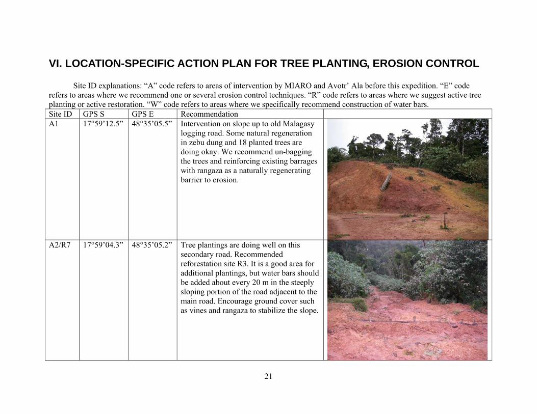
Site ID explanations: “A” code refers to areas of intervention by MIARO and Avotr’ Ala before this expedition. “E” code refers to areas where we recommend one or several erosion control techniques. “R” code refers to areas where we suggest active tree planting or active restoration. “W” code refers to areas where we specifically recommend construction of water bars. Site ID GPS S GPS E Recommendation A1 17°59’12.5” 48°35’05.5” Intervention on slope up to old Malagasy
logging road. Some natural regeneration in zebu dung and 18 planted trees are doing okay. We recommend un-bagging the trees and reinforcing existing barrages with rangaza as a naturally regenerating barrier to erosion.
A2/R7 17°59’04.3” 48°35’05.2” Tree plantings are doing well on this secondary road. Recommended reforestation site R3. It is a good area for additional plantings, but water bars should be added about every 20 m in the steeply sloping portion of the road adjacent to the main road. Encourage ground cover such as vines and rangaza to stabilize the slope.
21
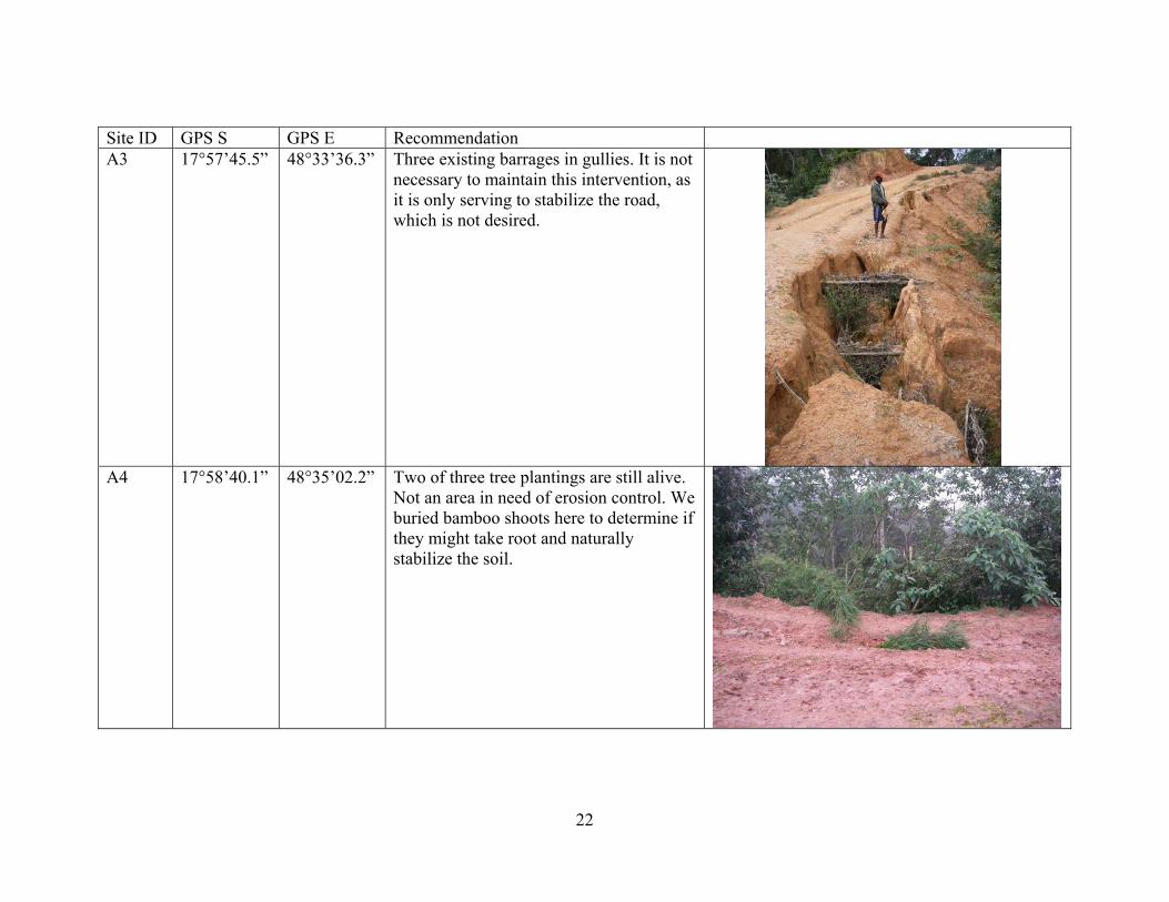
Site ID GPS S GPS E Recommendation A3 17°57’45.5” 48°33’36.3” Three existing barrages in gullies. It is not
necessary to maintain this intervention, as it is only serving to stabilize the road, which is not desired.
A4 17°58’40.1” 48°35’02.2” Two of three tree plantings are still alive.
Not an area in need of erosion control. We buried bamboo shoots here to determine if they might take root and naturally stabilize the soil.
22
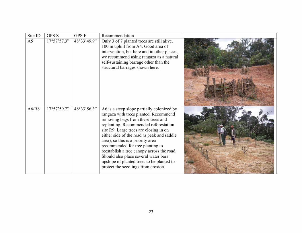
Site ID GPS S GPS E Recommendation A5 17°57’57.3” 48°33’49.9” Only 3 of 7 planted trees are still alive.
100 m uphill from A4. Good area of intervention, but here and in other places, we recommend using rangaza as a natural self-sustaining barrage other than the structural barrages shown here.
A6/R8 17°57’59.2” 48°33’56.3” A6 is a steep slope partially colonized by
rangaza with trees planted. Recommend removing bags from these trees and replanting. Recommended reforestation site R9. Large trees are closing in on either side of the road (a peak and saddle area), so this is a priority area recommended for tree planting to reestablish a tree canopy across the road. Should also place several water bars upslope of planted trees to be planted to protect the seedlings from erosion.
23
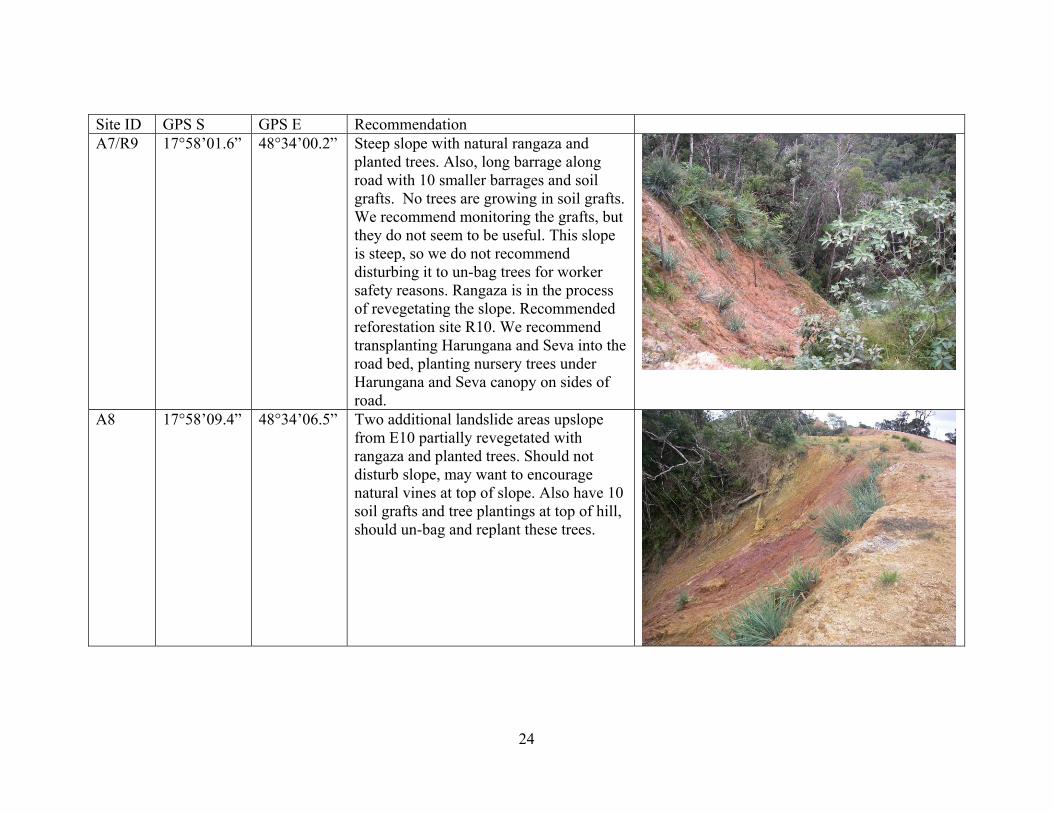
Site ID GPS S GPS E Recommendation A7/R9 17°58’01.6” 48°34’00.2” Steep slope with natural rangaza and
planted trees. Also, long barrage along road with 10 smaller barrages and soil grafts. No trees are growing in soil grafts. We recommend monitoring the grafts, but they do not seem to be useful. This slope is steep, so we do not recommend disturbing it to un-bag trees for worker safety reasons. Rangaza is in the process of revegetating the slope. Recommended reforestation site R10. We recommend transplanting Harungana and Seva into the road bed, planting nursery trees under Harungana and Seva canopy on sides of road.
A8 17°58’09.4” 48°34’06.5” Two additional landslide areas upslope from E10 partially revegetated with rangaza and planted trees. Should not disturb slope, may want to encourage natural vines at top of slope. Also have 10 soil grafts and tree plantings at top of hill, should un-bag and replant these trees.
24
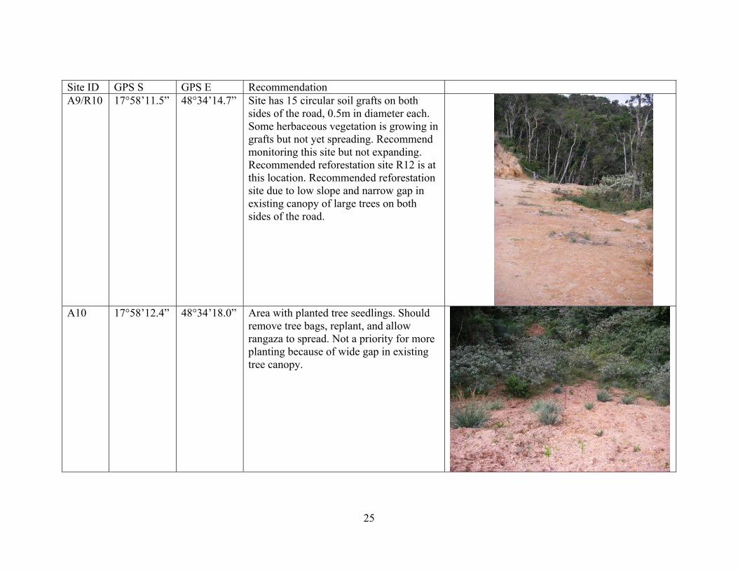
Site ID GPS S GPS E Recommendation A9/R10 17°58’11.5” 48°34’14.7” Site has 15 circular soil grafts on both
sides of the road, 0.5m in diameter each. Some herbaceous vegetation is growing in grafts but not yet spreading. Recommend monitoring this site but not expanding. Recommended reforestation site R12 is at this location. Recommended reforestation site due to low slope and narrow gap in existing canopy of large trees on both sides of the road.
A10 17°58’12.4” 48°34’18.0” Area with planted tree seedlings. Should
remove tree bags, replant, and allow rangaza to spread. Not a priority for more planting because of wide gap in existing tree canopy.
25
Site ID GPS S GPS E Recommendation A11 17°58’13.1” 48°34’26.0” Recommend adding a water bar as shown
and un-bagging and replanting seedlings in area.
No photo available
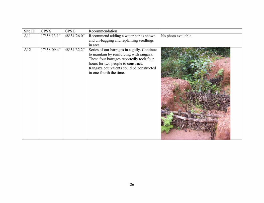
A12 17°58’09.4” 48°34’32.2” Series of our barrages in a gully. Continue to maintain by reinforcing with rangaza. These four barrages reportedly took four hours for two people to construct. Rangaza equivalents could be constructed in one-fourth the time.
26
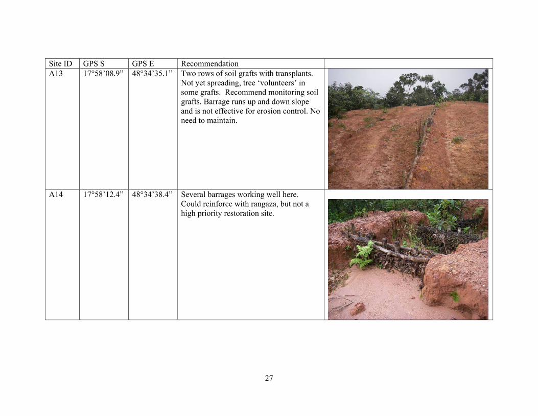
Site ID GPS S GPS E Recommendation A13 17°58’08.9” 48°34’35.1” Two rows of soil grafts with transplants.
Not yet spreading, tree ‘volunteers’ in some grafts. Recommend monitoring soil grafts. Barrage runs up and down slope and is not effective for erosion control. No need to maintain.
A14 17°58’12.4” 48°34’38.4” Several barrages working well here.
Could reinforce with rangaza, but not a high priority restoration site.
27
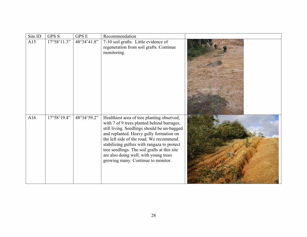
Site ID GPS S GPS E Recommendation A15 17°58’11.3” 48°34’41.8” 7-10 soil grafts. Little evidence of
regeneration from soil grafts. Continue monitoring.
A16 17°58’19.4” 48°34’59.2” Healthiest area of tree planting observed,
with 7 of 9 trees planted behind barrages, still living. Seedlings should be un-bagged and replanted. Heavy gully formation on the left side of the road. We recommend stabilizing gullies with rangaza to protect tree seedlings. The soil grafts at this site are also doing well, with young trees growing many. Continue to monitor.
28
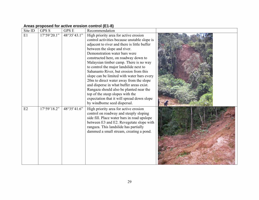
Areas proposed for active erosion control (E1-8) Site ID GPS S GPS E Recommendation E1 17°59’20.1” 48°35’43.1” High priority area for active erosion
control activities because unstable slope is adjacent to river and there is little buffer between the slope and river. Demonstration water bars were constructed here, on roadway down to Malaysian timber camp. There is no way to control the major landslide next to Sahananto River, but erosion from this slope can be limited with water bars every 20m to direct water away from the slope and disperse in what buffer areas exist. Rangaza should also be planted near the top of the steep slopes with the expectation that it will spread down slope by windborne seed dispersal.
E2 17°59’18.2” 48°35’41.6” High priority area for active erosion control on roadway and steeply sloping side fill. Place water bars in road upslope between E3 and E2. Revegetate slope with rangaza. This landslide has partially dammed a small stream, creating a pond.
29
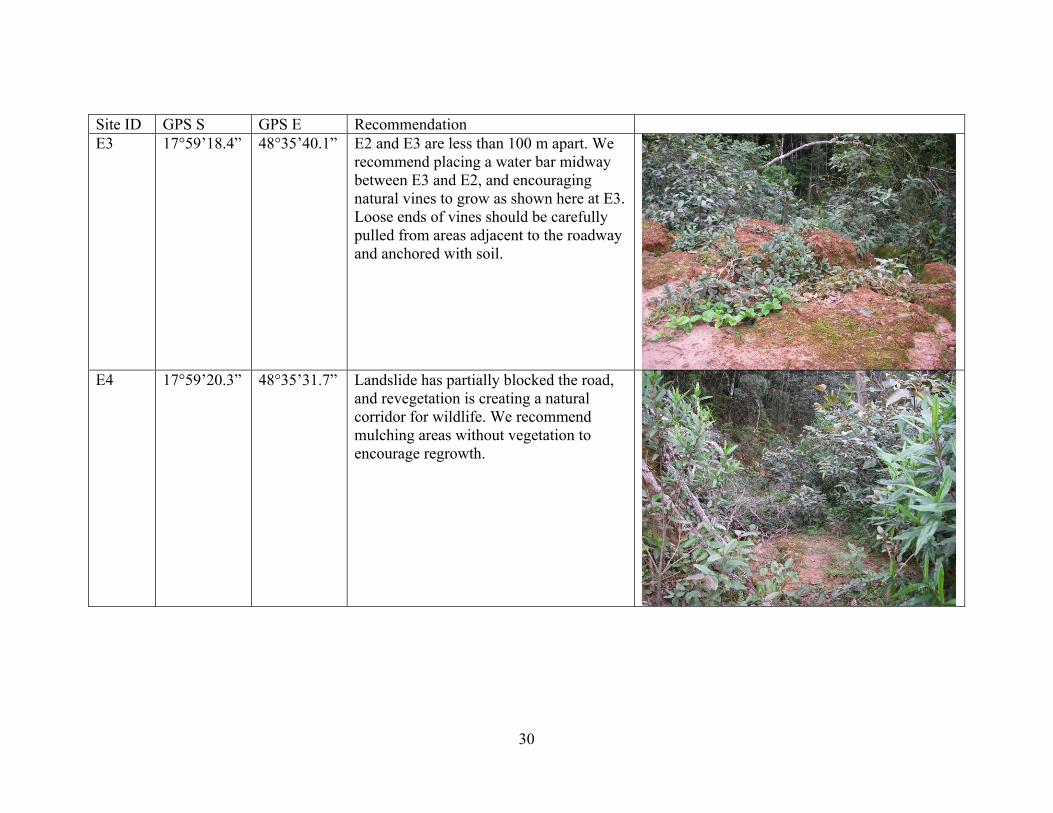
Site ID GPS S GPS E Recommendation E3 17°59’18.4” 48°35’40.1” E2 and E3 are less than 100 m apart. We
recommend placing a water bar midway between E3 and E2, and encouraging natural vines to grow as shown here at E3. Loose ends of vines should be carefully pulled from areas adjacent to the roadway and anchored with soil.
E4 17°59’20.3” 48°35’31.7” Landslide has partially blocked the road,
and revegetation is creating a natural corridor for wildlife. We recommend mulching areas without vegetation to encourage regrowth.
30
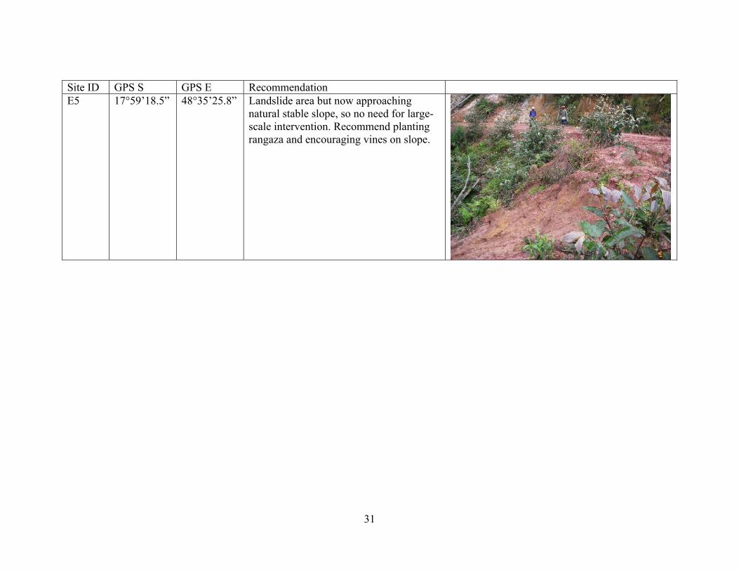
Site ID GPS S GPS E Recommendation E5 17°59’18.5” 48°35’25.8” Landslide area but now approaching
natural stable slope, so no need for large-scale intervention. Recommend planting rangaza and encouraging vines on slope.
31
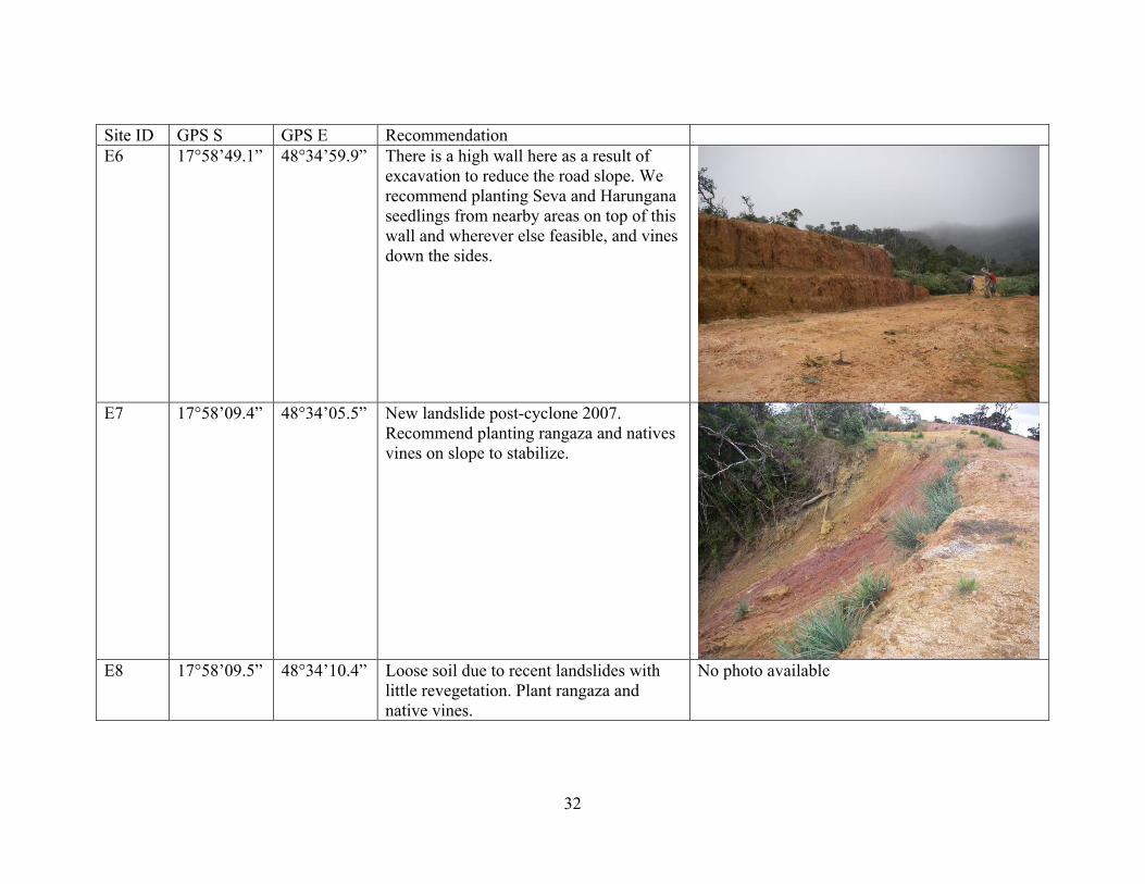
Site ID GPS S GPS E Recommendation E6 17°58’49.1” 48°34’59.9” There is a high wall here as a result of
excavation to reduce the road slope. We recommend planting Seva and Harungana seedlings from nearby areas on top of this wall and wherever else feasible, and vines down the sides.
E7 17°58’09.4” 48°34’05.5” New landslide post-cyclone 2007.
Recommend planting rangaza and natives vines on slope to stabilize.
E8 17°58’09.5” 48°34’10.4” Loose soil due to recent landslides with
little revegetation. Plant rangaza and native vines.
No photo available
32

Areas proposed for active reforestation with trees from the existing nurseries (R1- R6 here, R7- R10 in A section above). We recommend planting nursery-grown primary and secondary forest trees under the cover of fast-growing pioneer species (e.g. Harungana and Solanum) along the sides of the road. We also recommend moving some of the existing pioneer species from the road sides into the center of the road to facilitate corridor formation and create natural mulch on the compacted road bed. Site ID GPS S GPS E Recommendation R1 17°58’24.0” 48°35’02.4” Good saddle area for tree planting to
create a corridor. We recommend placing water bars every 20m to facilitate tree growth.
33
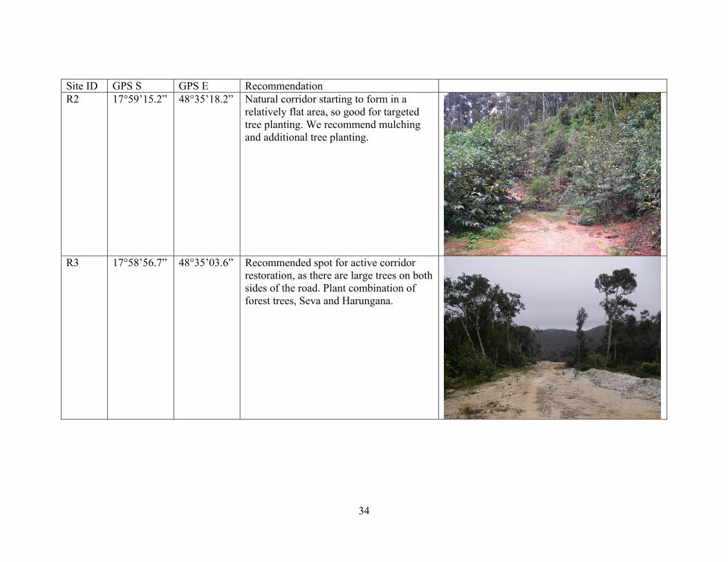
Site ID GPS S GPS E Recommendation R2 17°59’15.2” 48°35’18.2” Natural corridor starting to form in a
relatively flat area, so good for targeted tree planting. We recommend mulching and additional tree planting.
R3 17°58’56.7” 48°35’03.6” Recommended spot for active corridor
restoration, as there are large trees on both sides of the road. Plant combination of forest trees, Seva and Harungana.
34
Site ID GPS S GPS E Recommendation R4 17°57’45.5” 48°33’36.3” Recommended site for active reforestation
to restore wildlife corridor. Currently there is a 7m wide gap in the canopy, with large trees on both sides of the road. Top of saddle. Located between DP21-20
No photo available
R5 17°58’09.8” 48°34’07.4” Recommended site for active reforestation to restore wildlife corridor. Currently there is a 7 m wide gap in the canopy, with large trees on both sides of the road.
No photo available
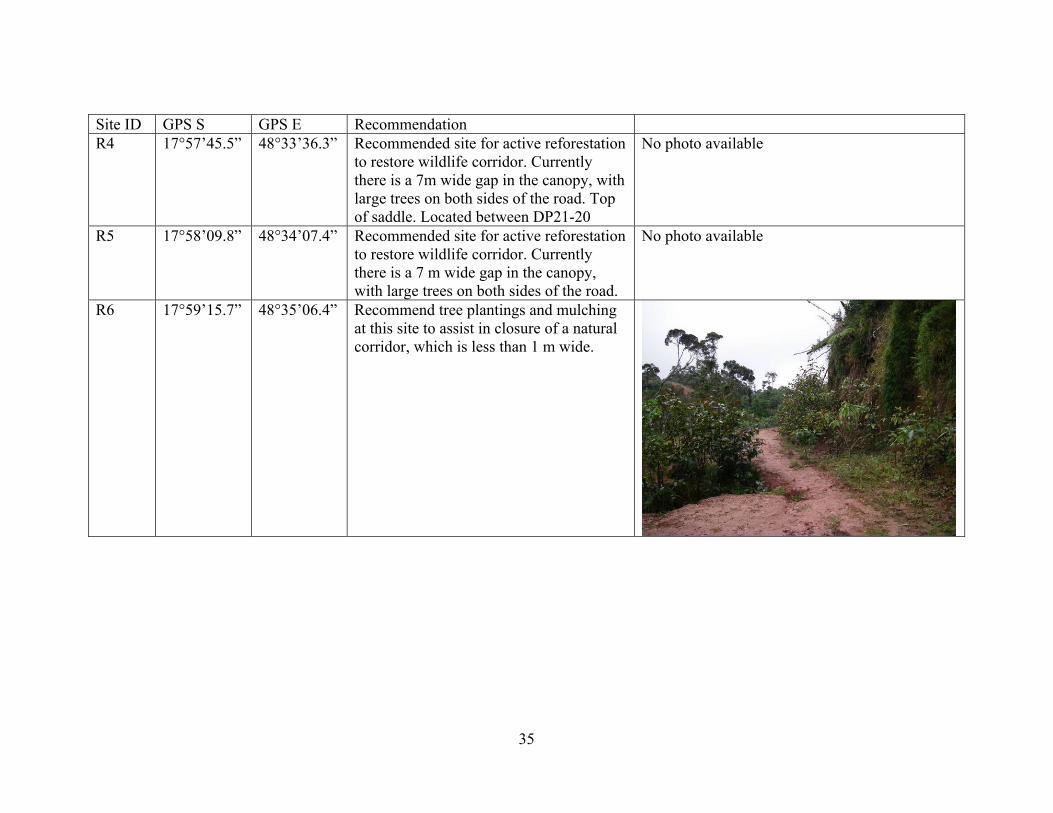
R6 17°59’15.7” 48°35’06.4” Recommend tree plantings and mulching at this site to assist in closure of a natural corridor, which is less than 1 m wide.
35
36
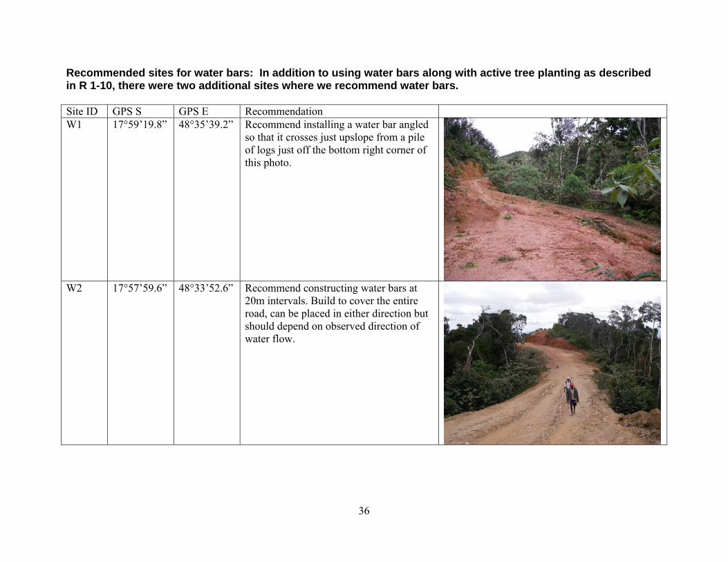
Recommended sites for water bars: In addition to using water bars along with active tree planting as described in R 1-10, there were two additional sites where we recommend water bars. Site ID GPS S GPS E Recommendation W1 17°59’19.8” 48°35’39.2” Recommend installing a water bar angled
so that it crosses just upslope from a pile of logs just off the bottom right corner of this photo.
W2 17°57’59.6” 48°33’52.6” Recommend constructing water bars at
20m intervals. Build to cover the entire road, can be placed in either direction but should depend on observed direction of water flow.
VII. CONCLUSIONS • The forest is recovering through natural regeneration. Recession, for example Harungana-
dominated vegetation can recede to herbaceous cover if they are not succeeded in their approximately 15-yr lifespan, is a possibility at this site (L. Holloway, personal communication, TAMS Project, Conservation International). We propose planting the secondary and primary forest trees available in the nurseries on site under the cover of these pioneer species to minimize the possibility of recession in key areas. We also recommend thinning the pioneer species growing along the road edge by transplanting those Harungana and Solanum into the main road bed. This will accomplish two goals: 1) thinning will increase the success of secondary forest seedlings trying to establish on the road edges, and 2) transplanting these young trees into the compacted road area will increase mulch in that area and promote natural regeneration and it will facilitate corridor formation for wildlife. The operations of Latitude Timber nearly severed the unique Ankeniheny-Zahamena corridor and the associated carbon conservation corridor, so any steps to facilitate natural regeneration in this important area should be taken.
• At this point, there do not seem to be major incursions of invasive species into this area (e.g.
Clidemia hirta that dominates in savoka environments). If non-native invasive species begin to be observed, we recommend immediate attempts at eradication to preserve the integrity of this unique forest system (L. Holloway, personal communication).
• Erosion, gullying, landslides, and bridge washouts have rendered the road impassable to
vehicles. This is an excellent development, which works against further exploitation of the area. The road should not be repaired or maintained.
• There do not seem to be major downstream water-quality impacts at this time due to the road
construction because of natural buffering by the forest. • National protocols are needed for construction of roads in forested and other natural areas.
Revegetation and erosion-control activities should occur simultaneously with road construction, and provisions must be made to include natural corridors or bridges across the road for wildlife movement.
• Capacity-building for ecological restoration is a priority. The TAMS project is developing
this capacity in this region, but national capacity building is a priority. Capacity-building must include professionals at all levels of Eaux et Foret AND local villagers that are likely to be tasked with “sustainable exploitation” as part of management transfer agreements without having any true understanding of what “sustainable” looks like on the ground.
• Ambohilero is an unusual opportunity to observe and study passive restoration in
Madagascar. The logging operations in this regions have impaired ecosystem function in ways very similar to forest conversion to agriculture (L. Holloway, personal communication), and so lessons learned at this site can be translated to multiple other similar situations. This unique opportunity at Ambohilero is mostly a result of the isolated nature of the area and the
37
low level of use, even as a throughway by locals. The team found very little evidence of small-tree cutting or other disturbance by locals since the termination of Latitude Timber operations (with the exception of the gold mining operation). The presence is mostly limited to zebu and the few locals who herd them, as well as the occasional traveler walking to or from Bemainty. This very low level of disturbance following a catastrophic upheaval is an unusual situation in Madagascar and provides the opportunity to learn from long-term monitoring of both passive and active forest restoration if future exploitation is limited.
• The incursion of the illegal logging road into pristine rainforest habitat has important
consequences for the endemic flora and fauna of this corridor region. While we are trying to quantify the effect of this activity on the flora and the responses of the flora to this perturbation, we are unable during such short expeditions to quantify the impact to the fauna. We did observe a diversity of lemur species along the road, including Indri indri, Propithecus diadema, Eulemur fulvus rufus, Avahi laniger, Microcebus murinus, and Cheirogaleus major, but we did not conduct systematic surveys to determine abundance. We did observe two adult Propithecus diadema (IUCN-Critically Endangered) vertically jumping across a section of road where the roadbed was 30m wide and there was only shrubby vegetation for 15m on both sides of the main road before the lemurs could reach trees large enough to climb. More systematic studies are needed to understand how different species are affected by the road, such as which species are capable of crossing it and how different species may avoid or be attracted to this new edge habitat. It is also important to minimize human access to this region as much as possible, to minimize hunting impacts in areas previously isolated from this pressure. Villagers in Bemainty mentioned that in the past, they were able to hunt and kill “greater than 10 lemurs per day” but that it was now impossible to find that many lemurs near their village. There is a real risk that they will start to use these newly available regions of forest made accessible by the road to hunt lemurs. Environmental education is needed on this subject.
VIII. LITERATURE CITED Aronson, J., P.P. Lowry II, F. Raharimalala, D.J. Tongway, P. Lavelle, P.O. Berner. 2005.
Restoring and reintegrating the Ambohilero Forest following uncontrolled, industrial logging and road building. A Report to USAID Madagascar, Antananarivo, Pp. 29.
Karpanty, S.M., J.D. Fraser, and C. Welch. 2005. Rapid assessment of damage and regeneration
potential in Didy Forest exploited by Latitude Timber Company. A Report to USAID Madagascar, Antananarivo, Pp. 34.
38
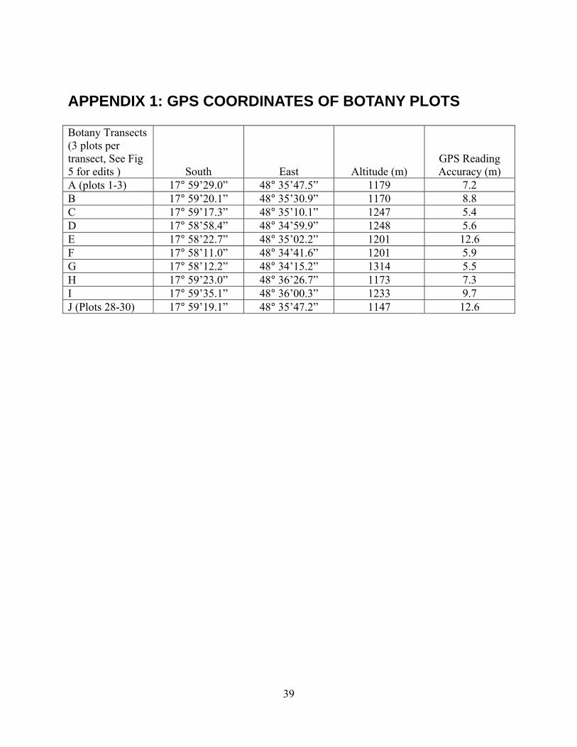
APPENDIX 1: GPS COORDINATES OF BOTANY PLOTS Botany Transects (3 plots per transect, See Fig 5 for edits ) South East Altitude (m)
GPS Reading Accuracy (m)
A (plots 1-3) 17° 59’29.0” 48° 35’47.5” 1179 7.2 B 17° 59’20.1” 48° 35’30.9” 1170 8.8 C 17° 59’17.3” 48° 35’10.1” 1247 5.4 D 17° 58’58.4” 48° 34’59.9” 1248 5.6 E 17° 58’22.7” 48° 35’02.2” 1201 12.6 F 17° 58’11.0” 48° 34’41.6” 1201 5.9 G 17° 58’12.2” 48° 34’15.2” 1314 5.5 H 17° 59’23.0” 48° 36’26.7” 1173 7.3 I 17° 59’35.1” 48° 36’00.3” 1233 9.7 J (Plots 28-30) 17° 59’19.1” 48° 35’47.2” 1147 12.6
39
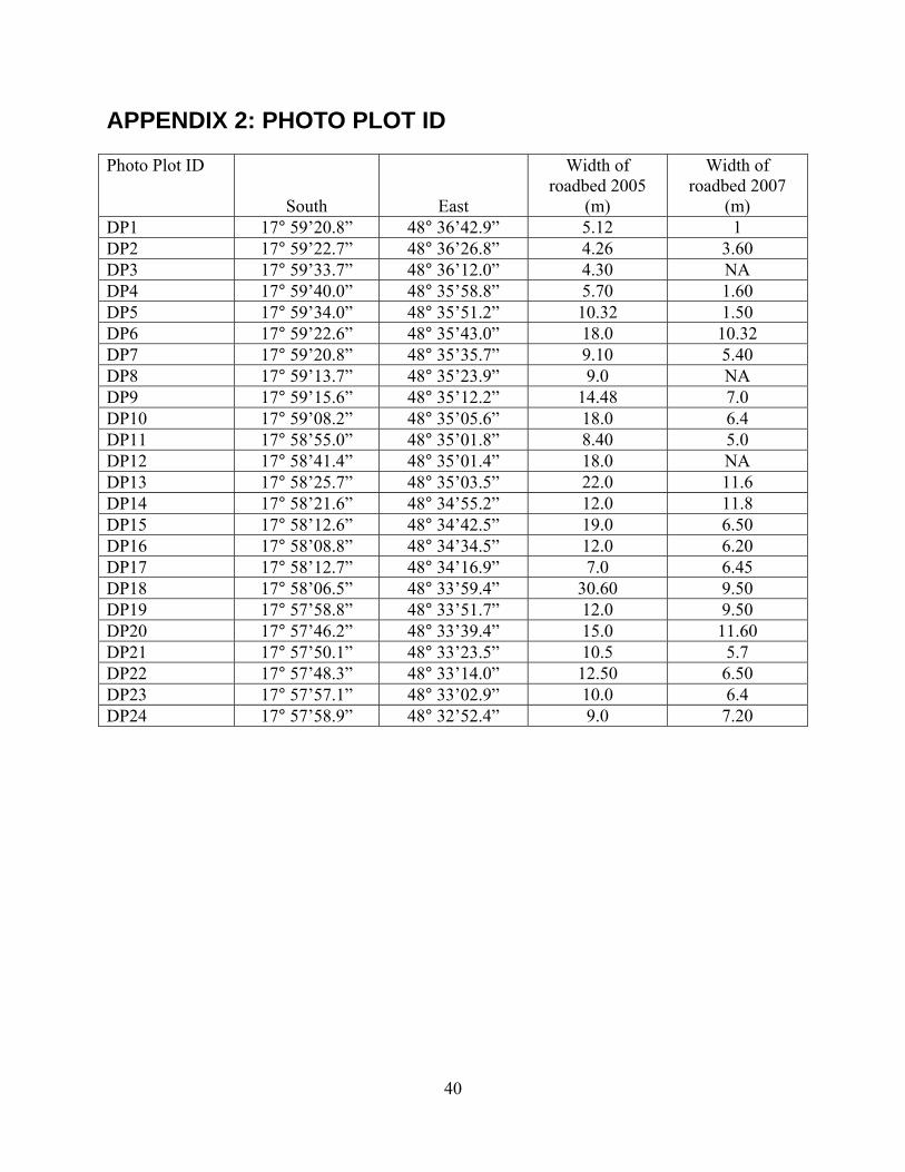
APPENDIX 2: PHOTO PLOT ID Photo Plot ID
South East
Width of roadbed 2005
(m)
Width of roadbed 2007
(m) DP1 17° 59’20.8” 48° 36’42.9” 5.12 1 DP2 17° 59’22.7” 48° 36’26.8” 4.26 3.60 DP3 17° 59’33.7” 48° 36’12.0” 4.30 NA DP4 17° 59’40.0” 48° 35’58.8” 5.70 1.60 DP5 17° 59’34.0” 48° 35’51.2” 10.32 1.50 DP6 17° 59’22.6” 48° 35’43.0” 18.0 10.32 DP7 17° 59’20.8” 48° 35’35.7” 9.10 5.40 DP8 17° 59’13.7” 48° 35’23.9” 9.0 NA DP9 17° 59’15.6” 48° 35’12.2” 14.48 7.0 DP10 17° 59’08.2” 48° 35’05.6” 18.0 6.4 DP11 17° 58’55.0” 48° 35’01.8” 8.40 5.0 DP12 17° 58’41.4” 48° 35’01.4” 18.0 NA DP13 17° 58’25.7” 48° 35’03.5” 22.0 11.6 DP14 17° 58’21.6” 48° 34’55.2” 12.0 11.8 DP15 17° 58’12.6” 48° 34’42.5” 19.0 6.50 DP16 17° 58’08.8” 48° 34’34.5” 12.0 6.20 DP17 17° 58’12.7” 48° 34’16.9” 7.0 6.45 DP18 17° 58’06.5” 48° 33’59.4” 30.60 9.50 DP19 17° 57’58.8” 48° 33’51.7” 12.0 9.50 DP20 17° 57’46.2” 48° 33’39.4” 15.0 11.60 DP21 17° 57’50.1” 48° 33’23.5” 10.5 5.7 DP22 17° 57’48.3” 48° 33’14.0” 12.50 6.50 DP23 17° 57’57.1” 48° 33’02.9” 10.0 6.4 DP24 17° 57’58.9” 48° 32’52.4” 9.0 7.20
40
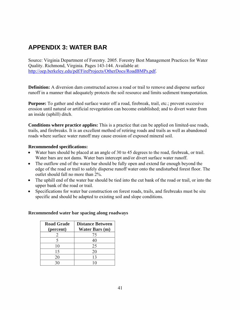
APPENDIX 3: WATER BAR Source: Virginia Department of Forestry. 2005. Forestry Best Management Practices for Water Quality. Richmond, Virginia. Pages 143-144. Available at: http://oep.berkeley.edu/pdf/FireProjects/OtherDocs/RoadBMPs.pdf. Definition: A diversion dam constructed across a road or trail to remove and disperse surface runoff in a manner that adequately protects the soil resource and limits sediment transportation. Purpose: To gather and shed surface water off a road, firebreak, trail, etc.; prevent excessive erosion until natural or artificial revegetation can become established; and to divert water from an inside (uphill) ditch. Conditions where practice applies: This is a practice that can be applied on limited-use roads, trails, and firebreaks. It is an excellent method of retiring roads and trails as well as abandoned roads where surface water runoff may cause erosion of exposed mineral soil. Recommended specifications: • Water bars should be placed at an angle of 30 to 45 degrees to the road, firebreak, or trail.
Water bars are not dams. Water bars intercept and/or divert surface water runoff. • The outflow end of the water bar should be fully open and extend far enough beyond the
edge of the road or trail to safely disperse runoff water onto the undisturbed forest floor. The outlet should fall no more than 2%.
• The uphill end of the water bar should be tied into the cut bank of the road or trail, or into the upper bank of the road or trail.
• Specifications for water bar construction on forest roads, trails, and firebreaks must be site specific and should be adapted to existing soil and slope conditions.
Recommended water bar spacing along roadways
Road Grade (percent)
Distance Between Water Bars (m)
2 75 5 40 10 25 15 20 20 13 30 10
41
42