Embed Size (px)
Citation preview
Action Plan for the Deployment of
Intelligent Transport Systems (ITS)
in the Czech Republic until 2020
(with the Prospect of 2050)
Original text is written in Czech language
Czech version was translated into English on 1st June 2016

3
Contents
1 Introduction ............................................................................................................................... 6
2 Preparation of the ITS Action Plan, Cooperation with Partners ........................................ 11
3 Opening ................................................................................................................................... 13
3.1 The Current State of ITS Deployment in the Czech Republic .......................................... 15
3.1.1 Road Transport ............................................................................................................. 15
3.1.2 Public Passenger Transport ......................................................................................... 19
3.1.3 Accessibility of Public Passenger Transport Services to People with Specific Needs 22
3.1.4 Railway Transport ......................................................................................................... 23
3.1.4.1 Railway Operator .................................................................................................. 25
3.1.4.2 Railway Passenger Transport Operator ............................................................... 27
3.1.4.3 Railway Freight Transport Operator ..................................................................... 27
3.1.5 Freight Transport Logistic ............................................................................................. 28
3.1.6 Inland Navigation .......................................................................................................... 29
3.1.7 Air Transport ................................................................................................................. 31
3.1.8 Spatial Data .................................................................................................................. 32
3.1.9 ITS Deployment by Regions and Statutory Towns ...................................................... 33
3.1.10 Social Significance of the ITS Implementation ......................................................... 33
3.1.10.1 Reducing the Social Costs of Transport through the ITS Implementation ........... 33
3.1.10.2 Legal Liability of the Road ITS Operators ............................................................ 36
3.1.10.3 Legal Issues Concerning Processing and Sharing of Data in the Transport
Systems Area ....................................................................................................................... 38
3.1.11 The Imperative to Set and Comply with Technical Norms, Standards and System
Parameters while Defining the Procurement Policies .............................................................. 39
4 ITS AP in Follow-up to Related Strategic and Legal Documents ..................................... 42
4.1 ITS Directive and Development of ITS Priority Actions Defined in the ITS Directive ....... 42
4.2 Implementation the ITS Directive in the CR ..................................................................... 46
4.3 Other Related Strategic and Legal EU Documents .......................................................... 47
4.4 Related Strategic and National Legal Documents ........................................................... 50
5 Persisting Problems in ITS Operation in the CR ................................................................. 54
6 Development of International ITS Cooperation ................................................................... 60
7 SWOT Analysis ....................................................................................................................... 61
8 Global Objective, Strategic and Specific Objectives of the ITS Action Plan .................. 64
8.1 Vision: Ideal Resulting Situation of ITS Development ...................................................... 64
8.2 Global Objective ............................................................................................................... 68
8.3 Strategic and Specific Objectives ..................................................................................... 69
8.3.1 Strategic Objective No. 1: Efficient and Intelligent Transport Infrastructure with
Qualified Service Staff .............................................................................................................. 69
8.3.2 Strategic Objective No. 2: Ensuring Continuity of Traffic and the Associated Reduction
of Total Time Losses in Traffic ................................................................................................. 71
8.3.2.1 Specific Factual Objective No. 2.1: Increasing Awareness of Traffic Participants73
8.3.3 Strategic Objective No. 3: Increasing Traffic Safety ..................................................... 73
4
8.3.3.1 Specific Framework Objective No. 3.1: Reducing Number of Dead and Seriously
Injured People in Road Traffic .............................................................................................. 74
8.3.3.2 Specific Framework Objective No. 3.2: Reducing Risk of Emergencies while
Transporting Loads that Require Special Care or Supervision (Dangerous, Oversized and
Overweight Loads) ............................................................................................................... 75
8.3.3.3 Specific Framework Objective No. 3.3: Increasing Awareness of People Located
in the Area of Natural Disaster or Other Emergency or Approaching That Place ................ 76
8.3.3.4 Specific Factual Objective No. 3.4: Improving Safety in Road Freight Transport 76
8.3.3.5 Specific Factual Objective No. 3.5: Reducing Risk Behavior of People
Approaching the Railway Tracks .......................................................................................... 76
8.3.3.6 Specific Factual Objective No. 3.6: Reducing Risk of Jeopardizing Railway
Transport Safety due to Technical Defects in Vehicles ........................................................ 76
8.3.3.7 Specific Factual Objective No. 3.7: Improving Safety and Flow Continuity of
Railway Transport through ITS – Control-analysis Centre for Railway Traffic Management77
8.3.3.8 Specific Factual Objective No. 3.8: Reducing the Risk of Jeopardizing Railway
Traffic Safety due to Damage or Theft of Technical Devices and Equipment on Railway
Infrastructure ........................................................................................................................ 78
8.3.4 Strategic Objective No. 4: Reducing Serious Violations of Traffic Rules and Avoiding
Serious Law Violations in Traffic .............................................................................................. 78
8.3.5 Strategic Objective No. 5: Development of ITS in a Harmonized Manner ................... 79
8.3.5.1 Specific Framework Objective No. 5.1: Creating Transparent Market of ITS
Mobility as a Service............................................................................................................. 80
8.3.5.2 Specific Framework Objective No. 5.2: Creating Standardized ITS Interfaces for
Technically Similar Systems in Other Modes of Transport .................................................. 80
8.3.5.3 Specific Factual Objective No. 5.3: Creating an Integrated Technological System
of the Railway Infrastructure Manager ................................................................................. 81
8.3.5.4 Specific Framework Objective No. 5.4: Development of the Spatial Data in
Transport 81
8.3.5.5 Specific Factual Objective No. 5.5: ITS Development in Connection with the
Development of Clean Mobility ............................................................................................. 83
8.3.5.6 Specific Framework Objective 5.6: Development of Space Technologies ........... 84
8.3.5.7 Specific Decisive Objective No. 5.7: Supporting Development of Autonomous
(Robotic) Vehicles ................................................................................................................ 85
8.3.5.8 Specific Decisive Objective No. 5.8: Supporting Research, Development and
Innovations ........................................................................................................................... 86
8.3.6 Strategic Objective No. 6: Supporting the Development of Social Technologies and
Services .................................................................................................................................... 87
8.3.7 Strategic Objective No. 7: Supporting Educational and Training Programmes ........... 88
8.3.8 Strategic Objective No. 8: Supporting Development of Standardized ITS in Railway
Transport within the EU and of Standardized Data Exchange among Infrastructure Managers
and Operators ........................................................................................................................... 88
9 Follow-up Measures ............................................................................................................... 90
9.1 Measures Related to Data Sources and Ensuring the Transmission and Quality ........... 90
9.2 Measures Related to Data, Storage, Evaluation and Processing and Subsequent
Provision of Information ................................................................................................................ 91
9.3 Measures Related to Traffic Control ................................................................................. 95
9.4 Measures Related to Service Provision ........................................................................... 96
9.5 Measures Related to Respecting of Road Traffic Rules .................................................. 97
9.6 Systemic and Cross-section Measures ............................................................................ 97
5
10 ITS Funding ........................................................................................................................... 104
10.1 Financial Aspects of ITS Deployment ............................................................................ 105
10.1.1 Estimated Financial Requirements for ITS Deployment ........................................ 106
10.1.1.1 Estimated Financial Requirements for ITS Deployment in Road Transport ...... 106
10.1.1.2 Estimated Financial Requirements for ITS Deployment in Public Passenger
Transport 110
10.1.1.3 Estimated Financial Requirements for ITS Deployment for Ensuring Accessibility
of Public Passenger Transport for Persons with Specific Needs ....................................... 111
10.1.1.4 Estimated Financial Requirements for ITS Deployment in Railway Transport .. 111
10.1.1.5 Estimated Financial Requirements for ITS Deployment in Freight Transport
Logistics 115
10.1.1.6 Estimated Financial Requirements for ITS Deployment in Inland Navigation .... 115
10.1.1.7 Estimated Financial Requirements for ITS Deployment in the Area of Spatial Data
115
10.1.2 Defining the Sources and Structure of Funding for Individual Items ...................... 116
10.2 Public Financial Resources for Funding of ITS Implementation Projects ...................... 126
10.2.1 State Budget ........................................................................................................... 126
10.2.2 State Fund for Transport Infrastructure (SFDI) ...................................................... 126
10.2.3 Operational Programme Transport 2014-2020 (OPD2) ......................................... 127
10.2.4 Integrated Regional Operational Programme (IROP) ............................................ 129
10.2.5 Operational Programme Enterprise and Innovation for Competitiveness 2014 – 2020
(OP EIC) 130
10.2.6 Operational Programme Research and Development for Innovation (2008-2015) 131
10.2.7 Integrated Tools ...................................................................................................... 131
10.2.8 Connecting Europe Facility (CEF) .......................................................................... 131
10.2.9 Expenditure for Projects of Common Interest that are Partially Financed from
European Funds ..................................................................................................................... 133
10.3 Public Resources for Support of ITS Research and Development ................................ 135
10.3.1 BETA ...................................................................................................................... 135
10.3.2 GAMA ..................................................................................................................... 135
10.3.3 DELTA .................................................................................................................... 135
10.3.4 EPSILON ................................................................................................................ 135
10.3.5 OMEGA .................................................................................................................. 135
10.3.6 Centers of Competence.......................................................................................... 136
10.3.7 Horizon 2020 (H2020) ............................................................................................ 136
10.3.8 SHIFT2RAIL (S2R) ................................................................................................. 136
11 Monitoring the Progress in Fulfillment of ITS AP Objectives .......................................... 138
12 Conclusion ............................................................................................................................ 139
Annex No. 1: List of Indicators for Monitoring the Progress in Fulfillment of the ITS AP Objectives
........................................................................................................................................................ 140
Annex No. 2: Acronyms and Glossary of Terms ............................................................................ 142
Annex No. 3: Maps
Annex No. 4: Pictures
6
1 Introduction
The main purpose of transport is to move or carry persons or goods from one place to
another, meanwhile the organization of the transport process has the priority over related
activities: these play just an auxiliary role, helping to ensure regularity, safety and reliabil-
ity of the transport process and providing with services of relevant quality. Intelligent
transport systems represent the integral part of the transport process. Their function is not
only the traffic management but they are also able to analyze data from the past and fore-
cast the future course of traffic-related events. Furthermore, the ITS systems represent
the tool allowing to monitor the technical condition of transport infrastructure and to use
the gathered data to plan their repairs. Monitoring meteorological conditions at particular
spots (or, eventually, effects of these conditions on the transport infrastructure, such as
rime or black ice creation) allows to inform the road (or another transport network) users
about imminent danger ( using traffic information devices or mobile applications) and to
order the speed decreasing, preventing from serious accidents. The ITS, mainly in con-
nection with satellite systems, may also monitor the condition of the ground along the
transport corridors, inform about land subsidence and prevent from the malfunctioning of
the basic function of transport.
The ITS may also help detect serious traffic-related criminal activity. Equipping the
transport network with appropriate devices will make it possible to monitor the impact of
traffic on the environment (noise, emissions or smog) and to react accordingly when the
ITS may be used to divert the traffic out of the most currently affected areas. In order to
ensure appropriate function of the ITS, it is necessary to monitor and assess the function-
ality of individual ITS components and technical equipment of the transport infrastructure
(whether they function according to defined requirements /are out of order). As for the
telecommunication networks, it is necessary to monitor whether the data are transmitted
within the required time limits and in appropriate quality. (Historical) data from the ITS sys-
tems may be used to plan the development of transport networks, to optimize mainte-
nance process or to reconstruct particular sections of transport networks, all of this ac-
cording to priorities defined by the ITS based diagnostic information.
On 12th June 2013, the Government of the Czech Republic approved the Transport Policy
of the Czech Republic for 2014 – 2020 with the Prospect 2050 document. This document
is aimed at, besides other things, the question of utilization of the most up-to-date infor-
mation and communication technologies (ICT), intelligent transport systems (ITS) and
global navigation satellite systems (GNSS). The Transport Policy of the Czech Republic
for 2014 – 2020 with the Prospect 2050 is a conceptual document superior to the
Transport Sector Strategies 2nd Phase (TSS-2) document, issued by the Government of
the Czech Republic as of 13th November 2013, defining the key national transport con-
structions and priorities within the new European networks. This is why the ITS deploy-
ment within this document aims mainly at the ITS relating to highways, motorways, first
class roads and urban road infrastructure. When defining the transport sector strategies,
the Government specified financial requirements of the ITS deployment as a part of the
whole transport network, with a close link to physical transport constructions. Because of
this, the Transport Sector Strategies 2nd Phase document does not cover all ITS-related
issues and this is why the Action Plan for the Deployment of Intelligent Transport
Systems (ITS AP) was created. The Transport Sector Strategies 2nd Phase document
defines that specific measures will be described in the Action Plan for the Deployment
of Intelligent Transport Systems in Europe (ITS AP).
7
Intelligent transport systems (ITS, sometimes called also transport telematics) or their ap-
plications are usually the combination of an intelligent vehicle and an intelligent infrastruc-
ture and services fulfilling the specific functions what they have been designed for. The
ITS are systems which are able to collect and send information (data) on the current con-
dition of a particular vehicle or device to a control unit or to an operator. When certain
conditions are met (as soon as the situation has automatically been assessed), the control
unit sends back relevant instructions (or, eventually, the instructions are given by the op-
erator) and, resulting from this, a traffic management device is activated, changing the
signaling lights, for example, or symbols on variable message signs, information given
navigation by the device in individual vehicles, etc.
In order to define professional and qualification standards for ITS engineers, the ETNITE
(European Network on ITS Training & Education) project was launched, supported by the
EU through the Leonardo da Vinci programme. According to the ETNITE, ITS may be
defined as follows: “Technological innovation and Intelligent Transport Systems are con-
cerned with the procedures, the systems and the devices which allow through the collec-
tion, communication, analysis, and distribution of information to enhance the transport and
mobility of passengers and goods as well as the evaluation and quantification of the
gained results.”
The Czech Republic legislation (Section 39 (1) of Act No. 13/1997 Coll., On the Road
Network, as amended) defines the Intelligent Transport Systems as follows: “An Intelligent
Transport System is a set of electronic and technical devices, software and other tools
enabling to search for, collect, provide access to, use and otherwise process data on
roads, traffic, travel, logistics and transport connections. Its purpose, furthermore, is to
enhance the safety and coordinated utilization of roads and to reduce the negative impact
of road traffic on the environment.”
When implementing the ITS systems, each type of transport defines its own needs and
requirements, according to which the particular ITS systems are designed. The following
table describes the main components and systems of the ITS.
1. Air transport SESAR (Single European Sky ATM Research/air traffic man-
agement), ATC (Air Traffic Control). To make the ITS work
properly, it is important to be able to interconnect/make in-
teroperable information about flight schedules and transported
air shipments. Data concerning individual phases of flight are
not relevant.
2. Inland navigation The LAVDIS (Elbe-Moldau Waterway Information System)
operates the RIS (River Information Services). The RIS are
covering the following: ECDIS (Electronic Chart Display and
Information System for Inland Navigation), monitoring the po-
sition and navigation of the vessels (with the help of the inland
Automatic Identification System/AIS), Electronic message
transmission and Messages to ship masters.
3. Sea transport VTMIS (Vessel Traffic Monitoring & Information Systems), AIS
(Automatic Identification System), LRIT (Long-Range Identifi-
cation and Tracking)
4. Railway transport a) ERTMS (European Rail Traffic Management System)
GSM-R (Global Mobile System – Railways): digital railway
radio network, ETCS (European Train Control System)
8
b) ATO (Automatic Train Operation)
c) telematic apps for both freight and passenger transport
d) intelligent traffic control systems and intelligent traffic doc-
umentation for railway networks administrators, information
systems for both operators and passengers
e) intelligent maintenance management systems, intelligent
operational diagnostics and asset management systems
5. Road and public
passenger transport +
interface with other
types of transport
(according to the EU
directive on the ITS)
ITS – intelligent transport systems (road traffic management,
increasing its safety, traffic information, logistics and travel
information
The ITS include a broad range of applications, subsystems and systems providing with a
set of services. Formerly, the ITS were perceived in quite a narrow context, as high-tech
accessories in cars or as specific-purpose applications allowing, for example, to find the
closest available parking spot. Until recently, they had not been sufficiently interconnected
and it was problematic to technically coordinate them. Over time, a need has increased to
interconnect the systems and the ITS started being perceived as a complex, systemic
issue. The ITS, therefore, ought not to be perceived as individual applications but rather
as complex, comprehensive systems (such as a road traffic control systems, etc.).
ITS components used in transport infrastructure and means of transport must be compat-
ible on both national and international traffic level. End users (drivers or passengers, for
example) expect to be provided with services on a continuous basis (to be informed about
the traffic situation or about bus services, for example), during the whole duration of the
journey, regardless of their current location. They also expect to be able to use the ser-
vices no matter who owns or operates the particular segment of the traffic infrastructure
(Technical Administration of Roadways of the Capital of Prague/TSK, the Town of Ostrava
Communications, etc.) or who runs the particular passenger transport company. The
above taken into consideration, it is evident that it is necessary to align the technical as-
pects of the ITS infrastructure development with the need to create a complex and coordi-
nated ITS network based on international standards. The requirement for the compatibility
of ITS-provided applications became even stronger along with the implementation of the
integrated passenger transport systems as well as with the creation of freight transport
logistic systems which need to be provided with a comprehensive information or for the
purpose of the traffic control.
It is possible to integrate, into the ITS systems other additional systems, such as the
Global Navigation Satellite Systems (GNSS), enabling to determine the current location of
the particular vehicle. The information about the location determined by the GNSS must
be, in most cases, displayed in a map to make it visible to the end user. This is why the
satellite systems and digital maps or, as the case may be, sets of spatial data, are also
integrated into the ITS.
It is furthermore possible to integrate, into the ITS, other systems, such as various types
of mobile communication (ranging from the 1G cellular networks to the current 4G LTE
network but also the future 5G network, satellite mobile communication systems, such as
Inmarsat, Iridium or Thuraya, etc.), but also other land and satellite mobile radio networks.
This is the reason why mobile systems become a part of the ITS.
9
According to the Government of the Czech Republic Decree No. 449 issued on 12th June
2013, the Action Plan for the Deployment of Intelligent Transport Systems (ITS AP) is
submitted to be discussed by the Government as a document directly related to the
Transport Policy of the Czech Republic for 2014–2020 with the Prospect of 2050 docu-
ment. The ITS AP sets the goals and conditions governing the implementation of ITS
technologies as a tool helping to support the priorities of the Czech Republic's transport
policy, emphasizing the necessity to interlink the national transport system to the Europe-
an system. It defines which steps should be made in a short and medium term perspective
in order to fulfill the goals as set by the Transport Policy of the Czech Republic for 2014–
2020 and in the 2010/40/EU directive. The ITS AP defines specific development needs
and how they should be realized and informs about the framework of possible financing of
proposed measures.
According to the Government of the Czech Republic Decree No. 815 issued on 8th Octo-
ber 2014 on the strategy of the development of infrastructure for spatial information in the
Czech Republic till 2020 and with respect to the need to provide for a convenient data-
base enabling a proper traffic organization, the ITS AP furthermore specifies some devel-
opment needs in the area of geospatial data infrastructures and geospatial data funds.
The ITS AP takes into consideration the role and competencies of particular levels of pub-
lic administration responsible for operating the road network, controlling and regulating the
traffic and informing the traffic participants, as well as the roles and competencies in the
area of public non-regional, regional and local passenger transport. Agglomerations are
the source of the most serious traffic-related environmental problems, the ITS are used to
solve or at least minimize them. Decisions about specific measures in frame of urban ag-
glomerations are made on the level of regional self-governing units, which is the reason
why the introduction of ITS in urban agglomerations is not covered in detail by the ITS AP.
The ITS AP covers the ITS utilization and implementation within not only the road infra-
structure but also within all other types of transport modes which are in the public interest.
Investment and operation costs of these systems are entirely or partially covered by the
public sector. The European Rail Traffic Management System/European Train Control
System (ERTMS/ETCS) and the Global System for Mobile Communication – Railways
(GSM-R), both operating in frame of the railway transport system, and investments into
the River Information Services (RIS), operating in frame of the waterways transport sys-
tem, are covered in related conceptual documents to which the measures defined by the
ITS AP are linked to.
Measures taken to develop the ITS must be, in some cases, interlinked with other, for
example construction or organization-related measures to answer the needs of all users,
including people with reduced mobility or orientation. Furthermore, it is necessary to en-
sure that the ITS is linked to the development of relevant telecommunication infrastructure
and crisis management systems as well as to critical national infrastructure measures.
These types measures are not covered by the ITS AP into detail: the Plan propose that
they be drawn up if needed. The ITS AP Action Plan is focused neither on information nor
traffic control systems using the ITS and providing with a comprehensive support to both
public administration information systems and private systems governing operational and
business process in private companies. The ITS Action Plan, furthermore, is not focused
on the electronic toll systems. A full integration of the above cited systems will be drawn
up by means of standardized interface and mutual links towards system users.
10
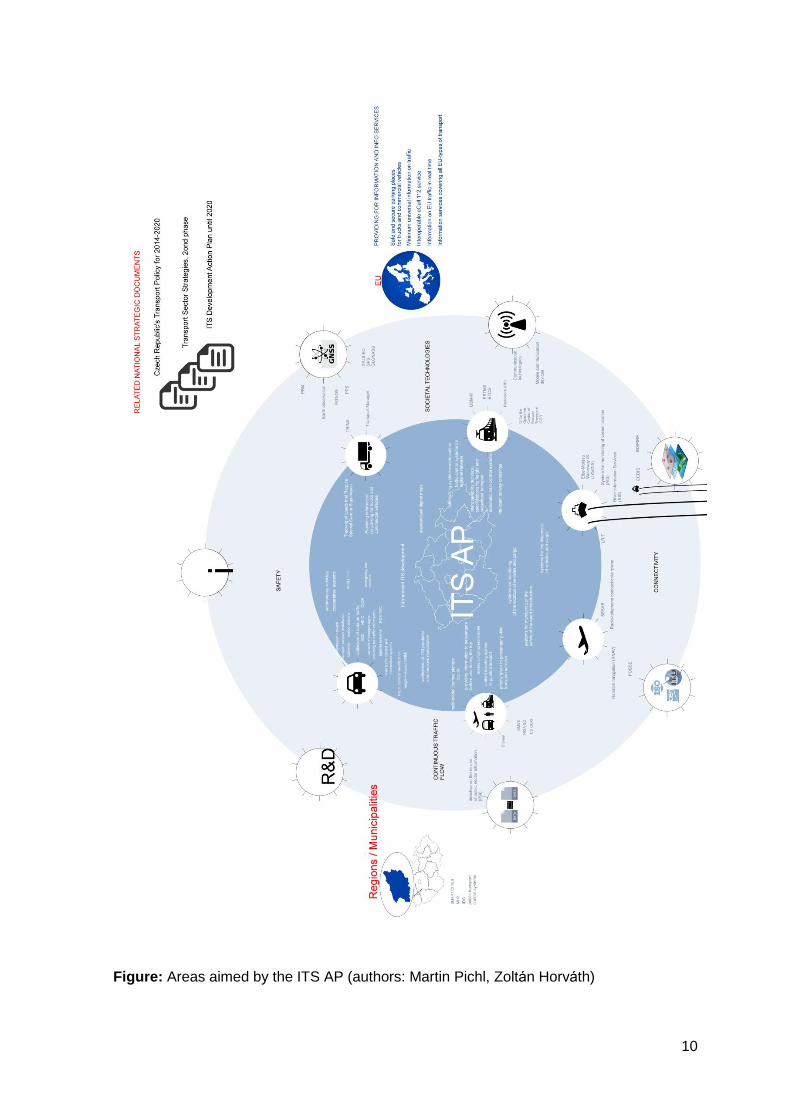
Figure: Areas aimed by the ITS AP (authors: Martin Pichl, Zoltán Horváth)
11
2 Preparation of the ITS Action Plan, Cooperation
with Partners
The initial preparation phase of the ITS AP was under way by the schedule defined by the
Coordination Council of the Minister of Transport for the ITS (KR - ITS) constituted in 2010
to ensure sufficient coordination and interlinking of activities related to the ITS develop-
ment within individual Ministries as well as across them.
One of the main goals of the ITS AP is not only to create new intelligent transport systems
but to optimize the currently functioning ones and enhance the utilization/sharing of data
in frame of individual applications. It was with respect to the above that the analysis was
drawn up to see what the current state of the ITS utilization was, based on the experience
of end users with the ITS. This analysis was drawn up by the below mentioned working
groups and its results made it possible to propose measures that would allow to provide
the end users with ITS-related services according to their expectations. The CC – ITS set
up working groups that described the current functioning of the ITS in the Czech Republic
from their perspective and to propose a vision and priorities for the ITS development in the
particular sector. The following working groups were constituted:
1) WG No. 1: Ensuring the traffic safety and continuous traffic flow. Coordinator: Ministry
of Transport
2) WG No. 2: Traffic management and control, provision of information. Coordinator:
ITS&S.
3) WG No. 3: Analysis, situation and forecast of traffic. Coordinator: Technical University
of Ostrava
4) WG No. 4: Services. Coordinator: Central Auto-Moto-Club of the Czech Republic
5) WG No. 5: Supporting telematic systems. Coordinator: the Road and Motorway Direc-
torate of the Czech Republic.
The working groups took into account the specific situation in the railway and public pas-
senger transport, logistics, urban ITS systems, GNSS systems and geospatial data con-
centrated mainly on the road transport. The results of their work were presented and
submitted to the Coordination Council of the Minister of Transport for the ITS on 7th July
2014.
The first phase of the research, concentrating on finding what the concerned subjects and
end users require and demand in the area of the ITS and what their opinions about the
ITS development are, was followed by a second phase, starting in autumn 2014, focusing
on the creation of the ITS AP document, which took into consideration the opinions of the
above listed working groups.
The ITS Action Plan was prepared by regular as well as extra members of the KR - ITS as
a permanent coordination, initiation and counseling authority of the Minister of Transport
for the systematic ITS deployment. From September 2014 until November 2014, a num-
ber of ITS AP drafts were drawn up, edited and specified according to what was agreed
during regular meetings with individual departments of the Ministry of Transport, the Road
and Motorway Directorate, the Railway Infrastructure Administration (state organization),
the Air Navigation Services of the Czech Republic (state organization), the Czech Rail-
ways (Ltd.), the Directorate of Waterways of the Czech Republic, the State Navigation
Administration and also with the representatives of the Ministry of Industry and Trade,
12
Ministry of the Interior, Ministry of the Interior - Fire Rescue Service of the Czech
Republic, the Police of the Czech Republic, ITS&S, Transport Research Centre, the Fac-
ulty of Transportation Sciences of the Czech Technical University in Prague, the Jan
Perner Transport Faculty of University of Pardubice, the Institute of Geoinformatics and
the Faculty of Electrical Engineering and Computer Science of the Technical University of
Ostrava, the Faculty of Electrical Engineering and Communication of Brno University of
Technology and the Faculty of Electrical Engineering of the University of West Bohemia
in Pilsen.
Next to state administrations, transport companies, transport infrastructure administrators,
professional and research organizations and universities, end users were also invited to
participate in the creation of the ITS AP through various interest groups and civic associa-
tions. This is how real demand and real requirements in the area of ITS were researched
because skipping this very basic phase of ITS development and implementation would
lead into the implementation of systems with limited lifetime period.
The above described procedure created a suitable platform gathering all parties interested
in the ITS AP creation, able to recommend ITS-development priorities respecting the
technical and economic possibilities as well as the real needs of public administration and
ITS users.
The document is written according to the “Methodology of Strategic Documents Prepara-
tion” (as defined in the Government resolution No. 318, issued on 2nd of May, 2013.
The contents of the Action Plan for the Deployment of Intelligent Transport Systems in the
Czech Republic until 2020 document does not fulfill the Section 10a, Act 100/2001 Coll.
on environmental assessment, which means that it is not bound to undergo the SEA pro-
cedure.
13
3 Opening
The transport sector is a network branch of world-wide importance. As such, it has a spe-
cific character: transport systems operated on the territories of various national states
must function in harmony and must be interlinked. Transport systems, furthermore, are
required to comply with whole range of characteristics and capacities and they develop,
stagnate or disappear according to how their segments are able to meet the users’ re-
quirements. The term transport is closely related to the term mobility, which is perceived
as a capability to transfer persons or goods without major obstacles and with a relevant
level of safety and reliability not only with respect to transport technologies but also with
respect to socially-defined factors, such as accessibility of transport systems to vulnerable
traffic participants, i.e. mostly people with reduced mobility, orientation or communication
abilities. The term mobility covers all technically realizable ways allowing people to relo-
cate in order to fulfill their needs. This can be done with the help of transport but also
through communication networks (information services and electronic trading services).
Personal mobility is currently undergoing some major changes (and other will follow),
caused by an rapid development of information and communication technologies (ICT)
and services enhancing mobile connectivity. In the near future, vehicles as well as traffic
participants and transport infrastructure will be equipped by millions of sensors able to
communicate with each other. The number of smartphones, mobile internet and mobility
enhancing applications users will be increasing. Development of mobile (the so called
“connected”) services in the automotive industry confirms that these technologies are be-
coming an integral part of vehicles. It is possible to expect that in several years, each ve-
hicle will have a data connection.
Sufficient amount and quality of information used in managing and controlling the traffic is
necessary for the correct functioning of traffic systems and correct organization of
transport of persons or goods. And it is why an up-to-date, detailed and accurate view of
individual traffic situations is needed both in the area of the traffic itself (such as speed
and traffic flow density, current situation in particular segments of the transport network,
emergency and danger situations such as fog, glaze ice, etc.) and in the passenger
transport area: meet the schedules, transfers and connections, emergencies, organization
of transport during mass events such as festivals, concerts or sport events or, in the area
of freight transport, finding out the current state of the transported cargo. Management,
control and decision-making based on accurate data accessible in real time may increase
performance of the transport companies, reduce operational costs and help to better
manage risks and emergencies.
The road transport development trends copy, to a certain extent, the railway and air
transport development which have already been, for some time, monitoring the real
movement of individual means of transport, doing so for two main reasons: to manage
and control the traffic and its safety and to provide information to clients. Information about
the location of a particular train was considered to be the key information even at the very
beginning of the development of railway transport. The way this information was obtained
depended on technological facilities of the particular era. At the beginning of railway
transport, various train movement management and control systems were used. These
systems were depended, on available technology, corresponding directly to the current
state of technological development. At the very beginning of railway transport, the system
of time coordinates was used for example, which means that trains were dispatched in
defined time intervals. This way of traffic management and control, however, did not
14
correspond to the increasing intensity of railway transport and did not meet the security
requirements. Frequent railway accidents requested the introduction of the new system,
the “spatial” system, using sets of railway light signals and based on the transfer of infor-
mation that gives the authorization to trains. The principle of this new system was based
on the idea according to which “only one train is allowed in one block section of the rail-
way”. Information about the real location of the train has always been and remains crucial
for the management and control of the railway transport. Until recently ( some of the lines
until today), trains have been located by persons. lines with high traffic intensity, they are
located by security systems equipped with detection devices. To ensure the security of the
entire railway system it is necessary to equip the railway vehicles with communication,
safety and monitoring systems. These systems, placed mainly in railway vehicles, are
nowadays important also with respect to the requirement to gradually interlink and inte-
grate individual national systems on the European continent (or, in other words, to ensure
the Interoperability). The trend, mainly on regional railways, is to change the current way
of railway traffic management and control, exercised through elements placed directly on
the railway tracks because it is not economically profitable. Satellite based systems of
train localization devices are being implemented, which make it possible to determine the
location of rail traction or non-traction vehicle unit without necessarily incorporating the
detection equipment directly to the infrastructure. This approach, however, may be adopt-
ed only if the entire infrastructure and all vehicles are equipped with a wireless communi-
cation technology, able to transfer the information about the train location to the traffic
control centre in real time. The air transport used to be the less safe transport mode. To-
day, on the contrary, it is the safest transport mode, which is due to, besides other things,
the implementation of the air traffic control and safety services. Air navigation has also
been following the trend of abandoning the conventional navigation and has been trans-
ferring to global navigation satellite systems.
The road transport, has been going through the information revolution that took place in
the air, railway and waterway transport. In a short time, the isolated road transport partici-
pants will be informed about the behavior of the “mass of participants” within their vicinity,
meaning that each of them will behave on the basis of knowledge of other road transport
participants’ behavior. In near future omnipresent all road transport participants will be
continuously provided with an up-to-date information generated by constantly working
network.
The currently used decision-making based on intuition will thus change into reflexive deci-
sion-making based on the knowledge of the circumstances. The informed mass will re-
quire more sophisticated and coordinated regulation and centralized control systems (us-
ing also the distributive system control methods), replacing today’s isolated traffic control
systems. When we look at this development from the public administration's perspective,
then the above entails a necessity to radically review the current approach to traffic con-
trol-related issues (developed for dozens of years). There is a need to come up with
mechanisms that will help to sort, analyze and give sense to huge volume of heterogene-
ous data, distributed in order to help to make decisions in specific situations. Transport
systems will have to review their input data paradigm, start working with a new generation
of accessible data (“retrain to the new data generation”) and reflect the existence of a
large group of well-informed traffic participants (which, in turn, entails a necessity to
change the mode regulatory interventions are made in space and time).
Transport technologies are comprised of means of transport, transport infrastructure and
transport organization. Transport, or transport system, must comply with the principles of
15
technical interoperability and continuity of the transport process. Individual transport mode
systems are influenced not only by technological requirements but also by social and polit-
ical influences and long-term technological and safety trends.
As it was already mentioned, the persons and goods traffic management and monitoring
require reliable transfer of information in real time. Looking at the problem from the per-
spective of classification and description of individual ITS systems, was chosen the sorting
according to used transport infrastructure and transport means and opted so to create two
separate areas: freight transport logistics and passenger public transport. It has been
chosen to do so because passenger public transport systems and logistic systems coordi-
nate, synchronies and optimize the carriage of persons and consignments across the
network of individual transport modes, starting with the place and moment of their entry
into the complex transport network and ending at the moment at which they leave this
network.
3.1 The Current State of ITS Deployment in the Czech
Republic
Modern information and communication technologies enabled to create new transport
systems and applications, ITS (also called transport telematics). ITS offer a complex view
on all transport modes and facilitate the coordinated interlinking of various transport sys-
tems. The ITS-related issues are focused on a wide variety of offered services as well as
in frame of their specific utilization. In general, it is possible to say that the ITS systems
are systems allowing to inform passengers, to manage, control and regulate the traffic
flow, to make it safe and continuous.
3.1.1 Road Transport
The Road and Motorway Directorate of the Czech Republic has recently been introducing
or developing, in frame of the motorway, expressway and the first class road network, the
following basic ITS systems:
1) Road traffic control and information systems (including dynamic management): mainly
the dynamic road traffic control systems, implemented on the R1 Prague City Road Ring,
and information portals on most motorways. These portals provide the traffic participants
with up-to-date traffic information by the means of variable information panels. These
panels display text information (three lines of text) and in most localities, they are placed
with a variable warning message sign, displaying selected warning symbols;
2) Systems enabling to increase the safety of road traffic: video systems and meteorologi-
cal stations were installed on most sections of motorways and expressways and warning
meteorological systems were installed in selected dangerous localities (such as bridges,
flyovers, forest sections, deep notches, etc.);
3) Collecting traffic data: step by step, automatic traffic counters have been installed on
motorways and first class roads in order to make it possible to continuously monitor the
intensity of traffic and to determine the characteristics of the traffic flow in the particular
section;
4) System of emergency reporting stations allowing the road traffic participants to contact
the operational dispatch of the Police of the Czech Republic or the Fire Rescue Service of
the Czech Republic. At the same time, these emergency reporting stations serve as
16
connection points for various ITS equipment such as meteorological devices, video cam-
eras, traffic detectors, variable message signs, etc.);
5) Systems for the identification of illegal behavior: in selected localities, dynamic weigh-
ing systems were built in order to prevent behavior damaging the road network by over-
loaded trucks.
The road and street networks of major cities were also equipped with ITS systems and in
some cases lower class roads were equipped too, These roads are not administered by
the State but by relevant cities or regions.
The creation of the Integrated Traffic Information System of the Czech Republic system
was launched in 2005, on the basis of the Government of the Czech Republic resolution
No. 590/2005 on the Integrated Traffic Information System of the Czech Republic and
according to the stipulations of Section 124 (3) of Act No. 361/2000 Coll. and related im-
plementing legislation No. 3/2007 Coll. These documents defined a complex system for
the collection, processing, sharing, publishing and distribution of traffic data from the en-
tire network of road infrastructure. The Integrated Traffic Information System of the Czech
Republic is comprised of three main parts:
- The National Traffic Information and Management Centre (NDIC) (processes and evalu-
ates traffic information, monitors the traffic situation on a centralized bases, carries out
central traffic management and control and provides the public with traffic-related infor-
mation and data
- Information providing subsystems
The National Traffic Information and Management Centre (NDIC) is a central technical,
technological, operational and organizational point of the Integrated Traffic Information
System of the Czech Republic (JSDI). It is an operational department run by the Road and
Motorway Directorate, functioning on the 24/7 basis and collecting, processing, assessing,
verifying and authorizing traffic information and data. This information and data serve as a
basis on which the National Traffic Information and Management Centre operators regu-
late the traffic by means of variable traffic signs, traffic information devices, the Radio Da-
ta System - Traffic Message Channel or through the www.dopravniinfo.cz website and
through relevant mobile phone applications.
- Data collection subsystems,
The Police of the Czech Republic represents another important provider of information in
frame of the Integrated Traffic Information System, gathering important information mainly
through calls to the 158 emergency line or from its patrols. Traffic information does not
concern only traffic accidents but also obstacles on roads, current density and speed of
the traffic flow (1-5 grades ), current restrictions on the road network, accidents and de-
fects, vehicles in fire, bad weather, non-functioning signaling devices or, in other words,
any factor that prevents the traffic from being continuous and safe. Traffic information is
checked and entered into the Integrated Traffic Information System Ostrava, on the Police
of the Czech Republic website and on the Online Traffic Update website: this is done by
the integrated operational centers of the Police of the Czech Republic as well as by the
Traffic Police units (mainly the Highway department).
According to the contract between private entities and the Road and Motorway Directorate
of the Czech Republic, private entities have, in order to provide their clients with
17
information services, the right to use information from the National Traffic Information and
Management Centre and from the Integrated Traffic Information System. They are bound
to distribute verified, authorized, digitally geographically localized and Alert-C protocol-
coded traffic information. Doing so, they have to add value to the basic information. The
term added value refers to using the traffic information in the form of web applications,
acoustic broadcast, sending the traffic information to the client through a relevant distribu-
tion channel (such as SMS), etc. The primary goal of the value added to data taken over
from the above mentioned sources as well as to data created by private entities them-
selves must be provided for a traffic information service aiming to increase the safety and
continuous flow of road traffic. The value added by the private company may be used to
make profit; meanwhile the traffic information is communicated to clients in the defined
data structure, specified before the contract is signed. Private companies do not have the
right to transfer the data or provide a third person with the data in their non-altered form,
without modifying them by adding additional value to them. The National Traffic Infor-
mation and Management Centre along with the Czech Radio currently operates the Radio
Data System – Traffic Message Channel as an integral part of the Integrated Traffic In-
formation System.
The Integrated Traffic Information System is a project that goes beyond the basic compe-
tencies of the Highway and Motorway Directorate of the Czech Republic. It includes the
entire road network ranging from highways to publicly accessible service roads. Since the
very beginning, it has been implemented, directly or indirectly, by dozens of authorities,
organizations and institutions (or their departments) on various state or regional levels or
on the level of cities, municipalities, etc. The project was, at the beginning, guaranteed by
the Ministry of Informatics (until the end of 2006), Ministry of Transport and Ministry of the
Interior. The other authorities, organizations and institutions participating in the project
are:
- Police of the Czech Republic
- Fire Rescue Service of the Czech Republic
- Emergency medical service
- Communications administrators
- Road administration authorities
- Municipal police
- Exceptional loads or exceptional dimensions load operators
- Czech Hydrometeorological Institute
- Water management authorities
- River basins management authorities
- Operators of networks of voluntary traffic reporters (such as the Czech Radio, GLOBAL
ASSISTANCE, Central Auto-Moto-Club of the Czech Republic)
- Customs administration of the Czech Republic
- Owners and operators of ITS and telematics applications
Individual authorities, organizations and institutions transfer or ought to transfer traffic in-
formation and traffic data to the Integrated Traffic Information System according to Section
1 of the regulation 3/2007 Coll. on the national traffic information system.
These data concern:
- Higher traffic intensity, congestion, traffic jams
- Traffic accidents
- Vehicle or cargo in fire
18
- Fire of objects near the road in case it puts in danger or restrains the traffic flow on the
road
- Road closures or detours
- Specific utilization of the road
- Obstacles on roads
- Road repairs or maintenance
- The state of the road and problems related to bad state of roads
- Sections of roads not maintained in winter
- Meteorological and weather conditions influencing the traffic capacity of the roads, safe
movement of vehicles on the roads or limited visibility
- Utilities accidents in the earthwork structures of the road or in its vicinity
- Defects of the parts and fixtures of the road
- Waiting times resulting in various administrative or similar measures taken
- Limited possibility to use the road concerning certain types of vehicles, vehicles with a
certain equipment, etc.
- Static transport situation, parking possibilities, parking restrictions, current capacity of
Park and Ride parking
- Another type of emergency
Information and data on the current traffic situation are transferred to the Integrated Traffic
Information System according to current legislation or according to contracting agree-
ments by authorities, organizations or public administration institutions and other public or
private persons or subjects. The Integrated Traffic Information System, however, is not
finalized in some areas.
On the European level, the following EU regulations were issued on 15th May, 2013 in
order to ensure coordinated provision of information about parking places, to optimize and
regulate the utilization of parking areas for trucks and commercial vehicles and to ensure
coordinated provision of those types of information concerning the situation on the road
network that, by its character, helps inform drivers about traffic emergencies:
The 885/2013 EU regulation concerns the area of provision of information about parking
places for trucks and commercial vehicles, designed to inform truck drivers about conven-
ient places to park their trucks and about places that will be protected against crime such
as theft of transported freight, theft of vehicles or mugging.
The 886/2013 EU regulation concerns the area of provision of road traffic information con-
cerning the situation within the road network, meanwhile this information should attract the
drivers’ attention to dangerous traffic situations. The provision of „minimum universal traf-
fic information” by public and/or private road operators is to be done in a way that makes it
possible to reach the broadest possible range of end users (drivers, for example). This
traffic information is to be provided free of charge, which, according to the definition,
means with no additional costs for the end users (fees or costs for receiving the infor-
mation must be relevant to costs for the collection and processing of the information).
Public and private service providers are bound to cooperate to harmonies the presentation
of the content of information provided to end users.
Both of the above regulations represent the EC specifications as described in Section
39a/2 of Act No. 13/1997 Coll. on the road network as amended.
19
In order to properly implement the above regulations in the environment of the Czech Re-
public, it is necessary to extend the number of authorities, organizations, institutions and
other persons and entities that will provide with information to be included in the Integrat-
ed Traffic Information System. This need was translated into the Section 124 (3) of Act
No. 361/2000 Coll. on Traffic on the Road Network.
3.1.2 Public Passenger Transport
The National Timetable Information System (CIS JŘ) provides the public, ordering party of
transport services and transport operators with state-guaranteed data on public passenger
transport. The timetable data are to be put into the System are provided by transport op-
erators who have the obligation to hand over their timetables to the transport authority to
be approved. The data are to be transferred in a format and structure defined by the
transport authority or, as the case may be, railway operator. The data are provided by
railway operators (trains), rail administrative authorities (trams, trolleybuses, special vehi-
cles /i.e. underground / and cableway) and by the Ministry of Transport (urban, domestic
and international bus lines). All the above is done according to the provisions of the Act on
Road Transport (Act No. 111/1994 Coll. as amended and its implementing regulation No.
122/2014 Coll.) and the Act on Railways (Act No. 266/1994 Coll. as amended and its im-
plementing regulation No. 173/1995 Coll. as amended). The data from the Nationwide
Information System for Public Transport Timetables are publicly accessible through the
internet interface. Data on timetables are published on the Internet in the .pdf and .xls
formats. They are not, however, published in machine readable formats. This is why in
2013, a new Czech Republic Government regulation on regular public road transport ser-
vices was introduced. Section 9 (8) of this regulation stipulates that all approved road
transport service schedules be immediately published on the Internet in a way that makes
it possible to machine process them (database structure). On 9th July 2014, a new Czech
Republic Government regulation No. 122/2014 Coll. on Regular Public Transport Timeta-
bles was published in the Collection of Laws. A similar adjustment was made in the regu-
lation 7/2015 Coll., which concerned railway transport and which was an amendment to
the railway regulation No. 173/1995 Coll.
The above described data on public passenger transport have been used by various
search engines helping to find travel connections. Currently, the most often used search
engine is the IDOS (www.idos.cz; www.jizdnirady.cz). This engine makes it possible to
search for travel connections across the individual types of public transport and it also
provides with the information about barrier-free transport.
The functioning of the Nationwide Information System for Public Transport Timetables will
be adjusted according to the principles set by the European Directive on the re-use of
public sector information (the so called PSI Directive). It will be necessary to define, during
this transition that concerns the accessibility and openness of this system to other sub-
jects, the responsibility of participating subjects in a sensitive way in order to prevent the
deterioration of the quality of this system and to keep its quality up to the expectations of
end users since the current, very complex system represents a unique European project.
In order to maintain the stability of the Nationwide Information System for Public Transport
Timetables, it is necessary that this system continues to be supported by the state admin-
istration, mainly through activities such as gathering of relevant data and providing these
data to third parties through a relevant distribution interface. The openness of this system
will result in broadening and increase of attractiveness of related systems called multi-
modal journey planers integrating also information systems for individual car transport. It
is crucial to select the right strategy: the process of transferring from the Nationwide
20
Information System for Public Transport Timetable to a system as defined by the PSI Di-
rective must not be underestimated because if it is, it could result in various problems or
even lead to the total collapse of the entire system.
Despite the fact that the functioning of the Nationwide Information System for Public
Transport Timetable is not yet completely aligned with the provisions of the PSI Directive,
passengers are already being offered applications combining pedestrian navigation with
the search for connections applications offered by passenger public transport operators,
which makes it possible to plan a journey from one stop to another but also, thanks to the
combination of various criteria, also the journey from a particular place to final destination
(the so called door-to-door journey planning).
A lot of towns in the Czech Republic have already introduced urban public transport man-
agement and control systems enhancing the traffic dispatching process and increasing the
quality of information provided to travelling public. These control systems carry out real-
time monitoring of the urban public transport network and regional bus lines and trains
and, in case of non-respect of bus or train schedules, they help to remove the obstacles
causing delays. These systems use different technologies. In Prague, defining of the posi-
tion of trams is based on the communication of the particular vehicle with beacons operat-
ing in the infra-red frequency range (the so called infra-red beacons or IR beacons) placed
along the tracks (on pillars at the stops, for example) and the location of urban and subur-
ban transport buses is tracked through GPS systems. The iRIS control system, for exam-
ple, used by the Transport Company in Brno, for example locates its vehicles (trams,
buses and trolleybuses) by the means of the GPS navigation system. This system pro-
vides the dispatchers with important operational data and makes it possible to send in-
structions to individual vehicles' drivers as well as information for passengers to be dis-
played on the information panels inside the vehicles, at selected stops or in passengers’
mobile applications. But not even the most intelligent systems are able to solve, without
human assistance, all situations that might occur in traffic. This is why these systems in-
clude also radio communication systems or GPRS devices that allow the drivers to directly
communicate with the dispatchers. Furthermore, systems in vehicles are able display syn-
chronized time (which is done on time displays as well as on the ticket validators).
The control and information system also enables a continuous movement of trams, trolley-
buses and buses through intersections according priority to urban public transport vehi-
cles. This way of ensuring a continuous flow of urban public transport vehicles through
complicated traffic spots has been continuously elaborated and combined with warning
systems. In Ostrava, for example, there is a system of automatic warning of both drivers
and pedestrians about trams arriving to a tram crossing. The system automatically acti-
vates and deactivates warning signs for drivers and LED strips installed along pedestrian
crossings traversing the tram tracks.
The urban public transport as well as important transfer nodes and regional passenger
transport terminals also use the network of intelligent stops. Information panels have been
installed at selected urban passenger transport stops in Prague, Pilsen, Ceske
Budejovice, Brno, Olomouc and Liberec and around large towns. These panels display
the time remaining to the arrival of the next vehicle and the information about the type of
the vehicle (such as low floor) or, eventually, inform about the delay. The railway stations
and the Integrated system of the South-Moravian region have implemented the 2D codes
service. The 2D codes are planned to be introduced on the urban public transport lines in
21
Prague. This system allows passengers to connect, through an application, to interactive
timetables displaying also the information about delays of the particular vehicle or train.
Systems allowing to carry out operational control of vehicles are used not only in frame of
the urban public transport but also in regional public passenger transport. The first dis-
patching unit in the Czech Republic working with the new systems was the Central Dis-
patching Unit of the Integrated Transport System of the South-Moravia region. The main
task of this dispatching unit is to operatively manage the movement of the regional pas-
senger transport vehicles in a way that would guarantee the connection of transfers in
transfer nodes (i.e. transfers from bus to bus, or from bus to train). The central dispatching
unit plays an especially important role during emergencies, such as road or track closures,
accidents and other extraordinary events concerning the traffic. During such event, the
priority is to coordinate individual transport service operators participating in the integrated
transport system, with the goal to bring the negative consequences of the emergency to
minimum meanwhile maintaining the comfort of services provided to the passengers.
On 1st June 2014, a new Czech technical norm (ČSN 01 8245), the Information System in
Public Transport – National Timetable Information System for Real Time (CISReal) en-
tered into effect. This norm defines the way to exchange data and the minimum require-
ments governing the communication among dispatching systems of individual public pas-
senger transport operators, transport systems (Urban Passenger Transport, Integrated
Transport Systems) and the railway operator (the Railway Infrastructure Administrator).
This norm, furthermore, governs the data exchange through a centralized element (the
CISReal), with the possibility to use information about current location of the public pas-
senger transport vehicle in multimodal journey planers.
Most public passenger transport operators offer to their customers a possibility to obtain
their travel ticket in an electronic form on a data medium (contactless smartcard). Several
passenger (mainly urban) transport operators (around Prague and around Ostrava, Brno,
Liberec and Pilsen) provide their passengers with the “SMS ticket” service, offered in co-
operation with all mobile-phone operators in the Czech Republic. New electronic ticketing
standards (EOC) are currently being created: this electronic ticketing (electronic fare
management) service will make it possible to check into public passenger transport ser-
vices through an interoperable electronic media storing the travel ticket. It is expected that
this kind of media will become an integral part of the national interoperable concept, which
is currently being worked on and which has to be backed by electronic media issuers,
applications and products providers, transport operators and clients. The key factors influ-
encing a successful standardization of the electronic ticketing system (electronic fare
management) are: consensual approach, coordination of public transport ordering party
and efficient support provided by the Ministry of Transport. It is expected that the electron-
ic ticketing standard will be, through the ordering party, consistent with the goals defined
by public sector authorities. The opinion of the ordering party represents thus the key fac-
tor influencing the final form, extent and content of the project as well as the means used
to ensure its sustainability. It is assumed that interoperable applications and products en-
abling identification, storage of products (travel ticket) or, eventually, other applications,
will be an integral part of the electronic ticketing standard.
22
3.1.3 Accessibility of Public Passenger Transport Services to
People with Specific Needs
An increasing range of applications are being designed to assist people with reduced mo-
bility and orientation and to give them more autonomy to move around independently and
safely. There has been a real expansion of voice and acoustic information services help-
ing visually impaired people to orientate in urban surroundings, in public passenger
transport vehicles, in suburban transport vehicles and in railway transport vehicle, on
crossroads, in underpasses, at the stops (equipped with electronic information panels), in
the underground and around state administration offices and hospitals.
The IDOS application, for example, providing information about public transport run on the
www.jizdnirady.cz website, was adapted to use by people with various phases of visual
impairment (www.jizdnirady.cz/blind). Adaptations were carried out according to principles
of the “Blind Friendly Web” project introduced by the Czech Blind United Association and
to standards issued by the World Wide Web Consortium (W3C) publishing norms applying
to internet technologies. Three large LED information panels were placed in the area sur-
rounding Prague in frame of a trial run. These panels provide information about the Pra-
gue Integrated Transport System timetables in an acoustic way (the acoustic output is
activated through a personal control device). Furthermore, six information stands, current-
ly operating in trial mode, were placed in underground stations situated near important
regional bus passenger transport terminals. These transport information stand prototypes
were equipped with audio and orientation beacons and operate on the basis of a specific
acoustic procedure. Using an electronic speech synthesis, they inform the visually im-
paired person about the convenient connection. Analogical devices are starting to be in-
troduced as a systematic measure within the railway system.
Information systems implemented in the urban public transport vehicles (underground
trams, buses, trolleybuses) were complemented by communication systems allowing to
communicate to people with reduced orientation. These systems are called command sets
for visually impaired and are also referred to as “talking trams”. When activated at the
station, this system informs the blind passenger, through an outside-placed loudspeaker,
about the number of the line and direction. If the blind passenger is interested in getting
on the vehicle, they press a button informing the driver about their intention and the driver
may pay attention to them. (The driver is informed by the means of an inside loudspeak-
er.) A similar procedure is applied when the blind passenger is getting off the vehicle.
Some types of regional Czech Railways trains and Prague trams are equipped with sys-
tems that allow the blind passenger to open the vehicle door by the means of their walky-
talky and to, parallel to this, set off the sound signal allowing them to find the door so there
is no need for them to search for the control buttons on the vehicle. The Prague under-
ground works in a similar way.
There has also been an expansion of acoustic signaling systems on pedestrian crossings
and systems of remotely-controlled acoustic orientation and information beacons located
in places accessible to the public. It is now obligatory to place acoustic signaling systems
for blind people on newly built or reconstructed pedestrian crossing and on railway cross-
ings.
Furthermore, transport companies in some towns, such as the Prague Public Transport
Company, have been providing, on their website, with information services enabling to
find barrier-free travel connections, including the information whether the particular
23
low-floor vehicle is really deployed at the moment, at which stops it is possible to change
in a barrier-free way (or whether extra time is scheduled) or whether the particular con-
nections, stops and stations are accessible to people with impaired mobility. Information
about the accessibility of transport connections to wheelchair people is provided also by
the IDOS search engine, which also specifies (as a pictogram) whether the vehicles are
adapted to transport wheelchair people and whether they are equipped with lifting plat-
forms to facilitate the getting on and off. As for the railway transport, the principles of ac-
cessibility of trains to people with reduced mobility and orientation are defined by the EU
railway interoperability technical specifications. Czech transport operators have introduced
a reservation system allowing people with special needs to book travel assistance.
Deaf and hearing-impaired people represent another group of people with specific needs.
People with hearing problems have the possibility to search the Internet for basic infor-
mation about their trip before they start travelling. Problems, however, occur in case of
unexpected changes happening right before the journey or during it. Hearing-related
handicaps are not visible at the first sight, which makes other people suppose that while
travelling, the deaf and hearing-impaired people will react as it is common for the majority
population, meaning that they will react appropriately when given voice information about,
for example, the change of the train departure track, train delay or cancellation, diversion
of the regular route, replacement of transport means, etc. Visual digital information sys-
tems informing not only about planned arrivals and departures but also about all extraor-
dinary changes in transport represent an appropriate solution for deaf and hearing-
impaired people, and these devices are useful also for people without hearing problems.
Unless the person asked to help explain the situation knows how to use the sign lan-
guage, they can find it difficult to communicate with a hearing-impaired person. People
with hearing impairment do not react to sound stimuli and express themselves in way that
it is difficult to understand and may therefore sometimes be taken for people with a mental
health issue or can be confused with an intoxicated person (who is having problems to
express themselves). This represents a possible cause of misunderstandings and results,
quite often, in a situation when the majority population, not having been properly educat-
ed, turns away from people with hearing impairments in need of help. Information and
communication technologies bring new possibilities to deaf and hearing-impaired people.
Applications able to transcribe the everyday conversation in real time have already been
introduced on the market. The organization of public transport should therefore carefully
provide with verified up-to-date information about visual basis.
The Ministry of Transport has published, on its website (in the section dedicated to inter-
national bus transport) a methodological document helping bus drivers approach to pas-
sengers with specific needs.
3.1.4 Railway Transport
The Czech Republic started to develop, in frame of the European Rail Traffic Manage-
ment System, various systems allowing to enhance interoperability on all lines of the Eu-
ropean Rail System, and, particularly, on lines included in the TEN-T network. The tech-
nical aspect of the ITS interoperability, in accordance with the European legislation (i.e.
mainly technical specifications enabling the interoperability of signaling, control and train
protection systems) resides mainly in the implementation of the ERTMS/ETCS, level 2
(interim priority for international corridors) and of the mobile radio network providing for
the ERTMS/GSM-R (Global System for Mobile Communication – Railways) voice and
data services according to the ERTMS National Implementation Plan. The ERTMS im-
plementation will entail not only a significant increase of safety standards (i.e. the
24
reduction of human errors such as one of the main causes of accidents) but, as soon as it
will have completely replaced the current national signaling, control and train protection
system, it will be possible to consider, as soon as convenient control equipment has been
designed and linked to the new technology, a possible increase of the capacity of relevant
sections of the railway network.
The term “railway traffic control” refers mainly to the process of giving instructions (this is
done by station inspectors or train dispatchers, for example), concerning the desired
characteristics of the driving (such as speed), to the train driver. These instructions are
given by the means of traffic route signals operated through the control and signaling
equipment. Station inspectors and train dispatchers are informed about the current traffic
situation at their station and at adjoining track sections. The train speed increase taken
into consideration, it is necessary that the station inspectors and train dispatchers at par-
ticular operating points (such as stations and passing or branching-off operating points) be
informed about the current situation on a segment of tracks exceeding the length of cur-
rently defined sections. This is the reason why new Central Dispatching Units for the Re-
mote Train Traffic Control have been established in the so called controlled areas of se-
lected lines, specifically in Prague (for the Bohemia region) and in Přerov (for the Moravia
and Silesia regions). Furthermore, other Regional Dispatching Units were established for
the remaining segment of the railway network. Dispatchers control the traffic at the par-
ticular segment of controlled area, commanding remotely the control and signaling equip-
ment at both the stations and on the tracks.
As for the international railway freight transport, it has to be said that transport of goods
represents a very complicated process from the technical, technological as well as legal
point of view. This complicated character is due to issues related to relationship between
the consignor and the consignee, to long transport distances and, as a result of this, long
keeping of the goods by the rail, and to great number of subjects participating in the
transport process (and complex relationships between them).
Various measures related to railway transport were thus introduced in frame of the EU’s
effort to remove the obstacles to free movement of goods and persons within the Single
European Railway Area. The current routine in international railway transport still consist
of technical check-ups of vehicles, check-ups of the current state of transported cargo,
administrative checks of the documents accompanying the train or, eventually, border and
customs control, carried out when the vehicles, cargo or passengers cross the national
state borders in designated exchange or border crossing points. The railway system, fur-
thermore, is specific with respect to the, in many cases, prevailing changing locomotive
and crew on the border. The implementation of the EU legislation entails a transfer of the
system of unitary national railway administrations (national railway companies playing the
role of both railway operator and passenger and freight operator) to a system of inde-
pendent railway infrastructure operators and railway operators. Except for the aforemen-
tioned transformation of the railway sector, further measures have been taken to enlarge
the supply of technology providers. This approach, on the European level, aims at ap-
proaching the railway transport to the road transport in the sense of the elimination of ob-
stacles related to crossing of the borders (crossing the border on a road is highly noticea-
ble). This is not yet possible in railway transport because individual railway infrastructures
and operational procedures set by individual rail operators are not compatible at the mo-
ment: in many cases, therefore, locomotives and train crews have to be changed on the
borders of the EU member states. The desired state of railway transport adjustments is
25
the existence of an interoperable railway network on which any subject, meeting the de-
fined characteristics, will be able to provide for railway transport.
The technical unification of information and communication systems used by various rail-
way infrastructure operators and railway operators and the cross-border continuity of in-
formation services represent the key factor enabling to ensure the quality of planning, ad-
ministration and provision of services in frame of both national and international railway
transport with respect to technical specifications concerning the interoperability in the area
of telematics in both passenger and freight rail transport within the EU railway system.
The rules governing technical harmonization are issued by the European Commission in
the form of the so called Technical Specifications for Interoperability (TSI), applicable for
relevant subsystems of the EU railway system. The conventional railway system is con-
cerned by the following TSIs: 1) rail vehicles – freight wagons, 2) rail vehicles – locomo-
tives and rail vehicles for passenger transport, 3) rail vehicles – noise, 4) infrastructure, 5)
energy, 6) track and on-board control and safety equipment, 7) operation and traffic con-
trol, 8) telematics applications in freight transport, 9) telematics application in passenger
transport, 10) maintenance, 11) accessibility to people with reduced mobility or orienta-
tion, 12) safety in railway tunnels.
The implementation of telematic applications, on the EU level, is governed by the TSI-TAF
(Technical Specifications for Interoperability for Telematics Applications for Freight
Transport) and by the TSI-TAP (Technical Specifications for Interoperability for Telematic
Applications for Passenger Transport). These documents define selected processes and
information connections between the operators and infrastructure administrators, among
individual operators and, to a certain extent, among infrastructure administrators them-
selves. This includes, except for railway capacity reservations, also the monitoring of ac-
tual traffic situation. The goal, in freight transport, is mainly to increase the transport’s reli-
ability, to reduce the costs and to improve monitoring of both the vehicles (as the opera-
tor's propriety) and transported goods. In the passenger transport area, the goal is mainly
to facilitate the cooperation (i.e. remove technical obstacles) during the check-in, to better
inform the passengers and to enhance the interconnectivity among individual transport
modes.
3.1.4.1 Railway Operator
In the Czech Republic, there is a total of 9 459 km state-owned railway lines and 106 km
railway lines owned by other proprietors, such as the Jindřichohradecké místní dráhy, a.s.
(a local railway located in the Southern Bohemian region) or the Alliance of Communities
of the Valley of the Desná river. The state-owned railway is administered by the Railway
Infrastructure Administration, state organization. This administration also operates the
lines. The above calculations do not cover industrial tracks, the Railway Research Institute
test lines (the Test Centre Velim test lines) and the Prague underground, which has the
status of a special railway. Tram lines and cableways do not fall under the jurisdiction of
the Act on Railways, along with yet other lines, such as mine or industrial railways. Most
of the industrial tracks are owned by companies that are using them and operated by the
owner itself or by a subcontractor. Some companies specialize in operating the industrial
tracks and the law also allows the Railway Infrastructure Administration to provide for this
type of services.
In the Czech Republic's railway network, numerous information and control applications
are used or ready to be used, such as the DIS (Dispatching System for Railway Traffic
26
Control), a traffic control support system for the railway administrator, the so called the
Graphical and Technological Layer (GTN), the Automatic Train Route Setting (ASVC), the
Automatic Train Operation system (ATO), devices allowing to find the optimal time itiner-
ary, information systems for passengers, information about trains and delays, monitoring
the train location through the GNSS, radio block, devices measuring fuel consumption of
the traction wagons, the “actively detached train” application, etc.
The Information System for the Operative Control of the Railway Transport (ISOŘ) is one
of the tools used by the railway operator.
The Dispatching System for Railway Traffic Control (DIS) is composed of subsystems
working in real time and concentrating on collecting primary data, presenting and as-
sessing results related to railway traffic control and providing and processing of data used
in performance statistics. Primary data are provided by railway stations, rail vehicles de-
pots, dispatcher railway traffic control centers and other specialized operational units.
In order to keep the railway in a good working condition, the Railway Infrastructure Admin-
istration has a number of applications and passports gathering information about the
state of particular segments of the line (i.e. the track itself, the track substructure, power
supply system, feed lines and information, signaling and control technologies). Data on
the working condition of the railway are collected by local administration units, on the
scale of the entire network and with help of technical diagnostic tools (diagnostic units,
etc.).
Another type of technologies is used to detect serious defects of currently operating rail
vehicles, such as hot axle box detector (seized bearings, twisted pivots, derailment), dy-
namic shocks (track fraction, destruction of parts of switches, etc.). The above defects put
the safety of the railway transport in serious danger and cause, each year, great damages
on the railway infrastructure and on the vehicles.
Information systems for passengers and operators represent a special area.
The Graphical and Technological Layer (GTN) is a computer application designed to back
up the traffic-related processes on the defined segment of the railway network. It can be
characterized as a superstructure over the control system equipped with the train num-
bers transfer. It is preferentially used on lines with remote traffic control equipment.
The automatic train route setting system (ASVC) analyses eventual conflicting train
schedules (e.g. optimizes train routes by preventing functionless delays, eliminates risks
ran by pedestrians while crossing one-level crossings between the platforms) and tries to
define the decisive moment to set the train route. It applies an intelligent algorithm allow-
ing to automatically set the train routes and assesses the proposed route alternatives.
ASVC fully substitutes the system of remote train traffic control carried out by the dis-
patchers from a particular location.
The automatic train operation system (ATO) automatically controls speed, regulates the
traction and switches on automated breaking in the destination in order to bring down the
number of routine tasks carried out by the driver. At the same time, it automatically con-
trols compliance with the time schedule and optimizes the functioning of the train.
27
Today, however, it needs to be pointed out that in most cases, these applications are not
interconnected and that each of them represents, in fact, a closed system.
3.1.4.2 Railway Passenger Transport Operator
In order to become a rail operator in the Czech Republic (both on the national and region-
al train lines), a company needs to have a valid license, operator certificate and have en-
tered into agreement with the railway administrator. The RegioJet a.s., LEO Express, a.s.,
ARRIVA TRANSPORT ČESKÁ REPUBLIKA a.s. or Jindřichohradecké místní dráhy, a.s.
are examples of private companies providing passenger with railway transport services in
the Czech Republic. The České dráhy, a.s. (ČD/Czech Railways) is the biggest national
operator, providing both national and international passenger with railway transport.
The Czech Railways have created systems able to provide with more up-to-date infor-
mation about the movement, current situation and occupancy of the vehicles in service.
The DISOD (passenger transport control) system, for example, has been designed to dis-
play the current location of the vehicle according to GPS coordinates and to help the op-
erator's dispatcher react to extraordinary events, such as long and short term line clo-
sures, and minimize so the impact that these events have on passengers. The DISOD
passenger transport control system has been developed to be able to communicate to
both integrated transport systems and with the particular infrastructure operator. Vehicles
are furthermore able to, except for the GSM-R communication, send information about
their state into the systems governing the fleet administration and active vehicle detach-
ment from traffic. Vehicles are equipped with mobile audio-visual information systems
(MAVIS) that are able to inform about the current speed of the vehicle, incidents, train
schedule or the next station, which is announced with respect to the current location of the
train as defined by the GPS system. The ITS include also the system of Automatic filling
stations evidence (EVITA): information about filling activities at the automatic filling sta-
tions placed in railway vehicle depots is matched with the information concerning the par-
ticular employee and their filling activities. Passenger ticketing service is currently facilitat-
ed by the semi-online portable personal registers (POP), used mainly as a device ena-
bling the train conductor to sell tickets and carry out the check-in or as an information
channel, providing with information concerning line closures or extraordinary events.
When checking the validity of the inland travel documents (tickets), the conductor may
control the tickets with the help of a 2D (QR) code, which makes it possible to count the
number of passengers.
3.1.4.3 Railway Freight Transport Operator
The ČD Cargo, a.s. company has continuously been developing or, alternatively, updating
its information systems to make their processes and functionalities comply with the re-
quirements of the technical specifications for the interoperability of the subsystems for
telematic applications in freight transport within the Trans-European conventional railway
system (TSI-TAF).
The Upgrade IS was the most important project, introducing the DISC freight transport
dispatching on system functioning the basis of online communication with the systems
used by the infrastructure administrator (concerns the long-term timetable in graphic
mode) forecasting the train journey in relation to its preparation and train composition or
train's journey abroad carried out within the Operational and Informational system (PRIS).
The ICAR system, furthermore, helps streamline the activities carried out by the operator,
collects and assesses data on current restrictions on the infrastructure or on forecasts
issued by infrastructure administrators. A new system (KNV) was created to ensure the
28
compatibility with the WIMO (Wagon and Intermodal Operations Database) project, ad-
ministering a register of data on cargo wagons. Other important implemented systems
are: the TMS, allowing to narrow down the ETI and ETA reports during the process of
takeover and handover of trains to other operators and to adapt and expand the model
with the electronic consignment note that will be used not only for the purposes of inland
transport but also for international transport. The rail traction units were equipped with
devices for mobile voice and data communication in frame of the GSM-R.
Information systems allowing to support the railway freight transport according to the TSI-
TAF requirements were introduced out also by other freight operators, such as AWT
Doprava, a.s. or UNIPETROL DOPRAVA, s.r.o.
The systems enumerated in the last two sub-chapters are used by the owner and operator
of the railway, i.e. an organization providing with a high quality, safe railway transport
route. Rail traffic management and control is a very complex and specific problem, which
is why it needs to be supported by ITS technologies. Attention is currently paid mostly to
technological equipment of the railway network meanwhile it is necessary to pay strategic
attention to equipping the rail vehicles (this needs to be done in well argued cases and on
the non-discriminatory basis). Attention needs to be paid also to systems used by the op-
erators. The Operational Programme Transport 2014-2020 is well aware of this, aiming to
meet the requirements set by the TSI-TAF and the TSI-TAP or, alternatively, of all TSIs
adopted in future.
3.1.5 Freight Transport Logistic
ITS systems have been serving well in freight transport as well. In this area, these sys-
tems are usually represented by systems used by individual companies, which means that
the state can influence them mainly through research, development and innovations,
standardization and legislation meanwhile it does not interfere in the operative manage-
ment of freight transport itself, with the only exception of cases when the continuity of the
traffic flow or the safety of population could be jeopardized. Such cases include mainly the
exceptional load and exceptional size load transports, transport of dangerous items trans-
ported in line with the ADR/RID agreement and transports of weapons, ammunition and
explosives.
The issues related to the process of increasing the efficiency of logistic chains (mainly the
visibility of the movement of goods of individual business partners) is closely related with
ITS these days and the “Internet of things” might, in future, even accelerate the integration
of data from individual sensors into the logistic information systems.
If there is an accident involving dangerous substances on the territory of the Czech Re-
public, the Fire Rescue Services of the Czech Republic as operational centers of the Inte-
grated Rescue System may ask for help from the Transport Information and Accident Sys-
tem (TRINS), which may provide with advice or practical assistance with the elimination of
an incident with the aim to mitigate its impact as much as possible. Three levels of assis-
tance are provided: level 1 (questions and consultations by phone, including national and
international exercises), level 2 (sending an expert to the place of intervention), level 3
(technical assistance).
With respect to the above, it needs to be pointed out that on 1st July 2014, an amendment
of the Act No. 170/2013 Coll. on weapons and ammunition entered into effect. According
to this amendment, any vehicle transporting a specified amount of weapons or
29
ammunition has to be continuously tracked. Any such transport has to be reported to the
Police of the Czech Republic through a specialized application. The subject responsible
for the particular transport logs into this application on the basis of an form approved by
the Police of the Czech Republic. The subject has the obligation to equip the vehicle with
a non-stop tracking system (GNSS navigation systems). The subject responsible for the
transport (using its own vehicle or a vehicle provided by a subcontractor) has to comply
with the defined technical parameters and it's up to them what kind of product they choose
to use. Each 15 minutes, the vehicle unit sends information about its current location to
the portal of the “Transport Manager” Presidium of the Police of the Czech Republic. It is
recommended that data be transmitted in a secured mode.
The GNSS, along with the data transfers through the GSM networks, represents a logical
solution allowing to ensure security for a “reasonable price” for any kind of dangerous
transports, not only weapons and ammunition. In Italy, for example, dangerous transports
GNSS tracking has already been implemented.
3.1.6 Inland Navigation
The river information services (RIS) were established and have been developing accord-
ing to the Directive 2005/44/EC of the European Parliament and of the Council on harmo-
nized river information services (RIS) on inland waterways in the Community and accord-
ing to the related EC regulation on the main directions of the RIS. Administration of the
system is delegated to the State Navigation Administration and investment activities relat-
ed to the development of the system are administered mainly by the Directorate of Wa-
terways of the Czech Republic. The Elbe-Moldau Waterway Information System
(LAVDIS), operating the RIS, is at its full functionality. It has been implemented by the
Directorate of Waterways of the Czech Republic (ŘVC ČR) and the State Navigation Ad-
ministration (SPS). The Elbe-Moldau Waterway information system is a modular system.
Next to the basic general information, it provides, for example, with meteorological infor-
mation, information about current level of water, footage on the state of selected important
objects, information to shipmasters on the state of the waterway. The Elbe-Moldau Wa-
terway Information System also includes a map portal with both online and offline elec-
tronic digital navigation plans drawn according to the national model and in the Electronic
Chart Display and Information System for Inland Navigation (ECDIS). The Elbe-Moldau
Waterway Information System was created and elaborated between 2007 – 2014, also in
frame of international projects and operational programmes. Between 2009 and 2011, it
implemented, in frame of the IRIS Europe project, services aiming at the collection of sta-
tistical and dynamic data on the waterway, monitoring of the location of vessels and
freight and wireless access to the RIS at points important for navigation. Furthermore, a
Differential Global Positioning System station for the GPS satellite navigation system was
established in Obříství.
Activities around the IRIS Europe III international project concentrated on increasing the
quality of the already introduced services and on implementing, as pilot projects, transport
information services and information services for logistics and administrations. The Auto-
matic Identification System (AIS) allowing to track the vessels was introduced (it gives
information about the vessel's location, about the navigation direction and speed, about
the type of vessel, about the cargo, target port, etc.). This system is based on the radio
waves technology, the vessels being equipped with transponders. RIS dispatchers moni-
tor the movement of the vessels and these records may be used to solve potential acci-
dents or extraordinary events that need to be handled through crisis management. The
Czech Republic established a pilot project introducing 2 ground-based AIS stations. The
30
other crucial aspect is equipping a hundred vessels by the AIS board units complying with
the International Maritime Organization standards, including the electronic navigation
plans viewers used within the Electronic Chart Display and Information System for Inland
Navigation (ECDIS).
Other features implemented in frame of the IRIS Europe III project are advanced modeling
and locking management of the Prague Smíchov lock chamber, meteorological conditions
modeling and statistics assessment.
River Information Services operating on waterways have the character of a public service
provided to users mainly with the aim to guarantee the safety and continuous traffic. The
Directive 2005/44/EC of the European Parliament and of the Council on harmonized river
information services (RIS) on inland waterways in the Community of the 7th September
2005 stipulates the necessity to provide with a high-quality RIS services on the Elbe-
Moldau waterway, on the IV and higher categories segments. This implies also an obliga-
tion to guarantee a proper functioning of the ECDIS system that needs to get reliable and
accurate location data (which is done through the satellite navigation system). The data
collection and measuring is provided by the Elbe River Basin Administration, state enter-
prise, by the means of the Střekov measuring vessel. This vessel is equipped with all
necessary devices, such as the software allowing to record the measurements in real time
while using the current measurement technology (hardware), and the HyPOS, HyMAS
and HyDAK software. The vessel is able to gather information about the depth of channel,
searches for obstacles, checks the sediments and defines where the riverbed needs to be
adjusted. The Elbe River Basin Administration, state enterprise, is also required, in frame
of operating and maintaining the systems, to guarantee proper functioning and updating of
the navigation levels model. The transfer of the final data from the navigation levels model
into the ECDIS and its utilization in the LAVDIS web environment is carried out by the
State Navigation Administration. The State Navigation Administration, furthermore, guar-
antees the overall functioning of the system and distribution of the information to ship
masters, provides for access to the RIS services through the WiFi connection and ensures
the pilot realization of the operations according to the technical and administrative agree-
ment on the data exchange between the European RIS systems (ELWIS, RoRIS, DoRIS,
SlovRIS, etc.).
The system of navigation plans in the ECDIS format makes it possible to consider the cur-
rent and modeled depths of the navigation channel and help thus the ship master define
the needed usable draught and the optimal load of the vessel, meanwhile preventing the
vessel from being damaged or stuck even in a situation in which other vessels, not
equipped with this system, are not able to navigate or able to use a 100% of their
transport capacity. Using modern technologies makes it possible to track, into detail, the
movement of vessels on European waterways and record when they cross national state
borders. At the same time, this technologies make it possible to improve the provision of
information services to ship masters who will thus gain a better access to thorough and
up-to-date information. In order to connect to RIS system, the vessels may use the WiFi
connection because transmitters have been placed at important spots.
The introduction of the new system will enhance the efficiency and safety of traffic on wa-
terways. The reliability and accessibility of the services is planned to be even increased in
future. It is also planned to increase the number of the AIS ground-based stations, broad-
ening the network to the entire TEN-T waterway, and to implement the tools allowing to
solve emergencies according to Calamity Abatement standards, including the dangerous
31
transports tracking with the transfer to the Integrated Rescue System. It would be good to
gradually interlink the waterway information systems with other transports information sys-
tems. This would allow to prevent the need to insert information about the transport two
times. It is supposed that the RIS development trend will be going on, mainly with respect
to the possible revision of the Directive 2005/44/EC of the European Parliament and of the
Council on harmonized river information services (RIS) on inland waterways in the Com-
munity.
3.1.7 Air Transport
The “Radio-telephone/traffic information centre connection” project was launched in 2012.
Sport aircraft pilots will be offered the tools to use assigned frequencies to immediately
transfer information about transport problems, about tailbacks, accidents and about fires
and other emergencies. The project should be going on until 2022.
The area (also random) navigation (RNAV) makes it possible to conduct aircraft along any
desired flight route through any desired navigation points, not only along the radials and
bearings within the radius of ground-based navigation devices.
It is possible to locate the airplane not only by regular navigation devices or satellites
(through the navigation sensors) used nowadays (i.e. all current and future satellite navi-
gation systems such as the GPS, GLONASS, Galileo, etc.). The currently used European
EGNOS system is able to make more accurate the location information provided by the
GPS.
The 2nd of May, 2013, new departure and arrival routes for regional airports were pub-
lished, using the satellite navigation and requiring the airplanes to be equipped according
to the Performance Based Navigation (PBN) standard, the RNAS-1 specification. This
new routes implementation represented one step of the ongoing PBN implementation in
the Czech Republic. New routes make it possible to use the air space around regional
airports more efficiently and they also respect, to a large extent, noise-sensitive area
around the airports. During 2013, terminal services projects for the Brno and Ostrava air-
ports using EGNOS European satellite system were being elaborated. They were pub-
lished at the end of 2013 and entered into effect in January 2014. The EGNOS system
allows to increase the accuracy of the approach (under 1,5 m with a 99% likehood) and, in
the overall perspective, leads to a great increase in the air navigation safety and improves
access to airports in aggravated meteorological conditions, mainly with respect to ap-
proach of airplanes not equipped with the ILS system. This project has been partially fi-
nanced from the ACCEPTA.
The conception of the Czech Republic navigation environment is more thoroughly de-
scribed in the AIP A 1/12 aeronautical information broadsheet. This conception is based
on the „ECAC Navigation Strategy and Implementation Plan“ published by the
Eurocontrol.
The Prague Airport corporation introduced, in the Václav Havel Prague Airport, the TE-
VOGS (TECHNISERV Vehicle Onboard) system with the aim to increase the safety of
service (road) vehicles operating on the airport and to prevent possible collision with air-
crafts or construction obstacles. This system uses satellite navigation and the WiMAX
technology to communicate and transfer the data while using the information about both
air traffic and the traffic at the airport. This system is able to inform the drivers, by alerting
them visually, that they are approaching a forbidden area, closed because of construction

32
works or other-type closure. In case of a disruption of the runway, the driver is informed by
a sound signal. The qualities of the TE-VOGS system become even more apparent in
extreme climatic conditions (poor visibility, for example) or in case of other extraordinary
circumstances, such as large construction projects going on.
3.1.8 Spatial Data
It is not possible to make competent decisions on the development of the transport infra-
structure development and management without the knowledge of descriptive (attributive)
information about transport and without knowing how this information is related to particu-
lar areas (e.g. receiving an information about traffic accidents is worthy only under the
condition that it is concretely located on the infrastructure; it is only worthy to increase the
capacity of a transport infrastructure on the basis of a previous analysis of the particular
infrastructure usage in specific segments and in specific times). The quality of the traffic
organization depends directly on the quality of descriptive information about the traffic,
relations in the given area and about the quality of spatial data (i.e. maps).
The Ministry of Transport is the owner of the Unified Transport Vector Map system, which
integrates and publishes vector transport-related data. The system is based on the
ZABAGED® national map database, frequently used for supporting the agenda of regional
and municipal administrations and as an information source used by professions needing
this type of information (this mainly applies to a particular tool used for analysis the acci-
dent rate in a particular territory, which is operated in cooperation with the Police of the
Czech Republic). The Unified Transport Vector Map, however, is currently neither appro-
priately operated nor developed, for lack of financial means. The Ministry of Transport
has been broadening the portfolio of spatial data accessible on the Internet in frame of the
implementation of the INSPIRE system (mainly through the National INSPIRE Geoportal).
The Ministry of Transport implements the INSPIRE in close cooperation with the Czech
Environmental Information Agency (CENIA), founded by the Ministry of Environment and
coordinating the implementation of the relevant Directive on the Czech Republic territory,
and with the State Administration of Land Surveying and Cadastre, playing also an im-
portant role in the process of the implementation of the Directive. The INSPIRE guaran-
tees the basic compatibility of spatial data in frame of the EU. In order to properly develop
the ITS, it will be necessary to adopt the descriptions of objects depicted in spatial data
sets (digital maps) to the needs and requirements of the users. The Spatial Data Infra-
structure (SDI) related to transport is very fragmented. Each organization subordinated to
the Ministry of Transport uses its own system, created to its needs. These systems are
not interconnected with the systems of other organizations, which results in their incom-
patibility. The goal, therefore, is to interlink these systems in a way that would make it
possible not only to use data provided by them transversally, across the Ministry of
Transport subordinated organizations and the Ministry of Transport itself, but also as the
source data for other public administrations bodies and as services offered by the public
administrations. Services and applications developed in frame of the Unified Transport
Vector Map should become an integral part of the Ministry of Transport Spatial Data Infra-
structure. The problem of system incompatibility could be solved by implementing an inte-
gration platform including all the existing spatial data administration systems used in the
area of traffic management.
The knowledge of the spatial (territorial) context of monitored phenomena represents the
basic condition to coordinate the ITS and the functioning of their applications. It is, there-
fore, necessary to create such spatial data infrastructure that will include appropriately
33
described spatial data of needed quality and scope and that will be able to provide with
these data in a convenient format so they can be used in the ITS.
The State Administration of Land Surveying and Cadastre (ČUZK) is responsible for the
creation of the national map work (the basic as well as specialized works) and for the el-
ementary basis of geographic data (ZABAGED®), which represents the basic pillar of all
information systems based on the principle of georeferencing (i.e. systems working with
location and territorial relations).
3.1.9 ITS Deployment by Regions and Statutory Towns
ITS systems have been developed also on the level of Czech Republic regional admin-
istrations and by large statutory towns such as Brno, Karlovy Vary, Liberec, Olomouc,
Prague, Ostrava, Pilsen, Ústí nad Labem, Zlín, ensuring functions related to safety and
traffic control, public passenger transport management, management and safety of munic-
ipal tunnel constructions, monitoring the traffic to make sure laws are not infringed (this
concerns, for example, respecting the speed limit or jumping a red light). They also pro-
vide information to drivers and passengers. Since the ITS development by the regional
and municipal authorities does not fall under the competency of the Ministry of Transport,
the ITS AP document will not further elaborate on this issue.
3.1.10 Social Significance of the ITS Implementation
3.1.10.1 Reducing the Social Costs of Transport through the ITS Imple-
mentation
Next to a whole range of indisputable benefits, the transport also has some negative im-
pact (created by all t transport modes). As for the negative impact of the road transport, it
is mainly the noise, irregularities of the traffic flow or increased consumption of the fuel
resulting in an increase of emissions.
ITS may reduce the burden of this negative impact on citizens and environment. A
driver, for example, has a certain chance to bypass the traffic jam and, therefore, cut
down the time loss concerning them, their passengers or transported goods and make
sure the goods are delivered in time. The development of information systems based on
the ITS that are able to inform the drivers about congestions on their route will bring down
the external impact and costs of road transport. The introduction of automatic vehicles (in
quite a near future) will significantly help to increase the continuity of the road and railway
traffic flow and to develop the largest possible scope of transport in the particular segment
and particular time period with respect to given conditions (technical equipment on
transport network), manageable in a continuous and long-term perspective.
Accidents represent another serious negative impact of transport. It is very difficult
and problematic to quantify the consequences of accidents, mainly the loss of human
lives, which it is very difficult to express from the ethical and sentimental point of view and
with respect to losses as perceived by victims' families. It is therefore rather a philosophi-
cal than economic question to quantify the cost of a human life lost during an accident.
The Transport Research Centre, however, thoroughly analyzed a number of accidents
and quantified an average price of a human life lost in an accident as 18.5 million CZK,
meanwhile pointing out that from the ethical and human point of view, the price of a hu-
man life may not be quantified. The calculation was based on the following criteria: imme-
diate damages on vehicles and road infrastructure, cost of intervening medical staff, fire
rescue staff and police, insurance companies costs, legal costs, losses that the deceased
34
would produce during the rest of their life for the benefit of the society, taxes that they
would pay as well as widow and orphan pensions. The Transport Research Centre has
furthermore found out that the average cost per badly wounded person is 4.8 million CZK
and per slightly injured person 0.5 million CZK. An accident with no injuries costs, on av-
erage, 0.23 million CZK (material damages). The health care costs, calculated per acci-
dent, amount to 1,356,212 CZK. The police intervention per accident amounts, on aver-
age, to 13,507 CZK. As for the intervention of fire brigade, it is not possible to calculate
the costs exactly because it is not only the Fire Rescue Service of the Czech Republic
units that intervene on the place of the accident but also corporate fire brigade (such as
the Fire Rescue Services of the Railway Infrastructure Administration), local voluntary fire
units and other fire units. When we compare the ratio of the annual budget of the Fire
Rescue Services of the Czech Republic to the number of interventions in case of emer-
gencies, supposing that not all the costs of the Fire Rescue Services of the Czech Repub-
lic result from interventions at emergencies, than the average cost per emergency would
be calculated as 71,410 CZK. The Transport Research Centre furthermore defined that
insurance companies pay, on average, 352,337 CZK on insurance indemnities per acci-
dent.
According to estimates, each 30th accident in the Czech Republic road network per year
involves death or serious injury. On the IInd and IIIth class roads outside urban areas, it is
even each 3rd accident. In 2013, the Police registered 13,454 cases of (i.e. 15.9% of the
total of accidents) of hit-and-run accidents during which 17 persons were killed and 815
injured. The total of economic losses incurred as a result of traffic accidents in the Czech
Republic amounts to 33 - 35 billion CZK.
Substantial damages of the road infrastructure also result from the lack of respect of
height or weight limits. Exceeding the axle load limits by vehicles in the HGV (heavy
goods vehicles) category represents one of the main causes of damages on the road in-
frastructure and results in an increase of costs for the infrastructure repairs, including aux-
iliary constructions and bridges. Overloaded vehicles also jeopardize the safety of road
traffic, doing this not only by creating ruts and potholes but also by running a higher risk of
defects. The drive ability and safety of a vehicle drop substantially when it is overloaded:
the breaking system is overloaded and the stability of the vehicle decreases, mainly if the
centre of gravity is relocated higher above the ground. A 175tons generator was trans-
ported, for example, from the Škoda Plzeň plant in July 2008. During this transport, an
accident occurred in Vítov in the region of Central Bohemia. The total cost of the accident
amounted to nearly 110 million CZK, concerning both the road network and damaged car-
go.
Exceptional load transports and exceptional dimensions load transports represent another
risk factor jeopardizing the safety and continuity of road traffic. The 12 October 2011, for
example, the traffic on the D1 motorway nearby Ostrava, at the direction of Bohumín, was
paralyzed by the accident of an exceptional load carrying vehicle that got stuck under a
bridge. In order to remove the vehicle, traffic on the particular segment of the motorway
had to be stopped in both directions as well as on the bridge (connecting t Ostrava and
Opava) under which the vehicle got stuck. The traffic diversion lead to a traffic collapse in
Ostrava. The state of the above mentioned bridge had to be assessed by a structural en-
gineer in order to rule out the possibility of damage by the impact of the vehicle. Or, on the
7th June 2012, the Police of the Czech Republic retained a transport of a generator of ex-
ceptional dimensions (94 t) that was not properly registered and, therefore, travelled with-
out permission. Despite this lack of permission, the foreign transporter transported this
35
exceptional load and exceptional dimensions load. The vehicle was checked: its weight
was 170 t and the axle load per axle was around 16 t to 17 t. The vehicle was overloaded
by incredible 120 t.
A traffic accident is an unanticipated collision of one or more vehicles resulting in material
damages and injury or loss of human lives. The probability of the occurrence of an acci-
dent is the highest in road transport. Accidents occur also during railway, waterway or air
transport. These types of transport, however, have a higher level of safety than the road
transport, which is due to the fact that in these types of transport, each vehicle is tracked
and has a safety backup by a safety system.
Despite the effort to equip the Czech railway network with safety devices, 84 lines are run
without safety devices, through the so called simplified train operation control. The region-
al railway line Číčenice – Volary is one of them and three serious accidents with grave
consequences occurred there during the last ten years.
The first, most tragic train collision took place on 22 July 2004, between the Bavorov and
Strunkovice nad Blanicí stations. It was a frontal collision of two passenger trains. Two
passengers were killed and 33 injured. The damages amounted to nearly 3.9 million CZK.
This accident was caused by non-authorized train departure from the Bavorov station: the
engine driver did not wait for the dispatcher's approval to leave the station.
The 1st July 2007, there was another frontal collision between two passenger trains in the
Vodňany – Bavorov segment of the rail line. The total material damage on the train
amounted to nearly 140,000 CZK. This accident, again, was caused by an unauthorized
departure from the Bavorov station. 7 passengers were severely injured and 5 passengers
and 1 railway employee suffered minor injuries.
On the 2nd February 2011, there was another frontal collision of a passenger and freight
train between the Číčenice station and the Vodňany train movement operating control
point. Again, this accident had tragic consequences: 1 passenger was killed, 6 severely
injured and 4 suffered minor injuries. The collision caused 4 accidents at work and 1 se-
vere accident at work, suffered by operator's employees. The total damages resulting from
the accident amounted to a total of 6.8 million CZK. This accident, too, was caused by
human error: one of the train drivers badly assessed the operational situation.
The total amount of material damages of the three above described accidents amounted
to 10.8 million CZK. As for the social costs, covered by the public sector, it is possible to
conclude, that according to the Transport Research Centre methodology, they amounted
around 300 million CZK (meanwhile this number may not represent to final sum).
The Railway Safety Inspection, having analyzed these accidents, issued the following
recommendation: “...to install, on lines with simplified train operation control, technical
(safety) equipment that would rule out the chances of possible eventual human error in
order to improve the safety of the rail and railway transport and to prevent serious acci-
dents and dangers in railway transport, mainly unauthorized departures of trains from the
operating points. This measure should be preferentially applied to the Číčenice – Volary
line segment because three serious accidents have taken place there recently and be-
cause of the high intensity of traffic on this line.”
36
The expected price of the installation of the above mentioned security device (working on
the GNSS basis) would be, on this line, approximately 50 million CZK, which is six times
less than the damages incurred as a result of accidents during the last 10 years.
The problem of unauthorized train departures from operating points does not, however,
concern only the Číčenice – Volary segment but also other lines in the Czech Republic
where the simplified train operation control system is used or where the lines are not
equipped with the line safety and signaling system, which means that there is a threat of
human error and train collision.
Serious accidents can also be caused by technical defects on railway lines or vehicles. On
the 5th of May, 2012, for example, a four axle high sided freight train wagon, ranked as the
23rd behind the locomotive located in front of the train, derailed from the line and was
pulled for another 1.1 km approximately, taking along another four similar wagons. At the
moment the train was entering the Liběchov station at the point where the track branches,
the first of the derailed wagons turned over. The freight-carrying wagon derailed as a re-
sult of a breaking of an axle of the wheelset, meanwhile the direct cause of the accident
was the overheating of the axle bearing. This technical defect caused, except for the de-
railment of the freight-carrying wagons, also the destruction of the railway superstructure
and of the contact system. The damage on vehicles and tracks amounted to 38.7 million
CZK. Passengers travelling between Mělník and Štětí were provided, during the clearing
the railway and repairs, with substitute (bus) transport. But, because of restrictions on the
road network, substitute buses were delayed for as much as 40 minutes.
After this accident, the Railway Safety Inspection issued the following recommendation
addressed to the operator of the track (Railway Infrastructure Administration, state-owned
organization): “...we recommend that on the national lines with intensive traffic, the diag-
nostic network be extended, as soon as possible, by diagnostic devices able to diagnose
the temperatures of the railway vehicle bearings (such as temperatures of metal wheels
and break discs or irregularities of wheel circumferences) in order to increase the chances
that the defect be diagnosed on a moving railway vehicle and to notify, through the ROSA
system, about eventual defects well in advance. Before this is done, it is recommended
that the hot axle bearing temperatures limits should be reset.”
3.1.10.2 Legal Liability of the Road ITS Operators
ITS technologies represent a great potential for further development of road transport,
meanwhile the utilization of these technologies is currently limited by the fact that they
represent, more or less, rather an information system, while the users, having been pro-
vided with the relevant information, have to decide themselves about their next step and
are fully responsible for it. To take full advantage of the ITS potential to improve the secu-
rity of the road traffic, it is necessary to consider also the question of reliable and secure
cooperation of the ITS systems in vehicles and the ITS systems on the road network: any
error while running either of the systems or while transmitting the information could result
in putting in danger or even destroying human lives.
This is the basic classification of ITS-related legal liabilities:
1) Information and alert systems
These systems provide the driver with particular information, such as a warning pointing
out to a critically small length gap between vehicles. They do not physically replace the
driver in any activities, the driver keeping full control over the vehicle and being alerted to
37
carefully listen or read, meanwhile the goal is to help them drive safely and in line with the
traffic rules. If an accident or a collision occurs after the device warned the driver and the
driver forgets to react in the appropriate way, it means that they have probably violated
their obligation to fully focus on driving. In such cases, the driver is responsible for the
correct driving.
2) Information systems able to interfere with driving, the functions of which can be disre-
garded.
Potential liability of the driver for driving carelessly in cases where it is possible to disre-
gard the instructions given by the system is to be defined on an individual basis. The im-
portant aspect is the functioning of the system itself (what kind of restrictions it has built
in), whether the driver takes on not into account the system warning about possible con-
sequences of these restrictions and acts accordingly and whether, under the same cir-
cumstances and in the same situation, a good driver could prevent the collision by not
respecting the instructions given by the system. If a driver decides to buy a vehicle with a
system the functions of which may be disregarded, they can run a new type of risk be-
cause buying such a vehicle, they take the responsibility to use the system's functions in
an appropriate way. It is necessary to properly consider the level of information and warn-
ings as described by the producer. When assessing whether the driver paid sufficient at-
tention to driving, it is mainly the driver's ability to properly use the system that is evaluat-
ed, while respecting information and instructions given in the instructions for user manual.
If case the vehicle does not function properly, the liability may be transferred to the pro-
ducer, meanwhile it will be explored whether there is a causal relationship between the
faulty functioning of the system and the traffic accident.
3) Information systems able to interfere with driving, the functions of which cannot be dis-
regarded.
The ability of the driver to prevent an accident (vehicle collision, for example) is very im-
portant. If the driver does not have the chance to switch off or not to use the functions of a
system influencing the way the vehicle is driven, then they are not liable for the breach of
the rule stipulating that a driver needs to pay full attention to driving because the prerequi-
site of this rule is that the driver has a direct influence on their driving. If the driver is not
able to switch the system off, the liability in case of an accident is transferred to the pro-
ducer or seller of the device.
Malfunctioning of a safety system without warning and without a timely backup by alterna-
tive measures may result in serious injuries or great material damages. This means that
the following must be guaranteed:
the provided service must comply with relevant parameters;
these parameters must be designed to fit relevant devices that are sold or available.
A great attention needs to be paid to the creation of relevant frameworks and procedures
that would allow to make sure that no low-quality or non-functional components for securi-
ty applications are introduced on the market. This is why it is necessary to make sure the
ITS systems are highly reliable and technologically advanced, which will make it possible
to prevent eventual damages and traffic accidents.
38
3.1.10.3 Legal Issues Concerning Processing and Sharing of Data in the
Transport Systems Area
The “Big data” market segment has been developing rapidly. It comes up with new ways
to process and analyze large volumes of data meanwhile it is necessary to point out that
not only technical issues are to be dealt with in this area: the organizational and legal
point of view must not be neglected.
When it comes to questions related to personal data and privacy protection in frame of the
ITS applications and services, the solution is to minimize the collection of private data and
to promote the anonymization of personal data. The ITS systems use information and
communication technologies processing data. Organizations working in this field must be
well aware of how they may or may not treat these data, mainly if they are of personal or
business confidential character or if they are handed over to a third person. In cases in
which data are handed over to third persons, it is necessary to clearly define which data
are to be handed over, how they are regulated, what services are to be provided, what
subject is going to measure the provided services (their volume, quality, etc.), how to de-
fine the guarantees and how to claim responsibility for possible defects.
In cases in which the data are going to be handled by a subcontractor, it is necessary for
this subcontractor to submit a proof of its registered office (to be able to enforce the legal
requirements, mainly outside the EU countries), to inform where the infrastructure pro-
cessing the data is based and who controls it (because of the personal data protection, for
example) and how the data technical protection system is set (because of, for example,
possible release in case of administrative offence related to data leaks). Furthermore, it is
necessary to define liability for damages and delay.
When handing over the data to third persons, the contract represents the main tool to pro-
tect the data. This is why, contracts governing data processing ought to include stipula-
tions regulating mainly the following:
- scope of authorization to use the provided data: this is important when it comes to re-
peated utilization of the information gathered by the public sector
- protection of privacy and business confidentiality
- definition of principles governing the transmission of data to third persons
- definition of liabilities when obligations are not met by the third person
- setting guarantees for the provision of services (responsibilities for defects) and setting
responsibilities for damages
- definition of the procedure to be followed to terminate the contract (a/consensual termi-
nation: agreement, termination by one party by agreement, by expiration or b/conflicting
termination: termination by one party or c/termination by circumstances- insolvency).
In cases when a decision is made to cancel the contractual relation, it is necessary to de-
fine, both from a legal and factual perspective, how the data are to be returned and make
sure that the parties will cooperate.
If the data are to be collected and created through the GNSS or GSM technologies, it is
necessary to know the answers to the following:
- whether the data exist and are available
- do the data have a unified format and structure?
- are the data updated on a regular basis?
39
- the type and accessibility of the communication channel (delay caused by transmission
and processing)
- consistency of the service (qualitative level of provided data)
- accessibility of the service
3.1.11 The Imperative to Set and Comply with Technical
Norms, Standards and System Parameters while Defining
the Procurement Policies
In order to efficiently coordinate the ITS implementation, it is necessary to clearly define
the interfaces between the systems and their constituting parts, which, in turn allows to
standardize the interfaces and open the market with interchangeable ITS equipment (i.e.
equipment independent of the producer). This will ultimately influence not only the price of
these systems (this concerns also the public procurement) but also their capacity to be
used for other purposes (in connection to other applications), their compatibility and po-
tential applicability in other systems.
The purpose of coordination is not to dictate what kinds of technologies are to be used but
to define required technical systemic parameters and standardized interfaces and to make
sure systems are compatible and ITS services may be offered on a continuous basis,
across individual systems on local, regional, national or European level.
Procurement of ITS is complicated from the technological point of view: technical stand-
ards, therefore, play an important, unifying role. If public procurement orders are placed
without requiring that ITS-related norms and standards be complied with, supplied solu-
tions are not compatible. It is desirable to use open standards that will limit future costs for
connecting incompatible systems. Defining open standards also helps to prevent the re-
striction of competition to just some providers, or even the “monopolization” of future de-
liveries, as a result of which the public procurer may be offered better contractual terms.
As for the terms and conditions of contracts, the contracting party ought to reserve suffi-
cient rights to obtain, after the termination of the contract, further fulfillment from another
provider. When entering into agreements on provision and administration of information
systems, it is necessary to reserve sufficient rights to created SW.
If public procurement authorities open one tendering procedure for both construction and
technological aspect (ITS) of transport construction and the lowest price is the main crite-
rion, it is possible that a bid is opted for the price of which reflects the prevailing part of the
project (i.e. construction works). This means that it is virtually impossible for even the
most advantageous ITS bids (no matter whether the price or other, investor-defined pa-
rameters are taken into consideration) cannot be winning in case they are connected with
the less advantageous overall offer. This is why norms and standards have been created
to govern the ITS purchases that are not legally binding but that guarantee a high quality
of delivered ITS systems as well as their interoperability. It should therefore be consistent-
ly required that the norms governing the purchases of ITS in frame of public procurement
for transport construction be respected in cases when the delivery of ITS represents a part
of the procurement.
As mentioned in chapter 4.2, the ITS provider is bound to use only those components of
ITS that comply with the specifications as given by the EU Official Journal and provide the
ITS services only in a way that responds to these specifications. If the relevant
40
specification says so, only such ITS components may be introduced on the market for
which the conformity assessment or suitability for use procedure or has been put in place,
respecting the above specification. Principles governing the creation of the EC specifica-
tions for the introduction and operational use of the ITS in case of priority actions are set
in the Annex II to Directive 40/2010 on ITS.
If this requirement is not complied with that, the procedure can result in creation of future
increased (hidden) costs for interlinking incompatible ITS. It is even possible that if re-
quirements and norms are not defined, systems may neither be administered nor devel-
oped by a subject other than the original supplier because the technologies developed by
other suppliers do not cooperate with the original system. A similar situation may occur in
cases when the tendering documentation does not clearly define the way of communica-
tion or interfaces with the devices currently used with the investor the technical parame-
ters of which are not aligned with standards.
Another way to proceed, except for undergoing formal and time consuming procedures
defined by the national and international norm defining bodies (in the Czech Republic, it is
The Czech Office for Standards, Metrology and Testing/ ÚNMZ), is to carry out voluntary
certification. Voluntary certification is a procedure ran according to Section 10 (1b) of Act
No. 22/1997 Coll. on technical requirements on produce as amended, meanwhile in cases
when this Act is not applicable, the voluntary certification can be carried out by non-
accredited subjects. The voluntary certification, of course, can be carried out by accredit-
ed subjects as parts of authorized and notified bodies. The scope of voluntary certification
depends on the client's requirements, i.e. on the purpose for which the certificate is to be
used. This procedure does not result in the creation of elaborated technical norms but
rather creates open specifications defining technical, quality and functional characteristics.
The efficiency of the above described voluntary approach was analyzed in frame of the
European POSSE (Promoting Open Specifications and Standards in Eu-
rope/http://posse.intens.cz) project. The analysis showed that associating local admin-
istrations in Germany, Austria and Switzerland helped, through the utilization of open
specifications and norms during the public procurement procedures, to cut the ITS realiza-
tion costs by 40% approx. and, in case of the intersection traffic control systems, the sav-
ings amount to as much as 80% in some cases. Open systems open the gateway to the
market for new participants, they enhance innovative thinking and promote modular de-
velopment of the already existing systems by adding additional technologies, respecting
the open specification requirements.
It is suitable to define, for the ITS used in multiple modes of transport (e.g. management
and control of public transport vehicles) not only the technical standards but also systemic
parameters. A systemic parameter is defined in order to make sure that it will be possible
to use the particular application according to the customer's requirements (user). The
Stricter the customer's requirement, the stricter not only the systemic requirements but
also investment and operation costs-related requirements. Well set systemic parameters
for individual applications and related systems will enable these systems to expand easily.
Systemic parameters are to be aligned with individual elements of the application of its
entire chain, i.e. requirements concerning the location sensor, data transfer, telecommuni-
cation environment, control centre applications or emergency call centers, or, eventually,
interfaces providing for interconnections with other systems. The application is assessed
as a whole, from the GNSS system to the end device.
41
When assessing the parameters of a navigation service, 4 basic criteria are to be taken
into consideration:
- Accuracy;
- Integrity;
- Continuity;
- Availability.
When assessing parameters of the GNSS using ITS applications, there are two additional
criteria:
- Reliability;
- Safety.
The choice of technologies usually represents a compromise between system-related
requirements of the applications and technological possibilities with respect to economic
aspects.
42
4 ITS AP in Follow-up to Related Strategic and
Legal Documents
The Action Plan for the Deployment of ITS in the Czech Republic was made in follow-up
to related legislative or concept documents varying in terms of:
- Territorial extent, i.e. where the document is applicable (EU, national or regional level);
- Subject-matter range (focus on the general concept of ITS as opposed to the focus on
individual aspects of ITS, e.g. equipping transport infrastructure with ITS devices).
The top national strategic document relating to ITS deployment is the “Transport Policy of
the CR for 2014-2020, with the prospect of 2050”, the purpose of which is, among other,
to implement a broader context and objectives of the European transport policy and to set
out major needs and objectives across the transport sector.
According to the chapter “Modern technologies, research, development and innovation,
and space technologies”, using and deploying modern traffic management and control
systems, information systems, intelligent transport systems and GNSS must become an
integral part of transport development. The principal objectives of the Transport Policy,
expected to be achieved with the help of ITS, include, among other, ensuring continuity of
different modes of transport, including barrier-free connecting services, and improving
traffic safety and awareness of traffic users. Also, the Transport Policy supports the de-
velopment of priority areas and priority actions set out in the ITS Directive (2010/40/EU).
The same document in fact implies the need for the ITS Action Plan to be compiled with it,
which is to become one of the twelve follow-up strategic documents to the “Transport Pol-
icy of the CR for 2014-2020, with the prospect of 2050”.
4.1 ITS Directive and Development of ITS Priority Actions
Defined in the ITS Directive
The need for a harmonized deployment of ITS within the framework of the EU has led to
the making of EU-applicable legal regulations ensuring that newly built intelligent transport
systems and ITS applications as well as those already in existence achieve an adequate
level of compatibility, both technically and in terms of organization. For this reason, ITS
Directive No. 2010/40/EU was adopted to set out priority areas and actions for ITS de-
ployment on the European level. The aim of the Directive is to set frameworks for a coor-
dinated and coherent deployment of ITS across individual EU member states.
The Directive referred to above defines the range of the so-called priority actions in rela-
tion to which the European Commission (EC) is to adopt technical specifications issued in
the form of a delegated act:
a) Providing multimodal information services relating to travelling within the EU;
b) Providing real-time traffic information services within the EU;
c) Data and procedures designed to provide users (where possible) with free minimum
universal traffic information relating to road traffic safety;
d) Harmonized providing of the interoperable eCall service within the EU;
e) Providing information services for safe and secure parking places for trucks and com-
mercial vehicles;
f) Providing booking services for safe and secure parking places for trucks and commer-
cial vehicles.
43
At present, technical specifications for priority actions c), d) and e) are in place, as op-
posed to priority actions a), b) and f) where no such specifications have been issued so
far.
Detailed information on the existing ITS technical specifications (situation as of 1st
December 2014):
1) Commission Delegated Regulation (EU) No. 305/2013 of 26th November 2012, supple-
menting Directive 2010/40/EU of the European Parliament and of the Council, with regard
to the harmonized provision of an interoperable EU-wide eCall1.
The pan-European system of automatic in-vehicle emergency calls (eCall) is to work on
the basis of the single European emergency number 112 built into all new passenger cars
and delivery vans as of 1st October 2017 (the original launch date was to be October
2015). The vehicle will communicate with the 112 Public Safety Answering Point (PSAP)
from in-vehicle equipment using the mobile telecommunications network. In case of a se-
rious traffic accident, the so-called Minimum Set of Data (MSD) will be transferred to the
PSAP, containing information on, among other, the time, current position and travelling
direction or the VIN code. Information about the accident will be available to the 112 oper-
ator within 14-17 seconds of the time the traffic accident occurred, allowing the operator to
decide quickly and initiate adequate rescue action, thus eliminating serious health conse-
quences for those injured in the accident.
About eCall:
- If their state of health prevents the vehicle’s driver or passengers from calling for help
and/or, at the moment of the accident, the driver and the passengers are in a foreign
country, unable to express quickly and accurately by phone what happened and where,
the emergency service will receive information about the traffic accident independently of
the vehicle’s driver or passengers and will be able to respond to the call;
- eCall will localize the place of accident quickly and accurately, sending automatically
verified information to the 112 emergency number;
- Time is of the essence – reducing the reaction time of the emergency services will help
mitigate serious health consequences for those injured in the accident which might by
caused by late medical help;
- By forwarding accident-relevant information from the PSAP to the Traffic Information and
Control Centre, drivers heading towards the place of accident will be informed of the inci-
dent;
- The deployment of the eCall system within the European Union follows single technical
standards;
- The eCall in-vehicle equipment is built into the car in a safe place;
- It activates only if the vehicle electronics assess that an accident occurred. The system
activates automatically immediately after the accident, however, manual activation is pos-
sible as well;
1 Note: To make sure that the eCall service using the 112 Public Safety Answering Point is fully
functional, the following, mutually supplementing legal regulations have been issued with respect to the individual components of the eCall system: 1) Commission Recommendation No. 2011/750/EU of 8 September 2011 on support for an EU-wide eCall service in electronic communication networks for the transmission of in-vehicle emergency calls based on 112 (eCalls); 2) Decision No. 585/2014/EU of the European Parliament and of the Council of 15 May 2014 on the deployment of the interoperable EU-wide eCall service; and 3) the currently debated proposal for the Regulation of the European Parliament and of the Council concerning type-approval requirements for the deployment of the eCall in-vehicle system and amending Directive 2007/46/EC.
44
- If the driver witnesses an accident, he or she may call for help for others as well by
pressing a special SOS button.
- eCall is designed for calling rescue services, not for monitoring a vehicle’s movement.
In the initial phase of the eCall service deployment, two technology nodes and two region-
al TCTV (PSAP) 112 call centers will be adapted to receive eCalls. As the up-grading
works on the TCTV 112 service (building of the new system) are currently under way, par-
ticular regional TCTV 112 centers designed to receive eCalls have not been defined yet.
As soon as the call centers are selected, eCalls from across the Czech Republic will be
routed to these centers, which will back up for each other in their functioning. Depending
on the gradually increasing number of eCall in-vehicle units, the number of designated call
centers will be growing so that, eventually, all regional centers receiving TCTV 112 emer-
gency calls will be ready to provide the service.
The testing and issuing of protocols related to the assessment of conformity of PSAP
eCall service operations will be arranged by an entity authorized by the Czech Office for
Standards, Metrology and Testing (ÚNMZ, hereinafter the “Office”) upon compliance with
the requirements for authorization, set out in Section 11 (2) of Act No. 22/1997 Coll., on
technical requirements on products and on the amendment to and supplementing of cer-
tain acts, as amended. If the entity concerned is authorized to assess conformity under
the above Act in a different sphere, it will ask for authorization in the sphere of conformity
assessment of the operations of eCall Public Safety Answering Points. The requirements
for the entities carrying out tests and issuing protocols related to the assessment of con-
formity of the PSAP eCall service will also include the knowledge of Commission Regula-
tion 305/2013 and the following standards: EN 16454 (to be introduced into the set of
Czech standards (ČSN), ČSN EN 16072, ČSN EN 16062, ČSN EN 15722, and ČSN
EN 16102. Upon assessment of the standard requirements, the applicant will be author-
ized and notified by the Office via the Permanent Representation of the Czech Republic in
Brussels.
The Czech Republic presumes that the entity to assess conformity of PSAP eCall service
operations could be the Czech Technical Institute of Fire Protection (Technický ústav
požární ochrany, Písková 42, 143 00 Prague 4 – Modřany). The Technical Institute of Fire
Protection is a technical branch of the Ministry of Interior-General Directorate of the Fire
Rescue Service of the CR, specializing in research and development in the area of fire
protection, testing and conformity assessment of fire-fighting technical equipment and
selected fire protection devices and performing fire-protection technical examinations.
Without reservation, other entities may acquire authorization for this activity as well.
2) Commission Delegated Regulation (EU) No. 885/2013 of 15th May 2013, supplementing
ITS Directive 2010/40/EU of the European Parliament and of the Council, with regard to
the provision of information services for safe and secure parking places for trucks
and commercial vehicles;
The Regulation governs the provision of information on parking places for trucks and
commercial vehicles, notifying truck drivers of places suitable for truck parking and places
secured against crime – theft of transported consignments or vehicles and protection of
drivers against robbery. The service providing parking place information is to facilitate op-
timization and regulate the use of parking places for trucks and commercial vehicles. Eve-
ry EU Member State will be encouraged to define priority zones (particular sections of
TEN-T) where, in addition to static information, dynamic information should be also
45
provided for operational and safety reasons. As part of the service, operational data and
data on facilities available at the relevant parking places including contact details of the
operators will be collected. Operational data include:
- Static information: location of the parking places, including entrance and exit, number of
parking places for trucks and the parking fee;
- Dynamic information about availability of the parking places: number of vacant parking
places or information that the parking is occupied or closed.
Data concerning facilities available at the parking places include information on the
equipment and security of the parking area: specification of the facilities and security pro-
visions against serious crime, number of parking places for refrigerated trucks, special
equipment or services for vehicles carrying oversize loads, high consequence dangerous
goods under ADR, etc.
Data concerning the parking places should be available through national/international ac-
cess points (interface). The creation and administration of a central national /international
access point is in the competence of national authorities of individual Member States. The
central access point receives information from all (national) operators of parking places or
providers of information services relating to safe and secure parking of freight vehicles.
Both public and private service providers must make sure that the published data are up-
dated and in high-quality.
The State will appoint an impartial and independent national entity, which is to assess
whether or not public and private operators of parking places and providers of information
services meet the requirements set out in the above Regulation.
3) Commission Delegated Regulation (EU) No. 886/2013 of 15th May 2013, supplementing
ITS Directive 2010/40/EU of the European Parliament and of the Council, with regard to
data and procedures for the provision, where possible, of road safety-related mini-
mum universal traffic information free of charge to users;
This Regulation governs the provision of traffic information on the situation of the road
network. By its nature, this information warns drivers against dangerous situations in road
traffic. In order for the provided traffic information to be classified as “minimum universal
traffic information”, the provided data must cover at least one of the following events:
- temporary slippery road;
- animal, people, obstacles, debris on the road;
- unprotected accident area;
- short-term road works;
- reduced visibility;
- wrong-way driver;
- unmanaged blockage of road;
- exceptional weather conditions.
“Minimum universal traffic information” by public and/or private operators should be avail-
able to as wide a range of end users (e.g. drivers) as possible. The traffic information
should be provided free of charge, which, by definition, means without extra cost on the
part of end users (fees/costs of obtaining the information must be adequate to the costs of
collecting and processing the same), however, not for free. Public and private service pro-
viders are to cooperate to harmonies the contents of the information/data provided to end
users.
46
“Minimum universal traffic information” is to be provided on sections of the TEN-T where
launching of the relevant service is required by operational and safety requirements. Both
public and private service providers are required to share and exchange data collected for
the purpose of providing “minimum universal traffic information” in the DATEX II (CEN/TS
16157) format or another format compatible with this standard. The relevant data must be
made accessible through a “national” access point and must be available for repeated use
of data on a non-discriminatory basis. Both public and private service providers must
make sure that the data published at the national access point are updated and in high-
quality.
The state will appoint an impartial and independent national entity, which is to assess
whether or not the public and private managers of transport infrastructure, providers of
information services and broadcasters meet the requirements set out in the above Regu-
lation.
4.2 Implementation the ITS Directive in the CR
As already referred to above, the EC is gradually adopting, based on the ITS Directive
(40/2010/EU), particular technical specifications for individual ITS priority services. The
Directive expects that conformity should be assessed not only in respect of products, but
also in respect of services, i.e. the use of ITS technical equipment and information links to
support controlling and information processes through ITS applications.
In case of ITS applications where errors in the system’s functioning do not entail a risk for
human life or a substantial risk of damage on property, a simplified process of conformity
assessment is expected, i.e. submission of the declaration of conformity certifying that the
requirements set out by the relevant EC Regulation have been met. These declarations
will be assessed by an impartial and independent national entity appointed by the state.
First and foremost, the Directive implies the obligation for the Member States to adopt
measures ensuring that relevant technical specifications are applied to ITS applications,
systems and services. In the context of the Czech legislation, this obligation has been
embedded in the Roads Act (Section 39a of Act No. 13/1997 Coll., on roads, as amend-
ed). According to this regulation, entities launching ITS components onto the market or
into operation (both public and private entities) are responsible for making sure that, if the
specification of the EC so requires, the relevant components are assessed in terms of
their conformity or suitability for use in line with the specification.
An amendment to the Act also defines the reviewing role of the Ministry of Transport as
well as the maximum amount of penalty for a breach of the stipulated obligations. When-
ever the MoT finds out or has a reason to suspect that an ITS component is not compliant
with the EC specifications, it will impose a protective measure pursuant to Section 18a of
Act No. 22/1997 Coll., on technical requirements for products and the modification of, and
amendment to, certain acts, as amended. Where the MoT has a reason to suspect that
the product fails to meet the requirements set out by this Act, it forbids the product or the
product line from being launched onto the market or into operation or from being distribut-
ed for a period long enough for a check to be performed.
In doing so, the Ministry of Transport proceeds in line with the legislation applicable to
state supervision, specifically in line with Chapter 9 of the Roads Act. As the competent
authority, the MoT imposes protective measures in respect of ITS components (Section
40 (1) (j) of the Roads Act). An entity appointed to exercise supervision on behalf of the
47
state checks whether or not ITS service providers meet the obligations set out by the
Roads Act. Upon finding out a breach of the stipulated obligations, the entity appointed to
exercise state supervision decides in writing, if necessary and depending on the nature of
the shortcomings found, on the way of, and time-limit for, the removal of these shortcom-
ings and their causes (Section 41 (2) of the Roads Act). A legal entity or a self-employed
individual acting as ITS service provider commits an administrative infraction by using an
ITS component that does not meet the EC specifications or by providing the ITS service in
a manner non-compliant with these specifications. Such administrative infraction may be
subjected to penalty of up to 500,000 CZK.
The state exercises public administration through administrative authorities or, where ap-
plicable, through appointed individuals or legal entities. In relation to ITS, there are two
different positions of the state in legal relations. First, the state acts as holder of the exec-
utive power, i.e. as an entity authorized to order, forbid, instruct, permit something or simi-
lar. Second, when dealing in private relations during the building or operating of ITS, the
State acts as an equal to the other contracting party.
4.3 Other Related Strategic and Legal EU Documents
White Paper “Roadmap to a Single European Transport Area - Towards a competi-
tive and resource efficient transport system” COM(2011) 144 proposes a more effi-
cient use of transport and infrastructure through improved systems of transport manage-
ment and information systems (e.g. ITS, SESAR, ERTMS, SafeSeaNet, RIS). The White
Paper’s objectives include, without limitation:
- introducing modernized infrastructure for air traffic management (SESAR) in Europe by
2020 and complete the common European aviation area;
- deploying relevant systems for surface and water-borne transport (ERTMS, ITS, SSN
and LRIT, RIS);
- completing the European global navigation satellite system (Galileo);
- creating by 2020 a framework for information, controlling and payment system of Euro-
pean multimodal transport;
- supporting, on the part of the EU, the development and deployment of technologies
which improve the efficiency of infrastructure use and decarbonization (new charging sys-
tems for the use of roads and toll collection, ITS and capacity improvement programmes).
Action Plan on Global Navigation Satellite Systems (GNSS) Applications COM(2010)
0308: Its aim is to expand the use of satellite navigation, particularly through the use of
new guaranteed services of EGNOS and Galileo, on a much wider basis than would be
possible using the existing systems.
Action Plan for the Deployment of Intelligent Transport Systems in Europe
COM(2008) 886 sets a series of short to mid-term steps leading towards fulfillment of the
objectives set out by Directive 2010/40/EU. The Action Plan covers six priority areas with
specific measures and a fixed time-schedule, its aim being to speed up and coordinate the
deployment of ITS in road transport and, by defining specific interfaces with ITS systems,
in other modes of transport as well. The Action Plan for the Deployment of ITS in the EU
draws on a series of ongoing EC initiatives, including, without limitation, the Freight
Transport Logistics Action Plan, the Action Plan on Urban Mobility, Galileo deployment,
the Greening Transport Package, the i2010 initiative on Intelligent Cars, eSafety initiative,
the 7th Framework Programme for Research and Technological Development, eCall ser-
vice, European Technology Platforms and their strategic research agendas or CARS 2020
initiative.
48
A Digital Agenda for Europe COM(2010) 245 sets a series of short to mid-term steps
leading towards enhancing the development and global deployment of ICT-based systems
offering potential for a structural shift to less resource-intensive products and services, for
energy savings in buildings and electricity networks, as well as for more efficient and less
energy consuming intelligent transport systems. As for ITS, the areas supported include,
in particular, deployment of real-time traffic and travel information (RTTI) and dynamic
traffic management systems to relieve congestion and encourage greener mobility, while
improving safety and security.
Directive 2008/57/EC of the European Parliament and of the Council on the interopera-
bility of the railway system within the Community, as amended. Commercial operation
of trains throughout the rail network requires excellent compatibility between parameters
of the infrastructure and those of the vehicles, as well as efficient interconnection of the
information and communication systems of the different infrastructure managers and rail-
way undertakings. Performance levels, safety, quality of service and cost depend upon
such compatibility and interconnection, as does the interoperability of the rail system. In
view of the extent and complexity of the rail system, it has proved necessary, for practical
reasons, to break the system down into the following subsystems: infrastructure, control-
command and signaling, energy, rolling stock (noise, freight wagons, locomotives and rail
vehicles for passenger transport), operation and traffic management, telematics applica-
tions in passenger and freight services, safety in tunnels and accessibility of the EU rail
system for people with disabilities and people with reduced mobility and orientation. For
each of these subsystems, essential requirements must be specified and technical speci-
fications determined so that the essential requirements can be met. The same system is
broken down into fixed and mobile elements comprising on the one hand, the network,
composed of lines, stations, terminals, and all kinds of fixed equipment and, on the other
hand, all vehicles travelling on this network.
Directive 2004/49/EC of the European Parliament and of the Council of 29th April 2004, on
safety of the Community’s railways (…), as amended, setting, among other, common
safety targets (CST), common safety methods (CSM) and common safety indicators (CSI)
leading towards a common approach to railway safety and security and requiring technical
support on the Community level.
Directive 2007/2/EC of the European Parliament and of the Council of 14th March 2007,
establishing an Infrastructure for Spatial Information in the European Community
(INSPIRE): its aim is to integrate specifications of individual transport networks into a sin-
gle system to ensure inter-compatibility of databases.
Commission Decision 2008/671/EC of 5th August 2008, on the harmonized use of radio
spectrum in the 5875 – 5905 MHz frequency band for safety-related ITS applications.
Regulation (EU) No. 1315/2013 on Union guidelines for the development of the
trans-European transport network (TEN-T), the principle aim of which is to create and
develop a comprehensive transport network comprising rail, road, inland waterway, mari-
time and air transport infrastructure as well as infrastructure for combined transport, and
thus to facilitate proper functioning of the internal market and strengthening of economic
and social cohesion. Based on this Regulation, the TEN-T is newly defined as a dual-layer
structure. The first layer is the “core network” established by interconnecting “primary
nodes” defined on the basis of the EC methodology, the completion of which is expected
by 2030. The core network is a subsystem to the “comprehensive network” to be
49
completed by 2050. One of the important measures both in terms of development of the
TEN-T as such and its connection to regional and local infrastructure as defined by the
TEN-T Regulation is the deployment of telematic applications
(ITS/ERTMS/RIS/VTMIS/SESAR) and the support of innovative technological develop-
ment.
A considerably large number of legal regulations relating to rail transport have been is-
sued by the EU, which set out single technical standards. The trend in enforcement and
implementation of single technical standards in railway transport has a long tradition. Back
in 1882, the “Agreement on Technical Uniformity in Rail Transport” was made on the ini-
tiative of the Swiss Federal Railways, which united basic technical parameters for vehicle
compatibility between two railway networks. Over the time, other intergovernmental organ-
izations have been established to deal with the same, e.g. UIC (International Union of
Railways) since 1922. Only now, European countries have started to create an environ-
ment under which the operation of transport and providing of transport services is sepa-
rated from transport network maintenance and management or traffic management and
control.
In the area of rail transport, technical regulations are gradually being harmonized on the
EU level in order to achieve mutual interoperability of individual rail systems of the respec-
tive EU Member States. The overarching documents include the Interoperability Directive
and the Railway Safety Directive. The first directive adopted was Council Directive
96/48/EC on the interoperability of the trans-European high-speed rail system, followed in
2001 by Directive 2001/16/EC on the interoperability of the trans-European conventional
rail system, both of which were replaced by the common Directive 2004/50/EC on the in-
teroperability of the trans-European rail system. The currently valid documents are: Di-
rective 2008/57/EC on the interoperability of the rail system within the Community,
as amended, and Directive 2004/49/EC on safety of the Community’s railways, as
amended, the latter being relevant in terms of the ITS AP in relation to accident and
emergency investigation, including single recording and calculation of the cost incurred.
Pursuant to the above directives, technical specifications for interoperability of the individ-
ual subsystems of the rail system have been formed as well as those for the system’s
structural and functional areas. The follow-up EU legislation relevant for the ITS AP in-
cludes, among other, the following documents with EU-wide binding effect and direct ap-
plicability:
Commission Regulation (EU) No. 454/2011 on the technical specification for in-
teroperability relating to the subsystem “telematic application for passenger ser-
vices” on the trans-European rail system, as amended by Commission Regulation (EU)
No. 1273/2013. The systems involved include ticketing, booking and payment systems for
passenger, issuing of transport documents (at a ticket office, in a ticket machine, on the
train, online) and partly also train documentation.
Commission Regulation (EU) No. 1305/2014 on the technical specification for in-
teroperability relating to the telematic applications for freight subsystem of the rail
system in the European Union. The systems involved include a system for freight
transport planning, online communication with the carrier systems and the railway infra-
structure administrator systems, monitoring current train position, operative control of lo-
comotives and staff management, information systems for freight wagons and systems for
electronic customer communication.
50
Commission Decision (EU) No. 2012/757/EU concerning the technical specification
for interoperability relating to the “operation and traffic management” subsystem of
the rail system in the European Union as amended by Commission Decision (EU) No.
2013/710/EU. In terms of the ITS AP, the relevant issues include, without limitation, traffic
planning, train identification, traffic management as such, transmitting information relating
to a running train between the infrastructure manager and the carrier (railway undertak-
ing), traffic planning and management under degraded conditions or in extraordinary
events.
Commission Regulation (EU) No. 1300/2014 concerning the technical specification
for interoperability relating to accessibility of the Union's rail system to persons
with disabilities and persons with reduced mobility and orientation. In terms of the
ITS AP, the relevant provisions relate to visual, dynamic and audio information.
Commission Decision (EU) No. 2012/88/EU concerning the technical specification
for interoperability relating to the control-command and signaling subsystems of
the trans-European rail system, as amended by Commission Decision (EU) No.
2012/696/EU. In terms of the ITS AP, the relevant issues include, without limitation,
checking defect diagnosis in running rail vehicles (hot axle boxes, braked wagons and
flattened wheels) which may, in consequence, result in train derailment as well as damage
to the rail track.
Commission Regulation (EU) No. 1303/2014 concerning the technical specification
for interoperability relating to “safety in railway tunnels” of the rail system of the
European Union. In terms of the ITS AP, one of the relevant issues is the communication
system in tunnels over 1 km long.
4.4 Related Strategic and National Legal Documents
Transport Sector Strategies 2nd Phase – Medium-term plan for the development of
infrastructure with a long-term prospect: The strategies define priorities and objectives
in the area of infrastructure development over the medium term until 2020, generally also
over the long run until 2050. In relation to ITS, the relevant part concerns, among other,
the implementation of “priority actions” as defined by the ITS Directive 40/2010/EU. In
terms of ITS deployment, priority actions according to the Transport Sector Strategies
include actions aimed at a coordinated deployment and application of ITS on a European-
wide level. The strategies outlined the main financial criteria for equipping infrastructure
with ITS systems in different modes of transport, to be funded by the Ministry of Transport
or, as the case may be, its subordinate organizations including the State Fund for
Transport Infrastructure (SFDI), the Road and Motorway Directorate (ŘSD), the Railway
Infrastructure Administration (SŽDC), and the Directorate of Waterways (ŘVC).
National Road Traffic Safety Strategy (BESIP) for term 2011 to 2020: The strategy
addresses the most problematic aspects of road traffic safety by combining separate
measures applied in relation to road infrastructure and road vehicles, education and train-
ing, penalization and legislation as well as ITS technologies. The measures applied under
the BESIP national strategy include the application of ITS in road traffic monitoring and
management, in-vehicle ITS application (especially the so-called cooperative systems).
Other measures applied under the strategy focus on improving drivers’ awareness of the
existence and potential of new traffic safety technologies, or on reducing traffic accidents
caused by risk drivers, with the help of ITS components.
51
National ERTMS Deployment Plan
The European Commission has defined the global strategy for the development of the
European Rail Traffic Management System with the aim to prepare its future implementa-
tion on the European railway network. The strategy has been reflected in the Interopera-
bility Directive and, subsequently, in the technical specifications for interoperability of the
subsystems “command-control and signaling” applicable to the European rail system. An-
other important document is Directive 2004/49/EC on safety of the Community’s railways,
as amended. The National Implementation Plan proposes specific steps and conditions
for the deployment and building of the system. It contains plans for the implementation of
GSM-R and ETCS systems on the rail network in the Czech Republic until 2020.
National Development Programme – Mobility for all
The programme supports the implementation of complex barrier-free travel routes in cities
and municipalities, i.e. eliminating barriers in buildings of state and public administration
institutions as well as eliminating barriers in transport. One of the specific objectives to
achieve the fundamental objective of the Mobility for All programme is the deployment of
signaling and information devices in transport.
Public Transport Concept (under preparation – comments to the White Paper are
being discussed)
The system of public passenger transport in the Czech Republic has been set to accom-
modate the passenger’s need for a satisfactory functioning of the system. One of the con-
ceptual issues that still remain open include the funding of public passenger transport,
which presents an essential criterion for long-term sustainability of the system of public
passenger transport in the CR. Based on discussions with partners, e.g. respective re-
gions or the expert public, the “Public Transport Concept” is being formulated (the so-
called White Paper) which is to define the new organization structure of public transport,
necessary legislative changes and a proposal for the system’s financing.
National Electronic Communications Policy – “Digital Czech v. 2.0, A Way to Digital
Economy”
The policy outlines a strategy for the Czech Republic’s next course in digital agenda and
is aimed at the utilization of synergy effects generated by information and communications
technologies. Digital Czech policy defines several main objectives: strengthening digital
economy in general, emphasizing market self-regulation, building fast Internet, strategy for
radio spectrum management, diffusing ICT and digital services among all users, digital
literacy, free Internet access, information provided by public authorities in digital form, free
information for media, supporting legal online supply of audio-visual contents.
National Plan for the Development of Next-Generation Networks
The aim of the National Plan for the Development of Next-Generation Networks is to de-
fine the strategic approach of the CR to the building of next-generation networks and, in
particular by way of providing support, to implement the development of next-generation
access networks.
National Spatial Data Policy (GeoInfoStrategy)
The efforts to formulate the national spatial data policy have been substantially affected by
the adoption of the INSPIRE Directive in 2007. The need to transpose the Directive into
Czech legislation and to implement the principles defined by INSPIRE into national con-
text has facilitated the start of the process leading to the defining of the concept of coordi-
nated development in the sphere of spatial data. In this context, the Ministry of Interior
52
has, in cooperation with other departments and public authorities involved (including the
Ministry of Transport), prepared the Strategy for Development of Spatial Data Infrastruc-
ture in the CR until 2020 (“GeoInfoStrategy”), as adopted by Government Resolution No.
815 of 8 October 2014. The principle objectives of the GeoInfoStrategy include, among
other, effective coordination and integration of the individual activities of both public ad-
ministration authorities and the commercial sphere as concerns spatial data in general,
building a single information basis by interconnecting territory-oriented data from different
sources, and creating conditions for cost efficiency and savings in public administration in
the process of acquiring, processing and sharing spatial data.
At present, ITS applications acquire data from a number of information systems, using
often disparate and incompatible data/information bases. In this context, the main benefit
of the actions following from the GeoInfoStrategy implementation will be the consolidation
and harmonization of spatial data in transport infrastructure in general. Considering the
fact that ITS and the use and acquiring of spatial data/information as part of individual
mapping as well as detection, communication and control systems are closely connected,
it is vital, in terms of sustainability of ITS development, to benefit from the GeoInfoStrategy
for ITS and ITS-related information systems purposes. Also, it is necessary to stress that
newly built ITS data infrastructure is to be formed in line with the GeoInfoStrategy princi-
ples.
National Space Plan
The National Space Plan, as adopted by Government Resolution No. 872 of 27 October
2014, presents the Czech Republic’s strategy for further development in the capacities of
the Czech industry and the Czech academic sphere and for maximizing the return on pub-
lic investment into space activities. The main objective of the National Space Plan 2014 is
to increase the Czech Republic’s international competitiveness as well as its technology
and innovations standard. The Plan contains recommendations for the development of
space activities of the Czech Government, including, among other, development of space
technologies, some of which may be of use on the ground as well, or development of ap-
plications based on satellite systems products, i.e. satellite navigation, satellite telecom-
munications and remote Earth sensing.
The examples of space technologies applied in transport include, among other, impact
detection sensor systems activating airbags in cars, robotic solutions applied in car pro-
duction or operation. As for applications, satellite navigation is applied for LBS purposes,
services (e.g. eCall), tracking position of cars with consignments of interest (hazardous,
sensitive, valuable, etc.). Satellite communication will be used mainly in civil aviation.
Considering the improved availability of data, remote Earth sensing is a technology on the
rise to be benefited from in, e.g., monitoring of transport infrastructure and risks in areas in
close vicinity of the infrastructure.
The most significant instruments allowing for the development of the above technologies
and applications include the optional programmes of the European Space Agency, EU
space programmes, Horizon 2020, operational programmes and, last but not least, na-
tional frameworks such as the Czech Technology Agency (TAČR) programmes.
Personal Data Protection Act
The Act deals with the aspects of deploying technical devices enabling personal data pro-
cessing and the obligations relating to personal data protection when making records,
transmitting and storing data if, on the basis of such data, though indirectly only (e.g. in
connection with other data or records) individuals could be identified.

53
In order to provide for sufficient protection of privacy when processing ITS-based records
and data against misuse by unauthorized access, modification or loss, it is the aim of the
Act to ensure maximum anonymity of such records or data as possible.
54
5 Persisting Problems in ITS Operation in the CR
Intelligent transport systems in the CR often lack sufficient informational interconnection.
At present, there are enormous quantities of diverse data, and in some cases public ad-
ministration authorities collect data with similar content. In order to allow, e.g., spatial data
from different databases to be applied and shared and interconnected more efficiently with
other ITS applications and public administration information systems, a uniform data for-
mat must be set.
The development, deployment and application of intelligent transport systems (e.g. traffic
management systems on motorways and high-capacity roads) is insufficient and fails to
meet the present needs, all this despite the fact that ITS have a high potential in increas-
ing the transportation capacity of roads and continuity of traffic and in reducing conges-
tions and incidence of traffic accidents. Currently, technological systems collecting traffic
data are installed but on a marginal part of the entire road network of the Czech Republic,
the acquired data being used separately for individual intelligent transport or
telematic systems or for statistic and planning purposes. It has been estimated that,
in order to acquire sufficient information on vehicles movements, these technologies need
to cover at least backbone roads, bypass routes, selected urban roads and Ist class roads,
i.e. approx. 7,000 km of the total number of 56,000 kilometers of motorways, expressways
and Ist, IInd and IIIrd class roads.
A significant, yet still rather underestimated source of information important in terms of
traffic safety is the surveillance systems. Though urban agglomerations are monitored by
various surveillance systems, data acquired from these systems fail to be shared. Motor-
ways are a similar case. Video-data are centralized under the Road and Motorway Direc-
torate (ŘSD) and shared with the Police of the CR, in some cases even with the Fire Res-
cue Service of the CR (HZS ČR), whether directly at the relevant local headquarters or
centrally. As soon as the Police of the CR are directly connected to the National Traffic
Information and Management Centre (NDIC), they will even be able to work with the Cen-
tre’s records. As for private providers of transport services, video records, data from vari-
able traffic information panels (via the National Traffic Information Centre) or numbers of
vehicles passing through monitored roads are currently not available. Railway infrastruc-
ture offers similar possibilities as well (stations, level crossings, foot level crossings, etc.).
The D1, D2, D5 and D8 motorways are currently equipped with travel time predicting sys-
tems which, however, are able to calculate the destination time only if the traffic is contin-
uous. As soon as a traffic situation occurs, the system does not react fast enough, which
needs to be corrected.
In the Czech Republic it is still necessary to continue in accomplishing and perfecting the
functionalities of the National Traffic Information Centre and to ensure its interconnection
with regional traffic information centers (DIC) so that both sides may profit from the traffic
information available. Compatibility between the individual existing centers must be en-
sured, along with substitution if needed. There is insufficient interconnection between the
National Traffic Information Centre systems and the Road Administration and Mainte-
nance (SÚS) and other municipalities throughout the Czech Republic, with the National
Traffic Information Centre receiving merely information on road closures and lacking any
other telematics information, including real time images from surveillance systems. In
principle, the structure of the Integrated Traffic Information System of the Czech Republic
has been set correctly, however, the system’s potential remains unexploited in full. It
seems desirable to interconnect the Integrated Traffic Information System with the existing
55
and the newly developed partial intelligent transport systems which not only collect, but
also distribute traffic information (e.g. integrating the weigh-in-motion system). These par-
tial systems are also necessary for supplementing the distributed data with information on
how the traffic situation is affected. One of the main objectives for the National Traffic In-
formation Centre is to start cooperation with similar centers in foreign, in particular neigh-
boring, countries.
The present state of implementation and operation of the Integrated Traffic Information
System as well as that of the National Traffic Information Centre correspond to the real
situation in this field that has evolved over the last few years. The competent authorities
for coordination of the Integrated Traffic Information System project were the Managing
Committee and the Project Team (until around 2008). Later on, the only coordinating au-
thority left was the interdepartmental coordinator responsible for communication with all
authorities, organizations and institutions according to the progress of the systems and
applications preparation who arranged their involvement in the project. The coordinator’s
tasks also included communication with ordering party, solving possible ways of involve-
ment in various projects and activities and coordinating the systems and applications de-
velopment on interdepartmental level. In this form, the coordinator’s position functioned
until November 2011. Over time, the interdepartmental nature of the project as well as the
staffing needed for coordination of activities and operations in the area of traffic infor-
mation and traffic data transmission between individual authorities, organizations and in-
stitutions of different departments, has gradually faded out. Over the last years, the devel-
opment has either slowed down to a great extent or, save for few exceptions, has come to
a near halt.
Car navigation systems currently using GPS are a frequent component of additional car
equipment. Navigation systems also process TMC information. Based on the initiative of
the Škoda Auto company, a report assessing RDS-TMC reporting in the Czech Republic
was compiled in April 2013, one of the reasons for making of this report being the frequent
complaints about quality of the navigation service using RDS-TMC in Škoda cars. Cus-
tomers visiting the garage complained about the information service working badly in their
navigation devices. Up to two-fifths of the drivers questioned used TMC rarely. Also, only
one third of them allow the messages to affect their decision-making on a few rare occa-
sions. Those not using TMC at all do so because of bad functioning, uselessness or sim-
ple unawareness of TMC information. Mostly, drivers would appreciate if the information
was more up-to-date. Moreover, the system shows poor performance in cities. Also, more
up-to-date and accurate information would be appreciated, whereas two-fifths of the driv-
ers lacked correct data on the length of tailbacks. The volume of information transmitted
via RDS-TMC is limited in capacity by the current technical parameters and coverage of
the service provided by current broadcasters. The present distribution radio network is
unsatisfactory in terms of coverage and regional character of the messages distributed.
The assessment shows that drivers do not perceive TMC systems as a reliable adviser.
Only a marginal share of the drivers questioned are completely satisfied with the RDS-
TMC system.
As already said, ITS generated information may be used also for planning construction,
maintenance and upgrading works on the transport network. At present, there is no na-
tional-level centre responsible for coordinating individual closures and transport network
lockouts, whether between individual institutions operating the road network (Road and
Motorway Directorate, regions, cities) or between individual transport route managers and
operators of individual modes of transport (road and rail network, etc.). An example of the

56
serious consequences of non-existent coordination of road closures and rail interruptions
may be the situation on the route between Brno and Olomouc or Ostrava dating from au-
tumn 2014. In this corridor, closures were commenced at a single time, covering both the
main as well as the by-pass routes (an extensive closure on the D1 motorway nearby
Vyškov was introduced simultaneously with a closure near Rousínov with temporary two-
way traffic signals). This situation was made even worse by closures on the R46 between
Vyškov and Olomouc which, at rush hours, resulted in a complete collapse of the road
network between the two towns. At this time, real travel time was entirely unacceptable for
users: between Ostrava and Brno, it often exceeded 4.5 hours as opposed to 1.5 hours
under normal circumstances. Users who, after their negative experience, decided not to
use their cars and travelled between the two towns by train instead, were affected by a
week-long service interruption on the railway, being forced to use standby coach
transport, which, due to the above combination of road closures, was also affected by
serious delays (up to several hours). In the end, the poor coordination of these events
resulted in an absolute collapse of the given section of the transport network.
Some transport companies offer SMS travel ticket service to their passengers in coopera-
tion with all Czech mobile operators. Passengers are informed they will receive the SMS
ticket within two minutes of sending the request for purchase of the relevant ticket. It is no
exception, however, that passengers receive their SMS ticket with delay or not at all. SMS
tickets become valid travel vouchers only after they have been delivered. Only then are
the passengers entitled to get on the vehicle which, in case of evening or late night con-
necting services, may mean waiting for the next service, a situation which may be unac-
ceptable for most passengers. Though the ticket inspector may check if the request for
purchase of the SMS ticket was sent before getting onto the vehicle, unpleasant situations
arise. The system is not passenger-friendly. The delivery time of the SMS ticket is not
guaranteed which reduces the value of this technology in the eyes of the travelling public.
While some urban transport companies own data on the current position of urban public
transport vehicles, they use them only for internal needs. At present, passengers may
receive information concerning the current position of public transport vehicles only via an
application covering the vehicles of the Transport Company of Brno. This information is
valuable also for passengers with reduced mobility or orientation, for which reason infor-
mation of this kind should be available to the wider public as well. As for rail transport,
information on delayed trains in passenger transport are available, for instance, in the so-
called GRAPP systems (providing graphic presentation of vehicle position of the trains of
all carriers within the Railway Infrastructure Administration network), in the Babitron sys-
tem (a private project) monitoring the Czech Railways trains or in the Multimodal Journey
Planner (IDOS) as part of the searched connecting service.
In the Czech Republic the blind and visually impaired people travelling by public passen-
ger transport use a radio system at the 86.79 MHz frequency for orientation and infor-
mation purposes. The system has been in operation since 1996 and enhances spatial
orientation of the blind by providing acoustic information about the situation at a given
place (an important orientation point or landmark, a stop or means of public transport) or
by providing acoustic information on the vehicle’s direction, the passengers’ intention to
get on/off, etc. At present, however, the selected 80 MHz frequency band is jammed by
external radio sources which are very difficult to isolate in order to make sure sensitivity of
the system receiver is not substantially reduced. The reduced coverage by the above sys-
tem due to interference occurs mostly in those means of urban public transport where fast
data bus devices (intranet), fast time multiplexing information panels, new fast-processor
57
on-board units, radio systems for vehicle preference on cross-roads, vehicle control sys-
tems, etc., are increasingly used. As a result of the ever evolving information technolo-
gies, interference in the frequency band up to 100 MHz is not going to reduce. A systemic
solution would be to supplement the existing 80 MHz frequency band radio module of the
relevant devices with a radio module at 434 MHz (433.9 MHz), and thus allow the user of
the controlling transmitter to choose one frequency from both bands. In the Czech Repub-
lic, this means costs spent on partial reconstruction of the orientation and information sys-
tem for the visually impaired. Specifically, more than 10,000 remote-controlled acoustic
orientation signals would have to be added or replaced that are installed in various
transport structures (including the Prague underground), on the premises of buildings
open to the public, in ticketing and dispatching systems for passengers in public transport
vehicles, in regional railway vehicles operated by the Czech Railways, at pedestrian
crossings controlled by traffic lights, at selected level-crossings, in electronic information
devices installed in railway and bus stations.
In 2006, the Czech transport institute “Institut Jana Pernera” launched a survey examining
the accessibility of public transport for the hearing-impaired. According to the survey made
among deaf users, the equipment standard of urban public transport vehicles (buses,
trams, trolleybuses) varies in individual cities, the situation being considered best in bigger
towns. According to respondents, only 48.6 % of the installed information panels were
actually functioning. In some cases, the information panels showed only where the vehicle
is bound (terminus) which is insufficient information for hearing-impaired passengers. Al-
so, respondents stressed that sufficient contrast between colors of the text and its back-
ground or, more specifically, combination of the two colors would deserve more attention
(for instance, yellow or green on black, not the commonly used red on black). Despite the
deployment of ITS in public passenger transport systems, the deaf and hearing-impaired
need to acquire information through personal contact with the carrier staff. Most of the
staff is untrained for communication with passengers with hearing impairment. There are
different categories of the hearing-impaired requiring different ways of communication.
Choosing the right communication means is therefore very difficult. Different rules apply in
lip-reading as opposed to speaking and listening. Some of the hearing-impaired are una-
ble to lip-read while others use sign language. If the ticket office, where travel tickets are
purchased for travelling by a means of public passenger transport, is a glass box, prob-
lems arise when the staff sitting behind the counter are turned sideways to the passenger,
looking at the PC monitor. While speaking, they sometimes never turn their head to the
passenger, expecting communication via the microphone. This may be very difficult for the
deaf as the sound may get distorted. Upon being alerted that the deaf passenger needs to
lip-read, the carrier staff often turn nervous, yet still are unable, or even willing, to facilitate
their communication with the deaf or hearing-impaired person.
In the past, several successful ITS prototypes were implemented as a result of interna-
tional cooperation, which were designed to monitor excess weight or oversize loads and
to monitor transport of hazardous goods. However, none of these prototypes has been
developed fully for commercial purposes, the reason being that all were developed to re-
flect technical parameters only, without considering organizational and legislative aspects
applied in individual countries.
Outdated and non-uniform interlocking and signaling devices or communication equip-
ment on many crucial railway tracks, together with their high operational costs, do not
meet the standards of a modern, interoperable (i.e. connectible), high-performance and
safe railway transport. The up-grading of railway transport management is focused
58
primarily on TEN-T tracks. To improve security of railway transport, it is necessary to test
whether modern technologies (including applications using space systems or, more spe-
cifically, data generated by such systems) can be used also on tracks outside of the TEN-
T. Here, it needs to be considered whether the tracks in question are completely isolated
or if they lead to railway junctions where ERTMS will be launched. It is crucial that ERTMS
supports localization of trains using GNSS in the future, thanks to which the deployment of
ERTMS would prove economically more feasible even on tracks outside of TEN-T corri-
dors.
At present, the crucial obstacle for ensuring compliance with all system requirements of
ITS on the railway is the absence of ETCS and ATO on-board systems in rail vehicles.
ETCS is present in none of the commercial vehicles, including the newly acquired, for
both passenger and freight transport. The number of vehicles equipped with the ATO sys-
tem is higher, mainly thanks to their systematic installing to the 471 vehicle line (City
Elefant) or the 380 locomotives. However, the ATO system does not substitute the func-
tion of ETCS. Another essential requirement for ensuring compliance with, and use of, the
properties of ITS is that all tracks and vehicles are covered and equipped with radio sys-
tems enabling data transmission. Currently, GSM-R system is installed mainly on the
TEN-T, whereas on the remaining national-wide tracks TRS (450 MHz) is maintained and
partly expanded, which, however, enables audio communication only, not data communi-
cation. The number of vehicles equipped with GSM-R end terminals is increasing gradual-
ly. As the ETCS and GSM-R systems are gradually launched on the TEN-T, the number
of trains entering this technologically equipped network will be growing substantially. To
ensure safety and continuity of transport it is desirable that all vehicles are equipped with
adequate on-board ETCS and ATO components as soon as possible. This way, an in-
crease in the safety parameters and operation optimization with direct impact on the ca-
pacity, efficiency and competitiveness of rail transport will be possible to achieve in the
future.
The consolidation of SDI and related consolidation and development of data stock con-
taining sets of spatial data describing transport infrastructure (i.e. digital maps of transport
infrastructure) is one of the basic conditions for ITS development. Information that is fun-
damental and of key importance to transport is that which concerns position or, more ac-
curately, the position of a means of transport on the transport infrastructure (mainly in land
transport).
Although the present SDI in the transport sector meets the functions for which the respec-
tive departmental organizations are operating them, as a whole SDI within the transport
sector is fragmented.
The Ministry of Transport needs a global SDI instead of the existing isolated local SDIs.
Although a local SDI may be able to cover the needs of its (local) users, the systems are
not interconnected. The existing isolated solutions are not implemented in the extent
meeting the needs and tasks of the Ministry of Transport. The situation is growing ever
more pungent and demands adequate solution, namely considering the tasks of the Minis-
try of Transport in terms of developing the sphere of spatial data, which are a standard
means to support decision-making, as well as considering the trend of ever wider inter-
connection of spatial and attributive data for more efficient organization of transport and
events occurring in a particular territory.

59
Most of the spatial datasets (i.e. stock of data, digital maps) are compiled by subordinate
organizations who have their own SDIs available which had been established inde-
pendently over nearly 20 years and, in most cases, fully cover the needs of these organi-
zations, including their integration into the other systems of the respective subordinate
organization. Mutually, however, these spatial data infrastructures are interoperable to a
little degree only. Still, their interoperability plays a substantial role for the efficient use of
spatial data not only for the needs of transport, but for other industries as well. Another
important task for the future shall also be the development of public services as add-on to
spatial data in transport.
Also, the Ministry of Transport needs to finalize the implementation of Directive 2007/2/EC
of the European Parliament and of the Council (INSPIRE) and related regulations.
60
6 Development of International ITS Cooperation
ITS is a globally affected industry which, considering its geographic complexity as well as
the wide interests of different participants, requires certain basic rules and parameters for
products, technologies, systems and services to be set out. This is why ITS are so closely
connected to international activities, whether carried out only within the territory of the
Czech Republic or abroad.
The Czech Republic will intensify its engagement in international scientific, research and
implementation projects in the field of ITS and will continue in supporting international
data exchange and cross-border cooperation.
A very important aspect of international cooperation is the testing of product or complex
system prototypes, aimed at testing their expected functionality in real environment. In
such cases, the requested product (system, etc.) finds itself at a stage when the initial
research of the issue has been completed (analytical, conceptual and defining stage) and
the research results are to be tested in reality using prototypes in real environment (in
practice), and thus either confirm the correctness of the designed technical parameters or
induce further modifications and testing based on such practical tests.
International cooperation has major significance for the support of gaining industrial know-
how, for stimulating development and deployment of systems and ITS applications of
scale or for adopting standards. Intense cross-border cooperation may help initiating EU
pilot projects, which address transport issues of individual countries or regions with cross-
border relevance and relating to EU financial help. Also, more emphasis should be placed
on cooperation in the standardization of intelligent transport systems.
In terms of building necessary infrastructure, in particular wireless electronic communica-
tion systems, more room should be given to opinions and needs of the transport sector
within international, global and European organizations and EU structures in the area of
radio spectrum and Internet administration and in the area of standardization of tools for
implementation of ITS communications systems (e.g. International Telecommunications
Union or the Electronic Communications Committee and the European Conference of
Postal and Telecommunications Administrations/CEPT).
For these reasons, the Czech Republic will benefit from engaging in European activities
and initiatives as part of which joint proposals of ITS development solutions are often for-
mulated on the basis of pilot projects.
61
7 SWOT Analysis
During the compiling and discussions of the ITS AP data have been collected which were
used for laying down the following SWOT analysis:
Strengths
- In the area of ITS deployment both on national and European level, the Czech Republic
counts among the more advanced EU countries thanks to the high potential of scientific
and private spheres in developing ITS technologies and products and in participating in
international projects.
- ITS-related needs and measures are laid down in top strategic documents including,
without limitation, the “Transport Policy for years 2014-2020 with the prospect of 2050”,
“Transport Sector Strategies” and the follow-up implementation documents “Action Plan
for the Deployment of Intelligent Transport Systems in the CR until 2020”, and the “Public
Transport Concept”. Hence, coordination of ITS activities has been outlined to ensure
sustainable development both on national and European levels.
- Individual transport modes in the Czech Republic perceive ITS as a very important tool
for the implementation of measures, resolving both present and future problems, their
development and the interconnection of individual modes of transport.
- Data sets (mainly the national map work) created and maintained by the State Admin-
istration of Land Surveying and Cadastre (ČUZK) (e.g. Digital Surface Map, road map of
the Czech Republic at a 1:50 000 scale and road map of the regions of the CR at a 1:200
000 scale, and other); network of permanent GNSS stations – CZEPOS – providing prod-
ucts and services locating position in real time with a whole range of applications, with
accuracy from a few millimeters to several meters (GBAS).
Weaknesses
- Missing long-term outlook for ITS deployment and implementation, including the financial
framework and binding methodical procedures. The current state of implementation is
fragmented, the major institutional entities cooperating with each other insufficiently.
- There is no real ITS connection between individual and freight road transport with public
transport, due to which a tool for multimodal integration of transport is missing. There is no
coordination framework for connecting points of ITS technologies between customer and
ITS operator liability.
- In road transport, there is no clear framework for active traffic management using ITS in
cooperation with transport infrastructure managers and the Integrated Rescue System
services.
- ITS projects are part of a set of supplies which are implemented in aggregate in a public
tender. As a result, it is difficult to make sure that legislation and standards are observed
during the design of the ITS project.
- The implementation of supplies of intelligent transport systems and ITS services is hin-
dered by legislative requirements for funding from European structural funds.
62
- There is no legislation assisting to the needs of state organizations subordinated to the
Ministry of Transport, which act as authorities assigning tenders for implementation of ITS
supplies and as operators of ITS and ITS services.
- There is little emphasis on the initiative of state organizations and the private sphere in
relation to systematic fulfillment of the basic conditions for ensuring sustainable ITS de-
velopment (ITS interoperability, standardization of technological procedures and equip-
ment, conformity with standards, etc.) in designing research equipment, projects, in the
development of ITS services, coordination of ITS activities and setting of functional pro-
cesses between other organizations (the Ministry of Transport, Road and Motorway Direc-
torate, State Navigation Administration, etc.).
- No evaluation criteria assessing the efficiency of ITS measures installed have been set
(Key Performance Indicators).
- There is no unifying concept or unifying standards or application thereof on the methods
of data collection ensuring that sufficient data coverage, data structure, up-to-date nature
and sharing of data meet the needs of the users of such data and that, via standardized
interfaces, such data are efficiently (in terms of financial cost and complexity of the inter-
face design) shared across all intelligent transport systems on both national and European
levels.
Opportunities
- European funds as well as national financial resources are employed to support re-
search in ITS, international cooperation in innovation projects and ITS supplies. This en-
courages perfecting of products or services and contributes to the expansion of present,
and the acquiring of new, knowledge in the field. As a result, the Czech industry grows
along with export competitiveness and new tools for increased reliability and quality of
services are introduced.
- A proposal of required legal regulations may help subordinated state organizations to
eliminate ITS problems or further develop the ITS area in line with sustainability principles
(interoperability, standardization, declarations of conformity, etc.).
- Increase the share of more environmentally-friendly transport modes on transport out-
puts of passenger and freight transport.
- Ensure continuity of transport by offering traffic and travel information in real time to ITS
users via individual services.
- Increase traffic safety by collecting data on traffic conditions and unusual situations on
the traffic route and subsequently creating traffic and travel information for ITS users;
monitor carriage of hazardous substances, etc.
- ITS and ITS services are also a tool for increasing attractiveness of public passenger
transport through services offering real-time travel information, integrated transport sys-
tems, unified ticketing systems or seeking preferences in modes of public transport, all on
regional, national as well as cross-border levels.
63
- An integrated approach to collecting and sharing traffic and travel data that perceives
and reflects upon the needs of ITS users as well as users from other transport fields or,
for instance, users involved in zoning, may to a great extent help with such data becoming
a highly efficient basis for solving related issues (such as mobility modeling, zoning, etc.).
- In consequence of implementing the INSPIRE Directive, increased compatibility and
interoperability of individual spatial datasets (map works) applicable in transport. However,
a description of individual datasets extended to particular applications will be needed for
ITS purposes according to the needs of individual user groups.
Threats
- In the Czech Republic, ITS will be limited due to missing or incompatible strategy of fi-
nancing (R&D and supplies of ITS, ITS applications, services, equipment and technology).
As a result, the implementation of individual measures may be at risk and, along with it,
the future development of ITS alone, which is currently conditioned by regulations of the
EC.
- The industrial sphere will be unable to keep up with the development in ITS technologies
and products, the present trend in R&D being slow. This might result in the Czech industry
producing internationally non-competitive and expensive products, with ITS alone and ITS
services based on inefficient technologies and technical equipment.
- Inappropriate attention will be paid to protection of personal data and data of industrial
businesses and companies employed in business relations. This will lead to unauthorized
infringement of privacy and other related unwanted consequences, all resulting in major
financial losses. Preventing the risk of insufficient personal data protection will thus
strengthen user confidence in information technologies.
- The Czech Republic’s involvement in international projects will not reach a level high
enough to stimulate acquiring of knowledge and developing ITS and ITS services with
cross-border relevance. For the Czech Republic, being involved in such projects is highly
important; for this reason, it is vital not only to support international cooperation but in ef-
fect also to use the same in order to solve ITS issues.
- The present situation may result in a failed transport regulation due to missing feedback
and due to lack of wider understanding of the trends in transport and, in final effect, to
inefficient utilization of the investments into the currently developed transport infrastruc-
ture. The interconnection of traffic management systems used in cities and among them
will continue to suffer from insufficient integration, leading to more intense congestion and
problems in safety. Innovative ITS services will continue to struggle with inadequate ac-
cess to data, making the quality and continuity of services questionable.
- Inadequate education and training of the ITS-handling staff will not bring the efficiency
expected from the deployment and operation of such systems.
64
8 Global Objective, Strategic and Specific
Objectives of the ITS Action Plan
The mobility of people and goods is one of the fundamental prerequisites of successful
functioning of today’s economy, as well as a key condition of life quality improvement in
modern society. On the other hand, the increasing volumes of traffic burden the environ-
ment and are energy-demanding. The basic aim of the ITS Action Plan is to find a balance
between advantages and drawbacks of increasing mobility and to systematically build an
intelligent transport system; the Action Plan will allow to embark on processes that lead to
optimal use of traffic networks capacities, it will allow to optimize the impact of traffic on
the environment and to introduce user-oriented systems so as to increase the safety of
users.
The ITS development must focus on users – particularly on end users – and on under-
standing their needs and identifying their view of functionality and usability of the ITS sys-
tems and services, all this involving people with reduced mobility or orientation. The needs
of end users in the Czech Republic were examined in research projects or in thematic
workshops such as Galileo User Forum (GUF). The ITS Action Plan must take into ac-
count the complexity of ITS which is reflected in the expected ideal outcome. On the other
hand, the Action Plan cannot ignore the fact that some of the ITS have already been built.
In their case, the focus is on improving the technical condition, if it is efficient.
8.1 Vision: Ideal Resulting Situation of ITS Development
The ITS will become a crucial tool for integrating individual transport modes in the Czech
Republic, for ensuring interconnectivity between transport in cities/regions and neighbor-
ing countries, for managing transport infrastructure and related services and for finding
solutions with respect to static traffic. The transport will be organized into a coherent inter-
connected system consisting of intelligent transport infrastructure, safer and more envi-
ronmentally friendly vehicles and better informed users – drivers and passengers. Public
and private sector will have access to reliable information on up-to-date state of traffic
flows in the Czech Republic and on prediction of their behavior. The ITS will be a tangible
and measurable contribution to the national economy. The Czech Republic will become
one of the most advanced European countries in door-to-door mobility; this type of mobili-
ty organizes travel itineraries containing interchanges so as to efficiently use passengers'
time, if possible without unnecessary time losses for passengers while waiting for connec-
tion. In the freight transport, a comprehensive logistics service will benefit from electronic
data transmission based on interconnected information systems in all modes of transport.
Information systems will be more widely used for planning and deployment of vehicles so
as to improve the use of vehicle fleets. New business opportunities will open up abroad for
the Czech ITS field.
From the perspective of end users, drivers and passengers, the above-mentioned
vision will lead to the following specific benefits:
1) Thanks to the availability and timely delivery of appropriate and technically harmonized
static or dynamic information/data (including spatial data) from relevant sources, users of
the ITS can have an insight into the current traffic situation or can use such information
(including their current location data) while travelling, without being burdened with redun-
dant information. Based on these available high-quality data, users can obtain information
on traffic and travelling before departing and when on journey and also in the case of
65
unexpected changes in traffic, preferably via mobile applications and systems in vehicles
designed in a unified format, all based on the data availability in one or more standardized
central databases. Based on available high-quality spatial data continuously stored in a
manner allowing for their spatial and temporal analyses, it is also possible to develop dy-
namic multi-modal transport models and predict the development of traffic in the Czech
Republic for several dozens of minutes in advance.
2) Road network is additionally fitted with sensors (such as traffic detectors and video-
detection systems). The current profile measurement and sample surveys are comple-
mented with time-continuous and at the same time nationwide accessible data coming
from sampling technologies – working with GNSS data for traffic monitoring or with signal
data from mobile networks. This is the way to ensure inputs of sufficient quality for models
calculating the current traffic situation and geographic mobility of people, which support
innovative control systems, information and support systems and other advanced applica-
tions.
3) Active elements of the ITS (such as light signals, variable traffic signs, information pan-
els) are implemented in high-capacity roads with heavy traffic, or in the sections with the
risk of tailbacks, traffic accidents or reduced possibility to ride due to adverse weather
conditions. In the sections which are not equipped with these elements and on lower class
roads the traffic flow may be influenced by means of variable message signs and infor-
mation or instructions transmitted through on-board equipment in vehicles which will result
in increasing the use of GNSS systems and mobile applications.
4) All processes in the ITS related to data collection (including spatial data) are protected
against the risk of misuse of personal data or information obtained in the course of trade.
5) Data collected in the public sector are made available to other customers both from the
public and the private sector, which strengthens the development of new services with
added value, such as information on availability, accessibility and mapping of public build-
ings and publicly accessible places in a convenient form. Based on defined conditions, the
applications based on open data are also used by the public sector, for consideration re-
lated to the data provided.
6) High-quality fundamental spatial data associated with traffic which has a uniform format
is available. Other spatial data from various databases may be used and more efficiently
interconnected with other public administration information systems. Other entities which
do not make part of the transport system, such as the IRS, can also use spatial data relat-
ed to traffic through standardized reference interface, preferably free of charge. However,
it is essential to provide financial resources to administer, update and develop the data
stock and related spatial data infrastructure. Spatial data serve as a basis for the devel-
opment of services to meet the needs of different user groups, such as transport infra-
structure managers and users, people with reduced mobility or orientation, etc., as well as
for the needs of e-Government and to solve critical life situations. The database contain-
ing fundamental spatial data related to transport is administered, expanded and improved
in a long-term, sustainable manner, in consistence with the needs of various user groups
and e-Government.
7) ITS applications are created based on customers' (users') requirements and system
parameters, i.e. based on such setting of system properties ensuring that information de-
livered by the system is reliable, trustworthy and available at a specified time to ensure
66
target application functions throughout the whole chain of transmitted information and not
only for an individual subsystem (i.e. only as a locator) or part of the service (e.g. display-
ing the location of tracked vehicles). Assessment of system parameters ensures that pro-
vided services are of specified quality and the acquisition and operating costs of the ITS
are efficient.
8) Recording traffic conditions in space and in real time allows for the collection and eval-
uation of important developments in traffic. This information is correspondingly processed
in traffic models and after that distributed in real time in order to improve the flow continui-
ty for transport users.
9) Transport infrastructure managers can monitor in real time conditions in the traffic net-
work and provide for the safety and continuity of the traffic flow.
10) So as to minimize disruptions to traffic flow continuity and traffic safety, the movement
of oversized and overweight loads as well as of high consequence dangerous goods is
monitored in real time (Article 1.10.3.1.1 of ADR Agreement). Incidents during the
transport of such goods, if any, are adequately addressed as quickly as possible, and at
the same time, information on and navigation for barrier-free transport (i.e. allowing safe
and independent unassisted movement for all users) is provided in a manner accessible
to all affected parties.
11) Information about emergencies (such as serious traffic accidents, natural disasters,
etc.) and relevant instructions for their solution are presented to transport users in a timely
and understandable manner by means of internationally used and recognized pictograms
and voice messages for the visually impaired including people with hearing disabilities,
which thus reduces the risk of inadequate behavior or panic.
12) Users of public passenger transport can obtain necessary information about the man-
ner, conditions and planning of emergency measures related to travelling thanks to the
compatibility of individual existing systems. While travelling, the passengers have an
overview of traffic irregularities (such as delays and closures due to incidents) in real time,
as well as of adopted corrective measures. Information can be distributed through differ-
ent channels and is also available at selected transfer terminals with barrier-free access.
Public transport vehicles are being equipped with passenger information systems and
operative traffic control systems; thanks to them, continuity during transfer can be ensured
in case of a defined delay. The straightforward and clearly structured system for operative
traffic management and for passenger information makes public transport more attractive
and reliable; it is then used more often, too.
13) The existing electronic ticketing systems have been unified and electronic ticketing
systems for passengers in public passenger transport have been interconnected. Users of
public passenger transport will be able to purchase a universal multi-modal ticket at one
point of sale (but not necessarily a single one). It could be acquired online at the very
moment of journey planning and could exist only as a soft copy (e.g. on a contactless
smart card, in a mobile phone, tablet, etc.). Ordering party of public transport also benefit
from interconnected ticketing systems because they lead to more efficient processes, as
well as to cost reductions, optimization, and more efficient management and auditing of
financial processes associated with providing transport as a public service. Ordering party
of public transport can also use these systems to calculate and distribute fare revenue
among individual carriers. The increased accessibility of cashless fare payments helps to

67
accelerate the process of ticketing particularly in suburban bus transport where passen-
gers buy tickets from the driver when boarding the bus.
14) Road traffic safety has significantly improved as the risk of accidents has been re-
duced thanks to reliable warning systems alerting road users on non-standard conditions
on their route (localization of congestions, information about road surface conditions, etc.)
The ITS also improve safety of vulnerable road users.
15) All newly manufactured vehicles are fitted with vehicle technologies which will warn
drivers in time of dangerous situations; if the situation cannot be averted, the system will
automatically report a serious traffic accident to the public safety answering point (line
112). Procedures for removing obstacles from roads have been transparently set up al-
lowing to provide assistance to individual road traffic information centers.
16) Drivers are assisted by on-board systems which use modern cooperative ITS solu-
tions in difficult traffic situations, in intersections and in merge lanes and help prevent traf-
fic accidents that occur in emergency situations. Semi-automatic and fully automatic driv-
ing (under specific conditions) help reduce the number of accidents which would result
from drivers' failures.
17) Products and services of space systems are used in the transport sector for the pur-
poses of normal traffic. Applications based on space systems are used for all transport
modes according to specificities of individual transport modes so as to increase transport
efficiency and safety and last but not least, to reduce the operational costs of transport
networks. As an example, we can cite the use of satellite systems for the purposes of re-
gional railways for safe localization of trains within railway traffic control systems; satellite
systems will also facilitate approaching and landing of air rescue service helicopters in
difficult terrain, and in conjunction with other decision support systems they will help to
conduct rescue operations in dangerous conditions (especially in poor weather) without
jeopardizing the lives of the person being rescued and also of the crew, as well as the
helicopter safety. Inland navigation also benefits from satellite systems. Applications
based on space systems can help improve the accessibility of information for users of
public passenger transport and provide better opportunities for ensuring continuity during
transfer, including integrated transport systems (multi-modal integration). Last but not
least, space systems can contribute to more frequent use of urban public transport when
efficient for the users with respect to current traffic situation, and to increased safety of the
transport infrastructure.
18) Ensuring the availability and wider use of meteorological forecast and warning ser-
vices for effective control and increased traffic safety. Meteorological forecast and warning
services are among key factors for the control and safety of traffic (during maintenance of
transport infrastructure and for traffic control both under normal and emergency condi-
tions, etc.). To be able to provide the above meteorological services, it is important to en-
sure in the future the access to satellite data and to services which are based on this data;
this data represents a necessary input for meteorological models which are successfully
used in transportation.
19) The implementation of the ITS in cities will be supported by the Smart City concept
which is a modern urban concept. The fundamental vision of this concept is to effectively
and systematically promote the development and interconnection of high-quality energy,
68
telecommunications, transport and environmental infrastructures, education, culture and
business with high added value.
20) Gradually, autonomous (robotic) vehicles are being put into operation in the transport
network, which results in automated road traffic control. Road traffic continuity thus im-
proves, and unnecessary congestions and resulting economic losses are minimized, as
well as harmful pollution with CO2, for example. Autonomous vehicles are capable of re-
sponding to threats; as a result, it is possible to completely eliminate fatal accidents. De-
ployment of autonomous vehicles will support unassisted mobility of the elderly and of
people with reduced mobility or orientation.
21) The ITS are able to record and evaluate traffic data for the purposes of transport op-
eration, as well as of automated transport organization planning and of development of
conceptual changes.
22) International cooperation in the field of ITS is developing and various Czech organiza-
tions take part in international innovation projects, which results in the refinement of prod-
ucts and services as well as in advancements in knowledge in this field. Czech industry is
developing, its export competitiveness is improving and the transport system in the Czech
Republic provides most up-to-date and very reliable services of high quality.
23) The above-mentioned situation is achieved by joint efforts of all stakeholders, admin-
istration bodies, industrial facilities, service providers and other private organizations, all
this thanks to the implemented technical basis and support of an information platform
which disseminates information about the ITS and serves as an educational source espe-
cially for public procurers.
Based on this vision, the ITS Action Plan was drafted and further elaborated in more de-
tails into the strategic objectives. Strategic objectives, which are consistent with the priori-
ties of the national transport policy, are subsequently divided into specific objectives that
will be implemented through individual measures.
8.2 Global Objective
The global objective is to continuously increase the efficiency of the transport system in
the Czech Republic through the ITS. This specifically means to increase traffic safety and
traffic flow continuity, to coordinate, synchronize and optimize the transport of passengers
and movement of consignments across the network of individual transport modes, to fur-
ther reduce the impact of transport on the environment and thus to help improve the life
quality for all inhabitants.
In the times when still separated national economies are being more and more intercon-
nected and the integration of Central and Eastern European countries results in new de-
mands on the performance of the transport systems, the implementation of modern meth-
ods of organization and management is also crucial to maintaining the competitiveness of
the Czech Republic. In today's globalised world, we can no longer rely on the fact that
competitiveness is primarily based on good transport infrastructure. We also need to take
into account the very traffic on that infrastructure which must provide appropriate services
to the transport users.
The ITS are among the important solutions to deal with the problems of increasing mobili-
ty both now and in the future. They allow for a comprehensive overview of all modes of
69
transport and help coordinate interconnecting of different transport systems. They help to
better manage stressful situations stemming from the ever increasing traffic intensity and
the resulting critical events.
The ITS Action Plan describes the will of the government to develop cost-efficient and
technically scalable ITS implemented in a harmonized way. This approach will have sev-
eral benefits. Thanks to it, we will avoid isolated solutions which would be incompatible
with other systems and therefore would have high operating costs. It will allow for future
cooperation among individual systems and it will significantly reduce the costs of this pro-
cess. With unified data formats, data from the ITS (including spatial data) will be more
often used in various applications and the costs of sharing the data will decrease. Thanks
to the implementation of the ITS, we will avoid solutions which would not enable interop-
erability (interconnectivity) of systems and continuity of services provided by the ITS (con-
tinuous provision) at the European, national and regional levels. Ultimately, the approach
using open system and open specifications will significantly influence the acquisition and
operating costs of the ITS. Last but not least, it will provide for the desired functionality of
transport systems as a part of the state's critical infrastructure.
Thanks to rapidly evolving technologies, the ITS Action Plan proposes to build the ITS on
existing technologies and on those to come, too. As for the very implementation of the
ITS, their development will mainly focus on the systems whose implementation will be
essential for target groups in terms of social benefits and which will be feasible from the
technical (compatibility of systems), and also organizational point of view (setting ade-
quate information relations and using relevant telecommunications infrastructure).
8.3 Strategic and Specific Objectives
8.3.1 Strategic Objective No. 1: Efficient and Intelligent Transport
Infrastructure with Qualified Service Staff
This objective is primarily focused on managers and operators of transport infrastructure
or transport services, rather than directly on end users such as drivers or passengers.
While building new systems and integrating the existing and new technologies, it is im-
portant to provide for harmonization of the ITS taking into account their international char-
acter.
So as to prevent to the maximum possible extent the creation of mutually incompatible
solutions and also fragmentation of individual systems and ITS applications, it is neces-
sary to ensure the compatibility of systems and continuity of ITS services among individu-
al systems at the local, regional, national or European level.
To effectively coordinate ITS implementation, it is vital to define interfaces among systems
and their components so that these interfaces could be standardized; this would "liberate"
the market with ITS devices which would be technically substitutable, i.e. independent of
the manufacturer (concept of technological neutrality). Ultimately, this fact will significantly
affect the price of the systems (also for public ordering party), their usability for other pur-
poses (applications), and their compatibility and potential extensibility (within other sys-
tems). This coordination does not result in orders to use a particular technology, but in
determining necessary system parameters and standardized interfaces and in providing
for the systems compatibility and continuity of ITS services among individual systems at
the local, regional, national or European level.

70
In this context it is useful to define system parameters for individual applications, taking
into account the ratio between the level of required reliability and safety of the application
and its acquisition and operating costs. The aim of defining system parameters is to pro-
vide for the usability of a specific application by setting the properties of the system ac-
cording to the requirements of the customer (user). The more stringent the requirements
of the user are, the higher the demands both on the system parameters and on the in-
vestment and operating costs. It is necessary to establish validation procedures for devic-
es on which the highest demands on reliability and accuracy are imposed. Besides sys-
tem parameters provided by satellite navigation services, attention needs to be paid to the
data stocks for related applications such as digital maps, data layers, points of interest,
including data updates and verification.
For this reason, it is necessary to support the standardization process so as to comply
with technical standards; this will ensure both the functionality and mainly further modular
extensions of the ITS. A standard is always a voluntary act and compliance with it can
only be enforced by legislation or through a market-based force. In railway transport, the
technical standards or their parts defined in the Technical Specifications for Interoperabil-
ity (TSI) become binding upon publication of the relevant TSI. Existing legal regulations
will have to be changed or new ones will have to be elaborated in the areas where it is
vital (e.g. to provide for safety and eliminate the threats to human lives). With this ap-
proach, the ITS can be extended without additional funds which would otherwise be
needed to overcome technical barriers and to more efficiently use the allocated funds.
Given the fact that the ITS may be built by a group of various stakeholders, interoperability
(cooperation) among systems and subsystems is important. The following types of in-
teroperability must be considered while building the ITS:
1) Technical interoperability: the interconnection of computer networks and information
services;
2) Information (semantic) interoperability: well defined meaning of shared data and
information that is unambiguous for all connected systems;
3) Organizational interoperability: cooperation of various private and public entities
based on mutually agreed procedures and objectives in order to provide continuous in-
formation support for the process of moving things;
4) Legal (contractual) interoperability: the development of relevant national and inter-
national legal frameworks to ensure that data such as electronic data from GNSS and
their related applications are recognized as legally relevant;
5) Political (conceptual) interoperability: support of the ITS development based on a
shared vision and common priorities.
It is necessary to address other important issues such as permissions to use the obtained
data, because when using public funds, it must be ensured that other entities can also
benefit from the data obtained by the public sector (Directive 2013/37/EU and Directive
2003/98/EC). The protection of privacy and commercial secrets must also be addressed,
and transmission of data to third parties must be sufficiently legally protected, too. Fur-
thermore, guarantees for service provision (liability for defects) must be defined as well as
unambiguous liability for damage.
When developing and applying innovation technologies, experts and end users must be
consulted, including people with reduced mobility or orientation and the elderly, so that
these groups can make a full use of the innovations potential as well. As an example, we
71
can cite electric and hybrid vehicles whose operation has become so quiet that it poses a
direct threat to the visually impaired (but by no means only to them).
As a result of this approach, the ITS will become a tool for quality management of the pro-
vided service that is called "Efficient, smart and living traffic route". Directive 40/2010 on
the ITS provides for the assessment of conformity of products and also services, i.e. the
use of ITS technical equipment so as to ensure the control and information processes
through the applications of the ITS. In the case of the applications of those ITS whose
system error (when in operation) would endanger lives of people or pose a substantial
threat to property, the so-called simplified conformity assessment is recommended; it is a
submission of a declaration indicating that all requirements provided for in the relevant EC
regulation are met. These declarations will be assessed by an impartial and independent
national body selected by the state.
8.3.2 Strategic Objective No. 2: Ensuring Continuity of Traffic and
the Associated Reduction of Total Time Losses in Traffic
To ensure traffic flow continuity, it is essential to provide traffic participants with infor-
mation, both for the planning purposes before their departure and in real time when on
journey. We particularly need to provide information on emergencies to participants locat-
ed at the very place of the emergency or nearby, or to participants who are expected to
head in that direction. The information should provide an overview of the current situation
and its expected development, but sometimes it is needed to send specific instructions to
traffic participants or passengers. Time has become an important variable while travelling,
and non-verbal (mainly visual) simple basic information are the fastest way to quickly,
cost-efficiently and understandably convey information or instructions. Thanks to the tech-
nical principles of the ITS, information and instructions can be presented to all participants
in the language of their choice and best in combination with an internationally recognized
and used pictograms; other manners can be used based mainly on the needs of various
groups of people with reduced mobility or orientation (e.g. voice messages for the visually
impaired). This matter should be consulted with representatives of these groups. Picto-
grams can be easily understood by people who cannot read messages because they do
not master the language (foreigners) or because their intellectual abilities have not been
developed yet (commuting pupils of first grades of primary schools). Visual information
systems such as the symbols on variable traffic signs should have unified style and con-
tent.
In the case of an emergency, there is very little time during which a quick and appropriate
decision about subsequent steps to take needs to be made. Practice shows that informed
people cope with emergencies better. To address such situations, timely provision of in-
formation about possible threats and of instructions on how to behave is essential. Other-
wise, there is a risk that due to the stress caused by the lack of information, emotions of
people will burst and such a reaction may be disproportionate to the gravity of the situa-
tion. People may start panicking which is a dangerous phenomenon in relation to traffic
and as such it must be prevented. The ITS have a significant potential to address stress,
conflict and emergency situations in traffic more effectively.
To be able to provide the above information and instructions, we need to have all the input
data necessary for the analysis and evaluation of such a situation. Sufficient high-quality
information allows for faster and more appropriate decisions of traffic management
72
personnel to address and manage the situation. The ITS reduce the likelihood of subse-
quent related multiple emergencies. In public passenger transport, the ITS reduce the
impact of traffic irregularities.
Implementing and using control and information technologies based on detailed analyses
of the state and prediction of traffic flow dynamics in real time, the ITS will help to increase
knowledge about the state and behavior of traffic, and to reduce time losses caused by
congestions by up to 10% by 2020; it will further help to reduce societal losses (e.g. loss-
es incurred from secondary accidents which happen due to lack of information about tail-
backs, losses due to missed connecting services, etc.).
To be able to regularly assess traffic flow situation in the monitored areas and to foresee
their imminent development (in the range of tenths of minutes to hours), it is important to
regularly collect, store, process and analyze the necessary data on the state of traffic
flows. Regular recording of the movement of vehicles in a specific location is made by
automatic transport counters which continuously count and classify vehicles; they also
count on-board units in vehicles for satellite tracking nationwide or for other nationwide
sampling technologies.
Time and economic losses may also be significantly reduced thanks to more effective and
faster removal of obstacles. We need to implement a functional system solution based on
close and permanent cooperation between national traffic information centers, authorized
call centers, volunteer traffic "reporters" and the network of entities which remove the in-
curred traffic incidents (the circumstances having a negative effect on flow continuity and
road safety). The selection of such contractual entities that have special technical equip-
ment to remove the incident and its negative effects and consequences must be non-
discriminatory and must be based on the following criteria:
- Expertise and technical/technological skills and equipment
- Distance from the specific incident
- Current traffic capability of the road network at issue
- Number of cases solved in the past (effort to allocate the cases among the entities as
fairly and equally as possible).
Traffic flow continuity also needs to be improved through the deployment of management
systems for overburdened road sections, sections under reconstruction and other identi-
fied bottlenecks of the road network. Improved flow continuity will automatically result in
lower total time losses in road traffic.
Congestions may result not only from accidents or incidents which require flexible clo-
sures of road network sections, from incidents on railways, or from railway line closures
requiring flexible railway passenger traffic restrictions. Unplanned events such as failures,
accidents and natural disasters, etc. cannot be foreseen. On the other hand, foreseen
traffic restrictions due to construction works, which include modernization, maintenance
and refurbishment of lines, railway stations and stops can be planned and effectively co-
ordinated.
We also need to create a work centre which will see the transport network in a holistic
perspective and particularly from the user's perspective. Users hardly ever care who runs
what part of the network, but they want a basic level of services, i.e. safety and also traffic
flow continuity. The above work centre will see the transport network holistically and will
primarily assess the impacts of individual traffic measures on the living traffic route.
73
The work centre will be equipped with a range of modeling tools and will have a rather
quick access to all relevant historical traffic data describing typical phenomena and related
traffic problems. It will be responsible for the following basic tasks:
1) Collection of information about all planned traffic restrictions in the relevant transport
networks (particularly road and railway networks and in case of some urban transport op-
erators also in networks of trams and trolley-buses);
2) Assessment (based on historical data) of impacts of individual restrictions and their
combinations on the level of provided services in the transport network;
3) Issuing recommendations regarding measures which would mitigate the impacts of
planned restrictions (as for awareness, implementation of control systems, etc.);
4) Issuing recommendations regarding potential optimization of the schedule of individual
activities;
5) Continuous financial evaluation of the impacts of implemented restrictions, both in
terms of potentially increased costs of implementation for network managers and opera-
tors, and in terms of costs transferred to the user.
8.3.2.1 Specific Factual Objective No. 2.1: Increasing Awareness of Traffic
Participants
Suitable information sources are the following: the so-called agenda systems, the ITS
detection elements in the transport network, and nationwide accessible data from sam-
pling technologies; the systems can work with GNSS data for traffic monitoring, with signal
data from mobile networks, or with data from additional sources. Traffic information can
also be obtained from other (additional) sources which report traffic incidents seasonally,
intermittently or voluntarily (such as reporters of Český rozhlas radio, GLOBAL ASSIS-
TANCE service and "Green angels" of Central Auto-Moto-Club of the Czech Republic).
Another important group of traffic information providers consists of entities operating traffic
information services. Coherence and interconnection of existing systems and a holistic
approach to the collection, processing, storing, analyses and distribution of traffic infor-
mation within the ITS need to be ensured. Currently, ample data is available, but staff as-
sessing this data is often missing, as well as tools and mechanisms for using the analyses
outputs for current dispatching control or for planning. The timeliness of data is an im-
portant area of interest. We have methodologies to respond to emergencies, to take ap-
propriate measures, and to provide information about emergencies, but we often lack
guidance in terms of revocation of the measures and restoration of the initial state.
8.3.3 Strategic Objective No. 3: Increasing Traffic Safety
In the field of transport, safety is understood as a safe operation of a vehicle on a traffic
route so as to avoid death or injury of people or damage to property or transported goods
in direct connection to the operation of the vehicle in motion. The safety is also related to
the protection of traffic participants or users of the transport system against crimes. This
issue is covered by Strategic Goal No. 4. The ITS working with vehicle technologies and
equipment installed on transport infrastructure allow to timely detect and inform drivers of
dangerous situations, and if an accident cannot be averted, to automatically report a major
traffic accident to the public safety answering point (number 112). The ITS also improve
the safety of vulnerable road users, particularly of people with reduced mobility or orienta-
tion.
74
Currently, the character of road traffic does not require (to ensure the safety of vehicles on
the road) such interlocking and signaling equipment as railway or air transport use. Driving
and ensuring safe transport of people or goods on the road is the driver's responsibility. It
has been so far only the driver's task. However, systems similar to those in railway and air
transport are beginning to appear in road transport, i.e. anti-collision systems, automatic
vehicle control systems, traffic situation detection systems, etc. Information about current
locations plays a crucial role in these systems. Use of autonomous vehicles (vehicles
without drivers) in traffic requires both the autonomous vehicle platform and the creation
of supporting infrastructure allowing for the operation of such vehicles. The supporting
infrastructure will involve appropriately adjusted orientation systems including navigation,
customized maps, and associated cooperative communication systems for vehicle-to-
vehicle and vehicle-to-infrastructure communication (C-ITS), i.e. highly reliable telecom-
munications infrastructure. The development of the autonomous vehicle platform requires
new specialized components and technologies to be developed, which will enable the
transition from the current phase of prototypes created by adapting people-driven vehicles
to the sustainable production of safe and fully autonomous vehicles, which will represent a
new and revolutionary form of transport.
We have recently seen a growing demand for inexpensive portable devices to support the
driver when driving, which would not be supplied directly by the car manufacturer (e.g.
PDA-based systems). However, such equipment can jeopardize the safety of drivers,
passengers and other road users if due to poor interface design the information in the
device distracts the user and if he thus does not pay attention to the task he is performing.
A well designed human–machine interface/interaction is an essential element contributing
to road safety.
The safety of transport infrastructure forms an integral part of traffic safety and needs to
be monitored and ensured.
8.3.3.1 Specific Framework Objective No. 3.1: Reducing Number of Dead and
Seriously Injured People in Road Traffic
The use of the ITS will help to reduce the number of killed and injured people. One of the
groups of ITS users are vulnerable road users. These are cyclists, pedestrians, the elderly
and people with reduced mobility or orientation. The essential aim of the ITS is to improve
the safety of these groups of users through warnings about dangers or potential obstacles
on the infrastructure, while taking into account their special needs.
As regards visually impaired people, navigation and acoustic systems should be imple-
mented to help orientation in public passenger transport, public buildings, urban areas,
underpasses and intersections. The ITS can also inform people with reduced mobility
about the best barrier-free route. And hearing-impaired people are supported by signs,
images and pictograms.
New technologies at pedestrian crossings, such as motion detectors which are independ-
ent of traffic lights, help to reduce the number of injured pedestrians. Pedestrians' safety
can be improved by in-vehicle warning systems which can warn the driver about the risk
of collision with a pedestrian, even if it the pedestrian is dressed in dark clothes at night or
in bad weather.
75
Attention will also be paid to the use of modern technologies within cooperating ITS which
are based on vehicle-to-infrastructure and vehicle-to-vehicle communication (C-ITS); the-
se should help to:
- Reduce the number of accidents and their consequences caused by speeding
- Reduce the number of accidents and their consequences caused by violating the right of
way
- Enhance the protection of vulnerable road users
- Improve road users' compliance with legal regulations
The number of multiple-vehicle collisions (i.e. accidents caused when cars cannot stop in
time behind a tailback) in motorways and expressways may be reduced by informing driv-
ers through in-vehicle systems directly and well in advance about the occurrence and lo-
cation of a queue within their direction; this information can also be disseminated thanks
to dynamic road traffic management systems which are activated in case of an emerging
tailback and are able to consolidate the traffic flow or reduce the speed of the traffic flow
before arriving to the dangerous place.
Drivers can also be informed and warned about a danger through cooperative ITS by au-
tomatic anticipation of other drivers' mistakes. This technology is based on wireless com-
munication between (road) vehicles and is intended to detect potential risks in traffic, thus
preventing accidents.
8.3.3.2 Specific Framework Objective No. 3.2: Reducing Risk of Emergen-
cies while Transporting Loads that Require Special Care or Supervi-
sion (Dangerous, Oversized and Overweight Loads)
We have already implemented several ITS applications for planning and monitoring of
transportation. These are closed systems usually operated by one organization and only
customers have access (usually limited) to them. Neither rescue services nor road traffic
management centers have access into these systems. In the case of an accident or
emergency, integrated rescue system (IRS) units cannot be automatically informed so as
to intervene in a fast, adequate and qualified manner.
The services within road freight transport include ensuring high quality of transport in its
course. Therefore, a constant overview of the status and progress of transport processes
must be available. To inform about the progress of transport in real time between the
points of loading and unloading, location of the transported goods or of the vehicle needs
to be known. In road freight transport, information systems informing about the location of
vehicles or loads are mostly used by medium and large carriers. There is no connection to
the rescue system. In the event of an accident, the intervening unit must either rely on the
information of the person who reported the accident or determines the seriousness of the
situation not earlier than on the spot. The ITS could therefore mitigate potential negative
impacts of traffic accidents involving dangerous goods. Vehicles carrying high conse-
quence dangerous goods should be equipped with a GNSS receiver allowing to receive
GPS and Galileo signals (or GLONASS and Beidou as well) and EGNOS signals for more
accurate information on the vehicle location; vehicles should also be equipped with means
for communicating the location information.
In addition to normal (text or table) description (bill of lading and related documentation of
carriers and their customers, transport contractors), comprehensive information support of
special loads tracking (dangerous, oversized and overweight and other loads) also
76
involves features closely related to the spatial description of transport networks, especially
maps and other graphic documents.
8.3.3.3 Specific Framework Objective No. 3.3: Increasing Awareness of Peo-
ple Located in the Area of Natural Disaster or Other Emergency or
Approaching That Place
To increase the use of ITS in this field, it is important to develop plans for management of
traffic on the main routes connecting major agglomerations in the Czech Republic, as well
as on the routes heading to major agglomerations in neighboring countries; these plans
should include procedures for normal situations, emergencies and critical events which
would provide for planning, acquisition and subsequent use of the ITS deployed in emer-
gencies and critical scenarios, across individual sectors and all IRS services.
In the case of natural disasters or other large-scale emergencies, information about the
current state of transport infrastructure and potential restrictions of its use need to be dis-
seminated.
8.3.3.4 Specific Factual Objective No. 3.4: Improving Safety in Road Freight
Transport
This specific objective is dedicated to providing information on parking places for trucks
and commercial vehicles (with potential booking of places); truck drivers will be informed
about locations suitable for parking their road freight vehicles and about locations that will
be protected against crime, such as thefts of transported cargo and of vehicles; at the
same time, drivers should be protected against robbery.
8.3.3.5 Specific Factual Objective No. 3.5: Reducing Risk Behavior of People
Approaching the Railway Tracks
Despite functioning technical equipment at railway crossings (e.g. crossing barriers, warn-
ing lights), drivers and pedestrians behave dangerously at railway and pedestrian cross-
ings and in the proximity of tracks, which often results in tragic consequences. Between
2005 and 2014, there were about 2,500 collisions with vehicles or pedestrians out of
which 1,754 were fatal. Implementation of ITS video systems equipped with infra-red bar-
riers and other modern technologies at railway crossings, pedestrian crossings and in
other selected areas in the proximity of tracks (i.e. automatic warning system) can reduce
risky behavior of drivers and pedestrians on parts of the railway infrastructure where this
danger may occur. The system will among others build on the "Amelia" project which was
implemented within the support programme for applied research and experimental devel-
opment (ALFA) funded by the Technology Agency of the Czech Republic.
8.3.3.6 Specific Factual Objective No. 3.6: Reducing Risk of Jeopardizing
Railway Transport Safety due to Technical Defects in Vehicles
The direct result of defects (particularly of freight trains) are large-scale accidents entailing
material damage to vehicles and cargo, as well as considerable damage to transport in-
frastructure and significant threat to the safety of railway transport depending on the train
speed and place of derailment (direct collisions between a car and an approaching train
can also occur, among others). In such cases, there is a dramatically increased risk of
major consequences such as rail fractures, wrenched off axle pivots, released tyres and
teared monoblock wheels at the so-called corridor lines, and due to the increase of line
speed to 160 km/h also on other lines. There is still also a significant risk of collisions be-
tween railway vehicles due to poor quality and maintenance of sandboxes; this results in
77
insufficient sand delivery and therefore loss of "train trash" and impaired functioning of
signaling equipment.
The potential risk of these defects is increased not only by a higher line speed and permit-
ted speed, but also by running through long line sections without stopping (mainly shuttle
container trains between inland terminals and sea ports) and by increase in axle load; still,
the number of employees who monitor the train movement throughout the transport pro-
cess has been decreasing which therefore reduces the likelihood of detection of the above
defects by visual checks of passing trains. For this reason, we use devices that try to re-
place the human factor and allow for the detection of such defects even at high speeds
and low visibility, i.e. under conditions when human senses only discern the defects with
difficulties. The basic precondition for the diagnostics of these defects is that it must be
carried out when the train is in motion because when still, the defects manifest themselves
less (temperature of bearings) or not at all (mechanical shocks of flat wheels). Although
hot box detectors started to be implemented in the ČSD network in 1969, a network of
digital devices for the diagnostics of defects on vehicles in motion which has been imple-
mented on railways in the Czech Republic since 1999 has still not been finished. The cur-
rent network of indicators only diagnoses 12% of the total output of railway vehicles and
individual indicators only work locally.
Expansion of the network and implementation of a telematics add-on (ROSA) providing
communication between individual checkpoints with online evaluation of the defect devel-
opment will substantially reduce the number of undetected serious defects of the rolling
stock which jeopardize the safety of railway traffic. If we identify a vehicle in motion whose
condition does not comply any more with technical requirements but does not yet jeopard-
ize traffic safety, it will be from then on constantly monitored, which will reduce the dam-
age incurred by technical defects of rolling stock deployed in the Czech railway network.
To determine the location of vehicles, the ROSA system will also use European satellite
positioning systems EGNOS and Galileo. Interlinking with similar systems in neighboring
European railways in the form of exchange of alerts and of related data is also being pre-
pared.
8.3.3.7 Specific Factual Objective No. 3.7: Improving Safety and Flow Conti-
nuity of Railway Transport through ITS – Control-analysis Centre for
Railway Traffic Management
Railway transport is managed in continuous operation on a large area and it is connected
to railway networks of neighboring countries. Railway traffic is protected against accidents
or collisions through interlocking and signaling equipment and defined administrative pro-
cedures; its organization is also supported by a range of information systems. Signaling
and supporting information systems contain a lot of valuable information about railway
traffic or detailed information on each train in motion, such as time of arrival in and depar-
ture from individual stations, number of the open line track or station track on which the
train runs, which wagons make part of trains and their order, the train speed, occurred
incidents, etc. Based on this information, it can be evaluated if during the journey of each
train, conditions laid down by internal regulations were fulfilled or whether these regula-
tions were not seriously violated. This information can also be used to evaluate current
situation in railway traffic and to adopt control measures in real time in the case of irregu-
larities in traffic. This mainly relates to situations when traffic flow continuity is hampered
above tolerable limits and it sets off a chain of similar events within the system, as well as
to gridlocks due to traffic accidents or devices failures, etc. The above historical data can
also help to balance and plan the capacity of railway network and model optimal modes of
78
operation of railway stations and line sections. For this reason, a comprehensive and so-
phisticated set of technical resources will be created, which will provide access to all in-
formation needed to optimize and secure the process of railway infrastructure manage-
ment. First of all, a unified environment for data collection and recording will be created
forming a subsystem of the main traffic management system; in this way the individual
systems that provide key information for railway traffic management (these systems are
currently dispersed in various places and the technology is not unified) will be interlinked
and put together. New features of the system will simplify the procedures in the area of
management and organization of railway infrastructure, particularly processes related to
planning, organization and surveillance. In this way we will create an environment in which
a realistic and up-to-date model of operational conditions for trains running on the
transport infrastructure will be built; it will also result in more flexible approach to manag-
ing and organizing the traffic both on line sections and on the whole railway network. This
system will also provide evidence for investigation and clarification of causes of accidents.
The implementation of the above comprehensive system will provide a well-defined
unique approach to information and data provided by the above information systems; we
will thus maintain the required level of accessibility within the limits set forth by relevant
legal regulations.
8.3.3.8 Specific Factual Objective No. 3.8: Reducing the Risk of Jeopardizing
Railway Traffic Safety due to Damage or Theft of Technical Devices
and Equipment on Railway Infrastructure
Every year, large-scale thefts of equipment on railway infrastructure are committed and
damage is incurred. Mainly metallic (copper) cables and other parts of interlocking, signal-
ing and communication equipment controlling the operation, sequences, speed and cross-
ings of trains in stations, etc. are stolen. In addition to considerable material damage, ad-
verse impacts on railway traffic, long delays and irregularities in passenger and freight
transport and high costs of eliminating these illegal acts, the greatest risks are the disrup-
tions of integrity of the interlocking and signaling equipment, interferences into this sys-
tems and potential major accidents (collisions of trains running against each other on one
line track, running on an occupied or dead end track in a station, etc.).
Most modern detection systems for line protection can provide online information about
interferences, damage, thefts, illegal activities, even prior to the very "physical" interfer-
ence in the parts or equipment on the railway infrastructure. The ITS will analytically eval-
uate information and define precise location, type and manner of the potential disruption
of the integrity of equipment, identify its damage or suspicious activities preceding such
disruptions. Thanks to an intelligent operational and graphic add-on, employees in the
surveillance centre will be able to take appropriate measures to prevent or reduce the
occurrence of damaging activities, all that in cooperation with operational and law-
enforcement units of the Czech Republic so as to minimize the impact of emergencies.
We expect that the preventive concept of the system will significantly reduce the frequen-
cy of these cases on the Railway Infrastructure Administration's (SZDC) network, as well
as material damage, delays, operational problems, expenses necessary to eliminate the
defects and in particular the risk of jeopardizing railway traffic safety.
8.3.4 Strategic Objective No. 4: Reducing Serious Violations of
Traffic Rules and Avoiding Serious Law Violations in Traffic
The ITS applications related to the monitoring of drivers' behavior in traffic are an effective
prevention and the ITS can prevent aggressive behavior on the road. Crime may or may
79
not be primarily related to road traffic. Still, risk areas need to be identified and their moni-
toring ensured for example through video surveillance of rest areas and license plates
checks (stolen vehicles, unregistered vehicles on the roads, insurance frauds, etc.). To
ensure appropriate response of law-enforcement units, interconnection of security applica-
tions needs to be provided for in legislative amendments.
8.3.5 Strategic Objective No. 5: Development of ITS in a Harmo-
nized Manner
To fully exploit the potential of the ITS, the existing applications and systems as well as
those under development need to achieve appropriate level of compatibility, interoperabil-
ity and continuity of services provided to end users at the local, regional, national or Euro-
pean level. Such a comprehensive system requires that the proposed solution covers
technical, organizational, economic and operational aspects and therefore achieves max-
imum compatibility; considering and understanding users' needs, the solution also needs
to be adjusted for the relevant application. An important prerequisite is the mutual interop-
erability of the ITS, possibility to electronically share telematic information among various
transport modes which significantly contributes to improving traffic safety and also
among entities involved in the whole transportation process, influencing traffic flows, per-
forming logistic operations or providing technical supervision of these activities. As for the
development of new devices and their implementation respecting new European direc-
tives, technical specifications and standards (whose objective is to gradually establish
technically compatible European transport system) are the essential condition.
Fundamental spatial data – standardized digital maps – are an important support material
for the ITS. Requirements for quality, level of detail, accuracy and timeliness of the spatial
data (i.e. mainly for digital maps) in relation to today's ITS applications are high and will
only continue to rise in the future, also due to the development of car2car and car2x co-
operative systems. The importance and usefulness of spatial data has also been rapidly
growing for people with limited mobility or orientation. Acquiring, updating and providing
spatial data and spatial information is a part of the industry with growing potential and im-
portance for the national economy.
The field of transport in particular requires that attribute information (properties, values of
variables, calculations, etc.) be understood and processed both in the territorial (or spatial)
and temporal contexts. The relation of a specific piece of information to a certain territory
is ensured by linking an attribute with location information (i.e. extending descriptive at-
tribute information using spatial information), including its quality, which means accuracy
of coordinates. This information is needed also for independent movement of people with
reduced mobility or orientation, for example. Only then can we provide data analyses in
relation to a specific area and therefore successfully plan, develop and manage transport
infrastructure and monitor phenomena which occur on it. There is currently no unified plat-
form which would integrate spatial data for all modes of transport, fully cover the require-
ments of users and meet the requirements we impose on interoperability. Along with the
development of the stock of spatial data about traffic, spatial data infrastructure and public
services based on these data also need to be developed. Spatial data sets showing and
describing the transport infrastructure must be seen as its integral part, which is perceived
today primarily in terms of transport structures.
80
8.3.5.1 Specific Framework Objective No. 5.1: Creating Transparent Market
of ITS Mobility as a Service
Unified legal and regulatory frameworks and technical standards frameworks need to be
improved so as to allow sharing of the obtained data (including spatial data) under non-
discriminatory conditions. Through standardization, certification and training, we also need
to ensure compliance with applicable data structures and therefore interoperability in the
Czech Republic as well as within the EU. The final effect will be achieved by:
- Ensuring the interoperability and continuity of services (based on standardization);
- Actively promoting more and more open access to the data and services;
- Adapting the relevant frameworks for public procurement;
- Active involvement of users in the process of developing new services and increasing
cooperation with users with reduced mobility or orientation.
8.3.5.2 Specific Framework Objective No. 5.2: Creating Standardized ITS In-
terfaces for Technically Similar Systems in Other Modes of Transport
Standardized interfaces among individual ITS systems, subsystems and applications are
an essential prerequisite for harmonized ITS development. To create a standardized inter-
face we need to:
- Define the specifications of the individual relationships among ITS applications, subsys-
tems and systems;
- Specify the requirements for individual interfaces of the relations;
- Define interface standards;
- Support the use of standards by legislative measures;
- Establish uniform terminology.
Unified manner of describing and exchanging traffic information among public administra-
tion entities and towards the public will be ensured. We also need to adapt the formats of
shared information to the possibilities of automated checks of their accuracy and ensure
the organizational and formal aspects of data sharing and exchanging process so that it
can be used to link the technical systems without involvement of the human factor in this
process (apart from conclusion of contracts).
Besides personal prerequisites, a person's mental state has important influence on one's
behavior in traffic; mental state is particularly affected by attention defined as "focus and
concentration of mental activity on a certain action or an object“. Human mental capacity
for receiving and processing information is limited and can lead to insufficient perception
and processing of information important for safe driving. While driving, drivers are provid-
ed with a lot of information about the traffic situation, whether it is through a variety of in-
formation services or through the systems installed directly in the vehicle. Information
communicated by on-board systems and requiring driver's response or manipulation with
the devices installed in the vehicle represent an information burden for the driver, which
can result in the driver looking away from the outside traffic. Operators of control systems
in surveillance and traffic control centers face similar information burden, which needs to
be considered as well. This issue is closely related to methods for evaluating human be-
havior in human-device interactions and to the design of user interfaces of information
systems and of dashboards in vehicles or supervisory and control centers. For this rea-
son, we need to focus on verification of the impact of devices on traffic safety in terms of
human factor.
81
8.3.5.3 Specific Factual Objective No. 5.3: Creating an Integrated Technolog-
ical System of the Railway Infrastructure Manager
Railway transport system is very all-embracing. It is interconnected at the international
level (with railway systems abroad) and it is also linked with systems of regional and ur-
ban passenger transports at the national level and in some cases also across borders; it is
further interconnected with logistic systems. Currently, a broad range of control and infor-
mation systems have been built in railway transport. It is very important to ensure their
interoperability so that different systems are mutually supportive. Intelligent Transport Sys-
tems offer a large variety of applications for infrastructure managers, carriers and
transport users. By creating standardized interfaces among individual systems, subsys-
tems and applications providing diagnostic, defectoscopy and technical data about the
condition and operability of railway infrastructure, by defining the specifications of the indi-
vidual relationships among applications, subsystems and systems, and by specifying the
requirements for individual interface links, we will create conditions for the development of
the ITS. Thanks to the implementation of the system, the railway infrastructure manager
will be able to optimally allocate resources and capacities in order to increase the safety
and continuity of the works on the railway network and to ensure optimal operational pa-
rameters for the use of individual parts of the infrastructure, taking into account existing
and prospective operational needs. Being connected to the operation, this application will
make the planning of train transport and closures easier and more efficient; timely infor-
mation and reduction of the number of irregular and emergency interventions on train
routes will allow for overall reduction in delays and irregularities in the operation.
The integrated system of the infrastructure manager should also involve standardization,
allocation of responsibilities for given sets of data and for their updates, and uniform de-
scriptions of the infrastructure including interfaces of information, control and interlocking
and signaling systems. The main aim is to solve and prevent any irregularities in systems
interfaces which may occur due to inconsistency and difficult interconnection of systems
of various suppliers.
While implementing the integrated system of the railway infrastructure manager, we will
create conditions and interfaces allowing for the use of EGNOS, Galileo and systems of
applications based on satellite systems so as to monitor the safety of railway infrastructure
and to forecast the impacts of winds, landslides, soil erosion and floods.
8.3.5.4 Specific Framework Objective No. 5.4: Development of the Spatial
Data in Transport
Spatial data and information are essential for organizing transport and planning construc-
tions and maintenance of the transport infrastructure.
Spatial data associated with the transport field is acquired by the Ministry of Transport
(MoT and its subordinate organizations), as well as by regions, municipalities and other
public administration entities.
Every subordinate organization uses its own self-built system which fully meets the re-
quirements and needs of the given entity. Interconnection of the systems and the use of
the data by a manager of a different transport infrastructure are difficult due to technical
and particularly organizational reasons. Therefore, the existing spatial data infrastructures
in the transport sector need to be consolidated and the interoperability with other related
spatial data infrastructures outside the field of transport or with related information
82
systems needs to be ensured. We also need to provide for standardization and appropri-
ate description of spatial data so as to meet the demands and requirements of various
infrastructure managers (state, regions, municipalities, private owners), as well as of other
user groups (e.g. IRS services); however at the same time, we must also focus on the
usability of the data in practice and on performing their updates in a continuous and sus-
tainable manner. The development of the stock of spatial data associated with transport
needs to be ensured at the national level and at the level of regions and cities.
To localize (assign coordinates to) spatial data, GNSS technologies have been commonly
used. The use of the CZEPOS network is an important qualitative contribution as it in-
creases the accuracy of spatial data coordinates, the resulting accuracy being in the
range of several centimeters (or decimeters). It is necessary to always have funds in the
future to modernize the CZEPOS network systems so that they still follow the current de-
velopments of GNSS and IT technologies.
The development of sustainable public services working with spatial data which will be
targeted at different user groups also needs to be ensured. Presentation of attribute data
associated with a specific location (i.e. geographic relation) should be provided in a format
that will allow to perform spatial and temporal analyses of the data (statistics of traffic,
traffic accidents, etc.).
Due to the increasing need for central registers in the area of roadways (the planned Cen-
tral Register of Roads - CEPK) as well as of the railway infrastructure, we will have to cre-
ate appropriate record-keeping systems. Given the nature of the items which are to be
recorded and their strong geographic relation, the designed systems will have to focus on
the spatial component (i.e. will have to be geographically oriented) and will have to be
compatible from the very beginning with the planned spatial data infrastructure of the
transport sector. In the case of the railway infrastructure, there are two types of owners:
private and state. The provision of the necessary data to the system will thus have to be
set forth by the law and the administrator of this register will have to be determined. The
extent of registered items and their description will need to be defined, too.
The development of spatial data and related infrastructures is dealt with in more detail in
the Strategy of Spatial Information Infrastructure Development in the Czech Republic up
to 2020 (GeoInfoStrategy) managed by the Ministry of Interior and drafted in cooperation
with other affected ministries (including the Ministry of Transport) and in the
GeoInfoStrategy Action Plan defining concrete measures to implement the
GeoInfoStrategy.
In the long term (after 2020), we plan to create a National Infrastructure for Spatial Infor-
mation (NIPI) which should integrate all national spatial data, and we also foresee sharing
and efficient use of spatial data and information. The "transport" spatial data infrastruc-
tures should then provide data to the National Infrastructure for Spatial Information, too.
In relation to European projects focusing on spatial data exchange, it is important to sup-
port the use of a unified spatial reference system and to ensure the transformation of spa-
tial data acquired in the reference systems used in the Czech Republic for the purposes of
the above reference system.
83
Such an approach will enable interconnection of complex dynamic ITS without complicat-
ed conversions of various formats of map data. In the case of other ITS applications, it is
necessary to prepare the planned transition to a new version of spatial data.
The main benefit of the ITS deployment is the increased traffic safety which will be en-
sured through warnings about dangerous situations or through prevention of their occur-
rence. Nevertheless, accidents may occur. In such a case, the ITS applications in connec-
tion with GNSS applications working with spatial data and information can be of benefit to
the rescue services because they can provide timely information identifying the location of
the incident, pass as precise instructions for the rescue vehicle crew as possible, and nav-
igate anyone to the location of the incident. Although the intervention area of rescue units
is defined and units usually do not intervene in unfamiliar areas, interventions may also be
needed in spots inaccessible on standards roads (but on field or forest roads, for exam-
ple). In such cases, different types of deployed vehicles use different access roads (rapid
intervention passenger cars, heavy fire trucks, etc.).
With regard to technical and organizational complexity of some tasks within the field of
spatial data and to their follow-up to other strategic documents (such as the
GeoInfoStrategy), these initiatives may extend even beyond 2020.
8.3.5.5 Specific Factual Objective No. 5.5: ITS Development in Connection
with the Development of Clean Mobility
The following benefits are among the reasons to support clean mobility: improved air qual-
ity, improved quality of life and reduced noise levels thanks to the reduction of pollution
generated by vehicles of individual and also public passenger transport, especially in the
most affected urban areas. Other important reasons to support clean mobility include ac-
celerating the development of clean technologies and reducing the dependence of the
Czech Republic on petrol. It is the use of natural gas and mainly of electric drive in
transport which will help the Czech Republic to gradually break away from the depend-
ence on supplies of this strategic raw material. Due to the environmental concerns and
also to this reason, we need to primarily focus on the development of electro mobility and
on the support for vehicles running on natural gas.
Energy efficiency, i.e. the lowest energy input per unit of transport capacity, is an im-
portant prerequisite for clean mobility implementation. Fuel consumption can be effectively
influenced by better traffic control enabled by the ITS. Following the development of smart
grids and installing charging and filling stations on the infrastructure, we will need to pro-
vide road users with information particularly about location, type and equipment of the
charging and filling stations. To provide this information, a national access point seems to
be the most suitable tool; it should provide "minimum universal traffic information", i.e.
information about road traffic situation, which will at the same time warn drivers about
dangerous situations in traffic. The aforementioned national access point will also serve
as a source of information about the road network coverage with charging and filling sta-
tions. Related information services will provide drivers before and during the journey with
information about available stations and about driving distances to the nearest charging or
filling stations. The ITS will help to interconnect the networks of charging stations and
payment systems and support the development of smart services such as roaming and
electronic payments with authentication and timestamps of the financial transaction per-
formed when recharging.
84
8.3.5.6 Specific Framework Objective 5.6: Development of Space Technolo-
gies
The Czech Republic has a great potential in modern technologies which has already been
proven many times in history. The greatest potential for innovations lays in space activi-
ties, both in the field of building new space systems and mainly in space systems applica-
tions and services. In this way, the public sector can motivate Czech industrial and aca-
demic capacities to actively work on space applications in downstream systems, i.e. also
on the ITS.
The ITS work with data about locations of vehicles from the GNSS. With regard to trends
in the development of global navigation satellite systems, we need to consider the use of
GPS receivers and of combined receivers for GPS, Galileo (or GLONASS and Beidou as
well). Such receivers will greatly benefit from the use of satellites from multiple satellite
systems, which will increase the availability of the basic service. For this reason, it would
be appropriate that the requirements for EGNOS (due to increased accuracy and integrity)
and Galileo (due to independence, possibility to verify the authenticity of signal) gradually
start to appear among requirements for GNSS receivers, i.e. we talk about multi-
constellation receivers here. If we need very precise localization of spatial data, the re-
quirement for multi-constellation receivers would also apply to the CZEPOS network,
which currently provides services and products based on signals from GPS and
GLOSNASS; in this network, the use of signals from Galileo and Beidou has been under
preparation.
Many applications from various economic sectors – and most of them will likely be from
the transport sector which has been the largest user of the data from the Global Naviga-
tion Satellite Systems (mainly the GPS) – will soon depend on Galileo Open Service (OS).
Galileo system and its services which are currently under development are not fully re-
sistant (just like any other system) to intentional jamming and consequent disabling of
reception, or to spoofing which may influence the final location determined by the receiver.
The issue of jamming could be prevented to some extent by the so-called authentication;
it has been considered that this feature could be implemented within the whole Galileo
system. Still, this will always be a constant race with those who try to abuse and influence
GNSS signals or applications. Attention will therefore focus on measures to mitigate the
threat of jamming and spoofing so as to obtain, maintain and develop the capabilities
needed to ensure the proper functioning of GNSS applications.
For the monitoring of undesired movement and deformations of the transport infrastruc-
ture, particularly satellite radar interferometry (InSAR) can be used. When processing time
series of shots, this system allows motion detection in the range of centimeters to millime-
ters. Due to overaged transport infrastructure (which, in some cases, is in such a technical
condition that it almost cannot be used anymore) in many places in the Czech Republic,
regular monitoring of the condition of the infrastructure is an appropriate prevention to
detect unwanted movement or deformations of infrastructure elements (such as bridges).
The advantage of remote sensing, in this case through radar interferometry methods, is
the fact that monitoring can be performed continuously over a vast territory and that from
a long time series of radar images we can evaluate the trends of continuous undesired
movement and deformations that precede virtually all static problems of buildings and
structures; in this manner, we can predict future developments or determine the time hori-
zon over which the relevant building or structure could achieve the limit for movements or
deformations for which it was designed. Radar interferometry can however also bring
85
important benefits when used for long-term evaluations of the state of "settlement" of new
transport structures or for evaluations of their stability after natural disasters such as
floods. This technology can also be used for planning repairs of the transport infrastruc-
ture, or for setting priorities of repairs (on the basis of trends in undesired movement or
deformations we can determine when the limit state will be reached). As a "by-product",
we can benefit from the possibility to track potential movements in the vicinity of transport
infrastructure (such as the risk of landslides, in cases where this is relevant).
To effectively manage traffic and to increase its safety, we can also use information from
the meteorological forecast and warning services.
8.3.5.7 Specific Decisive Objective No. 5.7: Supporting Development of Au-
tonomous (Robotic) Vehicles
Technology for manufacturing of autonomous vehicles already exists. In most cases,
standard cars are rebuilt and used for the testing of the concept of autonomous car traffic
in the form of pilot (demonstration) projects. Several successful tests of autonomous vehi-
cles in real traffic have been carried out, but mass use of autonomous vehicles in real
traffic is hindered partially by technical and mainly by legal obstacles. The ultimate vision
is to construct a fully autonomous vehicle where the driver will not be able to interfere with
the driving, i.e. vehicles without conventional controls.
In the near future, the deployment of partially autonomous vehicles needs to be expected;
in this type of vehicle, the driver has at all times full control over driving. They provide op-
timal support to the driver in all stages of driving, from parking assistance to normal opera-
tion (these are for example cars controlling appropriate spacing between vehicles or those
keeping the driver in the correct lane, as well as cars automatically braking in front of ob-
stacles) to critical moments before an accident or after it (e.g. eCall 112 initiative). For this
reason, we need to define various levels of autonomous (robotic) vehicles, from simple to
nearly autonomous vehicles which still require the driver's attention, to fully autonomous
vehicles.
The operation of partially or fully autonomous vehicles must also be allowed by the road
and street network, enabling communication and interaction of these vehicles both among
themselves and with the devices (stations) on the transport infrastructure (e.g. when driv-
ing through intersections). This means that the development of the so-called cooperative
systems must be ensured as a prerequisite for the deployment of autonomous vehicles.
From the technical perspective, issues of reliability of autonomous vehicles need to be
solved: localization and orientation of autonomous vehicles in the case of failure to receive
signal from global navigation satellite systems, possible narrowing of roads when snow
ploughs remove snow, reliable on-board sensors to operate vehicles in dense fog, unpre-
dictable development of all possible safety-critical situations on the road which cannot be
accurately modeled for subsequent automation of these scenarios in order to completely
eliminate accidents. It will also be important to predict with sufficient reliability behavior of
pedestrians walking at the border of sidewalks and roads or on road shoulders. If autono-
mous vehicles will be operated based on the principle of electric vehicles and will thus
move noiselessly, we will have to warn pedestrians of approaching vehicles; this especial-
ly concerns visually impaired people.
Another issue to be tackled is the security of protection systems in autonomous vehicles,
from privacy protection to criminality directed against autonomous vehicles (such as
86
vehicle thefts) to crimes committed by means of autonomous vehicles (e.g. possible ter-
rorist attacks using autonomous vehicles laden with explosives and programmed to drive
into the target of the attack).
Full deployment of vehicles in real traffic will require a rather important modification of the
national and international legislation and traffic rules. Furthermore, legal regulations do
not specify who would be responsible for accidents involving fully autonomous vehicles.
At the beginning, the pace of the deployment of autonomous vehicles in real traffic will be
rather slow due to high acquisition costs. The development of this technology could also
be helped by the public sector, which could support their deployment in the services of
public interest such as the transport of the elderly to preventive health care, to rehabilita-
tion, provision of transportation for the blind, etc.
Compared to cars, railway vehicles benefit from the fact that the track both carries and
guides them. Since 1991, Automatic Train Operation (ATO) has been gradually imple-
mented on the Czech railway network.
8.3.5.8 Specific Decisive Objective No. 5.8: Supporting Research, Develop-
ment and Innovations
In respect of the new technologies development, we need to provide equal Internet ac-
cess to all information (except for information that constitutes a trade secret or to which
intellectual property rights apply) related to research, development and innovations from
all entities involved in this field. Providing both public and private sector with more infor-
mation on innovations should help improve the implementation of research results into
practice; in this way, public funds allocated for scientific and research project will result in
higher values. Sharing innovative knowledge and providing access to the results of re-
search financed from public funds should be a priority for further efficient opening of the
access to public sector information; training seminars should also be organized. Another
priority is the very implementation of research, development and innovation results and
avoiding duplication of research and development projects.
Innovations are developed on the basis of research and development results. Another
factor for the development of innovations is the demand for refined products or technolo-
gies, or the pressure to increase the efficiency and competitiveness of companies. Innova-
tion can be seen as the engine of economic growth, therefore environment supporting
their development needs to be created.
As for research and development activities, we need to support pilot projects to test the
functioning of new innovative systems in operation, especially at the international level.
This approach helps to increase the compatibility and interoperability of the ITS at the
national or at the European level; in the case of European projects, it increases the possi-
bility of providing harmonized services on the EU territory. Pilot projects can help to start
massive production and installation of ITS systems and equipment in the national
transport network or in a network of several EU member states; in this way, the projects
can also expand into other markets, which they tend to do anyway.
A lot of attention needs to be paid to providing scientific and research teams with better
access to spatial data obtained from traffic monitoring. Only then we will enable the dy-
namic growth of innovations in the field of modeling the traffic flows behavior, prediction of
traffic development, planning the transportation of people and goods in an environment
87
when various modes of transport are interconnected, creation of entirely new services for
customers, etc.
Research and development activities also need to focus on the development of space
technologies and their applications, particularly on innovation applications for monitoring
of deformations of the transport infrastructure and its surroundings using methods of re-
mote sensing (InSAR) and on kinematic positioning using GNSS, including the establish-
ment of a metrological support system (i.e. for calibration) of satellite apparatuses used in
transport (GNSS receivers, for example). In the field of metrology, it is recommended to
use the expertise of the accredited calibration laboratory of the Research Institute of Ge-
odesy, Topography and Cartography (VÚGTK), as well as the bases and reference
standard for position created by this Research Institute for the purposes of validation of
devices determining location using GNSS.
8.3.6 Strategic Objective No. 6: Supporting the Development of
Social Technologies and Services
Nowadays, we can commonly use smartphones or tablets which can connect to the Inter-
net. Thanks to modern communication technologies, we can have information about traffic
conditions every single minute. Rapid implementation of mobile digital technologies has
also been changing the manner of providing information on traffic conditions or on current
changes that affect our travelling in public passenger transport.
Besides information on timetables and connecting services, users of public passenger
transport also need (at least basic) information on tariffs, i.e. on types of tickets and fares,
provided in a form available also to passengers with specific needs. The above systems
will also be connected to dispatching systems of transport companies providing public
passenger transport for the purposes of actual deployment of specific types of vehicles for
individual connections; this particularly affects the sale of tickets (ship and airline tickets
as well) and reservation systems.
When ensuring access to data and information, both their readability and content are im-
portant because passengers with specific needs (people with reduced mobility or orienta-
tion, the elderly, parents with prams, etc.) need more detailed information which would be
more adapted to their mobility needs than the rest of the population. The needs of these
groups of people are consulted with entities that represent and organize them. With no
consultations with experts in the field, available information will not be sufficient for pas-
sengers with specific needs and will not be of enough high quality.
Investments in the ITS will be economically efficient and the costs associated with their
implementation will be offset by measurable economic or socio-economic benefits. The
ordering party and operators will develop and operate ITS systems and services transpar-
ently and with due diligence; they will use open interfaces and already existing standards
to the maximum possible extent. The ITS will be compatible and interoperable both in the
national and international scale.
The ITS will be used to manage the quality and availability of the transport infrastructure,
from planning to construction and to operation. Through the ITS, transport infrastructure
managers will guarantee to the users minimum defined quality and availability of the infra-
structure. The ITS will reduce the operating costs for transport network managers and
vehicle operators.
88
8.3.7 Strategic Objective No. 7: Supporting Educational and Train-
ing Programmes
Recently, we have been witnessing a rapid and massive implementation of new systems
and modern technologies in all industries including the transport sector, and the ITS are
being implemented as well. For this reason, it is necessary to address the issue of educa-
tion. However, the creation of top-level ITS applications requires sufficient high-quality
knowledge and skills. Design, development, operation and maintenance of the ITS re-
quires a lot of new technical methods and innovative technologies. Czech technical uni-
versities guarantee and provide education in terms of compulsory and compulsory elective
courses of bachelor, master's and doctoral studies which are partially or wholly focused on
the ITS. Technical innovations in the ITS are a continuous and never-ending activity. For
this reason, it is important that graduates from secondary vocational schools, secondary
technical schools and accredited educational programmes in the field of engineering sci-
ence continuously follow the developments in the ITS and related fields and pursue further
education through lifelong learning. Targeted educational programmes will enable us to
accelerate the deployment of ITS applications in the long term.
In relation to the development of automation in transportation, routine human activities are
being automated which reduces employees' workloads; incorrect human interventions are
corrected, occurring errors are eliminated and systems performance increase. On the oth-
er hand, employees lose their working habits and flexibility, particularly in situations when
the automated system does not ensure required activities or if unusual or emergency situ-
ations must be solved in a flexible manner. People operating or using automatic electronic
systems have to be sufficiently and continuously trained so as be able to handle traffic
situations (controlling automated electronic equipment and cooperating with these devic-
es), as well as extraordinary situations involving emergency and crisis situations that are
not addressed by automatic systems. The ongoing automation could lead to a situation
when people only use the devices, completely rely on them, and because they lack skills
in terms of work with the automated systems, they will not (without automatic evaluation
and decision-making) recognize at all that there is a system failure or a critical situation,
which they need to understand and handle. So as to cope with critical and dangerous sit-
uations, people can be trained on equipment that realistically simulates emergency situa-
tions occurring in the real traffic. This approach prevents the loss of ability to handle criti-
cal situations due to the lack of practice.
8.3.8 Strategic Objective No. 8: Supporting Development of
Standardized ITS in Railway Transport within the EU and of
Standardized Data Exchange among Infrastructure Manag-
ers and Operators
Railway traffic is supported by control and information systems having different technical
nature and different level of technological advancement. From the perspective of the rail-
way infrastructure manager and the operator, these systems are also developed in an
international context. With regard to the implementation of the trans-European railway
system, we need to focus while developing the ITS in particular on passenger transport,
i.e. ticketing systems, reservation and payment systems, as well as on issuing transport
documents (at box offices, vending machines, in trains and on the Internet) and partly also
on systems for train documentation. Railway transport is specific because train staff from
various carriers may work on different parts of the same journey (e.g. in international pas-
senger transport). Therefore, the implemented solution must enable passengers to travel
89
with one e-ticket across borders and must be compatible with international systems. E-
tickets can also be accessed on personal media, such as mobile phones and
smartphones. According to the position of the user, mobile applications can provide addi-
tional services, such as buying specific tickets, directions planning, navigation and infor-
mation from timetables. The essence of railway transport is the movement of vehicles on
a track, which both carries and guides the vehicle. For this reason, it is necessary to bal-
ance the technical parameters of the railway infrastructure and railway vehicles so that the
technical possibilities of (modern) vehicles are not limited by the state (not upgraded) of
the railway, and on the other hand, so that due to their condition, the (older) vehicles are
not limited in using the technical possibilities of the lines equipped with modern diagnostic,
control and information systems. Besides the railway infrastructure, the development of
advanced technology systems including the ITS will therefore be extended to include rail-
way vehicles, so that railway does not lag behind other modes of transport from the tech-
nical point of view. For the purposes of railway traffic control, we need to ensure that the
very transportation process is not disturbed. The arrangement of the traffic control system
as well as the operation of subsystems will be directed towards information support of the
operational management. In the case of operational anomalies, the system will enable
regulatory interventions without undue delay in order to minimize disturbance to traffic flow
continuity or to mitigate to the maximum possible extent negative consequences of such
disruptions or interruptions of traffic. Operational dispatching railway traffic control will use
the ITS and GNSS systems as well as elements of telecommunication, control, communi-
cations, interlocking, safety, diagnostic and computer technologies.
90
9 Follow-up Measures
The entire process of intelligent transport systems functioning shall cover the technical,
organizational (competence) and if possible also the research and development aspects
(if the system is not yet available on the market).
9.1 Measures Related to Data Sources and Ensuring the
Transmission and Quality
Technical Measures Contributes to objectives:
1) Installation of detection points on the transport network; for
the road network both on the network of national importance
and within important urban agglomerations, in particular con-
necting to the backbone TEN-T road network, including solu-
tions for an appropriate data transmission network.
Strategic Objective No.
2
Specific Objective No.
2.1
2) To continuously collect sufficient volume of input data de-
scribing the behavior of traffic flows, to store them and to ana-
lyze the development in transport volumes aimed at early pre-
vention of expected congestions.
Strategic Objective No.
1 and 2
Specific Objective No.
2.1
3) To define the minimal level of equipment by transport sen-
sors of the existing and new infrastructure:
- To carry out the analysis of sensor systems
- To connect sensors that are not yet connected to the NDIC
- To plan the further development of sensor systems and their
integration into the NDIC control system.
Strategic Objective No.
1 and 2
Specific Objective No.
2.1
4) To integrate a source of information on traffic flows dynam-
ics into the NDIC. As part of this measure, a general source of
information on the state of traffic flows based on full-area sam-
pling technologies using the GNSS systems for monitoring of
vehicles by satellite systems (data source based on floating
vehicles) shall be integrated into the NDIC.
Strategic Objective No.
1 and 2
Specific Objective No.
2.1
5) To include a module into the NDIC allowing for spatial con-
version among individual sources so that they can be connect-
ed to a single spatial base used by the NDIC.
Strategic Objective No.
5
Specific Objective No.
5.2
Specific Objective No.
5.3
6) To define in the NDIC the data input formats, including spa-
tial description, and to enable automatic validation of these
input data.
Strategic Objective No.
5
Specific Objective No.
5.2
Specific Objective No.
5.3
7) To add all significant meteorology data to the data set. Strategic Objective No.
1 and 5
8) To support data connection of municipal traffic information
centers with the NDIC as an important element for complex
evaluation of the transport situation on the Czech territory.
Strategic Objective No.
5
9) To provide support to mobile network operators when de- Strategic Objective No.
91
ploying telecommunication networks on railway corridors, on
motorways and expressways to ensure access of passengers
to high-speed internet.
5, 7 and 8
Organizational Measures (Competence) Contributes to objectives:
1) To include into the NDIC a source of information provided
voluntarily by traffic participants. This is already partially in
place (for example from the radio station Český rozhlas). As
part of additional sources of data collection to be introduced, a
platform for cooperation with other providers of such infor-
mation shall be set up, thus adding to the RDS-TMC system
inputs from the general traffic flows monitoring system on the
Czech territory.
.
Strategic Objective No.
2 and 6
Specific Objective No.
2.1
2) To integrate into the NDIC other data from existing systems
which are absent so far, such as position data for public
transport vehicles. As part of this measure, data from existing
ITS technologies shall be integrated into the NDIC, in particular
tunnel sets, ITS on some lower class road and in cities:
- Integration of data from tunnels into the NDIC
- Integration of new meteorology station products into the
NDIC.
Strategic Objective No.
5
3) To support the development of municipal traffic information
centers and ITS on the territory of important urban agglomera-
tions with links to high-capacity TEN-T roads as an source of
important traffic information from major cities selected for inte-
gration with the NDIC (see Point 6).
Strategic Objective No.
2 and 5
Specific Objective No.
2.1
4) To define the minimum level of equipment by basic ITS el-
ements of the existing and new infrastructure on the territory of
important urban agglomerations connected to important high-
capacity TEN-T roads.
Strategic Objective No.
2
Specific Objective No.
2.1
5) To define the electronic communication infrastructure envis-
aged for data transmission and how this transmission network
shall be dimensioned.
Strategic Objective No.
2
Specific Objective No.
2.1
6) To add the source of information on equipment of the road
network by charging and feeding stations into the national ac-
cess point that allows to access information on road traffic and
travel conditions.
Strategic Objective No.
5
Specific Objective No.
5.5
9.2 Measures Related to Data, Storage, Evaluation and
Processing and Subsequent Provision of Information
Technical Measures Contributes to objectives:
1) To ensure archiving of all relevant data for the needs of pre-
diction models and systems assisting in decision making
based on defined retention times.
Strategic Objective No.
1, 5 and 6
2) To ensure optimum access to historic data or their subse- Strategic Objective No.
92
quent aggregates for follow-up systemic modules. 1, 5 and 6
3) To perform continuously and on a cross-sectional basis the
control of quality (in time, accessibility, integrity,…) of the col-
lected and provided data from internal and external audits;
based on these audits, to carry out activities contributing to
better quality of provided data.
Strategic Objective No.
1, 5 and 6
4) To continuously collect metadata of spatial data in order to
facilitate the reliability assessment, for example of future
transport development predictions or quality of services pro-
vided based on processing of spatial data acquired through
traffic monitoring.
Strategic Objective No.
1, 5 and 6
5) To continuously assess the state of traffic flows in the Czech
Republic, in particular with regard to traffic flows dynamics and
automatic monitoring of traffic flow collapses leading to con-
gestions, based on collected data. To ensure continuous moni-
toring and evaluation of traffic flows in real time, uninterrupted
24/7 on national level. Based on these measurements, to fol-
low the impact of ITS technologies and services implementa-
tion.
Strategic Objective No.
1, 5 and 6
6) Based on evaluation of data on traffic flows and other inputs
(for example meteorology data), to generate forecasts of situa-
tions aimed at limitation of critical events in busy areas or
hours.
Strategic Objective No.
1, 3, 5 and 6
7) To ensure optimal access to monitoring outputs in real time
and to transport development forecasts for related control and
information systems.
Strategic Objective No.
1, 5 and 6
8) To create a central database of traffic signs. Strategic Objective No.
1, 5 and 6
9) To continuously expand the source of information of road
traffic data with information on the coverage of the road net-
work by feeding and charging stations and to provide infor-
mation services on the accessibility of these stations to road
traffic participants.
Strategic Objective No.
2, 3 and 5
Specific Objective No.
5.7
Organizational Measures (Competence) Contributes to objectives
1) To develop conditions for collection and verification of traffic
information from direct road traffic participants, either directly
or through organized reporting networks, and to create condi-
tions for improving the quality of information provision through
the RDS-TMC channel service, including issues such as geo-
graphical coverage, regionalization and possibilities to engage
various providers into this service.
Strategic Objective No.
1, 2, 5 and 6
2) To support owners of the road networks on territories of
important urban agglomerations connected to major high-
capacity TEN-T roads when developing and equipping of this
network by basic ITS components for data collection.
Strategic Objective No.
2
Specific Objective No.
2.1
3) To provide on-time, verified and sufficiently spatially precise
information on standard and extraordinary traffic situations.
The drivers shall be informed about traffic events and situa-
tions on the roads where there is no imminent danger but the
Strategic Objective No.
2
Specific Objective No.
2.1
93
provided information might allow them to choose a different
route, a different mode of transport, use a different parking
space and thus avoid complications. The following types of
information are to be provided:
- Temporary slippery road: this type of data is provided by the
ŘSD (danger of skidding) Animals, persons, obstacles, debris
on the road: possibility to add information from drivers
- Unprotected accident area: possibility to add information from
drivers motorist-
- Short-term road works: this type of data is provided by the
ŘSD
- Reduced visibility: possibility to add information from drivers
- Wrong-way driver: this type of data is provided by the ŘSD
on motorways D1, D2, D5
- Unmanaged blockage of the road: possibility to add infor-
mation from drivers
- Exceptional weather conditions: this type of data is provided
by the ŘSD.
4) To make all available NDIC data accessible to third parties
in a machine-readable format.
Strategic Objective No.
1, 2, 5 and 6
5) To create a data interface allowing for a (non-discriminatory)
integration of available road traffic data into mobile applications
and other information devices (for example navigations) of
third parties. To provide information to drivers directly into de-
vices located in the vehicle (with a filtering option based on the
driver´s needs) and to set up an alternative information system
to ground-based telematic components located on roads.
Strategic Objective No.
1 and 5
6) To set up a multi-lingual call centre for traffic information in
line with specifications included in respective technical and
legal regulations. The call centre shall collect information from
all available sources in the Czech Republic and provide veri-
fied information to drivers on an uninterrupted basis 24/7 in
Czech, English and German language. At the same time, the
call centre shall become part of the information media system
for cases of crisis management or natural disasters (floods
etc.). The phone number of the call centre must be easy to
remember. The monitored areas shall work with information
prior to and during the journey. This topic must be discussed
with the MIT and Czech Telecommunication Office (national
numbering plan)
Strategic Objective No.
2
Specific Objective No.
2.1
7) To provide on-time information about occurrence of an acci-
dent and to ensure timely and appropriate reactions to save
human lives. Complex and timely information support shall be
provided in case of exceptional events and accidents requiring
an intervention of the IRS. The flow of information necessary to
save and protect lives and health of traffic accident participants
must be ensured in order to enable timely activation of rescue
teams. Prevention of subsequent accidents shall be ensured
by fast removal of obstacles and allowing the traffic to resume,
Strategic Objective No.
3
Specific Objective No.
3.1
94
with priority given to the backbone road network.
8) To ensure that information about the exceptional event is
provided in time to other road traffic participants; this not solely
through ITS information elements, but also via mobile applica-
tions, GNSS systems and other suitable means. These include
also telephonic communication systems operated by special-
ized call centers and dispatching centers of traffic information
and assistance services providers. The interactivity of such
information represents an undeniable benefit. Direct contact
with the users allows for delivery of targeted information, rele-
vant as for to time and location.
Strategic Objective No.
2, 3, 5 and 6
Specific Objective No.
2.1
9) To prepare a functional interconnection of ITS with infor-
mation media and to use appropriate information channels
available within the ITS to inform traffic participants (driver,
passenger, citizen) during critical events.
Strategic Objective No.
3
Specific Objective No.
3.3
10) To adjust the functioning of the Nationwide information
system for timetables to align with the principles of the Di-
rective on the re-use of public sector information.
Strategic Objective No.
1, 5 and 6
11) To provide a broad spectrum of services and to develop
applications based on data on public passenger transport time-
tables.
Strategic Objective No.
1, 5 and 6
12) To integrate information on tariffs, also in forms accessible
for passengers with specific needs, with information on timeta-
bles and public transport connection options.
Strategic Objective No.
6
13) To ensure interconnection of public passenger transport
travel systems with ticketing systems of transport companies
providing public passenger transport in relation to specific
types of vehicles to be used for individual journeys which has
an impact on selling of tickets (also for boats or airplanes) or
the reservation systems.
Strategic Objective No.
6
14) Any information that is to be made available to users must
be provided in such a form so that it can be received in full also
by users with disabilities, for example visually or hearing im-
paired. Such users also might have specific requirements re-
lated to the data, for example the level of precision (e.g. ability
to distinguish public transport stops with the same name) or
accessibility assessment of a specific place based on different
handicaps, interconnection with assistance services etc. It is
necessary to ensure the setting up and operation of a central
database of works in course affecting transport and mobility of
users when travelling from one place to another, including
walking (earth works, barriers, scaffoldings etc.).This infor-
mation from the central database shall be accessible for all
users so that it can be further processed and applied by users
with special mobility needs (visually impaired, passengers on
wheelchairs and older passengers).
Strategic Objective No.
6
15) Announcing of changes and incidents in transport via radio
systems in railway stations, airport radio systems, radio sys-
tems in underground station, urban public transport stops with
Strategic Objective No.
6
95
high frequency of passengers and public passenger transport
terminals to be complemented by content- and style-
harmonized visual information (signals) on platforms, in waiting
rooms and in the means of transport.
16) To introduce - as part of professional preparation and regu-
lar trainings for acquiring, maintaining or broadening of profes-
sional competences of operators’ employees or managers and
operators of railway infrastructure that are in direct contact with
the passengers – training of principles of communication with
persons that are deaf, have lost hearing or are hearing im-
paired; knowledge of principles of communication with and
assistance to blind persons and persons with limited mobility;
knowledge of principles how to approach persons with mental
disabilities and how to communicate with them aimed at not
showing any impatience, not limiting of the communication but
trying to find ways how to communicate better not just through
ITS.
Strategic Objective No.
5 and 6
17) To ensure standardization of information connection inter-
faces.
Strategic Objective No.
5
Specific Objective No.
5.2
18) To provide for a single format of spatial data that will com-
ply with the requirements of the Directive of the European Par-
liament and of the Council EC/2/2007 INSPIRE and of key
user groups (transport network managers, IRS, infrastructure
users etc.) across individual modes of transport.
Strategic Objective No.
5
Specific Objective No.
5.3
Specific Objective No.
5.4
19) To ensure consolidation of spatial data infrastructure within
the transport sector, to ensure interoperability of spatial data
about transport infrastructure and to ensure conditions for pro-
vision of public services that will be based on this type data.
Strategic Objective No.
5
Specific Objective No.
5.3
Specific Objective No.
5.4
20) To ensure free access to the data for ITS research and
development purposes, in particular new services and also
multimodal models of mobility of persons and of logistic pro-
cesses in freight transport.
Strategic Objective No.
5
Specific Objective No.
5.1 and 5.8
9.3 Measures Related to Traffic Control
Technical Measures Contributes to objectives:
1) To interconnect traffic information systems with crisis man-
agement systems.
Strategic Objective No.
3 and 5
Specific Objective No.
5.4
2) To support the equipment of SSÚD by portable/mobile ITS
control and information systems for management of traffic
flows and informing of road traffic participants in places of road
closures.
Strategic Objective No.
2
Specific Objective No.
2.1
3) To support the equipment of the public passenger transport Strategic Objective No.
96
vehicle fleet with ITS on-board and information systems. 2
Specific Objective No.
2.1
4) To introduce higher-level control algorithms for detection of
events on defined sensors and to perform automatic interven-
tions in the traffic in the given area.
Strategic Objective No.
2
Specific Objective No.
2.1
5) To support use of dynamic multimodal transport models for
directing of traffic flows.
Strategic Objective No.
1 and 2
Specific Objective No.
2.1
Organizational Measures (Competence) Contributes to objectives
1) To prepare road traffic control plans for main routes among
important cities within the Czech Republic and also with im-
portant cities in neighboring countries – these plans shall in-
clude organizational procedures for ordinary, extraordinary and
critical events for planning, acquisition and subsequent use of
ITS in extraordinary and crisis traffic situations, across all sec-
tors and all IRS services.
Strategic Objective No.
2 and 3
Specific Objective No.
3.3
2) To support solving of critical events related to traffic control
on the territory of important cities that are directly affected by
non-standard traffic situations on motorways or expressways
leading through their territory or in its vicinity.
Strategic Objective No.
3
Specific Objective No.
3.3
9.4 Measures Related to Service Provision
Technical Measures Contributes to objectives:
1) To require integration of ITS sensors and services for newly
built parking places.
Strategic Objective No.
5 and 6
2) To create conditions for allowing reservation of a parking
place on parking sites for trucks and commercial vehicles.
Strategic Objective No.
5 and 6
Organizational Measures (Competence) Contributes to objectives:
1) To provide information services on safe and secure parking
places for trucks and commercial vehicles, also on the territory
of important cities.
Strategic Objective No.
2 and 6
2) To prepare and to introduce (based on transparent and non-
discriminatory rules) a systemic solution for removal of obsta-
cles to road traffic based on cooperation of traffic information
and assistance services providers with the IRS (both in the
case of serious traffic accidents but also, and in particular, in
case of traffic accidents not requiring a direct intervention of
the IRS, or in case of removing of an obstacle caused by other
extraordinary road traffic events).
Strategic Objective No.
2, 5 and 6
3) To support projects aimed at improving the quality and effi-
ciency of services for drivers through faster interventions ena-
bled by road vehicles localization technologies.
Strategic Objective No.
6
97
9.5 Measures Related to Respecting of Road Traffic
Rules
Technical Measures Contributes to objectives:
1) To identify high-risk areas on the Czech road network man-
aged by the ŘSD or in the ownership of important cities and to
equip them with relevant sensors compatible with ITS devices
which will significantly improve road traffic safety in the given
areas and will contribute to reducing of the number of acci-
dents.
Strategic Objective No.
3
Specific Objective No.
3.1
2) To put into operation monitoring systems to ensure preven-
tion of criminal activities and obtaining of elements of proof.
Strategic Objective No.
4
3) To add the following ITS safety applications to the equip-
ment of the road network managed by the ŘSD or in the own-
ership of important cities:
- Devices for identification of vehicles exceeding the speed
limits
- Sectional speed measurement Detection of driving when the
red light is on – warning lights and railway crossings
- Automatic high-speed weighting
- Lane keeping assist function for vehicles
- Monitoring of safe distance
- Video systems
Strategic Objective No.
2
Specific Objective No.
2.1
4) To identify in time possible security threats and to ensure
protection against these.
Strategic Objective No.
4
5) To notify about severe breaches of road traffic rules and to
ensure an adequate reaction of law-enforcement units.
Strategic Objective No.
4
6) To notify about danger or safety violation in case of damage
to road traffic control devices (consequences: death, injury and
material damage).
Strategic Objective No.
4
9.6 Systemic and Cross-section Measures
These are measures that affect two or more of the above-mentioned areas.
Technical Measures Contributes to objectives:
1) To create a national/international access point (data distri-
bution interface) for provision of data on safe and secure park-
ing places and on minimal traffic information.
Strategic Objective No.
2, 5 and 6
2) To introduce the European standard for provision of traffic
information DATEX II into the practice in the Czech Republic.
Strategic Objective No.
5
Specific Objective No.
5.2
3) To expand options offered by IRS dispatcher centers includ-
ing information support to and coordination with its units.
Strategic Objective No.
5 and 6
4) To join the EUCARIS system Strategic Objective No.
4 and 5
5) To introduce the European system of automatic emergency
call from the vehicle (eCall 112).
Strategic Objective No.
3
Specific Objective No.
3.1
98
6) To interlink the existing systems of traffic data collection
(Weighting-in-motion systems /WIM/, automatic traffic sensors,
meteo-stations etc.) into big data and harmonies the use
thereof for existing systems and for systems under develop-
ment.
Strategic Objective No.
5
7) To introduce procedures and data collection for provision of
information on irregularities in railway transport for passengers
and for railway companies, for example information about the
running of a replacement bus service etc. and to integrate this
data into the NDIC.
Strategic Objective No.
7and 8
8) To mutually interconnect electronic ticketing systems for
passengers in public transport. A standardized communication
among individual components within the vehicles and with ex-
ternal systems is necessary to ensure interoperability of indi-
vidual ticketing, information and control elements in public
passenger transport.
Strategic Objective No.
5
Specific Objective No.
5.2
9) To remove barriers to accessibility of public passenger
transport for persons with limited orientation, mobility or com-
munication capacities by supporting the introduction of sys-
tems for improved orientation and navigation in an unknown
space (open to the public).
Strategic Objective No.
2 and 6
Specific Objective No.
2.1
10) When introducing solutions based on data on vehicle posi-
tion from GNSS, to support equipping of vehicles by multi-
constellation receivers enabled for GPS, Galileo and EGNOS
(and if possible also GLONASS or Beidou) in order to achieve
the best possible reach of signal and position definition preci-
sion, including the possibility to use GBAS.
Strategic Objective No.
5 and 6
11) To support implementation of systems of dynamic route
planning for integrated rescue system vehicles to reach the
place of intervention in exceptional situations that will take into
account the actual immediate times needed to reach the desti-
nation.
Strategic Objective No.
3 and 6
12) To develop and support systems (including applications
based on satellite systems such as remote Earth sensing) for
monitoring of transport infrastructure safety – to forecast the
impacts of weather, floods and inundations; monitoring, fore-
casting and warning systems for landslides or land movements
on transport infrastructure or in its immediate surroundings;
monitoring of the condition of transport infrastructure and con-
trolling if its condition complies with requirements set by tech-
nical regulations in place.
Strategic Objective No.
3 and 5
Specific Objective No.
3.8
Specific Objective No.
5.4
13) To ensure support for development of ITS and of applica-
tions and services related to usage of data from satellite navi-
gation, telecommunication and Earth remote sensing by grad-
ual development of a sufficiently robust spatial data infrastruc-
ture, appropriately dimensioned communication environment,
cooperative infrastructure and distribution systems.
Strategic Objective No.
5
Specific Objective No.
5.3
Specific Objective No.
5.4
14) To support introduction of cooperative systems for public
passenger transport vehicles preference in larger agglomera-
tions.
Strategic Objective No.
1, 5 and 6
99
15) To support systems for preference of integrated rescue
system vehicles.
Strategic Objective No.
1, 3, 5 and 6
16) To support development of systems for automatic train
operation.
Strategic Objective No.
6
17) To develop and support systems for a harmonized and
precise description of transport infrastructure for detailed local-
ization and display of traffic information and events to the level
of visualization in maps. To ensure consolidation and devel-
opment of the data fund of transport-related data both on the
level of the state and of regions and cities.
Strategic Objective No.
5
Specific Objective No.
5.3
Specific Objective No.
5.4
18) To support the development of systems for tracking of the
status and location of sent consignments, means of transport
and mobile devices that would also allow for assessment of
defects on the vehicle or change of status of the consignment
that could endanger the safety of road or railway traffic.
Strategic Objective No.
3, 5, 6, 7 and 8
19) To support development and installation of “smart” devices
on railway crossings that will adjust the start of functioning of
the signal warning to the speed of the approaching train.
Strategic Objective No.
3 and 6
20) In addition to deployment of interlocking and signaling on
railway crossings, to support development of cooperative
warning information systems for informing road traffic partici-
pants in real time about movement of rolling stock approaching
the railway crossing by variable traffic signs and through per-
sonal or on-board navigation devices. It is necessary to accen-
tuate in this regard that these are only secondary supporting
warning information systems that are not reliable or safe when
assessed against requirements for interlocking equipment.
Therefore, if these are to be introduced and will not meet the
strict safety and reliability criteria, it will be necessary to launch
a BESIP information campaign for drivers explaining that they
cannot rely solely on information from personal or on-board
navigation devices when driving through a railway crossing as
these are just complementary systems that do not replace the
interlocking and signaling equipment.
Strategic Objective No.
3 and 6
Specific Objective No.
3.5
21) To improve safety of railway operation on regional lines by
supporting the development of safe train localization systems
based on GNSS, using of satellite systems for monitoring the
position of the train, communication with the train by wireless
transmission networks, centralized driving system with auto-
matic right of way and velocity profile control. If possible, these
systems should use existing infrastructural elements, interlock-
ing and signaling, traffic information systems and information
systems for passengers, GNSS.
Strategic Objective No.
3, 6, 7 and 8
22) To support systems for performing of rescue operations by
air ambulance helicopters (LZS/HEMS) under risky conditions
that will not put into danger either the life of the person being
rescued, or of the rescue crew, or the safety of the helicopter
by using of EGNOS, Galileo and other systems to assist the
decision-making of the helicopter chief during approach of
LZS/HEMS helicopters for landing in difficult landscapes or
Strategic Objective No.
3 and 6
Specific Objective No.
3.1
100
bad meteorological conditions (low visibility, heavy rain, strong
gust wind and clouds at low altitude, night).
Organizational Measures (Competence) Contributes to objectives:
1) To create conditions for verification of ITS products and ser-
vices compliance with the aim to fulfill requirements of the EU
Directive on deployment of ITS in road transport and to guar-
antee superior professional and technical approach to ITS de-
signing and supplying.
Strategic Objective No.
4 and 5
2) To prepare a strategic plan for further NDIC development
with an outlook for 10 years. The document shall further speci-
fy the NDIC role and set up the vision for its development. The
functional scope of NDIC shall be defined as well as its coop-
eration with other systems providing similar or complementary
functions operated by public or private entities on regional,
national and international level.
Strategic Objective No.
5 and 6
3) To clearly define functional processes and cooperation of
the NDIC and other public and private institutions. The NDIC
shall become the communication node for exchange of road
traffic information among similar public and private entities on
regional, national and international level. The NDIC shall be-
come the basic platform for providing of traffic information,
ensuring dispatcher supervision, coordination of traffic control
and management of traffic on the Czech road network. The
potential of the site shall be used to the full, thus allowing its
use for controlling that the ŘSD infrastructure is made availa-
ble to the users in the minimal defined quality standards. The
central role of NDIC is important with regard to information
sharing. The road traffic control itself should be done in line
with rules set by regional control centers in the given areas
(DIC regional control or traffic information centers).
Strategic Objective No.
5 and 6
4) To set up a system for controlling the quality of provided
information; to focus on relevance of provided information.
Currently on some sections, drivers are overwhelmed by nu-
merous traffic information messages. It is therefore necessary
to analyze not only if the respective information has been pro-
vided correctly and in time, but also if the driver has noticed
the information and interpreted it correctly. In the negative
case it is necessary to look for causes (if this is for example
caused by information not being provided in the right form or
by excessive amounts of provided information).
Strategic Objective No.
2 and 6
Specific Objective No.
2.1
5) To define areas on the TEN-T network that require introduc-
tion of services for safe and secure parking places and for
providing of minimum traffic information because of traffic or
safety situations.
Strategic Objective No.
5
Specific Objective No.
5.3
Specific Objective No.
5.4
6) To define the lines (in the context of their classification)
where the use of GNSS will bring about rapid improvement of
safety and efficiency of operation at appropriate cost.
Strategic Objective No.
5
Specific Objective No.

101
5.3
7) To ensure availability of real time location information of all
public transport vehicles based on an open interface, in partic-
ular by implementing the standard ČSN 01 8245 “Information
system in public passenger transport – Nationwide system for
real time information (CISReal)”.
Strategic Objective No.
5
Specific Objective No.
5.1
Specific Objective No.
5.2
8) To integrate into the NDIC real-time data on movement of
public transport vehicles via an open interface of public pas-
senger transport vehicles control systems.
Strategic Objective No.
1, 2 and 5
9) To ensure the preparation of a unified digital register of rail-
way crossings. This important register contributes to elimina-
tion of a serious safety risk. Both crossings on railways admin-
istered by SŽDC and also by other railway and siding owners
are to be included.
Strategic Objective No.
5
Specific Objective No.
5.3
Specific Objective No.
5.4
10) To ensure interoperability of various format of spatial data
sets (map works), GIS and information managed while taking
into account spatial, object-related and time-related synchroni-
zation.
Strategic Objective No.
5
Specific Objective No.
5.3
Specific Objective No.
5.4
11) To ensure development of a consolidated spatial data in-
frastructure across the transport sector.
Strategic Objective No.
5
Specific Objective No.
5.3
12) For purposes of navigation of rescue units on routes that
are not part of the road network, to ensure a uniform digital
register of special purpose roads, field roads and forest roads;
to ensure also a register of anti-noise walls including infor-
mation on places where emergency exits or access sites are
located and that can be in case of need accessed by vehicles
of the FRS, allowing thus to shorten the intervention time by
the period needed for searching of a suitable place for passing
or driving through the anti-noise wall.
Strategic Objective No.
3 and 5
Specific Objective No.
3.1
Specific Objective No.
5.3
Specific Objective No.
5.4
13) Communication with the general public is also necessary in
the area of systems for mobility support and control. The suc-
cess of projects implementation depends on acceptance of the
proposed solutions by final users. It is therefore necessary to
responsibly, objectively, correctly and transparently explain
why specific projects are implemented and what is expected in
result. In parallel, future users must be listened to and this im-
portant feedback shall be assessed and used when designing
solutions.
Strategic Objective No.
6
14) In public tenders, terms of reference shall be prepared with
reference to appropriate standards and regulations; for existing
devices where parameters and interphases do not follow spe-
cific standards, the terms of reference shall contain adequate
exhaustive technical descriptions of the communication or
Strategic Objective No.
5
Specific Objective No.
5.1
Specific Objective No.
102
connection method. This shall minimize issues with compatibil-
ity of systems in the future while open competition will prevent
the need for additional financial resources for resolving of
technical obstacles.
5.2
Specific Objective No.
5.8
15) To ensure education of drivers or other road traffic partici-
pants in ITS technologies so that they can react to gradual
development of new technologies. This education should be
provided mainly through driver´s schools before obtaining of a
driving license, but also as part of life-long learning for drivers
or thematically focused information courses and awareness
campaigns. In addition, the education focusing on new tech-
nologies should include the possibility to practically test these
technologies with the aim of better mastering of behavior and
skills (for example how to correctly mount the portable device
so that it does not distract from driving etc.). Such an approach
can contribute to achieving of the necessary awareness and at
the same time will help in dispersing psychological barriers
when using new technologies.
Strategic Objective No.
6
Research and Development Measures Contributes to objectives:
1) The paradigm shifts that we could observe – from meticu-
lously controlled valid data to major flows of real-time data of
unknown quality – will require new scientific foundations. An
increasing number of aspects of scientific research in transport
require sophisticated computation methods to be able to face
the complexity of the dynamic environment.
Strategic Objective No.
5 and 6
Specific Objective No.
5.8
2) To ensure active participation in standardization and setting
of conditions for ITS certification which shall guarantee correct
functioning of individual components or parts of the system
and open communication among individual system modules
themselves and with the control/information centre. In parallel,
compatibility of individual HW/SW versions shall be ensured,
thus the possibility to use the system over a longer period of
time.
Strategic Objective No.
5
Specific Objective No.
5.2
3) To support research and development activities in the area
of man-machine interaction in transport (HMI - Human-
Machine Interface/Interaction, MMI - Man-Machine-Interface).
Strategic Objective No.
5 and 6
Specific Objective No.
5.8
4) To carry out preparation for deployment of cooperative intel-
ligent transport systems. Cooperative solutions are now fo-
cused in particular on support of pro-active driving and timely
detection of dangers and risks, allowing the driver to adjust the
vehicle speed in order to increase the distance between vehi-
cles. This is done through vehicle on-board and communica-
tion systems that expand the information horizon of the drivers
and inform about potentially dangerous situations ahead. The
main expected areas for application of cooperative systems
are the following
- Vehicle preference systems
- Timely warning systems for drivers
Strategic Objective No.
3 and 6
103
- Exchange of traffic information between vehicles and infra-
structure-based system.
- Assisting the driver when moving through traffic flows.
- Autonomous driving on specialized infrastructure.
- Assisting the driver passing across a railway crossing.
5) To get involved internationally in the development of coop-
erative ITS corridors on the TEN-T network within the Czech
Republic with connection to corridors developed in neighboring
countries, thus ensuring interoperability of cooperative ITS
networks operation. In parallel, this shall support future intro-
duction of robotic vehicles.
Strategic Objective No.
5 and 6
6) To support research and development of automatic and
autonomous systems able to flexibly react to incidents on the
infrastructure, with equipment both in vehicles and on the in-
frastructure, and to create conditions for setting up of coopera-
tive ITS enabling cooperation between the infrastructure and
navigation systems of autonomous vehicles etc.
Strategic Objective No.
5 and 6
Specific Objective No.
5.7
7) To provide for testing of proposed research and develop-
ment ITS solutions in test/verification operation.
Strategic Objective No.
5 and 6
Specific Objective No.
5.8
8) Research in spatial data, for example the possibility to share
geo-data and metadata from various sources without transfor-
mation (i.e. without conversion from one reference system into
another) for ITS services and applications; use of large-scale
spatial data sets (maps) as basis for development of new ITS
services.
Strategic Objective No.
5
Specific Objective No.
5.4
104
10 ITS Funding
Intelligent transport systems represent a complex part of transport. Currently, the vehicles
and devices on transport infrastructure are supported by numerous intelligent transport
systems. A large number of these systems are intended for commercial purposes and the
public sector does not contribute financially to the implementation thereof.
The funding of ERTMS/ETCS and GSM-R systems on the railway and the funding of
planned investment projects of the RIS system for inland navigation is covered in other
documents listed in Chapter 3 and therefore the ITS AP does not address the issue of
funding of the mentioned systems.
The ITS AP proposes to support from public budgets those implementation projects that
will contribute to:
Collection and subsequent open publication of transport data in machine-readable
format pursuant to EU standards, if such standards exist, and development of data
platforms for provision of real-time information on traffic and travelling;
Improved traffic control and improved management of incidents;
More efficient control of respecting of road traffic rules;
Reduced accident rate and reduction of consequences of severe injuries caused
by traffic accidents;
Better quality and attractiveness of public passenger transport;
Improved management of freight logistic processes for consignments that can af-
fect the safety and continuity of road traffic when transported;
Efficient detection of serious cases of illegal behavior in traffic;
Improved safety and accessibility of public passenger transport; accessibility of
public passenger transport for persons with reduced mobility or orientation and for
vulnerable road traffic participants;
Preparing and using of standardized digital maps appropriate also for persons with
reduced mobility or orientation.
Using of the EGNOS and Galileo systems (or also of the CZEPOS network) for
improving the safety of railway transport on regional lines;
Using of the EGNOS and Galileo systems for approaching of air emergency res-
cue helicopter for landing, in particular in bad visibility conditions;,
Using of specific services of the Galileo system for more efficient navigation and
management of IRS services.
ITS design, development, operation and maintenance require numerous new professional
methods and innovative technologies. Technologies are developing fast and therefore the
public sector also needs to financially support research and development activities in ITS
and implementation of pilot applications, in particular internationally, that are used to verify
the theoretically set technical principles so that the new ITS applications being introduced
can be implemented without any serious obstacles or problems.
Multi-source funding is crucial for ITS development, combing sources from the state
budget, the budget of the State Fund for Transport Infrastructure (SFDI), budgets of re-
gions and statutory cities with sources from corresponding EU financing instruments and
with private funds of the business sector and users (market-oriented ITS applications and
projects, for example ITS devices for vehicles, ITS services of electronic communication
providers). The issue of state aid must be analyzed in this regard as it could constitute an
economic advantage for some entities active on the market.
105
Future ITS deployment can follow two main directions:
1) More expensive infrastructure – cheaper vehicles: ITS equipment preferentially de-
ployed on transport infrastructure. For example in dynamic road traffic control, the respec-
tive section is equipped with variable traffic signs. This method shall be used mainly on
high-capacity sections of the network and on lines that are part of the European railway
system;
2) More expensive vehicle – cheaper infrastructure: ITS devices preferentially installed
in vehicles. This direction is based on the use of satellite systems.
10.1 Financial Aspects of ITS Deployment
Intelligent transport systems are composed of the following basic parts: components and
devices on the infrastructure, communication environment (transmission network for data,
voice or also image), on-board systems and control and information centers. The estimat-
ed lifecycle is about 100 years for transport constructions, about 30 years in case of rail-
way vehicles, about 10 years for road vehicles and about 18 months for ITS technologies.
In the area of smart technologies, it is generally true that a newer component reduces the
operation costs (experience shows that by 30-40 % compared to the older solution).
Data transmission together with digital transmission of voice and image require high-
quality telecommunication connection, with individual systems having different require-
ments as for the transmission parameters (for example it is not possible to control traffic or
efficiently react to a serious situation based on information received several dozen
minutes ago). Public or private communication networks (for example for railway traffic
control) can be used for ITS.
On-board ITS shall be financed from public resources only for public passenger transport
vehicles (information systems for passengers, ticketing systems, dispatcher control sys-
tems). Railway vehicles shall also be equipped by mobile interlocking components. For
global navigation satellite systems to be used for controlling the movement of railway ve-
hicle or navigation of vessels, it will be necessary for this purpose to prepare map docu-
mentation (GIS) with strict parameters, draft name “safe map”.
The financial requirements for ITS development were set based on data from projects that
are already under preparation and further based on information from the project “Complex
analysis of the current state of deployment and real functioning of ITS in the Czech Re-
public with a further development outlook” that has been prepared in 2011 by ASSECO
CE, CDV and INTENS. ITS prices were set based on data available from infrastructure
managers and SFDI. Further information was provided by SŽDC, ČD, ŘSD, ŘVC and
SPS.
In any case, the price of implementation of individual ITS shall be set based on feasibility
studies and specifically determined based on bid prices from procurement procedures.
The cost of ITS development as well as benefits for the society resulting from deployment
of these systems may be affected by factors described in the following chapter.
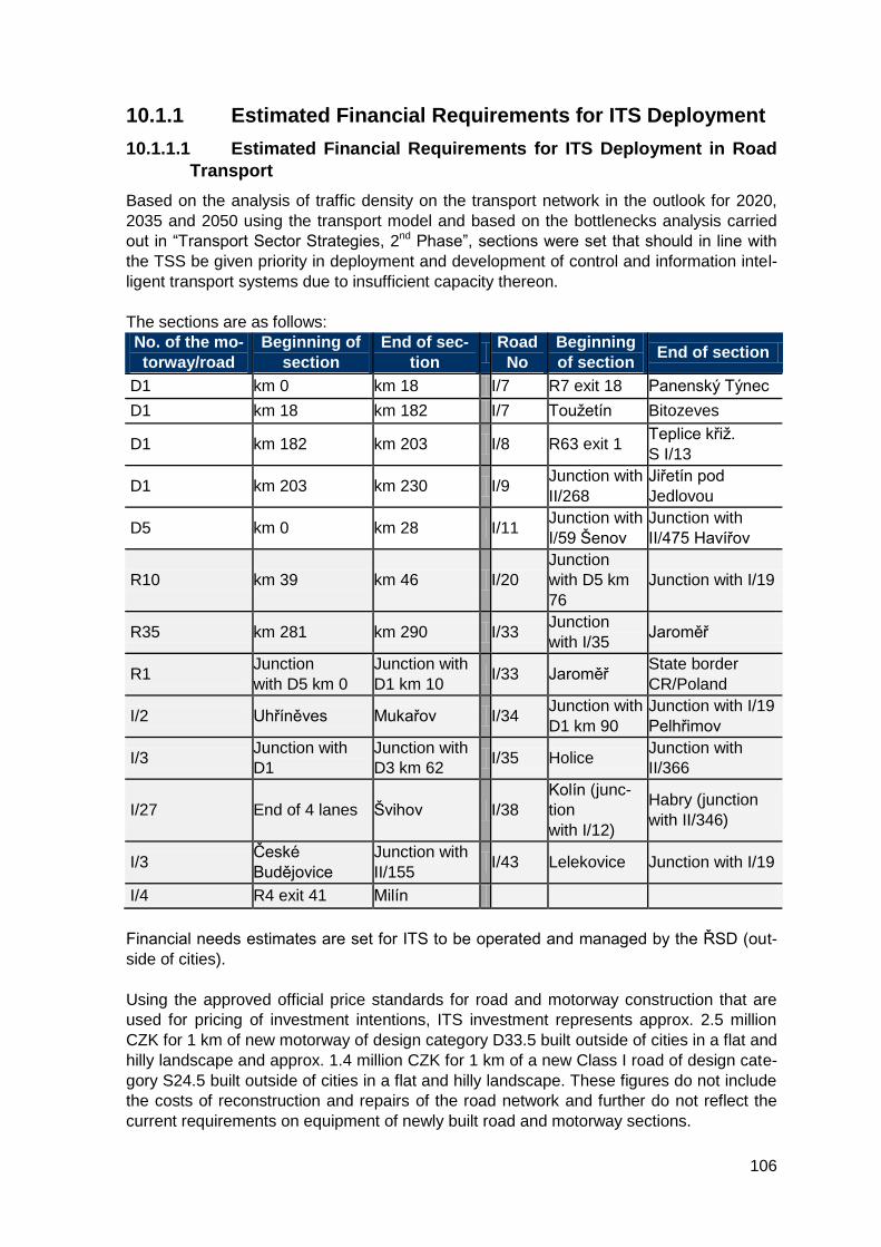
106
10.1.1 Estimated Financial Requirements for ITS Deployment
10.1.1.1 Estimated Financial Requirements for ITS Deployment in Road
Transport
Based on the analysis of traffic density on the transport network in the outlook for 2020,
2035 and 2050 using the transport model and based on the bottlenecks analysis carried
out in “Transport Sector Strategies, 2nd Phase”, sections were set that should in line with
the TSS be given priority in deployment and development of control and information intel-
ligent transport systems due to insufficient capacity thereon.
The sections are as follows:
No. of the mo-
torway/road
Beginning of
section
End of sec-
tion
Road
No
Beginning
of section End of section
D1 km 0 km 18 I/7 R7 exit 18 Panenský Týnec
D1 km 18 km 182 I/7 Toužetín Bitozeves
D1 km 182 km 203 I/8 R63 exit 1 Teplice křiž.
S I/13
D1 km 203 km 230 I/9 Junction with
II/268
Jiřetín pod
Jedlovou
D5 km 0 km 28 I/11 Junction with
I/59 Šenov
Junction with
II/475 Havířov
R10 km 39 km 46 I/20
Junction
with D5 km
76
Junction with I/19
R35 km 281 km 290 I/33 Junction
with I/35 Jaroměř
R1 Junction
with D5 km 0
Junction with
D1 km 10 I/33 Jaroměř
State border
CR/Poland
I/2 Uhříněves Mukařov I/34 Junction with
D1 km 90
Junction with I/19
Pelhřimov
I/3 Junction with
D1
Junction with
D3 km 62 I/35 Holice
Junction with
II/366
I/27 End of 4 lanes Švihov I/38
Kolín (junc-
tion
with I/12)
Habry (junction
with II/346)
I/3 České
Budějovice
Junction with
II/155 I/43 Lelekovice Junction with I/19
I/4 R4 exit 41 Milín
Financial needs estimates are set for ITS to be operated and managed by the ŘSD (out-
side of cities).
Using the approved official price standards for road and motorway construction that are
used for pricing of investment intentions, ITS investment represents approx. 2.5 million
CZK for 1 km of new motorway of design category D33.5 built outside of cities in a flat and
hilly landscape and approx. 1.4 million CZK for 1 km of a new Class I road of design cate-
gory S24.5 built outside of cities in a flat and hilly landscape. These figures do not include
the costs of reconstruction and repairs of the road network and further do not reflect the
current requirements on equipment of newly built road and motorway sections.
107
For motorways and expressways outside of cities, the objective is to achieve the standard
level of the road network equipment by ITS applications used for monitoring of the actual
traffic/weather situation and for collection of data for statistical/transport-engineering anal-
yses. The above mentioned study shows that the average length of a motorway section
between two exits is approximately 7 km and 5 km for an expressway section.
The emergency call stations system DIS-SOS is one of the most important part of ITS
deployed on the Czech road network. This system is used to create the backbone com-
munication network through which the other ITS communicate; the emergency call station
itself represents the access point for other devices such as surveillance cameras, traffic
counters, meteo-stations etc. It is necessary to upgrade approx. 33% of the emergency
call stations that for technical reasons are not able to serve as elements of the backbone
communication network or access points. The average emergency call station installation
price for one site is estimated at 1 million CZK. Approx. 240 million CZK should thus be
necessary for this upgrading. Approx. 780 million CZK will be needed to complete the
emergency call stations system over the entire planned road network.
To complete the system of automatic traffic counting, approximately 60 sections would
have to be equipped with induction detection technology based on expert estimates (on
the currently operated motorway and expressway network). To equip the planned road
network that should be composed of approx. 150 sections as estimated, 150 automatic
traffic counting devices will be necessary. As average investment costs for one counting
site range between 500,000 and 750,000 CZK, the costs for completing the equipping of
the current road network are estimated at 30-45 million CZK. For completion of the
planned Czech motorway and expressway network, it is possible to expect costs of 75-
115 million CZK.
The video surveillance system is used for monitoring of the current state of traffic and su-
pervision for provision of winter maintenance. On a standard equipped motorway, camera
points should be located every 2-3km. To complete this system, it will be necessary to
install approximately 135 camera points in the price range of 75-135 million CZK on the
currently operated motorway and expressway network. The deployment of such a system
on the road network that is planned or under construction would require some 200 camera
points with a corresponding investment of 100–200 million CZK.
Portal or semi-portal variable message panels (in the majority of cases, these are also
equipped with a variable message sign) with the minimum/optimum spacing of the infor-
mation panels of 20 km. Taking into account the current state, at maximum 15 additional
panels would be necessary to develop the current system into an optimized form. Esti-
mated investments costs for these additional devices amount to 150-170 million CZK. For
the future and the planned extent of the road network, investments costs of approx. 500-
600 million CZK are expected for approx. 50 of these devices.
The financial costs estimate for completion of the meteorology system is done based on
the target state of 500 meteo-stations that should sufficiently cover the Czech road net-
work. Currently, in total 385 meteo-stations exist and are operated. To achieve that,
approx. 100 stations must be installed which represents a total investment ranging be-
tween 240 and 380 million CZK. The installation of the so called small-scale alert
meteo-systems is planned as well to cover dangerous places where accidents are caused
mainly by bad weather conditions.
108
The introduction of dynamic weight-in-motion systems is being envisaged to reduce the
negative impacts on roads of overweight freight vehicles. From the ITS point of view, an
automatic weighting site is an application with complex equipment as it includes detection
technology for road freight vehicles weighting and passage/classification/speed recording
with a surveillance camera. The estimated target state of the system is 100 weighting
sites (on Class I roads). The investment costs for one dynamic weight-in-motion site on
two lanes amount to 5 million CZK, therefore the estimated investment needs for complet-
ing the system to achieve the target state are 450 million CZK.
Basic investment cost estimates for the dynamic traffic control system amount to 3.6 bil-
lion CZK.
Provision of information on parking places and optimized and controlled use of parking
areas for trucks and commercial vehicles and provision of traffic information about the
situation on the road network shall be ensured; this information by its nature informs the
drivers in particular about dangerous traffic situations. The introduction of the DATEX II
data transmission protocol is planned as well as the NDIC modernization using current
possibilities offered by information technologies consisting in the upgrade of the control
system and dispatcher and data centre technology renewal. It is planned to build a back-
up centre. Permanent administration, servicing and maintenance of information systems in
these centers will have to be ensured.
The vision of the final stage of development of traffic information in the Czech Republic is
based on the availability and timely provision of correct and technically harmonized static
or dynamic data from relevant sources which will allow the users of the traffic information
provision systems to get an overview of the traffic situation that corresponds to the real
state without being overburdened by excessive information, ideally through mobile appli-
cations and on-board systems developed using available data in a uniform format from
one or more standardized central databases. Data collected by the public sector are made
available for other clients, which helps to develop new services with added value, for ex-
ample information on availability and accessibility of public buildings. Open-data applica-
tions are also used by the public sector under specific conditions reflecting also the value
of data provided in exchange. Floating Car Data (FCD) can be used for monitoring the
real traffic situation. This data can also be used for modeling of conditions on the road
network, thus helping to improve the quality of real-time traffic information and contribute
to better safety and continuity of the traffic.
Cooperative systems (C-ITS) that are based on communication (data exchange) between
the vehicles, but also between vehicles and infrastructure, represent another major chal-
lenge for the car electronics and ITS. Cooperative systems allow for direct communication
between the vehicles themselves and between vehicles and ITS components on transport
infrastructure; the data are subsequently transferred to transport control or information
centers. There are several advantages of C-ITS communication, for example enabling
safer driving of the vehicle by providing on-time and precise information to the driver about
the traffic situation, dangerous places or other issues occurring near to them. For exam-
ple, the traffic control and information centers will receive precise and complete infor-
mation on the current traffic situation directly from the vehicles which will allow them to
efficiently and quickly manage the traffic flow and thus improve the safety and continuity of
traffic and reduce the negative environmental impacts (for example CO2) on roads. Intelli-
gent mobility going beyond the national borders is one of the basic objectives of the EU,
with activities contributing to this objective as the foundations for a pan-European
109
deployment and usage of cooperative systems. Cooperative systems technologies were
developed by European research and scientific projects and were verified in pilot tests
throughout Europe. The majority of suitable and necessary cooperative systems technol-
ogies have already been standardized on the level of CEN, ETSI or ISO.
The transport ministers of the Netherlands, Germany and Austria have signed a Memo-
randum of understanding and cooperation in development of cooperative intelligent
transport systems, more specifically by developing of an international ITS corridor con-
necting Rotterdam, Frankfurt am Maine and Vienna. This corridor shall be equipped with
ITS devices on transport infrastructure along the entire corridor at latest during 2015. At
least two ITS services shall be provided on the corridor:
- Road Works Warning (including the monitoring of maintenance vehicles/information
carts movement on roads via GNSS technology, transmission of their location into the
monitoring system (located on the respective SSUD) via 3G/4G technologies and in paral-
lel informing the vehicles approaching the area where maintenance vehicles are in motion
or where information carts are stationed via 5.9GHz (802.11p);
- Data from vehicles – “Probe” data (maintenance vehicles and other vehicles equipped
with ITS devices are sending information on their speed, direction of movement, accelera-
tion or deceleration or weather conditions into infrastructure-based ITS units via 5.9GHz
and these transmit them further to the control/information centers or direct communication
with these centers via 3G/4G services is also possible. This information is then used to
inform other drivers or for direct management of the traffic flow leading to improved safety
and continuity of traffic.
In both cases, the vehicle-to-vehicle or vehicle-to infrastructure communication should
primarily be based on WiFi (5.9GHz, 802.11p), while 3G/4G communication should be
used only as the second option. 802.11p is an IEEE approved standard for wireless com-
munication with vehicles (Wireless Access in Vehicular Environments WAVE) that sup-
ports ITS applications. This standard supports data exchange between high speed vehi-
cles, between vehicles themselves and vehicles to infrastructure in a licensed band for
ITS applications at 5.9 GHz (5.85 – 5.925 GHz). The communication and interconnection
of individual elements is shown on the picture below (picture based on the document ITS
Corridor).
The estimated financial costs for installation of ITS stations on all Czech motorways using
in particular the emergency call stations system represent 40 million CZK. Costs of C-ITS
integration into NDIC amounting to approx. 8-10 million CZK must be also taken into ac-
count. Annual operating costs are estimated at 4-8 million CZK.
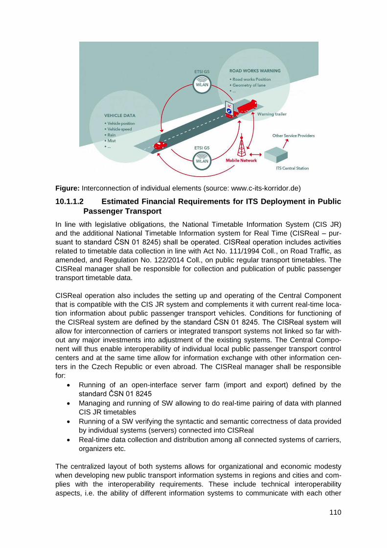
110
Figure: Interconnection of individual elements (source: www.c-its-korridor.de)
10.1.1.2 Estimated Financial Requirements for ITS Deployment in Public
Passenger Transport
In line with legislative obligations, the National Timetable Information System (CIS JR)
and the additional National Timetable Information system for Real Time (CISReal – pur-
suant to standard ČSN 01 8245) shall be operated. CISReal operation includes activities
related to timetable data collection in line with Act No. 111/1994 Coll., on Road Traffic, as
amended, and Regulation No. 122/2014 Coll., on public regular transport timetables. The
CISReal manager shall be responsible for collection and publication of public passenger
transport timetable data.
CISReal operation also includes the setting up and operating of the Central Component
that is compatible with the CIS JR system and complements it with current real-time loca-
tion information about public passenger transport vehicles. Conditions for functioning of
the CISReal system are defined by the standard ČSN 01 8245. The CISReal system will
allow for interconnection of carriers or integrated transport systems not linked so far with-
out any major investments into adjustment of the existing systems. The Central Compo-
nent will thus enable interoperability of individual local public passenger transport control
centers and at the same time allow for information exchange with other information cen-
ters in the Czech Republic or even abroad. The CISReal manager shall be responsible
for:
Running of an open-interface server farm (import and export) defined by the
standard ČSN 01 8245
Managing and running of SW allowing to do real-time pairing of data with planned
CIS JR timetables
Running of a SW verifying the syntactic and semantic correctness of data provided
by individual systems (servers) connected into CISReal
Real-time data collection and distribution among all connected systems of carriers,
organizers etc.
The centralized layout of both systems allows for organizational and economic modesty
when developing new public transport information systems in regions and cities and com-
plies with the interoperability requirements. These include technical interoperability
aspects, i.e. the ability of different information systems to communicate with each other
111
and also in real-time via shared interfaces, and semantic interoperability – the ability to
understand the content and quality of data. Procedure for assessing compliance shall be
introduced also for electronic ticketing systems.
10.1.1.3 Estimated Financial Requirements for ITS Deployment for En-
suring Accessibility of Public Passenger Transport for Persons with
Specific Needs
This will require detailed maps adjusted to the needs of users (barrier-free routes) to facili-
tate movement of persons with reduced mobility (persons on wheelchairs, older citizens,
mothers with baby prams) or with reduced orientation (visually-impaired or blind, hearing
impaired). The needs differ based on requirements of individual users and updating of
data on time and verification of information to make sure it is reliable are of crucial im-
portance. For example, visually impaired passengers need up-to-date information about
passage through an area (for example earthworks in progress, installed scaffoldings,
where is the pavement located in the direction of walking), about configuration of stops in
a place of transfer (for example urban public transport stops used for both directions of the
line, with the same name but different end stop etc.). Wheelchair users require information
about access ramps etc. In railway transport, technical specifications for interoperability
on accessibility of the EU railway system for persons with disabilities and persons with
reduced mobility or orientation capacities must be met.
10.1.1.4 Estimated Financial Requirements for ITS Deployment in Rail-
way Transport
Upgrading of both HW and SW equipment of train staff will be necessary to ensure online
on-board ticketing and information services for passengers that will allow to provide up-to-
date information on exceptional situations, traffic conditions or to provide information to
persons with reduced mobility or orientation. The estimated investment costs for equip-
ment to meet the specified requirement amount to approx. 120 million CZK and to approx.
50 million CZK for works on applications. The systems maintenance and operation cost
are estimated roughly at 10-20% of the investment costs; costs of ensuring online com-
munication must be added to this. The part related to international electronic issuing and
control of tickets equipped with QR codes should maximally amount to 12 million CZK.
The implementation of a fully electronic ticket would require an investment not exceeding
48 million CZK. On-board ITS upgrading is related to ITS development on railway infra-
structure – Czech Railways are interested in increasing of the safety and continuity of
passenger and freight transport which requires upgrading of vehicles that only comply with
safety requirements that were in place at the moment of introducing these into operation.
For maximum usage of technologies such as ATO, AO or other and meeting requirements
for potential analysis of exceptional situations such as the Speed-metering server, invest-
ments into railway vehicles and associated systems are estimated at 220 million CZK and
the increase of operating costs is estimated at 99 million CZK over 6 years; this includes
both ITS operation and ensuring of the online communication. Investments into improving
of the DISOD dispatcher system and its input parameters, also using GNSS including
connection to information systems of neighboring dispatcher sites of other carriers or
transport infrastructure managers represent a crucial element for improving of safety and
continuity of operation. Estimated investment costs for ensuring GNSS coverage of all
vehicles and adjustments of related systems and interfaces amount to 120 million CZK.
Adjustments of the dispatcher system and system of online information provision to all
units and services (security bodies, the public or companies and entities in charge of
passenger or freight transport) should require estimated investments not exceeding 100
million CZK.
112
Diagnostic, information, warning, control and interlocking systems (including Automatic
train operation) and radio data transmission systems shall be installed on railway infra-
structure. The carriers shall install ETCS and ATO on-board systems. If all vehicles are
equipped with ETCS (ideally also with ATO), it is necessary to consider the verification
and implementation of data transmission technology on the infrastructure and select the
optimum level of control and interlocking without the need to install infrastructural ele-
ments (signals, detection devices) on national and regional lines outside of TEN-T. The
proposed amount for introduction of satellite systems on regional lines is based on the
following economic and technological requirements.
In addition to other parameters, the capacity of the railway is affected by the method of
traffic control. On 44 regional lines with the total length of 1,218 km (38.6% of the total
length of regional lines), traffic is controlled using a system where the lines are divided
into track sections between operating posts with rail branching and into tracks within op-
erating posts. The operating posts are permanently occupied by staff of the railway opera-
tor (for example dispatchers, signalers, points operators, signal block operators etc.) that
is in charge of transport control and organization. For this type of lines, investment cost
shall amount to 50 million CZK for one standard line, including adequate interlocking and
equipping of 10 vehicles providing basic transport service coverage.
On 44 lines with the total length of 1,939 km (61.4% of the total length of regional lines),
traffic is controlled in line with the regulation on simplified railway traffic control. On such
lines, only one train or one shunting rail vehicle is moving on defined line sections. The
operating posts are not permanently occupied by the railway operator staff. Railway
transport is usually controlled from one place and train crew (for example conductor)
communicates at defined operating posts with the person in charge of traffic control via a
suitable signaling device. In situations of crossing or overtaking of trains, the arrival track
must be defined or it must be decided which train will enter the operating post first. Train
departure is conditioned by approval of the person in charge of traffic control (controlling
dispatcher – can be described as in charge of the area) or other approval of the railway
operator. For this type of lines, investment cost shall amount to 20 million CZK for one
standard line, including adequate warning information system and equipping of 10 vehi-
cles providing basic transport service coverage.
The Automatic Train Operation (ATO) system is designed for automatic control of rail ve-
hicles on SŽDC railway lines. This equipment is part of a superior system of driving regu-
lation of engine and control vehicle - CRV&ATO, i.e. Central Regulator of Vehicle and
Automatic Train Operation. The equipment is linked to the dynamic train interlocking pro-
tection LS 90 with prepared connection to the European train control system ERTMS-
ETCS.
The set of devices is composed of mobile and track-side parts. The track-side part con-
sists of a system of specific track information points – magnetic information points (MIB)
placed in the railway yard. The information point is composed of two prisms placed longi-
tudinally in the rail. These prisms contain 8 permanent magnets in total. ATO also allows
for obtaining of location data via the GNSS system, thus eliminating the need for the cost-
ly and complicated installation of magnetic information points. This method of ATO system
location called GIB (geographic information point) has been successfully introduced and
tested on vehicles running mostly on non-corridor lines. ATO also allows reading location
information from the Eurobalise system in case the line is equipped with it. The infor-
mation points thus provide definite information on the immediate position of the train. In
113
case of MIB, the specific information is coded using a secure code and is transmitted to
the vehicle through direct-current magnetic field. Other non-variable information neces-
sary for train operation control, such as line speed, position of signals, line gradient and
others are taken by the ATO system from the Route Map in the mobile part. The mobile
part is composed of a computer for control, track information points readers, entry key-
board and display at the conductor´s site, this display being shared with the vehicle con-
trol system. The data part – Route Map – contains track descriptions and data from train
timetables and it is loaded in the mobile part of the equipment. The CRV&ATO system
provides functions of vehicle control with automatic speed regulation (basic vehicle control
mode), automatic braking at target position, travel time regulation and manual vehicle con-
trol.
ATO brings about savings in particular through reduced traction energy needs by 10-30%.
The return of investments into MIB installation is very short, ranging between 1 and 3
years. The ATO system contributes to stricter respecting of travel times, thus running in
line with timetables. Functional ATO systems enable trains to stop precisely in stations
and stop on predefined positions. Other benefits of the system are improved rail traffic
safety through better working environment for train conductors (safety of vehicle move-
ment must however be ensured via ETCS train interlocking protection). Introduction of on-
board interlocking and automatization systems is a basic prerequisite for improved com-
petitiveness of railway transport. Optimum usage of ATO system capacities would require
provision of information about the defined train route from the interlocking and signaling
system which would help to achieve higher control automatization through ATO (at pre-
sent, the missing information must be added by the conductor based on immediate as-
sessment of the situation) and also to increase the efficiency of traction energy savings
algorithm.
The implementation of the track-side part of ATO on SŽDC railway network is planned for
2015 with expected financial costs of 155 million CZK. In the following period from 2016
on, it is planned to continue equipping lines with ATO based on cooperation with carriers,
taking into account the numbers of their traction units equipped with the mobile part of
ATO. Currently, mobile parts of ATO are installed in electric double-decker units of series
471 (CityElephant) and traction units of series 380 and vehicles of series 163, 362, 750.7,
842, 961, 363.5. As lines are being gradually equipped with ETCS, in line with the de-
ployment concept defined in the National ERTMS Deployment Plan, it is planned to re-
move the MIB information points from lines where ETCS will be deployed and subse-
quently install them on other selected railway lines where their use will be beneficial for
operation, taking into account the equipment of traction units by ATO. The option of in-
stalling of a unit for reading of GIB information points based on GNSS into all vehicles
equipped with ATO can also be considered.
Traffic on the railway network is controlled non-stop and over a large territory and it is in-
terconnected with railway networks of neighboring countries. Railway traffic is secured
against accidents or collisions through the interlocking and signaling equipment and its
organizing is supported by numerous information and communication systems. Strength-
ening of the inadequate transmission infrastructure through elements of modern commu-
nication technologies represents the basic condition for setting up of the “Control and Ana-
lytic Centre for Railway Operation Control”. The estimated costs of this step amount to
350 million CZK and the measure shall also contribute to improved safety and reliability of
the existing systems. Costs of creating of a single environment for communication and
recording of data from audio, video, diagnostic, dispatcher and interlocking systems (SW,
114
HW) are estimated at 90 million CZK. Cost for setting up of the add-on control, surveil-
lance and analytic system for the “Control and Analytic Centre for Railway Operation Con-
trol” are estimated at 100 million CZK. New system functionalities shall ensure simplifica-
tion of railway infrastructure control and organization procedures, in particular in relation to
processes of control activities planning, organization and execution methods.
Defects of rail vehicles undercarriage (in particular in freight wagons) can directly lead not
only to major accidents with material damage to the vehicle and transported cargo, but
depending on the train speed and exact place of derailing severe damage can be caused
to transport infrastructure and major risks for rail transport safety can occur (possibility of
a direct contact of the vehicle with the train running in the opposite direction etc.). The risk
of major consequences of defects such as rail break, axle pivot shear, loosening of a
wheel, fracture of a full wheel is growing not only on corridor lines, but also on other lines
in the context of line speed increase to 160 km/h. The costs for completing the track-side
part of the network of digital devices for diagnostic of defects on vehicles in motion – i.e.
approx. 64 checkpoints – are estimated at 400 million CZK. Development of a thematic
superior layer ensuring communication between individual checkpoints with online as-
sessment of the defect´s development shall lead to further reduction of undetected serious
defects – affecting the safety of railway operation – of rail vehicles in motion. The costs for
development of this ITS together with preparation for connection to similar systems of
neighboring European railways by exchanging warning notifications and related data and
preparation for use of vehicle location information from European satellite positioning sys-
tems EGNOS and Galileo are estimated approximately at 110 million CZK.
Implementation of the “Automatic warning system” (SAV) aimed at reducing risky behavior
of drivers and pedestrians on dangerous parts of railway infrastructure involves protection
of some 500 selected dangerous sites, ensuring connectivity, surveillance centers and
access of rescue and enforcement services of the Czech Republic to the system via a
“thin client”. Expected costs of full implementation in 2020 amount to 520 million CZK.
Railway transport safety is also significantly affected by damages to or theft of railway
infrastructure technical devices and equipment – mostly theft of metallic (copper) cabling
and other interlocking and signaling equipment components used for controlling of the
trains running, sequence, speed, crossing in stations etc. A major reduction of these crim-
inal activities is expected from modern dynamic protection detection systems for railway
infrastructure components or equipment. It is expected that some 2,000 km of lines shall
be covered by the detection system, with connection of selected key structures, by 2020.
The described network shall be supervised from a monitoring work post. The expected
costs of 1 billion CZK include costs for ensuring connectivity of the equipment and com-
munication interface for access of enforcement units.
Currently, numerous information systems exist in relation to managing and maintaining
railway infrastructure. Intelligent transport systems offer a large scale of applications for
infrastructure managers, carriers and transport users. Conditions for ITS development are
created through setting up of standardized interfaces between individual systems, sub-
systems and applications running on diagnostic, defectoscopy and technical data on the
condition and operability of railway infrastructure; defining specification of individual con-
nections between applications, sub-systems and systems; specification of requirements
on individual connection interfaces. By implementing the system, the railway infrastructure
manager will be able to allocate capacities and resources in an optimum way with the aim
of improving safety and continuity of works on the railway network, ensuring of optimum
115
operability parameters for using of individual infrastructure parts while taking into account
the current and outlook transport needs. Interlinking of this application under preparation
to operation will facilitate and render more efficient the planning of railway transport, line
closures and will, through on-time indication and reduction in irregular and emergency
interventions on the infrastructure, contribute to an overall reduction of delays and irregu-
larities in transport. Implementation of the software for the integrated rail infrastructure
management system is planned in phases through modules “Economy of tracks” for 78
million CZK, “Interlocking and telecommunication technology” for 34 million CZK and
“Electro-technics and energy” for 38 million CZK. In parallel, conditions and interfaces
shall be created enabling the use of EGNOS and Galileo systems and applications sys-
tems based on satellite systems for monitoring of railway transport infrastructure safety to
forecast impacts of the weather situation, landslides or movements, floods and inunda-
tions.
10.1.1.5 Estimated Financial Requirements for ITS Deployment in Freight
Transport Logistics
The current information systems for tracking of the transportation of special consignments
are being developed in a dispersed way, be it by individual industrial companies or opera-
tors, or even in different countries. The information and corresponding applications cannot
be shared between the companies themselves or between the companies and rescue
services. Therefore, in case of an accident, the rescue services cannot use the infor-
mation on the nature of transported goods, even if this would be possible from the tech-
nical point of view. The potential of these systems – to provide relevant information within
a very short time to those who might need it for rescue activities – is thus not being used
fully. Critical events often require re-directing of traffic flows outside of the affected area.
Serious problems in organization of traffic can occur on the road network as it is the truck
driver who decided about the route to take, unless a specific route is defined or on the
contrary passage banned on some sections by a specific implementing act. In case of a
critical event, a vehicle with an oversized or very heavy load can act as an obstacle for
other vehicles. Precise information about these obstacles provided on time to respective
units can improve the efficiency of transport organizing in situations of crisis.
10.1.1.6 Estimated Financial Requirements for ITS Deployment in Inland
Navigation
The development of the dispatching centre and applications connected to river information
services shall be ensured and the access of lock chambers staff to RIS will be introduced.
The following shall be supported as well: transmission of meteorological information (cur-
rent and forecast data) from CHMI to RIS; operation of AIS transmitters, of a differential
GPS with receptions of the IALA system correction signal; upgrade of the measuring HW
and SW for measuring vessel Střekov; HW and SW renewal of the LAVDIS system; en-
suring of data transfer from the national geo-database into the S-57 system for navigation
of vessels.
10.1.1.7 Estimated Financial Requirements for ITS Deployment in the
Area of Spatial Data
Currently, the MoT does not own almost any spatial data infrastructure (SDI). Only partial
exceptions exist in the form of isolated solutions. This situation is becoming more pressing
and not sustainable for the future. The need to interlink and combine infrastructure data
for different transport modes is becoming more urgent and therefore such an environment
needs to be created where the existing systems will be interconnected to create a com-
plex data source for the development of those services that use spatial data as the basic
116
input, i.e. above all for achieving an economic approach to organizing and controlling of
transport and related ITS introduction, etc. The existing SDIs, operated within individual
subordinate organizations, shall be therefore consolidated. SDI shall be set up at the MoT
where this type of infrastructure is missing. An integration platform shall be set up as an
expansion of the MoT SDI which shall integrate data from all transport modes and enable
their simple and efficient use across the transport sector, but shall also serve as the single
access point for transport spatial data and as support for execution of transport-related
and territorial agendas of public administration central bodies, regional and municipal au-
thorities or the expert public.
In the context of preparation of the Central Register of Roads (CEPK) and the function it
should play, it is important to develop it as an information system with strong accentuation
of the spatial component and its spatial precision, i.e. as a geographic information system.
At the same time, the system must be correctly interlinked with the planned SDI for the
transport sector. An analysis and survey will be necessary – to collect the attributes to
attributes that should be registered in the CEPK so that the information contained in
CEPK meets the requirements of various user groups (for example infrastructure manag-
er, infrastructure users, IRS etc.). It is also necessary to define the basic spatial data pa-
rameters to ensure that a connected roads data set (layer) is created.
There is a growing need for a central register of railway infrastructure and therefore an
adequate information system shall be set up. Also this system shall be designed with a
strong accentuation of the spatial component and as fully compatible with the planned SDI
for the transport sector. The transmission of such data into the system will have to be pro-
vided for in the legislation as both private and public railway infrastructure exists; the reg-
ister manager will have to be selected. The scope and description of items in the register
also needs to be defined.
It is also necessary to consolidate and develop the data fund of transport spatial data,
both on the state level and regional and urban level. Interoperability of spatial data needs
to be ensured as well as the possibility to easily interconnect spatial data infrastructure
with other similar systems when suitable. Public services based on transport spatial data
shall be developed.
10.1.2 Defining the Sources and Structure of Funding for In-
dividual Items
A framework estimate of potential planned expenditure has been drawn in order to identify
the funding volumes necessary for implementation of measures defined in the ITS AP and
to analyze the possible sources of funding from public sector budgets. Therefore the ITS
AP does not specify the sources and structure of funding (MoT chapter No 327, EU re-
sources, TAČR, regional and municipal budgets etc.) or the respective shares of the state
budget and EU (if applicable for the specific expenditure) for specific costs. As the figures
presented are rough framework estimates, it is not specified if the amounts are including
or excluding VAT.
The ITS AP implementation shall not mean increase of the number of MoT employees or
of costs spent on wages.
Based on the ITS AP, an implementation plan shall be drafted subsequently that will con-
tain a more detailed framework for the subject matter, schedule and financial aspects of
individual projects.

117
Funding of ITS development by the MoT, SFDI, SŽDC, ŘSD, ŘVC and SPS:
Tota
l [m
il.C
ZK
]
2015 2016 2017 2018 2019 2020
In
vestm
ent
co
sts
[mil.
CZ
K]
Op
era
tin
g c
osts
[m
il.C
ZK
]
Investm
ent
co
sts
[mil.
CZ
K]
Op
era
tin
g c
osts
[m
il.C
ZK
]
Investm
ent
co
sts
[mil.
CZ
K]
Op
era
tin
g c
osts
[m
il.C
ZK
]
Investm
ent
co
sts
[mil.
CZ
K]
Op
era
tin
g c
osts
[m
il.C
ZK
]
Investm
ent
co
sts
[mil.
CZ
K]
Op
era
tin
g c
osts
[m
il.C
ZK
]
Investm
ent
co
sts
[mil.
CZ
K]
Op
era
tin
g c
osts
[m
il.C
ZK
]
ITS in road transport
Data sources and ensuring the transmission and quality
Universal de-
ployment of
detection tech-
nologies on
road transport
infrastructure in
the CR
1,910 20 0 525 0 500 0 25 0 420 0 420 0
Development
and upgrading
of the commu-
nication net-
work for data
transmission
and for the
communication
system for the
cooperative
vehicles con-
cept
662 7 0 140 0 65 0 10 0 220 0 220 0
Acquisition and
incorporation of
a general data
source on traf-
fic flows dy-
namics and
costs of reposi-
tory operation
331 1 55 0 55 0 55 0 55 0 55 0 55
NDIC 400 100 30 50 30 50 30 20 30 0 30 0 30
National ac-
cess point 75 20 5 5 5 0 10 0 10 0 10 0 10
Information
service for
truck parking
550 20 20 40 40 60 50 40 80 20 80 20 80
DATEX 20 10 0 5 0 5 0 0 0 0 0 0 0
Compliance 120 20 10 10 10 0 15 0 15 0 20 0 20
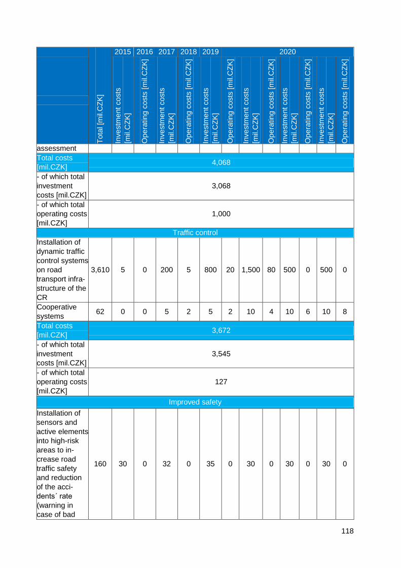
118
Tota
l [m
il.C
ZK
]
2015 2016 2017 2018 2019 2020
Investm
ent
co
sts
[mil.
CZ
K]
Op
era
tin
g c
osts
[m
il.C
ZK
]
Investm
ent
co
sts
[mil.
CZ
K]
Op
era
tin
g c
osts
[m
il.C
ZK
]
Investm
ent
co
sts
[mil.
CZ
K]
Op
era
tin
g c
osts
[m
il.C
ZK
]
Investm
ent
co
sts
[mil.
CZ
K]
Op
era
tin
g c
osts
[m
il.C
ZK
]
Investm
ent
co
sts
[mil.
CZ
K]
Op
era
tin
g c
osts
[m
il.C
ZK
]
Investm
ent
co
sts
[mil.
CZ
K]
Op
era
tin
g c
osts
[m
il.C
ZK
]
assessment
Total costs
[mil.CZK] 4,068
- of which total
investment
costs [mil.CZK]
3,068
- of which total
operating costs
[mil.CZK]
1,000
Traffic control
Installation of
dynamic traffic
control systems
on road
transport infra-
structure of the
CR
3,610 5 0 200 5 800 20 1,500 80 500 0 500 0
Cooperative
systems 62 0 0 5 2 5 2 10 4 10 6 10 8
Total costs
[mil.CZK] 3,672
- of which total
investment
costs [mil.CZK]
3,545
- of which total
operating costs
[mil.CZK]
127
Improved safety
Installation of
sensors and
active elements
into high-risk
areas to in-
crease road
traffic safety
and reduction
of the acci-
dents´ rate
(warning in
case of bad
160 30 0 32 0 35 0 30 0 30 0 30 0
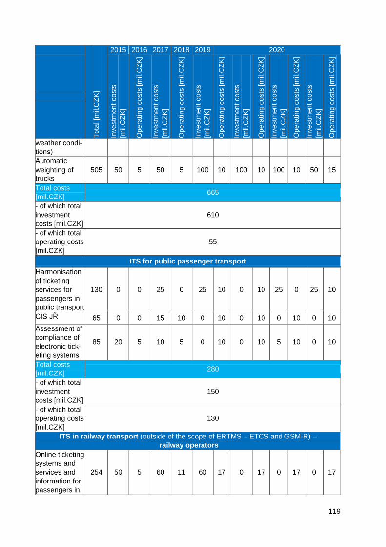
119
Tota
l [m
il.C
ZK
]
2015 2016 2017 2018 2019 2020
Investm
ent
co
sts
[mil.
CZ
K]
Op
era
tin
g c
osts
[m
il.C
ZK
]
Investm
ent
co
sts
[mil.
CZ
K]
Op
era
tin
g c
osts
[m
il.C
ZK
]
Investm
ent
co
sts
[mil.
CZ
K]
Op
era
tin
g c
osts
[m
il.C
ZK
]
Investm
ent
co
sts
[mil.
CZ
K]
Op
era
tin
g c
osts
[m
il.C
ZK
]
Investm
ent
co
sts
[mil.
CZ
K]
Op
era
tin
g c
osts
[m
il.C
ZK
]
Investm
ent
co
sts
[mil.
CZ
K]
Op
era
tin
g c
osts
[m
il.C
ZK
]
weather condi-
tions)
Automatic
weighting of
trucks
505 50 5 50 5 100 10 100 10 100 10 50 15
Total costs
[mil.CZK] 665
- of which total
investment
costs [mil.CZK]
610
- of which total
operating costs
[mil.CZK]
55
ITS for public passenger transport
Harmonisation
of ticketing
services for
passengers in
public transport
130 0 0 25 0 25 10 0 10 25 0 25 10
CIS JŘ 65 0 0 15 10 0 10 0 10 0 10 0 10
Assessment of
compliance of
electronic tick-
eting systems
85 20 5 10 5 0 10 0 10 5 10 0 10
Total costs
[mil.CZK] 280
- of which total
investment
costs [mil.CZK]
150
- of which total
operating costs
[mil.CZK]
130
ITS in railway transport (outside of the scope of ERTMS – ETCS and GSM-R) –
railway operators
Online ticketing
systems and
services and
information for
passengers in
254 50 5 60 11 60 17 0 17 0 17 0 17
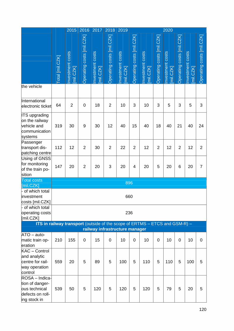
120
Tota
l [m
il.C
ZK
]
2015 2016 2017 2018 2019 2020
Investm
ent
co
sts
[mil.
CZ
K]
Op
era
tin
g c
osts
[m
il.C
ZK
]
Investm
ent
co
sts
[mil.
CZ
K]
Op
era
tin
g c
osts
[m
il.C
ZK
]
Investm
ent
co
sts
[mil.
CZ
K]
Op
era
tin
g c
osts
[m
il.C
ZK
]
Investm
ent
co
sts
[mil.
CZ
K]
Op
era
tin
g c
osts
[m
il.C
ZK
]
Investm
ent
co
sts
[mil.
CZ
K]
Op
era
tin
g c
osts
[m
il.C
ZK
]
Investm
ent
co
sts
[mil.
CZ
K]
Op
era
tin
g c
osts
[m
il.C
ZK
]
the vehicle
International
electronic ticket 64 2 0 18 2 10 3 10 3 5 3 5 3
ITS upgrading
on the railway
vehicle and
communication
systems
319 30 9 30 12 40 15 40 18 40 21 40 24
Passenger
transport dis-
patching centre
112 12 2 30 2 22 2 12 2 12 2 12 2
Using of GNSS
for monitoring
of the train po-
sition
147 20 2 20 3 20 4 20 5 20 6 20 7
Total costs
[mil.CZK] 896
- of which total
investment
costs [mil.CZK]
660
- of which total
operating costs
[mil.CZK]
236
ITS in railway transport (outside of the scope of ERTMS – ETCS and GSM-R) –
railway infrastructure manager
ATO – auto-
matic train op-
eration
210 155 0 15 0 10 0 10 0 10 0 10 0
KAC – Control
and analytic
centre for rail-
way operation
control
559 20 5 89 5 100 5 110 5 110 5 100 5
ROSA – Indica-
tion of danger-
ous technical
defects on roll-
ing stock in
539 50 5 120 5 120 5 120 5 79 5 20 5
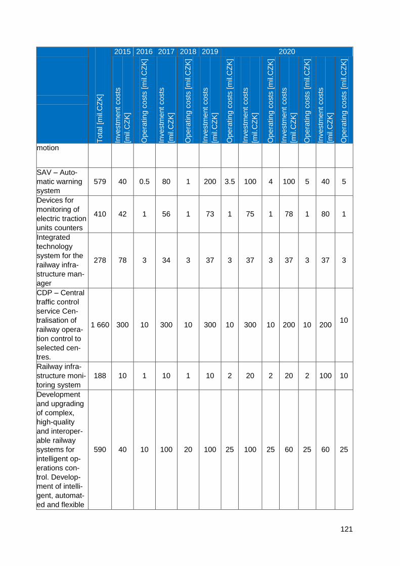
121
Tota
l [m
il.C
ZK
]
2015 2016 2017 2018 2019 2020
Investm
ent
co
sts
[mil.
CZ
K]
Op
era
tin
g c
osts
[m
il.C
ZK
]
Investm
ent
co
sts
[mil.
CZ
K]
Op
era
tin
g c
osts
[m
il.C
ZK
]
Investm
ent
co
sts
[mil.
CZ
K]
Op
era
tin
g c
osts
[m
il.C
ZK
]
Investm
ent
co
sts
[mil.
CZ
K]
Op
era
tin
g c
osts
[m
il.C
ZK
]
Investm
ent
co
sts
[mil.
CZ
K]
Op
era
tin
g c
osts
[m
il.C
ZK
]
Investm
ent
co
sts
[mil.
CZ
K]
Op
era
tin
g c
osts
[m
il.C
ZK
]
motion
SAV – Auto-
matic warning
system
579 40 0.5 80 1 200 3.5 100 4 100 5 40 5
Devices for
monitoring of
electric traction
units counters
410 42 1 56 1 73 1 75 1 78 1 80 1
Integrated
technology
system for the
railway infra-
structure man-
ager
278 78 3 34 3 37 3 37 3 37 3 37 3
CDP – Central
traffic control
service Cen-
tralisation of
railway opera-
tion control to
selected cen-
tres.
1 660 300 10 300 10 300 10 300 10 200 10 200 10
Railway infra-
structure moni-
toring system
188 10 1 10 1 10 2 20 2 20 2 100 10
Development
and upgrading
of complex,
high-quality
and interoper-
able railway
systems for
intelligent op-
erations con-
trol. Develop-
ment of intelli-
gent, automat-
ed and flexible
590 40 10 100 20 100 25 100 25 60 25 60 25
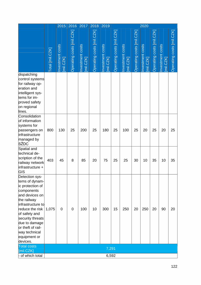
122
Tota
l [m
il.C
ZK
]
2015 2016 2017 2018 2019 2020
Investm
ent
co
sts
[mil.
CZ
K]
Op
era
tin
g c
osts
[m
il.C
ZK
]
Investm
ent
co
sts
[mil.
CZ
K]
Op
era
tin
g c
osts
[m
il.C
ZK
]
Investm
ent
co
sts
[mil.
CZ
K]
Op
era
tin
g c
osts
[m
il.C
ZK
]
Investm
ent
co
sts
[mil.
CZ
K]
Op
era
tin
g c
osts
[m
il.C
ZK
]
Investm
ent
co
sts
[mil.
CZ
K]
Op
era
tin
g c
osts
[m
il.C
ZK
]
Investm
ent
co
sts
[mil.
CZ
K]
Op
era
tin
g c
osts
[m
il.C
ZK
]
dispatching
control systems
for railway op-
eration and
intelligent sys-
tems for im-
proved safety
on regional
lines.
Consolidation
of information
systems for
passengers on
infrastructure
managed by
SŽDC
800 130 25 200 25 180 25 100 25 20 25 20 25
Spatial and
technical de-
scription of the
railway network
infrastructure +
GIS
403 45 8 85 20 75 25 25 30 10 35 10 35
Detection sys-
tems of dynam-
ic protection of
components
and devices on
the railway
infrastructure to
reduce the risk
of safety and
security threats
due to damage
or theft of rail-
way technical
equipment or
devices.
1,075 0 0 100 10 300 15 250 20 250 20 90 20
Total costs
[mil.CZK] 7,291
- of which total 6,592
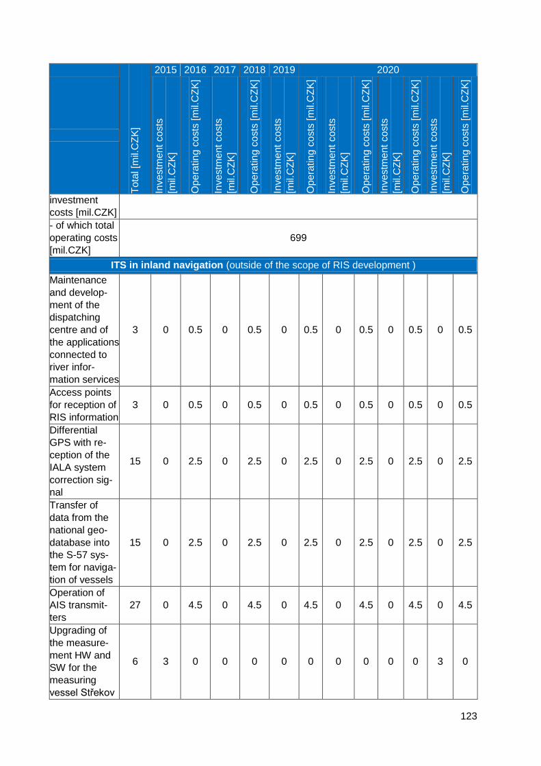
123
Tota
l [m
il.C
ZK
]
2015 2016 2017 2018 2019 2020
Investm
ent
co
sts
[mil.
CZ
K]
Op
era
tin
g c
osts
[m
il.C
ZK
]
Investm
ent
co
sts
[mil.
CZ
K]
Op
era
tin
g c
osts
[m
il.C
ZK
]
Investm
ent
co
sts
[mil.
CZ
K]
Op
era
tin
g c
osts
[m
il.C
ZK
]
Investm
ent
co
sts
[mil.
CZ
K]
Op
era
tin
g c
osts
[m
il.C
ZK
]
Investm
ent
co
sts
[mil.
CZ
K]
Op
era
tin
g c
osts
[m
il.C
ZK
]
Investm
ent
co
sts
[mil.
CZ
K]
Op
era
tin
g c
osts
[m
il.C
ZK
]
investment
costs [mil.CZK]
- of which total
operating costs
[mil.CZK]
699
ITS in inland navigation (outside of the scope of RIS development )
Maintenance
and develop-
ment of the
dispatching
centre and of
the applications
connected to
river infor-
mation services
3 0 0.5 0 0.5 0 0.5 0 0.5 0 0.5 0 0.5
Access points
for reception of
RIS information
3 0 0.5 0 0.5 0 0.5 0 0.5 0 0.5 0 0.5
Differential
GPS with re-
ception of the
IALA system
correction sig-
nal
15 0 2.5 0 2.5 0 2.5 0 2.5 0 2.5 0 2.5
Transfer of
data from the
national geo-
database into
the S-57 sys-
tem for naviga-
tion of vessels
15 0 2.5 0 2.5 0 2.5 0 2.5 0 2.5 0 2.5
Operation of
AIS transmit-
ters
27 0 4.5 0 4.5 0 4.5 0 4.5 0 4.5 0 4.5
Upgrading of
the measure-
ment HW and
SW for the
measuring
vessel Střekov
6 3 0 0 0 0 0 0 0 0 0 3 0
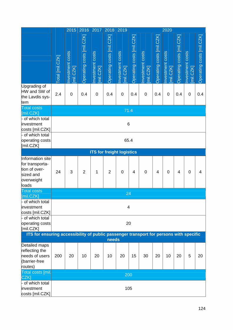
124
Tota
l [m
il.C
ZK
]
2015 2016 2017 2018 2019 2020
Investm
ent
co
sts
[mil.
CZ
K]
Op
era
tin
g c
osts
[m
il.C
ZK
]
Investm
ent
co
sts
[mil.
CZ
K]
Op
era
tin
g c
osts
[m
il.C
ZK
]
Investm
ent
co
sts
[mil.
CZ
K]
Op
era
tin
g c
osts
[m
il.C
ZK
]
Investm
ent
co
sts
[mil.
CZ
K]
Op
era
tin
g c
osts
[m
il.C
ZK
]
Investm
ent
co
sts
[mil.
CZ
K]
Op
era
tin
g c
osts
[m
il.C
ZK
]
Investm
ent
co
sts
[mil.
CZ
K]
Op
era
tin
g c
osts
[m
il.C
ZK
]
Upgrading of
HW and SW of
the Lavdis sys-
tem
2.4 0 0.4 0 0.4 0 0.4 0 0.4 0 0.4 0 0.4
Total costs
[mil.CZK] 71.4
- of which total
investment
costs [mil.CZK]
6
- of which total
operating costs
[mil.CZK]
65.4
ITS for freight logistics
Information site
for transporta-
tion of over-
sized and
overweight
loads
24 3 2 1 2 0 4 0 4 0 4 0 4
Total costs
[mil.CZK] 24
- of which total
investment
costs [mil.CZK]
4
- of which total
operating costs
[mil.CZK]
20
ITS for ensuring accessibility of public passenger transport for persons with specific
needs
Detailed maps
reflecting the
needs of users
(barrier-free
routes)
200 20 10 20 10 20 15 30 20 10 20 5 20
Total costs [mil.
CZK] 200
- of which total
investment
costs [mil.CZK]
105
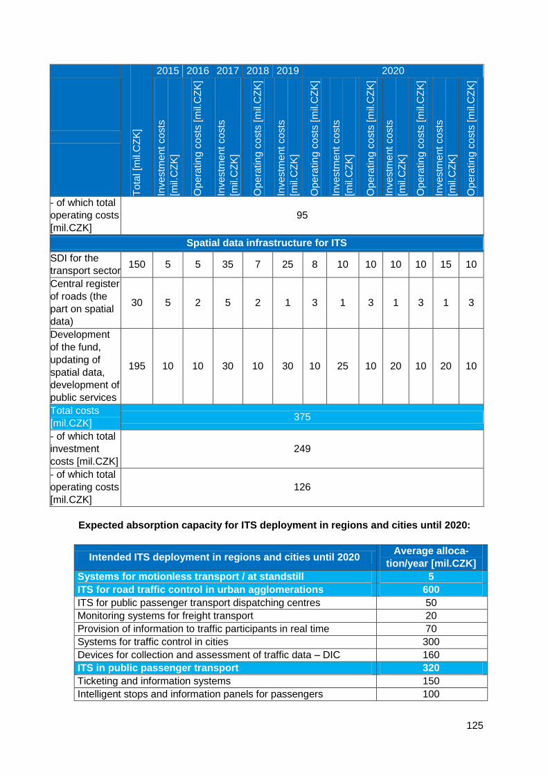
125
Tota
l [m
il.C
ZK
]
2015 2016 2017 2018 2019 2020
Investm
ent
co
sts
[mil.
CZ
K]
Op
era
tin
g c
osts
[m
il.C
ZK
]
Investm
ent
co
sts
[mil.
CZ
K]
Op
era
tin
g c
osts
[m
il.C
ZK
]
Investm
ent
co
sts
[mil.
CZ
K]
Op
era
tin
g c
osts
[m
il.C
ZK
]
Investm
ent
co
sts
[mil.
CZ
K]
Op
era
tin
g c
osts
[m
il.C
ZK
]
Investm
ent
co
sts
[mil.
CZ
K]
Op
era
tin
g c
osts
[m
il.C
ZK
]
Investm
ent
co
sts
[mil.
CZ
K]
Op
era
tin
g c
osts
[m
il.C
ZK
]
- of which total
operating costs
[mil.CZK]
95
Spatial data infrastructure for ITS
SDI for the
transport sector 150 5 5 35 7 25 8 10 10 10 10 15 10
Central register
of roads (the
part on spatial
data)
30 5 2 5 2 1 3 1 3 1 3 1 3
Development
of the fund,
updating of
spatial data,
development of
public services
195 10 10 30 10 30 10 25 10 20 10 20 10
Total costs
[mil.CZK] 375
- of which total
investment
costs [mil.CZK]
249
- of which total
operating costs
[mil.CZK]
126
Expected absorption capacity for ITS deployment in regions and cities until 2020:
Intended ITS deployment in regions and cities until 2020 Average alloca-
tion/year [mil.CZK]
Systems for motionless transport / at standstill 5
ITS for road traffic control in urban agglomerations 600
ITS for public passenger transport dispatching centres 50
Monitoring systems for freight transport 20
Provision of information to traffic participants in real time 70
Systems for traffic control in cities 300
Devices for collection and assessment of traffic data – DIC 160
ITS in public passenger transport 320
Ticketing and information systems 150
Intelligent stops and information panels for passengers 100
126
Improved attractiveness and continuity of public passenger
transport – preference for urban public transport vehicles, infor-
mation on connections with barrier-free vehicles.
70
10.2 Public Financial Resources for Funding of ITS
Implementation Projects
Investments in intelligent transport systems are paid from the state budget, via the State
Fund for Transport Infrastructure or through EU programmes co-financed from Czech
public budgets. Individual regions and cities also have their own budgets that are used for
investments into ITS.
10.2.1 State Budget
It is expected that the budgetary chapter of the Ministry of Transport will be used to fund
activities related to the National Timetable Information System (CIS JR); activities related
to spatial data infrastructure consolidation within the transport sector, including operation
and incorporation of the geographic information system Unified Transport Vector Map
(JDVM) and database of transport infrastructures; issues related to harmonization and
accessibility of the obtained spatial data (for example sets of spatial data (map layers),
other structures or elements on maps and their description including information on their
location – coordinates) in line with requirements of European legislation on development
of European spatial data infrastructure, i.e. in line with the Directive of the European Par-
liament and of the Council EC/2/2007 INSPIRE and related regulations. Also activities
related to compliance assessment of ITS products, devices and services pursuant to Act
No. 13/1997 Coll., on Roads, as amended, aimed at creating framework conditions allow-
ing ITS end users to rely on guaranteed and critical applications, i.e. such applications
when an error in functioning of the system would mean serious threat to health or life of
persons, or a substantial financial loss, shall be supported from the state budget. Co-
financing for the MoT participation in European projects of common interest for ITS devel-
opment and deployment is also planned.
10.2.2 State Fund for Transport Infrastructure (SFDI)
Expenditure for ITS funding, both for investments and maintenance and operation of sys-
tems, in particular ITS operated by the ŘSD, represent one of mandatory expenses of the
SFDI. The ŘSD is the investor in majority of cases, but other organizations can be inves-
tors too, such as for example SŽDC, SPS or important cities, in particular those connected
to the backbone road network.
Maximum drawing of EU resources is the primary priority for the MoT and for the Czech
Government. From the financial perspective, ensuring of sufficient sources for national co-
financing is a necessary precondition for maximum drawing of allocated resources from
EU funds.
Some ITS projects are perceived by the EU as priority ones. ITS projects with European
added value where large scale application in several member states is expected can be
defined for two different scopes of impact:
1) Geographic definition – for example ITS for road traffic control (or other relevant sys-
tems and applications) can be preferentially deployed on TEN-T networks of individual
states with a given interface to related systems on regional, local or large cities level, or to
private sector systems;
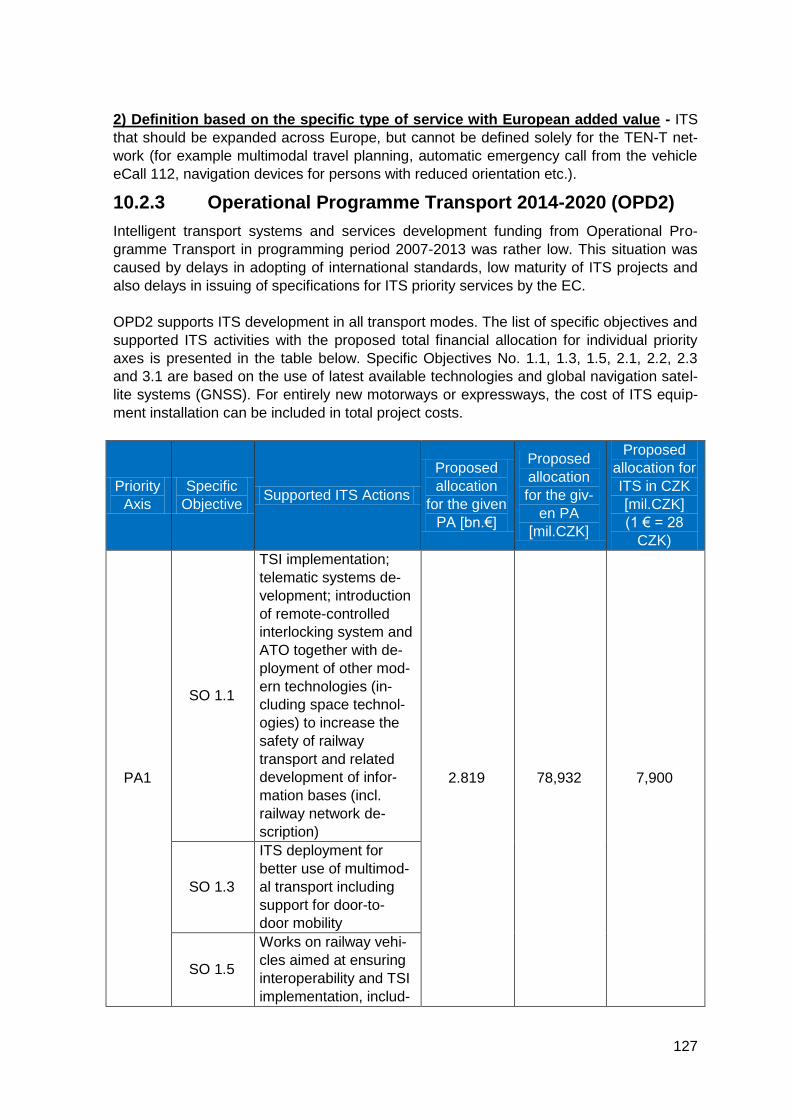
127
2) Definition based on the specific type of service with European added value - ITS
that should be expanded across Europe, but cannot be defined solely for the TEN-T net-
work (for example multimodal travel planning, automatic emergency call from the vehicle
eCall 112, navigation devices for persons with reduced orientation etc.).
10.2.3 Operational Programme Transport 2014-2020 (OPD2)
Intelligent transport systems and services development funding from Operational Pro-
gramme Transport in programming period 2007-2013 was rather low. This situation was
caused by delays in adopting of international standards, low maturity of ITS projects and
also delays in issuing of specifications for ITS priority services by the EC.
OPD2 supports ITS development in all transport modes. The list of specific objectives and
supported ITS activities with the proposed total financial allocation for individual priority
axes is presented in the table below. Specific Objectives No. 1.1, 1.3, 1.5, 2.1, 2.2, 2.3
and 3.1 are based on the use of latest available technologies and global navigation satel-
lite systems (GNSS). For entirely new motorways or expressways, the cost of ITS equip-
ment installation can be included in total project costs.
Priority
Axis
Specific
Objective Supported ITS Actions
Proposed
allocation
for the given
PA [bn.€]
Proposed
allocation
for the giv-
en PA
[mil.CZK]
Proposed
allocation for
ITS in CZK
[mil.CZK]
(1 € = 28
CZK)
PA1
SO 1.1
TSI implementation;
telematic systems de-
velopment; introduction
of remote-controlled
interlocking system and
ATO together with de-
ployment of other mod-
ern technologies (in-
cluding space technol-
ogies) to increase the
safety of railway
transport and related
development of infor-
mation bases (incl.
railway network de-
scription)
2.819 78,932 7,900
SO 1.3
ITS deployment for
better use of multimod-
al transport including
support for door-to-
door mobility
SO 1.5
Works on railway vehi-
cles aimed at ensuring
interoperability and TSI
implementation, includ-
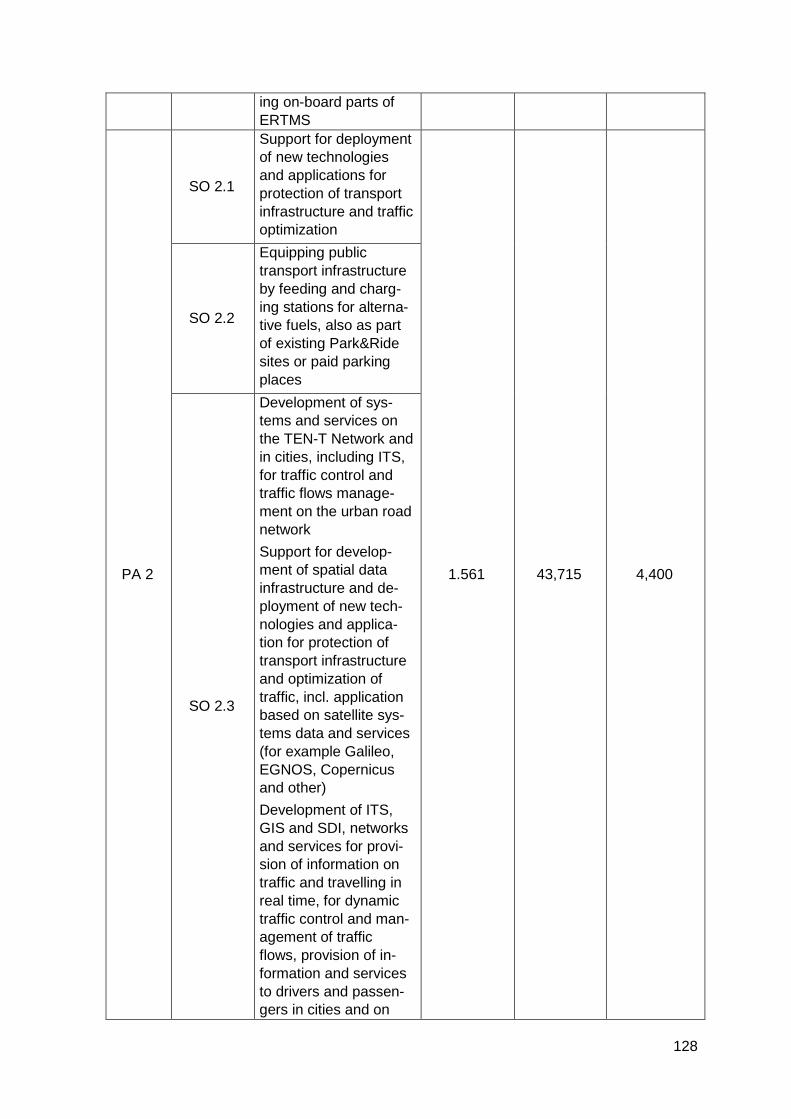
128
ing on-board parts of
ERTMS
PA 2
SO 2.1
Support for deployment
of new technologies
and applications for
protection of transport
infrastructure and traffic
optimization
1.561 43,715 4,400
SO 2.2
Equipping public
transport infrastructure
by feeding and charg-
ing stations for alterna-
tive fuels, also as part
of existing Park&Ride
sites or paid parking
places
SO 2.3
Development of sys-
tems and services on
the TEN-T Network and
in cities, including ITS,
for traffic control and
traffic flows manage-
ment on the urban road
network
Support for develop-
ment of spatial data
infrastructure and de-
ployment of new tech-
nologies and applica-
tion for protection of
transport infrastructure
and optimization of
traffic, incl. application
based on satellite sys-
tems data and services
(for example Galileo,
EGNOS, Copernicus
and other)
Development of ITS,
GIS and SDI, networks
and services for provi-
sion of information on
traffic and travelling in
real time, for dynamic
traffic control and man-
agement of traffic
flows, provision of in-
formation and services
to drivers and passen-
gers in cities and on
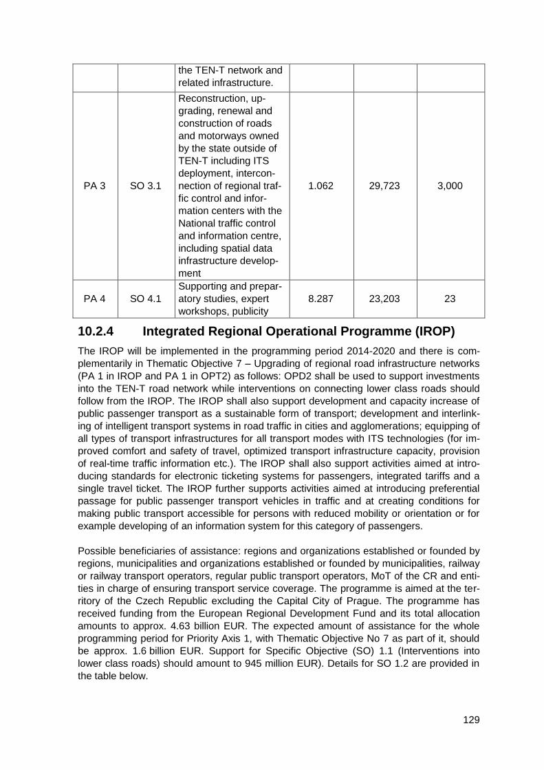
129
the TEN-T network and
related infrastructure.
PA 3 SO 3.1
Reconstruction, up-
grading, renewal and
construction of roads
and motorways owned
by the state outside of
TEN-T including ITS
deployment, intercon-
nection of regional traf-
fic control and infor-
mation centers with the
National traffic control
and information centre,
including spatial data
infrastructure develop-
ment
1.062 29,723 3,000
PA 4 SO 4.1
Supporting and prepar-
atory studies, expert
workshops, publicity
8.287 23,203 23
10.2.4 Integrated Regional Operational Programme (IROP)
The IROP will be implemented in the programming period 2014-2020 and there is com-
plementarily in Thematic Objective 7 – Upgrading of regional road infrastructure networks
(PA 1 in IROP and PA 1 in OPT2) as follows: OPD2 shall be used to support investments
into the TEN-T road network while interventions on connecting lower class roads should
follow from the IROP. The IROP shall also support development and capacity increase of
public passenger transport as a sustainable form of transport; development and interlink-
ing of intelligent transport systems in road traffic in cities and agglomerations; equipping of
all types of transport infrastructures for all transport modes with ITS technologies (for im-
proved comfort and safety of travel, optimized transport infrastructure capacity, provision
of real-time traffic information etc.). The IROP shall also support activities aimed at intro-
ducing standards for electronic ticketing systems for passengers, integrated tariffs and a
single travel ticket. The IROP further supports activities aimed at introducing preferential
passage for public passenger transport vehicles in traffic and at creating conditions for
making public transport accessible for persons with reduced mobility or orientation or for
example developing of an information system for this category of passengers.
Possible beneficiaries of assistance: regions and organizations established or founded by
regions, municipalities and organizations established or founded by municipalities, railway
or railway transport operators, regular public transport operators, MoT of the CR and enti-
ties in charge of ensuring transport service coverage. The programme is aimed at the ter-
ritory of the Czech Republic excluding the Capital City of Prague. The programme has
received funding from the European Regional Development Fund and its total allocation
amounts to approx. 4.63 billion EUR. The expected amount of assistance for the whole
programming period for Priority Axis 1, with Thematic Objective No 7 as part of it, should
be approx. 1.6 billion EUR. Support for Specific Objective (SO) 1.1 (Interventions into
lower class roads) should amount to 945 million EUR). Details for SO 1.2 are provided in
the table below.
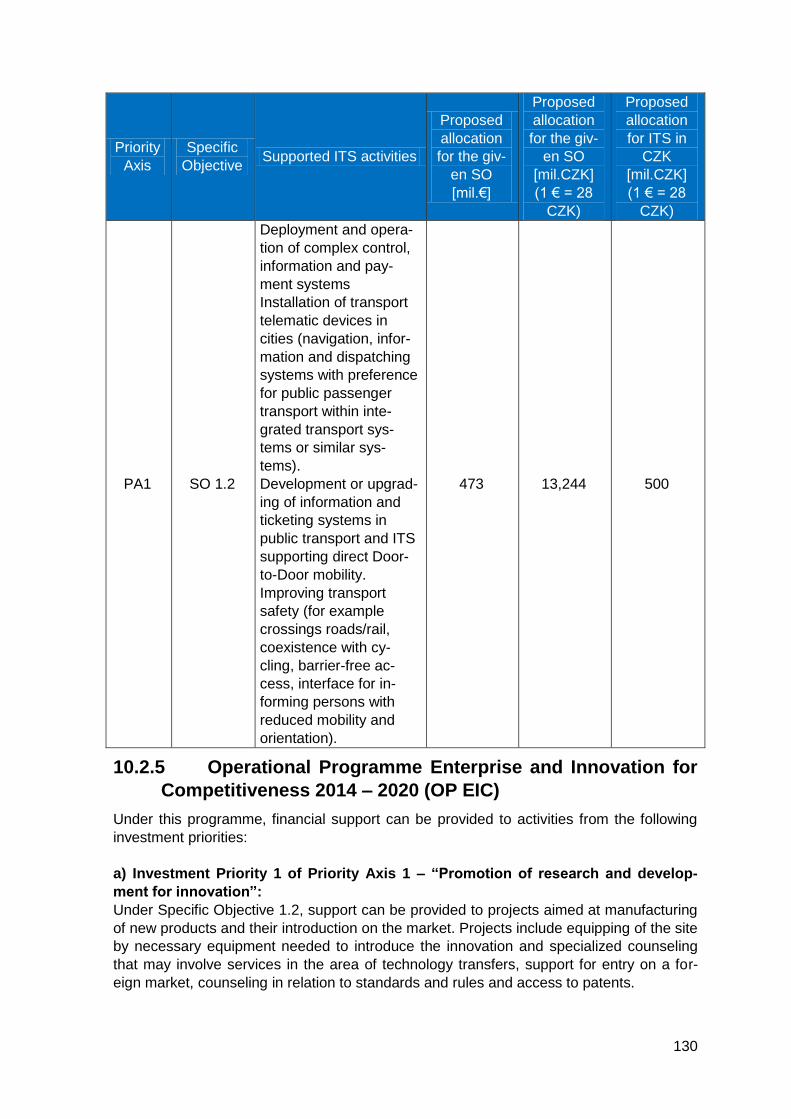
130
Priority
Axis
Specific
Objective Supported ITS activities
Proposed
allocation
for the giv-
en SO
[mil.€]
Proposed
allocation
for the giv-
en SO
[mil.CZK]
(1 € = 28
CZK)
Proposed
allocation
for ITS in
CZK
[mil.CZK]
(1 € = 28
CZK)
PA1 SO 1.2
Deployment and opera-
tion of complex control,
information and pay-
ment systems
Installation of transport
telematic devices in
cities (navigation, infor-
mation and dispatching
systems with preference
for public passenger
transport within inte-
grated transport sys-
tems or similar sys-
tems).
Development or upgrad-
ing of information and
ticketing systems in
public transport and ITS
supporting direct Door-
to-Door mobility.
Improving transport
safety (for example
crossings roads/rail,
coexistence with cy-
cling, barrier-free ac-
cess, interface for in-
forming persons with
reduced mobility and
orientation).
473 13,244 500
10.2.5 Operational Programme Enterprise and Innovation for
Competitiveness 2014 – 2020 (OP EIC)
Under this programme, financial support can be provided to activities from the following
investment priorities:
a) Investment Priority 1 of Priority Axis 1 – “Promotion of research and develop-
ment for innovation”:
Under Specific Objective 1.2, support can be provided to projects aimed at manufacturing
of new products and their introduction on the market. Projects include equipping of the site
by necessary equipment needed to introduce the innovation and specialized counseling
that may involve services in the area of technology transfers, support for entry on a for-
eign market, counseling in relation to standards and rules and access to patents.
131
b) Investment Priority 2 of Priority Axis 4 – “Development of products and services
in the area of information and communication technologies, electronic commerce
and increasing the demand for ICT”:
Under Specific Objective 4.2, support is available for projects creating new sophisticated
ITC solutions (in particular ERP systems, CRM systems, payment and card systems, data
safety, HR systems, B2B systems, B2C systems, IS for the non-profit and public sector,
power management, process-oriented web applications, solutions for mobile devices,
Business Intelligence solutions, software simulations, cloud computing), i.e. creating mod-
ern and advanced digital services and applications for communication, leisure, trading,
education, healthcare, access to work or for cultural and creative industries. Solutions for
data security promotion, development of mobile devices, introduction of open standards
and enhanced interoperability shall be supported.
10.2.6 Operational Programme Research and Development
for Innovation (2008-2015)
The project Transport Research Centre (CDV PLUS) was funded from EU resources and
the Czech state budget through the Operational Programme Research and Development
for Innovation; the total amount was 463 million CZK, of that the EU share amounted to
390 million CZK. The project was implemented by the Centre for Transport Research; the
implementation ended in December 2014. The project Transport Research Centre (CDV
PLUS) included five research programmes: In-depth analysis of traffic accidents, Human
synergies in transport, Safety in road traffic, Transport Infrastructure and Transport and
environment. The aim of the project was to develop a high-quality research environment
with laboratories, equipment and know-how that shall serve to provide complex conditions
for research in selected fields of applied transport sciences. The equipment of the
Transport Research Centre (CDV PLUS) meets the highest current standards and trends
in transport research.
10.2.7 Integrated Tools
Broader usage of ITS shall also be achieved due to measures implemented through Inte-
grated Territorial Investments (ITI) and Integrated Territorial Development Plans (IPRÚ) –
two of the integrated instruments that exist in the programming period 2014 – 2020.
ITI/IPRÚ shall contain the key investments addressing the issues of the given territory
from more than one priority axis or from more ESIF programmes. Transport is one of the
key themes in connecting of core cities and the most important centers of the Czech Re-
public with their functional areas, as in these metropolitan areas/settlement agglomera-
tions, transport often has to face very high requirements for transport performance and
service quality.
Measures related to ITS shall be integrated in Operational Programme Transport in par-
ticular through SO 1.4. Measures aimed at creating conditions for increased use of public
transport in electric traction in cities and within the Integrated Regional Operational Pro-
gramme shall be supported under SO 2.1 – Increasing the share of sustainable transport
modes (among other by ITS development, deployment, reconstruction or upgrading).
10.2.8 Connecting Europe Facility (CEF)
The Connecting Europe Facility (CEF) represents another important source of EU funding
for ITS development. The programme supports projects of European common interest as
part of the trans-European networks policy in the sectors of transport, telecommunications
132
and energy. As intelligent transport systems are using information and communication
technologies, some ITS projects can be aimed at development or upgrading of telecom-
munication infrastructure.
The CEF functions based on work programmes and calls. There are two types of work
programmes. The Multiannual work programme has already been announced for larger
projects on the core TEN-T network. This programme shall be complemented by annual
work programmes announced for implementation of smaller projects on the core network
and in very limited scope also of projects on the comprehensive TEN-T network. A part of
CEF funds is allocated exclusively for the needs of cohesion countries; these funds have
been transferred to the CEF from the Cohesion Fund. Specific rules are in place for the
“cohesion envelope” of CEF, different to the standard rules. First in relation to the co-
funding rate (theoretically can be up to 85%) and second the fact that none of the cohe-
sion countries can receive more financial resources in support for presented projects than
the amount available in its national envelope. However this does not mean that allocation
of these financial resources is automatic, without an assessment of the projects by the
EC. Nevertheless the EC role will gain even more in importance after 2016, as the pro-
jects from cohesion states will be directly competing for the remaining CEF cohesion fi-
nancial resources.
ITS projects that are in line with the following priorities shall be implemented under the
Multiannual work programme:
1) New technologies and innovations in all transport modes, including sustainability, oper-
ation, control, accessibility, multi-modal approach and transport network efficiency;
2) Safe infrastructure including safe parking and provision of related services;
3) Intelligent transport services for road traffic;
4) Actions focused on large urban agglomerations (junctions), including interfaces of long-
distance and urban/regional transport.
The following priorities for ITS have been set in the Annual work programme:
1) Other technologies than the technologies covered by the Multiannual work programme;
2) Other telematic applications than the applications covered by the Multiannual work pro-
gramme;
3) Actions focused on large urban agglomerations (junctions), including interfaces of long-
distance and urban/regional transport.
The above listed priorities include:
1) Cooperative systems (communication between the vehicle and a device on the infra-
structure – C2I – including demonstration of long-term sustainability of the project and
possibility to expand it in the future for mass deployment);
2) Systems for traffic control and optimization on the core pan-European transport net-
work;
3) Safety-enhancing systems (for example eCall).
EU member states are beneficiaries of support. The maximum possible co-funding rate
depends on whether the project is implemented from the non-cohesion or from the cohe-
sion part of CEF. In the latter case, the EU co-funding rate can reach up to 85%. Support
is intended mainly for railway projects; for road projects, the maximum implemented vol-
ume is limited to 10% of the allocated resources in the “national envelope” and to projects
implemented with the participation of at least 3 EU member states. Railway transport is
133
the backbone transport mode in integrated transport systems and it will be therefore pos-
sible to submit ITS projects for public passenger transport.
For larger ITS projects, various European funding sources can be structured and inter-
connected without creating undesired duplicity in funding of individual parts or stages that
could be thus mutually interlinked as for their subject-matter and their funding should be
coordinated. The CEF financial instrument could be used for actions on EU level, for ex-
ample for cross-border verification and testing operations of intelligent transport systems
and applications for European priority services that have not been fully deployed yet. The
aim is to test their expected functionality in a real environment using prototypes in order to
either confirm the correctness of the proposed technical parameters or to proceed to a
modification of ITS components as a consequence of this practical testing.
Primary candidates for ITS implementation from the CEF are the following: data collection
and publication in priority ITS actions; expanding the eCall system with information on
transport of high-risk dangerous goods; development of cooperative ITS, also for rail-
way/road level crossings (railway crossings).
10.2.9 Expenditure for Projects of Common Interest that are
Partially Financed from European Funds
Introducing of the latest technologies into transport, including intelligent transport systems
and satellite system (GNSS, remote sensing of the Earth, satellite communication) have a
significant international, or in certain cases even global, impact. In many cases, there are
solutions that have already been designed on the technical level, but the respective
standards, despite being already available, have not been approved yet, the solution has
not been tested in practice, if it were the case, the deployment and operation of the solu-
tion is not backed up by implementing legislation nor is it clear how the operative control
will be organized, in particular with regard to responsibilities, decision-making and com-
munication.
If European or international consortia of transport ministries or road network managers
etc. are being established, the Czech Republic (similarly to any other country) has the
possibility to be there from Day 1 and participate in such a project. Projects are aimed at
supporting those investment actions, research works and testing projects where the re-
search-development stage has already been completed but the application of the technol-
ogy still needs to be verified in practice. This verification stage allows fine-tuning the solu-
tion so that it best meets the users´ needs. In case of EU projects, the needs and re-
quirements for technical and organizational solutions that vary across member states
must be taken into account. The aim of the proposed solution is to ensure the deployment
of the system in question in a compatible form from the international, technical and organ-
izational perspective. The results are then presented to the EC for preparation of legisla-
tive and non-legislative documents.
If the Czech Republic decides not to participate in projects as described above, it will not
have the possibility to propose solutions complying with the conditions, needs and possi-
bilities of our country. If the resulting solutions are reflected in draft EU legislation, even if
only in the form of principles, it is usually rather difficult to substantially modify the pro-
posed direction of development during official meetings of EU institutions. For example,
the pilot verification of the eCall system functioning in international traffic has been tested
by European project HeERO (Harmonized eCall European Pilot), running till the end of
134
2013 also in the Czech Republic. A fleet of project´s testing vehicles was simulating traffic
accidents on the territory of the Czech Republic and other selected EU countries to verify
if the transmission of data about the accident and voice communication with the emergen-
cy call centre 112 is flawless, including testing of the interface with the Integrated traffic
information system JSDI/NDIC Ostrava. The test operation of eCall system was imple-
mented onto the testing platform of the Telephone centre for the Public Safety Answering
Point 112 (TCTV 112). Based on testing results, parts of the system were modified to en-
sure a fully functional and stable performance. This test operation and its results contrib-
uted significantly to improvement of the eCall system in Czech conditions and to the prep-
aration of the Czech Republic for deployment of this system. The test and verification op-
eration of the eCall 112 system as part of the HeERO project allowed to better specify the
technical parameters in European technical standards so that the eCall service can be
provided in a harmonized way across the whole EU.
Project results were also used for preparation of the Commission Delegated Regulation
(EU) No 305/2013 of 26 November 2012 supplementing Directive 2010/40/EU of the Eu-
ropean Parliament and of the Council with regard to the harmonized provision for an in-
teroperable EU-wide eCall. Under the eCall system, it is planned to expand the minimal
set of data (MSD) on traffic accidents also with data on transport of dangerous goods.
Therefore a new project is being prepared on EU level - draft name “I_HeERO” – that
should verify in practice the possibility to use the eCall system when transporting danger-
ous goods. The main aim of the projects is not to monitor the transport of dangerous
goods or the transport technology itself (in particular pursuant to ADR), but to serve as
information support for rescue services and the NDIC in case a traffic accident happens,
this through the eCall system. The proposed European standard FprCEN/TR 16405 “In-
telligent transport systems. ESafety. ECall additional optional data set for heavy goods
vehicles eCall” expands the MSD message with additional data on transport of dangerous
goods, thus making it possible to warn the emergency call centre 112 operator in case of
an accident. Based on the test operation, European standards for eCall would be adjusted
and the project results would be presented to the EC to be used for preparation of legisla-
tive and non-legislative documents.
The CROCODILE project is another important EU project aimed at coordinated introduc-
tion of ITS for road traffic management, in particular through high-quality traffic information
services. The project also focuses on common approach to implementation of the EC reg-
ulation on provision of information services for safe and secure parking places for trucks
and commercial vehicles and further on provision of minimum traffic information that have
an impact on traffic safety. At present, the CROCODILE II project is under preparation
aimed in particular at completion of the implementation of the DATEX II protocol for ex-
change of available traffic data. The project shall also focus on setting up of a national
access point for provision of minimum traffic information, provision of information on truck
parking and of real-time traffic information. The project CROCODILE II under preparation
shall also focus on provision of traffic information services to end users in neighboring
states and on the process of compliance verification in line with requirements defined in
the above-given Regulations.
135
10.3 Public Resources for Support of ITS Research and
Development
Intelligent transport systems cannot be purchased as ready adjusted solutions and tech-
nologies and innovative solutions are advancing very fast, therefore research, develop-
ment and innovation activities are crucial for ITS deployment in the Czech Republic.
ITS research projects can draw national resources from programmes of the Technology
Agency of the Czech Republic (TAČR). These are existing programmes or programmes
under preparation aimed at supporting research, experimental development and innova-
tions for research organizations, companies or public institutions.
10.3.1 BETA
The public sector can currently use the BETA programme (coming to its end) that sup-
ports projects falling under objectives specified for the transport sector based on MoT
conceptual and strategic documents, including the ITS AP. Currently works on the follow-
up TAČR programme for the public sector needs are in progress.
10.3.2 GAMA
The main objective of the programme is to support the verification of the R&D and Innova-
tions' programme results as for their practical application and for preparation of their sub-
sequent commercialization. The programme is divided into two sub-programmes. Sub-
programme 1 focuses on supporting the verification of practical applicability of R&D re-
sults coming from research organizations and that show a high potential to be applied in
practice. Sub-programme 2 focuses on support to applied research projects, in particular
experimental research projects contributing demonstrably to commercialization of the ob-
tained results in practice. The programme is not sector-specific; it is therefore possible to
present applications for projects focusing on ITS which were or are being implemented as
part of previous programmes ALFA and EPSILON through the opened calls; the aim of
this programme is to forward the results of these projects into the innovation stage and
thus implicitly support ITS AP measures.
10.3.3 DELTA
This is a programme supporting cooperation in applied research and experimental devel-
opment through joint projects of technology and innovation agencies. Similarly to pro-
gramme GAMA, programme DELTA is not sector-specific and it can therefore be used for
support of ITS projects. It focuses on supporting common projects of Czech companies
and research institutions with foreign technology and innovation agencies. The pro-
gramme is planned for the years 2014-2019.
10.3.4 EPSILON
The main aim of the programme is to support in particular industrial applications when
using new technologies and materials in energy, environmental and transport sectors,
including ITS. The programme is planned for the years 2015-2025.
10.3.5 OMEGA
The programme focuses on support for projects from the social sector. Adaption of people
to new technologies is an ITS-related subject that can be covered from the programme.
The programme is planned for the years 2012-2017.
136
10.3.6 Centers of Competence
The Centers of Competence programme focuses on supporting the setting up and func-
tioning of research, development and innovation centers in progressive fields with a high
potential of application and perspective major contribution to growth of Czech competi-
tiveness. The established Centers should offer conditions for development of long-term
cooperation in research, development and innovations between the public and private
sectors. The main objective of the programme is to increase competitiveness of the Czech
Republic; the programme aims at stimulating cooperation of companies and research or-
ganizations in setting up of strategic partnerships, improved transdisciplinary of research,
development and innovation and increased horizontal mobility of researchers (in particular
new researchers). Real implementation of results in practice is accentuated.
More specifically, projects “Centre for development of transport systems (RODOS)”
scheduled until end 2018 and “Centre for efficient and sustainable transport infrastructure
(CESTI)” scheduled until end 2019 are funded from this programme.
10.3.7 Horizon 2020 (H2020)
Horizon 2020 is the new European framework programme for research and development
that follows on from the 7th Framework Programme of the EU (7th FP). Unlike the 7th FP,
H2020 promotes the bottom-up approach when formulating the research themes – the
themes are defined less specifically, with a bigger accent on the expected impact of the
proposed projects. H2020 is planned for the period 2014 - 2020 and has a total budget of
77 billion EUR. ITS projects can draw support from calls in the area “Smart, ecological
and integrated transport” or from the priority “Industrial leadership” in the area “Space Ap-
plications” of Galileo calls.
10.3.8 SHIFT2RAIL (S2R)
The Shift2Rail project was approved by the Council Regulation (EU) No 642/2014 of 16
June 2014 establishing the Shift2Rail Joint Undertaking (Shift2Rail JU). The members of
the Joint Undertaking are the European Commission (50%) and railway industry stake-
holders (50%).
Increased mobility and better, higher-quality and simplified services for passengers and
transport contractors (transport contractor = client of a railway carrier in freight transport,
i.e. the consignor or consignee of the transported item) constitute the key objectives.
The objective of the Shift2Rail is to contribute to the following through targeted research,
development and innovation:
- Reducing the life-cycle cost of railway transport (i.e. costs of building, operating, main-
taining and renewing infrastructure and railway vehicle) by as much as 50%;
- Total railway capacity increase by as much as 100%;
- Increasing reliability in various segments of the railway market by as much as 50%.
The project will be organized around 5 key "Innovation Programmes" (Innovative Package
– IP):
IP 1 - Cost-efficient and reliable trains, including High Speed trains and high-capacity
trains; IP 2 - Advanced traffic management & control systems;
IP 3 - Cost-efficient and reliable high capacity infrastructure;
IP 4 - IT Solutions for Attractive Railway Services in passenger transport;
IP 5 - Technologies for Sustainable & Attractive European Railway Freight transport.
137
The following directions shall be given preference from the scientific and research per-
spective:
- Developing prototypes;
- Integration;
- Virtual validation (assessment);
- Implementation of successful technologies.
Shift2Rail JU research and innovation activities shall be covered approx. 50% from public
sources (450 million EUR), from the HORIZON 2020 programme and approx. 50% (470
million EUR) from private financial sources of founding and associated members of the
joint undertaking.
Currently, temporary bodies of the joint undertaking Shift2Rail are in place and shall be
replaced by permanent bodies during the first half of 2015 (i.e. the Executive Director and
the Governing Board, advisory bodies – i.e. a States' Representatives Group and a Scien-
tific Committee). The States' Representatives Group is fully operational; the Czech Re-
public is represented by permanent member Ing. Miroslav Haltuf (independent consultant)
and alternate Ing. Michal Pavel (AŽD Praha s. r. o.). Both representatives were nominated
by the MoEYS based on recommendation for professional railway associations.
In line with the rules for HORIZON 2020 and the States´ Representatives Group, the Ref-
erence Group has been established in the Czech Republic composed of representatives
of entities involved directly or indirectly in Shift2Rail activities – public administration bod-
ies (MoT, MoEYS), industry associations (ACRI, Technological platform for railway infra-
structure) and companies that are interested in direct cooperation with Shift2Rail and
submitted an application to become Associate member of Shift2Rail, i.e. AŽD Praha and
OLTIS Group, a.s. that submitted applications as independent legal entities, and ČD, a.s.
that applied under the EUROC consortium, and potential future applicants to open calls of
projects announced by Shift2Rail. The academia is also represented, either individually or
through associations.
Shift2Rail represent so far the biggest project in rail transport where Czech companies are
actively involved for the first time in history with the aim to participate in development of
innovative technologies. For funding of Shift2Rail needs, additional sources will be used,
not only from the Horizon 2020 budget, but also from the CEF, regional development
funds and other actions.
138
11 Monitoring the Progress in Fulfillment of ITS
AP Objectives
Annex No. 1 hereto contains the list of indicators for monitoring and assessment of the
progress in fulfillment of objectives of the Action Plan for the Deployment of Intelligent
Transport Systems in the Czech Republic until 2020 (with the Prospect of 2050). The indi-
cators were set based on the study (under preparation) for the European Commission
called “Study on Key Performance Indicators (KPIs) for Intelligent Transport Systems
(ITS)”. The main objective of the study is to define the use of indicators across EU mem-
ber states, across different types of participants and also across 6 priority areas defined in
the Action plan for deployment of intelligent transport systems in Europe. To be able to
assess and evaluate the achieved results, such indicators were proposed and such
measurement units were defined for the ITS AP for which source data are or will be avail-
able allowing regular monitoring and detection of the required change. If necessary, the
indicators shall be further adjusted, this also based on available data and its quality and
informative value. In addition to indicators, the progress in fulfillment of the Action Plan
shall be assesses also with regard to quality or impacts for example.
To assess the suitability of a specific project intention of ITS deployment as the most ben-
eficial solution of a given transport problem (when compared with other possible
measures), detailed indicators shall be defined breaking down both costs and benefits,
this for ex-ante situations as well as after introduction into operation (ex-post). Such a
detailed assessment cannot be performed on the ITS AP level; this must be done on fea-
sibility study level.
An Implementation Plan shall be drafted subsequently based on the ITS AP that will con-
tain a more detailed factual, time and financial framework for individual projects, including
sources and structure of funding for the planned expenditure. The Implementation Plan
shall be drafted in 2015 and updated as necessary once in two years.
As ITS, GNSS and Earth observation technologies are developing continuously, the ITS
AP efficiency shall be assessed in 2018 (for the period 2015 – 2017) and the interim ITS
AP assessment report shall be presented to the Government by June 2018. The overall
ITS AP fulfillment assessment report (for the whole implementation period), this including
the proposed update of this Action Plan or a new draft document related to ITS, GNSS
and Earth observation for the next period, shall be submitted to the Government in 2020.
139
12 Conclusion
Intelligent transport systems or their applications are in most cases based on the combi-
nation of an intelligent vehicle, intelligent infrastructure and services that are fulfilling the
specific functions for which they were designed. The mutual connection of components
vehicle-infrastructure-application/service in implementation of ITS applications showed
that for the ITS advantages to be provided and benefited from in full, not only superior
public administration bodies must be involved, but also all other institutional entities, i.e.
the public sector (owners and managers of transport infrastructure, rescue system), lo-
gistic companies, operators, drivers and other traffic participants as well as the private
sector (manufacturers of cars and ITS applications). For the ITS potential to be used in
full, it is necessary to achieve the required level of compatibility, interoperability and conti-
nuity of services provided to users on the local, regional, national or European level for
existing and developed systems and applications.
Systematic development of an intelligent transport system that will allow for safe, continu-
ous, economically balanced and environmentally friendly movement of persons and goods
represents a major challenge for the current society. The only solution to address this
challenge is to establish a strong and long-term partnership of responsible bodies, re-
search institutions and private businesses that will contribute to shifting the development
of technologies and transport systems to such a point where their daily used will make it
possible to implement even the longer-term visions related to intelligent and sustainable
mobility described in the document.
But, at the end, once the proposed measures are implemented, the end users themselves
should be able to experience a real improvement in quality and safety of travel or trans-
portation of goods. Transport must be focused around the traffic participants and any sys-
tem (or combination of systems) ignoring this fact shall only last for a limited time and the
provided financial resources would thus be spent inefficiently. Benefits for the society shall
represent a real and tangible result in the long term and the present document aims at
contributing thereto.
The ITS AP replaces the document “Innovation technologies in transport strategy –
INOTECH”, approved by the Government Resolution No. 12/2009
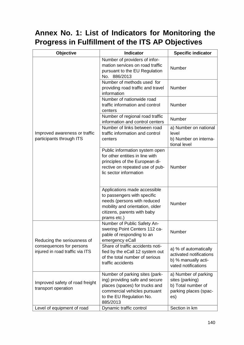
140
Annex No. 1: List of Indicators for Monitoring the
Progress in Fulfillment of the ITS AP Objectives
Objective Indicator Specific indicator
Improved awareness or traffic
participants through ITS
Number of providers of infor-
mation services on road traffic
pursuant to the EU Regulation
No. 886/2013
Number
Number of methods used for
providing road traffic and travel
information
Number
Number of nationwide road
traffic information and control
centers
Number
Number of regional road traffic
information and control centers Number
Number of links between road
traffic information and control
centers
a) Number on national
level
b) Number on interna-
tional level
Public information system open
for other entities in line with
principles of the European di-
rective on repeated use of pub-
lic sector information
Number
Applications made accessible
to passengers with specific
needs (persons with reduced
mobility and orientation, older
citizens, parents with baby
prams etc.)
Number
Reducing the seriousness of
consequences for persons
injured in road traffic via ITS
Number of Public Safety An-
swering Point Centers 112 ca-
pable of responding to an
emergency eCall
Number
Share of traffic accidents noti-
fied by the eCall 12 system out
of the total number of serious
traffic accidents
a) % of automatically
activated notifications
b) % manually acti-
vated notifications
Improved safety of road freight
transport operation
Number of parking sites (park-
ing) providing safe and secure
places (spaces) for trucks and
commercial vehicles pursuant
to the EU Regulation No.
885/2013
a) Number of parking
sites (parking)
b) Total number of
parking places (spac-
es)
Level of equipment of road Dynamic traffic control Section in km
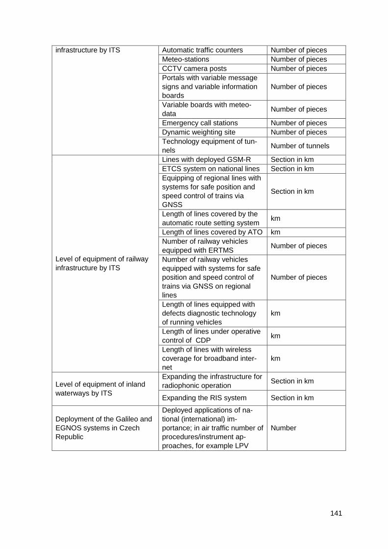
141
infrastructure by ITS Automatic traffic counters Number of pieces
Meteo-stations Number of pieces
CCTV camera posts Number of pieces
Portals with variable message
signs and variable information
boards
Number of pieces
Variable boards with meteo-
data Number of pieces
Emergency call stations Number of pieces
Dynamic weighting site Number of pieces
Technology equipment of tun-
nels Number of tunnels
Level of equipment of railway
infrastructure by ITS
Lines with deployed GSM-R Section in km
ETCS system on national lines Section in km
Equipping of regional lines with
systems for safe position and
speed control of trains via
GNSS
Section in km
Length of lines covered by the
automatic route setting system km
Length of lines covered by ATO km
Number of railway vehicles
equipped with ERTMS Number of pieces
Number of railway vehicles
equipped with systems for safe
position and speed control of
trains via GNSS on regional
lines
Number of pieces
Length of lines equipped with
defects diagnostic technology
of running vehicles
km
Length of lines under operative
control of CDP km
Length of lines with wireless
coverage for broadband inter-
net
km
Level of equipment of inland
waterways by ITS
Expanding the infrastructure for
radiophonic operation Section in km
Expanding the RIS system Section in km
Deployment of the Galileo and
EGNOS systems in Czech
Republic
Deployed applications of na-
tional (international) im-
portance; in air traffic number of
procedures/instrument ap-
proaches, for example LPV
Number
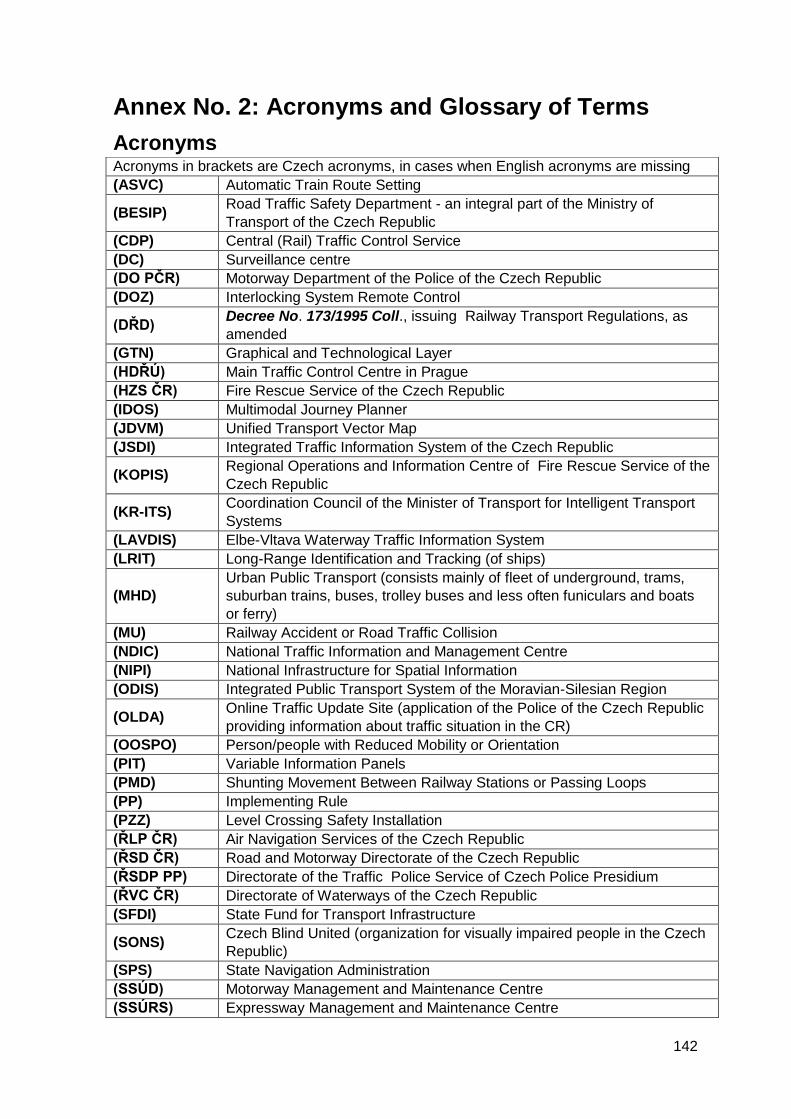
142
Annex No. 2: Acronyms and Glossary of Terms
Acronyms Acronyms in brackets are Czech acronyms, in cases when English acronyms are missing
(ASVC) Automatic Train Route Setting
(BESIP) Road Traffic Safety Department - an integral part of the Ministry of
Transport of the Czech Republic
(CDP) Central (Rail) Traffic Control Service
(DC) Surveillance centre
(DO PČR) Motorway Department of the Police of the Czech Republic
(DOZ) Interlocking System Remote Control
(DŘD) Decree No. 173/1995 Coll., issuing Railway Transport Regulations, as
amended
(GTN) Graphical and Technological Layer
(HDŘÚ) Main Traffic Control Centre in Prague
(HZS ČR) Fire Rescue Service of the Czech Republic
(IDOS) Multimodal Journey Planner
(JDVM) Unified Transport Vector Map
(JSDI) Integrated Traffic Information System of the Czech Republic
(KOPIS) Regional Operations and Information Centre of Fire Rescue Service of the
Czech Republic
(KR-ITS) Coordination Council of the Minister of Transport for Intelligent Transport
Systems
(LAVDIS) Elbe-Vltava Waterway Traffic Information System
(LRIT) Long-Range Identification and Tracking (of ships)
(MHD)
Urban Public Transport (consists mainly of fleet of underground, trams,
suburban trains, buses, trolley buses and less often funiculars and boats
or ferry)
(MU) Railway Accident or Road Traffic Collision
(NDIC) National Traffic Information and Management Centre
(NIPI) National Infrastructure for Spatial Information
(ODIS) Integrated Public Transport System of the Moravian-Silesian Region
(OLDA) Online Traffic Update Site (application of the Police of the Czech Republic
providing information about traffic situation in the CR)
(OOSPO) Person/people with Reduced Mobility or Orientation
(PIT) Variable Information Panels
(PMD) Shunting Movement Between Railway Stations or Passing Loops
(PP) Implementing Rule
(PZZ) Level Crossing Safety Installation
(ŘLP ČR) Air Navigation Services of the Czech Republic
(ŘSD ČR) Road and Motorway Directorate of the Czech Republic
(ŘSDP PP) Directorate of the Traffic Police Service of Czech Police Presidium
(ŘVC ČR) Directorate of Waterways of the Czech Republic
(SFDI) State Fund for Transport Infrastructure
(SONS) Czech Blind United (organization for visually impaired people in the Czech
Republic)
(SPS) State Navigation Administration
(SSÚD) Motorway Management and Maintenance Centre
(SSÚRS) Expressway Management and Maintenance Centre
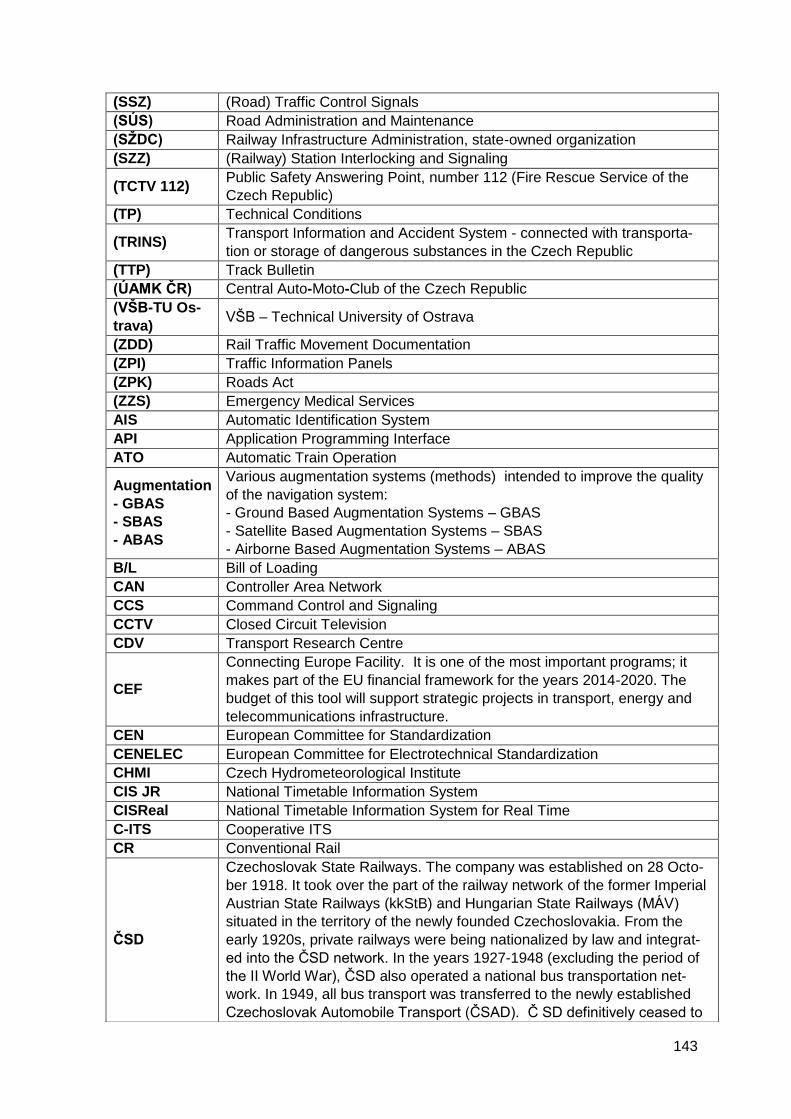
143
(SSZ) (Road) Traffic Control Signals
(SÚS) Road Administration and Maintenance
(SŽDC) Railway Infrastructure Administration, state-owned organization
(SZZ) (Railway) Station Interlocking and Signaling
(TCTV 112) Public Safety Answering Point, number 112 (Fire Rescue Service of the
Czech Republic)
(TP) Technical Conditions
(TRINS) Transport Information and Accident System - connected with transporta-
tion or storage of dangerous substances in the Czech Republic
(TTP) Track Bulletin
(ÚAMK ČR) Central Auto-Moto-Club of the Czech Republic
(VŠB-TU Os-
trava) VŠB – Technical University of Ostrava
(ZDD) Rail Traffic Movement Documentation
(ZPI) Traffic Information Panels
(ZPK) Roads Act
(ZZS) Emergency Medical Services
AIS Automatic Identification System
API Application Programming Interface
ATO Automatic Train Operation
Augmentation
- GBAS
- SBAS
- ABAS
Various augmentation systems (methods) intended to improve the quality
of the navigation system:
- Ground Based Augmentation Systems – GBAS
- Satellite Based Augmentation Systems – SBAS
- Airborne Based Augmentation Systems – ABAS
B/L Bill of Loading
CAN Controller Area Network
CCS Command Control and Signaling
CCTV Closed Circuit Television
CDV Transport Research Centre
CEF
Connecting Europe Facility. It is one of the most important programs; it
makes part of the EU financial framework for the years 2014-2020. The
budget of this tool will support strategic projects in transport, energy and
telecommunications infrastructure.
CEN European Committee for Standardization
CENELEC European Committee for Electrotechnical Standardization
CHMI Czech Hydrometeorological Institute
CIS JR National Timetable Information System
CISReal National Timetable Information System for Real Time
C-ITS Cooperative ITS
CR Conventional Rail
ČSD
Czechoslovak State Railways. The company was established on 28 Octo-
ber 1918. It took over the part of the railway network of the former Imperial
Austrian State Railways (kkStB) and Hungarian State Railways (MÁV)
situated in the territory of the newly founded Czechoslovakia. From the
early 1920s, private railways were being nationalized by law and integrat-
ed into the ČSD network. In the years 1927-1948 (excluding the period of
the II World War), ČSD also operated a national bus transportation net-
work. In 1949, all bus transport was transferred to the newly established
Czechoslovak Automobile Transport (ČSAD). Č SD definitively ceased to
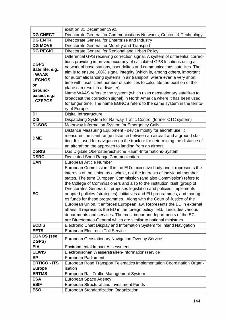
144
exist on 31 December 1992.
DG CNECT Directorate General for Communications Networks, Content & Technology
DG ENTR Directorate General for Enterprise and Industry
DG MOVE Directorate General for Mobility and Transport
DG REGIO Directorate General for Regional and Urban Policy
DGPS
Satellite, e.g.:
- WAAS
- EGNOS
or
Ground-
based, e.g.:
- CZEPOS
Differential GPS receiving correction signal. A system of differential correc-
tions providing improved accuracy of calculated GPS locations using a
network of base stations, pseudolites and communications satellites. The
aim is to ensure 100% signal integrity (which is, among others, important
for automatic landing systems in air transport, where even a very short
time with insufficient number of satellites to calculate the position of the
plane can result in a disaster).
Name WAAS refers to the system (which uses geostationary satellites to
broadcast the correction signal) in North America where it has been used
for longer time. The name EGNOS refers to the same system in the territo-
ry of Europe.
DI Digital Infrastructure
DIS Dispatching System for Railway Traffic Control (former CTC system)
DI-SOS Motorway Information System for Emergency Calls
DME
Distance Measuring Equipment - device mostly for aircraft use; it
measures the slant range distance between an aircraft and a ground sta-
tion. It is used for navigation on the track or for determining the distance of
an aircraft on the approach to landing from an airport.
DoRIS Das Digitale Oberösterreichische Raum-Informations-System
DSRC Dedicated Short Range Communication
EAN European Article Number
EC
European Commission. It is the EU’s executive body and it represents the
interests of the Union as a whole, not the interests of individual member
states. The term European Commission (and also Commission) refers to
the College of Commissioners and also to the institution itself (group of
Directorates General). It proposes legislation and policies, implements
adopted policies (strategies), initiatives and EU programmes, and manag-
es funds for these programmes. Along with the Court of Justice of the
European Union, it enforces European law. Represents the EU in external
affairs. It represents the EU in the foreign policy field. It includes various
departments and services. The most important departments of the EC
are Directorates-General which are similar to national ministries.
ECDIS Electronic Chart Display and Information System for Inland Navigation
EETS European Electronic Toll Service
EGNOS (see
DGPS) European Geostationary Navigation Overlay Service
EIA Environmental Impact Assessment
ELWIS Elektronischen Wasserstraßen-Informationsservice
EP European Parliament
ERTICO - ITS
Europe
European Road Transport Telematics Implementation Coordination Organ-
isation
ERTMS European Rail Traffic Management System
ESA European Space Agency
ESIF European Structural and Investment Funds
ESO European Standardization Organization
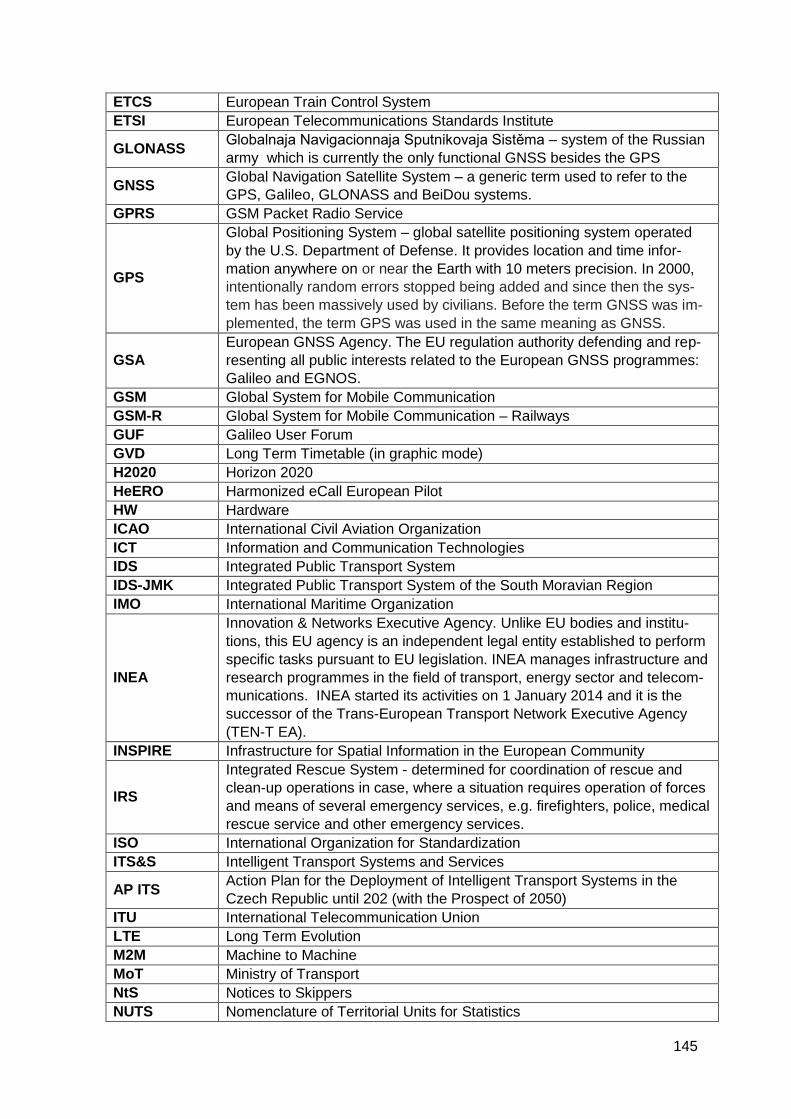
145
ETCS European Train Control System
ETSI European Telecommunications Standards Institute
GLONASS Globalnaja Navigacionnaja Sputnikovaja Sistěma – system of the Russian
army which is currently the only functional GNSS besides the GPS
GNSS Global Navigation Satellite System – a generic term used to refer to the
GPS, Galileo, GLONASS and BeiDou systems.
GPRS GSM Packet Radio Service
GPS
Global Positioning System – global satellite positioning system operated
by the U.S. Department of Defense. It provides location and time infor-
mation anywhere on or near the Earth with 10 meters precision. In 2000,
intentionally random errors stopped being added and since then the sys-
tem has been massively used by civilians. Before the term GNSS was im-
plemented, the term GPS was used in the same meaning as GNSS.
GSA
European GNSS Agency. The EU regulation authority defending and rep-
resenting all public interests related to the European GNSS programmes:
Galileo and EGNOS.
GSM Global System for Mobile Communication
GSM-R Global System for Mobile Communication – Railways
GUF Galileo User Forum
GVD Long Term Timetable (in graphic mode)
H2020 Horizon 2020
HeERO Harmonized eCall European Pilot
HW Hardware
ICAO International Civil Aviation Organization
ICT Information and Communication Technologies
IDS Integrated Public Transport System
IDS-JMK Integrated Public Transport System of the South Moravian Region
IMO International Maritime Organization
INEA
Innovation & Networks Executive Agency. Unlike EU bodies and institu-
tions, this EU agency is an independent legal entity established to perform
specific tasks pursuant to EU legislation. INEA manages infrastructure and
research programmes in the field of transport, energy sector and telecom-
munications. INEA started its activities on 1 January 2014 and it is the
successor of the Trans-European Transport Network Executive Agency
(TEN-T EA).
INSPIRE Infrastructure for Spatial Information in the European Community
IRS
Integrated Rescue System - determined for coordination of rescue and
clean-up operations in case, where a situation requires operation of forces
and means of several emergency services, e.g. firefighters, police, medical
rescue service and other emergency services.
ISO International Organization for Standardization
ITS&S Intelligent Transport Systems and Services
AP ITS Action Plan for the Deployment of Intelligent Transport Systems in the
Czech Republic until 202 (with the Prospect of 2050)
ITU International Telecommunication Union
LTE Long Term Evolution
M2M Machine to Machine
MoT Ministry of Transport
NtS Notices to Skippers
NUTS Nomenclature of Territorial Units for Statistics
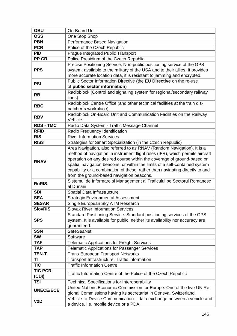
146
OBU On-Board Unit
OSS One Stop Shop
PBN Performance Based Navigation
PCR Police of the Czech Republic
PID Prague Integrated Public Transport
PP CR Police Presidium of the Czech Republic
PPS
Precise Positioning Service. Non-public positioning service of the GPS
system; available to the military of the USA and to their allies. It provides
more accurate location data, it is resistant to jamming and encrypted.
PSI Public Sector Information Directive (the EU Directive on the re-use
of public sector information)
RB Radioblock (Control and signaling system for regional/secondary railway
lines)
RBC Radioblock Centre Office (and other technical facilities at the train dis-
patcher´s workplace)
RBV Radioblock On-Board Unit and Communication Facilities on the Railway
Vehicle
RDS - TMC Radio Data System - Traffic Message Channel
RFID Radio Frequency Identification
RIS River Information Services
RIS3 Strategies for Smart Specialization (in the Czech Republic)
RNAV
Area Navigation, also referred to as RNAV (Random Navigation). It is a
method of navigation in instrument flight rules (IFR), which permits aircraft
operation on any desired course within the coverage of ground-based or
spatial navigation beacons, or within the limits of a self-contained system
capability or a combination of these, rather than navigating directly to and
from the ground-based navigation beacons.
RoRIS Sistemul de Informare si Management al Traficului pe Sectorul Romanesc
al Dunarii
SDI Spatial Data Infrastructure
SEA Strategic Environmental Assessment
SESAR Single European Sky ATM Research
SlovRIS Slovak River Information Services
SPS
Standard Positioning Service. Standard positioning services of the GPS
system. It is available for public, neither its availability nor accuracy are
guaranteed.
SSN SafeSeaNet
SW Software
TAF Telematic Applications for Freight Services
TAP Telematic Applications for Passenger Services
TEN-T Trans-European Transport Networks
TI Transport Infrastructure, Traffic Information
TIC Traffic Information Centre
TIC PCR
(CDI) Traffic Information Centre of the Police of the Czech Republic
TSI Technical Specifications for Interoperability
UNECE/ECE United Nations Economic Commission for Europe. One of the five UN Re-
gional Commissions having its secretariat in Geneva, Switzerland.
V2D Vehicle-to-Device Communication – data exchange between a vehicle and
a device, i.e. mobile device or a PDA
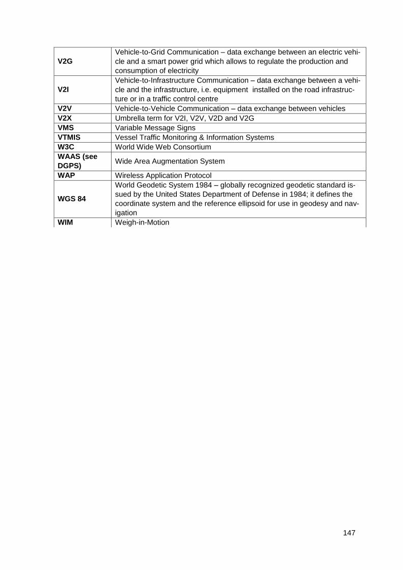
147
V2G
Vehicle‐to‐Grid Communication – data exchange between an electric vehi-
cle and a smart power grid which allows to regulate the production and
consumption of electricity
V2I
Vehicle‐to‐Infrastructure Communication – data exchange between a vehi-
cle and the infrastructure, i.e. equipment installed on the road infrastruc-
ture or in a traffic control centre
V2V Vehicle‐to‐Vehicle Communication – data exchange between vehicles
V2X Umbrella term for V2I, V2V, V2D and V2G
VMS Variable Message Signs
VTMIS Vessel Traffic Monitoring & Information Systems
W3C World Wide Web Consortium
WAAS (see
DGPS) Wide Area Augmentation System
WAP Wireless Application Protocol
WGS 84
World Geodetic System 1984 – globally recognized geodetic standard is-
sued by the United States Department of Defense in 1984; it defines the
coordinate system and the reference ellipsoid for use in geodesy and nav-
igation
WIM Weigh-in-Motion
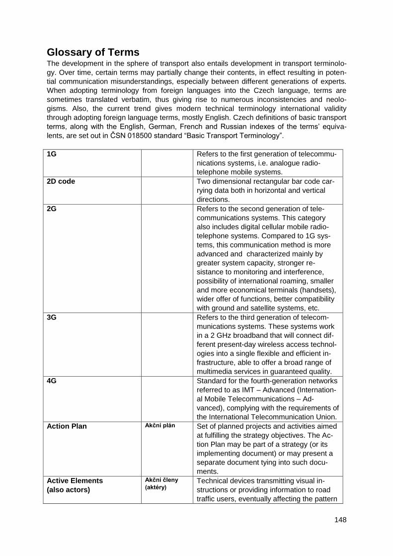
148
Glossary of Terms The development in the sphere of transport also entails development in transport terminolo-
gy. Over time, certain terms may partially change their contents, in effect resulting in poten-
tial communication misunderstandings, especially between different generations of experts.
When adopting terminology from foreign languages into the Czech language, terms are
sometimes translated verbatim, thus giving rise to numerous inconsistencies and neolo-
gisms. Also, the current trend gives modern technical terminology international validity
through adopting foreign language terms, mostly English. Czech definitions of basic transport
terms, along with the English, German, French and Russian indexes of the terms’ equiva-
lents, are set out in ČSN 018500 standard “Basic Transport Terminology”.
1G Refers to the first generation of telecommu-
nications systems, i.e. analogue radio-
telephone mobile systems.
2D code
Two dimensional rectangular bar code car-
rying data both in horizontal and vertical
directions.
2G
Refers to the second generation of tele-
communications systems. This category
also includes digital cellular mobile radio-
telephone systems. Compared to 1G sys-
tems, this communication method is more
advanced and characterized mainly by
greater system capacity, stronger re-
sistance to monitoring and interference,
possibility of international roaming, smaller
and more economical terminals (handsets),
wider offer of functions, better compatibility
with ground and satellite systems, etc.
3G Refers to the third generation of telecom-
munications systems. These systems work
in a 2 GHz broadband that will connect dif-
ferent present-day wireless access technol-
ogies into a single flexible and efficient in-
frastructure, able to offer a broad range of
multimedia services in guaranteed quality.
4G Standard for the fourth-generation networks
referred to as IMT – Advanced (Internation-
al Mobile Telecommunications – Ad-
vanced), complying with the requirements of
the International Telecommunication Union.
Action Plan Akční plán
Set of planned projects and activities aimed
at fulfilling the strategy objectives. The Ac-
tion Plan may be part of a strategy (or its
implementing document) or may present a
separate document tying into such docu-
ments.
Active Elements
(also actors)
Akční členy
(aktéry)
Technical devices transmitting visual in-
structions or providing information to road
traffic users, eventually affecting the pattern
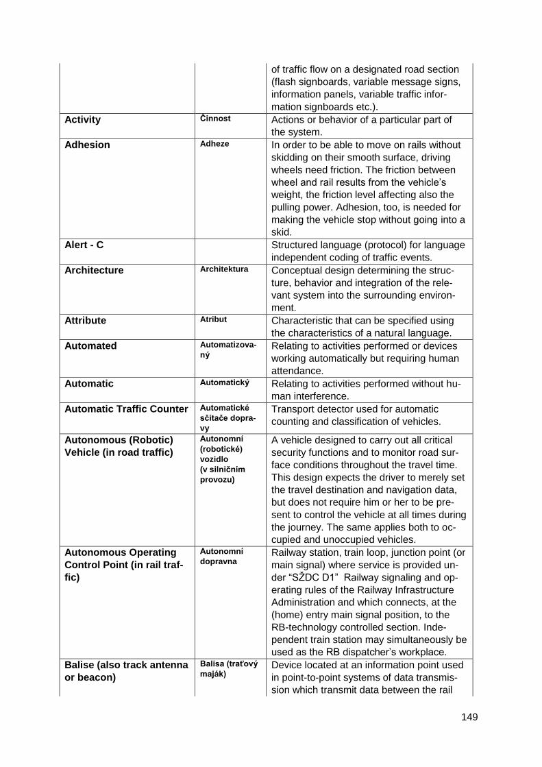
149
of traffic flow on a designated road section
(flash signboards, variable message signs,
information panels, variable traffic infor-
mation signboards etc.).
Activity Činnost
Actions or behavior of a particular part of
the system.
Adhesion Adheze In order to be able to move on rails without
skidding on their smooth surface, driving
wheels need friction. The friction between
wheel and rail results from the vehicle’s
weight, the friction level affecting also the
pulling power. Adhesion, too, is needed for
making the vehicle stop without going into a
skid.
Alert - C
Structured language (protocol) for language
independent coding of traffic events.
Architecture Architektura
Conceptual design determining the struc-
ture, behavior and integration of the rele-
vant system into the surrounding environ-
ment.
Attribute Atribut
Characteristic that can be specified using
the characteristics of a natural language.
Automated Automatizova-
ný
Relating to activities performed or devices
working automatically but requiring human
attendance.
Automatic Automatický Relating to activities performed without hu-
man interference.
Automatic Traffic Counter Automatické
sčítače dopra-
vy
Transport detector used for automatic
counting and classification of vehicles.
Autonomous (Robotic)
Vehicle (in road traffic)
Autonomní
(robotické)
vozidlo
(v silničním
provozu)
A vehicle designed to carry out all critical
security functions and to monitor road sur-
face conditions throughout the travel time.
This design expects the driver to merely set
the travel destination and navigation data,
but does not require him or her to be pre-
sent to control the vehicle at all times during
the journey. The same applies both to oc-
cupied and unoccupied vehicles.
Autonomous Operating
Control Point (in rail traf-
fic)
Autonomní
dopravna Railway station, train loop, junction point (or
main signal) where service is provided un-
der “SŽDC D1” Railway signaling and op-
erating rules of the Railway Infrastructure
Administration and which connects, at the
(home) entry main signal position, to the
RB-technology controlled section. Inde-
pendent train station may simultaneously be
used as the RB dispatcher’s workplace.
Balise (also track antenna
or beacon)
Balisa (traťový
maják)
Device located at an information point used
in point-to-point systems of data transmis-
sion which transmit data between the rail
150
vehicle and the track.
Bottom-Up Planning method used for setting objectives
and methods of accomplishing the objec-
tives in a bottom-up way. First, relatively
detailed partial objectives are set at the bot-
tom levels of the organizational hierarchy,
being gradually integrated at higher levels
until general global objectives and global
strategies are formed. A convergent ap-
proach.
Car2Car (also V2V) This technology is based on wireless com-
munication between individual (road) vehi-
cles (traffic participants) and is supposed to
spot potential risks in traffic, i.e. to prevent
accidents.
Transport Operator Dopravce
Person or organization arranging transport
for third-party needs in return for considera-
tion under terms and conditions published in
advance.
Cellular Network Celulární sít
Mobile network. Area covered by a signal is
divided into smaller parts or “cells”, covered
by individual transmitters. Mobile telephone
networks consist of roughly several thou-
sands of cells.
Chip Čip Miniature silicon plate with connected inte-
grated circuits.
Clearing Distribution of sales among transport con-
tractors in public passenger transport on a
designated territory under specific, contract-
based terms.
Train Dispatcher with lead
responsibility for train
movements supervisory
operations
Dirigující dis-
pečer
Qualified employee authorized to organize
railway traffic and to provide train move-
ment control over an assigned D3 railway
line (by simplified operating procedures).
Controlling Collecting, showing and analyzing account-
ing data, including but not limited to costs
and revenues, as basis for decision-making.
D1 Railway Signaling and
Operating Rules of the
Railway Infrastructure
Administration
Dopravní a
návěstní před-
pis SŽDC D1
Basic internal regulation on railway opera-
tion by Railway Infrastructure Administra-
tion. The regulation contains national safety
regulations within the meaning of EU legis-
lation applicable to railway management
and organization of rail transport on rail-
ways operated by Railway Infrastructure
Administration. Individual provisions of the
regulation are derived from the implement-
ing regulation of the Ministry of Transport
(“Railway Transport Regulations”), supple-
mented with further internal instructions
applicable to railway management-related
151
and rail transport organizing activities.
D3 Operating Control
Point
Dopravna D3
Railway station on a D3 railway line for
providing train movements or shunting op-
erations between D3 train stations which
are unstaffed by a local train dispatcher.
Data Data Information or formalized characteristics of
a certain process or effect in a form allowing
processing by information technologies.
Data have an exact form and a set struc-
ture.
Data Distribution Interface
(DDR)
Datové distri-
buční rozhraní Part of the editorial dispatching and control-
ling system of the National Traffic Infor-
mation Centre. The interface allows, based
on assigned access rights, traffic infor-
mation and traffic data to be taken over
from the central repository of the Integrated
Traffic Information System of CR via stand-
ard web services.
Data Network Datová síť
Telecommunications environment for data
transmission. Most data networks do not
guarantee the time of the data delivery (due
to applied communication protocols). Data
networks support a number of interfaces
and may have a number of protocol virtual
layers of logical networks. Data networks
are often interconnected or, on the contrary,
particularly for safety reasons, separated in
which case communication is possible
through network crossings points via special
systems (routers).
Database Databáze Set of data (information) from a specific
area organized and stored in digital form.
Delegating Delegování
Process of dividing activities (work), powers
or responsibilities among organization units
down to individual workers.
Detector Detektor Device used for detecting or identifying in-
put data and information for intelligent
transport systems. The measuring is done
through detectors, or sensors.
Digital Digitální Manner of storing information (data, imag-
es, sounds) in a form readable or allowing
further processing by a computer (in a nu-
merical code).
Centralized Traffic Opera-
tive Management and
Control
Dispečerské
řízení doprav-
ního provozu
Type of operative traffic management the
main purpose of which is to control in an
operative way the activities of all organiza-
tion units involved in traffic in order to meet
all tasks set for the accomplishment of the
transport or carriage process.
Display Displej Displaying device used for optic depiction of
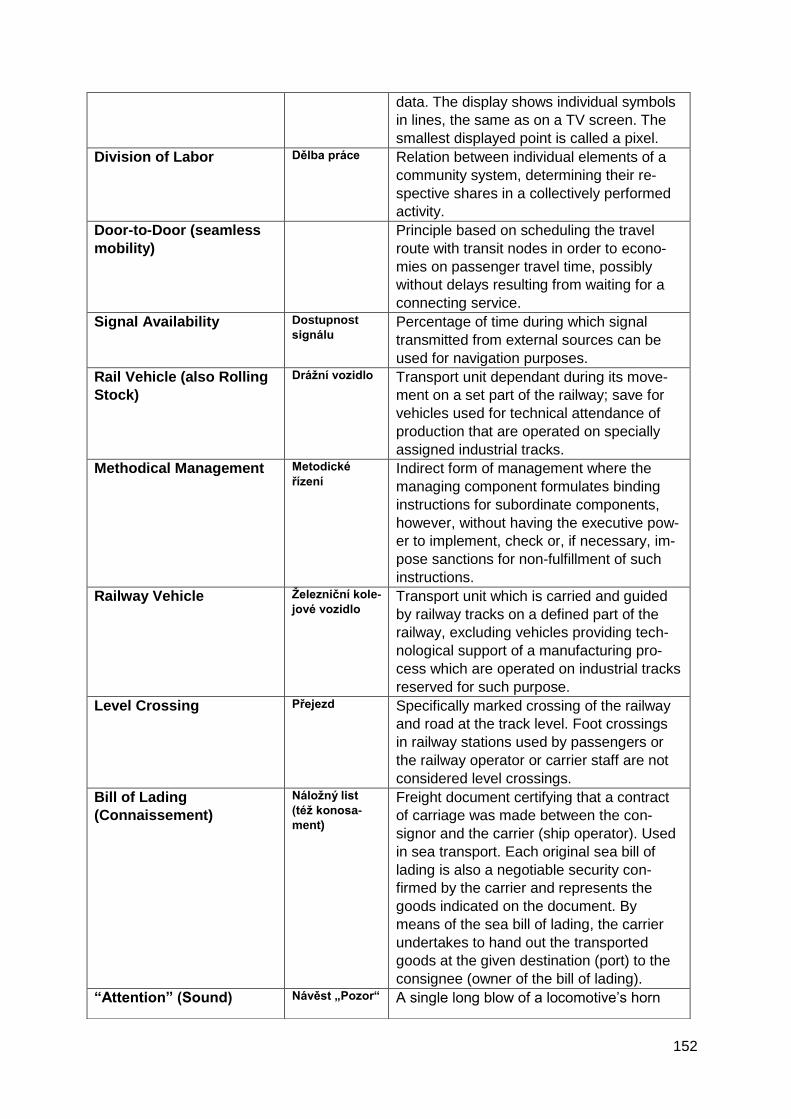
152
data. The display shows individual symbols
in lines, the same as on a TV screen. The
smallest displayed point is called a pixel.
Division of Labor Dělba práce
Relation between individual elements of a
community system, determining their re-
spective shares in a collectively performed
activity.
Door-to-Door (seamless
mobility)
Principle based on scheduling the travel
route with transit nodes in order to econo-
mies on passenger travel time, possibly
without delays resulting from waiting for a
connecting service.
Signal Availability Dostupnost
signálu Percentage of time during which signal
transmitted from external sources can be
used for navigation purposes.
Rail Vehicle (also Rolling
Stock)
Drážní vozidlo Transport unit dependant during its move-
ment on a set part of the railway; save for
vehicles used for technical attendance of
production that are operated on specially
assigned industrial tracks.
Methodical Management Metodické
řízení Indirect form of management where the
managing component formulates binding
instructions for subordinate components,
however, without having the executive pow-
er to implement, check or, if necessary, im-
pose sanctions for non-fulfillment of such
instructions.
Railway Vehicle Železniční kole-
jové vozidlo Transport unit which is carried and guided
by railway tracks on a defined part of the
railway, excluding vehicles providing tech-
nological support of a manufacturing pro-
cess which are operated on industrial tracks
reserved for such purpose.
Level Crossing Přejezd
Specifically marked crossing of the railway
and road at the track level. Foot crossings
in railway stations used by passengers or
the railway operator or carrier staff are not
considered level crossings.
Bill of Lading
(Connaissement)
Náložný list
(též konosa-
ment)
Freight document certifying that a contract
of carriage was made between the con-
signor and the carrier (ship operator). Used
in sea transport. Each original sea bill of
lading is also a negotiable security con-
firmed by the carrier and represents the
goods indicated on the document. By
means of the sea bill of lading, the carrier
undertakes to hand out the transported
goods at the given destination (port) to the
consignee (owner of the bill of lading).
“Attention” (Sound) Návěst „Pozor“
A single long blow of a locomotive’s horn

153
Signal lasting at least two seconds or a single long
whistle blow warning passengers of moving
vehicles. This signal may be repeated.
“RB Operating
Control Point
number” Signal
Board
Návěst „Číslo
dopravny“
On RB railway lines, this signal informs the
engine driver of the RB train station num-
ber, which the driver enters into the RB ter-
minal of the leading traction unit to allow for
identification of the train’s position.
Train Reception
(as internal telephone
communication between
stations (local train dis-
patchers) as the safe
working procedures for
the operation of the train
movement control)
Přijetí (vlaku)
(Local) train dispatcher’s consent to the
train’s arrival (entering into the (single-track
line) track section towards the station con-
trolled by him), given in a prescribed form.
Access Network Přístupová síť
Network enabling the participants’ and us-
ers’ end stations to get connected to the
backbone telecommunications network.
Accuracy Přesnost
Degree of conformity between measured
location or speed at a given time and real
location or speed.
Answer Back Signal
(as internal telephone
communication between
stations (local train dis-
patchers) as the safe
working procedures for
the operation of the train
movement control)
Odhláška
Message (given by local train dispatcher or
by track block operator) in a prescribed form
passed to the rear train movement operat-
ing point informing that the whole train (train
integrity check by watching the rear end
marker or tail light) has vacated the block
section (track section in rear re-
leased/clear).
Amendment Novela
Regulation in which modifications were
made by means of subrogating, amending
or changing certain provisions.
Approaching Section Přibližovací
úsek
Defined section of a track which, when oc-
cupied by a train approaching to an train
movement operating point or level crossing,
initiates the activity of the relevant interlock-
ing and signaling system.
Availability Dostupnost
Percentage of time during which the system
services are ready for use. The figure illus-
trates the system’s ability to provide useful
service within a territory it is covering.
Axle Counter (or
Wheelsets Counter)
Počítač náprav
(též počítač
dvojkolí)
Device checking the vacancy of a track sec-
tion by counting axles (wheelsets) at the
borders of this section.
Axle Load Hmotnost na
nápravu
Weight of one rail vehicle axle affecting the
track. The weight limit on the Czech railway
network is 22 tones.
Rail Traffic Movement Základní A term collectively referring to station
154
Documentation
dopravní do-
kumentace
(železniční
provoz)
timetables, operating procedure rules, im-
plementing acts, operating rules for con-
necting services and those for industrial
tracks.
Bill of Lading (in railway
Consignment Note)
Nákladní list
Freight document in domestic and interna-
tional transport certifying that a contract of
carriage was made between the consignor
and the carrier. It accompanies the con-
signment from the moment it is accepted by
the carrier until it is handed out to the con-
signee. As a freight document, the bill of
lading is a mere evidentiary document, not
a security, and cannot be assigned.
Block Section Prostorový
oddíl
Part of the open (railway) line between two
adjoining train movement operating points
or between a train movement operating
point and the end of a line at a (cul-de-sac
built) train-stop or loading point.
Excluded Track
Vyloučená
kolej
A track temporarily out of order due to tech-
nical, operational or transport reasons.
Bypass (Train) Path Objízdná trasa
vlaku
Train route necessary for a train to run
along a different track or into a different pe-
rimeter of the railway station other than
scheduled by the train’s tabular timetable.
Trains going on bypass routes run under
their original numbers according to terms
set out in Table 3 of the working timetable
(travel times, set speed, prescribed brake
mass percentage, etc.).
Calling-on Sig-
nal
(permissive
stop signal
passing)
(long flash-
ing white
light)
Přivolávací
návěst
Signal authorizing a train to run past the
main signal displaying the “Stop” signal or
giving no signal (with the lights out), or au-
thorizing a train to run past a mechanical
main signal emitting a doubtful signal.
Carriage of Persons and
Goods
Přeprava osob
a věcí
The carrier transports a person who asked
for carriage at an agreed price, accepting
also their luggage (at the agreed price) and
consignments submitted for carriage pro-
vided that the contract terms of carriage and
the terms set out by special regulations
were fulfilled.
Carriage Operating Přepravní pro-
voz Sum of all activities of a carrier and a
transport contractor or entities through
which transport is procured.
Transportation Chain Přepravní řetě-
zec
Intentional sequence of partial processes in
transport, handling, packing and storing,
necessary for transferring goods from the
155
manufacturer to the consumer.
Switch to Telephone
Communication
Přechod na
telefonické
dorozumívání
Measure taken by (local) train dispatchers
of adjoining train movement operating
points to interlock moving trains by request,
acceptance and advice of train arrival in-
stead of using the line interlocking and sig-
naling line block system.
Combined Transport Kombinovaná
přeprava
Intermodal transport where most of the
route is covered by railway, inland waterway
or by sea while the initial or final (pre-
carriage or on-carriage) sections of the
journey are covered by road and, in gen-
eral, are as short as possible.
Communication
Sdělování
Transmission, recording or reproduction of
signals.
Compatibility Kompatibilita
General capacity of a device or system to
work with another device or system without
any modifications.
Competence Působnost (též
kompetence)
Aggregate of tasks, powers and responsibil-
ities of a specific organization point.
Concept Koncepce
In the context of strategic management, a
concept refers to a structured outline of the
general course of a given field. Whereas a
concept contains basic starting and orienta-
tion points, a strategy is more specific, de-
fining particular targets and their values. A
concept may be similar in nature to a policy,
the main difference being, in particular, the
time horizon of their implementation (as
opposed to the concept’s mostly short- to
mid-term implementation horizon, a policy is
implemented on a medium to long-term ba-
sis).
Concession Koncese
Official permit (license) to pursue a certain
activity – e.g. to establish a transport link –
under specific, predefined terms.
Congestion Kongesce
Queue of standing or slow-running vehicles
causing delays to drivers or passengers.
Connecting Service, Con-
nection
Přípojný spoj,
přípoj
A connecting service which, at the point of
transfer, follows, within reasonable time
intervals, the arrival of another means of
transport (incl. an airplane).
Connecting Services Návaznost
spojů
Arranging two or more connecting links in
the timetable (air schedule) with reasonable
time intervals to allow transfers of passen-
gers or reloading of luggage/goods.
Connection Spoj
Particular transport connection between
given destinations, determined by the time-
table or using other time and place
156
specification, available within the framework
of transport service provided in the given
area.
Railway Interchange Point Styk drah
Connecting, parallel or crossing lines and
relations resulting therefore.
Consignee Příjemce
Organization or entity (person) indicted in
the bill of lading to whom the consignment
is designated pursuant to the contract of
carriage and to whom the carrier is obliged
to hand over the consignment.
Consignment Zásilka
A thing or a set of things that the carrier
took over from the sender for transportation,
usually with a relevant transport document,
which are to be transported to the recipient
at the destination.
Consignment
Note/Freight Document
Přepravní listi-
na
Document certifying that a contract of car-
riage (e.g. ticket, air ticket, bill of lading)
was made between the carrier and the
transport contractor (in freight transport) or
between the carrier and the passenger (in
passenger transport).
Consignor Odesílatel
Organization or entity indicated in the bill of
lading entering into a contract on the car-
riage of goods with the carrier.
Contact System Trakční vedení
Set of electrical wiring and all devices for
their attachment and division, which is used
to power the electric drive vehicle through a
pantograph.
Continuity Kontinuita
Probability that the system’s functions (ac-
curacy, availability) will be maintained over
time. Expressed as the probability of func-
tion failures occurring over a given period of
time.
Contract of Carriage Přepravní
smlouva
Contract made between the carrier and an
organization or entity for whose sake the
carriage (transport) is implemented.
Control/Management Řízení
Information process through which the con-
trolling entity restricts the number and ex-
tent of possible ways of behavior of the con-
trolled entity to achieve desired behavior.
Coordination
Koordinace
Controlling procedure where a factually co-
ordinating organization point exercises au-
thority over other locations that are not func-
tionally subordinate to it.
Council of the European
Union
Rada Evropské
unie
Principal decision-making body of the Euro-
pean Union, representing its Member
States. The EU Council does not meet in a
fixed configuration, the meetings are at-
tended by ministers responsible for the area
under discussion and authorized to act on
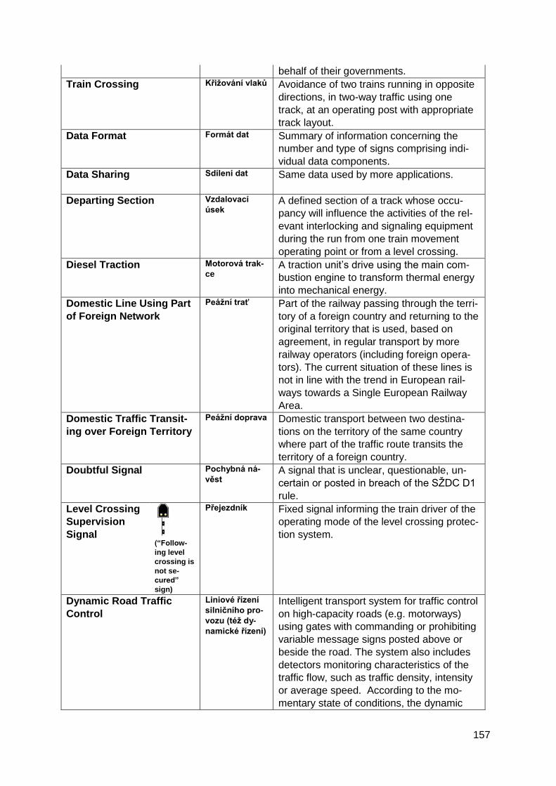
157
behalf of their governments.
Train Crossing Křižování vlaků
Avoidance of two trains running in opposite
directions, in two-way traffic using one
track, at an operating post with appropriate
track layout.
Data Format Formát dat
Summary of information concerning the
number and type of signs comprising indi-
vidual data components.
Data Sharing Sdílení dat
Same data used by more applications.
Departing Section Vzdalovací
úsek
A defined section of a track whose occu-
pancy will influence the activities of the rel-
evant interlocking and signaling equipment
during the run from one train movement
operating point or from a level crossing.
Diesel Traction Motorová trak-
ce
A traction unit’s drive using the main com-
bustion engine to transform thermal energy
into mechanical energy.
Domestic Line Using Part
of Foreign Network
Peážní trať
Part of the railway passing through the terri-
tory of a foreign country and returning to the
original territory that is used, based on
agreement, in regular transport by more
railway operators (including foreign opera-
tors). The current situation of these lines is
not in line with the trend in European rail-
ways towards a Single European Railway
Area.
Domestic Traffic Transit-
ing over Foreign Territory
Peážní doprava
Domestic transport between two destina-
tions on the territory of the same country
where part of the traffic route transits the
territory of a foreign country.
Doubtful Signal Pochybná ná-
věst
A signal that is unclear, questionable, un-
certain or posted in breach of the SŽDC D1
rule.
Level Crossing
Supervision
Signal (“Follow-
ing level
crossing is
not se-
cured”
sign)
Přejezdník
Fixed signal informing the train driver of the
operating mode of the level crossing protec-
tion system.
Dynamic Road Traffic
Control
Liniové řízení
silničního pro-
vozu (též dy-
namické řízení)
Intelligent transport system for traffic control
on high-capacity roads (e.g. motorways)
using gates with commanding or prohibiting
variable message signs posted above or
beside the road. The system also includes
detectors monitoring characteristics of the
traffic flow, such as traffic density, intensity
or average speed. According to the mo-
mentary state of conditions, the dynamic
158
road traffic control system automatically
gradually reduces speed or changes the
organization of lanes to ensure as continu-
ous and safe traffic flow as possible.
eCall 112 The pan-European eCall system is defined
as an automatic or user-launched system
for sending calls and relevant coordinates of
a car accident to the 112 emergency call
centre via the Global System for Mobile
Communications (GSM), carrying a defined
minimum set of data informing that an acci-
dent occurred that requires the intervention
of rescue units. If possible, the system picks
up voice communication with the vehicle.
eCall is designed to send for rescue ser-
vice, not to monitor the vehicle’s move-
ments. Immediate warning of a serious ac-
cident and the knowledge of the exact loca-
tion of the accident reduces time necessary
for providing effective help.
Efficiency
Efektivnost
Describes the relation between outputs from
business activities (generally meaning prof-
it) and inputs (generally meaning invested
or tied capital or, if relevant, costs).
EGNOS “European Geostationary Navigation Over-
lay System” is the European form of SBAS
or Satellite Based Augmentation System
which is used to augment the accuracy of
GPS (including Galileo up from Version 3)
and also allows the system to be used for
applications critical in terms of safety (air-
plane or ship navigation).
Electric Traction Elektrická trak-
ce
Drive of a traction unit using transformation
of electric power from an external source or
an accumulator to kinetic energy or vice
versa.
Electric Equipment Elektrická vý-
zbroj
Traction device in an electromobile.
Electric Power Elektrická
energie
Capacity of the electric current to perform
work.
Electrified Line Elektrizovaná
trať (též elektri-
fikovaná trať)
Track fit for operation of rail traction units
with dependant electric drive
Electromagnetic Compat-
ibility (EMC)
Elektromagne-
tická kompati-
bilita (EMC)
Capacity of an equipment, system or device
to work correctly even in environments that
are affected by other sources of electro-
magnetic signals (both natural and artificial)
and, on the contrary, to shield the environ-
ment from the undesired impact of its own
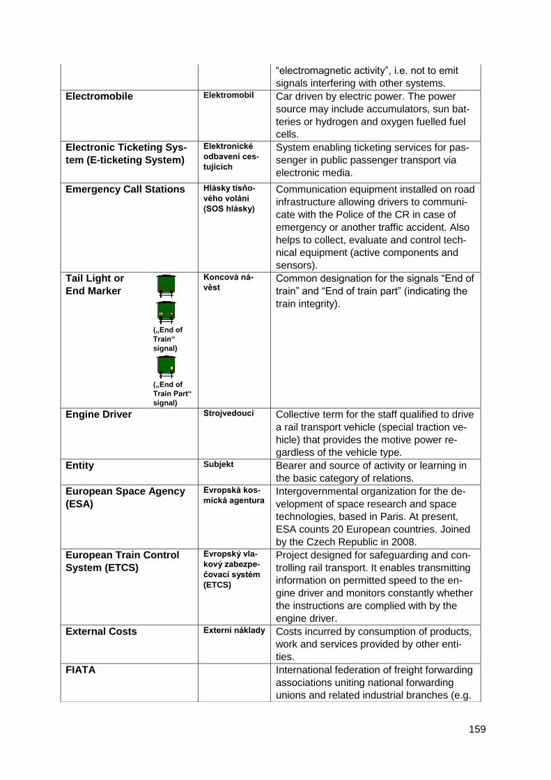
159
“electromagnetic activity”, i.e. not to emit
signals interfering with other systems.
Electromobile Elektromobil Car driven by electric power. The power
source may include accumulators, sun bat-
teries or hydrogen and oxygen fuelled fuel
cells.
Electronic Ticketing Sys-
tem (E-ticketing System)
Elektronické
odbavení ces-
tujících
System enabling ticketing services for pas-
senger in public passenger transport via
electronic media.
Emergency Call Stations Hlásky tísňo-
vého volání
(SOS hlásky)
Communication equipment installed on road
infrastructure allowing drivers to communi-
cate with the Police of the CR in case of
emergency or another traffic accident. Also
helps to collect, evaluate and control tech-
nical equipment (active components and
sensors).
Tail Light or
End Marker
(„End of
Train“
signal)
(„End of
Train Part“
signal)
Koncová ná-
věst
Common designation for the signals “End of
train” and “End of train part” (indicating the
train integrity).
Engine Driver Strojvedoucí
Collective term for the staff qualified to drive
a rail transport vehicle (special traction ve-
hicle) that provides the motive power re-
gardless of the vehicle type.
Entity Subjekt
Bearer and source of activity or learning in
the basic category of relations.
European Space Agency
(ESA)
Evropská kos-
mická agentura
Intergovernmental organization for the de-
velopment of space research and space
technologies, based in Paris. At present,
ESA counts 20 European countries. Joined
by the Czech Republic in 2008.
European Train Control
System (ETCS)
Evropský vla-
kový zabezpe-
čovací systém
(ETCS)
Project designed for safeguarding and con-
trolling rail transport. It enables transmitting
information on permitted speed to the en-
gine driver and monitors constantly whether
the instructions are complied with by the
engine driver.
External Costs Externí náklady
Costs incurred by consumption of products,
work and services provided by other enti-
ties.
FIATA International federation of freight forwarding
associations uniting national forwarding
unions and related industrial branches (e.g.
160
warehouses)
(in French: Fédération Internationale des
Associations de Transitaires et Assimilés)
Floating Car Data Data
z plovoucích
vozidel
Data collected from vehicles equipped with
respective in-vehicle units forwarded to traf-
fic information and controlling centers for
assessment and defining of basic trends in
road traffic development.
Forwarder Zasílatel (též
speditér)
An organization procuring and providing
transportation and related tasks for a cus-
tomer in an agreed scope and under speci-
fied conditions.
Forwarding
Zasílatelství
Organization of the transport of goods or of
other tasks related to the transport, in one’s
own name and on someone else’s account.
Freight Transport Nákladní do-
prava
Transport the fundamental aim of which is
to carry goods (freight).
Galileo Galileo is a global navigation satellite sys-
tem owned by the European Union which
offers precise global positioning service.
Galileo is interoperable with GPS, the US
global navigation satellite system.
Geostationary Geostacionární
Stationary in relation to the Earth surface.
Geostationary satellites orbit the Earth at an
altitude of 36,000 km directly over the equa-
tor, as a result of which they seem station-
ary seen from the Earth.
Global System for Mobile
communications – Rail-
way (GSM-R)
Based on GSM standard; however, it uses
its own frequencies and offers several ex-
tended functions specific for rail transport. It
is a radio system designed mainly for ex-
changing audio (voice) information and data
between rail and mobile components.
Global Objective Globální cíl
Specific (clear, matter-of-fact and compre-
hensible) description of a future state
through which a set vision will be accom-
plished. A summary of the results and im-
pacts of strategic objectives. Applies to the
strategy as a whole. Similarly to a vision, a
global objective should be met within a mid-
term or long-term horizon (not necessarily
immediately upon conclusion of the strategy
implementation).
Gradient Profile of a Line Podélný profil
tratě
Set of data relating to a section of the line,
specifying the respective gradients and in-
dicating the locations and radiuses of
curves or the line speed and points of
change in speed. The set also includes data
concerning the stationing and location of
operating posts, stops and signals.
161
Green Paper Zelená kniha
The purpose of a Green Paper is to provide
the public with material gathering proposals
in a selected area so as to spark off a de-
bate. Green Papers are followed by White
Papers, which already contain specific pro-
posals for action in specific policy areas.
GS1 International organization specialized in
drafting or proposing and implementing
global standards, procedures and solutions
to improve efficiency and transparency of
the supply and demand relationship in glob-
al terms and across industrial branches.
GS1 System Systém GS1
Global standard for identification, automatic
data collection and communication of data
between business partners.
Handling Equipment /
Transport Facility
Dopravní zaří-
zení
Equipment used for ensuring operation of
transport means, unloading and loading,
informing the transport operator staff, driv-
ers, passengers, dispatchers and consign-
ees, treatment and maintenance of
transport means and traffic routes. Traffic
routes as such, other transport structures
and means of transport are not considered
handling/transport equipment.
Service Track Manipulační
koleje
Tracks used for handling of vehicles (e.g.
loading or unloading) or, as the case may
be, other purpose tracks.
Hardware Technological equipment of a computer,
individual structural components (mother-
board with a microprocessor, power supply
unit, graphic card, etc.)
Heavy Consignment/Load Těžká zásilka
Loads whose weight exceeds the values
given in the table of car load limits, or
whose weight will cause that weight per
axle or weight per running meter of the car
are exceeded, even only on one section of
the transportation route defined for the
shipment.
Homeostasis Homeostáze
Mechanism of community systems facilitat-
ing target behavior and creation of inner
balance which is a precondition for efficient
accomplishment of selected targets.
Horizon 2020 Horizont 2020
Framework Programme for Research and
Innovation (H2020) is to be the biggest and
most important programme to fund Europe-
an science, research and innovation in the
years 2014-2020. The H2020 programme
continues in the research framework pro-
grammes declared by the EU since 1980,
specifically the Seventh Framework
162
Programme for research, technological de-
velopment and demonstration (2007-2013).
Impossible Communica-
tion
Nemožné doro-
zumění
Situation in which, due to malfunction of the
telecommunication equipment (mutual
communication of the staff attending adja-
cent operating posts is made impossible)
and simultaneous breakdown of the inter-
locking and signaling equipment (if in
place), it is impossible to ensure safe run-
ning of a train between adjacent operating
posts.
Incident (also Accident) Mimořádná
událost (též
nehodová udá-
lost)
Event occurring in connection with the op-
eration of a means of transport, resulting in
death or damage to health, property or
transported goods or threatening life, health
and property or putting at risk the safe op-
eration of buildings and facilities or, if appli-
cable, gross violation of safety standards
and/or continuity and regularity of traffic that
might result in the above consequences.
Indicator Indikátor
Quantified target or rate measuring the level
of a target’s accomplishment or an activity’s
implementation. Indicators are used to mon-
itor the process and result of implementa-
tion of a strategy (programme, project).
Industrial Track Vlečka
Track which serves the needs of the indus-
trial track owner or other entrepreneur and
runs into a national or regional line or into
another industrial track.
Information Informace
Describes events in verbal or visual form,
thus it cannot be expressed in an exact
way:
1. Message, advice or data concerning a
specific part of objective reality that is nec-
essary for the management process.
2. Meaning attributed to data (figures, num-
bers, signs, orders, instructions, commands,
reports, etc.)
There are various types of information: up-
to-date, reviewing, primary, continuous,
controlling, external, internal, input, output,
etc.
Information System Informační
systém
Aggregate of means providing visual and
acoustic information to drivers, road users,
passengers and transport contractors (cus-
tomers of a freight carrier).
Information Technology Informační
technologie
Technical aspect of information, separate
from the contents of the message, infor-
mation, data and their significance (issues
involving also psychology, sociology and
other fields).
163
Inland ECDIS Vnitrozemský
ECDIS
International data standard for the creation
of inland navigation maps for water
transport.
Inland Waterways Vnitrozemské
vodní cesty
Rivers and other areas where boats can
navigate.
Integrated Traffic Infor-
mation System of the CR
(JSDI)
Jednotný sys-
tém dopravních
informací pro
ČR (JSDI)
Complex system environment collecting,
processing, sharing, publishing and distrib-
uting (road) traffic information and traffic
data primarily (but not exclusively) from
public administration authorities, organiza-
tions and institutions as well as from other
public and private entities pursuant to Reso-
lution of the Government of CR No. 590 of
18 May 2005 “Draft implementation plan for
the Integrated Traffic Information System of
the CR” and in compliance with Act No.
361/2000 Coll., as amended. The Integrated
Traffic Info. System is a joint project of the
Ministry of Transport of the CR, the Ministry
of Interior of the CR and the Road and Mo-
torway Directorate.
Integrated Transport Sys-
tem
Integrovaný
dopravní sys-
tém
Public Transport Service provided on a par-
ticular territory by several carriers subject to
agreed contractual terms.
Integration Integrace
State of the process of enhancing a sys-
tem’s organization, integrity, adaptability
and homeostasis.
Integrity Integrita
Capacity of a system to send early warnings
to users if its signals cannot be applied for
navigation purposes. Expressed by proba-
bility of incorrect information provided at a
given period of time.
Intelligent Infrastructure Inteligentní
infrastruktura
Complex of ITS applications integrated into
transport infrastructure based on which ITS
services are provided to users. Intelligent
transport infrastructure can be understood
as transport infrastructure enabling, for in-
stance, traffic and travel information to be
conveyed in real time.
Intelligent Stop Inteligentní
zastávka
Public passenger transport stop equipped
with information panels supplying real time
travel information.
Intelligent Transport Sys-
tems (ITS)
Inteligentní
dopravní sys-
témy
Advanced applications designed to provide
innovative services relating to various
modes of transport and traffic control, with-
out being intelligent themselves. ITS allow
for improved awareness of various user
groups, enabling a safer, better coordinated
and more “intelligent” use of transport net-
works.
164
Intelligent Vehicle Inteligentní
vozidlo
Vehicle equipped with a technical system
allowing it to make decisions on the vehi-
cle’s running without human intervention.
The decisions are made at different intelli-
gence levels and thus are capable of affect-
ing the vehicle as a whole (autonomous
vehicle) or individual systems of the vehicle
(ABS, ESP, ASC and other systems).
Interface Rozhraní
Mechanism working between systems, en-
suring the systems’ interconnection and
interaction.
Interlocked Route Zabezpečená
jízdní cesta
A track section which is supported by an
interlocking and signaling equipment to
comply with the conditions for safe run of
railway vehicles. Interlocked route is
bounded by a place from where a permis-
sion to proceed is valid (usually from a sig-
nal) and a place to which the permit is valid
(usually the next signal). Interlocked routes
are either train routes or shunting routes.
Interlocking and Signaling
Equipment
Zabezpečovací
zařízení (želez-
niční)
Equipment which helps to ensure safe
movement of railway vehicles through sur-
veillance and replacement of the operation
performed by people, automation and in-
crease of railway stations and tracks per-
formance. The system is designed to con-
trol the traffic and technological processes
in real time. Given that an error in the man-
agement of this process can lead to very
serious consequences, i.e. to loss of life,
injuries and considerable damage to proper-
ty or the environment, this process (or some
of its functions) is considered to be safety-
critical. For this reason, requirements are
imposed both on the correct operation of
the plant in defect-free state, and on the so-
called fail-safe, too. Fail-safe means that no
potential failure of the plant nor of its parts
can result in a safety hazard.
Securing of Train Move-
ment
Zabezpečení
jízdy vlaku
Set of operating tasks to secure the run of a
train to or from a neighboring train move-
ment operating point with track develop-
ment, or to a defined place on an open track
and back. Different categories and types of
track interlocking and signaling equipment
are used to secure the movement of trains.
In addition to the track interlocking and sig-
naling system, also train movement without
interlocking and signaling devices or tele-
phone communication is used.
Intermodal Transport Intermodální Several transport modes are used in
165
System přepravní sys-
tém
carriage of goods. Lorries, trailers, semi-
trailers, detachable add-ons or containers
use roads for the initial and/or final sections
of the journey whereas for the remaining
part, they are shipped, with or without the
tow (traction) vehicle, by railway, waterway
or by sea. Only unified units are transported
under this system, not undergoing any
change in terms of weight or form during the
carriage (e.g. ISO containers). As opposed
to the multimodal transport system, a sepa-
rate consignment note is issued for each
transport mode (CMR for road transport,
CIM for rail transport, etc.).
Internal Rate of Return Vnitřní výno-
sové procento The rate of interest at which the present
value of cash income from investments is
equal to capital expenditure on the invest-
ment.
Internet
Worldwide interconnected data network
generally operating using the TCP/IP proto-
cols, equipped with information servers with
a range of extensive services. In common
sense, the Internet is primarily understood
as the access to such information and ser-
vices, regardless of their actual global loca-
tion and manner of implementation of the
data connection.
Internet of Things (IoT) Internet věcí
Communications network of a broad range
of “embedded” devices (devices equipped
with software and hardware for a specific
purpose, e.g. sensors, navigation or GPS
modules) accessible via the Internet. In
transport, the principle and the purpose of
IoT is similar to the principle and the pur-
pose of the V2X concept.
Interoperability Interoperabilita
Capacity of a product or system (whose
interface is in full public domain) to com-
municate and work with other products or
systems without any limitations in access or
implementation.
Interoperability Compo-
nents
Prvky interope-
rability
All basic structural parts, groups of structur-
al parts, substructures or full structures of
equipment included, or to be included in the
future, into the subsystem of the European
Railway System that are crucial, directly as
well as indirectly, for the system’s interop-
erability. The concept of “component” in-
cludes both tangible as well as intangible
property (e.g. software equipment).
In-vehicle (On-board) Unit Vozidlová (pa-
lubní) jednotka Technical equipment installed in a vehicle,
which enables the electronic exchange of
166
data between the vehicle and the equip-
ment on transport infrastructure in order to
automatically identify the vehicle.
In-vehicle RB Terminal Radioblokový
terminál vozi-
dla
Aggregate of technical devices on the lead-
ing rail traction unit ensuring that the trans-
mitted permissions are displayed to the en-
gine driver. The terminal also passes infor-
mation on the condition and location of the
train to the RBS with respect to the engine
driver’s operation of and interference with
the vehicle’s control systems, and their
compliance with the issued permissions.
ITS Application Aplikace ITS Intelligent transport system implemented
and operated in real environment for the
purpose of providing services to users of
intelligent transport systems.
ITS Service Služba ITS
Deployment of an ITS application through a
correctly defined organizational and opera-
tional framework with the aim to improve
safety, efficiency and user comfort or to
facilitate or support operational activities
related to carriage or travelling.
ITS Services Interconnec-
tion
Návaznost
služeb ITS
Capacity to ensure continuous connecting
ITS services on transport networks across
the EU.
ITS Users Uživatelé sys-
tému ITS
All users of ITS applications or services
including drivers, passengers, vulnerable
road users, carriers, managers and opera-
tors of the transport infrastructure, manag-
ers of vehicle fleets and integrated rescue
services.
Legislation Legislativa
Creation of legal rules laid down in writing.
Level Crossing Protection
System
Přejezdové
zabezpečovací
zařízení
Interlocking and signaling equipment in-
forming road users of a rail vehicle heading
towards the level crossing and simultane-
ously informing the engine driver or relevant
rail traffic service staff if the train is allowed
to run at the permitted line speed before
reaching the level crossing.
Line Linka
Aggregate of connecting services on a giv-
en route.
Line Closure Výluka koleje
Temporal interruption of train service or
shunt on a track (section of the track), on an
open track or in an operating post with track
development; it can also be due to long-
term impassability, in order to perform nec-
essary repairs or other activities.
Interlocking System Re-
mote Control Supervisor
Traťový dispe-
čer
An employee with the competence to organ-
ize and control train movements, except
train dispatchers for centralized traffic
167
control, who remotely controls an area or its
part on a defined track section.
Line Speed Limit Největší traťo-
vá rychlost
Speed allowed on a track (track section)
with respect to its constructional layout and
equipment.
(Railway) Line with Sim-
plified Operating Proce-
dures
Trať se zjedno-
dušeným říze-
ním drážní
dopravy
Railway line on which the service is provid-
ed under “SŽDC D3” rule for simplified op-
erating procedures (D3 line) and which is
limited by home (entry) signals of the station
with lead responsibility for controlling train
movements over an assigned dispatching
section or by home (entry) signals of an
adjacent station or by the buffer post in the
cul-de-sac built “D3” station.
(Railway) Line Trať
A defined part of the railway designed for
trains movement (or for shunting operations
between train movement operating points),
divided into line sections between train
movement operating points with track de-
velopment and into tracks in train move-
ment operating points on which the
transport service is provided under “SŽDC
D1” Railway signaling and operating rules.
A line can also be a substructure and per-
manent way including structures and fixed
railway facilities between two designated
points. It can be open, standard gauge, nar-
row gauge, broad gauge, with reversible
tracks, with privileged transit traffic, electri-
fied, rack railway line, frontier, main, sec-
ondary, controlled, high-speed.
Loading Gauge Průjezdný prů-
řez
Defines the free space along the track ena-
bling the safe passing of rail vehicles.
LTE Technology designed for high-speed Inter-
net in mobile networks (abbreviation of
Long Term Evolution).
M2M Mobile Data Tele-
communications Service
Mobilní datová
telekomuni-
kační služba
M2M
Mobile data telecommunications service of
the Machine-2-Machine (M2M) type with
limited quantity of transmitted data. This
type of service is used to ensure specific,
mostly technological communication be-
tween two and more devices where usually
various weather-related data are transmit-
ted, placing minimum demands on the
quantity of the transmitted data.
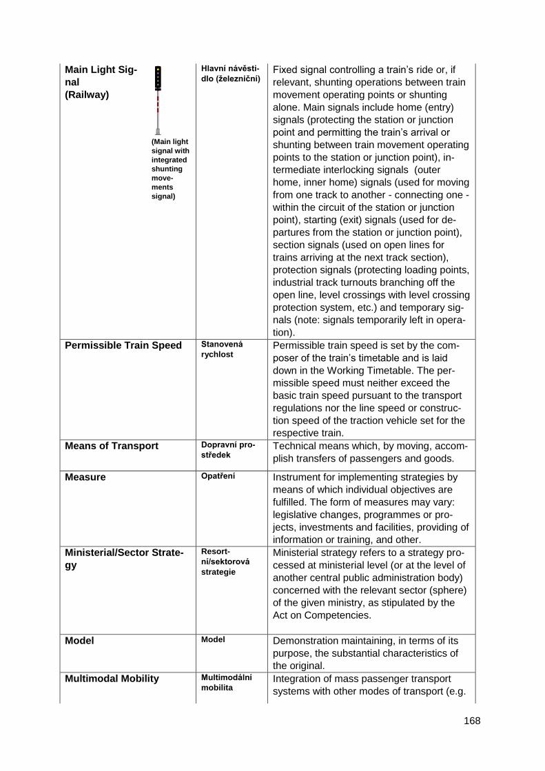
168
Main Light Sig-
nal
(Railway)
(Main light
signal with
integrated
shunting
move-
ments
signal)
Hlavní návěsti-
dlo (železniční)
Fixed signal controlling a train’s ride or, if
relevant, shunting operations between train
movement operating points or shunting
alone. Main signals include home (entry)
signals (protecting the station or junction
point and permitting the train’s arrival or
shunting between train movement operating
points to the station or junction point), in-
termediate interlocking signals (outer
home, inner home) signals (used for moving
from one track to another - connecting one -
within the circuit of the station or junction
point), starting (exit) signals (used for de-
partures from the station or junction point),
section signals (used on open lines for
trains arriving at the next track section),
protection signals (protecting loading points,
industrial track turnouts branching off the
open line, level crossings with level crossing
protection system, etc.) and temporary sig-
nals (note: signals temporarily left in opera-
tion).
Permissible Train Speed Stanovená
rychlost
Permissible train speed is set by the com-
poser of the train’s timetable and is laid
down in the Working Timetable. The per-
missible speed must neither exceed the
basic train speed pursuant to the transport
regulations nor the line speed or construc-
tion speed of the traction vehicle set for the
respective train.
Means of Transport Dopravní pro-
středek
Technical means which, by moving, accom-
plish transfers of passengers and goods.
Measure Opatření
Instrument for implementing strategies by
means of which individual objectives are
fulfilled. The form of measures may vary:
legislative changes, programmes or pro-
jects, investments and facilities, providing of
information or training, and other.
Ministerial/Sector Strate-
gy
Resort-
ní/sektorová
strategie
Ministerial strategy refers to a strategy pro-
cessed at ministerial level (or at the level of
another central public administration body)
concerned with the relevant sector (sphere)
of the given ministry, as stipulated by the
Act on Competencies.
Model Model Demonstration maintaining, in terms of its
purpose, the substantial characteristics of
the original.
Multimodal Mobility Multimodální
mobilita
Integration of mass passenger transport
systems with other modes of transport (e.g.

169
car sharing) with the aim to reduce individu-
al car transport.
Multimodal Transport
System
Multimodální
přepravní sys-
tém
This system does not deal with the carriage
of unified units (i.e. units undergoing no
changes during the carriage process) – the-
se are used in the so-called intermodal
transport system. A single bill of lading
(FIATA) is issued for all modes of transport
which covers the entire carriage section.
The multimodal transport operator (e.g. for-
warder) assumes responsibility for imple-
menting the entire process of the combined
transport, even if implemented by various
means of transport.
As for mass passenger transport systems
designed to provide high-quality transport
service within a given territory, the so-called
Integrated Public Transport Systems are
created that work under single carriage and
tariff terms and endorse a single transport
solution, including the coordination of time-
tables comprising several modes of public
passenger transport operating at a given
territory, e.g. underground (Metro), trams,
trolleybuses, railways, urban and suburban
bus service, cable car and ferries.
National Traffic Infor-
mation and Management
Centre (NDIC)
Národní do-
pravní infor-
mační a řídicí
centrum (NDIC)
Subsystem for review, authorization and
verification of traffic information from di-
verse sources. The National Traffic Infor-
mation Centre is operated by the Road and
Motorway Directorate of the CR by force of
the Czech Government’s resolution as part
of its branch in Ostrava, Slovenská 7/1142,
Ostrava-Přívoz. It is a round-the-clock op-
erations centre.
Navigation Plavba
Operating vessels on waterways.
Navigation Network Plavební síť
Technical base of inland navigation consist-
ing of a network of waterways and ports.
Nomadic Device Přenosné zaří-
zení
Portable communications or information
device that can be taken by the driver into
the vehicle and used when driving or ac-
complishing transport, e.g. PDA or
smartphone.
Non-interlocked Running Jízda bez za-
bezpečovacího
zařízení
Manner of securing running trains where the
trains’ rides are organized by a single train
dispatcher.
One Stop Shop 1) In rail freight transport a one stop shop is
a point of contact allocating railway infra-
structure capacity of international freight
train paths. Either, a single stop is
170
established in each respective rail network
to offer paths to international trains, able to
arrange for an international train’s path from
the starting point to its destination, regard-
less of the number of rail networks passed
on the way, or a single point of contact is
established for the entire corridor as part of
the given railway freight corridor.
2) In public passenger transport, a one stop
shop means providing comprehensive, spe-
cific area-related information through on-line
or mobile applications, informing about
timetables of public passenger transport,
walking distances to stops, navigation to the
point of destination, comparing the travelling
conditions to individual car or cycle
transport, or providing information on car-
riage and tariff terms.
Open Line Širá trať
Line section delimited on each side either
by a station, a D3 operating post, an RB
operating post or the end of the line (end of
track at, e.g., a stop or loading point). The
border between the open line and a station
is delimited by a home signal; in case of
tracks with no home signal, the border is at
the home signal level of the right track. The
border between the open line and a D3 or
RB operating post is the trapezoid sign
board.
Open Line Track Traťová kolej
Track on an open line.
Train Movement Operat-
ing Control Point
Dopravna
Railway point used to control train move-
ments and shunting operations between
train movement operating points. There are
train movement operating points with track
development (railway station, passing loop,
junction point, D3 train station, etc.) or with-
out track development (train announcing
point, track block operating post with block
apparatus, automatic block section signal or
section signal of the automatic line block
system).
Operational Programme Operační pro-
gram
Operational programme is the fundamental
strategic document of financial and tech-
nical nature focusing on a specific sphere
(e.g. employment and social affairs) or a
specific cohesion region (e.g. Moravian-
Silesian region) that is compiled by the
Member States of the EU. Operational pro-
grammes contain detailed descriptions of
the objectives and priorities which the
171
particular Member States want to achieve in
the given sphere over the given program-
ming period. The Programmes contain de-
scriptions of type activities for which funds
may be allocated from EU Structural Funds.
An Operational Programme also includes a
list of those eligible for applying for such
funds.
Operative Traffic Control Operativní
řízení doprav-
ního provozu
Constant everyday activity carried out ac-
cording to concept models of operative pro-
cess management, respecting the immedi-
ate needs of and possibilities in the
transport, carriage and service processes of
traffic.
Organized State Organizova-
nost
State of a system different from chaos
showing traits of a structure in the relations
between the system’s components, accord-
ing to certain criteria.
Out of Gauge Překročení
ložné míry Consignment exceeding the prescribed pro-
file of the route at any point of its length the
dimensions of which exceed the loading
gauge of the relevant track in the defined
travel path of the consignment.
Out-of-Gauge Load Zásilka s pře-
kročenou lož-
nou mírou (též
zásilka PLM)
Exceptional consignment whose dimen-
sions exceed prescribed loading gauge,
transported separately under specified con-
ditions.
Overtaking of Trains Předjíždění
vlaků
Two trains bound for the same direction
passing at a train movement operating point
with a track development where the train
arriving at the train movement operating
point with a track development later departs
from (or passes through) the train move-
ment operating point and enters the next
block section earlier than the first train. Al-
so, two trains bound for the same direction
passing at a double or multiple track line.
Part-Load Consignment Kusová zásilka
Consignment of limited weight and dimen-
sions which needs no separate rail wagon
or separate road vehicle for being trans-
ported.
Passenger Cestující
A person transported by a transport con-
tractor in compliance with Carriage Regula-
tions and the Tariff.
Passenger Transport Osobní dopra-
va
Transport the fundamental aim of which is
the carriage of persons and their luggage.
Permissible Braking Dis-
tance
Zábrzdná vzdá-
lenost
Distance determined for a particular section
of the track, on which any train has to safely
stop from the greatest speed authorized at
the given section. Braking distance is
172
determined uniformly according to the tech-
nical parameters of the track and is reported
in the route book containing the line charac-
teristics.
Maximum Permitted Line
Speed
Nejvyšší dovo-
lená rychlost
Set speed restricted at a given track section
by the line speed limit, by a temporary re-
striction of the line speed limit (e.g. due to
construction works on the track), by main
signals or by a message informing the en-
gine driver of the restricted speed limit.
In road transport the maximum permitted
speed is restricted by Act No. 361/2000
Coll., on road traffic, as amended. On mo-
torways, the speed limit is 130 km/h, on
roads outside of municipalities 90 km/h, in
municipalities 50 km/h, whereas in pedes-
trian and residential areas the speed limit is
20 km/h.
Person (people) with Re-
duced Mobility or Orienta-
tion
Osoba s ome-
zenou schop-
ností pohybu
a orientace
People whose mobility when using a means
of transport is reduced due to any physical
disability (sensory or motoric, permanent or
temporary), mental disorder or incapacity or
due to any other handicap resulting from
health or age and whose state requires that
adequate attention is paid to their special
needs and that services available to all pas-
sengers are adapted to meet their needs as
well.
Personal Digital Assistant Osobní digitál-
ní pomocník
(PDA)
Small pocket computer.
Pilot Solution
(test operation)
Pilotní řešení
(též pilot, polo-
provoz nebo
zkušební pro-
voz)
Temporary version of a system showing
basic features of the system to be imple-
mented later on.
Platform Platforma
On-board unit or other device enabling im-
plementation, providing, use and integration
of ITS applications and services.
Point Machine Přestavník
Device placed next to the points (diamond
junctions, catch points) the main function of
which is to reset, consequently fix and
monitor the position of the movable compo-
nents of the switch panel, crossing or catch
point.
Portal Portál
A website enabling quick access to a great
amount of information in one place. In order
to be able to efficiently work with such
amounts of information, each portal has a
browser. Browser is a programme able to
173
search through all of its records upon the
users’ entering their requirements and to
offer the corresponding result information.
Power Industry Energetika
Field of human activity focusing on the ex-
traction of primary energy sources and the
transformation, transport, storage and use
of energy.
Primary Data
Primární data
Basic data used as input reference data for
messages or as basis for a system’s func-
tioning and for computation of derived data.
Pseudolite Pseudolit
Surface device simulating and emitting GPS
signals. Used for making the GPS satellite
network denser at places where 100% in-
tegrity and availability of the signal is crucial
for navigation purposes (i.e. at airports
when navigating airplanes before landing).
Public Carriage Veřejná pře-
prava
Transport provided to meet the general
transport needs and available to everyone
under uniformly applicable terms and condi-
tions or under specifically agreed transport
conditions.
Public Transport Veřejná dopra-
va
Transport for users, during which a legal
relationship between the operator of the
means of transport and an organization or
person, whose transportation needs are
satisfied, is established. The service is
available to everyone under the defined
terms and conditions.
Qualified Person Author-
ized to Organize Rail
Transport and to Provide
the Safe and Efficient
Train and Shunting
Movements
Odborně způ-
sobilá osoba
k organizování
a řízení drážní
dopravy
Person assigned by the railway operator or
carrier to carry out, as part of the railway or
rail transport operating, activities having
direct effect on safe working procedures for
the operation of the train and shunting
movement control. The person must have a
professional qualification as required by
legal regulations and the railway operator’s
or the carrier’s internal rules applying to
activities carried out in railway, or rail
transport, operating.
Queue Kolona
Row of road vehicles in a traffic lane with no
possibility of overtaking, affected by the first
vehicle. In terms of mutual influencing, two
vehicles are involved. In terms of evaluating
congestions, a queue involves 20 and more
vehicles moving at varying speed or alterna-
tively going to a full stop.
Quick Response Code QR kód
System for automated data collection. Ma-
trix code arranged in a square consisting of
black and white modules (square dots),
which form images. One QR code – image
174
– can contain great amounts of stored in-
formation.
Radio Data System - Traf-
fic Message Channel
(RDS-TMC)
. Service for drivers designed to provide traf-
fic and travel information before and during
travelling. Uses standard radio signal for
data transmission. Among other, RDS is
also used for acquiring information on the
current radio station, name or text of the
music currently on air. The same method
can be applied in traffic data distribution.
These include, among other, data concern-
ing unexpected changes and accidents oc-
curring on the transport network, conges-
tions and exceeded capacity of the
transport network. Traffic information may
show on the radio display, however, it is
more efficiently applied when used in con-
nection with navigation systems. Individual
traffic incidents have a standardized code
designation, i.e. RDS-TMC works all across
Europe regardless of the localization.
Radioblock (RB) Radioblok (RB) Technical device enabling the providing of
train movement in a defined area by means
of granting permissions (movement authori-
ty) communicated to the rail traction vehi-
cles via radio networks, transmitting data
and subsequently checking the movement
of rail traction vehicles based on the issued
permits.
Rail Kolejnice
Ensures guiding of rail vehicles and transfer
of force generated by running trains onto
rail supports. Rails are components of the
track carrying the greatest strain, being in
direct contact with the wheels of vehicles.
Rail Traction Unit Hnací vozidlo
Railway vehicle capable of generating trac-
tive force on the wheel circuit designed for
traction of trains, transport of passengers or
goods or for moving other rolling stock,
save where such motion is produced by a
special tractive vehicle.
Rail Transport Manage-
ment on RB lines through
Dispatching
Organizování
drážní dopravy
na trati RB
dispečerským
způsobem
Operating and management of rail transport
by means of granting permissions (move-
ment authority) to proceed to trains or
shunting sets of cars, issued by Radio Block
Centers based on advance reservation of
the movement path by an RB dispatcher
which workplace is located at the RBC and
transmitted to the leading rail traction unit
through a radio data network. Leading
175
tractive vehicles with no RB equipment re-
ceive permissions to proceed from the RB
dispatcher in the verbal form (voice instruc-
tions).
Rail Transport Operating Provozování
drážní dopravy
Activity carried out by the carrier to
transport persons, animals or goods based
on a legal relationship or to meet its own
operational needs.
Rail Vehicle Železniční vo-
zidlo
Vehicle whose movement is carried and
guided by a railway track.
Rail-Road vehicle Dvoucestné
vozidlo
Means of transport equipped for moving on
a railway and other designated traffic route.
Railway Dráha
Traffic route used for transferring rail vehi-
cles plus fixed equipment needed for such
transfers, ensuring safety and continuity of
rail transport. In terms of purpose and im-
portance, railways differentiate between
national and regional railways and industrial
tracks.
Railway Node Železniční uzel
Important place in the railway network,
transportation-wise, where several lines
converge and which includes several sta-
tions and connecting lines.
Railway Network Železniční síť
Set of individual railway lines in a territorial
unit, mostly within a city, region, country, or
a continent.
Railway Operability Provozu-
schopnost
dráhy
Technical condition of the railway enabling
its safe and continuous operation. Railway
operability is a basic precondition for the
railway’s operating.
Railway Operating Provozování
dráhy
Activities safeguarding and maintaining the
railway and organizing rail transport.
Railway Station Železniční sta-
nice
An train movement operating control point
with track development allowing crossing
(meeting) and overtaking of trains and hav-
ing a defined scope of provided transport
services for passengers or transport con-
tractors (in freight transport).
Railway Substructure
Železniční
spodek
The construction of an earthwork structure
of a railway (excavation, embankment, side-
hill cut). This term further includes drainage
facilities (ditches, subsurface drains), ob-
jects in the earthwork structure (walls, cul-
verts, bridges, tunnels), platforms, ramps
and other special-purpose facilities and
equipment of lines and stations.
176
Railway Superstructure Železniční svr-
šek
A superstructure receives the load stress
from the rolling stock and guides the vehi-
cles’ movement.
Railway System Interop-
erability
Interoperabilita
železničního
systému
Operational and technical interconnection of
the European railway system.
RB Line Trať vybavená
radioblokem
(trať RB)
Railway line on which the train service is
provided under “SŽDC D4” rule for train
movement operation control on lines
equipped with Radio Block, with borders at
entry signals of independent train stations
or at the end of the track in the final RB cul-
de-sac built train station.
RB Train Operating Con-
trol Point
Dopravna RB
Train movement operating point with di-
verged tracks on the RB line, designed for
train movement control and shunting opera-
tions between train movements operating
points, unstaffed by a local train dispatcher,
signalman or track block operator.
RB Dispatcher Dispečer radi-
obloku
Qualified employee authorized to organize
railway transport and to provide train and
shunting movements on a designated
line/lines equipped with a radio-block who
operates the train control system equipment
based on the radio-block switchboard tech-
nology.
RB Switchboard Radiobloková
centrála
Set of the radio-block system supporting
technical devices at the workplace of the
RB dispatcher. RBS checks movement
paths locked by the RB dispatcher and en-
ables data or voice transmission of permis-
sions (movement authority). RBS is con-
nected to a system used for keeping and
making records on rail traffic movement
documentation.
Reduced Visibility Snížená vidi-
telnost
Visibility where objects and persons are not
clearly visible at a distance of no more than
100 m (e.g. from twilight to dawn, at dark, in
snow or heavy rain, in a tunnel or in a se-
cluded unlit area).
Regional (Secondary)
Line
Regionální
dráha
Line of local importance used for public
(passenger and goods) rail transport, inte-
grated into the national or other regional
lines.
Regulation Regulace
Component of the control process, respond-
ing to identified deviations from the course
of a controlled process as opposed to the
initially set intentions (plans).
177
Repository Datový sklad
Integrated, subject oriented, permanent and
time-variable set of data organized to sup-
port management needs. Data are connect-
ed on the basis of specific rules to provide
the end user with a general view of his or
her area of interest.
Request (for permission
for a train to proceed)
(as internal telephone
communication between
stations (local train dis-
patchers) as the safe
working procedures for
the operation of the train
movement control)
Nabídka
A (local) train dispatcher’s request for per-
mission for a train to proceed (entering into
the (single line) track section towards the
station controlled by the next local train dis-
patcher), having a prescribed form.
Reversible Track Line Banalizovaná
trať
Railway lines where all track rails are
equipped with an interlocking and signaling
system for two-way traffic.
Track Bulletin Tabulky traťo-
vých poměrů
Handbook containing construction relevant
technical parameters of railway structures
and structures built on the railway, along
with technical and operational data having
direct effect on the safety and continuity of
rail transport.
Running Ahead of Sched-
ule
Náskok
Agreed, ordered or achieved arrival, pas-
sage or departure of a train ahead of the
relevant train’s timetable.
Sight Driving Jízda podle
rozhledových
poměrů
Manner of running a train using only the
sight of the engine driver (employee posi-
tioned at the head of the shunted train or
the shunting set of cars) so that the train or
shunting set is able to stop in front of an-
other vehicle endangering its driving and, if
possible, to stop in front of a different ob-
stacle, while the permitted line speed is not
to be exceeded. In case of oncoming vehi-
cles, the engine driver must be able to em-
ploy all means available to stop the train or
shunting set of cars (fast brake, sand dis-
persion, dynamic brake, etc.).
Running Track Dopravní kolej
Tracks used by arriving, passing or depart-
ing trains.
Train Movements May
Only Continue with Re-
strictions Imposed
Jízda se zvý-
šenou opatr-
ností
Manner of running a train when the engine
driver must repeatedly sound signal “Atten-
tion” starting at least 250m ahead of a level
crossing until the train head (head of the
shunting set of cars) passes the level cross-
ing. The maximum permitted speed of the
train reaching the point of 60m ahead of the
level crossing until the train head (head of
178
the shunting set of cars) passes the level
crossing is 10km/h. In case of a sudden
obstacle blocking the level crossing, the
engine driver must be able to employ all
means available to stop the train or shunt-
ing set of cars.
Interlocking and Signaling
System Remote Control
Dálkové ovlá-
dání zabezpe-
čovacího zaří-
zení
Add-on to railway interlocking and signaling
system enabling the system’s control from
another place via a transmission device.
Interlocking and Signaling
Systems
Zabezpečovací
zařízení
Part of transport equipment used to ensure
the security and control automation and to
improve the performance of transport.
Satellite Družice A body orbiting another, more massive
body. Man-made satellites are bodies
weighing hundreds to thousands of kilo-
grams put to the Earth’s orbit by a space-
craft. Satellites travel in different altitudes
above the Earth’s surface, depending on
type. In terms of purpose, we differentiate
between telecom, navigation, remote Earth
observation, meteorological, intelligence
and scientific satellites.
Setting-Back Úvrať
Change of the direction of a train, shunted
vehicle or special vehicle to the opposite
direction.
Ship Operator Rejdař
Operator of (also inland) water transport for
third party purposes.
Shunting Posun
Each intentionally made and organized
movement of vehicles that is not the move-
ment of a train, shunting operations be-
tween train movement operating points or a
run to or from a blocked track.
Shunting Operations be-
tween Train Movements
Operating Points
Posun mezi
dopravnami
Each intentionally made movement of rail
vehicles to, from or on the open line that is
not the run of a train, shunting or a run to or
from a blocked track.
Fouling Point
Marker Námezník
Fixed signal used to define the limit be-
tween two tracks not to be exceeded by a
vehicle in order to ensure safety of vehicles
running along the adjacent tract.
Signal Návěst
Visible or audible expression of an order,
message or information by means of a set
signal. Signals may be expressed using
colors (red, green, yellow), motions (circling
of a hand or other), sound intervals (short
and long whistle/horn blow, etc.) or light
intervals (calm, flashing light), images
(“work site” – works on the track), numbers
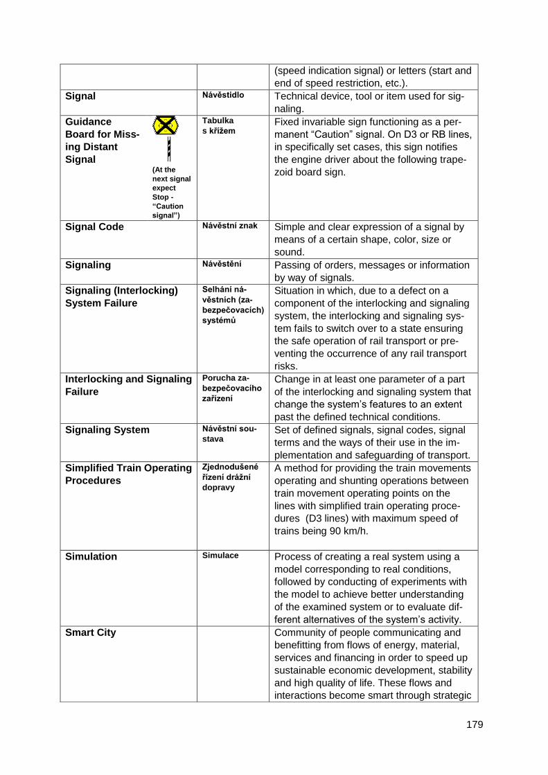
179
(speed indication signal) or letters (start and
end of speed restriction, etc.).
Signal Návěstidlo
Technical device, tool or item used for sig-
naling.
Guidance
Board for Miss-
ing Distant
Signal
(At the
next signal
expect
Stop -
“Caution
signal”)
Tabulka
s křížem
Fixed invariable sign functioning as a per-
manent “Caution” signal. On D3 or RB lines,
in specifically set cases, this sign notifies
the engine driver about the following trape-
zoid board sign.
Signal Code Návěstní znak
Simple and clear expression of a signal by
means of a certain shape, color, size or
sound.
Signaling Návěstění
Passing of orders, messages or information
by way of signals.
Signaling (Interlocking)
System Failure
Selhání ná-
věstních (za-
bezpečovacích)
systémů
Situation in which, due to a defect on a
component of the interlocking and signaling
system, the interlocking and signaling sys-
tem fails to switch over to a state ensuring
the safe operation of rail transport or pre-
venting the occurrence of any rail transport
risks.
Interlocking and Signaling
Failure
Porucha za-
bezpečovacího
zařízení
Change in at least one parameter of a part
of the interlocking and signaling system that
change the system’s features to an extent
past the defined technical conditions.
Signaling System Návěstní sou-
stava
Set of defined signals, signal codes, signal
terms and the ways of their use in the im-
plementation and safeguarding of transport.
Simplified Train Operating
Procedures
Zjednodušené
řízení drážní
dopravy
A method for providing the train movements
operating and shunting operations between
train movement operating points on the
lines with simplified train operating proce-
dures (D3 lines) with maximum speed of
trains being 90 km/h.
Simulation Simulace
Process of creating a real system using a
model corresponding to real conditions,
followed by conducting of experiments with
the model to achieve better understanding
of the examined system or to evaluate dif-
ferent alternatives of the system’s activity.
Smart City Community of people communicating and
benefitting from flows of energy, material,
services and financing in order to speed up
sustainable economic development, stability
and high quality of life. These flows and
interactions become smart through strategic
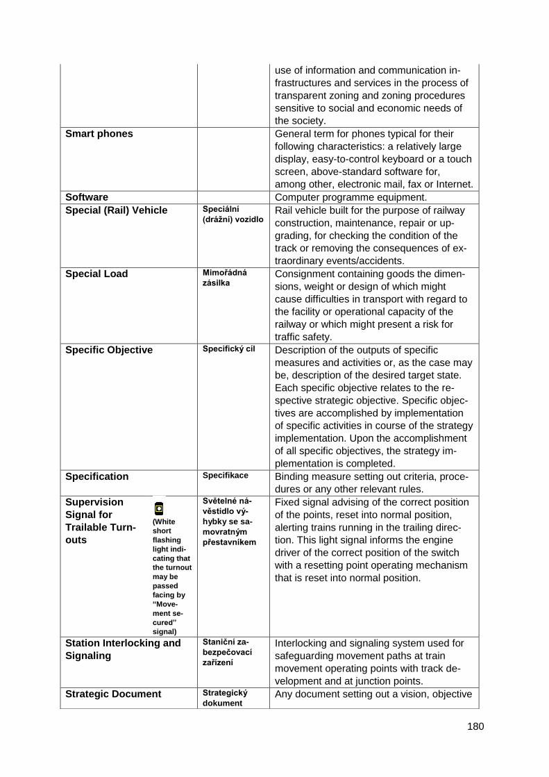
180
use of information and communication in-
frastructures and services in the process of
transparent zoning and zoning procedures
sensitive to social and economic needs of
the society.
Smart phones General term for phones typical for their
following characteristics: a relatively large
display, easy-to-control keyboard or a touch
screen, above-standard software for,
among other, electronic mail, fax or Internet.
Software Computer programme equipment.
Special (Rail) Vehicle Speciální
(drážní) vozidlo
Rail vehicle built for the purpose of railway
construction, maintenance, repair or up-
grading, for checking the condition of the
track or removing the consequences of ex-
traordinary events/accidents.
Special Load Mimořádná
zásilka
Consignment containing goods the dimen-
sions, weight or design of which might
cause difficulties in transport with regard to
the facility or operational capacity of the
railway or which might present a risk for
traffic safety.
Specific Objective Specifický cíl
Description of the outputs of specific
measures and activities or, as the case may
be, description of the desired target state.
Each specific objective relates to the re-
spective strategic objective. Specific objec-
tives are accomplished by implementation
of specific activities in course of the strategy
implementation. Upon the accomplishment
of all specific objectives, the strategy im-
plementation is completed.
Specification Specifikace
Binding measure setting out criteria, proce-
dures or any other relevant rules.
Supervision
Signal for
Trailable Turn-
outs
(White
short
flashing
light indi-
cating that
the turnout
may be
passed
facing by
“Move-
ment se-
cured”
signal)
Světelné ná-
věstidlo vý-
hybky se sa-
movratným
přestavníkem
Fixed signal advising of the correct position
of the points, reset into normal position,
alerting trains running in the trailing direc-
tion. This light signal informs the engine
driver of the correct position of the switch
with a resetting point operating mechanism
that is reset into normal position.
Station Interlocking and
Signaling
Staniční za-
bezpečovací
zařízení
Interlocking and signaling system used for
safeguarding movement paths at train
movement operating points with track de-
velopment and at junction points.
Strategic Document Strategický
dokument Any document setting out a vision, objective
181
or measure in the given sphere. Strategic
documents include, without limitation, strat-
egies, concepts, action plans or develop-
ment plans.
Strategic Objective
Strategický cíl
Description of the future state of individual
partial areas of the relevant problem
through which the global objective will be
met. An aggregate of the results and im-
pacts of individual specific objectives. Each
strategic objective relates to a particular
part of the strategy. A strategic objective is
accomplished as soon as the strategy im-
plementation reaches its end, or over a
short or medium term.
Points
Výhybka
Rail equipment enabling the passage of
vehicles from one track to another without
interrupting the ride. Part of the points
equipped with switch blade is called a
switch.
Trailable Turnouts Výhybka se
samovratným
přestavníkem
These points are mainly used in railway
stations on tracks with simplified train oper-
ating procedures as provided for in the
“SŽDC D3” Rule, on industrial tracks, etc.
Trailable turnouts mechanisms enable rail-
way vehicles to run across a points from
three directions without any assistance of
the points operator or of the interlocking and
signaling system. The fourth direction is
operated in a traditional way by manual ad-
justment of the points mechanism.
Target Group Cílová skupina
In terms of the strategy set-up (its objec-
tives and measures) a person, group of
persons or an institution to be affected by
the implementation of the strategy as
planned. In terms of communications, a
person, group of persons or an institution
that can or should be informed (through
various means, tools and at a different in-
tensity) of the progress, outputs and results
of strategy formation. The target group in
terms of strategy set-up does not necessari-
ly have to be the target group in terms of
communications, and vice versa.
Tariff Tarif
Scale of prices for individual carriage acts
performed as part of carriage services, and
the terms and conditions of their use.
Technical Specifications
for Interoperability (TSI)
Technické
specifikace pro
interoperabilitu
(TSI)
Set technical requirements for the subsys-
tems of the European rail system: infra-
structure, energy, rolling stock, control-
command and signaling, traffic and traffic
management and telematics applications in
182
passenger and freight transport, including
the respective deployment procedures.
Telecommunications Telekomunika-
ce
Set of methods, equipment and measures
through which one participant may com-
municate to another participant (one or
more) any information at any distance using
any form of an appropriate telecommunica-
tion system.
Telecommunications
Network (also Electronic
Communications Net-
works)
Telekomuni-
kační síť
(též sítě elek-
tronických
komunikací)
Functionally interconnected set of telecom-
munications equipment, which enables the
transfer of information between end points
of the network, or a set of radio equipment
for the transmission of information, or their
combination. Telecommunications network
is a mobile network of an operator and tele-
communications equipment is a mobile ter-
minal. Telecommunications networks are
built to provide services such as voice, tele-
vision, and Internet access.
Telecommunication
Equipment
Telekomuni-
kační zařízení
A set of equipment for processing and utili-
zation of telecommunications signals which
carry information in different forms.
Ticket Jízdenka
Type of consignment note entitling passen-
gers to transport.
Timetable Jízdní řád
Summary of information concerning ser-
vices operated on a given line and connect-
ing services running at given times and in
given locations. Contains, at least, infor-
mation on the departure and arrival times
from/to respective stops and stations.
Top-Down Planning method which sets out objectives
and ways to achieve them proceeding from
top to bottom. First, global (framework) stra-
tegic objectives and manners to achieve
them are defined. These are subsequently
split into lower and lower levels of the or-
ganizational hierarchy and are further elab-
orated and specified. It is a concept of di-
vergence, its disadvantage being that the
planning method lacks feedback.
Track Kolej
Two rails fixed on sleepers at a distance
called the track gauge.
Track Circuit Kolejový obvod
Electric set comprising electric components
of track circuit and the track circuit section
used for identifying if the relevant line sec-
tion is clear of railway vehicles or occupied.
The status of a clear or occupied line is
identified on the basis of a conductive con-
nection of compact rail strings and the rail
vehicle axle.
183
Track Interlocking and
Signaling
Traťové zabez-
pečovací zaří-
zení
Interlocking and signaling equipment used
to secure the movement of trains on a track
between train movement operating points
with track development.
Traction Trakce
Set of devices and activities associated with
propelling a vehicle in the form of exerting
tractive force, of dynamic braking or of pro-
pulsion. Traction in railway transport: steam,
diesel and electric.
Traffic Dopravní pro-
voz
Aggregate of activities accomplishing the
transport process (vehicle movement).
Traffic Accident Dopravní ne-
hoda
Emergency event involving damage to per-
sonal health or property in direct connection
with the operation of a means of transport
or a transport facility.
Traffic Control Centre Dopravní řídící
centrum Using sensor-collected data, the centre per-
forms traffic control via end devices such as
traffic controllers, variable messages signs,
etc.
Traffic Data Dopravní data
Data outputs mainly from ITS applications
(including telematics applications) and traf-
fic information systems, interpreted into
comprehensible form, characterizing the
traffic situation, and suitable for distribution
to road users and traffic participants.
Traffic Detectors Dopravní de-
tektory
Technical devices collecting data on traffic
flow and transport infrastructure (inductive
loops, automatic traffic counters, video-
detection systems, weather stations, etc.).
Traffic Dispatching Dopravní dis-
pečink
Professional operating control or, if neces-
sary, also checking of the transport process
in a particular organization or on a particular
territory from a single point.
Traffic Flow (Road Traffic) Dopravní proud
(silniční pro-
voz)
Sequence of all vehicles and pedestrians
moving in one lane one after another or
alongside each other in parallel lanes fol-
lowing the same traffic direction; the traffic
flow may consist of several running or pe-
destrian flows.
Traffic Information Dopravní in-
formace
Information on the traffic situation having
direct or indirect impact on road traffic safe-
ty and continuity.
Traffic Information Centre Dopravní in-
formační cent-
rum
Regional or national centre providing traffic
information before or during travelling which
relate to road traffic or the traffic route con-
ditions. The Centre is attended by staff.
Traffic Information Device Zařízení pro
provozní in-
formace
An active element which enables the ex-
change of information about traffic condi-
tions on roads (traffic accidents, traffic ob-
structions, etc.) on a defined road section.
184
Traffic Intensity (Road
Traffic)
Intenzita do-
pravy (silniční
provoz)
Number of vehicles running or pedestrians
walking through the cross-section of a road
at a given period of time.
Train Vlak
A series of rail vehicles (also of special ve-
hicles) consisting of at least one driving
and one towed vehicle, marked with defined
indicators, having a train crew and running
based on a timetable or instructions of a
competent person controlling railway
transport. A train can also consist of only
one locomotive (special as well).
Train Dispatcher Výpravčí A term referring to all staff authorized to
organize rail transport and provide safe and
efficient train and shunting movements.
Train Dispatcher for Cen-
tralized Traffic Control
Výpravčí DOZ
An employee who provides safe and effi-
cient train and shunting movements over an
assigned small-scale dispatching district
(one train movement operating point locally
or more train movement operating points
remotely).
Train Diversion Route Odklonová
trasa vlaku
Train route necessary for a train to run
along a diversion route. Trains going on
diversion routes run under their original
numbers and according to the timetable set
for this route.
Train (Cab) Interlocking
and Signaling
Vlakové zabez-
pečovací zaří-
zení
Interlocking and signaling equipment for
securing reliable and safe control of the
train. In this apparatus, some functions of
the station, track, or level crossing signaling
equipment may be part of the devices situ-
ated on the locomotive itself. Part of the
equipment on the locomotive or control ve-
hicle is called the mobile part of the train
protection system (train control) and is used
to receive and evaluate information trans-
mitted from the track. It also serves to peri-
odically check the alertness of the person
controlling the railway vehicle. This part can
be operated independently without coordi-
nation with other interlocking and signaling
equipment.
Train Timetable Jízdní řád vla-
ku
Specific time location of a train at a specific
section of the train line.
Train Traffic Diagram Grafikon vla-
kové dopravy
Summary of measures and tools related to
train traffic. Prepared and issued for a time-
period set in line with international railway
agreements and treaties. Introduced across
the entire network at a single time. Train
traffic diagram tools contain instructions for
organizing rail transport and train running.
185
Telephone Communica-
tion (as the safe working
procedure for the opera-
tion of the train move-
ment control)
Telefonické
dorozumívání
Train movements are interlocked by tele-
phone communication by a telephone ad-
vice or, in specified cases, by telephone
request and acceptance.
Transport Doprava
Intentional activity involving spatial transfer
of persons and items via traffic routes, using
means of transport, energy and labor force.
Transport Contractor Přepravce
Carrier’s customer in freight transport. Ag-
gregate designation for consignor and con-
signee of the consignment. A customer of
the carrier in passenger transport is referred
to as passenger. This concept dates back to
1964 when a single term for all carrier cus-
tomers was introduced. However, based on
linguistic sense, the wider public regards a
transport contractor as an active participant
in the transport process rather than a user
of the results of transport/carriage.
Transport Mode Druh dopravy
Transport characterized by a specific com-
mon feature (e.g. means of transport, traffic
route, transport equipment) regardless of
organizational and local integration.
Transport Branch Obor dopravy
Sphere of transport characterized by a spe-
cific organizational complex and manage-
ment, using primarily a specific type of
transport means.
Transport Network Dopravní síť
Aggregate of transport routes delimited by a
territory.
Transport Process Dopravní pro-
ces
Aggregate of time-connected, factually rele-
vant acts accomplishing and securing
transport.
Forwarding Process Přepravní pro-
ces
Sum of subsequent, factually and time-
related acts through which carriage is im-
plemented and safeguarded.
Transport Route Dopravní trasa
Setting the route in terms of direction, alti-
tude or even position, if necessary.
Transport System Dopravní sys-
tém
Aggregate of interconnected elements
(means of transport and transport equip-
ment/facilities, transport infrastructure and
traffic organization) on a designated territory
(e.g. region, country or continent) where
transport process is taking place (carriage
of passengers, goods and information).
Transport Terminal Dopravní ter-
minál
Area where consignments are loaded, un-
loaded or reloaded or the mode of transport
is changed. In individual car transport, a
terminal may be, for instance, a car park, in
public passenger transport a bus/coach or
train station, in air transport terminals are
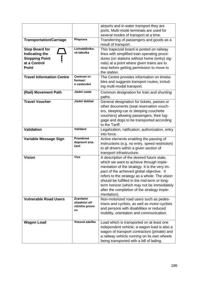
186
airports and in water transport they are
ports. Multi-mode terminals are used for
several modes of transport at a time.
Transportation/Carriage Přeprava
Transferring of passengers and goods as a
result of transport.
Stop Board for
Indicating the
Stopping Point
at a Control
Point
Lichoběžníko-
vá tabulka
This trapezoid board is posted on railway
lines with simplified train operating proce-
dures (on stations without home (entry) sig-
nals) at a point where given trains are to
stop before getting permission to move to
the station.
Travel Information Centre Centrum in-
formací
o cestování
The Centre provides information on timeta-
bles and suggests transport routes, includ-
ing multi-modal transport.
(Rail) Movement Path
Jízdní cesta
Common designation for train and shunting
paths.
Travel Voucher Jízdní doklad
General designation for tickets, passes or
other documents (seat reservation vouch-
ers, sleeping-car or sleeping couchette
vouchers) allowing passengers, their lug-
gage and dogs to be transported according
to the Tariff.
Validation Validace
Legalization, ratification, authorization, entry
into force.
Variable Message Sign Proměnné
dopravní zna-
čení
Active elements enabling the passing of
instructions (e.g. no entry, speed restriction)
to all drivers within a given section of
transport infrastructure.
Vision Vize A description of the desired future state,
which we want to achieve through imple-
mentation of the strategy. It is the very im-
pact of the achieved global objective. It
refers to the strategy as a whole. The vision
should be fulfilled in the mid-term or long-
term horizon (which may not be immediately
after the completion of the strategy imple-
mentation).
Vulnerable Road Users Zranitelní
účastníci sil-
ničního provo-
zu
Non-motorized road users such as pedes-
trians and cyclists, as well as motor-cyclists
and persons with disabilities or reduced
mobility, orientation and communication.
Wagon Load Vozová zásilka
Load which is transported on at least one
independent vehicle; a wagon load is also a
wagon of transport contractors (private) and
a railway vehicle running on its own wheels
being transported with a bill of lading.
187
Technical terms with the adjective “spatial” are used in many fields and thus have multiple
definitions and interpretations. In this document, the term “spatial” is a synonym for “geo-
graphic”. Similarly, the prefix “geo” in some of the terms which were used herein replaces the
adjective “geographic“ or “spatial”.
In the case of some general terms, we chose those definitions (from all that exist), which are
directly associated with the field of infrastructure for spatial information.
Distant signal
(“Caution”
signal
indicating
“be pre-
pared to
stop at
next sig-
nal” -
yellow
light)
Předvěst (sa-
mostatná)
Fixed signal located at a permissible brake
distance before the next main signal. Used
to warn the engine driver of the oncoming
main signal.
Website Webová strán-
ka Internet site containing information (text,
images, animations, voice) as well as links
which easily refer the user from one page to
another. Every website is hosted on a serv-
er and has its own unique URL (Uniform
Resource Locator) address. Websites can
be displayed using browsers (e.g. Netscape
Navigator or Internet Explorer).
White Paper Bílá kniha
Report or hand-book designed to help re-
solve a particular issue and to facilitate de-
cision-making. Contrary to Green Papers,
White Papers contain specific proposals for
adopting measures in specific policy areas.
White Papers reflect upon results of public
consultations on the proposals and outline
possible legislative measures. White Papers
are submitted for debate to political repre-
sentatives (the College of Commissioners of
the EC).
WiFi Wireless networking technology that allows
you to connect to the Internet in the vicinity
of a required transmitter / access point.
Wireless application pro-
tocol (WAP)
Protocol for wireless communication, de-
signed to provide access to Internet ser-
vices through various wireless communica-
tion network solutions. WAP is primarily
designed for mobile devices.
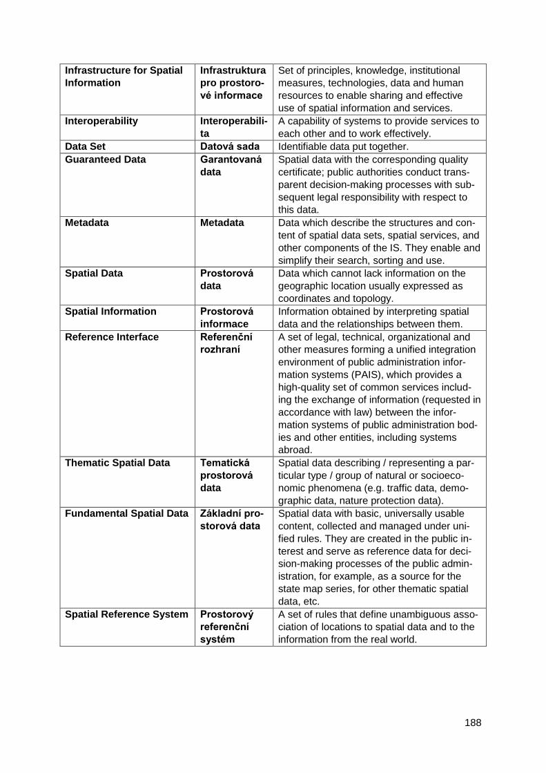
188
Infrastructure for Spatial
Information
Infrastruktura
pro prostoro-
vé informace
Set of principles, knowledge, institutional
measures, technologies, data and human
resources to enable sharing and effective
use of spatial information and services.
Interoperability Interoperabili-
ta
A capability of systems to provide services to
each other and to work effectively.
Data Set Datová sada Identifiable data put together.
Guaranteed Data Garantovaná
data
Spatial data with the corresponding quality
certificate; public authorities conduct trans-
parent decision-making processes with sub-
sequent legal responsibility with respect to
this data.
Metadata Metadata Data which describe the structures and con-
tent of spatial data sets, spatial services, and
other components of the IS. They enable and
simplify their search, sorting and use.
Spatial Data Prostorová
data
Data which cannot lack information on the
geographic location usually expressed as
coordinates and topology.
Spatial Information Prostorová
informace
Information obtained by interpreting spatial
data and the relationships between them.
Reference Interface Referenční
rozhraní
A set of legal, technical, organizational and
other measures forming a unified integration
environment of public administration infor-
mation systems (PAIS), which provides a
high-quality set of common services includ-
ing the exchange of information (requested in
accordance with law) between the infor-
mation systems of public administration bod-
ies and other entities, including systems
abroad.
Thematic Spatial Data Tematická
prostorová
data
Spatial data describing / representing a par-
ticular type / group of natural or socioeco-
nomic phenomena (e.g. traffic data, demo-
graphic data, nature protection data).
Fundamental Spatial Data Základní pro-
storová data
Spatial data with basic, universally usable
content, collected and managed under uni-
fied rules. They are created in the public in-
terest and serve as reference data for deci-
sion-making processes of the public admin-
istration, for example, as a source for the
state map series, for other thematic spatial
data, etc.
Spatial Reference System Prostorový
referenční
systém
A set of rules that define unambiguous asso-
ciation of locations to spatial data and to the
information from the real world.