Embed Size (px)
Citation preview
Activation history of the Hutchinson dunes in east-central Kansas, USA duringthe past 2200 years
Alan F. Halfen a,!, William C. Johnson a, Paul R. Hanson b, Terri L. Woodburn a, Aaron R. Young b,Gregory A. Ludvigson c
aDepartment of Geography, University of Kansas, 213 Lindley Hall, 1475 Jayhawk Blvd., Lawrence, KS 66045, USAb School of Natural Resources, University of Nebraska-Lincoln, Hardin Hall, Lincoln, NE 68583, USAcKansas Geological Survey, University of Kansas, 111 Parker Hall, Lawrence, KS 66045, USA
a r t i c l e i n f o
Article history:Received 4 October 2011Revised 20 February 2012Accepted 20 February 2012
Keywords:DroughtAeolian dunesOptical stimulated luminescence (OSL)datingMedieval Climate Anomaly (MCA)Little Ice Age (LIA)North American Great Plains
a b s t r a c t
This paper presents data for the Hutchinson dunes, the third and southernmost of three dunefields thatcollectively span a 400 km north–south transect of the eastern Great Plains. Optically stimulated lumi-nescence dating was used to create a new, high temporal- and spatial-resolution chronology of dunefieldactivity, which spans the last 2200 years. Ages indicate that three major episodes of dune activityoccurred !2100–1800, !1000–900, and after !600 years ago, especially within the past 420–70 years.Dune activity !1000–900 years ago correlates to the height of the Medieval Climatic Anomaly. Wide-spread dune activity during the past 600 years, which peaked !320 and !200 years ago, correlates withthe coolest periods of the Little Ice Age. Dune activity in the Hutchinson dunes during the Medieval Cli-matic Anomaly correlates well with available proxy data and dune records from the region, includingother eastern-margin dunefields, and suggests that one or more severe droughts were occurring through-out most of the Great Plains at this time. Dune activity during the Little Ice Age, unlike that of the Medi-eval Climatic Anomaly, does not correlate with other eastern margin dunefields, but does with those inwestern Kansas, Colorado, Oklahoma, and Texas and with other regional proxies. This pattern suggeststhat Little Ice Age droughts, unlike those associated with the Medieval Climatic Anomaly, were lessintense and/orgeographically limited. Little Ice Age droughts, though, were still significant as evidencedby the migration of large dune forms in the Hutchinson dunes at this time.
! 2012 Elsevier B.V. All rights reserved.
1. Introduction
Dunefields of the North American Great Plains are importantindicators of past drought because, during extended times ofreduced moisture, vegetation cover is diminished and aeoliansedimentation ensues (Muhs and Holliday, 1995). By assigningchronologies to aeolian sedimentation events, evaluations can bemade regarding the timing and extent of these droughts. This datacollection is particularly important in regions like the NorthAmerican Great Plains because traditional drought proxies, suchas tree rings and fossil pollen, are less common in the paleoclimaterecord (cf., Stahle et al., 2007). Research using dunefields as indica-tors of drought has identified region-wide, long-term droughtsfrom large dunefields of the Great Plains (e.g., Mason et al., 2004;Forman et al., 2005; Sridhar et al., 2006; Miao et al., 2007). Recentemphasis, however, has focused on drought records from smallerand more peripheral dunefields of the eastern Great Plains (Hansonet al., 2009, 2010). In keeping with this approach, this study pre-
sents a new, high-resolution chronology from a small dunefieldalong the eastern margin of the east-central Great Plains. Theaim of this study, like those prior, is to determine the spatial extentof well-documented Holocene droughts. The first of these studiesinvestigated the Duncan dunes in Nebraska (Hanson et al., 2009),and the second, the Abilene dunes in Kansas (Hanson et al.,2010) (Fig. 1). As with these previous studies, dating dune activityin the Hutchinson dunes will provide important spatial and tempo-ral data on the eastward propagation of Holocene droughts previ-ously recognized in major dunefields of the Great Plains (e.g., theNebraska Sand Hills; Miao et al., 2007). This study also presentsthe first numerical ages of dune activity in the Hutchinson dunesand places that record within the broader context of Great Plainsaeolian activity and past climate change.
2. Previous studies
Although dunefields cover vast areas of the Great Plains, muchof the aeolian-derived, regional drought record has been basedon chronologies from a combination of optically stimulated
1875-9637/$ - see front matter ! 2012 Elsevier B.V. All rights reserved.http://dx.doi.org/10.1016/j.aeolia.2012.02.001
! Corresponding author. Tel.: +1 847 951 8990; fax: +1 785 864 5378.E-mail address: [email protected] (A.F. Halfen).
Aeolian Research 5 (2012) 9–20
Contents lists available at SciVerse ScienceDirect
Aeolian Research
journal homepage: www.elsevier .com/locate /aeol ia
luminescence (OSL) and radiocarbon dating, which for the mostpart have been generated from the Nebraska Sand Hills, and theWray and Fort Morgan dunes of Colorado (e.g., Madole, 1995;Forman et al., 2001, 2005; Clarke and Rendell, 2003; Goble et al.,2004; Mason et al., 2004, 2011; Miao et al., 2007) (Fig. 1).Drought-induced dune activity occurred in the Nebraska Sand Hillsbetween !9600 and !6500 years ago and during events centered!3800, !2500, and !700 years ago (Goble et al., 2004; Masonet al., 2004; Miao et al., 2007). Forman et al. (2005) alsodocumented aeolian activity in the far western Nebraska Sand Hills!3700, !670, !470, !240, !140, and !70 years ago. Additionally,the Wray and Fort Morgan dunes of eastern Colorado (Fig. 1) wereactive !540, !420, and !70 years ago, and !4900, !2400, !1100,!800, !600–530, and !370 years ago, respectively (Forman et al.,2005; Clarke and Rendell, 2003).
Less attention has been given to dunes south and east of the Ne-braska Sand Hills, for example, the Arkansas River valley and theGreat Bend Sand Prairie of Kansas (e.g., Arbogast, 1996; Arbogastand Johnson, 1998; Forman et al., 2008), dunefields adjacent tothe Cimarron River in Oklahoma (e.g., Lepper and Scott, 2005;Wer-ner et al., 2011), and those of the Southern High Plains (Holliday,1997, 2001) (Fig. 1). Radiocarbon dating of buried soils in the GreatBend Sand Prairie, Kansas (Fig. 1) indicated periods of dune stabil-ity !6700, !3700, !2300, !1400, !1100, !700, and !300 yearsago (Arbogast, 1996; Arbogast and Johnson, 1998)—each of theseperiods of stability was followed by aeolian activity. Formanet al. (2008) recognized dune activity within the Arkansas Riverdunes !1500, !430, !380–320, !180, and !70 years ago, and, in
the Cimarron River valley of west-central Oklahoma and west-cen-tral Kansas, dunes were activated !900–700 years ago (Lepper andScott, 2005) and !800–400 years ago (Werner et al., 2011) (Fig. 1).Aeolian activity on the Southern High Plains occurred in the Mule-shoe dunes after !1300, !700, !500 years ago, in the Lea-Yoakumdunes following !3400 years ago, in the Andrews dunes after!2300 years ago, and in the Seminole sand sheet between !400and !300 years ago (Holliday, 2001). Additionally, all dunefieldsstudied by Holliday (2001) were active within the last 200 years.
Several smaller dunefields lie on the eastern margin of the GreatPlains (Fig. 1). The Duncan dunes in the eastern Platte River valley,Nebraska were active !4300–3500 years ago and !900–500 yearsago (Hanson et al., 2009), and a companion study of the Abilenedunes (Hanson et al., 2010) documented activation at !1100–500 years ago. The latter periods of activity from both the Duncanand Abilene dunes correspond very well with regional dunefieldrecords, including those from the Nebraska Sand Hills (Miaoet al., 2007) and from other dunefields in Kansas and Oklahoma(Arbogast, 1996; Arbogast and Johnson, 1998; Lepper and Scott,2005; Werner et al., 2011).
In addition to paleoclimatic records derived from dunefieldactivity, some data exist from other Great Plains drought proxies,though these data at times are limited in spatial coverage and insome instances, such as lake sediments, are of coarser resolutionwith less accurate temporal control (Woodhouse and Overpeck,1998). Nevertheless, drought identified in available records gener-ally correlates well with Great Plains aeolian activation records.Schmieder et al. (2011), for example, provided a 4000-year recordof drought from the Nebraska Sand Hills. These investigators con-tended that drought activity prior to 2000 years ago was more pre-valent, but, they also documented both the MCA megadrought andmany smaller ‘‘minidroughts’’ within the last 2000 years. Further,they attempted to correlate dune activity in the Nebraska SandHills with their drought record and concluded that many Holoceneminidroughts recorded in the lake records are not present in theaeolian record.
Laird et al. (1996) documented four Holocene hydrological peri-ods in Moon Lake, North Dakota: (1) a transitional period from gla-cial conditions to the earliest Holocene; (2) dry conditions duringthe mid Holocene !7300–4700 years ago; (3) another transitionalperiod between 4700 and 2200 years ago; and (4) a period of in-creased, but variable, aridity during the past 2200 years. While rec-ognizing variability during the past 2200 years, Laird et al. (1996)also documented specific increases in aridity during the MedievalClimatic Anomaly (MCA). Similarly, Fritz et al. (1994) reportedaridity in North Dakota during the Little Ice Age (LIA).
Using lake-water salinity records from North Dakota, Fritz et al.(2000) documented highly variable climate during the past2000 years and argued specifically that the MCA and LIA werehydrologically complex, though they also argued that the changesin moisture documented during the MCA and LIA differed littlefrom those recorded in the longer-term hydrological patterns ofthe Great Plains. Most recently, Hobbs et al. (2011), using diatomsto reconstruct lake salinity records from Kettle Lake, North Dakota,reported several episodes of aridity following !8400, !4400, and!870 years ago in the northern Great Plains.
Rapid channel incision, which results from greater surface run-off due to less vegetation cover, has provided another droughtproxy for the Great Plains. Incision events corresponding to theMCAwere reported for multiple basins of the southern Great Plainsby Hall (1990) and in the Republican River basin of southern Ne-braska by Daniels and Knox (2005). Tree-ring series from the wes-tern United States have also provided useful paleoclimate data onthe timing of recent drought episodes (e.g., Grissino-Mayer, 1996;Cook et al., 2004, 2007). Specifically, Cook et al. (2004) recognizedwidespread drought !1100–700 years ago, an interval that
NSH
AR
FM W
CD
500
mm
700
mm
900
mm
1100
mm
GBSP
CV
DD
AB
HD
Platte R.
Arkansas R.Canadian R.
Red R.
Brazos R.
200 km N
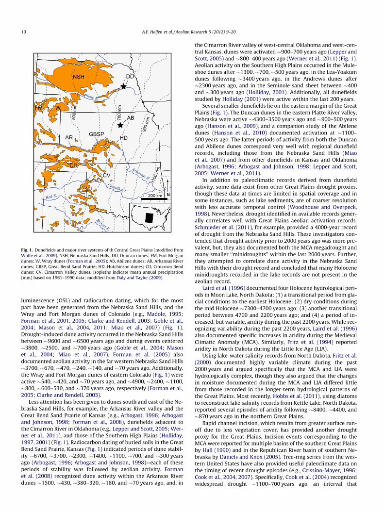
Fig. 1. Dunefields and major river systems of th Central Great Plains (modified fromWolfe et al., 2009). NSH, Nebraska Sand Hills; DD, Duncan dunes; FM, Fort Morgandunes; W, Wray dunes (Forman et al., 2005); AB, Abilene dunes; AR, Arkansas Riverdunes; GBSP, Great Bend Sand Prairie; HD, Hutchinson dunes; CD, Cimarron Benddunes; CV, Cimarron Valley dunes. Isopleths indicate mean annual precipitation(mm) based on 1961–1990 data; modified from Daly and Taylor (2009).
10 A.F. Halfen et al. / Aeolian Research 5 (2012) 9–20
matches the timing of the MCA. Cook et al. (2007) also documenteddrought in the Mississippi River valley !1000, !900–750, and!650–600 years ago.
3. Study area
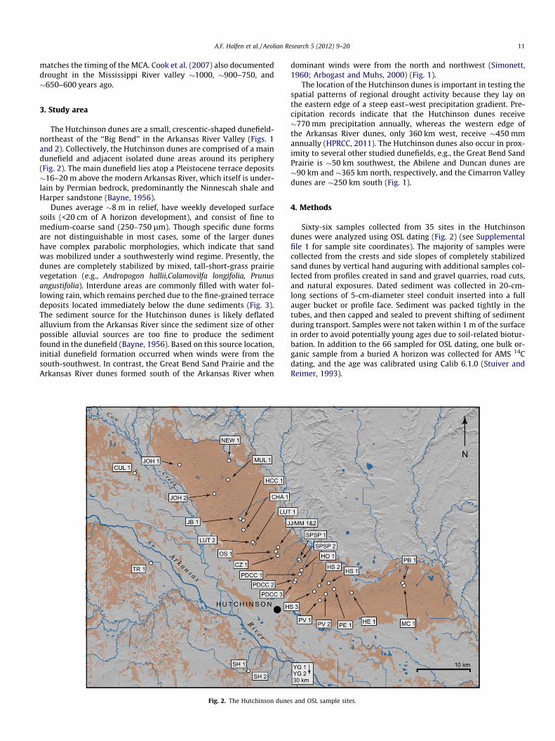
The Hutchinson dunes are a small, crescentic-shaped dunefield-northeast of the ‘‘Big Bend’’ in the Arkansas River Valley (Figs. 1and 2). Collectively, the Hutchinson dunes are comprised of a maindunefield and adjacent isolated dune areas around its periphery(Fig. 2). The main dunefield lies atop a Pleistocene terrace deposits!16–20 m above the modern Arkansas River, which itself is under-lain by Permian bedrock, predominantly the Ninnescah shale andHarper sandstone (Bayne, 1956).
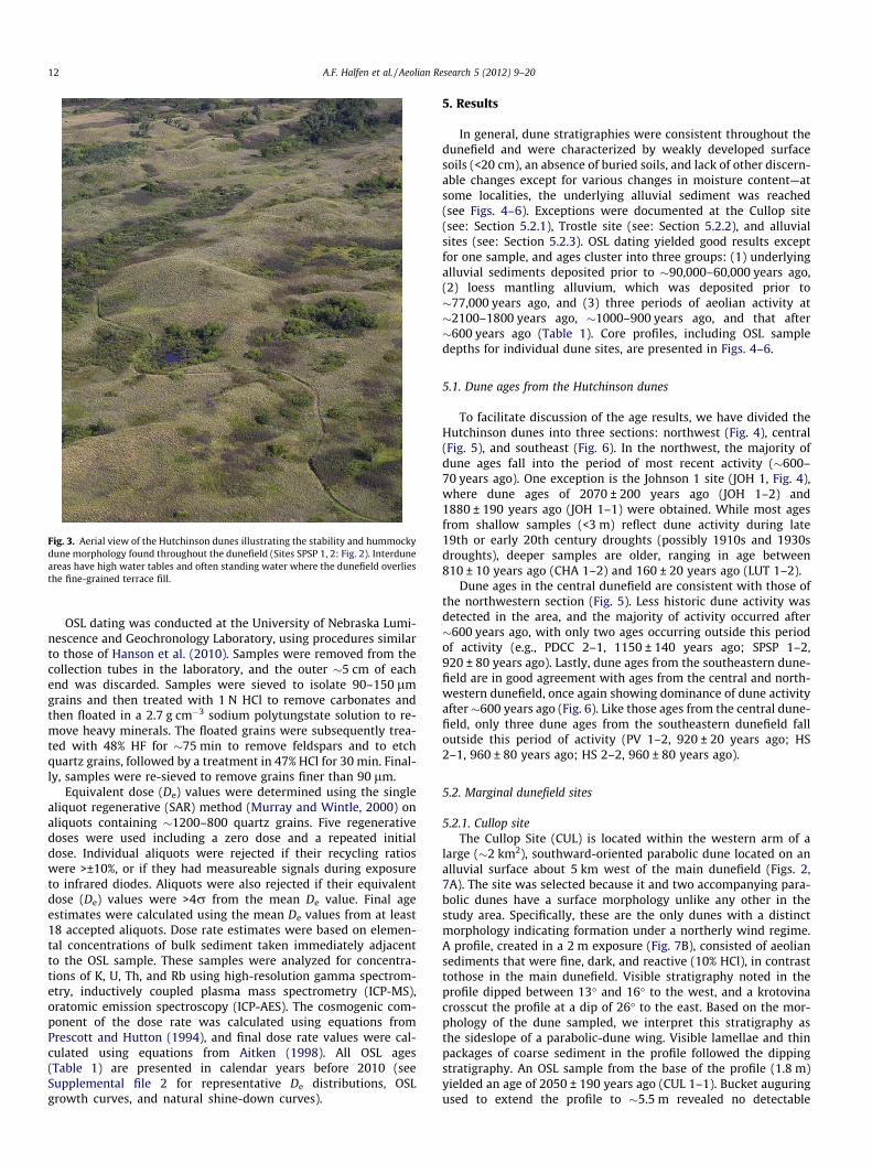
Dunes average !8 m in relief, have weekly developed surfacesoils (<20 cm of A horizon development), and consist of fine tomedium-coarse sand (250–750 lm). Though specific dune formsare not distinguishable in most cases, some of the larger duneshave complex parabolic morphologies, which indicate that sandwas mobilized under a southwesterly wind regime. Presently, thedunes are completely stabilized by mixed, tall-short-grass prairievegetation (e.g., Andropogon hallii,Calamovilfa longifolia, Prunusangustifolia). Interdune areas are commonly filled with water fol-lowing rain, which remains perched due to the fine-grained terracedeposits located immediately below the dune sediments (Fig. 3).The sediment source for the Hutchinson dunes is likely deflatedalluvium from the Arkansas River since the sediment size of otherpossible alluvial sources are too fine to produce the sedimentfound in the dunefield (Bayne, 1956). Based on this source location,initial dunefield formation occurred when winds were from thesouth-southwest. In contrast, the Great Bend Sand Prairie and theArkansas River dunes formed south of the Arkansas River when
dominant winds were from the north and northwest (Simonett,1960; Arbogast and Muhs, 2000) (Fig. 1).
The location of the Hutchinson dunes is important in testing thespatial patterns of regional drought activity because they lay onthe eastern edge of a steep east–west precipitation gradient. Pre-cipitation records indicate that the Hutchinson dunes receive!770 mm precipitation annually, whereas the western edge ofthe Arkansas River dunes, only 360 km west, receive !450 mmannually (HPRCC, 2011). The Hutchinson dunes also occur in prox-imity to several other studied dunefields, e.g., the Great Bend SandPrairie is !50 km southwest, the Abilene and Duncan dunes are!90 km and !365 km north, respectively, and the Cimarron Valleydunes are !250 km south (Fig. 1).
4. Methods
Sixty-six samples collected from 35 sites in the Hutchinsondunes were analyzed using OSL dating (Fig. 2) (see Supplementalfile 1 for sample site coordinates). The majority of samples werecollected from the crests and side slopes of completely stabilizedsand dunes by vertical hand auguring with additional samples col-lected from profiles created in sand and gravel quarries, road cuts,and natural exposures. Dated sediment was collected in 20-cm-long sections of 5-cm-diameter steel conduit inserted into a fullauger bucket or profile face. Sediment was packed tightly in thetubes, and then capped and sealed to prevent shifting of sedimentduring transport. Samples were not taken within 1 m of the surfacein order to avoid potentially young ages due to soil-related biotur-bation. In addition to the 66 sampled for OSL dating, one bulk or-ganic sample from a buried A horizon was collected for AMS 14Cdating, and the age was calibrated using Calib 6.1.0 (Stuiver andReimer, 1993).
Fig. 2. The Hutchinson dunes and OSL sample sites.
A.F. Halfen et al. / Aeolian Research 5 (2012) 9–20 11
OSL dating was conducted at the University of Nebraska Lumi-nescence and Geochronology Laboratory, using procedures similarto those of Hanson et al. (2010). Samples were removed from thecollection tubes in the laboratory, and the outer !5 cm of eachend was discarded. Samples were sieved to isolate 90–150 lmgrains and then treated with 1 N HCl to remove carbonates andthen floated in a 2.7 g cm"3 sodium polytungstate solution to re-move heavy minerals. The floated grains were subsequently trea-ted with 48% HF for !75 min to remove feldspars and to etchquartz grains, followed by a treatment in 47% HCl for 30 min. Final-ly, samples were re-sieved to remove grains finer than 90 lm.
Equivalent dose (De) values were determined using the singlealiquot regenerative (SAR) method (Murray and Wintle, 2000) onaliquots containing !1200–800 quartz grains. Five regenerativedoses were used including a zero dose and a repeated initialdose. Individual aliquots were rejected if their recycling ratioswere >±10%, or if they had measureable signals during exposureto infrared diodes. Aliquots were also rejected if their equivalentdose (De) values were >4r from the mean De value. Final ageestimates were calculated using the mean De values from at least18 accepted aliquots. Dose rate estimates were based on elemen-tal concentrations of bulk sediment taken immediately adjacentto the OSL sample. These samples were analyzed for concentra-tions of K, U, Th, and Rb using high-resolution gamma spectrom-etry, inductively coupled plasma mass spectrometry (ICP-MS),oratomic emission spectroscopy (ICP-AES). The cosmogenic com-ponent of the dose rate was calculated using equations fromPrescott and Hutton (1994), and final dose rate values were cal-culated using equations from Aitken (1998). All OSL ages(Table 1) are presented in calendar years before 2010 (seeSupplemental file 2 for representative De distributions, OSLgrowth curves, and natural shine-down curves).
5. Results
In general, dune stratigraphies were consistent throughout thedunefield and were characterized by weakly developed surfacesoils (<20 cm), an absence of buried soils, and lack of other discern-able changes except for various changes in moisture content—atsome localities, the underlying alluvial sediment was reached(see Figs. 4–6). Exceptions were documented at the Cullop site(see: Section 5.2.1), Trostle site (see: Section 5.2.2), and alluvialsites (see: Section 5.2.3). OSL dating yielded good results exceptfor one sample, and ages cluster into three groups: (1) underlyingalluvial sediments deposited prior to !90,000–60,000 years ago,(2) loess mantling alluvium, which was deposited prior to!77,000 years ago, and (3) three periods of aeolian activity at!2100–1800 years ago, !1000–900 years ago, and that after!600 years ago (Table 1). Core profiles, including OSL sampledepths for individual dune sites, are presented in Figs. 4–6.
5.1. Dune ages from the Hutchinson dunes
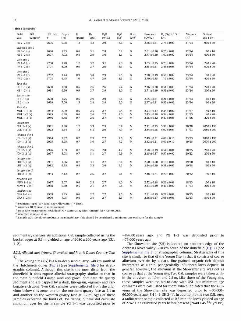
To facilitate discussion of the age results, we have divided theHutchinson dunes into three sections: northwest (Fig. 4), central(Fig. 5), and southeast (Fig. 6). In the northwest, the majority ofdune ages fall into the period of most recent activity (!600–70 years ago). One exception is the Johnson 1 site (JOH 1, Fig. 4),where dune ages of 2070 ± 200 years ago (JOH 1–2) and1880 ± 190 years ago (JOH 1–1) were obtained. While most agesfrom shallow samples (<3 m) reflect dune activity during late19th or early 20th century droughts (possibly 1910s and 1930sdroughts), deeper samples are older, ranging in age between810 ± 10 years ago (CHA 1–2) and 160 ± 20 years ago (LUT 1–2).
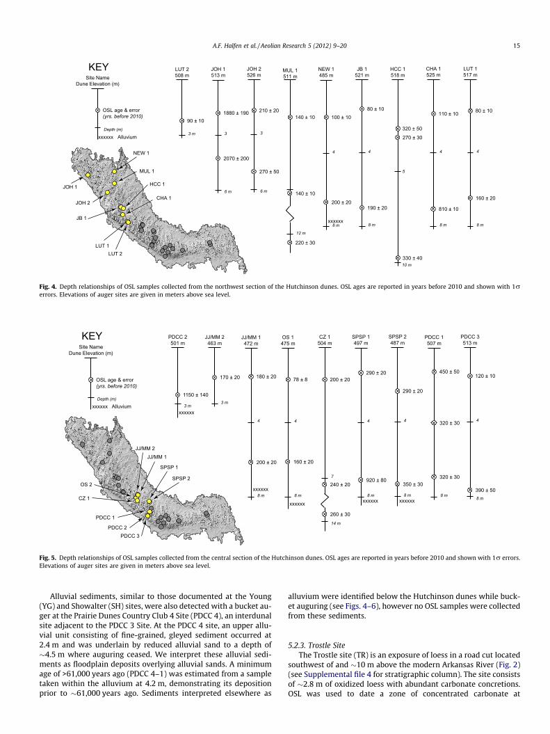
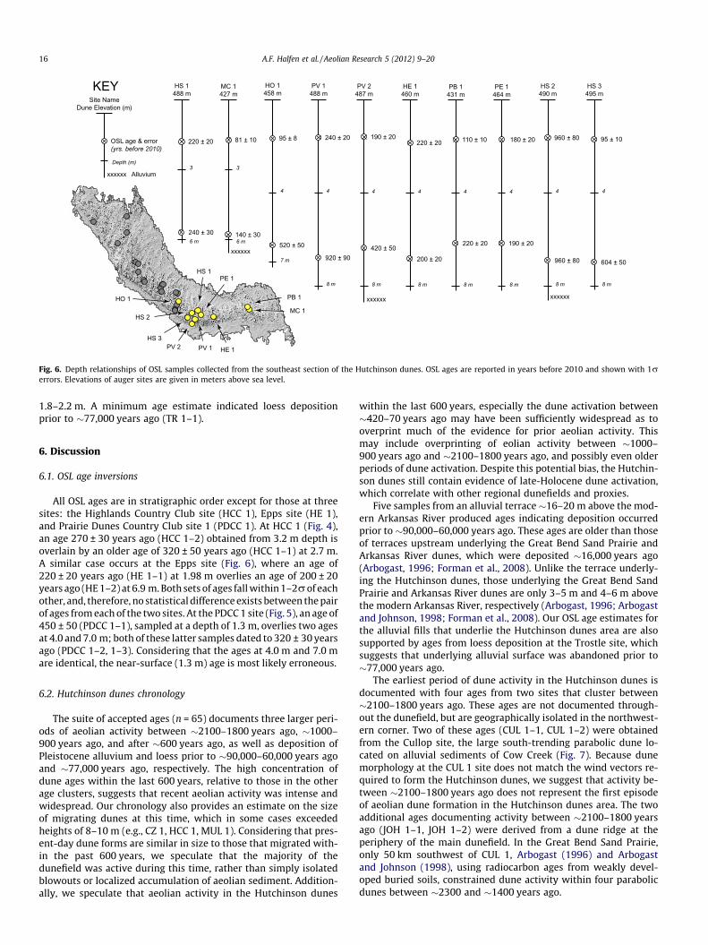
Dune ages in the central dunefield are consistent with those ofthe northwestern section (Fig. 5). Less historic dune activity wasdetected in the area, and the majority of activity occurred after!600 years ago, with only two ages occurring outside this periodof activity (e.g., PDCC 2–1, 1150 ± 140 years ago; SPSP 1–2,920 ± 80 years ago). Lastly, dune ages from the southeastern dune-field are in good agreement with ages from the central and north-western dunefield, once again showing dominance of dune activityafter!600 years ago (Fig. 6). Like those ages from the central dune-field, only three dune ages from the southeastern dunefield falloutside this period of activity (PV 1–2, 920 ± 20 years ago; HS2–1, 960 ± 80 years ago; HS 2–2, 960 ± 80 years ago).
5.2. Marginal dunefield sites
5.2.1. Cullop siteThe Cullop Site (CUL) is located within the western arm of a
large (!2 km2), southward-oriented parabolic dune located on analluvial surface about 5 km west of the main dunefield (Figs. 2,7A). The site was selected because it and two accompanying para-bolic dunes have a surface morphology unlike any other in thestudy area. Specifically, these are the only dunes with a distinctmorphology indicating formation under a northerly wind regime.A profile, created in a 2 m exposure (Fig. 7B), consisted of aeoliansediments that were fine, dark, and reactive (10% HCl), in contrasttothose in the main dunefield. Visible stratigraphy noted in theprofile dipped between 13" and 16" to the west, and a krotovinacrosscut the profile at a dip of 26" to the east. Based on the mor-phology of the dune sampled, we interpret this stratigraphy asthe sideslope of a parabolic-dune wing. Visible lamellae and thinpackages of coarse sediment in the profile followed the dippingstratigraphy. An OSL sample from the base of the profile (1.8 m)yielded an age of 2050 ± 190 years ago (CUL 1–1). Bucket auguringused to extend the profile to !5.5 m revealed no detectable
Fig. 3. Aerial view of the Hutchinson dunes illustrating the stability and hummockydune morphology found throughout the dunefield (Sites SPSP 1, 2: Fig. 2). Interduneareas have high water tables and often standing water where the dunefield overliesthe fine-grained terrace fill.
12 A.F. Halfen et al. / Aeolian Research 5 (2012) 9–20
Table 1Equivalent dose, dose rate data, and optical age estimate for the Hutchinson dunes.
Fieldsite
OSLsamplea
UNL Lab#
Depth(m)
U(ppm)
Th(ppm)
K2O(wt.%)
H2O(%)b
Doseratec
Dose rate(Gy/ka)
De (Gy) ± 1 Std.Err.
Aliquots(n)d
Opticalage ± 1r
Highlands Country ClubHCC 1–1 (s) 1874 3.15 0.8 3.6 2.4 3.1 M 2.45 ± 0.16 0.67 ± 0.04 20/20 270 ± 30HCC 1–2 (s) 1875 2.70 0.7 2.9 2.6 2.3 M 2.54 ± 0.17 0.82 ± 0.12 22/23 320 ± 50HCC 1–3 (s) 1876 9.75 0.6 2.6 2.4 3.4 M 2.22 ± 0.16 0.72 ± 0.07 21/26 330 ± 40
Prairie Dunes Country Club site 1PDCC 1–1 (s) 1877 1.32 0.6 2.6 2.7 1.4 M 2.61 ± 0.17 1.16 ± 0.09 21/24 450 ± 50PDCC 1–2 (s) 1878 4.04 0.6 2.7 2.5 2.7 M 2.35 ± 0.16 0.74 ± 0.03 22/24 320 ± 30PDCC 1–3 (s) 1879 6.69 0.7 3.1 2.3 5.0 M 2.21 ± 0.17 0.71 ± 0.03 21/23 320 ± 30
Prairie Dunes Country Club site 2PDCC 2–1 (s) 1880 2.77 0.9 3.7 2.4 12.6 M 2.25 ± 0.26 2.59 ± 0.05 24/24 1150 ± 140
Prairie Dunes Country Club site 3PDCC 3–1 (s) 2091 1.80 0.7 2.7 2.6 4.6 M 2.46 ± 0.18 0.30 ± 0.01 24/24 120 ± 10PDCC 3–2 (s) 2092 7.70 0.8 3.4 2.8 1.6 M 2.67 ± 0.17 1.03 ± 0.10 21/24 390 ± 50
Prairie Dunes Country Club site 4PDCC 4–1 (a) 2093 4.20 1.1 4.7 2.5 9.8 M 2.47 ± 0.17 >150 – >61,000e
Sand Hills State Park site 1SPSP 1–1 (s) 1881 1.40 0.9 3.7 2.6 1.6 M 2.66 ± 0.16 0.77 ± 0.01 23/23 290 ± 20SPSP 1–2 (s) 1882 7.10 0.8 3.2 2.6 4.0 M 2.43 ± 0.17 2.24 ± 0.07 22/24 920 ± 80
Sand Hills State Park site 2SPSP 2–1 (s) 1883 2.40 0.7 3.0 2.5 1.2 M 2.49 ± 0.16 0.75 ± 0.02 20/23 300 ± 30SPSP 2–2 (s) 2090 7.40 0.6 2.4 2.7 3.8 M 2.40 ± 0.18 0.83 ± 0.02 22/24 350 ± 30
Young site 1YG 1–1 (a) 2180 2.10 0.8 4.1 2.5 6.3 M 2.47 ± 0.14 >220 – >89,000e
Young site 2YG 2–1 (a) 2181 1.65 0.8 3.4 3.0 2.2 M 2.92 ± 0.11 >220 – >75,000e
Showalter site 1SH 1–1 (a) 2182 1.00 2.0 10.4 2.4 13.4 M 2.89 ± 0.29 >190 – >66,000e
Showalter site 2SH 2–1 (a) 2183 1.00 1.5 7.1 2.4 11.2 M 2.63 ± 0.23 >160 – >60,000e
Trostle siteTR 1–1 (l) 2184 2.13 2.4 9.8 2.2 9.9 M 2.86 ± 0.21 >220 – >77,000e
Jarrott site 1JJ 1–1 (s) 2553 1.60 3.2 3.0 2.9 2.0 G 3.39 ± 0.20 0.59 ± 0.02 20/24 180 ± 10JJ 1–2 (s) 2554 6.15 2.5 3.6 2.9 5.1 G 3.08 ± 0.22 0.62 ± 0.02 22/24 200 ± 20
Jarrott site 2JJ 2–1 (s) 2555 1.60 2.6 3.4 2.8 2.5 G 3.20 ± 0.19 0.55 ± 0.04 24/24 170 ± 20
Holland siteHO 1–1 (s) 2562 1.60 3.5 5.1 2.7 2.8 G 3.43 ± 0.20 0.33 ± 0.01 23/24 100 ± 10HO 1–2 (s) 2563 6.33 3.8 3.3 2.9 4.4 G 3.40 ± 0.22 1.78 ± 1.20 24/24 520 ± 50
McCury siteMC 1–1 (s) 2560 1.63 4.6 4.7 2.7 4.4 G 3.61 ± 0.22 0.29 ± 0.03 23/24 80 ± 10MC 1–2 (s) 2561 5.85 2.6 2.7 2.8 17.7 G 2.63 ± 0.40 0.38 ± 0.03 23/24 140 ± 30
Prairie Bell Angus sitePB 1–1 (s) 2558 1.80 2.4 2.7 2.8 3.9 G 3.06 ± 0.20 0.33 ± 0.01 23/24 110 ± 10PB 1–2 (s) 2559 6.26 1.2 2.9 2.9 2.0 G 2.79 ± 0.18 0.62 ± 0.04 23/25 220 ± 20
Oswald siteOS 1–1 (s) 2556 1.73 2.4 2.8 2.8 1.4 G 3.15 ± 0.18 0.25 ± 0.02 20/24 80 ± 80OS 1–2 (s) 2557 6.23 2.6 3.2 2.6 3.3 G 2.92 ± 0.18 0.47 ± 0.03 23/24 160 ± 20
Pease sitePE 1–1 (s) 2551 1.63 4.8 3.5 2.8 4.7 G 3.64 ± 0.23 0.64 ± 0.03 23/24 180 ± 20PE 1–2 (s) 2552 6.23 4.7 3.8 2.8 4.4 G 3.54 ± 0.22 0.66 ± 0.05 22/24 190 ± 20
Czarnek site 1CZ 1–1 (s) 2686 1.72 0.8 3.6 2.9 6.7 G 2.71 ± 0.22 0.55 ± 0.02 24/24 200 ± 20CZ 1–2 (s) 2687 7.42 1.1 2.2 2.9 4.4 G 2.67 ± 0.20 0.63 ± 0.02 22/24 240 ± 20
Czarnek site 2CZ 2–1 (s) 2688 6.65 1.3 4.7 2.8 5.8 G 2.78 ± 0.20 0.73 ± 0.02 22/24 260 ± 30
Czarnek site 3CZ 3–1 (s) 2689 5.43 0.9 2.6 2.9 4.0 G 2.72 ± 0.19 0.55 ± 0.03 24/24 200 ± 20
Swanson site 1HS 1–1 (s) 2692 1.91 0.8 3.5 3.0 3.1 G 2.85 ± 0.19 0.62 ± 0.02 24/24 220 ± 20HS 1–2 (s) 2693 5.71 1.1 4.8 2.9 11.0 G 2.65 ± 0.03 0.62 ± 0.03 24/24 240 ± 30
Swanson site 2HS 2–1 (s) 2694 1.74 1.5 4.6 2.9 5.4 G 2.98 ± 0.22 2.86 ± 0.03 23/24 960 ± 80
(continued on next page)
A.F. Halfen et al. / Aeolian Research 5 (2012) 9–20 13
sedimentary changes. An additional OSL sample collected using thebucket auger at 5.3 m yielded an age of 2080 ± 200 years ago (CUL1–2).
5.2.2. Alluvial sites (Young, Showalter, and Prairie Dunes Country Club3)
The Young site (YG) is a 6 m-deep sand quarry !40 km south ofthe Hutchinson dunes (Fig. 2) (see Supplemental file 3 for strati-graphic column). Although this site is the most distal from thedunefield, it does expose alluvial stratigraphy similar to that inthe main dunefield. Coarse sand and gravel dominate the quarrysediment and are capped by a dark, fine-grain, organic- and car-bonate-rich zone. Two OSL samples were collected from the allu-vium below this zone, one on the northern quarry face at 2.1 mand another on the western quarry face at 1.7 m. Ages of thesesamples exceeded the limits of OSL dating, but we did calculateminimum ages for them: sample YG 1–1 was deposited prior to
!89,000 years ago, and YG 1–2 was deposited prior to!75,000 years ago.
The Showalter site (SH) is located on southern edge of theArkansas River valley !10 km south of the dunefield (Fig. 2) (seeSupplemental file 3 for stratigraphic column). Stratigraphy of thissite is similar to that of the Young Site in that it consists of coarsealluvium overlain by a dark, fine-grained, organic-rich depositinterpreted as a thin, pedogenically influenced loess deposit. Ingeneral, however, the alluvium at the Showalter site was not ascoarse as that at the Young site. Two OSL samples were taken with-in the alluvium at 1.0 m and 2.5 m. Like those of the Young site,these samples were too old to date with OSL, but minimum ageestimates were calculated for them, which indicated that the allu-vium at the Showalter site was deposited prior to !66,000–60,000 years ago (SH 1–1, SH 2–1). In addition to the two OSL ages,a radiocarbon sample collected at 0.5 min the loess yielded an ageof 2762 ± 27 calibrated years before present (2640 ± 45 14C yrs BP).
Table 1 (continued)
Fieldsite
OSLsamplea
UNL Lab#
Depth(m)
U(ppm)
Th(ppm)
K2O(wt.%)
H2O(%)b
Doseratec
Dose rate(Gy/ka)
De (Gy) ± 1 Std.Err.
Aliquots(n)d
Opticalage ± 1r
HS 2–2 (s) 2695 6.98 1.3 4.2 2.9 4.6 G 2.86 ± 0.21 2.75 ± 0.03 21/24 960 ± 80
Swanson site 3HS 3–1 (s) 2696 1.83 0.6 3.1 2.8 5.2 G 2.61 ± 0.20 0.25 ± 0.01 22/24 100 ± 10HS 3–2 (s) 2697 7.02 0.8 2.9 3.0 3.1 G 2.77 ± 0.19 1.67 ± 0.02 24/24 600 ± 50
Voth site 1PV 1–1 (s) 2700 1.78 1.7 3.7 3.1 7.0 G 3.03 ± 0.25 0.73 ± 0.02 23/24 240 ± 20PV 1–2 (s) 2701 6.90 0.9 2.7 2.9 5.3 G 2.65 ± 0.21 2.45 ± 0.08 24/24 920 ± 90
Voth site 2PV 2–1 (s) 2702 1.74 0.9 3.8 2.9 2.5 G 2.90 ± 0.19 0.56 ± 0.02 23/24 190 ± 20PV 2–2 (s) 2703 6.45 1.0 4.7 2.9 8.5 G 2.70 ± 0.25 1.13 ± 0.07 22/24 420 ± 50
Epps siteHE 1–1 (s) 2690 1.98 0.6 2.6 2.6 7.4 G 2.36 ± 0.20 0.51 ± 0.03 21/24 220 ± 20HE 1–2 (s) 2691 6.90 0.9 2.7 2.9 3.6 G 2.71 ± 0.19 0.53 ± 0.02 23/24 200 ± 20
Buttler siteJB 1–1 (s) 2698 1.75 0.6 2.9 2.9 5.4 G 2.65 ± 0.21 0.21 ± 0.01 21/24 80 ± 10JB 2–1 (s) 2699 7.00 1.5 2.8 2.9 5.0 G 2.77 ± 0.21 0.52 ± 0.02 23/24 190 ± 20
Mull siteMUL 1–1 (s) 2984 2.09 0.6 2.5 2.7 2.4 M 2.53 ± 0.17 0.34 ± 0.02 21/27 140 ± 10MUL 1–2 (s) 2985 6.38 0.6 2.6 2.7 4.0 M 2.43 ± 0.18 0.34 ± 0.02 21/33 140 ± 20MUL 1–3 (s) 2986 6.58 0.7 2.6 2.7 15.9 M 2.16 ± 0.32 0.47 ± 0.01 21/26 220 ± 30
Cullop siteCUL 1–1 (s) 2971 1.80 1.2 5.3 2.9 6.9 M 2.91 ± 0.23 5.96 ± 0.09 20/28 2050 ± 190CUL 1–2 (s) 2972 5.34 1.2 5.3 2.9 7.9 M 2.84 ± 0.25 5.92 ± 0.09 21/23 2080 ± 200
Johnson site 1JOH 1–1 (s) 2974 1.87 0.7 2.9 2.7 7.0 M 2.49 ± 0.21 4.69 ± 0.16 23/23 1880 ± 190JOH 1–2 (s) 2975 4.25 0.7 3.0 2.7 7.2 M 2.42 ± 0.21 5.00 ± 0.10 19/28 2070 ± 200
Johnson site 2JOH 2–1 (s) 2976 1.69 0.7 2.6 2.8 4.7 M 2.58 ± 0.19 0.54 ± 0.01 20/25 210 ± 20JOH 2–2 (s) 2977 5.08 0.7 3.1 2.7 19.9 M 2.15 ± 0.37 0.57 ± 0.02 20/22 270 ± 50
Luttgen site 1LUT 1–1 (s) 2981 1.86 0.7 3.1 2.7 6.4 M 2.50 ± 0.20 0.19 ± 0.01 19/20 80 ± 10LUT 1–2 (s) 2982 6.55 0.8 3.3 2.6 5.7 M 2.44 ± 0.19 0.38 ± 0.02 19/28 160 ± 20
Luttgen site 2LUT 2–1 (s) 2983 2.12 0.7 2.6 2.7 7.1 M 2.48 ± 0.21 0.22 ± 0.02 20/32 90 ± 10
Newfield siteNEW 1–1 (s) 2987 2.07 0.6 2.3 2.7 4.0 M 2.52 ± 0.18 0.26 ± 0.01 18/23 100 ± 10NEW 1–2 (s) 2988 6.80 0.5 2.1 2.7 5.8 M 2.33 ± 0.19 0.46 ± 0.02 21/23 200 ± 20
Chalfant siteCHA 1–1 (s) 2969 1.85 0.6 2.7 2.7 4.5 M 2.51 ± 0.19 0.27 ± 0.01 20/33 110 ± 10CHA 1–2 (s) 2970 7.05 0.6 2.5 2.7 3.3 M 2.56 ± 0.17 2.08 ± 0.06 22/23 810 ± 70
a Sediment type: (s) = Sand; (a) = Alluvium; (l) = Loess.b Assumes 100% error in measurement.c Dose rate measurement technique: G = Gamma ray spectrometry; M = ICP-MS/AES.d Accepted disks/all disks.e Sample was too old to produce a meaningful age; this should be considered a minimum age estimate for the sample.
14 A.F. Halfen et al. / Aeolian Research 5 (2012) 9–20
Alluvial sediments, similar to those documented at the Young(YG) and Showalter (SH) sites, were also detected with a bucket au-ger at the Prairie Dunes Country Club 4 Site (PDCC 4), an interdunalsite adjacent to the PDCC 3 Site. At the PDCC 4 site, an upper allu-vial unit consisting of fine-grained, gleyed sediment occurred at2.4 m and was underlain by reduced alluvial sand to a depth of!4.5 m where auguring ceased. We interpret these alluvial sedi-ments as floodplain deposits overlying alluvial sands. A minimumage of >61,000 years ago (PDCC 4–1) was estimated from a sampletaken within the alluvium at 4.2 m, demonstrating its depositionprior to !61,000 years ago. Sediments interpreted elsewhere as
alluvium were identified below the Hutchinson dunes while buck-et auguring (see Figs. 4–6), however no OSL samples were collectedfrom these sediments.
5.2.3. Trostle SiteThe Trostle site (TR) is an exposure of loess in a road cut located
southwest of and !10 m above the modern Arkansas River (Fig. 2)(see Supplemental file 4 for stratigraphic column). The site consistsof !2.8 m of oxidized loess with abundant carbonate concretions.OSL was used to date a zone of concentrated carbonate at
JOH 1
NEW 1
MUL 1
JOH 2
JB 1
CHA 1
HCC 1
LUT 2LUT 1
OSL age & error(yrs. before 2010)
Depth (m)
Site NameDune Elevation (m)
KEY
xxxxxx Alluvium
xxxxxx
100 ± 10
200 ± 20
8 m
NEW 1485 m
4
140 ± 10
MUL 1511 m
140 ± 10
12 m
220 ± 30
1880 ± 190
6 m
JOH 1513 m
2070 ± 200
3
210 ± 20
6 m
JOH 2526 m
270 ± 50
3
10 m
320 ± 50270 ± 30
5
330 ± 40
HCC 1518 m
80 ± 10
190 ± 20
8 m
JB 1521 m
4
110 ± 10
810 ± 10
8 m
CHA 1525 m
4
80 ± 10
8 m
LUT 1517 m
160 ± 20
4
90 ± 10
3 m
LUT 2508 m
Fig. 4. Depth relationships of OSL samples collected from the northwest section of the Hutchinson dunes. OSL ages are reported in years before 2010 and shown with 1rerrors. Elevations of auger sites are given in meters above sea level.
SPSP 1
PDCC 1
SPSP 2
JJ/MM 1JJ/MM 2
OS 2
CZ 1
PDCC 2PDCC 3
OSL age & error(yrs. before 2010)
Depth (m)
Site NameDune Elevation (m)
KEY
xxxxxx Alluviumxxxxxx
xxxxxx xxxxxx
xxxxxx
xxxxxx
180 ± 20
8 m
JJ/MM 1472 m
200 ± 20
4
170 ± 20
3 m
JJ/MM 2463 m
78 ± 8
160 ± 20
8 m
OS 1475 m
4
200 ± 20
CZ 1504 m
240 ± 20
14 m
7
260 ± 30
290 ± 20
920 ± 80
8 m
SPSP 1497 m
4
290 ± 20
8 m
SPSP 2487 m
350 ± 30
4
120 ± 10
8 m
PDCC 3513 m
390 ± 50
4
1150 ± 140
3 m
PDCC 2501 m
450 ± 50
320 ± 30
8 m
PDCC 1507 m
320 ± 30
Fig. 5. Depth relationships of OSL samples collected from the central section of the Hutchinson dunes. OSL ages are reported in years before 2010 and shown with 1r errors.Elevations of auger sites are given in meters above sea level.
A.F. Halfen et al. / Aeolian Research 5 (2012) 9–20 15
1.8–2.2 m. A minimum age estimate indicated loess depositionprior to !77,000 years ago (TR 1–1).
6. Discussion
6.1. OSL age inversions
All OSL ages are in stratigraphic order except for those at threesites: the Highlands Country Club site (HCC 1), Epps site (HE 1),and Prairie Dunes Country Club site 1 (PDCC 1). At HCC 1 (Fig. 4),an age 270 ± 30 years ago (HCC 1–2) obtained from 3.2 m depth isoverlain by an older age of 320 ± 50 years ago (HCC 1–1) at 2.7 m.A similar case occurs at the Epps site (Fig. 6), where an age of220 ± 20 years ago (HE 1–1) at 1.98 m overlies an age of 200 ± 20years ago (HE1–2) at 6.9 m.Both sets of ages fallwithin1–2rof eachother, and, therefore, no statistical differenceexists between thepairof ages fromeach of the two sites. At the PDCC1 site (Fig. 5), an age of450 ± 50 (PDCC 1–1), sampled at a depth of 1.3 m, overlies two agesat 4.0 and 7.0 m; both of these latter samples dated to 320 ± 30 yearsago (PDCC 1–2, 1–3). Considering that the ages at 4.0 m and 7.0 mare identical, the near-surface (1.3 m) age is most likely erroneous.
6.2. Hutchinson dunes chronology
The suite of accepted ages (n = 65) documents three larger peri-ods of aeolian activity between !2100–1800 years ago, !1000–900 years ago, and after !600 years ago, as well as deposition ofPleistocene alluvium and loess prior to !90,000–60,000 years agoand !77,000 years ago, respectively. The high concentration ofdune ages within the last 600 years, relative to those in the otherage clusters, suggests that recent aeolian activity was intense andwidespread. Our chronology also provides an estimate on the sizeof migrating dunes at this time, which in some cases exceededheights of 8–10 m (e.g., CZ 1, HCC 1, MUL 1). Considering that pres-ent-day dune forms are similar in size to those that migrated with-in the past 600 years, we speculate that the majority of thedunefield was active during this time, rather than simply isolatedblowouts or localized accumulation of aeolian sediment. Addition-ally, we speculate that aeolian activity in the Hutchinson dunes
within the last 600 years, especially the dune activation between!420–70 years ago may have been sufficiently widespread as tooverprint much of the evidence for prior aeolian activity. Thismay include overprinting of eolian activity between !1000–900 years ago and !2100–1800 years ago, and possibly even olderperiods of dune activation. Despite this potential bias, the Hutchin-son dunes still contain evidence of late-Holocene dune activation,which correlate with other regional dunefields and proxies.
Five samples from an alluvial terrace!16–20 m above the mod-ern Arkansas River produced ages indicating deposition occurredprior to !90,000–60,000 years ago. These ages are older than thoseof terraces upstream underlying the Great Bend Sand Prairie andArkansas River dunes, which were deposited !16,000 years ago(Arbogast, 1996; Forman et al., 2008). Unlike the terrace underly-ing the Hutchinson dunes, those underlying the Great Bend SandPrairie and Arkansas River dunes are only 3–5 m and 4–6 m abovethe modern Arkansas River, respectively (Arbogast, 1996; Arbogastand Johnson, 1998; Forman et al., 2008). Our OSL age estimates forthe alluvial fills that underlie the Hutchinson dunes area are alsosupported by ages from loess deposition at the Trostle site, whichsuggests that underlying alluvial surface was abandoned prior to!77,000 years ago.
The earliest period of dune activity in the Hutchinson dunes isdocumented with four ages from two sites that cluster between!2100–1800 years ago. These ages are not documented through-out the dunefield, but are geographically isolated in the northwest-ern corner. Two of these ages (CUL 1–1, CUL 1–2) were obtainedfrom the Cullop site, the large south-trending parabolic dune lo-cated on alluvial sediments of Cow Creek (Fig. 7). Because dunemorphology at the CUL 1 site does not match the wind vectors re-quired to form the Hutchinson dunes, we suggest that activity be-tween !2100–1800 years ago does not represent the first episodeof aeolian dune formation in the Hutchinson dunes area. The twoadditional ages documenting activity between !2100–1800 yearsago (JOH 1–1, JOH 1–2) were derived from a dune ridge at theperiphery of the main dunefield. In the Great Bend Sand Prairie,only 50 km southwest of CUL 1, Arbogast (1996) and Arbogastand Johnson (1998), using radiocarbon ages from weakly devel-oped buried soils, constrained dune activity within four parabolicdunes between !2300 and !1400 years ago.
PB 1
PE 1
MC 1
HE 1
HS 1
PV 1
HS 2
HS 3PV 2
HO 1
OSL age & error(yrs. before 2010)
Depth (m)
Site NameDune Elevation (m)
KEY
xxxxxx Alluvium
240 ± 20
920 ± 90
8 m
PV 1488 m
4
220 ± 20
6 m
HS 1488 m
240 ± 30
3
190 ± 20
420 ± 50
8 m
PV 2487 m
4
220 ± 20
200 ± 20
8 m
HE 1460 m
4
81 ± 10
6 m
MC 1427 m
140 ± 30
3
110 ± 10
220 ± 20
8 m
PB 1431 m
4
95 ± 8
520 ± 50
7 m
HO 1458 m
4
180 ± 20
190 ± 20
8 m
PE 1464 m
4
960 ± 80
960 ± 80
8 m
HS 2490 m
4
95 ± 10
604 ± 50
8 m
HS 3495 m
4
xxxxxx xxxxxx
xxxxxx
Fig. 6. Depth relationships of OSL samples collected from the southeast section of the Hutchinson dunes. OSL ages are reported in years before 2010 and shown with 1rerrors. Elevations of auger sites are given in meters above sea level.
16 A.F. Halfen et al. / Aeolian Research 5 (2012) 9–20
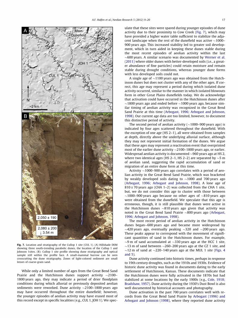
While only a limited number of ages from the Great Bend SandPrairie and the Hutchinson dunes support activity !2100–1800 years ago, they may indicate a period of drier floodplainconditions during which alluvial or previously deposited aeoliansediments were reworked. Dune activity !2100–1800 years agomay have occurred throughout the entire dunefield; however,the younger episodes of aeolian activity may have erased most ofthis record except in specific localities (e.g., CUL 1, JOH 1). We spec-
ulate that these sites were spared during younger episodes of duneactivity due to their proximity to Cow Creek (Fig. 7), which mayhave provided a higher water table sufficient to stabilize the adja-cent landscape when the rest of the dunefield was active !1000–900 years ago. This increased stability led to greater soil develop-ment, which in turn aided in keeping these dunes stable duringthe most recent episodes of aeolian activity within the last!600 years. A similar scenario was documented by Werner et al.(2011) where older dunes with better-developed soils (i.e., a great-er abundance of fine particles) could retain moisture and remainstable during drought conditions, whereas younger dune formswith less developed soils could not.
A single age of !1100 years ago was obtained from the Hutch-inson dunes but does not cluster with any of the other ages. If cor-rect, this age may represent a period during which isolated duneactivity occurred, similar to the manner in which isolated blowoutsform in other Great Plains dunefields today. We do acknowledgethat activation could have occurred in the Hutchinson dunes after!1800 years ago and ended before !1000 years ago, because sim-ilar timing of aeolian activity was recognized in the Great BendSand Prairie at this time (Arbogast, 1996; Arbogast and Johnson,1998). Our current age data are too limited, however, to documentthis distinctive period of activity.
The second period of aeolian activity (!1000–900 years ago) isindicated by four ages scattered throughout the dunefield. Withthe exception of one age (HS 2–1), all were obtained from samplesat depth, directly above the underlying alluvial surface, althoughthey may not represent initial formation of the dunes. We arguethat these ages may represent a reactivation event that overprintedmost of the earlier dune activity !2100–1800 years ago, or earlier.Widespread aeolian activity is documented!960 years ago at HS 2,where two identical ages (HS 2–1, HS 2–2) are separated by !5 mof aeolian sand, suggesting the rapid accumulation of sand ormigration of an entire dune form at this time.
Activity !1000–900 years ago correlates with a period of aeo-lian activity in the Great Bend Sand Prairie, which was bracketedby weakly developed soils dating to !1000 and 700 years ago(Arbogast, 1996; Arbogast and Johnson, 1998). A lone age of810 ± 70 years ago (CHA 1–2) was collected from the CHA 1 site,but, we do not consider this age to cluster with those between!1000–900 years ago because no other ages of !810 years agowere obtained from the dunefield. We speculate that this age iserroneous, though, it is still plausible that dunes were active inthe Hutchinson dunes !810 years ago given that activity wasnoted in the Great Bend Sand Prairie !800 years ago (Arbogast,1996; Arbogast and Johnson, 1998).
The most recent period of aeolian activity in the Hutchinsondunes began!600 years ago and became more widespread by!420 years ago, eventually peaking !320 and !200 years ago.These peaks appear to correspond with the movement of signifi-cant quantities of sand in the Hutchinson dunes. For example,!9 m of sand accumulated at !330 years ago at the HCC 1 site,!13 m of sand between !260–200 years ago at the CZ 1 site, and!12 m of sand at !220–140 years ago at the MUL 1 site (Figs. 4and 5).
Dune activity continued into historic times, perhaps in responseto 19th century droughts, such as the 1910s and 1930s. Evidence ofhistoric dune activity was found in documents dating to the earlysettlement of Hutchinson, Kansas. These documents indicate thatthe Hutchinson dunes were fully activated in the 1870s but hadstabilized at some locations by the early 1900s (e.g., Cole, 1918;Bradshaw, 1957). Dune activity during the 1930’s Dust Bowl is alsowell documented by historical accounts and photography.
Dune activation in the past 700 years correlates well with re-cords from the Great Bend Sand Prairie by Arbogast (1996) andArbogast and Johnson (1998), where they reported dune activity
Fig. 7. Location and stratigraphy of the Cullop 1 site (CUL 1). (A) Hillshade DEMshowing three south-trending parabolic dunes, the location of the Cullop 1 andJohnson 1sites. (B): Cullop 1 site profile showing dune stratigraphy and opticalsample still within the profile face. A small-mammal burrow can be seencrosscutting the dune stratigraphy. Zones of light-colored sediment are smalllenses of coarse-grain sand.
A.F. Halfen et al. / Aeolian Research 5 (2012) 9–20 17
occurring after brief periods of stability dating to !700, !500, and!300 years ago. The brief periods of stability in the Great BendSand Prairie were indicated by thin (!10–20 cm) buried soils (AbHorizons). Unlike the Great Bend Sand Prairie, however, no suchburied soils were found in the Hutchinson dunes. While our sam-pling strategy included only a fraction of the dunes in the dune-field, it is unlikely that any soils formed as the result ofwidespread stability were missed. Rather, we propose that any sta-bility during the last 600 years was too short-lived to foster visibleaccumulations of organic matter, or at least none that survivedensuing episodes of aeolian activity.
We suggest that the identified periods of dune activity were theresult of extended reductions in moisture (i.e., drought), which re-sulted in the desiccation of vegetation and subsequent activation ofdunefield. While other factors such as a rapid influx of sedimentcould potentially cause dune activity (e.g., Muhs et al., 1996; Han-son et al., 2009), all evidence in the Hutchinson dunes suggest thisis not the case. For example, no well-developed dunes are found onthe floodplain between the Hutchinson dunes and the modernArkansas River, a distance of !10 km. Additionally, there is no cor-relation between ages of dune activation and distance from theArkansas River. If dune activity were driven by changes in sedi-ment supply, one would expect to see younger dunes closer tothe river.
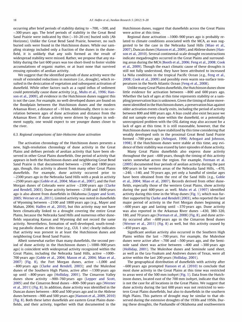
6.3. Regional comparisons of late-Holocene dune activation
The activation chronology of the Hutchinson dunes presents anew, high-resolution chronology of dune activity in the GreatPlains and defines periods of aeolian activity that have been ob-served in other Great Plains dunefields. One period of activity thatappears in both the Hutchinson dunes and neighboring Great BendSand Prairie is that documented between !2100 and 1800 yearsago, though, this activity is absent from many other Great Plainsdunefields. For example, dune activity occurred prior to!2300 years ago in the Nebraska Sand Hills with a peak in activity!2500 years ago (Goble et al., 2004; Miao et al., 2007), and the FortMorgan dunes of Colorado were active !2300 years ago (Clarkeand Rendell, 2003). Dune activity between !2100 and 1800 yearsago is also absent from dunefields in Oklahoma (Lepper and Scott,2005;Werner et al., 2011). Limited activity was noted in dunefieldsof Wyoming between !2100 and 1800 years ago (e.g., Mayer andMahan, 2004; Halfen et al., 2010), but this activity may not havebeen climatically linked to a drought covering the entire GreatPlains, because the Nebraska Sand Hills and numerous other dune-fields separating Kansas and Wyoming did not record the sameactivity. Nevertheless, formation of well-developed, south-trend-ing parabolic dunes at this time (e.g., CUL 1 site) clearly indicatesthat activity was present in at least the Hutchinson dunes andneighboring Great Bend Sand Prairie.
Albeit somewhat earlier than many dunefields, the second per-iod of dune activity in the Hutchinson dunes (!1000–900 yearsago) is coincident with widespread activity recognized within theGreat Plains, including the Nebraska Sand Hills, active !1000–700 years ago (Goble et al., 2004; Mason et al., 2004; Miao et al.,2007) (Fig. 8), the Fort Morgan dunes, active !1,000 and!800 years ago (Clarke and Rendell, 2003); and the Muleshoedunes of the Southern High Plains, active after !1300 years agoup until !800 years ago (Holliday, 2001). The Cimarron Valleydunes show activity !900–760 years ago (Lepper and Scott,2005) and the Cimarron Bend dunes !800–500 years ago (Werneret al., 2011) (Fig. 8). In addition, dune activity was identified in theDuncan dunes between !800 and 500 years ago and in the Abilenedunes between !900 and 500 years ago (Hanson et al., 2009, 2010)(Fig. 8). Both these latter dunefields are eastern Great Plains dune-fields, and their activity, together with that documented in the
Hutchinson dunes, suggest that dunefields across the Great Plainswere active at this time.
Regional dune activation !1000–900 years ago is probably re-lated to climate conditions associated with the MCA, as was sug-gested to be the case in the Nebraska Sand Hills (Miao et al.,2007), Duncan dunes (Hanson et al., 2009), and Abilene dunes (Han-son et al., 2010). Several continental-scale drought reconstructionsindicate megadroughts occurred in the Great Plains and surround-ing areas during theMCA (Booth et al., 2006; Feng et al., 2008; Cooket al., 2009). Though the exact climatic cause of these droughts isstill not fully understood, they have been attributed to increasedLa Niña conditions in the tropical Pacific Ocean (e.g., Feng et al.,2008; Cook et al., 2009) and possibly even warm sea-surface tem-peratures in the North Atlantic Ocean (Feng et al., 2008).
UnlikemanyGreat Plains dunefields, theHutchinsondunes showlittle evidence for activation between !800 and 600 years ago.Whether the lack of ages at this time represents stability or a sam-pling/preservation bias is unknown.Given the timing of dunemove-ment identified in theHutchinsondunes, a preservation bias againstolder activation events clearly exits, including the period of activitybetween 800 and 600 years ago. A bias could also exist because wedid not sample every dune within the dunefield, or a potentiallyunrecognized problem with the OSL dating may also account for alack of ages at this time. It is still reasonable, however, that theHutchinson dunesmay have stabilized by this time considering thatweakly developed soils in the proximal Great Bend Sand Prairieformed !700 years ago (Arbogast, 1996; Arbogast and Johnson,1998). If the Hutchinson dunes were stable at this time, any evi-dence of their stabilitywas erased by later episodes of dune activity.
Many Great Plains dunefields also express dune activitythroughout the past !600 years, though the timing of this activityvaries somewhat across the region. For example, Forman et al.(2005) documented four periods of aeolian activity during the past600 years in far western areas of the Nebraska Sand Hills, !470,!240, !140, and 70 years ago, yet only a handful of similar ageshave been obtained from the rest of the Sand Hills (e.g., Gobleet al., 2004; Miao et al., 2007). Records derived from other dune-fields, especially those of the western Great Plains, show activityduring the past 600 years as well. Muhs et al. (1997) identifiedactivity during this time in the Wray dunes (Fig. 1), which was fur-ther supported by Clarke and Rendell (2003), who reported the lastmajor period of activity in the Fort Morgan dunes beginning at!600 years ago and lasting until !370 years ago. Dune activitywas also reported in the Arkansas River dunes !430, 380–320,180, and 70 years ago (Forman et al., 2008) (Fig. 8), and dune activ-ity occurred after !600 years ago in the Cimarron Bend dunes(Werner et al., 2011) (Fig. 8) as well, but this activity ceased by!450 years ago.
Significant aeolian activity also occurred in the Southern HighPlains within the last !700 years. For example, the Muleshoedunes were active after !700 and !500 years ago, and the Semi-nole sand sheet was active between !400 and !300 years ago(Holliday, 2001). The Muleshoe dunes and Seminole sand sheet,as well as the Lea-Yoakum and Andrews dunes of Texas, were allactive within the last 200 years (Holliday, 2001).
The geographical distribution of dunefields with activity after!600 years ago prompted Hanson et al. (2010) to conclude thatmost dune activity in the Great Plains at this time was restrictedto areas west of the 500 mm isohyet (Fig. 1). Data from the Hutch-inson dunes, located east of the 700 mm isohyet, indicate that thisis not the case for all locations in the Great Plains. We suggest thatdune activity during the last 600 years was not restricted to wes-tern Great Plains dunefields, but also to dunefields in the southernHigh Plains. This pattern of drought may be similar to that ob-served during the extensive droughts of the 1930s and 1950s. Dur-ing these droughts, the Panhandle of Oklahoma and southwestern
18 A.F. Halfen et al. / Aeolian Research 5 (2012) 9–20
Kansas experienced widespread drought, whereas areas of thenorthern and eastern Great Plains did not (e.g., Schubert et al.,2004; Cook et al., 2009; Seager et al., 2008). Further evidence thatdroughts impacting the Great Plains within the last 600 years weremore geographically isolated than those of that occurred duringthe MCA has been documented in other Great Plains proxies (e.g.,Fritz et al., 1994, 2000; Laird et al., 1996).
Hutchinson dune activity during the past 600 years, especiallyincreased activity after !420 years ago, correlates well with thecoolest periods of the LIA (Mann et al., 2009). Widespread, conti-nental megadroughts of the LIA are not as well recognized as thoseduring the MCA. Nevertheless, Cook et al. (2009) concluded thatNorth America remained under drought-prone climates followingthe MCA well into the LIA, and, despite drought-prone climate,many dunefields of the Great Plains did stabilize at this time. Sev-eral tree-ring reconstructions also document drought in the mid-continental North American during the past 600 years (e.g., Stahleet al., 2000; Herweijer et al., 2006). Fritz et al. (1994) documenteddrought in the Northern Great Plains during the LIA, but this recorddid not agree with Laird et al. (1996), who reconstructed mesicconditions during the same time. Fritz et al. (2000) later arguedthat drought occurred during the LIA, but that decreases in precip-itation during the LIA were not anomalous compared to the longer-term hydrological patterns of the Great Plains. It is clear from theserecords that drought, while not as widespread as during the MCA,was present in the Great Plains during the LIA. Dune activationages from the Hutchinson dunes has allowed us to re-evaluatethe geographical patterns of LIA megadrought activity, and, basedon these ages, we suggest that LIA droughts were restricted moreto the southern and western Great Plains.
7. Conclusions
Numerous OSL ages provide a reliable chronology of dune acti-vation for the Hutchinson dunes, resulting in the identification of
three significant periods of dune activity !2100–1800 years ago,!1000–900 years ago, and after !600 years ago, especially withinthe past 420–70 years. Regional correlation between dune activityin the Hutchinson dunes and that of other Great Plains dunefieldsis limited between !2100–1800 years ago, however dune activity!1000–900 years ago and that within the last 600 years correlateswell. As previous investigations have hypothesized, dune activityin the Great Plains !1000 years ago appears to correlate with sig-nificant climate change associated with the MCA, though theHutchinson dunes appear to stabilize earlier than many otherGreat Plains dunefields at this time. Nevertheless, the geographicallocation of dunefields with activity after !1000 years ago suggeststhat megadroughts impacting the region during the MCA werewidespread and impacted most of the Great Plains. Activity inthe Hutchinson dunes during the past 600 years does not correlatewell with that of other northern and eastern Great Plains dune-fields. It does correlate, however, with activity reported for wes-tern Nebraska, Colorado, Oklahoma, the Arkansas River valley ofKansas and the Southern High Plains, suggesting that widespreaddroughts also impacted the Great Plains throughout the LIA andinto historic times. Notably, droughts during the LIA were lessextensive and limited more to the southern and western GreatPlains. Despite being less extensive, droughts at this time were sig-nificant in that the Hutchinson dunes were active with migratingdune forms exceeding 8–10 m in height.
Acknowledgments
We extend our gratitude to the landowners who graciously pro-vided access for sampling and to Mark Bowen and Erin De Lee forinvaluable field assistance. Comments from Vance Holliday and ananonymous reviewer greatly strengthened this paper. This re-search was supported by the United States Geological SurveySTATEMAP program and by the University of Kansas General Re-search fund.
Fig. 8. Asymmetrical point plots of OSL ages from dunes in the central Great Plains, including data from this study.
A.F. Halfen et al. / Aeolian Research 5 (2012) 9–20 19
Appendix A. Supplementary data
Supplementary data associated with this article can be found, inthe online version, at doi:10.1016/j.aeolia.2012.02.001.
References
Aitken, M.J., 1998. An Introduction to Optical Dating: The Dating of QuaternarySediments by the Use of Photon-Stimulated Luminescence. Oxford UniversityPress, New York.
Arbogast, A.F., 1996. Stratigraphic evidence for late-Holocene aeolian sandmobilization and soil formation in south-central Kansas, USA. Journal of AridEnvironments 34, 403–414.
Arbogast, A.F., Johnson, W.C., 1998. Late-quaternary landscape response toenvironmental change in south-central Kansas. Annals of the Association ofAmerican Geographers 88, 126–145.
Arbogast, A.F., Muhs, D.R., 2000. Geochemical and mineralogical evidence fromeolian sediments for northwesterly mid-Holocene paleowinds, central KansasUSA. Quaternary International 67, 107–118.
Bayne, C.K., 1956. Geology and ground-water resources of Reno County, Kansas.Kansas Geological Survey Bulletin 120, 130.
Booth, R.K., Notaro, M., Jackson, S.T., Kutzbach, J.E., 2006. Widespread droughtepisodes in the western Great Lakes region during the past 2000 years:geographic extent and potential mechanisms. Earth and Planetary ScienceLetters 242, 415–427.
Bradshaw, A.B., 1957. When the Prairies Were New. A.J. Allen Press, Turon, Kansas,USA, p. 96.
Clarke, M.L., Rendell, H.M., 2003. Late Holocene dune accretion and episodes ofpersistent drought in the Great Plains of Northeastern Colorado. QuaternaryScience Reviews 22, 1051–1058.
Cole, R., 1918. The Old Trail and the New, 1865–1918. Reno Country Kansas CountySuperintendent and Teachers of Reno County, Hutchinson, Kansas, USA, p. 400.
Cook, E.R., Seager, R., Cane, M.A., Stahle, D.W., 2007. North American drought:reconstructions, causes and consequences. Earth Science Reviews 81,93–134.
Cook, E.R., Seager, R., Heim, R.R., Vose, R.S., Herweijer, C., Woodhouse, C., 2009.Megadroughts in North America: placing IPCC projections of hydroclimaticchange in a long-term palaeoclimate context. Journal of Quaternary Science 25,48–61.
Cook, E.R., Woodhouse, C., Eakin, C.M., Meko, D.M., Stahle, D.W., 2004. Long-termaridity changes in the western United States. Science 306, 1015–1018.
Daly, C., Taylor, G., 2009. Map: United State Average Annual Precipitation. Availableonline: <http://www.ncgc.nrcs.usda.gov/products/datasets/climate/data/index.html>.
Daniels, J.M., Knox, J.C., 2005. Alluvial stratigraphic evidence for channel incisionduring the Mediaeval Warm Period on the central Great Plains, USA. TheHolocene 15, 736–747.
Feng, S., Oglesby, R.J., Rowe, C.M., Loope, D.B., Hu, Q., 2008. Atlantic and Pacific SSTinfluences on Medieval drought in North America simulated by the CommunityAtmospheric Model. Journal of Geophysical Research 113, D11101.
Forman, S.L., Marin, L., Pierson, J., Gomez, J., Miller, G.H., Webb, R.S., 2005. Aeoliansand depositional records from western Nebraska: landscape response todroughts in the past 1500 years. The Holocene 15, 973–981.
Forman, S.L., Marin, L., Gomez, J., Pierson, J., 2008. Late quaternary sand depositionalrecord for southwestern Kansas: landscape sensitivity to droughts.Palaeogeography, Palaeoclimatology, Palaeoecology 265, 107–120.
Forman, S.L., Oglesby, R., Webb, R.S., 2001. Temporal and spatial patterns ofHolocene dune activity on the Great Plains of North America: megadroughtsand climatelinks. Global and Planetary Change 29, 1–29.
Fritz, S.C., Engstrom, D.R., Haskell, B.J., 1994. ‘Little Ice Age’ aridity in the northernAmerican Great Plains: a high-resolution reconstruction of salinity fluctuationsfrom Devils Lake, North Dakota, USA. The Holocene 4, 69–73.
Fritz, S.C., Ito, E., Yu, Z., Laird, K.R., Engstrom, D.R., 2000. Hydrologic variation in theNorthern Great Plains during the last two millennia. Quaternary Research 53,175–184.
Goble, R.J., Mason, J.A., Loope, D.B., Swinehart, J.B., 2004. Optical and radiocarbonages of stacked paleosols and dune sands in the Nebraska Sand Hills, USA.Quaternary Science Reviews 23, 1173–1182.
Grissino-Mayer, H.D., 1996. A 2129-year reconstruction of precipitation fornorthwestern New Mexico, U.S.A. In: Dean, J.S., Meko, D.M., Swetnam, T.W.(Eds.), Tree Rings, Environment, and Humanity. Radiocarbon, Tucson, Arizona,pp. 191-204.
Halfen, A.F., Fredlund, G.G., Mahan, S.A., 2010. Holocene stratigraphy andchronology of the Casper Dune Field, Casper, Wyoming, USA. The Holocene20, 773–783.
Hall, S.A., 1990. Channel trenching and climatic change in the southern US. GreatPlains. Geology 18, 342–345.
Hanson, P.R., Joeckel, R.M., Young, A.R., Horn, J., 2009. Late Holocene dune activity inthe Eastern Platte River Valley, Nebraska. Geomorphology 103, 555–561.
Hanson, P.R., Arbogast, A.F., Johnson, W.C., Joeckel, R.M., Young, A.R., 2010.Megadroughts and late Holocene dune activation at the eastern margin of theGreat Plains, north-central Kansas, USA. Aeolian Research 1, 101–110.
Herweijer, C., Seager, R., Cook, E.R., 2006. North American Droughts of the mid-to-late nineteenth century: a history, simulation and implication for Mediaevaldrought. The Holocene 16, 159–171.
High Plains Regional Climate Center (HPRCC), 2011. http://www.hprcc.unl.edu/data/historical/ (last accessed 09.09.2011).
Hobbs, W.O., Fritz, S.C., Stone, J.R., Dovocan, J.J., Grimm, E.C., Almendinger, J.E., 2011.Environmental history of a closed-basin lake in the US Great Plains: diatomresponse to variations in groundwater flow regimes over the last 8500 cal. yrBP. The Holocene 21, 1–14.
Holliday, V.T., 1997. Origin and evolution of lunettes on the high plains of Texas andNew Mexico. Quaternary Research 47, 54–89.
Holliday, V.T., 2001. Stratigraphy and geochronology of upper quaternary eoliansand on the Southern High Plains of Texas and New Mexico, United States.Geological Society of America Bulletin 113, 88–108.
Laird, K.R., Fritz, S.C., Maasch, K.A., Cumming, B.F., 1996. Greater drought intensityand frequency before AD 1200 in the Northern Great Plains, USA. Nature 384:pp. 552–554.
Lepper, K., Scott, G.F., 2005. Late Holocene aeolian activity in the Cimarron RiverValley of west-central Oklahoma. Geomorphology 70, 42–52.
Madole, R.F., 1995. Spatial and temporal patterns of Late Quaternary eoliandeposition, Eastern Colorado, USA. Quaternary Science Reviews 14, 155–177.
Mann, M.E., Zhang, Z., Rutherford, S., Bradley, R.S., Hughes, M.K., Shindell, D.,Ammann, C., Faluvegi, G., Ni, F., 2009. Global signatures and dynamical originsof the Little Ice Age and Medieval Climatic Anomaly. Science 329, 1256–1260.
Mason, J.A., Swinehart, J.B., Goble, R.J., Loope, D.B., 2004. Late Holocene dune activitylinked to hydrological drought, Nebraska Sand Hills, USA. The Holocene 14,209–217.
Mason, J.A., Swinehart, J.B., Hanson, P.R., Loope, D.B., Goble, R.J., Miao, X.,Schmeisser, R.L., 2011. Late Pleistocene dune activity in the central GreatPlains, USA. Quaternary Science Reviews 30, 3858–3870.
Miao, X., Mason, J.A., Swinehart, J.B., Loope, D.B., Hanson, P.R., Goble, R.J., Liu, X.,2007. A 10,000-year record of dune activity, dust storms, and drought in thecentral Great Plains. Geology 35, pp. 119–122.
Muhs, D.R., Stafford Jr., T.W., Cowherd, S.D., Mahan, S.A., Kihl, R., Maat, P.B., Bush,C.A., Nehring, J., 1996. Origin of the late Quaternary dune fields of northeasternColorado. Geomorphology 17, 129–149.
Muhs, D.R., Stafford Jr., T.W., Swinehart, J.B., Cowherd, S.D., Mahan, S.A., Bush, C.A.,Madole, R.F., Maat, P.B., 1997. Late Holocene eolian activity in themineralogically mature Nebraska Sand Hills. Quaternary Research 48, 162–176.
Muhs, D.R., Holliday, V.T., 1995. Evidence of active dune sand on the Great Plains inthe19th century from accounts of early explorers. Quaternary Research 43,198–208.
Murray, A.S., Wintle, A.G., 2000. Luminescence dating of quartz using an improvedsingle-aliquot regenerative-dose protocol. Radiation Measurements 32, 57–73.
Prescott, J.R., Hutton, J.T., 1994. Cosmic ray contributions to dose rates forluminescence and ESR dating: large depths and long-term time variations.Radiation Measurements 23, 497–500.
Schmieder, J., Fritz, S.C., Swinehart, J.B., Shinneman, A.L.C., Wolfe, A.P., Miller, G.,Daniels, N., Jacobs, K.C., Grimm, E.C., 2011. A regional-scale climatereconstruction of the last 4000 years from lakes in the Nebraska Sand Hills,USA. Quaternary Science Reviews 30, 1797–1812.
Schubert, S.D., Suarez, M.J., Pegion, P.J., Koster, R.D., Bacmeister, J.T., 2004. On thecause of the 1930s Dust Bowl. Science 303, 1855–1859.
Seager, R., Kushnir, Y., Ting, M.F., Cane, M., Naik, N., Velez, J., 2008. Would advanceknowledge of 1930s SSTs have allowed prediction of the Dust Bowl drought?Journal of Climate 21, 3261–3281.
Simonett, D.S., 1960. Development and grading of dunes in western Kansas. Annalsof the Association of American Geographers 50, 216–241.
Sridhar, V., Loope, D.B., Swinehart, J.B., Mason, J.A., Oglesby, R.J., Rowe, C.M., 2006.Large wind shift on the Great Plains during the Medieval Warm Period. Science313, 345–347.
Stahle, D.W., Cook, E.R., Cleaveland, M.K., Therrell, M.D., Meko, D.M., Grissino-Mayer, H.D., Watson, E., Luckman, B.H., 2000. Tree-ring data document 16thcentury megadrought over North America. Eos. Transactions of the AmericanGeophysical Union 81, 121–125.
Stahle, D.W., Fye, F.K., Cook, E.R., Griffin, R.D., 2007. Tree-ring reconstructedmegadroughts overNorth American sinceA.D. 1300. Climate Change 83, 133–149.
Stuiver, M., Reimer, P.J., 1993. Extended 14C data base and revised CALIB 3.0 14Cage calibration program. Radiocarbon 35, 215–230.
Werner, C.M., Mason, J.A., Hanson, P.R., 2011. Non-linear connections between duneactivity and climate in the High Plains, Kansas and Oklahoma, USA. QuaternaryResearch 75, 267–277.
Wolfe, S.A., Robertson, L., Gillis, A., 2009. Late Quaternary Aeolian Deposits ofNorthern North America: Age and Extent. Geological Survey of Canada, OpenFile 6006, CD-ROM.
Woodhouse, C.A., Overpeck, J.A., 1998. 2000 Years of Drought Variability in theCentral United States. Bulletin of the American Meteorological Society 79,2643–2714.
20 A.F. Halfen et al. / Aeolian Research 5 (2012) 9–20