Embed Size (px)
Citation preview

Exhibit “A” CompPlan.doc
Page 1 of 51
ADAMS COUNTY
COMPREHENSIVE PLAN
Approved by the BOARD OF COUNTY COMMISSIONERS, ADAMS COUNTY, WASHINGTON on _______________ _____________________________________ Chairman
ATTEST: _______________________ Linda Reimer, MMC Clerk of the Board
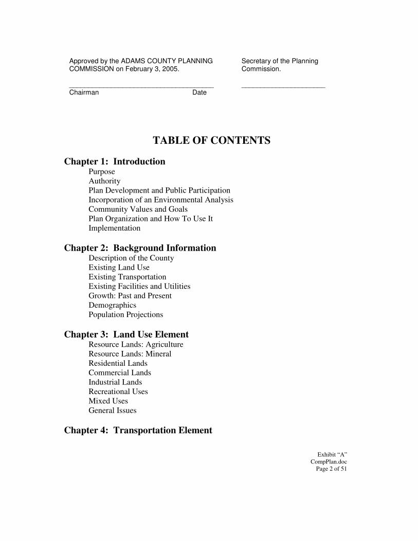
Exhibit “A” CompPlan.doc
Page 2 of 51
Approved by the ADAMS COUNTY PLANNING COMMISSION on February 3, 2005. ______________________________________ Chairman Date
Secretary of the Planning Commission. ______________________
TABLE OF CONTENTS
Chapter 1: Introduction Purpose Authority Plan Development and Public Participation Incorporation of an Environmental Analysis Community Values and Goals Plan Organization and How To Use It Implementation Chapter 2: Background Information Description of the County Existing Land Use Existing Transportation Existing Facilities and Utilities Growth: Past and Present Demographics Population Projections Chapter 3: Land Use Element Resource Lands: Agriculture Resource Lands: Mineral Residential Lands Commercial Lands Industrial Lands Recreational Uses Mixed Uses
General Issues Chapter 4: Transportation Element

Exhibit “A” CompPlan.doc
Page 3 of 51
Chapter 5: Facilities and Utilities Element Chapter 6: Economic Development Element
Exhibit “A” CompPlan.doc
Page 4 of 51
CHAPTER 1: INTRODUCTION Purpose The purpose of the Adams County Comprehensive Plan is to provide a guide for the physical growth and development of the community for the foreseeable future. It provides goals, policies, recommendations and land use map(s) that will be used as official policy guidelines, enabling county officials to make informed decisions that are in the best interest of the community as a whole. The plan provides a general sense of direction and a broad overview of where the county is now, and where it is going in the future. The plan is also intended to maintain reasonable continuity in future decision-making as turnover occurs within the county's legislative body. It furnishes direction for development of the county that will make it a more convenient, attractive, and orderly place in which to live, shop, work and play. However, the plan must be periodically reviewed and updated to reflect technological, social, economic and political changes that may invalidate certain plans and policies. Authority The comprehensive plan has been prepared pursuant to Chapter 36.70 of the Revised Code of Washington. This legislation authorizes and describes how counties in Washington State are to engage in planning activities. There are procedural as well as substantive requirements for counties to meet when developing a comprehensive plan, as well as development regulations. Specifically, RCW 36.70 requires adoption of a comprehensive plan prior to implementing zoning actions. Adams County does not currently “fully” plan according to the provisions of the Washington State Growth Management Act (GMA). However, the GMA contains certain mandates that are required of all local governments in the state: all are required to identify and protect resource lands and critical areas; all are required have development regulations, such as zoning and subdivision codes, that are consistent with the adopted comprehensive plan. Therefore, there is authority and direction to prepare this comprehensive plan that is also garnered from Chapter 36.70A of the Revised Code of Washington.
Exhibit “A” CompPlan.doc
Page 5 of 51
Plan Development and Public Participation In large part the impetus for preparing the comprehensive plan was a desire on the part of the Board of County Commissioners to attract new commercial and manufacturing industry to Adams County, thereby promoting future economic development opportunities. While the county’s economic base is and will continue to be related to agriculture, it is recognized that diversification is important because the agricultural community typically struggles to survive difficult financial times, which, in turn, threatens the economic stability of the county as a whole. The development of the plan occurred in two different phases: one conducted during 2000 and 2001 that focused on the issues important to the eastern two-thirds of the county, and another conducted during 2002 and 2003 that initially focused on the issues facing the Panhandle, or western portion of the county. The second phase of the effort quickly expanded into integrating the two parts of the county into an overall comprehensive planning effort as it became apparent that the fundamental issues important to citizens of the different geographic regions of the county were actually very consistent. The result of these two phases is the final, overall, coordinated and complete comprehensive plan described herein. Early on, the Board of County Commissioners and the Planning Commission recognized that public involvement is essential to the planning process. The people of Adams County need to have a strong understanding of the purpose of the comprehensive plan and the development regulations that are created to implement the plan. To ensure that understanding is developed, Adams County elected officials and Planning Commission members promoted numerous efforts to seek citizen participation throughout the planning process. During each process, a citizen’s workbook was widely distributed to stimulate thinking about where Adams County should be in the next ten plus years regarding land use, zoning, economic development and the environment. Additionally, there were public workshops held throughout the county to discuss planning progress, and to seek public comments. In total, the four-year process that went into the development of this comprehensive plan involved countless hours of invaluable insight, direction and expressions of commitment to a positive future for Adams County. Incorporation of an Environmental Analysis The State Environmental Policy Act (SEPA) requires that, as local governments consider different actions, there be a deliberate evaluation of those actions on different elements of the natural and built environments. To comply with the requirements of SEPA, Adams County conducted an initial environmental review during the east-county planning process that resulted in the development and issuance of a non-project Draft Environmental Impact Statement (DEIS) that was imbedded in the actual Draft East
Exhibit “A” CompPlan.doc
Page 6 of 51
County Comprehensive Plan. The detail and depth of analysis contained in the DEIS, as well as the consistent issues and integrated outcome of the two phases, allows the county to incorporate it by reference {pursuant to WAC 197-11-600(4)(b)} in taking action to adopt the final comprehensive plan. Community Values and Goals Through the many public participation processes employed during the development of this comprehensive plan, the residents of Adams County provided thoughtful insight into what is valuable to them as a community. The input received has been used as the planning framework within which the different components of the comprehensive plan have been developed. Below is a summary of the planning framework and community vision that has guided the development of this document.
• Protect agricultural lands. • Protect agricultural lands with infrastructure (e.g. irrigation) for
agricultural production. • Maintain and increase economic stability by promoting diverse growth. • Prioritize for new industries that fit in with the main industry, which is
agriculture. • Provide protection measure for our environment. • Depend on and utilize existing transportation networks (including state
highways and railroads) to promote growth. • Link future land uses to needed infrastructure (both social and public
services/facilities). • Create desirable development outcomes by planning for future growth. • Ensure on-going opportunities for citizen participation. • Encourage joint city/county jurisdictional partnerships in Adams County. • Promote a safe, clean and beautiful community environment. • Encourage local capacity for community pride and leadership by respecting
values fostered by the rural way of life. • Preserve traditional development patterns through zoning (rely on
separating land uses to reduce conflicts and incompatibility) • Allow for development opportunities with mixed uses in single zones when
compatibility is not an issue. • Require the use of buffers as one means of preventing land use conflicts.
Plan Organization and How To Use It A comprehensive plan, by definition, is a policy document. It is used by decision-makers over time to evaluate a jurisdiction’s progress in achieving its community goals and
Exhibit “A” CompPlan.doc
Page 7 of 51
preferred future. The plan should provide guidance on a range of topics, known as elements in the comprehensive plan. Each of these elements instructs the county on how to proceed with a myriad of development decisions, both public and private. In order to obtain the best possible utility from a plan, it must be considered a “living” document, rather than one that collects dust on some remote shelf. As such, the comprehensive plan must be consulted regularly, and familiarity with its contents will help people to determine when it is best to overhaul the outdated plan. While each of the topics, or elements, is considered individually, it is also intricately linked to the other elements. For instance, changes in future land use will change how transportation works. Growth that occurs in an area will trigger the need to improve certain roads. Growth will also drive the need to upgrade utilities. Growth may result from choices made about economic development. Or, growth may stifle economic development opportunities by consuming various available resources, like housing, too quickly. In any event, each of the elements must be considered within the context of the others. To achieve the greatest utility of the comprehensive plan, it is important each time a land use decision is before the county to first ask the question “Is it consistent with the comprehensive plan?” If the answer is yes, then the choice is likely to be a “right” one. If it is no, then either the choice is not suitable, or the plan must be changed. There are two types of land use decisions the county will make that will trigger this question: one is “legislative” such as adopting a new zoning, critical areas or subdivision code, and one is “quasi-judicial” such as approving a new subdivision or conditional use permit proposal. Considering the comprehensive plan during each of these types of decision making processes will ensure growth and development is consistent with the community values and goals for Adams County’s future. Specifically, this plan contains the following elements:
• Background Information – describes the existing conditions within Adams County.
• Land Use – contains the goals and policies for future land uses within Adams County.
• Transportation – contains the goals and policies for Adams County’s transportation systems.
• Facilities and Utilities - contains the goals and policies for Adams County’s capital facility and utility systems.
• Economic Development – contains the goals and policies for future economic growth within Adams County.
• Environment – contains goals and policies related to reducing impacts to the environment.
Exhibit “A” CompPlan.doc
Page 8 of 51
• Implementation – describes important tools for implementing the vision expressed in the comprehensive plan.
Implementation The comprehensive plan is an expression of how the county should grow and develop, and serves as a guide for future development and redevelopment. Therefore, the goals and policies of the plan are general guidelines, not regulations. The Growth Management Act of 1990, as amended, states at Section 36.70A.120 "...[E]ach county and city that is required or chooses to plan under RCW 36.70A.040 shall enact development regulations that are consistent with and implement the comprehensive plan." The following ordinances, codes and programs have been developed, will be amended, or will be prepared as the primary means to implement the goals and policies of this Comprehensive Plan. Zoning Zoning is the most commonly used legal tool used to implement the plan. In a zoning code the town is divided into zoning districts, with types of uses, permit requirements and other land use regulations defined for each district. The most basic regulations pertain to:
• The height and bulk of buildings; • The percentage of the lot which may be occupied and the size of required yards; • The density of population and, • The use of buildings and land for residential, commercial, industrial and other
purposes. It is also possible to develop performance standards and criteria to further define the characteristics of the different zoning categories, such as:
• Building materials and construction standards or attributes; • The ability and/or criteria for keeping both domestic pets and livestock and, • Any buffering, landscaping, parking or other similar standards.
Planned Developments Planned development regulations, which are generally included within the county’s zoning code, are intended to provide an alternative method for land development that:
Exhibit “A” CompPlan.doc
Page 9 of 51
• Encourages flexibility in the design of land use activities so that they are conducive to a more creative approach to development which will result in a more efficient, aesthetic and environmentally responsive use of the land;
• Permits creativity in the design and placement of buildings, use of required open spaces, provisions of on-site circulation facilities, off-street parking, and other site design elements that better utilize the potential of special features such as geography, topography, vegetation, drainage, and property size and shape;
• Facilitates the provision of economical and adequate public improvements such as sewer, water, and streets and,
• Minimizes and/or mitigates the impacts of development on valuable natural resources and unique cultural, historic, or natural features such as agricultural lands, steep slopes and floodplain and shoreline areas.
Subdivision Subdivision regulations are intended to regulate the manner in which land may be divided and prepared for development. They apply whenever land is divided for purposes of sale, lease or transfer. State law specifies that any subdivision of land which results in the creation of a parcel of less than five acres in size must comply, at a minimum, with state subdivision requirements, as well as with any local subdivision regulations. There are two basic forms of subdivision including long plats, which contain five or more lots, and short plats, which contain four or fewer lots. Regulations pertaining to both types of subdivisions are adopted and enforced at the local level in accordance with provisions and statutory authority contained in state law. The regulations specify methods of subdivision procedures for the developer and the county; minimum improvements (streets, utilities, etc.) to be provided by the developer, and design standards for streets, lots, and blocks. Subdivision regulations are intended to encourage the orderly development and redevelopment of large tracts within and around the community. Binding Site Plan The binding site plan is another different method of dividing property for commercial and industrial purposes, and in some cases for residential uses such as manufactured home and recreational vehicle parks where the individual parcels are not to be sold. This method for regulating development is intended to provide a flexible alternative to developers, and requires that a specific site plan be developed which shows the layout of streets and roads and the location of utilities required to serve the property. The binding site plan is a legally enforceable document which, when required, can be amended to reflect changing conditions. The plan also must be reviewed to ensure that the cost of providing basic
Exhibit “A” CompPlan.doc Page 10 of 51
services and the maintenance of those services does not represent an unreasonable burden on the residents of the county. State Environmental Policy Act SEPA directs government decision makers to consider the environmental consequences of their actions. The SEPA process starts when someone submits a permit application to the county, or when the county proposes to take some official action. An environmental checklist is used to determine whether the project or action is significant enough to require an environmental impact statement (EIS). While an EIS is commonly not required, certain conditions may be included in a determination of non-significance that are intended to minimize environmental impacts. Regardless, a threshold determination must be made on all permit applications unless they are specifically exempted by SEPA. Critical Areas Ordinance The Growth Management Act requires that all cities and counties in the State classify, designate and protect critical areas such as wetlands, aquifer recharge areas, frequently flooded areas, geologically hazardous areas, and fish and wildlife habitat conservation areas. One avenue for protection is a critical areas ordinance that is consistent with the comprehensive plan. This ordinance may preclude any development that is incompatible with the critical areas, but usually it will provide for mitigation measures to be applied to alleviate the negative impacts of a specific development on a specific critical area or areas.
Exhibit “A” CompPlan.doc Page 11 of 51
CHAPTER 2: BACKGROUND INFORMATION Description of the County Adams County, named after the late president John Adams, is located in the southeastern portion of Washington State. Its shape is as an upside down pan with the southwest portion of the county referred to as the panhandle. Interstate 90 runs through the northern part of the county with US 395 meeting I-90, running south through the middle of the county. Adams County is approximately 35 miles long and 65 miles wide at its largest point, encompassing 1,894 square miles. Adams County’s topography consistently rises from the west side to the east ranging from approximately 1000 to 1900 feet in elevation. The County has several attractive streams and lakes that provide a range of recreational opportunities. The southeast corner of the county is bordered by the Palouse River with the Columbia National Wildlife Refuge in the northern portion of the Panhandle. Cow Creek watershed in east Adams County is where the Columbia Plateau State Park facility is located. This is yet another economic opportunity for the County. The climate of Adams County is shielded by the Rocky Mountains which prevent severe winter storms and cold continental air that moves southward across Canada and the Cascades obstruct the easterly movement of moist air from the Pacific Ocean. The temperature generally averages between 25 degrees in January and 80 degrees and more in the summer months. Average annual precipitation ranges from 8inches on the west side of the county to 12 inches on the east side, with the heaviest precipitation occurring during the winter months. Snowfall averages range from 0 to 2 inches. Most of eastern Adams County has been designated as Interim Agricultural or Range Lands of Long Term Commercial Significance according to GMA requirements. Extractive mining operations are located in the area also, often using the deep layers of basalt for local roadwork. There are no forests in Adams County. Sprague Lake is a water body of statewide significance as determined by the Shoreline Management Act. This fact is given special attention anytime development proposals are considered. Critical areas have been identified and designated for habitat and wetlands that exist because of Sprague Lake. Floodplains can be found in each of the towns in east Adams County, as well as in most of the coulees. Wetlands, although in existence, are relatively scarce given the climate. The county is underlain by three distinct, relatively deep aquifers: Grand Ronde, Wanapum and Odessa Subarea. Adams County has a number of lake and a couple of streams that are included by statue in the Adams County Shoreline Master Plan. The US Department of Agriculture has recognized 6 separate soil associations within Adams County. A soil association is a landscape that has a distinctive proportional pattern
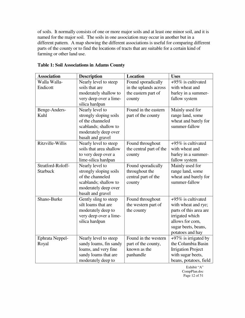
Exhibit “A” CompPlan.doc Page 12 of 51
of soils. It normally consists of one or more major soils and at least one minor soil, and it is named for the major soil. The soils in one association may occur in another but in a different pattern. A map showing the different associations is useful for comparing different parts of the county or to find the locations of tracts that are suitable for a certain kind of farming or other land use. Table 1: Soil Associations in Adams County Association Description Location Uses Walla Walla-Endicott
Nearly level to steep soils that are moderately shallow to very deep over a lime-silica hardpan
Found sporadically in the uplands across the eastern part of county
+95% is cultivated with wheat and barley in a summer-fallow system
Benge-Anders-Kuhl
Nearly level to strongly sloping soils of the channeled scablands; shallow to moderately deep over basalt and gravel
Found in the eastern part of the county
Mainly used for range land, some wheat and barely for summer-fallow
Ritzville-Willis Nearly level to steep soils that area shallow to very deep over a lime-silica hardpan
Found throughout the central part of the county
+95% is cultivated with wheat and barley in a summer-fallow system
Stratford-Roloff-Starbuck
Nearly level to strongly sloping soils of the channeled scablands; shallow to moderately deep over basalt and gravel
Found sporadically throughout the central part of the county
Mainly used for range land, some wheat and barely for summer-fallow
Shano-Burke Gently sling to steep silt loams that are moderately deep to very deep over a lime-silica hardpan
Found throughout the western part of the county
+95% is cultivated with wheat and rye; parts of this area are irrigated which allows for corn, sugar beets, beans, potatoes and hay
Ephrata Neppel-Royal
Nearly level to steep sandy loams, fin sandy loams, and very fine sandy loams that are moderately deep to
Found in the western part of the county, known as the panhandle
+97% is irrigated by the Columbia Basin Irrigation Project with sugar beets, beans, potatoes, field
Exhibit “A” CompPlan.doc Page 13 of 51
deep over a lime-silica hardpan, Ringold beds or gravel
corn and hay are the main crops
Source: NRCS Soil Survey for Adams County Existing Land Use Adams County is a sparsely populated, rural landscape with enormous tracts of land devoted to agricultural production and range-related activities. Dryland wheat, small family farms and grain elevators dominate land use in east Adams County. Amongst these uses, Adams County has five incorporated communities. In the Panhandle area is Othello, which was incorporated in 1910, the youngest of the cities. Across the southern portion of the county on Highway 26 you will continue through Hatton then on to Washtucna. Lind is located in the middle of the county along US Highway 395, which connects to Interstate 90 at Ritzville, the county seat and the oldest city. There are several other small, historic settlements not formally incorporated which depend on clustered residents to provide a community setting. Aside from the cities and towns the predominant land use in Adams County is agriculture, in the form of dry land grain crops, rangeland livestock grazing and irrigated orchard farming. These resource use activities are typically a source of multiple benefits ranging from economic stability to providing a significant amount of habitat for native wildlife species. Othello is the more diverse economic community with its main ties still related to agriculture and agriculture processing facilities. The Columbia Basin Project began in the 1930’s to bring irrigation to the areas in the Columbia Basin. The project allowed for nearly a half million acres to be irrigated. The panhandle area thrived by this and now has a significant portion of its croplands in irrigation. This allows the area to grow a larger diversity of crops; including potatoes, asparagus, mint, corn and some fruit orchards. The remainder of the County is sparsely populated with enormous tracts of land devoted to agricultural production and range-related activities. Particularly in the Panhandle Area, there are increasing pressures placed on the agricultural base to convert to other activities such as residential and industrial uses. Small spurts of commercial development growth are occurring at the intersections of major roads and highways. There are some manufacturing and warehouse uses beginning to occur along the railroads. The growing interest in the sand dunes near Hatton along SR 26 is increasing the recreational opportunities of the County and drawing more and more interest for economic development.
Exhibit “A” CompPlan.doc Page 14 of 51
It will be important to the future of Adams County's economic base to find a feasible way to maintain and enhance both agricultural and industrial uses without degrading one in the name of promoting the other. Agriculture… Adams County's history has been intricately tied to a diverse range of agricultural activities. The Ritzville area was the first to be settled in the late 1800's by stockmen raising cattle and growing small gardens and hay. In 1890, the first crop of wheat in Adams County’s history was harvested. After the development of the irrigation systems through the Panhandle area in the 1960’s, Othello became a more diversified community with a variation of crops, while the remaining area of the county continued producing dry land crops. Across the state, Adams County remains in the top five for total land in farms, total cropland and total harvested cropland. The County harvests 50% of it cropland, of which 78% is wheat. It is likely that the agricultural industry will continue to be a primary trade in Adams County's future. There are some overall trends upward in the agricultural industry that may warrant additional attention in order to maintain this primary economic base. The following table 1 is a graphic description of some of these trends, as found in the 1997 US Census of Agriculture. Table 2: Agricultural Statistics For Adams County
1992 1997 Change # of Farms 602 628 26 Acres in Farms 996,742 1,096,447 99,705 Average Farm Size 1,656 1,746 90 Average Farm Value $792,726 $1,307,300 $514,547 Average Acre Value $465 $714 $249 County Land Area (acres) 1,212,160 1,212,160 0 % of Land in Farms 82.23% 90.45% 8.23%
Source: USDA National Agricultural Statistical Service, 1992 & 1997 Census of Agriculture
Exhibit “A” CompPlan.doc Page 15 of 51
Othello Planning Area
Panhandle (less OPA)
Eas t County (less cities ) Total Acres
Res idential 1,122.75 1,001.86 478.50 2,603.11
Manufacturing 47.62 12.24 24.79 84.65
Transportation, Communication
& Utilities 30.08 20.38 15.95 66.41
Trade 45.21 4.20 60.06 109.47
Services 9.68 25.97 90.54 126.19
Cultural, Entertainment, & Recreational 56.10 - 48.89 104.99
Agriculture 10,346.59 92,362.94 1,003,549.46 1,106,258.99
Undeveloped Land & W ater
Areas 607.70 87.19 219.26 914.15
Exempt 441.94 11,664.37 17,757.26 29,863.57
Totals 12,707.67 105,179.15 1,022,244.71 1,140,131.53
Adams CountyAcreage Analysis
Note: All information is based on the assessor parcel data. Most of the acres may not be accurate because not all land acres are listed for the OPA. The housing unit information for the OPA is based on the TAZ report. Any agricultural uses with a physical address were counted as a housing unit for the two other areas. The information in the red is to note that there are not always acres listed for exempt lands. Dry land... Dry land crop farming takes up a large part of the County's land area, particularly on the east side of the County. Because of the dry climate the predominant crop is wheat primarily soft
Exhibit “A” CompPlan.doc Page 16 of 51
white and club varieties, as well as some winter wheat that is grown in alternate years. Every other year a particular piece of ground sits idle in order to increase the moisture and mineral content of the soil. In general, the average bushel/acre harvested is usually lower in Adams County than the state average. However, this can vary tremendously from year to year, depending on the amount and timing of precipitation. According to the 1997 US Census of Agriculture, Adams County is ranked 3rd of the wheat producing counties in the state and 4th of the counties in the United States, and it does so without the aid of irrigation. However, the census also points out that while Adams County has had an increase in the number of bushels produced, the acres harvested have dropped. There was an increase of 6,532,599 bushels from 1992 to 1997, and the average bushel per acre harvested amplified from 40 in 1992 to 61 in 1997. Within this time period, Adams County's contribution to the State's total bushels climbed from 5th in the state to 3rd. Of the top 10 wheat counties in the State, only Franklin County has actually dropped in their rank among the top ten in regards to total bushels produced. However, among the top 10, although the total acres decreased, the total bushels have increased, and the average yield per acre has increased from 1992 to 1997 in all 10 counties. It is important to note, however, that some counties can have noticeable change in production from year to year, depending on precipitation. Another factor to be considered when looking at the wheat producing ground in the County is the Conservation Reserve Program (CRP) implemented by the Federal government in 1986. This program involves allowing farmers to enroll some of their ground into a 10-year plan of maintaining a cover crop, as opposed to the typical winter wheat/fallow rotation that involves harvesting and replanting. This is a multiple use program designed to conserve soil and water and to provide wildlife habitat. The federal government pays a certain dollar amount per acre to the farmer to keep that ground out of production, but maintained with an adequate cover crop and controlled for noxious weeds. The typical cover crops are crested wheat, tall wheat, Sherman blue rye grasses, or alfalfa. In Adams County most of the land in the CRP program is located in the eastern part of the County because of soil types that are prone to wind erosion and are generally less productive than those within the federal reclamation project. The Census of Agriculture shows that Adams County has approx 205,000 acres enrolled in the CRP program that makes Adams County one of the higher percentage counties in the State. The following table provides a summary look at the comparison in wheat crops between 1992 and 1997 in Adams County, based on the 1997 US Census of Agriculture.
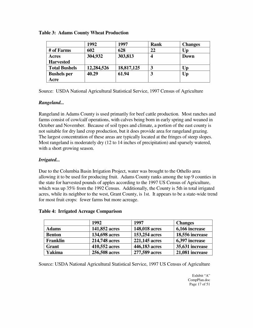
Exhibit “A” CompPlan.doc Page 17 of 51
Table 3: Adams County Wheat Production
1992 1997 Rank Changes # of Farms 602 628 22 Up Acres Harvested
304,932 303,813 4 Down
Total Bushels 12,284,526 18,817,125 3 Up Bushels per Acre
40.29 61.94 3 Up
Source: USDA National Agricultural Statistical Service, 1997 Census of Agriculture Rangeland... Rangeland in Adams County is used primarily for beef cattle production. Most ranches and farms consist of cow/calf operations, with calves being born in early spring and weaned in October and November. Because of soil types and climate, a portion of the east county is not suitable for dry land crop production, but it does provide area for rangeland grazing. The largest concentration of these areas are typically located at the fringes of steep slopes. Most rangeland is moderately dry (12 to 14 inches of precipitation) and sparsely watered, with a short growing season. Irrigated... Due to the Columbia Basin Irrigation Project, water was brought to the Othello area allowing it to be used for producing fruit. Adams County ranks among the top 9 counties in the state for harvested pounds of apples according to the 1997 US Census of Agriculture, which was up 35% from the 1992 Census. Additionally, the County is 5th in total irrigated acres, while its neighbor to the west, Grant County, is 1st. It appears to be a state-wide trend for most fruit crops: fewer farms but more acreage. Table 4: Irrigated Acreage Comparison
1992 1997 Changes Adams 141,852 acres 148,018 acres 6,166 increase Benton 134,698 acres 153,254 acres 18,556 increase Franklin 214,748 acres 221,145 acres 6,397 increase Grant 410,552 acres 446,183 acres 35,631 increase Yakima 256,508 acres 277,589 acres 21,081 increase
Source: USDA National Agricultural Statistical Service, 1997 US Census of Agriculture
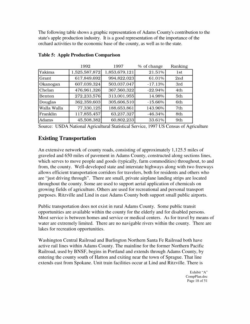
Exhibit “A” CompPlan.doc Page 18 of 51
The following table shows a graphic representation of Adams County's contribution to the state's apple production industry. It is a good representation of the importance of the orchard activities to the economic base of the county, as well as to the state. Table 5: Apple Production Comparison
1992 1997 % of change RankingYakima 1,525,587,872 1,853,679,121 21.51% 1stGrant 617,849,692 994,822,023 61.01% 2ndOkanogan 607,039,324 503,037,047 -17.13% 3rdChelan 476,961,326 367,560,322 -22.94% 4thBenton 272,233,576 313,001,955 14.98% 5thDouglas 362,359,603 305,606,510 -15.66% 6thWalla Walla 77,330,125 188,653,861 143.96% 7thFranklin 117,855,457 63,237,327 -46.34% 8thAdams 45,508,382 60,802,233 33.61% 9th Source: USDA National Agricultural Statistical Service, 1997 US Census of Agriculture Existing Transportation An extensive network of county roads, consisting of approximately 1,125.5 miles of graveled and 650 miles of pavement in Adams County, constructed along sections lines, which serves to move people and goods (typically, farm commodities) throughout, to and from, the county. Well-developed state and interstate highways along with two freeways allows efficient transportation corridors for travelers, both for residents and others who are “just driving through”. There are small, private airplane landing strips are located throughout the county. Some are used to support aerial application of chemicals on growing fields of agriculture. Others are used for recreational and personal transport purposes. Ritzville and Lind in east Adams County both support small public airports. Public transportation does not exist in rural Adams County. Some public transit opportunities are available within the county for the elderly and for disabled persons. Most service is between homes and service or medical centers. As for travel by means of water are extremely limited. There are no navigable rivers within the county. There are lakes for recreation opportunities. Washington Central Railroad and Burlington Northern Santa Fe Railroad both have active rail lines within Adams County. The mainline for the former Northern Pacific Railroad, used by BNSF, begins in Portland and extends through Adams County, by entering the county south of Hatton and exiting near the town of Sprague. That line extends east from Spokane. Unit train facilities occur at Lind and Ritzville. There is
Exhibit “A” CompPlan.doc Page 19 of 51
another BNSF route over the Palouse River Line that serves a portion of eastern Adams County. Finally, Washington Central Railroad has a line that connects Connell to Moses Lake. It serves a portion of Adams County as well. Existing Facilities & Utilities In the eastern part of the county, most residents within the rural areas of Adams County, particularly, are served by domestic wells and small public water supply systems. Wastewater treatment facilities do not exist in the county to serve the rural population. Instead, people and businesses rely mostly on on-site septic disposal systems for this purpose. Two large bodies of industrial wastewater piped from food processing plants in Othello are located in the western portion of Adams County. Both have periodic odor problems due to anaerobic processes. One pond ultimately provides additional irrigation water for crops grown within that vicinity. Solid waste facilities are provided by ADA-LIN Waste Systems, Inc. They transport solid waste to transfer stations throughout the county where it then is collected for long haul outside of the county. The county road department constructs, maintains and repairs all public roads identified within the county road network, as well as plows most of them during the winter. The County Public Works collaborates and coordinates closely with Planning and Building Department personnel on all new development proposals. Adams County is served by a modest number of deputies and the sheriff; their workplace is located in the courthouse in Ritzville, as well as at a substation just outside of Othello in the Panhandle. The Othello substation also contains the offices for Emergency Management and Support Enforcement. The smaller towns in eastern Adams County contract with the Sheriff’s Department to obtain the enforcement coverage they need. The county seat of government is located in Ritzville. The courthouse building is comprised of various offices, such as the Auditor, Assessor, Treasurer and Prosecuting Attorney. There is also the County Services Building (CSB) which is located in the city of Othello. This building houses several additional county offices, some functioning as outposts, while some are full departments, e.g., the Planning and Building Department. Another District Court, Community Counseling Services and the Licensing Department complete the occupants at this location. The Board of County Commissioners meets at the CSB in the District Courtroom once a month on each second Wednesday, to accommodate county business in the Panhandle. The County also provides: public health services, juvenile facilities, hospital districts, one water district, fire districts, library districts, parks and recreation, weed and mosquito districts. The East County does not have irrigation however there is an irrigation district in the Panhandle.
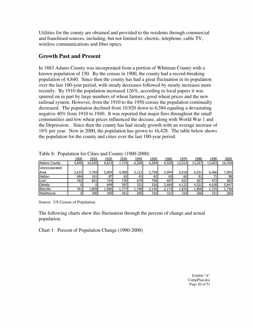
Exhibit “A” CompPlan.doc Page 20 of 51
Utilities for the county are obtained and provided to the residents through commercial and franchised sources, including, but not limited to: electric, telephone, cable TV, wireless communications and fiber optics. Growth Past and Present In 1883 Adams County was incorporated from a portion of Whitman County with a known population of 150. By the census in 1900, the county had a record-breaking population of 4,840. Since then the county has had a great fluctuation in its population over the last 100-year period, with steady decreases followed by steady increases more recently. By 1910 the population increased 126%, according to local papers it was spurred on in part by large numbers of wheat farmers, good wheat prices and the new railroad system. However, from the 1910 to the 1950 census the population continually decreased. The population declined from 10,920 down to 6,584 equaling a devastating negative 40% from 1910 to 1940. It was reported that major fires throughout the small communities and low wheat prices influenced the decease, along with World War 1 and the Depression. Since then the county has had steady growth with an average increase of 18% per year. Now in 2000, the population has grown to 16,428. The table below shows the population for the county and cities over the last 100-year period. Table 8: Population for Cities and County (1900-2000)
���� ���� ���� ���� ���� ���� ���� ��� ��� ���� ����
�� ��������� ���� ������ ����� ��� ����� ���� ����� ������ ����� ������ �����
���������� ����
��� ����� ��� ����� ���� ����� ���� ����� ���� ����� ����� ����
� ���� �� ��� �� �� �� �� �� � � �
���� �� �� �� �� �� �� �� ��� �� �� ��
�!�""� � � ��� �� ��� ��� ����� ����� ����� ���� ���
#��$%�""� �� ���� ����� �� ��� ����� ���� ��� ���� ���� ����
& �!���� � ��� ��� ��� �� ��� ��� ��� ��� ��� ���
Source: US Census of Population The following charts show this fluctuation through the percent of change and actual population. Chart 1: Percent of Population Change (1900-2000)
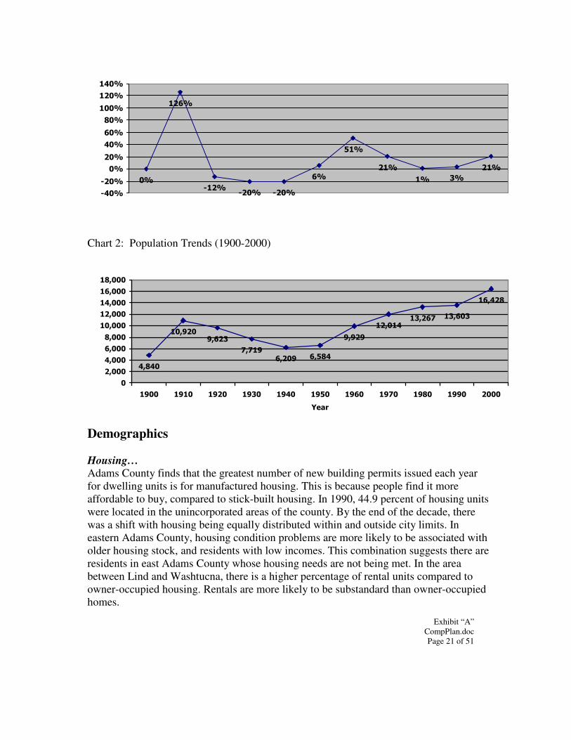
Exhibit “A” CompPlan.doc Page 21 of 51
��
����
��������
��
���
���
�� ��
���
�������
����
��
���
��
���
��
����
����
���
Chart 2: Population Trends (1900-2000)
��
�����������
� �����
�����
���������� ������
����
�����
�
�����
����
�����
����
������
������
�����
������
�����
���� ���� ���� ���� ��� ���� ���� �� � ��� ���� ����
����
Demographics Housing… Adams County finds that the greatest number of new building permits issued each year for dwelling units is for manufactured housing. This is because people find it more affordable to buy, compared to stick-built housing. In 1990, 44.9 percent of housing units were located in the unincorporated areas of the county. By the end of the decade, there was a shift with housing being equally distributed within and outside city limits. In eastern Adams County, housing condition problems are more likely to be associated with older housing stock, and residents with low incomes. This combination suggests there are residents in east Adams County whose housing needs are not being met. In the area between Lind and Washtucna, there is a higher percentage of rental units compared to owner-occupied housing. Rentals are more likely to be substandard than owner-occupied homes.
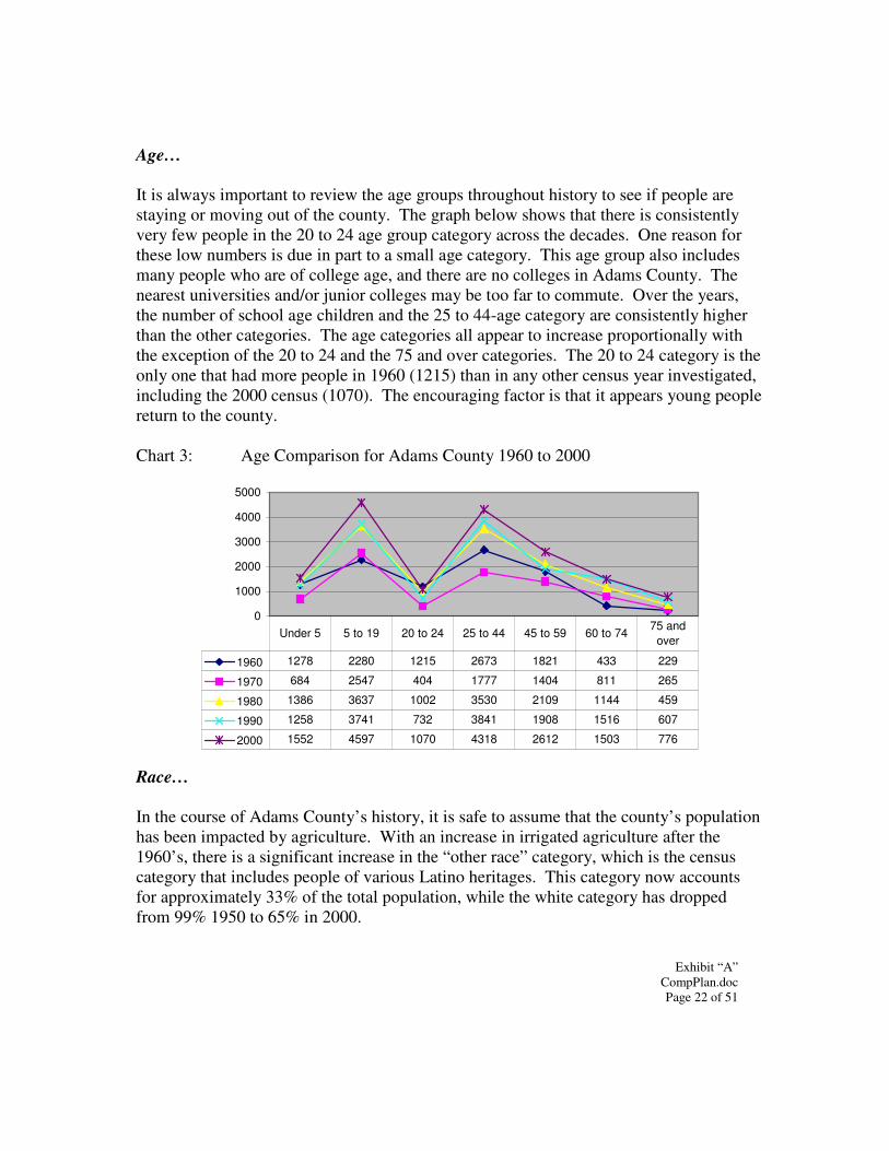
Exhibit “A” CompPlan.doc Page 22 of 51
Age… It is always important to review the age groups throughout history to see if people are staying or moving out of the county. The graph below shows that there is consistently very few people in the 20 to 24 age group category across the decades. One reason for these low numbers is due in part to a small age category. This age group also includes many people who are of college age, and there are no colleges in Adams County. The nearest universities and/or junior colleges may be too far to commute. Over the years, the number of school age children and the 25 to 44-age category are consistently higher than the other categories. The age categories all appear to increase proportionally with the exception of the 20 to 24 and the 75 and over categories. The 20 to 24 category is the only one that had more people in 1960 (1215) than in any other census year investigated, including the 2000 census (1070). The encouraging factor is that it appears young people return to the county. Chart 3: Age Comparison for Adams County 1960 to 2000
0
1000
2000
3000
4000
5000
1960 1278 2280 1215 2673 1821 433 229
1970 684 2547 404 1777 1404 811 265
1980 1386 3637 1002 3530 2109 1144 459
1990 1258 3741 732 3841 1908 1516 607
2000 1552 4597 1070 4318 2612 1503 776
Under 5 5 to 19 20 to 24 25 to 44 45 to 59 60 to 7475 and
over
Race… In the course of Adams County’s history, it is safe to assume that the county’s population has been impacted by agriculture. With an increase in irrigated agriculture after the 1960’s, there is a significant increase in the “other race” category, which is the census category that includes people of various Latino heritages. This category now accounts for approximately 33% of the total population, while the white category has dropped from 99% 1950 to 65% in 2000.
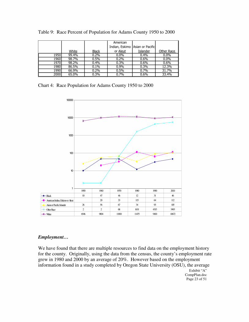
Exhibit “A” CompPlan.doc Page 23 of 51
Table 9: Race Percent of Population for Adams County 1950 to 2000
&!��� '" �(
������ ��
)��� ���*�(����
����"���
��� �����+ ��,���
)�" ���� �!���# ������� ��-�. �-�. �-�. �-�. �-�.���� �-. �-�. �-�. �-�. �-�.��� �-�. �-�. �-�. �-�. �-�.��� �-�. �-�. �-�. �-�. ��-�.���� ��-�. �-�. �-�. �-. ��-.���� ��-�. �-�. �-. �-�. ��-�.
Chart 4: Race Population for Adams County 1950 to 2000
1
10
100
1000
10000
100000
Black 10 47 46 12 31 46
American Indian, Eskimo or Aleut 20 33 115 64 112
Asian or Pacific Islander 26 56 67 34 93 105
Other Race 2 2 68 1631 4315 5493
White 6546 9804 11800 11475 9100 10672
1950 1960 1970 1980 1990 2000
Employment… We have found that there are multiple resources to find data on the employment history for the county. Originally, using the data from the census, the county’s employment rate grew in 1980 and 2000 by an average of 20%. However based on the employment information found in a study completed by Oregon State University (OSU), the average
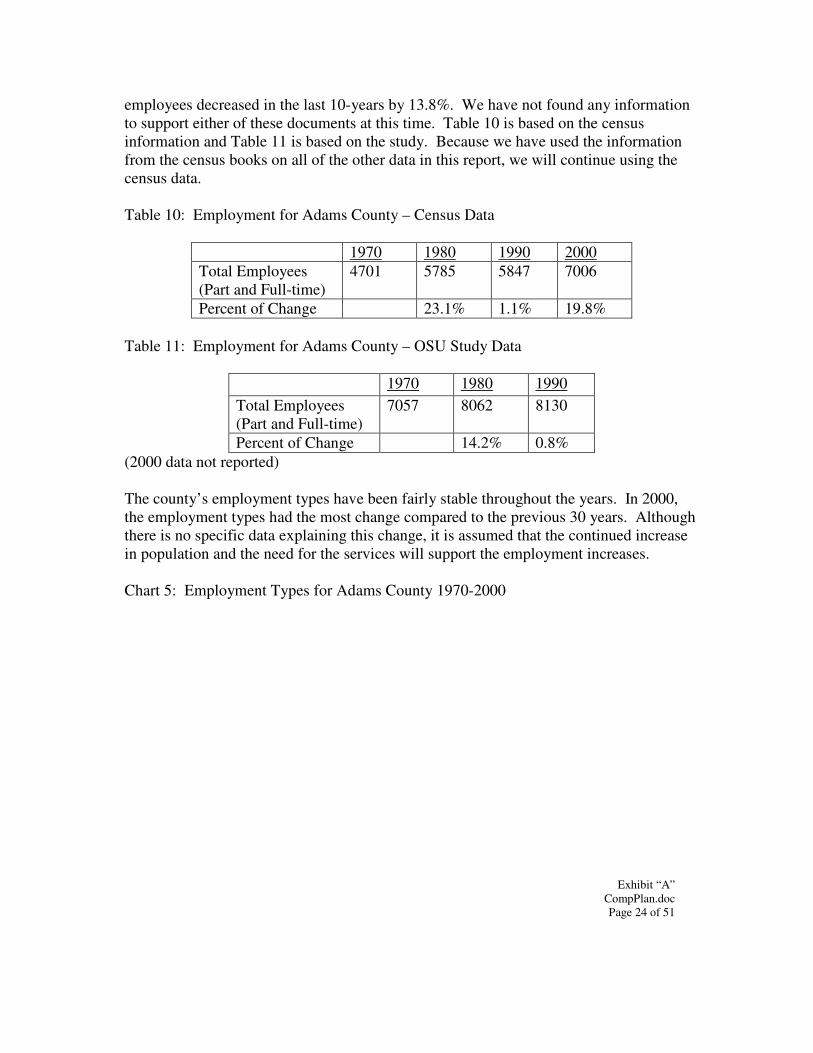
Exhibit “A” CompPlan.doc Page 24 of 51
employees decreased in the last 10-years by 13.8%. We have not found any information to support either of these documents at this time. Table 10 is based on the census information and Table 11 is based on the study. Because we have used the information from the census books on all of the other data in this report, we will continue using the census data. Table 10: Employment for Adams County – Census Data
1970 1980 1990 2000 Total Employees (Part and Full-time)
4701 5785 5847 7006
Percent of Change 23.1% 1.1% 19.8% Table 11: Employment for Adams County – OSU Study Data
1970 1980 1990 Total Employees (Part and Full-time)
7057 8062 8130
Percent of Change 14.2% 0.8% (2000 data not reported) The county’s employment types have been fairly stable throughout the years. In 2000, the employment types had the most change compared to the previous 30 years. Although there is no specific data explaining this change, it is assumed that the continued increase in population and the need for the services will support the employment increases. Chart 5: Employment Types for Adams County 1970-2000
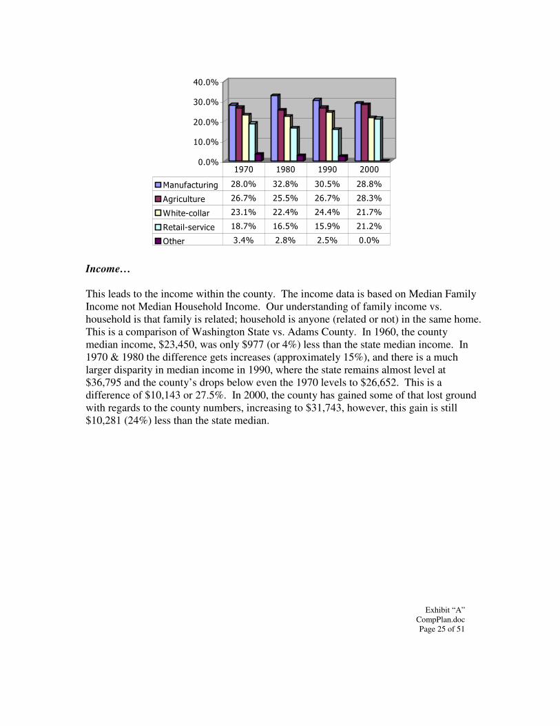
Exhibit “A” CompPlan.doc Page 25 of 51
�-�.
��-�.
��-�.
��-�.
��-�.
/ ��, ������0 �-�. ��-. ��-�. �-.
�0����"���� ��-. ��-�. ��-. �-�.
&!���1��"" � ��-�. ��-�. ��-�. ��-.
#�� �"1���%��� �-. ��-�. ��-�. ��-�.
�!�� �-�. �-. �-�. �-�.
��� ��� ���� ����
Income… This leads to the income within the county. The income data is based on Median Family Income not Median Household Income. Our understanding of family income vs. household is that family is related; household is anyone (related or not) in the same home. This is a comparison of Washington State vs. Adams County. In 1960, the county median income, $23,450, was only $977 (or 4%) less than the state median income. In 1970 & 1980 the difference gets increases (approximately 15%), and there is a much larger disparity in median income in 1990, where the state remains almost level at $36,795 and the county’s drops below even the 1970 levels to $26,652. This is a difference of $10,143 or 27.5%. In 2000, the county has gained some of that lost ground with regards to the county numbers, increasing to $31,743, however, this gain is still $10,281 (24%) less than the state median.
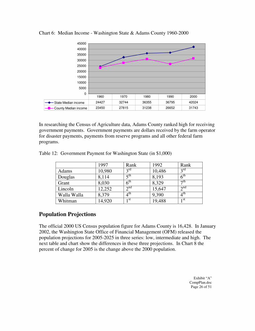
Exhibit “A” CompPlan.doc Page 26 of 51
Chart 6: Median Income - Washington State & Adams County 1960-2000
0
5000
10000
15000
20000
25000
30000
35000
40000
45000
State Median income 24427 32744 36355 36795 42024
County Median income 23450 27815 31238 26652 31743
1960 1970 1980 1990 2000
In researching the Census of Agriculture data, Adams County ranked high for receiving government payments. Government payments are dollars received by the farm operator for disaster payments, payments from reserve programs and all other federal farm programs. Table 12: Government Payment for Washington State (in $1,000)
1997 Rank 1992 Rank Adams 10,980 3rd 10,486 3rd Douglas 8,114 5th 8,193 6th Grant 8,030 6th 8,329 7th Lincoln 12,252 2nd 15,647 2nd Walla Walla 8,379 4th 9,390 4th Whitman 14,920 1st 19,488 1st
Population Projections The official 2000 US Census population figure for Adams County is 16,428. In January 2002, the Washington State Office of Financial Management (OFM) released the population projections for 2005-2025 in three series: low, intermediate and high. The next table and chart show the differences in these three projections. In Chart 8 the percent of change for 2005 is the change above the 2000 population.
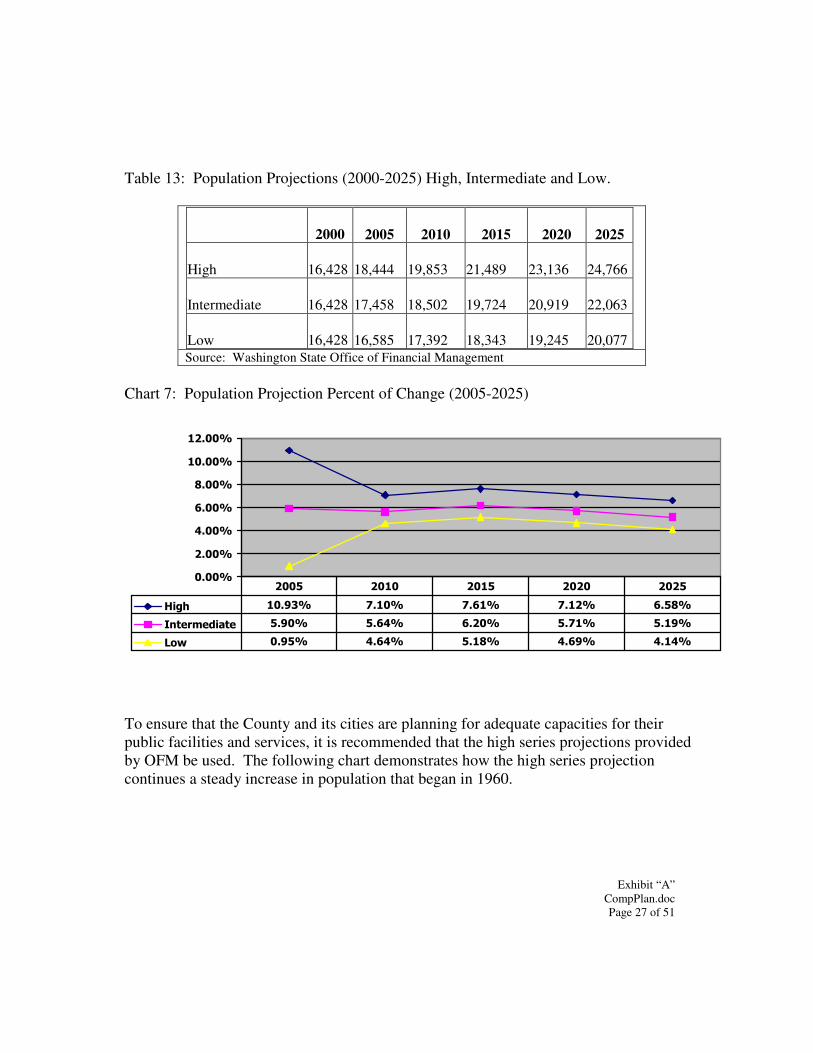
Exhibit “A” CompPlan.doc Page 27 of 51
Table 13: Population Projections (2000-2025) High, Intermediate and Low.
2000 2005 2010 2015 2020 2025
High 16,428 18,444 19,853 21,489 23,136 24,766
Intermediate 16,428 17,458 18,502 19,724 20,919 22,063
Low 16,428 16,585 17,392 18,343 19,245 20,077
Source: Washington State Office of Financial Management Chart 7: Population Projection Percent of Change (2005-2025)
�����
�����
����
�����
����
������
������
���� ������ ���� ���� ���� ����
������������ ����� ���� ����� �� �� �����
��� ����� ��� ���� ���� ���
���� ���� ���� ���� ����
To ensure that the County and its cities are planning for adequate capacities for their public facilities and services, it is recommended that the high series projections provided by OFM be used. The following chart demonstrates how the high series projection continues a steady increase in population that began in 1960.
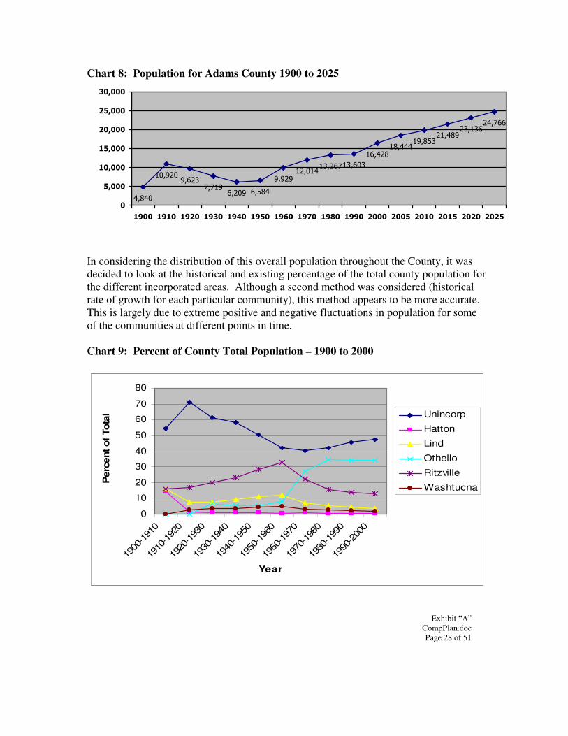
Exhibit “A” CompPlan.doc Page 28 of 51
Chart 8: Population for Adams County 1900 to 2025
����
�����������
�������� ����
�����������
�����������
����������
����������
�����������
�
�����
������
������
������
������
������
���� ���� ���� ���� ��� ���� ���� �� � ��� ���� ���� �������� �������� ����
In considering the distribution of this overall population throughout the County, it was decided to look at the historical and existing percentage of the total county population for the different incorporated areas. Although a second method was considered (historical rate of growth for each particular community), this method appears to be more accurate. This is largely due to extreme positive and negative fluctuations in population for some of the communities at different points in time. Chart 9: Percent of County Total Population – 1900 to 2000
0
10
20
30
40
50
60
70
80
1900
-191
0
1910
-192
0
1920
-193
0
1930
-194
0
1940
-195
0
1950
-196
0
1960
-197
0
1970
-198
0
1980
-199
0
1990
-200
0
Year
Per
cent
of T
otal Unincorp
Hatton
Lind
Othello
Ritzville
Washtucna
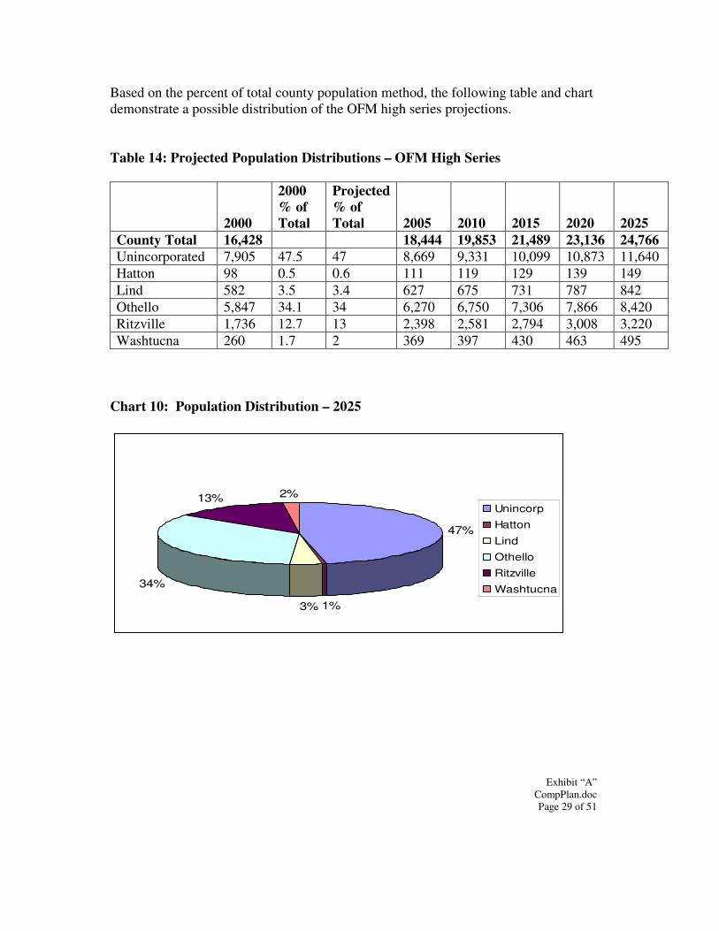
Exhibit “A” CompPlan.doc Page 29 of 51
Based on the percent of total county population method, the following table and chart demonstrate a possible distribution of the OFM high series projections. Table 14: Projected Population Distributions – OFM High Series
2000
2000 % of Total
Projected % of Total 2005 2010 2015 2020 2025
County Total 16,428 18,444 19,853 21,489 23,136 24,766 Unincorporated 7,905 47.5 47 8,669 9,331 10,099 10,873 11,640 Hatton 98 0.5 0.6 111 119 129 139 149 Lind 582 3.5 3.4 627 675 731 787 842 Othello 5,847 34.1 34 6,270 6,750 7,306 7,866 8,420 Ritzville 1,736 12.7 13 2,398 2,581 2,794 3,008 3,220 Washtucna 260 1.7 2 369 397 430 463 495
Chart 10: Population Distribution – 2025
13% 2%
47%
1%3%
34%
Unincorp
Hatton
Lind
Othello
Ritzville
Washtucna
Exhibit “A” CompPlan.doc Page 30 of 51
CHAPTER 3: LAND USE ELEMENT Resource Lands: Agriculture Agriculture was and is a vital economic mainstay of Adams County. The diversity of the agricultural industry provides the County with not only a relatively stable economic base, but also a cultural heritage and quality of life. This quality of life is created and defined through physical, environmental aspects as well as through lifestyles, attitudes and a sense of community that is somewhat unique to a rural area. Adams County, through its past as well as the future expressed in this comprehensive plan, will provide an example of how this quality of life can be maintained through progressive, innovative techniques. The intent of this section is to recognize and acknowledge the importance of agricultural lands and related activities to the economic livelihood of Adams County. Existing and future agricultural activities are permanent land uses as well as a significant economic function within the community. It is important to preserve and encourage these activities as viable operations and to protect them from the encroachment of incompatible uses, particularly through innovative development techniques. This section also contains Adams County’s response to the requirements of the GMA to identify and classify agricultural lands of long term commercial significance. Goals and Policies GOAL: Because of their importance to the continued economic viability of the County, agricultural lands will be preserved and maintained to the greatest extent possible. Policy 1: Encourage the retention of agricultural lands and prevent haphazard growth into these areas. Policy 2: Encourage the maintenance and viability of the family farm. Policy 3: Adopt a “right-to-farm” attitude whereby the County recognizes that agricultural uses and activities enjoy historical or prescriptive rights to normal farm practices such as early and late hours of operation, noise, dust generation, crop dusting, odors, slow moving vehicles and livestock on rural roads. Policy 4: Protect and retain existing and future agricultural lands from conflicting non-farm uses and influences.
Exhibit “A” CompPlan.doc Page 31 of 51
Policy 5: Support the existing economic base by discouraging the unnecessary or speculative rezoning of agricultural lands to non-farm use. Policy 6: Agricultural lands considered desirable for acquisition for public, recreational, scenic and/or park purposes, or for wildlife habitat, will first be evaluated for its impacts on the commercial agricultural and social-economic structure of the immediate area, and of the County as a whole. Policy 7: Encourage the use of agricultural value assessment, open space designations, and/or other tax benefits that help retain the economic viability of farming practices. Policy 8: Clustering of residential development may be carefully allowed in areas designated for agriculture, promoting a balance between future non-farm development and protecting agricultural activities from incompatible uses. Policy 9: Encourage farm-based businesses as accessory uses in agricultural areas that supplement farm income. Farm-based businesses are those that occur on-farm and are devoted to the direct marketing of unprocessed and/or value-added agricultural products that are produced, processed and/or sold on-site. Policy 10: Preserve agricultural tracts that are adequate in size, in relation to the particular activity, to maintain the economic viability of farming operations. Policy 11: Land divisions that are needed to support the operation for the family farm will continue to be expedited through an administrative review process. Said, divisions may include situations where a second residence at the farmstead is needed to accommodate family members who are expected to take over the farm operations. Land divisions of residences existing as of the date of adoption of the comprehensive plan may be permitted on less than the minimum lot size requirement of the particular agricultural zone. Policy 12: Allow recreational activities and other commercial and/or industrial uses that can be conducted in a manner that results in no negative impacts to agricultural operations. Policy 13: Small “hobby farms” should be allowed to serve as a buffer between the more densely populated residential areas and lands devoted to agriculture as commercial enterprise. Policy 14: Require some level of subdivision review process for any proposal that would create lots/parcels/tracts that are less than 20 acres in size, except that in those areas designated Prime Agriculture, require a review process for any proposal creating lots/parcels/tracts that are less than 60 acres in size.
Exhibit “A” CompPlan.doc Page 32 of 51
Policy 15: Allow existing parcels created through a process previously exempt from County subdivision review standards to be developed consistent with applicable health, building and zoning standards, even though they may not meet the density and/or minimum lot size standards. Criteria for Classifying “Long-term Commercially Significant Agricultural Lands” Adams County, with assistance from the Ground Water Management Area (GWMA), conducted a Geographic Information System (GIS) analysis to identify agricultural lands of long term commercial significance within the County. The following criteria was applied independently to dryland and irrigated farming areas within the County, resulting in the prime Agricultural Lands mapped in this comprehensive plan. An overriding theme in the many discussions leading to these criteria was “critical mass”. In other words, to maintain a truly viable agricultural economy that will continue to support the important agriculturally-related industries in the County, it is vital to preserve large areas of productive agricultural lands that are protected from impacts of non-farm uses that tend to promote conversion to other types of land uses. Dryland Criteria: Using NRCS digital information showing soil types that are “Prime if irrigated” and 2003 aerial photographs showing actual agricultural fields, the following criteria were identified and applied:
• Dryland fields at least 160 acres in size, and • Any other dryland field within ¼ mile of the above fields.
Irrigated Criteria: Using NRCS digital information showing soil types that are “Prime if irrigated” and 2003 aerial photographs showing actual agricultural fields, the following criteria were identified and applied:
• Irrigated fields at least 80 acres in size, and • Irrigated fields at least 10 acres in size within ¼ mile of the above fields, and • Each of the above fields had some portion of it within the NRCS digital
information showing soil types that are “Prime if irrigated” Agricultural Lands Designations Adams County will use the following agricultural lands designations in the comprehensive plan to identify those areas of the County that are appropriately utilized in a manner consistent with the above policies:
Exhibit “A” CompPlan.doc Page 33 of 51
Prime Agriculture: this designation will be applied to lands that have soil quality and other physical and chemical characteristics, including an adequate water supply in irrigated areas, needed to economically produce sustained high yields of crops when treated and managed according to acceptable farming methods. Included within this designation are the areas that fall into either the dryland prime or irrigated prime criteria identified above. This is the largest designation within the County, encompassing the entire center portion of the County, generally from the easterly edge of the Othello area to the westerly edge of the “channeled scablands” found in the East County. The minimum lot size in this district will be 60 acres. General Agriculture: this designation will be applied to lands used primarily for irrigated row crop and orchard production, grain or feed crop production as well as livestock grazing that do not fall within the parameters of “long-term commercially significant agricultural lands”. Included within this designation are those area enrolled in the Conservation Reserve Program (CRP) administered by the Natural Resource Conservation Service (NRCS). This designation is primarily located at the far eastern and western edges of the County where prime agricultural and other residential, commercial and/or industrial areas have not been identified. The minimum lot size in this district will be 20 acres. Resource Lands: Mineral As future development occurs within Adams County, mineral resources are needed for roads and utilities as well as residential, commercial and industrial development. The monetary value of mineral resources for construction has risen as deposits are covered by development, existing mines are depleted and development of new deposits or expansion of existing operations may be detrimental to adjacent land values and do not make attractive neighbors. The resulting higher value of construction materials means higher prices for homes, public infrastructure and transportation. The need and demand for sand, gravel and rock will continue. The challenge will be to protect known deposits while at the same time accommodating an expanding population. The intent of this section is to recognize and acknowledge the importance of mineral resource lands and related activities to the economic livelihood of Adams County. It is important to preserve and encourage mineral resource activities as viable operations and to protect them from the encroachment of incompatible uses. This section also contains Adams County’s response to the requirements of the GMA to identify and classify mineral lands of long term commercial significance. Goals and Policies
Exhibit “A” CompPlan.doc Page 34 of 51
GOAL: Adams County will conserve mineral resource lands for productive economic use to help maintain a stable, cost-effective source of needed construction materials. Policy 1: The County will encourage the retention and protection of long-term mineral resource sites of commercial grade aggregate for new development, roads and other uses. Policy 2: Mining and extraction operations will be sited and designed to minimize conflicts with adjacent land uses, and to minimize impacts on the environment. Policy 3: Mining sites will be encouraged to first locate in non-urban areas where impacts can be minimized to critical areas, archaeological sites and agriculturally designated lands. Policy 4: Allow incidental extraction and processing of mineral resources prior to construction or development of permitted residential, commercial, or industrial land uses or in conjunction with a demonstrated need, such as to address environmental water quality issues or imminent danger from a natural hazard. Policy 5: Use existing topography to screen and minimize blasting, noise, dust, vibration, and visual impacts when developing new mineral extraction sites. Where heavy equipment, mines and pits cannot be effectively screened from residential and/or commercial areas, shorelines of the state and major highways, a combination of existing topography, berms and landscaping may be utilized to screen the site. Policy 6: Ensure that mining sites and associated off-site stockpiles are maintained during the life of the operation, particularly in regard to the control of noxious weeds and dust. Policy 7: Reclamation of mining and extraction sites is an integral part of all mining operations, and will be required and completed in a manner that will encourage future land uses that are compatible with local comprehensive plans. Policy 8: Review and designate existing commercially significant mineral resource extraction sites that are legally established through local or state permitting processes and that meet the review guidelines set forth in this section for designating mineral resource lands of long-term commercial significance. Criteria for Classifying “Long-term Commercially Significant Mineral Lands” The following factors can be used to identify mineral resource lands of long-term commercial significance in Adams County:

Exhibit “A” CompPlan.doc Page 35 of 51
• All existing permitted sand and gravel extraction sites (pits) are designated as
mineral lands of long-term commercial significance, as shown on the “Mineral Resource Lands Reference Map”. These lands are classified as a mineral resource lands overlay to the underlying land use designation.
• Designate other mineral resource areas when a location can be demonstrated as
having a significant commercial supply and meet the review guidelines suggested below.
• Within Adams County, the existing pits designated as mineral lands of long-term
commercial significance are allowed to be used outright in all zoning districts. Future mineral resource lands that are identified are also allowed outright in these two designations/zoning districts, EXCEPT, where the future location is proposed within 500’ of a municipal boundary or an existing residence or a subdivisions, short subdivision or any other platted lot approved pursuant to RCW 58.17 and the Adams County Subdivision Code. In these instances a conditional use permit must be obtained prior to operations to allow for appropriate site-specific review of that new mineral resource.
• Areas can be classified as mineral resource lands based on geologic, environment,
commercial quality and volume of the resource, topographic characteristics of the site, visual aesthetics, economic factors, compatibility with existing land uses and land ownership patterns. The following categories of mineral resource lands will be used by Adams County for the purpose of classification:
1. Metallics 2. Sand and Gravel 3. Other Minerals (including bentonite, oil and gas)
Residential Lands This section is intended to provide direction for the development of implementing ordinances that pertain to residential land uses within Adams County, and to guide the review of specific project proposals. Their purpose is to help provide continuity between existing and potential residential uses. It is also their intent to equip the implementing ordinances with the needed background and authority to help maintain the quality of life within the County.
Exhibit “A” CompPlan.doc Page 36 of 51
Goals & Policies Policy 1: Residential uses should be located in areas with adequate public water and sewer facilities that are near existing established neighborhoods where the primary use is residential. Policy 2: The extension of public infrastructure should proceed into new areas in a logical way that promotes cost effective utilization of that infrastructure. Policy 3: Discourage the mixing of incompatible commercial and industrial land uses in residential areas, however community educational, religious and/or recreational activities may be sited in these area where adequate buffering can be provided. Policy 4: Provide appropriate measures to regulate the keeping of livestock and animals other than domestic pets, including performance standards for maintenance of pastures, shelters and feeding areas. Policy 5: Adams County should implement animal control regulations, particularly those that address exotic and potentially dangerous animals. Policy 6: Provide innovative and flexible design for residential developments, especially for multi-family units, by establishing and encouraging planned developments. Policy 7: Maintain (preserve) current housing stock, and provide additional residential options for the future. Policy 8: Affordable Housing is critical to the citizens of Adams County. While manufactured homes serve as one means of meeting this need, other affordable housing options that address single and multi family needs also should be studied. Future policies that address affordable housing needs by various methods should be developed. Policy 9: Accessory dwelling units, where one household lives adjacent to another on the same parcel, should be considered one possible method of providing affordable housing, however, older, single-wide mobile homes should not be allowed as accessory dwelling units. Policy 10: The process of citing group homes and other congregate care living arrangements for people with disabilities and other special needs in Adams County should be studied and addressed by future policies within this comprehensive plan. Policy 11: Require new development on existing townsite plats that contain nonconforming lot sizes to meet the minimum lot size of the applicable zone or the
Exhibit “A” CompPlan.doc Page 37 of 51
minimum land area required to handle on-site wastewater disposal needs, whichever is greater. Policy 12: Where a city/town has existing public water and sewer systems available to accommodate further development, require new development proposed at less than 1 unit/1.25 acres to connect to that city’s/town’s systems, even where that connection requires annexation. Residential Designations Adams County will use the following residential designations in the comprehensive plan to identify those areas of the County that are appropriately utilized in a manner consistent with the above policies: Residential: this designation will be applied to lands that are adjacent to the established communities within the County that have the following characteristics: 1) Access to public water and sewer systems; 2) Near existing established neighborhoods where the primary use is residential; 3) Not in areas where the predominant uses are prime agricultural production; and 4) Within reasonable response times for emergency services. The types of activities that are allowed may include single family residences, schools, parks, churches, home occupations and some agricultural activities, usually for personal use (home gardens, orchards, etc.). Commercial and industrial activities, as well as the keeping of livestock, are generally not allowed in these areas. The density of residential development will be 4 units per acre with public sewer and water. Rural Residential: this designation will be applied to lands that are somewhat removed from the established communities within the County, but not in areas that are considered appropriate for commercial farming activities, and that have the following characteristics: 1) Public water may be available, however public sewer systems are not usually available; 2) Near existing established neighborhoods where primary use is residential; 3) Not in areas where the predominant uses are prime agricultural production; and 4) Response times for emergency services are not as low as in the residential areas . The types of activities that are allowed may include single family residences, home occupations, agricultural activities including some agri-tourism uses and the keeping of livestock (“hobby farms”). Commercial and industrial activities are generally not allowed in these areas. The density of residential development will be 1 unit per 1.25 acres. Commercial Lands This section is intended to provide direction to guide the development of a quality environment for commercial development. The goals and policies and designation
Exhibit “A” CompPlan.doc Page 38 of 51
description help define the scope of future development while still assuring compatibility with surrounding land uses. Goals & Policies GOAL: Create opportunities for safe, attractive and accessible commercial districts that will provide for diverse economic development and contribute to a sound economic base for the County. Policy 1: Encourage the development of commercial land in a manner that is complimentary and compatible with adjacent land uses and the surrounding environment, particularly through the use of transition or buffer areas. Policy 2: Maintain existing zoning for commercial uses and protect it from conversion to other uses, however a mix of commercial and light industrial uses is appropriate. Policy 3: Commercial development should be encouraged to locate adjacent to highway access points. Policy 4: Encourage landscaping that screens or softens parking lots and unsightly areas, particularly where there is a transition between commercial areas and residential uses. Policy 5: Develop adequate standards for off-street parking and loading for diverse commercial needs and encourage public/private partnerships in the provision of parking facilities. Policy 6: Encourage efforts to revitalize as well as to maintain established commercial development. Policy 7: Design and create traffic patterns that will improve the accessibility of commercial establishments. Policy 8: Expand commercial uses adjacent to existing similarly developed areas which would encourage clustering of the commercial district. Policy 9: Promote the extension of support facilities and services to commercial areas. Support interagency cooperation in the extension and upgrading of infrastructure and support facilities to commercial areas.
Exhibit “A” CompPlan.doc Page 39 of 51
Commercial Designations Adams County will use the following commercial designation in the comprehensive plan to identify those areas of the County that are appropriately utilized in a manner consistent with the above policies: Commercial: this designation will be applied to lands that have the following characteristics: 1) Public water and sewer systems may not be required, depending on the type of use; 2) Located near existing population centers and/or near major intersecting transportation corridors (highways); and 3) Are coordinated with adjacent jurisdictions to ensure status of existing and future public facilities and services is known. The types of activities that are allowed may include retail and service commercial uses, commercial recreational uses, and some light industrial activities that don’t involve manufacturing and/or processing activities. Development standards that will be addressed in development regulations include fire flow, access to public streets with sufficient right-of-way, adequate off-street parking and loading, landscaping/buffers next to residential areas, adequate setbacks, clear view triangle (adequate sight and turning distance), lighting shouldn’t project onto other properties, signs, near urban areas sidewalks should be provided and/or at least an area set aside for future sidewalks. Industrial Lands New industrial development is necessary and desirable for helping to stabilize a community's economy, however, there can be a number of negative impacts associated with various industrial uses. The intent of this section is to provide a framework for alleviating and internalizing some of these impacts while still creating viable areas for conducting industrial activities. Goals & Policies Goal: Promote industrial development that contributes to economic diversification, growth and stability of the community without degrading its natural systems or residential living environment. Policy 1: Encourage the continued development of industries that are agriculturally related. Policy 2: Encourage industrial development to locate in industrial/business park areas adjacent to major arterials, preferably on lands not suited for residential uses or agricultural uses.
Exhibit “A” CompPlan.doc Page 40 of 51
Policy 3: Encourage variety and innovative design in industrial site development and encourage an attractive and high quality environment for industrial activities. Policy 4: Actively support economic development measures that serve to revitalize and promote the growth of existing industrial locations. Policy 5: Encourage air related industries and non-conflicting light industrial on existing airport facilities. Policy 6: Recognize sand and gravel extraction and processing as an interim use and develop criteria for the location, compatibility and aesthetics to surrounding land uses. Policy 7: Encourage, whenever possible, the extension of support facilities and services for industrial activity. Policy 8: Industrial land use should be located northeast of towns because of prevailing winds. Policy 9: Within industrial areas, allow some commercial uses, particularly that are supportive of industrial uses and employees, ensuring that these commercial uses are protected from impacts from the industrial activities. Industrial Designations Adams County will use the following industrial designations in the comprehensive plan to identify those areas of the County that are appropriately utilized in a manner consistent with the above policies: Light Industrial: this designation will be applied to lands that have the following characteristics: 1) Public water and sewer systems may not be available but are a plus; 2) Located near existing population centers and/or near major intersecting transportation corridors (highways and major county roads); 3) Not in areas of existing, established residential; and 4) Located near existing industrial areas. The types of activities that are allowed may include some more land-intensive commercial uses, as well as less intensive industrial, manufacturing and processing uses. Development standards that will be addressed in development regulations include fire flow, access to public streets with sufficient right-of-way, adequate off-street parking and loading, landscaping/buffers next to residential areas, adequate setbacks, clear view triangle (adequate sight and turning distance), lighting shouldn’t project onto other properties, signs, near urban areas sidewalks should be provided and/or at least an area set aside for future sidewalks.
Exhibit “A” CompPlan.doc Page 41 of 51
Heavy Industrial: this designation will be applied to lands that have the following characteristics: 1) Access to public water is required, while access to public sewer systems isn’t required but is a plus; 2) Located near existing population centers and/or near major intersecting transportation corridors (highways and major county roads); 3) Not in areas of existing, established residential; and 4) Located near existing industrial areas. The types of activities that are allowed may include all types of industrial and manufacturing uses. Development standards that will be addressed in development regulations include fire flow, access to public streets with sufficient right-of-way, adequate off-street parking and loading, landscaping/buffers next to residential areas, adequate setbacks, clear view triangle (adequate sight and turning distance), lighting shouldn’t project onto other properties, signs, near urban areas sidewalks should be provided and/or at least an area set aside for future sidewalks. Recreational Uses Recreational opportunities are many and varied throughout Adams County. When developed and enhanced in a way that is respectful of their unique qualities, these activities can be used to help expand the economic base of the County by capitalizing on the available natural resources and beauty of the area to entice tourist/recreational activity. These goals and policies seek to provide a framework to guide the development of recreational opportunities as an economic venture in a manner that is sensitive not only to the resource that makes it appealing, but also to the people of the County and their quality of life. Goals & Policies Goal: Promote recreation and tourism as viable economic development opportunities that build on the many and varied existing natural resources of the County in a way that prevents degradation of the resource and the quality of life already in place. Policy 1: Outdoor recreational opportunities should be focused on the northeast and southeast corners of Adams County. Policy 2: Promote private commercial recreational opportunities adjacent to the Columbia Plateau Park facility such as Bed and Breakfast facilities that are common to rural areas and long distance trail facilities. Policy 3: Cooperate and coordinate with the Washington State Parks Commission to facilitate the installation and operation of current and future parks under their jurisdiction within east Adams County.
Exhibit “A” CompPlan.doc Page 42 of 51
Policy 4: Sprague Lake is a natural location to allow and promote recreational opportunities. Other water bodies, such as Cow Creek and those identified within Adams County’s Shoreline Master Program, also may be suitable for outdoor recreational development. Policy 5: Amend the Adams County Zoning Code to allow the citing of park facilities outright in zones that are deemed suitable. Policy 6: Private recreation areas, i.e., golf courses, campgrounds, hunting resorts and clubs should be mapped in Adams County. The Adams County Zoning Code should be amended to list permitted uses associated with these kinds of activities. Policy 7: Promote eco-tourism opportunities such as non-motorized interpretive trials that capitalize Adams County’s history as well as natural and cultural resources, especially railroad history and its impact on the settlement of the county. Opportunities to explore and promote geologic forces and history in Adams County within a regional perspective should be a priority. Policy 8: Encourage cooperation and coordination of recreation-oriented economic development that keeps different entities informed on a County-wide basis. General Issues The following policies are statements of general application throughout the County. Although they may not precisely fit within the general categories/elements of the comprehensive plan, they are important statements that are included in the plan for further guidance as the County grows and develops. Policy 1: Ensure each land development application is thoroughly considered for potentially significant negative impacts. Require appropriate mitigation measures to control unavoidable impacts. Applications that would cause significant negative impacts even with mitigation should be denied. Policy 2: Adams County should provide prospective applicants sufficient assistance to help navigate the complex maze of state and federal environmental regulations. Policy 3: On-going efforts to designate and protect natural resource lands of long term commercial significance should emphasize the potential for commercial production of agricultural and mineral products for future generations. Policy 4: The Comprehensive Plan should be evaluated periodically and amended if necessary to be coordinated and consistent with plans of other counties and cities where there are common regional or statewide concerns (such as Sprague Lake).
Exhibit “A” CompPlan.doc Page 43 of 51
Policy 9: Adams County should develop a Park and Recreational Plan to be included within the Comprehensive Plan as another element. It should conform to the standards and requirements as specified by the Interagency for Outdoor Recreation in order to be eligible for future park and recreation funds. Policy 10: Provide appropriate guidance and protection measures for addressing the needs and concerns associated with the important environmental issues that help define the quality of life in Adams County.
Exhibit “A” CompPlan.doc Page 44 of 51
Mixed Use Lands: This section is intended to provide direction for the development of existing unincorporated rural settlements, plats or mixed use areas that provide, or when developed may provide for the general needs of the residents of small and sometimes secluded communities. This designation could be applied to lands that are somewhat removed from established communities that are considered appropriate based on the following goals and policies. Goal: To provide a mechanism for the preservation and enhancement of the existing unincorporated communities that currently provide areas of mixed residential, multi-family residential, commercial, agricultural and light manufacturing / light industrial uses Goal: To provide a mechanism for the establishment of unincorporated communities that may provide areas of mixed residential, multi-family residential, commercial, agricultural and light manufacturing/industrial uses Policies: Policy 1: Limit the development or creation of such areas to locations that have or will
have adequate public water and sewer/septic facilities. Policy 2: Limit the development or creation of such areas to locations where the primary
use of the adjacent existing established neighborhoods is rural/agricultural; Policy 3: Designate areas that have either direct access to existing improved Adams
County roads or to private roads constructed/improved to current applicable Adams County standards.
Policy 4: Provide for a range of land uses using innovative and flexible designs that
provide adequate buffering and discourage the mixing of incompatible land uses. Such land use activities may include:
A. Single- and multi-family residences; B. Schools; C. Parks; D. Churches; E. Home occupations; F. Agricultural activities including some agri-tourism and the keeping of
livestock; G. Commercial activities compatible with the general character of the
community and surrounding rural / agricultural area;
Exhibit “A” CompPlan.doc Page 45 of 51
H. Light industrial activities compatible with the general character of the community and surrounding rural / agricultural area.
CHAPTER 4: TRANSPORTATION ELEMENT Transportation networks tie a community together as well as linking it to the outside world. County and state roads provide the access among the communities and rural areas, as well as providing important routes for goods and commodities into and out of the areas. Local streets and roadways provide safe, reliable access to work, schools, shopping and residences. The transportation system also involves accommodating different modes of transportation, including public transit, air and rail transport, and trails for non-motorized uses such as bicycles, pedestrians and horses. These important linkages are vital to the economic health and viability of Adams County and they need to be maintained and enhanced in order to efficiently provide their service. Goals & Policies GOAL: Provide the most efficient use of existing and future transportation facilities through a systematic approach of monitoring and maintaining the road systems; integrating all types of transportation systems and facilities; and by coordinating transportation facilities planning with other element of the comprehensive plan, as well as with other federal, state and local agencies. Policy 1: Development that generates high traffic amounts (as indicated by measuring Average Daily Trips) should be encouraged to locate adjacent to state highway and freeway access. Policy 2: The County should emphasize the intersection at I-90 and Hwy 395 as a gateway for local tourism. Policy 3: Distinguish between public and private county roads. Produce clear and easily understood road standards for each type to be adopted within the context of this Comprehensive Plan. Policy 4: Create an inventory accompanied by suitable maps that identifies the current location, condition, capacity, and traffic issues of all county roads, both public and private. Develop an affordable transportation strategy linked to current and future land use to maintain and enhance the integrity of the county road system.
Exhibit “A” CompPlan.doc Page 46 of 51
Policy 5: Define and implement a coordinated approach for future infrastructure construction, e.g., the installation of water, sewer and power, within county rights-of-way prior to paving of roads within the county. Policy 6: Identify and encourage preservation of future rights-of-way options. Apply access management strategies that are consistent with state requirements. Policy 7: Level of service (LOS) standards should be adopted for state routes within Adams County by the county to reflect LOS standards of the state, namely, LOS C for urban conditions, and LOS D for rural conditions. Policy 8: Require that prior to the granting of quasi-judicial rezones, applicants address potential traffic impacts to the state and county road networks. For projects determined to generate significant traffic volumes, a traffic study should be required of applicants to determine actual impacts and what improvements would be necessary to mitigate them. Policy 9: Establish and adopt a threshold description/figure to determine what constitutes significant traffic volume. Policy 10: Assure that county haul routes are maintained and repaired to move agricultural products efficiently to market. Policy 11: Support county transportation decisions that enhance local economic stability and encourage future development options. Policy 12: Conduct an inventory and map private and public airports that exist in Adams County. All public use airports should be categorized and dealt with as “essential public facilities.” Suitable development policies that address future growth around and near airports should be developed to reduce or prevent incompatible land uses. Policy 13: Support the continued and improved use of railroad service for Adams County to foster economic development by hauling agricultural, commercial and industrial products to, from and within the county. The use should also be directed toward recreational pursuits. Policy 14: Provide alternative transportation choices for the traveling public by identifying suitable bicycle routes within the county where incompatibility issues with long haul truck traffic aren’t involved. Policy 15: Coordinate the Adams County Comprehensive Plan Transportation Element with city, regional, and state transportation plans whenever possible.
Exhibit “A” CompPlan.doc Page 47 of 51
Policy 16: Develop the six year Transportation Improvement Program in coordination with the relevant contents of the Comprehensive Plan. Policy 17: Present and future QuadCo Regional Transportation Planning Organization (RTPO) Plans should be incorporated by reference into this Comprehensive Plan. Policy 18: Provide for continuation of logical public streets and roads as development occurs by requiring right-of-way dedications and/or public road improvements during the review and approval process. Policy 19: New development on private roads should be considered, however the standards for private roads should be similar to those for public roads. Policy 20: Where feasible, larger subdivisions should provide a second access point to accommodate emergency vehicle access.
Exhibit “A” CompPlan.doc Page 48 of 51
CHAPTER 5: FACILITIES & UTILITIES ELEMENT It is intended that this element serve as a framework for making decisions about County-owned facility, service and utility improvement projects, as well as providing a guide for orderly growth as identified in the other elements of the comprehensive plan. For those facilities, services and utilities that are not within the jurisdiction of the County government to provide, but are required by the residents of Adams County, this plan encourages those service purveyors to consider the information and vision presented in this document when planning for capital improvements for their future. By coordinating individual purveyors’ plans with this plan, a more effective, cost efficient provision of services will benefit the users and the purveyors. GOAL: Development in Adams County will only occur in conjunction with the availability of adequate, cost effective provision of utilities and public facilities and services. The installation and expansion of utilities, public facilities and services will be coordinated to minimize cost and disruption of normal activities. Policy 1: Increased infrastructure needs triggered by future development proposals should be financed by developer investment. Policy 2: Proposals for more intense, resource-consumptive development that require public services and utilities should be located within sufficient distance of a municipality to obtain such services. Policy 3: Industrial development that does not require being hooked up to public services and utilities should be allowed to locate in multiple parts of Adams County where the transportation needs of that industry can be met. Policy 4: Future expansion to various utilities and facilities that serve the needs of people in Adams County should be considered within the context of the Comprehensive Plan. Policy 5: Adams County should promote effective cooperation and communication across multi- jurisdictional lines when appropriate to improve public services for the public. Policy 6: Coordinate county long range planning efforts with private and public service providers to ensure sufficient infrastructure capacity for future growth. Policy 7: Define and implement through an interdepartmental, coordinated approach, pre-established timelines for future infrastructure construction, e.g., the installation of
Exhibit “A” CompPlan.doc Page 49 of 51
water, sewer and power, within county rights-of-way prior to paving of roads within the county. Policy 8: Enhance cooperation and coordination with appropriate junior taxing districts such as education, park, water, fire and irrigation by providing timely information regarding development proposals for their review and comment. Policy 9: Develop a policy that addresses density requirements for utilities, as well as for publicly and privately supplied water sources. Policy 10: Require that proposals for new land uses that depend on provision of public services and utilities be coordinated with towns and cities. Policy 11: Opportunities to enhance and promote communications technology within Adams County that strengthen its competitive edge in recruiting new businesses from the commercial and industrial sectors should be considered a priority issue. Policy 12: Adams County will implement local storm water management policies and regulations consistent with area conditions that protect public and private investments. Policy 13: Future proposals to locate cellular and other communications towers should not be allowed if they pose unmitigated hazards for the safe operations and use of airport facilities within the county.
Exhibit “A” CompPlan.doc Page 50 of 51
CHAPTER 6: ECONOMIC DEVELOPMENT ELEMENT Economic development entails actions by the County that will directly or indirectly result in the increase of trading activity within the area. Through good policy direction a county can determine which economic activities will be pursued in order to stimulate steady, beneficial growth over the long term. The intent of this element is to provide goals and policies to guide the County’s future activities when pursuing important economic development issues. GOAL: Adams County, through its comprehensive plan efforts, and by the application of development regulations, should provide for an adequate land supply of suitable sizes, types, locations and service levels for industrial and commercial uses consistent with the community values and goals and policies within this Plan. Policy 1: Adams County supports the creation of new jobs that provide livable, family wages for county residents. Policy 2: Adams County should promote multi-jurisdictional cooperation efforts between and among city, county and state departments to facilitate and advance economic development opportunities. Policy 3: Whenever possible, cooperate and collaborate with efforts of other public, private and/or non-profit organizations to foster economic development opportunities within Adams County. Policy 4: Support the cooperative efforts of all area educational institutions to maintain high standards in all areas of educational opportunity. Policy 5: Pursue local, state, federal and other funding and technical assistance to plan and develop facilities and programs that attract new business. Policy 6: The Economic Element of this Comprehensive Plan should be expanded to include appropriate technical studies and an Economic Opportunities Analysis to define and analyze community economic patterns and potential strengths and weaknesses relative to state and federal economic trends. Appropriate strategies to offset deficiencies should be adopted. Policy 7: Coordinate economic development efforts that are consistent with the transportation, land use, and public facilities and utilities elements of this comprehensive plan. Policy 8: Encourage compatible land uses in areas designed to attract commercial and/or industrial uses, so as not to deter, delay or increase the cost of attracting new and/or retaining existing commercial and industrial development.

Exhibit “A” CompPlan.doc Page 51 of 51
Policy 9: Coordination should be encouraged between local and state agencies to provide quick turn around for development decisions that involve transportation, water supply, and sewage and solid waste disposal. Policy 10: Streamline the development and permit process to include simplified access to information, application and permitting.