Embed Size (px)
Citation preview
Addressing Climate Change in Long-Term Water
Resources Planning and Management User Needs for Improving Tools and Information
January 2011 Approved for public release; distribution is unlimited
REPORT DOCUMENTATION PAGE Form Approved
OMB No. 0704-0188 Public reporting burden for this collection of information is estimated to average 1 hour per response, including the time for reviewing instructions, searching existing data sources, gathering and maintaining the data needed, and completing and reviewing this collection of information. Send comments regarding this burden estimate or any other aspect of this collection of information, including suggestions for reducing this burden to Department of Defense, Washington Headquarters Services, Directorate for Information Operations and Reports (0704-0188), 1215 Jefferson Davis Highway, Suite 1204, Arlington, VA 22202-4302. Respondents should be aware that notwithstanding any other provision of law, no person shall be subject to any penalty for failing to comply with a collection of information if it does not display a currently valid OMB control number. PLEASE DO NOT RETURN YOUR FORM TO THE ABOVE ADDRESS.
1. REPORT DATE (DD-MM-YYYY)
January 2011
2. REPORT TYPE
Technical Report 3. DATES COVERED (From - To)
4. TITLE AND SUBTITLE
Addressing Climate Change in Long-Term Water Resources Planning and Management:
User Needs for Improving Tools and Information Title
5a. CONTRACT NUMBER
5b. GRANT NUMBER
5c. PROGRAM ELEMENT NUMBER
6. AUTHOR(S)
Levi D. Brekke
Bureau of Reclamation
Technical Service Center
5d. PROJECT NUMBER
5e. TASK NUMBER
5f. WORK UNIT NUMBER
7. PERFORMING ORGANIZATION NAME(S) AND ADDRESS(ES) 8. PERFORMING ORGANIZATION REPORT NUMBER
U.S. Army Corps of Engineers
Bureau of Reclamation, U.S. Department of the Interior CWTS 10-02
9. SPONSORING / MONITORING AGENCY NAME(S) AND ADDRESS(ES) 10. SPONSOR/MONITOR’S ACRONYM(S)
U.S. Department of the Interior U.S. Army Corps of Engineers
Bureau of Reclamation, Washington, DC 20314-1000
Washington, DC 20240-0001
11. SPONSOR/MONITOR’S REPORT NUMBER(S)
12. DISTRIBUTION / AVAILABILITY STATEMENT
Available from the National Technical Information Service
Operations Division, 5285 Port Royal Road, Springfield VA 22161
13. SUPPLEMENTARY NOTES
Report can be downloaded from the Reclamation Web site: www.usbr.gov/climate/userneeds
14. ABSTRACT
This document describes the water management community’s needs for climate change information and tools to support long-term
planning. Reclamation and the U.S. Army Corps of Engineers (USACE) technical specialists and program managers have worked with
their planners, water operators, and environmental compliance managers to identify the information and tools most relevant to their
programs. Reclamation and USACE also have engaged and consulted with other Federal, State, and local agencies and stakeholder
groups that have a role in water and water-related resource management to identify complementary priorities and individual
perspectives. This document is meant to help focus research and technology efforts to address information and tools gaps relevant to the
water management user community.
Technical climate change information may be incorporated into longer-term water resources planning using various methods. In this
report, eight technical steps representative of these various methods are used to categorize tools and information needs (i.e., gaps): 1.
Summarize Relevant Literature; 2. Obtain Climate Change Information; 3. Make Decisions About How To Use the Climate Change
Information; 4. Assess Natural Systems Response; 5. Assess Socioeconomic and Institutional Response; 6. Assess System Risks and
Evaluate Alternatives; 7. Assess and Characterize Uncertainties; and 8. Communicating Results and Uncertainties to Decisionmakers. 15. SUBJECT TERMS
Water management, climate change, water-related resource management, tools gaps, water management user community, literature
review, climate change information, natural systems response, system risks, uncertainties 16. SECURITY CLASSIFICATION OF: 17. LIMITATION
OF ABSTRACT 18. NUMBER OF PAGES
19a. NAME OF RESPONSIBLE PERSON
Levi Brekke
a. REPORT
U
b. ABSTRACT
U
c. THIS PAGE
U U 161
19b. TELEPHONE NUMBER (include
area code)
303-445-2494 Standard Form 298 (Rev. 8-98)
Prescribed by ANSI Std. 239.18
Addressing Climate Change in Long-Term Water
Resources Planning and Management User Needs for Improving Tools and Information
U.S. Army Corps of Engineers Civil Works Technical Series CWTS-10-02
Levi D. Brekke, Bureau of Reclamation, Technical Service Center, Lead Author
Contributing Authors, U.S. Army Corps of Engineers:
Kathleen White and J. Rolf Olsen, Institute for Water Resources
Edwin Townsley, South Pacific Division
David Williams, Tulsa District
Fauwaz Hanbali, Hydrologic Engineering Center
Contributing Authors, Bureau of Reclamation: Chuck Hennig and Curt Brown, Research and Development Office
David Raff, Policy and Administration
Rod Wittler, Mid-Pacific Region
Prepared by and for:
U.S. Army Corps of Engineers
Washington, DC
U.S. Department of the Interior
Bureau of Reclamation
Washington, DC
Under: USACE Campaign Plan Goal 2 and Bureau of Reclamation Science and Technology Program
Monitored by: USACE Senior Executive Service Leader: James Dalton, P.E.
and
Bureau of Reclamation, Senior Executive Service Leader: Michael Gabaldon, P.E.
January 2011
CWTS 10-02 ii
Abstract
This document describes the water management community‘s needs for
climate change information and tools to support long-term planning.
Reclamation and the U.S. Army Corps of Engineers (USACE) technical
specialists and program managers have worked with their planners, water
operators, and environmental compliance managers to identify the
information and tools most relevant to their programs. Reclamation and
USACE also have engaged and consulted with other Federal, State, and
local agencies and stakeholder groups that have a role in water and water-
related resource management to identify complementary priorities and
individual perspectives. This document is meant to help focus research
and technology efforts to address information and tools gaps relevant to
the water management user community.
Technical climate change information may be incorporated into longer-
term water resources planning using various methods. In this report,
eight technical steps representative of these various methods are used to
categorize tools and information needs (i.e., gaps): 1. Summarize
Relevant Literature; 2. Obtain Climate Change Information; 3. Make
Decisions About How To Use the Climate Change Information; 4. Assess
Natural Systems Response; 5. Assess Socioeconomic and Institutional
Response; 6. Assess System Risks and Evaluate Alternatives; 7. Assess
and Characterize Uncertainties; and 8. Communicating Results and
Uncertainties to Decisionmakers.
CWTS 10-02 iii
A Joint Message from the Commissioner, Bureau of Reclamation, and the Director of Civil Works, U.S. Army Corps of Engineers:
Water resources underpin our quality of life and our national economy. Climate
change impacts to water and water-dependent resources present new and
complex challenges to the water resources management community. Meeting
these challenges will require close collaboration between the water resources
management community and the science community to develop and apply new
and improved scientific information and technical tools.
With this publication, the Bureau of Reclamation and the U.S. Army Corps of
Engineers, as part of the Climate Change and Water Working Group, offer our
joint agency perspectives on user needs we have identified to help us meet this
challenge for long-term water resources planning. We also recognize the other
Federal and non-Federal water resource organizations and interest groups that
have contributed their perspectives to this document. We have published these
contributed perspectives along with our own, and offer a synthesis of the
collective messages heard.
We hope this document takes a step toward communicating a collective
expression of needs from the water resources community of practice to the
science community and fosters closer collaboration and expedited application of
research results. As a next step, we encourage other water and natural resource
user and coordination groups, such as the U.S. Department of the Interior (DOI)
Landscape Conservation Cooperatives, to assist as new capabilities and new
knowledge are applied and new perspectives and insights are gained.
We also encourage the science community to rally behind these needs with
collaborative research and development (R&D) efforts to build the capabilities
that we have identified. We look forward to effective, collaborative R&D across
this community, including organizations such as the DOI Climate Science
Centers, National Oceanic and Atmospheric Administration Regional Integrated
Science and Assessment Centers, National Science Foundation and other Federal
and non-Federal science organizations, as well as our own science capabilities.
As water resource management agencies, we stand ready to work with the science
community.

CWTS 10-02 v
Acknowledgements
Executive Sponsors
Bureau of Reclamation
Michael Gabaldon – Director, Technical Resources Karl Wirkus – Regional Director, Pacific Northwest Region (formerly Deputy Commissioner of Operations)
U.S Army Corps of Engineers
Steven Stockton – Director of Civil Works Robert Pietrowsky – Director of Institute for Water Resources James C. Dalton – Chief, Engineering and Construction Theodore A. Brown – Chief, Planning and Policy
Reclamation Reviews Provided by:
Great Plains Region – Eastern Colorado Area Office Lower Colorado Region – Regional Office Mid-Pacific Region – Central California Area Office Mid-Pacific Region – Regional Office Pacific Northwest Region – Regional Office
USACE Reviews Provided by:
Great Lakes and Ohio River Division South Atlantic Division South Atlantic Division–Jacksonville District Northwestern Division–Portland District Northwestern Division–Walla Walla District
Review, Advice, and Contributions by:
Karen Metchis – Environmental Protection Agency – Office of Water Nancy Steinberger – Federal Emergency Management Agency Earl Greene – Unites States Geological Survey – Water Resources Discipline Robert Webb – National Oceanic and Atmospheric Administration – Earth System Research Laboratory Michael Alexander – National Oceanic and Atmospheric Administration – Earth System Research Laboratory
vi CWTS 10-02
Andrea Ray – National Oceanic and Atmospheric Administration – Earth System Research Laboratory Joseph Barsugli – National Oceanic and Atmospheric Administration – University of Colorado Cooperative Institute for Research in Environmental Science
Edited by:
David Cate – USACE – Remote Sensing/GIS Center of Expertise Patty Alexander – Reclamation – Technical Service Center
Independent perspectives were contributed and published in this
report by representatives from the following organizations:
Non-Federal organizations:
American Society of Civil Engineers American Water Works Association Association of Metropolitan Water Agencies California Department of Water Resources California Water and Environmental Modeling Forum Family Farm Alliance Seattle City Light Water Utility Climate Alliance Western States Water Council
Other Federal water and water-related management organizations:
Federal Emergency Management Agency Federal Energy Regulatory Commission NOAA National Ocean Service - Coastal Services Center Power Marketing Administration – Western Area Power Administration USEPA – Office of Research and Development USEPA – Office of Water USEPA – Region 8
CWTS 10-02 vii
Executive Summary
The Bureau of Reclamation (Reclamation) and the United States Army
Corps of Engineers (USACE) recognize that there is a critical need to begin
incorporating climate change science into the design, construction, and
operations of our water resources management infrastructure. These two
agencies, together with the United States Geological Survey (USGS) and
National Oceanic and Atmospheric Administration (NOAA), formed an
interagency working group called the Climate Change and Water Working
Group (CCAWWG) in 2007 to provide scientific collaborations in support
of water management as climate changes. In February 2009, the four
agencies produced an interagency report, USGS Circular 1331, Climate
Change and Water Resources Management: A Federal Perspective,
which provides a foundation to guide future policies, methods, and
technologies.
Building on the foundation established by USGS Circular 1331, CCAWWG
is pursuing a collaborative process to better define the critical capability
gaps that face the water management community and to define a sound
science strategy for filling the information gaps and providing critical
tools. The effort builds on chapter 6, table 2 of USGS Circular 1331 and is
guided by the following objectives:
Consolidate the Needs of the Water Management Community -
Identify the common needs of the Federal and non-Federal water
management community for information and tools required to support
adaptation as climate changes.
Inform the Scientific Community - Guide and foster Federal and non-
Federal research and technology investments toward meeting these
―user-defined‖ needs.
Teamwork - Generate collaborative efforts across the water
management and scientific communities to develop, test, and apply
new methods, tools, and capabilities
viii CWTS 10-02
Flexible and Inclusive - Issue periodic updates as new information and
additional perspectives are obtained. It is unrealistic to assume that all
relevant perspectives can be represented in the initial release of a user-
needs document. The intent is to seed the initial release with a
representative cross section of the other Federal and non-Federal water
management perspectives and then use online networking technologies
to accommodate input and perspectives across the water management
community of practice.
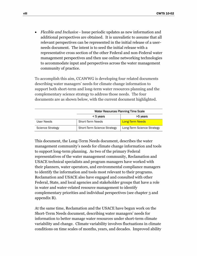
To accomplish this aim, CCAWWG is developing four related documents
describing water managers‘ needs for climate change information to
support both short-term and long-term water resources planning and the
complementary science strategy to address those needs. The four
documents are as shown below, with the current document highlighted.
Water Resources Planning Time Scale
< 5 years >5 years
User Needs Short-Term Needs Long-Term Needs
Science Strategy Short-Term Science Strategy Long-Term Science Strategy
This document, the Long-Term Needs document, describes the water
management community‘s needs for climate change information and tools
to support long-term planning. As two of the primary Federal
representatives of the water management community, Reclamation and
USACE technical specialists and program managers have worked with
their planners, water operators, and environmental compliance managers
to identify the information and tools most relevant to their programs.
Reclamation and USACE also have engaged and consulted with other
Federal, State, and local agencies and stakeholder groups that have a role
in water and water-related resource management to identify
complementary priorities and individual perspectives (see chapter 3 and
appendix B).
At the same time, Reclamation and the USACE have begun work on the
Short-Term Needs document, describing water managers‘ needs for
information to better manage water resources under short-term climate
variability and change. Climate variability involves fluctuations in climate
conditions on time scales of months, years, and decades. Improved ability
CWTS 10-02 ix
to forecast and use climate variability information would greatly enhance
the ability of water managers and water users to plan their short-term-
operations and water delivery schedules. The influence of climate
change on short-term climate variability is an additional factor that is
now central to this area of concern.
In response to these user-needs documents, the USGS and NOAA will
jointly prepare two documents describing respectively a science strategy
for meeting short-term and long-term needs for information and tools.
Development of those documents also will incorporate perspectives from
other Federal and non-Federal representatives of the scientific
community.
Note: This report refers to planning as the analyses conducted
to inform decisions about water system development and
management. In contrast, USACE defines Planning as a six-step
process in accordance with Economic and Environmental
Principles and Guidelines for Water and Related Resources
Implementation Studies (Water Resources Council 1983) and as
authorized by the Water Resources Development Act of 1986
(Public Law 99-662) (see Orth and Yoe 1997). The Planning
process includes decisionmaking under uncertainty, based on
information from these analyses. Although decisionmaking is not
explicitly addressed in the planning definition of this report,
many gaps in this report address how supporting analyses are
affected by knowledge limits and uncertainties. Research to
address such gaps, thus, should benefit decisionmaking in
Planning processes.
Audience: This document is meant to help focus research and
technology efforts to address information and tools gaps relevant to the
water management user community. As such, the primary audience for
this document is the research and technology community in position to
address these gaps. Such community members include CCAWWG science
agencies (NOAA, USGS), other Federal research entities and programs
(e.g., National Science Foundation, National Aeronautics and Space
Administration, U.S. Environmental Protection Agency, U.S. Department
of Agriculture, U.S. Forest Service, Department of Energy), State and local
x CWTS 10-02
science centers, academic institutions, and the members of the
practitioner community that support climate and water resources
research.
Summary of Gap Categories: Technical climate change information
may be incorporated into longer-term water resources planning using
various methods. For this report, eight technical steps representative of
these various methods are used to categorize tools and information needs
(i.e., gaps). These steps are:
1. Summarize Relevant Literature: For a given planning study, this step
involves identifying, synthesizing, and summarizing previous research on
global to regional climate change and what it means for the region‘s water
resources.
2. Obtain Climate Change Information: This step involves obtaining
contemporary climate projections and associated uncertainties that may
have been spatially downscaled to finer resolution desired for water
resources planning at the regional to local scale. This step also involves
consideration of paleoclimate proxies that may imply climate conditions
different from those of the observed record.
3. Make Decisions About How To Use the Climate Change Information:
From the body of climate projections surveyed, decisions must be made on
which projections to use and which aspects of these projections to relate to
planning assumptions on water supplies, water demands, and operating
constraints.
4. Assess Natural Systems Response: Based on the preceding step‘s
decisions, this step involves assessing the natural systems response under
projected climate conditions. Results from these analyses will be used to
set assumptions about future water supplies, water demands, and
operating constraints. Types of natural systems responses include
watershed hydrology, ecosystems, land cover, water quality, consumptive
use requirements of irrigated lands, sedimentation and river hydraulics,
and sea level rise.
5. Assess Socioeconomic and Institutional Response: This step involves
assessing social, economic, and institutional responses to climate change
that could influence planning assumptions concerning water demands and
CWTS 10-02 xi
operating constraints (e.g., constraints that determine source of supply
preference and/or expected level of operating performance relative to
objectives such as flood risk reduction, environmental management, water
quality management, water allocation for agricultural and municipal use,
energy production, recreation, and navigation).
6. Assess System Risks and Evaluate Alternatives: This step involves
assessing system risks based on future planning assumptions (informed by
Steps 4 and 5); and, as necessary, evaluating long-term management
alternatives to address climate change risks. For example, many water
resources management studies focus on operations risk and assumptions
about future water supplies, demands, and operating constraints. In
contrast, infrastructure safety or flood risk reduction studies focus on
human safety and economic and environmental damages under
assumptions about future extreme hydrologic event probabilities; and
water quality studies focus on the interaction between the human
activities, landscape hydrology, and aquatic systems.
7. Assess and Characterize Uncertainties: This step involves assessing and
characterizing uncertainties accumulated during preceding steps (e.g.,
uncertainties of projecting future factors forcing climate, simulating
climate, downscaling climate, assessing natural and social system
responses, etc.).
8. Communicating Results and Uncertainties to Decisionmakers: This step
involves aggregating information from previous steps and then
communicating this distilled information to decisionmakers to support
planning decisions.
Table ES-1 provides an initial list of gaps in tools and information
associated with these steps. Given the geographic areas served by
Reclamation and USACE, these gaps may be thought of as being nationally
relevant. While this document presents gaps that are particularly relevant
for management of Reclamation and USACE water supply and river
regulation systems, it was envisioned that these gaps may be generally
applicable for long-term management of any type of water infrastructure.
To gauge this possibility, feedback on the gaps in table ES-1 was gathered
from non-Federal organizations and other Federal agencies. The most-
frequent relative priority (i.e., low, medium, high) assigned by
Reclamation and USACE for each gap is shown next to the most frequent
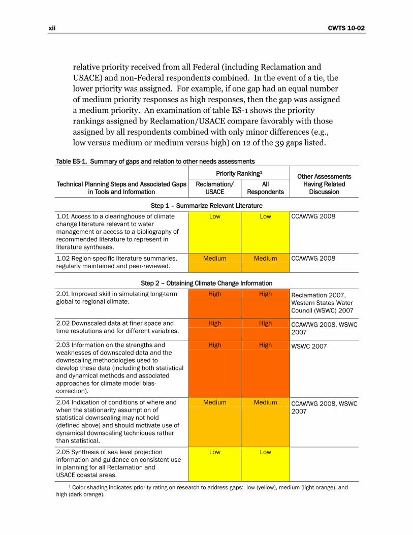
xii CWTS 10-02
relative priority received from all Federal (including Reclamation and
USACE) and non-Federal respondents combined. In the event of a tie, the
lower priority was assigned. For example, if one gap had an equal number
of medium priority responses as high responses, then the gap was assigned
a medium priority. An examination of table ES-1 shows the priority
rankings assigned by Reclamation/USACE compare favorably with those
assigned by all respondents combined with only minor differences (e.g.,
low versus medium or medium versus high) on 12 of the 39 gaps listed.
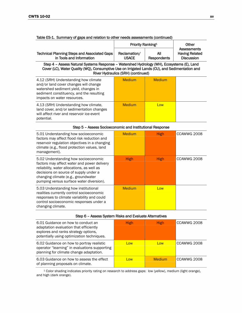
Table ES-1. Summary of gaps and relation to other needs assessments
Technical Planning Steps and Associated Gaps
in Tools and Information
Priority Ranking1 Other Assessments
Having Related
Discussion
Reclamation/
USACE
All
Respondents
Step 1 – Summarize Relevant Literature
1.01 Access to a clearinghouse of climate
change literature relevant to water
management or access to a bibliography of
recommended literature to represent in
literature syntheses.
Low Low CCAWWG 2008
1.02 Region-specific literature summaries,
regularly maintained and peer-reviewed.
Medium Medium CCAWWG 2008
Step 2 – Obtaining Climate Change Information
2.01 Improved skill in simulating long-term
global to regional climate.
High High Reclamation 2007,
Western States Water
Council (WSWC) 2007
2.02 Downscaled data at finer space and
time resolutions and for different variables.
High High CCAWWG 2008, WSWC
2007
2.03 Information on the strengths and
weaknesses of downscaled data and the
downscaling methodologies used to
develop these data (including both statistical
and dynamical methods and associated
approaches for climate model bias-
correction).
High High WSWC 2007
2.04 Indication of conditions of where and
when the stationarity assumption of
statistical downscaling may not hold
(defined above) and should motivate use of
dynamical downscaling techniques rather
than statistical.
Medium Medium CCAWWG 2008, WSWC
2007
2.05 Synthesis of sea level projection
information and guidance on consistent use
in planning for all Reclamation and
USACE coastal areas.
Low Low
1 Color shading indicates priority rating on research to address gaps: low (yellow), medium (light orange), and
high (dark orange).
CWTS 10-02 xiii
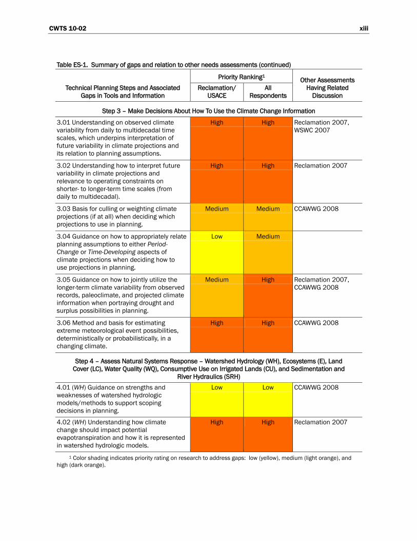
Table ES-1. Summary of gaps and relation to other needs assessments (continued)
Technical Planning Steps and Associated
Gaps in Tools and Information
Priority Ranking1 Other Assessments
Having Related
Discussion
Reclamation/
USACE
All
Respondents
Step 3 – Make Decisions About How To Use the Climate Change Information
3.01 Understanding on observed climate
variability from daily to multidecadal time
scales, which underpins interpretation of
future variability in climate projections and
its relation to planning assumptions.
High High Reclamation 2007,
WSWC 2007
3.02 Understanding how to interpret future
variability in climate projections and
relevance to operating constraints on
shorter- to longer-term time scales (from
daily to multidecadal).
High High Reclamation 2007
3.03 Basis for culling or weighting climate
projections (if at all) when deciding which
projections to use in planning.
Medium Medium CCAWWG 2008
3.04 Guidance on how to appropriately relate
planning assumptions to either Period-
Change or Time-Developing aspects of
climate projections when deciding how to
use projections in planning.
Low Medium
3.05 Guidance on how to jointly utilize the
longer-term climate variability from observed
records, paleoclimate, and projected climate
information when portraying drought and
surplus possibilities in planning.
Medium High Reclamation 2007,
CCAWWG 2008
3.06 Method and basis for estimating
extreme meteorological event possibilities,
deterministically or probabilistically, in a
changing climate.
High High CCAWWG 2008
Step 4 – Assess Natural Systems Response – Watershed Hydrology (WH), Ecosystems (E), Land
Cover (LC), Water Quality (WQ), Consumptive Use on Irrigated Lands (CU), and Sedimentation and
River Hydraulics (SRH)
4.01 (WH) Guidance on strengths and
weaknesses of watershed hydrologic
models/methods to support scoping
decisions in planning.
Low Low CCAWWG 2008
4.02 (WH) Understanding how climate
change should impact potential
evapotranspiration and how it is represented
in watershed hydrologic models.
High High Reclamation 2007
1 Color shading indicates priority rating on research to address gaps: low (yellow), medium (light orange), and
high (dark orange).
xiv CWTS 10-02
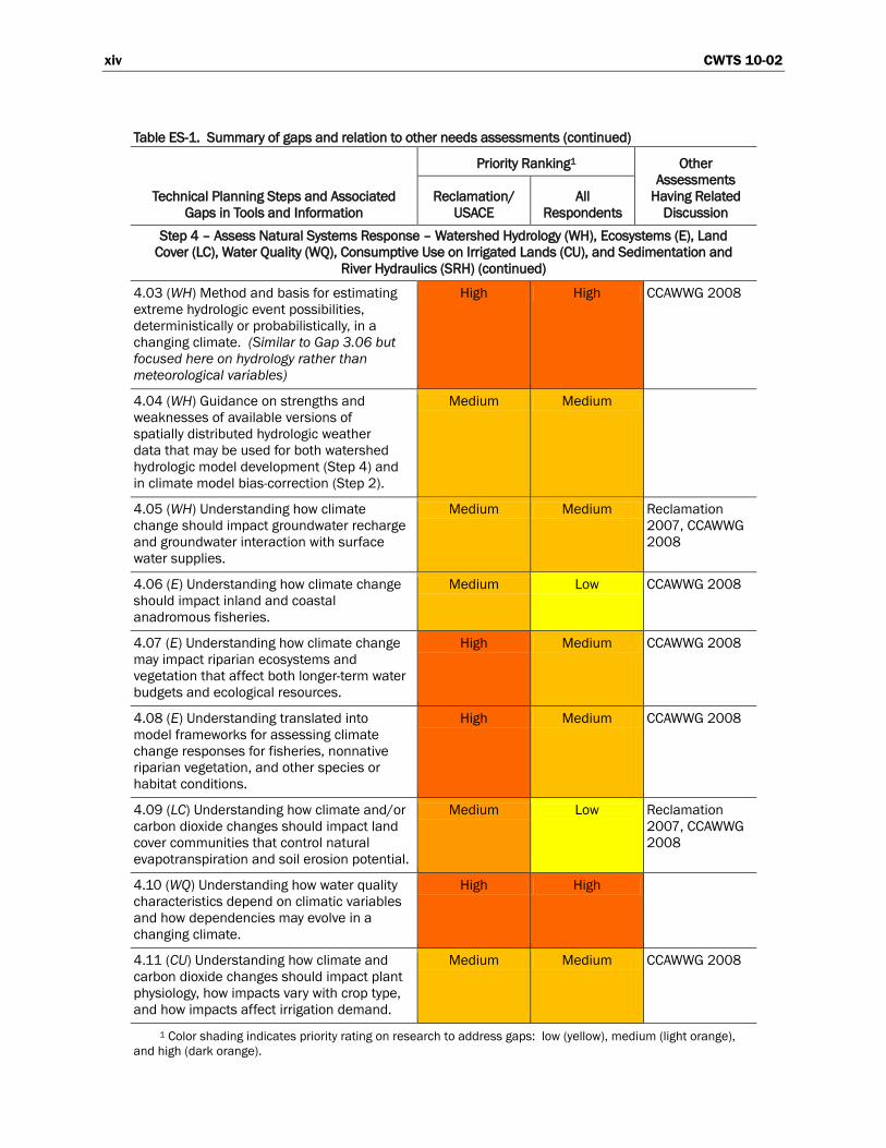
Table ES-1. Summary of gaps and relation to other needs assessments (continued)
Technical Planning Steps and Associated
Gaps in Tools and Information
Priority Ranking1 Other
Assessments
Having Related
Discussion
Reclamation/
USACE
All
Respondents
Step 4 – Assess Natural Systems Response – Watershed Hydrology (WH), Ecosystems (E), Land
Cover (LC), Water Quality (WQ), Consumptive Use on Irrigated Lands (CU), and Sedimentation and
River Hydraulics (SRH) (continued)
4.03 (WH) Method and basis for estimating
extreme hydrologic event possibilities,
deterministically or probabilistically, in a
changing climate. (Similar to Gap 3.06 but
focused here on hydrology rather than
meteorological variables)
High High CCAWWG 2008
4.04 (WH) Guidance on strengths and
weaknesses of available versions of
spatially distributed hydrologic weather
data that may be used for both watershed
hydrologic model development (Step 4) and
in climate model bias-correction (Step 2).
Medium Medium
4.05 (WH) Understanding how climate
change should impact groundwater recharge
and groundwater interaction with surface
water supplies.
Medium Medium Reclamation
2007, CCAWWG
2008
4.06 (E) Understanding how climate change
should impact inland and coastal
anadromous fisheries.
Medium Low CCAWWG 2008
4.07 (E) Understanding how climate change
may impact riparian ecosystems and
vegetation that affect both longer-term water
budgets and ecological resources.
High Medium CCAWWG 2008
4.08 (E) Understanding translated into
model frameworks for assessing climate
change responses for fisheries, nonnative
riparian vegetation, and other species or
habitat conditions.
High Medium CCAWWG 2008
4.09 (LC) Understanding how climate and/or
carbon dioxide changes should impact land
cover communities that control natural
evapotranspiration and soil erosion potential.
Medium Low Reclamation
2007, CCAWWG
2008
4.10 (WQ) Understanding how water quality
characteristics depend on climatic variables
and how dependencies may evolve in a
changing climate.
High High
4.11 (CU) Understanding how climate and
carbon dioxide changes should impact plant
physiology, how impacts vary with crop type,
and how impacts affect irrigation demand.
Medium Medium CCAWWG 2008
1 Color shading indicates priority rating on research to address gaps: low (yellow), medium (light orange),
and high (dark orange).
CWTS 10-02 xv
Table ES-1. Summary of gaps and relation to other needs assessments (continued)
Technical Planning Steps and Associated Gaps
in Tools and Information
Priority Ranking1 Other
Assessments
Having Related
Discussion
Reclamation/
USACE
All
Respondents
Step 4 – Assess Natural Systems Response – Watershed Hydrology (WH), Ecosystems (E), Land
Cover (LC), Water Quality (WQ), Consumptive Use on Irrigated Lands (CU), and Sedimentation and
River Hydraulics (SRH) (continued)
4.12 (SRH) Understanding how climate
and/or land cover changes will change
watershed sediment yield, changes in
sediment constituency, and the resulting
impacts on water resources.
Medium Medium
4.13 (SRH) Understanding how climate,
land cover, and/or sedimentation changes
will affect river and reservoir ice-event
potential.
Medium Low
Step 5 – Assess Socioeconomic and Institutional Response
5.01 Understanding how socioeconomic
factors may affect flood risk reduction and
reservoir regulation objectives in a changing
climate (e.g., flood protection values, land
management).
Medium High CCAWWG 2008
5.02 Understanding how socioeconomic
factors may affect water and power delivery
reliability, water allocations, as well as
decisions on source of supply under a
changing climate (e.g., groundwater
pumping versus surface water diversion).
High High CCAWWG 2008
5.03 Understanding how institutional
realities currently control socioeconomic
responses to climate variability and could
control socioeconomic responses under a
changing climate.
Medium Low
Step 6 – Assess System Risks and Evaluate Alternatives
6.01 Guidance on how to conduct an
adaptation evaluation that efficiently
explores and ranks strategy options,
potentially using optimization techniques.
High High CCAWWG 2008
6.02 Guidance on how to portray realistic
operator “learning” in evaluations supporting
planning for climate change adaptation.
Low Low CCAWWG 2008
6.03 Guidance on how to assess the effect
of planning proposals on climate.
Low Medium CCAWWG 2008
1 Color shading indicates priority rating on research to address gaps: low (yellow), medium (light orange),
and high (dark orange).
xvi CWTS 10-02
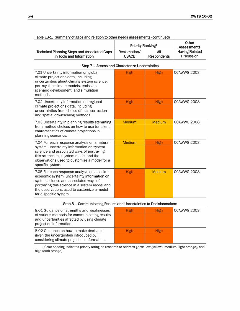
Table ES-1. Summary of gaps and relation to other needs assessments (continued)
Technical Planning Steps and Associated Gaps
in Tools and Information
Priority Ranking1 Other
Assessments
Having Related
Discussion Reclamation/
USACE
All
Respondents
Step 7 – Assess and Characterize Uncertainties
7.01 Uncertainty information on global
climate projections data, including
uncertainties about climate system science,
portrayal in climate models, emissions
scenario development, and simulation
methods.
High High CCAWWG 2008
7.02 Uncertainty information on regional
climate projections data, including
uncertainties from choice of bias-correction
and spatial downscaling methods.
High High CCAWWG 2008
7.03 Uncertainty in planning results stemming
from method choices on how to use transient
characteristics of climate projections in
planning scenarios.
Medium Medium CCAWWG 2008
7.04 For each response analysis on a natural
system, uncertainty information on system
science and associated ways of portraying
this science in a system model and the
observations used to customize a model for a
specific system.
Medium High CCAWWG 2008
7.05 For each response analysis on a socio-
economic system, uncertainty information on
system science and associated ways of
portraying this science in a system model and
the observations used to customize a model
for a specific system.
High Medium CCAWWG 2008
Step 8 – Communicating Results and Uncertainties to Decisionmakers
8.01 Guidance on strengths and weaknesses
of various methods for communicating results
and uncertainties affected by using climate
projection information.
High High CCAWWG 2008
8.02 Guidance on how to make decisions
given the uncertainties introduced by
considering climate projection information.
High High
1 Color shading indicates priority rating on research to address gaps: low (yellow), medium (light orange), and
high (dark orange).
CWTS 10-02 xvii
Gaps are more fully discussed in section 2.4, and the priority ratings
received during the perspective gathering process is discussed in section
3.0 (e.g., inviting prioritization of research to address gaps, inviting
general comments, and inviting suggestions on missing gaps). A complete
record of perspectives received, including relative priority assignments,
are included in appendices B-D.
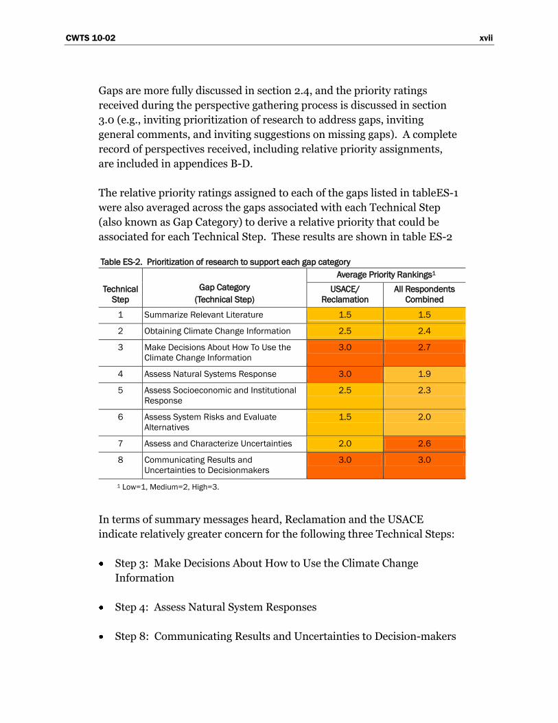
The relative priority ratings assigned to each of the gaps listed in tableES-1
were also averaged across the gaps associated with each Technical Step
(also known as Gap Category) to derive a relative priority that could be
associated for each Technical Step. These results are shown in table ES-2
Table ES-2. Prioritization of research to support each gap category
Technical
Step
Gap Category
(Technical Step)
Average Priority Rankings1
USACE/
Reclamation
All Respondents
Combined
1 Summarize Relevant Literature 1.5 1.5
2 Obtaining Climate Change Information 2.5 2.4
3 Make Decisions About How To Use the
Climate Change Information
3.0 2.7
4 Assess Natural Systems Response 3.0 1.9
5 Assess Socioeconomic and Institutional
Response
2.5 2.3
6 Assess System Risks and Evaluate
Alternatives
1.5 2.0
7 Assess and Characterize Uncertainties 2.0 2.6
8 Communicating Results and
Uncertainties to Decisionmakers
3.0 3.0
1 Low=1, Medium=2, High=3.
In terms of summary messages heard, Reclamation and the USACE
indicate relatively greater concern for the following three Technical Steps:
Step 3: Make Decisions About How to Use the Climate Change
Information
Step 4: Assess Natural System Responses
Step 8: Communicating Results and Uncertainties to Decision-makers
xviii CWTS 10-02
This compares favorably to the perspectives of water managers from all
respondents combined with agreement that both Steps 3 and Step 8
deserve the greatest concern. However, all respondents combined indicate
a greater concern for Step 7: Assess and Characterize Uncertainties.
The remaining steps received relatively lower priority. Review of gap-
specific summaries (section 3.3) suggests that much of this lower
prioritization stems from perception that a relatively greater
understanding currently exists in these step areas compared to those that
were given higher priority and does not necessarily indicate they are not as
important as those assigned a high priority.
Lastly, a number of commenting entities provided letter responses, some
of which highlighted themes that were largely absent in the draft version of
this report. Those letter responses are provided in appendix D. Two
notable themes were:
Monitoring and Data Collection: Need for supporting current
data collection networks and understanding their adequacy to support
water management in a changing climate.
Making Decisions Under Uncertainty: Need for understanding
the relative merits of various tools/concepts (e.g., adaptive
management, robustness, resilience, flexibility) to support water
management and development under a changing climate, and also
understanding the compatibility of these tools/concepts with current
influences on management (e.g., legislation, appropriations, policy).
DISCLAIMER: The contents of this report are not to be used for advertising, publication, or promotional
purposes. Citation of trade names does not constitute an official endorsement or approval of the use of such
commercial products. All product names and trademarks cited are the property of their respective owners.
The findings of this report are not to be construed as an official Department of the Army position unless so
designated by other authorized documents.
DESTROY THIS REPORT WHEN NO LONGER NEEDED. DO NOT RETURN IT TO THE
ORIGINATOR.
CWTS 10-02 xix
Contents Page
Acknowledgements ............................................................................................. v
A Joint Message from the Commissioner, Bureau of Reclamation, and the Director of Civil Works, U.S. Army Corps of Engineers ................ iii
Executive Summary ............................................................................................ vii
List of Acronyms .................................................................................................. xxiii
1 Introduction ................................................................................................... 1
1.1 Background .................................................................................... 1 1.2 Purpose ........................................................................................... 3 1.3 Audience ......................................................................................... 6 1.4 Document Organization ................................................................. 7
2 Capabilities Assessment .............................................................................. 9
2.1 Longer-Term Water Systems Planning in Reclamation and USACE ...................................................................................... 10 2.1.1 Planning for Water Resources Management .................. 10 2.1.2 Planning for Infrastructure Safety and Flood Risk
Reduction .......................................................................... 11 2.2 Role of Climate in Longer-Term Planning Assumptions ............... 12
2.2.1 Planning for Water Resources Management .................. 12 2.2.2 Planning for Infrastructure Safety and Flood
Risk Reduction .................................................................. 14 2.3 Approaches for Considering Climate Change in Planning ........... 16 2.4 Step-by-Step Capabilities in Quantitative Approach .................... 19
2.4.1 Step 1 – Summarize Relevant Literature ........................ 21 2.4.2 Step 2 – Obtain Climate Change Information ................. 26 2.4.3 Step 3 – Make Decisions About How to Use the
Climate Change Information ............................................ 33 2.3.4 Step 4 – Assess Natural Systems Response .................. 46 2.4.5 Step 5 – Assess Socioeconomic and Institutional
Response ........................................................................... 56 2.4.6 Step 6 – Assess Systems Risks and Evaluate
Alternatives ........................................................................ 61 2.4.7 Step 7 – Assess and Characterize Uncertainties ........... 65 2.4.8 Step 8 – Communicate Results and Uncertainties
to Decisionmakers ............................................................ 68
xx CWTS 10-02
Contents (continued)
Page
3 Perspectives from Other Water Management Organizations ................... 71
3.1 Process for Gathering Perspectives .............................................. 71
3.2 Key Themes Among Gathered Perspectives ................................ 75
3.3 Perspectives Summaries for Each Gap Statement ...................... 82
3.2.1 Step 1 – Summarize Relevant Literature ........................ 82
3.2.2 Step 2 – Obtaining Climate Change Data ....................... 83
3.2.3 Step 3 – Make Decisions About How To Relate
Climate Projections Data to Planning .............................. 86
3.2.4 Step 4 – Assess Natural Systems Response .................. 91
3.2.5 Step 5 – Assess Socioeconomic Systems Response ..... 98
3.2.6 Step 6 – Assess Socioeconomic Systems Response ..... 100
3.2.7 Step 7 – Assess Socioeconomic Systems Response ..... 102
3.2.8 Step 8 – Assess Socioeconomic Systems Response ..... 105
3.4 Additional Comments and Feedback ............................................ 107
4 References .................................................................................................... 113
Appendix A: Preliminary Activities ..................................................................... 121
Appendix B: Survey Results on Gap Prioritization ........................................... 127
Appendix C: Record of Perspectives Contributed by Other Organizations –
Table Comments (Electronic Supplement)
Appendix D: Record of Perspectives Contributed by Other Organizations –
Letter Comments (Electronic Supplement)
CWTS 10-02 xxi
Figures and Tables Page
Figures
Figure 1. Reclamation and USACE geographical organization ..................... 1
Figure 2. Types of planning assumptions in resource management
studies affected by climate information ........................................................... 14
Figure 3. Types of planning assumptions in hydrologic hazards and
flood risk evaluations affected by climate information ................................... 15
Figure 4. Decision tree for guiding level of analysis on incorporating
projected climate information into longer-term project planning ................... 17
Figure 5. Analytical steps involved with translating climate projection
information into planning assumptions for resource management
evaluations .......................................................................................................... 22
Figure 6. Analytical steps involved with translating climate projection
information into planning assumptions for infrastructure safety and
flood risk reduction evaluations ........................................................................ 23
Figure 7. Period-change paradigm example – two water supply
variability assumptions. Hypothetical study location is Trinity
Reservoir, California ............................................................................................ 38
Figure 8. Historical precipitation, NOAA Climate Division #1,
Trinity Reservoir basin, California ...................................................................... 40
Figure 9. Period-change paradigm issue: stability of projected
change through time .......................................................................................... 41
Figure 10. Time-developing paradigm example – Trinity Reservoir,
California .............................................................................................................. 42
Tables
Table 1. Summary of gaps and relation to other needs assessments ......... 76
Table 2. Prioritization of research to support each Gap Category ................ 81

CWTS 10-02 xxiii
List of Acronyms
C degrees Celsius
F degrees Fahrenheit
AMWA Association of Metropolitan Water Agencies
ASCE American Society of Civil Engineers
AWWA American Water Works Association
BCSD Bias-Correction Spatial Disaggregation
CA DWR California Department of Water Resources
CCAWWG Climate Change and Water Working Group
CCSD Climate Change Science Program
cfs cubic feet per second
CIRES Cooperative Institute for Research in Environmental
Science
CMIP3 Coupled Model Intercomparison Project, phase 3
CO2 carbon dioxide
DCP downscaled climate projections
DOD Department of Defense
DOI United States Department of the Interior
DOT Department of Transportation
EIS environmental impact statement
ESRL Earth System Research Laboratory
ERDC Engineer Research and Development Center
ET evapotranspiration
FEMA Federal Emergency Management Agency
FERC Federal Energy Regulatory Commission
GCM general circulation model (i.e., a type of global climate
model)
GHG greenhouse gas
xxiv CWTS 10-02
GSSHA Gridded Surface Subsurface Hydrologic Analysis
GW groundwater
HEC-HMS Hydrologic Engineering Center hydrological modeling
system
IACWD Interagency Committee on Water Data
I&E Installations and Environment
IJC International Joint Commission
IPCC Intergovernmental Panel on Climate Change
LLNL Lawrence Livermore National Laboratory
NASA National Aeronautics and Space Administration
NARCCAP North American Regional Climate Change Assessment
Program
NED National Economic Development
NER National Ecosystem Restoration
NOAA National Oceanic and Atmospheric Administration
NOAA Fisheries National Oceanic and Atmospheric Administration
National Marine Fisheries Service
NRC National Research Council
NSTC-CENR National Science and Technology Council -
Committee on Environment and Natural Resources
NWS National Weather Service
OSD Office of the Secretary of Defense
OSE Other Social Effects
P Precipitation
P&G Economic and Environmental Principles and
Guidelines for Water and Related Land Resources
Implementation Studies
PMA Power Marketing Administration
Q Runoff (or streamflow)
R&D Research and Development
Reclamation Bureau of Reclamation
CWTS 10-02 xxv
RED Regional Economic Development
RFC River Forecast Centers
RISA Regional Integrated Science and Assessment
SECURE Science and Engineering to Comprehensively
Understand and Responsibly Enhance Water Act
SERDP Strategic Environmental Research and Development
Program
SRES IPCC Special Report on Emissions Scenarios
SW surface water
SWE snow water equivalent
SWP State Water Project
T temperature
TAF thousand acre-feet
USACE United States Army Corps of Engineers
USDA United States Department of Agriculture
USEPA United States Environmental Protection Agency
USGS United States Geological Survey
WCRP World Climate Research Programme
WestFAST Western Federal Agency Support Team
WRC Water Resources Council
WSWC Western States Water Council
WUCA Water Utility Climate Alliance

CWTS 10-02 1
1 Introduction
1.1 Background
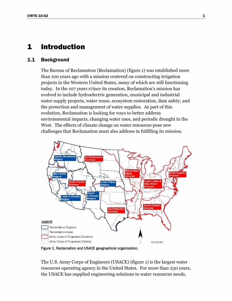
The Bureau of Reclamation (Reclamation) (figure 1) was established more
than 100 years ago with a mission centered on constructing irrigation
projects in the Western United States, many of which are still functioning
today. In the 107 years s7ince its creation, Reclamation‘s mission has
evolved to include hydroelectric generation, municipal and industrial
water supply projects, water reuse, ecosystem restoration, dam safety, and
the protection and management of water supplies. As part of this
evolution, Reclamation is looking for ways to better address
environmental impacts, changing water uses, and periodic drought in the
West. The effects of climate change on water resources pose new
challenges that Reclamation must also address in fulfilling its mission.
Figure 1. Reclamation and USACE geographical organization.
The U.S. Army Corps of Engineers (USACE) (figure 1) is the largest water
resources operating agency in the United States. For more than 230 years,
the USACE has supplied engineering solutions to water resources needs,

2 CWTS 10-02
including navigation, flood and coastal storm damage reduction,
protection and restoration of aquatic ecosystems, hydropower, water
supply, recreation, regulatory, and disaster preparedness and response.
Each year, USACE implements new water resources development projects
with non-Federal sponsors, adding to the approximately 12 million acres
of land and water resources under USACE jurisdiction. The entire
portfolio of USACE Civil Works water resources infrastructure and
programs, existing and proposed, could be affected by climate change and
adaptation to climate change, which in turn affect design and operational
assumptions about resource supplies, system demands or performance
requirements, and operational constraints. Both droughts and floods can
affect the operations of these projects. Numerous regulatory decisions
made by USACE will need to be informed by climate change impacts and
adaptation considerations throughout the United States.
In February 2009, the National Oceanic and Atmospheric Administration
(NOAA), USACE, Reclamation, and U.S. Geological Survey (USGS)
released a report (USGS Circular 1331, Climate Change and Water
Resources Management: A Federal Perspective) (Brekke et al. 2009a) on
strategies to improve water management by tracking, anticipating, and
responding to climate change. The report represents the views of two
Federal water management agencies (USACE and Reclamation) and two
Federal climate and water science agencies (USGS and NOAA) with
respect to climate change impacts to water resources management. In
addition to discussing climate impacts, the report also covered topics
related to the use of available climate information in long-range planning,
approaches for decisionmaking, and adaptation options. On the subject of
anticipating and adapting to climate change impacts, the report offered the
following key point:
―Current expectations about future climate may indicate a
need to supplement historical climate information. Planning
assumptions might instead be related to projections of future
temperature and precipitation. This can be accomplished
using a multitude of approaches; a best approach has yet to
be determined.‖
The point speaks to the growing need to incorporate climate projection
information in planning. Planning in this document refers to planning in
the general sense, encompassing studies that may involve proposed
CWTS 10-02 3
operations or physical changes to the water-related infrastructure that
Reclamation and USACE manage. Other Federal, State, and local entities
undertake similar types of planning and likely have similar needs.
Incorporating information means translating climate projection
information into key planning assumptions (e.g., supplies, demands and
constraints in the context of resource management studies, or hydrologic
possibilities in flood risk and infrastructure safety evaluations). Although
Reclamation and USACE have some understanding and capability of how
to accomplish this, questions remain about how to interpret climate
projection information and how to select appropriate methods for
incorporating such information into planning evaluations, engineering
design, construction, and operations. Circular 1331 highlights the
importance of monitoring and research for addressing such limitations in
understanding and planning capabilities.
―Research and monitoring are both needed to fill knowledge
gaps and set up advances in planning capabilities. Although
neither will eliminate all uncertainties, they will provide
significant improvements in understanding the effects of
climate change on water resources, including quantity and
quality, and in evaluating associated uncertainties and risks
required for more informed decisionmaking.‖
Reclamation and USACE both recognize gaps between current and desired
capabilities for incorporating climate change information into longer-term
water resources planning, engineering design, construction, and
operations. Some of these gaps are shared, given the mutual presence of
these two Federal water management agencies in many Western United
States (U.S.) systems. In contrast, some of these gaps are agency-specific,
given the separate yet complementary missions of these two agencies.
1.2 Purpose
To build on the foundation established by USGS Circular 1331, the
Climate Change and Water Working Group (CCAWWG) is pursuing a
collaborative forum to better define the critical knowledge gaps that face
the water management community. The effort builds on chapter 6, table 2
of USGS Circular 1331 and is guided by the following objectives:
4 CWTS 10-02
Consolidate the Needs of the Water Management Community -
Identify the common needs of the Federal and non-Federal water
management community for the information and tools they need to
support adaptation as climate changes.
Inform the Scientific Community - Guide and foster Federal and non-
Federal research and technology investments toward meeting these
―user-defined‖ needs.
Teamwork - Generate collaborative efforts across members of the
water management and scientific communities to develop, test, and
apply new methods, tools, and capabilities
Flexible and Inclusive - Issue periodic updates as new information and
additional perspectives are obtained. It is unrealistic to assume that all
relevant perspectives can be represented in the initial release of the
document. The intent is to seed the initial release with a representative
cross section of the other Federal and non-Federal water management
perspectives and then utilize online networking technologies to
accommodate input and perspectives across the water management
community of practice.
The effort involves the two parts outlined below. This document
reports the results of Part I-A.
Part I - Addressing Climate Change in Long-Term Water Resources
Planning and Management: This effort involves communicating user
needs and formulating science strategy to improve the tools and
information that support resilient water management over multidecadal
planning horizons.
Part I-A is the preparation of a document outlining user needs
by USACE and Reclamation that also contains the perspectives of
the non-Federal and other Federal organizations that play a role
in managing water resources.
Part I-B is the preparation of a document by USGS and NOAA that
provides the science strategy to meet the user needs indentified in
Part I-A.
CWTS 10-02 5
As the two primary Federal representatives of the water management
community, Reclamation and USACE technical specialists and program
managers have worked with their water and environmental compliance
managers to identify the information and tools most relevant to their
programs. Reclamation and USACE also have engaged and consulted with
other Federal, State, and local agencies and stakeholder groups that have a
role in water and water-related resource management to identify
complementary priorities and individual perspectives (chapter 3). Part I-B
will be led by NOAA and USGS and will also incorporate engagement and
perspectives from other Federal and non-Federal representatives of the
scientific community.
Part II – Addressing Climate Variability in Short-Term Water Resources
Planning and Management: This effort involves communicating user
needs and formulating science strategy to improve the tools and
information that support water system management and operations
scheduling over seasonal to annual planning horizons.
Climate variability is the fluctuation of climate around seasonal norms.
The improved ability to forecast and utilize climate variability information
would greatly enhance the ability of water managers and water user to
plan their short-term operations and water delivery schedules. The
influence of climate change on short-term climate variability is an
additional factor now central to this area of concern.
Part II is being pursued in parallel to Part I. CCAWWG agencies will use a
similar approach to ensure the perspectives of other Federal and non-
Federal representatives are incorporated.
Lastly, it is noted that this document speaks to the technical issues when
conducting ―top-down‖ vulnerability assessments rather than ―bottom-up‖
assessments. In a ―top-down‖ assessment, climate projection information
is obtained and explicitly translated into inputs for system vulnerability
analyses (e.g., translating climate projection information into associated
weather inputs for a hydrologic modeling exercise, which produces results
that then are used to adjust water supply inputs for a reservoir systems
analysis). In this sense, the ―top-down‖ assessment is an exercise in
information generation for decisionmaking. A ―bottom-up‖ approach also
generates such information, but in a simplified manner where stressing
scenarios are defined without going through the explicit steps of a ―top-
6 CWTS 10-02
down‖ assessment. ―Bottom-up‖ assessments might be thought of as
providing screening-level information on system vulnerabilities, which can
be very useful in initiating discussion on adaptation needs and options
(i.e., How would we operate our reservoir system if we experienced a
20 percent [%] reduction in water supply?). To be useful, ―bottom-up‖
assessments must feature stressing scenarios that are plausible in the
context of information that might be generated using a more rigorous top-
down approach. Further, as the discussion on adaptation needs and
options proceeds to decisions on capital improvement investments, it is
expected that a bottom-up approach will need to be complemented or
possibly replaced by a top-down approach where contemporary climate
projection information is more explicitly linked to characterization of
adaptation needs and related investment decisions.
Note: This report refers to planning as the analyses conducted to
inform decisions about water system development and
management. In contrast, USACE defines Planning as a six-step
process in accordance with Economic and Environmental
Principles and Guidelines for Water and Related Resources
Implementation Studies (Water Resources Council 1983) and as
authorized by the Water Resources Development Act of 1986
(Public Law 99-662) (see Orth and Yoe 1997). The Planning
process includes decisionmaking under uncertainty, based on
information from these analyses. Although decisionmaking is not
explicitly addressed in the planning definition of this report,
many gaps in this report address how supporting analyses are
affected by knowledge limits and uncertainties. Research to
address such gaps, thus, should benefit decisionmaking in
Planning processes.
1.3 Audience
This document is meant to motivate research efforts to address gaps in
tools and information relevant to the water management user community.
As such, the primary audience for this document is the research
community in position to strategize research to address these gaps.
Such community members include CCAWWG science agencies (NOAA,
USGS), other Federal research agencies and programs (e.g., National
CWTS 10-02 7
Science Foundation [NSF], National Aeronautics and Space
Administration [NASA], U.S. Environmental Protection Agency
[USEPA], U.S. Department of Agriculture [USDA], U.S. Forest Service
[USFS], Department of Energy [DOE]), State and local science centers,
academic institutions, and also members of the practitioner community
that support climate and water resources research.
1.4 Document Organization
The remainder of this document is organized as follows:
2 Capabilities Assessment
This chapter is the primary contribution of this document. It outlines
and discusses planning capability gaps as they related to the planning
frameworks broadly used by Reclamation and USACE to evaluate
proposed resource management strategies and infrastructure
safety/reliability issues. It builds on the foundation laid in
USGS Circular 1331 and the effort discussed in chapter 2.0.
3 Perspectives from Other Water Management Organizations
This section summarizes views and reactions to gaps from section 2.0,
offered by internal management at Reclamation and USACE, other Federal
agencies, and non-Federal organizations. The common attribute of
entities providing perspectives is that they all manage, or play a role in,
managing water and water-related resources. This section provides a
summary of views and perspectives offered, including opinions on how
research to address gaps in section 2.0 might be relatively prioritized.
Appendix A: Preliminary Activities
This appendix summarizes findings from a technology and research
scoping workshop in Denver, Colorado, during February 20–21, 2008,
which included initial discussions between Reclamation, USACE, NOAA,
USGS, USEPA, the Federal Emergency Management Agency (FEMA), and
other agencies regarding capability gaps.
Appendix B: Survey Results on Gap Prioritization
This appendix is a table of surveyed priority ratings by gap statement from
section 2.0, which is also summarized in section 3.
8 CWTS 10-02
Appendix C: Record of Perspectives Contributed by Other Organizations –
Table Comments (Electronic Supplement)
This appendix contains unedited feedback provided by organizations
receiving the initial release of this document, as explained in section 3.0.
The appendix is available at: www.usbr.gov/climate/userneeds.
Appendix D: Record of Perspectives Contributed by Other Organizations –
Letter Comments (Electronic Supplement)
This appendix contains unedited feedback provided by organizations
receiving the initial release of this document, as explained in section 3.0.
The appendix is available at: www.usbr.gov/climate/userneeds.
CWTS 10-02 9
2 Capabilities Assessment
This chapter describes contemporary (2009) perspectives of Reclamation
and USACE on their technical capabilities status for incorporating climate
change information into longer-term water resources planning, as
described in the ―Introduction.‖ This chapter outlines and discusses
planning capability gaps as they relate to the planning frameworks broadly
used by Reclamation and USACE to evaluate proposed resource
management strategies and infrastructure safety/reliability issues. The
gap statements in this outline build on discussions from a workshop
convened by CCAWWG in 2008 (appendix A) and include gap statements
discussed during that workshop and later reported in USGS Circular 1331.
This chapter is organized as follows:
Section 2.1: Summary of longer-term water resources planning
evaluations regularly carried out by Reclamation and USACE.
Section 2.2: Role of climate information in making planning
assumptions for two types of studies: (1) water resource management
studies and (2) infrastructure safety and flood risk reduction
evaluations.
Section 2.3: Approaches for considering climate change (or climate
projection) information in longer-term planning, with approaches
varying from qualitative to quantitative.
Section 2.4: Capability assessment on implementing quantitative
approaches:
o Desired Capabilities in carrying out the planning analysis steps
involved with translating climate change information into study
assumptions for both types of studies listed above.
o Current Capabilities in conducting those planning analysis steps.
o Capability Gaps where current capabilities fall short of those
desired.
10 CWTS 10-02
Section 2.5: Tabular summary of capability gaps from section 2.4, and
cross-reference with other needs assessment conducted prior to 2009:
Note: Reclamation and USACE plan to periodically update this
capabilities assessment.
2.1 Longer-Term Water Systems Planning in Reclamation and
USACE
Reclamation and USACE are two of the principle Federal water
management agencies, but each provide separate and complementary
roles within their participation in the broader water management
community of practice. Reclamation is primarily a water supply agency,
and the USACE is primarily a flood control and waterway navigation
agency. Both agencies have complementary responsibilities involving
hydropower generation, aquatic ecosystem stewardship and restoration,
operating and maintaining water infrastructure, and administering water-
related recreation. USACE also has roles in regulatory and emergency
response that are not addressed specifically in this document.
Both Reclamation and USACE regularly carry out studies that may lead to
long-term investments in water infrastructure or long-term changes in
facility operations. Two broad categories of planning are introduced in
this section:
1. Planning for water resources management
2. Planning for infrastructure safety and flood risk reduction
These studies are conducted in accordance with the Economic and
Environmental Principles and Guidelines (P&G) for Water and Related
Land Resources Implementation Studies (WRC), 1983]. While the P&G
contain no explicit discussion of climate change, the process is flexible
enough to account for climate change (Frederick et al. 1997). Efforts are
currently underway to review and update the P&G.
2.1.1 Planning for Water Resources Management
These studies examine options for providing new water-related services.
These services include agricultural, municipal and industrial water supply,
managed river flows, enhanced river transport, hydropower generation,
CWTS 10-02 11
and lake recreation. Study options may focus on the development of
infrastructure to support these services, or possibly long-term changes in
the operation of existing facilities.
The challenges of climate change now are being recognized as an
important focus of water planning studies. The Federal Science and
Engineering to Comprehensively Understand and Responsibly Enhance
(SECURE) Water Act, signed as part of the Omnibus Land Management
Act of 2009, authorizes a Climate Change Adaptation Program and
requires the Secretary of the Interior to report to Congress on the effect of
global climate change on each major Reclamation river basin. Monitoring
and reporting increments are detailed in this section, and much of it is
focused on the potential effects of climate change on Reclamation projects
and developing mitigation strategies.
The USACE similarly has proposed the Adaptations to Climate Change
Program scheduled for fiscal year (FY) 2010–2014. This program‘s goal is
to develop and begin implementing practical, nationally consistent, and
cost-effective approaches and policies to reduce potential vulnerabilities to
the Nation‘s water infrastructure resulting from climate change and
variability, in partnership with other Federal science and water
management agencies and other stakeholders
2.1.2 Planning for Infrastructure Safety and Flood Risk Reduction
A second set of studies, aimed at reducing flood risk, might be further
separated into two subsets: one focusing on ensuring the safety of existing
infrastructure and another focusing on societal flood protection through
developing flood control rules that constrain reservoir operations and river
regulation.
Focusing on infrastructure safety evaluations, all Reclamation and
USACE dams are subjected to periodic review of safety and risks, including
risks associated with extreme flood events. For Reclamation, base reviews
(comprehensive facility reviews) occur approximately every 6 years. For
USACE, a national screening level has occurred and initial comprehensive
reviews are underway, with implementation of a cycle of regular review
expected thereafter. If the base process reveals significant risk,
subsequent Issue Evaluations may occur. These evaluations may lead to
decisions to modify operations or facility structures to reduce risk. For the
latter types of modifications, an evaluation of longer-term service is
12 CWTS 10-02
required in accordance with the P&Gs for Water Resources Projects.
USACE also is in the process of developing and implementing a similar
process for levees.
Focusing on studies to develop flood control rules, USACE leads such
studies for facilities with Flood Control Act of 1944, Section 7
requirements. Reclamation participates in these evaluations, along with
other system stakeholders. These evaluations lead to USACE specifying
―flood control rules‖ that govern USACE reservoir regulation and
constrain Reclamation‘s (and other‘s) reservoir operations. Such rules
reflect calendar periods when historical information suggests relatively
greater and lesser flood risk, manifesting into respective periods when
Reclamation must either operate reservoirs to reserve more or less storage
space for flood risk reduction objectives. These rules typically are
described in water control manuals specific to a given reservoir system and
periodically are supposed to be revisited (approximately [~]10–15 years).
However, funding constraints have limited the occurrence and frequency
of reviews. Reclamation also evaluates flood potentials at facilities that are
authorized for nonflood control objections.
2.2 Role of Climate in Longer-Term Planning Assumptions
This section explores how climate is represented in the two types of
Reclamation and USACE planning studies discussed above. Discussion
focuses on how climate information influences planning assumptions for
each type of study.
2.2.1 Planning for Water Resources Management
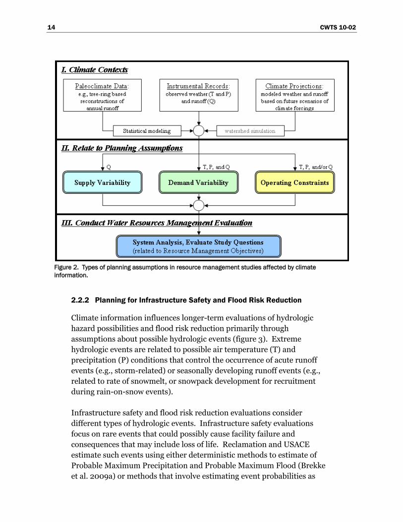
Climate information influences longer-term evaluations of resource
management strategies through assumptions about possible air
temperature (T), precipitation (P) and runoff (Q) conditions, among other
weather variables. These physical variables are translated into assumed
variability in future water supplies, demands, and/or operational
constraints (figure 2, adapted from Brekke et al. 2009a). Water supply
assumptions are developed to portray the expected envelope of supply
variability suitable for the given planning horizon. This includes
assumptions about future surface water and groundwater supplies and
associated statistics (e.g., mean, variance, possibilities for drought and
surplus spells, and accumulations), including the potential for hydrologic
CWTS 10-02 13
extremes that create flood risk. All projections must reflect expected
climate during the study‘s planning period.
Demand assumptions are characterized for each of the various system
uses, including agricultural, municipal, environmental, hydropower
generation, etc. For many studies, it is only necessary to establish ―limits
of demands‖ (upper or lower) and then assess system performance subject
to the assumed demand limits, supplies, and system constraints. For other
studies, the demands themselves may be the central question (e.g.,
establishment of long-term service contracts) and are evaluated subject to
available supplies, constraints, and expected levels of delivery reliability.
Demands are often characterized at a local level (e.g., municipality,
irrigation district). Demands also depend on physical factors like
temperature and precipitation, available nonsystem water supplies,
atmospheric composition affecting plant evapotranspiration (carbon
dioxide [CO2]) and a variety of socioeconomic factors such as economic
drivers of cropping choices, municipal use, and hydropower generation;
institutional/legal capacity for water markets or transfer schemes affecting
the timing of various system demands; technology development affecting
water use efficiency; environmental trends affecting timing and amount of
reservoir releases to support aquatic and riparian habitats.
Operating constraint assumptions are similar to demand assumptions in
that both physical and nonphysical factors determine these assumptions.
For example, flood control rules governing operation of surface water
reservoirs depend on hydrologic event probabilities that, in turn, represent
the present or assumed future climate conditions. Such rules also reflect
other factors that determine USACE‘s ability to regulate reservoir systems
to meet flood risk reduction objectives (e.g., channel conveyance capacity
below flood control reservoirs, flood plain management affecting
vulnerability and risk). System operations are also guided by, and
constrained by, environmental objectives, social values (e.g., recreation),
and the maintenance of important ecosystems and species habitat.
Accomplishment of these objectives also must occur within projected
climatic conditions.
14 CWTS 10-02
Figure 2. Types of planning assumptions in resource management studies affected by climate
information.
2.2.2 Planning for Infrastructure Safety and Flood Risk Reduction
Climate information influences longer-term evaluations of hydrologic
hazard possibilities and flood risk reduction primarily through
assumptions about possible hydrologic events (figure 3). Extreme
hydrologic events are related to possible air temperature (T) and
precipitation (P) conditions that control the occurrence of acute runoff
events (e.g., storm-related) or seasonally developing runoff events (e.g.,
related to rate of snowmelt, or snowpack development for recruitment
during rain-on-snow events).
Infrastructure safety and flood risk reduction evaluations consider
different types of hydrologic events. Infrastructure safety evaluations
focus on rare events that could possibly cause facility failure and
consequences that may include loss of life. Reclamation and USACE
estimate such events using either deterministic methods to estimate of
Probable Maximum Precipitation and Probable Maximum Flood (Brekke
et al. 2009a) or methods that involve estimating event probabilities as
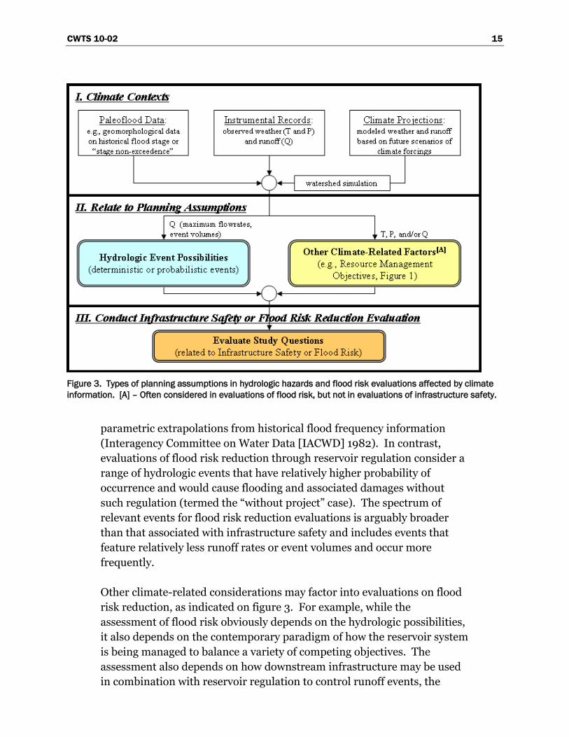
CWTS 10-02 15
Figure 3. Types of planning assumptions in hydrologic hazards and flood risk evaluations affected by climate
information. [A] – Often considered in evaluations of flood risk, but not in evaluations of infrastructure safety.
parametric extrapolations from historical flood frequency information
(Interagency Committee on Water Data [IACWD] 1982). In contrast,
evaluations of flood risk reduction through reservoir regulation consider a
range of hydrologic events that have relatively higher probability of
occurrence and would cause flooding and associated damages without
such regulation (termed the ―without project‖ case). The spectrum of
relevant events for flood risk reduction evaluations is arguably broader
than that associated with infrastructure safety and includes events that
feature relatively less runoff rates or event volumes and occur more
frequently.
Other climate-related considerations may factor into evaluations on flood
risk reduction, as indicated on figure 3. For example, while the
assessment of flood risk obviously depends on the hydrologic possibilities,
it also depends on the contemporary paradigm of how the reservoir system
is being managed to balance a variety of competing objectives. The
assessment also depends on how downstream infrastructure may be used
in combination with reservoir regulation to control runoff events, the
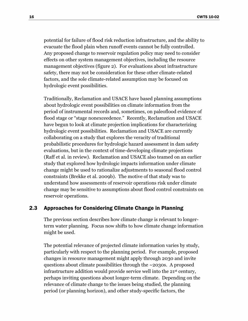
16 CWTS 10-02
potential for failure of flood risk reduction infrastructure, and the ability to
evacuate the flood plain when runoff events cannot be fully controlled.
Any proposed change to reservoir regulation policy may need to consider
effects on other system management objectives, including the resource
management objectives (figure 2). For evaluations about infrastructure
safety, there may not be consideration for these other climate-related
factors, and the sole climate-related assumption may be focused on
hydrologic event possibilities.
Traditionally, Reclamation and USACE have based planning assumptions
about hydrologic event possibilities on climate information from the
period of instrumental records and, sometimes, on paleoflood evidence of
flood stage or ―stage nonexceedence.‖ Recently, Reclamation and USACE
have begun to look at climate projection implications for characterizing
hydrologic event possibilities. Reclamation and USACE are currently
collaborating on a study that explores the veracity of traditional
probabilistic procedures for hydrologic hazard assessment in dam safety
evaluations, but in the context of time-developing climate projections
(Raff et al. in review). Reclamation and USACE also teamed on an earlier
study that explored how hydrologic impacts information under climate
change might be used to rationalize adjustments to seasonal flood control
constraints (Brekke et al. 2009b). The motive of that study was to
understand how assessments of reservoir operations risk under climate
change may be sensitive to assumptions about flood control constraints on
reservoir operations.
2.3 Approaches for Considering Climate Change in Planning
The previous section describes how climate change is relevant to longer-
term water planning. Focus now shifts to how climate change information
might be used.
The potential relevance of projected climate information varies by study,
particularly with respect to the planning period. For example, proposed
changes in resource management might apply through 2030 and invite
questions about climate possibilities through the ~2030s. A proposed
infrastructure addition would provide service well into the 21st century,
perhaps inviting questions about longer-term climate. Depending on the
relevance of climate change to the issues being studied, the planning
period (or planning horizon), and other study-specific factors, the
CWTS 10-02 17
treatment of projected climate information might range from no analysis
and a literature review to analytical treatments that proceed qualitatively
or quantitatively. The flowchart in figure 4 represents such decisions.
Figure 4. Decision tree for guiding level of analysis on incorporating projected climate information into longer-term
project planning. Adapted from U.S. Department of the Interior (DOI) 2008, chart shows potential scoping questions,
and answers leading to recommended options for considering whether and how to incorporate projected climate
information into project-specific planning. Options 4 through 6 also include the literature review from Options 2 and 3.
Recent examples of qualitative analysis in longer-term planning studies
include:
Lower Colorado and Upper Colorado Regions, final environmental
impact statement (EIS), for the Colorado River Interim Guidelines for
Lower Basin Shortages and Coordinated Operations for Lake Powell
18 CWTS 10-02
and Lake Mead,1 (Reclamation 2007). A separate report to the final
EIS, Appendix U, Review of Science and Methods for Incorporating
Climate Change Information into Reclamation‘s Colorado River Basin
Planning Studies was developed to provide supporting information for
the qualitative analysis and was co-edited by a team of Federal,
academic, and private-sector researchers.
Pacific Northwest Region, Final Planning Report/EIS, for the Yakima
River Basin Water Storage Feasibility Study2 (Reclamation 2008b).
Recent examples of quantitative sensitivity analysis in longer-term
planning studies include:
Mid-Pacific Region, biological assessment on the Continued Long-term
Operations of the Central Valley Project and the State Water Project3
(Reclamation 2008a). The analysis featured selection of climate and
sea level scenarios, adjustments to assumptions on supplies and
constraints related to sea level conditions. Evaluations were conducted
on water system conditions (i.e., storage, river flows, and water
deliveries) and dependent resources (i.e., water temperatures in
reservoirs and rivers, channel flows and velocities in the
Sacramento/San Joaquin Delta). Methods and results were
documented in Appendix R, ―Sensitivity of Future Central Valley
Project and State Water Project Operations to Potential Climate
Change and Associated Sea Level Rise.‖
Pacific Northwest Region, general planning study, The Effects of
Climate Change on the Operation of Boise River Reservoirs, Initial
Assessment Report4 (Reclamation 2008c). The analysis featured a
selection of climate scenarios and adjustment to water supply
assumptions (runoff). Evaluations were conducted on water system
conditions, with focus placed on impacts to both water supply and
flood control operations.
11 http://www.usbr.gov/lc/region/programs/strategies/FEIS/index.html,
section 4.2.5.
2 http://www.usbr.gov/pn/programs/storage_study/, section 4.2.2.6.
3 http://www.usbr.gov/mp/cvo/ocap_page.html.
4 http://www.usbr.gov/pn/programs/srao_misc/climatestudy/
boiseclimatestudy.pdf.
CWTS 10-02 19
Lake Ontario–St Lawrence River Study used climate projection
information and stochastic modeling to guide hydrologic variability
assumptions in water control planning for the Lake Ontario–
St. Lawrence River System1 (International Joint Commission [IJC]
2006).
2.4 Step-by-Step Capabilities in Quantitative Approach
When incorporating projected climate information into longer-term
planning, the broadest range of necessary planning capabilities occurs
when a quantitative approach is implemented (i.e., either Options 4 or 5,
figure 4). For that reason, this section focuses on planning capability gaps
associated with implementing a quantitative approach to serve either
water resources management or infrastructure safety and flood risk
reduction studies.
For any quantitative approach, climate change information may be
technically incorporated into longer-term planning using a variety of
methods. For this report, eight technical planning steps representative of
these various methods are used to categorize tools and information needs
(i.e., gaps). These steps are:
1. Summarize Relevant Literature: For the region of a given planning study,
this step involves identifying, synthesizing, and summarizing previous
research on global to regional climate change and what it means for the
region‘s water resources.
2. Obtaining Climate Change Information: This step involves obtaining
contemporary climate projections data and associated uncertainties that
have been spatially downscaled to finer resolution desired for water
resources planning at the regional to local scale. This step also involves
consideration of paleoclimate proxies that may imply climate conditions
different from those of the observed record.
3. Make Decisions About How to Relate Climate Projections Data
to Planning: From the body of climate projections surveyed,
decisions must be made on which projections to use and which
aspects of these projections to relate to planning assumptions on
water supplies, water demands, and operating constraints.
1 http://www.ijc.org/en/activities/losl/losl_study.php.
20 CWTS 10-02
4. Assess Natural Systems Response: Pending the preceding step‘s
decisions, this step involves assessing natural systems responses under
projected climate conditions. Results from these analyses will be used to
set assumptions about future water supplies, water demands, and
operating constraints. Types of natural systems responses include
watershed hydrology, ecosystems, land cover, water quality, consumptive
use requirements of irrigated lands, sedimentation and river hydraulics,
and sea level rise.
5. Assess Socioeconomic and Institutional Response: Similar to the
preceding step, this step involves assessing social, economic, and
institutional responses to climate change that could influence planning
assumptions concerning water demands and operating constraints (e.g.,
constraints that determine source of supply preference and/or expected
level of operating performance relative to objectives such as flood risk
reduction, environmental management, water quality management, water
allocation for agricultural and municipal use, energy production,
recreation, navigation).
6. Assess Systems Risks and Evaluate Alternatives: This step involves
assessing system risks based on future planning assumptions (informed by
Steps 4 and 5) and, as necessary, evaluating long-term management
alternatives to address climate change risks. For example, in many water
resources management studies, the focus is on operations risk and
assumptions about future water supplies, demands, and operating
constraints. In contrast, infrastructure safety or flood risk reduction
studies focus on human safety and economic and environmental damages
under assumptions about future extreme hydrologic event probabilities;
and water quality studies focus on the interaction between the human
activities, landscape hydrology, and aquatic systems.
7. Assess and Characterize Uncertainties: This step involves assessing and
characterizing uncertainties accumulated during preceding steps (e.g.,
uncertainties of projecting future factors forcing climate, simulating
climate, downscaling climate, assessing natural and social system
responses, etc.).
CWTS 10-02 21
8. Communicating Results and Uncertainties to Decisionmakers:
This step involves aggregating information from previous steps
and then communicating this distilled information to decisionmakers
to support planning decisions.
Figure 5 illustrates the occurrence of each step within the context of
resource management evaluations. Figure 6 shows the occurrence of each
step during infrastructure safety or flood risk reduction evaluations.
Following the outline of these eight steps, the remainder of this section
provides Reclamation and USACE perspectives on desired planning
capabilities for each step, current capabilities, and capability gaps pointing
to tool and information needs. When reading these discussions, two
considerations should be recognized:
The capability inventories in the following sections may not be
exhaustive. However, Reclamation and USACE view these inventories
as representative of the range of capabilities relevant to both agencies
and, also, the range of shared capability gaps.
This is a living document. Future updates are anticipated, based on
research progress that addresses capability gaps as well as input from
interested government, private sector, and stakeholder parties.
2.4.1 Step 1 – Summarize Relevant Literature
For longer-term planning processes, it is necessary to explain the role and
impacts of climate change in the given study. Context is provided by a
narrative representing available peer-reviewed literature and synthesis
reports, summarizing:
The state of climate change science (e.g., What are key indicators that
climate is changing globally or regionally? What is our ability to
project future changes in regional climate?).
Historical and projected effects of climate change on water resources
featured in the planning study.
Contemporary climate projections characterized over the study region,
focusing on climate variables and look-ahead period relevant to given
planning evaluation.
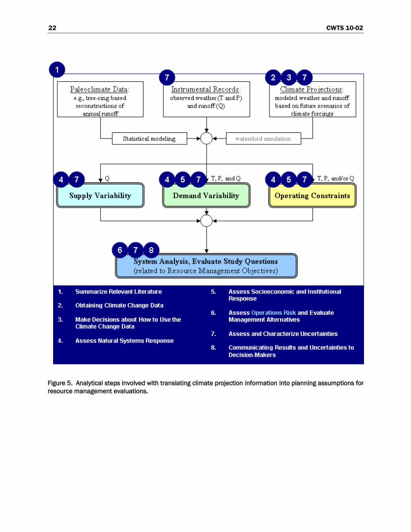
22 CWTS 10-02
Figure 5. Analytical steps involved with translating climate projection information into planning assumptions for
resource management evaluations.
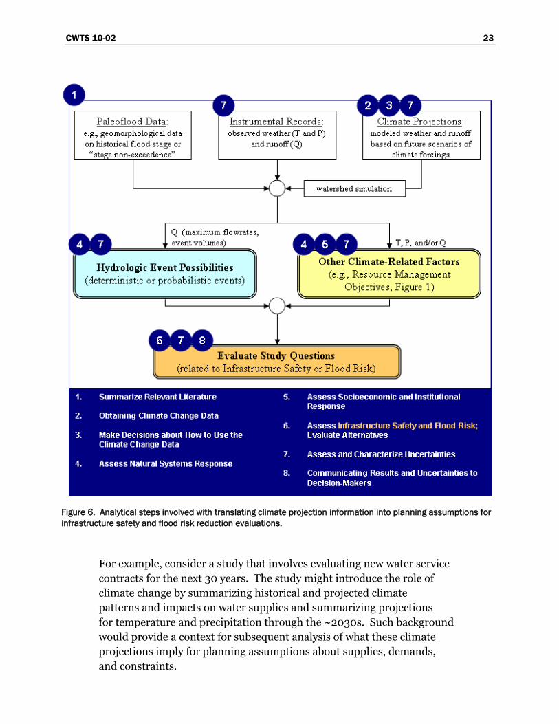
CWTS 10-02 23
Figure 6. Analytical steps involved with translating climate projection information into planning assumptions for
infrastructure safety and flood risk reduction evaluations.
For example, consider a study that involves evaluating new water service
contracts for the next 30 years. The study might introduce the role of
climate change by summarizing historical and projected climate
patterns and impacts on water supplies and summarizing projections
for temperature and precipitation through the ~2030s. Such background
would provide a context for subsequent analysis of what these climate
projections imply for planning assumptions about supplies, demands,
and constraints.
24 CWTS 10-02
Desired Capabilities
In the 2008 Research and Development (R&D) Scoping Workshop
(appendix A), two desired capabilities were discussed. To be able to
generate suitable literature summaries for environmental compliance
and other longer-term planning documents, water resources study
managers should:
Have access to a clearinghouse for climate change literature.
Have a means to consistently discuss climate change knowledge and
implications for Reclamation and USACE systems on a regional basis.
As shown on figure 1, Reclamation regions and areas have some border
similarities with USACE districts and divisions, with borders largely
following hydrological boundaries relevant to each agencies projects
or systems of projects. Key differences are that USACE divisions and
districts span the entire United States (lower 48 States shown on
figure 1) while Reclamation regions and areas span only the 17 Western
States.
Current Capabilities
Reclamation and USACE planning, engineering, and R&D groups are
capable of initiating literature review and preparing a synthesis to address
the points listed above. However, there are logistical limitations. Climate
change research is dynamic. It is difficult to start from no background and
be able to efficiently conduct a comprehensive literature review. Also,
there are multiple potential ways to interpret the significance of literature
research findings and/or current climate projection information. Given
these realities, potential exists for syntheses to be inconsistent if prepared
separately by each planning group. Doing so is also not cost effective,
especially considering that both Reclamation and USACE conduct multiple
longer-term planning processes in their geographic jurisdictions at any
given time.
The need to efficiently and consistently prepare literature syntheses in all
Reclamation regions was discussed at the 2008 R&D Scoping Workshop
(Appendix A). Prior to that workshop, Reclamation had generated two
―example‖ narratives for environmental compliance documents
(appendix U of Reclamation 2007, and draft section 4.2.2.6 of
Reclamation 2008b). The first narrative was relatively longer in form.
CWTS 10-02 25
Workshop discussions suggested that centrally coordinated development
of these syntheses was needed. Reclamation R&D scoping ensued, and a
project was initiated to develop region-specific short-form literature
syntheses more analogous to the shorter form (Reclamation 2008b) for
use in Reclamation‘s environmental compliance and other longer-term
planning reports. The first release of these literature syntheses was
released in September 2009 (Reclamation 2009a1) and is scoped to
support longer-term planning processes for Reclamation‘s five
administered regions in the 17 Western States (figure 1). The document
reflects peer-review by climate scientists from the five NOAA Regional
Integrated Sciences and Assessment (RISA) centers focused on climate
and hydrology in Reclamation regions.
Capability Gaps
While the initial release of Reclamation 2009a supports Reclamation
planning on the near-term, it is understood that this document will need
to be a living document, with literature review and synthesis narratives
updated annually to take advantage of ongoing research developments.
Drivers of this document maintenance include the facts that climate
change science is dynamic and new research will need to be reported; also,
the initial release is strong in some water resource areas and weak in
others (Reclamation 2009a). It also is recognized that, while these
syntheses are of value to USACE studies within the Reclamation region,
USACE would be need to develop similar syntheses to support its
additional missions within the 17 Western States and to support its
missions in divisions and districts outside the 17 Western States.
Gap 1.01: Access to a clearinghouse of climate change literature
relevant to water management or access to a bibliography of
recommended literature to represent in literature syntheses.
Gap 1.02: Region-specific literature summaries, regularly
maintained and peer-reviewed.
1 Available at: http://www.usbr.gov/research/docs/climatechangelitsynthesis.pdf .
26 CWTS 10-02
Current efforts have begun to build capability on distributing and utilizing
region-specific literature syntheses in planning evaluations. More work
remains to be done on completing, implementing, and refining the
framework, and potentially broadening the scope of resource areas
surveyed. Potential future efforts may focus on targeting these syntheses
to discipline-specific audiences (e.g., hydrologists, ecologists) rather than
solely to geographic audiences.
The matter of Reclamation and USACE having joint access to a
clearinghouse for climate change literature remains unaddressed.
Assuming that such a clearinghouse could be assembled within copyright
limitations, its existence would benefit the preparation and maintenance
of region-specific literature syntheses. Short of assembling such a
clearinghouse, it would be helpful to at least have access to a
recommended bibliography (possibly with abstracts) of relevant region-
and resource-specific literature. Input from CCAWWG science agencies
would help shape such a bibliography.
2.4.2 Step 2 – Obtain Climate Change Information
This step involves obtaining contemporary climate projection information
over the study region. For water resources management evaluations, these
data would be related to assumptions on future supplies, demands, and
operating constraints during the planning period. For infrastructure
safety and flood risk reduction evaluations, these data would be related to
assumptions about hydrologic event probabilities.
Desired Capabilities
At a minimum, this step requires gathering projected temperature and
precipitation data over the study region. Such regional projection data
would presumably stem from available global climate projections that
have been simulated by general circulation models (GCM, sometimes
referred to as ―global climate models‖) under various greenhouse gas
(GHG) emissions scenarios and from different initial estimates of
distributed ocean and atmospheric conditions.1
1 Represented in the World Climate Research Programme‘s Coupled Model
Intercomparison Project – Phase 3 (WCRP CMIP3) multimodel dataset maintained by
the Lawrence Livermore National Laboratory Program for Coupled Model Diagnosis and
Intercomparison, http://www-pcmdi.llnl.gov/ipcc/about_ipcc.php.
CWTS 10-02 27
Planners also require information on the quality of GCMs being used to
develop these climate projections.1
For ―climate change‖ assessment, planners must have access to historical
temperature and precipitation data to define a climate reference for two
purposes: climate model bias-correction and climate projection spatial
downscaling.
The need for climate model bias-correction starts with recognition that
the GCMs have been used to simulate historical conditions as well as
future conditions. Comparing historical simulations to historical
observations provides a sense of how that particular model‘s
projections may be biased, given that the model may simulate
historical climate that is too wet, dry, warm, and cool, etc. Each model
has its own unique biases, and decisions must be made on whether and
how to account for these climate model tendencies in planning (i.e.,
bias-correction).
The need for climate projection downscaling stems from how spatial
hydrologic processes at the study region-scale are coarsely resolved in
GCM at the atmospheric circulation model region-scale. This raises
questions about how to translate climate projections data to
resolutions that are relevant to the planning process. Spatially, the
data need to be translated from the coarse spatial resolution of GCMs
to a finer ―basin-relevant‖ resolution necessary for impacts analysis on
natural and social systems (e.g., hydrologic, ecosystem, social). This
process typically is called spatial downscaling and can be conducted
statistically or dynamically (e.g., appendix B of Brekke et al. 2009a).
Temporally, GCM generate climate projections at subhourly time steps.
The value of raw, subhourly GCM information is questionable, given
the spatially coarse nature of the output (e.g., subhourly output over
Western U.S. mountainous topography that is necessarily smoothed for
1 In 2009, the Water Utility Climate Alliance (http://www.wucaonline.org/html/) has
commissioned the report (WUCA 2009) that is concerned with how investments in
climate modeling can best be directed to help improve the quality of science so that it may
be more useful to water utilities and other possible users in adapting to climate change.
The main focus of the report is the identification of investments in the science of climate
change that, in the opinion of the report‘s authors, can best improve the science to
support adaptation.
28 CWTS 10-02
GCM-simulation purposes). As it is, much of these GCM output
datasets have been temporally aggregated from subhourly to monthly
for data sharing purposes.1 For some of the impacts assessments that
follow, assumptions have to be introduced to disaggregate this
available monthly projection information into submonthly time-steps
(e.g., daily, hourly) at the spatially downscaled resolution desired to
meet the study purposes.
Participants at the 2008 R&D Scoping Workshop discussed various issues
on access to downscaling and regional climate projection information.
Several needs were expressed:
Projections of temperature, precipitation, and other climate variables
(e.g., humidity, daily minimum and maximum temperature) at spatial
and temporal resolutions that vary with type of impact being analyzed.
For example, for resource management evaluations in a given reservoir
system, suitable spatial and temporal scales may be tributary subbasin
and monthly to daily. For flood risk evaluation in that same system,
the temporal scale may need to be daily or finer. For ecosystem habitat
or water quality evaluations, there may be added emphasis on diurnal
temperature range as a determinant of habitat conditions, with the
resulting need for daily minimum and maximum temperature
information.
Understanding the relative strengths and weaknesses of the various
downscaling methodologies.
Understanding the significance of the stationarity assumption1 featured
in nondynamical techniques.
In addition to having access to regional climate projection information,
planning in coastal areas requires sea level projection information
consistent with global climate projections. Global drivers of sea level
change include ocean thermal expansion due to warming and ocean
volume change due to melting of global ice (Mote et al. 2009). Local
drivers include regional atmospheric circulation and vertical tectonic
movements (e.g., subsidence or isostatic rebound). Sea level projection
1 In the context of downscaling, ―stationarity‖ means that the relationship between
regional atmospheric circulation and local surface weather will remain constant while
global and regional climate changes.
CWTS 10-02 29
information affects Reclamation and USACE planning in a variety of
U.S. coastal areas (e.g., Reclamation‘s Mid-Pacific Region Central Valley
Project, where water supplies are conveyed through the Sacramento-San
Joaquin Delta). USACE has developed guidance on sea level change based
on three scenarios (USACE 2009), which are: 1) a continuation of the
local mean relative sea level trend, 2) an ―intermediate‖ rate of local mean
sea level change using the modified Curve I provided in the guidance from
the National Research Council‘s (NRC) report Responding to Changes in
Sea Level: Engineering Implications (NRC 1987), and 3) a ―high‖ rate of
local sea level change using the modified NRC Curve III provided in the
guidance.
Current Capabilities
Reclamation and USACE have access to a large collection of current global
climate projections.1 It is recognized that the GCMs used to generate these
projections have strengths and weaknesses in simulating regional climate
conditions. Summaries of these weaknesses have been well-documented
(Christensen et al. 2007, CCSP 2008).
Reclamation and USACE also have access1 to numerous types of
downscaling techniques that might be applied to translate global climate
projections from GCM-resolution to basin-relevant resolution over their
study areas. Information is also available on the relative strengths and
weaknesses of these available techniques (Fowler et al. 2007, CWCB 2008,
Maurer and Hidalgo 2008, Brekke et al. 2009a, Water Utility Climate
Alliance [WUCA] 2009).
Reclamation and USACE have access to downscaled climate projections
data over the lower 48 States, produced using two different techniques,
dynamical and statistical downscaling:
Dynamically Downscaled Data. The North American Regional
Climate Change Assessment Program (NARCCAP2) is a dynamical
downscaling effort funded by Nationals Science Foundation,
Department of Energy, NOAA, the Canadian consortium OURANOS
1 From this point forward, it is understood that members of the broader water
management community share the same access as Reclamation and USACE, except in
instances where noted.
2 http://www.narccap.ucar.edu/.
30 CWTS 10-02
and the U.S. Environmental Protection Agency (USEPA). The main
goals of NARCAAP are: (1) exploration of multiple uncertainties in
regional model and global climate model regional projections, and
(2) development of multiple high resolution regional climate scenarios
for use in impacts assessments. The approach involves using multiple
regional climate models (RCMs) laterally forced by output from a
GCM, where the latter output originates from a chosen GCM and its
simulation of historical climate (1961-1990) and future climate (2041–
2070 based on SRES A2). The NARCCAP dataset is being completed in
2009 and will contain downscaled output from four global climate
projections. While the dataset is sparse in number of global climate
projections represented, it is variable rich and provides downscaled
conditions for not only surface conditions but also atmospheric
conditions. It is also informed by multiple RCMs, which supports some
investigation of RCM-specific uncertainties associated with dynamical
downscaling.
Statistically Downscaled Data. The ―Statistically Downscaled WCRP
CMIP3 Climate Projections‖ comprises an archive of downscaled
projections of monthly precipitation and temperature from 1950-2099,
downscaled to 1/8 spatial resolution (~12 km2), over the contiguous
United States (downscaled climate projections [DCP] archive).
Relative to the NARCCAP archive, the DCP archive is variable-poor but
projection-rich as it represents a large collection of currently available
global climate projections. The archive was developed through
collaboration by Reclamation, Santa Clara University and Lawrence
Livermore National Laboratory (LLNL). It is accessible through a
public Web service.1 Downscaling was conducted using a statistical
technique known as Bias Corrected Spatial Downscaling (BCSD) that
uses fine-scale climate observations to (1) adjust future climate
projections based upon errors in simulations of historical climate and
(2) add spatial detail to the coarse-resolution results (Wood et al.
2002, Wood et al. 2004). The technique has been applied to
numerous hydrologic impacts studies (e.g., Payne et al. 2004,
Maurer 2007, Christensen and Lettenmaier 2007, Brekke et al.
2009b). Reclamation, Santa Clara University, and LLNL maintain
the Web service, which supports custom and region-specific data
1 Statistically Downscaled WCRP CMIP3 Climate Projections at http://gdo-
dcp.ucllnl.org/downscaled_cmip3_projections/.
CWTS 10-02 31
requests by archive users. The archive has been used to support
various Reclamation planning studies (e.g., Reclamation 2008a)
and research activities (e.g., Brekke et al. 2009b, Raff et al., in
review).1
USACE has joined the development group of the DCP archive. Some of
their effort will focus on daily time-step downscaling to compliment
monthly data already contained in the archive. Daily data may be
generated using Constructed Analogs (Hidalgo et al. 2007) coupled with
bias-correction, which is a relatively new statistical downscaling
technique.
For planning in coastal areas, Reclamation and USACE have access to
sea level projection information directly produced by GCM and also
sea level rise information derived using alternative, temperature-based
methods (e.g., Rahmstorf 2007). The latter has been referenced in
recent impacts assessments given limitations of interpreting sea level
projections directly produced by global climate models (e.g., California
Department of Water Resources [CA DWR] 2009 and Mote et al. 2008
addressing coastal impacts in California and Washington, respectively).
This latter information was featured in a recent resource management
evaluation conducted by Mid-Pacific Region (e.g., Reclamation 2008a).
USACE projects in the planning, engineering, construction, and operation
phases are in the process of complying with the recent sea level guidance
(USACE 2009).
Capability Gaps:
Gap 2.01: Improved skill in simulating long-term global to
regional climate.
Gap 2.02: Downscaled data at finer space and time resolutions
and for more than just temperature and precipitation.
1 Since being launched in 2007, the archive has served 488 users, collectively
submitting over 3,500 data requests (as of July 9, 2009).
32 CWTS 10-02
Gap 2.03: Information on the strengths and weaknesses of
downscaled data and the downscaling methodologies used to
develop these data (including both statistical and dynamical
methods, and associated approaches for climate model bias-
correction).
Gap 2.04: Indication of conditions of where and when the
stationarity assumption of statistical downscaling may not hold
(defined above) and should motivate use of dynamical downscaling
techniques rather than statistical.
Gap 2.05: Synthesis of sea level projection information and
guidance on consistent use in planning for all Reclamation and
USACE coastal areas.
On the matter of obtaining climate projections data, perhaps the
most apparent capability gap stems from perceptions held by water
resource planning managers that global to regional climate projections
currently have limited applicability in supporting water resources
investigations (Reclamation 2007, WSWC 2007, perspectives offered at
the 2008 R&D Scoping Workshop (appendix A), WUCA 2009). Improving
global and regional climate prediction capabilities would improve the
planners‘ inclination to incorporate such projection information into water
resources investigations. Planners would also benefit if capabilities in
downscaling were advanced. Relative to the archive of monthly data
described above, some planning processes require temperature and
precipitation information at finer resolution in space and time. For
example, flood risk reduction evaluations require information at the
daily or subdaily time scale, and information is needed on the quality of
GCM outputs at these time scales for flood risk evaluation purposes.
Other planning processes require information for climate variables other
than the archive‘s temperature and precipitation (e.g., as noted, ecological
studies requiring information about diurnal temperature range).
On the downscaling technique used to develop the archive data (BCSD) or
the proposed new technique that will be applied with USACE support
(BCCA), there is limited understanding about whether the underlying
stationarity assumption is significant (geographically, by season, etc.). For
CWTS 10-02 33
example, it is questionable how climate change might trigger changes in
land-atmosphere feedbacks that determine local microclimates, giving rise
to questions about the ―stationarity‖ of statistical relationships between
local surface climate conditions and larger-scale atmospheric circulation
(appendix B in Brekke et al. 2009a). Such questions might be addressed
though comparison of NARCCAP data (dynamical downscaling, not
encumbered by the stationarity assumption) and the BCSD- or BCCA-
derived data for common underlying projections.
On sea level projection information, Reclamation and USACE have access
to regionally oriented sea level projection assessments (e.g., Mote et al.
2008, CA DWR 2009). The Climate Change Science Program (CCSP)
Synthesis and Assessment Product 4.1 (SAP 4.1), Coastal Sensitivity to Sea
Level Rise: A Focus on the Mid-Atlantic Region, details both how sea
level change affects coastal environments and what needs to be addressed
to protect the environment and sustain economic growth (USEPA 2009).
Reclamation and USACE still require guidance on how to synthesize
coastal and inland regional assessments into information that consistently
serves planning in all of their coastal areas.
2.4.3 Step 3 – Make Decisions About How To Use the Climate Change
Information
After obtaining climate projections information, decisions must be made
on: (a) which portion of this projection information to use in the planning
study and (b) how the retained portion will be related to planning
scenarios.
Desired Capabilities
To appropriately relate the body of projection information to a given
planning study, practitioners need to be able to address several questions
regarding choice and use of projections:
How do we use our understanding of shorter-term historical climate
variability (from daily to monthly time scales) to aid interpretation of
the storm and synoptic weather possibilities portrayed in climate
projections? Or, how do we use our understanding of longer-term
historical climate variability (from annual to multidecadal time scales)
to aid interpretation of climatological pattern possibilities portrayed in
climate projections?
34 CWTS 10-02
For hydrologic event portrayal in infrastructure safety and flood
risk reduction evaluations, how should historical observations
affect or constrain consideration of shorter-term variability
in climate projections?
For drought and surplus portrayal in resource management
evaluations, how should historical observations and paleoclimate
proxies affect or constrain consideration of longer-term variability in
climate projections?
Should some of the projection information be culled from
consideration? If yes, then what is an appropriate rationale for culling
projections? Considering the retained projections after culling, should
these projections be regarded as equally plausible or weighted in some
unequal fashion? If the latter, what is an appropriate rationale for
weighting retained projections?
Which aspects of projected climate variability should be related to
planning? For example, one approach would be to sample projections
for period-statistics in mean climate and assess changes in those
period-means from historical to future. Another approach would be to
relate a more complete envelope of projected variability to planning
assumptions, possibly considering the projection‘s portrayal of how
temperature and precipitation conditions will unfold over time (e.g.,
mean and variability possible at any point in time, including frequency
characteristics that govern reoccurrence potential for storms and
droughts).
Much discussion was spent during the 2008 R&D Scoping Workshop
(appendix A) on how to regard regional aspects projected climate
variability and particularly that of precipitation projections. It was
recognized that Intergovernmental Panel on Climate Change (IPCC) 2007
offered guidance on how to interpret global to continental projections, but
offered less guidance for interpreting local to regional projections. There
was particular interest in understanding projected low-frequency
variability in precipitation (i.e., interannual to interdecadal spells of
surplus or drought) as well as projected extreme event possibilities (e.g.,
probable maximum precipitation, storm possibilities relevant to flood
control, heat wave possibilities). It was questioned how low-frequency
CWTS 10-02 35
variability should be regarded relative to such variability in historical
observations and paleoclimate proxies (e.g., tree ring records).
On relating hydrologic event portrayal in infrastructure safety and flood
risk reduction evaluations to shorter-term variability in climate
projections, Reclamation and USACE are interested in how such
information interfaces with either deterministic event portrayal (e.g.,
probable maximum precipitation estimation) or probabilistic portrayal
(e.g., characterizing precipitation intensity-duration-frequency estimates
in an historically or projected changing climate). The matter of
probabilistic portrayal requires guidance on how much retrospective
history should inform a point-in-time estimate of precipitation intensity-
duration-frequency. This raises questions on how to interpret historical
climate variability and, specifically, the time-changing nature of period
statistics in that climate history (i.e., climate nonstationarity).
Nonstationarity issues are also a matter of interpretation when using
historical and projected climate information to inform drought and
surplus portrayal in resource management evaluations.
On the drought and surplus portrayal in resource management
evaluations, Reclamation and USACE are interested in how paleoclimate
and projected climate variability information might be jointly utilized to
support assumptions about water supplies. Paleoclimate data is of interest
because it features a longer period of historical evidence for droughts and
surpluses that have occurred. However, it is recognized that this evidence
is more reliable for characterizing historical hydrologic year-type rather
than actual runoff (Reclamation 2007). In contrast, climate projections
can infer both runoff magnitudes and variability. However, projected
variability generated by climate models is questionable given their
limitations in simulating historical climate variability (Christensen et al.
2007, CCSP 2008). This has led to suggestions that water supply
assumptions in resource management evaluations might be based on
a blend of paleoclimate and projected climate information, where
drought and surplus reoccurrence is linked to paleoclimate evidence, and
intensity is linked to climate and runoff conditions climate projections
(Reclamation 2007).
On the matter of deciding which projections to use, there was interest
among managers at the 2008 R&D Scoping Workshop on whether climate
projections might be culled or weighted. While managers wish to
36 CWTS 10-02
represent the breadth of climate projection information in planning
assumptions, there is also a desire to minimize computational burdens in
planning analyses and, therefore, limit the set of projections that would be
related to planning assumptions to regard those assumptions as
representative of available climate projections. Further, there was interest
in being able to assert that planning assumptions were rooted in a body of
―more credible‖ climate projection information, if that claim can be
supported. To that end, there was workshop discussion on how climate
projections might be culled or weighted based on regard for the relative
likelihood of greenhouse gas emissions scenarios in the 21st century and/or
regard for relative climate model skill at simulating historical climate
conditions.
The question of deciding which aspects of climate projections to use in
planning hints at the two paradigm options, listed below, for system
portrayal in climate change planning:
1. Period-Change: system response to a period-change in climate conditions
2. Time-Developing: system response to a time-developing climate
projection (Brekke et al. 2009a).1
The contrasting nature of these two paradigms is relevant to planning
because they can portray significantly different climate change
possibilities and associated impacts on water management. This is
illustrated in the following example for the Trinity River basin. For this
illustration, the Period-Change application is discussed first, then the
Time-Developing application, followed by a comparison of the two.
Period-Change Application
To understand this paradigm, it helps to review a traditional planning
approach, focusing on resource management evaluations. In the
traditional approach (prior to considering changes in period climate),
planning assumptions on water supply, demands, and operations
constraint possibilities are based on observed historical data. Collectively,
these planning assumptions represent an envelope of historical climate
variability that is also assumed to be plausible and appropriate for the
1 Brekke et al. 2009a used labels ―Stationary System‖ and ―System Projection,‖
respectively.
CWTS 10-02 37
planning future. In the Period-Change paradigm, parallel analyses are
conducted, building from the traditional approach. One analysis is
conducted with the traditional assumption representing the envelope of
historical climate variability. The other analysis is conducted where
traditional assumptions are incrementally adjusted to reflect an
incremental change in climate. An increment of interest might be change
in period-mean temperature conditions from historical to future periods
sampled from a given climate projection.1
A conceptual illustration of water supply variability assumptions in a
hypothetical Period-Change application is shown on figure 7 (water
demand and operational constraint assumptions are not considered in this
illustration). In this example, water supply variability is represented by
reservoir inflow variability over time. Variability is defined by both period
statistical and sequencing aspects. Figure 7 shows two reservoir inflow
time series, each exhibiting an envelope of variability and having
sequencing characteristics consistent with historical. The series differ in
their full-period statistics. The first series (blue) reflects historical
statistics from the period of instrumental record. The second series (red)
reflects a uniform 10% reduction in historical. This 10% presumably is
based on a related hydrologic impacts assessment where hydrology is
simulated under historical weather and under adjusted weather reflecting
a given increment of climate change (e.g., change in 30-year climate from
a given climate projection; 1971–2000 to 2031–2060 in this example).
Carrying forward these results in the planning process, the two reservoir
inflow series are meant to reflect water supply variability under two
climates: ―historical‖ and ―future.‖ Two operations analyses then follow,
and comparison of the two studies results reveals a resource management
response (e.g., Miller et al. 2003, Anderson et al. 2008, Reclamation
2008a, CH2M-Hill 2008, and Vano et al. 2009).
1 Many Period-Change studies have featured ―change in monthly mean‖ as the
climate change increment (Miller et al. 2003 for runoff impacts, or Anderson et al. 2008
and Vano et al. 2009 for water system management impacts). Recent Period-Change
studies have featured ―change in period distribution of conditions‖ (e.g., CH2M-Hill
2008).
38 CWTS 10-02
Figure 7. Period-change paradigm example – two water supply variability assumptions.
Hypothetical study location is Trinity Reservoir, California.
The Period-Change paradigm is useful if the focus is primarily to illustrate
how operations performance is sensitive to change in climate (e.g., wetter
to drier, cooler to warmer). A shortcoming of this approach is that
interpretation of incremental changes in period-climate statistics within
climate projections is not straight-forward (Brekke et al. 2009a). Being
able to identify incremental ―climate change‖ in projections requires being
able to define future and historical ―climates,‖ which are periods of
hydroclimate variability having unique statistical and/or frequency
(sequencing) characteristics. This draws on understanding of observed
historical climate variability from daily to multidecadal time scales. For
some variables, such as air temperature, it may be clear that conditions are
CWTS 10-02 39
evolving in a fashion where trends in period-statistics through time are
significant relative to the natural variability that overlies these trends. For
other variables, such as precipitation, this may not be so clear.
Detecting changes in ―30-year precipitation climatology‖ is difficult given
the occurrence of multidecadal natural variability in both regional
observations and regional climate simulations. For example, the Pacific
Decadal Oscillation and its historical effects on the Western United States
hydroclimate have been well documented. Focusing first on observations,
consider our case study area over the Trinity Reservoir basin in California.
Historical annual precipitation in the overlying NOAA Climate Division is
shown in figure 8. Let ―climate change‖ be defined as change in 30-year
mean precipitation between consecutive 30-year periods. As the figure
indicates, if we compute all of the change possibilities in this record, the
range of ―climate change‖ is -6% to +19%. This illustrates the presence of
multidecadal variability in the historical record at this location raises
questions about a 30-year-period duration being sufficiently long when
sampling change in 30-year mean precipitation and then calling it ―climate
change.‖
Current climate projections also exhibit multidecadal variability,
although to different degrees (discussed later). Figure 9 shows sampled
―period-climate changes‖ from an ensemble of 112 projections of annual
precipitation over the Trinity River basin from 1950–2099.1 For each
projection, five periods were considered: 1951–1980,2 1981–2040, 2041–
2070, and 2070–2099, and period-mean precipitation was computed for
each period (figure 9, top panel). Change in 30-year mean precipitation
(P) was then computed in each projection for the four latter periods
relative to the first period, 1951–1980 (figure 9, middle panel as
incremental change, bottom panel as percentage change). Projections
were then color-classified for whether the sign of period-change from the
first period stayed consistent through the four future periods (gray) or was
1 Statistically Downscaled WCRP CMIP3 Climate Projections at http://gdo-
dcp.ucllnl.org/downscaled_cmip3_projections/.
2 Historical period results on figure 9 are ―simulated historical‖ and not observed
historical. Simulated historical climate varies with climate model choice and initial
conditions. These simulated historical results also reflect adjustment to be statistically
consistent with observed period-statistics during 1950–1999 (see footnote 1 and review
how downscaled data were developed); but within this 50-year period, subperiod
statistics can still vary as shown.
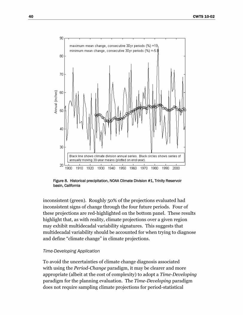
40 CWTS 10-02
Figure 8. Historical precipitation, NOAA Climate Division #1, Trinity Reservoir
basin, California
inconsistent (green). Roughly 50% of the projections evaluated had
inconsistent signs of change through the four future periods. Four of
these projections are red-highlighted on the bottom panel. These results
highlight that, as with reality, climate projections over a given region
may exhibit multidecadal variability signatures. This suggests that
multidecadal variability should be accounted for when trying to diagnose
and define ―climate change‖ in climate projections.
Time-Developing Application
To avoid the uncertainties of climate change diagnosis associated
with using the Period-Change paradigm, it may be clearer and more
appropriate (albeit at the cost of complexity) to adopt a Time-Developing
paradigm for the planning evaluation. The Time-Developing paradigm
does not require sampling climate projections for period-statistical
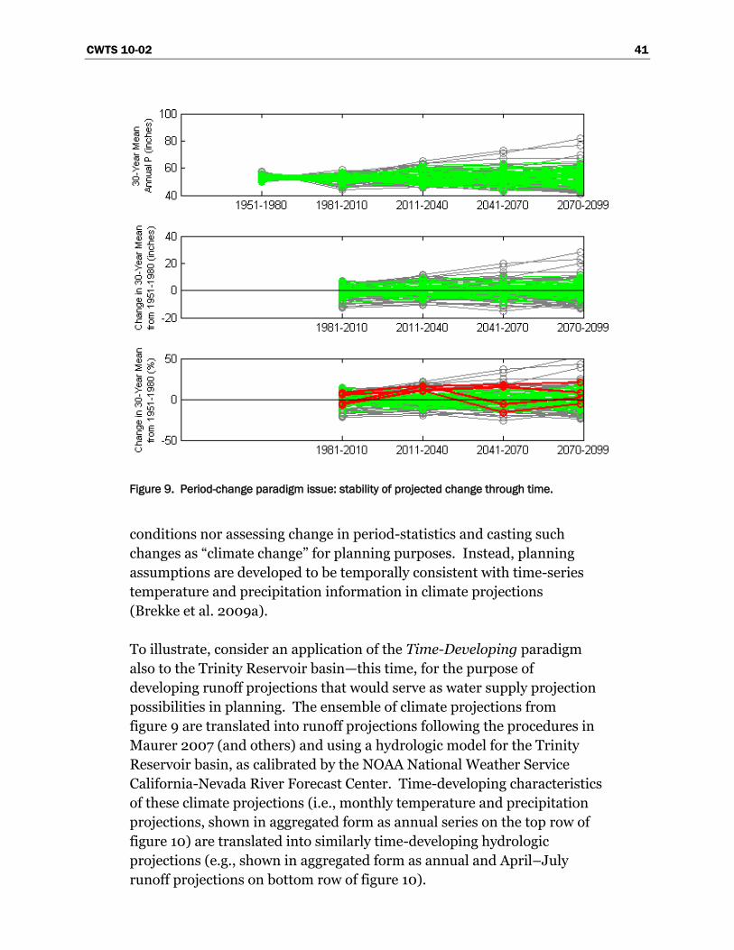
CWTS 10-02 41
Figure 9. Period-change paradigm issue: stability of projected change through time.
conditions nor assessing change in period-statistics and casting such
changes as ―climate change‖ for planning purposes. Instead, planning
assumptions are developed to be temporally consistent with time-series
temperature and precipitation information in climate projections
(Brekke et al. 2009a).
To illustrate, consider an application of the Time-Developing paradigm
also to the Trinity Reservoir basin—this time, for the purpose of
developing runoff projections that would serve as water supply projection
possibilities in planning. The ensemble of climate projections from
figure 9 are translated into runoff projections following the procedures in
Maurer 2007 (and others) and using a hydrologic model for the Trinity
Reservoir basin, as calibrated by the NOAA National Weather Service
California-Nevada River Forecast Center. Time-developing characteristics
of these climate projections (i.e., monthly temperature and precipitation
projections, shown in aggregated form as annual series on the top row of
figure 10) are translated into similarly time-developing hydrologic
projections (e.g., shown in aggregated form as annual and April–July
runoff projections on bottom row of figure 10).
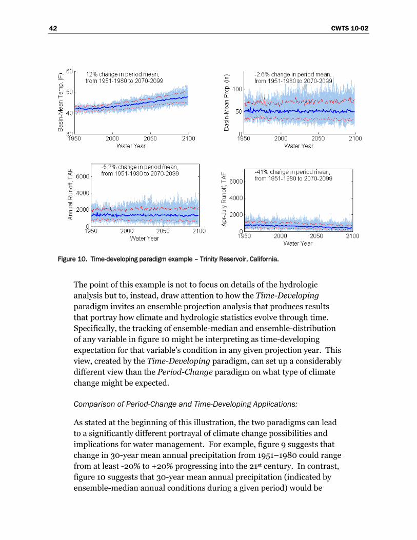
42 CWTS 10-02
Figure 10. Time-developing paradigm example – Trinity Reservoir, California.
The point of this example is not to focus on details of the hydrologic
analysis but to, instead, draw attention to how the Time-Developing
paradigm invites an ensemble projection analysis that produces results
that portray how climate and hydrologic statistics evolve through time.
Specifically, the tracking of ensemble-median and ensemble-distribution
of any variable in figure 10 might be interpreting as time-developing
expectation for that variable‘s condition in any given projection year. This
view, created by the Time-Developing paradigm, can set up a considerably
different view than the Period-Change paradigm on what type of climate
change might be expected.
Comparison of Period-Change and Time-Developing Applications:
As stated at the beginning of this illustration, the two paradigms can lead
to a significantly different portrayal of climate change possibilities and
implications for water management. For example, figure 9 suggests that
change in 30-year mean annual precipitation from 1951–1980 could range
from at least -20% to +20% progressing into the 21st century. In contrast,
figure 10 suggests that 30-year mean annual precipitation (indicated by
ensemble-median annual conditions during a given period) would be
CWTS 10-02 43
expected to change very little through the 21st century. In fact, the 30-year
average ensemble-median condition in 2070–2099 is only –3% from
the same condition during 1951–1980.
Use of the Time-Developing paradigm is not without its own
interpretation challenges. Contrasting from use of the Period-Change
paradigm, use of the Time-Developing paradigm requires:
The view that variability aspects in climate projections are reasonable
for planning purposes, understanding that different planning processes
will have different criteria for credibility (e.g., flood risk evaluations
may be more concerned about the credibility of projected daily
precipitation possibilities compared to resource management
evaluations more concerned about seasonal to multidecadal
precipitation variability).
The view that frequency aspects in climate projections are reasonable
for planning purposes (e.g., reoccurrence and intensity of drought and
surplus spells, reoccurrence of storm patterns relevant to flood risk
evaluation) and acknowledgment that the sequencing of events (e.g.,
reoccurrence of storms and droughts) will not align with historically
experienced events (unlike the Period-Change paradigm).
The view that planning evaluations must be conducted for an ensemble
of climate projections to adequately characterize the envelope of
climatic possibility evolving through time (contrasting from the Period-
Change paradigm that invites a view that a relatively smaller,
―bracketing‖ set of climate projections can be selected to represent the
breadth of projected incremental change possibilities).
These views aside, a Time-Developing paradigm may permit more
efficient development of longer-term climate change adaptation
strategies (where ―adaptation‖ in the climate change context is not to be
confused with ―adaptive management‖ featured in Reclamation and
USACE ecosystem management activities). While a Period-Change
paradigm would indicate resource management response specific to a
specific future period or period center-year (e.g., 2050), a Time-
Developing paradigm would include analysis of resource management
during intervening years, from historical to future and reveal the onset and
development of management vulnerability. Likewise, while a Period-
44 CWTS 10-02
Change paradigm could indicate the level of adaptive intervention
necessary for that given future year, a Time-Developing paradigm could
provide a time-evolving context within which multiple adaptive
interventions may be strategized and scheduled, fostering climate change
preparedness through time.
Current Capabilities
On the matter of interpreting historical climate variability for the purpose
of interpreting projected climate variability, Reclamation and USACE have
access to synthesis understanding on climate variability reported by IPCC
(Meehl et al. 2007, Christensen et al. 2007) and the U.S. Climate Change
Science Program (CCSP 2008). However, given the complexity of
information included in these synthesis reports, Reclamation and USACE
also pursue assistance from Government science partners (e.g., NOAA,
USGS), regional science centers (e.g., NOAA RISA centers), and academic
partners to help interpret the relevance of report findings in the context of
Reclamation and USACE planning evaluations.
On the matter of culling or weighting projections based on regard for
greenhouse gas emissions scenarios, Reclamation and USACE do not have
a basis for doing so. On the matter of culling or weighting projections
based on regard for climate model skill, Reclamation and USACE have
access to several methods (e.g., Tebaldi et al.2005; Brekke et al. 2008).
Reclamation recently collaborated with USGS, Santa Clara University,
and the California Department of Water Resources to develop and apply
a rationale to cull or weight climate models based on skill when assessing
climate projection uncertainty (Brekke et al. 2008).1 The rationale was
applied in a study over northern California, where climate model skill
was assessed and used to cull the model-ensemble to a ―better half‖ of
models. Climate projection ensembles were then evaluated for both
the full and ―better half‖ model-ensembles. Results showed that
projection uncertainty depicted by the ―better half‖ model-ensemble
was not substantially different from the complete ensemble, suggesting
that substantial projection uncertainty was introduced by emissions
pathway and optional initial conditions for the climate projections
(Brekke et al. 2008). Findings from this study supported a decision
1 This work occurred in a broader study involving these collaborators and additional
support from USACE and focusing on applying risk analysis principles to exploring
climate change implications for reservoir operations (Brekke et al. 2009b).
CWTS 10-02 45
by Reclamation to not cull climate models and their projections in
a subsequent planning application (Reclamation 2008a)
On the choice of framing planning evaluations based on the Period-
Change or Time-Developing paradigms discussed above, Reclamation has
previous discussed the paradigm options in the resource management
evaluations (e.g., appendix U of Reclamation 2007, where terms ―Period
Composite‖ and ―Transient‖ were used rather than Period-Change and
Time-Developing). Reclamation and USACE have access to both
methodologies but does not have guidance on best paradigm choice and
for various planning situations. Reclamation has experience applying the
Period-Change paradigm resource management evaluations (Reclamation
2008a, Brekke et al. 2009b). Reclamation also has experience applying
the Time-Developing paradigm to hydrologic impacts investigations (Raff
et al. in review, Reclamation 2009b).
On relating hydrologic event portrayal in infrastructure safety and flood
risk reduction evaluations to shorter-term variability in climate
projections, Reclamation and USACE are exploring the veracity of
traditional procedures for assessing hydrologic hazard potential in the
context of time-changing climate (i.e., ―nonstationary‖ climate). Using the
Time-Developing paradigm above, the effort involves developing
hydrologic projections consistent with climate projections and conducting
hydrologic hazard assessments, updating through time (Raff et al. in
review). This activity represents an initial effort to explore scoping
guidance for this issue of hydrologic event portrayal in a changing climate.
Reclamation and USACE also are seeking input from Federal science
partners on how to develop such guidance (e.g., NOAA, USGS).
Reclamation is leading an interagency effort to develop a methodology for
relating drought and surplus portrayal in resource management
evaluations to a blend of paleoclimate and projected climate information.
An additional objective is to explore how water supply variability portrayal
differs when based on a blend of paleoclimate and projected climate
information versus either paleoclimate or projected climate information
individually (Reclamation 2009b).
46 CWTS 10-02
Capability Gaps
Comparison of the preceding discussions on desired and current
capabilities leads to the following list of gaps in understanding, guidance
and methods.
Gap 3.01: Understanding on observed climate variability from
daily to multidecadal time scales, which underpins interpretation of
future variability in climate projections and it's relation to planning
assumptions.
Gap 3.02: Understanding on how to interpret climate projections‘
simulated climate variability on longer-term scales (from annual to
multidecadal scales).
Gap 3.03: Basis for culling or weighting climate projections (if at
all) when deciding which projections to use in planning.
Gap 3.04: Guidance on how to appropriately relate planning
assumptions to either Period-Change or Time-Developing aspects
of climate projections, when deciding how to use projections in
planning.
Gap 3.05: Guidance on how to jointly utilize the longer-term
climate variability from observed records, paleoclimate, and
projected climate information when portraying drought and surplus
possibilities in planning.
Gap 3.06: Method and basis for estimating extreme meteoro-
ogical event possibilities, deterministically or probabilistically, in a
changing climate.
2.3.4 Step 4 – Assess Natural Systems Response
After obtaining climate projection data (Step 2) and making decisions on
how to translate these data into climate scenarios for planning (Step 3,
e.g., Period-Change or Time-Developing scenarios), work proceeds on the
analyses necessary to map these data to planning assumptions. For
resource management evaluations, this means analyses to develop water
CWTS 10-02 47
supply, demand, and operating constraint assumptions, given the
availability of methods and tools to do so (figure 2). Likewise, for
infrastructure safety and flood risk reduction evaluations, this means
characterizing hydrologic events possibilities (figure 3).
Two categories of analyses occur to establish planning assumptions:
response of natural systems to climate scenarios (Step 4) and response of
socioeconomic conditions (Step 5). This section focuses on Step 4
analyses, which includes a broad range of natural systems. Discussion in
this section is divided for several types of natural systems or conditions:
watershed hydrology, ecosystems, land cover, water quality, consumptive
use of irrigated areas (physical drivers only), and sedimentation.
Desired Capabilities
For the types of natural systems and conditions discussed in this section,
planning managers need to be able to defend method and tool choices as
best available for their evaluations, particularly for environmental
compliance evaluations. It is recognized that a variety of system models
might be considered for use in these evaluations. Models may have
differing levels of complexity. Choice among these models will vary
depending on the study question being addressed.
Watershed Hydrology: For characterizing water supply assumptions or
a hydrologic event potential consistent with climate scenarios, planning
teams must be able to simulate surface water hydrologic response to
these climate scenarios using process-based hydrologic models.
Modeled weather inputs and land cover assumptions (which control
evapotranspiration) need to be cast consistently with climate scenarios.
Simulations must adequately portray all aspects of the surface water
balance, including basin water storage (i.e., soil moisture and in mountain
regions, snowpack), groundwater recharge, and evapotranspiration
(from natural land cover and riparian vegetation).
One necessary method decision when developing a hydrologic model for a
given basin is how to specify spatially distributed historical weather over
the basin. Proper specification of historical weather affects the process of
model development, where model parameters are set so that hydrologic
simulation reproduces historical runoff when forced by historical weather.
Different methods have been proposed for specifying distributed historical
weather (e.g., Daly et al. 1994, Maurer et al. 2002, Hamlet and
48 CWTS 10-02
Lettenmaier 2005), each leading to versions having different
characteristics. Differences arise from how a particular method
establishes weather station eligibility for informing the dataset and how
selected station data are mapped to the distributed dataset. It is possible
for a hydrologic model to similarly reproduce runoff characteristics when
using any of these historical weather versions. This is because there is
considerable flexibility on setting model parameters during calibration
(i.e., lack of field evidence or physical understanding to constrain what
parameter values could be). Nevertheless, it is necessary for hydrologic
modeling teams to be able to rationalize how this distributed weather
should be specified. Further, to avoid challenges in interpreting
differences between historical climate simulations (Step 2) and hydrologic
simulations (Step 4), it would be desirable to use a common distributed
historical weather dataset to serve bias-correction of both climate
projections (Step 2) and to hydrologic model calibration (Step 4).
Ecosystems: A variety of ecological resources and related conditions affect
reservoir operations and regulation. Notable resources include coastal
anadromous fisheries, inland freshwater fisheries in reservoirs and rivers,
riparian ecosystems, wetlands, and coastal ecosystems. For the purposes
of characterizing ecosystem-related constraints on operations that are
consistent with climate scenarios, planning teams must understand how to
simulate response of associated ecosystems (or ecosystem habitat) to a
given climate scenario. For systems where operations are constrained by
management objectives related to anadromous fisheries, planning teams
may require understanding on how climate change could alter the factors
that affect these fisheries, including hydrology (e.g., flow frequency,
duration, and magnitude during various life stages), habitat (during
various life stages, implying interest in both freshwater and ocean habitat),
human harvest, and hatchery production. For systems where riparian
ecosystems and vegetation control operations, teams also may require
understanding on how carbon dioxide conditions associated with that
scenario affect ecosystem function.
Land Cover: It is necessary for planning teams to understand how
watershed and riparian vegetation communities will respond to climate
and carbon dioxide change. Vegetation change would affect natural
evapotranspiration in tributary watersheds (watershed hydrology,
discussed above) as well as soil erosion-related river sedimentation
(discussed below). The response of vegetation communities also affects
CWTS 10-02 49
potential for wildfires and associated land cover disturbances that would
further alter watershed evapotranspiration and the potential for soil
erosion. In addition, the interaction of climate change and land use (such
as extent of impervious cover) also affects stream flow and water quality.
Water Quality: For many resource management evaluations (certainly for
evaluation of pollution control, water treatment systems, and sometimes
for evaluation of water supply system featuring dams and reservoirs, it is
necessary to consider water quality response to climate and hydrologic
change. Examples of water supply system evaluation might be assessing
changes in salinity controls on water management in the Colorado River
Basin and the San Joaquin River basin or water temperature controls on
reservoir water releases in the Upper Sacramento River basin. Analysis
first involves assessing surface water hydrology response to climate
scenario information and then overlaying water quality simulation and
source water quality information to simulate system water quality
response.
Consumptive Use in Irrigated Areas: For characterizing water demands
in resource management evaluations, planners must be able to assess
changes in plant water use efficiency (agricultural or urban landscape) to
given changes in climate (temperature, precipitation, growing season
length) and atmospheric composition (carbon dioxide). Further, as the
energy sector changes to new forms of energy and fuel production,
patterns of water demand are likely to change.
Sedimentation and River Hydraulics: Reclamation and USACE both
require understanding of how sedimentation budgets in reservoirs and
river systems may respond under a given climate scenario and hydrologic
regime. Reservoir sedimentation budgets affect reservoir storage capacity
through time, which affects ability to operate or regulate reservoirs to
satisfy a variety of objectives (e.g., water supply, hydropower, flood
control, ecosystem, navigation, recreation). On river hydraulics, cold-
season hydrology also may be of interest in regulated river systems
affected by ―ice events.‖ Assessing the response of ice-event potential to
climate scenario information first requires hydrologic analysis, followed by
river hydraulics and potentially sedimentation analysis.
50 CWTS 10-02
Current Capabilities
Reclamation and USACE both have invested considerably in the
development of tools and capabilities to analyze these natural systems and
conditions. Capabilities are relatively more evolved on the analysis of
watershed hydrology, river hydraulics and sedimentation, consumptive
use in irrigated areas (climate controls only), and water quality. This
investment will continue so long as there are issues with physical
understanding limiting the development and application of model
concepts or issues with monitoring affecting the application of these
concepts to particular systems. Specific to this section, the discussion on
current capabilities is focused on specific aspects in physical
understanding, tool selection, and tool application that are confounded
when considering climate change.
Watershed Hydrology: For assessments of surface water hydrologic
response to climate change and establishing water supply assumptions for
resource management evaluations, Reclamation and USACE have access
to multiple hydrologic model types and methods of application (e.g., see
appendix U in Reclamation 2007). USACE has extensive experience with
their Hydrologic Engineering Center hydrological modeling system (HEC-
HMS) (USACE 2008a and b), both in terms of software development and
application to address basin-specific studies. The USACE Engineer
Research and Development Center (ERDC) and Environmental Modeling
Systems Inc. are collaborating to develop the Gridded Surface Subsurface
Hydrologic Analysis (GSSHA). GSSHA capabilities include simulation of
overland flow, streamflow, infiltration, groundwater flow, and coupling
between the groundwater, vadose zone, streams, and overland flow.
Reclamation has not sponsored internal development of hydrologic
modeling software. However, Reclamation has become experienced
applying two types of surface water models in the context of climate
change studies1 and is working to developing capability with other types of
models.
Reclamation and USACE do not have guidance on which surface water
model types may be structurally more appropriate for climate change
evaluations, although this is a subject of ongoing collaborative research by
1 Models provided by the NOAA National Weather Service River Forecast Center
(Sacramento Soil Moisture Accounting model) and the University of Washington
(Variable Infiltration Capacity model).
CWTS 10-02 51
Reclamation, USGS, and the NWS Colorado Basin River Forecast Center.1
It has been shown that runoff projections can vary greatly depending on
model type and method choice (e.g., see discussions about Colorado
River runoff uncertainty in appendix U of Reclamation 2007 and
WWA 2008). Results also can vary greatly relative to process
representation (e.g., representing potential evapotranspiration using
a simple temperature-based method versus a more variable-intensive but
possibly more appropriate method like Penman-Monteith).
For characterizing hydrologic event potential, Reclamation and USACE
have access to deterministic (e.g., probable maximum flood) and
probabilistic techniques, as outlined in Guidelines for Determining Flood
Flow Frequency (IACWD 1982). However, an assumption underlying
these techniques is that the historical period of hydrologic and climate
data is statistically representative of the evaluation‘s planning future. In
other words, an assumption of ―stationarity‖2 is applied such that
historical flood frequency possibilities are adopted for the planning future.
However, in a changing climate, it is recognized that local hydrologic and
climate statistics may not be stationary (Milly et al. 2008). Properly
evaluating future flood risk within a changing, or ―nonstationary,‖ climate
remains a goal for water-management decisionmakers (Brekke et al.
2009a).
For the matter of developing a hydrologic model for a given basin and
doing the necessary preliminary step of specifying historical distributed
weather over the basin, Reclamation and USACE have access to multiple
methods. Such methods have been applied to develop similar but unequal
versions of historical weather (e.g., Maurer et al. 2002, Hamlet and
Lettenmaier 2005, NWS River Forecast Centers‘ (RFC) datasets used to
calibrate hydrologic simulation models and force them during operational
forecasting, plus numerous others). Among these available versions, only
the RFC operationally maintains a data management system designed to
track and gather station meteorological data to serve as inputs for
1 Assessing Preference among Surface Water Hydrologic Models for studies
involving Climate Change, https://www.usbr.gov/research/Propcweb/reviewer/
print_research_question.cfm?fy=2009&proposalid=2404.
2 This use of ―stationarity‖ to describe the consistency of local hydrologic and climate
statistics through time is not to be confused with the use of ―stationarity‖ in downscaling
discussions (Step 2) ,which relates to the consistency of spatially distributed land-
atmospheric interactions through time.
52 CWTS 10-02
hydrologic simulations models (also developed and operationally
maintained by the RFC). In comparison, the datasets from Maurer et al.
(2002) and Hamlet and Lettenmaier (2005) include meteorological
variables necessary to simulate both surface water and energy balances—
for example, using the Variable Infiltration Capacity model (Liang et al.
1994) rather than only surface water balance (e.g., using the Sacramento
Soil Moisture Accounting and Snow17 models [Burnash et al. 1973,
Anderson et al. 1973] used by the RFC). Further, there is currently a lack
of guidance on the strengths and weaknesses of these available methods
and versions for the task of supporting (a) climate projection bias-
correction and (b) hydrologic model calibration. There is also a lack of
understanding on whether an altogether different version needs to be
developed to support these latter objectives, recognizing that different
applications and purposes motivated the development of existing methods
and versions.
For assessments of coupled surface water (SW) and groundwater (GW)
response to climate change, Reclamation is less familiar with available
tools and application methods. During the 2008 R&D Scoping Workshop,
there was discussion about the USGS‘ new model type for coupled SW-GW
simulation (GSFlow) and its potential use in climate change studies (see
further discussion in chapter 4). Reclamation‘s Mid-Pacific Region has
access to other two types of models for coupled surface water and
groundwater systems: Integrated Water Flow Model (developed by the
California Department of Water Resources1 and applied to the California
Central Valley) and HydroGeoSphere (developed by the University of
Waterloo, HydroGeoLogic Inc., and Mid-Pacific Region and being applied
to the California Central Valley). Currently, no authoritative peer
assessment provides guidance on which coupled SW-GW model types and
application methods are most appropriate for climate change evaluations.
Ecosystems: Depending on the species considered, Reclamation and
USACE have varying capability in being able to characterize how climate
change may affect fisheries population and health as well as the health
of important ecosystems such as wetlands. Capabilities depend on
Reclamation and USACE understanding the primary factors that
control fisheries population and how climate will affect those factors.
For anadromous fisheries, Reclamation and USACE have some
1 http://baydeltaoffice.water.ca.gov/modeling/hydrology/IWFM/.
CWTS 10-02 53
understanding on two key factors: surface water hydrology and
aquatic temperatures. Capabilities are more limited in other factor
areas due to lack of understanding on both the relationship between
fisheries population and those factors and how climate change could
affect those factors (e.g., ocean habitat, riparian and wetland ecosystem
function, and vegetation that control freshwater habitat).
Land Cover: Reclamation and USACE do not have methods for assessing
land cover response to climate and carbon dioxide changes, nor do they
have methods for integrating such land cover response into hydrologic
impacts assessment. However, Reclamation has begun to build research
partnerships in this area. One ongoing effort1 involves collaboration with
Texas Water Development Board and Oklahoma Water Resources Board
to investigate the role of joint land cover and climate changes in the Upper
Canadian and North Fork Red River basins. The second year of the effort
involves assessing hydrologic response to joint projections of climate and
land cover, with the latter information being provided by collaborators
from the U.S. Forest Service Pacific Northwest Research Station and
USGS Earth Systems Observation and Science Data Center. Still, this
research represents an initial effort, and questions remain about
frameworks for studying land cover response to climate change, including
species- or community-specific aspects.
Water Quality: Reclamation and USACE have methods and models for
studying the fate and transport of water quality constituents in river and
reservoir systems. Different model types are available for use, with
complexity depending on the specificity of study objectives. As stated, the
analysis first involves assessing hydrologic conditions relative to climate
scenario information, and then overlaying water quality simulation and
source water quality data to simulate system water quality conditions.
Uncertainties and questions about characterizing hydrologic conditions
were discussed above. Water quality simulation frameworks generally are
well established, given available field evidence on source water quality to
apply a given framework to a given system. Questions may be more
prevalent on how given water quality parameters have source
characteristics that depend on climate variability (e.g., air temperature
and/or precipitation regimes). Reclamation and USACE continue to rely
1 ―Methodology to Evaluate the Influence of Joint Changes in Climate and Land Cover
on Water Availability.‖ https://www.usbr.gov/research/Propcweb/reviewer/
print_research_question.cfm?fy=2009&proposalid=2768.
54 CWTS 10-02
on input from other agencies (e.g., USEPA Office of Water) for guidance
on evaluating these dependencies and how they may be affected by
changing climate conditions.
Consumptive Use in Irrigated Areas: On assessing physical drivers of
irrigation water demand (agricultural and urban), Reclamation has
methods that can translate input climate scenarios into consumptive use
requirements, predicated on a static plant physiological relationship and
availability of meteorological data. Methods differ in how they simulate
potential evapotranspiration over irrigated lands, by crop type, and range
from U.S. Department of Agriculture Soil Conservation Service modified
Blaney-Criddle (which might be applied when data on key meteorological
variables are limited) to more sophisticated methods featuring Penman-
Monteith. Effects of growth stage and growing season are accounted for
empirically in these methodologies. Reclamation currently does not have
guidance on how to modify consumptive use models to account for
changes in plant physiological relationships with joint changes in climate
and carbon dioxide. Nor does Reclamation factor in long-term changes in
agricultural crops, such as from shifting to biomass to produce energy and
fuel. Reclamation will continue to look to guidance from other agencies
(e.g., USDA Agricultural Research Service) for guidance on how to advance
capabilities in this area.
Sedimentation and River Hydraulics: USACE and Reclamation field an
extremely competent array of sedimentation tools. The inherent
complexity of sedimentation, whether it is due to watershed, river, or
reservoir processes, limits sediment modeling to a heuristic exercise. In
this sense, the existing models are competent for detecting changes in
sediment yield, transport, and fate under climate change scenarios that are
mainly manifested in changes in hydrology. Relative, not absolute,
changes in sedimentation rates should correlate directly with changes in
hydrology, and indirectly with changes in land cover due to climate
change.
Capability Gaps
Comparison of the preceding discussions on desired and current
capabilities leads to the following list of gaps in understanding, guidance,
and methods.
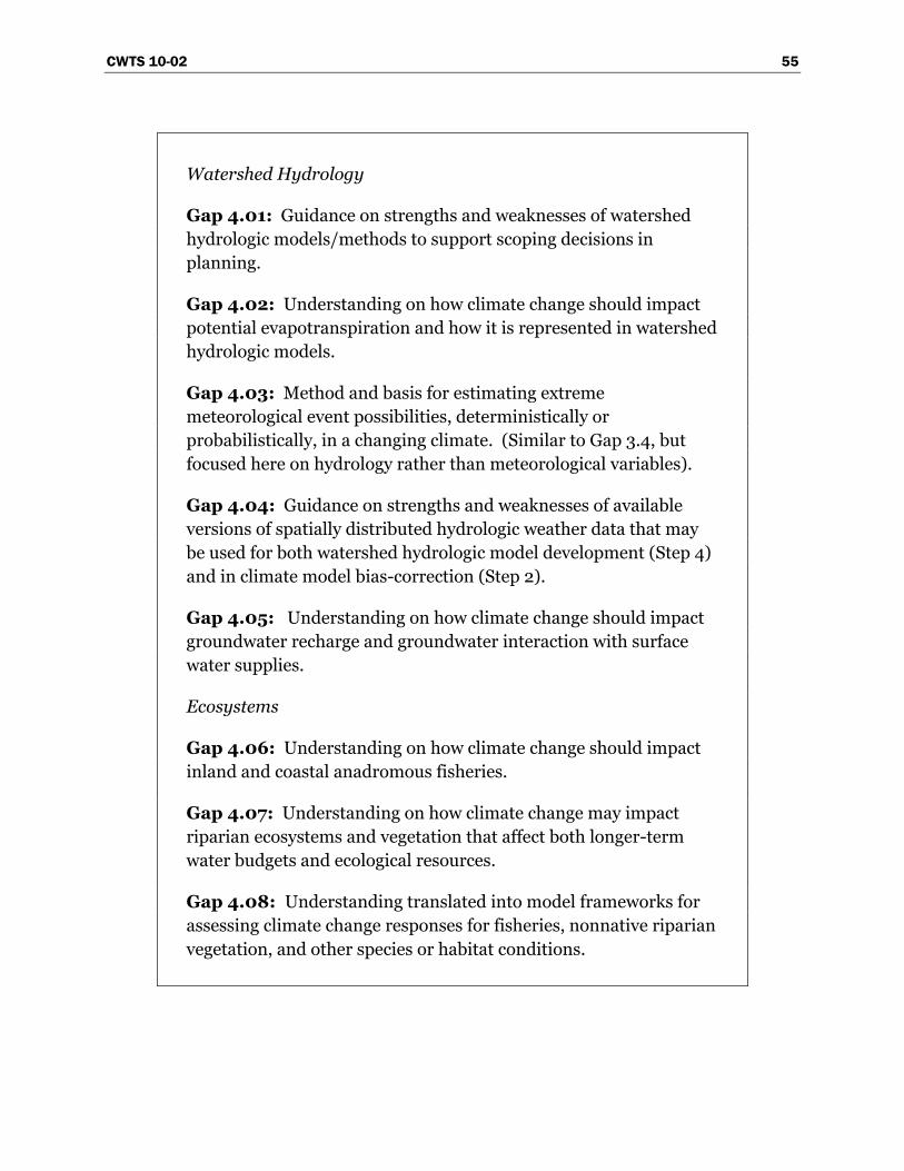
CWTS 10-02 55
Watershed Hydrology
Gap 4.01: Guidance on strengths and weaknesses of watershed
hydrologic models/methods to support scoping decisions in
planning.
Gap 4.02: Understanding on how climate change should impact
potential evapotranspiration and how it is represented in watershed
hydrologic models.
Gap 4.03: Method and basis for estimating extreme
meteorological event possibilities, deterministically or
probabilistically, in a changing climate. (Similar to Gap 3.4, but
focused here on hydrology rather than meteorological variables).
Gap 4.04: Guidance on strengths and weaknesses of available
versions of spatially distributed hydrologic weather data that may
be used for both watershed hydrologic model development (Step 4)
and in climate model bias-correction (Step 2).
Gap 4.05: Understanding on how climate change should impact
groundwater recharge and groundwater interaction with surface
water supplies.
Ecosystems
Gap 4.06: Understanding on how climate change should impact
inland and coastal anadromous fisheries.
Gap 4.07: Understanding on how climate change may impact
riparian ecosystems and vegetation that affect both longer-term
water budgets and ecological resources.
Gap 4.08: Understanding translated into model frameworks for
assessing climate change responses for fisheries, nonnative riparian
vegetation, and other species or habitat conditions.
56 CWTS 10-02
Land Cover
Gap 4.09: Understanding on how climate and/or carbon dioxide
changes should impact land cover communities that control natural
evapotranspiration and soil erosion potential.
Water Quality
Gap 4.10: Understanding on how water quality characteristics
depend on climatic variables and how dependencies may evolve in a
changing climate.
Consumptive Use in Irrigated Areas
Gap 4.11: Understanding on how climate and carbon dioxide
changes should impact plant physiology, how impacts vary with
crop type, and how impacts affect irrigation demand.
Sedimentation and River Hydraulics
Gap 4.12: Understanding how climate and/or land cover changes
will change watershed sediment yield, changes in sediment
constituency, and the resulting impacts on water resources.
Gap 4.13: Understanding how climate, land cover, and/or
sedimentation changes will affect river and reservoir ice-event
potential.
2.4.5 Step 5 – Assess Socioeconomic and Institutional Response
As previewed for Step 4, work in Step 5 continues to focus on mapping
climate scenario data to planning assumptions. Here, the focus is on
social and economic systems that are influenced in some fashion by
climate factors, estimating responses in those systems to climate scenario
data, and translating those responses into adjusted planning assumptions
on water demands, source of supply preferences, and operational
constraints.
Social and economic systems generate the water demands, source of
supply preferences, and values that shape various operational constraints.
CWTS 10-02 57
These factors interact to affect how water managers make and implement
water allocation decisions. These system dynamics may alter under
changed climatic conditions. For example, under some climate change
scenarios the volume and spatial distribution of water supply and demand
in the U.S. West may be expected to change. The way society values water
and the environment, and what constraints this puts on the ways water is
used, may also change. Furthermore, the relation between society and
climate is reciprocal; social and economic dynamics can also impact how
climate change unfolds.
Without climate change as a new driver, the relations between these social
and economic system dynamics and water management are traditionally
complex, poorly understood, and underemphasized in water management.
The National Research Council concludes that ―research leading to the
development of improved water management institutions should receive
much more attention in the research agenda of the 21st century than it did
in the past‖ (NRC 2001). In this context, an ―institution‖ can be thought of
as any assemblage of rules, legal or otherwise, which governs how water
users make use of their resource and how water managers facilitate that
use. Underlying any institution are sets of social, political, cultural, and
economic variables, which interact to determine what is acceptable,
profitable, or otherwise valued by society.
Economic, political, and social variables are dynamic with time,
particularly under pressure from significant forcers like climate change.
As Heclo (2008) states, ―... to be enduring, institutions also have to be
adaptive and change in time-factored ways.‖ Water managers will need
relevant, concise, and timely information on potential shifts that may
occur in environmental values, water demand, and other social, political,
and economic variables if they are to adapt to climate change efficiently
and effectively
In exploring institutional dynamics, it is fully understood that decisions on
water management are most often made at the State and local level. The
objective of improving capability in Step 5 is to generate and provide
information that is useful to decisionmakers at all levels, not to influence
decisionmaking responsibilities in any way. Toward this objective, it is
vital that work in this area is done in consultation and coordination with
State and local water managers, so that their knowledge and experience is
included in identifying current and desired capabilities.
58 CWTS 10-02
As members of the water community of practice, Reclamation and USACE
studies and decisions are also guided by social and economic factors. The
current P&G are used to guide the formulation and evaluation of water
resource alternatives and investments by the Federal water resources
agencies. USACE policy requires that any planning study evaluate
National Economic Development (NED), National Ecosystem Restoration
(NER), Regional Economic Development (RED), and Other Social Effects
(OSE) benefits (the latter encompassing life safety). Given the focus on
NED in the current P&G and in USACE policy, developing new methods
for economic evaluation embracing NER, OSE, and RED under the
influence of climate change considerations is anticipated. The P&G are
currently undergoing revision under the leadership of the President‘s
Council on Environmental Quality. The USACE has already begun an
internal process to suggest and review potential new methods. In the
fiscal year 2010 budget hearing before the U.S. Senate Subcommittee on
Energy and Water Development, Reclamation Commissioner Michael L.
Connor announced that Reclamation will work with State and local
partners to initiate comprehensive water supply and demand studies in
the West, with each study including state-of-the-art projections of future
water supply and demand on a basin-wide scale.
Desired Capabilities
For longer-term water resources evaluations, Reclamation and USACE
seek capability in being able to relate climate scenario data to the social
and economic factors that govern assumptions on water demands, source
of supply preference, and a variety of constraints affecting reservoir
operations or regulation. For water demand assumptions, this means
understanding social and economic influences of demand from the field-
to district-management level, where a mix of social, economic, and natural
factors determine aggregate demand. For constraint assumptions, this
means understanding the interaction of climate, social, and economic
factors in a variety of areas:
Flood protection expectations and risk reduction objectives
Water and hydropower delivery reliability objectives
Environmental preservation, restoration, and management objectives
Reservoir and river recreation objectives
River navigation objectives
CWTS 10-02 59
Current Capabilities
Assuming historical social and economic trends will continue in a linear
fashion are generally accepted assumptions when conducting water and
water-related resource planning studies, unless changes in social drivers
are assumed as part of the longer-term system change being evaluated.
From the perspective of a more dynamic, climate-sensitive view of social
and economic factors, there are isolated researchers and research
programs within and outside of the Federal Government examining this
issue. The interdisciplinary and ―second-thought‖ nature of these issues
within the water research community are typically a barrier to more
mainstream collaboration on the development and integration of these
capabilities across the water management community of practice.
Similarly, some members of the water community of practice have a keen
awareness of the issues, but the awareness is not uniform or widespread.
Finally, while there is a relatively large body of research scattered across
different disciplines and journals, there are few general synthesis
publications and even fewer relevant to water management.
Consequently, there remains little capacity in the realm of gathering,
filtering, synthesizing, and packaging this kind of information in ways that
are relevant to and supportive of the mission of water managers.
On matters of relating climate scenario data to the social and economic
drivers, Reclamation and USACE have limited capability. For example,
while flood risk reduction evaluations are clearly informed by natural
hydrologic response (Step 4), the assessment of flood risk also depends on
social, political, and economic drivers of flood plain management and
community expectations on flood protection. Reclamation and USACE
currently do not have guidance on how to assess these drivers in a
changing climate.
On environmental preservation and restoration efforts, strategy
evaluations under a changing climate will not only depend on physical
drivers from that climate scenario, but also assumed socioeconomic
responses that translate into paradigms for ecosystem management and
valuation of ecosystem services. For example, if the restoration is focused
on a species that will experience habitat reduction as climate warms, the
paradigm for preservation and/or restoration management comes into
question. Reclamation and USACE continue to look to natural resource
60 CWTS 10-02
and wildlife management agencies for guidance on exploring these
questions (e.g., U.S. Fish and Wildlife Service, NOAA National Marie
Fisheries Service [NOAA Fisheries], USEPA). The question of valuing
ecosystem services is a perennial and controversial issue in the water
resources planning community. Despite a strong statement by the NRC in
2004 that ―the economic values of the ecosystem goods and services must
be known so that they can be compared with the economic values of
activities that may compromise them and so that improvements to one
ecosystem can be compared to those in another,‖ there remains no single
approach to consider ecosystem services—an issue that is more critical in
the face of climate change.
Expected levels of water and hydropower delivery reliability depend on the
robustness of hydrosystems and source of supply options for system users.
The latter depends on whether system users are economically inclined to
enter into water transfer arrangements or participate in water markets.
Physical drivers of a climate scenario feedback to affect the economics of
source of supply decisions and, thus, the tendencies of system users to
enter into transfer agreements and water markets. Reclamation and
USACE have ability to conduct such analyses when the underlying social
and economic drivers on the system can be characterized. Reclamation
and USACE continue to look for guidance from others on characterizing
these drivers or supporting research for these purposes (e.g., USGS,
USDA Economic Research Service, USDA Cooperative State Research,
Education, and Extension Service; National Science Foundation, and
Federal hydropower authorities).
It is recognized that prediction of future social, economic, and institutional
conditions are already quite challenging without considering the
interactions of these conditions with climate change. Given the complexity
of this problem, capability advancements may be slow to develop, even
with targeted efforts in research. For the interim, water management
agencies may look to applications of scenario planning, where potential
social, economic, and institutional pathways might be conceptualized and
used to bound assumption uncertainties on how climate change may affect
social, economic, and institutional systems. Frameworks are available for
conducting scenario planning (Schwartz 1996). Such an approach would
be generally consistent with the approach taken by IPCC to characterize
future climate system drivers associated with anthropogenic emissions of
greenhouse gases (IPCC 2000), where scenario assumptions on global
CWTS 10-02 61
demographic, economic, technology and energy usage pathways are
characterized and translated into atmospheric composition scenarios (e.g.,
scenarios labeled A2, A1b, B1). Scenario planning may also be coupled to
robust-decision support methods (e.g., Lempert et al. 2003) where
management approaches are explored for robustness relative to the space
of uncertain planning assumptions and associated scenarios for each
assumption.
Capability Gaps
Comparison of the preceding discussions on desired and current
capabilities leads to the following list of gaps in understanding.
Gap 5.01: Understanding on how socioeconomic factors may
affect flood risk reduction and reservoir regulation objectives in a
changing climate (e.g., flood protection values, land management).
Gap 5.02: Understanding on how socioeconomic factors may
affect water and power delivery reliability, water allocations, as well
as decisions on source of supply under a changing climate (e.g.,
groundwater pumping versus surface water diversion).
Gap 5.03: Understanding on how institutional realities currently
control socioeconomic responses to climate variability and could
control socioeconomic responses under a changing climate.
These gap statements are rather general in nature. A more precise and
more informed characterization of these gaps (and current capabilities)
can only be achieved through follow-on consultation and collaboration
across the water community of practice.
2.4.6 Step 6 – Assess Systems Risks and Evaluate Alternatives
In this step, the results from Steps 4 and 5 are now integrated into
planning assumptions for either the resource management evaluation
(i.e., supplies, demands, and operating constraint assumptions
framing reservoir operations analysis) or infrastructure safety and
flood risk-reduction assessments (i.e., hydrologic hazard and
socioeconomic assumptions framing these assessments). Analyses
62 CWTS 10-02
then follow, where results are used to inform the driving study questions
about resource management, infrastructure safety or flood risk.
Desired Capabilities
Reclamation and USACE require analytical tools and methods that can
relate planning assumptions to plan evaluation outcomes of interest. For
example, resource management evaluations may be focused on the
reliability of satisfying water and power delivery objectives, downstream
river flow targets, reservoir water levels, etc. Flood risk-reduction
evaluations may be concerned about the combined outcomes of storage
space encroachment and downstream flow rates during hydrologic events
of interest. Infrastructure evaluations may be concerned about facility
integrity under assumed hydrologic loads. Reclamation and USACE must
apply tools and methods with thought given to regulatory, institutional,
and social contexts.
It is expected that Reclamation and USACE will be increasingly asked to
evaluate planning proposals or strategies that serve climate change
adaptation efforts. When considering multiple strategy options for system
developments, there is a need to be able to efficiently assess and rank
strategies (e.g., resource management evaluations concerned with supply
side, demand side, or constraint-change strategies, or some mix of all
three).
For reservoir operations and regulation simulations, decisions are made
(often implicitly) on how to portray operator knowledge as climate
changes. There may be a need to be able to portray realistic operator
―learning‖ as climate change develops. Doing so leads to a more realistic
portrayal of the onset and degree of impacts. It also leads to a more
realistic portrayal of adaptive capacity (something that may otherwise be
overestimated in perfect-foresight ―strategy evaluation‖ studies), which
could influence decisions on when and which adaptation strategies to
implement.
All of the discussion thus far on Steps 2 through 6 has focused on how
climate change is expected to affect operations. Conversely, there may be
questions in a planning evaluation about how the planning proposal
(operational or infrastructure) may affect climate (i.e., climate change
mitigation). For example, several Western States now have objectives for
reducing greenhouse gas emissions on a future timeline (e.g., California).
CWTS 10-02 63
In those States, it is becoming increasingly necessary for environmental
compliance documents on proposed system changes to disclose how the
proposed action affects regional emission strategies.
Current Capabilities
Reclamation and USACE have much collective experience conducting
resource management, infrastructure safety, and flood risk-reduction
evaluations. These evaluations are supported by a ―toolbox‖ of system-
specific models that have gained acceptance by managers, stakeholders,
and planning practitioners in the given study region.
Reclamation and USACE have yet to establish a common understanding
on how climate change should be incorporated in flood risk and dam
safety evaluations, although collaborative efforts and research are being
conducted in this area. Questions remain about how risk depends on
characterization of storm and hydrologic event possibilities under a
changing climate (Steps 3 and 4) and on how socioeconomic drivers in
these assessments may change (Step 5).
Reclamation and USACE have limited recent experience in basin
development planning that involves multiproject strategy and phased
implementation over time. Such planning may be of interest in
demonstrating preparedness for climate change adaptation. On assessing
and ranking strategies that promote climate change adaptation,
Reclamation and USACE have access to a variety of ―master planning‖
techniques, some of which involve economically driven optimization (e.g.,
Tanaka et al. 2006). However, neither agency has guidance on
appropriate frameworks for conducting such evaluations. Reclamation
and USACE will continue to look for collaborative opportunities with local
and regional water management entities that have more recent experience
applying and developing approaches for multiproject ―master planning‖
evaluations (e.g., AWWA, Water Utilities Climate Alliance, State water
agencies coordinating multibasin water development efforts). On the
portrayal of operator learning in adaptation evaluations, Reclamation does
not have an established method.1
1 This is not to say that Reclamation does not have access to software that can
simulate operations under user-define rules that may change with time, reflecting
operator learning as climate changes. It is only saying that a rationale for specifying
64 CWTS 10-02
On the issue of estimating the effects of operational changes on climate,
Reclamation and USACE have access to online ―calculators‖ of greenhouse
gas emissions changes. However, there is lack of guidance on appropriate
tools and methods of application. Reclamation and USACE will continue
to look to other agencies for assistance on developing such guidance (e.g.,
USEPA).
Capability Gaps
Comparison of the preceding discussions on desired and current
capabilities leads to the following list of gaps in guidance.
Gap 6.01: Guidance on how to conduct an adaptation evaluation
that efficiently explores and rank strategy options, potentially using
optimization techniques.
Gap 6.02: Guidance on how to portray realistic operator learning
in evaluations supporting planning for climate change adaptation.1
Gap 6.03: Guidance on how to assess the effect of planning
proposals on climate.
Note that the list of gaps does not include two other areas potentially
requiring guidance:
How to assess flood control requirements in a changing climate
How to assess infrastructure safety in a changing climate
In the context of this document, these gaps seem to require programmatic
reactions rather than a research or technology response. However, success
in developing such programmatic responses will be affected by the success
such rule changes over time (and specifying operator learning as climate changes)
remains to be developed.
1 In this context, ―climate change adaptation‖ has a longer-term context, contrasting
from concerns of shorter-term ―adaptive management‖ featured in a number of
Reclamation and USACE ecosystem management efforts.
CWTS 10-02 65
of implementing research to address a number of associated gaps (e.g.,
Gaps 2.01–2.03, 3.01–3.06, 4.01–4.13, 5.01 and 5.03).
2.4.7 Step 7 – Assess and Characterize Uncertainties
This step involves assembling the various uncertainties that were
individually introduced, assessed, and characterized during the course of
the planning evaluation in Steps 2 through 6 (as possible). This element
also involves assessing the interactions between these uncertainties (as far
as is possible).
Desired Capabilities
Such assessment would ideally consider uncertainties arising from model
structures, model development data, and methods of application.
Reclamation requires an understanding on how to assess these various
types of uncertainties, some of which are highlighted below:
Step 2 (Obtain Climate Projections Data)
o Data uncertainties affecting the regard for climate projections and
their use (e.g., global socioeconomic and technological development
translating into future greenhouse gas emissions; subsequent fate
and transport of these emissions through the global ocean-
atmosphere-land system, ultimately affecting climate; ability to
model the climate system).
o Method uncertainties involving bias-correction of climate
projections.
o Method uncertainties involving spatial downscaling of climate
projections (e.g., statistically or dynamically).
Step 3 (Decisions on Which Projections to Use and How to Use in
Planning Scenarios)
o Method uncertainties for culling or weighting climate projections.
o Method uncertainties for blending climate information from the
instrumental record, paleoclimate, and climate projections in
planning assumptions.
66 CWTS 10-02
o Method uncertainties for assessing regional precipitation
characteristics in climate projections, on time scales from days to
decades.
o Method uncertainties for incorporating Period-Change or Time-
Developing projection or prediction information into planning
assumptions.
Step 4 (Assess Natural Systems Response)
o Data uncertainties affecting the development and calibration of
natural systems models (hydrologic, ecosystem).
o Method and model development uncertainties associated with
natural system models and how they are applied to the given study
area.
Step 5 and 6 (Assess Socioeconomics Response and Evaluate Study
Questions)
o Similar data and method uncertainties as Step 4, but for the various
social system, operations, and dependent-resource analyses
considered.
Current Capabilities
Reclamation and USACE are capable of performing uncertainty analyses
on each analytical step, given available uncertainty information on model
structures, model development data, and method of use. For example,
tools like ―@Risk‖ (Palisade Corporation, http://www.palisade.com/) and
custom-built tools may be used to conduct studies on how system model
outputs vary in relation to the possible values for model input data and/or
model parameters.
On the analysis of how uncertainties interact across analytical elements,
Reclamation and USACE have methods and tools for conducting such
studies. However, the scope of such studies would be limited by
understanding of how model inputs and structures should be free to
vary. For example, in Step 2, Reclamation and USACE receive climate
CWTS 10-02 67
projections data from external groups.1 These data reflect a series of
analyses linking global economic and technological developments to future
climate. Uncertainties stemming from these analyses are not readily
accessible to the water planning community. Likewise, in Step 3, there are
a number of uncertainties on how to best use Period-Change or Time-
Developing characteristics of the climate projections in planning
scenarios. There is also limited understanding on how these uncertainties
affect analysis results and subsequent decisions. Generally speaking, it
could be said that each of the step and gaps previously discussed have
associated questions about how to characterize data, models, and methods
uncertainties.
Capability Gaps
Comparison of the preceding discussions on desired and current
capabilities leads to the following list of gaps in uncertainty information.
Gap 7.01: Uncertainty information on global climate projections
data, including uncertainties about climate system science,
portrayal in climate models, emissions scenario development, and
simulation methods.
Gap 7.02: Uncertainty information on regional climate
projections data, including uncertainties from choice of bias-
correction and spatial downscaling methods.
Gap 7.03: Uncertainty in planning results stemming from method
choices on how to use transient characteristics of climate
projections in planning scenarios.
Gap 7.04: For each response analysis on a natural system,
uncertainty information on system science and associated ways of
portraying this science in a system model and the observations used
to customize a model for a specific system.
1 http://www.narccap.ucar.edu/. Statistically Downscaled WCRP CMIP3 Climate
Projections at http://gdo-dcp.ucllnl.org/downscaled_cmip3_projections/.
68 CWTS 10-02
Gap 7.05: For each response analysis on a socioeconomic system,
uncertainty information on system science and associated ways of
portraying this science in a system model and the observations used
to customize a model for a specific system.
2.4.8 Step 8 – Communicate Results and Uncertainties to
Decisionmakers
After completing the analytical tasks of the planning evaluation, results are
summarized and presented for the consideration of decisionmakers and
interested parties, along with characterized uncertainties.
Desired Capabilities
To support decisionmaking, the salient results of planning evaluations
must be communicated effectively. Uncertainties in the evaluation‘s
results must be disclosed and related to interpretation of results.
Current Capabilities
Reclamation and USACE have considerable experience in communicating
planning results and uncertainties to decisionmakers and stakeholder
groups. Such communication is a common feature of environmental
compliance and other longer-term planning documentation. However,
climate change is a relatively new feature in these studies and raises new
communication questions. Further, much of this communication
experience is rooted in the system portrayal paradigm that is more
amenable to the Period-Change paradigm discussed under Step 3
(section 2.4.3). Switching to a Time-Developing paradigm would
necessitate a view of a time-changing system with evolving probabilities of
system conditions through time, which differs from the comparative
―stationary systems‖ view featured under the Period-Change paradigm.
Reclamation‘s Mid-Pacific and Pacific Northwest Regions have experience
communicating climate change implications for environmental
compliance processes using the Period-Change paradigm (Reclamation
2008a, Reclamation 2008c). Reclamation‘s Upper Colorado and Lower
Colorado Regions have experience communicating in a Time-Developing
CWTS 10-02 69
paradigm (e.g., Reclamation 2007). USACE adopted a risk-based analysis
policy for water resource projects in 1996. However, much of that analysis
is based on a static hydrologic characterization for expected project life,
typically 50 years. Incorporating either a Period-Change or a Time-
Developing paradigm is beyond the current capabilities of USACE
analytical tools. USACE does not have standards for evaluating potential
futures under either paradigm.
Capability Gaps
Reclamation has recently implemented different approaches to
communicating climate change and variability information in planning
(Reclamation 2007 and 2008a) but continues to be in a learning phase on
best approaches for doing so. USACE is developing improved methods for
risk communication and public involvement in risk management. They
have yet to develop a framework for communicating risk related to climate
but will be moving forward with Reclamation in this area.
Gap 8.01: Guidance on strengths and weaknesses of various
methods for communicating results and uncertainties affected by
the use of climate projection information.
Gap 8.02: Guidance on how to make decisions given the
uncertainties introduced by consideration of climate projection
information.

CWTS 10-02 71
3 Perspectives from Other Water
Management Organizations
The preceding section was prepared by the Bureau of Reclamation and the
U.S. Army Corps of Engineers and is meant to be viewed as a joint agency
perspective on improved tools and information our agencies need to better
incorporate global climate change information into our management of
water and water-related resources. Discussion now transitions to views
and reactions to gaps from table 1, offered by internal management at
Reclamation and USACE, other Federal agencies, and non-Federal
organizations. The common attribute of entities providing perspectives is
that they all manage, or play a role in managing water and water-related
resources.
The purpose of this section is to provide a summary of views and
perspectives offered, including opinions on how to relatively prioritize
research to address gaps in table 1. This section proceeds in first
describing the process for gathering feedback on gap statements, followed
by key themes among gathered perspectives, and then a gap-specific
summary of comments and perspectives.
3.1 Process for Gathering Perspectives
A draft version of this document, completed through section 2.0, was
distributed to a list of internal Reclamation and USACE offices, non-
Federal organizations, and other Federal organizations. These entities
also received a summary table of gaps statements that included columns
where the respondent could indicate priority-level rating for research to
address the given gap (i.e., low, medium, and high rating choices), and/or
offer comments on the given gap. The list of entities receiving distribution
materials includes:
Reclamation‘s regional offices, who then distributed materials to
various area offices
USACE division offices, who then distributed materials to various
district offices
72 CWTS 10-02
Non-Federal organizations
o American Water Works Association (AWWA)
o American Society of Civil Engineers (ASCE) - Environmental and
Water Resources Institute
o ASCE Task Committee on Sustainable Design
o Association of Fish and Wildlife Agencies
o Association of Metropolitan Water Agencies (AMWA)
o Association of State and Interstate Water Pollution Control
Authorities
o Association of State Dam Safety Officers
o Association of State Drinking Water Administrators
o Association of State Flood Plain Managers
o Association of State Wetland Managers
o California Department of Water Resources
o California Energy Commission
o California Farm Water Coalition
o California Water and Environmental Modeling Forum
o Central Arizona Project
o Family Farm Alliance
o Interstate Council on Water Policy
o National Association of Flood and Stormwater Management
Agencies
o National Water Resources Association
o National Waterways Conference
o Salt River Project
o Seattle City Light
o Northern Colorado Water Conservancy District
o The Nature Conservancy
o Trout Unlimited
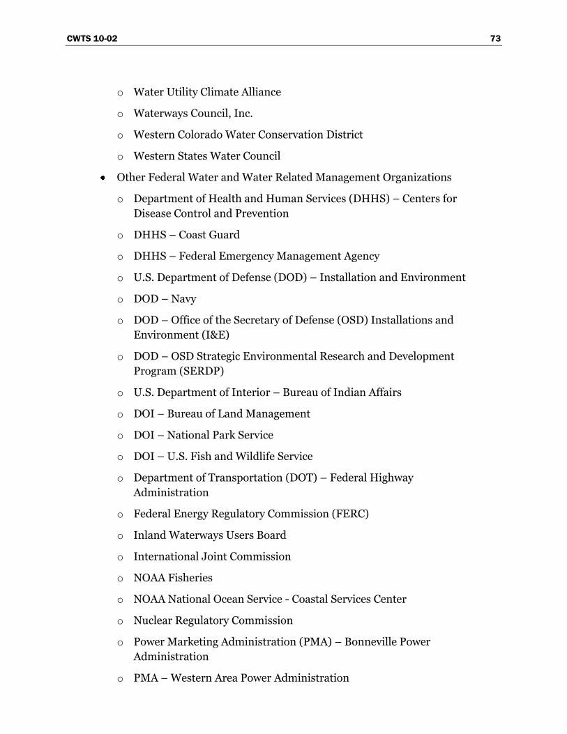
CWTS 10-02 73
o Water Utility Climate Alliance
o Waterways Council, Inc.
o Western Colorado Water Conservation District
o Western States Water Council
Other Federal Water and Water Related Management Organizations
o Department of Health and Human Services (DHHS) – Centers for
Disease Control and Prevention
o DHHS – Coast Guard
o DHHS – Federal Emergency Management Agency
o U.S. Department of Defense (DOD) – Installation and Environment
o DOD – Navy
o DOD – Office of the Secretary of Defense (OSD) Installations and
Environment (I&E)
o DOD – OSD Strategic Environmental Research and Development
Program (SERDP)
o U.S. Department of Interior – Bureau of Indian Affairs
o DOI – Bureau of Land Management
o DOI – National Park Service
o DOI – U.S. Fish and Wildlife Service
o Department of Transportation (DOT) – Federal Highway
Administration
o Federal Energy Regulatory Commission (FERC)
o Inland Waterways Users Board
o International Joint Commission
o NOAA Fisheries
o NOAA National Ocean Service - Coastal Services Center
o Nuclear Regulatory Commission
o Power Marketing Administration (PMA) – Bonneville Power
Administration
o PMA – Western Area Power Administration
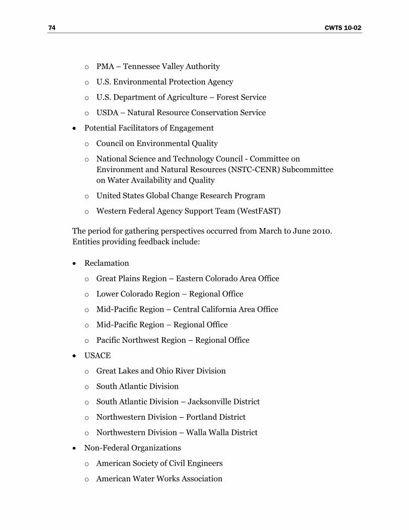
74 CWTS 10-02
o PMA – Tennessee Valley Authority
o U.S. Environmental Protection Agency
o U.S. Department of Agriculture – Forest Service
o USDA – Natural Resource Conservation Service
Potential Facilitators of Engagement
o Council on Environmental Quality
o National Science and Technology Council - Committee on
Environment and Natural Resources (NSTC-CENR) Subcommittee
on Water Availability and Quality
o United States Global Change Research Program
o Western Federal Agency Support Team (WestFAST)
The period for gathering perspectives occurred from March to June 2010.
Entities providing feedback include:
Reclamation
o Great Plains Region – Eastern Colorado Area Office
o Lower Colorado Region – Regional Office
o Mid-Pacific Region – Central California Area Office
o Mid-Pacific Region – Regional Office
o Pacific Northwest Region – Regional Office
USACE
o Great Lakes and Ohio River Division
o South Atlantic Division
o South Atlantic Division – Jacksonville District
o Northwestern Division – Portland District
o Northwestern Division – Walla Walla District
Non-Federal Organizations
o American Society of Civil Engineers
o American Water Works Association
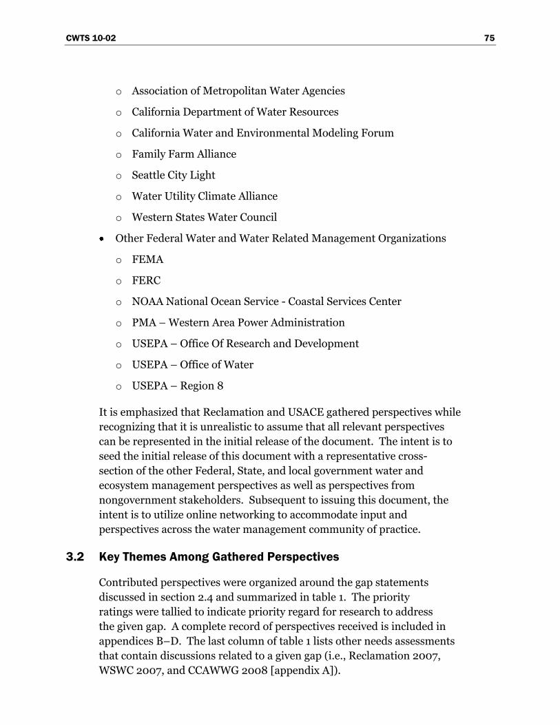
CWTS 10-02 75
o Association of Metropolitan Water Agencies
o California Department of Water Resources
o California Water and Environmental Modeling Forum
o Family Farm Alliance
o Seattle City Light
o Water Utility Climate Alliance
o Western States Water Council
Other Federal Water and Water Related Management Organizations
o FEMA
o FERC
o NOAA National Ocean Service - Coastal Services Center
o PMA – Western Area Power Administration
o USEPA – Office Of Research and Development
o USEPA – Office of Water
o USEPA – Region 8
It is emphasized that Reclamation and USACE gathered perspectives while
recognizing that it is unrealistic to assume that all relevant perspectives
can be represented in the initial release of the document. The intent is to
seed the initial release of this document with a representative cross-
section of the other Federal, State, and local government water and
ecosystem management perspectives as well as perspectives from
nongovernment stakeholders. Subsequent to issuing this document, the
intent is to utilize online networking to accommodate input and
perspectives across the water management community of practice.
3.2 Key Themes Among Gathered Perspectives
Contributed perspectives were organized around the gap statements
discussed in section 2.4 and summarized in table 1. The priority
ratings were tallied to indicate priority regard for research to address
the given gap. A complete record of perspectives received is included in
appendices B–D. The last column of table 1 lists other needs assessments
that contain discussions related to a given gap (i.e., Reclamation 2007,
WSWC 2007, and CCAWWG 2008 [appendix A]).
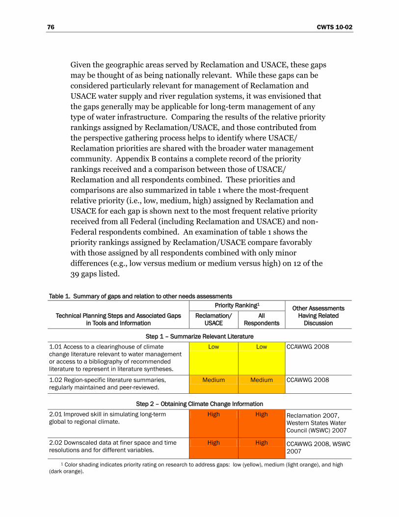
76 CWTS 10-02
Given the geographic areas served by Reclamation and USACE, these gaps
may be thought of as being nationally relevant. While these gaps can be
considered particularly relevant for management of Reclamation and
USACE water supply and river regulation systems, it was envisioned that
the gaps generally may be applicable for long-term management of any
type of water infrastructure. Comparing the results of the relative priority
rankings assigned by Reclamation/USACE, and those contributed from
the perspective gathering process helps to identify where USACE/
Reclamation priorities are shared with the broader water management
community. Appendix B contains a complete record of the priority
rankings received and a comparison between those of USACE/
Reclamation and all respondents combined. These priorities and
comparisons are also summarized in table 1 where the most-frequent
relative priority (i.e., low, medium, high) assigned by Reclamation and
USACE for each gap is shown next to the most frequent relative priority
received from all Federal (including Reclamation and USACE) and non-
Federal respondents combined. An examination of table 1 shows the
priority rankings assigned by Reclamation/USACE compare favorably
with those assigned by all respondents combined with only minor
differences (e.g., low versus medium or medium versus high) on 12 of the
39 gaps listed.
Table 1. Summary of gaps and relation to other needs assessments
Technical Planning Steps and Associated Gaps
in Tools and Information
Priority Ranking1 Other Assessments
Having Related
Discussion
Reclamation/
USACE
All
Respondents
Step 1 – Summarize Relevant Literature
1.01 Access to a clearinghouse of climate
change literature relevant to water management
or access to a bibliography of recommended
literature to represent in literature syntheses.
Low Low CCAWWG 2008
1.02 Region-specific literature summaries,
regularly maintained and peer-reviewed.
Medium Medium CCAWWG 2008
Step 2 – Obtaining Climate Change Information
2.01 Improved skill in simulating long-term
global to regional climate.
High High Reclamation 2007,
Western States Water
Council (WSWC) 2007
2.02 Downscaled data at finer space and time
resolutions and for different variables.
High High CCAWWG 2008, WSWC
2007
1 Color shading indicates priority rating on research to address gaps: low (yellow), medium (light orange), and high
(dark orange).
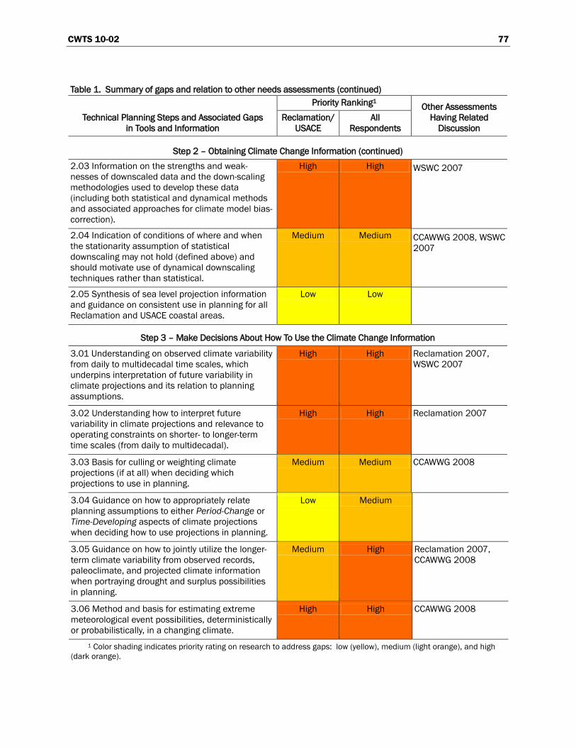
CWTS 10-02 77
Table 1. Summary of gaps and relation to other needs assessments (continued)
Technical Planning Steps and Associated Gaps
in Tools and Information
Priority Ranking1 Other Assessments
Having Related
Discussion
Reclamation/
USACE
All
Respondents
Step 2 – Obtaining Climate Change Information (continued)
2.03 Information on the strengths and weak-
nesses of downscaled data and the down-scaling
methodologies used to develop these data
(including both statistical and dynamical methods
and associated approaches for climate model bias-
correction).
High High WSWC 2007
2.04 Indication of conditions of where and when
the stationarity assumption of statistical
downscaling may not hold (defined above) and
should motivate use of dynamical downscaling
techniques rather than statistical.
Medium Medium CCAWWG 2008, WSWC
2007
2.05 Synthesis of sea level projection information
and guidance on consistent use in planning for all
Reclamation and USACE coastal areas.
Low Low
Step 3 – Make Decisions About How To Use the Climate Change Information
3.01 Understanding on observed climate variability
from daily to multidecadal time scales, which
underpins interpretation of future variability in
climate projections and its relation to planning
assumptions.
High High Reclamation 2007,
WSWC 2007
3.02 Understanding how to interpret future
variability in climate projections and relevance to
operating constraints on shorter- to longer-term
time scales (from daily to multidecadal).
High High Reclamation 2007
3.03 Basis for culling or weighting climate
projections (if at all) when deciding which
projections to use in planning.
Medium Medium CCAWWG 2008
3.04 Guidance on how to appropriately relate
planning assumptions to either Period-Change or
Time-Developing aspects of climate projections
when deciding how to use projections in planning.
Low Medium
3.05 Guidance on how to jointly utilize the longer-
term climate variability from observed records,
paleoclimate, and projected climate information
when portraying drought and surplus possibilities
in planning.
Medium High Reclamation 2007,
CCAWWG 2008
3.06 Method and basis for estimating extreme
meteorological event possibilities, deterministically
or probabilistically, in a changing climate.
High High CCAWWG 2008
1 Color shading indicates priority rating on research to address gaps: low (yellow), medium (light orange), and high
(dark orange).
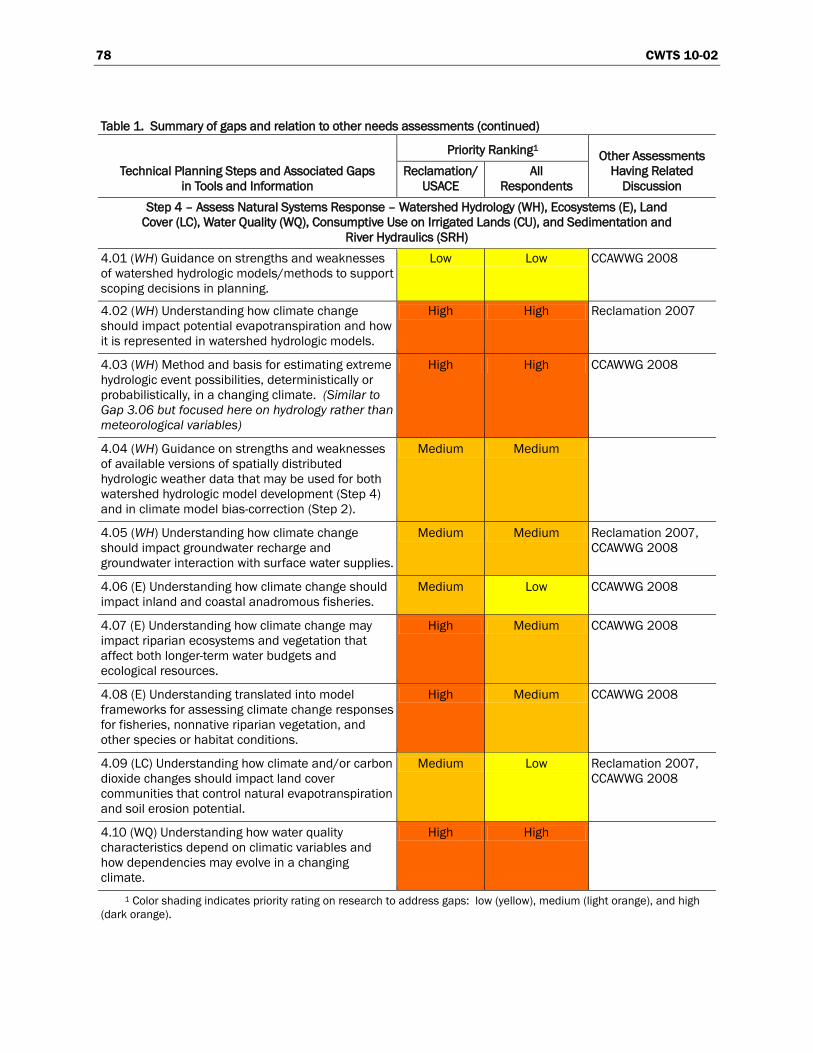
78 CWTS 10-02
Table 1. Summary of gaps and relation to other needs assessments (continued)
Technical Planning Steps and Associated Gaps
in Tools and Information
Priority Ranking1 Other Assessments
Having Related
Discussion
Reclamation/
USACE
All
Respondents
Step 4 – Assess Natural Systems Response – Watershed Hydrology (WH), Ecosystems (E), Land
Cover (LC), Water Quality (WQ), Consumptive Use on Irrigated Lands (CU), and Sedimentation and
River Hydraulics (SRH)
4.01 (WH) Guidance on strengths and weaknesses
of watershed hydrologic models/methods to support
scoping decisions in planning.
Low Low CCAWWG 2008
4.02 (WH) Understanding how climate change
should impact potential evapotranspiration and how
it is represented in watershed hydrologic models.
High High Reclamation 2007
4.03 (WH) Method and basis for estimating extreme
hydrologic event possibilities, deterministically or
probabilistically, in a changing climate. (Similar to
Gap 3.06 but focused here on hydrology rather than
meteorological variables)
High High CCAWWG 2008
4.04 (WH) Guidance on strengths and weaknesses
of available versions of spatially distributed
hydrologic weather data that may be used for both
watershed hydrologic model development (Step 4)
and in climate model bias-correction (Step 2).
Medium Medium
4.05 (WH) Understanding how climate change
should impact groundwater recharge and
groundwater interaction with surface water supplies.
Medium Medium Reclamation 2007,
CCAWWG 2008
4.06 (E) Understanding how climate change should
impact inland and coastal anadromous fisheries.
Medium Low CCAWWG 2008
4.07 (E) Understanding how climate change may
impact riparian ecosystems and vegetation that
affect both longer-term water budgets and
ecological resources.
High Medium CCAWWG 2008
4.08 (E) Understanding translated into model
frameworks for assessing climate change responses
for fisheries, nonnative riparian vegetation, and
other species or habitat conditions.
High Medium CCAWWG 2008
4.09 (LC) Understanding how climate and/or carbon
dioxide changes should impact land cover
communities that control natural evapotranspiration
and soil erosion potential.
Medium Low Reclamation 2007,
CCAWWG 2008
4.10 (WQ) Understanding how water quality
characteristics depend on climatic variables and
how dependencies may evolve in a changing
climate.
High High
1 Color shading indicates priority rating on research to address gaps: low (yellow), medium (light orange), and high
(dark orange).
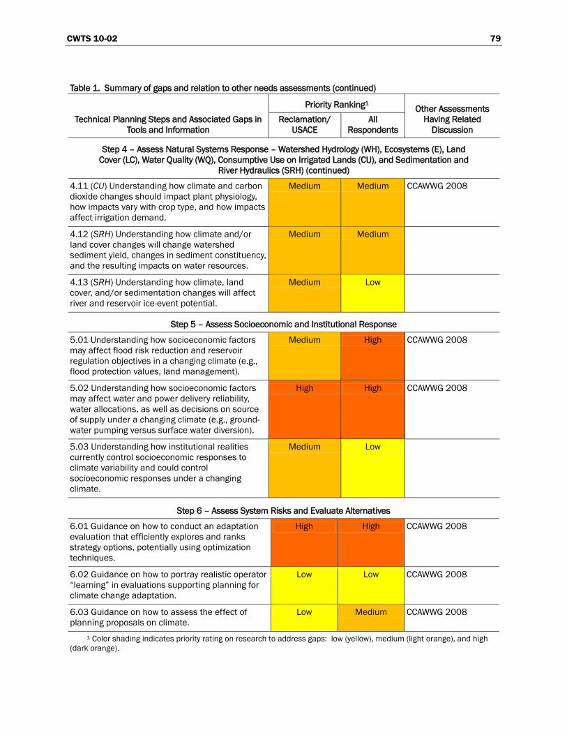
CWTS 10-02 79
Table 1. Summary of gaps and relation to other needs assessments (continued)
Technical Planning Steps and Associated Gaps in
Tools and Information
Priority Ranking1 Other Assessments
Having Related
Discussion
Reclamation/
USACE
All
Respondents
Step 4 – Assess Natural Systems Response – Watershed Hydrology (WH), Ecosystems (E), Land
Cover (LC), Water Quality (WQ), Consumptive Use on Irrigated Lands (CU), and Sedimentation and
River Hydraulics (SRH) (continued)
4.11 (CU) Understanding how climate and carbon
dioxide changes should impact plant physiology,
how impacts vary with crop type, and how impacts
affect irrigation demand.
Medium Medium CCAWWG 2008
4.12 (SRH) Understanding how climate and/or
land cover changes will change watershed
sediment yield, changes in sediment constituency,
and the resulting impacts on water resources.
Medium Medium
4.13 (SRH) Understanding how climate, land
cover, and/or sedimentation changes will affect
river and reservoir ice-event potential.
Medium Low
Step 5 – Assess Socioeconomic and Institutional Response
5.01 Understanding how socioeconomic factors
may affect flood risk reduction and reservoir
regulation objectives in a changing climate (e.g.,
flood protection values, land management).
Medium High CCAWWG 2008
5.02 Understanding how socioeconomic factors
may affect water and power delivery reliability,
water allocations, as well as decisions on source
of supply under a changing climate (e.g., ground-
water pumping versus surface water diversion).
High High CCAWWG 2008
5.03 Understanding how institutional realities
currently control socioeconomic responses to
climate variability and could control
socioeconomic responses under a changing
climate.
Medium Low
Step 6 – Assess System Risks and Evaluate Alternatives
6.01 Guidance on how to conduct an adaptation
evaluation that efficiently explores and ranks
strategy options, potentially using optimization
techniques.
High High CCAWWG 2008
6.02 Guidance on how to portray realistic operator
“learning” in evaluations supporting planning for
climate change adaptation.
Low Low CCAWWG 2008
6.03 Guidance on how to assess the effect of
planning proposals on climate.
Low Medium CCAWWG 2008
1 Color shading indicates priority rating on research to address gaps: low (yellow), medium (light orange), and high
(dark orange).
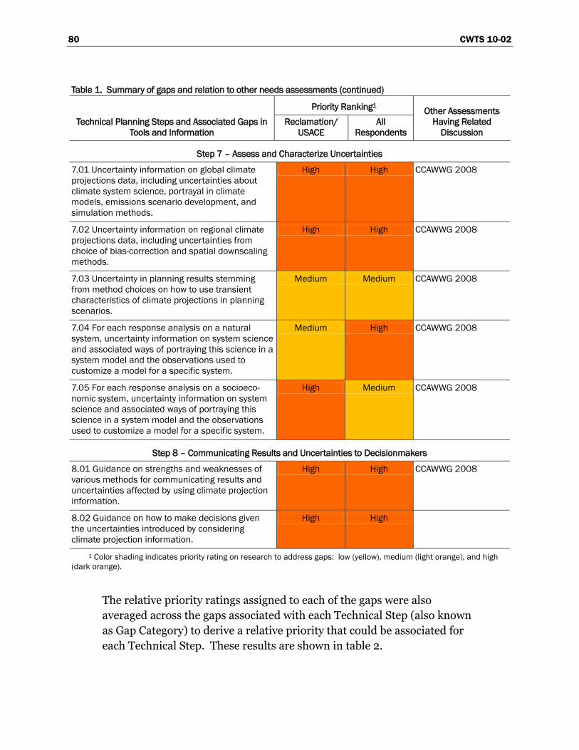
80 CWTS 10-02
Table 1. Summary of gaps and relation to other needs assessments (continued)
Technical Planning Steps and Associated Gaps in
Tools and Information
Priority Ranking1 Other Assessments
Having Related
Discussion
Reclamation/
USACE
All
Respondents
Step 7 – Assess and Characterize Uncertainties
7.01 Uncertainty information on global climate
projections data, including uncertainties about
climate system science, portrayal in climate
models, emissions scenario development, and
simulation methods.
High High CCAWWG 2008
7.02 Uncertainty information on regional climate
projections data, including uncertainties from
choice of bias-correction and spatial downscaling
methods.
High High CCAWWG 2008
7.03 Uncertainty in planning results stemming
from method choices on how to use transient
characteristics of climate projections in planning
scenarios.
Medium Medium CCAWWG 2008
7.04 For each response analysis on a natural
system, uncertainty information on system science
and associated ways of portraying this science in a
system model and the observations used to
customize a model for a specific system.
Medium High CCAWWG 2008
7.05 For each response analysis on a socioeco-
nomic system, uncertainty information on system
science and associated ways of portraying this
science in a system model and the observations
used to customize a model for a specific system.
High Medium CCAWWG 2008
Step 8 – Communicating Results and Uncertainties to Decisionmakers
8.01 Guidance on strengths and weaknesses of
various methods for communicating results and
uncertainties affected by using climate projection
information.
High High CCAWWG 2008
8.02 Guidance on how to make decisions given
the uncertainties introduced by considering
climate projection information.
High High
1 Color shading indicates priority rating on research to address gaps: low (yellow), medium (light orange), and high
(dark orange).
The relative priority ratings assigned to each of the gaps were also
averaged across the gaps associated with each Technical Step (also known
as Gap Category) to derive a relative priority that could be associated for
each Technical Step. These results are shown in table 2.
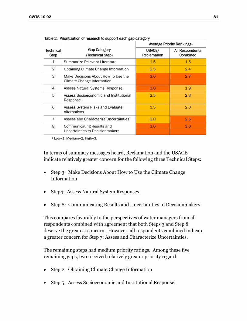
CWTS 10-02 81
Table 2. Prioritization of research to support each gap category
Technical
Step
Gap Category
(Technical Step)
Average Priority Rankings1
USACE/
Reclamation
All Respondents
Combined
1 Summarize Relevant Literature 1.5 1.5
2 Obtaining Climate Change Information 2.5 2.4
3 Make Decisions About How To Use the
Climate Change Information
3.0 2.7
4 Assess Natural Systems Response 3.0 1.9
5 Assess Socioeconomic and Institutional
Response
2.5 2.3
6 Assess System Risks and Evaluate
Alternatives
1.5 2.0
7 Assess and Characterize Uncertainties 2.0 2.6
8 Communicating Results and
Uncertainties to Decisionmakers
3.0 3.0
1 Low=1, Medium=2, High=3.
In terms of summary messages heard, Reclamation and the USACE
indicate relatively greater concern for the following three Technical Steps:
Step 3: Make Decisions About How to Use the Climate Change
Information
Step4: Assess Natural System Responses
Step 8: Communicating Results and Uncertainties to Decisionmakers
This compares favorably to the perspectives of water managers from all
respondents combined with agreement that both Steps 3 and Step 8
deserve the greatest concern. However, all respondents combined indicate
a greater concern for Step 7: Assess and Characterize Uncertainties.
The remaining steps had medium priority ratings. Among these five
remaining gaps, two received relatively greater priority regard:
Step 2: Obtaining Climate Change Information
Step 5: Assess Socioeconomic and Institutional Response.
82 CWTS 10-02
The remaining steps received relatively lower priority. Review of gap-
specific summaries (section 3.3) suggests that much of this lower
prioritization stems from perception that a relatively greater
understanding currently exists in these step areas compared to those that
were given higher priority and does not necessarily indicate they are not as
important as those assigned a high priority.
3.3 Perspectives Summaries for Each Gap Statement
This section provides gap-specific capsules that provide summary
information on gathered feedback, including number of responses, most
frequent priority rating for research to address the given gap, and
comment highlights. A complete record of comments and feedback is
provided in appendix C,1 as an electronic supplement available at
www.usbr.gov/climate/userneeds.
3.2.1 Step 1 – Summarize Relevant Literature
Gap 1.01: Access to a clearinghouse of climate change literature relevant
to water management or access to a bibliography of recommended
literature to represent in literature syntheses.
Number of responses: 16
Most frequent priority: Low (9)
Some respondents suggested that providing such access should be
viewed as a low priority, citing that many region-specific groups
already monitor and gather relevant literature. Others suggested that
providing such access ought to be high-priority, but only if it‘s done
through an interagency effort that doesn‘t duplicate effort and
complemented by an evaluation of documents included in the
clearinghouse. There were also suggestions that any Reclamation and
USACE investment in this area might involve partnering with entities
that have begun to initiate such clearing houses (e.g.,
www.theclimatechangeclearinghouse.org).
1 Several of the commenters cited the disclaimer that the perspectives they submitted
are those of their own and do not necessarily represent the views of their respective
agency/organization. This includes commenters from ASCE Geo-Institute, FEMA,
Reclamation ECAO, Reclamation Mid-Pacific Region, USACE LRD, USACE NWP,
USACE NWW, and Seattle City Light.
CWTS 10-02 83
Gap 1.02: Region-specific literature summaries, regularly maintained
and peer-reviewed.
Number of responses: 16
Most frequent priority: High (7)
Several respondents suggested that this is a high priority activity, citing
that such a review provides a place-based context for what‘s been
studied. One respondent noted that most Federal water resources
planning studies up to a feasibility level warrant only a literature
review and that such a synthesis product would streamline reporting.
Others suggested that any such review product be made easy to access
by the water resources planning community (e.g., through a Share
Point system). However, there were cautions that any synthesis would
quickly become dated given the pace of climate change research and
that there would need to be a continual effort to monitor, evaluate, and
update such syntheses. Also, while summaries by administrated
regions may be useful, suggestions also were made to consider
organizing such summaries by natural watersheds, (which may or may
not coincide with administrative boundaries)
3.2.2 Step 2 – Obtaining Climate Change Data
Gap 2.01: Improved skill in simulating long-term global to regional
climate.
Number of responses: 16
Most frequent priority: High (9)
A number of respondents suggested that activities to improve climate
modeling skill should be highly prioritized. Some suggest that
improvements in climate modeling would increase planners'
inclination to incorporate climate projection information into
investigations. Suggested targets for improvement ranged from global
scale (e.g., processes in the equatorial Pacific related to ENSO,
formation and tracking of hurricanes, low frequency climate variations
like PDO and NAO) to the more regional and local scale where
planning studies generally occur.
84 CWTS 10-02
Gap 2.02: Downscaled data at finer space and time resolutions and for
different variables.
Number of responses: 17
Most frequent priority: High (12)
This gap received as many responses as any other gap and was also the
most highly prioritized. Respondents generally recognized a need for
downscaled climate projection information to translate global climate
projection information at coarser spatial resolution to the finer spatial
resolutions of assumptions that frame local water resources studies.
Some respondents suggested consideration for supplying a suite of
meteorological variables that support studies on vegetation water use
in managed or natural areas (e.g., information on carbon dioxide,
relative humidity and wind speed). Others suggested that downscaling
be performed at time-resolutions consistent with a broad suite of
watershed hydrologic analyses (e.g., monthly, daily, etc.).1
Gap 2.03: Information on the strengths and weaknesses of downscaled
data and the downscaling methodologies used to develop these data
(including both statistical and dynamical methods, and associated
approaches for climate model bias-correction).
Number of responses: 16
Most frequent priority: High (9)
A representative response was provided by FEMA:
―It is extremely important for water managers to understand
the limitations of the information they employ when making
decisions. This could be addressed by educating engineers
and other practitioners on the types of methods available
for obtaining climate information, and the assumptions
inherent in those methods. The question of scale is
1 Many respondents gave comments that suggested they may not be familiar with
Reclamation‘s current downscaled climate projection resources. This fall, there will be an
update to include daily downscaled data products for three variables—the list of LTdoc
respondents should be on the announcement list upon the release of this new dataset.
CWTS 10-02 85
extremely important. . . . Engineers have a tendency to rely
on published datasets. If they don't understand how the
values were estimated, they could be placing too much
confidence in the results.‖
On the matter of bias-correction, concerns were expressed like the
following offered by Reclamation Pacific Northwest Region:
―Bias correction is a process which appears to use math
tricks to create the illusion of good calibration. It is
bothersome that a model, which is heavily dependent on bias
correction, is used to predict flow into the future when there
is no scientific reason behind the bias correction. More time
should be spent on calibration. The problem is that time is
usually short, and it is not known to me if you get the same
solution with a good calibration with minor bias correction
as compared to a poor calibration with major bias
correction.‖
Another respondent directed attention to a useful white paper
commissioned by the Water Utilities Climate Alliance describing the
strengths and weaknesses of various downscaling methodologies and
opportunities to improve such methods (www.wucaonline.org).
Gap 2.04: Indication of conditions of where and when the stationarity
assumption of statistical downscaling may not hold (defined above) and
should motivate use of dynamical downscaling techniques rather than
statistical.
Number of responses: 15
Most frequent priority: Medium (9)
One commenter pointed out the challenges of interpreting historical
nonstationarity and to what degree historical hydroclimate information
still applies for future planning. The same commenter suggests that
―it would be great to have a national map, like the
generalized skew coefficients map in Bulletin 17B, that shows
how much to factor historic data to reflect the
nonstationarity of hydrology for each part of the country.‖
86 CWTS 10-02
On the choice of statistical versus dynamical techniques, one
commenter suggested that, although statistical techniques are limited
by the ―flawed‖ stationarity assumption, it doesn‘t necessarily follow
that dynamical downscaling will be more valuable. Instead, it depends
on what we‘re trying to interpret from the downscaling results, relative
to the strengths and weakness of the downscaling technique. Another
reviewer suggested that research might be spent on developing
downscaling methodologies that combine the strengths of both
dynamical and statistical techniques, perhaps leading to an approach
that still relies on data-driven statistical relationships, but honoring
more physical cause-and-effect constraints.
Gap 2.05: Synthesis of sea level projection information and guidance on
consistent use in planning for all Reclamation and USACE coastal areas.
Number of responses: 16
Most frequent priority: Low (6)
This prioritization of this gap was almost evenly split between low,
medium, and high. Some respondents commented that a lot of
guidance is already available, including national guidance recently
developed by USACE, guidance developed by the States of California,
Oregon, and Washington, and guidance being developed by the
National Research Council. Others recognized that development of
syntheses and guidance would be a good activity, so long as the
resultant guidance is appropriately tailored to a particular decision
context and for use by any agency planning in coastal areas, not just
Reclamation and USACE. Another commenter questioned how any
synthesis development responding to this gap statement would be
potentially incorporated into Federal P&Gs that are currently being
revised.
3.2.3 Step 3 – Make Decisions About How To Relate Climate Projections
Data to Planning
Gap 3.01: Understanding on observed climate variability from daily to
multidecadal time scales, which underpins interpretation of future
variability in climate projections and it's relation to planning
assumptions.
CWTS 10-02 87
Number of responses: 16
Most frequent priority: High (9)
All priority ratings for this gap were at least medium or greater.
Several commenters suggested that better historical climate
understanding is needed to support future hydroclimate planning
assumptions. One commenter pointed out that the climate varies on
many different timescales and that it is difficult to interpret our relative
position within sets of nested variability cycles. Another respondent
suggested that more research is needed on being able to ―translate the
observed variability from different, unknown historical mechanisms
into a reasonable prediction of variability under new mechanisms.‖
On the matter of needing to interpret historical climate variability
simultaneously across multiple time scales, one commenter pointed
out the challenge of doing this and how it could influence water
resources planning, citing proposals to
―allow reservoirs to be more full in the future to mitigate for
droughts brought on by climate change [which could
conflict] with flood control requirements … designed for
extreme events. It is currently very difficult to justify
adjusting historic peak flows to simulate future flood events.‖
Gap 3.02: Understanding on how to interpret future variability in
climate projections and relevance to operating constraints on shorter- to
longer-term time scales (from daily to multidecadal).
Number of responses: 15
Most frequent priority: High (10)
This gap statement received one of the more consensus priority ratings
among all gap statements considered (high). Comments reflected how
there is considerable debate and little guidance on how to interpret
future climate variability in climate projections for the sake of
influencing local water resources planning assumptions. For example,
one commenter offered a planner‘s perspective ―we need to be
confident that our adjustment for climate change is an improvement‖
[relative to traditional planning assumptions] and concern that
88 CWTS 10-02
planners not let any such adjustments cause planning miscalculations,
especially in the short term. One respondent suggested that ―divergent
viewpoints need to be aired and integrated‖ in a way that would lead
to ―guidance on best application of various downscaling
methods/approaches relative to the use's temporal and spatial
scales.‖ Another commenter offered the perception that, although
climate models provide reasonable estimates of mean future
conditions, they do not necessarily provide reasonable information
about the extremes.
Gap 3.03: Basis for culling or weighting climate projections (if at all)
when deciding which projections to use in planning.
Number of responses: 14
Most frequent priority: Medium (8)
Most commenters recognized a need for more research to address
this gap; however, some pointed out that considerable work in
this area has already been completed. There was recognition that
expert information on the use of individual projections or a
projections ensemble is important given the wide array of projection
information available. On the matter of using ensemble information,
one commenter pointed out that doing so increased the analytical
burden in planning analyses and that, in order to justify this burden,
it‘s important to understand the merits of the ensemble view.
Another commenter cautioned that, although an ensemble represents
consensus information from many projections, it‘s possible that all
projections could be relying on similar physical assumptions, right
and wrong, leading to bias and pointing to the sensibility in
understanding ―the methods associated with the projections to
determine their biases, simplifications, and assumptions.‖ The same
commenter suggested that ―guidance on which projections (and
methodologies) are most appropriate for specific management
applications would be useful.‖
CWTS 10-02 89
Gap 3.04: Guidance on how to appropriately relate planning
assumptions to either Period-Change or Time-Developing aspects of
climate projections, when deciding how to use projections in planning.
Number of responses: 16
Most frequent priority: Medium (7)
Although the majority of commenters suggested that this gap
warranted a medium or greater priority, commenters had mixed
feelings on whether the response to this gap involved research or
subjective judgment and policy. One commenter conditioned their
high priority rating on the chance that the statement might be edited to
remove the word ―guidance‖ and emphasized the research connotation.
In terms of what type of information is sampled from the climate
projections, a region-specific view was offered from the USACE
Atlantic Coastal Region, suggesting that guidance is warranted on how
to interpret climate projections for changes in future frequency and
intensity of hurricanes.1
Gap 3.05: Guidance on how to jointly utilize the longer-term climate
variability from observed records, paleoclimate, and projected climate
information when portraying drought and surplus possibilities in
planning.
Number of responses: 16
Most frequent priority: High (9)
1 Note from the authors: There were several comments suggesting that the review
draft report‘s description of issues leading to this gap statement may have been unclear.
For example, one commenter interpreted the gap to be about whether a collective of
climate projections should inform planning, and not the subsequent matter of how the
climate projections should be temporally sampled for information that would affect
planning assumptions (i.e., Should a ―Time-Developing‖ approach be used where time-
developing climate is GCM simulated (historical to future) and mapped directly to time-
developing planning assumptions? Or, should a ―Period-Change‖ approach be used
where more aspects of observed historical climate variability are preserved in planning
assumptions, with the observed historical envelope adjusted to reflect period statistical
changes in climate sampled from the climate projections?).
90 CWTS 10-02
Most commenters indicated a high-level of interest in this gap
statement, with some pointing out that the research to address
Gap 3.01 would likely be relevant to addressing 3.05. Some
commenters suggested that paleoclimate information could be useful
to help characterize hydrologic possibilities outside the range of
instrumental observations, but that there was some uncertainty on how
to best utilize such paleo-informed information.1 Another commenter
pointed out that it‘s clear that some water managers are making their
own judgments on the utility of paleoclimate information for planning,
noting examples where tree-ring studies have been used to characterize
drought possibilities.
Gap 3.06: Method and basis for estimating extreme meteorological event
possibilities, deterministically or probabilistically, in a changing climate.
Number of responses: 15
Most frequent priority: High (10)
This gap received mostly high priority ratings among respondents.
Several pointed out how this gap is relevant to characterizing the
potential for rare flood events relevant to infrastructure safety and
more common flood events relevant to flood control operating criteria
in reservoir systems. It was recognized by several others that
characterizing potential for rare flood events is already difficult based
on historical climate information, without adding the complexity of
interpreting potential changes in storm frequency within future climate
projections or considering the uncertainties introduced by the chosen
process of downscaling such information to local scales relevant to
flood frequency estimation. One commenter focused on the apparent
intractability of the problem, questioning whether significant research
should be spent to address this gap, since it seems that this gap is
relatively more difficult to address and that research outcomes seem
―highly uncertain.‖ Still another commenter offered more optimism
about research success, suggesting that activities might be scoped ―to
improve our understanding of the physical processes associated with
extreme hydrologic events, to combine downscaling with an
1 Several commenters suggested terminology change from ―drought and surplus‖ to
―drought and flood.‖ However, the use of surplus was meant to contrast long, wet spells
with long, dry spells and not necessarily conjure the notion of floods.
CWTS 10-02 91
‗upscaling‘ framework,‖ progressing in scales from event to storm to
weather patterns and finally to climate conditions, and ―to improve the
statistical tools for nonstationary flood frequency analysis.‖
3.2.4 Step 4 – Assess Natural Systems Response
Gap 4.01 (Watershed Hydrology): Guidance on strengths and
weaknesses of watershed hydrologic models/methods to support scoping
decisions in planning.
Number of responses: 16
Most frequent priority: Medium and Low (6 each)
Some commenters felt that research in this gap area is critical to
support planning efforts at the regional or basin watershed scale.
However, there was a majority sentiment that much is already
understood about the strengths and weaknesses of hydrologic models
and that more research attention should be spent on how to best
characterize climate change adjusted inputs to hydrologic models (e.g.,
weather, basin characteristics). One commenter shared the perception
that the uncertainty of climate change overshadows the uncertainty of
choosing among hydrologic models and that ―Institutions like their
own models, so probably will not change them. Agencies without
models will seek simplicity and ‗good enough‘ answers rather than
precision.‖ Still, other commenters showed interest in understanding
how various model types (i.e., model structures and associated
parameters) are more or less well-suited for assessing climate change
implications for hydrology. One commenter suggested interagency
collaboration on the matter, taking advantage of research and
application developments by Federal, State, and nongovernmental
entities.
Gap 4.02 (Watershed Hydrology): Understanding on how climate
change should impact potential evapotranspiration and how it is
represented in watershed hydrologic models.
Number of responses: 15
Most frequent priority: High (7)
92 CWTS 10-02
There were mixed perceptions about whether research to better
understand climate change impacts on natural landscape
evapotranspiration (ET) should be highly prioritized. The majority of
commenters felt that it was a high-priority issue, with some suggesting
that improved understanding in this area would lead to better
characterization of future hydrologic processes and runoff. Other
commenters wondered if we already understand a considerable
amount in this area (e.g., ―How [is this] different from literature
review question above?‖), or how relevant this issue area is to
understanding hydrologic impacts in developed regions (e.g., ―This is
important in undeveloped regions like the forests. Not so important
in farm country. ET will change, but crops will change too.‖).1
Gap 4.03 (Watershed Hydrology): Method and basis for estimating
extreme hydrologic event possibilities, deterministically or
probabilistically, in a changing climate. (Similar to Gap 3.06, but focused
here on hydrology rather than meteorological variables).
Number of responses: 16
Most frequent priority: High (11)
Most commenters shared the view that research in this area is a high
priority and saw this as the hydrology follow-on to characterizing
climatic and weather extremes in a changing climate (Gap 3.06). As
with 3.06, several commenters found this gap to be relevant to a variety
of water planning and management interests, including characterizing
the potential for rare flood events relevant to infrastructure safety,
characterizing more common flood events relevant to flood control,
and characterizing long-term time scale events related to drought and
wet periods.
1 Note from the authors: The contrasting sentiments may reflect some contrast in
geographic experience among commenters. For example, a low-priority view was
contributed from Reclamation‘s Pacific Northwest Region, which experiences relatively
more runoff-abundant conditions. In contrast, a high-priority view was contributed from
Reclamation‘s Lower Colorado Region, which manages under relatively less abundant
runoff and in a basin where ET is the dominant fate of precipitation.
CWTS 10-02 93
Gap 4.04 (Watershed Hydrology): Guidance on strengths and
weaknesses of available versions of spatially distributed hydrologic
weather data that may be used for both watershed hydrologic model
development (Step 4) and in climate model bias-correction (Step 2).
Number of responses: 16
Most frequent priority: Medium (9)
The prevalent view among respondents was that research in this area
was a medium priority; however, there was limited commentary
offered to explain this level of prioritization. Two of the respondents
that labeled this a high priority gap offered similar views on the need
for research in this area, one commenting that research on:
―. . .the physical processes linking extreme flood events to
mesoscale and synoptic weather patterns would be valuable.
However, there are limitations on the datasets, including
length of record and spatial distribution of [weather]
stations.‖
Another generically suggested that ―Improving our understanding of
existing tools, resources, models, datasets, etc. is important.‖
Gap 4.05 (Watershed Hydrology): Understanding on how climate
change should impact groundwater recharge and groundwater
interaction with surface water supplies.
Number of responses: 16
Most frequent priority: Medium (8)
As with the preceding gap, the prevailing view was that the need for
research in this gap area was a medium priority. However, as with
4.04, comments were primarily offered to explain high or low priority
views. Low priority views were offered based on perception that we
already have considerable amount of understanding about how to
assess groundwater interactions with surface water. High priority view
seemed to stem from several concerns, including questions about
future water scarcity in regions where groundwater resources are
already heavily utilized (―Does not get much attention but is needed for
94 CWTS 10-02
many areas in Great Plains Region.‖), and questions about the
adequacy of current hydrologic models for characterizing how
ecologically relevant groundwater and surface water interactions might
be affected by climate change (e.g., ―…this is particularly important
for understanding effects on low-flow streamflow events and stream
temperature which are very important/limiting for many ecosystem
endpoints.‖).
Gap 4.06 (Ecosystems) Understanding on how climate change should
impact inland and coastal anadromous fisheries.
Number of responses: 14
Most frequent priority: Low (6)
The prevailing view among respondents is that low priority should be
assigned to address this gap, although priority views were fairly well
mixed. Few respondents offered reasons for assigning low priority; one
exception was a commenter expressing concern about the potential
intractability of the issue (―Too many variables (urban runoff, ocean
harvest, management practices, etc.‖). Another commenter
suggesting medium priority shared concern that perhaps there is
already much understood on this subject, which should inform any
additional research scoping.
Gap 4.07 (Ecosystems): Understanding on how climate change may
impact riparian ecosystems and vegetation that affect both longer-term
water budgets and ecological resources.
Number of responses: 15
Most frequent priority: Medium (7)
All respondents except two either assigned medium or high priority
level to research in this gap area. One commenter suggested that:
―. . .there should be a focus on assessment of changes in
ecosystem services provided by these habitats and what
appropriate mitigative actions to preserve and/or restore
these functions could be.‖
CWTS 10-02 95
Another commented on how:
―. . .vegetation health is intrinsically linked to aquatic life
designated uses under the Clean Water Act, and water
quality criteria protect vegetation and are based on the latest
scientific information.‖
Gap 4.08 (Ecosystems): Understanding translated into model
frameworks for assessing climate change responses for fisheries,
nonnative riparian vegetation, and other species or habitat.
Number of responses: 15
Most frequent priority: Medium (7)
Similar to 4.07, most respondents assigned medium or high priority to
research in this gap area, although one commenter, suggesting high
priority ,did question the limited scope of the gap statement:
―Unclear why there is specific focus on nonnative riparian
vegetation unless for invasive species control. …the focus
should be on assessment and quantification (if possible) of
changes in ecosystem services provided by habitats.‖
Another commenter placed their high priority rating in the context of
others offered for 4.06 and 4.07, suggesting that research on the two
former gaps should occur prior to research in this gap area.
Gap 4.09 (Land Cover): Understanding on how climate and/or carbon
dioxide changes should impact land cover communities that control
natural evapotranspiration and soil erosion potential.
Number of responses: 14
Most frequent priority: Low and High (5 each)
There was a near even-split among the three possible priority levels
surveyed. There also was limited commentary in association with
priority ratings. One commenter, offering a high rating, cautioned

96 CWTS 10-02
that research in this gap area may be ―sector-based, hard to prioritize.‖
Another offering a low priority view commented that this gap seemed
―outside of scope.‖
Gap 4.10 (Water Quality): Understanding on how water quality
characteristics depend on climatic variables and how dependencies may
evolve in a changing climate.
Number of responses: 16
Most frequent priority: High (9)
Thirteen of the sixteen responses suggested a research priority-
level of medium or greater in this area. For example, a
commenter from USEPA offered the following view point
(which was largely echoed in comments from AWWA and AMWA)
in association with a high priority rating:
―There is a lack of research regarding climate change impacts
on water quality to protect designated uses (being
management objectives in State, tribal, and territorial water
quality standards for individual surface waters, e.g., aquatic
life is a category of designated uses). This originates from
the basic uncertainty in GCM precipitation projections and
their compounded uncertainty when this information is used
to drive hydrologic models. The focus of the output for these
hydrologic models in most cases is water supply, but OW is
interested in how this will impact water quality, not just
quantity, and if current water quality standards under the
Clean Water Act are sufficient to protect human health and
the environment.‖
Other commenters offered high priority ratings, but some views may
have been motivated less by perceptions on limited understanding on
how to conduct water quality assessments under climate change and
more by the lack of built water quality model applications and lack of
agency staff trained on how to use such models (e.g., ―There are few
river/reservoir system water quality models. Water quality
monitoring and modeling is in drastic need for upgrading. Staff
needs experience and training with this.‖).
CWTS 10-02 97
Gap 4.11 (Consumptive Use in Irrigated Areas): Understanding on how
climate and carbon dioxide changes should impact plant physiology, how
impacts vary with crop type, and how impacts affect irrigation demand.
Number of responses: 15
Most frequent priority: Medium (7)
Respondent attitudes varied fairly evenly in how priority level was
assigned to this gap area. One high priority rating came from the
Family Farm Alliance, who also suggested that:
―The potential water impacts associated with use of
alternative fuels must also be studied. Another growing
demand that will be placed on Western water resources is
driven by power requirements. The total water consumed by
electric utilities accounts for 20 percent of all the nonfarm
water consumed in the United States. By 2030, utilities
could account for up to 60 percent of the nonfarm water, to
meet the water needs required for cooling and pollutant
scrubbing. This new demand will likely have the most
serious impacts in fast-growing regions of the United States,
such as the Southwest.‖
Another commenter gave a high priority rating but cautioned that
research in this area would be ―sector based, hard to prioritize,‖ which
perhaps suggests a research need that will be hard to prioritize on the
grounds of multisector or broad geographic benefit. In this sense, the
suggestion of another commenter may have merit, namely that
Reclamation and USACE respond by scoping collaborative research
activities with ―their fellow Federal agencies to develop solutions to
these problems.‖
Gap 4.12 (Sedimentation and River Hydraulics): Understanding how
climate and/or land cover changes will change watershed sediment yield,
changes in sediment constituency, and the resulting impacts on water
resources.
Number of responses: 15
Most frequent priority: Medium (9)
98 CWTS 10-02
A variety of priority levels and views were offered in reaction to this
gap statement. One commenter focused on the water quality aspects of
watershed sediment yield, suggesting that yield of other pollutants
should also be studied. Several recognized that landscape vegetation
response to climate change would affect watershed sediment yield and,
perhaps, needs to be better characterized before addressing this issue.
Gap 4.13 (Sedimentation and River Hydraulics): Understanding how
climate, land cover, and/or sedimentation changes will affect river and
reservoir ice-event potential.
Number of responses: 14
Most frequent priority: Low and Medium (5 each)
The response to this gap was nearly an even mix of low to high priority
ratings. Comments were limited. One respondent was concerned
about Pacific Northwest Region impacts, suggesting that ―streambed
aggradation and increased sedimentation in reservoirs from loss of
glaciers in North Cascades is a potential impact in our watersheds.‖
Another questioned whether we need to have a better understanding of
impacts from increased rainfall on soils that transition to being frozen
for less time during the year.
3.2.5 Step 5 – Assess Socioeconomic Systems Response
Gap 5.01: Understanding on how socioeconomic factors may affect flood
risk reduction and reservoir regulation objectives in a changing climate
(e.g., flood protection values, land management).
Number of responses: 15
Most frequent priority: High (7)
Most respondents viewed research on this gap to be of at least medium
priority. One high priority view was offered with the comment that
―These socioeconomic research needs are highly ranked because we're
simply lagging so much in integrating social sciences into climate
change work.‖ Another high priority view focused on the matter of
estimating flood frequency and characterizing flood risk: ―Research
activities which would provide improved projections of future flood
CWTS 10-02 99
risks under changing climate conditions for various regions of the
nation would be extremely useful for local flood plain management
efforts,‖ suggesting that even though ―Flood Insurance Rate Maps
(FIRMs) prepared for implementation of the National Flood
Insurance Program use existing conditions, local communities can
manage increased flood risks due to future conditions.‖
Gap 5.02: Understanding on how socioeconomic factors may affect
water and power delivery reliability, water allocations, as well as
decisions on source of supply under a changing climate (e.g.,
groundwater pumping versus surface water diversion).
Number of responses: 14
Most frequent priority: High (10)
Respondents mostly gave this gap a high priority rating. One comment
focused on how understanding on this aspect could become extremely
important in water management as climate change leads to greater
water scarcity in some areas. Another commenter from Reclamation
suggested a broader scope to the gap statement, saying that better
understanding is needed ―on how socioeconomic factors related to
climate change may affect all resources (deliveries, hydropower,
recreational, environmental, etc.) [for which] Reclamation operates.‖
Gap 5.03: Understanding on how institutional realities currently control
socioeconomic responses to climate variability and could control
socioeconomic responses under a changing climate.
Number of responses: 14
Most frequent priority: Low (6)
Priority ratings varied fairly evenly for this gap, with a majority of
responses suggesting low priority. One such low rating came with the
comment that
―Adaptation strategies will likely involve the reworking of
institutional ‗realities.‘ The ongoing efforts of the Council on
100 CWTS 10-02
Environmental Quality's Interagency Climate Change
Adaptation Task Force should be useful in addressing this
gap.‖
However, others felt this fell into the general category of understanding
socioeconomic responses to climate change, which could, in turn,
influence water and environmental resources management and
warrants high priority research activity given that relatively little
research has been spent to-date on the study of climate change impacts
on socioeconomics relative to impacts on natural systems. Still other
comments suggested that perhaps this gap statement doesn‘t easily
invite research activities, as posed. To this effect, one commenter
suggested the statement be edited to:
―. . .understanding how socioeconomic responses to
climate variability will impact established institutional
structures and how rigidity of those structures may prevent
adaptation to climate change.‖
3.2.6 Step 6 – Assess Socioeconomic Systems Response
Gap 6.01: Guidance on how to conduct an adaptation evaluation that
efficiently explores and rank strategy options, potentially using
optimization techniques.
Number of responses: 17
Most frequent priority: High (8)
There was consensus among respondents that research in this area
should be highly prioritized. More interestingly, most of the priority
ratings were accompanied by a diverse set of perspectives. Several
comments focused on how this gap relates to adaptation planning
(e.g., ―Evaluation of adaptation alternatives and development
of optimization strategies at the watershed or basin level is critical
for future planning efforts.‖). Another suggested that this is an
important research need and that non-optimization approaches
should be explored. However, one comment, offered in association
with a medium rating, suggested that although ranking strategies
is important, ―optimization rarely ends up with a valuable
product when dealing with water systems because institutional
CWTS 10-02 101
and legal constraints lead to non optimal solutions.‖ On the scope
of the gap statement, one comment suggested the scope might be
broadened: ―Expand to include guidance on and an understanding
of the strengths and weaknesses of decisionmaking approaches
under climate change uncertainty.‖ This comment hints at a
boundary of this report, namely that the document addresses
user needs for the task of generating information to support
decisions, and stops short of characterizing user needs for the
task of making decisions under uncertainty (associated with
potential climate change or uncertain study drivers). That said,
several comments do speak to the need for research to address
decisionmaking uncertainty—e.g., from USACE:
―Adaptive management, robustness, resilience, and flexibility
are some key tools for water managers to deal with climate
change. This draft report barely dealt with the need for
robustness, resilience, and adaptive management as tools for
dealing with climate change. I feel this should be identified
as a gap in tools in this draft report. A major impediment to
robust and resilient design is focusing on the optimal
solution.‖)
Gap 6.02: Guidance on how to portray realistic operator ―learning‖ in
evaluations supporting planning for climate change adaptation.
Number of responses: 12
Most frequent priority: Low (9)
This gap statement received the lowest priority reaction among gaps
considered. Based on a couple of comments received, it might be
interpreted that this report doesn‘t clearly make a case on what is
meant by operator ―learning‖ in systems evaluations under a changing
climate context and why portrayal of such learning is relevant or
important to adaptation assessments.
102 CWTS 10-02
Gap 6.03: Guidance on how to assess the effect of planning proposals on
climate.
Number of responses: 17
Most frequent priority: Medium (9)
Although this gap received a priority rating of medium, it is interesting
to note that no respondent suggested that research in this area should
be given a high priority. One comment was offered in association with
medium priority rating:
―… we need this sort of information to complete our effects
analysis in NEPA documents. One application for this
information is in assessing the impacts of our operations
(e.g., execution of long-term water contracts (40-years) on
water supply. How are these actions affecting climate
change?‖
Still another comment offered the contrasting view and low priority
rating: ―Not too worried on Reclamation‘s impact on climate. More
concerned with impact of climate on water supplies.‖
3.2.7 Step 7 – Assess Socioeconomic Systems Response
Gap 7.01: Uncertainty information on global climate projections data,
including uncertainties about climate system science, portrayal in
climate models, emissions scenario development, and simulation
methods.
Number of responses: 17
Most frequent priority: High (8)
The most prevalent reaction among respondents is that research
should be highly prioritized in this area. One commenter suggested
that it is extremely important for water managers to understand the
limitations of the data they employ when making decisions and ―not
just the uncertainty associated with individual steps, but the
propagation of aggregated uncertainties throughout the process.‖
Another commenter went beyond the scope of the gap statement,
CWTS 10-02 103
suggesting that we need to understand how results from planning
analyses are sensitive to such uncertainties. Still others held a more
reserved view. One commenter suggested that uncertainty information
would be useful but difficult to quantify. Another comment built on
this thought, suggesting that any research to characterize uncertainties
and their relevance will be decision-centric (―Uncertainties are
everywhere, and we need to understand them sure, but we need a
decision context to help reveal which uncertainties are most
important in a given problem.‖). Lastly, a suggestion was offered that
research to address gaps under Technical Steps 2 through 6 should be
scoped to also characterize associated uncertainties, rather than scope
specific research to address Gaps 7.01–7.05.
Gap 7.02: Uncertainty information on regional climate projections data,
including uncertainties from choice of bias-correction and spatial
downscaling methods.
Number of responses: 16
Most frequent priority: High (10)
Comments on this gap were similar to those offered for Gap 7.01.
However, in contrast to Gap 7.01, this gap appeared to resonate more
consistently with respondents as all priority ratings were medium or
greater. One commenter offering a high priority-rating suggested that
there‘s need to characterize uncertainties introduced by both spatial
downscaling and climate model bias-correction. Another commenter
suggested that perhaps such research in this area might be scoped at a
medium priority, with higher priority efforts spent on improving the
skill of regional climate projections.
Gap 7.03: Uncertainty in planning results stemming from method
choices on how to use transient characteristics of climate projections in
planning scenarios.
Number of responses: 16
Most frequent priority: Medium (7)
104 CWTS 10-02
Comments on this gap were similar to those offered for Gap 7.01. One
Reclamation commenter, offering a high priority rating, recognized the
challenges of implementing transient techniques (described as ―Time-
Developing‖ application in section 2.4.3) and characterizing associated
uncertainties (―Transient analysis is very interesting but difficult to
understand and communicate. Needs lots of work. Big Gap.‖). A
similar high priority-rating and comment was offered by a respondent
from USACE:
―For the LOSLR, we used steady state climate scenarios but
recognized the need to evaluate transient scenarios. For the
upper lakes study, we hope to address transience via
stochastic generation of supplies based on climate change
projections.‖
Still, the prevalent view was a medium priority rating, with several
commenters suggesting that research to improve the credibility of
climate projection information should be prioritized over research to
characterize uncertainties.
Gap 7.04: For each response analysis on a natural system, uncertainty
information on system science and associated ways of portraying this
science in a system model and the observations used to customize a model
for a specific system.
Number of responses: 17
Most frequent priority: High (8)
On this gap, there was a near even split in priority ratings between
medium and high, with a couple of respondents suggesting low
priority. Similar comments were offered for this gap as for Gap 7.01.
Two commenters offering high priority ratings suggested that this
understanding was a limitation in recent climate change impacts
assessments within their region—e.g., from Reclamation Pacific
Northwest:
―The recent RMJOC modeling of the Columbia/Snake has
revealed many of the shortcomings of the current
[hydrology] models for performing detailed climate change
analysis.‖; from USACE Great Lakes District ―We missed this

CWTS 10-02 105
step in the LOSLR Study; we have been working on
addressing this in the Upper Lakes Study.‖
Also, one respondent that suggested medium priority for Gaps 7.01–
7.03 suggested high priority for this gap, commenting that:
―. . .here the importance is higher, because we don't
necessarily have good process models (e.g., bio, eco, socio) to
integrate into climate and hydrology models to actually
explore the complex interactions and emergent behaviors
that would likely provide the largest challenges for
management.‖
Gap 7.05: For each response analysis on a socioeconomic system,
uncertainty information on system science and associated ways of
portraying this science in a system model and the observations used to
customize a model for a specific system.
Number of responses: 17
Most frequent priority: Medium (7)
Priority ratings were fairly evenly distributed on this gap statement.
Many commenters suggested high priority for research in this area, just
as they did for Gaps 7.01–7.04. Other commenters shared pessimism
about the likelihood of positive research outcomes in this area (e.g.,
―Socioeconomics seems like a ‗black hole‘ for climate change research
funds. Should not be a Reclamation priority.‖).
3.2.8 Step 8 – Assess Socioeconomic Systems Response
Gap 8.01: Guidance on strengths and weaknesses of various methods for
communicating results and uncertainties affected by the use of climate
projection information.
Number of responses: 16
Most frequent priority: High (9)
Except for a lone exception, all commenters suggested medium or high
priority research in this area. One commenter suggested that
106 CWTS 10-02
―communicating climate information, results, and uncertainties is
very necessary to successful planning; and this area hasn't been well
researched.‖ Another pointed to the challenges of communicating
flood risk to individuals and communities even under current climate
conditions, suggesting that it will be a challenge to develop
―communication products to convey information with large
variability and uncertainty, but with important implications for life-
safety.‖ One commenter relayed a recent experience where their
planning process was challenged on the task of communicating
uncertain climate information, suggesting that ―there was a lot of
misunderstanding and misinterpretation of the current climate
results let alone the climate change results.‖ Another commenter
cautioned that communication of uncertainties will have to be
applicable to a wide range of audiences that will be receiving climate
change information. On research direction, one commenter suggested
consideration on how various methods of communication are more or
less effective given the target audience and how planning processes are
often dealing with multiple audiences. Another comment questioned
whether the response to this gap involved research or practitioner
education on how to effectively communicate results.
Gap 8.02: Guidance on how to make decisions given the uncertainties
introduced by consideration of climate projection information.
Number of responses: 16
Most frequent priority: High (9)
Commenters mostly assigned medium and high priority ratings on
research to address this gap area. One commenter summarized their
view, suggesting that:
―. . .the most important challenge facing planners is how to
make decisions under conditions of deep uncertainty. This is
the area where research could make a big difference.‖
Another commenter suggested that there is a need for Reclamation and
USACE:
―. . .to establish a common understanding on how climate
change should be incorporated in flood risk and dam safety
CWTS 10-02 107
evaluations. … If the best available science is not yet
adequate to inform decisionmaking, guidance on interim
approaches should be developed.‖
Still others felt that this gap warranted a policy response rather than
research, for example:
―Do we use the climate change information to plan a project
or not? It is easier to do the climate analysis and display it in
an appendix but not actually act on it because of
uncertainty.‖
Another suggested that research in this area should be a low priority
assuming that ―decisionmaking will be influenced more by
[nonclimate] factors, including: location, parties involved, statutory
environment, regulatory processes, etc.‖ Still, most respondents felt
that activity in this area was warranted. AWWA and AMWA summed
up their view, suggesting that this gap was not only highly important,
but that this gap should be separated from the list of gaps and couched
as an elevated, overarching issue:
―Guidance on how to make decisions given the uncertainties
of climate change is an extremely important topic and is
central to the entire debate on how to adjust to a new
planning paradigm. … We would suggest elevating the
importance of this knowledge gap. This is not to say that
Reclamation and USACE should be responsible for
developing this guidance. Instead, they should work with
their Federal partners, State, and local water utilities,
research organizations, and water sector associations. A
collaborative approach that incorporates all the relevant
stakeholders is the most effective way to identify best
management practices for long-term water resource
planning in a changing climate.‖
3.4 Additional Comments and Feedback
The process of gathering perspectives also led to some entities suggesting
other gaps statements to be considered along with those from table 1.
Those statements are listed below and are also appended with comments
in the record of feedback in appendix C. Note that these other gap
statements were not screened relative to those listed in table 1, and they
108 CWTS 10-02
may appear to overlap in some ways with those already listed in table 1.
Rather than screen these other gap suggestions, a decision was made to
simply list them below:
Step 1
o Problem Definition/formulation: Recognized weakness in planning
processes that do not focus on clearly defining the problem being
studied, or recognizing that many adaptation issues have probably
not yet been recognized or problems may exist that may require
adaptations, which are ill-defined.
Step 2
o Data Management System: An information technology (IT)
system/framework that facilitates the mining, extraction, analysis,
and distribution of data.
o Identify gaps and collect new data to inform modeling based upon
this new data. Then, as the project develops and is placed online,
data collection to inform adaptive management decisions also is
needed.
Step 3
o Understanding nonstationarity of historical observations.
o Guidance on when and how a project needs to address climate
change.
Step 4
o (Watershed Hydrology) Understand impacts on seasonal wetlands.
o (Watershed Hydrology/Geomorphology) Understanding how soil
erosion and land subsidence affect hydrogeomorphology.
o (Water Quality) Understanding bioaccumulation rates and
residence times of contaminates in source water and wetlands.
o (Sedimentation, River Hydraulics) Understanding sedimentation/
erosion rates in light of changing river hydraulics.
CWTS 10-02 109
o (Coastal Dynamics) Coastal issues are not limited to sea level rise
but also changes in wave dynamics, or the processes affecting
coastal nearshore water levels. Wave Surge-Infragravity, Wave Set-
up (radiation stress), Wave Run-up at Shores Edge, Total storm
Power, etc.
Step 5
o Understand impacts on land subsidence (associated with
groundwater management and potential for overdraft).
o Understanding on how development of local water management
features could impact transportation systems (e.g., features
unintentionally acting as flood control features).
o Understanding municipal and industrial water use on nonirrigated
lands, and role of groundwater substitution.
o Understanding groundwater recharge; changes in return flows to
natural water bodies.
o Asset management and economic tools that allow for the
consideration of costs and values in weighing adaptation options,
including costs of inaction.
Step 6
o Guidance on evaluation of alternatives to build resiliency and
incorporate adaptive management into project design and
operation.
Step 7
o Understanding variability and uncertainty of baseline information
(i.e., foundational sense of uncertainty before considering the
added uncertainties of introducing climate change information).
o Guidance on how to communicate and work with decisionmakers to
improve use of climate vulnerability assessments.
Some entities also provided letter response to the draft report. Those
letters responses are consolidated into appendix D. Among the views and
perspectives offered within those letters, two are highlighted.

110 CWTS 10-02
The first view relates to monitoring and data collection and pertains to
Step 2 (Obtaining Climate Change Information) and Step 3 (Making
Decisions about How to Use Climate Change Information) and relates to
monitoring and data collection. On this subject, the Western States Water
Council (WSWC) wrote:
―This topic is virtually absent from the document (except for
a brief mention on page 2), and no discussion is provided on
how monitoring and data collection relate to the overall
scope of work being planned under the Secure Water Act.
While the Council has gone on record as supporting climate
change research – especially as it relates to regional climate
modeling – it‘s fair to say that maintaining Federal funding
for basic data collection (e.g., USGS stream gages, USDA
Snotel sites, NOAA‘s HRCN/Co-op program) trumps all in
terms of priority. We believe that somewhere in the world of
Federal climate change adaptation, funding must be
provided to maintain important long-term hydroclimate
monitoring sites, as well as to add new monitoring sites (e.g.,
in higher elevation alpine rain to snow transition zones) for
change detection and attribution. Data collection and
analysis is a basic function of long-term planning (the focus
of this document), and needs to be addressed here. Also,
research to define needs for new monitoring
networks/integration with existing networks would be a
valuable addition to this document.‖
The authors of this document share the view of WSWC that continued
support for data collection is crucial as we prepare for climate change
impacts on our water systems. Focusing on the spirit of this document,
which is to motivate research to address knowledge, tool, and method
limitations, the final statement offered by WSWC perhaps suggests a
gap statement missing from table 1: Understanding the adequacy of
our current monitoring network to support water management in a
changing climate and identifying ways to improve hydrological
monitoring and data collection to support climate-related
decisionmaking.
The second view relates to making decisions under uncertainty. One
USACE commenter felt that there is much still to learn about various
available methods, and citing appreciation for how USGS Circular 1331
CWTS 10-02 111
(Brekke et al. 2009) addresses key decisionmaking concepts such as
adaptive management, robustness, resilience, and flexibility that water
managers might use to deal with climate change. The same commenter
suggested that the report should include a gap statement on how
managers need to understand the role of robustness, resilience, and
adaptive management as tools for dealing with climate change, perhaps
building on earlier work.1 They went further to suggest that a major
impediment to robust and resilient design is focusing on the optimal
solution, which is, maybe, a matter of planning policy.
In addition to raising questions about decisionmaking criteria, the
USACE commenter pointed attention to the need and challenges of
adopting a systems view in water resources development rather than a
project-specific view. They cited the April 30, 2009, Army Corps of
Engineers‘ document Building a Stronger Corps: A Snapshot of How the
Corps is Applying Lessons Learned from Katrina,2 which reported a key
finding from the post-Katrina analysis as the need to adopt a systems
approach to project planning and development—to move away from a
project-by-project view to a more integrated one. The commenter
suggested that implementing such integrated water resources
management requires fundamental changes in USACE‘s policies and
procedures, but also in the nature of the way the American public views
the USACE‘s role and how they respond to Federal legislation and
appropriations that influence how, where, and when USACE can conduct
its programs.
1 The commenter suggested that the concept of using robustness in water resources
planning, engineering, and management has been around since at least the 1970s and has
some roots in the concept of ecological resilience introduced by Buzz Holling. James
Hanchey, Kyle Schilling, and Gene Stakhiv from the U.S. Army Corps of Engineers'
Institute of Water Resources (IWR), in their paper Water Resources Planning Under
Climate Uncertainty (Congressional Research Service 1989), argued that a robust water
resources system is able to absorb the inevitable range of uncertainties associated with
the planning and design of a water resources project.
2 http://www.mvn.usace.army.mil/pdf/USACEPKUpdateReport_Final.pdf.

CWTS 10-02 113
4 References
Anderson, E.A. 1973. National Weather Service River Forecast System:
Snow Accumulation and Ablation Model. Technical Memorandum
NWS HYDRO-17. Silver Spring, MD: National Oceanic and
Atmospheric Administration.
Brekke, L.D., M.D. Dettinger, E.P. Maurer, and M. Anderson. 2008.
Significance of model credibility in estimating climate projection
distributions for regional hydroclimatological risk assessments.
Climatic Change 89(3–4): 371–394.
Brekke, L.D., J.E. Kiang, J.R. Olsen, R.S. Pulwarty, D.A. Raff, D.P.
Turnipseed, R.S. Webb, and K.D. White. 2009a. Climate change
and water resources management—A Federal perspective.
U.S. Geological Survey Circular 1331. Reston, VA: U.S. Geological
Survey. (Also available online at http://pubs.usgs.gov/circ/1331/.)
Brekke, L.D., E.P. Maurer, J.D. Anderson, M.D. Dettinger, E.S. Townsley,
A. Harrison, and T. Pruitt. 2009b. ―Assessing reservoir operations
risk under climate change.‖ Water Resources Research 45:
W04411.
Burnash, R.J.C., R.L. Ferral, and R.A. McQuire, et al. 1973. A generalized
streamflow simulation system, in conceptual modeling for digital
computers. Silver Spring, MD: U.S. National Weather Service.
California Department of Water Resources (CA DWR). 2009. Using
future climate projections to support water resources
decisionmaking in California. Draft report from the California
Energy Commission, CEC-500-2009-052-D. (F. Chung,
J. Anderson, S. Arora, M. Ejeta, J. Galef, T. Kadir, K. Kao,
A. Olson, C. Quan, E. Reyes, M. Roos, S. Seneviratne, J. Wang,
H. Yin, and N. Blomquist, ed.).
CH2M-Hill. 2008. Climate change study – Report on evaluation
methods and climate scenarios. Submitted to Lower
Colorado River Authority and San Antonio Water System,
WBS 3.3.3.1.CH2M.14.82676.
114 CWTS 10-02
Christensen, J.H., B. Hewitson, A. Busuioc, A. Chen, X. Gao, I. Held,
R. Jones, R.K. Kolli, W.T. Kwon, R. Laprise, V. Magaña Rueda,
L. Mearns, C.G. Menéndez, J. Räisänen, A. Rinke, A. Sarr, and
P. Whetton. 2007. ―Regional climate projections.‖ In Climate
Change 2007: The Physical Science Basis. Contribution of
Working Group I to the Fourth Assessment Report of the
Intergovernmental Panel on Climate Change (S. Solomon, D. Qin,
M. Manning, Z. Chen, M. Marquis, K.B. Averyt, M. Tignor, and
H.L. Miller, ed.). Cambridge, United Kingdom: Cambridge
University Press.
Christensen, N., and D.P. Lettenmaier. 2007. A multimodel ensemble
approach to assessment of climate change impacts on the hydrology
and water resources of the Colorado River Basin. Hydrology and
Earth System Sciences 3: 1–44.
Climate Change Science Program (CCSP). 2008. Climate models: An
assessment of strengths and limitations. Report by the
U.S. Climate Change Science Program and the Subcommittee on
Global Change Research (D.E. Bader, C. Covey, W.J. Gutowski, Jr.,
I.M. Held, K.E. Kunkel, R.L. Miller, R.T. Tokmakian, and
M.H. Zhang, authors). Washington, DC: Department of Energy,
Office of Biological and Environmental Research.
Daly, C., R.P. Neilson, and D.L. Phillips. 1994. A statistical-topographic
model for mapping climatological precipitation over mountainous
terrain. Journal of Applied Meteorology 33: 140-158.
Frederick, K.D., D.C. Major, and E.Z. Stakhiv. 1997. Water resources
planning principles and evaluation criteria for climate change—
Summary and conclusions. Climatic Change 37: 291–313.
Gleckler, P.J., K.E. Taylor, and C. Doutriaux. 2008. Performance metrics
for climate models. Journal of Geophysical Research 113: D06104.
Hamlet, A.F., and D.P. Lettenmaier. 2005. Production of temporally
consistent gridded precipitation and temperature fields for the
Continental United States. Journal of Hydrometeorology 6: 330–
336.
Heclo, H. 2008. On thinking institutionally. Paradigm Publishers:
E. Boulder, CO.
CWTS 10-02 115
Hidalgo, H.G., M.D. Dettinger, and D.R. Cayan. 2008. Downscaling with
constructed analogues: Daily Precipitation and temperature
fields over the United States. Report # CEC-500-2007-123.
California Energy Commission. Available at
http://meteora.ucsd.edu/ cap/pdffiles/analog_pier_report.pdf.
IJC (International Joint Commission). 2006. Options for managing Lake
Ontario and St. Lawrence River water levels and flows. Report to
the International Joint Commission, prepared by the International
Lake Ontario—St. Lawrence River Study Board.
Interagency Committee on Water Data (IACWD). 1982. Guidelines for
determining flood flow frequency. Bulletin 17B (revised and
corrected). Reston, VA: U.S. Geological Survey, Office of Water
Data Coordination, Hydrology Subcommittee.
IPCC (Intergovernmental Panel on Climate Change). 2000. Special
report on emissions scenarios (N. Nakicenovic, and R. Swart, ed.).
Cambridge, United Kingdom: Cambridge University Press.
Available at http://www.grida.no/climate/ipcc/emission/.
IPCC. 2007. Climate change 2007: The physical science basis.
Contribution of Working Group I to the Fourth Assessment Report
of the Intergovernmental Panel on Climate Change (S. Solomon,
D. Qin, M. Manning, Z. Chen, M. Marquis, K.B. Averyt, M. Tignor
and H.L. Miller, ed.). Cambridge, United Kingdom: Cambridge
University Press. Available at http://www.ipcc.ch/ipccreports/
ar4-wg1.htm.
Lempert, R.J., S.W. Popper, and S.C. Bankes. 2003. Shaping the next one
hundred years—New methods for quantitative long-term policy
analysis. Santa Monica, CA: Rand Corporation.
Liang, X, D.P. Lettenmaier, E.F. Wood, and S.J. Burges. 1994. ―A simple
hydrologically based model of land surface water and energy fluxes
for general circulation models.‖ Journal of Geophysical Research
99 (D7): 14415–14428.
Maurer, E.P., and H.G. Hidalgo. 2008. ―Utility of daily vs. monthly large-
scale climate data: An intercomparison of two statistical
downscaling methods.‖ Hydrology and Earth System Sciences 12:
551–563.
116 CWTS 10-02
Maurer, E.P. 2007. ―Uncertainty in hydrologic impacts of climate change
in the Sierra Nevada, California under two emissions scenarios.‖
Climatic Change 82: 309–325.
Maurer, E.P., A.W. Wood, J.C. Adam, D.P. Lettenmaier, and B. Nijssen.
2002. ―A long-term hydrologically-based data set of land surface
fluxes and states for the conterminous United States.‖ Journal of
Climate 15(22): 3237–3251.
Meehl, G.A., T.F. Stocker, W.D. Collins, P. Friedlingstein, A.T. Gaye,
J.M. Gregory, A. Kitoh, R. Knutti, J.M. Murphy, A. Noda,
S.C.B. Raper, I.G. Watterson, A.J. Weaver, and Z.C. Zhao. 2007.
―Global climate projections.‖ In Climate change 2007: The
physical science basis. Contribution of Working Group I to the
Fourth Assessment Report of the Intergovernmental Panel on
Climate Change (S. Solomon, D. Qin, M. Manning, Z. Chen,
M. Marquis, K.B. Averyt, M. Tignor, and H.L. Miller, eds.).
Cambridge, United Kingdom: Cambridge University Press.
Milly, P. C.D, J. Betancourt, M. Falkenmark, R.M. Hirsch,
Z.W. Kundzewicz, D.P. Lettenmaier, and R.J. Stouffer. 2008.
―Stationarity is dead: Whither water management?‖ Science 319
(5863): 573.
Mote, P.W., A. (Sascha) Petersen, S. Reeder, H. Shipman, and L.C. Whitely
Binder. 2008. Sea level rise in the coastal waters of Washington
State. Report prepared by the Climate Impacts Group, Center for
Science in the Earth System, Joint Institute for the Study of the
Atmosphere and Oceans, University of Washington, Seattle,
Washington and the Washington Department of Ecology, Lacey,
Washington.
National Research Council (NRC). 1987. Responding to changes in sea
level: Engineering implications. Washington, DC: National
Academy Press.
(http://www.nap.edu/catalog.php?record_id=1006).
National Research Council. 2001. Envisioning the agenda for water
resources research in the twenty-first century. Washington, DC:
National Academy Press.
CWTS 10-02 117
National Research Council. 2004. Valuing ecosystem services: Toward
better environmental decisionmaking. NRC Water Science and
Technology Board (WSTB). Washington, DC: National Academy
Press. (http://www.nap.edu/openbook.php?isbn=030909318X).
Payne, J.T., A.W. Wood, A.F. Hamlet, R.N. Palmer, and D.P. Lettenmaier.
2004. ―Mitigating the effects of climate change on the water
resources of the Columbia River Basin.‖ Climatic Change 62 (1–3):
233–256.
Raff, D.A., T. Pruitt, and L.D. Brekke. In review. ―A framework for
assessing flood frequency based on climate projection information.‖
Hydrology and Earth System Sciences Discussion 6: 2005–2040.
www.hydrol-earth-syst-sci-discuss.net/6/2005/2009/.
Reclamation. 2007. Review of science and methods for incorporating
climate change information into Bureau of Reclamation‘s Colorado
River Basin Planning Studies. Appendix U in Final Environmental
Impact Statement - Colorado River interim guidelines for lower
basin shortages and coordinated operations for Lakes Powell and
Mead. Prepared by Climate Technical Work Group (L.D. Brekke,
B. Harding, T. Piechota, B. Udall, C. Woodhouse, and D. Yates, ed.).
Bureau of Reclamation, U.S. Department of the Interior.
Reclamation. 2008a. Sensitivity of future CVP/SWP operations to
potential climate change and associated sea level rise. Appendix R
in Biological assessment on the continued long-term operations of
the Central Valley Project and the State Water Project. Prepared
by Bureau of Reclamation, U.S. Department of the Interior.
Reclamation. 2008b. Global climate change. In section 4.2.2.6 of Final
Planning Report and Environmental Impact Statement - Yakima
River Basin Water Storage Feasibility Study. Prepared by Bureau
of Reclamation, U.S. Department of the Interior.
Reclamation. 2008c. The effects of climate change on the operation of
Boise River Reservoirs, initial assessment report. Prepared by
Bureau of Reclamation, U.S. Department of the Interior.
118 CWTS 10-02
Reclamation. 2009a. Literature synthesis on climate change
implications for Reclamation‘s water resources. Technical
Memorandum 86-68210-091. Prepared by Bureau of Reclamation,
U.S. Department of the Interior.
Reclamation. 2009b. Long-term planning hydrology based on various
blends of instrumental records, paleoclimate, and projected
climate information. Technical report prepared by Bureau of
Reclamation, U.S. Department of Interior.
Reichler, T., and J. Kim. 2008. ―How well do coupled models simulate
today‘s climate?‖ Bulletin of the American Meteorological Society
89(3): 303–311.
Schwartz, P. 1996. The art of the long view: Planning for the future in
an uncertain world. New York, NY: Doubleday.
Tanaka, S.K., T. Zhu, J.R. Lund, R.E. Howitt, M.W. Jenkins, M.A. Pulido,
M. Tauber, R.S. Ritzema, and I.C. Ferreira. 2006. ―Climate
warming and water management adaptation for California.‖
Climatic Change 76: 361–387.
Tebaldi, C., R.L. Smith, D. Nychka, and L.O. Mearns. 2005. ―Quantifying
uncertainty in projections of regional climate change: A Bayesian
approach to the analysis of multimodel ensembles.‖ Journal of
Climate 18: 1524–1540.
USACE. 2008a. Hydrologic Modeling System, HEC-HMS User‘s Manual,
Version 3.3, September 2008. Report CPD-74A. USACE
Hydrologic Engineering Center. (http://www.hec.usace.army.mil/
software/hec-hms/).
USACE. 2008b. Hydrologic Modeling System, HEC-HMS Application
Guide, March 2008. Report CPD-74C. USACE Hydrologic
Engineering Center. (http://www.hec.usace.army.mil/software/
hec-hms/).
USACE. 2009. Incorporating sea level change considerations in Civil
Works projects. Engineer Circular 1165-2-211. U.S. Army Corps of
Engineers. (http://140.194.76.129/publications/).
CWTS 10-02 119
U.S. Department of the Interior (DOI). 2008. Draft report from the
DOI Climate Change Task Force, Subcomittee on Legal and Policy
Issues. Washington, DC: DOI.
U.S. Environmental Protection Agency (EPA). 2009. Climate Change
Science Program (CCSP) (2009) Synthesis and Assessment
Product 4.1: Coastal Sensitivity to Sea Level Rise: A Focus on the
Mid-Atlantic Region. A report by the U.S. Climate Change Program
and the Subcommittee on Global Change Research [J.G. Titus
(Coordinating Lead Author), E.K. Anderson, D. Cahoon, S.K. Gill,
R.E. Thieler, and J.S. Williams (Lead Authors)]. Washington, DC:
U.S. Environmental Protection Agency.
(http://www.climatescience.gov/Library/sap/sap4-1/final-
report/default.htm).
Water Resources Council (WRC). 1983. Economic and environmental
principles and guidelines (P&G) for water and related land
resources implementation studies. (http://www.usace.army.mil/
cw/cecw-cp/library/Principles_Guidelines.pdf.).
Water Utility Climate Alliance (WUCA). 2009. Options for improving
climate modeling to assist water utility planning for climate
change (J. Barsugli, C. Anderson, and J.B. Smith, ed.). Draft.
Western Water Assessment (WWA). 2008. Climate change in Colorado –
A synthesis to support water resources management and adaptation
(A.J. Ray, J.J. Barsugli, K.B. Averyt, K. Wolter, M. Hoerling,
N. Doesken, B. Udall, and R. Webb, ed.). Report prepared for the
Colorado Water Conservation Board.
Wood, A.W., E.P. Maurer, A. Kumar, and D.P. Lettenmaier. 2002. ―Long-
range experimental hydrologic forecasting for the eastern United
States.‖ Journal of Geophysical Research-Atmospheres 107 (D20):
4429.
Wood, A.W., L.R. Leung, V. Sridhar, and D.P. Lettenmaier. 2004.
―Hydrologic implications of dynamical and statistical approaches to
downscaling climate model outputs.‖ Climatic Change 15: 189–
216.

CWTS 10-02 121
Appendix A: Preliminary Activities
Initial discussions on Reclamation and USACE capability gaps took place
at a technology and research scoping workshop in Denver, Colorado,
during February 20–21, 2008. The workshop was convened by member
Climate Change and Water Working Group (CCAWWG) agencies at the
time of the workshop:1 Bureau of Reclamation (Reclamation), United
State Geological Survey (USGS)2, and National Oceanic and Atmospheric
Administration (NOAA).3 CCAWWG was formed in 2007 with the goal of
addressing several basic questions concerning the incorporation of climate
change information into longer-term water resources planning:
What types of information do managers and planning practitioners
want, and what are their desired outcomes?
What knowledge, methods, and tools are available?
What is needed from the research and development (R&D) and
technology development community?
What is possible to achieve?
Discussion from the February 2008 workshop led to initial listing of
capability gaps as well as prioritization of which gaps managers desired to
have addressed more immediately through additional research.
Highlights from that workshop discussion are summarized in this chapter,
along with results from a post-workshop survey where managers were
asked to rank gaps for the purpose of revealing their near-term research
priorities. These findings serve as starting points for the capability
assessment presented in chapter 3.
1 United States Army Corps of Engineers (USACE) has since become a member
CCAWWG agency.
2 USGS Colorado Water Science Center, Denver, Colorado, http://co.water.usgs.gov/.
3 NOAA Earth Systems Research Laboratory - Physical Sciences Division - Climate
Analysis Branch, Boulder, Colorado, http://www.cdc.noaa.gov/.
122 CWTS 10-02
A.1 February 2008 CCAWWG Workshop Summary
The 2-day workshop1 included over 80 research, management, and
practitioner participants, collectively from the CCAWWG agencies
(Reclamation, USGS and NOAA) other Federal agencies (i.e., USACE,
U.S. Forest Service, the U.S. Fish and Wildlife Service, Bureau of Land
Management), and federally supported research entities (i.e., the
NOAA Regional Integrated Science and Assessment (RISA) centers
―Western Water Assessment‖ and ―Climate Impacts of the Southwest‖).
The first day of the workshop was focused on building relationships
between all of the participants and sharing knowledge about agency
missions and capabilities. Two panel discussions introduced science
participants to Reclamation‘s water operations and environmental
compliance managers and to the types of climate change information
needed for their planning and decisionmaking processes.
The panel of water operations managers included a representative from
the Dam Safety Office and a representative from a water operations
office in each of Reclamation‘s five regions (figure 1). This panel
represented ―shorter-term‖ planning perspectives. Operations office
managers offered perspectives on preparing operations schedules
ranging from hourly schedules over the next week to monthly
schedules applying for the next 1 to 2 years. The Dam Safety Office
perspective is framed by a need to characterize contemporary potential
for hydrologic events affecting safety of structures. Climate variability
and forecasting such variations dominates the ―shorter term‖
perspective (e.g., seasonal to interannual climate forecasting, flood
event forecasting). However, longer-term historical climate change is
also of interest, such as how this affects interpretation of water supply
predictions that guide contemporary operations scheduling and how it
affects calibration of the prediction models used for characterizing
hydrologic hazard potential.
The panel of environmental compliance managers included planners
responsible for evaluating proposed operational or physical system
changes in the context of environmental compliance requirements
1 R&D Roadmap: Managing Western Water as Climate Changes – Knowledge Gaps
and Initial Research Strategies and Projects, http://www.esrl.noaa.gov/psd/workshops/
mwwcc/index.html.
CWTS 10-02 123
(e.g., National Environmental Policy Act, Endangered Species Act), and
also staff from the Office of Program and Policy Services, which
provides framework guidance for such planning processes. This panel
represented Reclamation‘s ―longer-term‖ planning perspective where
proposed system changes are expected to provide service for up to
several decades. In these cases, future climate change considerations
are relevant as they affect the context for evaluating the effects of such
proposed long-term system changes. However, climate variability
possibilities are also relevant in such longer-term evaluations (e.g.,
portrayal of interannual to interdecadal hydrologic variations that
translate into multiyear drought and surplus possibilities, portrayal of
possible short-term weather and hydrologic possibilities that manifest
into assumed flood control constraints on operations).
Both panel discussions were influenced by informal surveys conducted of
panel participants prior to the workshop. The surveys invited impressions
about key capability gaps in relating climate projection information to
their planning activities. Region-specific and general summaries of these
impressions are available online.1 Day one ended with presentations on
the roles and capabilities of CCAWWG science agencies (USGS and NOAA)
and science partners at the NOAA RISA centers.2
Day two featured a more structured gap discussion, complementary to the
day-one panel discussions and informal pre-workshop surveys. The day-
two gaps discussion was framed by a handout prepared prior to the
workshop and distributed among workshop participants (one of three
handouts;3 the latter two focused on ongoing and potential research to
address gaps). The handout outlined capability gaps within a general
analytical framework relating climate to the various supply, demand, and
operational constraint assumptions featured in Reclamation‘s longer-term
decision processes. (Chapter 3 builds and expands upon the foundation
1 http://www.esrl.noaa.gov/psd/workshops/mwwcc/docs.html. See documents
under ―Perspectives from Water Operations Managers on Responsibilities, Challenges,
and Needs Related to Climate Change and Western Water‖ and ―Perspectives from
Environmental Compliance Managers on Responsibilities, Challenges, and Needs
Related to Climate Change and Western Water.‖
2 Western Water Assessment (http://wwa.colorado.edu/) and Climate Assessment of
the Southwest (http://www.climas.arizona.edu/).
3 http://www.esrl.noaa.gov/psd/workshops/mwwcc/docs/
Handouts_080219_final.pdf,
124 CWTS 10-02
laid at this workshop.) Day two also featured presentations about the
National Integrated Drought Information System (NIDIS), and a NOAA-
facilitated discussion about training, knowledge transfer, and outreach.
There were several recurring themes in the 2 days of workshop discussion:
CCAWWG agencies are taking a proactive approach to addressing
climate change within the context of western water management
(Reclamation), while serving the national viewpoint (USACE).
Water management agencies have a need to identify the most
appropriate role of climate change information in its longer-term
planning processes, operations studies, and dam safety decisions.
There are climate services within the Federal Government (NOAA,
USGS) that may be looked upon for information and guidance on
climate data usage.
Water operations managers need improved weather and climate
forecast on time scales varying from days to decades.
Climate change information is needed for planning assumptions
related to supplies, demands and operating constraints; implications
for supplies has received considerably more R&D attention than
implications for demands and constraints.
A.2 Post-Workshop Survey of Gap Priorities
Workshop participants were surveyed afterwards to provide input on how
the gaps ranked in terms of warranting greater research priority on the
near-term and in terms of being feasibly addressed through such research.
The survey on research priorities for the near-term was targeted to water
and environmental managers. The survey on research feasibility to
address gaps was targeted to the workshop‘s science participants.
On the first survey, managers were asked to rate gaps as lower, medium,
and higher priority for being addressed through research or technology
development on the near-term. Consensus results are listed in table A1.
Gaps receiving a ―higher‖ priority included ability to efficiently and
consistently document the state of climate change understanding for
planning evaluations, being able to address uncertainties introduced by
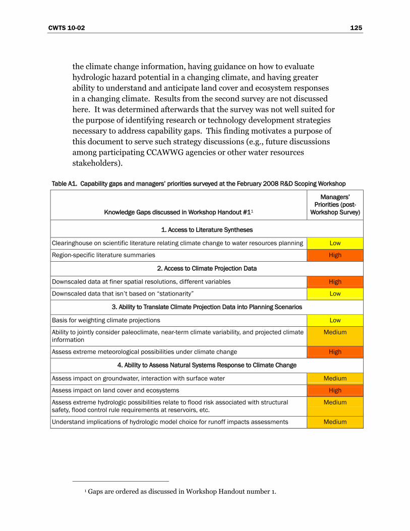
CWTS 10-02 125
the climate change information, having guidance on how to evaluate
hydrologic hazard potential in a changing climate, and having greater
ability to understand and anticipate land cover and ecosystem responses
in a changing climate. Results from the second survey are not discussed
here. It was determined afterwards that the survey was not well suited for
the purpose of identifying research or technology development strategies
necessary to address capability gaps. This finding motivates a purpose of
this document to serve such strategy discussions (e.g., future discussions
among participating CCAWWG agencies or other water resources
stakeholders).
Table A1. Capability gaps and managers’ priorities surveyed at the February 2008 R&D Scoping Workshop
Knowledge Gaps discussed in Workshop Handout #11
Managers’
Priorities (post-
Workshop Survey)
1. Access to Literature Syntheses
Clearinghouse on scientific literature relating climate change to water resources planning Low
Region-specific literature summaries High
2. Access to Climate Projection Data
Downscaled data at finer spatial resolutions, different variables High
Downscaled data that isn’t based on “stationarity” Low
3. Ability to Translate Climate Projection Data into Planning Scenarios
Basis for weighting climate projections Low
Ability to jointly consider paleoclimate, near-term climate variability, and projected climate
information
Medium
Assess extreme meteorological possibilities under climate change High
4. Ability to Assess Natural Systems Response to Climate Change
Assess impact on groundwater, interaction with surface water Medium
Assess impact on land cover and ecosystems High
Assess extreme hydrologic possibilities relate to flood risk associated with structural
safety, flood control rule requirements at reservoirs, etc.
Medium
Understand implications of hydrologic model choice for runoff impacts assessments Medium
1 Gaps are ordered as discussed in Workshop Handout number 1.
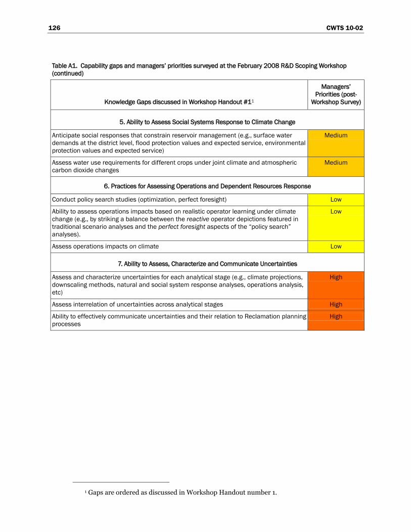
126 CWTS 10-02
Table A1. Capability gaps and managers’ priorities surveyed at the February 2008 R&D Scoping Workshop
(continued)
Knowledge Gaps discussed in Workshop Handout #11
Managers’
Priorities (post-
Workshop Survey)
5. Ability to Assess Social Systems Response to Climate Change
Anticipate social responses that constrain reservoir management (e.g., surface water
demands at the district level, flood protection values and expected service, environmental
protection values and expected service)
Medium
Assess water use requirements for different crops under joint climate and atmospheric
carbon dioxide changes
Medium
6. Practices for Assessing Operations and Dependent Resources Response
Conduct policy search studies (optimization, perfect foresight) Low
Ability to assess operations impacts based on realistic operator learning under climate
change (e.g., by striking a balance between the reactive operator depictions featured in
traditional scenario analyses and the perfect foresight aspects of the “policy search”
analyses).
Low
Assess operations impacts on climate Low
7. Ability to Assess, Characterize and Communicate Uncertainties
Assess and characterize uncertainties for each analytical stage (e.g., climate projections,
downscaling methods, natural and social system response analyses, operations analysis,
etc)
High
Assess interrelation of uncertainties across analytical stages High
Ability to effectively communicate uncertainties and their relation to Reclamation planning
processes
High
1 Gaps are ordered as discussed in Workshop Handout number 1.
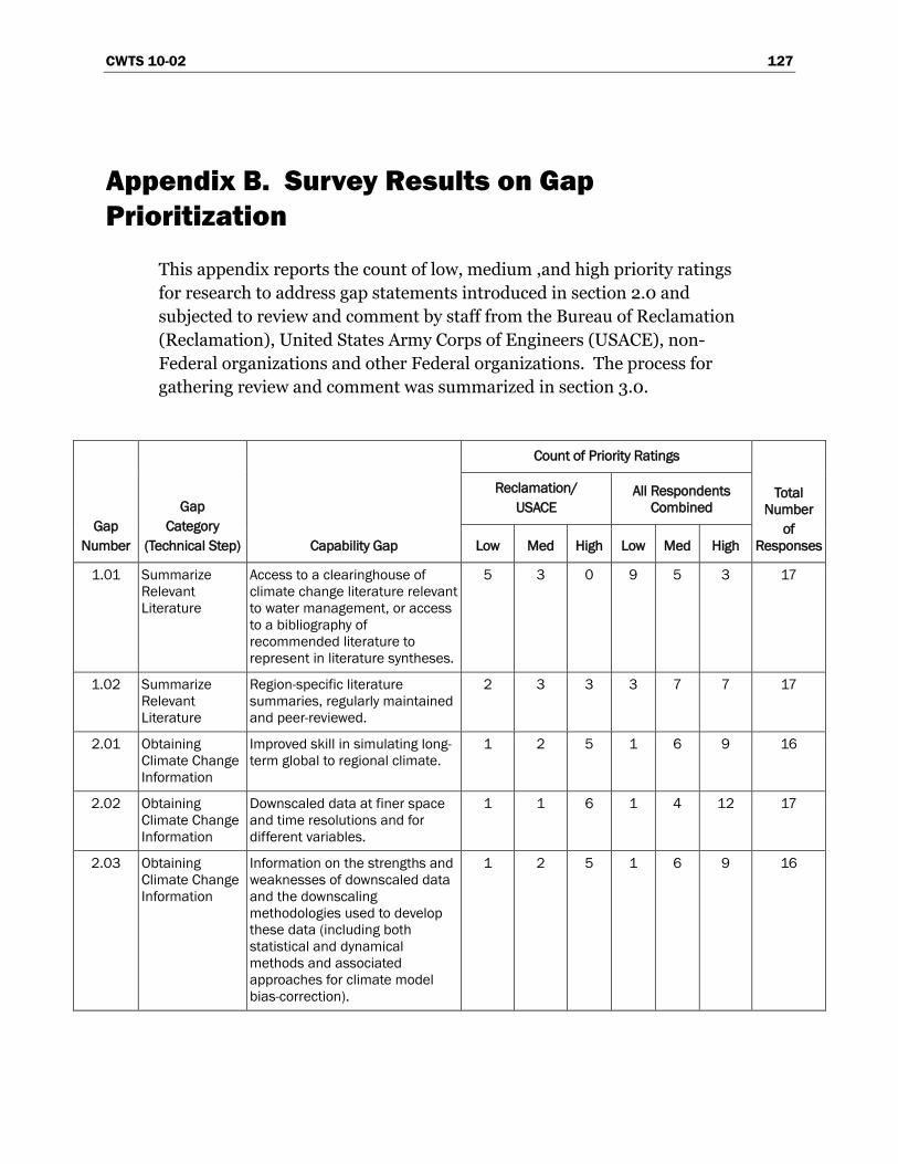
CWTS 10-02 127
Appendix B. Survey Results on Gap
Prioritization
This appendix reports the count of low, medium ,and high priority ratings
for research to address gap statements introduced in section 2.0 and
subjected to review and comment by staff from the Bureau of Reclamation
(Reclamation), United States Army Corps of Engineers (USACE), non-
Federal organizations and other Federal organizations. The process for
gathering review and comment was summarized in section 3.0.
Gap
Number
Gap
Category
(Technical Step) Capability Gap
Count of Priority Ratings
Total
Number
of
Responses
Reclamation/
USACE
All Respondents
Combined
Low Med High Low Med High
1.01 Summarize
Relevant
Literature
Access to a clearinghouse of
climate change literature relevant
to water management, or access
to a bibliography of
recommended literature to
represent in literature syntheses.
5 3 0 9 5 3 17
1.02 Summarize
Relevant
Literature
Region-specific literature
summaries, regularly maintained
and peer-reviewed.
2 3 3 3 7 7 17
2.01 Obtaining
Climate Change
Information
Improved skill in simulating long-
term global to regional climate.
1 2 5 1 6 9 16
2.02 Obtaining
Climate Change
Information
Downscaled data at finer space
and time resolutions and for
different variables.
1 1 6 1 4 12 17
2.03 Obtaining
Climate Change
Information
Information on the strengths and
weaknesses of downscaled data
and the downscaling
methodologies used to develop
these data (including both
statistical and dynamical
methods and associated
approaches for climate model
bias-correction).
1 2 5 1 6 9 16
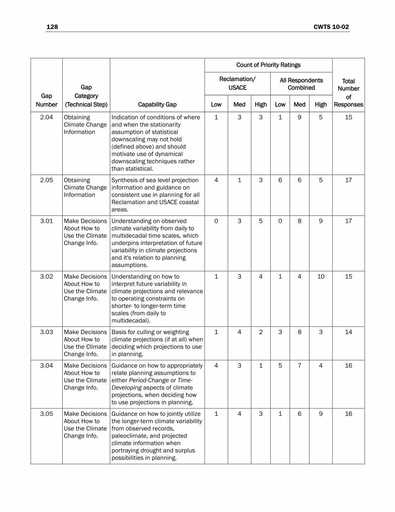
128 CWTS 10-02
Gap
Number
Gap
Category
(Technical Step) Capability Gap
Count of Priority Ratings
Total
Number
of
Responses
Reclamation/
USACE
All Respondents
Combined
Low Med High Low Med High
2.04 Obtaining
Climate Change
Information
Indication of conditions of where
and when the stationarity
assumption of statistical
downscaling may not hold
(defined above) and should
motivate use of dynamical
downscaling techniques rather
than statistical.
1 3 3 1 9 5 15
2.05 Obtaining
Climate Change
Information
Synthesis of sea level projection
information and guidance on
consistent use in planning for all
Reclamation and USACE coastal
areas.
4 1 3 6 6 5 17
3.01 Make Decisions
About How to
Use the Climate
Change Info.
Understanding on observed
climate variability from daily to
multidecadal time scales, which
underpins interpretation of future
variability in climate projections
and it's relation to planning
assumptions.
0 3 5 0 8 9 17
3.02 Make Decisions
About How to
Use the Climate
Change Info.
Understanding on how to
interpret future variability in
climate projections and relevance
to operating constraints on
shorter- to longer-term time
scales (from daily to
multidecadal).
1 3 4 1 4 10 15
3.03 Make Decisions
About How to
Use the Climate
Change Info.
Basis for culling or weighting
climate projections (if at all) when
deciding which projections to use
in planning.
1 4 2 3 8 3 14
3.04 Make Decisions
About How to
Use the Climate
Change Info.
Guidance on how to appropriately
relate planning assumptions to
either Period-Change or Time-
Developing aspects of climate
projections, when deciding how
to use projections in planning.
4 3 1 5 7 4 16
3.05 Make Decisions
About How to
Use the Climate
Change Info.
Guidance on how to jointly utilize
the longer-term climate variability
from observed records,
paleoclimate, and projected
climate information when
portraying drought and surplus
possibilities in planning.
1 4 3 1 6 9 16
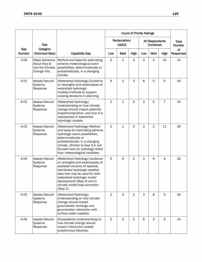
CWTS 10-02 129
Gap
Number
Gap
Category
(Technical Step) Capability Gap
Count of Priority Ratings
Total
Number
of
Responses
Reclamation/
USACE
All Respondents
Combined
Low Med High Low Med High
3.06 Make Decisions
About How to
Use the Climate
Change Info.
Method and basis for estimating
extreme meteorological event
possibilities, deterministically or
probabilistically, in a changing
climate.
2 1 4 3 2 10 15
4.01 Assess Natural
Systems
Response
(Watershed Hydrology) Guidance
on strengths and weaknesses of
watershed hydrologic
models/methods to support
scoping decisions in planning.
4 2 3 6 5 5 16
4.02 Assess Natural
Systems
Response
(Watershed Hydrology)
Understanding on how climate
change should impact potential
evapotranspiration, and how it is
represented in watershed
hydrologic models.
2 1 5 3 5 7 15
4.03 Assess Natural
Systems
Response
(Watershed Hydrology) Method
and basis for estimating extreme
hydrologic event possibilities,
deterministically or
probabilistically, in a changing
climate. (Similar to Gap 3.4, but
focused here on hydrology rather
than meteorological variables)
2 1 5 3 2 11 16
4.04 Assess Natural
Systems
Response
(Watershed Hydrology) Guidance
on strengths and weaknesses of
available versions of spatially
distributed hydrologic weather
data that may be used for both
watershed hydrologic model
development (Step 4) and in
climate model bias-correction
(Step 2).
0 6 2 3 9 4 16
4.05 Assess Natural
Systems
Response
(Watershed Hydrology)
Understanding on how climate
change should impact
groundwater recharge and
groundwater interaction with
surface water supplies.
2 4 2 3 8 5 16
4.06 Assess Natural
Systems
Response
(Ecosystems) Understanding on
how climate change should
impact inland and coastal
anadromous fisheries.
2 2 2 6 3 5 14
130 CWTS 10-02
Gap
Number
Gap
Category
(Technical Step) Capability Gap
Count of Priority Ratings
Total
Number
of
Responses
Reclamation/
USACE
All Respondents
Combined
Low Med High Low Med High
4.07 Assess Natural
Systems
Response
(Ecosystems) Understanding on
how climate change may impact
riparian ecosystems and
vegetation that affect both
longer-term water budgets and
ecological resources.
0 3 4 2 7 6 15
4.08 Assess Natural
Systems
Response
(Ecosystems) Understanding
translated into model frameworks
for assessing climate change
responses for fisheries, non-
native riparian vegetation, and
other species or habitat
conditions.
0 3 4 3 6 6 15
4.09 Assess Natural
Systems
Response
(Land Cover) Understanding on
how climate and/or carbon
dioxide changes should impact
land cover communities that
control natural
evapotranspiration and soil
erosion potential.
1 3 3 5 4 5 14
4.10 Assess Natural
Systems
Response
(Water Quality) Understanding on
how water quality characteristics
depend on climatic variables,
and how dependencies may
evolve in a changing climate.
1 2 6 3 4 10 17
4.11 Assess Natural
Systems
Response
(Consumptive Use in Irrigated
Areas) Understanding on how
climate and carbon dioxide
changes should impact plant
physiology, how impacts vary with
crop type, and how impacts affect
irrigation demand.
1 4 2 4 7 3 14
4.12 Assess Natural
Systems
Response
(Sedimentation and River
Hydraulics) Understanding how
climate and/or land cover
changes will change watershed
sediment yield, changes in
sediment constituency, and the
resulting impacts on water
resources.
1 4 2 2 9 3 14
4.13 Assess Natural
Systems
Response
(Sedimentation and River
Hydraulics) Understanding how
climate, land cover, and/or
sedimentation changes will affect
river and reservoir ice-event
potential.
2 4 1 5 5 4 14
CWTS 10-02 131
Gap
Number
Gap
Category
(Technical Step) Capability Gap
Count of Priority Ratings
Total
Number
of
Responses
Reclamation/
USACE
All Respondents
Combined
Low Med High Low Med High
5.01 Assess
Socioeconomic
and Institutional
Response
Understanding on how
socioeconomic factors may affect
flood risk reduction and reservoir
regulation objectives in a
changing climate (e.g., flood
protection values, land
management).
0 4 3 2 6 7 15
5.02 Assess
Socioeconomic
and Institutional
Response
Understanding on how
socioeconomic factors may affect
water and power delivery
reliability, water allocations, as
well as decisions on source of
supply under a changing climate
(e.g., groundwater pumping
versus surface water diversion).
1 0 5 3 1 10 14
5.03 Assess
Socioeconomic
and Institutional
Response
Understanding on how
institutional realities currently
control socioeconomic responses
to climate variability and could
control socioeconomic responses
under a changing climate.
1 3 3 6 5 4 15
6.01 Assess System
Risks and
Evaluate
Alternatives
Guidance on how to conduct an
adaptation evaluation that
efficiently explores and rank
strategy options, potentially using
optimization techniques.
1 3 4 4 5 8 17
6.02 Assess System
Risks and
Evaluate
Alternatives
Guidance on how to portray
realistic operator “learning” in
evaluations supporting planning
for climate change adaptation.
5 0 1 9 2 1 12
6.03 Assess System
Risks and
Evaluate
Alternatives
Guidance on how to assess the
effect of planning proposals on
climate.
5 4 0 8 9 0 17
7.01 Assess and
Characterize
Uncertainties
Uncertainty information on global
climate projections data,
including uncertainties about
climate system science, portrayal
in climate models, emissions
scenario development, and
simulation methods.
0 3 5 4 5 8 17
132 CWTS 10-02
Gap
Number
Gap
Category
(Technical Step) Capability Gap
Count of Priority Ratings
Total
Number
of
Responses
Reclamation/
USACE
All Respondents
Combined
Low Med High Low Med High
7.02 Assess and
Characterize
Uncertainties
Uncertainty information on
regional climate projections data,
including uncertainties from
choice of bias-correction and
spatial downscaling methods.
0 2 6 0 6 10 16
7.03 Assess and
Characterize
Uncertainties
Uncertainty in planning results
stemming from method choices
on how to use transient
characteristics of climate
projections in planning scenarios.
2 3 3 3 7 6 16
7.04 Assess and
Characterize
Uncertainties
For each response analysis on a
natural system, uncertainty
information on system science
and associated ways of
portraying this science in a
system model, and the
observations used to customize a
model for a specific system.
1 2 5 2 7 8 17
7.05 Assess and
Characterize
Uncertainties
For each response analysis on a
socioeconomic system,
uncertainty information on
system science and associated
ways of portraying this science in
a system model, and the
observations used to customize a
model for a specific system.
2 3 3 5 7 5 17
8.01 Communicating
Results and
Uncertainties to
Decisionmakers
Guidance on strengths and
weaknesses of various methods
for communicating results and
uncertainties affected by the use
of climate projection information.
0 3 5 1 7 9 17
8.02 Communicating
Results and
Uncertainties to
Decisionmakers
Guidance on how to make
decisions given the uncertainties
introduced by consideration of
climate projection information.
1 1 5 3 4 9 16