Embed Size (px)
Citation preview
T S A W W A S S E N F I R S T N A T I O N
S O U T H N E I G H B O U R H O O D P L A N
Adopted February 4, 2015
South Neighbourhood Plan (Adopted 2015 Feb 04)
Tsawwassen First Nation

Table of Contents
1 SOUTH NEIGHBOURHOOD PLAN PURPOSE 1
2 SOUTH NEIGHBOURHOOD PLAN AREA AND OWNERSHIP CONTEXT 2
3 RELATED PLANNING LEGISLATION 5
4 CONTEXT REPORT SUMMARY 6
5 CONSULTATION FEEDBACK 10
6 VISION 12
7 DESIGN PRINCIPLES 13
8 SOUTH NEIGHBOURHOOD PLAN POLICIES 14
8.1 RESIDENTIAL POLICIES 14 8.1.1 TOWNHOUSE AND DUPLEX 15 8.1.2 APARTMENT 16 8.1.3 SINGLE DETACHED 17 8.1.4 CALCULATION OF DENSITY FOR TOWNHOUSE AND APARTMENT USES 18 8.2 PUBLIC REALM DESIGN 19 8.3 AMENITY AREA 19 8.3.1 AMENITY AREA PROVISION 19 8.4 PARK 21 8.5 NEIGHBOURHOOD CIRCULATION 25 8.5.1 ROADS 25 8.6 PRECINCT PLANNING 26 8.6.1 DEVELOPMENT PRECINCTS POLICY 28 8.6.2 EAST PRECINCT 28 8.6.3 CENTRAL PRECINCT 28 8.6.4 FORESHORE PRECINCT 29 8.6.5 PRECINCT PLAN OPTION FOR MULTI‐PHASE DEVELOPMENTS 29
9 SUSTAINABILITY 31
10 LAND USE AND CIRCULATION CONCEPT PLAN 32
11 DEFINITIONS AND ABBREVIATIONS 33
12 REFERENCES 35
South Neighbourhood Plan (Adopted 2015 Feb 04)
Tsawwassen First Nation
LIST OF SCHEDULES
1 – Land Use and Circulation Concept Plan
LIST OF FIGURES
Figure 1: South Neighbourhood Plan Context .................................................................. 2 Figure 2: Aerial View of Plan Area and East, Central and Foreshore Precincts .............. 3 Figure 3: Regional Multi-Use Path Concept ...................................................................... 7 Figure 4: Land below 3.5 M elevation, Canadian Geodetic Vertical Datum 1928, circa 2009 .... 9 Figure 5: Apartment Example .......................................................................................... 17 Figure 6: Park and Path Concept .................................................................................... 22 Figure 7: Potential Foreshore Park/Open Space ........................................................... 23 Figure 8: Detail East Precinct Amenity, Bluff and Linear Parks ..................................... 24 Figure 9: Illustrative Site Plan - East Precinct ................................................................. 26
1 SOUTH NEIGHBOURHOOD PLAN PURPOSE
The South Neighbourhood Plan builds upon the framework and certainty
established in the Tsawwassen First Nation (TFN) Land Use Plan (January
12, 2009), which provides a long‐term vision for TFN land development. The
South Neighbourhood Plan provides detailed policies aimed at facilitating
development within the South Neighbourhood Plan Area in the near‐term
and longer term. The purpose of this plan is to facilitate a new
neighbourhood which:
Respects TFN’s historical and cultural context
Reflects best practices in community development
Establishes a high quality community that serves the needs of TFN, its
members, and all future residents, and
Guides development of both Tsawwassen Fee Simple Interest lands and
lands owned by the TFN Government.
The report begins with a summary of a context report (see separate report
for full text) describing the plan area setting, higher level plans and
regulatory instruments that have an important impact on land use and
circulation in the plan area. Together with results of initial consultations,
the context provided the basis to develop a vision and guiding principles.
Plan policies flowing from those inputs are then described for major land
use designations, public amenities, park and circulation elements. A Land
Use and Circulation Concept Plan, consistent with the policies and
regulatory framework, follows. The report ends with a description of the
plan’s linkages to Sustainability Elements of the TFN Land Use Plan and
implementation actions arising from the plan.
South Neighbourhood Plan (Adopted 2015 Feb 04)
2 | P a g e Tsawwassen First Nation
2 SOUTH NEIGHBOURHOOD PLAN AREA AND OWNERSHIP CONTEXT
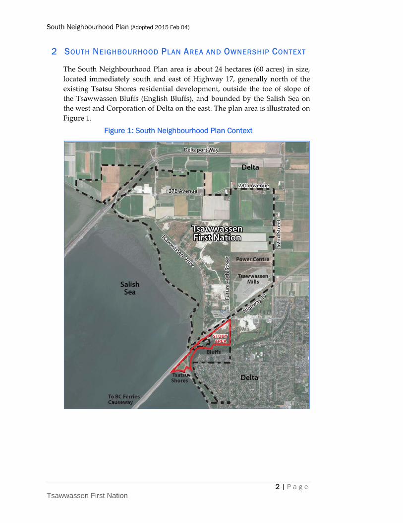
The South Neighbourhood Plan area is about 24 hectares (60 acres) in size,
located immediately south and east of Highway 17, generally north of the
existing Tsatsu Shores residential development, outside the toe of slope of
the Tsawwassen Bluffs (English Bluffs), and bounded by the Salish Sea on
the west and Corporation of Delta on the east. The plan area is illustrated on
Figure 1.
Figure 1: South Neighbourhood Plan Context
South Neighbourhood Plan (Adopted 2015 Feb 04)
3 | P a g e Tsawwassen First Nation
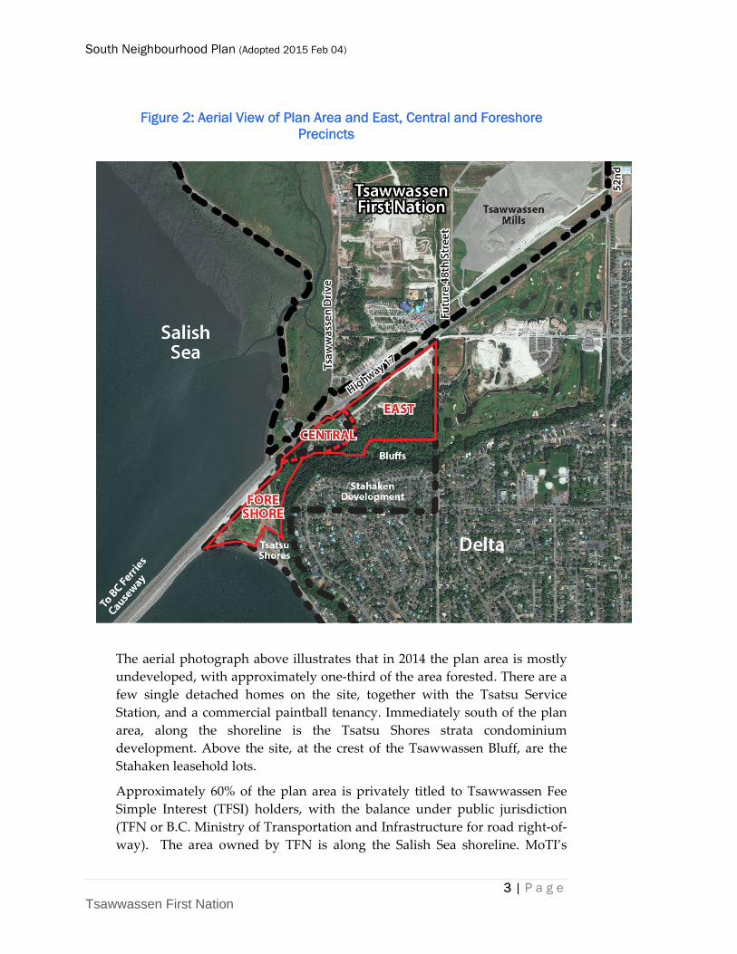
Figure 2: Aerial View of Plan Area and East, Central and Foreshore Precincts
The aerial photograph above illustrates that in 2014 the plan area is mostly
undeveloped, with approximately one‐third of the area forested. There are a
few single detached homes on the site, together with the Tsatsu Service
Station, and a commercial paintball tenancy. Immediately south of the plan
area, along the shoreline is the Tsatsu Shores strata condominium
development. Above the site, at the crest of the Tsawwassen Bluff, are the
Stahaken leasehold lots.
Approximately 60% of the plan area is privately titled to Tsawwassen Fee
Simple Interest (TFSI) holders, with the balance under public jurisdiction
(TFN or B.C. Ministry of Transportation and Infrastructure for road right‐of‐
way). The area owned by TFN is along the Salish Sea shoreline. MoTI’s
South Neighbourhood Plan (Adopted 2015 Feb 04)
4 | P a g e Tsawwassen First Nation
jurisdiction from the TFN Final Agreement is related to road access, design
and safety within the Tsawwassen Drive corridor, as part of the Highway 17
Corridor.
South Neighbourhood lands have been divided into three precincts for
planning purposes by Tsawwassen Drive. The largest is East Precinct,
comprising 14 ha, located east of Tsawwassen Drive. Central Precinct is a 4
hectare of land mostly owned by TFSI holders and is south of Highway 17,
north of Tsawwassen Drive. Tsatsu Service Station and homes of several
TFN Members are in this precinct. The final precinct, approximately 6 ha in
size, is the Foreshore Precinct bounding the Salish Sea shoreline and 100%
owned by TFN.
Immediately south of the B.C. Ferries causeway, Parcel “U” is a sliver of
land that falls between TFN Lands and the Salish Sea. This parcel is owned
by the B.C. Transportation Finance Authority. Under Chapter 4 (Lands) of
the TFN Final Agreement, Section 100 provides that Tsawwassen First
Nation owns any lawful accretions to Tsawwassen Lands. Based on aerial
photography from the past 50 years, the South Neighbourhood foreshore
has historically been an area of accretion. If this process continues, future
accreted lands may be potentially added to TFN.
There is a 30 m wide easement in favour of Tsawwassen Golf & Country
Club Ltd. and TFN, located adjacent to Highway 17 and extending from
Tsawwassen Drive to the east boundary of TFN with Corporation of Delta.
In preparing the plan, the broader context of the South Neighbourhood Plan
area was considered, specifically its relations to the Tsawwassen Bluffs, the
commercial lands to the north and east across Highway 17, the Tsatsu
Shores apartment strata project to the south, waterfront to the west and
Tsawwassen Spring golf course and community development in
Corporation of Delta to the east.
Tsawwassen Drive South provides vehicular access from Highway 17 to the
plan area. Through the Treaty Final Agreement, this road right‐of‐way is
under the jurisdiction of the Province of British Columbia Ministry of
Transportation and Infrastructure.
South Neighbourhood Plan (Adopted 2015 Feb 04)
5 | P a g e Tsawwassen First Nation
3 RELATED PLANNING LEGISLATION
Tsawwassen First Nation (TFN) has enacted legislation and regulations to
guide land development on TFN Lands. The following TFN acts and
regulations also serve to guide the implementation of the South
Neighbourhood Plan:
Tsawwassen First Nation Final Agreement, Effective April 3, 2009 (Treaty)
Land Act
Land Use Planning and Development Act
▪ Regulations:
▫ Zoning
▫ Offsite Levies
▫ Development Permit Areas (as of December 2013):
Floodplain
Environmental Protection
Heritage Conservation
Soil Stability/Landfill
▫ Subdivision and Development
▫ Building
▫ Tree
TFN Land Use Plan, 2009
Metro Vancouver Regional Growth Strategy, 2011 as amended to 2014
TFN Reports (approved by Executive Council):
▪ Internal TFN Road Analysis Report, December 2013
▪ TFN Bulk Water and Sanitary Sewer Trunk Master Plan, January 2014
▪ TFN Integrated Rainwater Management Plan, 2013
▪ TFN Supplementary Design and Construction Specifications, 2014
South Neighbourhood Plan (Adopted 2015 Feb 04)
6 | P a g e Tsawwassen First Nation
4 CONTEXT REPORT SUMMARY
Approximately 60% of the 24‐hectare South Neighbourhood Plan area is
privately held under Tsawwassen Fee Simple Interest title, one‐third by
TFN, and the balance is under road jurisdiction of the B.C. Ministry of
Transportation and Infrastructure.
The 2009 TFN Land Use Plan, approved by community vote, provides
considerable guidance to future development in the South Neighbourhood
through its Multiple Family Housing, Bluff Area, Heritage Conservation,
Park, Trail Network, Amenity, Sustainable Development, Transportation
and Utility policy sections, as well as the Schedule 1 Land Use Plan
designations map.
The 2009 TFN Land Use Plan is deemed consistent with the Regional
Growth Strategy through the TFN Final Agreement (Treaty). A South
Neighbourhood Plan which is consistent with the 2009 TFN Land Use Plan
requires no further consultation with Metro Vancouver.
Regional road planning in relation to the South Neighbourhood has been
refined in recent years, as contemplated by the TFN Land Use Plan. The
existing Tsawwassen Drive South intersection at Highway 17 is to remain
the main road link to the community. Access from Tsawwassen Drive North
to Highway 17 is to eventually be closed after alternate access is available to
from the new 48th Street.
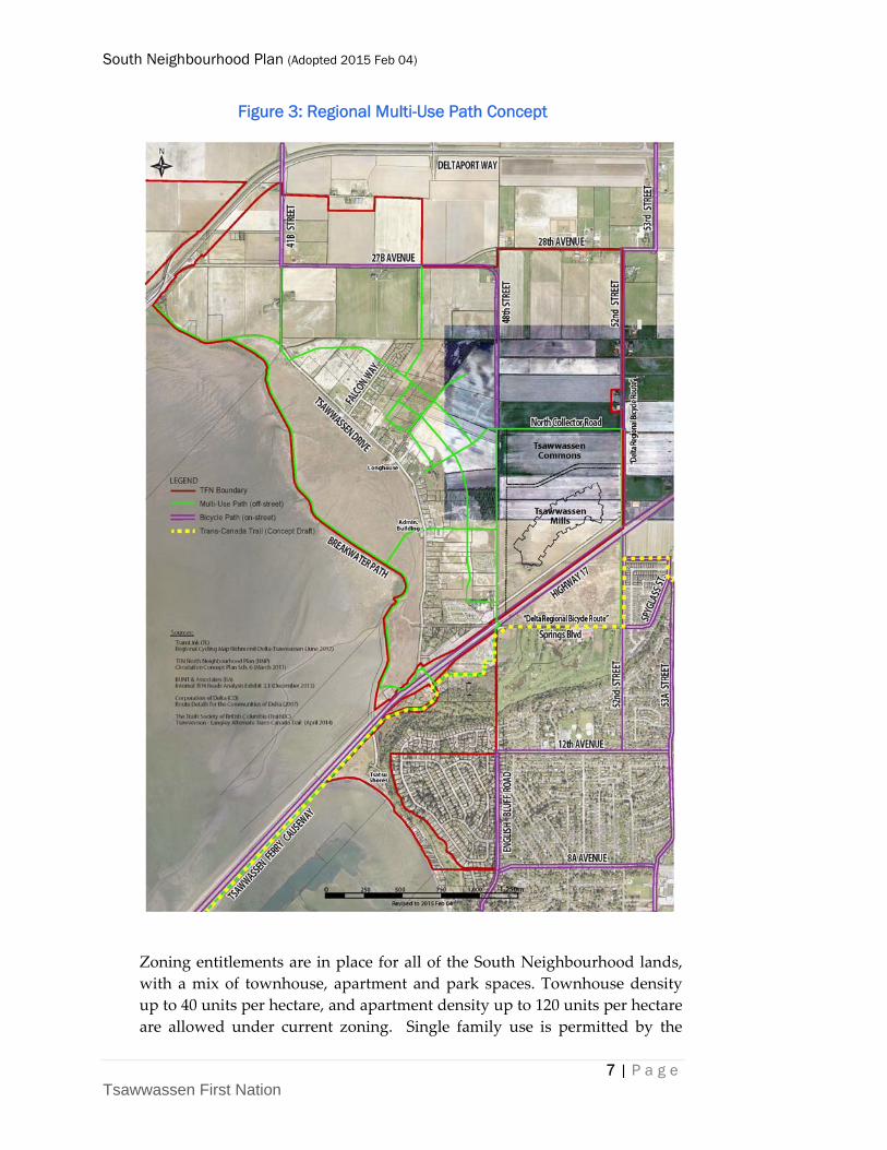
A regional multi‐use path network is also evolving, with important
connections to and through the South Neighbourhood in cooperation with
BC Ferries, Ministry of Transportation and Infrastructure, TransLink and
Corporation of Delta, and consistent with the policies of the TFN Land Use
Plan and a 2013 TFN Internal Roads Analysis report (Figure 3).
South Neighbourhood Plan (Adopted 2015 Feb 04)
7 | P a g e Tsawwassen First Nation
Figure 3: Regional Multi-Use Path Concept
Zoning entitlements are in place for all of the South Neighbourhood lands,
with a mix of townhouse, apartment and park spaces. Townhouse density
up to 40 units per hectare, and apartment density up to 120 units per hectare
are allowed under current zoning. Single family use is permitted by the

South Neighbourhood Plan (Adopted 2015 Feb 04)
8 | P a g e Tsawwassen First Nation
TFN Land Use Plan and on Tsawwassen Fee Simple Interest lands in
accordance with Section 4.6 of the Zoning Regulation. The Tsatsu service
station is anticipated to be relocated under the TFN Land Use Plan, but has a
lease expiry of 2053 and will remain a permitted use indefinitely in a C2
zone under the Zoning Regulation.
Designated areas for park and conservation uses are not identical under the
zoning, TFN Land Use Plan and 2011 Regional Growth Strategy. A TFN‐
owned parcel is designated Conservation and Recreation in the Regional
Growth Strategy, but is not in the P‐1 park zone, and the P‐1 zone includes
land outside the Regional Conservation and Recreation designation in the
East Precinct.
There are several relevant Development Permit Area regulations currently in
place which will regulate future development applications in the South
Neighbourhood; specifically floodplain, environmental protection, heritage
conservation and slope stability.
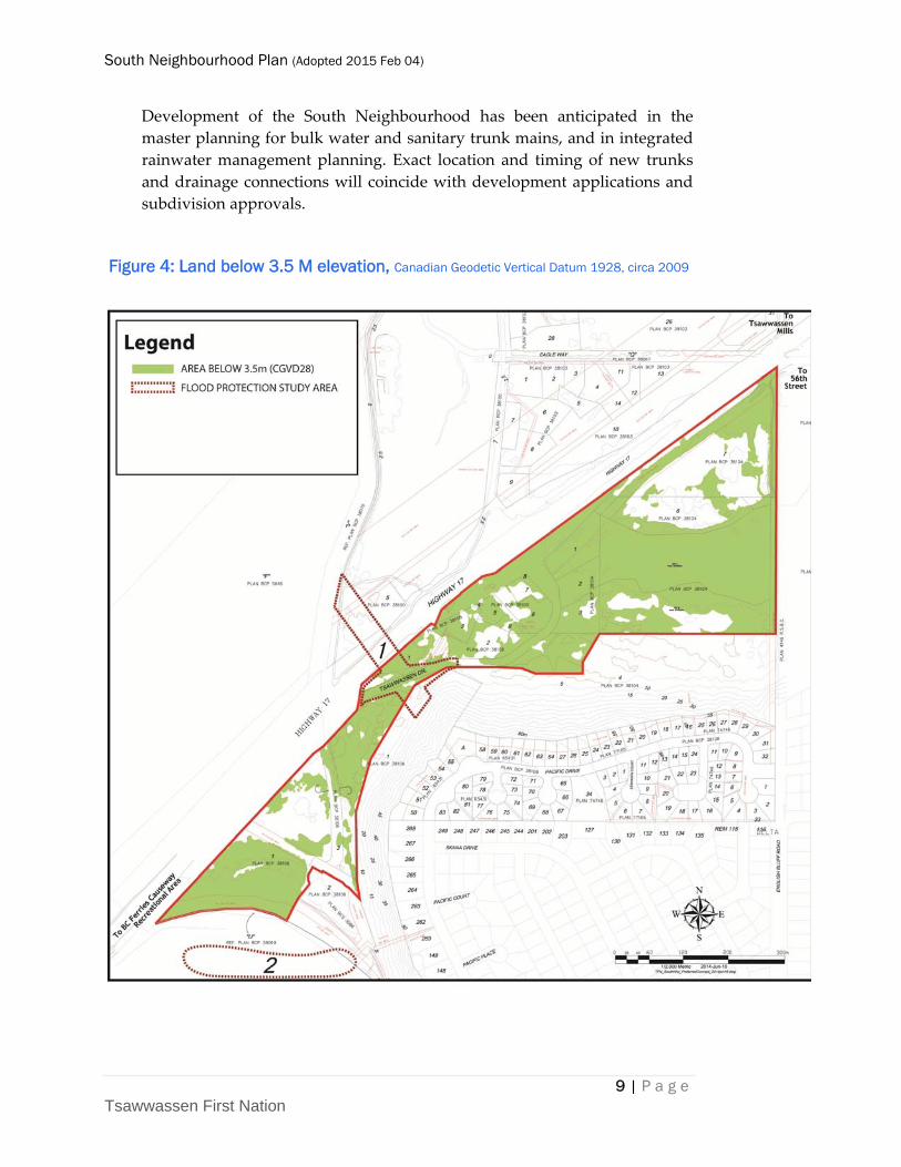
New buildings must meet a minimum floor elevation of 3.5 metres, a height
which will require fill for a substantial portion of the neighbourhood plan
area as development occurs. Environmental protection is a requirement of
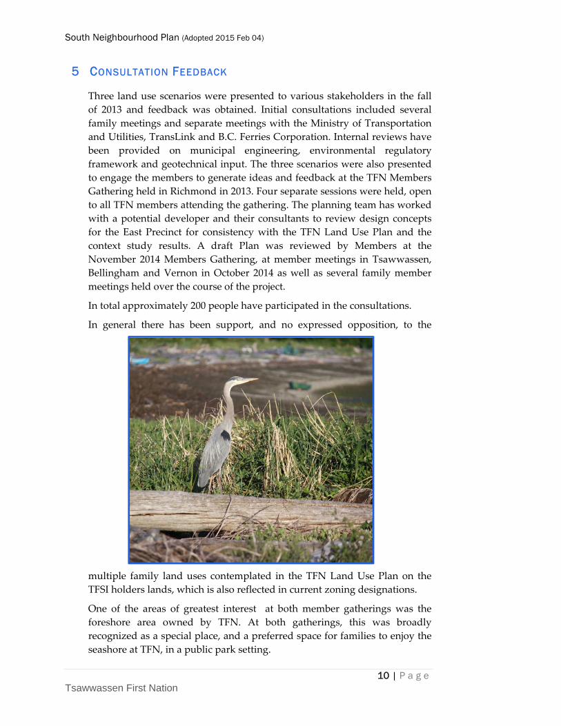
every development application, and the Great Blue Heron Colony is an
exceptional feature of the area. The Integrated Rainwater Management Plan
provides specific water quality criteria to be met for riparian habitat health.
With the exception of the foreshore, where land has accreted to enlarge the
beach area, development in the South Neighbourhood will also require a
Heritage Conservation Development Permit, reflecting its historic
importance as the original village site prior to construction of the ferry
causeway.
South Neighbourhood Plan (Adopted 2015 Feb 04)
9 | P a g e Tsawwassen First Nation
Development of the South Neighbourhood has been anticipated in the
master planning for bulk water and sanitary trunk mains, and in integrated
rainwater management planning. Exact location and timing of new trunks
and drainage connections will coincide with development applications and
subdivision approvals.
Figure 4: Land below 3.5 M elevation, Canadian Geodetic Vertical Datum 1928, circa 2009
South Neighbourhood Plan (Adopted 2015 Feb 04)
10 | P a g e Tsawwassen First Nation
5 CONSULTATION FEEDBACK
Three land use scenarios were presented to various stakeholders in the fall
of 2013 and feedback was obtained. Initial consultations included several
family meetings and separate meetings with the Ministry of Transportation
and Utilities, TransLink and B.C. Ferries Corporation. Internal reviews have
been provided on municipal engineering, environmental regulatory
framework and geotechnical input. The three scenarios were also presented
to engage the members to generate ideas and feedback at the TFN Members
Gathering held in Richmond in 2013. Four separate sessions were held, open
to all TFN members attending the gathering. The planning team has worked
with a potential developer and their consultants to review design concepts
for the East Precinct for consistency with the TFN Land Use Plan and the
context study results. A draft Plan was reviewed by Members at the
November 2014 Members Gathering, at member meetings in Tsawwassen,
Bellingham and Vernon in October 2014 as well as several family member
meetings held over the course of the project.
In total approximately 200 people have participated in the consultations.
In general there has been support, and no expressed opposition, to the
multiple family land uses contemplated in the TFN Land Use Plan on the
TFSI holders lands, which is also reflected in current zoning designations.
One of the areas of greatest interest at both member gatherings was the
foreshore area owned by TFN. At both gatherings, this was broadly
recognized as a special place, and a preferred space for families to enjoy the
seashore at TFN, in a public park setting.
South Neighbourhood Plan (Adopted 2015 Feb 04)
11 | P a g e Tsawwassen First Nation
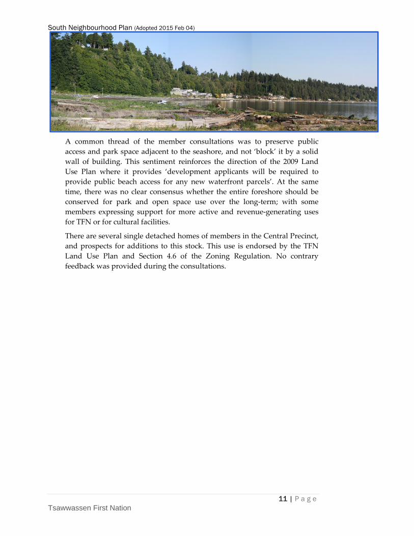
A common thread of the member consultations was to preserve public
access and park space adjacent to the seashore, and not ‘block’ it by a solid
wall of building. This sentiment reinforces the direction of the 2009 Land
Use Plan where it provides ‘development applicants will be required to
provide public beach access for any new waterfront parcels’. At the same
time, there was no clear consensus whether the entire foreshore should be
conserved for park and open space use over the long‐term; with some
members expressing support for more active and revenue‐generating uses
for TFN or for cultural facilities.
There are several single detached homes of members in the Central Precinct,
and prospects for additions to this stock. This use is endorsed by the TFN
Land Use Plan and Section 4.6 of the Zoning Regulation. No contrary
feedback was provided during the consultations.
South Neighbourhood Plan (Adopted 2015 Feb 04)
12 | P a g e Tsawwassen First Nation
6 VISION
The South Neighbourhood Plan retains the elements of the vision adopted in
the 2009 Land Use Plan:
Tsawwassen First Nation will be a safe accessible community, with infrastructure
and services that will make it the perfect place to raise children and to live. Our
community will be close‐knit, with elders and youth at the core of the community.
Our people will be proud of our culture, traditions and stories and the
Hunq’um’I’num language will be enjoying a revival. Development will not intrude
on the environment, views, and idyllic location of TFN lands.

South Neighbourhood Plan (Adopted 2015 Feb 04)
13 | P a g e Tsawwassen First Nation
7 DESIGN PRINCIPLES
A set of South Neighbourhood Plan design principles guide the plan:
Publicly accessible beach area with public park space adjacent to the beach
designed for enjoyment by all ages
Safe accessible community
Recreational & cultural opportunities are diverse and inviting
Urban design and built‐form reflect TFN community identity
Provide a diversity of housing opportunities, by which we mean:
▪ Apartment, Townhouse and Single Detached (limited) options
▪ Housing appropriate for different ages, different family structures,
low‐to‐upper middle income.
Plan bike and major walking routes in concert with major roads – provide
links to jobs and community nodes.
Work with adjacent owners and agencies (such as B.C. Ferries and B.C.
Ministry of Transportation and Infrastructure) for co‐ordinated long‐term
protection of buildings and structures from flood hazard.
Consider adoption of both shorter and longer term policies for land uses, where appropriate.
South Neighbourhood Plan (Adopted 2015 Feb 04)
14 | P a g e Tsawwassen First Nation
8 SOUTH NEIGHBOURHOOD PLAN POLICIES
In response to the context outlined in Section 1, initial consultations with
TFN members and other stakeholders, and the vision and design principles
in Sections 3 and 4, the following policies have been developed to apply
across the South Neighbourhood Plan, and within the East, Central and
Foreshore Precincts specifically.
The policies are organized as follows:
Residential, including Townhouse, Apartment and Single Detached
Public Realm Design
Amenity Areas
Park
Neighbourhood Circulation
Precinct Planning, and policies specific to the East, Central and
Foreshore Precincts
8.1 RESIDENTIAL POLICIES
The South Neighbourhood Plan establishes a mixture of residential densities
and housing options, which will support and encourage a cohesive
community, with residents benefiting from distributed amenities.
Four (4) residential housing types are permitted within the Multiple Family
Residential designation:
Townhouse
Duplex
Apartment
Single Detached
South Neighbourhood Plan (Adopted 2015 Feb 04)
15 | P a g e Tsawwassen First Nation
Definitions for these terms are found in Section 9, and are the same as in the
Zoning Regulation Order 028‐2009 (as amended to Order 008‐2014). For
purposes of the South Neighbourhood Plan, the Townhouse category
includes duplexes.
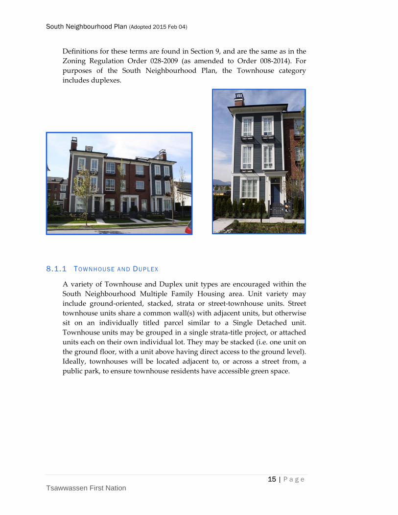
8.1.1 TOWNHOUSE AND DUPLEX
A variety of Townhouse and Duplex unit types are encouraged within the
South Neighbourhood Multiple Family Housing area. Unit variety may
include ground‐oriented, stacked, strata or street‐townhouse units. Street
townhouse units share a common wall(s) with adjacent units, but otherwise
sit on an individually titled parcel similar to a Single Detached unit.
Townhouse units may be grouped in a single strata‐title project, or attached
units each on their own individual lot. They may be stacked (i.e. one unit on
the ground floor, with a unit above having direct access to the ground level).
Ideally, townhouses will be located adjacent to, or across a street from, a
public park, to ensure townhouse residents have accessible green space.
South Neighbourhood Plan (Adopted 2015 Feb 04)
16 | P a g e Tsawwassen First Nation
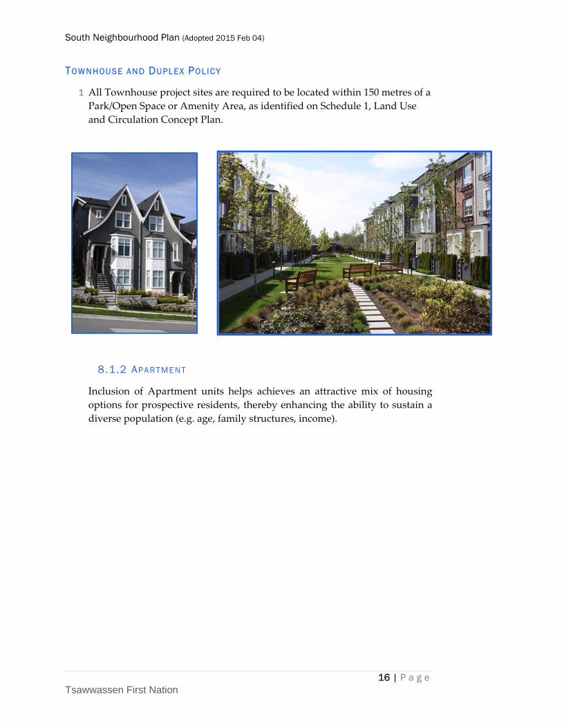
TOWNHOUSE AND DUPLEX POLICY
1 All Townhouse project sites are required to be located within 150 metres of a
Park/Open Space or Amenity Area, as identified on Schedule 1, Land Use
and Circulation Concept Plan.
8.1.2 APARTMENT
Inclusion of Apartment units helps achieves an attractive mix of housing
options for prospective residents, thereby enhancing the ability to sustain a
diverse population (e.g. age, family structures, income).
South Neighbourhood Plan (Adopted 2015 Feb 04)
17 | P a g e Tsawwassen First Nation
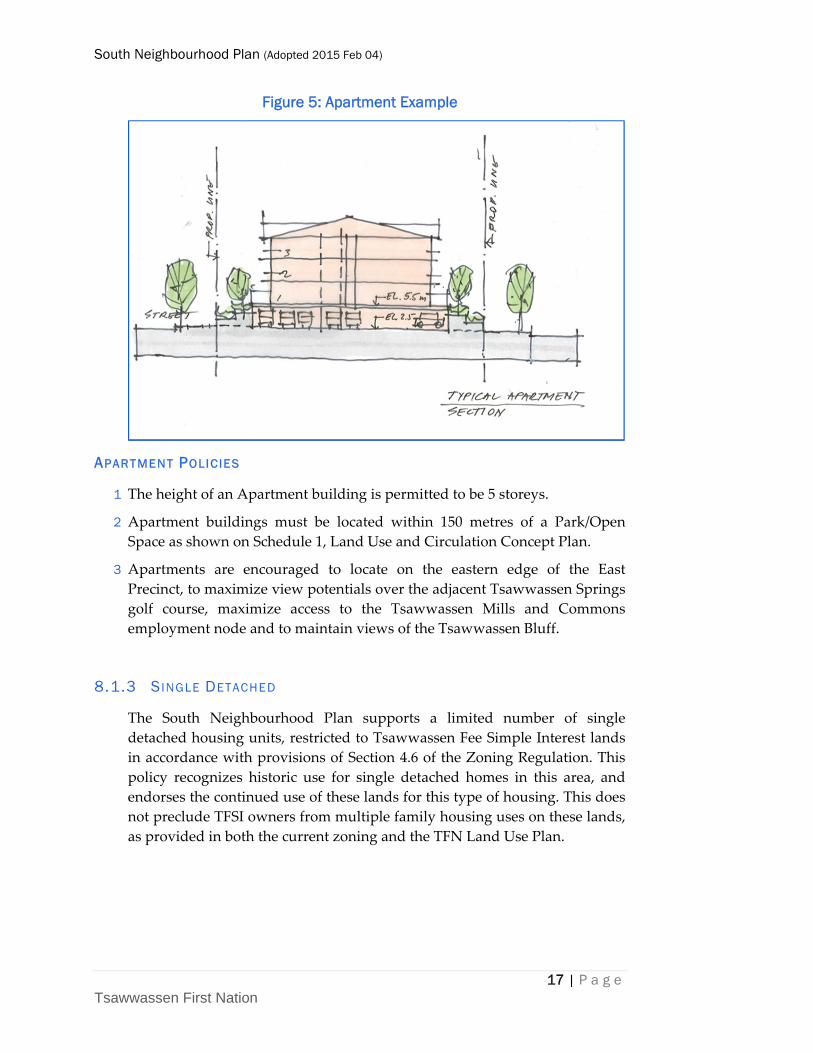
Figure 5: Apartment Example
APARTMENT POLICIES
1 The height of an Apartment building is permitted to be 5 storeys.
2 Apartment buildings must be located within 150 metres of a Park/Open
Space as shown on Schedule 1, Land Use and Circulation Concept Plan.
3 Apartments are encouraged to locate on the eastern edge of the East
Precinct, to maximize view potentials over the adjacent Tsawwassen Springs
golf course, maximize access to the Tsawwassen Mills and Commons
employment node and to maintain views of the Tsawwassen Bluff.
8.1.3 SINGLE DETACHED
The South Neighbourhood Plan supports a limited number of single
detached housing units, restricted to Tsawwassen Fee Simple Interest lands
in accordance with provisions of Section 4.6 of the Zoning Regulation. This
policy recognizes historic use for single detached homes in this area, and
endorses the continued use of these lands for this type of housing. This does
not preclude TFSI owners from multiple family housing uses on these lands,
as provided in both the current zoning and the TFN Land Use Plan.
South Neighbourhood Plan (Adopted 2015 Feb 04)
18 | P a g e Tsawwassen First Nation
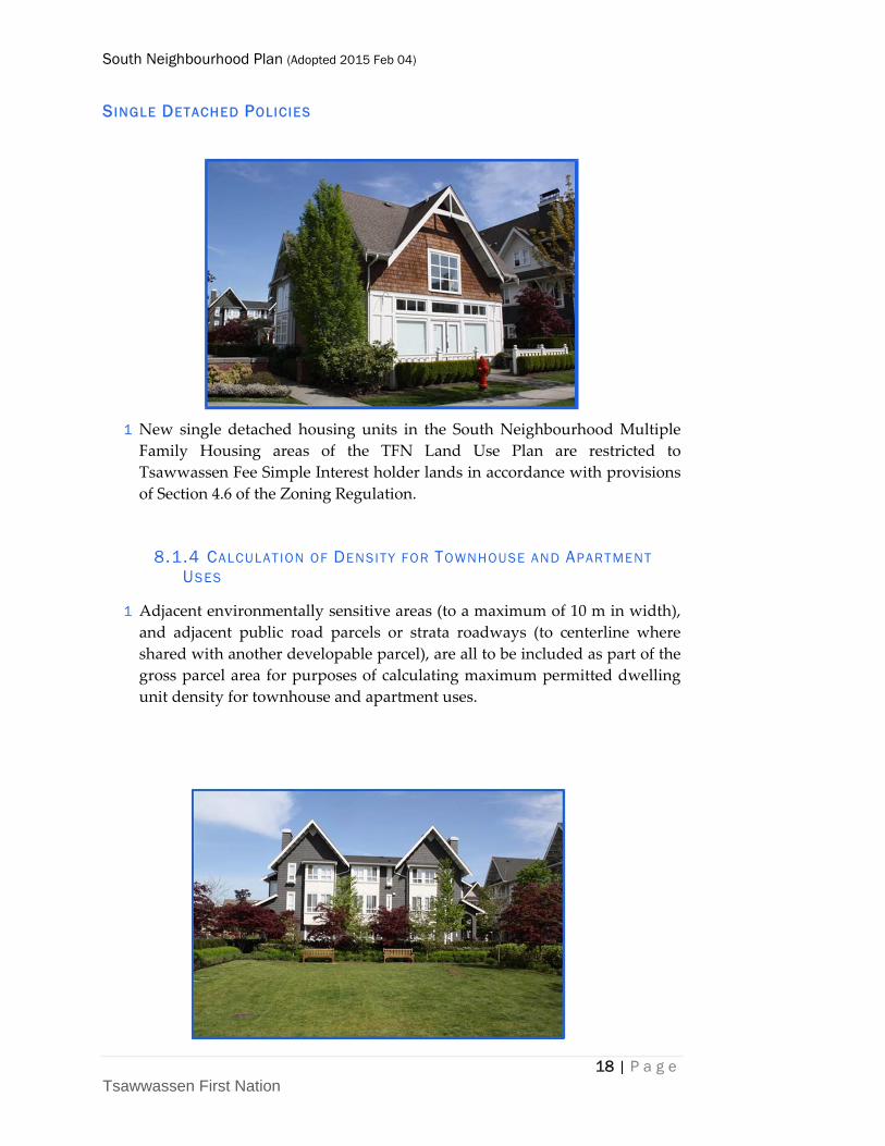
SINGLE DETACHED POLICIES
1 New single detached housing units in the South Neighbourhood Multiple
Family Housing areas of the TFN Land Use Plan are restricted to
Tsawwassen Fee Simple Interest holder lands in accordance with provisions
of Section 4.6 of the Zoning Regulation.
8.1.4 CALCULATION OF DENSITY FOR TOWNHOUSE AND APARTMENT USES
1 Adjacent environmentally sensitive areas (to a maximum of 10 m in width),
and adjacent public road parcels or strata roadways (to centerline where
shared with another developable parcel), are all to be included as part of the
gross parcel area for purposes of calculating maximum permitted dwelling
unit density for townhouse and apartment uses.
South Neighbourhood Plan (Adopted 2015 Feb 04)
19 | P a g e Tsawwassen First Nation
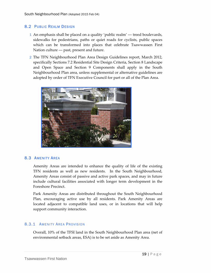
8.2 PUBLIC REALM DESIGN
1 An emphasis shall be placed on a quality ‘public realm’ ‐‐‐ treed boulevards,
sidewalks for pedestrians, paths or quiet roads for cyclists, public spaces
which can be transformed into places that celebrate Tsawwassen First
Nation culture ‐‐‐ past, present and future.
2 The TFN Neighbourhood Plan Area Design Guidelines report, March 2012,
specifically Sections 7.2 Residential Site Design Criteria, Section 8 Landscape
and Open Space and Section 9 Components shall apply in the South
Neighbourhood Plan area, unless supplemental or alternative guidelines are
adopted by order of TFN Executive Council for part or all of the Plan Area.
8.3 AMENITY AREA
Amenity Areas are intended to enhance the quality of life of the existing
TFN residents as well as new residents. In the South Neighbourhood,
Amenity Areas consist of passive and active park spaces, and may in future
include cultural facilities associated with longer term development in the
Foreshore Precinct.
Park Amenity Areas are distributed throughout the South Neighbourhood
Plan, encouraging active use by all residents. Park Amenity Areas are
located adjacent to compatible land uses, or in locations that will help
support community interaction.
8.3.1 AMENITY AREA PROVISION
Overall, 10% of the TFSI land in the South Neighbourhood Plan area (net of
environmental setback areas, ESA) is to be set aside as Amenity Area.
South Neighbourhood Plan (Adopted 2015 Feb 04)
20 | P a g e Tsawwassen First Nation
Land is to be dedicated at time of subdivision. Cash‐in‐lieu, where
acceptable to TFN, would be due as follows:
a one‐third on registration of a subdivision,
b one‐third within one year of the registration of a subdivision, and
c the balance outstanding within two years of the registration of a subdivision.
The intent of the staggered payments is to approximate the time when cash
flows would be received for the subdivided parcels, and the time at which
users are likely to begin benefitting from the use of the amenity spaces.
Where lands are owned by the TFN government within the South
Neighbourhood Plan area, and are appropriate for park or community use,
these lands may result in amenity area for the neighbourhood exceeding
10%.
For purposes of calculating cash‐in‐lieu payments, the provisions of TFN
Policy for Land Sale, Purchase or Exchange, December 2009 shall apply. If an
owner is to pay cash‐in‐lieu, the valuation of the land is whichever of the
following is applicable:
(a) the average market value of all the land in the proposed subdivision
calculated as that value would be on either:
(i) the date of preliminary approval of the subdivision, or
(ii) if no preliminary approval is given, a date within 90 days before
the final approval of the subdivision,
as though
(iii) the land is zoned to permit the proposed use, and
(iv) any works and services necessary to the subdivision have not
been installed;
(b) if the Tsawwassen First Nation and the owner agree on a value for
the land, the value on which they have agreed.
For clarity, cash‐in‐lieu policy will be specifically considered in the Central
Precinct, should development of non‐single detached uses be proposed for
sites of less than 2 hectares.
AMENITY AREA POLICIES
1 Amenity Areas, such as local parks, are to be distributed throughout the
plan area.
2 Amenity Area locations are to be generally consistent with locations shown
on Schedule 1, Land Use and Circulation Concept Plan.
3 As lands develop, each TFSI holder within the South Neighbourhood Plan
area will contribute 10% of their land (net of ESA) to these purposes as
either:
South Neighbourhood Plan (Adopted 2015 Feb 04)
21 | P a g e Tsawwassen First Nation
a dedication from within the precinct acceptable to TFN up to a
maximum of 10%, or
b cash‐in‐lieu, where acceptable to TFN, for the value of the balance of
the land area needed to raise the precinct amenity area to the 10%
level.
8.4 PARK
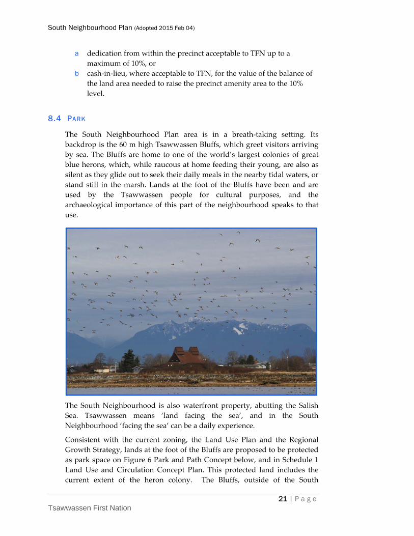
The South Neighbourhood Plan area is in a breath‐taking setting. Its
backdrop is the 60 m high Tsawwassen Bluffs, which greet visitors arriving
by sea. The Bluffs are home to one of the world’s largest colonies of great
blue herons, which, while raucous at home feeding their young, are also as
silent as they glide out to seek their daily meals in the nearby tidal waters, or
stand still in the marsh. Lands at the foot of the Bluffs have been and are
used by the Tsawwassen people for cultural purposes, and the
archaeological importance of this part of the neighbourhood speaks to that
use.
The South Neighbourhood is also waterfront property, abutting the Salish
Sea. Tsawwassen means ‘land facing the sea’, and in the South
Neighbourhood ‘facing the sea’ can be a daily experience.
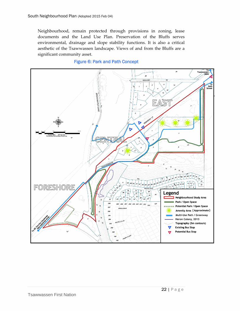
Consistent with the current zoning, the Land Use Plan and the Regional
Growth Strategy, lands at the foot of the Bluffs are proposed to be protected
as park space on Figure 6 Park and Path Concept below, and in Schedule 1
Land Use and Circulation Concept Plan. This protected land includes the
current extent of the heron colony. The Bluffs, outside of the South
South Neighbourhood Plan (Adopted 2015 Feb 04)
22 | P a g e Tsawwassen First Nation
Neighbourhood, remain protected through provisions in zoning, lease
documents and the Land Use Plan. Preservation of the Bluffs serves
environmental, drainage and slope stability functions. It is also a critical
aesthetic of the Tsawwassen landscape. Views of and from the Bluffs are a
significant community asset.
Figure 6: Park and Path Concept
South Neighbourhood Plan (Adopted 2015 Feb 04)
23 | P a g e Tsawwassen First Nation
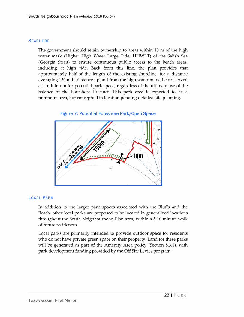
SEASHORE
The government should retain ownership to areas within 10 m of the high
water mark (Higher High Water Large Tide, HHWLT) of the Salish Sea
(Georgia Strait) to ensure continuous public access to the beach areas,
including at high tide. Back from this line, the plan provides that
approximately half of the length of the existing shoreline, for a distance
averaging 150 m in distance upland from the high water mark, be conserved
at a minimum for potential park space, regardless of the ultimate use of the
balance of the Foreshore Precinct. This park area is expected to be a
minimum area, but conceptual in location pending detailed site planning.
Figure 7: Potential Foreshore Park/Open Space
LOCAL PARK
In addition to the larger park spaces associated with the Bluffs and the
Beach, other local parks are proposed to be located in generalized locations
throughout the South Neighbourhood Plan area, within a 5‐10 minute walk
of future residences.
Local parks are primarily intended to provide outdoor space for residents
who do not have private green space on their property. Land for these parks
will be generated as part of the Amenity Area policy (Section 8.3.1), with
park development funding provided by the Off Site Levies program.
South Neighbourhood Plan (Adopted 2015 Feb 04)
24 | P a g e Tsawwassen First Nation
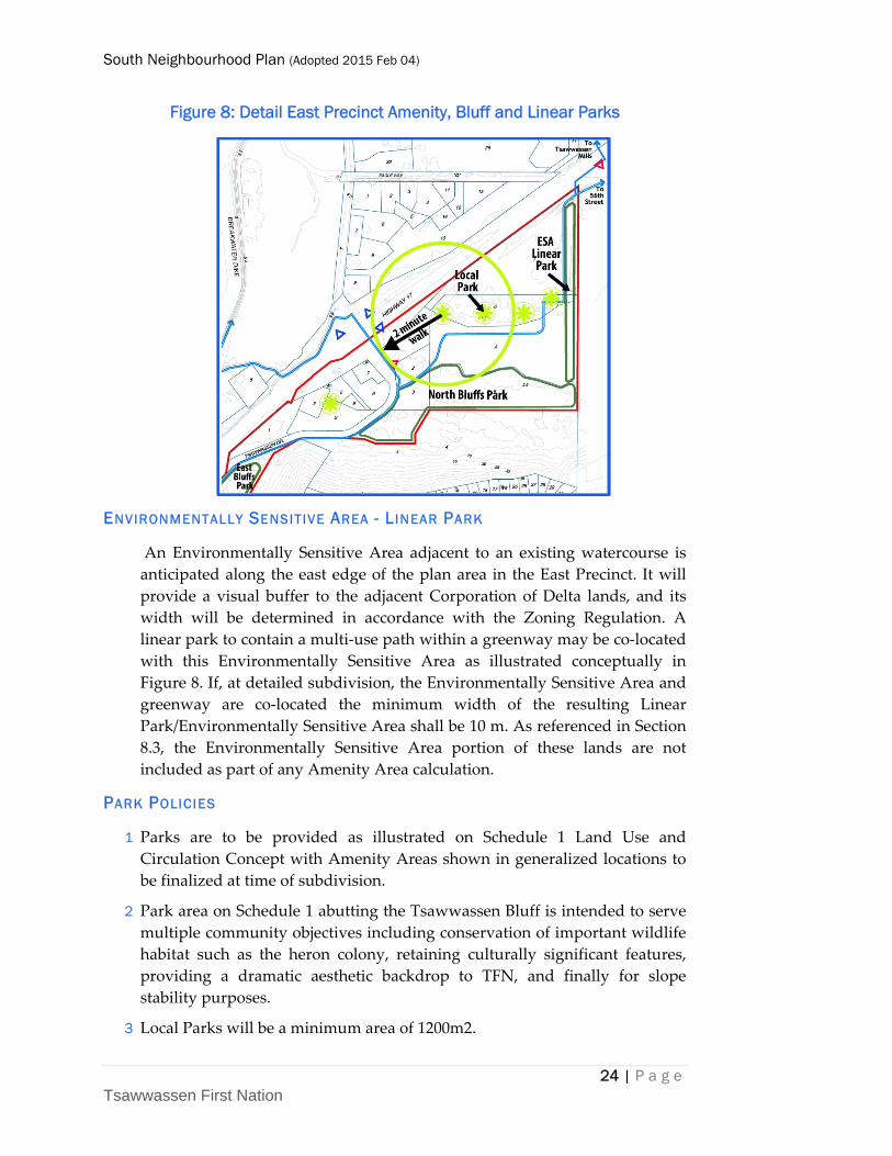
Figure 8: Detail East Precinct Amenity, Bluff and Linear Parks
ENVIRONMENTALLY SENSITIVE AREA - LINEAR PARK
An Environmentally Sensitive Area adjacent to an existing watercourse is
anticipated along the east edge of the plan area in the East Precinct. It will
provide a visual buffer to the adjacent Corporation of Delta lands, and its
width will be determined in accordance with the Zoning Regulation. A
linear park to contain a multi‐use path within a greenway may be co‐located
with this Environmentally Sensitive Area as illustrated conceptually in
Figure 8. If, at detailed subdivision, the Environmentally Sensitive Area and
greenway are co‐located the minimum width of the resulting Linear
Park/Environmentally Sensitive Area shall be 10 m. As referenced in Section
8.3, the Environmentally Sensitive Area portion of these lands are not
included as part of any Amenity Area calculation.
PARK POLICIES
1 Parks are to be provided as illustrated on Schedule 1 Land Use and
Circulation Concept with Amenity Areas shown in generalized locations to
be finalized at time of subdivision.
2 Park area on Schedule 1 abutting the Tsawwassen Bluff is intended to serve
multiple community objectives including conservation of important wildlife
habitat such as the heron colony, retaining culturally significant features,
providing a dramatic aesthetic backdrop to TFN, and finally for slope
stability purposes.
3 Local Parks will be a minimum area of 1200m2.
South Neighbourhood Plan (Adopted 2015 Feb 04)
25 | P a g e Tsawwassen First Nation
4 Linear parks must be a minimum of 10m in width.
8.5 NEIGHBOURHOOD CIRCULATION
8.5.1 ROADS
Schedule 1 illustrates selected local roads, which are considered critical to
maintaining the integrity of the Land Use and Circulation Concept Plan and
providing a minimum level of connectivity between precincts. Access is
retained to Highway 17 from Tsawwassen Drive South at its existing
location, and a new local road is proposed for a portion of the East Precinct,
enabling efficient phasing of future residential projects.
MULTI-USE PATHS/GREENWAYS
Greenways are part of the TFN Supplementary Design Guideline and
Construction Specifications and are specified as 3m wide hard‐surface paths
suitable for cycling or pedestrians, treed on both sides. They can be adjacent
to local roads, or located within linear parks. Where multi‐use paths are
built adjacent to roads, they would add 2.7 m to the typical road right‐of‐
way width.
They are identified on the Schedule 1 Land Use and Development Concept
as Multi‐Use Paths/Greenways. They will provide residents with alternative
transportation options to cross the neighbourhood, minimizing encounters
with vehicle traffic.
Further to providing safe alternative transportation routes, the paths will
link key destinations, including local parks, the beach, the Comprehensive
Shopping and Mixed Use (C‐3 and C‐4 zones) employment node, and
ultimately connect with Metro Vancouver, B.C. Ferries, Corporation of Delta
and TransLink’s regional trail network plan.
An east‐west Multi‐use Path/Greenway is proposed through the heart of the
South Neighbourhood linking the B.C. Ferries Causeway to the to the Mixed
Use Shopping district and beyond to the industrial employment zone. It also
links through the Corporation of Delta at 16th Avenue. A spur to the main
path connects north across Highway 17, and ultimately to a multi‐use path
along the Breakwater Dyke.
With this network of direct, safe off‐street cycling routes, ideal flat terrain,
and job and recreational destinations within a 5 km radius, there is potential
for above‐average cycling usage in Tsawwassen First Nation.
South Neighbourhood Plan (Adopted 2015 Feb 04)
26 | P a g e Tsawwassen First Nation
CIRCULATION POLICIES
1 Pedestrian, cyclist, transit and road facilities shall be provided in accordance
with Schedule 1 Land Use Plan and Circulation Concept Plan and the
Supplementary Specifications of the MMCD adopted by TFN.
2 Consistent with the 2013 Internal Road Analysis, Tsawwassen Drive South is
to be retained as the sole vehicular entry to the South Neighbourhood at its
existing intersection with Highway 17.
3 A multi‐use path shall link from the south side of the BC Ferries causeway
continuously through the South Neighbourhood to connect to 48th Street/16th
Avenue as well as across Highway 17 at Tsawwassen Drive South to connect
to the Breakwater Path.
4 In the South Neighbourhood, TFN may consider reducing the 3 m standard
width in the TFN Supplementary Design Guideline and Construction
Specifications for a greenway path to a minimum of 2.5 m, where planting
and future provision is made within the right‐of‐way to allow widening the
path to 3 m should traffic demand warrant.
8.6 PRECINCT PLANNING
Balancing what is flexible against what is fixed in the Neighbourhood Plan
requires a set of policies to be applied to specific Precincts. Precincts are
defined by the location of Tsawwassen Drive South.
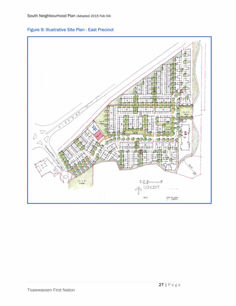
A preliminary example of what a precinct plan could look like is illustrated
for the East Precinct in Figure 9.
South Neighbourhood Plan (Adopted 2015 Feb 04)
27 | P a g e Tsawwassen First Nation
Figure 9: Illustrative Site Plan - East Precinct
South Neighbourhood Plan (Adopted 2015 Feb 04)
28 | P a g e Tsawwassen First Nation
8.6.1 DEVELOPMENT PRECINCTS POLICY
1 Within the South Neighbourhood Plan area, East, Central and Foreshore
Precincts are established as shown on Figure 2 for the purpose of allocating
density, Amenity Area calculations and future detailed planning.
8.6.2 EAST PRECINCT
1 A local public road is to be constructed at the time of subdivision within the
East Precinct, with a multi‐use path and emergency vehicle access to 16th
Avenue in Corporation of Delta, as conceptually illustrated on Schedule 1
and will be consistent with provisions of any existing access easements.
2 A mix of townhouse and apartment uses are allowed at densities of up to120
units per hectare for apartment use and 40 units per hectare for townhouse
use, calculated on a gross parcel area basis as described in Section 8.1.4
above.
3 A minimum of 15% of units in East Precinct are to be apartment units and a
minimum of 50% are to be townhouse units.
8.6.3 CENTRAL PRECINCT
1 A mix of townhouse and apartment uses are allowed at densities of up to
120 units per hectare for apartment use and 40 units per hectare for
townhouse use, calculated on a gross parcel area basis as described in
Section 8.1.4 above.
2 A minimum of 15% of multiple family units in Central Precinct are to be
apartment units and a minimum of 50% are to be townhouse units.
3 Zoning of Lot 7 (Tsatsu Service Station site) is to be brought into
conformance with the TFN Land Use Plan.
4 Where subdivision of a parcel or parcels in the Central Precinct is for Single
Family use in accordance with Zoning Regulation Section 4.6, the
subdivision applicant may defer provision of Amenity Area provided a
restrictive covenant is registered on title of the subdivided parcels which
restricts the parcel use to Single Family and records the amount of Amenity
Area deferral measured in land area.
South Neighbourhood Plan (Adopted 2015 Feb 04)
29 | P a g e Tsawwassen First Nation
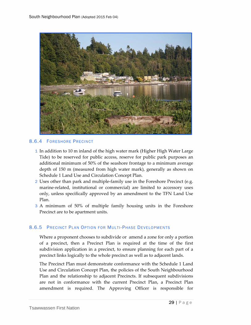
8.6.4 FORESHORE PRECINCT
1 In addition to 10 m inland of the high water mark (Higher High Water Large
Tide) to be reserved for public access, reserve for public park purposes an
additional minimum of 50% of the seashore frontage to a minimum average
depth of 150 m (measured from high water mark), generally as shown on
Schedule 1 Land Use and Circulation Concept Plan.
2 Uses other than park and multiple‐family use in the Foreshore Precinct (e.g.
marine‐related, institutional or commercial) are limited to accessory uses
only, unless specifically approved by an amendment to the TFN Land Use
Plan.
3 A minimum of 50% of multiple family housing units in the Foreshore
Precinct are to be apartment units.
8.6.5 PRECINCT PLAN OPTION FOR MULTI-PHASE DEVELOPMENTS
Where a proponent chooses to subdivide or amend a zone for only a portion
of a precinct, then a Precinct Plan is required at the time of the first
subdivision application in a precinct, to ensure planning for each part of a
precinct links logically to the whole precinct as well as to adjacent lands.
The Precinct Plan must demonstrate conformance with the Schedule 1 Land
Use and Circulation Concept Plan, the policies of the South Neighbourhood
Plan and the relationship to adjacent Precincts. If subsequent subdivisions
are not in conformance with the current Precinct Plan, a Precinct Plan
amendment is required. The Approving Officer is responsible for
South Neighbourhood Plan (Adopted 2015 Feb 04)
30 | P a g e Tsawwassen First Nation
determining whether a Precinct Plan is in conformance with the South
Neighbourhood Plan, and whether a subdivision application is in
conformance with a current Precinct Plan.
PRECINCT PLAN OPTION FOR MULTI-PHASE DEVELOPMENT POLICY
1 Where a zoning amendment application or subdivision application does not
encompass the entire area of a Precinct, a Precinct Plan shall be prepared for
the entire Precinct. A Precinct Plan shall:
a Provide a circulation layout for all public highways, lanes and
pedestrian facilities, including rights of way and typical road cross
sections.
b Demonstrate conformance to Schedule 1, Land Use and Circulation
Concept Plan and to the policies, guiding principles and vision of the
South Neighbourhood Plan.
c Identify proposed dwelling unit types, densities and demonstrate that
they conform to the residential mix and density requirements of the
South Neighbourhood Plan.
d Demonstrate how the Precinct Plan area connects with adjacent land
parcels for roads, pedestrian facilities, greenways and utility services
(including water, sanitary sewer, drainage, power, gas, phone and
cable, and district heating (where applicable)).
e Include with the first and subsequent subdivision or Development
Permit Applications, a table and supplementary information as
required by the Approving Officer showing cumulative conformance
to the use and density provisions of the South Neighbourhood Plan.
South Neighbourhood Plan (Adopted 2015 Feb 04)
31 | P a g e Tsawwassen First Nation
9 SUSTAINABILITY
The TFN Land Use Plan places a high level of emphasis on sustainability ‘to
create a remarkable community that is a centrepiece for sustainable
development’.
The Land Use and Circulation Concept Plan and policies respond to this
challenge in the following ways:
The allowable residential density has been retained from the current
multiple family zoning in place, a density which itself is supportive of active
transportation and transit options to single‐occupancy vehicle use.
A network of greenways provides convenient linkage within the South
Neighbourhood, to other parts of Tsawwassen First Nation, and to the
Metro region, and to Vancouver Island via the B.C. Ferries causeway.
A diversity of housing is ensured through the South Neighbourhood Plan
policies.
Park space is distributed throughout the plan area, within convenient
walking distance of users.
Road cross sections are adopted as part of Supplementary Specifications to
the MMCD which provide room for bio‐swales to clean stormwater prior to
South Neighbourhood Plan (Adopted 2015 Feb 04)
32 | P a g e Tsawwassen First Nation
discharge, sidewalks for pedestrians, and with room to provide for district
heating distribution, if demand warrants.
The South Neighbourhood Plan area, because of its proximity to new job
opportunities emerging in the commercial mixed‐use area makes it possible
for a significant number of work trips from the local area to be made by non‐
auto modes.
As a market‐oriented approach to land planning, the plan encourages
affordable housing for the general population, and thereby economic
sustainability.
Development Permit Guidelines for Multiple Family Housing form and
character throughout TFN is supported, as this may further sustainability
goals.
There is an opportunity to include TFN culture in the South Neighbourhood
Plan Public Realm, to pursue cultural sustainability. This expression of TFN
culture may consider the past, present and future TFN generations. The
South Neighbourhood Plan encourages the inclusion of cultural identity in
the public realm, particularly in the Foreshore Precinct.
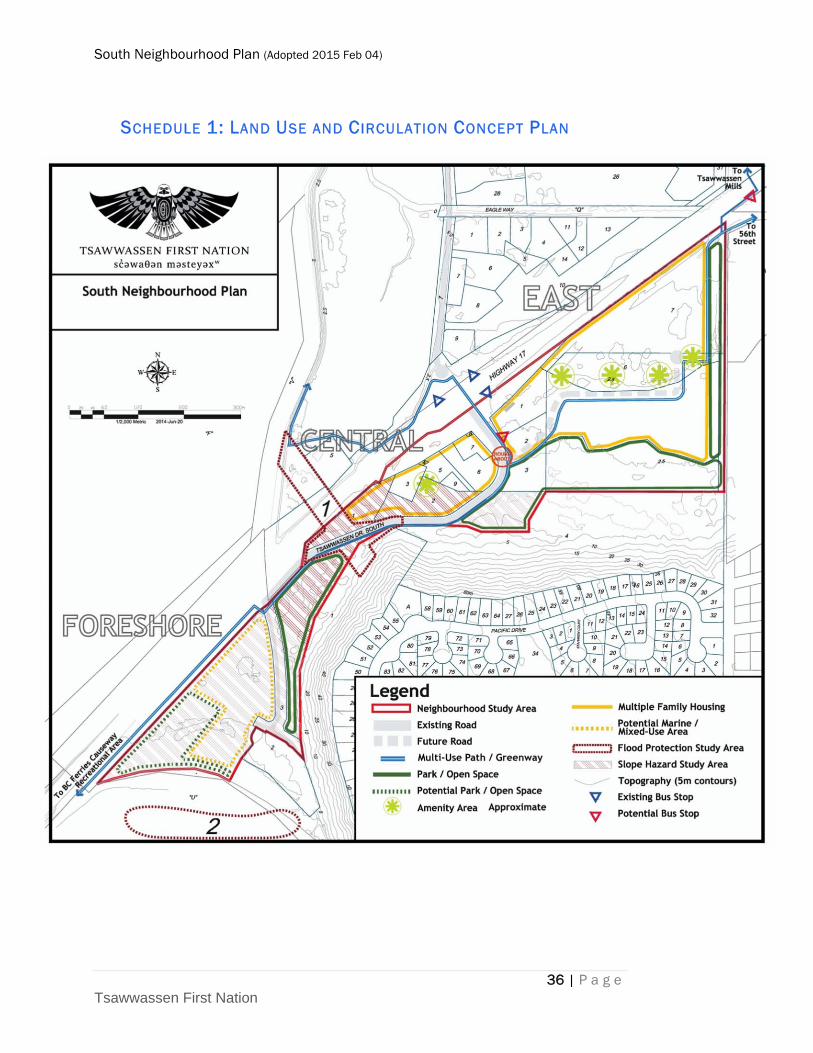
10 LAND USE AND CIRCULATION CONCEPT PLAN
The Land Use and Circulation Concept Plan (Schedule 1) is a visual
expression of the land use intents and policies described above, which in
turn have been based on the understanding of opportunities and constraints
from Section 1, initial consultations with stakeholders summarized in
Section 2, the Vision and Guiding Principles of Sections 3 and 4 respectively.
Schedule 1 defines key concepts such as location of multiple family housing
and park areas, road and multi‐use trail (greenway) locations, slope and
flood hazard study areas. Potential for future park area at the seashore and a
marine/mixed‐use option is broadly illustrated in the Foreshore Precinct.
Areas designated Multiple Family Residential comprise the majority of the
plan area, permitting Townhouse, Apartment and Single Detached units (in
the Central Precinct). It also includes associated roads.
Amenity Areas are to be provided through the subdivision process, with
locations to be determined at time of detailed planning, and in conformance
with the Amenity Area policies. Conceptual locations are shown on the
Land Use and Circulation Concept Plan.
The Concept Plan also illustrates a potential roundabout near the future
entry to the East Precinct. This has been discussed with both MOTI and a
potential development proponent of the East Precinct. It will help calm
traffic, and provides a convenient turn‐around for a future community
South Neighbourhood Plan (Adopted 2015 Feb 04)
33 | P a g e Tsawwassen First Nation
shuttle bus service which has been contemplated in the Internal Roads
Report (2013). A possible bus stop location is shown on Schedule 1 along
Tsawwassen Drive South immediately north of the roundabout. Other bus
stops are also shown, both existing and a future Route 620 stop on the south
side of Highway 17, near 48th Street. These bus stop locations will provide
convenient access for pedestrian and cyclists using TransLink transit
services from the South Neighbourhood.
Park areas reflect the intent of both TFN to conserve the Bluffs to beyond the
toe‐of‐slope, and the integrity of culturally significant lands and the great
blue heron colony.
Slope stability study areas are defined on a parcel basis, and will be refined
as development applications are made for specific parcels affected by the
designation. These are somewhat larger study areas than currently provided
in the Development Permit regulation, reflecting the parcel‐based approach.
Flood Protection Study areas are also defined on the Land Use and
Circulation Concept Plan. These areas are intended to reserve lands for
potential flood protection measures, as one component of long‐term
planning for flood protection at TFN. They are consistent with
recommendations for site‐specific flood protection studies provided in the
Integrated Rainwater Management Plan (2013). Implementation of any
recommended improvements will require multi‐agency cooperation on
problem definition and strategies. Lands therefore are being set aside for
potential works at this point in time. There may be no need for additional
works, but a site‐specific study is needed to establish viable options for the
long term, both technically and financially.
11 DEFINITIONS AND ABBREVIATIONS
Amenity means uses as defined in the TFN Land Use Planning and
Development Act Sec. 62 (2) including without limitation: community
development, including community halls, museums, cultural centres,
recreational facilities and schools; acquiring land for parkland or other
community amenities;
Apartment means units which are accessed by a common or shared entrance
facilities or interior passageway, where none of the dwelling units are rented
or are available for rent or occupation for periods of less than 30 days.
CGVD28 means Canadian Geodetic Vertical Datum 1928. In the TFN Slope
Stability/Fill Development Permit Regulation, CGD or Canadian Geodetic
Datum is equivalent to CGVD28. In November 2013 a new vertical datum
has been adopted in Canada, CGVD13. In Tsawwassen area, CGVD13
South Neighbourhood Plan (Adopted 2015 Feb 04)
34 | P a g e Tsawwassen First Nation
elevations will be approximately 0.2 m higher than CGVD28 elevations, so a
3.7 m CGVD13 elevation is the same as a 3.5 m CGVD28.
Development as defined within the Land Use Planning and Development
Act – Subdivision and Development Regulation.
Duplex means a residential building, divided horizontally or vertically into
two separate dwelling units (excluding secondary suites), each of which has
an independent entrance either directly from the outside or through a
common vestibule.
ESA means Environmentally Sensitive Area.
HHWLT means Highest High Water Large Tide, the average of the highest
high waters, one from each of 19 years of predictions. Each day has two high
tides, and the LT is the higher of the two daily high tides. For Tsawwassen,
HHWLT in 2013 is 2.0 m CGVD28 or 2.2 m CGVD13. Mean tide is 0.0 m
CGVD28.
IRMP means Integrated Rainwater Management Plan
m means metre
Metro Vancouver means Greater Vancouver Regional District
MOTI means British Columbia Ministry of Transportation and
Infrastructure
MMCD means Master Municipal Construction Document Design Guide
Manual (Platinum Edition 2009)
Single Detached means a detached building containing only one dwelling
unit designed exclusively for occupancy by one household. They may be a
single unit on a single lot, or a detached unit within a strata project.
Site Area means is a project site (e.g. townhouse or apartment) or a strata‐
title site (apartment, townhouse or single detached strata), including private
roads and common areas. The individual parcel (or lot) is the site area for a
single detached unit, not in a strata.
Substantial Completion for East Precinct construction means no later than
three years following registration of the subdivision that completes parcel
subdivision of 90% or more of the Multiple Family Housing area in the East
Precinct as shown on Schedule 1.
TFN means Tsawwassen First Nation
TFSI means Tsawwassen Fee Simple Interest
Townhouse means a building not more than three storeys high divided into
three or more dwelling units located side by side under one roof with
private exits or entrances to each dwelling, with each dwelling sharing at
South Neighbourhood Plan (Adopted 2015 Feb 04)
35 | P a g e Tsawwassen First Nation
least one common wall or party wall, and have direct access from the unit to
the exterior of the building, For purposes of the South Neighbourhood Plan,
the townhouse category also includes duplexes.
12 REFERENCES
Tsawwassen First Nation Internal TFN Roads Analysis Final Report,
December 5, 2013
Golder Associates, Landslide Risk Assessment English Bluff Area of TFN
Lands, Tsawwassen, BC, Report 09‐1411‐5079 Final Report, November 18,
2010
Greater Vancouver Regional District Board, Regional Growth Strategy
Bylaw 1136, 2010, Adopted July 29, 2011, as amended to Bylaw 1201, 2014
(May 23, 2014).
Tsawwassen First Nation Neighbourhood Plan Area Design Guidelines,
March, 2012
Tsawwassen First Nation Bulk Water and Sanitary Trunk Master Plan,
January 2014
Tsawwassen First Nation Integrated Rainwater Management Plan Final
Report, December 2013
Tsawwassen First Nation, Government of Canada, Government of British
Columbia, Tsawwassen First Nation Final Agreement, December, 2007
Tsawwassen First Nation Land Use Plan, January 12, 2009
Tsawwassen First Nation Supplementary Design Guideline and
Construction Specifications, January 2014
South Neighbourhood Plan (Adopted 2015 Feb 04)
36 | P a g e Tsawwassen First Nation
SCHEDULE 1: LAND USE AND CIRCULATION CONCEPT PLAN

South Neighbourhood Plan (Adopted 2015 Feb 04)
South Neighbourhood Plan (Adopted 2015 Feb 04)