Embed Size (px)
Citation preview

1
1
Advance Hydrologic Prediction Services
Flood Inundation Mapping http://water.weather.gov/ahps/inundation.php
Laurie G. HoganHydrologic Services Division
Eastern Region HeadquartersNOAA’s National Weather Service
September 21st & 22nd, 2010
Flood Warning User ForumsDelaware River Basin
2
Advance Hydrologic Prediction Services
Flood Inundation Mapping
• OverviewLocations available
Background Description
How the inundation libraries were created
• Strengths and Limitations
• Introduction to Interacting with the MapsTour of AHPS Web Pages
Downloads, Quick View of Maps in Google Earth
• Risk Mitigation Scenarios
• Future Plans

2
3
Overview
• AHPS Flood Inundation Maps are funded for 9 NWS River Forecast locations along the Delaware River main stem.
• 5 maps sets are now in AHPS: Trenton
Lambertville/New Hope
Stockton
Frenchtown
Riegelsville
• Inundation maps provide information on the spatial extent and estimated depth of flood waters in the vicinity of NWS River Forecast locations.
NWS AHPS River Observation and Forecast Locations
http://water.weather.gov/ahps2/index.php?wfo=phi
4
Background
• Recommendations FW-9 and FW-11 in the Task Force Action Agenda speak to the development of “Flood Inundation Mapping”.
• Funding ($65K)secured by DRBC initiatives for NWS web contractor

3
5
Inundation Map Creation
• U.S. Army Corps of Engineers, Philadelphia District developed inundation mapping for the Delaware River main stem from Trenton, NJ north to Port Jervis, NY.
NWS AHPS River Observation and Forecast Locations
http://water.weather.gov/ahps2/index.php?wfo=phi
NWS Quality Controlled and processed USACE model/GIS files to produce web ready inundation maps for 5 Delaware locations.
• 4 map libraries still in NWS QCprocess, TBD date for AHPS:
Phillipsburg/Easton
Belvidere
Montague
Port Jervis
6
AHPS Flood Inundation MappingStrengths and Limitations
Strengths:
Available to public via the Internet at reasonably quick display speeds.
Completely integrated with other NWS AHPS information
Multiple formats for download
Limitations:
Zoom capability currently limited
Only preset transportation layers, mapping overlays available.
4
7
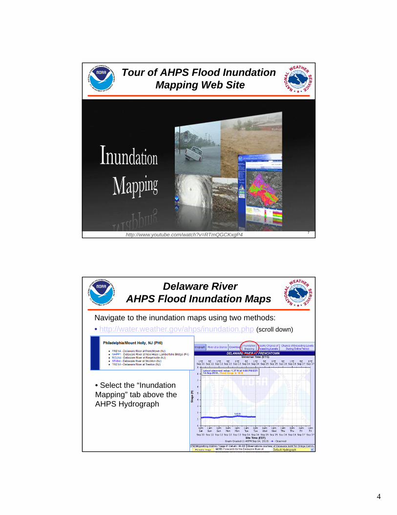
Tour of AHPS Flood InundationMapping Web Site
http://www.youtube.com/watch?v=RTmQGCKxgP4
8
Delaware River AHPS Flood Inundation Maps
Navigate to the inundation maps using two methods:
• http://water.weather.gov/ahps/inundation.php (scroll down)
• Select the “Inundation Mapping” tab above the AHPS Hydrograph

5
9
• Standard View
Delaware River AHPS Flood Inundation Maps
10
• Detailed View
Delaware River AHPS Flood Inundation Maps

6
11
Delaware River AHPS Flood Inundation Maps
User Guide available (.pdf file)
12
AHPS Flood Inundation MapsDownloads
http://grass.fbk.eu/index.phphttp://www.esri.com/software/arcgis/arcreader/index.htm Maps.google.com/earthviewhttp://worldwind.arc.nasa.gov/java/
7
13
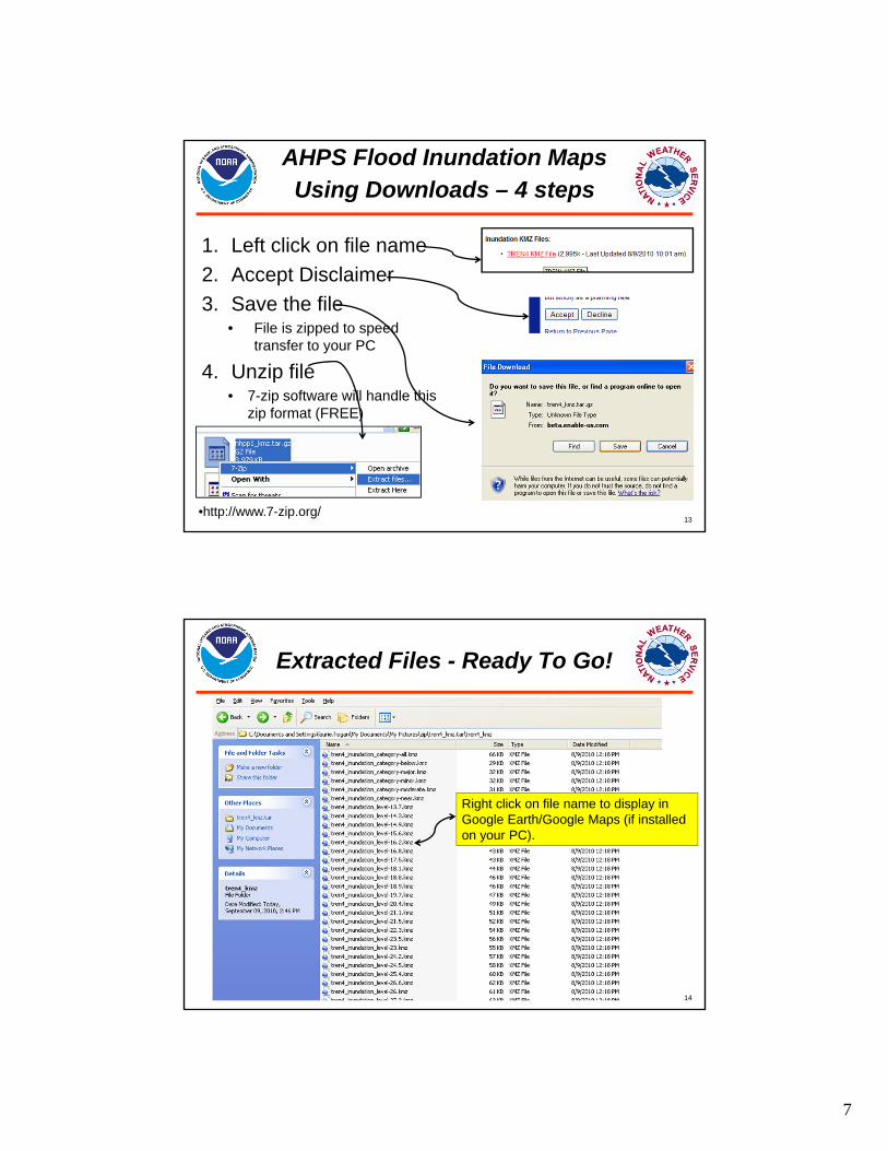
1. Left click on file name
2. Accept Disclaimer
3. Save the file• File is zipped to speed
transfer to your PC
4. Unzip file• 7-zip software will handle this
zip format (FREE)
AHPS Flood Inundation Maps Using Downloads – 4 steps
•http://www.7-zip.org/
14
Extracted Files - Ready To Go!
Right click on file name to display in Google Earth/Google Maps (if installed on your PC).

8
15
Google Earth Inundation DepictionStage 15.9 ft at New Hope
Zoomed in
16
Scenario: Road Closure Decisions
Task: Identify locations that will require road closure in the next 2-4 hours.
Q. What NWS forecast point inundation map covers my area of concern?
Q. When does the hydrograph forecast flooding; what categories are forecast?
Record assessment for future use.

9
17
AHPS Standard View Road Closures
When the NWS forecasts Major Flooding, plans are needed for road closures along Railroad Ave. and near Hawk St. in Frenchtown, NJ.
Location: Frenchtown, NJ
18
Scenario: Critical Facility Risk Assessment
Task: Identifying nursing homes at risk for flooding in the New Hope/Lambertville area.Q. Where are the nursing homes?
Q. What would minor flooding vs. major flooding look like in the vicinity of the nursing homes?
Q. How many persons are in each facility?
Q. If evacuations are needed, what lead time is needed for numbers/types of individuals to relocate?
Q. What transportation routes would be available?
Record assessment for future use.

10
19
For this scenario, Nursing Home #1 is not at risk for flooding from main stem Delaware River
Nursing Home #2 is at risk for flooding at NWS minor flood stage. Significant transportation issues occur at minor flood stage.
Nursing Home #3 is at risk for flooding at NWS major flood stage. Significant transportation issues occur at minor flood stage.
20
Scenario: Major Flooding ForecastNWS compares to April 2005
11
21
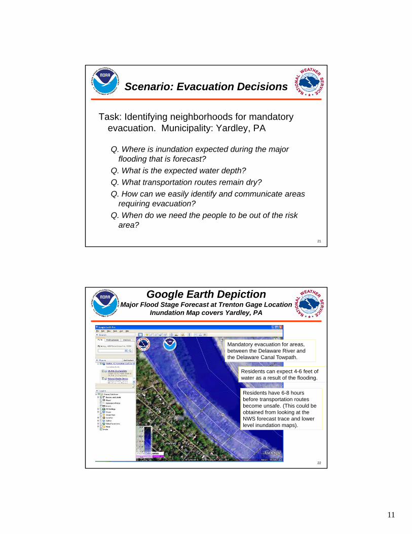
Scenario: Evacuation Decisions
Task: Identifying neighborhoods for mandatory evacuation. Municipality: Yardley, PA
Q. Where is inundation expected during the major flooding that is forecast?
Q. What is the expected water depth?
Q. What transportation routes remain dry?
Q. How can we easily identify and communicate areas requiring evacuation?
Q. When do we need the people to be out of the risk area?
22
Google Earth DepictionMajor Flood Stage Forecast at Trenton Gage Location
Inundation Map covers Yardley, PA
Mandatory evacuation for areas, between the Delaware River and the Delaware Canal Towpath.
Residents can expect 4-6 feet of water as a result of the flooding.
Residents have 6-8 hours before transportation routes become unsafe. (This could be obtained from looking at the NWS forecast trace and lower level inundation maps).

12
23
AHPS Flood Inundation Mapping
• Summary5 Delaware River Locations now available
Last 4 Delaware River locations available late 2010/early 2011
Inundation maps are available in web browsers - fully integrated with other AHPS information
Downloads, Utilization of Maps in a wide variety of software applications
• Risk Mitigation ScenariosNWS assistance available
• Future Plans
24
AHPS Flood Inundation Mapping
Thank you for spending your time with us today.
Acknowledgement:
The NWS AHPS Flooding Inundation Maps were made possible by the partnership efforts of the USACE-Philadelphia District, DRBC, and the USGS. The NWS greatly appreciates the contributions of all parties in this effort!!
Contact information of the presenter: [email protected]