Embed Size (px)
Citation preview

BY ORDER OF THE COMMANDER
12TH FLYING TRAINING WING
(AETC)
12TH FLYING TRAINING WING
INSTRUCTION
15-101
2 JANUARY 2018
Weather
WEATHER SUPPORT
COMPLIANCE WITH THIS PUBLICATION IS MANDATORY
ACCESSIBILITY: Publications and forms are available on the e-Publishing website at
www.e-publishing.af.mil for downloading or ordering.
RELEASABILITY: There are no releasability restrictions on this publication.
OPR: 12 OSS/OSW
Supersedes: 12FTWI 15-101,
30 May 2014
Certified by: 12 OG/CC
(Col Jupe A. Etheridge)
Pages: 85
This instruction implements Air Force Policy Directive (AFPD) 15-1, Air Force Weather
Operations, AFI 10-206, Operational Reporting, AFI 15-114, Functional Resource and Weather
Technical Performance Evaluation, AFI 15-128, Air Force Weather Roles and Responsibilities,
AFI 10-2501, Air Force Emergency Management Program Planning and Operations; Air Force
Manual (AFMAN) 10-2504, Air Force Incident Management Guidance for Major Accidents and
Natural Disasters, AFMAN 15-111, Surface Weather Observations; AFMAN 15-124,
Meteorological Codes; AFMAN 15-129, Volume 1, Air and Space Weather Operations–
Characterization, and, AFMAN 15-129, Volume 2, Air and Space Weather Operations–
Exploitation. It establishes responsibilities and weather support procedures, general information
including weather services to include weather observations and forecasts, weather watches,
warnings, and advisories (WWAs), space weather, supported services, dissemination of
information, and reciprocal support. See Attachment 1 for a Glossary of Reference & Supporting
Information. This instruction applies to Joint Base San Antonio-Randolph (JBSA-Randolph)-
based 12th Flying Training Wing (FTW) and subordinate units, in addition to mission partners
co-located at JBSA-Randolph. Ensure that all records created as a result of processes prescribed
in this publication are maintained IAW Air Force Manual (AFMAN) 33-363, Management of
Records, and disposed of IAW Air Force Records Information Management System (AFRIMS)
Records Disposition Schedule (RDS). Refer recommended changes and questions about this
publication to the Office of Primary Responsibility (OPR) using the AF Form 847,
Recommendation for Change of Publication; route AF Forms 847 from the field through the
appropriate functional chain of command. This publication may be supplemented at any level,

2 12FTWI15-101 2 JANUARY 2018
but all direct supplements must be routed to the OPR of this publication for coordination prior to
certification and approval.
SUMMARY OF CHANGES
This document has been substantially revised and must be completely reviewed. The order of
chapters have rearrangement to facilitate better organization. Chapter rearrangements from the
previous publication include: Chapter 1, Roles & Responsibilities was previously listed as
General Information. Chapter 2, Weather Flight Operations, was identified in Chapter 1 of the
previous publication. Chapter 3, Weather Equipment, was presented as Chapter 7. Runway
numbers 14L, 32R, 14R and 32L re-designated runways numbers 15L, 33R, 15R and 33L
(Section 3.2). Weather equipment to include the Gibson Ridge Radar Software (Section
3.2.2.2.) and FMQ-23, Automatic Meteorological Station (Section 3.2.5.2) and FMQ-23
weather sensor limitations (Section 3.2.6.1.) have been added. Chapter 4, Airfield Services
Function was listed as Chapter 2, Airfield Services and the Cooperative Weather Watch
requirement to report tower visibility in weather observations, when conditions warrant was
added (Section 4.7.4.2.4.). Chapter 5, Mission Integration Function was reflected as Chapter 3,
Mission Services, Chapter 6, Staff Integration Function was reflected as Chapter 4, Staff
Weather Support. Chapter 7, Emergency Actions was listed as Chapter 5, Chapter 8, Resource
Protection was registered as Chapter 6. The customer desired lead times for forecasted WWAs in
Tables 8.1., 8.2., 8.3. have been significantly changed to coincide with default thresholds in
AFMAN 15-129, Volume 1. Chapter 9, Resource Protection was listed as Chapter 8.
Organizational re-designations are reflected to include the re-designation of the Air Force
Weather Agency (AFWA) to the 557th Weather Wing (557 WW) and various units within the
502nd Air Base Wing (ABW), special observation criteria for reporting tower visibility added (
A2.14.). Index of Thermal Stress Reference Value Chart has been modified in accordance with
AFI 48-151 (Figure A6.1.).

12FTWI15-101 2 JANUARY 2018 3
Chapter 1— ROLES & RESPONSIBILITIES. 8
1.1. Overview. ............................................................................................................... 8
1.2. Concept of Operations. .......................................................................................... 8
1.3. The 26 OWS duty priorities are noted within Tables 1. ......................................... 8
Table 1.1. 26 OWS Weather Forecaster Duty Priorities. ......................................................... 8
Table 1.2. 26 OWS Flight weather Briefer Duty Priorities...................................................... 9
Table 1.3. 12 OSS/OSW (WF) Duty Priorities. ....................................................................... 10
Chapter 2— WEATHER FLIGHT OPERATIONS. 11
2.1. General. ................................................................................................................... 11
2.2. Flight Location, Hours of Operation & Contact Information. ................................ 11
Table 2.1. WF (12 OSS/OSW) Duty Phone Numbers. ............................................................ 11
Table 2.2. WF (12 OSS/OSW) Duty Hours. ............................................................................ 11
2.3. Continuity of Operations (COOP). ........................................................................ 11
2.4. Post Mission Analysis & Feedback. ...................................................................... 12
2.5. Release of Information to Non-DoD Agencies or Individuals. ............................. 12
Chapter 3— WEATHER EQUIPMENT 13
3.1. General. .................................................................................................................. 13
3.2. Meteorological (Weather) Equipment .................................................................... 13
3.3. Communications Equipment. .................................................................................. 14
Table 3.1. Primary ADS (e.g., JET) Users and Contact Numbers. .......................................... 15
Table 3.2. Weather Flight Hotlines. ......................................................................................... 16
3.4. The 12 OSS/OSW Weather Webpage. .................................................................. 16
3.5. Equipment ............................................................................................................... 16
Table 3.3. Weather Equipment Maintenance. .......................................................................... 16
3.6. Restoral Priorities. ................................................................................................. 16
Table 3.4. Weather Equipment Restoral Priorities. ................................................................. 16
3.7. Building Power. ..................................................................................................... 17
Chapter 4— AIRFIELD SUPPORT FUNCTION 18
4.1. General. ................................................................................................................... 18

4 12FTWI15-101 2 JANUARY 2018
4.2. Airfield Support Element (ASE). ........................................................................... 18
4.3. Airfield Weather Observations. .............................................................................. 18
4.4. Weather Watch. ..................................................................................................... 20
4.5. Backup Dissemination Procedures ......................................................................... 20
Table 4.1. WF Backup Dissemination Listing. ........................................................................ 21
4.6. Terminal Aerodrome Forecast (TAF). .................................................................... 21
4.7. Cooperative Weather Watch. .................................................................................. 21
4.8. Meteorological Watch (METWATCH). ................................................................. 23
Chapter 5— MISSION INTEGRATION FUNCTION 25
5.1. General. .................................................................................................................. 25
5.2. Mission Weather Products (MWPs). ..................................................................... 25
5.3. Mission Support Element (MSE). .......................................................................... 25
5.4. Area of Responsibility (AOR). .............................................................................. 25
5.5. Weather Impacts on Supported Customers. ............................................................ 25
Table 5.1. T-6 Weather Sensitivities. ....................................................................................... 26
Table 5.2. T-38 Weather Sensitivities. ..................................................................................... 27
Table 5.3. T-1 Weather Sensitivities. ....................................................................................... 28
5.6. Mission Execution Forecast (MEF). ...................................................................... 28
5.7. MWP Amendments. ............................................................................................... 29
Table 5.4. Randolph MEFF Ceiling Amendment/Specification Criteria. ................................ 29
Table 5.5. Randolph MEFF Visibility Amendment/Specification Criteria. ............................ 29
Table 5.6. Fax Numbers for Local Agencies. .......................................................................... 30
5.8. Mission Watch (MISSIONWATCH). ................................................................... 30
5.9. MWP Verification. ................................................................................................. 30
5.10. Off-station Support for 12 FTW Aircraft. .............................................................. 30
5.11. Flight Weather Briefings......................................................................................... 31
5.12. Pilot-to-Metro Service (PMSV). ............................................................................ 31
5.13. Distinguished Visitor (DV) Support. ..................................................................... 31
5.14. Space Weather ........................................................................................................ 31

12FTWI15-101 2 JANUARY 2018 5
Chapter 6— STAFF INTEGRATION FUNCTION 33
6.1. General. .................................................................................................................. 33
6.2. 12 FTW/MX Daily Standup/Staff Briefing. .......................................................... 33
6.3. 12 FTW/MX Ops Flimsy. ...................................................................................... 33
6.4. Mass Deployment Briefings. ................................................................................. 33
6.5. Instrument Refresher Course (IRC) Weather Briefings. ........................................ 33
6.6. Air Traffic Controller (ATC) Observer Training/Orientation. .............................. 33
6.7. Quarterly Supervisor of Flying (SOF) Briefings. .................................................. 33
6.8. SOF Orientation Briefings. .................................................................................... 33
6.9. Pre-Deployment Concept Briefings. ...................................................................... 33
6.10. Climatology Support. ............................................................................................. 34
6.11. Flight Information Publications (FLIPs) Updates. ................................................. 34
6.12. Wing Inspection Team (WIT). ............................................................................... 34
6.13. Chemical, Biological, Radiological, Nuclear, and High-yield Explosive
(CBRNE) Coordination. ......................................................................................... 34
6.14. Weather METRICs. ............................................................................................... 34
6.15. Installation Data Pages (IDP). ................................................................................ 34
Chapter 7— EMERGENCY ACTIONS 35
7.1. Alternate Operating Location (AOL). ..................................................................... 35
Table 7.1. Agencies/Personnel Notified of Changes in Operating Location. .......................... 35
7.2. Aircraft Emergencies. ............................................................................................. 36
7.3. Severe Weather Action Plan/Procedures (SWAP). ................................................ 37
7.4. Operational Reporting (OPREP). ........................................................................... 37
7.5. Recalling On-Call Personnel................................................................................... 38
7.6. Backup Support to 26 OWS. .................................................................................. 38
CHAPTER 8— RESOURCE PROTECTION 39
8.1. General. ................................................................................................................... 39
8.2. Delineation of Duties. ............................................................................................. 39
8.3. Unit Requirements. ................................................................................................ 39

6 12FTWI15-101 2 JANUARY 2018
8.4. Watches, Warnings, & Advisories (WWAs). ........................................................ 39
8.5. Weather Watches. ................................................................................................... 40
Table 8.1. Weather Watches for JBSA-Randolph. .................................................................. 40
8.6. Weather Warnings. ................................................................................................ 42
Table 8.2. Weather Warnings for JBSA-Randolph. ................................................................. 43
8.7. Weather Advisories. ................................................................................................ 45
Table 8.3. Forecast and Observed Weather Advisories for JBSA-Randolph. ......................... 46
8.8. Dissemination Procedures. ...................................................................................... 46
8.9. Base Siren Activation. ............................................................................................ 46
8.10. Tropical Weather Activity. .................................................................................... 46
Table 8.4. Hurricane Conditions and Tropical Cyclone Conditions of Readiness. ................. 47
8.11. Flash Flood Warnings. ............................................................................................ 47
8.12. Actions by Base Agencies. ..................................................................................... 47
Chapter 9— RECIPROCAL SUPPORT 48
9.1. General. ................................................................................................................... 48
9.2. 502 ABW/CP (Command Post) will: ...................................................................... 48
9.3. 502 CS will: ............................................................................................................ 48
9.4. 502 SFS will: ......................................................................................................... 48
9.5. 502 CES will: .......................................................................................................... 48
9.6. 502 OSS/OSW will: ............................................................................................... 48
9.7. 359 AMDS will: ...................................................................................................... 49
9.8. 99th, 435th, 559th, 560th FTS and 415 FLTF will: ................................................ 49
9.9. 12OSS/OSM will: ................................................................................................... 49
9.10. 12 OSS/OSA will: .................................................................................................. 49
9.11. All Weather Support Recipients will: ..................................................................... 49
Attachment 1— GLOSSARY OF REFERENCES AND SUPPORTING INFORMATION 50
Attachment 2— SPECIAL AND LOCAL OBSERVATION CRITERIA 54
Attachment 3— WEATHER OBSERVATION AND PIREP FORMATS 57
Attachment 4— TAF SPECIFICATION / AMENDMENT CRITERIA AND FORMATS 59

12FTWI15-101 2 JANUARY 2018 7
Attachment 5— WEATHER WATCH, WARNING AND ADVISORY (WWA) FORMATS 61
Attachment 6— INDEX OF THERMAL STRESS (ITS) CHART 63
Attachment 7— WIND CHILL INDEX (WCI) CHART 64
Attachment 8— TROPICAL STORM / HURRICANE BULLETIN 65
Attachment 9— TERMINAL/AREA WEATHER ADVISORY NOTIFICATION
DIAGRAM 66
Attachment 10— TERMINAL WEATHER WATCH/WARNING NOTIFICATION
DIAGRAM 67
Attachment 11— WEATHER IMPACTS ON AND PROTECTIVE ACTIONS BY UNITS 68
Attachment 12— MISSION EXECUTION FORECAST (MEF) FLIMSY (MEFF) 78
Attachment 13— DAILY OPERATIONS AND MAINTENANCE FLIMSY 82
Attachment 14— 12TH FLYING TRAINING WING OPERATIONS WEATHER BRIEF 83
Attachment 15— 12 FTW MILITARY OPERATING AREAS (MOAs) / LOW-LEVEL
ROUTES 84
Attachment 16— AIRFIELD AUTOMATED WEATHER SENSOR LOCATIONS 85

8 12FTWI15-101 2 JANUARY 2018
Chapter 1
ROLES & RESPONSIBILITIES.
1.1. Overview. The 26th Operational Weather Squadron (26 OWS) and the 12th Operations
Support Squadron Weather Flight (12 OSS/OSW or WF) are designated as JBSA-Randolph’s
Weather Characterization Unit (CU) and Exploitation Unit (EU), respectively. Both units
provide and arrange weather support to the 12 FTW and all associated units assigned to and
located at JBSA-Randolph. This instruction establishes the requirements and procedures
pertaining to the12 OSS/OSW’s weather support and will be reviewed no less than biennially.
1.1.1. Characterization is the process of understanding a weather environment’s transition,
intensity, and significant features over an area. CUs are the primary source in collecting,
analyzing, and predicting large scale weather patterns in an air and space environment. CUs
communicate with EUs within their Area of Responsibility (AOR).
1.1.2. Exploitation is the ability to minimize the impact of environmental threats while
simultaneously capitalizing on conditions that maximize operational efficiency. EUs are the
primary weather source for integrating and tailoring information to the unit they have
responsibility over.
1.1.3. EU & CU definition, roles, and responsibilities are outlined and defined within AFI
15-128, AFMAN 15-129V1, Air and Space Weather Operations–Characterization, and
AFMAN 15-129V2, Air and Space Weather Operations–Exploitation.
1.2. Concept of Operations. The 26 OWS is the authoritative source for weather analysis
while the WF integrates that analysis into JBSA-Randolph’s planning process. Both units work
in conjunction to provide the best weather service supporting mission needs.
1.2.1. The 26 OWS is located at Barksdale AFB, Louisiana and provides regional and
operational-level weather products and information to units within the Southeastern
Continental United States (SECONUS). The 26 OWS also performs a continuous monitoring
of the SECONUS’s terrestrial and space weather environment called Meteorological Watch
(METWATCH). METWATCH is crucial to JBSA-Randolph receiving resource protection
notifications, forecasts, updates, and pertinent data.
1.2.2. The WF is the focal point for all weather support to JBSA-Randolph. The WF alerts
decision makers on mission-limiting environmental factors potentially impacting mission
execution. This process is called MISSIONWATCH.
1.3. The 26 OWS duty priorities are noted within Tables 1. 1. and 1.2. The WF duty
priorities are noted within Table 1.3. The WF and 26 OWS personnel follow these duty priorities
to save and preserve life and property when the environment poses imminent danger.
Table 1.1. 26 OWS Weather Forecaster Duty Priorities.
Priority Duty Priority
1 Perform 26 OWS Emergency War Order (EWO) Taskings
2 Respond to aircraft/ground emergencies/mishaps (responding consists of obtaining
data specific to incident. Conducting data save is “other routine weather
requirements”)

12FTWI15-101 2 JANUARY 2018 9
3 Execute OWS Evacuation/Continuity of Operations
4 Respond to Pilot to Metro Service (PMSV) Contacts
5 Disseminate Urgent (UUA) Pilot Reports (PIREPs)
6 Provide weather products for Force Protection (WWAs, etc.,)
7 Assist other regions in providing weather products for Force Protection as required
8 Ensure horizontal consistency of WWAs, FITL products and TAFs
9 Prepare and Disseminate MOAFs/JOAFs as required
10 Prepare and Disseminate Terminal Aerodrome Forecasts
11 Disseminate Routine (UA) PIREPs
12 Monitor Plan of The Day
13 Conduct 15-minute spin-up
14 Accomplish other routine weather requirements (5-day forecasts, Quality
Assurance, Forecast Reviews, Lessons Learned, data saves)
15 Participate in shift change
16 Accomplish administrative tasks
Table 1.2. 26 OWS Flight weather Briefer Duty Priorities.
Priority Duty Priority
1 Perform 26 OWS Emergency War Order (EWO) Taskings
2 Respond to aircraft/ground emergencies/mishaps (responding consists of
obtaining data specific to incident. Conducting data save is “other routine
weather requirements”)
3 Execute OWS Evacuation/Continuity of Operations
4 Provide products and services for combat, contingency operations, Peace-Support
Operations, AFRCC missions (text bulletins, MOAFs)
5 Respond to Pilot to Metro Service (PMSV) Contacts
6 Disseminate Urgent (UUA) Pilot Reports (PIREPs)
7 Prepare and disseminate peacetime/exercise regional and operational-level
alphanumeric Products (MOAFs/JOAFs)
8 Conduct MISSIONWATCH for “At Risk” missions
9 Provide scheduled flight weather briefings, identify Lead Weather Unit (LWU)
10 Conduct MISSIONWATCH for “Some Risk” missions
11 Provide non-scheduled flight weather briefings
12 Disseminate Routine (UA) PIREPs
13 Conduct routine MISSIONWATCH
14 Provide other air and space weather products, information, and weather briefings
15 Accomplish other routine weather requirements (Quality Assurance, metrics, data
saves, etc.)
16 Accomplish administrative tasks

10 12FTWI15-101 2 JANUARY 2018
Table 1.3. 12 OSS/OSW (WF) Duty Priorities.
Priority Duty Priority
1 Perform Emergency War Order (EWO) Tasks
2 Execute WF Evacuation
3 Respond to Aircraft/Ground Emergencies or Mishaps
(to include Emergency Support to Supervisors of Flying (SOFs))
4 Issue Imminent Hazardous Weather (to include Issuing Severe Weather Warnings
and/or Supplementing FMQ-19 Observations, as required)
5 Respond to Pilot-to-Metro Service (PMSV) Contacts
6 Disseminate Non-Imminent Weather Warnings, Watches and/or Forecast
Advisories
7 Provide Routine Support to SOFs
8 Disseminate Urgent (UUA) Pilot Reports (PIREPs) and/or Special AIREPs Locally
and to 26 OWS
9 Take and Disseminate Weather Observations Locally and to 26 OWS (to include
Backup of FMQ-19 Observations, as required)
10 Disseminate Observed Weather Advisories
11 Perform METWATCH / MISSIONWATCH Support
12 Perform Severe Weather Actions Procedures (SWAP )
13 Prepare and Disseminate Mission Execution Forecasts (MEFs)
14 Disseminate Routine PIREPs Locally and to 26 OWS
15 Transmit Surface Observations and PIREPs/AIREPs Longline
16 Provide Scheduled Flight Weather Briefings
17 Provide Non-Scheduled Flight Weather Briefings
18 Provide Other Weather Products, Information and/or Briefings
19 Accomplish Other Routine Weather Tasks (e.g., Training)
20 Accomplish Other Routine Tasks

12FTWI15-101 2 JANUARY 2018 11
Chapter 2
WEATHER FLIGHT OPERATIONS.
2.1. General. The WF’s daily operations provide a set schedule, contact information, and
alternate methods of ensuring mission success. WF operations can be broken down into three
functions: Airfield Services, Mission Integration, and Staff Integration. These functions can be
found in greater detail in their respective chapters (Chapter 4, 5, & 6). WF leadership provides
and coordinates all weather support services to JBSA-Randolph and its tenant units IAW AFI 15-
128.
2.2. Flight Location, Hours of Operation & Contact Information. The WF’s primary
operating location is 1350 5th Street East; 1st Floor, Bldg 8 (Base Operations). The WF is a
limited duty station with operating hours primarily dictated by the 12 OG flying schedule.
2.2.1. The WF’s primary phone numbers are listed in Table 2.1; DSN prefix is 487-.
Table 2.1. WF (12 OSS/OSW) Duty Phone Numbers.
Functional Area Phone Number
Airfield Services Comm (210) 652-3040/3538 (Fax -2686)
Mission Integration Comm (210) 652-3040/3538 (Fax -2686)
Staff Integration (Flight Chief / Supervisor) Comm (210) 652-5329/3040 (Fax -2686)
2.2.2. Organizational Email Address: [email protected].
2.2.3. Operating Hours:
2.2.4. The WF aligns duty/operating hours IAW airfield operating hours. Table 2.2. depicts
standard airfield and corresponding WF operating hours. There may be short-notice changes
to WF hours IAW changes to airfield hours.
Table 2.2. WF (12 OSS/OSW) Duty Hours.
Day Airfield Open WF (12 OSS/OSW) Open
Mon-Fri 0700 - 1900L 0000–2400L
Holidays/Weekends Closed 0000–2400L
2.2.5. During off-duty hours, the 26 OWS will provide weather support. The 26 OWS can be
reached at: DSN: 331-2625, commercial: (318) 529-2625.
2.2.6. On-call weather technicians are contacted during Severe Weather Action Plan
(SWAP) procedures through the 502 Air Base Wing Command Post (CP) at: DSN: 471-
9363, commercial: (210) 221-9363.
2.2.7. A WF technician will be present at least 2 hours prior whenever the airfield is open
until airfield closure.
2.2.8. Staff integration services are available on normal duty days from 0730-1700L and can
be extended, as required.
2.3. Continuity of Operations (COOP). COOPs are periods of time where a weather unit’s
operations are supported by another unit. COOPs ensure proper operations can continue if

12 12FTWI15-101 2 JANUARY 2018
hindered or in the event of a disaster or an emergency. Both the WF and 26 OWS provide and
practice COOP procedures to ensure continuity. COOPs for the WF pertaining to alternate
observing site are outlined in Chapter 7.
2.4. Post Mission Analysis & Feedback. IAW AFMAN 15-129V2, units that regularly utilize
weather support from the WF are encouraged to provide feedback.
2.4.1. This information ensures proper quality assurance, provides a metrics database of
forecast accuracy, and gauges forecasting strengths and weaknesses. Formal/informal
feedback methods include:
2.4.2. Emailing through SharePoint or the 12 OSS/OSW Weather Flight Inbox.
2.4.3. PIREPs transmitted via PMSV.
2.4.4. SOF and Operations Supervisor End of Day reports.
2.4.5. Face-to-face feedback after any briefing.
2.4.6. Provide information to WF.
2.5. Release of Information to Non-DoD Agencies or Individuals. Weather information will
not be released to non-DoD agencies, individuals or the public without approval from 502
ABW/PA (Public Affairs) and 502 SFLSG/JA (Legal). Any related issues should be coordinated
through the WF Chief or Supervisor.

12FTWI15-101 2 JANUARY 2018 13
Chapter 3
WEATHER EQUIPMENT
3.1. General. This chapter provides a brief description on the wide range of equipment to
determine the current state of the atmosphere and formulate forecasts. Additionally, this chapter
provides information on back-up systems, maintenance, and restoral priorities.
3.2. Meteorological (Weather) Equipment . The WF uses a wide range of equipment to
determine the current state of the atmosphere. These critical systems are used continuously to
provide customers the most timely, accurate and relevant weather intelligence possible.
3.2.1. FMQ-19. FMQ-19, Automatic Meteorological Station (AMS). The FMQ-19 is an
automated, integrated system of weather sensors, processors and communications and data
automation components that continually measure weather conditions to provide reliable, real-
time weather data in support of flying and other operations and resource protection. The
FMQ-19 measures or detects: wind speed and direction; temperature and dew point; pressure;
prevailing visibility and present weather; cloud amounts and heights; precipitation; freezing
rain and lightning strikes. JBSA-Randolph has an FMQ-19 Automated Observing System
(AOS) comprised of 1 primary weather sensor unit (located near runway 15L) and 3
discontinuity sensor suites (located near runways 33R, 15R and 33L). (Attachment 16):
Primary Sensor Group (near runway 15L) with wind, visibility, ambient light, freezing rain,
precipitation (type and amount), temperature, dewpoint, pressure, cloud and lightning
detection sensors; Discontinuity Sensor Group 1 (near runway 33R) with wind, visibility and
cloud sensors; Discontinuity Sensor Group 2 (near runway 15R), with wind, visibility and
cloud sensors; and Discontinuity Sensor Group 3 (near runway 33L) with wind and visibility
sensors.
3.2.2. Kestrel . The Kestrel is a hand-held, commercial off-the-shelf (COTS) weather
instrument that provides measurements of 10 different environmental conditions: wind speed,
temperature, wind chill, humidity, heat index, dewpoint, wet bulb, barometric pressure,
pressure altitude and density altitude. It serves as the primary back-up for most of the FMQ-
19 sensors.
3.2.3. Radar and Lightning Detection Systems. Lightning data is received by the FMQ-19
and other sources:
3.2.3.1. Air Force Weather Webpage (AFW-WEBS). This is a java web application that
provides weather products for Air Force use only. While there are many products
available, AFW-WEBS can also track lightning strikes. The system is also tied into the
National Lightning Data Network (NLDN), but is dependent on local area network
(LAN) access.
3.2.3.2. Weather Tap. A subscription weather service which provides near real-time
radar, high-resolution satellite imagery, lightning strike data.
3.2.3.3. Gibson Ridge Radar Software. The WF utilizes two software programs to
interpret NEXRAD radar data: (1) GR2Analyst and (2) GRLevel3. Weather technicians
use this software to analyze complex radar signatures, obtain detailed information on
storm intensity, movement, outflow boundaries, internal circulation, and wind flow.

14 12FTWI15-101 2 JANUARY 2018
Weather technicians routinely incorporate the signatures into daily operations and
resource protection. Radar products are used extensively during severe weather events
monitoring the airfield, low-level routes, and military operating areas (MOAs). Backup
radar imagery is available via numerous military and commercial websites.
3.2.4. Vaisala Digital Barometer . The Vaisala Barometer is a fully compensated, COTS
digital barometer designed to cover a wide range of environmental pressures and
temperatures. It serves as a back-up for the FMQ-19 barometers.
3.2.5. Weather Equipment at Randolph Auxiliary Airfield (Seguin) . The following
equipment is in use at Seguin:
3.2.5.1. FMQ-13V2, Digital Wind Sensor . There are two FMQ-13V2 wind sensors at
Randolph’s Auxiliary Field (Seguin). One is located near the touchdown end of Runway
13 and the other is located near the touchdown end of Runway 31. The digital readout
displays are in the northwest and southeast runway control structures (RCS).
3.2.5.2. FMQ-23, Automatic Meteorological Station (AMS) . The FMQ-23 is a
complete system of outdoor and indoor equipment for measuring weather-related
conditions to support flight operations and safety. The outdoor equipment unit (located
near Runway 13) includes sensor groups (precipitation, visibility, cloud height,
temperature and relative humidity, pressure and lightning detection), towers and support
structures, Data Collection Platforms (DCP), communication equipment, and
uninterruptible AC power. Indoor equipment includes the Central Processing Station
(CPS) and the Airport Weather Advisor® (AWA®) software (located at the Fire Station
in Bldg 415).
3.2.6. Limitations of Airfield Weather Sensors .
3.2.6.1. FMQ-19 and FMQ-23 (Seguin) . The FMQ-19 and FMQ-23 are unable to
observe hail (size), tornado activity, volcanic ash or visibility < 1/4 SM. In the event any
of these phenomena occur within a reportable distance, the WF technician will
supplement the Randolph observation only, with the appropriate details. In addition, the
FMQ-19 and FMQ-23 are most accurate when weather is stable. In rapidly changing
conditions of sky cover and visibility, observations may lag slightly behind actual
weather.
3.2.6.2. FMQ-13V2 (Seguin). The wind data readout is only available at the RCS, which
limits access to the information to times when the RSU is manned and ability to contact
RCS SOF.
3.3. Communications Equipment.
3.3.1. Joint Environmental Toolkit (JET) . JET is an automated dissemination system
(ADS) and is the primary method of disseminating observations, forecasts, and weather
watches, warnings & advisories (WWAs).
3.3.1.1. The ADS runs on the LAN and consists of a dedicated collection sensor device
located at the 502 Communications Squadron (502 CS), Building 990, along with
hardware that allows for a connection to the JBSA-Randolph Airfield Automation
System (AFAS) or IDS-5 server located in the East Tower. These servers, integrated
through the LAN, provide weather information to both the 502 ABW/CP, JBSA-

12FTWI15-101 2 JANUARY 2018 15
Randolph towers, SOFs, MOC, and FTS duty desks. Additionally, the 26 OWS has the
capability to access the JET system in the absence of WF personnel.
3.3.1.2. If any agency’s ADS malfunctions, that office should immediately contact the
WF for troubleshooting and repairs. Any repairs that cannot be performed by the WF will
be referred to the 557th Weather Wing Consolidated Support Cell (formerly AFWA Help
Desk) and tracked by the WF. In the event of an ADS outage, 26 OWS and the WF will
pass watches, warnings and advisories to the 502 ABW/CP and applicable agencies by
phone or fax IAW Table 3.1.
Table 3.1. Primary ADS (e.g., JET) Users and Contact Numbers.
Primary Phone
502 ABW/CP DSN 471-9363/ Commercial (210) 221-9363
MOC Hotline / 652-6481
East Tower (and SOF) Hotline / 652-7251
West Tower (and SOF) Hotline / 652-7270
3.3.2. Pilot-to-Metro Service (PMSV) Radio . The WF PMSV is assigned frequency 239.8
MHz. WF personnel can speak directly to aircrews to pass and receive weather information,
e.g. PIREPs. Aircrews can also contact the WF via phone patch through the 502 ABW/CP
(DSN 471-9393; Commercial (210) 221-9363). During PMSV outages, the 502 OSS/OSW at
Lackland (DSN 945-5709; Commercial (210) 925-5709) will monitor the [shared] PMSV
frequency and respond to “Randolph METRO” PMSV calls. (For Lackland outages, the
Randolph WF will monitor and answer PMSV calls.)
3.3.3. Local Area Network (LAN) . The LAN is an essential tool for receiving,
transmitting and disseminating critical weather information. During LAN outages, WF
services will be degraded. As needed, the 26 OWS will provide the WF needed products and
support by alternate means (phone, fax). See paragraph 4.5. for specific backup procedures
for services provided.
3.3.4. Telephone . The WF has multi-line phones used to receive and relay weather
information. After advisories, watches and warnings are issued, modified and/or cancelled,
the WF makes courtesy calls to critical agencies to ensure receipt (refer to Table 3.2.).
3.3.5. Hotlines . Hotlines are installed between the WF and key agencies for the rapid
dissemination and exchange of weather data. Normal phone lines will be used in the event of
a hotline outage. Hotlines are installed between the WF and the following agencies.

16 12FTWI15-101 2 JANUARY 2018
Table 3.2. Weather Flight Hotlines.
Agency Phone Agency Phone
East SOF 652-5739 12 FTW/CC 652-1201
West SOF 652-2395 12 OG/CC 652-1203
East Tower 652-7251 99 FTS Ops 652-6746
West Tower 652-7270 435 FTS Ops 652-7171
MOC 652-6481 559 FTS Ops 652-5661
575 (P) AMXS 652-1813 560 FTS Ops 652-3518
3.4. The 12 OSS/OSW Weather Webpage. Online WF products may be obtained through the
12 OSS/OSW SharePoint under the AETC 12th OSS Home Page link
(https://randolph.eis.aetc.af.mil/12OG/OSS/weather/default.aspx). Products include, but are
not limited to, JBSA-Randolph Climatology, 5-Day Forecasts, and MWPs.
3.5. Equipment Maintenance. All equipment requires maintenance. The following
organizations provide preventive maintenance and repair services for weather and
communications equipment:
Table 3.3. Weather Equipment Maintenance.
Equipment: Maintenance Organization:
FMQ-19, Automatic Meteorological System 12 OSS/OSM (Airfield Systems Flight)
Pilot-to-Metro Service (PMSV) Radio 12 OSS/OSM (Airfield Systems Flight)
Automated Dissemination System (e.g., JET,
etc.,)
557 WW; Network Control Center (BNCC)
Telephones / Hotlines 502 CS (Telephone Maintenance)
3.6. Restoral Priorities. 12 OSS/OSA has established priorities for restoring critical systems
airfield systems in the event natural disasters or other anomalies simultaneously impact systems
base-wide. The priorities for weather equipment are listed in Table 3.4: These priorities may be
adjusted based on the weather threat.
Table 3.4. Weather Equipment Restoral Priorities.
Equipment: Maintenance by: Priority:
FMQ-19 Server and Primary Sensor Suite 12 OSS/OSM #13
FMQ-19 Discontinuity Sensor Suites 1, 2 & 3 12 OSS/OSM #14
FMQ-13 Wind Measuring Set–Active (Seguin RCS) 12 OSS/OSM #42
FMQ-13 Wind Measuring Set–Inactive (Seguin RCS) 12 OSS/OSM #45
Pilot-to-Metro Service Radio (PMSV) 12 OSS/OSM #55

12FTWI15-101 2 JANUARY 2018 17
3.7. Building Power. Building 8 is equipped with a back-up generator located in adjacent
Building 10. The WF maintains an uninterrupted power supply capable of powering all critical
systems for a 30 minute period. Once the generator startup is complete, or if generator problems
are encountered, the WF will notify 502 CES’ Electrical Power Production (652-3850) duty
hours, or 24-hr Emergency Management Customer Support (EMCS) (652-3151) after hours.

18 12FTWI15-101 2 JANUARY 2018
Chapter 4
AIRFIELD SUPPORT FUNCTION
4.1. General. Airfield support function include those actions and areas that affect the JBSA-
Randolph aerodrome or base as a whole. Services include weather observing and reporting,
resource protection (detailed in Chapter 6) and pilot-to-metro service (PMSV), as outlined
further below.
4.2. Airfield Support Element (ASE). The ASE is comprised of the Airfield Support Provider
(ASP) and any WF members conducting airfield services. ASE responsibilities and tasks pertain
to the following areas: (1) airfield observations, (2) weather watch, (3) backup dissemination of
weather products, (4) terminal aerodrome forecasts, (6) cooperative weather watch, and (7)
meteorological watch.
4.3. Airfield Weather Observations. The WF takes, records and disseminates observations
IAW AFMAN 15-111. The FMQ-19, Automatic Meteorological Station (AMS), is the AF
standard system and the primary means of taking observations, with WF technicians providing
backup to and augmenting the system (only) when required. In the automated mode, the system
continually senses and reports the following weather elements: wind, visibility,
precipitation/obstructions to visibility, cloud amounts and heights, temperature, dewpoint,
altimeter and lightning. (Key notes: Automated systems, including the FMQ-19, report weather
elements over a more limited area, typically take-off/touch-down end of the active runway, vice
the entire celestial dome (horizon to horizon). These systems, which can generate observations
every minute, also use time-weighted averaging of elements for more consistent observations.)
4.3.1. Types of Observations . The WF provides three basic types of weather observations:
aviation routine weather report (METAR), special (SPECI) and local (LOCAL) observations.
All observations are taken from the official observing points (paragraph 4.3.2.).
4.3.1.1. METAR (Aviation Routine Weather Report) . A METAR is a regularly
scheduled observation taken and disseminated every hour at 55-59 minutes after the hour.
A METAR observation may also indicate any special criteria met during the given
observing period. METAR observations are disseminated locally and longline.
4.3.1.2. SPECI (Aviation Selected Special Weather Report) . A SPECI is an
unscheduled observation taken and disseminated when any special criteria IAW AFMAN
15-111, local flying requirements and specified criteria in Flight Information Publications
(FLIPs) (see Attachment 2) is sensed or observed. SPECI reports will be prepared and
transmitted as soon as possible after the given criteria is observed. SPECI observations
are disseminated locally and longline.
4.3.1.3. LOCAL (Aviation Selected Local Weather Report) . A LOCAL is an
unscheduled observation, taken and reported to the nearest minute, for elements not
meeting SPECI criteria. For JBSA-Randolph, the only LOCAL taken is for altimeter and
only when the airfield and WF are open and backing up the FMQ-19 pressure sensor.
(The FMQ-19 is not designed to take local observations.)
4.3.2. Official Points of Observation . The official points of observation for JBSA-
Randolph are at the FMQ-19’s Primary Sensor Group instrumentation site (by Runway 15L)

12FTWI15-101 2 JANUARY 2018 19
and Discontinuity Sensor Groups’ instrumentation sites (by Runways 33R, 15R and 33L);
Attachment 16 depicts sensor sites. When FMQ-19 augmentation is required, WF
technicians will use the red brick area on the flightline side of Bldg 8, or, for alternate
location operations, the parking lot adjacent to the East Tower, as the official observing
point.
4.3.2.1. Backup Observation Site Limitations . The view from both observation points
is restricted by flightline facilities, shelters and trees from south to northwest and parked
aircraft. High intensity security lights severely limit the ability to determine nighttime
visibility and cloud amounts or heights. The west runway is not visible from either
observation point.
4.3.3. FMQ-19 Operations . IAW AFMAN 15-111, the WF will operate the FMQ-19 in
full automated mode to provide the official METAR and SPECI observations for JBSA-
Randolph, except when augmentation is required.
4.3.3.1. Augmentation . Augmentation is the process of having qualified WF
technicians manually add or edit data to observations generated by the FMQ-19. The two
principal augmentation processes involved are supplementing and backup.
4.3.3.1.1. Supplementing is manually adding to the automated observation weather
data beyond the capability of the FMQ-19 to detect or report. WF technicians will
supplement observations whenever the WF is open and the following conditions are
observed:
4.3.3.1.1.1. Tornado, Funnel Cloud or Water Spout (+FC) (see Note)
4.3.3.1.1.2. Hail (GS and GR) (any size)
4.3.3.1.1.3. Volcanic Ash (VA)
4.3.3.1.1.4. Sandstorm (SS) or Dust storm (DS)
4.3.3.1.1.5. Ice Pellets
4.3.3.1.1.6. Snow Depth (only reported during airfield operating hours when
heavy snow warning has been issued and snowfall is occurring.)
4.3.3.1.1.7. Visibility < 1/4 mile (local requirement for visibility > 300 and 100
feet). (Note: Immediate reporting of a tornado, funnel cloud or water spout takes
precedence over any other phenomena.)
4.3.3.1.2. Backup is manually providing weather data and/or disseminating an FMQ-
19 generated observation when the primary automated method is not operational or
unavailable due to individual sensor(s), system or communications failure.
4.3.3.1.2.1. When an FMQ-19 sensor is no longer working properly, the WF
(typically ASP) will report the outage and, until fixed, perform backup, inputting
the corrected or missing element in the METAR/SPECI observation.
4.3.3.2. The WF will maintain situational awareness of local weather conditions and
FMQ-19 observations during airfield and WF hours. WF technicians will also monitor
area observation and forecast products to keep abreast of changes expected to affect the
JBSA-Randolph AoR.
20 12FTWI15-101 2 JANUARY 2018
4.3.3.3. Backup for Operationally Significant Weather : WF technicians will perform
a basic weather watch (BWW) and be prepared to backup observations for the following
conditions:
4.3.3.3.1. Any ceiling layer reported below 3,500 AGL over airfield
4.3.3.3.2. Visibility at or below 5 SM
4.3.3.3.3. Any present weather to include thunderstorms, any precipitation or
obscurations
4.3.3.3.4. Thunderstorms/lightning observed within 10 NM (of JBSA-Randolph)
4.3.3.3.5. Any other meteorological condition deemed critical by WF technician
4.3.3.3.6. If, in the WF technician’s judgment , the FMQ-19 observation is deemed
unrepresentative of current conditions and pose a potential threat to flight/ground
safety (i.e., dynamic changes in cloud coverage or visibility not being reported by the
FMQ-19 due to the delay in the sensor processing software, etc.,) the WF technician
will:
4.3.3.3.6.1. Immediately contact the Supervisors of Flying (SOFs).
4.3.3.3.6.2. Intervene by immediately augmenting (backing up) the FMQ-19
observation to modify (i.e., add, change, etc.,) the necessary meteorological data.
4.3.3.3.6.3. Allow 20 minutes for the FMQ-19 to report representative
observations. If the FMQ-19 begins to report representative observations within
that allotted time, the WF technician will suspend backup procedures. However, if
the FMQ-19 still does not reflect observations that are representative after the
elapsed time, the WF technician will log the sensor/system out and continue to
augment observations IAW AFMAN 15-111.
4.4. Weather Watch. The (automated) FMQ-19 system performs a continuous weather watch.
When the FMQ-19 requires augmentation, WF personnel will conduct a BWW.
4.4.1. Basic Weather Watch (BWW) . In a BWW, WF personnel will monitor and visually
check weather conditions every 20 minutes (min) and be ready to supplement observations if
conditions in paragraph 4.3.3.1.1. are forecasted within 2 hours. WF personnel will also log
on to and be prepared to supplement the FMQ-19 whenever a watch or warning is issued for
tornadoes or hail.
4.5. Backup Dissemination Procedures . In the event of ADS or other communications
outages, the WF will disseminate weather observations/resource protection products locally to
agencies in Table 4.1. (in prioritized order), and record dissemination on a Local Dissemination
Log.

12FTWI15-101 2 JANUARY 2018 21
Table 4.1. WF Backup Dissemination Listing.
Dissemination Agencies (in Priority Order) Phone
East SOF Hotline / 652-5739
West SOF Hotline / 652-2395
East (Randolph)Tower Hotline / 652-7251
West (Hangover) Tower Hotline / 652-7270
26 OWS DSN 331-2625
502 ABW Command Post (Resource Protection only) DSN 471-9363
Maintenance Operations Center (MOC) 652-6481
4.6. Terminal Aerodrome Forecast (TAF).
4.6.1. TAFs for JBSA-Randolph are routinely produced and disseminated by 26 OWS for
JBSA-Randolph based on 12 FTW operational requirements. Forecasts are valid for a 30-
hour period and issued at a frequency not to exceed every 8 hours while the airfield is open.
The WF will coordinate any other TAF requirements (e.g., for extended hours) with 26 OWS
as soon as possible. TAF specification, amendment criteria and formats are outlined in
Attachment 4.
4.6.2. 26 OWS will amend the TAF as outlined (in Attachment 4) for all watch/warning
conditions, and any other conditions described in AFMAN 15-129V1, Table 3.8.
4.6.3. During local airfield/flying hours, the WF produced mission execution forecast
(MEF), derived from and expanding on the TAF, will be considered the official forecast for
JBSA-Randolph. The (OWS produced) TAF will serve as the official forecast at all other
times.
4.6.4. If 26 OWS operations are interrupted (e.g. by power outage, natural disaster), the
OWS will advise the WF. As required, responsibility for the Randolph TAF, weather
watches, warnings, and advisories may be transferred to the WF for up to 72 hours.
Responsibility for other 26 OWS products (e.g., graphic products) will be transferred to other
units/agencies, as necessary, to continue weather information flow to JBSA-Randolph
customers (https://ows.dm.af.mil/index.cfm?fuseaction=main&UF=B&AOR=26).
4.7. Cooperative Weather Watch. IAW this instruction and 12FTWI 13-204, the WF
maintains a cooperative weather watch (CWW) with 12 OSS/OSA and the SOFs, as outlined
below:
4.7.1. Both 12 OSS/OSA air traffic control (ATC) personnel and SOFs should notify the WF
when any of the following unreported conditions are observed to occur at JBSA-Randolph:
4.7.1.1. Tornado or funnel cloud.
4.7.1.2. Thunderstorms or lightning.
4.7.1.3. Visibility changes of one or more reportable values, when the prevailing
visibility at the tower or the surface is less than 4 statute miles (SM).

22 12FTWI15-101 2 JANUARY 2018
4.7.1.4. Precipitation (any type) beginning or ending.
4.7.1.5. Any other significant meteorological condition.
4.7.2. Both 12 OSS/OSA tower personnel and SOFs, as applicable, should also:
4.7.2.1. Notify the WF of and pass along any PIREPs received.
4.7.2.2. Notify the WF of any ADS outages or other weather equipment problems noted.
4.7.2.3. Notify the WF of any changes or imminent changes to the active runway and
runway light settings or wind sensors.
4.7.2.4. Provide operational checks (daily at minimum) of the Pilot-to-Metro Service
(PMSV) radio.
4.7.2.5. Provide ATC tower and SOF orientation for all newly-assigned weather
technicians.
4.7.2.6. Ensure newly assigned ATC personnel receive local weather phenomena and
prevailing visibility training, and newly appointed SOFs receive a local weather
orientation.
4.7.3. 12 OSS/OSAA (Airfield Management) will:
4.7.3.1. Notify the WF of any changes in runway conditions (e.g., RCR, RSC), aircraft
mishaps and aircraft in-flight or ground emergencies.
4.7.3.2. Forward the WF changes initiated to flight information publications (FLIPs) and
chart orders to the appropriate agencies for action.
4.7.3.3. Disseminate weather warnings received for JBSA-Randolph over Secondary
Crash Net.
4.7.4. 12 OSS/OSW (WF) will:
4.7.4.1. Reevaluate weather conditions and ensure airfield weather equipment (FMQ-19)
is working properly when a reliable source (e.g., ATC, SOF, aircrew) reports conditions
differing from those in the last reported observation (e.g., different cloud ceiling,
visibility, weather).
4.7.4.2. Accomplish the following when/if FMQ-19 augmentation (supplementation or
backup) is required, based on reevaluation of the differing weather conditions reported
and local policy:
4.7.4.2.1. As soon as possible, notify the East and West Towers whenever prevailing
visibility at the official weather observation point decreases to less than, increases to
or exceeds 4 SM.
4.7.4.2.2. As soon as practical, reevaluate prevailing surface visibility, on receipt of a
differing tower reported value, or on receipt of reportable changes from the tower
level.
4.7.4.2.3. Use tower reported prevailing visibility values as a guide in determining
surface visibility when portions of the horizon are obstructed from view (by
buildings, aircraft, etc.,).

12FTWI15-101 2 JANUARY 2018 23
4.7.4.2.4. Include a tower visibility remark in the next METAR or SPECI when
either the surface prevailing visibility or the control tower visibility is less than 4
statute miles and the control tower visibility differs from the surface prevailing
visibility by a reportable value.
4.7.4.2.5. Generate a SPECI or LOCAL observation when/if the differing conditions
warrant immediate dissemination. (Note: Unless stated otherwise, LOCALs are
generated only for altimeter setting during airfield hours and backup of FMQ-19
pressure sensors.)
4.7.4.2.6. Backup the FMQ-19 for operationally significant weather.
4.7.4.3. Provide limited weather observing training for newly assigned ATC personnel
and weather orientation for newly appointed SOFs.
4.8. Meteorological Watch (METWATCH). METWATCH is the process of monitoring
observed and forecast weather conditions and notifying select agencies (e.g., ATC, SOF) when
specific weather conditions occur or are forecast. 26 OWS performs a continuous METWATCH
for JBSA-Randolph, with the WF acting as “eyes forward,” providing continuous, on-site
feedback on changing weather conditions to 26 OWS. Through the METWATCH process,
changes in related weather elements drive notification from the WF or 26 OWS to base agencies.
4.8.1. Eyes Forward Function .
4.8.1.1. The WF integrates visual, airfield sensor, radar, satellite, lightning detection, and
non-standard weather data to form an integrated weather picture and near-term forecast
for the OWS. The WF’s “eyes forward” function provides the OWS meaningful weather
information not conveyed in coded observations and is an integral part of the
METWATCH for JBSA-Randolph.
4.8.1.2. Performing the eyes forward function, the WF will contact and provide the OWS
significant information on local weather patterns and unforecast weather changes, (esp.)
when:
4.8.1.2.1. The OWS produced TAF is out of category or unrepresentative for JBSA-
Randolph.
4.8.1.2.2. Severe weather signatures are noted on radar or satellite that could affect
the JBSA-Randolph area or local flying missions or significant PIREPS are received
for within 50 NM.
4.8.1.2.3. Weather meeting forecast warning criteria occurs or is expected and no
warning is issued, or when a forecast warning is issued, but related conditions are no
longer expected.
4.8.1.2.4. Weather occurs or is expected (within 30 mins) that can affect 26 OWS
and WF products (e.g., TAFs, hazard charts), or when significant elements forecast
on OWS generated products are no longer expected.
4.8.1.2.5. When JBSA-Randolph (KRND), JBSA-Lackland (KSKF), Stinson Field
(KSSF), New Braunfels (KBAZ), San Antonio (KSAT), or San Marcos (KHYI)
surface observations would cause the OWS-issued TAF for KRND to be “out of

24 12FTWI15-101 2 JANUARY 2018
category” or weather information indicates 12 OSS/OSW-issued MEFs will cross
operational thresholds.
4.8.1.2.6. National Weather Service Forecast Office (NWSFO) Austin/San Antonio
issues weather watches and or warnings for the San Antonio area.
4.8.1.2.7. Surface observations or other weather information (e.g., PIREPs) cause
OWS-issued TAFs to be out of category or unrepresentative; or indicate WF-issued
MEFs will cross aircraft weather sensitivity or MEFF amendment/specification
thresholds, as outlined in Chapter 3.

12FTWI15-101 2 JANUARY 2018 25
Chapter 5
MISSION INTEGRATION FUNCTION
5.1. General. Mission integration function consists of those actions directly related to
completing the customers’ daily missions (e.g., MEFs, SOF briefings, flight weather briefings).
The MEF and weather liaison are the primary tools used to accomplish these tasks.
5.2. Mission Weather Products (MWPs). MWPs fuse theater scale products with local
mission requirements enabling the direct inject of weather impacts into timely, accurate, and
relevant environmental information for planning and execution. MWPs include the MEF,
mission briefings, and the DD Form 175-1, Flight Weather Briefing. See Attachment 12 for
sample products, formats, and decoding information. These products must be horizontally
consistent with products issued by any OWS and the 557 WW.
5.2.1. The primary MWP is the MEF. The WF creates MEFs for all MOAs, ranges, air
refueling tracks and cross country trips utilized by the 12 FTW by following the MEF
process and utilizing flying schedules, mission profile, and pilot limitations. See Attachment
12 for an example. MEFs are available for all agencies via 12 OSS/OSW SharePoint site and
are designed to provide critical go/no-go weather information.
5.3. Mission Support Element (MSE). The MSE consists of the Mission Support Provider
(MSP), Flight Weather Briefer and any WF members conducting mission services. The MSP is
the MSE focal point. The MSP performs MISSIONWATCH, focused primarily on off-station
missions, including any military operating areas (MOAs), low-level routes or alternate airfields
in the AOR. The MSE should have a full understanding of the mission limiting parameters for
each flying unit’s aircraft and missions. The MSE will work closely with the ASE to ensure all
wing/base customers receive required support. MSE responsibilities and tasks include:
5.3.1. Liaison Support .
5.3.1.1. Subject to manning availability and IAW WF duty priorities (Table 1.3.), a WF
liaison may provide telephonic or in-person briefs to the Operations Supervisors at the
flying squadrons’ duty desks. The liaison/briefer may also solicit feedback on current and
past weather products.
5.3.1.2. A WF liaison/briefer may also be available for mass briefs and any situation
requiring weather support at squadron level (e.g., flying safety or continuation training).
The liaison can also provide direct input to wing scheduling for future mission planning,
on request.
5.4. Area of Responsibility (AOR). 12 FTW aircraft assigned to JBSA-Randolph conduct
local pattern flight training and fly/operate in several MOAs and low-level routes across Texas.
The WF prepares tailored MEF products for operations in these areas. Figures A15.1 and A15.2
in Attachment 15 depict common MOAs and low-level routes.
5.5. Weather Impacts on Supported Customers. The following tables, derived from AFI 11-2
series (aircraft type) publications and AETC and JBSA-Randolph Sups, provide guidance on
weather sensitivities for locally assigned aircraft and related programs. (Note: These Tables do
not include all-inclusive lists of the weather sensitivities for each aircraft. For complete lists, see
respective AFIs and Technical Orders (TO) for each aircraft.)

26 12FTWI15-101 2 JANUARY 2018
5.5.1. Pilot Weather Categories (PWC). PWCs are designed to reduce the exposure of pilots
with limited experience to risks inherent during periods of low ceiling and visibility.
5.5.2. T-6 Weather Sensitivities. Per AFI 11-2T-6 V3, T-6 Operations Procedures, the T-6
operates at JBSA-Randolph under the following weather restrictions:
Table 5.1. T-6 Weather Sensitivities.
Action Ceiling (AGL) / Visibility Minimums
Unrestricted Pattern (See Note) 2000ft / 3SM
Restricted Pattern (See Note) 1500ft / 3SM
VFR 1500ft / 3SM
Interval Takeoffs/Drag Maneuvers 1500ft / 3SM
Low Level Routes 1500ft / 3SM
PWC 2 (away from KRND) Suitable Published Minimums or 300ft/1SM (RVR
5000ft), whichever is higher
PWC 1 pilots fly Approach Minimums
Formation Takeoff 500ft / 1 1/2SM or Circling Minimums (whichever is
higher)
Formation Approach / Landing 500ft / 1 1/2SM
Crosswinds
Initial takeoff/Full-stop Landing on
dry runway
25kts
Touch-and-go landings 20kts
Formation wing take offs and
landings/Solo students
15kts
Wet runway/Standing water due to
patchy standing water (ponding) as
determined by the SOF
10kts
Ice on runway/Standing water 5kts
Other
Steady State SFC Winds >35kts No Ops
Freezing Rain/Drizzle at KRND No Ops
Note: Pattern restriction for the West runway.
5.5.2.1. T-6 aircraft do not possess anti-icing equipment. Sustained operations in icing
conditions are prohibited. The T-6 has been approved only for transit through a 5000ft
band of light rime ice.
5.5.2.2. T-6s will not operate in any areas of forecast or actual turbulence.
5.5.3. T-38 Weather Sensitivities. Per AFI 11-2T-38 V3, T-38 Operations Procedures, and
AETC Sup 1, the T-38 operates at JBSA-Randolph under the following weather restrictions:

12FTWI15-101 2 JANUARY 2018 27
Table 5.2. T-38 Weather Sensitivities.
Action Ceiling (AGL) / Visibility Minimums
Unrestricted Pattern (See Note) 2800ft / 3SM
Restricted - Overhead Open (See Note) 2300ft / 3SM
VFR/Restricted - Straight-In Only 1500ft / 3SM
10’ Interval Takeoffs 1500ft / 3SM
Low Level Routes VFR - 3000ft / 5SM; IFR - 1500ft / 3SM
PWC 1 Suitable approach mins
PWC 2 (away from KRND) 300ft / 1SM
Formation Approach / Landing 500ft / 1 1/2SM
Formation Takeoff Suitable approach mins
Crosswinds
Touch and Go 25kts (dry)
Formation Takeoff/Landing 15kts
Other
Steady State SFC Winds >35kts No Ops
Ice on runway No formation takeoffs/landings
Wet runway No formation landings
Freezing Rain/Drizzle at KRND No Ops
Note: Pattern restriction for east runway.
5.5.3.1. T-38 aircraft do not possess anti-icing equipment. T-38s will not fly in known or
reported icing conditions. T-38 aircrews should request complete icing condition
forecasts, to include trace icing for the entire route of flight when receiving a preflight
weather briefing via any source. Climbs or descents through icing conditions more severe
than forecast light rime are prohibited.
5.5.3.2. T-38 aircraft do not possess weather radar and, therefore, should maintain at
least 10NM distance when below FL230, and 20NM distance when at or above FL230,
from all verified or suspected thunderstorms.
5.5.4. T-1 Weather Sensitivities. Per AFI 11-2T-1 V3, T-1A Operations Procedures, the T-1
operates at JBSA-Randolph under the following weather restrictions:

28 12FTWI15-101 2 JANUARY 2018
Table 5.3. T-1 Weather Sensitivities.
Action Ceiling (AGL) / Visibility Minimums
VR Low Level Routes 3000ft / 5SM
Night VFR Approach 2000ft / 3SM
VFR 1500ft / 3SM
SR / IR Low Level Routes 1500ft / 3SM
PWC 2 (away from KRND) 300ft / 1SM
PWC 1 Approach Minimums
Crosswinds
Dry Runway 25kts
Wet Runway/Takeoff and Landings 15kts
Icy Runway 10kts
Other
Freezing Rain/Drizzle at KRND No ops
5.5.4.1. The T-1A will not be flown in areas of forecast or reported severe turbulence,
severe icing, freezing rain or freezing drizzle.
5.5.4.2. The T1-A should not cruise or conduct multiple pattern operations in actual
moderate icing conditions.
5.6. Mission Execution Forecast (MEF). The WF develops the MEF using the administrative
and operational processes outlined in AFMAN 15-129, Volume 2, integrating and tailoring
products from strategic and regional weather centers, as well as information from local units and
agencies. The final result is a product designed to provide timely, accurate and relevant weather
information to local customers. MEFs should be horizontally consistent with (but not necessarily
mirror) corresponding products issued by the OWS and/or 557 WW. During rapidly changing
conditions, the WF can amend the MEF to better reflect expected conditions, brief the customer,
then back-brief the OWS.
5.6.1. MEF Flimsy (MEFF) . The WF produces the MEFF, a tailored area forecast for
JBSA-Randolph airfields, MOAs, ranges and low-level routes flown by JBSA-Randolph
aircraft. It also contains flight level winds, flight hazard charts and links to space and
alternate airfield weather information. The MEFF is considered a legal flight weather
briefing for local sorties (take-off and land at KRND), out-and-back sorties (take-off KRND,
land at one of locations on MEFF and return KRND). The MEFF is flexible and amended, as
necessary, to meet the mission needs of 12 FTW and JBSA-Randolph units. The MEFF can
be viewed via the JBSA-Randolph Unit Tailored Pages on the 26 OWS web site:
https://26ows.us.af.mil/utp/index.cfm?utp_id=27#.
5.6.1.1. MEFF Issue . The WF normally issues and publishes the MEFF by 0515L,
Mon-Fri. The MEFF is maintained and valid through the end of the flying day, and the
WF amends the MEFF as conditions warrant. The WF does not issue a MEFF outside
normal airfield hours, on declared down or no-fly days or on weekends, unless flying is
scheduled.
5.6.1.2. Weekend/No-fly Day MEF Support. The WF will provide MEF support to 12
FTW units flying local missions weekends or no-fly days. The WF requests advance (24-
hr) notice.

12FTWI15-101 2 JANUARY 2018 29
5.7. MWP Amendments. When weather conditions cross known mission limiting criteria, the
WF amends the specific MEF that is not horizontally consistent. The WF will amend the MEF as
required, then contact the SOF and Flying Squadrons. In some scenarios with significant, rapidly
changing weather, be advised that higher priorities will take precedence over the amendment.
5.7.1. MEFF Amendment Criteria . The MEFF is amendable through the landing of the
last aircraft flying the local area. Scheduled first take-offs and last landings are typically
published by Thu for the following week. The WF will check with 12 OSS/OSAA (Base
Operations) to verify last landing times for each day’s local flying. The WF will amend the
MEFF for the following forecast or observed conditions at JBSA-Randolph, the MOAs, low-
level routes or other areas for which a MEFF forecast is issued. (Note: The following will
also be MEFF specification criteria.)
5.7.1.1. Ceiling . If the ceiling descends below, or if less than, rises to or above:
Table 5.4. Randolph MEFF Ceiling Amendment/Specification Criteria.
JBSA-Randolph Forecast Low-Levels MOAs
3000ft 3000ft (VRs) See Note Below
1500ft 1500ft
(IRs/SRs)
1000ft
300ft
200ft
Note: For the MOAs, amend anytime BKN/OVC (SCT/CLR)
conditions are forecast between 6,000 and 35,000 ft. and SCT/CLR
(BKN/OVC) conditions are actually occurring.
5.7.1.2. Visibility. If the visibility goes below, or if less than, rises above or equal to:
Table 5.5. Randolph MEFF Visibility Amendment/Specification Criteria.
JBSA-Randolph Forecast Low-Levels
3SM 5SM (VRs)
2SM 3SM (IRs/SRs)
1SM
3/4 SM
1/2 SM
5.7.1.3. Turbulence . If not forecast and reported (any intensity), or if forecast and
reported not to exist, unless the forecast is still deemed representative.
5.7.1.4. Icing . If not forecast and reported (any intensity), or if forecast and reported
not to exist, unless the forecast is still deemed representative.

30 12FTWI15-101 2 JANUARY 2018
5.7.1.5. Thunderstorms . If not forecast and occur (any intensity), or if forecast and do
not occur, unless the forecast is still deemed representative.
5.7.1.6. Freezing precipitation . If not forecast and occurs, or if forecast and not to
occur.
5.7.1.7. Wind Speed/Direction . If the difference between the predominant and forecast
wind speed is 10 knots or greater and/or the difference between observed gusts is 10
knots or greater than forecast. The MEFF will be amended for wind direction when the
forecast predominant direction changes 30 degrees or more and sustained wind speeds or
gusts are expected to exceed 15 knots.
5.7.1.8. Representativeness . The MEFF will be amended any other time the WF deems
it unrepresentative of current or forecast conditions at JBSA-Randolph or any other
MEFF location.
5.7.2. MEFF Dissemination . The WF will normally disseminate the MEFF via SharePoint
by 0515L Mon-Fri. The MEFF will also be posted on SharePoint and Air Force Portal
accessible at 26 OWS website. If the LAN is down, the WF will verbally brief both SOFs
and print/fax copies to each FTS duty desk (Table 5.6.). The MEF may also be hand-carried
to the squadrons on request (e.g., if fax is not legible).
Table 5.6. Fax Numbers for Local Agencies.
Organization Fax Number
East SOF 652-7256
99 FTS 652-7371
559 FTS 652-4437
560 FTS 652-7525
435 FTS 565-7140
415 FLTF 652-8530
5.8. Mission Watch (MISSIONWATCH). MISSIONWATCH is the monitoring of weather
for local flying missions at, and cross-country or transient missions briefed out of, JBSA-
Randolph by the WF. Combined with METWATCH (paragraph 4.8.), MISSIONWATCH
compels the WF to monitor missions and weather and, as required, issue changes or amendments
to respective MEFs issued. As conditions dictate, the WF will amend the MEF, and contact the
SOFs and Operations Supervisors to pass on impacts to missions. The WF will
MISSIONWATCH transient flights briefed by the WF, and 26 OWS will MISSIONWATCH
transient flights [from JBSA-Randolph] briefed by the OWS.
5.9. MWP Verification. The WF and 26 OWS conduct post-mission analysis of their forecasts
to verify operational effectiveness. This aids in identifying areas of needed improvement and the
base-line for the metrics program.
5.10. Off-station Support for 12 FTW Aircraft. IAW AFMAN 15-129V2, the WF is the
primary source for tailored weather information for 12 FTW units. When mission activities occur

12FTWI15-101 2 JANUARY 2018 31
away from the main operating location, WF leadership will determine the most effective means
of ensuring JBSA-Randolph-based units receive mission execution weather information.
5.8.1. The WF will provide MEFs to JBSA-Randolph units/assets transiting or conducting
flying missions at other locations via reachback, or by arranging support through other
weather units or the OWS servicing the off-station location.
5.11. Flight Weather Briefings. The WF will provide traditional (DD 175-1) or verbal flight
weather briefings to aircrews, as requested, IAW WF duty priorities (Table 1.3.). Briefings will
be available at the WF (Bldg 8) and via the network, fax and/or phone. Aircrews should provide
the WF (652-3040/3538) as much lead-time as possible (1-hr min) to complete the request. 26
OWS also stands ready to provide briefings to 12 FTW or transient crews flying out of JBSA-
Randolph during the WF’s non-duty hours. In the flight planning room (Bldg 8) are instructions
on contacting the OWS for a briefing, and on browsing the OWS webpage for information.
Briefings can be requested from the 26 OWS Flight Weather Briefing Cell DSN 331-2651,
Comm (318) 529-2651; fax -2609). For equipment or communications outages, the OWS will
back up the WF for DD 175-1 briefings.
5.11.1. Mass Weather Briefings. The WF will provide mass briefings for larger or special
missions, on request (24-hrs notice desired) and subject to available manning.
5.11.2. Transient Aircrew Services. The WF will provide traditional DD 175-1 or verbal
flight weather briefings to aircrews, as requested, and IAW WF duty priorities (Table 1.1.).
If the WF is unable to provide a briefing or update in a timely manner, a transient aircrew
may be directed to the aircrew briefing terminal in the flight planning room (Bldg 8)
provided and maintained by the WF (IAW AFMAN 15-129). This terminal also allows
aircrews to self-brief or secure a flight weather briefing from the 26 OWS, especially during
WF non-duty hours. The WF will provide transient crews sufficient information and supplies
to help complete their briefings.
5.12. Pilot-to-Metro Service (PMSV). Randolph’s assigned PMSV frequency is 239.8 MHz.
The WF will provide weather information to all aircrews who contact Randolph, regardless of
home station. The WF will also solicit PIREPs during PMSV contacts; PIREPs are a tool to help
enhance forecast accuracy and flying safety. During local PMSV outages, 502 OSS/OSW
(Lackland/Kelly) will monitor and respond to Randolph PMSV contacts; the Randolph WF will
likewise monitor and respond to JBSA-Lackland PMSV calls during local outages. Phone
patches (direct or via the 502 ABW/CP) can be directed to the WF at DSN 487-3040/3538,
Commercial (210) 652-3040/3538, or to the 26 OWS Flight Weather Briefing Cell, DSN 331-
2651, Commercial (318) 529-2651or toll free 1866-223-9328.
5.13. Distinguished Visitor (DV) Support. 12 OSS/OSAA will notify the WF of any
scheduled DV aircraft arrivals/departures, which may drive changes to published airfield open
hours. The WF, in turn, will adjust WF operating hours to support scheduled DV missions. If
unscheduled missions should occur during airfield closed hours, the 502 ABW/CP will notify the
Weather Standby Supervisor, who will recall the Standby Forecaster. The Standby Forecaster
will report to and open the WF as soon as possible and remain open until the airfield is closed or
the DV mission’s complete.
5.14. Space Weather . The WF will monitor and brief space weather events and impacts, with
focus largely on communications. Space weather products are available via the Air Force

32 12FTWI15-101 2 JANUARY 2018
Weather Web Services (AFW-WEBS) webpage:
https://weather.af.mil/confluence/display/AFWWEBSTBT/Space+Weather+Main+Page.
The WF’s webpage and MEFF also contain links to these CONUS space weather.

12FTWI15-101 2 JANUARY 2018 33
Chapter 6
STAFF INTEGRATION FUNCTION
6.1. General. The WF also provides staff weather support to the 12 FTW with the Flight Chief
serving as staff weather officer (SWO). Support includes, but is not limited to, staff weather,
SOF, mass deployment and other briefings; and assisting the planning and execution of exercises
and serving as member/advisor of Randolph Commander’s Senior Staff (RCSS). The Flight
Chief may delegate SWO duties to qualified personnel, as required. Staff services are designed to
be flexible and tailored to meet customers’ needs. Staff weather services are available normal
duty days/hours (paragraph 1.8.2.), but can be extended, as required.
6.2. 12 FTW/MX Daily Standup/Staff Briefing. The WF will brief weather and related
impacts (see Figures A14.1-4. In Attachment 14) at the 12 FTW/CC staff meeting (‘standup’),
held weekly or more frequently if weather conditions dictate. The weather briefing is flexible,
but should include (at a minimum) forecasts for the current and next day and outlook for the
week, highlighting related impacts to Wing missions and threats to base and off-station locations
where 12 FTW aircraft are positioned. Other items, e.g., tropical storms posing threats, should
also be briefed.
6.3. 12 FTW/MX Ops Flimsy. The WF will produce and post a 12 FTW/MX Ops flimsy (see
Figures A13.1. and A13.2 in Attachment 13) to the JBSA-Randolph Weather Flight Unit
Tailored Page at https://26ows.us.af.mil/web/tech_ref/utp/index_utp.cfm?utp_id=27 and/or e-
mail it to the maintenance schedulers, by 0600L Mon-Fri. The daily flimsy is used to plan (only)
aircraft and ground maintenance activities. It is not amended.
6.4. Mass Deployment Briefings. The WF will provide mass weather briefings, as required,
for mass aircraft deployments, such as hurricane evacuations (HUREVAC) (see paragraph
3.9.1.). Briefing format will depend on the mission. The WF requests advance (24-hrs) notice of
such briefings.
6.5. Instrument Refresher Course (IRC) Weather Briefings. The WF will brief weather
to/at IRCs, as requested. The IRC lead will provide the WF a schedule of upcoming IRCs and
coordinate (especially) any higher level IRC briefings required for flag officers. IRC weather
briefings will be tailored to seasonal and common flying weather threats and may include
overviews of WF services, capabilities, procedural changes and other items of interest.
6.6. Air Traffic Controller (ATC) Observer Training/Orientation. The WF provides
limited observer training to ATC controllers assigned to Randolph. On completing training, ATC
personnel will be given a short test and an orientation tour of the WF. The WF will maintain the
ATC training program and related records.
6.7. Quarterly Supervisor of Flying (SOF) Briefings. IAW AFI 11-418, AETC Sup 1, the
WF will present upcoming seasonal weather and weather challenges at quarterly SOF meetings.
This will also be the venue to solicit feedback and address SOF and other weather support issues.
6.8. SOF Orientation Briefings. The WF will provide orientation briefings to new SOFs, to
include CWW responsibilities and WF duties, hours, capabilities, limitations and equipment.
6.9. Pre-Deployment Concept Briefings. On request, the WF will provide pre-deployment
weather briefings. These briefings will typically include local, point of embarkation and

34 12FTWI15-101 2 JANUARY 2018
debarkation and deployed location weather data. The WF requests advance (24-hrs) notice for
such requests.
6.10. Climatology Support. The WF tracks climate statistics for the base and leverages the
support of the 14th Weather Squadron (the Air Force’s climatology center:
(https://www.afccc.af.mil/ ) for climate statistics worldwide. On request from an authorized
agency, the WF will provide climatology data for JBSA-Randolph or other locations. Requests
may be made by phone, e-mail, letter or in person.
6.11. Flight Information Publications (FLIPs) Updates. The WF is responsible for ensuring
all weather information in the FLIP, such as WF operating hours and equipment limitations, is
current and accurate. The WF will review new FLIPs within 10 days of receipt for weather
information, and for changes to airfield take-off, landing, radar instrument approach minima,
NOTAMs and other key items which may drive changes to weather support. As applicable, the
Flight Supervisor or designee will route any weather updates to the Airfield Manager (12
OSS/OSAA) for processing. Updates can include revisions, changes or corrections. The WF will
implement any requisite changes to WF guidance and/or procedures as soon as possible.
6.12. Wing Inspection Team (WIT). WIT members are designated throughout the wing to
ensure Commander’s Inspection Program compliance is obtained and maintained. The WF is
required to designate a primary and alternate representative to support inspections, evaluations,
and provide staff support during local exercises. Required support will be coordinated by 12
FTW/IGI.
6.13. Chemical, Biological, Radiological, Nuclear, and High-yield Explosive (CBRNE)
Coordination. The WF will provide weather subject matter expertise (SME) to CBRNE control
center operations IAW AFI 15-128, JBSA IEMP 10-2. The WF representative will document
weather support in existing parent/host unit plans and directives. The WF no longer produces
toxic corridor plotting itself but may be called upon by the Readiness Flight, 502 Civil
Engineering Squadron (502 CES/CEX) to produce weather data for reference.
6.14. Weather METRICs. The MEFF Verification (MEFVER/METRIC) program provides
flight personnel with feedback as to the effectiveness of weather information, as well as overall
unit accuracy of weather products provided to the customers. The METRICS program is a tool to
aid and improve overall operational processes by providing flight management a tool to gauge
the flight forecast accuracy within the most used operational flying area and is tailored to
customer defined thresholds and points of critical mission failure.
6.15. Installation Data Pages (IDP). The IDP is an agreement between the 26 OWS and the
WF as to what weather support will be provided. WF leadership will review the IDP within 90
days of initial assignment and annually to ensure consistency with supported unit requirements.
If updates are needed to the JBSA-Randolph and Seguin (Randolph Auxiliary Airfield) IDPs,
WF leadership will inform the 26 OWS.
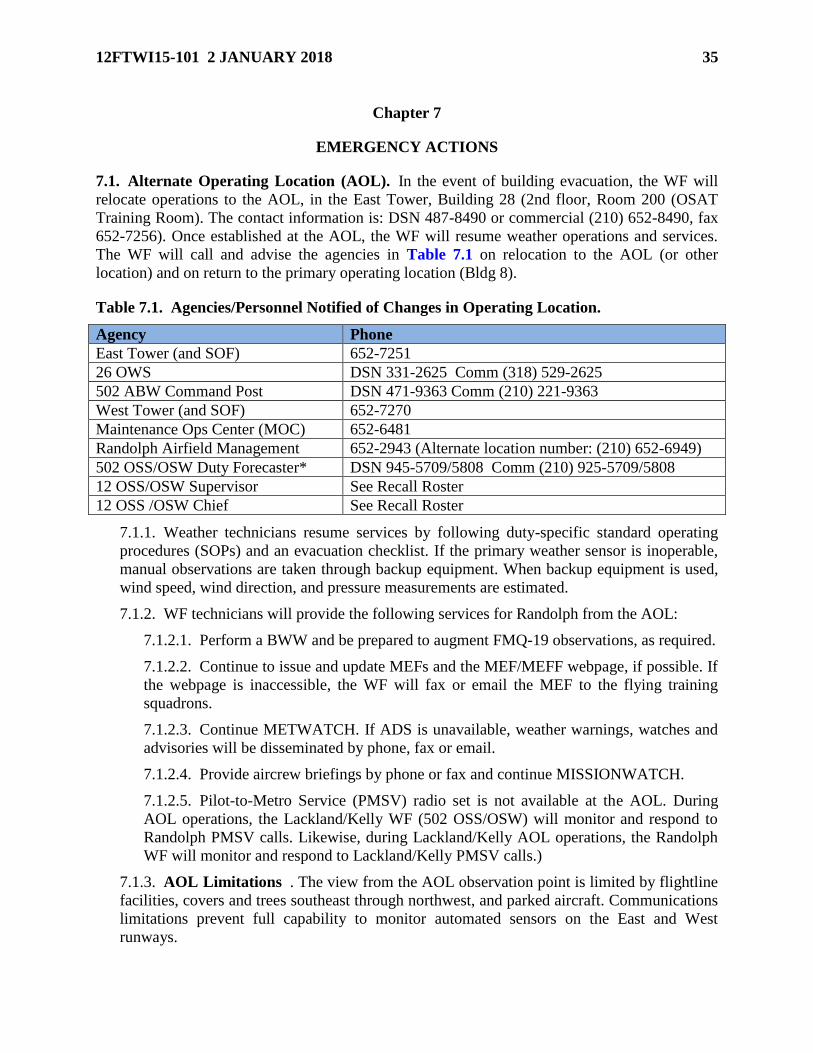
12FTWI15-101 2 JANUARY 2018 35
Chapter 7
EMERGENCY ACTIONS
7.1. Alternate Operating Location (AOL). In the event of building evacuation, the WF will
relocate operations to the AOL, in the East Tower, Building 28 (2nd floor, Room 200 (OSAT
Training Room). The contact information is: DSN 487-8490 or commercial (210) 652-8490, fax
652-7256). Once established at the AOL, the WF will resume weather operations and services.
The WF will call and advise the agencies in Table 7.1 on relocation to the AOL (or other
location) and on return to the primary operating location (Bldg 8).
Table 7.1. Agencies/Personnel Notified of Changes in Operating Location.
Agency Phone
East Tower (and SOF) 652-7251
26 OWS DSN 331-2625 Comm (318) 529-2625
502 ABW Command Post DSN 471-9363 Comm (210) 221-9363
West Tower (and SOF) 652-7270
Maintenance Ops Center (MOC) 652-6481
Randolph Airfield Management 652-2943 (Alternate location number: (210) 652-6949)
502 OSS/OSW Duty Forecaster* DSN 945-5709/5808 Comm (210) 925-5709/5808
12 OSS/OSW Supervisor See Recall Roster
12 OSS /OSW Chief See Recall Roster
7.1.1. Weather technicians resume services by following duty-specific standard operating
procedures (SOPs) and an evacuation checklist. If the primary weather sensor is inoperable,
manual observations are taken through backup equipment. When backup equipment is used,
wind speed, wind direction, and pressure measurements are estimated.
7.1.2. WF technicians will provide the following services for Randolph from the AOL:
7.1.2.1. Perform a BWW and be prepared to augment FMQ-19 observations, as required.
7.1.2.2. Continue to issue and update MEFs and the MEF/MEFF webpage, if possible. If
the webpage is inaccessible, the WF will fax or email the MEF to the flying training
squadrons.
7.1.2.3. Continue METWATCH. If ADS is unavailable, weather warnings, watches and
advisories will be disseminated by phone, fax or email.
7.1.2.4. Provide aircrew briefings by phone or fax and continue MISSIONWATCH.
7.1.2.5. Pilot-to-Metro Service (PMSV) radio set is not available at the AOL. During
AOL operations, the Lackland/Kelly WF (502 OSS/OSW) will monitor and respond to
Randolph PMSV calls. Likewise, during Lackland/Kelly AOL operations, the Randolph
WF will monitor and respond to Lackland/Kelly PMSV calls.)
7.1.3. AOL Limitations . The view from the AOL observation point is limited by flightline
facilities, covers and trees southeast through northwest, and parked aircraft. Communications
limitations prevent full capability to monitor automated sensors on the East and West
runways.

36 12FTWI15-101 2 JANUARY 2018
7.2. Aircraft Emergencies.
7.2.1. In-fl ight emergency (IFE) or ground emergency (GE). When notified of an IFE or GE
involving aircraft, WF technicians will maintain a heightened weather situational awareness
until advised the emergency has been terminated. In the event an IFE or GE results in an
accident or incident, the WF will immediately initiate the actions for an aircraft mishap (as
specified below).
7.2.2. Aircraft Mishap . When notified of an aircraft mishap, the WF will:
7.2.2.1. Regardless of operating mode, encode and disseminate a full element SPECI
observation.
7.2.2.2. Ensure all data and products used in developing any weather information,
product or service provided to a customer (to include MEFs, forms, wind/hazard charts,
etc.,) are saved.
7.2.2.3. Save enough data before, during and after the mishap to fully reconstruct the
weather conditions at the time of the mishap. Activate the FMQ-19 aircraft accident
investigation (AAI) function as an added fail-safe measure.
7.2.2.4. Coordinate with other units (OWS, 557 WW, other WFs) to save any required
data.
7.2.2.5. Collect and save the following products, as applicable, until requested, or send
them to the unit requesting the data save:
7.2.2.5.1. Meteorological Satellite (METSAT) imagery (visible, infrared and water
vapor, etc.)
7.2.2.5.2. Radar products (reflectivity, VAD winds, echo tops, base velocity, etc.)
7.2.2.5.3. Local area work charts (LAWCs)
7.2.2.5.4. Upper air package and upper air soundings enroute and nearest mishap site
7.2.2.5.5. Hazard charts (thunderstorms, turbulence, icing and any other appropriate
charts)
7.2.2.5.6. PIREPs, SIGMETs, AIRMETs
7.2.2.5.7. TAFs and observations for departure point, destination and any alternate(s)
7.2.2.5.8. Weather warnings, watches and advisories
7.2.2.5.9. Briefing material provided mishap aircrew (DD Form 175-1, MEF, flimsy,
etc.)
7.2.2.6. Coordinate with the 557 WW Consolidated Support Cell (DSN 271-2586) to
save any applicable data and products that cannot be saved locally, providing AFWA a
specific list of data to be saved.
7.2.2.7. Coordinate with 26 OWS to initiate a data save for any OWS provided products
used in preparing the flight weather MEF. If other OWS products crossing OWS AORs
were used, the WF will coordinate data saves with all applicable OWSs. If an OWS
provided the flight weather briefing, they will coordinate the data save with other units
involved.

12FTWI15-101 2 JANUARY 2018 37
7.3. Severe Weather Action Plan/Procedures (SWAP). The SWAP ensures weather flight
leadership and/or the Severe Weather Action Team (SWAT), consisting of senior, experienced
WF members, are notified and respond to potential and actual severe weather events in JBSA-
Randolph’s AOR. The 26 OWS routinely schedules adequate resources to respond to severe
weather situations within the AOR. The 26 OWS, in close coordination with the WF, will assess
and respond to any potential severe weather threat. Based on the assessment, a severe weather
watch or warning may be issued. Note: During severe weather events, the WF may have to limit
other support and services, IAW duty priorities (Table 1.1.), due to increased workload and
limited resources. WF limitations may include: answering only hotlines, shortening/canceling
weather briefings, extending telephone hold periods and/or delaying updates to various products
and services (e.g., MEFs).
7.3.1. SWAP Initiation. The SWAP will be initiated if any of the following occur or are
expected in Randolph’s AOR:
7.3.1.1. Tornadic activity, hail > 3/4 inch, winds > 50 knots, heavy precipitation (rain or
snow) or freezing precipitation. (If the event poses imminent threat to life and/or
property, the WF will ensure the appropriate warning is issued prior to calling the SWAT
leader or OWS.)
7.3.1.2. A severe weather event is observed at or in vicinity of JBSA-Randolph.
7.3.1.3. The WF determines the potential for severe weather exists at JBSA-Randolph.
7.3.1.4. The National Weather Service (NWS) Storm Prediction Center (SPC) includes
the San Antonio area in a severe weather watch or warning area.
7.3.2. SWAP and SWAT Activation. The 26 OWS and WF will collaborate; time permitting,
prior to any watch/warning issuance. At minimum, the SWAT will consist of the Flight Chief
and/or Duty Forecaster, as available. The SWAT leader will determine if additional WF
personnel are required. SWAP continue until the threat subsides and/or related severe
weather watches/warnings have ended.
7.3.3. Augmenting Automated Observations During SWAP . The WF will supplement
automated FMQ-19 observations for conditions prescribed in AFMAN 15-111 and this
document (paragraph 4.3.3.1.1.). The WF will also backup automated FMQ-19 sensors as
conditions warrant. Flight safety and resource protection are paramount, and augmentation
will help ensure “eyes forward” support to the OWS and that all severe weather aspects are
fully identified, reported and recorded.
7.3.4. Post-Event Procedures and SWAT Deactivation . Once the WF and 26 OWS
determine the severe threat has ended, the SWAT leader will release the team and the WF
resumes normal operations. Post-event procedures will include, as applicable, OPREP or
other required reporting.
7.3.5. SWAT Exercises . IAW AFMAN 15-129V2, the WF and 26 OWS will jointly
conduct semi-annual severe weather response exercises. Real world severe weather events
can serve as suitable substitutes for this requirement.
7.4. Operational Reporting (OPREP). The WF will initiate reporting of severe weather
occurring at and impacting Randolph by contacting the 502 ABW/CP after the occurrence the
following:

38 12FTWI15-101 2 JANUARY 2018
7.4.1. Tornado
7.4.2. Winds > 50kts (to include gusts)
7.4.3. Hail > 3/4 inch
7.4.4. Anytime base resources suffer damage caused by weather.
7.4.5. As soon as the WF is able to do so after the severe weather event, the WF will provide
an event memorandum for record (MFR) containing pertinent information, to the 502
ABW/CP, 26 OWS and HQ AETC/A3OW. If email and fax are unavailable, the summary
may be passed by phone. Within 24 hours of the event, the WF will ensure relevant weather
information is provided to the 502 ABW/CP for OPREP-3 reporting.
7.5. Recalling On-Call Personnel.
7.5.1. The WF will provide the 502 ABW/CP a WF On-Call Supervisor schedule and
contact numbers and provide updates as necessary. As required, the SWAT leader and other
SWAT members will also be recalled.
7.5.2. The SWAT will be activated and recalled if the 26 OWS issues a watch or warning for
any severe weather conditions (see paragraph 7.3.2.). When recalled, SWAT members will
report to the WF as soon as possible and initiate contact with and advise 12 FTW leadership
of the threat.
7.5.3. WF members will be prepared to augment FMQ-19 observations, as required, and
continue to do so until the severe weather threat has ended.
7.5.4. Recalled WF personnel must remain on duty as long as any of the following
conditions are occurring or expected, unless released by the WF Standby Supervisor or
SWAT Leader:
7.5.4.1. Watch/warning for severe weather (paragraph 5.3.3.) or hail (any)
7.5.4.2. Airfield is required to open/remain open for MEDEVAC or DV mission support
7.5.4.3. Airfield is required to open/remain open for any other reason
7.6. Backup Support to 26 OWS. If 26 OWS operations are interrupted (e.g., by power
outage, natural disaster), the OWS will advise the WF. As required, responsibility for the JBSA-
Randolph TAF, WWAs may be transferred to the WF for up to 72 hours. Responsibility for other
26 OWS products (e.g., graphics products) will be transferred to other units/agencies, as
necessary, to continue weather information flow to Randolph customers.

12FTWI15-101 2 JANUARY 2018 39
CHAPTER 8
RESOURCE PROTECTION
8.1. General. This section outlines actions taken to provide resource protection to JBSA-
Randolph. Resource protection is accomplished jointly by the WF and 26 OWS through the use
of weather watches, warnings and advisories, complemented by local observation and forecast
products.
8.2. Delineation of Duties. IAW AFMAN 15-129V1 and JBSA-Randolph Installation Data
Page (IDP), the 26 OWS is primarily responsible for issuing all forecast weather watches (with
the exception of forecast lightning watches). The WF is responsible for issuing forecast weather
warnings, forecast lightning watches, as well as forecast weather advisories. In addition, the WF
provides “Eyes Forward” support for the 26 OWS validating forecasts and is responsible for
issuing observed warnings and advisories, for JBSA-Randolph.
8.3. Unit Requirements. JBSA-Randolph units are responsible for coordinating with the WF
on any added watch, warning or advisory support or associated special notifications, not
identified in this instruction or IDPs. Units requesting such support should also validate the
requirement by providing a list of customer impacts and protective actions taken for each watch,
warning or advisory. The WF will determine if the requested support or criteria falls within the
capabilities of the WF or 26 OWS and adjust procedures, accordingly.
8.4. Watches, Warnings, & Advisories (WWAs). WWAs are crucial to the protection of
resources and personnel from weather. The sections below describe & define each WWA.
8.4.1. WWA Format & Specifics. Each WWA contains a five digit ID number, the period of
time the WWA is valid, and any specific conditions expected. The first two digits of the ID
number represent the month and the last three represent the order of the watch, warning, or
advisory (i.e., the tenth warning issued in April would be represented as Warning #04-010).
8.4.1.1. WWAs can be upgraded, downgraded, or extended:
8.4.1.1.1. Upgrades are needed when the weather is more severe than previously
anticipated.
8.4.1.1.2. Downgrades are needed when the weather is less severe than previously
anticipated.
8.4.1.1.3. Extensions are needed when the valid period of an issued WWA needs to
be longer.
8.4.1.2. WWAs that are upgraded, downgraded, or extended will not be given a different
ID number. An explanation will be given explaining why there was a change to the
original WWA.
8.4.1.3. When weather phenomena meeting WWA criteria are no longer expected during
the valid time, they are canceled with an explanation.
8.4.2. Weather Watches . A watch notifies personnel of a potential for environmental
conditions of such intensity, as to pose a hazard to life or property and are used to make force
protection and Risk Management decisions. Watches are issued for a 5 nautical mile (NM)
radius from perimeter of JBSA-Randolph. When a watch is issued, units should take, or

40 12FTWI15-101 2 JANUARY 2018
prepare to take, protective actions. Attachment 5 depicts watch formats, and Table 8.1.
outline watch criteria and lead times:
8.4.3. Weather Advisories. An advisory notifies JBSA-Randolph when an established
environmental condition affecting operations is occurring or is expected to occur.
8.4.3.1. Forecast Weather Advisories for JBSA-Randolph. Forecast advisories are issued
when advance notice is needed to take protective actions from specific weather
conditions.
8.5. Weather Watches. A weather watch alerts units to the potential for weather conditions
that could threaten life or property. Watches are issued for a 5 NM radius from perimeter of
JBSA-Randolph. When a watch is issued, units should take, or prepare to take, protective
actions. Attachment 5 depicts watch formats, and Table 8.1. outline watch criteria and lead
times:
Table 8.1. Weather Watches for JBSA-Randolph.
Weather Threat Threshold Impact Desired Lead-time
Tornado Tornado / Funnel
cloud (detected by
radar or visually
observed) AND
threatening JBSA-
Randolph
Potential threat of
catastrophic damage
to personnel and
property
60 minutes prior to
warning issuance
Severe
Thunderstorm
Damaging Wind
Surface wind GTE 50
knots associated with
thunderstorms
-AND/OR-
Damaging Hail
Hail GTE 3/4 inch
diameter
Potential threat to
exposed personnel
Potential of damage
to facilities and
exposed aircraft and
equipment
60 minutes prior to
warning issuance
Moderate
Thunderstorm
Strong Wind
Surface wind 35-49
knots associated with
thunderstorms
-AND/OR-
Large Hail
Hail GTE 1/4 inch
but LT 3/4 inch
Potential risk to
exposed personnel
Potential risk of
damage to unsecured
property
Potential risk to
flightline activities
and damage to
exposed aircraft or
vehicles
60 minutes prior to
warning issuance

12FTWI15-101 2 JANUARY 2018 41
Damaging Winds Damaging Wind
Surface wind GTE 50
knots not associated
with thunderstorms
Potential threat to
exposed personnel
Potential risk of
damage to facilities
and equipment
60 minutes prior to
warning issuance
Strong Wind Strong Wind
Surface wind 35-49
knots not associated
with thunderstorms
Potential risk to
exposed personnel
Potential risk of
damage to unsecured
property
Potential risk to
flightline activities
and damage to
exposed aircraft or
vehicles
60 minutes prior to
warning issuance
Freezing
Precipitation
Liquid precipitation
of any type and
intensity falls and
produces glaze ice on
exposed surfaces
Potential range of
impacts dependent on
precipitation type and
intensity
For Example:
Light freezing drizzle
increases risk of
unsafe driving
conditions and
disrupts flightline or
maneuver activities
Moderate or greater
intensity freezing rain
(ice storm) poses
significant risk of
damage to facilities
and rapidly creates
hazardous conditions
for personnel and
vehicle movement
that cannot easily be
mitigated
60 minutes prior to
warning issuance
Heavy Rain Heavy rain GTE 2
inches in 12 hours
Potential threat of
flash flooding or
systemic flooding
posing credible threat
60 minutes prior to
warning issuance

42 12FTWI15-101 2 JANUARY 2018
to unprotected
resources and
personnel
Disrupts flightline
and maneuver
activities
Imposes potential
increased risk on
personnel movement
Heavy Snowfall New snowfall GTE
1/4 inch
accumulation in 12
hours
Potentially disrupts
personnel movement
or flight line
activities
60 minutes prior to
warning issuance
Blizzard All of the following
conditions must
occur:
a) Surface visibility
less than or equal to
1/4 mile
b) Considerable
falling and/or
blowing snow
c) Sustained wind
speeds or gusts >30
knots
d) Duration > 3 hours
Imposes potential
significant risk to
personnel movement
Potential significant
risk to maneuver or
flight line activities
60 minutes prior to
warning issuance
Dust/Sandstorm Winds carrying sand
particles from the
surface with
prevailing visibility
LT 5/8 statute miles
Potentially disrupts
personnel movement
and aviation
operations
60 minutes prior to
warning issuance
Lightning Lightning within 5
statute miles
Potential of
immediate threat to
exposed personnel
30 minutes prior to
observed warning
issuance
8.6. Weather Warnings. A warning notifies personnel when an established weather condition
of such intensity as to pose a hazard to life or property is observed or forecasted to occur.
8.6.1. Forecast Weather Warnings. Forecast warnings are issued for weather events observed
or forecasted to occur within 5 statute miles (SM) of the JBSA-Randolph runway complex.
8.6.2. Observed Weather Warnings for JBSA-Randolph. The WF will issue an observed
weather warning (only) for lightning associated with thunderstorms within 5 NM of the
airfield*. When the WF is closed or unable to issue, 26 OWS will issue the observed weather

12FTWI15-101 2 JANUARY 2018 43
warning. Attachment 5 depicts warning formats, and Tables 8.2 outlines forecast and
observed weather warning criteria and DLTs:
Table 8.2. Weather Warnings for JBSA-Randolph.
Weather Threat Threshold Impact Desired Lead-time
Tornado Tornado / Funnel
cloud (detected by
radar or visually
observed) AND
threatening JBSA-
Randolph
Immediate threat of
catastrophic damage
to personnel and
property
15 minute advance
notice before
occurrence
Severe
Thunderstorm
Damaging Wind
Surface wind GTE 50
knots associated with
thunderstorms
-AND/OR-
Damaging Hail
Hail GTE 3/4 inch
diameter
Immediate threat to
exposed personnel
High risk of damage
to facilities and
exposed aircraft and
equipment
60 minutes advance
notice before
occurrence
Moderate
Thunderstorm
Strong Wind
Surface wind 35-49
knots associated with
thunderstorms
-AND/OR-
Large Hail
Hail GTE 1/4 inch but
LT 3/4 inch
Increased risk to
exposed personnel
Increased risk of
damage to unsecured
property
Increased risk to
flightline activities
and damage to
exposed aircraft or
vehicles
60 minutes advance
notice before
occurrence
Damaging Winds Damaging Wind
Surface wind GTE 50
knots not associated
with thunderstorms
Immediate threat to
exposed personnel
Increased risk of
damage to facilities
and equipment
60 minutes advance
notice before
occurrence
Strong Wind Strong Wind
Surface wind 35-49
knots not associated
with thunderstorms
Increased risk to
exposed personnel
Increased risk of
damage to unsecured
60 minutes advance
notice before
occurrence

44 12FTWI15-101 2 JANUARY 2018
property
Increased risk to
flightline activities
and damage to
exposed aircraft or
vehicles
Freezing
Precipitation
Liquid precipitation of
any type and intensity
falls and produces
glaze ice on exposed
surfaces
Range of impacts
dependent on
precipitation type and
intensity
For Example:
Light freezing drizzle
increases risk of
unsafe driving
conditions and
disrupts flightline or
maneuver activities
Moderate or greater
intensity freezing rain
(ice storm) poses
significant risk of
damage to facilities
and rapidly creates
hazardous conditions
for personnel and
vehicle movement
that cannot easily be
mitigated
60 minutes advance
notice before
occurrence
Heavy Rain Heavy rain GTE 2
inches in 12 hours
Increased threat of
flash flooding or
systemic flooding
posing credible threat
to unprotected
resources and
personnel
Disrupts flightline and
maneuver activities
Imposes increased
risk on personnel
movement
60 minutes advance
notice of the period
meeting heavy rain
threshold
Heavy Snowfall New snowfall GTE Disrupts personnel 60 minutes advance

12FTWI15-101 2 JANUARY 2018 45
1/4 inch accumulation
in 12 hours
movement or flight
line activities
notice of the period
meeting measureable
snowfall
accumulation
Blizzard All of the following
conditions must
occur:
a) Surface visibility
less than or equal to
1/4 mile
b) Considerable
falling and/or blowing
snow
c) Sustained wind
speeds or gusts >30
knots
d) Duration > 3 hours
Imposes significant
risk to personnel
movement
Significant risk to
maneuver or flight
line activities
60 minutes advance
notice of the period
meeting or exceeding
blizzard threshold
Dust/Sandstorm Winds carrying sand
particles from the
surface with
prevailing visibility
LT 5/8 statute miles
Disrupts personnel
movement and
aviation operations
60 minutes advance
notice of the period
meeting or exceeding
sand/duststorm
threshold
Lightning * Lightning within 5
statute miles
Immediate threat to
exposed personnel
As observed
8.7. Weather Advisories. An advisory notifies JBSA-Randolph when an established
environmental condition affecting operations is occurring or is expected to occur.
8.7.1. Observed Advisories . Weather advisories alert units to mission impacting weather
criteria not covered by watches or warnings. The WF will typically issue observed advisories
only during local flying hours, and advisories will end or be canceled when local flying is
complete. When the WF is unable to issue, 26 OWS will issue the observed advisories. The
WF will use observations, PIREPs, radar, satellite and other resources to determine if
conditions warrant issuing or canceling an observed advisory. Attachment 5 depicts advisory
formats, and Table 8.3. outlines advisory criteria.
8.7.2. Forecast Weather Advisories for JBSA-Randolph . Forecast advisories are issued
when advance notice is needed to take protective actions from specific weather conditions.

46 12FTWI15-101 2 JANUARY 2018
Table 8.3. Forecast and Observed Weather Advisories for JBSA-Randolph.
Forecasted Criteria Desired Lead Time
Winds > 25 knots to < 35 knots 30 min
Temperature ≤ 32o F 120 min
Observed Criteria Desired Lead Time
Icing, any intensity, within 100 NM N/A
Moderate or Greater Turbulence, within 100 NM N/A
Low-Level Wind Shear (LLWS), within 50 NM N/A
Thunderstorms, within 100 NM N/A
Index of Thermal Stress (ITS) Condition (CAUTION and
DANGER)
N/A
Wind Chill Condition (CAUTION, DANGER N/A
Surface Visibility < 1/16 SM N/A
8.8. Dissemination Procedures. Dissemination of weather watches, warnings and advisories,
to include their issuance, extension, upgrade/downgrade and/or cancellation, is accomplished via
ADS, with backup phone calls to ensure receipt by critical agencies (Table 7.1.).
8.9. Base Siren Activation. During tornadic activity, the base siren system serves as the
primary notification system for JBSA-Randolph. On receipt of a tornado warning from the 26
OWS or WF identification of a tornado threat (visual or radar), the WF will immediately notify
the 502 ABW/CP and who in turn will activate the siren. The siren will sound until the warning
is canceled or “ALL CLEAR” received.
8.10. Tropical Weather Activity. The WF, in close coordination with the 502 OSS/OSW,
JBSA-Lackland Weather Flight will maintain awareness of tropical systems that may threaten
the Greater San Antonio Area and NAS Pensacola. Both units will routinely monitor National
Hurricane Center (NHC) forecasts and advisories (http://www.nhc.noaa.gov) for Atlantic,
Caribbean or Gulf of Mexico tropical activity. Additionally, both units will also monitor the 26
OWS site (https://26ows.us.af.mil/web/index.cfm) for related products (e.g., Tropical Cyclone
Threat Assessment Product (TC-TAP)). NHC updates are issued every 6-hours (03, 09, 15 and
21Z) and followed, in turn, by 26 OWS product updates.
8.10.1. Tropical Cyclone Bulletins . Flight and base leadership will be notified anytime a
tropical depression, storm, or hurricane develops, moves within, or is forecast to move within
400nm of the Greater San Antonio Area and or NAS Pensacola, within a 96-hour period. 502
OSS/OSW forecasters will use the NHC Tropical Cyclone Bulletins and 26 OWS TC-TAP
products (as applicable) as well as coordinate with the 26 OWS to develop JBSA Tropical
Cyclone Bulletin (see Attachment 8). The bulletins are designed to alert base and JBSA
leadership, personnel and agencies of the storm’s forecast track, intensity and associated
impacts, focusing on the potential for winds > 50 knots within 96, 72, 48, 24 and 12 hours of
the Greater San Antonio Area and NAS Pensacola. (Note: Tropical cyclone outlooks,
especially beyond 48-hours, contain a high degree of uncertainty and are subject to change.)
8.10.2. In accordance with AFMAN 15-129V1, the WF will not deviate from the official
NHC forecast: position, track, movement, and maximum wind speed or intensity trend. The
WF will use the MEFP to tailor the official tropical cyclone forecast into a local mission
forecast product.
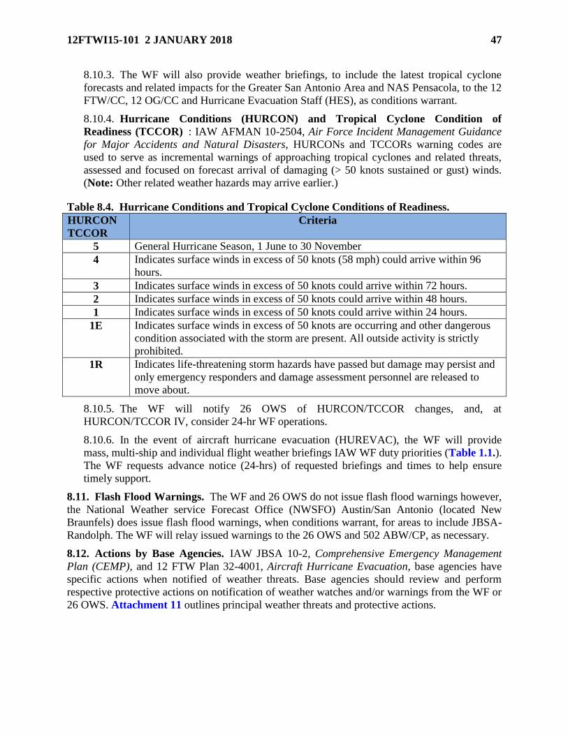
12FTWI15-101 2 JANUARY 2018 47
8.10.3. The WF will also provide weather briefings, to include the latest tropical cyclone
forecasts and related impacts for the Greater San Antonio Area and NAS Pensacola, to the 12
FTW/CC, 12 OG/CC and Hurricane Evacuation Staff (HES), as conditions warrant.
8.10.4. Hurricane Conditions (HURCON) and Tropical Cyclone Condition of
Readiness (TCCOR) : IAW AFMAN 10-2504, Air Force Incident Management Guidance
for Major Accidents and Natural Disasters, HURCONs and TCCORs warning codes are
used to serve as incremental warnings of approaching tropical cyclones and related threats,
assessed and focused on forecast arrival of damaging (> 50 knots sustained or gust) winds.
(Note: Other related weather hazards may arrive earlier.)
Table 8.4. Hurricane Conditions and Tropical Cyclone Conditions of Readiness.
HURCON
TCCOR
Criteria
5 General Hurricane Season, 1 June to 30 November
4 Indicates surface winds in excess of 50 knots (58 mph) could arrive within 96
hours.
3 Indicates surface winds in excess of 50 knots could arrive within 72 hours.
2 Indicates surface winds in excess of 50 knots could arrive within 48 hours.
1 Indicates surface winds in excess of 50 knots could arrive within 24 hours.
1E Indicates surface winds in excess of 50 knots are occurring and other dangerous
condition associated with the storm are present. All outside activity is strictly
prohibited.
1R Indicates life-threatening storm hazards have passed but damage may persist and
only emergency responders and damage assessment personnel are released to
move about.
8.10.5. The WF will notify 26 OWS of HURCON/TCCOR changes, and, at
HURCON/TCCOR IV, consider 24-hr WF operations.
8.10.6. In the event of aircraft hurricane evacuation (HUREVAC), the WF will provide
mass, multi-ship and individual flight weather briefings IAW WF duty priorities (Table 1.1.).
The WF requests advance notice (24-hrs) of requested briefings and times to help ensure
timely support.
8.11. Flash Flood Warnings. The WF and 26 OWS do not issue flash flood warnings however,
the National Weather service Forecast Office (NWSFO) Austin/San Antonio (located New
Braunfels) does issue flash flood warnings, when conditions warrant, for areas to include JBSA-
Randolph. The WF will relay issued warnings to the 26 OWS and 502 ABW/CP, as necessary.
8.12. Actions by Base Agencies. IAW JBSA 10-2, Comprehensive Emergency Management
Plan (CEMP), and 12 FTW Plan 32-4001, Aircraft Hurricane Evacuation, base agencies have
specific actions when notified of weather threats. Base agencies should review and perform
respective protective actions on notification of weather watches and/or warnings from the WF or
26 OWS. Attachment 11 outlines principal weather threats and protective actions.

48 12FTWI15-101 2 JANUARY 2018
Chapter 9
RECIPROCAL SUPPORT
9.1. General. The WF requires reciprocal support to accomplish its mission. This chapter
outlines some of the support required of other agencies on- and off- Randolph. (IAW AFMAN
15-129V1, support provided to the WF dictated by AF or other local directives is not included in
this chapter.)
9.2. 502 ABW/CP (Command Post) will:
9.2.1. Disseminate weather warnings, watches and advisories received for Randolph over the
Emergency Notification System (ENS) and/or Giant Voice broadcast system, as applicable.
9.2.2. Notify the WF Standby Supervisor (or, as backup, Flight Chief or Supervisor) during
hours of airfield closure of:
9.2.2.1. Any severe weather watch or warning issued for Randolph by the 26 OWS.
9.2.2.2. Any report of a known or suspected tornado or funnel cloud or any other
significant weather event at Randolph.
9.2.2.3. Any significant weather-related event (i.e. material damage, injuries, etc.).
9.2.2.4. Any MEDEVAC, DV travel or other action that requires the airfield to open.
9.2.3. Include the WF on dissemination/notification of any weather related incidents or
OPREPs.
9.3. 502 CS will:
9.3.1. Provide or arrange for the installation, maintenance and repair of AF
standard/approved processing and communications paths both copper and fiber optic and its
supporting equipment (except contract maintained hardware) and circuits.
9.3.2. Restore failed communications paths when necessary for inoperative processing and
communications equipment and circuits IAW established restoral priorities (IAW CS
OPLAN 400-1).
9.3.3. Coordinate with the WF before performing repairs or routine maintenance on
processing and communications equipment and circuits.
9.4. 502 SFS will: Report the sighting of any tornado, funnel cloud, hail, or freezing
precipitation to the WF directly or via the 502 ABW/CP.
9.5. 502 CES will:
9.5.1. Ensure periodic maintenance of Bldg 8’s backup generator (in Bldg 10) is
accomplished.
9.5.2. Provide annual generator training to WF personnel.
9.6. 502 OSS/OSW will:
9.6.1. Respond to Randolph PMSV requests when the WF evacuates to an AOL or the
PMSV is not operational.

12FTWI15-101 2 JANUARY 2018 49
9.6.2. Collaborate on expected weather effects across Joint Base San Antonio (JBSA), prior
to disseminating JBSA Tropical Bulletins.
9.7. 359 AMDS will:
9.7.1. Consult with the WF to review historical climate information as well as predictive
analyses.
9.7.2. Coordinate on processes and operating procedures for disseminating thermal injury
weather advisories (e.g., ITS and Wind Chill Conditions) as well as other pertinent current
weather information.
9.8. 99th, 435th, 559th, 560th FTS and 415 FLTF will:
9.8.1. Encourage aircrews to pass PIREPs to the WF, ATC or SOF.
9.8.2. Coordinate any additional mission or support requirements with WF leadership.
9.8.3. Report any known or suspected space weather impacts to operations (e.g., degraded
radio communications) to the WF.
9.8.4. Encourage aircrews to provide mission feedback to the WF, especially if actual
weather is significantly different than forecast or briefed.
9.8.5. Ensure the current flying schedule is available to the WF.
9.8.6. Support the weather liaison program.
9.9. 12OSS/OSM will:
9.9.1. Serve as the single POC for the maintenance and repair of approved fielded weather
sensing equipment and its peripheral necessary associated attached communications devices.
9.9.2. Coordinate with the WF before performing repairs or routine maintenance on weather
sensing, processing and communications equipment and circuits.
9.10. 12 OSS/OSA will: Provide support identified in CWW MOU (paragraph 4.7.) and a
location for the WF’s AOL (paragraph 7.1.).
9.11. All Weather Support Recipients will:
9.11.1. Notify the WF of ADS software application problems (only) after performing
troubleshooting measures.
9.11.2. Notify the WF when new or revised weather support requirements are identified.
9.11.3. Coordinate required changes or additions to this document as soon as possible.
9.11.4. Provide the WF advance notice (24-hrs) for requests requiring out-of-station support.
JOEL L. CAREY, Colonel, USAF
Commander
50 12FTWI15-101 2 JANUARY 2018
Attachment 1
GLOSSARY OF REFERENCES AND SUPPORTING INFORMATION
References
AFPD 15-1, Weather Operations, 12 November 2015
AFI 10-206, Operational Reporting, 11 June 2014
AFI 10-206 AETCSUP, Operational Reporting, 13 July 2009
AFI 10-2501, Air Force Emergency Management Program Planning and Operations, 19 April
2016
AFMAN 10-2504, Air Force Incident Management Guidance for Major Accidents and Natural
Disasters, 13 March 2013
AFI 11-2T-1V3, T-1A Operations Procedures, 16 July 2015
AFI 11-2T-6V3, T-6 Operations Procedures, 18 July 2016
AFI 11-2T-38V3, T-38 Operations Procedures, 2 October 2015
AFI 11-2T-AT-38V3, AETC Supplement, T-38 Operations Procedures, 6 October 2016
AFI 11-202V3, General Flight Rules, 10 August 2016
AFI 11-418, AETC Supplement 1, Operations Supervision, 16 February 2016
AFMAN 15-111, Surface Weather Observations, 27 February 2013
AFI 15-114, Weather Technical Readiness Evaluation, 16 March 2017
AFI 15-127, Weather Training, 20 January 2016
AFI 15-128, Air Force Weather Roles and Responsibilities, 7 February 2011
AFI 15-182, Weather Operations Capability Management, 12 March 2015
AFI 48-151, Thermal Injury Prevention Program, 7 April 2016
AFMAN 15-124, Meteorological Codes, 28 February 2013
AFMAN 15-129V1, Air and Space Weather Operations-Characterization, 6 December 2011
AFMAN 15-129V2, Air and Space Weather Operations-Exploitation, 7 December 2011
AFPAM 48-151, Thermal Injury Prevention Program, 7 April 2016
12 FTW Instruction 13-213, Air Driving, 28 December 2011
12 FTW Instruction 13-204, Air Traffic Control and Airfield Operations, 23 June 2014
RAFB Plan 10-403, Installation Deployment Plan
JBSA Plan 10-2, Comprehensive Emergency Management
12 FTW Plan 32-4001, Aircraft Hurricane Evacuation (HUREVAC) Plan, 13 October 2013
Joint Base San Antonio–Randolph Installation Data Sheet, 5 December 2015

12FTWI15-101 2 JANUARY 2018 51
Memorandum of Understanding (MOU) between 12th Operations Support Squadron and
National Weather Service, New Braunfels Office
Prescribed Forms
None
Adopted Forms
AF Form 847, Recommendation for Change of Publication
DD Form 175-1, Flight Weather Briefing
Abbreviations and Acronyms,
AFW-WEBS—Air Force Weather Web Services
ADS—Automated Dissemination System (e.g., JET, IWWC)
BWW—Basic Weather Watch—.
CWW—Cooperative Weather Watch—.
HURCON—Hurricane Condition—.
ICAO—International Civil Aviation Organization identifier
KRND—4-ICAO identifier for JBSA-Randolph.
IDP—Installation Data Page
JET—Joint Environmental Toolkit—.
MEF—Mission Execution Forecast—.
MEFF—Mission Execution Forecast Flimsy.
MEFP—Mission Execution Forecast Process
METAR—Aviation Routine Weather Report—.
METWATCH—Meteorological Watch—.
MOA—Military Operating Area.
MWP—Mission Weather Product
OWS—Operational Weather Squadron—.
PIREP—Pilot Report—.
SOF—Supervisor of Flying.
SPECI—Special Weather Observation
TAF—Terminal Aerodrome Forecast.
UPT—Unit Tailored Page
TCCOR—Tropical Cyclone Condition of Readiness
WF—Weather Flight.

52 12FTWI15-101 2 JANUARY 2018
Terms
557th Weather Wing (557 WW)—A strategic weather center at Offutt AFB NE, (formerly HQ
Air Force Weather Agency (AFWA)) providing atmospheric data and analysis/forecast products
required by the regional OWSs and the WFs worldwide. The 557 WW provides the centralized
repository for global observations and forecasts that are data based at 557 WW and, in turn,
disseminated to DOD weather data users worldwide. In addition to global observations and
forecasts collected from worldwide sources, the 557 WW collects meteorological satellite data
from multiple sources. Based on global analysis of available data, 557 WW creates global
analysis and forecast products to meet the forecast requirements of its supported users.
Alternate Operating Location (AOL)—A secondary location in which the WF will move to in
the event that the main operating location, Building 8 is evacuated.
Basic Weather Watch—Method of manually observing, recording, and disseminating
significant changes in weather conditions to principal customers.
Cooperative Weather Watch—Method of collective weather observing by WF, ATC and SOF
agencies, to enhance the BWW mission.
Desired Lead Time—The total amount of time required to disseminate a forecast WWA from
the 26 OWS through the local dissemination tree to all affected end-users plus the amount of
advance notice a supported organization requires to complete mandatory protective actions
before the onset of a particular weather phenomenon.
Hurricane Condition—The condition outlining threat of tropical storm or hurricane.
Joint Environmental Toolkit(JET)—The AF standard weather communications and computer
software.
LOCAL—Weather observation of limited scope, meeting local requirements; disseminated
locally.
METAR—Aviation Routine Weather Report. Routine, full hourly weather observation; taken
and disseminated locally and longline.
Meteorological Watch (METWATCH)—A deliberate process for monitoring the terrestrial
weather or space environment in an area or region. The purpose of a METWATCH is to identify
when and where observed conditions significantly diverge from forecast conditions and
determine courses of action to update or amend a forecast product or group of products and
notify designated agencies.
Mission Execution Forecast—-Tailored weather information for specific flying or other
mission; includes verbal, DD 175-1, “flimsy” and other forms of flight weather or mission
briefings.
Mission Execution Forecast Flimsy—-Webpage providing tailored weather information for
flying and other missions; includes weather for airfield, MOAs and alternates and flight hazards.
Mission Weather Product (MWP)—Any weather product or group of weather products
generated by the WF that is integrated into the military decision making process. MWPs may be
planning or execution products and are not limited to aviation missions.

12FTWI15-101 2 JANUARY 2018 53
MISSIONWATCH—Method of continuously monitoring and updating weather conditions,
focused on impacts to previously briefed and/or ongoing missions.
Military Operating A—rea, area used for military training; or Memorandum of Agreement.
Operational Weather Squadron—-Regional AF weather center, commonly referred to as
“Hub.” JBSA-Randolph’s servicing OWS is the 26 OWS located in Barksdale, Louisiana.
Pilot Report—. Report containing weather data collected by and passed from aircrew.
Severe Thunderstorm—A thunderstorm presenting a threat to lives or property that requires
agencies to enhance resource protection measures. Generally, thunderstorms producing hail
greater than or equal to 3/4 inch diameter and/or surface wind greater than or equal to 50 knots.
SPECI—Weather observation taken to address special criteria; disseminated locally and
longline.
Terminal Aerodrome Forecast—- A coded weather bulletin providing forecast information for
an aerodrome complex to facilitate flight planning and command and control. TAFs are
formatted IAW AFMAN 15-124, Meteorological Codes, and amended IAW AFMAN 15-129V1,
Air and Space Weather Operations-Characterization.
Weather Advisory—Notification of weather condition impacting or expected to impact flight
operations.
Weather Warning—Notification of weather condition occurring or imminent posing threat to
life/property.
Weather Watch—Notification of potential for weather condition posing threat to
life/property.

54 12FTWI15-101 2 JANUARY 2018
Attachment 2
SPECIAL AND LOCAL OBSERVATION CRITERIA
A2.1. The FMQ-19 will take and disseminate special observations (SPECI), which are
disseminated locally and longline. Special criteria are established IAW AFMAN 15-111 and
applicable Flight Information Publications (FLIP). Special criteria for Randolph follow; a SPECI
will be taken if:
A2.2. Ceiling. A cloud ceiling forms or dissipates below, decreases below or, if below,
increases to or above:
Table A2.1. SPECI Ceiling Criteria.
3500 ft Local Requirement
2800 ft Local Requirement 700 ft AFMAN 15-111
2300 ft Local Requirement 600 ft ILS, Circling, Straight-in, LNAV
2000 ft Local Requirement 500 ft AFMAN 15-111, LOC/DME, Circling
1500 ft AFMAN 15-111 400 ft LOC/DME, Straight-in, LNAV
1100 ft Circling 300 ft AFMAN 15-111, LOC/DME, Straight-in
1000 ft AFMAN 15-111 200 ft AFMAN 15-111, ILS
A2.3. Sky Condition. A layer of clouds or obscuring phenomena aloft is observed below 800
feet, and no layer aloft was reported below 800 feet in the preceding observation.
A2.4. Visibility. The visibility decreases to less than, or if below, increases to or above:
Table A2.2. SPECI Visibility Criteria.
5 SM
Local Requirement, RAFB
13-203
1 1/4 SM
LOC/DME, Straight-in, LNAV
3 SM AFMAN15-111, Circling 1 1/8 SM LOC/DME 15L
2 1/2 SM LNAV MDA , RNAV GPS
RWY 15R
1 SM
AFMAN 15-111, LOC/DME, Circling,
Straight-in, LNAV
2 SM
AFMAN 15-111, Circling,
Straight-in, LNAV
7/8 SM LNAV, RNAV (GPS) RWY 33R
1 7/8 SM S-LOC 15R 3/4 SM ILS, LOC/DME, Straight-in, LNAV
1 3/4 SM
Straight-in, Circling,
LNAV
5/8 SM
LOC/DME 33R, RNAV (GPS)
RWY 32 R
1 1/2 SM
LOC/DME, Circling,
Straight- in, LNAV
1/2 SM
AFMAN 15-111, ILS, LOC/DME
1 3/8 SM
LNAV, RNAV (GPS)
RWY 14 R
1/16 SM
Local Requirement (Ground Operations)
A2.5. Wind Shift. Wind direction changes by 45 degrees or more in less than 15 minutes and
the wind speed is 10 knots or more throughout the wind shift.
A2.6. Squalls. Whenever squalls occur. A squall is a sudden onset of strong winds with speeds
increasing to at least 16 knots and sustained at 22 or more knots for at least one minute.
A2.7. Thunderstorms. A thunderstorm begins or ends.

12FTWI15-101 2 JANUARY 2018 55
A2.8. Precipitation.
A2.8.1. Any hail begins or ends.
A2.8.2. Any freezing precipitation begins, ends or changes intensity.
A2.8.3. Ice pellets begin, end, or change intensity.
A2.8.4. Any other type of precipitation begins or ends.
A2.9. Tornado, Funnel Cloud or Waterspout.
A2.9.1. Is observed.
A2.9.2. Disappears from sight or ends.
A2.10. Runway Visual Range (RVR).
A2.10.1. The prevailing visibility is first observed < 1 SM/1600 M, and (again) when the
prevailing visibility goes above 1 SM/1600 M.
A2.10.2. The RVR decreases below, or if below, increases to or above:
Table A2.3. SPECI RVR Criteria.
6000 ft AFMAN 15-111
5900 ft FLIP
5500 ft FLIP
5000 ft AFMAN 15-111
4500 ft FLIP
4000 ft Local Requirement
3700 ft FLIP
3000 ft FLIP
2400 ft AFMAN 15-111
2000 ft AFMAN 15-111
1600 ft Local Requirement
A2.10.3. The RVR is first deemed unavailable (RVRNO) for the runway in use, and when it
is first determined the RVRNO report is not applicable, provided RVR reporting capability
exists.
A2.11. Volcanic Eruption. Eruption or volcanic ash cloud is first observed.
A2.12. Resumption of Observing Services. After the weather technician returns to duty after a
break in observing coverage or augmentation, unless a record observation is filed during the
period.
A2.13. Aircraft Mishap . An aircraft mishap SPECI will be taken immediately following the
notification or sighting of an aircraft mishap, at or near the observing location, unless there has
been an intervening observation.
56 12FTWI15-101 2 JANUARY 2018
A2.14. Tower Visibility. A SPECI will be taken when notified by control tower that tower
visibility has decreased to less than or, if below, increased to equal or exceed 1, 2, or 3 statute
miles and the control tower visibility differs from the prevailing visibility.
A2.15. Sandstorm (SS) or Duststorm (DS). Only augmented when a local warning is issued.
A2.16. Local Observation Criteria. During airfield hours, the WF will take and disseminate
Local (LOCAL) observations, as required. LOCALs are not disseminated longline. LOCAL
criteria are established IAW AFMAN 15-111 and local requirements. The LOCAL criteria for
JBSA-Randolph:
A2.16.1. Altimeter Setting LOCALs During Complete FMQ-19 Pressure Sensor
Outage. Altimeter setting LOCALs will be taken at an interval not to exceed 35 minutes
when there has been a change of 0.01 inch Hg (0.3 hPa) or more since the last reported value.
A2.16.2. Significant Pressure Changes . When the pressure is observed to rise or fall at
a rate of 0.06-inch Hg per hour or more, totaling a change 0.02-inch Hg or more at the
time of observation, a LOCAL observation will be taken to include the remark
PRESRR (pressure rising rapidly) or PRESFR (pressure falling rapidly).

12FTWI15-101 2 JANUARY 2018 57
Attachment 3
WEATHER OBSERVATION AND PIREP FORMATS
A3.1. General. Formats and samples of METAR, SPECI and LOCAL weather observations,
and PIREPs follow. AFMAN 15-124, Meteorological Codes, provides more detailed
information.
A3.2. METAR Format. Sample METAR observation with basic elements as transmitted
longline:
Table A3.1. METAR Format
KRND 201855Z 15010G18KT 5SM BR SCT025 BKN100 29/18 A29.84
(1) (2) (3) (4) (5) (6) (7) (8)
RMK PA+837
(9)
(1) Location: (4-letter) International Civil Aviation Organization (ICAO) identifier
(2) Date/Time Group: (2-digit) day of month and (4-digit) time Zulu/UTC
(3) Winds: (3-digit) direction, in degrees, and (2-digit) speed, with any gust (G), in knots (KT)
(4) Visibility: in statute miles (SM)
(5) Current Weather and/or Obstruction to Visibility: as applicable, (2-letter) code/abbreviation
(6) Sky Condition: (3-letter) cloud amount(s) and (3-digit) base(s) in hundreds of feet (AGL)
(7) Temperature/Dewpoint: in degrees Celsius (C)
(8) Altimeter Setting: in inches of mercury (Hg)
(9) Remarks: as applicable
Not all encoded remarks are transmitted longline—the example below reflects the same
observation, as transmitted locally:
KRND METAR 1855Z 15010G18KT 5 BR SCT025 BKN100 29/18 ALTSG 29.84 RMK PA
+837 T: 84F DP: 65F 55/JT [Note: Adds temperature (T) and dewpoint (DP) in degrees F.]
A3.3. SPECI Format. S ample SPECI observation, as transmitted longline and locally (resp):
Table A3.2. SPECI Format
KRND 202118Z 15012G21KT 2 1/2SM -RA SCT005 BKN020 OVC035 27/20 A29.91
KRND SPECI 2118Z 14012G21KT 2 1/2 -RA SCT005 BKN20 OVC035 27/20 ALTSG 29.91
T:80F DP:68F
A3.4. PIREP Format. Sample PIREP with basic elements, as transmitted longline and locally:
Table A3.3. PIREP Format
KRND UUA /OV KAUS220010 /TM 2110 /FL050 /TP T38 /SK OVC100- UNKN
(1) (2) (3) (4) (5) (6) (7)
/WX TS /TA M02 /WV 28025KT /TB LGT-MOD /IC MOD RIME
(8) (9) (10) (11) (12)
/RM ONCL LTGICCCCG
(13)

58 12FTWI15-101 2 JANUARY 2018
(1) Transmitting Station
(2) Type, Routine (UA) or Urgent (UUA)
(3) Location of Aircraft
(4) Time of Report (Zulu)
(5) Flight Level, hundreds of feet AGL
(6) Aircraft Type
(7) Sky Condition
(8) Current Weather
(9) Outside Air Temperature (deg C)
(10) Winds, direction and speed, at FL
(11) Turbulence, as applicable
(12) Icing, as applicable
(13) Remarks, as applicable
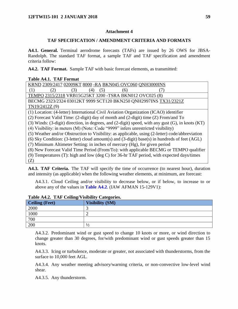
12FTWI15-101 2 JANUARY 2018 59
Attachment 4
TAF SPECIFICATION / AMENDMENT CRITERIA AND FORMATS
A4.1. General. Terminal aerodrome forecasts (TAFs) are issued by 26 OWS for JBSA-
Randolph. The standard TAF format, a sample TAF and TAF specification and amendment
criteria follow:
A4.2. TAF Format. Sample TAF with basic forecast elements, as transmitted:
Table A4.1. TAF Format
KRND 2309/2417 02009KT 8000 -RA BKN045 OVC060 QNH3000INS
(1) (2) (3) (4) (5) (6) (7)
TEMPO 2315/2318 VRB15G25KT 3200 -TSRA BKN012 OVC025 (8)
BECMG 2323/2324 03012KT 9999 SCT120 BKN250 QNH2997INS TX31/2321Z
TN19/2412Z (9)
(1) Location: (4-letter) International Civil Aviation Organization (ICAO) identifier
(2) Forecast Valid Time: (2-digit) day of month and (2-digit) time (Z) From/and To
(3) Winds: (3-digit) direction, in degrees, and (2-digit) speed, with any gust (G), in knots (KT)
(4) Visibility: in meters (M) (Note: Code “9999” infers unrestricted visibility)
(5) Weather and/or Obstruction to Visibility: as applicable, using (2-letter) code/abbreviation
(6) Sky Condition: (3-letter) cloud amount(s) and (3-digit) base(s) in hundreds of feet (AGL)
(7) Minimum Altimeter Setting: in inches of mercury (Hg), for given period
(8) New Forecast Valid Time Period (From/To): with applicable BECMG or TEMPO qualifier
(9) Temperatures (T): high and low (deg C) for 36-hr TAF period, with expected days/times
(Z)
A4.3. TAF Criteria. The TAF will specify the time of occurrence (to nearest hour), duration
and intensity (as applicable) when the following weather elements, at minimum, are forecast:
A4.3.1. Cloud Ceiling and/or visibility to decrease below, or if below, to increase to or
above any of the values in Table A4.2. (IAW AFMAN 15-129V1):
Table A4.2. TAF Ceiling/Visibility Categories.
Ceiling (Feet) Visibility (SM)
2000 3
1000 2
700
200 ½
A4.3.2. Predominant wind or gust speed to change 10 knots or more, or wind direction to
change greater than 30 degrees, for/with predominant wind or gust speeds greater than 15
knots.
A4.3.3. Icing or turbulence, moderate or greater, not associated with thunderstorms, from the
surface to 10,000 feet AGL.
A4.3.4. Any weather meeting advisory/warning criteria, or non-convective low-level wind
shear.
A4.3.5. Any thunderstorm.
60 12FTWI15-101 2 JANUARY 2018
A4.4. TAF Amendment. When conditions listed (in paragraph A4.3.) occur that are not
forecast, or are forecast, and/but do not occur, the TAF must be amended. The TAF will be
amended when:
A4.4.1. Cloud ceiling is observed to decrease below, or if below, to increase to or above the
values listed (in Table A4.2.), and such condition is not properly forecast in the TAF.
A4.4.2. Difference between observed and forecast wind speed (including gust) is 10 knots or
more, or difference in direction is more than 30 degrees, for wind or gust speeds 15kts or
greater.
A4.4.3. Any weather condition (esp precipitation) begins or ends that causes a weather
warning or advisory to be issued or cancelled (i.e., the TAF must be consistent with the
watch or warning).
A4.4.4. Icing, moderate or greater, below 10,000 feet AGL, not associated with a
thunderstorm, begins or ends, and was not so specified in the forecast.
A4.4.5. Turbulence, moderate or greater, below 10,000 feet AGL, not associated with a
thunderstorm begins or ends, and was not so specified in the forecast.
A4.4.6. Non-convective LLWS occurs and/or is expected but not specified in the forecast, or
is forecast to occur but no longer expected.
A4.5. TAF Amendment Actions. 26 OWS is primarily responsible for TAF amendments. If
the 26 OWS is unable, the WF can/will amend the TAF during duty hours. Amendment
guidelines:
A4.5.1. Anytime an unforecast change meeting TAF amendment criteria is expected to occur
and to last more than 30 minutes but is not correctly forecast by the next whole hour.
A4.5.2. Anytime an unforecast change meeting TAF amendment criteria occurs and is
expected to last at least 30 minutes but is not forecast by the next whole hour from the time
of occurrence.
A4.5.3. Anytime a forecast condition meeting TAF amendment criteria does not occur by
the specified hour and is not expected to occur within the next 30 minutes.
A4.5.4. Anytime a forecast condition within a temporary (TEMPO) group becomes
predominant or is not expected to occur.
12FTWI15-101 2 JANUARY 2018 61
Attachment 5
WEATHER WATCH, WARNING AND ADVISORY (WWA) FORMATS
A5.1. WWA Format & Specifics . Each WWA contains a five digit ID number, the period of
time the WWA is valid, and any specific conditions expected. The first two digits of the ID
number represent the month and the last three represent the order of the watch, warning, or
advisory (i.e., the tenth warning issued in April would be represented as Warning #04-010).
A5.1.1. WWAs can be upgraded, downgraded, or extended:
A5.1.1.1. Upgrades are needed when the weather is more severe than previously
anticipated.
A5.1.1.2. Downgrades are needed when the weather is less severe than previously
anticipated.
A5.1.1.3. Extensions are needed when the valid period of an issued WWA needs to be
longer.
A5.1.1.4. WWAs that are upgraded, downgraded, or extended will not be given a
different ID number. An explanation will be given explaining why there was a change to
the original WWA.
A5.1.1.5. When weather phenomena meeting WWA criteria are no longer expected
during the valid time, they are canceled with an explanation.
A5.2. JBSA-Randolph header for watch, warning or advisory format. Each watch, warning and
advisory will contain the following elements in order of transmission:
A5.2.1. Header . The Header will include location, type (watch/warning/advisory) and
number.
A5.2.1.1. Watches, warnings and advisories will have a separate numbering system and
will be formatted as MM-NNN. The first two digits (MM) will signify the month, and the
last 3 digits (NNN) will signify the watch, warning or advisory number. Example: The
second advisory for the month of November would be 11-002.
A5.2.1.2. It is possible to have a watch, warning or advisory out at the same time with
the same number. The key in determining the difference is the header. See the headers in
A5.2.2.1., A5.2.1.3. A5.2.3.2. and A5.2.4.1. for examples.
A5.2.2. Valid time in UTC and local time.
A5.2.3. Body of warning/watch.
A5.2.4. Weather Watch Example. Here is an example of a weather watch:
A5.2.5. JBSA-RANDOLPH WEATHER WATCH 09-002, VALID 05/1100Z (05/0600L)
TO 05/1500Z (05/1000L), THE POTENTIAL EXISTS FOR SEVERE THUNDERSTORMS
AT JBSA-RANDOLPH. SEVERE STORMS CAN PRODUCE WINDS > 50KTS AND
HAIL > 3/4 INCH DIAMETER. A WARNING WILL BE ISSUED IF CONDITIONS
WARRANT.

62 12FTWI15-101 2 JANUARY 2018
A5.2.5.1. Weather Warning Example . Here are examples of a forecast weather
warning and an observed weather warning, respectively:
A5.2.5.2. JBSA-RANDOLPH WEATHER WARNING 09-003, VALID 05/1300Z
(05/0800L) TO 05/1400Z (05/0900L). SEVERE THUNDERSTORMS WITH WINDS >
50 KNOTS AND HAIL > ¾ INCH AT JBSA-RANDOLPH. THIS WEATHER
WARNING SUPERCEDES WEATHER WARNING #09-002. WEATHER WARNING
#09-001 AND WEATHER WATCHES #09-002 AND #09-004 REMAIN IN EFFECT.
A TORNADO WARNING WILL BE ISSUED IF CONDITIONS WARRANT.
A5.2.5.3. JBSA-RANDOLPH WEATHER WARNING 10-004, VALID 19/1921Z
(19/1421L) TO UFN (UFN), LIGHTNING OBSERVED WITHIN 5NM OF JBSA-
RANDOLPH.
A5.2.6. Weather Advisory Example. Here is an example of a weather advisory:
A5.2.6.1. JBSA-RANDOLPH WEATHER ADVISORY 09-024, VALID 18/1714Z
(18/1215L) TO UFN (UFN), ITS CONDITION CAUTION IN EFFECT.
A5.3. Dissemination. The WF leverages a pyramid notification system to promptly disseminate
weather advisories, watches and warnings. The WF or 26 OWS initiate the process by issuing,
disseminating, canceling, or extending an advisory, watch, or warning over ADS. Upon
receiving the advisory, watch, or warning via ADS, the 502 ABW/CP will disseminate the
warning via the Emergency Notification System (ENS) to other agencies on JBSA-Randolph.
Each organization is responsible for internal dissemination. When ADS is inoperable, the WF
and 26 OWS will use a telephone line to transmit advisories, watches and warnings. See Table
A5.1. for backup voice dissemination list. See Attachments 9 and 10 for the dissemination
pyramids.
Table A5.1. Advisory, Watch and Warning Voice Dissemination.
Agency Phone
26 OWS DSN 331-2625
502 ABW/CP (Command Post) DSN 471-9363 / Commercial (210) 221-9363
MOC Hotline / 652-6481
East Tower (and SOF) Hotline / 652-7251
West Tower (and SOF) Hotline / 652-7270
Base Operations Hotline / 652-1861
A5.4. Backup Calls. To verify receipt of issues, extensions, or cancellations of watches,
warnings and advisories, the WF will courtesy call critical agencies for all advisories, watches
and warnings issued by the WF or 26 OWS. 26 OWS also calls the 502 ABW/CP to verify
receipt. Agencies called for verification of receipt are noted in Table A5.1.

12FTWI15-101 2 JANUARY 2018 63
Attachment 6
INDEX OF THERMAL STRESS (ITS) CHART
Figure A6.1. Index of Thermal Stress (ITS) Reference Value Chart.
A6.1. Instructions/Procedures. Find where Psychometric Wet Bulb Temperature (Tpwb)
and Dry Bulb Temperature (Tdb) values intersect on ITS Reference Value Chart to determine
ITS Condition. If fractional part of temperature is equal to one-half, round up to next whole
number.

64 12FTWI15-101 2 JANUARY 2018
Attachment 7
WIND CHILL INDEX (WCI) CHART
Figure A7.1. Wind Chill Index Chart (Excerpt from AFPMA 48-151).
A7.1. 1. Instructions/Procedures. Using sustained wind speed and temperature, determine
wind chill and danger zone. Wind chill temperatures 0oC/32oF and below pose frostbite risk and
fall in CAUTION zone. More severe chill conditions with risk of frostbite in 30 minutes or less
fall in DANGER zone. WF determines/reports wind chill indices falling in Caution or Danger
zone to SOF; SOF determines applicability for aircrews. Aircrew members should monitor
physical condition and not exceed safe mission accomplishment thresholds. Charts provide only
recommended exposure limits.

12FTWI15-101 2 JANUARY 2018 65
Attachment 8
TROPICAL STORM / HURRICANE BULLETIN
Figure A8.1. Example Hurricane Bulletin.

66 12FTWI15-101 2 JANUARY 2018
Attachment 9
TERMINAL/AREA WEATHER ADVISORY NOTIFICATION DIAGRAM
Figure A9.1. Weather Advisory Notification Diagram.

12FTWI15-101 2 JANUARY 2018 67
Attachment 10
TERMINAL WEATHER WATCH/WARNING NOTIFICATION DIAGRAM
Figure A10.1. Weather Watch/Warning Notification Diagram.

68 12FTWI15-101 2 JANUARY 2018
Attachment 11
WEATHER IMPACTS ON AND PROTECTIVE ACTIONS BY UNITS
A11.1. General. This attachment outlines principal potential weather threats and
corresponding impacts to and protective actions taken by affected customers at Randolph. The
WF and 26 OWS, working with wing/base agencies, will disseminate appropriate watches,
warnings and advisories, alerting wing/base customers to these weather threats and the need to
prepare to or to take protective actions.
A11.2. 12 Flying Training Wing (FTW).
Table A11.1. 12 FTW Command Section, Judge Advocate, Public Affairs, Safety.
Weather Conditions Impacts Customer Actions
Tornadic Activity Danger to life and property Cease all routine/normal activities
Personnel take shelter
Lightning within 5 NM Danger to life and property Cease/limit non-essential computer
operations
Hail > 3/4 inch (12
FTW/SE only)
Potential for damage to
avian radar
Shelter avian radar
Winds > 35 kts (12
FTW/SE only)
Potential for damage to
avian radar
Stow avian radar if winds are
forecast above 47 kts
Winds > 50 kts (12
FTW/SE only)
Potential for damage to
avian radar
Stow avian radar if winds are
forecast above 47 kts
Table A11.2. 502 CE (Civil Engineering).
Weather Conditions Impacts Customer Actions
Tornadic Activity Danger to life and property Cease all outdoor activities
Personnel take shelter
Wind Direction Changes Active runway changes Raise barriers on new active
runway Lower barriers on
inactive runway
Winds > 25 kts Curtails outside jobs
Stops higher-altitude work
Cease/cancel work using bucket
trucks, on roof tops, climbing
poles
Winds > 35 kts Damages to facilities/trees
Increased unscheduled
maintenance demands
Remove fallen trees and debris
Repair damaged facilities
Reschedule routine work/jobs
Hail > 1/2 inch Curtails outside jobs Cease outdoor work; take shelter
Lightning within 5 NM Curtails outside jobs Cease outdoor work; take shelter
Rain > 1/2 inch Potential non-compliance
with environmental regs
Inspect construction sites
Snow (any amount) Hazardous roads/runways Establish snow & ice control
center
Heavy Snow
( > 2 inches in 12 hrs)
Hazardous roads/runways Plan alternate response routes;
reduce response speeds

12FTWI15-101 2 JANUARY 2018 69
Prepare snow removal
equipment Reschedule personnel
for removal
Freezing Precipitation Hazardous roads/runways
Potential power loss (downed
wires/transformers)
Increased alarms
Plan alternate response routes;
reduce response speeds
Sand roads; sodium acetate
runways
Prioritize responses to alarms
Temp < 32º F Freezing water/water-foam Implement Freeze Protection
Plan
Table A11.3. 502 CE (Fire Department).
Weather Conditions Impacts Customer Actions
Tornadic Activity Danger to life and property Cease non-essential activities
Personnel take shelter
Winds > 35 kts Danger to property Park all vehicles
Secure loose equipment
Lightning within 5 NM
Danger to life and property
Increased alarms
Personnel take shelter
Respond one officer to trouble
alarms
Heavy Rain or Snow
(> 2 inches in 12 hrs)
Slower response time None
Freezing Precipitation Slower response time None
Temperature < 32º F Slower response time Use cold weather gear
Visibility < 1/16 SM Increased accident potential Flightline operations restricted to
emergency response vehicles only
Table A11.4. 502 CS (Telephone Maintenance).
Weather Conditions Impacts Customer Actions
Tornadic Activity Damage to/destruction of
communications capabilities,
networks and/or facilities
In total loss of telecommunications
capability, request for Mobility
Communications Unit/assistance
Lightning within 5 NM
Technicians unable to
respond to outages and/or
work orders
Cease all maintenance activities due
close contact to electronic wiring
and/or equipment
Table A11.5. 502 CONS (Contracting).
Weather Conditions Impacts Customer Actions
Tornadic Activity Danger to life and property Personnel take shelter
Lightning within 5 NM Danger to life and property Cease computer operations
Table A11.6. 502 LGR (Division) (Fuels).
Weather Conditions Impacts Customer Actions
Tornadic Activity Danger to life and property Cease all outdoor activities
Personnel take shelter
Lightning within 5 NM Danger to life and property Cease flightline operations, fueling

70 12FTWI15-101 2 JANUARY 2018
of aircraft/vehicles, computer
operations
Visibility < 1/16 SM Increased accident potential Flightline operations restricted to
emergency response vehicles only
Table A11.7. 502 LRS (Supply).
Weather Conditions Impacts Customer Actions
Tornadic Activity Danger to life and property Cease all routine/normal activities
Personnel take shelter
Lightning within 5NM Danger to life and property Restrict outdoor operations
Shutdown non-essential computers
Table A11.8. 502 LRS (Transportation).
Weather Conditions Impacts Customer Actions
Tornadic Activity Danger to life and property Cease all non-mission essential
activities
Lightning within 5 NM Danger to life and property Cease outdoor activities
Visibility < 1/16 SM Increased accident potential Flightline operations restricted to
emergency response vehicles only
Table A11.9. 502 SFS (Security Forces).
Weather Conditions Impacts Customer Actions
Tornadic Activity Danger to life and property Warn patrols to proceed with
caution and/or take shelter as
necessary
Winds > 25 kts Loose items blown around Secure/tie down unsecure equipment
Winds ≥ 35 kts Loose items blown around Advise all personnel to secure all
objects; notify housing areas
Hail > 1/2 inch Danger to life and property Warn patrols to proceed with
caution and/or take shelter as
necessary
Lightning within 5 NM Danger to life and property Warn patrols to proceed with
caution and/or take shelter as
necessary
Heavy Rain
(> 2 inches in 2 hours)
Localized street flooding May require extra patrols to put up
barricades near flooded areas
Heavy Snow
(> 2 inches in 12 hours)
Increased accident potential May require extra patrols to respond
to accidents
Freezing Precipitation Increased accident potential May require extra patrols to respond
to accidents
Visibility < 1500 ft Dictates increased security Increase patrols for base security
Visibility < 1/16 SM Increased accident potential Flightline operations restricted to
emergency response vehicles only

12FTWI15-101 2 JANUARY 2018 71
Table A11.10. 502 FSS (Division) (Fitness Center).
Weather Conditions Impacts Customer Actions
Tornadic Activity Danger to life and property Cease all indoor & outdoor activities
Staff/customers take shelter
Winds > 35 kts Stop outdoor events; secure
or store equipment items
inside
Customers/staff discontinue outdoor
sporting and fitness activities
Hail > 1/2 inch Stop all outdoor activities Customers/staff discontinue outdoor
sporting and fitness activities
Freezing Temperatures
(< 32°F for > 2 hours)
Stop outdoor sporting events Customers/staff discontinue outdoor
sporting and fitness activities
Table A11.11. 502 FSS (Golf Course).
Weather Conditions Impacts Customer Actions
Tornadic Activity Danger to life and property Staff/customers take shelter
Lightning within 5 NM Danger to life and property Cease all outdoor activities
Table A11.12. 502 FSS (Base Swimming Pools).
Weather Conditions Impacts Customer Actions
Tornadic Activity Danger to life and property Staff/customers take shelter
Lightning within 5 NM Danger to life and property Cease all pool and outdoor
activities
Table A11.13. 502 FSS (Child Development and Youth Centers).
Weather Conditions Impacts Customer Actions
Tornadic Activity Danger to life and property
Interrupts all normal activities
and routines in classrooms
Stops all outdoor activities
Implement emergency procedures
Shelter children/staff in hallways
of CDC, away from
windows/possible flying objects,
until “All Clear”
Temperatures, including
heat index, < 89F
Temperatures, including
heat index, 90-99F
Temperatures, including
heat index, > 100F
Outdoor activities unchanged
Outdoor activities limited
Outside activities suspended
None
Limit outdoor periods to 30 mins
Children/staff to remain indoors
Temperatures, including
wind chill, 33-50F
Temperature, including
wind chill, < 32F
Outdoor precautions taken
Outdoor activities suspended
Jackets/sweaters should be worn
Children/staff to remain indoors
Lightning within 5 NM Danger to life and property Cease outdoor activities; take
shelter

72 12FTWI15-101 2 JANUARY 2018
Table A11.14. 12 Maintenance Group (12 MXG).
Weather Conditions Impacts Customer Actions
Tornadic Activity Danger to life and property Cease all airfield ops; take shelter
Lightning within 5 NM Danger to life and property Cease all airfield ops; take shelter
Surface Winds > 25 kts
May cause damage to: open
canopies, loose panels or
radomes; Aerospace Ground
Equipment (AGE); Normally
Installed Equipment (INST);
external fuel tanks
Limits jacking operations
Close canopies not in work;
ensure/secure struts on those open
Cease aircraft jacking; secure/tie
down aircraft that can’t be lowered
Limit removal of large
panels/heavy equipment from
cockpit/avionic bays
Ensure AGE brakes set; remove
and secure AGE/munitions trailers
not in use, plus any AME/INST
Secure all tanks in tank farm
Consider fueling aircraft to max
Secure/tie-down all T-6 aircraft
Surface Winds > 35 kts Aircraft may fall from jacks Remove all aircraft from jacks
Secure/do not open T-38 canopies
Surface Winds > 40 kts Secure/do not open T-6 canopies
Surface Winds > 50 kts Potential damage to aircraft Secure all T-1/-38 & hangar max
aircraft
Ensure aircraft duct plugs/shields
installed, and raise flaps to full-up
Fuel aircraft to max capacity
Secure/close all doors and hatches
Surface Winds > 80 kts Potential damage to aircraft Hangar or evacuate all T-1, T-6
and T-38 aircraft
Hail > 3/4 inch Damage to aircraft Hangar aircraft; install wing covers
Shelter personnel before hail starts
Snow > 2 inches in 12
hrs
Snow/ice accumulation on
aircraft
Stop missions until ice/snow melts
(no deicing equipment/capability
available)
Freezing Precipitation
Icing > Light
Potential ice accumulation on
aircraft
Stop missions until ice/snow melts
(no deicing equipment/capability
available)
Visibility < 1/16 SM Increased accident potential Flightline operations restricted to
emergency response vehicles only
Temp < 32º F Freezing water/water-foam Shelter vehicles and powered flight
line equipment in available hangar
spaces.
Turn all heat on and close doors
and windows in facilities.

12FTWI15-101 2 JANUARY 2018 73
Table A11.15. 12 Operations Group (OG) (99, 435, 559, 560 FTS and 415 FLTF).
Weather Conditions Impacts Customer Actions
Ceiling
(ft)/Visibility(SM):
< 2000/3
Stops VFR flying jet
aircraft pattern; impacts
ATC training
Reschedule traffic pattern work;
change to IFR training
< 1500/3 Stops all VFR operations All aircraft require IFR
sequencing
> 200/1/2 to < 1000/3,
or RVR < 2400M
Field IFR File IFR flight plan only
< 700/2 Stops Cat IV flights Cat IV pilots wx
canceled/diverted
< 500/1 1/2
Stops Cat III flights Cat III pilots wx
canceled/diverted
> 200/1/2 to < 300/1 Stops Cat II flights; requires
Wg/CC approval Cat I
flights; cancels normal
training missions
Cat II pilots wx
canceled/diverted;
all rescheduled; Wg/CC
approval to fly Cat I pilots
< 200/ 3/4 (field mins
except for 33R which is
still 200/ 1/2)
Stops all flights Reschedule missions
Crosswinds > 30 kts Cancels local flight operations All rescheduled Reschedule
flights
Surface winds > 25kts Potential aircraft damage Close canopies; remove jacks
Surface winds
> 35kts to < 50 kts
Cancels normal training msns;
delays maintenance ops
Reschedule
missions/maintenance ops
Surface winds > 50 kts
(> 50 kts sustained for
control tower evacuation)
Cancels aircraft operations;
SOFs evacuate control towers
Reschedule missions
Thunderstorms in working
area/ranges
Restricts flying in area/ranges Reschedule or adjust area for
daily flying
Lightning within 5 NM Delayed sortie take-offs
and/or recoveries
Cease all air operations
Suspend take-offs, landings,
maintenance and refueling
operations
Tornadic activity Danger to life and aircraft Cease all operations; take
shelter
Hail > ½ inch Damage to aircraft Hangar aircraft; install wing
covers
Shelter personnel before hail
starts
Heavy Snowfall
(> 2 inches in 12 hrs)
Ice/snow on aircraft
Runway condition changes
Deice (or allow to melt)
Check w/Airfield Mgmt for
RSC
Freezing Precipitation or Icing on aircraft Deice (or allow to melt)

74 12FTWI15-101 2 JANUARY 2018
Icing > Light Check w/Airfield Mgmt for
RSC
Icing, Moderate Degrades aircraft performance Only climb/descend thru icing
area
Icing, Severe Degrades aircraft performance Cancel missions
Turbulence, < Moderate Bumpy ride Only climb/descend thru
turbulence area
Turbulence, > Moderate Aircraft control difficult Restrict flights
Frost Changes lift/drag for airfoils Deice aircraft (or allow to
melt)
ITS Caution/Danger Limits pilot time on flightline Delay or cancel missions
Table A11.16. 558th FTS.
Weather Conditions Impacts Customer Actions
Tornadic Activity Danger to life and property
Interrupts all normal
activities and routines in
classrooms
Cease all normal activities
Notify and shelter personnel
Lightning within 5 NM Danger to life and property Stop/limit non-essential computer
operations
Table A11.17. 12 OSS/OSAT (East/West Towers).
Weather Conditions Impacts Customer Actions
Tornadic Activity Danger to life and property
Loss of ATC services
Evacuate air traffic control towers
Personnel take shelter
Surface winds > 50
knots (sustained)
Danger to life and property
Loss of ATC services
Evacuate air traffic control towers
Personnel take shelter
Table A11.18. 12 OSS/OSM (Airfield Systems).
Weather Conditions Impacts Customer Actions
Tornado Stop all outside activity &
maintenance
Personnel take shelter
Winds > 50 kts Stop all outside activity &
maintenance
Personnel take shelter
Winds > 35 to < 50 kts Stop most outside activity &
maintenance
Personnel take shelter; use ORM to
assess justified
activities/maintenance
Hail > 1/2 inch Stop all outside activity &
maintenance
Personnel take shelter
Heavy Rain or Snow
(> 2 Inches in 12 Hours)
Curtail certain outside
activity & maintenance
Personnel take shelter; use ORM to
assess justified
activities/maintenance
Freezing Precipitation Curtail certain outside
activity & maintenance
Personnel take shelter; use ORM to
assess justified
activities/maintenance
Lightning within 5NM Stop all outside activity & Personnel take shelter

12FTWI15-101 2 JANUARY 2018 75
maintenance
Table A11.19. 12 OSS/OST (Simulators) (Boeing, T-1, T-6, T-25, Navy Sim).
Weather Conditions Impacts Customer Actions
Tornadic Activity Danger to life and property Stop all routine/normal activities
Personnel take shelter
Lightning within 5NM Danger to life and property T-1 simulator stays powered up; all
other simulators powered down
Table A11.20. Headquarters, Air Education and Training Command (HQ AETC)
(A2/3EA, A3XC, CSS, NOSC, PA).
Weather Conditions Impacts Customer Actions
Tornadic Activity Danger to life and property Cease all normal activities
Notify and shelter personnel
Lightning within 5NM Danger to life and property Stop/limit non-essential computer
operations
Table A11.21. Air Force Occupational Measurement Squadron (AFOMS) (AFOMS/CCE).
Weather Conditions Impacts Customer Actions
Tornadic Activity Danger to life and property Cease all normal activities
Notify and shelter personnel
Lightning within 5NM Danger to life and property Stop/limit non-essential computer
operations
Table A11.22. Headquarters, Air Force Personnel Center (AFPC) Command Post.
Weather Conditions Impacts Customer Actions
Tornadic Activity Danger to life and property Cease all normal activities
Notify and shelter personnel
Lightning within 5NM Danger to life and property Stop/limit non-essential computer
operations
Table A11.23. Air Force Security Assistance Training Squadron (AFSAT).
Weather Conditions Impacts Customer Actions
Tornadic Activity Danger to life and property Cease all normal activities
Notify and shelter personnel
Lightning within 5NM Danger to life and property Stop/limit non-essential computer
operations
Table A11.24. Defense Commissary Agency (DECA) (Commissary).
Weather Conditions Impacts Customer Actions
Tornadic Activity Danger to life and property Stop all normal activities
Notify staff/customers; take shelter
Table A11.25. Department of Navy Office of Civilian Human Resources–San Antonio Site
(HROC-SA).
Weather Conditions Impacts Customer Actions

76 12FTWI15-101 2 JANUARY 2018
Tornadic Activity Danger to life and property Cease all normal activities
Notify and shelter personnel
Lightning within 5NM Danger to life and property Stop/limit non-essential computer
operations
Table A11.26. Randolph Field Independent School District (ISD).
Weather Conditions Impacts Customer Actions
Tornadic Activity Danger to life and property
Interrupts all normal activities
and routines in classrooms
Stops all outdoor activities.
Implement emergency procedures
Shelter staff/students in hallways,
away from windows and possible
flying objects, until “All Clear”
Lightning within 5 NM Danger to life and property Notify entire school; take shelter
indoors; shut down computers
Table A11.27. 575 (P) AMXS.
Weather Conditions Impacts Customer Actions
Tornadic Activity Danger to life and property Cease all airfield ops; take shelter
Lightning within 5 NM Danger to life and property Cease all airfield ops; take shelter
Surface Winds > 25 kts
May cause damage to: open
canopies, loose panels or
radomes; Aerospace Ground
Equipment (AGE); Normally
Installed Equipment (INST);
external fuel tanks
Limits jacking operations
Close canopies not in work;
ensure/secure struts on those open
Cease aircraft jacking; secure/tie
down aircraft that can’t be lowered
Limit removal of large
panels/heavy equipment from
cockpit/avionic bays
Ensure AGE brakes set; remove
and secure AGE/munitions trailers
not in use, plus any AME/INST
Secure all tanks in tank farm
Consider fueling aircraft to max
Secure/tie-down all aircraft
Surface Winds > 35 kts Aircraft may fall from jacks Remove all aircraft from jacks
Secure/do not open T-38 canopies
Surface Winds > 40 kts Secure/do not open canopies
Surface Winds > 50 kts Potential damage to aircraft Secure all aircraft & hangar max
acft
Ensure aircraft duct plugs/shields
installed, and raise flaps to full-up
Fuel aircraft to max capacity
Secure/close all doors and hatches
Surface Winds > 80 kts Potential damage to aircraft Hangar or evacuate all aircraft
Hail > 3/4 inch Damage to aircraft Hangar aircraft; install wing covers
Shelter personnel before hail starts
Snow > 2 inches in 12
hrs
Snow/ice accumulation on
aircraft
Stop missions until ice/snow melts
(no deicing equipment/capability
available)

12FTWI15-101 2 JANUARY 2018 77
Freezing Precipitation
Icing > Light
Potential ice accumulation on
aircraft
Stop missions until ice/snow melts
(no deicing equipment/capability
available)
Visibility < 1/16 SM Increased accident potential Flight line operations restricted to
emergency response vehicles only
Temp < 32º F Freezing water/water-foam Shelter vehicles and powered flight
line equipment in available hangar
spaces.
Turn all heat on and close doors
and windows in facilities.

78 12FTWI15-101 2 JANUARY 2018
Attachment 12
MISSION EXECUTION FORECAST (MEF) FLIMSY (MEFF)
Figure A12.1. Example MEFF, Cover and T-1 Ops Flimsy.

12FTWI15-101 2 JANUARY 2018 79
Figure A12.2. Example MEFF, T-6 and T38 Ops Flimsy.

80 12FTWI15-101 2 JANUARY 2018
Figure A12.3. Example MEFF, IFF Flimsy.
Figure A12.4. Example MEFF, Icing Chart.

12FTWI15-101 2 JANUARY 2018 81
Figure A12.5. Example MEFF, Turbulence Chart.
Figure A12.6. Example MEFF, Thunderstorms Chart.

82 12FTWI15-101 2 JANUARY 2018
Attachment 13
DAILY OPERATIONS AND MAINTENANCE FLIMSY
Figure A13.1. MX Daily Ops Flimsy Cover Page.
Figure A13.2. MX Daily Ops Flimsy Weather Page.

12FTWI15-101 2 JANUARY 2018 83
Attachment 14
12TH FLYING TRAINING WING OPERATIONS WEATHER BRIEF
Figure A14.1. 12 FTW Ops Weather Brief–Today’s Forecast.
Figure A14.2. FTW Ops Weather Brief–Extended Outlook Slide.
Figure A14.3. 12 FTW Ops Weather Brief–Tropical Outlook Slide.
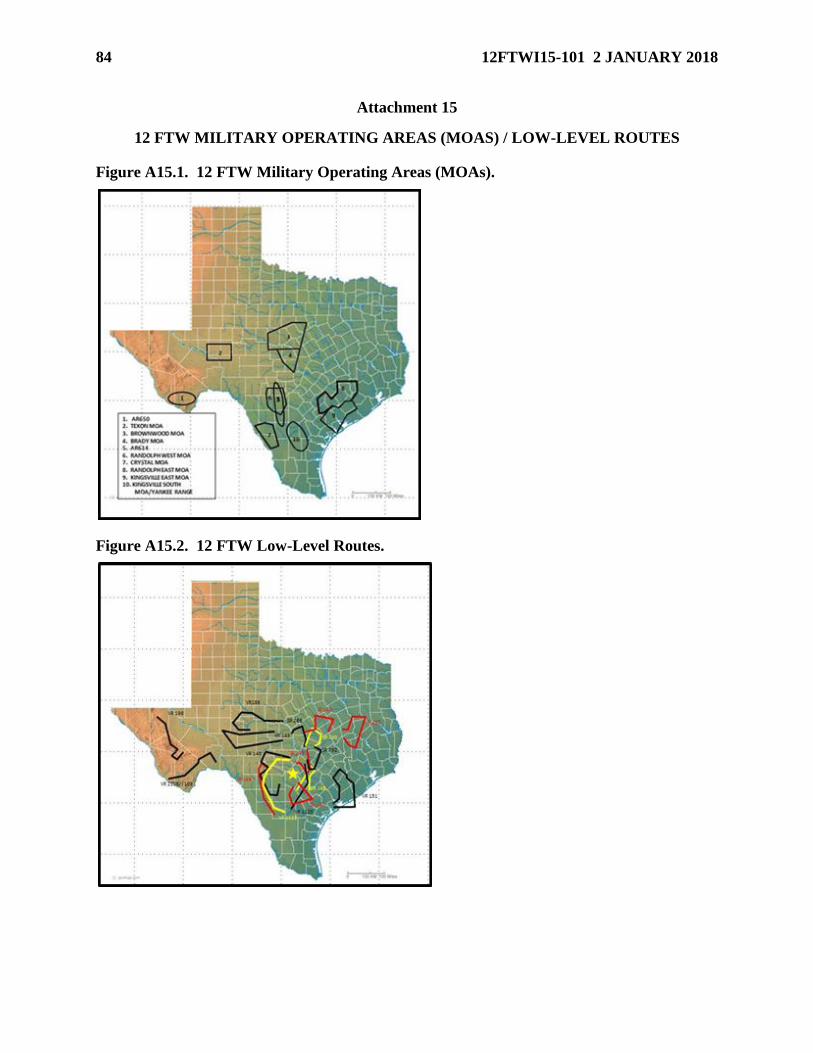
84 12FTWI15-101 2 JANUARY 2018
Attachment 15
12 FTW MILITARY OPERATING AREAS (MOAS) / LOW-LEVEL ROUTES
Figure A15.1. 12 FTW Military Operating Areas (MOAs).
Figure A15.2. 12 FTW Low-Level Routes.
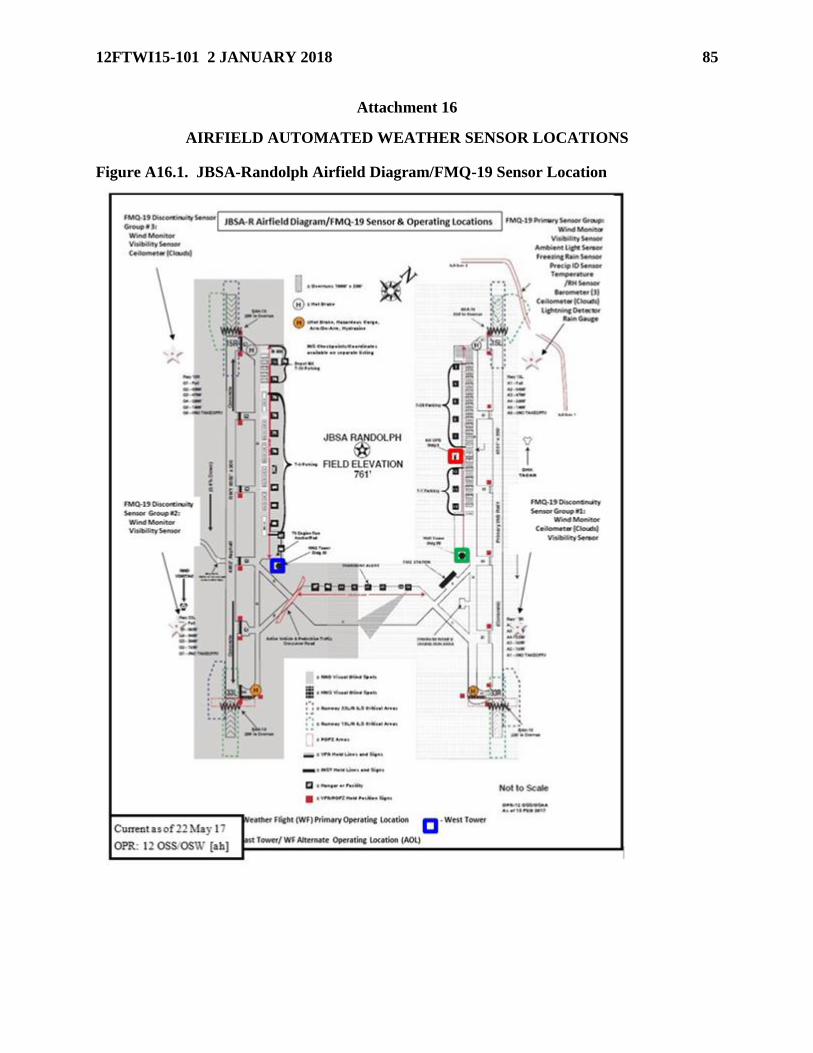
12FTWI15-101 2 JANUARY 2018 85
Attachment 16
AIRFIELD AUTOMATED WEATHER SENSOR LOCATIONS
Figure A16.1. JBSA-Randolph Airfield Diagram/FMQ-19 Sensor Location


![Vectored Thrust Flying Wing - Hobbicomanuals.hobbico.com/flz/flza3612-14-manual.pdf · Vectored Thrust Flying Wing ... Weight: 29.6 – 31.3 oz [840 – 885 g] Wing Loading: 10.4](https://img.pdfslide.net/doc/110x75/5af1af897f8b9a8b4c8f147a/vectored-thrust-flying-wing-thrust-flying-wing-weight-296-313-oz-840.jpg)