Embed Size (px)
Citation preview
Planning Committee Meeting
28 June 2011
Notice and Agenda of Meeting
to be held in the Council Chamber,
Magid Drive, Narre Warren
Commencing at 6:30 p.m.
Chairperson: Councillor Sam Aziz Members: Mayor - Councillor Shar Balmes Deputy Mayor - Councillor Wayne Smith, JP Councillor Geoff Ablett Councillor Kevin Bradford Councillor Simon Curtis Councillor Beverley Hastie Councillor Lynette Keleher Councillor Amanda Stapledon Councillor Judy Owen, JP Councillor Bob Halsall Chief Executive Officer: Mike Tyler

ORDER OF BUSINESS
Statement of Acknowledgement The City of Casey acknowledges that we are on the traditional land of the Bunurong and Wurundjeri People”.
1. Apologies 2. Confirmation of Minutes of:
Planning Committee Meeting held on 24 May 2011.
3. Declaration by Councillors of any Interest or Conflict of Interest pursuant to
Sections 77A and 79 of the Local Government Act 1989 (the Act) in any items on the Notice Paper. (Note that Sections 77A(4) and 79(1)(a) of the Act require Councillors to disclose the nature of an Interest or a Conflict of Interest immediately before the relevant consideration or discussion).
4. Consideration of Officers’ Reports
Section 1 - Permit Applications – 2
Section 2 - Appeals - Nil
Section 3 - Planning Scheme Amendments (Council) - 1
Section 4 - Planning Scheme Amendments (State Government) - Nil
Section 5 - Council Planning Policies - Nil
Section 6 - State Government Matters - Nil
Section 7 - General Matters - Nil
Section 8 - In Camera Items - Nil
Planning Officers
Director Planning and Development Services - Peter Fitchett
Acting Manager Planning - Duncan Turner
Manager Strategic Development - Liam Hodgetts
Planning Committee
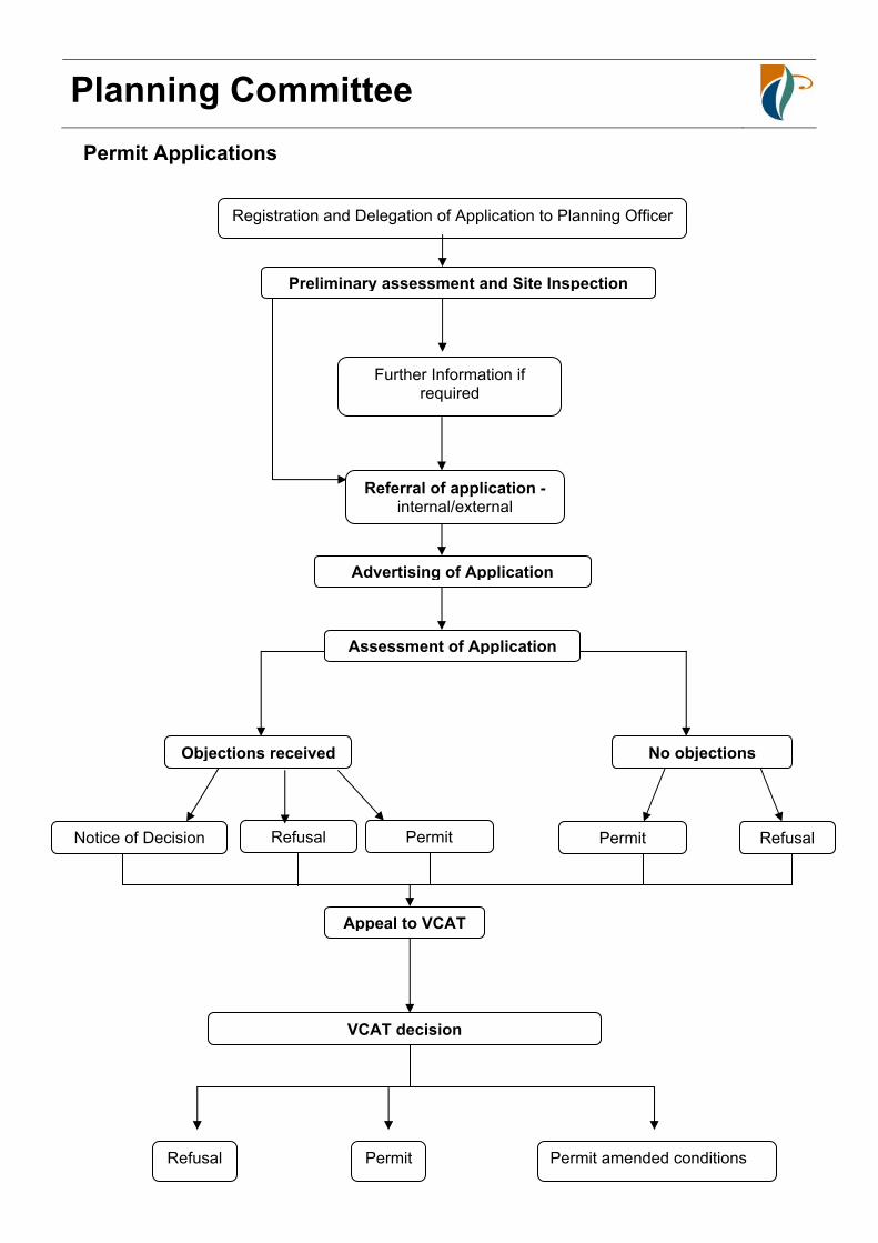
Permit Applications
Registration and Delegation of Application to Planning Officer
Preliminary assessment and Site Inspection
Further Information if required
Referral of application - internal/external
Advertising of Application
Assessment of Application
Notice of Decision Refusal Permit
Objections received No objections
Appeal to VCAT
VCAT decision
Refusal Permit Permit amended conditions
RefusalPermit

Planning Committee
I N D E X T O S E C T I O N 1 – P E R M I T A P P L I C A T I O N S
Item Page No.
File Ward (if
applicable)
Description Recommendation
1.1 5 59720.PPD01 Balla Balla Application No. P733/10 80 Finsbury Road Devon Meadows, Lot 2 LP204717 Use Of Property For Animal Keeping (10 Greyhounds)
Refusal to Grant a Planning Permit
1.2 23 79364.PPD01 Balla Balla Application No. P884/10 13 Sweet Wattle Drive Cranbourne South, Lot 20 PS:437844H Development Of Works Associated With A Horse Riding Arena
Refusal to Grant a Planning Permit
I N D E X T O S E C T I O N 3 – P L A N N I N G S C H E M E A M E N D M E N T S
( C O U N C I L )
Item Page No.
File Ward (if
applicable)
Description Recommendation
3.1 53 71-1-4-1C19 Four Oaks Amendment C19 to the Casey Planning Scheme Site-Specific Control to Allow Two Lot Subdivision - No. 96-104 Bailey Road, Narre Warren North
Council not proceed with Amendment C19
Planning Committee
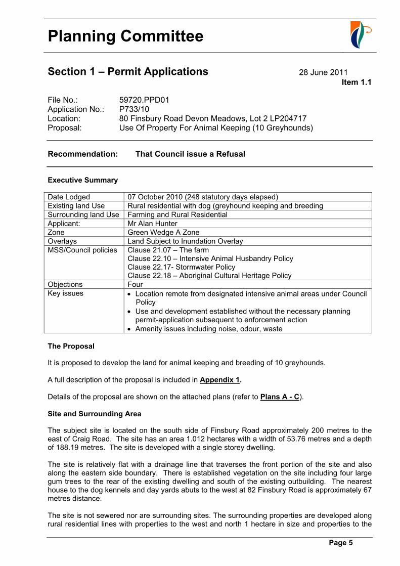
Section 1 – Permit Applications 28 June 2011
Item 1.1
Page 5
File No.: 59720.PPD01 Application No.: P733/10 Location: 80 Finsbury Road Devon Meadows, Lot 2 LP204717 Proposal: Use Of Property For Animal Keeping (10 Greyhounds)
Recommendation: That Council issue a Refusal
Executive Summary
Date Lodged 07 October 2010 (248 statutory days elapsed) Existing land Use Rural residential with dog (greyhound keeping and breeding Surrounding land Use Farming and Rural Residential Applicant: Mr Alan Hunter Zone Green Wedge A Zone Overlays Land Subject to Inundation Overlay MSS/Council policies Clause 21.07 – The farm
Clause 22.10 – Intensive Animal Husbandry Policy Clause 22.17- Stormwater Policy Clause 22.18 – Aboriginal Cultural Heritage Policy
Objections Four Key issues Location remote from designated intensive animal areas under Council
Policy Use and development established without the necessary planning
permit-application subsequent to enforcement action Amenity issues including noise, odour, waste
The Proposal
It is proposed to develop the land for animal keeping and breeding of 10 greyhounds. A full description of the proposal is included in Appendix 1. Details of the proposal are shown on the attached plans (refer to Plans A - C). Site and Surrounding Area
The subject site is located on the south side of Finsbury Road approximately 200 metres to the east of Craig Road. The site has an area 1.012 hectares with a width of 53.76 metres and a depth of 188.19 metres. The site is developed with a single storey dwelling. The site is relatively flat with a drainage line that traverses the front portion of the site and also along the eastern side boundary. There is established vegetation on the site including four large gum trees to the rear of the existing dwelling and south of the existing outbuilding. The nearest house to the dog kennels and day yards abuts to the west at 82 Finsbury Road is approximately 67 metres distance. The site is not sewered nor are surrounding sites. The surrounding properties are developed along rural residential lines with properties to the west and north 1 hectare in size and properties to the
Planning Committee
Section 1 – Permit Applications 28 June 2011
Item 1.1
Page 6
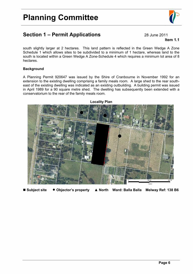
south slightly larger at 2 hectares. This land pattern is reflected in the Green Wedge A Zone Schedule 1 which allows sites to be subdivided to a minimum of 1 hectare, whereas land to the south is located within a Green Wedge A Zone-Schedule 4 which requires a minimum lot area of 8 hectares. Background A Planning Permit 920647 was issued by the Shire of Cranbourne in November 1992 for an extension to the existing dwelling comprising a family meals room. A large shed to the rear south-east of the existing dwelling was indicated as an existing outbuilding. A building permit was issued in April 1989 for a 90 square metre shed. The dwelling has subsequently been extended with a conservatorium to the rear of the family meals room.
Locality Plan
Subject site Objector’s property ▲ North Ward: Balla Balla Melway Ref: 138 B6
Planning Committee
Section 1 – Permit Applications 28 June 2011
Item 1.1
Page 7
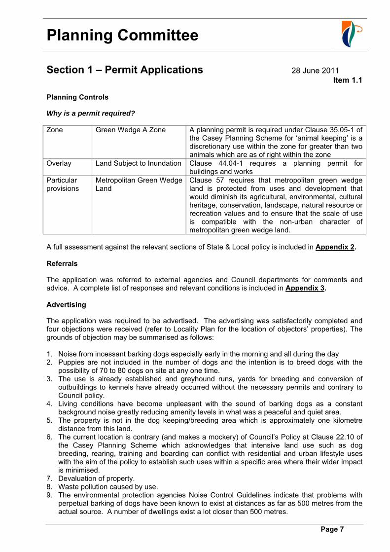
Planning Controls
Why is a permit required?
Zone Green Wedge A Zone A planning permit is required under Clause 35.05-1 of the Casey Planning Scheme for ‘animal keeping’ is a discretionary use within the zone for greater than two animals which are as of right within the zone
Overlay Land Subject to Inundation Clause 44.04-1 requires a planning permit for buildings and works
Particular provisions
Metropolitan Green Wedge Land
Clause 57 requires that metropolitan green wedge land is protected from uses and development that would diminish its agricultural, environmental, cultural heritage, conservation, landscape, natural resource or recreation values and to ensure that the scale of use is compatible with the non-urban character of metropolitan green wedge land.
A full assessment against the relevant sections of State & Local policy is included in Appendix 2. Referrals
The application was referred to external agencies and Council departments for comments and advice. A complete list of responses and relevant conditions is included in Appendix 3. Advertising
The application was required to be advertised. The advertising was satisfactorily completed and four objections were received (refer to Locality Plan for the location of objectors’ properties). The grounds of objection may be summarised as follows: 1. Noise from incessant barking dogs especially early in the morning and all during the day 2. Puppies are not included in the number of dogs and the intention is to breed dogs with the
possibility of 70 to 80 dogs on site at any one time. 3. The use is already established and greyhound runs, yards for breeding and conversion of
outbuildings to kennels have already occurred without the necessary permits and contrary to Council policy.
4. Living conditions have become unpleasant with the sound of barking dogs as a constant background noise greatly reducing amenity levels in what was a peaceful and quiet area.
5. The property is not in the dog keeping/breeding area which is approximately one kilometre distance from this land.
6. The current location is contrary (and makes a mockery) of Council’s Policy at Clause 22.10 of the Casey Planning Scheme which acknowledges that intensive land use such as dog breeding, rearing, training and boarding can conflict with residential and urban lifestyle uses with the aim of the policy to establish such uses within a specific area where their wider impact is minimised.
7. Devaluation of property. 8. Waste pollution caused by use. 9. The environmental protection agencies Noise Control Guidelines indicate that problems with
perpetual barking of dogs have been known to exist at distances as far as 500 metres from the actual source. A number of dwellings exist a lot closer than 500 metres.

Planning Committee
Section 1 – Permit Applications 28 June 2011
Item 1.1
Page 8
A response to these objections is provided in Appendix 4. Conclusion
A recommendation for refusal is based on an assessment against the requirements of the Casey Planning Scheme and consideration of all written objections. The key issues influencing the recommendation are as follows: Under Clause 10 the Casey Planning Scheme within the State Planning Policy Framework Planning authorities and Responsible Authorities should endeavour to integrate a range of policies relevant to the issues to be determined and balance conflicting objectives in favour of net community benefit and sustainable development for the benefit of present and future generations. The MSS encourages the retention of farming activities including animal boarding and dog breeding in the farm region. The canine industry in particular makes a significant contribution to the local and metropolitan economy. The policy also requires that land use conflict does not arise between existing intensive farming uses and rural residential development and that intensive uses should be encouraged to locate in identified areas so that noise and odours can be contained within these designated areas. The site is remote from the dog areas specified under Clause 22.10 the Casey Planning Scheme. While other permits have been issued for sites that are not in the preferred area for dog keeping and breeding it is prefaced on them being remote from neighbouring properties and that off site amenity impacts can be contained on site. As well, there are a number of elements of this proposal including location, construction, fencing and noise attenuation or lack thereof that are contrary to Council’s policy as it relates to the intensive animal husbandry and more specifically dog keeping/breeding. In relation to this site adjoining dwellings are located within close proximity of the site. The application has been lodged as result of enforcement action and complaints in relation to dogs barking and howling have been lodged on an on-going basis since the applicant commenced the operation without a planning permit approximately 12 months ago. The location of the site in a Green Wedge A Zone with a specific purpose “to recognise and protect the amenity of existing rural living areas” the nature of the objections and their on-going nature indicates that off site amenity impacts are not being appropriately managed. The use is inappropriately located being too close to adjoining rural residential developed properties. On balance it has not been demonstrated that a net community benefit will result from approval of this development. Melbourne Water requirements in relation to the relocation of the whelping kennel away from Christies Drain and onto higher ground and the need to protect overland flow paths will negatively impact on existing trees and could ultimately locate the whelping kennel even closer to adjoining residences. The construction of fencing along the eastern boundary while considered necessary for screening purposes to satisfy Council’s Policy, is likely to impede overland flow paths. The containment of and treatment of waste proposed on site is unlikely to negate that at least some polluted stormwater and/or animal waste and cleaning products will make their way into Christies Drain and ultimately into Westernport Bay.

Planning Committee
Section 1 – Permit Applications 28 June 2011
Item 1.1
Page 9
Recommendation
A. That Council issue a Refusal P733/10 for Use Of the Property For Animal Keeping and Breeding (10 Greyhounds) at 80 Finsbury Road Devon Meadows, Lot 2 LP204717 on the following grounds:
1. The proposed use and development does not accord with Council’s local policy at Clause 22.10 of the Casey Planning Scheme as it relates to intensive animal husbandry in that the site is remote from the designated area for dog keeping, provides insufficient buffer to contain off-site impacts, breeding and boarding and does not satisfy landscaping construction and fencing requirements contained in this policy.
2. The proposed use and development will result in inappropriate reduction of amenity levels within the area contrary to provisions of the Green Wedge A Zone.
3. The proposed use and development will not result in proper planning for the area as it undermines the local planning and zone provisions.
4. Off-site impacts including stormwater, treatment of waste products and noise are not being effectively managed to the detriment of the surrounding area and rural residential properties.
5. The location and construction of the whelping kennel (existing) is contrary to Melbourne Water requirements.
B. Notify the objectors of Council’s Decision C. Send a copy of Council’s Decision to Melbourne Water to comply with S66 of the
Planning and Environment Act.

Planning Committee
Section 1 – Permit Applications 28 June 2011
Item 1.1
Page 10
Appendices: Application details, considerations and assessment
Appendix 1: Details of proposal
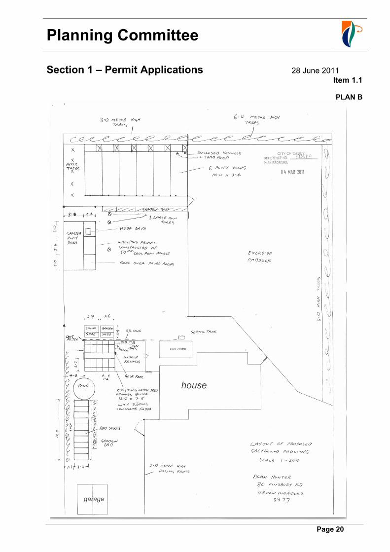
Ten greyhounds, 6 quality broods and 4 young pups to be retained on the site to an age of 12 to 14 months at which point they would leave the property to be prepared for racing or sold.
The main kennel block is the existing metal shed of 90 square metres that has been partitioned into 10 kennels at the eastern end of the shed with a kitchen and food preparation area at the western end of the shed closest to the rear of the dwelling.
The whelping kennel (already constructed on site) are located 3.7 metres from the eastern side boundary and is located a minimum of 2.1 metres to the west of four large existing eucalypts.
A whelping kennel has an area of 23 square metres containing two small rooms to allow two sets of puppies to be reared at the same time and a covered dry area above ground level and a small day yard of 35.5 square metres for the puppies immediately abutting the eastern boundary in the portion of the site that has a an existing corrugated iron fence.
The whelping kennels are made of 500mm thick coolroom panels.
The proposal involves the lining and insulation of the main kennel block (shed) with foam to reduce noise and in the roof for insulation.
There are day yards located in the south-east corner with a small covered/roofed space, while the existing paddock to the south-west corner is used for exercise.
The owner in his submission states that “All facilities were in place for greyhound accommodation”. (Council records and evidence from aerial photography and neighbours do not corroborate this written advice from the applicant).
The existing corrugated iron fence is to be extended in a southerly direction to the rear southern boundary and in a northerly direction to screen the day kennels located approximately metres from the eastern boundary.
The septic tank is located to the rear of the dwelling to the west of the four large existing eucalypts.
The kennel block (metal shed) is cleaned morning and night and a lint strainer has been installed to prevent hair from blocking the 90mm drain that feeds into the septic tank.
The day yards are utilised in the morning and night when the kennel block is being cleaned.
Solid waste is collected and removed from the site twice weekly.

Planning Committee
Section 1 – Permit Applications 28 June 2011
Item 1.1
Page 11
Appendix 2: Assessment against relevant Planning Scheme controls
Planning Scheme reference
Assessment
State Planning Policy Framework Clause No 10 – Integrated Decision Making
Planning Authorities and Responsible Authorities should endeavour to integrate a range of policies relevant to the issues to be determined and balance conflicting objectives in favour of net community benefit and sustainable development for the benefit of present and future generations.
Net community benefit in relation to this use has not been established.
Clause No 11.04-6 - Green Wedge provisions
The objective is to protect the green wedges of Metropolitan Melbourne from inappropriate development. Developments in the green wedges should provide for environmental, economic & social benefits and protect important productive agricultural areas such as Westernport and areas of environmental landscape & scenic value. The area has been developed along rural residential lines with land lost to productive agriculture due to the 1 hectare subdivision patter. While the use of the land for dog kennels to facilitate greyhound dog breeding could be supported the intensification and off site impacts of the use in relation to the surrounding area do not provide any environmental or social benefits to the immediate area.
Clause No 13.02 – Floodplain Management
Life, property and community infrastructure should be protected from flood hazard and an intensification of the impacts of flooding through inappropriately located uses and developments should be avoided. The Devon Meadows area is low lying with many lots in the area experiencing water logging at various times of the year due to poor drainage and very flat grades and the rural construction of drains. This site is no exception in that the front of the site and along the eastern boundary is at times inundated due to low lying areas and natural drainage lines. The application has been referred to Melbourne Water and they have set applicable flood levels, minimum setbacks of buildings to allow for the passage of flood waters and recommend that any outbuilding associated with housing animals be sited on the higher ground of the property outside of the land subject to inundation area.
Clause No 13.04 Noise and Air
The objectives are to assist in the control of noise effects on sensitive land uses and protect and improve air quality. The establishment of a dog breeding use within 70 metres of adjoining residences and the number of complaints that are being lodged indicate that the noise effects of barking dogs associated with this use are not being effectively managed and due to the proximity of surrounding residences are unlikely to be effectively managed in the future.
Clause 14.02–Water Quality
Ensure that land use activities potentially discharging contaminated runoff or wastes to waterways are sited and managed to minimise such discharges and to protect the quality of surface water and groundwater resources. It is likely that some runoff from this site in the form of cleaning products and animal waste products will make their way into the abutting Christies Drain and then ultimately into Western Port Bay.
Planning Committee
Section 1 – Permit Applications 28 June 2011
Item 1.1
Page 12
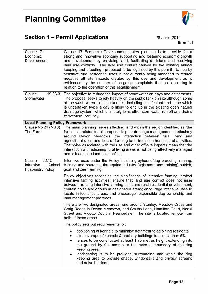
Clause 17 – Economic Development
Clause 17 Economic Development states planning is to provide for a strong and innovative economy supporting and fostering economic growth and development by providing land, facilitating decisions and resolving land use conflicts. The land use conflict caused by the existing animal keeping and breeding - proposed to be legalised by this permit - to nearby sensitive rural residential uses is not currently being managed to reduce negative off site impacts created by this use and development as is evidenced by the number of on-going complaints that are occurring in relation to the operation of this establishment.
Clause 19.03-3 Stormwater
The objective to reduce the impact of stormwater on bays and catchments. The proposal seeks to rely heavily on the septic tank on site although some of the wash when cleaning kennels including disinfectant and urine which is undertaken twice a day is likely to end up in the existing open natural drainage system, which ultimately joins other stormwater run off and drains to Western Port Bay.
Local Planning Policy Framework Clause No 21 (MSS) The Farm
The main planning issues affecting land within the region identified as ‘the farm’ as it relates to this proposal is poor drainage management particularly around Devon Meadows, the interaction between rural living and agricultural uses and loss of farming land from non-horticultural activities. The noise associated with the use and other off-site impacts mean that the interaction with adjoining rural living areas is not being effectively managed and is leading to land use conflict.
Clause 22.10 – Intensive Animal Husbandry Policy
Intensive uses under the Policy include greyhound/dog breeding, rearing, training and boarding, the equine industry (agistment and training) ostrich, goat and deer farming.
Policy objectives recognise the significance of intensive farming; protect intensive faming activities; ensure that land use conflict does not arise between existing intensive farming uses and rural residential development; contain noise and odours in designated areas; encourage intensive uses to locate in identified areas; and encourage responsible dog ownership and land management practices.
There are two designated areas; one around Stanley, Meadow Cross and Craig Roads in Devon Meadows, and Smiths Lane, Hamilton Court, Noaki Street and Vidotto Court in Pearcedale. The site is located remote from both of these areas.
The policy sets out requirements for:
positioning of kennels to minimise detriment to adjoining residents, site coverage of kennels & ancillary buildings to be less than 5%, fences to be constructed at least 1.75 metres height extending into
the ground by 0.4 metres to the external boundary of the dog keeping area;
landscaping is to be provided surrounding and within the dog keeping area to provide shade, windbreaks and privacy screens and noise barriers;
Planning Committee
Section 1 – Permit Applications 28 June 2011
Item 1.1
Page 13
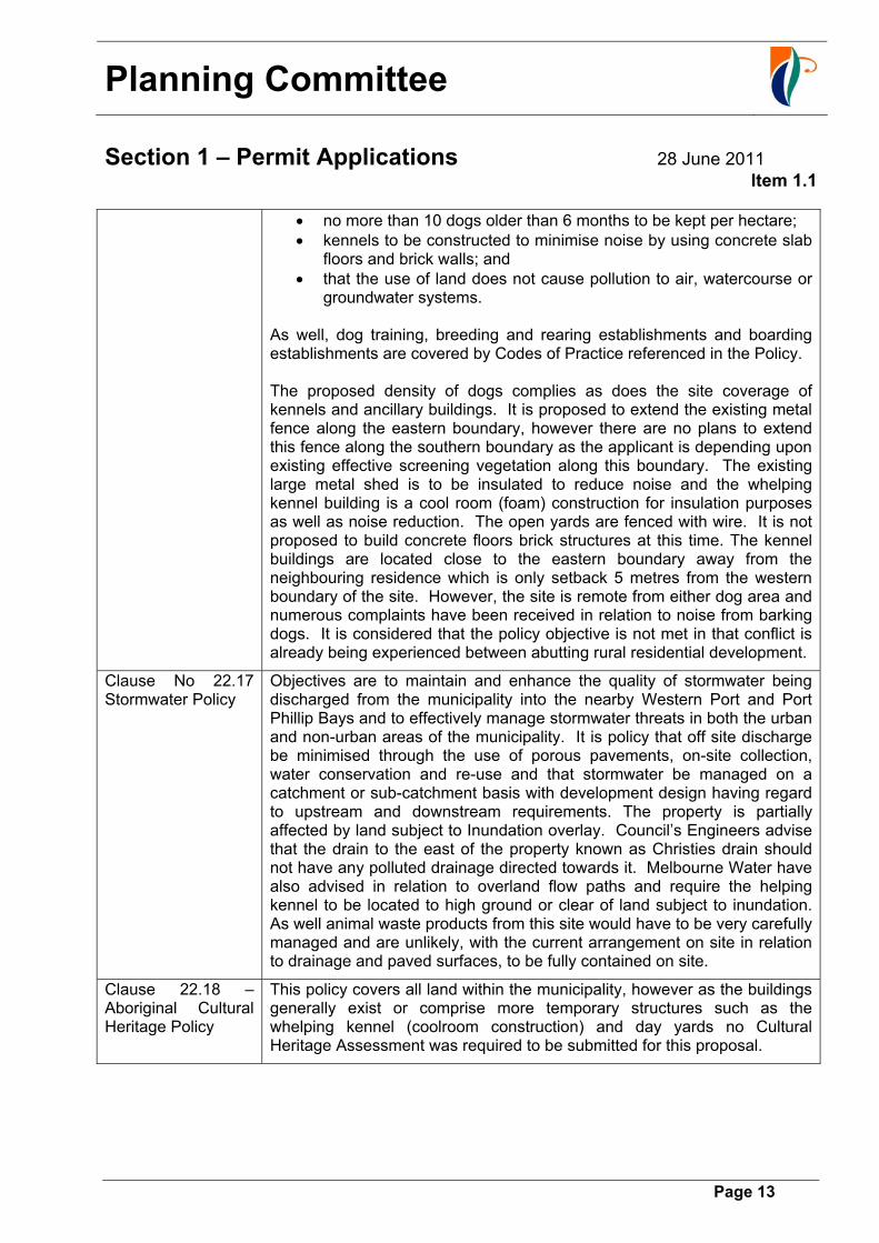
no more than 10 dogs older than 6 months to be kept per hectare; kennels to be constructed to minimise noise by using concrete slab
floors and brick walls; and that the use of land does not cause pollution to air, watercourse or
groundwater systems.
As well, dog training, breeding and rearing establishments and boarding establishments are covered by Codes of Practice referenced in the Policy. The proposed density of dogs complies as does the site coverage of kennels and ancillary buildings. It is proposed to extend the existing metal fence along the eastern boundary, however there are no plans to extend this fence along the southern boundary as the applicant is depending upon existing effective screening vegetation along this boundary. The existing large metal shed is to be insulated to reduce noise and the whelping kennel building is a cool room (foam) construction for insulation purposes as well as noise reduction. The open yards are fenced with wire. It is not proposed to build concrete floors brick structures at this time. The kennel buildings are located close to the eastern boundary away from the neighbouring residence which is only setback 5 metres from the western boundary of the site. However, the site is remote from either dog area and numerous complaints have been received in relation to noise from barking dogs. It is considered that the policy objective is not met in that conflict is already being experienced between abutting rural residential development.
Clause No 22.17 Stormwater Policy
Objectives are to maintain and enhance the quality of stormwater being discharged from the municipality into the nearby Western Port and Port Phillip Bays and to effectively manage stormwater threats in both the urban and non-urban areas of the municipality. It is policy that off site discharge be minimised through the use of porous pavements, on-site collection, water conservation and re-use and that stormwater be managed on a catchment or sub-catchment basis with development design having regard to upstream and downstream requirements. The property is partially affected by land subject to Inundation overlay. Council’s Engineers advise that the drain to the east of the property known as Christies drain should not have any polluted drainage directed towards it. Melbourne Water have also advised in relation to overland flow paths and require the helping kennel to be located to high ground or clear of land subject to inundation. As well animal waste products from this site would have to be very carefully managed and are unlikely, with the current arrangement on site in relation to drainage and paved surfaces, to be fully contained on site.
Clause 22.18 – Aboriginal Cultural Heritage Policy
This policy covers all land within the municipality, however as the buildings generally exist or comprise more temporary structures such as the whelping kennel (coolroom construction) and day yards no Cultural Heritage Assessment was required to be submitted for this proposal.

Planning Committee
Section 1 – Permit Applications 28 June 2011
Item 1.1
Page 14
Other Clause 35.05. Green Wedge A Zone provisions
The relevant purposes of the Green Wedge A Zone that relate to this application are to:
“Protect, conserve and enhance the biodiversity, natural resources, scenic landscapes and heritage values of the area;
Ensure that use and development promotes sustainable land management practices and infrastructure provision;
Protect, conserve and enhance the cultural heritage significance and the character of rural and scenic non-urban landscapes; and
Recognise and protect the amenity of existing rural living areas.”
The establishment of a dog breeding operation on the subject land creates detriment to surrounding properties and to people’s enjoyment of the rural living atmosphere. As well as utilising Decision Guidelines at Clause 65 Council is required to:
“Assess the capability of the land to accommodate the proposed use or development, addressing site quality attributes including soil type, fertility, structure permeability, aspect, contour and drainage patterns.
Whether the site is suitable for the use or development and whether the proposal will have an adverse impact on surrounding land uses;
The need to protect the amenity of existing residents.”
At Clause 35.05-6 of the Casey Planning Scheme.
The site is not sewered and relies on a septic tank. The applicant has advised that he washes the kennels and dogs and that this waste water ends up in the septic and hard waste (faeces) is disposed of remote from the site at a place of employment. This arrangement is far from ideal. The use and development of dog kennels for dog breeding also negatively impacts on the amenity of existing residents in the area and is considered to be unsuitably located within the context of the surrounding rural residential area.
Clause 43.04-Land Subject to Inundation Overlay
The relevant purposes of the land subject to Inundation Overlay are to:
“Ensure that development maintains the free passage and temporary storage of floodwaters, minimises flood damage is compatible with the flood hazard and local drainage conditions and will not cause any significant rise in flood level of flow velocity
Protect water quality in accordance with the provisions of relevant state environment protection policies
Ensure that development maintains or improves river and wetland health, waterway protection and flood plain health.”

Planning Committee
Section 1 – Permit Applications 28 June 2011
Item 1.1
Page 15
Melbourne Water is the relevant floodplain management authority for this area. Melbourne Water have requested that the whelping kennel be located clear of land subject to inundation or 5 metres from the eastern boundary. The whelping kennel is currently setback 3.7 metres from the eastern boundary and if located a greater distance from the boundary as required would negatively impact on existing eucalypts. Added to this the whelping kennel is located near the lowest portion of the site and is unlikely to be constructed at a height to meet Melbourne Water requirements although it is located approximately 200 mm above natural ground level on wooden stumps and comprises a building that could be moved relatively easily. Melbourne Water recommend that this building is located on higher ground rather than on land that is likely to be inundated. However, relocation of this building to higher ground would bring the structure closer to dwellings on surrounding properties.
Further, it is likely that the corrugated iron fence that has been constructed and the proposed extension of such in a northerly and southerly direction to offer a visual screen and satisfy Council’s Policy at Clause 22.10 of the Casey Planning scheme is likely to impede overland flow paths.
Clause 65 – Decision Guidelines
Applicable Decision Guidelines related to this proposed development are:
“the purposes of the zone;
the orderly planning of the area;
the effect on the amenity of the area;
factors likely to cause or contribute to land degradation, salinity or reduce water quality;
whether the proposed development is designed to maintain or improve the quality of stormwater within and exiting the site; and
the extent and character of native vegetation and the likelihood of its destruction.
The degree of flood, erosion or fire hazard associated with the location of the land and the use, development or management of the land so as to minimise any such hazard”
The purposes of the Green Wedge A Zone have been previously discussed, as has the effect on the amenity of the area, stormwater and water quality. While it is not proposed to remove any native vegetation there is potential for native vegetation to be damaged especially if the whelping kennel is relocated.
The negative affect on the amenity of the area has been previously discussed and it is considered that given council has policies in relation to the location of dog keeping/breeding facilities that approval of the current use and development on this site would not result in orderly planning for the area.
Planning Committee
Section 1 – Permit Applications 28 June 2011
Item 1.1
Page 16
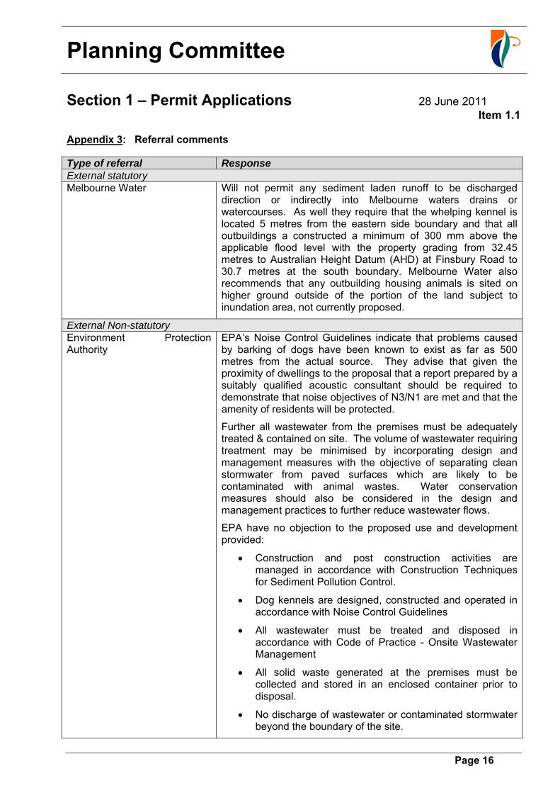
Appendix 3: Referral comments
Type of referral Response External statutory Melbourne Water Will not permit any sediment laden runoff to be discharged
direction or indirectly into Melbourne waters drains or watercourses. As well they require that the whelping kennel is located 5 metres from the eastern side boundary and that all outbuildings a constructed a minimum of 300 mm above the applicable flood level with the property grading from 32.45 metres to Australian Height Datum (AHD) at Finsbury Road to 30.7 metres at the south boundary. Melbourne Water also recommends that any outbuilding housing animals is sited on higher ground outside of the portion of the land subject to inundation area, not currently proposed.
External Non-statutory Environment Protection Authority
EPA’s Noise Control Guidelines indicate that problems caused by barking of dogs have been known to exist as far as 500 metres from the actual source. They advise that given the proximity of dwellings to the proposal that a report prepared by a suitably qualified acoustic consultant should be required to demonstrate that noise objectives of N3/N1 are met and that the amenity of residents will be protected.
Further all wastewater from the premises must be adequately treated & contained on site. The volume of wastewater requiring treatment may be minimised by incorporating design and management measures with the objective of separating clean stormwater from paved surfaces which are likely to be contaminated with animal wastes. Water conservation measures should also be considered in the design and management practices to further reduce wastewater flows.
EPA have no objection to the proposed use and development provided:
Construction and post construction activities are managed in accordance with Construction Techniques for Sediment Pollution Control.
Dog kennels are designed, constructed and operated in accordance with Noise Control Guidelines
All wastewater must be treated and disposed in accordance with Code of Practice - Onsite Wastewater Management
All solid waste generated at the premises must be collected and stored in an enclosed container prior to disposal.
No discharge of wastewater or contaminated stormwater beyond the boundary of the site.
Planning Committee
Section 1 – Permit Applications 28 June 2011
Item 1.1
Page 17
A secondary containment system shall be provided for liquids which if spilt are likely to cause pollution or pose and environmental hazard in accordance with the Bunding Guidelines.
No emission of offensive odours to the senses of human beings beyond the boundary of the site.
No visible discharge of dust beyond the boundary of the site.
Noise emitted from the premises must not exceed the noise objectives as set out in the Interim guidelines for Control of Noise from Industry in Country Victoria.
Internal Departments Community Safety Department – Environmental Health Section
Waste is disposed of into the existing septic tank system. All wastewater must be treated and contained on site in accordance with EPA Septic Tank code of Practice and Council requirements. Any installation or alteration works to the existing septic tank system are required to be approved by Council’s Health Department.
In view of the potential for noise generation affecting nearby residential lots compliance with EPA requirements relating to noise generation from this property are necessary
Engineering and Asset Management Department
The property is partially liable to flooding and comments are required from Melbourne Water. No polluted drainage is allowed to be discharged beyond the boundaries of the site from which it emanates into a watercourse or easement drain. An on-site rubble pit is to be constructed to the satisfaction of the Responsible Authority to meet this requirement or alternatively stormwater discharge for the property is located towards the eastern boundary of the property known as Christies Drain and would need approval from Melbourne Water.
Parks & Reserves Department – Landscape Design
An Arborist Report has been submitted in relation to the impact of the construction of the whelping kennels on four existing eucalypts (one quite remote to the north of the structure). The report has assessed 3 Eucalyptus botryoides (Southern Mahoganys) adjacent to the whelping kennel. The whelping kennel is located with the structural root zone of Tree #1. The Arborist advises that given the structure is built above grade, this encroachment is likely to have had minimal impact on the tree however under no circumstances should further disturbance or construction occur within the structural root zone SRZ of this tree. In terms of landscaping the animal keeping structures can be adequately screened by existing and additional screen planting. The planting may not address noise issues, however it would be sufficient to mitigate visual impact from the development with suitable conditions. Encroachment within the Tree Protection Zone (TPZ) of existing screen shrubs along the southern and eastern boundaries is not supported.

Planning Committee
Section 1 – Permit Applications 28 June 2011
Item 1.1
Page 18
Appendix 4: Response to Objections
Objection Comment 1. Incessant noise
from barking dogs There have been on-going complaints in relation to this aspect of the use and development both to Council’s Planning Enforcement Division and Local Laws. During inspection by Council’s Officer the dogs started to howl making it extremely difficult to be heard. The validity of this objection is not questioned.
2. Number of dogs in excess of 80 at any one time
As the proposal involves dog breeding it is likely as stated that there will be more than 10 dogs on the site as there will be puppies up to 6 months old. Litters average between 8 to 16 pups, although given there are only two whelping kennels it is unlikely that more than 42 dogs (32 puppies) could be accommodated at any one time.
3. The use is established illegally
The use exists on site and has been established without the necessary planning or building permits.
4. Use in breach of Council Policy
The use is in breach of council Policy in relation to its location the construction of the whelping kennels and conversion of a metal shed into dog kennels.
5. Reduced living conditions and amenity levels
This ground of objection is not disputed and has been raised by all objectors.
6. The property is not located in the dog area which is remote from site
The site is remote from the area that has been identified for intensive animal keeping to the south at Meadow and Stanley Roads. This ground of objection is not disputed.
7. Devaluation of property
This is not recognised as a valid ground of objection under Planning Legislation.
8. Waste pollution This could be a problem especially as waste is being taken off site and some effluent such as cleaning agents and animal waste is likely to end up in the drainage system as well as the existing septic tank due to the existing arrangements and building and pavement layout.
9. Location does not satisfy Noise Control Guidelines as a number of dwellings within 500 metres.
This ground of objection is not disputed and is why there have been on-going complaints in relation to the operation of the use on site.

Planning Committee
Section 1 – Permit Applications 28 June 2011
Item 1.1
Page 19
PLAN A
Planning Committee
Section 1 – Permit Applications 28 June 2011
Item 1.1
Page 20
PLAN B

Planning Committee
Section 1 – Permit Applications 28 June 2011
Item 1.1
Page 21
PLAN C

Planning Committee
Page 22
(this page is meant to be blank)
Planning Committee
Section 1 – Permit Applications 28 June 2011
Item 1.2
Page 23
File No.: 79364.PPD01 Application No.: P884/10 Location: 13 Sweet Wattle Drive Cranbourne South, Lot 20 PS:437844H Proposal: Development Of Works Associated With A Horse Riding Arena
Recommendation: That Council issue a Refusal
Executive Summary
Date Lodged 29-Nov-2010 (104 statutory days elapsed) Existing land Use Rural Residential property Surrounding land Use Rural Residential property Applicant: Ms Sarah Furman Zone Green Wedge A Zone (Schedule 5). Overlays No Overlay Controls apply to the land. MSS/Council Policies Clause 21.07 The Farm Restrictive Covenant Restrictive Covenant in Instrument of Transfer No. PS437844H Objections The application has not been advertised Key Issues Unlawful Vegetation Removal
Breach of Restrictive Covenant Breach of Section 173 Agreement
The Proposal
The applicant has described the proposal as constructing a surface of sand with a gravel base suitable for a horse riding arena that will also serve as a mineral fire break. A post and wire fence is to be erected around part of the riding arena. A full description of the proposal is included in Appendix 1. Details of the proposal are shown on the attached plans (refer to Plans A-C). The plan of the former Keblar Estate showing the areas of high and very high conservation value is attached in Plan D. Site and Surrounding Area
The subject site has an area of 2.01 hectares and is located on the western side of Sweet Wattle Drive, Cranbourne South. The allotment is irregular in shape, with a length of 104.59 metres cross the front (eastern) boundary, tapering to 49.20 metres to the rear (western) boundary, 263.23 metes along the northern boundary and a length of 272.94 metres (southern boundary). A post and wire fence is located around the perimeter of the site. The site has a fall of 0.42 metres across the front of the site, falling from the north to the south. The topography across the middle of the allotment varies. A narrow water course line (barely evident) dissects the property extending from a dam located to the north, through to the south of the riding arena/mineral earth break, then to the dam on the adjoining property to the south. There was no water evident on the subject site at the time of the initial inspection. A later inspection revealed a slight pooling of water to the east of the proposed riding arena.

Planning Committee
Section 1 – Permit Applications 28 June 2011
Item 1.2
Page 24
The site contains an ‘L’ shaped dwelling located towards the front of the property, setback approximately 36 metres from the front boundary; an outbuilding is constructed to the south-east of the dwelling, with provision for water tanks. Another small shed structure has been constructed to the north-west of the dwelling. The land is used for rural residential purposes. A large elongated rectangular grassed and fenced horse paddock is located to the north of the dwelling. An irregular shaped horse paddock is located northwest of the dwelling, and contains ‘pockets’ of native vegetation. This area abuts the proposed horse riding arena/mineral earth break, which is surrounded in part by native vegetation. The subject site contains significant patches of remnant native vegetation. There is a ‘linear’ pocket of vegetation with high conservation significance located parallel to the eastern boundary of the subject site. This extends from adjacent to part of the building envelope down to the rear of the site, it then takes a curvilinear form and there is an almost triangular patch towards the rear of the site, which extends to the eastern boundary. There is a larger more ‘intact’ area of vegetation which connects to that on site, which forms part of the adjoining lot to the east (9-11 Sweet Wattle Drive, Cranbourne South). There is also another ‘pocket’ of vegetation of high conservation value which affects the land in part at 15 Sweet Wattle and a larger portion of 17 Sweet Wattle Drive. The rear of the site is the least disturbed habitat and has an area of approximately 5919 square metres. There are also pockets of relatively undisturbed native vegetation remaining on site, the most significant being in a ‘linear’ form along the southern boundary to the south of an unusual shaped horse paddock in the middle of the subject site. There is also a larger area of relatively undisturbed native vegetation to the rear of the site, although it is noted that there are ‘fenced off’ tracks throughout parts of these areas. The surrounding area can be characterised as rural residential living, within the context of remnant native vegetation of very high and high conservation significance. It is noted that the vegetation to the rear of the property to the north was largely ‘moon-scaped’ some time ago and revegetation is occurring as a consequence of enforcement action. The property to the south is occupied by a dwelling, outbuildings, swimming pool and a large dam. This site also contains a significant area of relatively ‘undisturbed’ native vegetation and habitat. Any relevant planning history is included in Appendix 2 for background information.

Planning Committee
Section 1 – Permit Applications 28 June 2011
Item 1.2
Page 25
Locality Plan
Subject site ▲ North Ward: Balla Balla Melway Ref: 137F9, 137E9 Planning Controls
Why is a permit/consent required?
Zone Green Wedge A Zone A permit is required to construct or carry out works associated with a use (Dwelling) in Section 2 pursuant to Clause 35.05-3 of the Casey Planning Scheme.
Particular provisions
Native Vegetation A permit is required to remove, lop or destroy native vegetation pursuant to Clause 52.17 of the Casey Planning Scheme. This issue will be discussed later in the context of the report.
Restrictive Covenant PS 437844H
Section 61(4) of the Planning and Environment Act 1987
Consent is required under the Restrictive Covenant to construct any buildings or works outside the building envelopes & waste water envelopes.
Section 173 Agreement X409538E
The Section 173 Agreement requires the owners of lots affected by the agreement to do all things necessary to protect and conserve the areas of high and very high conservation value within the lots to the satisfaction of Council. The owners of the lots require a planning permit to remove, destroy or lop native vegetation in accordance with Clause 52.17 of the Casey Planning Scheme.
A full assessment against the relevant sections of state and local policy and restrictive covenants and agreements is included in Appendix 3.
Planning Committee
Section 1 – Permit Applications 28 June 2011
Item 1.2
Page 26
Referrals
The application was referred to external agencies and Council departments for comments and advice. A complete list of responses and standard conditions is included in Appendix 4. In addition, the following responses contain additional information that has influenced the recommendation: Department of Sustainability and Environment (DSE)-(Non Statutory Referral) The application was referred to Council’s Landscape, Environment, Vegetation Officer and
Drainage Departments. No conditions are recommended, as the proposal is not supported. Advertising
The application was not required to be advertised. Whilst the works associated with the arena have not been completed, the vegetation has been removed; the topography of the land altered and the area is already being used in its current condition for the purposes of a riding arena. Given the unlawful removal of vegetation, and the recommendation to refuse the application, advertising was not considered essential. Conclusion
A recommendation for refusal is based on an assessment against the requirements of the Casey Planning Scheme, and the relevant provisions of the Planning and Environment Act 1987 as they relate to the Restrictive Covenant and Section 173 Agreements registered on the Title for the land. The key issues influencing the recommendation are as follows:- The planning permit for the subdivision of the former Kerblar Estate which contained
vegetation of very high and high conservation value was approved on the basis that this vegetation would be protected in perpetuity by the specific and detailed requirements of the Section 173 Agreement registered on Title.
The applicant has been aware of the requirements of the Restrictive Covenants and Section 173 Agreements in the past, as evidenced by the obtaining of a planning permit for a shed and Council’s approval for altering the location and siting of the waste water envelope on site.
The Department of Sustainability and Environment and Council’s Environment, Drainage and Landscape Departments do not support the application and support Council’s Officer’s position to pursue enforcement action against the owner of the land.
Planning Committee
Section 1 – Permit Applications 28 June 2011
Item 1.2
Page 27
Recommendation
D. That Council issue A Refusal to Grant a Permit (P884/10) for Development Of Works Associated With A Horse Riding Arena/Mineral Earth Break at 13 Sweet Wattle Drive Cranbourne South, Lot 20 PS:437844H on the following grounds:
1. The proposed development does not satisfy the State and Local Planning
Policies, particularly as it relates to the protection and conservation of biodiversity, including native vegetation and the retention of habitat. The vegetation removed has undermined the ecological assets on site through habitat removal and ecological connectivity throughout this site and the broader areas of high conservation significance.
2. The removal of native vegetation has occurred without recognition of Victoria’s
Native Vegetation Management-a Framework for Action demonstrating how the three step process of avoid, minimise and offset was implemented.
3. The removal of vegetation and works associated with a riding arena is
inconsistent with the Section 173 Agreement X409538E dated 9/4/2001 affecting the land, through the removal of vegetation without a planning permit, the applicant has not done all things necessary to protect and conserve areas of high conservation significance, horses have been allowed into unfenced areas abutting vegetation of high conservation significance and the natural drainage flows across the land have been altered through changes to the topography of the land associated with the proposed riding arena.
4. The works commenced on site to date are in breach of Restrictive Covenant
PS437844H dated 12/2/2001, as the works have been commenced outside the approved building and waste water envelopes, without relevant approval from Council.
B. That Council initiate Enforcement Action.

Planning Committee
Section 1 – Permit Applications 28 June 2011
Item 1.2
Page 28
Appendices: Application details, considerations and assessment
Appendix 1: Details of proposal
The works associated with the application have been partly commenced on site. This includes the removal of native vegetation and altering of the topography of the land, by undertaking additional works including a sand surface with a gravel base suitable for a horse riding, dressage and show jumping purposes. In addition, the applicant argues that the riding arena is to “act as a mineral fire earth break”. The materials for the earth break, has been identified as follows:- The existing soil has been flattened slightly and the topography altered. No material to date has been bought onto the property to create the mineral earth fire zone. The proposed surfacing for the riding arena is to be undertaken by Blue Ribbon Arenas. Two
quarries provide the material to Blue Ribbon Arenas and include SBI and Hillview Quarries.Both have indicated that the products are blasted from the ground and should be classified as low nutrient product. SBI Quarry provided the crushed rock material which is deep mined material. The topping is from Hillview Quarry and comprises granite dust/stone fines. No soil will be imported onto the property for this project.
A post and wire fence is also proposed around the part of the western edge of the riding arena and part of the southern edge of the arena. `
The applicant states that “the horse riding surface will be composed of a subsurface layer of well compacted aggregate that allows for drainage and a top layer of loosely compacted sand. A fence shall be constructed adjacent to the conservation zone to prevent access to this area. It is proposed to have this surface installed by a company who specialise in preparing horse riding surfaces to ensure it is well made and has a minimum impact on the surrounding bush during construction” The mineral earth fire break is located towards the rear half of the subject site, it is flanked to the west by a fairly dense area of vegetation largely comprising of mature native vegetation with significant levels of existing understorey thus providing valuable habitat. The ‘riding arena’ area or mineral earth break has partly been formed on site by changing the existing condition or topography of the land, in addition native vegetation removed without any planning approval. The riding arena has an irregular shape, has approximate dimensions of 23m to the south; 46m to the west; 32m to the north; 50m to the east. An area of approximately 1296m2, with the exception of a small island of vegetation comprising only three mature trees is isolated ‘off-centre’ to the east of the arena. The applicant advises that the riding surface is only for personal use and will not be used for business purposes. Furthermore advised “while the mineral earth fire break/sand surface will be maintained as a clear zone for bush fire protection purposes, other parts of the bush on the property are being rehabilitated and re-planted with appropriately selected local native plants. This rehabilitation is to improve the health of the bush and provide additional habitat for the Southern Brown Bandicoot that has been seen on the property and to repair damage associated with years

Planning Committee
Section 1 – Permit Applications 28 June 2011
Item 1.2
Page 29
of drought. The rehabilitation works just completed was undertaken as part of the Westernport Woodlands Project with assistance provided by Landcare” The abutting land to the east of the mineral fire break/horse riding arena has been fenced and is grassed and used for the grazing and keeping of the owner’s two horses.

Planning Committee
Section 1 – Permit Applications 28 June 2011
Item 1.2
Page 30
Appendix 2: Relevant planning history
History of the Subdivision The subject land forms part of the Keblar Estate (formerly known as Lot 26 LP79388 -875 North Road, Pearcedale) an estate that was developed under Planning Permit P659/99 issued on the 31 December, 1999 for the purpose of rural residential subdivision and removal of native vegetation. At the time of subdivision it was recognised that this estate contained vegetation of significant very high and high conservation value. Accordingly, the planning permit included provision for a Restrictive Covenant and the creation of two Section 173 Agreements as follows:- Restrictive Covenants The subject land is encumbered by a restrictive covenant and two Section 173 Agreements (a) Restrictive Covenant in Instrument of Transfer No. PS437844H dated 12 December 2001. The Covenant states: The registered proprietor or proprietors for the time being of lots 4, 5, 6, 7, 17, 18, 19, 20 and 26 on this plan of subdivision shall: 1. Not construct any building or works outside the building envelopes and waste water envelopes
shown on this plan without the further approval of City of Casey. 2. Not construct any building or works in the waste water disposal envelope excepting for works
associated with the disposal of waste water. 3. Fence off the waste disposal envelopes to prevent soil disturbance during development of the
subject land and prior to any works on the subject land. The works associated with the riding arena are located outside the approved building and waste water envelopes without Council’s approval, thus resulting in a breach of the covenant affecting the land. Section 173 Agreement (X409538E dated 9 April, 2001) This Section 173 Agreement required the ongoing protection of certain portions of the land which are of high and very high conservation value and provides for the following matters relevant to this application:- “D. A condition of the permit is that the Council and the Owner enter into this agreement regarding the ongoing protection of certain portions of the land which are of high and very high conservation value. F. The areas of high and very high conservation value are, for the most part, contained within Lots 1,6,7,13,25 & 26 as shown on the Plan.” The specific relevant sections of this Agreement state:

Planning Committee
Section 1 – Permit Applications 28 June 2011
Item 1.2
Page 31
The owners of the Lots agree to do all things necessary to protect and conserve the areas of high and very high conservation value contained within the Lots, as shown on the Plan at Appendix 1, to the satisfaction of the Council, including the following: 4.1 A planning permit shall be obtained to remove, destroy or lop native vegetation in accordance
with Clause 52.17 of the Scheme (some exemptions apply). This requirement does not apply to vegetation within a designated development envelope.
4.3. No vegetation shall be introduced, grown or allowed to grow other than those plants in
Appendix 3 without the written consent of council. 4.5. Vehicular access into the areas of high and very high conservation value shall be minimised. 4.8 Horses and/or livestock shall not be allowed onto the Lots unless they are kept in a fenced-off
area outside the areas of high and very high conservation value. 4.9 Access tracks shall not be constructed within the areas of high or very high conservation value
without the prior written consent of the Council. (Existing tracks not required should be rehabilitated. No cultivation should be undertaken to rehabilitate these tracks to be closed, since cultivation is likely to encourage weed species)
4.10 Only natural drainage flows shall be allowed to enter the areas of high and very high conservation value. No drainage waters from developed areas shall enter such areas. Silt traps shall be installed during the construction of dwellings and other structures. Section 173 Agreement (V798103M dated 15 December 1998) This agreement requires the owner to undertake at its sole expense the minor road works required at the intersections of the Sweet Wattle Drive and Scott Road and North Road, to the satisfaction of the Council. Furthermore, requires the owner to pay to Council or undertake works to North Road to the equivalent of cost as the amount certified by the engineer of the Council to be equivalent to 30% of the actual cost of sealing North Road between Smiths Lane and the east boundary of the subject land. The obligations of this agreement have already been fulfilled by the developer.

Planning Committee
Section 1 – Permit Applications 28 June 2011
Item 1.2
Page 32
Appendix 3: Assessment against the State and Local Planning Policy Framework
Planning Scheme reference Assessment State Planning Policy Framework Clause 12 Environmental and Landscape Values
The general intent of this clause is that planning should assist in protecting the health of ecological systems and the biodiversity that they support (including ecosystems, habitats, species and genetic diversity) and conserve areas with identified environmental and landscape values.
In terms of biodiversity, the principal objective is the protection and conservation of biodiversity, including native vegetation retention and provision of habitats for native plants and animals and the control of pest plants and animals.
Through the actions of the applicant the intent and objectives of this clause have been severely compromised as follows:-
Native vegetation has been lost including shrubs, herbs and grasses grown naturally in Victoria.
Habitat (both flora and fauna) has been destroyed, by the “moon-scaping” of the riding arena.
The existing habitat and adjacent/nearby areas of high conservation value has been severely compromised through the use of the area as a ‘riding arena’ by:-
- loss of habitat connectivity through the areas of high and very high conservation significance which occurs on either side of the subject site and in the broader context.
- altering drainage flows across the land which impacts on vegetation and wildlife.
- possible contamination through horse excrement.
- increases opportunity for soil degradation, due to the loss of vegetation.
12.01-2 Native Vegetation Management
The objective of this clause is “to achieve a net gain the extent and quality of native vegetation”. The proposed removal of vegetation without regard for the Native Vegetation Framework has resulted in an undermining of the strategic direction for the protection, enhancement and revegetation of native vegetation across Victoria. The principal goal of the NVF is: “A reversal, across the entire landscape, of the long term decline in the extent and quality of native vegetation, leading to a net gain”
A strategic approach to native vegetation management and the three steps of avoid, minimise and offset is encouraged.
Council cannot issue retrospective planning approval for removal of the vegetation due to the nature of the breaches, in terms of the planning scheme, restrictive covenant and Section 173 Agreements registered on Title.
The Native Vegetation Framework has effectively been ignored, through the removal of native vegetation without due regard for the three step approach, avoid, minimise and offset.
Whilst the applicant has indicated a willingness to undertake replanting in areas of the site, she is adamant that she still wishes to have her horses, the riding arena and use the property for her horses.
Incremental clearing of pockets of the land has also occurred elsewhere on site over time. Council Officer’s believe that given the nature of the breaches that the most appropriate course of action is enforcement under the Planning and Environment Act 1987.

Planning Committee
Section 1 – Permit Applications 28 June 2011
Item 1.2
Page 33
Local Planning Policy Framework Clause 21.07 The Farm
The farm area of the municipality consists of the areas around Clyde, Cranbourne South, Devon Meadows, Five Ways, Junction Village and Pearcedale. It is mainly used for agricultural purposes such as beef cattle and vegetable growing, with other activities including poultry farming, horse racing and agistment, animal boarding and dog breeding.
The farm is being threatened by incremental subdivision, rural residential development and non-horticultural activities.
The land to the west of Devon Meadows (the subject site is the north-west) is noted as containing extensive areas of native vegetation.
The objective most relevant to this application is “To ensure the protection and enhancement of native vegetation, The Royal Botanic Gardens, Cranbourne, rural landscapes (particularly along and adjacent to main roads) and the creation of wildlife corridors.”
One of the key strategies relevant to this application is to “Retain or reinforce native vegetation removal controls, especially for areas with significant tracts of remnant vegetation”
The purpose of creating the Section 173 Agreement on Title was to provide additional protection to the native vegetation that existed in this estate, not only for the protection of the vegetation itself but also the invaluable ‘habitat’ that this environment provides for local flora and fauna.
The works associated with the riding arena and activities in the arena are considered detrimental to the valuable flora and fauna habitat on site. In order to achieve an appropriate environmental outcome for the site, Council Officers believe that ‘natural drainage flows’ in the location where they previously existed on site should be re-established to ensure the ongoing survival of the flora and fauna in the broader areas of high conservation value. Furthermore, that the areas in which vegetation has been removed ‘unlawfully’ should be revegetated with appropriate species from the Planting Guide, which forms part of the Section 173 Agreement, to re-establish the diversity and habitat that once existed in various locations throughout the site.
The commenced works and additional works are considered inconsistent with the objectives and strategies for the farm area.
Clause 22.18 Aboriginal Cultural Heritage Policy
This policy applies to all land within the municipality. The objectives are to provide for the identification, protection and management of Aboriginal cultural heritage values, to promote consultation with local Aboriginal communities and to ensure that new uses, development and works do not adversely impact on Aboriginal cultural heritage and archaeological significance
All or part of the subject site is affected by the Aboriginal Heritage Act 2006. Under the requirements of the Act, a Cultural Heritage Management Plan is mandatory. However, under the Aboriginal Heritage Regulations 2007 some exemptions exist for buildings and works associated with a dwelling. Section (2) The construction or carrying out works is an exempt activity if it is ancillary to (a) an existing dwelling. On this basis, Council Officers believed that the works associated with the riding arena, were ancillary to the dwelling and therefore were exempt from the requirement to provide a Cultural Heritage Management Plan

Planning Committee
Section 1 – Permit Applications 28 June 2011
Item 1.2
Page 34
Other Clause 35.04 -Green Wedge Zone
The purpose of this zone is principally to implement the State and Local Planning Policy Framework, including the Municipal Strategic Statement and other local policies.
Furthermore, its purpose is to recognise, protect and conserve green wedge land for its agricultural, environmental, historic, landscape, recreational and tourism opportunities, and mineral and stone resources.
Importantly to encourage use and development that is consistent with sustainable land management practices and encourage sustainable farming activities and provide opportunity for a variety of
productive agricultural uses.
The most relevant to the current application is the purpose to protect, conserve and enhance the cultural heritage significance and the character of open rural and scenic non-urban landscapes, whilst protecting and enhancing the biodiversity of the area.
The works already undertaken on site, and those additional works proposed are inconsistent with the purpose of the zone and have the potential to detrimentally impact on the native flora, fauna and ecological balance that once existed in the area.
Clause 52.17 Native Vegetation Framework
The purpose of this clause is to protect and conserve native vegetation to reduce the impact of land and water degradation and provide habitat for plants and animals.
This issue has largely been addressed under the State Planning Policy Framework. This site and the broader Keblar Estate is identified as containing areas of very high and high conservation significance. Both the unauthorised works and the proposed works have the potential to detrimentally impact on the quality of this natural habitat through habitat removal, alterations to drainage flows and removal of vegetation.
It is important for Council to take a stance and ensure that the objectives of the planning scheme and expectations imposed by the restrictive covenants and section 173 agreements are not undermined through unlawful works. These requirements apply to the whole estate and therefore Council should be directing a message to those owners that breach the relevant regulations that it is unacceptable and does not achieve good environmental outcomes for the broader site which is considered of conservation significance.

Planning Committee
Section 1 – Permit Applications 28 June 2011
Item 1.2
Page 35
Clause 65 Decision Guidelines
65.01 Approval of an application or plan.
Before deciding on an application or approval of a plan, the responsible authority must consider, as appropriate:
Matters set out in Section 60 of the Act.
The State Planning Policy Framework and the Local Planning Policy Framework, including the Municipal Strategic Statement and local planning policies.
The purpose of the zone, overlay or other provision.
The orderly planning of the area.
The effect on the amenity of the area.
The proposal is inconsistent with the relevant State Policy in relation to environmental and landscape values (Clause 12) and Clause (12.01-2) Native Vegetation Management. Furthermore, the proposal is inconsistent with Clause 21.07- Municipal Strategic Statement - (The Farm)
The existing and proposed works and use of the area for a riding arena would have a significant detrimental impact on the natural environment, including native flora and fauna. Furthermore, it has the potential to adversely impact on the adjacent and abutting areas of high and very high conservation value.
Approval of the additional works would not result in orderly and proper planning of the area and would result in an inconsistent approach ‘unlawful’ native vegetation removal within the estate.
Assessment against Section 61(4) of the Planning and Environment Act 1987 The main component of the restrictive covenant (PS437844H) that applies to the land is the requirement that the owners must not construct any buildings or works outside the building envelopes and waste water envelopes shown on this plan, without the further approval of the City of Casey. The wording of this covenant gives discretionary powers to the Council to waiver the restriction to undertake buildings and works outside the designated building envelopes on the subject land. Section 3 of the Planning and Environment Act 1987 defines “works” as follows:- “Works includes any change to the natural or existing condition or topography of the land including the removal, destruction or lopping of trees and the removal of vegetation or topsoil” Section 61 (4) of the Planning and Environment Act 1987 is applicable to the assessment of this application. This sub-section of the Act specifies the matters that a Responsible Authority must consider when deciding on applications. This sub-section reads: “If the grant of a permit would authorise anything which would result in a breach of a registered restrictive covenant, the responsible must refuse to grant the permit, to allow the removal or variation of the covenant.” As indicated, in this instance, Council has not approved the “works” associated with the riding arena, outside the designated building envelopes, nor the removal of native vegetation. Therefore, the proposal breaches the covenant. However, Council has discretion to grant the planning permit, if it finds the development appropriate. In this instance, the works are already in breach of the covenant and are not considered appropriate and therefore not supported.
Planning Committee
Section 1 – Permit Applications 28 June 2011
Item 1.2
Page 36
The applicant appeared to be aware of these requirements back in 2002 when consent was sought to vary the ‘waste water envelope’. Furthermore, a planning permit was sought for a horse shelter/shed partly protruding outside the approved building envelope in 2005. Assessment against Section 173 Agreement X409538E dated 9 April, 2001) The above Section 173 Agreement requires the owners of lots affected by the agreement to do all things necessary to protect and conserve the areas of high and very high conservation value contained within the lots (as shown on the Plan) to the satisfaction of Council. The owners require a planning permit to remove, destroy or lop native vegetation (in accordance with Clause 52.17 of the Casey Planning Scheme). The owner of the subject land removed the vegetation in the location of the riding arena in January, 2010 (and from Council’s aerial imagery has also ‘incrementally’ removed vegetation in other areas of the site (to the east of the riding arena) some years ago without obtaining a planning permit. There have been no planning permits granted for vegetation removal on the site. The applicant initially advised that the riding arena was a mineral earth/fire break and had been put in place to “protect her horses” from fire. The planning scheme contains specific clearing provisions which apply to fire breaks under Clause 52.17 including vegetation to be removed, destroyed or lopped. These provisions are quite specific depending on the purpose for which the vegetation is being removed, the use of the building for accommodation or whether the works are directed on behalf of a public authority. In this particular case, the vegetation removed does not meet any of the specific provisions relating to ‘fire breaks’. The vegetation that has been removed is located too far away from the dwelling and not in the right direction, (north-west) to protect it from fire. The fuel breaks are not intended to protect animals as such. The applicant alleges that the mineral earth/fire break was formed following consultation with the CFA, but could not provide details of the contact person. The mineral earth/fire break does not satisfy the requirements specified in the Table at Clause 52.17-7 which have specific maximum distances from a building used for accommodated within which native vegetation (other than trees) may be removed, destroyed or lopped without a permit. For a shrub and heath context upslope or on flat ground the maximum clearance is 80 metres in the north-western zone; 40 metres in the eastern zone. The vegetation removed would be considered shrub and heath and has totally been removed, the mineral earth break is located approximately 94.5 metres from the dwelling in due west of the dwelling. The above requirements are not met and therefore a ‘legitimate’ fire break cannot be argued in this instance. Once the applicant was provided with a copy of Clause 52-17 and asked to clearly demonstrate how the ‘mineral fire break’ satisfied the specific provisions above, she came back advising that no planning permit was required to remove the vegetation as an exemption applies under the native vegetation framework to “dead vegetation”, which is defined as follows:- “The native vegetation is dead. This exemption does not apply to standing dead trees with a trunk diameter of 40 centimetres or more at a height of 1.3 metres above natural ground level.”
Planning Committee
Section 1 – Permit Applications 28 June 2011
Item 1.2
Page 37
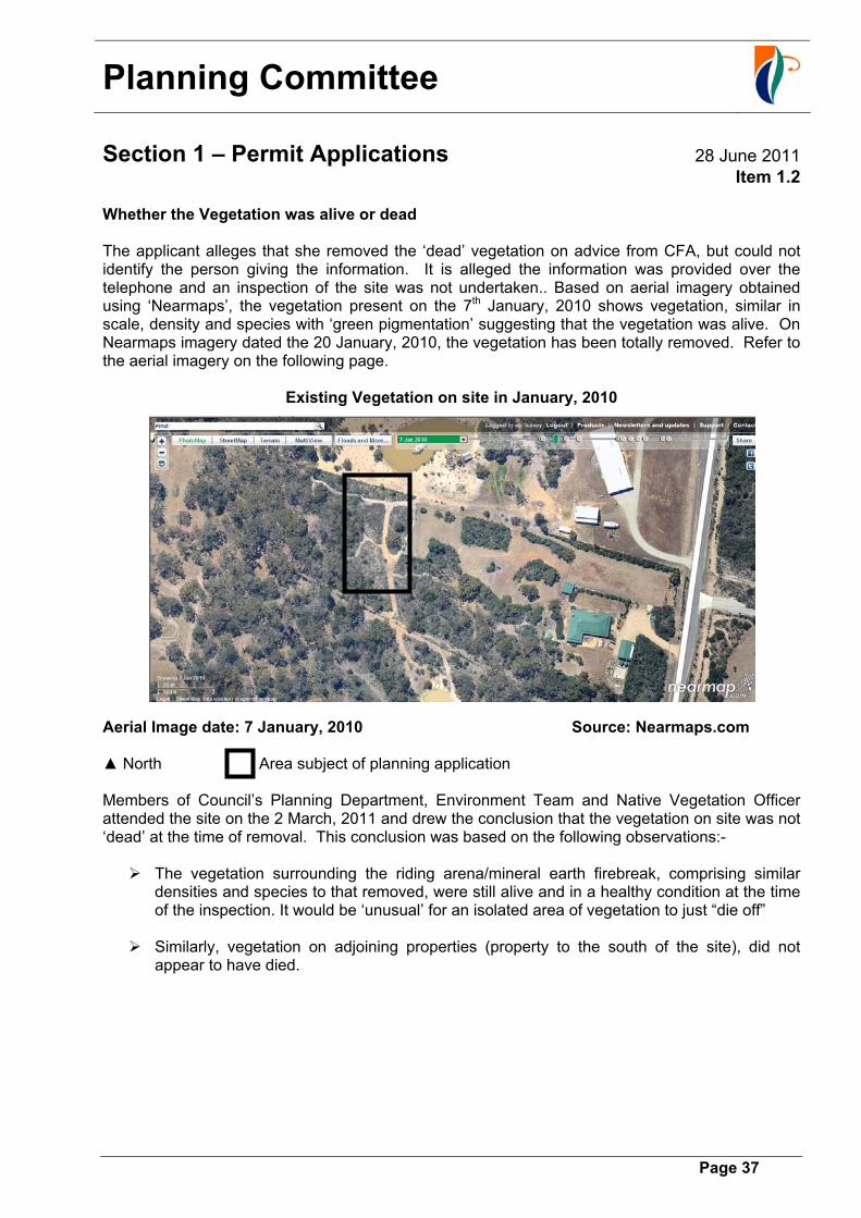
Whether the Vegetation was alive or dead The applicant alleges that she removed the ‘dead’ vegetation on advice from CFA, but could not identify the person giving the information. It is alleged the information was provided over the telephone and an inspection of the site was not undertaken.. Based on aerial imagery obtained using ‘Nearmaps’, the vegetation present on the 7th January, 2010 shows vegetation, similar in scale, density and species with ‘green pigmentation’ suggesting that the vegetation was alive. On Nearmaps imagery dated the 20 January, 2010, the vegetation has been totally removed. Refer to the aerial imagery on the following page.
Existing Vegetation on site in January, 2010 Aerial Image date: 7 January, 2010 Source: Nearmaps.com ▲ North Area subject of planning application Members of Council’s Planning Department, Environment Team and Native Vegetation Officer attended the site on the 2 March, 2011 and drew the conclusion that the vegetation on site was not ‘dead’ at the time of removal. This conclusion was based on the following observations:- The vegetation surrounding the riding arena/mineral earth firebreak, comprising similar
densities and species to that removed, were still alive and in a healthy condition at the time of the inspection. It would be ‘unusual’ for an isolated area of vegetation to just “die off”
Similarly, vegetation on adjoining properties (property to the south of the site), did not
appear to have died.
Planning Committee
Section 1 – Permit Applications 28 June 2011
Item 1.2
Page 38
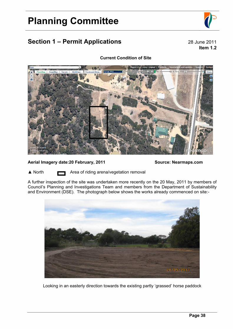
Current Condition of Site
Aerial Imagery date:20 February, 2011 Source: Nearmaps.com
▲ North Area of riding arena/vegetation removal A further inspection of the site was undertaken more recently on the 20 May, 2011 by members of Council’s Planning and Investigations Team and members from the Department of Sustainability and Environment (DSE). The photograph below shows the works already commenced on site:-
Looking in an easterly direction towards the existing partly ‘grassed’ horse paddock
Planning Committee
Section 1 – Permit Applications 28 June 2011
Item 1.2
Page 39
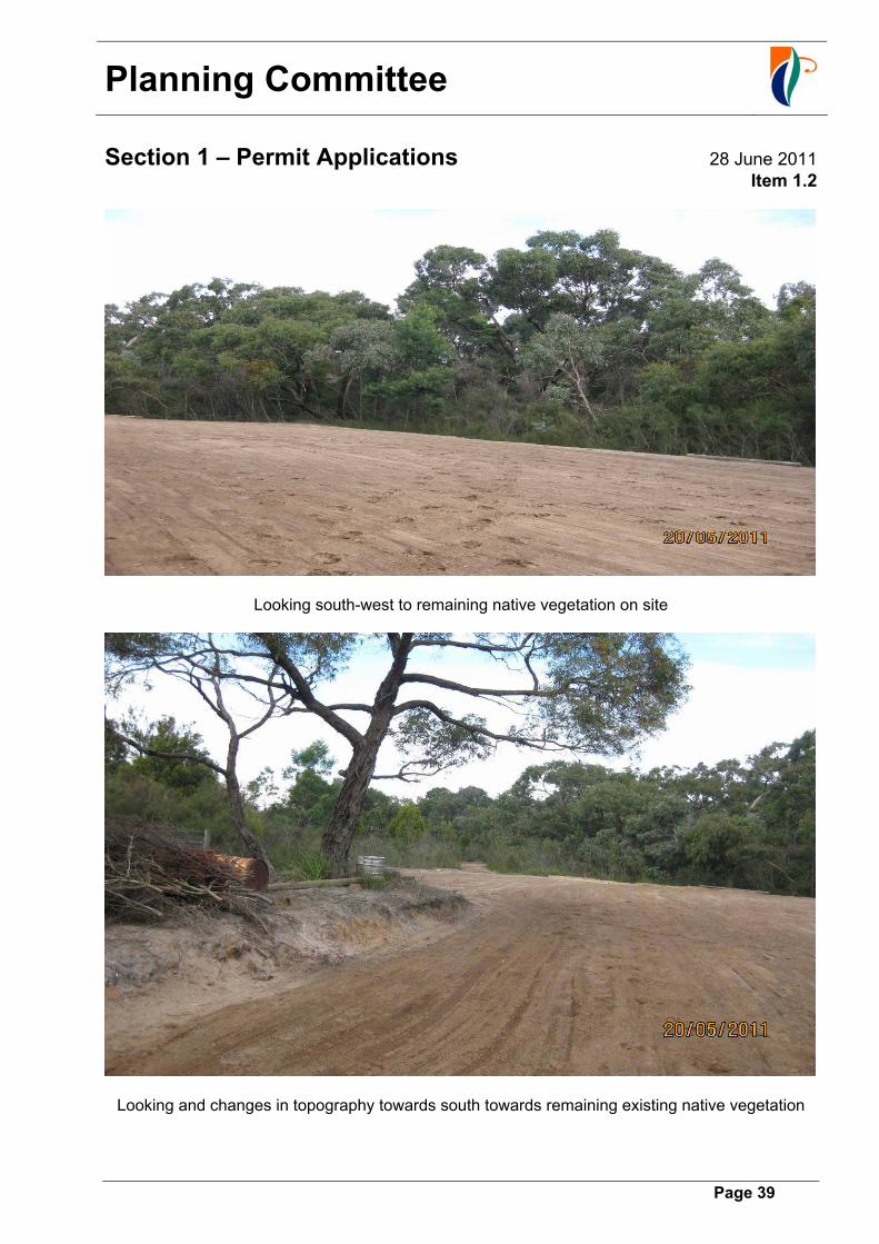
Looking south-west to remaining native vegetation on site
Looking and changes in topography towards south towards remaining existing native vegetation

Planning Committee
Section 1 – Permit Applications 28 June 2011
Item 1.2
Page 40
At this site meeting the DSE representative confirmed Council Officer’s observations as follows:- DSE Mapping demonstrated evidence of ‘green pigmentation’ prior to the vegetation
removal, on the basis of the pigmentation and condition of remaining abutting vegetation it was unlikely that the vegetation removed was ‘dead’ and therefore removal of the vegetation would be subject to the requirements of the Native Vegetation Framework and would require planning permission.
Based on the ‘earthworks’ through the modification to the topography, the DSE
representative indicated that one of the remaining trees in the ‘island’ area of the arena, would have to be offset, given the damage within the drip-line of the tree, the tree would be considered ‘lost’.
The DSE officer indicated that whilst of a different type of shrub to that further west, the
vegetation removed would be classified as a ‘remnant patch’ and would have provided valuable habitat.
The relevant sections of the agreement among others require the owners of the subject land not to undertake buildings and works within areas of high or very high conservation significance, these works partly abut areas of high conservation value significance. The removal of vegetation is not the only breach of the Section 173 Agreement, the following is an assessment against the other specific provisions contained within the agreement. 1. The applicant has not done all things necessary to protect and conserve the areas of high
and very high conservation values within the lots. The Plan prepared by KLM Development Consultants that identified the areas of Very High Conservation Significance (Zone A) and High Conservation Value (Zone B) is shown below. As indicated on this plan, Lot 20 (subject site) contains a portion of high conservation significance vegetation which extends in a linear form for a width of approximately 10 metres from the southern boundary, for a distance of approximately 120 metres parallel with this boundary and then in a curvilinear line forms an almost triangular parcel a distance of about 20 metres from the rear boundary. The applicant is currently using the horse riding arena for riding activities and has changed the natural topography of the land, this has the potential to detrimentally affect the adjacent and abutting areas of high conservation significance. 2. A planning permit has not been granted for the removal of the native vegetation from the site. As indicated earlier based on aerial photographs trees and understorey have been completely removed from several different parts of the site over time. The most recent removal occurred in January, 2010 (that being the area occupied by the horse riding arena. 3. Horses and /or livestock shall not be allowed on the Lots unless they are kept in a fenced off
area outside the areas of high and very high conservation value. An inspection of the site indicates that vegetation has been removed from various areas of the site to facilitate horse paddocks and grazing areas. The applicant is currently using an area adjacent
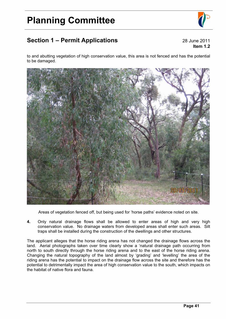
Planning Committee
Section 1 – Permit Applications 28 June 2011
Item 1.2
Page 41
to and abutting vegetation of high conservation value, this area is not fenced and has the potential to be damaged.
Areas of vegetation fenced off, but being used for ‘horse paths’ evidence noted on site. 4. Only natural drainage flows shall be allowed to enter areas of high and very high
conservation value. No drainage waters from developed areas shall enter such areas. Silt traps shall be installed during the construction of the dwellings and other structures.
The applicant alleges that the horse riding arena has not changed the drainage flows across the land. Aerial photographs taken over time clearly show a ‘natural drainage path occurring from north to south directly through the horse riding arena and to the east of the horse riding arena. Changing the natural topography of the land almost by ‘grading’ and ‘levelling’ the area of the riding arena has the potential to impact on the drainage flow across the site and therefore has the potential to detrimentally impact the area of high conservation value to the south, which impacts on the habitat of native flora and fauna.
Planning Committee
Section 1 – Permit Applications 28 June 2011
Item 1.2
Page 42
Exercise of Council’s Discretion under the Section 173 Agreement Previous legal advice relating to Section 173 Agreements indicates that under Section 126 of the Act, a person who develops land in contravention of or fails to comply with an agreement under section 173 is guilty of an offence. In such circumstances, even if Council decides to grant a permit, the owner would arguably be in breach of the Act for developing in contravention of the Section 173 Agreement. The Council could in the exercise of its discretion decide to refuse the application on the basis that the development is contrary to the Section 173 Agreement affecting the subject property. The legal advice (not relating to this property specifically) suggests that, in the event that a permit is issued by Council, the owner of the land would still be in breach of the section 173 Agreement and could be subject to prosecution or enforcement action (by all persons who are bound by the covenant in the agreement), in the absence of an amendment or ending of the Section 173 Agreement. If Council were to issue a permit it would effectively condone unlawful native vegetation removal without the relevant approval unless Council has considered to end the Section 173 Agreement (under Section 177(2) of the Act) or amend the Section 173 Agreement (under Section 178 of the Act), either with the approval of the Minister or by agreement between the responsible authority and all persons who are bound by any covenant in the agreement. In the present circumstances this approach does not appear appropriate, particularly where Council has pursued enforcement action against other landowners in the same estate. Tribunal Decisions relating to Section 173 Agreements The VCAT in recent time has made decisions affecting breaches of covenants contained in Section 173 Agreements. In the case of Salerno v Maribyrnong City Council (VCAT 762/2001), the Tribunal member stated that: “the issue of a permit which permitted construction outside a building envelope which was prohibited by the Section 173 Agreement constituted a material mistake in relation to the grant of the permit”’ In that particular case, that Council’s planning officers were under the understanding that the building envelope controls in the section 173 Agreement could be varied by the grant of a permit. In the contrary, the Tribunal member indicated that: “the Section 173 Agreement was a fundamental matter that should be taken into consideration” Furthermore, in the case of F & E Papp v Casey City Council (VCAT No P1483/2006), relating to the development of a second dwelling at No. 88 Nettle Drive, Hallam, the Tribunal member stated that: “At the end of the day I consider that the proposal is in breach of the Section 173 Agreement….I say this because even if Council has the ability to grant an exemption so as to allow any proposal….the practical reality is that Council has not granted such exemption”. In the absence of Council agreeing to co-operate in this regard, it seems to me that there is no possible conclusion other than the proposal will breach this Section 173 Agreement” The Tribunal concluded as follows: I agree with the comments by member Komesaroff in Salerno v Maribynong City Council (VCAT No. 762/2001) that the likely breach of a Section 173 Agreement by a proposal is a “fundamental
Planning Committee
Section 1 – Permit Applications 28 June 2011
Item 1.2
Page 43
matter”. The main situation I can think of where I might still at least consider approving the proposal which would breach a Section 173 Agreement is where the proposal has strong planning merits and where there is a strong case that the circumstances in question make the Section 173 Agreement redundant/superseded. The applicant removed vegetation unlawfully and altered the natural topography of the land, and is using it as a riding arena already, all of which have a cumulative negative impact on the flow of water across the site, potential contamination, destruction of valuable flora and fauna habitat and also the potential to detrimentally impact on the remainder of the vegetation of high conservation significance. Such a breach and disregard for the planning policy framework should not be supported.
Planning Committee
Section 1 – Permit Applications 28 June 2011
Item 1.2
Page 44
Appendix 4: Referral comments
Type of referral Response External (Non-Statutory) Department of Sustainability and Environment
The Department notes that native vegetation has already been removed from the site.
The subject land is located within the Gippsland Plain Bioregion. Departmental Mapping indicates the vegetation to be Grassy Woodland Ecological Vegetation Class (EVC 175) which has a conservation status of ‘Endangered’, 1-leathy Woodland Ecological Vegetation Class (EVC 48) which has a conservation status of ‘Least Concern’, within the Gippsland Plain Bioregion. The Department also notes that Swampy Riparian Complex EVC 83 was viewed onsite which has a conservation status of ‘Endangered’ within the Bioregion.
Records exist for 8 species in close proximity to the site –
- Southern-brown Bandicoot, Isooden ohesulus obesulus- FPBC (V), FFG Listed, DSE Advisory List (V)
- New Holland Mouse, Pseudomys novaehollandiae- FFG Listed, DSE Advisory List (V)
- Growling Grass Frog, Litoria raniformis- EPBC (V), FFG Listed, DSE Advisory List (E)
- Southern Toadlet, Pseudophryne semimarmorata- DSE Advisory List (V)
- Brown Quail, Coturnix ypsilophora australis- DSE Advisory List (N)
- River Swamp Wallaby-grass, Amphthrotrnis fluitans- EPEC (V)
- Naked Sun-orchid, Thelymitra circumsepta- DSE Advisory List (V)
- Poweiltown Correa, Correa reflexa var. lobata- DSE Advisory List (R)
Officers from DSE and Council attended a site visit to assess the extent of native vegetation removal along with any policy and legislation implications on Friday 20t1 May, 2011. The site in question is in close proximity to two known Biosites - Centreville
Bushland (inc. Morning Mist Reserve), Cranbourne South (5211) of Regional Significance and The Royal Botanic Gardens - Cranbourne Annexe (5095) of State significance. The vegetation in question adds to these ecological assets through habit and ecological connectivity.

Planning Committee
Section 1 – Permit Applications 28 June 2011
Item 1.2
Page 45
The Department has examined aerial photography archives of the native vegetation in question. In addition to this evidence collected on site indicates that the vegetation was alive when removed and would be classified as a patch. Dead vegetation within patches of native vegetation is an important characteristic within such ecosystems and also provides habitat and foraging resources for native fauna. At the site inspection the Department noted –
• regeneration of native grasses, shrubs and herbs was taking place at the edges of the cleared area along with some sprouting through the middle of the disturbed area.
• the site had been significantly disturbed and earth had been moved throughout the area changing the topography.
• significant impact has taken place to the remaining eucalypt on site with excavation into its root zone. It should be deemed lost and offset accordingly to the framework.
The Department notes that the property is covered by a section 173 agreement which states (Section 4.1) “A planning permit shall be obtained to remove, destroy or lop native vegetation in accordance with clause 52.17 of the scheme (some exemptions apply). This requirement does not apply to vegetation within a designated development envelope”. The removal of this native vegetation would appear to be in breach of this agreement.
The threatened species implications of this proposal are high considering the location of the subject property. Habitat exists for both the Southern Brown Bandicoot and the Southern Toadlet and both have been recorded nearby. This would add to the conservation significance of the vegetation removed. Without closer inspection at the appropriate times of the year the actual impact on threatened flora species cannot be ascertained.
The Department does not generally support the issuing of retrospective permits for the removal of native vegetation, as it is not possible to implement the planning controls related to native vegetation (Clauses 15.09 and 52.17 of the Planning Scheme), and in particular the requirements of Victoria’s Native Vegetation - A framework for action (DSE 2002). DSE considers that Council should seek an enforcement order where vegetation has been removed illegally.

Planning Committee
Section 1 – Permit Applications 28 June 2011
Item 1.2
Page 46
This order could include rehabilitation or revegetation of the site or, alternatively, compensation measures such as protecting and enhancing another area of native vegetation on the property or an external property. Due to the on title agreement already in place any offsets would be more suited off site as vegetation currently on the property is already deemed as protected and would provide limited gain.
If Council wishes to treat this proposal as a planning permit application, it may seek appropriate offsets in the form of revegetation. DSE would –
• support the reinstatement of vegetation; and
• the provision of offsets according to the Port Philip and Western Port - Native Vegetation Plan. If Council believes the vegetation constituted a remnant patch, Council may wish to determine offsets using the default habitat hectare scores provided in DSE’s Native Vegetation: Guide for assessment of referred planning permit applications.
The Department supports the planting of indigenous species on the property, however notes that any planting must be Ecological Vegetation Class specific and provide greatest benefit to ecological and habitat value.
Internal Department Environment 16/12/2010- Initial Comments
The environment department does not support the application.
The site is protection by a 173 Agreement, which has limitations on the uses within the sites. The site has been identified as having High conservation significance vegetation on it which is also recorded as endangered on the DSE data base.
The environment department does not support retrospective vegetation clearances. The applicant has already cleared vegetation in preparation for this arena.
Significant vegetation clearance has occurred across the site, outside the building envelope.
Enforcement action is recommended in relation to what appears to be unpermitted vegetation clearance.
In the application the applicant has made comment to the fact that the Southern Brown Bandicoot have been seen there on site. It is recommended that an application of this type be referred to the Commonwealth for comment.

Planning Committee
Section 1 – Permit Applications 28 June 2011
Item 1.2
Page 47
Relevant sections of the Section 173 Agreement
Section 4.1 states that a planning permit is required to remove, destroy or lop native vegetation in accordance with Clause 52.17 of the Casey Planning Scheme.
Section 4.8 of the 173 Agreement reads: Horses and/or live stock shall not be allowed in the lots unless they are kept in a fenced off area outside the areas of high and very high conservation values. The proposed development is within an area of high/very high conservation significance vegetation.
11 May, 2011 & 19 May, 2011 Post site inspection comments
After reviewing the aerial photographs of the property and ground truthing of these images on the property inspection on the 3 March, 2011, it is our belief, based on the green colouration of the vegetation on the aerial photographs and the condition of identical vegetation adjacent to the cleared area that the vegetation removed was alive.
Drainage Do not support the application since it is already constructed without provision for overland flow path. The proponent may construct a suitable capacity underground pipe system to convey the flow under the arena or around the arena to the satisfaction of the Responsible Authority.
Planning Committee
Section 1 – Permit Applications 28 June 2011
Item 1.2
Page 48
Landscaping Vegetation has been removed at the proposed horse riding arena as well as other locations on the subject site. The vegetation is listed as being of high conservation value in the Section 173 Agreement. The S173 Agreement also restricts the keeping of animals in areas of high/very high conservation.
A planning permit has not been obtained to remove the vegetation as required by the agreement.
The proposed horse riding area is to be constructed on a watercourse. A dam has been constructed on the adjacent property to the north of the subject site. Development on the water course is not encouraged or supported due to the potential to adversely impact on the supply of ground and surface water to existing swamp vegetation on the subject site and downstream. Reducing water supply to this vegetation has the potential to cause the decline of this vegetation.
Horses potentially introduce weeds from their droppings. Their urine and droppings are high in nutrients which has the potential to leach into nutrient poor soils with adverse impact on existing remnant vegetation. There is also potential for introduction of wees in horse feed such as hay/straw.
There are no overlays applicable to the subject site however there are restrictions on planting in the S173 Agreement.
Although the vegetation has generally been cleared two trees remain. It would not be appropriate to allow the development to occur in the vicinity of the remnant trees as there will be compaction to the root zone caused by horses. There is potential for the trees to be senesced by high nutrient from horse manure/urine. There is also a risk of horses ringbarking the trees also.
The application is not supported. It is not an appropriate location for the proposed use. Ideally the area will be revegetated (offsetting for vegetation removed) and fenced. The issues of offsetting and enforcement action are not areas assessed in detail and commented on by the landscape design team. It is assumed that Planning Investigations and Environment Teams have provided detailed recommendations on these matters.
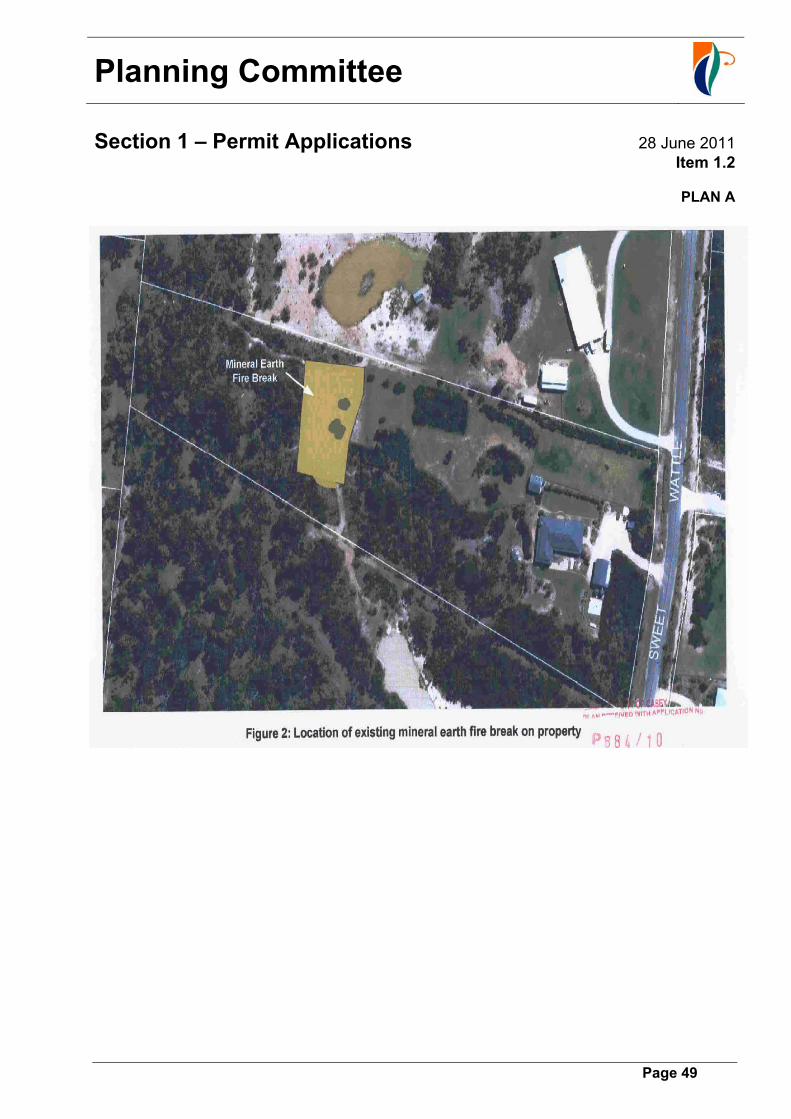
Planning Committee
Section 1 – Permit Applications 28 June 2011
Item 1.2
Page 49
PLAN A
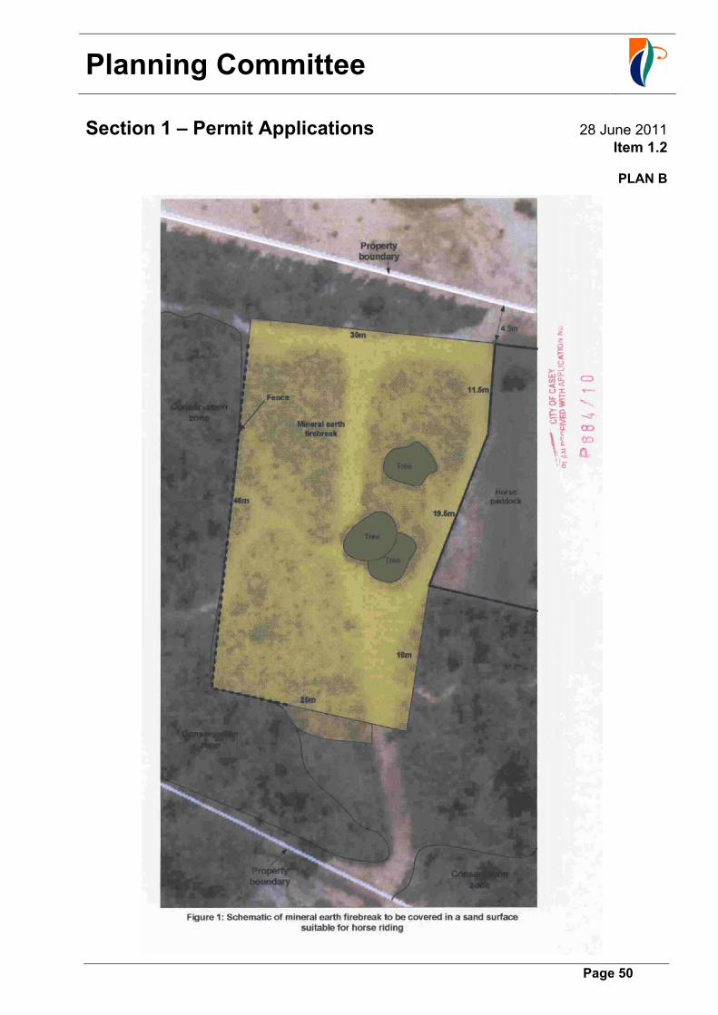
Planning Committee
Section 1 – Permit Applications 28 June 2011
Item 1.2
Page 50
PLAN B

Planning Committee
Section 1 – Permit Applications 28 June 2011
Item 1.2
Page 51
PLAN C
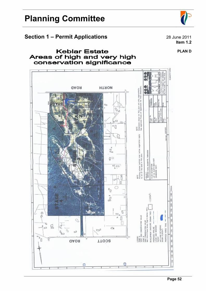
Planning Committee
Section 1 – Permit Applications 28 June 2011
Item 1.2
Page 52
PLAN D

Planning Committee
Section 3 - Planning Scheme Amendments (Council) 28 June 2011 Item 3.1
Page 53
Amendment C19 to the Casey Planning Scheme Site-Specific Control to Allow Two Lot Subdivision - No. 96-104 Bailey Road, Narre Warren North 71-1-4-1C19 MP
Recommendation: Council not proceed with Amendment C19
Background
Council resolved on 13 June 2000 to prepare and exhibit Amendment C19 to the Casey Planning Scheme to enable the land at No’s. 96-104 Bailey Road, Narre Warren North to be subdivided into two lots. The amendment request was lodged by A.M. & J.L. Bourke, the owners of the subject land at the time. The land at that time was located within a Rural Living Zone – Schedule 4 (RLZ4) under the Casey Planning Scheme, which specified a minimum lot size of 8 hectares, and was also affected by a Significant Landscape Overlay – Schedule 1 (SLO1 – Casey Foothills). As such, any further subdivision of the land was not permissible. The subject land, with an area of 8.15 hectares, contained two dwellings, one in the northern portion of the site and the other approximately midway along the eastern boundary.
Locality Plan
NNaarrrree WWaarrrreenn NNoorrtthh TToowwnnsshhiipp
SUBJECT PROPERTY
▲North Ward: Four Oaks Melway Ref: 109 C4
GWAZ4
Urban Growth Boundary
Planning Committee
Section 3 - Planning Scheme Amendments (Council) 28 June 2011 Item 3.1
Page 54
The amendment proposed to introduce a site-specific control into the Casey Planning Scheme by amending the schedule to Clause 52.03. A proposed Plan of Subdivision, to be submitted by the proponent, would form part of the site-specific control and provide for the subdivision of the land into two lots of approximately 4 hectares each. On 18 July 2000, prior to the formal exhibition of Amendment C19, Council resolved to abandon another amendment (Amendment C15), which similarly sought to subdivide a nearby property in King Road, Harkaway. Council resolved at that time that it would be inappropriate to further consider that amendment until such time as a recently commenced review of the Casey Foothills Strategy had been completed. In light of that situation, the proponent of Amendment C19 formally requested a deferral of the amendment prior to the commencement of the formal exhibition period. Accordingly, no further action, including public exhibition, was undertaken at that time in regard to the amendment. In February 2002, the proponent requested that Amendment C19 be “reactivated” on the basis of the delay in carrying out the review of the Foothills Strategy. Council subsequently resolved, at its Planning Committee meeting on 9 April 2002, to modify Amendment C19 to give effect to the proposed subdivision as follows:
A. “That Council resolves to modify and exhibit Amendment C19 to the Casey Planning Scheme to rezone the land at No. 96 – 104 Bailey Road, Narre Warren North, being Lot 2 on PS 142018, from a Rural Living Zone – Schedule 4 (RLZ4) to a Rural Living Zone – Schedule 2 (RLZ2).
B. That Council requests the proponent to submit a planning application to subdivide the subject land into two lots, generally in accordance with the modified plan of subdivision shown at Appendix B.
C. That, under Section 96A of the Planning and Environment Act 1987, Council resolves to consider the planning application submitted under paragraph B. concurrently with Amendment C19.
D. That Council resolves to give notice of Amendment C19 and the planning application submitted under paragraph B., together with a copy of a Proposed Permit, in accordance with the requirements of Section 96C of the Planning and Environment Act 1987.
E. That prior to Council adopting Amendment C19, the owner of the subject land must enter into an agreement under Section 173 of the Planning and Environment Act 1987 to provide for the following:
Subject to planning approval, the subdivision of the land into no more than two lots with no further subdivision of either lot permitted.
The costs of the preparation and registration of the agreement shall be borne by the owner of the land.
F. That the proponent be notified of Council’s decision.”
A copy of the above Planning Committee report is included at Attachment 1.

Planning Committee
Section 3 - Planning Scheme Amendments (Council) 28 June 2011 Item 3.1
Page 55
The modified amendment proposed to rezone the subject land from a Rural Living Zone – Schedule 4 (RLZ4) to a Rural Living Zone – Schedule 2 (RLZ2). In conjunction with the amendment, Council also resolved to concurrently consider a planning application to subdivide the land into two lots. The proponent was subsequently advised to submit an appropriate planning application for the proposed subdivision and associated supporting documentation in order that the amendment could proceed. However, in October 2002 the State Government introduced a new strategy for metropolitan Melbourne, Melbourne 2030 – planning for sustainable growth. This coincided with the introduction of an interim Urban Growth Boundary (UGB) into relevant metropolitan planning schemes, including the Casey Planning Scheme. Also, in May 2004 a new suite of ‘Green Wedge Zones’ was introduced and generally applied to land located outside the UGB. As a result of those initiatives the subject land is now located outside the UGB and included in a Green Wedge A Zone – Schedule 4 (GWAZ4). The GWAZ4 is a ‘rural’ zone and provides for lot sizes of eight hectares and above. It applies to non-urban land outside the UBG to protect and recognise the area’s agricultural, environmental, historic or recreational values or mineral and stone resources. Consequently, and notwithstanding the existing requirement for the proponent to submit a formal planning application and amendment documentation, the amendment could also not be formally prepared and exhibited without Council first obtaining authorisation for the amendment to proceed from the Minister for Planning. However, it was considered unlikely that the Minister would authorise an amendment that may have been perceived as undermining the Government’s “green wedge” policy. The proponent was advised in November 2004 that the Department of Sustainability and Environment was about to initiate the process of preparing ‘Green Wedge Management and Implementation Plans’ as part of the implementation of the Melbourne 2030 strategy. At its meeting on 4 November 2004, Council adopted the Casey Foothills Position Paper as Council’s position to take into the Green Wedge Management and Implementation Plan process for the preparation of the Southern Ranges Green Wedge Strategy. The position paper, among other things, sought to ensure that any planning scheme amendment that provided for further subdivision or development should be limited to land within the UGB. The proponent was further advised that in light of both the State Government’s and Council’s policy positions, it seemed clear that no further subdivision would be permitted outside the UGB unless already permitted under current planning controls. Accordingly, there appeared to be no prospect of Amendment C19 being able to proceed to formal public exhibition. While Council may have been able to keep the amendment “on hold” indefinitely, the proponent was asked to consider formally withdrawing the request. Council officers would then prepare a report to Council recommending that Amendment C19 not be proceeded with. However, no such undertaking to formally withdraw the amendment has ever been received from the proponent, nor has a planning application been submitted for the proposed subdivision, with the result being that the Council resolution of 9 April 2002 still remains unresolved.
Planning Committee
Section 3 - Planning Scheme Amendments (Council) 28 June 2011 Item 3.1
Page 56
In a recent review of the matter it has also been ascertained that ownership of the subject land has now changed. Land sales records from Council’s Property Rates & Valuations Department indicate that a change of ownership of the property was effected on 5 October 2007. It can therefore be reasonably assumed that the proponent, having sold the property, no longer has an interest in pursuing the subdivision proposal. Current Strategic Framework In December 2008 the State Government released Melbourne 2030: a planning update - Melbourne @ 5 million, which proposed the inclusion of land currently outside the Urban Growth Boundary (UGB) in Investigation Areas to accommodate Melbourne’s future growth requirements. In the Casey-Cardinia Growth Area the State Government released an Investigation Area affecting an area of 5,560 hectares south-east of Cranbourne. On 17 June 2009, the State Government released Delivering Melbourne's Newest Sustainable Communities which included proposed changes to the UGB in Casey. Then, on 6 August 2010 Amendment VC68 amended the Casey Planning Scheme to expand the UGB. However, the UGB was not changed in the area where the subject land is located. As stated above, the development of Green Wedge Management and Implementation Plans (GWMIP) is a core requirement of Melbourne 2030. A GWMIP is a Council-adopted strategy that identifies a vision, objectives and actions for the sustainable management of a particular Green Wedge. The GWMP identifies the values and features of the Green Wedge, preferred land uses, the environmental and natural resources to be protected and the social and economic needs of local communities and townships within the Green Wedge. The ‘Western Port Green Wedge’ is one of the three Green Wedges which are partially located within the City of Casey (it is shared with the Shire of Cardinia). The ‘Southern Ranges Green Wedge’ (at the north of the municipality) and the ‘South East Green Wedge’ (a small part of the west of the municipality) are Casey’s two other metropolitan Green Wedges. A GWMIP for the Western Port Green Wedge is at present being prepared by Council and it is expected that the Plan will be completed by mid-2012. Following completion of the Western Port GWMIP, the GWMIP for the Southern Ranges is anticipated to commence with a review of the Casey Foothills Strategy to be undertaken as part of that study. Conclusion With the proponent no longer having ownership of the property, the substantive basis for the original request for an amendment no longer applies. Further, the amendment does not accord with the current statutory and strategic framework, including Council policy for the Casey Foothills. Accordingly, in order to conclude the necessary administrative process, it is recommended that Amendment C19 to the Casey Planning Scheme not be proceeded with.
Recommendation
That Council not proceed with Amendment C19 to the Casey Planning Scheme.
Planning Committee
Section 3 - Planning Scheme Amendments (Council) 28 June 2011 Item 3.1
Page 57
ATTCHMENT 1

Planning Committee
Section 3 - Planning Scheme Amendments (Council) 28 June 2011 Item 3.1
Page 58
Planning Committee
Section 3 - Planning Scheme Amendments (Council) 28 June 2011 Item 3.1
Page 59
Planning Committee
Section 3 - Planning Scheme Amendments (Council) 28 June 2011 Item 3.1
Page 60
Planning Committee
Section 3 - Planning Scheme Amendments (Council) 28 June 2011 Item 3.1
Page 61

Planning Committee
Section 3 - Planning Scheme Amendments (Council) 28 June 2011 Item 3.1
Page 62

Planning Committee
Section 3 - Planning Scheme Amendments (Council) 28 June 2011 Item 3.1
Page 63
ATTACHMENT 2
Planning Committee
Section 3 - Planning Scheme Amendments (Council) 28 June 2011 Item 3.1
Page 64

Planning Committee
Section 3 - Planning Scheme Amendments (Council) 28 June 2011 Item 3.1
Page 65

Planning Committee
Section 3 - Planning Scheme Amendments (Council) 28 June 2011 Item 3.1
Page 66