Embed Size (px)
Citation preview
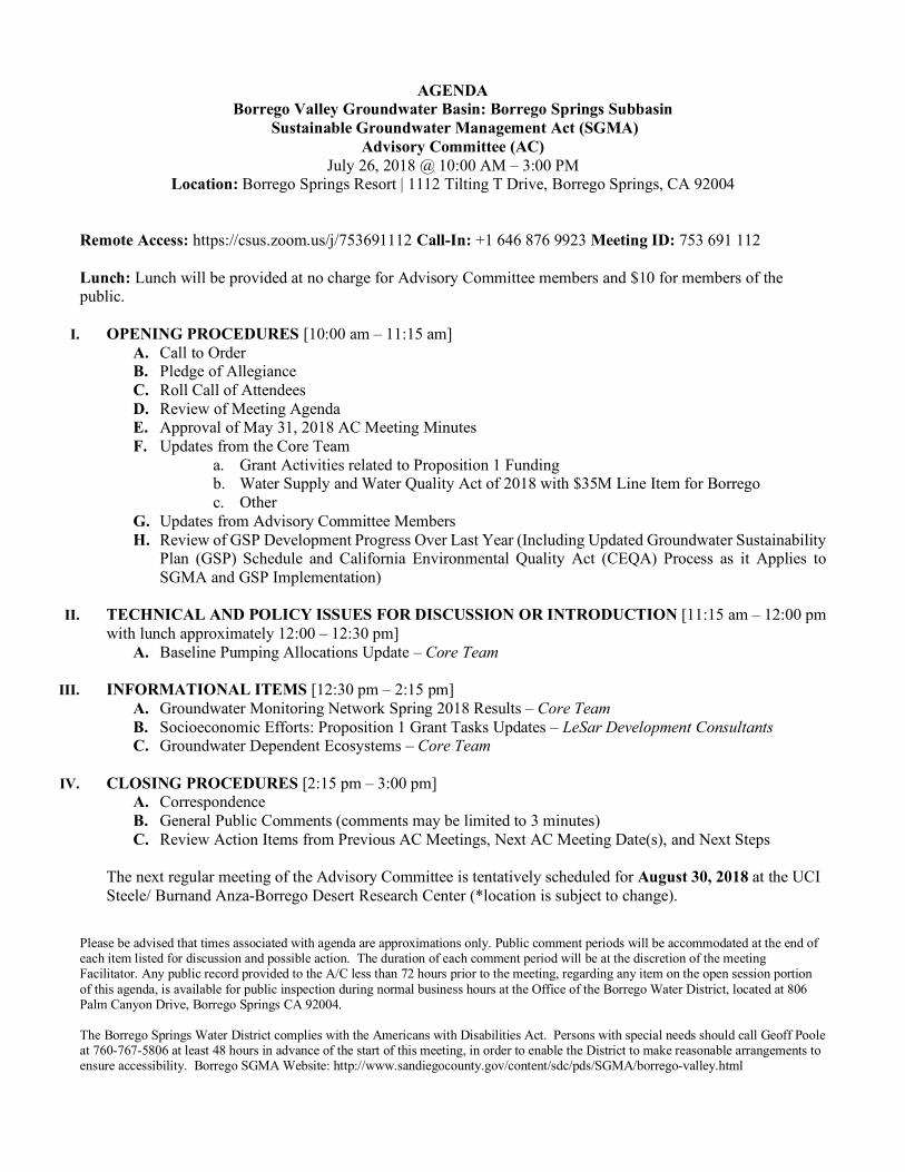
AGENDA Borrego Valley Groundwater Basin: Borrego Springs Subbasin
Sustainable Groundwater Management Act (SGMA) Advisory Committee (AC)
July 26, 2018 @ 10:00 AM – 3:00 PM Location: Borrego Springs Resort | 1112 Tilting T Drive, Borrego Springs, CA 92004
Remote Access: https://csus.zoom.us/j/753691112 Call-In: +1 646 876 9923 Meeting ID: 753 691 112 Lunch: Lunch will be provided at no charge for Advisory Committee members and $10 for members of the public.
I. OPENING PROCEDURES [10:00 am – 11:15 am]
A. Call to Order B. Pledge of Allegiance C. Roll Call of Attendees D. Review of Meeting Agenda E. Approval of May 31, 2018 AC Meeting Minutes F. Updates from the Core Team
a. Grant Activities related to Proposition 1 Funding b. Water Supply and Water Quality Act of 2018 with $35M Line Item for Borrego c. Other
G. Updates from Advisory Committee Members H. Review of GSP Development Progress Over Last Year (Including Updated Groundwater Sustainability
Plan (GSP) Schedule and California Environmental Quality Act (CEQA) Process as it Applies to SGMA and GSP Implementation)
II. TECHNICAL AND POLICY ISSUES FOR DISCUSSION OR INTRODUCTION [11:15 am – 12:00 pm
with lunch approximately 12:00 – 12:30 pm] A. Baseline Pumping Allocations Update – Core Team
III. INFORMATIONAL ITEMS [12:30 pm – 2:15 pm]
A. Groundwater Monitoring Network Spring 2018 Results – Core Team B. Socioeconomic Efforts: Proposition 1 Grant Tasks Updates – LeSar Development Consultants C. Groundwater Dependent Ecosystems – Core Team
IV. CLOSING PROCEDURES [2:15 pm – 3:00 pm]
A. Correspondence B. General Public Comments (comments may be limited to 3 minutes) C. Review Action Items from Previous AC Meetings, Next AC Meeting Date(s), and Next Steps
The next regular meeting of the Advisory Committee is tentatively scheduled for August 30, 2018 at the UCI Steele/ Burnand Anza-Borrego Desert Research Center (*location is subject to change).
Please be advised that times associated with agenda are approximations only. Public comment periods will be accommodated at the end of each item listed for discussion and possible action. The duration of each comment period will be at the discretion of the meeting Facilitator. Any public record provided to the A/C less than 72 hours prior to the meeting, regarding any item on the open session portion of this agenda, is available for public inspection during normal business hours at the Office of the Borrego Water District, located at 806 Palm Canyon Drive, Borrego Springs CA 92004. The Borrego Springs Water District complies with the Americans with Disabilities Act. Persons with special needs should call Geoff Poole at 760-767-5806 at least 48 hours in advance of the start of this meeting, in order to enable the District to make reasonable arrangements to ensure accessibility. Borrego SGMA Website: http://www.sandiegocounty.gov/content/sdc/pds/SGMA/borrego-valley.html
MINUTES Borrego Valley Groundwater Basin: Borrego Springs Subbasin
Sustainable Groundwater Management Act (SGMA) Advisory Committee (AC)
May 31, 2018 @ 10:00 AM – 3:00 PM Location: University of California, Irvine
Steele/Burnand Anza-Borrego Desert Research Center 401 Tilting T Drive, Borrego Springs, CA 92004-2098
I. OPENING PROCEDURES A. Call to Order The meeting was called to order at 10:00 a.m. by Borrego Water District (BWD) President Beth Hart. B. Pledge of Allegiance Those present stood for the Pledge of Allegiance. C. Roll Call of Attendees Committee members: Present: Jim Seley, Jim Wilson, Rebecca Falk, Dave
Duncan, Bill Berkley, Gina Moran, Ryan Hall, Diane Johnson Core Team members: Beth Hart, BWD Jim Bennett, County of San Diego Geoff Poole, BWD Trey Driscoll, Dudek, GSP Consultant Staff: Meagan Wylie, Center Wendy Quinn, Recording Secretary for Collaborative Policy Asha Bleier, Dudek, Consulting Team Mason Einbund, County of San Diego Public: Michael Sadler, Borrego Sun Linda Haneline Cathy Milkey, Rams Hill Bill Haneline Martha Deichler Mark Jorgensen Susan Percival, Club Circle Mike Seley, Seley Ranch East HOA Emily Brooks Patrick Meehan John Doljanin, West Coast Trees D. Review of Meeting Agenda Meagan Wylie reviewed the meeting ground rules, Agenda and Brown Act provisions. E. Approval of January 25, 2018 AC Meeting Minutes Upon motion by Member Berkley, seconded by Member Falk and unanimously carried, the Minutes of the March 29, 2018 AC Meeting were approved as amended (Item I.G, next to the last paragraph, revise to read in part, “. . . most members of the public of those present at a recent Sponsor Group meeting expressed the opinion that agreed there should be no development . . .”). F. Updates from the Core Team a. $1M Proposition 1 Funding Geoff Poole announced that the Proposition 1 grant application had been approved and recommended for funding. The County has returned the letter to the State confirming desired receipt of funds. In the next few weeks, the County expects to receive additional information on grant management and expenditure of grant funds. A cost reimbursement agreement is being developed between the County and BWD for reimbursement of grant expenditures. Work on some of the grant-funded projects has already begun.
b. Water Supply and Water Quality Act of 2018 with $35M Line Item for Borrego Mr. Poole explained that BWD is prohibited by law from spending money or time on a pending bill once it has been submitted. The measure should be on the November 2018 ballot, including Borrego’s line item. c. Socioeconomic Efforts: Proposition 1 Grant Tasks and Updates Mr. Poole explained that part of the Proposition 1 grant funding will be used for outreach to the Severely Disadvantaged Community (SDAC). Staff has been working with Rachel Ralston of LeSar Development Consultants, one of the outcomes being the community informational meeting held on March 5, 2018. Ms. Ralston has been reviewing data from that meeting, and has further developed and distributed surveys to the community to gather additional, more detailed information. The information will be used in a model being developed to assess the impact of SGMA on the SDAC. Another community meeting is in development, and Members Falk and Johnson are assembling written materials for public dissemination. Mr. Poole reported that Ms. Ralston will attend the next AC meeting to provide more detailed updates. d. AAWARE Meeting with Core Team members and GSP Consultant Mr. Poole reported that he met with Jim Bennett, Trey Driscoll and members of the Agricultural Alliance for Water and Resource Education (AAWARE). Topics included return flow and baseline pumping allocations (BPAs), and was productive. Mr. Bennett explained that the Core Team will have to proceed with the BPAs for agriculture using Dudek’s estimates based on aerial photos and evapotranspiration unless the farmers provide additional information on their pumping. The metered water use data will be reviewed by the GSA to determine whether the data is valid for use as a BPA. The Core Team also hopes to get additional access from agriculture regarding the water quality monitoring program, as additional wells are needed in the North Management Area. Mr. Bennett reported that at the next AC meeting, the consultants will present a draft BPA plan. Member Falk asked whether water quality monitoring of private wells can be mandated once the GSP has been adopted. Mr. Driscoll replied that it could be. e. Updated Groundwater Sustainability Plan (GSP) Schedule Mr. Bennett reported that the last bi-monthly AC meeting will be in July. The AC will review financing plans (fees and penalties) and BPAs. Another community meeting is also contemplated for August. In September the SDAC components will be incorporated into the GSP, and monthly meetings will continue throughout 2018. In December the draft GSP will be released for a 45-day public review and comment period. Thereafter, a final consensus recommendation will be requested from the AC before submitting the GSP to the County Board of Supervisors and BWD Board in the summer of 2019. Member Moran noted that it would be helpful to get written material to be considered by the AC in advance of the meetings. Ms. Wylie offered to arrange a webinar upon request. Discussion followed regarding the potential meeting in late August, and Ms. Wylie asked the AC and Core Team members to e-mail her their vacation plans. Suzanne Lawrence brought up the issue of governance following GSP adoption. Mr. Bennett cited the Memorandum of Understanding between the County and BWD and recognized the need for changes to the governance structure in the form of new agreements. f. Other None G. Updates from Advisory Committee Members Member Falk expressed concern regarding the need for water quality data, the length of time it takes to obtain it, and the need for more monitoring wells in the North Management Area. She was also concerned about the costs to the ratepayers. Member Falk echoed Member Moran’s request for written material in advance of the AC meetings, as well as a short synopsis of upcoming presentations. Member Duncan reported that he was continuing to hold ratepayers’ meetings, the last one on May 29. One item frequently addressed by his constituents is the recently proposed water shortage
emergency declaration. Although the BWD Board did not adopt it, the ratepayers still feel they are being treated unfairly by the consideration to force them to reduce their water use while agricultural flood irrigation continues. Member Hall pointed out that sometimes when wells are cleaned, it looks like flood irrigation. II. TECHNICAL AND POLICY ISSUES FOR DISCUSSION OR INTRODUCTION A. Baseline Pumping Allocation Update Mr. Driscoll explained the methodology being used to calculate BPAs, which allocate water extraction based on the historical rate of pumping over a defined period of time. The baseline period is January 1, 2010 to January 1, 2015, and the BPA is based on the highest annual use during this period. In the absence of validated flow meter data from production wells, extraction is estimated using aerial photography and evapotranspiration data. Evapotranspiration is based on data from the California Irrigation Management Information System (CIMIS) station in Borrego Springs for different types of plants. Salt leaching is considered, i.e. overwatering to flush excessive salts below the roots. Member Hall asked whether overwatering for frost protection was considered. Mr. Driscoll replied that it was not, but agreed to consider it further. Member Berkley asked whether salt leaching and frost protection on golf courses was considered. Mr. Driscoll replied that it was not, but agreed to consider it. Mr. Driscoll explained that once the BPAs have been calculated, they will be presented to each pumper for review and comment. Discussion followed regarding flood irrigation, and the fact that Mr. Driscoll’s estimates were based on the common practices of spray and drip. Mr. Poole pointed out that John Doljanin of West Coast Trees uses flood irrigation, and recent research indicates it may be very efficient. The Core Team agreed to review the topic of flood irrigation and potential efficiencies further as it relates to BPAs. Member Seley pointed out that spray irrigation for citrus is directed at the trees, whereas on a golf course it is sprayed over a wide area. Member Berkley added that there are different types of golf course irrigation, and some new ones are more efficient. Member Johnson asked how long the AC would remain in existence. Mr. Bennett explained that the Core Team planned through the GSP development process and would add the question to the Management Actions. Mr. Doljanin reported that studies from the University of New Mexico and the University of California at Davis addressed flood irrigation versus drip. He further stated that the Borrego Subbasin aquifer had dropped since the 1960s when farmers switched from flood to drip. Per the studies, on sand and flat terrain, flood is more efficient. He further stated he thought farmers should get credit for return flows. He indicates that his farm returns a large percentage of irrigation water into the aquifer via flood irrigating and removes nitrates. The Committee broke for lunch at 12:25 p.m. and reconvened at 1:00 p.m. B. Projects and Management Actions to be Considered a. Water Trading Program Mr. Driscoll explained how the proposed water trading program would facilitate transfer of BPAs and encourage water conservation. The current restrictive easements under the water credit program would be consolidated and reissued. A governing document would be developed, and there would be a publicly accessible registry. Water shares would be issued to replace existing water credits, and shareholders could negotiate the terms of their trade and then submit the deal to the GSA for review. Anticipated components could include water use limitation (must be used in this subbasin), a cap on shares owned by a single entity (to prevent hoarding), an enforcement and penalty structure, and an annual water trading policy review to determine if changes are necessary. Mr. Bennett noted that the Core Team had not yet reviewed the draft water trading program, but Dudek was presenting their ideas for discussion. President Hart added that a legal analysis had not been done, and the fact that Borrego is not an adjudicated basin may be an issue. Mr. Bennett
stated that it is intended that the water trading program will be part of the GSP unless there are legal impediments. b. Land Use Asha Bleier of Dudek explained that the County General Plan is the basis for all land use decisions. Besides land use, it includes conservation, housing, the relationship of growth to services, and availability of public infrastructure, including water. The Borrego Springs Community Plan is part of the General Plan and details County policies specific to that area. The Borrego Springs Community Sponsor Group assists the County in developing the Community Plan. Ms. Bleier explained that the Zoning Ordinance is based on land uses established under the General Plan. Agriculture is permitted under the residential designation. Most of the land use designations in Borrego Springs are rural residential or semi-rural residential. Each designation specifies how many dwelling units are permitted per acre. Once the GSP is implemented, the General Plan will be evaluated and updated as necessary. Ms. Bleier pointed out that a land use designation is not an automatic permission to build. Flood potential, public services, water, fire, health and safety must be considered. There will be public input during the update process, and changes would be considered to transition to land uses that are low water use and compatible with sustainability requirements of SGMA. Member Falk asked whether water would be available to existing vacant lots. Mr. Bennett replied that currently potential builders would have to contact BWD and satisfy the 4:1 mitigation ratio if they want to build. c. Long Term Water Potability Program Ms. Wylie announced that the Long Term Water Potability Program had been renamed the Groundwater Quality Optimization Program. Mr. Driscoll reported that he had identified two potential areas of existing water quality impairment: arsenic and nitrates. Arsenic exceeds the acceptable standard in some wells in the South Management Area, and nitrates historically have exceeded acceptable standards in a portion of the North Management Area. Additional data are needed. The contamination in the South is related to the wastewater treatment plant. The nitrates in the North date back to the 1950s. Efforts are underway to optimize use of impaired water, for example in irrigation, and to mitigate the impairment. Mr. Driscoll emphasized that all BWD wells meet drinking water standards. Impaired water can be treated, blended with higher quality water, or the well can be shut down. Areas for new wells in the basin are being explored. C. Well Metering Plan Mr. Driscoll explained that the objective of the Well Metering Plan is to facilitate reliable data reporting for non-de minimis well users. They would be required to register their wells with the GSA and have appropriate meters that can be validated and calibrated. The meters would be read monthly, either by the GSA pursuant to an access agreement or by an approved, independent party. There would be semi-annual reporting, annual verification by a GSA-approved contractor, and the meters would be recalibrated every five years. It is anticipated that compliance with the Metering Plan would be required within 45 days of GSP adoption. III. INFORMATIONAL ITEMS A. Groundwater Dependent Ecosystems Mr. Driscoll explained that SGMA requires that all end users of groundwater be considered in the GSP, including Groundwater Dependent Ecosystems (GDEs). GDEs are plants that require groundwater. Potential GDE areas in Borrego Springs include Coyote Canyon, Borrego Palm Canyon and Mesquite Bosque (commonly known as the Borrego Sink). Mr. Driscoll presented slides showing characteristics of Coyote Canyon, a watershed of 180 square miles almost entirely within State Park boundaries. Its water comes primarily from precipitation, and it is the primary source of recharge for the Borrego Springs Subbasin. The Coyote Canyon’s GDE
is supported by the recharge from the tributary watershed. The Borrego Springs subbasin water levels downstream of the Coyote Canyon has water levels that are too deep to support GDEs. Mr. Driscoll noted that there is an active United States Geological Survey (USGS) station in Borrego Palm Canyon, but he had not yet analyzed the data. Mr. Driscoll went on to summarize data on Mesquite Bosque, which has been identified in the County General Plan update as a sensitive plant habitat. There are three wells in the area, and the groundwater level has declined by 44.1 feet over 65 years. The water quality is poor. The mesquites in the area are a type of phreatophyte, long-rooted plants that get their water from the aquifer. Information on Mesquite Bosque will be included in the GSP. Another potential GDE site considered was Tubb Canyon, a contributing watershed to the Basin with some potential plant GDEs. It functions in much the same way as Coyote Canyon; the contributing watershed sustains the plants, not the groundwater within the Borrego Springs subbasin. Glorietta Canyon was also examined, but did not appear to be a GDE site. More field verification will follow. Mr. Driscoll explained that the water table is now 55 feet below the ground surface beneath the Mesquite Bosque. For a high GDE habitat value, it would need to be within 30 feet. Most of the impact to the GDEs from declining groundwater has already occurred. He predicted that vegetation in the area may gradually change. So far, it appears the only place that groundwater is supporting GDEs is in Mesquite Bosque. Mark Jorgensen disagreed that Coyote Canyon is independent of Borrego’s groundwater. He pointed out that the streams there used to flow year-round and urged that GDEs be considered in all discussions and management plans. IV. CLOSING PROCEDURES A. Correspondence Ms. Wyle announced that the correspondence was included in the Agenda Package. B. General Public Comments None. C. Review Action Items from Previous AC Meetings, Next AC Meeting Date(s), and Next Steps The next AC meeting was scheduled for July 26, 2018. There being no further business, the meeting was adjourned at 3:05 p.m.
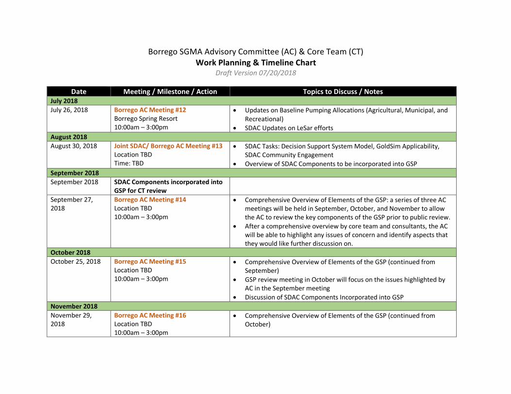
Borrego SGMA Advisory Committee (AC) & Core Team (CT) Work Planning & Timeline Chart
Draft Version 07/20/2018
Date Meeting / Milestone / Action Topics to Discuss / Notes July 2018 July 26, 2018
Borrego AC Meeting #12 Borrego Spring Resort 10:00am – 3:00pm
• Updates on Baseline Pumping Allocations (Agricultural, Municipal, and Recreational)
• SDAC Updates on LeSar efforts August 2018 August 30, 2018 Joint SDAC/ Borrego AC Meeting #13
Location TBD Time: TBD
• SDAC Tasks: Decision Support System Model, GoldSim Applicability, SDAC Community Engagement
• Overview of SDAC Components to be incorporated into GSP September 2018 September 2018 SDAC Components incorporated into
GSP for CT review
September 27, 2018
Borrego AC Meeting #14 Location TBD 10:00am – 3:00pm
• Comprehensive Overview of Elements of the GSP: a series of three AC meetings will be held in September, October, and November to allow the AC to review the key components of the GSP prior to public review.
• After a comprehensive overview by core team and consultants, the AC will be able to highlight any issues of concern and identify aspects that they would like further discussion on.
October 2018 October 25, 2018 Borrego AC Meeting #15
Location TBD 10:00am – 3:00pm
• Comprehensive Overview of Elements of the GSP (continued from September)
• GSP review meeting in October will focus on the issues highlighted by AC in the September meeting
• Discussion of SDAC Components Incorporated into GSP November 2018 November 29, 2018
Borrego AC Meeting #16 Location TBD 10:00am – 3:00pm
• Comprehensive Overview of Elements of the GSP (continued from October)
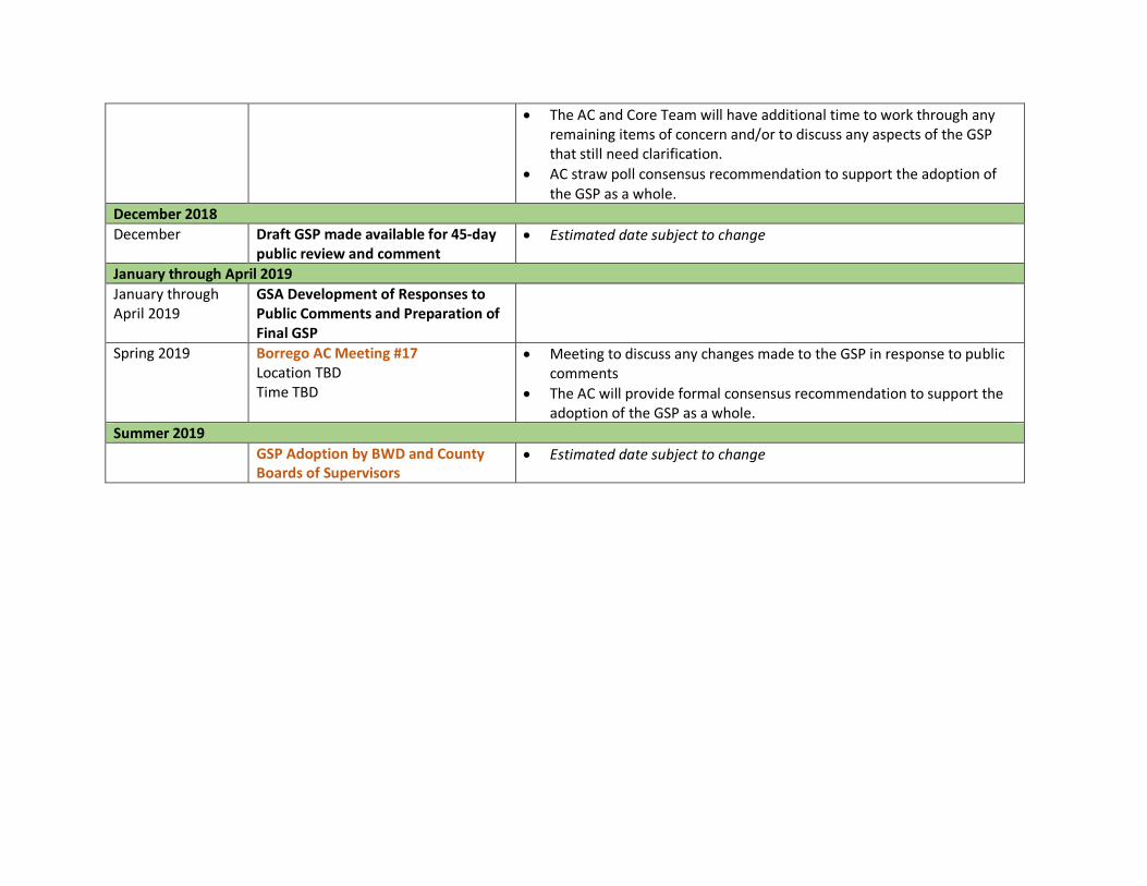
• The AC and Core Team will have additional time to work through any remaining items of concern and/or to discuss any aspects of the GSP that still need clarification.
• AC straw poll consensus recommendation to support the adoption of the GSP as a whole.
December 2018 December Draft GSP made available for 45-day
public review and comment • Estimated date subject to change
January through April 2019 January through April 2019
GSA Development of Responses to Public Comments and Preparation of Final GSP
Spring 2019 Borrego AC Meeting #17 Location TBD Time TBD
• Meeting to discuss any changes made to the GSP in response to public comments
• The AC will provide formal consensus recommendation to support the adoption of the GSP as a whole.
Summer 2019 GSP Adoption by BWD and County
Boards of Supervisors • Estimated date subject to change
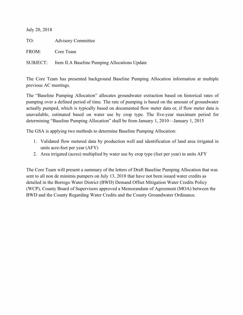
July 20, 2018 TO: Advisory Committee FROM: Core Team SUBJECT: Item II.A Baseline Pumping Allocations Update
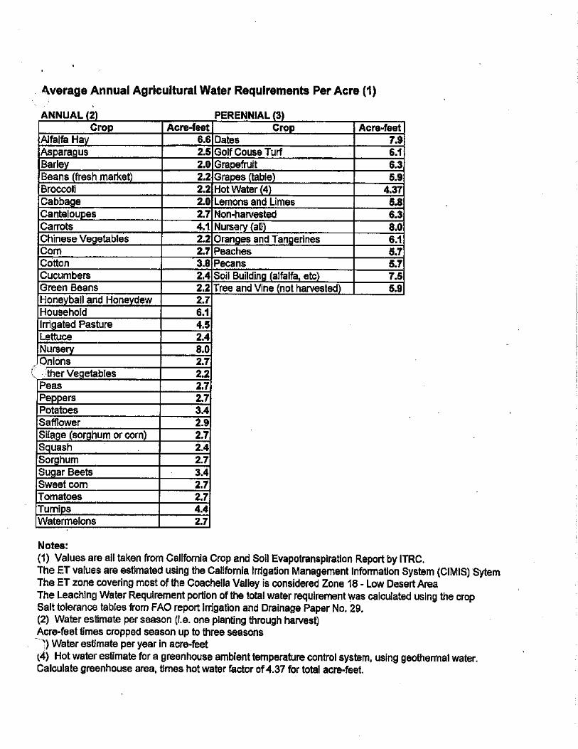
The Core Team has presented background Baseline Pumping Allocation information at multiple previous AC meetings.
The “Baseline Pumping Allocation” allocates groundwater extraction based on historical rates of pumping over a defined period of time. The rate of pumping is based on the amount of groundwater actually pumped, which is typically based on documented flow meter data or, if flow meter data is unavailable, estimated based on water use by crop type. The five-year maximum period for determining “Baseline Pumping Allocation” shall be from January 1, 2010—January 1, 2015
The GSA is applying two methods to determine Baseline Pumping Allocation:
1. Validated flow metered data by production well and identification of land area irrigated in units acre-feet per year (AFY)
2. Area irrigated (acres) multiplied by water use by crop type (feet per year) in units AFY
The Core Team will present a summary of the letters of Draft Baseline Pumping Allocation that was sent to all non de minimis pumpers on July 13, 2018 that have not been issued water credits as detailed in the Borrego Water District (BWD) Demand Offset Mitigation Water Credits Policy (WCP), County Board of Supervisors approved a Memorandum of Agreement (MOA) between the BWD and the County Regarding Water Credits and the County Groundwater Ordinance.
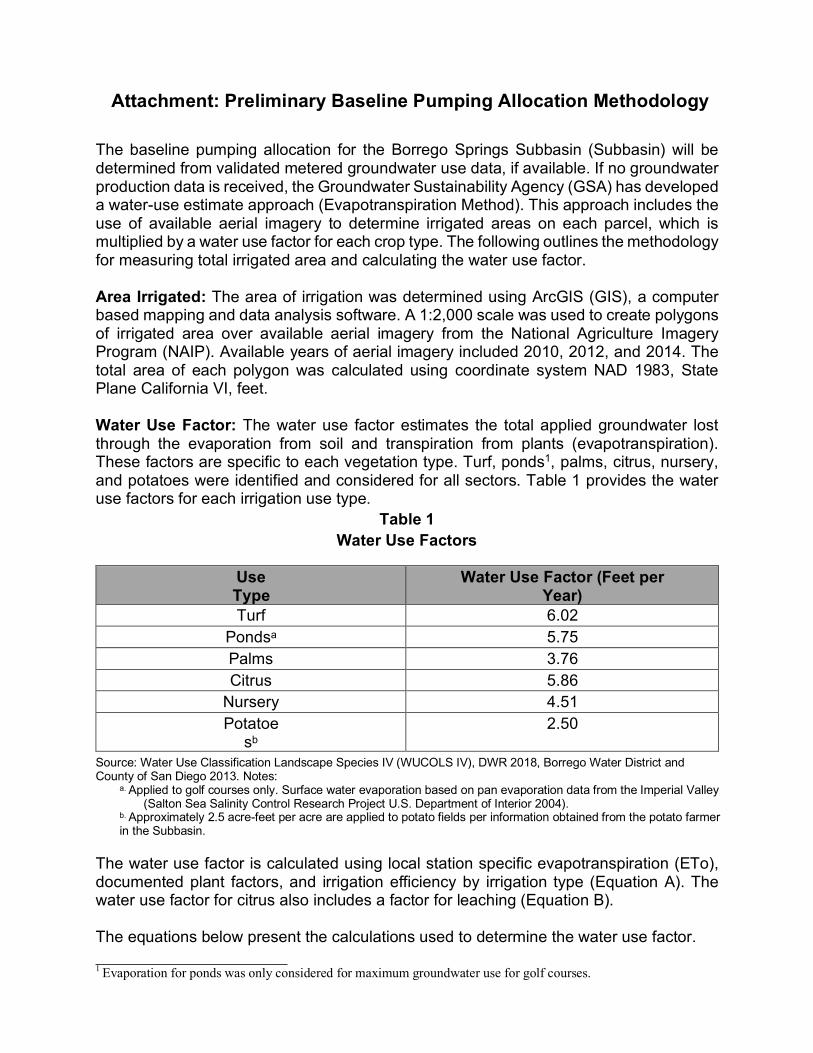
Attachment: Preliminary Baseline Pumping Allocation Methodology The baseline pumping allocation for the Borrego Springs Subbasin (Subbasin) will be determined from validated metered groundwater use data, if available. If no groundwater production data is received, the Groundwater Sustainability Agency (GSA) has developed a water-use estimate approach (Evapotranspiration Method). This approach includes the use of available aerial imagery to determine irrigated areas on each parcel, which is multiplied by a water use factor for each crop type. The following outlines the methodology for measuring total irrigated area and calculating the water use factor.
Area Irrigated: The area of irrigation was determined using ArcGIS (GIS), a computer based mapping and data analysis software. A 1:2,000 scale was used to create polygons of irrigated area over available aerial imagery from the National Agriculture Imagery Program (NAIP). Available years of aerial imagery included 2010, 2012, and 2014. The total area of each polygon was calculated using coordinate system NAD 1983, State Plane California VI, feet.
Water Use Factor: The water use factor estimates the total applied groundwater lost through the evaporation from soil and transpiration from plants (evapotranspiration). These factors are specific to each vegetation type. Turf, ponds1, palms, citrus, nursery, and potatoes were identified and considered for all sectors. Table 1 provides the water use factors for each irrigation use type.
Table 1 Water Use Factors
Use Type
Water Use Factor (Feet per Year)
Turf 6.02 Pondsa 5.75 Palms 3.76 Citrus 5.86
Nursery 4.51 Potatoe
sb
2.50
Source: Water Use Classification Landscape Species IV (WUCOLS IV), DWR 2018, Borrego Water District and County of San Diego 2013. Notes:
a. Applied to golf courses only. Surface water evaporation based on pan evaporation data from the Imperial Valley (Salton Sea Salinity Control Research Project U.S. Department of Interior 2004).
b. Approximately 2.5 acre-feet per acre are applied to potato fields per information obtained from the potato farmer in the Subbasin.
The water use factor is calculated using local station specific evapotranspiration (ETo), documented plant factors, and irrigation efficiency by irrigation type (Equation A). The water use factor for citrus also includes a factor for leaching (Equation B).
The equations below present the calculations used to determine the water use factor.
1 Evaporation for ponds was only considered for maximum groundwater use for golf courses.
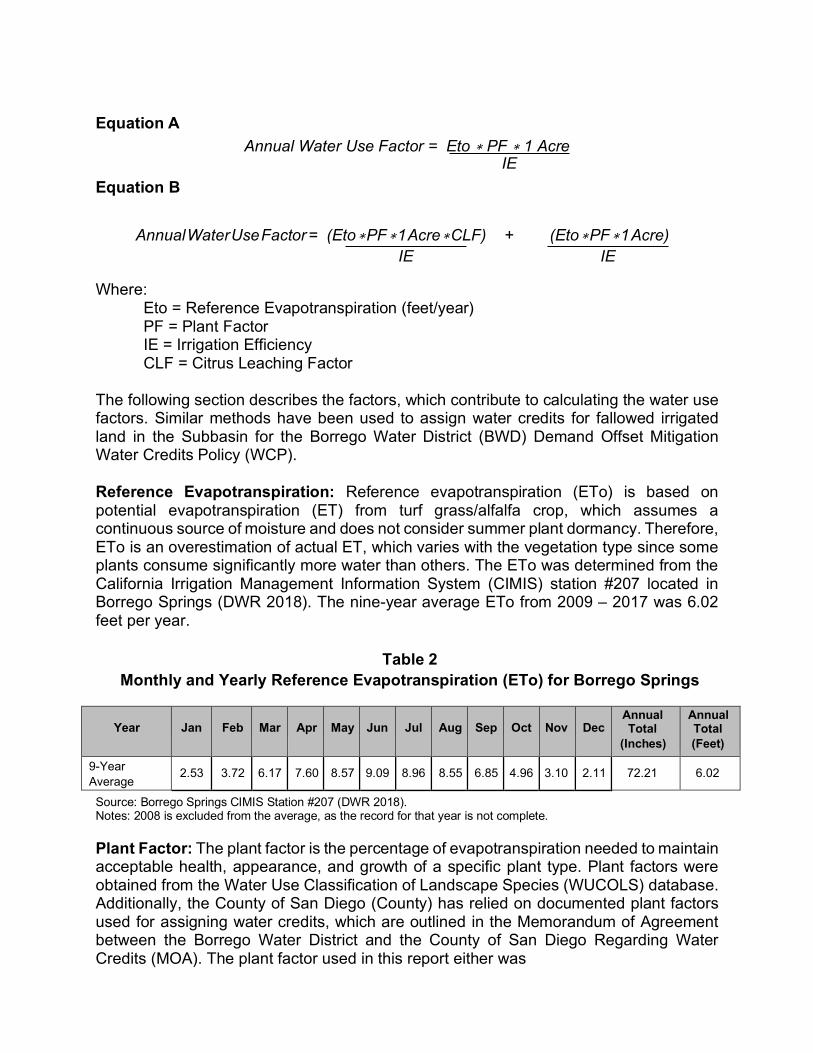
Equation A
Equation B
Annual Water Use Factor = Eto ∗ PF ∗ 1 Acre IE
Annual Water Use Factor = (Eto ∗ PF ∗ 1 Acre ∗ CLF) + (Eto ∗ PF ∗ 1 Acre)
IE IE
Where: Eto = Reference Evapotranspiration (feet/year) PF = Plant Factor IE = Irrigation Efficiency CLF = Citrus Leaching Factor
The following section describes the factors, which contribute to calculating the water use factors. Similar methods have been used to assign water credits for fallowed irrigated land in the Subbasin for the Borrego Water District (BWD) Demand Offset Mitigation Water Credits Policy (WCP).
Reference Evapotranspiration: Reference evapotranspiration (ETo) is based on potential evapotranspiration (ET) from turf grass/alfalfa crop, which assumes a continuous source of moisture and does not consider summer plant dormancy. Therefore, ETo is an overestimation of actual ET, which varies with the vegetation type since some plants consume significantly more water than others. The ETo was determined from the California Irrigation Management Information System (CIMIS) station #207 located in Borrego Springs (DWR 2018). The nine-year average ETo from 2009 – 2017 was 6.02 feet per year.
Table 2
Monthly and Yearly Reference Evapotranspiration (ETo) for Borrego Springs
Year
Jan
Feb
Mar
Apr
May
Jun
Jul
Aug
Sep
Oct
Nov
Dec
Annual Total
(Inches)
Annual Total (Feet)
9-Year Average
2.53 3.72 6.17 7.60 8.57 9.09 8.96 8.55 6.85 4.96 3.10 2.11 72.21 6.02
Source: Borrego Springs CIMIS Station #207 (DWR 2018). Notes: 2008 is excluded from the average, as the record for that year is not complete.
Plant Factor: The plant factor is the percentage of evapotranspiration needed to maintain acceptable health, appearance, and growth of a specific plant type. Plant factors were obtained from the Water Use Classification of Landscape Species (WUCOLS) database. Additionally, the County of San Diego (County) has relied on documented plant factors used for assigning water credits, which are outlined in the Memorandum of Agreement between the Borrego Water District and the County of San Diego Regarding Water Credits (MOA). The plant factor used in this report either was
based on an average of recent WUCOLS data or documented County plant factors, whichever was higher.
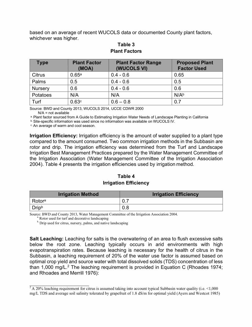
Table 3 Plant Factors
Type Plant Factor
(MOA) Plant Factor Range (WUCOLS VI)
Proposed Plant Factor Used
Citrus 0.65a 0.4 - 0.6 0.65 Palms 0.5 0.4 - 0.6 0.5 Nursery 0.6 0.4 - 0.6 0.6 Potatoes N/A N/A N/Ab
Turf 0.63c 0.6 – 0.8 0.7 Source: BWD and County 2013, WUCOLS 2014, UCCE CDWR 2000
N/A = not available a. Plant factor sourced from A Guide to Estimating Irrigation Water Needs of Landscape Planting in California b. Site-specific information was used since no information was available on WUCOLS IV. c. An average of warm and cool season.
Irrigation Efficiency: Irrigation efficiency is the amount of water supplied to a plant type compared to the amount consumed. Two common irrigation methods in the Subbasin are rotor and drip. The irrigation efficiency was determined from the Turf and Landscape Irrigation Best Management Practices prepared by the Water Management Committee of the Irrigation Association (Water Management Committee of the Irrigation Association 2004). Table 4 presents the irrigation efficiencies used by irrigation method.
Table 4
Irrigation Efficiency
Irrigation Method Irrigation Efficiency Rotora 0.7 Dripb 0.8
Source: BWD and County 2013, Water Management Committee of the Irrigation Association 2004. a. Rotor used for turf and decorative landscaping b. Drip used for citrus, nursery, palms, and native landscaping
Salt Leaching: Leaching for salts is the overwatering of an area to flush excessive salts below the root zone. Leaching typically occurs in arid environments with high evapotranspiration rates. Because leaching is necessary for the health of citrus in the Subbasin, a leaching requirement of 20% of the water use factor is assumed based on optimal crop yield and source water with total dissolved solids (TDS) concentration of less than 1,000 mg/L.2 The leaching requirement is provided in Equation C (Rhoades 1974; and Rhoades and Merrill 1976):
2 A 20% leaching requirement for citrus is assumed taking into account typical Subbasin water quality (i.e. <1,000 mg/L TDS and average soil salinity tolerated by grapefruit of 1.8 dS/m for optimal yield (Ayers and Westcot 1985)
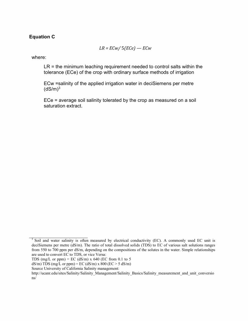
Equation C
LR=ECw/5(ECe)—ECw
where:
LR = the minimum leaching requirement needed to control salts within the tolerance (ECe) of the crop with ordinary surface methods of irrigation ECw =salinity of the applied irrigation water in deciSiemens per metre (dS/m)3
ECe = average soil salinity tolerated by the crop as measured on a soil saturation extract.
3 Soil and water salinity is often measured by electrical conductivity (EC). A commonly used EC unit is deciSiemens per metre (dS/m). The ratio of total dissolved solids (TDS) to EC of various salt solutions ranges from 550 to 700 ppm per dS/m, depending on the compositions of the solutes in the water. Simple relationships are used to convert EC to TDS, or vice Versa: TDS (mg/L or ppm) = EC (dS/m) x 640 (EC from 0.1 to 5 dS/m) TDS (mg/L or ppm) = EC (dS/m) x 800 (EC > 5 dS/m) Source University of California Salinity management: http://ucanr.edu/sites/Salinity/Salinity_Management/Salinity_Basics/Salinity_measurement_and_unit_conversions/
July 20, 2018 TO: Advisory Committee FROM: Core Team SUBJECT: Item III.A: Groundwater Monitoring Network Spring 2018 Results The Dudek team performed the spring 2018 groundwater monitoring event for the Borrego Springs Groundwater Subbasin (Subbasin), including measurement of groundwater elevations in 46 wells as compared to 37 wells in the fall 2017, and analysis of groundwater quality from 29 wells as compared to 30 wells in the fall 2017.1 The spring 2018 monitoring event builds on the spring 2017 and fall 2017 monitoring events to track changes in groundwater levels and groundwater quality in the Subbasin.2 The data collected will be compared to previous Groundwater Sustainability Agency (GSA) monitoring events and historical data to further refine understanding of Subbasin conditions for development of the Groundwater Sustainability Plan (GSP), and will also be used for tracking progress toward sustainability goals to be defined in the pending GSP. Data collected during the spring and fall 2017 and spring 2018 events have been incorporated into the GSA’s Data Management System (DMS). Results from measurement of groundwater levels and for water quality from the spring 2018 monitoring event were generally consistent with the fall 2017 monitoring event and previous available historical data and trends. A more detailed summary of groundwater monitoring results will be discussed at the July 26, 2018 AC meeting.
1 One well, RH-3, was not sampled due to a malfunctioning pump that has since been repaired. 2 The spring 2017 groundwater monitoring event included only groundwater level monitoring and no groundwater quality samples were collected.
July 20, 2018 TO: Advisory Committee FROM: Core Team and Le Sar Development Consultants SUBJECT: Item III.B. Socioeconomic Efforts: Proposition 1 Grant Tasks Updates
Rachel Ralston of Le Sar Development Consultants will provide a verbal summary of the projects status and review the attached copies of the latest versions of the various public outreach items being developed. These activities are being funded through Proposition 1 Grant funds.
Update on SDAC Engagement and Socioeconomic Modeling Projects July 26, 2018
1. Community engagement planning and implementation – April 2018-June 2019 a. The Ad Hoc Committee on SDAC Engagement has been meeting every other Friday
since April to provide guidance for developing community engagement materials, appropriate outreach channels, meeting venues, etc. The committee will continue to meet regularly through September as community meetings and other data collection/education opportunities are implemented. • Meeting materials include
1. Community meeting PowerPoint presentation 2. Door-to-door education and feedback tool 3. Educational brochure 4. Engagement flier 5. Frequently asked questions
• Preliminary dates set for first two community meetings 1. September 19-20, 2018 (one English, one Spanish meeting)
b. Municipal surveys – preliminary results
• Response rate (assuming 2100 surveys mailed out): appx. 11.6% 1. English responses – 223 2. Spanish responses – 18
• Preliminary responses: 1. Appx. 57% willing to pay $25 or less for water (7% indicated $0 more) 2. 83% own the home 3. 70% are retired 4. Average months living in Borrego each year: 9 5. 28% volunteer (primarily at the park, civic groups, and faith-based organizations) 6. Emerging themes:
a. Comments from respondents living on fixed incomes were most likely to indicate inability to pay more and concern about rate increases
b. Concerns about agriculture and golf course water use – using too much water and making Borrego economy unsustainable over the long term, fair share based on water consumption
c. Self-reported water conservation efforts, e.g., drought-friendly landscaping, graywater recycling, generally lowering water consumption
d. Concerns about privacy around information provided through the survey process
e. Water quality concerns (three respondents) – corrosion of faucets, pipes and sulfuric smell
f. Concerns about having to leave Borrego (five respondents)
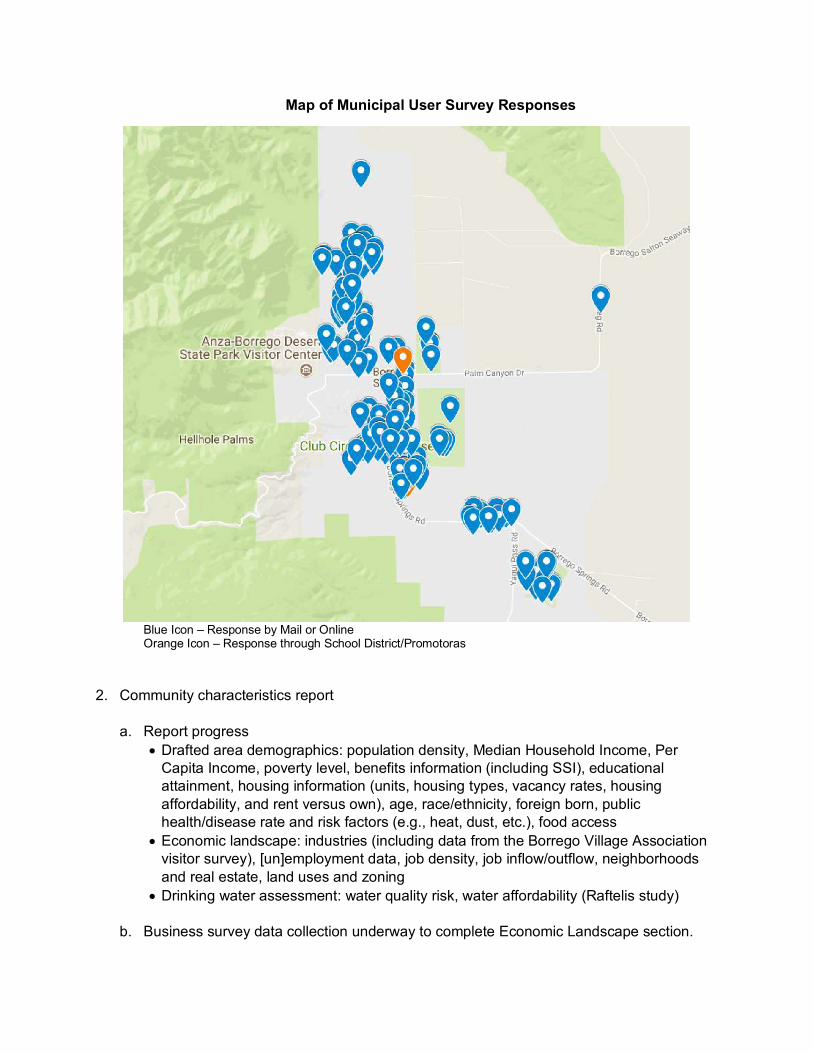
Map of Municipal User Survey Responses
Blue Icon – Response by Mail or Online Orange Icon – Response through School District/Promotoras
2. Community characteristics report a. Report progress
• Drafted area demographics: population density, Median Household Income, Per Capita Income, poverty level, benefits information (including SSI), educational attainment, housing information (units, housing types, vacancy rates, housing affordability, and rent versus own), age, race/ethnicity, foreign born, public health/disease rate and risk factors (e.g., heat, dust, etc.), food access
• Economic landscape: industries (including data from the Borrego Village Association visitor survey), [un]employment data, job density, job inflow/outflow, neighborhoods and real estate, land uses and zoning
• Drinking water assessment: water quality risk, water affordability (Raftelis study)
b. Business survey data collection underway to complete Economic Landscape section.

3. Socioeconomic baseline data and analysis – estimated completion in August 2018 a. Data compilation and review near completion for the baseline water use summary report.
Development of SDAC-specific metrics for subareas of the Borrego Valley. Costs for the BWD to supply subareas will be developed based on consultation with BWD specific to their overall water supply, water treatment, and distribution system. Areas outside of the BWD service area will also be evaluated.

GSP Borrego Informational Brochure
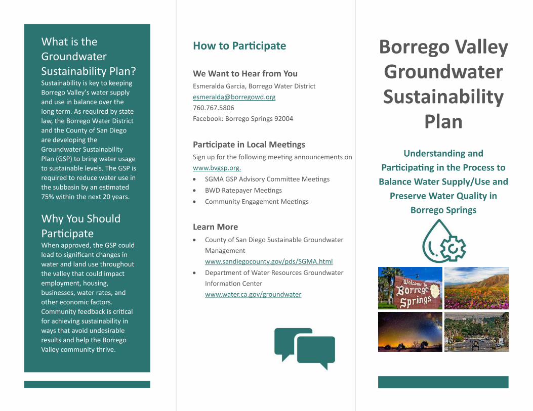
What is the Groundwater Sustainability Plan? Sustainability is key to keeping
Borrego Valley’s water supply
and use in balance over the
long term. As required by state
law, the Borrego Water District
and the County of San Diego
are developing the
Groundwater Sustainability
Plan (GSP) to bring water usage
to sustainable levels. The GSP is
required to reduce water use in
the subbasin by an es mated
75% within the next 20 years.
Why You Should Par cipate When approved, the GSP could
lead to significant changes in
water and land use throughout
the valley that could impact
employment, housing,
businesses, water rates, and
other economic factors.
Community feedback is cri cal
for achieving sustainability in
ways that avoid undesirable
results and help the Borrego
Valley community thrive.
How to Par cipate
We Want to Hear from You Esmeralda Garcia, Borrego Water District
760.767.5806
Facebook: Borrego Springs 92004
Par cipate in Local Mee ngs Sign up for the following mee ng announcements on
www.bvgsp.org.
SGMA GSP Advisory Commi ee Mee ngs
BWD Ratepayer Mee ngs
Community Engagement Mee ngs
Learn More County of San Diego Sustainable Groundwater
Management
www.sandiegocounty.gov/pds/SGMA.html
Department of Water Resources Groundwater
Informa on Center
www.water.ca.gov/groundwater
Borrego Valley Groundwater Sustainability
Plan
Understanding and Par cipa ng in the Process to
Balance Water Supply/Use and Preserve Water Quality in
Borrego Springs
Groundwater Sustainability Plan (GSP) Components
The Groundwater Sustainability Plan is the
community’s guide for achieving sustainable
water use by 2040. It must contain four parts.
1. A descrip on of the plan area, an
evalua on of the groundwater subbasin,
and a water budget (inflow and ou low)
2. Clearly defined sustainability goals
3. Project and management ac ons to
achieve sustainability and avoid
undesirable results
4. A monitoring plan to measure progress
Borrego Springs Subbasin The Borrego Springs Subbasin is in cri cal overdra , which occurs when:
The average amount of groundwater that is extracted exceeds the long-term average annual supply of water to the basin and
Con nuing these prac ces may result in
significant impacts to water quality and
availability, as well as to the local economy
and the environment.
Avoiding Undesirable Results
California’s Sustainable Groundwater
Management Act (SGMA) requires that
groundwater basin sustainability goals do not
invite significant or unreasonable impacts.
The poten al undesirable results that the GSP
seeks to avoid are the following.
Inadequate groundwater storage:
Significant groundwater reduc on means
inadequate long-term water supply.
Chronic lowering of groundwater levels:
Declining groundwater levels because of
groundwater overdra . Wells are at risk of
going dry, needing to be drilled deeper, or
producing degraded-quality water.
Poor water quality: Lower groundwater
can harm water quality.
The GSP considers impacts to water quality and long-term availability. Through a state
Proposi on 1 grant, the Borrego Water District and County of San Diego are evalua ng impacts to the economy and environment.
The Borrego Springs Groundwater Subbasin is the area’s only available
water source. Present water use in the area is not sustainable for the long term.
Change is coming. Your par cipa on is part of that
change.
All water in the basin comes from three aquifers. An aquifer is made of layers of rock that hold and transmit water underground. (A and B represent different wells.)
GSP Community Outreach Flyer
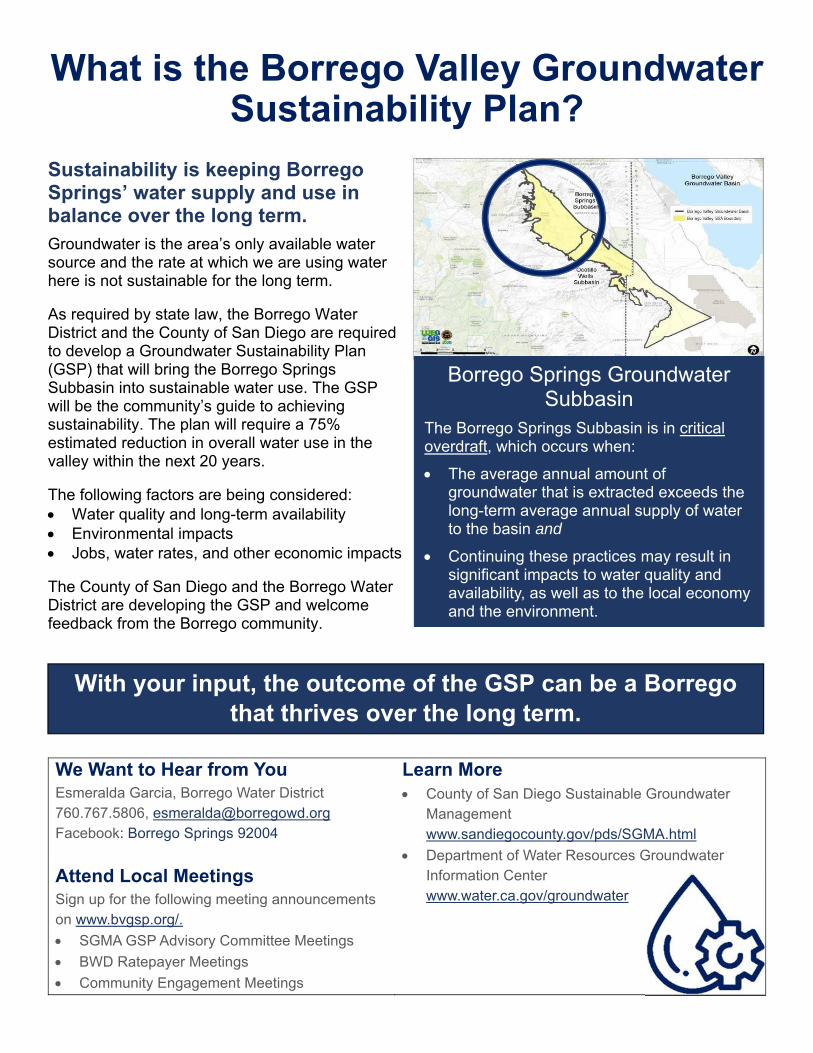
What is the Borrego Valley Groundwater Sustainability Plan?
Sustainability is keeping Borrego Springs’ water supply and use in balance over the long term. Groundwater is the area’s only available water source and the rate at which we are using water here is not sustainable for the long term. As required by state law, the Borrego Water District and the County of San Diego are required to develop a Groundwater Sustainability Plan (GSP) that will bring the Borrego Springs Subbasin into sustainable water use. The GSP will be the community’s guide to achieving sustainability. The plan will require a 75% estimated reduction in overall water use in the valley within the next 20 years. The following factors are being considered: Water quality and long-term availability Environmental impacts Jobs, water rates, and other economic impacts The County of San Diego and the Borrego Water District are developing the GSP and welcome feedback from the Borrego community.
We Want to Hear from You Esmeralda Garcia, Borrego Water District 760.767.5806, [email protected] Facebook: Borrego Springs 92004 Attend Local Meetings Sign up for the following meeting announcements on www.bvgsp.org/. SGMA GSP Advisory Committee Meetings BWD Ratepayer Meetings Community Engagement Meetings
Learn More County of San Diego Sustainable Groundwater
Management www.sandiegocounty.gov/pds/SGMA.html
Department of Water Resources Groundwater Information Center www.water.ca.gov/groundwater
Borrego Springs Groundwater Subbasin
The Borrego Springs Subbasin is in critical overdraft, which occurs when:
The average annual amount of groundwater that is extracted exceeds the long-term average annual supply of water to the basin and
Continuing these practices may result in significant impacts to water quality and availability, as well as to the local economy and the environment.
With your input, the outcome of the GSP can be a Borrego that thrives over the long term.
SDAC Community Meeting PowerPoint Presentation
COMMUNITY MEETING
1
BORREGO VALLEYGROUNDWATER SUSTAINABILITY PLANNING
AGENDA
2
• Welcome and Introductions
• Meeting Purpose
• Overview: The Need to Regulate Groundwater
• What is the Groundwater Sustainability Plan?
• How Might the Plan Affect Borrego Residents and Businesses?
• Listening Session
Introductions
Meeting purpose
• To provide an overview of the water situation in Borrego Springs and of
the plan that is being developed to ensure Borrego’s water supply is
sustainable in the long-term
• To hear from you about your concerns with present day water quality,
access, and affordability, as well as concerns about the groundwater
sustainability plan
• To develop relationships and contacts within the community to promote
an open dialogue with the community throughout the plan
implementation phase
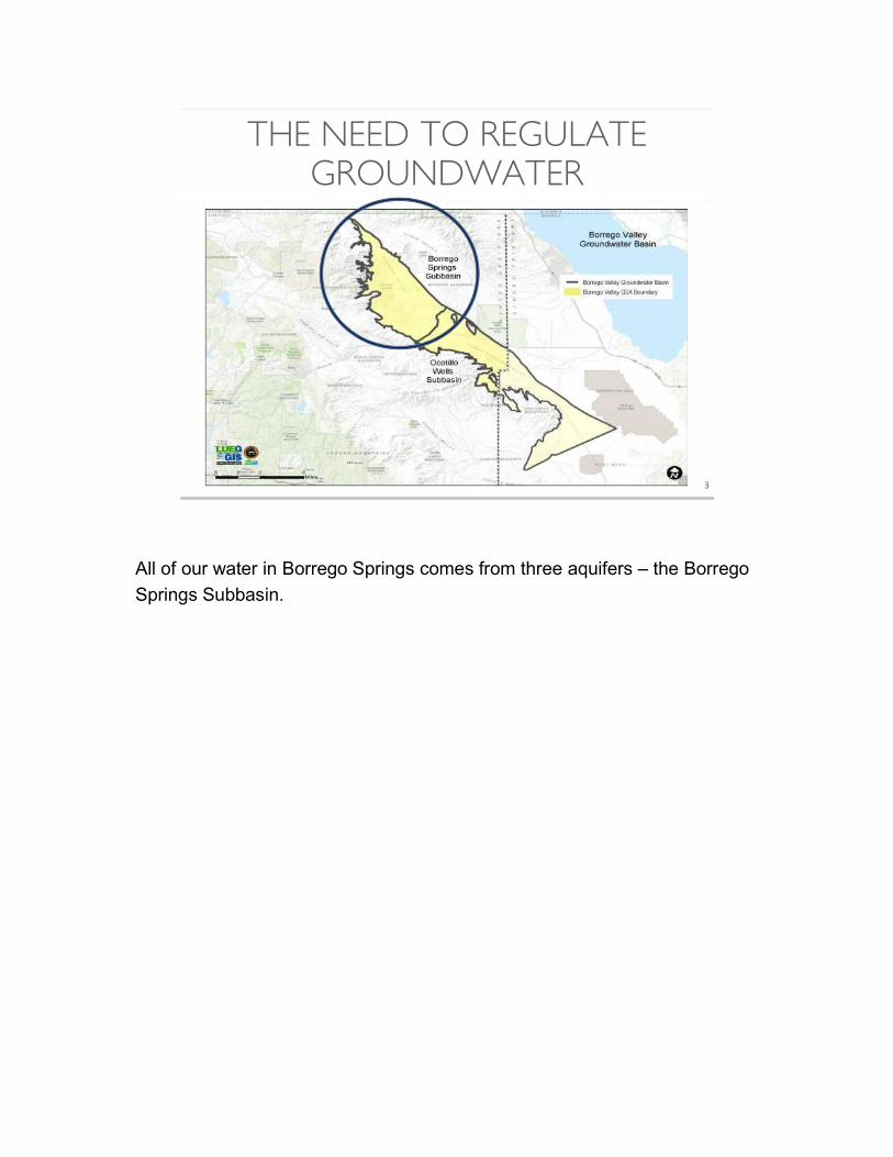
THE NEED TO REGULATE GROUNDWATER
3
All of our water in Borrego Springs comes from three aquifers – the Borrego
Springs Subbasin.
SUSTAINABLE GROUNDWATER MANAGEMENT
4
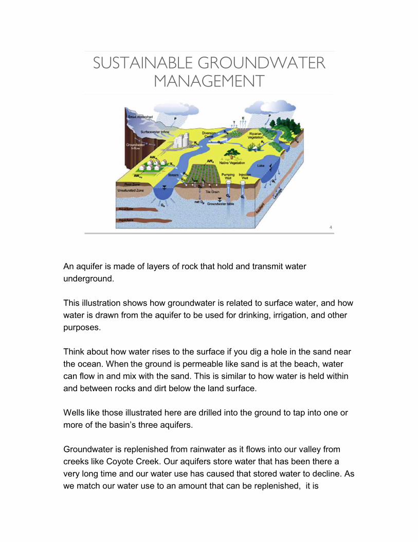
An aquifer is made of layers of rock that hold and transmit water
underground.
This illustration shows how groundwater is related to surface water, and how
water is drawn from the aquifer to be used for drinking, irrigation, and other
purposes.
Think about how water rises to the surface if you dig a hole in the sand near
the ocean. When the ground is permeable like sand is at the beach, water
can flow in and mix with the sand. This is similar to how water is held within
and between rocks and dirt below the land surface.
Wells like those illustrated here are drilled into the ground to tap into one or
more of the basin’s three aquifers.
Groundwater is replenished from rainwater as it flows into our valley from
creeks like Coyote Creek. Our aquifers store water that has been there a
very long time and our water use has caused that stored water to decline. As
we match our water use to an amount that can be replenished, it is
important that we monitor how much water we pump out of each aquifer and make
sure we are conserving water as much as possible through our everyday activities.
As you can see, because the groundwater in the basin is shared, excessive pumping
from one well can affect the amount of water available to other surrounding wells.
Also, any pesticides or other chemicals used as part of irrigation can percolate into
the groundwater over time, which affects water quality.
What you can’t see here is that the deeper into the ground wells are drilled to extract
groundwater, the more likely it is that the water will be impaired, which make the
water potentially unsuitable to drink. Through a treatment process, this water can be
made potable, but this process is often expensive.
These are some of the other reasons why it is important to conserve the water in our
basin over the long term.
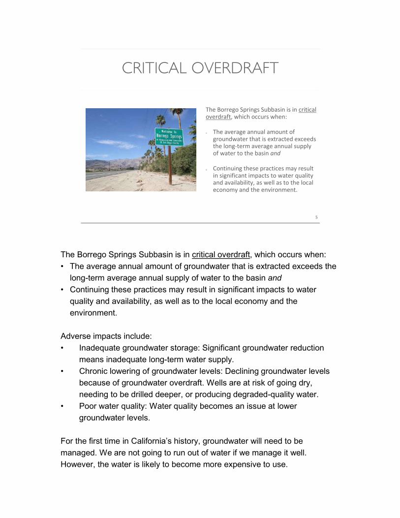
CRITICAL OVERDRAFT
The Borrego Springs Subbasin is in critical overdraft, which occurs when:
The average annual amount of groundwater that is extracted exceeds the long-term average annual supply of water to the basin and
Continuing these practices may result in significant impacts to water quality and availability, as well as to the local economy and the environment.
5
The Borrego Springs Subbasin is in critical overdraft, which occurs when:
• The average annual amount of groundwater that is extracted exceeds the
long-term average annual supply of water to the basin and
• Continuing these practices may result in significant impacts to water
quality and availability, as well as to the local economy and the
environment.
Adverse impacts include:
• Inadequate groundwater storage: Significant groundwater reduction
means inadequate long-term water supply.
• Chronic lowering of groundwater levels: Declining groundwater levels
because of groundwater overdraft. Wells are at risk of going dry,
needing to be drilled deeper, or producing degraded-quality water.
• Poor water quality: Water quality becomes an issue at lower
groundwater levels.
For the first time in California’s history, groundwater will need to be
managed. We are not going to run out of water if we manage it well.
However, the water is likely to become more expensive to use.

The Borrego Water District and the County of San Diego have been tasked with
bringing the community’s water usage to sustainable levels. This means reducing
overall water use in the basin by approximately 75% within the next 20 years. So how
do we do that? [next slide]

SUSTAINABLE GROUNDWATER MANAGEMENT
The State of California Sustainable Groundwater Management Act (SGMA) provides a path for long-term sustainability, with basin-specific solutions.
Sustainable groundwater management balances groundwater resources in a manner that benefits present and future generations.
6
The Sustainable Groundwater Management Act (SGMA) is a new state law
that will change the way we use and manage groundwater in California. The
act directs local authorities to form Groundwater Sustainability Agencies
(GSAs) to create a plan to manage and regulate groundwater. This is not
optional – this is required by the state.
The County of San Diego and the Borrego Water District are the authorities
that form the Groundwater Sustainability Agency for Borrego Springs. The
plan they are developing is called the Groundwater Sustainability Plan
(GSP). Under the SGMA law, our Borrego GSA will have the ability to limit or
suspend groundwater pumping and charge fees for groundwater pumping.
Our GSA will also be responsible for ensuring that we do not use more
groundwater than nature can restore.
Takeaways:
• The purpose of the Groundwater Sustainability Plan is to reach
sustainability for the basin, which means that the water we use and the
water that comes into our basin are in balance.
• The new SGMA law and the process of creating the groundwater plan
can help Borrego Springs thrive over the long term.
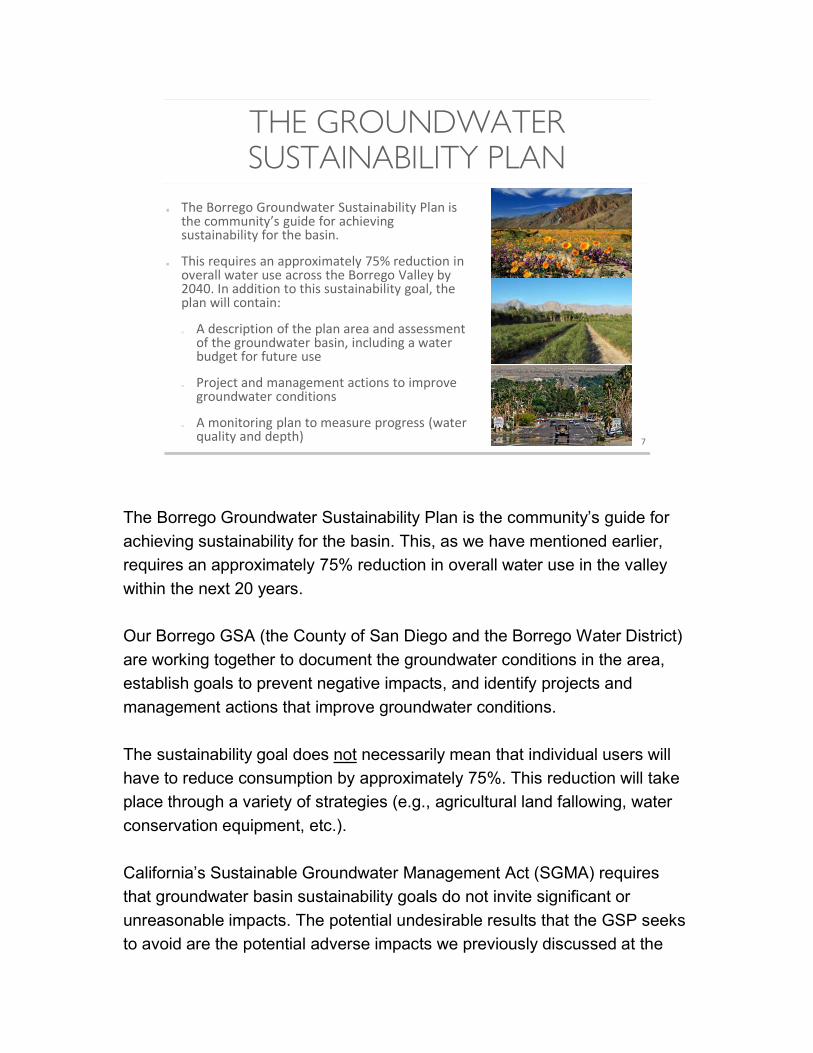
THE GROUNDWATER SUSTAINABILITY PLAN
7
The Borrego Groundwater Sustainability Plan is the community’s guide for achieving sustainability for the basin.
This requires an approximately 75% reduction in overall water use across the Borrego Valley by 2040. In addition to this sustainability goal, the plan will contain:
o A description of the plan area and assessment of the groundwater basin, including a water budget for future use
o Project and management actions to improve groundwater conditions
o A monitoring plan to measure progress (water quality and depth)
The Borrego Groundwater Sustainability Plan is the community’s guide for
achieving sustainability for the basin. This, as we have mentioned earlier,
requires an approximately 75% reduction in overall water use in the valley
within the next 20 years.
Our Borrego GSA (the County of San Diego and the Borrego Water District)
are working together to document the groundwater conditions in the area,
establish goals to prevent negative impacts, and identify projects and
management actions that improve groundwater conditions.
The sustainability goal does not necessarily mean that individual users will
have to reduce consumption by approximately 75%. This reduction will take
place through a variety of strategies (e.g., agricultural land fallowing, water
conservation equipment, etc.).
California’s Sustainable Groundwater Management Act (SGMA) requires
that groundwater basin sustainability goals do not invite significant or
unreasonable impacts. The potential undesirable results that the GSP seeks
to avoid are the potential adverse impacts we previously discussed at the
beginning of the meeting:
• Inadequate groundwater storage: Significant groundwater reduction means
inadequate long-term water supply.
• Chronic lowering of groundwater levels: Declining groundwater levels because
of groundwater overdraft. Wells are at risk of going dry, needing to be drilled
deeper, or producing degraded-quality water.
• Poor water quality: Water quality becomes an issue at lower groundwater levels.
Takeaway: The Groundwater Sustainability Plan is an opportunity to make clean
water available in the Borrego Valley over the long term.
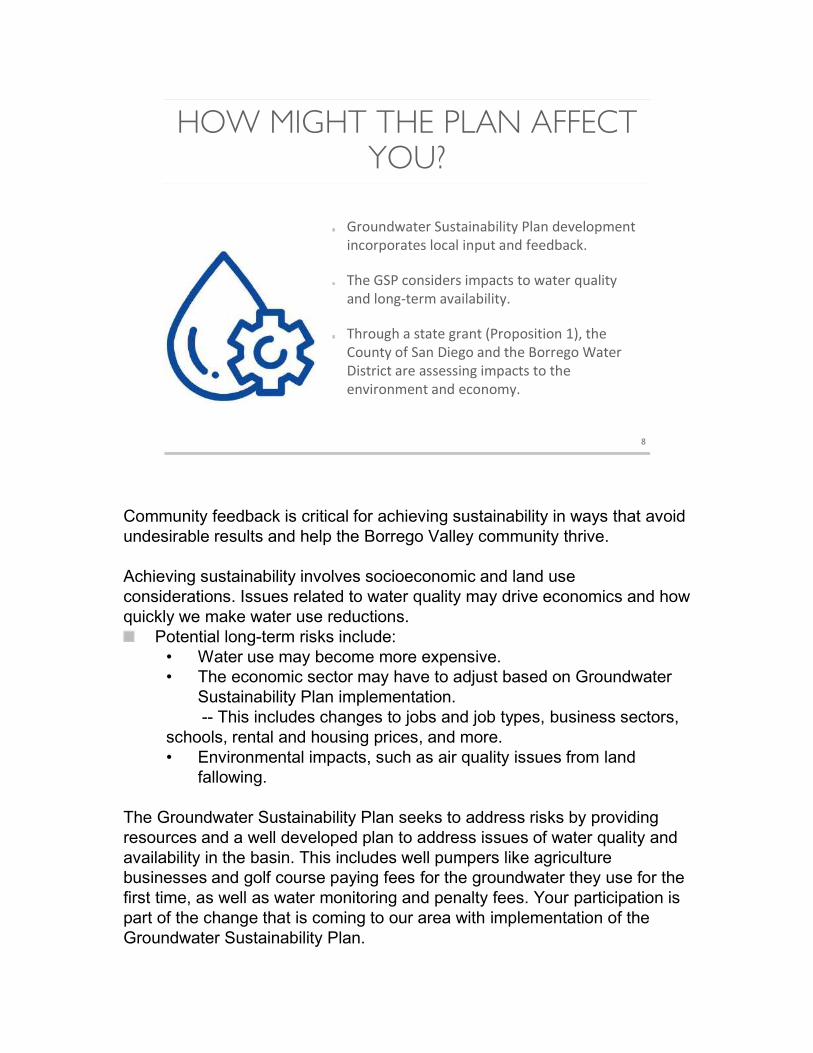
HOW MIGHT THE PLAN AFFECT YOU?
8
Groundwater Sustainability Plan development incorporates local input and feedback.
The GSP considers impacts to water quality and long-term availability.
Through a state grant (Proposition 1), the County of San Diego and the Borrego Water District are assessing impacts to the environment and economy.
Community feedback is critical for achieving sustainability in ways that avoid undesirable results and help the Borrego Valley community thrive.
Achieving sustainability involves socioeconomic and land use considerations. Issues related to water quality may drive economics and how quickly we make water use reductions.
Potential long-term risks include: • Water use may become more expensive. • The economic sector may have to adjust based on Groundwater
Sustainability Plan implementation.-- This includes changes to jobs and job types, business sectors,
schools, rental and housing prices, and more. • Environmental impacts, such as air quality issues from land
fallowing.
The Groundwater Sustainability Plan seeks to address risks by providing resources and a well developed plan to address issues of water quality and availability in the basin. This includes well pumpers like agriculture businesses and golf course paying fees for the groundwater they use for the first time, as well as water monitoring and penalty fees. Your participation is part of the change that is coming to our area with implementation of the Groundwater Sustainability Plan.
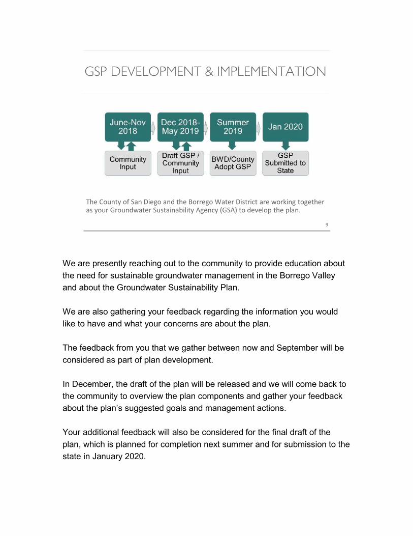
GSP DEVELOPMENT & IMPLEMENTATION
9
The County of San Diego and the Borrego Water District are working together as your Groundwater Sustainability Agency (GSA) to develop the plan.
We are presently reaching out to the community to provide education about
the need for sustainable groundwater management in the Borrego Valley
and about the Groundwater Sustainability Plan.
We are also gathering your feedback regarding the information you would
like to have and what your concerns are about the plan.
The feedback from you that we gather between now and September will be
considered as part of plan development.
In December, the draft of the plan will be released and we will come back to
the community to overview the plan components and gather your feedback
about the plan’s suggested goals and management actions.
Your additional feedback will also be considered for the final draft of the
plan, which is planned for completion next summer and for submission to the
state in January 2020.

LISTENING SESSION
oWhat are questions that you would like answered about the Groundwater Sustainability Plan?
10
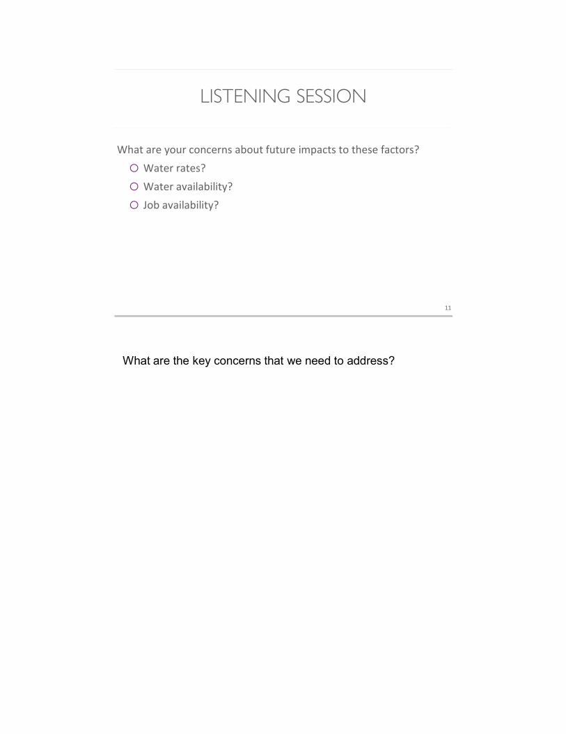
LISTENING SESSION
What are your concerns about future impacts to these factors?
o Water rates?
o Water availability?
o Job availability?
11
What are the key concerns that we need to address?
LISTENING SESSION
oWho else should we talk to?
o How do you want to be involved?
12
GET INVOLVED!
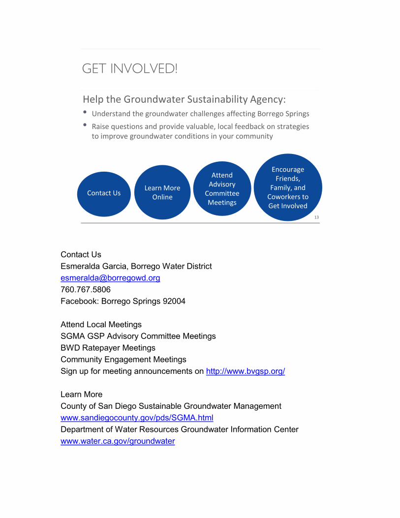
Help the Groundwater Sustainability Agency:• Understand the groundwater challenges affecting Borrego Springs
• Raise questions and provide valuable, local feedback on strategies to improve groundwater conditions in your community
13
Learn More Online
Attend Advisory
Committee Meetings
Encourage Friends,
Family, and Coworkers to Get Involved
Contact Us
Contact Us
Esmeralda Garcia, Borrego Water District
760.767.5806
Facebook: Borrego Springs 92004
Attend Local Meetings
SGMA GSP Advisory Committee Meetings
BWD Ratepayer Meetings
Community Engagement Meetings
Sign up for meeting announcements on http://www.bvgsp.org/
Learn More
County of San Diego Sustainable Groundwater Management
www.sandiegocounty.gov/pds/SGMA.html
Department of Water Resources Groundwater Information Center
www.water.ca.gov/groundwater
CONTACT INFORMATION
• Esmeralda Garcia, Borrego Water District
760-767-5806, [email protected]
• Borrego Valley GSP Website
http://www.bvgsp.org/sustainability-plan.html
14
GSP Door-to-Door Education and Feedback
Tool
Borrego Valley Groundwater Sustainability Plan Door-to-Door Education and Feedback Tool
1
Introduction: Hello! I would like to drop off this flyer about some upcoming community meetings [also include brochure]. The meetings are focused on conserving our water supply here in Borrego while minimizing the impacts on local employment, businesses, water rates, and other factors. Q: Have you heard of the Groundwater Sustainability Plan? [If yes, ask what they know about it and then fill in with the information below as needed.] A: Our groundwater basin is the area’s only available water source and the rate at which we
are using water here is not sustainable for the long term. The Groundwater Sustainability Plan is required to reduce water use in the basin by an
estimated 75% within the next 20 years. How this reduction is achieved will depend on many factors, including the needs of residents
and workers. We would like you to get involved in the meetings about the plan so that we know how best
to reduce or avoid negative impacts to Borrego’s community. Q: Are you satisfied with the quality of your tap water? Do you have any concerns about it? We will keep your responses confidential. A: Q: What about water rates or access to water? A: Q: Will you come to one of the upcoming meetings? A: Q: Who else should we talk to or invite to the meetings? A: Q: Do you have any additional questions for me? A: Q: Can I ask you a few demographic questions? Again, we will keep your responses confidential. [If yes, proceed with questions below. If no, say, “That’s OK. Thank you so much for your time today” and end the interview.]
Gender: ____________ Would you like us to text or email you with meeting updates? (If yes:)
Age: ____________ Cell phone #: _________________________ Primary occupation: ____________ Email address: ________________________
# household members: ____________
GSP Frequently Asked Questions
1
SDAC Community Engagement Frequently Asked Questions
• Does the Groundwater Sustainability Plan (GSP) mean that residents will have to cut water use by 75%? The sustainability goal does not necessarily mean that individual users will have to
reduce consumption by 75%. The 75% reduction focuses on overall water use in the basin, and
this overall reduction in water use will take place through a variety of strategies (e.g.,
agricultural land fallowing, water conservation equipment, etc.). All pumpers in Borrego Springs,
including the Borrego Water District (BWD), will be reducing water pumping over the next 20
years for basin sustainability. During implementation of the GSP, BWD will be pursuing
conservation activities, farmland fallowing, and other projects/management actions to ensure
an adequate potable water supply for municipal water users.
• Why is my water bill going up? Water rates are dependent on a number of factors, including
infrastructure cost and repairs, personnel, electricity, and other factors including prior
planning/studies and support for the current GSP process. BWD is continuously pursuing grant
opportunities, public bond measures (Proposition 3 on November 2018 ballot), and private bond
financing to minimize rate impacts and stabilize future rates. BWD maintains a two‐tiered rate
structures that rewards those who use less water (7 units/5,236 gallons or less per month).
• Why not just make the farmers and agricultural industry reduce water usage and exempt municipal users? This issue relates to complex California water rights law pertaining to land
ownership and where the water is used, when pumping began, and other factors. Instead of
going to the courts to decide (a process called adjudication), the various sectors are working on
the collaborative GSP process. The GSP and subsequent environmental planning documents will
address economic impacts such as job loss and potential negative environmental effects like air
quality issues from land fallowing.
• How long until we reach sustainability? The Groundwater Sustainability Plan is designed for a 20‐year timeframe, but it is a flexible and iterative process in which implementation of the plan
is monitored and adjusted every five years to better meet the sustainability goal.
July 18, 2018 TO: Advisory Committee FROM: Core Team SUBJECT: Item III.C: Groundwater Dependent Ecosystems Based on information and datasets provided by the California Department of Fish and Wildlife, Water Branch, the Core Team will present an informational update on Groundwater Dependent Ecosystems (GDEs).
ClubCircleEastHOAP.O.BOX2130 3134ClubCircleEast,BorregoSprings,CA92004 [email protected]
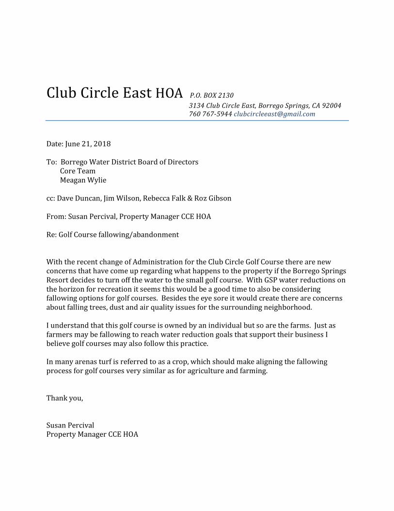
Date:June21,2018To:BorregoWaterDistrictBoardofDirectorsCoreTeamMeaganWyliecc:DaveDuncan,JimWilson,RebeccaFalk&RozGibsonFrom:SusanPercival,PropertyManagerCCEHOARe:GolfCoursefallowing/abandonmentWiththerecentchangeofAdministrationfortheClubCircleGolfCoursetherearenewconcernsthathavecomeupregardingwhathappenstothepropertyiftheBorregoSpringsResortdecidestoturnoffthewatertothesmallgolfcourse.WithGSPwaterreductionsonthehorizonforrecreationitseemsthiswouldbeagoodtimetoalsobeconsideringfallowingoptionsforgolfcourses.Besidestheeyesoreitwouldcreatethereareconcernsaboutfallingtrees,dustandairqualityissuesforthesurroundingneighborhood.Iunderstandthatthisgolfcourseisownedbyanindividualbutsoarethefarms.JustasfarmersmaybefallowingtoreachwaterreductiongoalsthatsupporttheirbusinessIbelievegolfcoursesmayalsofollowthispractice.Inmanyarenasturfisreferredtoasacrop,whichshouldmakealigningthefallowingprocessforgolfcoursesverysimilarasforagricultureandfarming.Thankyou,SusanPercival PropertyManagerCCEHOA
Irvine Office
2030 Main Street, 12th Floor
Irvine, California 92614
t 949.752.8585 f 949.752.0597
Westlake Village Office
2815 Townsgate Road, Suite 200
Westlake Village, California 91361
t 805.230.0023 f 805.230.0087
www.jacksontidus.law
June 15, 2018
Direct Dial: Email:
Reply to: File No:
949.851.7491 [email protected]
Irvine Office 7588-122439
VIA FACSIMILE AND U.S. MAIL
Facsimile: (858) 694-2555
Courtesy Copy Via Email: [email protected]
Leanne Crow, Hydrogeologist Planning and Development Services County of San Diego 5610 Overland Avenue, Suite 310 San Diego, CA 92123 RE: AAWARE Agricultural Water Use Survey and Report--2017
Dear Ms. Crow: This letter responds to the Borrego Valley Groundwater Sustainability Agency (“GSA”) request for additional information pertaining to the Agricultural Alliance for Water and Resource Education (“AAWARE”) Agricultural Water Use Survey and Report—2017 (“Report”). AAWARE is pleased that the Report information “will be useful in developing the Borrego Valley Groundwater Basin Groundwater Sustainability Plan (GSP)” for the Borrego Valley groundwater basin (“Basin”). The GSA has asked whether the Report information is “technically sound” and “developed in accordance with industry-accepted standards”. We would like to clarify that the Report is not derived from a scientific model. Instead, it is based upon first person grower reporting of irrigated acreage during the base period for each crop, and metered groundwater production for each of those crops in Borrego Valley. A simple arithmetical calculation was then conducted for each crop type using the acreage of the crop multiplied by the per-acre irrigation for that crop as the “water duty”. The report was prepared to assist the GSA in complying with the Sustainable Groundwater Management Act’s (“SGMA,” Water Code, §§ 10730-10737.8) requirement to prepare a water budget that quantifies various components, including groundwater extraction and evapotranspiration from, and applied water inflow into, the Borrego Valley Basin (“Basin”). (23 CCR, § 354.18, subd. (b).) The quantification of each budget component must be made either through direct measurements or estimates based on data. (Id.; Department of Water Resources (“DWR”) Water Budget Best Management Practices (“BMP”), p. 18.) SGMA requires the GSA to rely upon the best available information and science to quantify the water budget for the basin.” (23 CCR, § 354.18, subd. (e); DWR Water Budget BMP, p. 18.) Excluding Report
Leanne Crow, Hydrogeologist San Diego County Planning and Development Services Re: AAWARE Agricultural Water Use Survey and Report--2017 June 15, 2018 Page 2
information not “validated” regarding individual user well type, property APNs, crop type and acreage would be inappropriate in the context of these requirements, particularly in light of SGMA’s requirements for annual self-reporting water production information and protection of personal information. (Water Code, §§ 10725.8(c), (d); 10730.8(b).) To put matters in context, the Report:
(i) Provides first person metered water production measurement for 42% of the
known irrigated agricultural acreage (Report, p. 12);1 (ii) Calculates a water duty (water amount produced per acre) for each crop type
based upon metered water production measurements (Report, pp. 11-12); (iii) Estimates water production for the remaining 58% of the known irrigated
agricultural acreage based upon first-person reported crop types and acreage for each crop type multiplied by the metered water duty for that crop type (Report, pp. 11-12);
(iv) Estimates the amount of water consumed by the crops using the WUCOLs III
methodology adopted by the University of California Cooperative Extension (“UCCE”) (Report, p. 13) and the 2015 U.S. Geological Survey Hydrogeology, Hydrologic Effects of Development and Simulation of Groundwater Flow in the Borrego Valley Model Report (“2015 USGS Report”, p. 14); and
(v) Estimates the maximum potential amount of agricultural applied water infiltrating
the groundwater basin by subtracting the estimated water consumption from the reported and estimated water production. The Report also includes information about prior studies that estimated such return flows to the Basin for comparison purposes, and requests that the GSA conduct further studies to obtain a higher level of accuracy for the amount of applied water infiltration as part of its adaptive management of the Basin (Report, pp. 17-19).
SGMA allows for the use of different methodologies for different components of the water budget. (DWR Water Budget BMP, pp. 34-36.) Some water budget components such as groundwater extraction lend themselves to direct monitoring and measurement with a high degree of accuracy, certainty and reliability using meters and other readily available monitoring devices. (DWR Water Budget BMP, p. 35.) Selection of a methodology for a particular water budget component should consider past and current approaches to quantifying water budget
1 The County’s letter suggests that there is more irrigated acreage than reported to AAWARE, based upon 2015 irrigated acreage calculated by Borrego Water District (“BWD”). As discussed at page 2 of the Report, the survey responses represent 89% of total agricultural acreage calculated by BWD in 2015. The Report included all of the current irrigated agricultural acreage known to AAWARE, and welcomes any additional information BWD can provide on its accounting of irrigated acreage.
Leanne Crow, Hydrogeologist San Diego County Planning and Development Services Re: AAWARE Agricultural Water Use Survey and Report--2017 June 15, 2018 Page 3
components in the basin and alternative approaches representing the best available information and the best available science. (DWR Water Budget BMP, p. 35.) As required by SGMA, the Report’s various water budget components are either based upon best available information through direct measurement or estimated based upon the best available methodology:
(i) Groundwater extraction “can be directly measured with a high degree of accuracy, certainty, and reliability using various meters.” (Water Budget BMP, p. 35; see also 23 CCR, § 354.18, subd. (b)(3).)
(ii) Developing a crop-specific applied water duty based upon measured extraction
per crop type is an accepted method previously used by BWD that allows for estimation of unmetered water production in the Basin. (Water Budget BMP, pp. 35, 38 [applied irrigation water demand methodologies found in water management plans]; 2002 BWD Groundwater Management Plan, p. 39 [standard water use by crop type].)
(iii) Applying a water duty for each crop type based on measured extraction per crop
type multiplied by the acreage farmed for each crop type is an accepted method previously used by BWD that allows for estimation of unmetered water production in the Basin. (Water Budget BMP, pp. 35, 39 [agricultural groundwater pumping methodologies found in water management plans]; 2002 BWD Groundwater Management Plan, p. 39 [“These acreages, the crop type and a standard water use by crop type were used to calculate water use.”].)
(iv) The amount of evapotranspiration consumed from applied irrigation water can be
estimated using traditional approaches, including the WUCOLS III methodology adopted by the UCCE (Water Budget BMP, pp. 35, 38 [traditional approaches used to determine evapotranspiration from applied irrigation water include those used by UCCE]; UCCE-DWR, A Guide to Estimating Irrigation Water Needs of Landscape Plantings in California, August 2000].)
(v) The maximum potential agricultural applied water infiltrating the groundwater
(return flow) is not directly measured. The Report simply subtracts estimated agricultural crop evapotranspiration from measured and estimated agricultural water extraction, and demonstrates that an amount up to 40% of measured and estimated agricultural groundwater extraction returns to the Basin (6,673 acre feet per year). Other studies have estimated agricultural return flow as high as 30% (4,892 acre-feet per year). These amounts approximate or exceed initial calculations of the Basin sustainable yield and represent a significant data gap that should be further studied as part of the GSA’s adaptive Basin management.
Leanne Crow, Hydrogeologist San Diego County Planning and Development Services Re: AAWARE Agricultural Water Use Survey and Report--2017 June 15, 2018 Page 4
The Report components of measured and estimated water extraction and consumptive use are properly included by the GSA in the GSP because they fill identified water budget data gaps. (23 CCR, § 351, subd. (l).) As the 2015 USGS Report notes, “There is no known reported pumpage for Borrego Valley that can be used as additional calibration data for agricultural pumpage.” (2015 USGS Report, p. 97.) Dudek’s unsuccessful attempts to calibrate the Basin model found: “The model may overestimate groundwater level decline in the basin because it is overestimating pumping, underestimating recharge, underestimating water stored in the aquifer, or some combination of these three factors.” (October 20, 2017 GSA Staff Report for Agenda Item III.A, p. 15.) “Given the results of the sensitivity analysis, data for agricultural pumping, streamflow, and aquifer storage properties would be the most useful for reducing model uncertainty and bias.” (Id.) The Report provides useful data for the agricultural pumping factor. The applied irrigation water return flow component of the water budget can and should be refined in an economical manner by expanding upon the measurements conducted for the 2002 study by Steven Netto, Water Resources of the Borrego Valley, Master’s Thesis, San Diego State University, 2002 (“Netto Study”). The GSA could avoid undue economic impacts to the community that would otherwise result from unnecessarily restricting production by overlying commercial agricultural and recreational irrigators for that portion of their production that returns as inflow to the Basin and does not contribute to overdraft (23 CCR, § 354.18, subd. (b)(2); see Water Code, §§ 10720.1, subd. (b), 10720.5), as well as adverse impacts that would result from shorting the Basin when water production previously used for irrigation (a significant portion of which returns as inflow to the Basin) is credited for municipal use (which consumes 100% of the water). DWR recently opened applications for DWR Technical Support Services funding in critically overdrafted basins for field measurement activities designed specifically to address data gaps and technical needs. (See slides at pages 55-60 at https://www.water.ca.gov/-/media/DWR-Website/Web-Pages/Programs/Groundwater-Management/Assistance-and-Engagement/Files/Workshops/SGMP-Assistance-Workshop---Slide-Deck-for-Webinar---April-2018.pdf?la=en&hash=12537565E046612A929CCC5AA13AD7885474CD8D and https://www.waterboards.ca.gov/water_issues/programs/grants_loans/proposition1/tech_asst_funding.shtml.) In addition, the GSA has been awarded $3 million in grant funding under California Proposition One that could be used to fund measurement devices to more accurately address this water budget data gap. (https://www.water.ca.gov/-/media/DWR-Website/Web-Pages/Work-With-Us/Grants-And-Loans/Sustainable-Groundwater/Files/Prop1_SGWP_FINAL_Awards_Table.pdf?la=en&hash=D27AFBAB023F5DE2971AEEFC1104A5AD6ED7EF32.) Pending the availability of more accurate measurements, the GSP water budget should properly adopt the percentage return flow evidenced by prior scientifically accepted studies, such as the Netto Study (22% agricultural return flows) that measured one Basin grower’s return flows by chemical tracing, or the 2015 USGS model (as high as 30% agricultural return flows, but perhaps
Leanne Crow, Hydrogeologist San Diego County Planning and Development Services Re: AAWARE Agricultural Water Use Survey and Report--2017 June 15, 2018 Page 5
higher as indicated by the AAWARE Report and Dudek’s observations based on its unsuccessful model calibration). (Netto Study, p. 109; USGS Report, pp. 1, 48, 88.) In the context of the foregoing, but also mindful of the individual grower rights of privacy, Table 1 “Individual Grower Information” attached to this letter as Attachment 1 provides additional information in response to the GSA’s request including specific extraction, crop acreage and conservation information for each grower included in the Report. AAWARE further responds to each of the bullet points in the County’s March 21, 2018 letter, as follows: 1. The names of the farms for the growers providing information for the Report and APNs
included in the Report are listed in Attachment 2. 2. The earlier study measuring 22% agricultural irrigation return flows in Borrego Basin, as
indicated on page 14 of the AAWARE Report, is the Netto study cited above. 3. The reference/source for endnote 10 on page 4 of the AAWARE Report is the Netto
study, pages 21-54. In addition, it is important to point out that DWR has Monitoring Well No. 1 in the vicinity of the agricultural area at the intersection of Henderson Canyon and Borrego Valley roads. The geologic log for that well (Attachment 3) shows that shallow soils down to 200 feet below the surface are fine to medium sand with no clay preventing downward flow.
4. With respect to the presumption of agricultural applied water return flows from the
existence of healthy plants, the GSA acknowledges that the healthy plants evidence that salts have been flushed by agricultural applied water below the root zone. Once the agricultural applied water travels past the root zone, it is generally accepted that the applied water reaches the aquifer past the unsaturated zone. (See, for example, City of
Los Angeles v. City of San Fernando (1975) 14 Cal.3d 199, 260, 278-279 [assumption that certain amounts of return flow would result from water deliveries to agricultural users]; City of Los Angeles v. City of Glendale (1943) 23 Cal.2d 68, 76, [accepted percentage of 27% return flows from imported water used by farmers for irrigation].)
The 2015 USGS model similarly discusses that applied irrigation water return flow that passes the root zone eventually percolates to the water table, even if it remains suspended in the unsaturated zone for a while. (2015 USGS Report, pp. 88, 90, 92, 97.)
The best available information and science is that 22% to 30% of groundwater applied to agricultural crops returns to the Basin, and that number could be higher based on the water use reported by AAWARE and Dudek’s model validation efforts. The Report asks the GSA to directly measure the return flow amounts by way of an expanded lysimeter program or undertake a scientifically determined percentage of groundwater extraction to more accurately estimate the return flows for water budget purposes.
Leanne Crow, Hydrogeologist San Diego County Planning and Development Services Re: AAWARE Agricultural Water Use Survey and Report--2017 June 15, 2018 Page 6
5. Regarding site specific information of incremental amounts of irrigation water applied for purposes of plant spacing, frost protection and low soils moisture holding capacity, those amounts have not been measured and are likely to be highly individualized depending on particular spacing, particular frost events and crops, and particular soils at a given location.
AAWARE supports an iterative process building upon data and results compiled over time by the GSA’s adaptive Basin management effort should the GSA seek to more accurately quantify the amount of water for each factor. The GSA should consider seeking grant funding for soils studies, studies of the number and intensity of freezes and measurement of plant watering undertaken during freezes, and studies quantifying impacts of plant spacing on water use.
6. Regarding the type of metering devices used to derive the water duty for each crop type,
the water metering devices used to measure groundwater extraction are all propeller meters, not electric meters. (See the discussion at the top of page 7 of the Report for use of the term “meters” as the preferred water extraction direct measurement methodology, as distinguished from estimation of water usage using electric meter billings.)
7. Regarding the Report’s preferred use of the Coachella Valley Oasis CIMIS station as the
nearest station with appropriate measurements, professional engineer and registered geologist William R. Mills determined that the CIMIS station located in Borrego Valley does not provide readings that would be sufficiently accurate for agricultural properties. The CIMIS station located in Borrego Valley is located in a depression within a golf course property surrounded by green lawn sheltered from winds and in a different part of the Basin away from the agricultural properties. The CIMIS station located in Borrego Valley thus understates the water demand for the agricultural properties (primarily citrus groves on bare soil surrounded by desert landscaping and subjected to prevailing winds). The Oasis station is located at a bare soil site more similar to the AAWARE member properties and sufficiently close in elevation, proximity and land type to provide accurate water demand readings appropriate to AAWARE member properties. The significance of CIMIS station siting on the measurement of evapotranspiration is explained on the CIMIS website:
The placement of a weather station and the local environment near weather station sites will affect the accuracy and reliability of the ETo calculation for that surrounding area. Buildings or trees too close to a weather station affect wind speed data, which in turn affects the calculated ETo. The absence of healthy green grass under a weather station can affect net radiation and humidity, which will adversely affect ETo. Bare soil instead of cropped land around the weather station will increase temperatures and decrease
Leanne Crow, Hydrogeologist San Diego County Planning and Development Services Re: AAWARE Agricultural Water Use Survey and Report--2017 June 15, 2018 Page 7
humidities, which would increase the ETo value. (http://www.cimis.water.ca.gov/Stations.aspx?t=2.)
8. Regarding site specific data for soils or temperature in the Borrego Valley to support
AAWARE member anecdotal information about more Borrego Valley frost events and lower Borrego Valley ability to contain soil moisture than in the Coachella Valley, that anecdotal information is not used to support any conclusion about any particular water measurement or estimate. As previously explained in the #5 response, the purpose of such anecdotal information is not for the purpose of deriving conclusions, but as possible explanations for a potentially higher rate of return flow than previously modeled by the USGS, as suggested by the Report and by the Dudek findings regarding calibration of the 2015 USGS model. As previously explained, AAWARE supports the GSA applying for grant funding for lysimeters to build upon the study performed by Netto to more accurately measure irrigation return flows.
9. Regarding GSA ability to maintain confidential individual raw data, AAWARE
appreciates the intent of the GSA regarding privacy of the information, but the GSA has not yet adopted measures to comply with SGMA’s legal requirement for protection of personal information. (Water Code, § 10730.8.) AAWARE has taken care to provide relevant information while protecting against inadvertent public records disclosures of personal and private information. Individual AAWARE members could provide their own site-specific information to the GSA if the GSA would either approve a privacy protection protocol or enter into confidentiality agreements with individual growers as authorized under SGMA to protect information included in individual reports and records to the same extent as required under SGMA. (Water Code, §§ 10726.5, 10730.8.)
10. Regarding provision of the detailed questionnaire described on pages 8 and 9 of the
Report, the Report lists the information included in the questionnaire. 11. Regarding the AAWARE engineer methodology to identify anomalies and aggregate data
into usage by crop type, the Report explains the methodology at page 11. First-person reported meter data and acreage by crop type was obtained to develop an applied water duty (Metered Unit Delivery Rate) for each crop type. The water duty was cross checked against rates found in the literature, including those developed using the UCCE WUCOLS III procedure, to ensure they were within reasonable range as shown in Table 1 of the Report. The Metered Unit Delivery Rate was then used to estimate non-metered production based upon AAWARE member reported irrigated acreage for each crop type.
The only adjustment made was for one grower whose manager neglected to keep records of all metered production for 2017, as shown on Table A and as explained in the footnotes. In that instance, production for that grower’s three parcels was obtained from the grower’s meter records for the year 2014. The reported measured 2014 production amount (using drip irrigation) had a water duty per irrigated acre that was at or below the
Leanne Crow, Hydrogeologist San Diego County Planning and Development Services Re: AAWARE Agricultural Water Use Survey and Report--2017 June 15, 2018 Page 8
Coachella water duty amounts for those crops. Therefore, Mr. Mills had confidence in using the earlier year meter readings.
12. Regarding the use of the term “metered delivery records,” as stated previously in the #4
response above, the term refers to propeller type flow meters. 13. Regarding the use of conservation techniques, Table A describes which conservation
techniques are used by each grower whose meter readings were used. 14. Regarding site specific information of incremental amounts of irrigation water applied for
purposes of salt leaching, frost protection and low soils moisture holding capacity and larger fruit size, please refer to the #5 and #8 responses above.
15. Regarding use of the Borrego Valley CIMIS station data, please refer to the #7 response
above. 16. Regarding the DWR funding that is available for lysimeters, as discussed above, the
funding may be available from DWR Technical Support Services and from Proposition One funds. AAWARE counsel spoke with Steven Springhorn at DWR regarding the priority use of DWR Technical Support Services grant funding for water budget component measurements, including monitoring wells and lysimters. His contact information is:
Steven Springhorn, PG Supervising Engineering Geologist Sustainable Groundwater Management Program California Department of Water Resources (916) 651-9273 [email protected]
17. Regarding the potential maximum agricultural return flow of 41%, the Report explains
that it is derived by subtracting the estimated amount of crop water consumption from the measured and estimated amount of applied crop water. AAWARE suggests using an estimated percentage from the Netto study or USGS Basin model as the best available scientific information (up to 30%). It should also be noted that Dudek reports problems calibrating the Basin model and notes that one factor that could explain the model inaccuracy is underestimation of the return flow. Underestimation of the return flow established in the Basin model at 10-30% would be consistent with the higher potential maximum irrigated agriculture return flow of up to 41% suggested by the Report.
18. Regarding which farms provided data for the Report, please see the #1 response above.


Attachment 1 TABLE 1—INDIVIDUAL GROWER INFORMATION
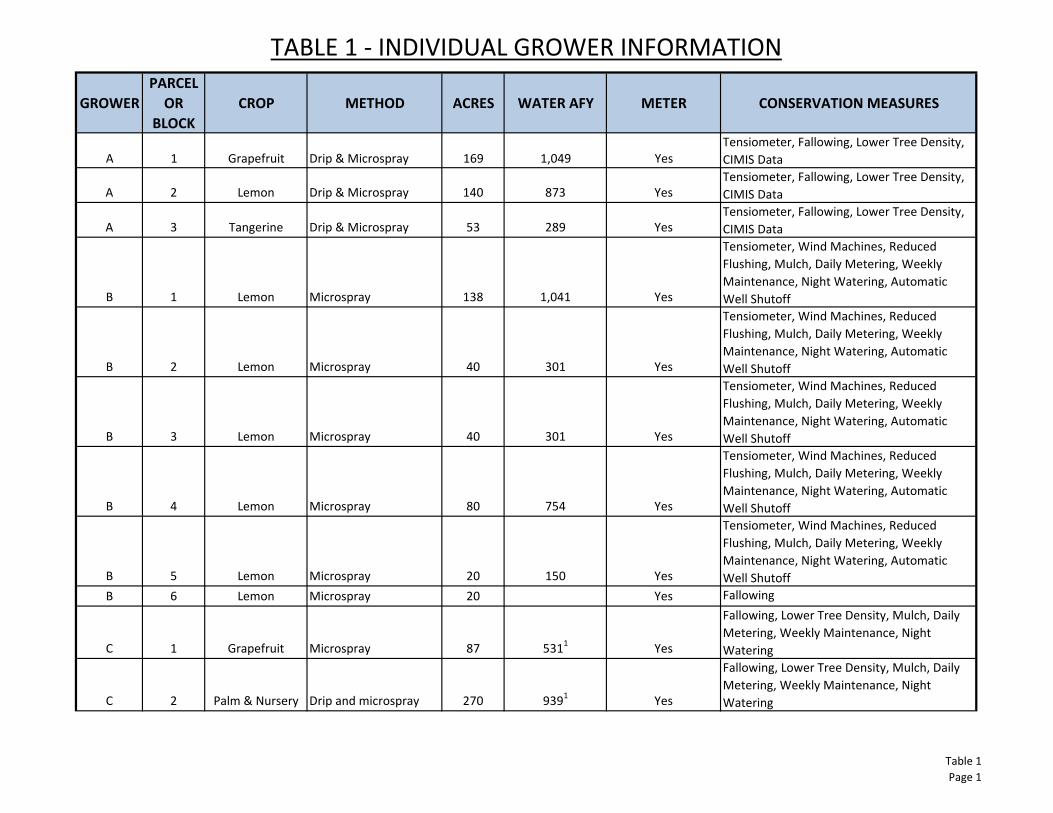
TABLE 1 - INDIVIDUAL GROWER INFORMATION
GROWER
PARCEL
OR
BLOCK
CROP METHOD ACRES WATER AFY METER CONSERVATION MEASURES
A 1 Grapefruit Drip & Microspray 169 1,049 Yes
Tensiometer, Fallowing, Lower Tree Density,
CIMIS Data
A 2 Lemon Drip & Microspray 140 873 Yes
Tensiometer, Fallowing, Lower Tree Density,
CIMIS Data
A 3 Tangerine Drip & Microspray 53 289 Yes
Tensiometer, Fallowing, Lower Tree Density,
CIMIS Data
B 1 Lemon Microspray 138 1,041 Yes
Tensiometer, Wind Machines, Reduced
Flushing, Mulch, Daily Metering, Weekly
Maintenance, Night Watering, Automatic
Well Shutoff
B 2 Lemon Microspray 40 301 Yes
Tensiometer, Wind Machines, Reduced
Flushing, Mulch, Daily Metering, Weekly
Maintenance, Night Watering, Automatic
Well Shutoff
B 3 Lemon Microspray 40 301 Yes
Tensiometer, Wind Machines, Reduced
Flushing, Mulch, Daily Metering, Weekly
Maintenance, Night Watering, Automatic
Well Shutoff
B 4 Lemon Microspray 80 754 Yes
Tensiometer, Wind Machines, Reduced
Flushing, Mulch, Daily Metering, Weekly
Maintenance, Night Watering, Automatic
Well Shutoff
B 5 Lemon Microspray 20 150 Yes
Tensiometer, Wind Machines, Reduced
Flushing, Mulch, Daily Metering, Weekly
Maintenance, Night Watering, Automatic
Well Shutoff
B 6 Lemon Microspray 20 Yes Fallowing
C 1 Grapefruit Microspray 87 5311
Yes
Fallowing, Lower Tree Density, Mulch, Daily
Metering, Weekly Maintenance, Night
Watering
C 2 Palm & Nursery Drip and microspray 270 9391
Yes
Fallowing, Lower Tree Density, Mulch, Daily
Metering, Weekly Maintenance, Night
Watering
Table 1
Page 1
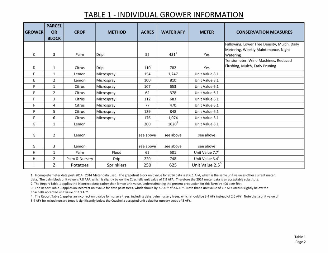
TABLE 1 - INDIVIDUAL GROWER INFORMATION
GROWER
PARCEL
OR
BLOCK
CROP METHOD ACRES WATER AFY METER CONSERVATION MEASURES
C 3 Palm Drip 55 4311
Yes
Fallowing, Lower Tree Density, Mulch, Daily
Metering, Weekly Maintenance, Night
Watering
D 1 Citrus Drip 110 782 Yes
Tensiometer, Wind Machines, Reduced
Flushing, Mulch, Early Pruning
E 1 Lemon Microspray 154 1,247 Unit Value 8.1
E 2 Lemon Microspray 100 810 Unit Value 8.1
F 1 Citrus Microspray 107 653 Unit Value 6.1
F 2 Citrus Microspray 62 378 Unit Value 6.1
F 3 Citrus Microspray 112 683 Unit Value 6.1
F 4 Citrus Microspray 77 470 Unit Value 6.1
F 5 Citrus Microspray 139 848 Unit Value 6.1
F 6 Citrus Microspray 176 1,074 Unit Value 6.1
G 1 Lemon 200 16202
Unit Value 8.1
G 2 Lemon see above see above see above
G 3 Lemon see above see above see above
H 1 Palm Flood 65 501 Unit Value 7.73
H 2 Palm & Nursery Drip 220 748 Unit Value 3.44
I Z Potatoes Sprinklers 250 625 Unit Value 2.55
1. Incomplete meter data post-2014. 2014 Meter data used. The grapefruit block unit value for 2014 data is at 6.1 AFA, which is the same unit value as other current meter
data. The palm block unit value is 7.8 AFA, which is slightly below the Coachella unit value of 7.9 AFA. Therefore the 2014 meter data is an acceptable substitute.
2. The Report Table 1 applies the incorrect citrus rather than lemon unit value, underestimating the present production for this farm by 400 acre-feet.
3. The Report Table 1 applies an incorrect unit value for date palm trees, which should by 7.7 AFY of 2.6 AFY. Note that a unit value of 7.7 AFY used is slightly below the
Coachella accepted unit value of 7.9 AFY .
4. The Report Table 1 applies an incorrect unit value for nursery trees, including date palm nursery trees, which should be 3.4 AFY instead of 2.6 AFY. Note that a unit value of
3.4 AFY for mixed nursery trees is significantly below the Coachella accepted unit value for nursery trees of 8 AFY.
Table 1
Page 2
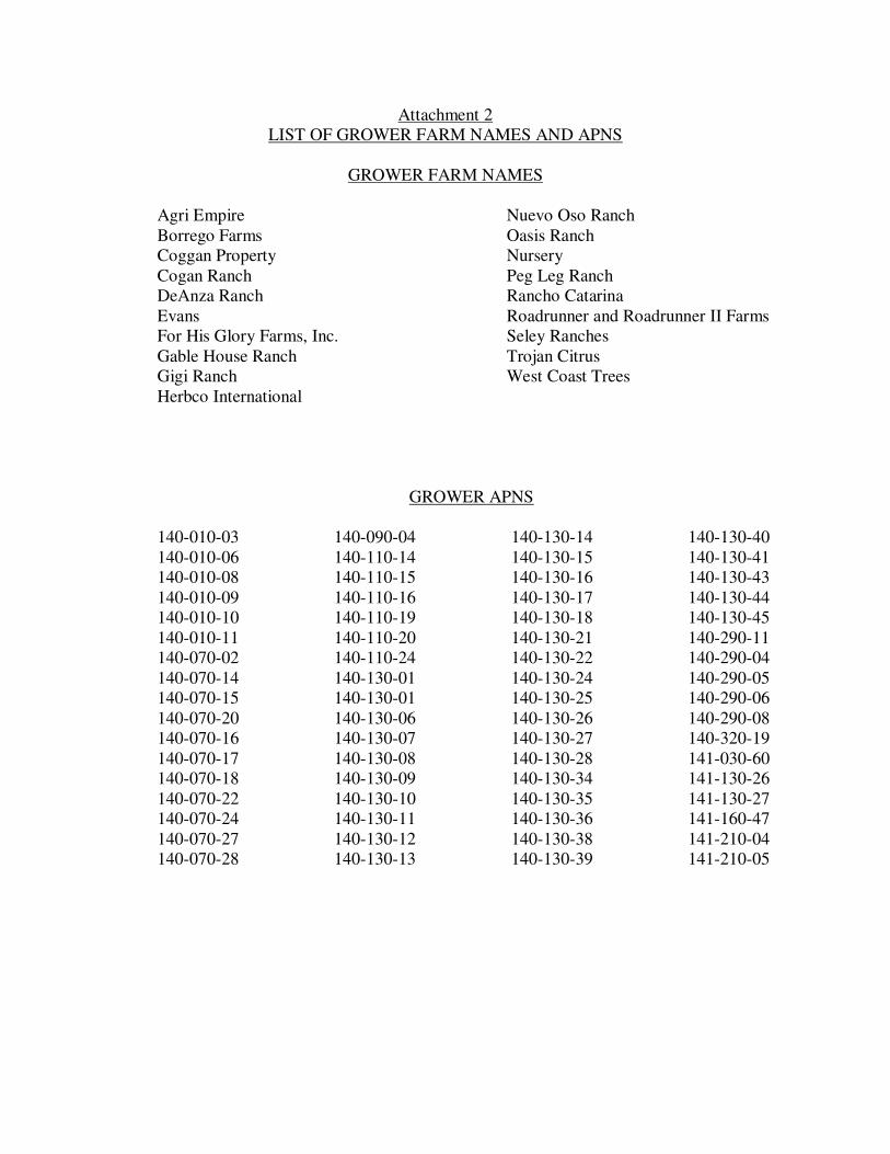
Attachment 2 LIST OF GROWER FARM NAMES AND APNS
GROWER FARM NAMES
Agri Empire Borrego Farms Coggan Property Cogan Ranch DeAnza Ranch Evans For His Glory Farms, Inc. Gable House Ranch Gigi Ranch Herbco International
Nuevo Oso Ranch Oasis Ranch Nursery Peg Leg Ranch Rancho Catarina Roadrunner and Roadrunner II Farms Seley Ranches Trojan Citrus West Coast Trees
GROWER APNS 140-010-03 140-010-06 140-010-08 140-010-09 140-010-10 140-010-11 140-070-02 140-070-14 140-070-15 140-070-20 140-070-16 140-070-17 140-070-18 140-070-22 140-070-24 140-070-27 140-070-28
140-090-04 140-110-14 140-110-15 140-110-16 140-110-19 140-110-20 140-110-24 140-130-01 140-130-01 140-130-06 140-130-07 140-130-08 140-130-09 140-130-10 140-130-11 140-130-12 140-130-13
140-130-14 140-130-15 140-130-16 140-130-17 140-130-18 140-130-21 140-130-22 140-130-24 140-130-25 140-130-26 140-130-27 140-130-28 140-130-34 140-130-35 140-130-36 140-130-38 140-130-39
140-130-40 140-130-41 140-130-43 140-130-44 140-130-45 140-290-11 140-290-04 140-290-05 140-290-06 140-290-08 140-320-19 141-030-60 141-130-26 141-130-27 141-160-47 141-210-04 141-210-05

Attachment 3 DWR MONITORING WELL #1 WELL COMPLETION REPORT
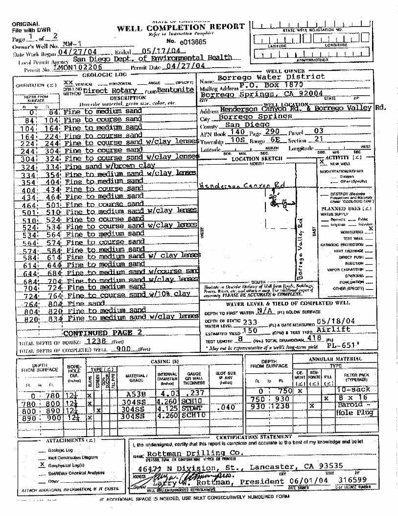

Attachment 4 COACHELLA VALLEY CHART OF AVERAGE ANNUAL AGRICULTURAL WATER REQUIREMENTS PER ACRE