Embed Size (px)
Citation preview
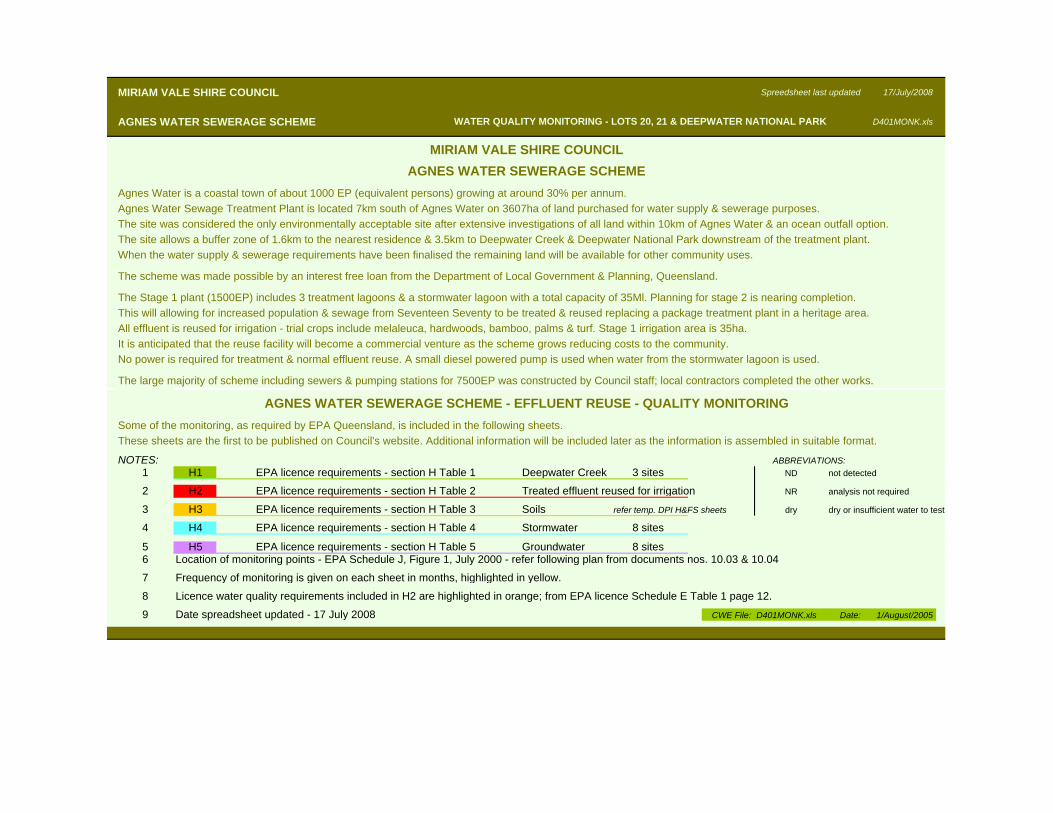
MIRIAM VALE SHIRE COUNCIL Spreedsheet last updated 17/July/2008
AGNES WATER SEWERAGE SCHEME D401MONK.xls
Agnes Water is a coastal town of about 1000 EP (equivalent persons) growing at around 30% per annum.Agnes Water Sewage Treatment Plant is located 7km south of Agnes Water on 3607ha of land purchased for water supply & sewerage purposes.The site was considered the only environmentally acceptable site after extensive investigations of all land within 10km of Agnes Water & an ocean outfall option.The site allows a buffer zone of 1.6km to the nearest residence & 3.5km to Deepwater Creek & Deepwater National Park downstream of the treatment plant.When the water supply & sewerage requirements have been finalised the remaining land will be available for other community uses.
The scheme was made possible by an interest free loan from the Department of Local Government & Planning, Queensland.
The Stage 1 plant (1500EP) includes 3 treatment lagoons & a stormwater lagoon with a total capacity of 35Ml. Planning for stage 2 is nearing completion.This will allowing for increased population & sewage from Seventeen Seventy to be treated & reused replacing a package treatment plant in a heritage area.All effluent is reused for irrigation - trial crops include melaleuca, hardwoods, bamboo, palms & turf. Stage 1 irrigation area is 35ha.It is anticipated that the reuse facility will become a commercial venture as the scheme grows reducing costs to the community.No power is required for treatment & normal effluent reuse. A small diesel powered pump is used when water from the stormwater lagoon is used.
The large majority of scheme including sewers & pumping stations for 7500EP was constructed by Council staff; local contractors completed the other works.
Some of the monitoring, as required by EPA Queensland, is included in the following sheets.These sheets are the first to be published on Council's website. Additional information will be included later as the information is assembled in suitable format.
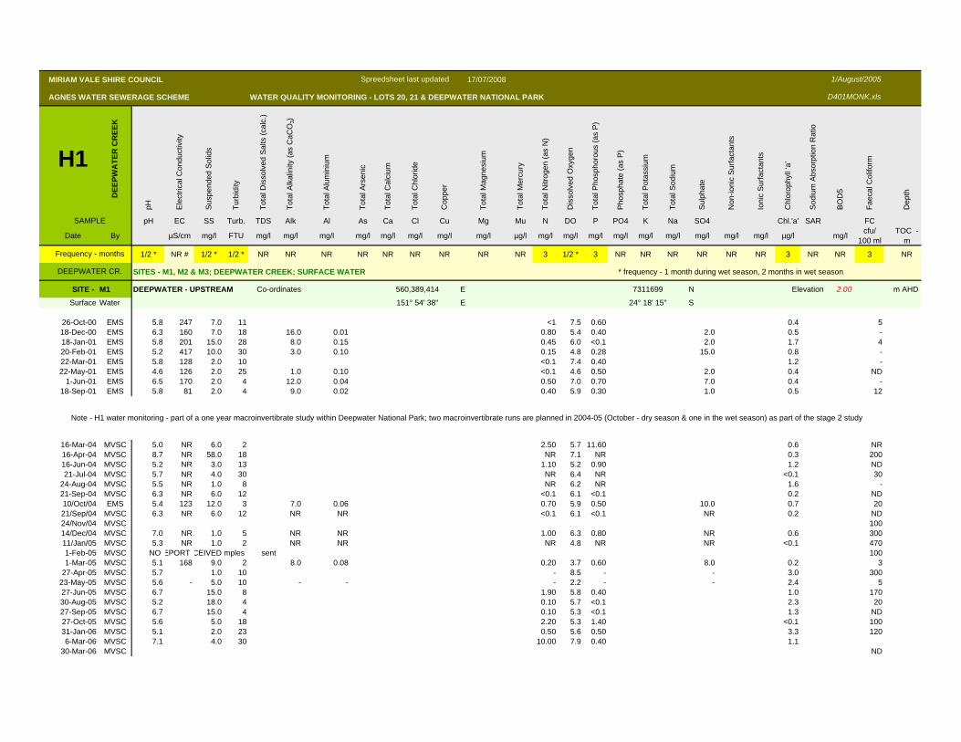
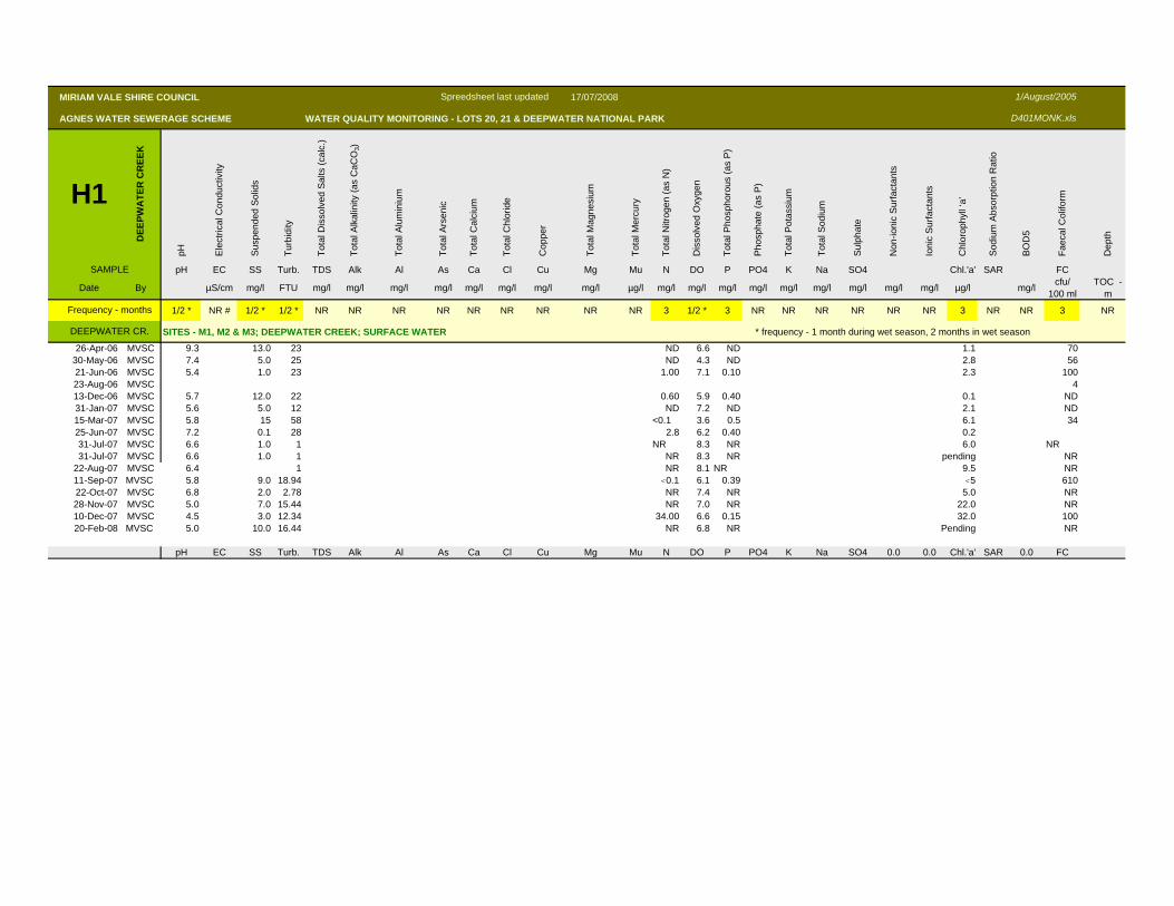
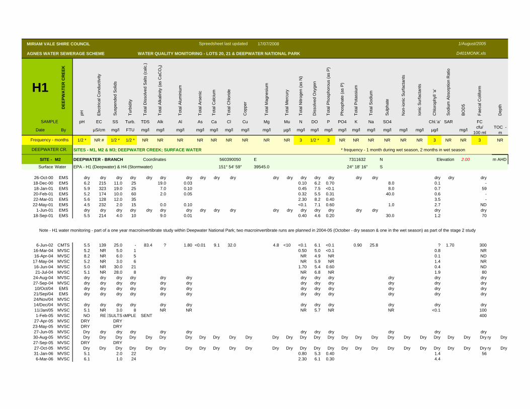
NOTES:1 H1 EPA licence requirements - section H Table 1 Deepwater Creek 3 sites ND not detected
2 H2 EPA licence requirements - section H Table 2 Treated effluent reused for irrigation NR analysis not required
3 H3 EPA licence requirements - section H Table 3 Soils refer temp. DPI H&FS sheets dry dry or insufficient water to test
4 H4 EPA licence requirements - section H Table 4 Stormwater 8 sites
5 H5 EPA licence requirements - section H Table 5 Groundwater 8 sites6 Location of monitoring points - EPA Schedule J, Figure 1, July 2000 - refer following plan from documents nos. 10.03 & 10.04
7 Frequency of monitoring is given on each sheet in months, highlighted in yellow.
8 Licence water quality requirements included in H2 are highlighted in orange; from EPA licence Schedule E Table 1 page 12.
9 Date spreadsheet updated - 17 July 2008 CWE File: D401MONK.xls Date: 1/August/2005
ABBREVIATIONS:
MIRIAM VALE SHIRE COUNCILAGNES WATER SEWERAGE SCHEME
WATER QUALITY MONITORING - LOTS 20, 21 & DEEPWATER NATIONAL PARK
AGNES WATER SEWERAGE SCHEME - EFFLUENT REUSE - QUALITY MONITORING
MIRIAM VALE SHIRE COUNCIL 17/07/2008
AGNES WATER SEWERAGE SCHEME WATER QUALITY MONITORING - LOTS 20, 21 & DEEPWATER NATIONAL PARK
H1
DEE
PWA
TER
CR
EEK
pH Ele
ctric
al C
ondu
ctiv
ity
Susp
ende
d So
lids
Turb
idity
Tota
l Dis
solv
ed S
alts
(cal
c.)
Tota
l Alk
alin
ity (a
s C
aCO
3)
Tota
l Alu
min
ium
Tota
l Ars
enic
Tota
l Cal
cium
Tota
l Chl
orid
e
Cop
per
Tota
l Mag
nesi
um
Tota
l Mer
cury
Tota
l Nitr
ogen
(as
N)
Dis
solv
ed O
xyge
n
Tota
l Pho
spho
rous
(as
P)
Pho
spha
te (a
s P
)
Tota
l Pot
assi
um
Tota
l Sod
ium
Sulp
hate
Non
-ioni
c S
urfa
ctan
ts
Ioni
c S
urfa
ctan
ts
Chl
orop
hyll
‘a’
Sod
ium
Abs
orpt
ion
Rat
io
BO
D5
Faec
al C
olifo
rm
Dep
th
SAMPLE pH EC SS Turb. TDS Alk Al As Ca Cl Cu Mg Mu N DO P PO4 K Na SO4 Chl.'a' SAR FC
Date By µS/cm mg/l FTU mg/l mg/l mg/l mg/l mg/l mg/l mg/l mg/l µg/l mg/l mg/l mg/l mg/l mg/l mg/l mg/l mg/l mg/l µg/l mg/l cfu/ 100 ml
TOC -m
1/2 * NR # 1/2 * 1/2 * NR NR NR NR NR NR NR NR NR 3 1/2 * 3 NR NR NR NR NR NR 3 NR NR 3 NR
SITES - M1, M2 & M3; DEEPWATER CREEK; SURFACE WATER * frequency - 1 month during wet season, 2 months in wet season
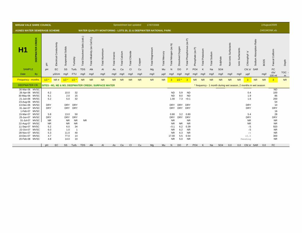
SITE - M1 DEEPWATER - UPSTREAM Co-ordinates 560,389,414 E 7311699 N Elevation 2.00 m AHD
Surface Water 151° 54' 38" E 24° 18' 15" S
26-Oct-00 EMS 5.8 247 7.0 11 <1 7.5 0.60 0.4 518-Dec-00 EMS 6.3 160 7.0 18 16.0 0.01 0.80 5.4 0.40 2.0 0.5 -18-Jan-01 EMS 5.8 201 15.0 28 8.0 0.15 0.45 6.0 <0.1 2.0 1.7 420-Feb-01 EMS 5.2 417 10.0 30 3.0 0.10 0.15 4.8 0.28 15.0 0.8 -22-Mar-01 EMS 5.8 128 2.0 10 <0.1 7.4 0.40 1.2 -22-May-01 EMS 4.6 126 2.0 25 1.0 0.10 <0.1 4.6 0.50 2.0 0.4 ND
1-Jun-01 EMS 6.5 170 2.0 4 12.0 0.04 0.50 7.0 0.70 7.0 0.4 -18-Sep-01 EMS 5.8 81 2.0 4 9.0 0.02 0.40 5.9 0.30 1.0 0.5 12
16-Mar-04 MVSC 5.0 NR 6.0 2 2.50 5.7 11.60 0.6 NR16-Apr-04 MVSC 8.7 NR 58.0 18 NR 7.1 NR 0.3 20016-Jun-04 MVSC 5.2 NR 3.0 13 1.10 5.2 0.90 1.2 ND21-Jul-04 MVSC 5.7 NR 4.0 30 NR 6.4 NR <0.1 30
24-Aug-04 MVSC 5.5 NR 1.0 8 NR 6.2 NR 1.6 -21-Sep-04 MVSC 6.3 NR 6.0 12 <0.1 6.1 <0.1 0.2 ND10/Oct/04 EMS 5.4 123 12.0 3 7.0 0.06 0.70 5.9 0.50 10.0 0.7 2021/Sep/04 MVSC 6.3 NR 6.0 12 NR NR <0.1 6.1 <0.1 NR 0.2 ND24/Nov/04 MVSC 10014/Dec/04 MVSC 7.0 NR 1.0 5 NR NR 1.00 6.3 0.80 NR 0.6 30011/Jan/05 MVSC 5.3 NR 1.0 2 NR NR NR 4.8 NR NR <0.1 4701-Feb-05 MVSC NO EPORT CEIVED mples sent 1001-Mar-05 MVSC 5.1 168 9.0 2 8.0 0.08 0.20 3.7 0.60 8.0 0.2 3
27-Apr-05 MVSC 5.7 1.0 10 - 8.5 - - 3.0 30023-May-05 MVSC 5.6 - 5.0 10 - - - 2.2 - - 2.4 527-Jun-05 MVSC 6.7 15.0 8 1.90 5.8 0.40 1.0 17030-Aug-05 MVSC 5.2 18.0 4 0.10 5.7 <0.1 2.3 2027-Sep-05 MVSC 6.7 15.0 4 0.10 5.3 <0.1 1.3 ND27-Oct-05 MVSC 5.6 5.0 18 2.20 5.3 1.40 <0.1 10031-Jan-06 MVSC 5.1 2.0 23 0.50 5.6 0.50 3.3 1206-Mar-06 MVSC 7.1 4.0 30 10.00 7.9 0.40 1.1
30-Mar-06 MVSC ND
1/August/2005
D401MONK.xls
Frequency - months
DEEPWATER CR.
Note - H1 water monitoring - part of a one year macroinvertibrate study within Deepwater National Park; two macroinvertibrate runs are planned in 2004-05 (October - dry season & one in the wet season) as part of the stage 2 study
Spreedsheet last updated
MIRIAM VALE SHIRE COUNCIL 17/07/2008
AGNES WATER SEWERAGE SCHEME WATER QUALITY MONITORING - LOTS 20, 21 & DEEPWATER NATIONAL PARK
H1
DEE
PWA
TER
CR
EEK
pH Ele
ctric
al C
ondu
ctiv
ity
Susp
ende
d So
lids
Turb
idity
Tota
l Dis
solv
ed S
alts
(cal
c.)
Tota
l Alk
alin
ity (a
s C
aCO
3)
Tota
l Alu
min
ium
Tota
l Ars
enic
Tota
l Cal
cium
Tota
l Chl
orid
e
Cop
per
Tota
l Mag
nesi
um
Tota
l Mer
cury
Tota
l Nitr
ogen
(as
N)
Dis
solv
ed O
xyge
n
Tota
l Pho
spho
rous
(as
P)
Pho
spha
te (a
s P
)
Tota
l Pot
assi
um
Tota
l Sod
ium
Sulp
hate
Non
-ioni
c S
urfa
ctan
ts
Ioni
c S
urfa
ctan
ts
Chl
orop
hyll
‘a’
Sod
ium
Abs
orpt
ion
Rat
io
BO
D5
Faec
al C
olifo
rm
Dep
th
SAMPLE pH EC SS Turb. TDS Alk Al As Ca Cl Cu Mg Mu N DO P PO4 K Na SO4 Chl.'a' SAR FC
Date By µS/cm mg/l FTU mg/l mg/l mg/l mg/l mg/l mg/l mg/l mg/l µg/l mg/l mg/l mg/l mg/l mg/l mg/l mg/l mg/l mg/l µg/l mg/l cfu/ 100 ml
TOC -m
1/2 * NR # 1/2 * 1/2 * NR NR NR NR NR NR NR NR NR 3 1/2 * 3 NR NR NR NR NR NR 3 NR NR 3 NR
SITES - M1, M2 & M3; DEEPWATER CREEK; SURFACE WATER * frequency - 1 month during wet season, 2 months in wet season
1/August/2005
D401MONK.xls
Frequency - months
DEEPWATER CR.
Spreedsheet last updated
26-Apr-06 MVSC 9.3 13.0 23 ND 6.6 ND 1.1 7030-May-06 MVSC 7.4 5.0 25 ND 4.3 ND 2.8 5621-Jun-06 MVSC 5.4 1.0 23 1.00 7.1 0.10 2.3 10023-Aug-06 MVSC 413-Dec-06 MVSC 5.7 12.0 22 0.60 5.9 0.40 0.1 ND31-Jan-07 MVSC 5.6 5.0 12 ND 7.2 ND 2.1 ND15-Mar-07 MVSC 5.8 15 58 <0.1 3.6 0.5 6.1 3425-Jun-07 MVSC 7.2 0.1 28 2.8 6.2 0.40 0.231-Jul-07 MVSC 6.6 1.0 1 NR 8.3 NR 6.0 NR31-Jul-07 MVSC 6.6 1.0 1 NR 8.3 NR pending NR
22-Aug-07 MVSC 6.4 1 NR 8.1 NR 9.5 NR11-Sep-07 MVSC 5.8 9.0 18.94 <0.1 6.1 0.39 <5 61022-Oct-07 MVSC 6.8 2.0 2.78 NR 7.4 NR 5.0 NR28-Nov-07 MVSC 5.0 7.0 15.44 NR 7.0 NR 22.0 NR10-Dec-07 MVSC 4.5 3.0 12.34 34.00 6.6 0.15 32.0 10020-Feb-08 MVSC 5.0 10.0 16.44 NR 6.8 NR Pending NR
pH EC SS Turb. TDS Alk Al As Ca Cl Cu Mg Mu N DO P PO4 K Na SO4 0.0 0.0 Chl.'a' SAR 0.0 FC
MIRIAM VALE SHIRE COUNCIL 17/07/2008
AGNES WATER SEWERAGE SCHEME WATER QUALITY MONITORING - LOTS 20, 21 & DEEPWATER NATIONAL PARK
H1
DEE
PWA
TER
CR
EEK
pH Ele
ctric
al C
ondu
ctiv
ity
Susp
ende
d So
lids
Turb
idity
Tota
l Dis
solv
ed S
alts
(cal
c.)
Tota
l Alk
alin
ity (a
s C
aCO
3)
Tota
l Alu
min
ium
Tota
l Ars
enic
Tota
l Cal
cium
Tota
l Chl
orid
e
Cop
per
Tota
l Mag
nesi
um
Tota
l Mer
cury
Tota
l Nitr
ogen
(as
N)
Dis
solv
ed O
xyge
n
Tota
l Pho
spho
rous
(as
P)
Pho
spha
te (a
s P
)
Tota
l Pot
assi
um
Tota
l Sod
ium
Sulp
hate
Non
-ioni
c S
urfa
ctan
ts
Ioni
c S
urfa
ctan
ts
Chl
orop
hyll
‘a’
Sod
ium
Abs
orpt
ion
Rat
io
BO
D5
Faec
al C
olifo
rm
Dep
th
SAMPLE pH EC SS Turb. TDS Alk Al As Ca Cl Cu Mg Mu N DO P PO4 K Na SO4 Chl.'a' SAR FC
Date By µS/cm mg/l FTU mg/l mg/l mg/l mg/l mg/l mg/l mg/l mg/l µg/l mg/l mg/l mg/l mg/l mg/l mg/l mg/l mg/l mg/l µg/l mg/l cfu/ 100 ml
TOC -m
1/2 * NR # 1/2 * 1/2 * NR NR NR NR NR NR NR NR NR 3 1/2 * 3 NR NR NR NR NR NR 3 NR NR 3 NR
SITES - M1, M2 & M3; DEEPWATER CREEK; SURFACE WATER * frequency - 1 month during wet season, 2 months in wet season
1/August/2005
D401MONK.xls
Frequency - months
DEEPWATER CR.
Spreedsheet last updated
SITE - M2 DEEPWATER - BRANCH Coordinates 560390050 E 7311632 N Elevation 2.00 m AHD
Surface Water EPA - H1 (Deepwater) & H4 (Stormwater) 151° 54' 59" 39545.0 24° 18' 16" S
26-Oct-00 EMS dry dry dry dry dry dry dry dry dry dry dry dry dry dry dry dry dry dry dry dry18-Dec-00 EMS 6.2 215 11.0 25 19.0 0.03 0.10 6.2 0.70 8.0 0.1 -18-Jan-01 EMS 5.9 323 19.0 25 7.0 0.10 0.45 7.5 <0.1 8.0 0.7 5920-Feb-01 EMS 5.2 174 10.0 60 2.0 0.05 0.32 5.5 0.31 40.0 0.6 -22-Mar-01 EMS 5.6 128 12.0 35 2.30 8.2 0.40 3.5 -22-May-01 EMS 4.5 232 2.0 15 0.0 0.10 <0.1 7.1 0.60 1.0 2.7 ND
1-Jun-01 EMS dry dry dry dry dry dry dry dry dry dry dry dry dry dry dry dry dry dry dry18-Sep-01 EMS 5.5 214 4.0 10 9.0 0.01 0.40 4.6 0.20 30.0 1.2 70
6-Jun-02 CMTS 5.5 139 25.0 - 83.4 ? 1.80 <0.01 9.1 32.0 4.8 <10 <0.1 6.1 <0.1 0.90 25.8 ? 1.70 30016-Mar-04 MVSC 5.2 NR 5.0 1 0.50 5.0 <0.1 0.8 NR16-Apr-04 MVSC 8.2 NR 6.0 5 NR 4.9 NR 0.1 ND
17-May-04 MVSC 5.2 NR 3.0 6 NR 5.9 NR 1.4 NR16-Jun-04 MVSC 5.0 NR 30.0 21 1.70 5.4 0.60 0.4 ND21-Jul-04 MVSC 5.1 NR 28.0 8 NR 6.8 NR 1.9 80
24-Aug-04 MVSC dry dry dry dry dry dry dry dry dry dry dry dry27-Sep-04 MVSC dry dry dry dry dry dry dry dry dry dry dry dry10/Oct/04 EMS dry dry dry dry dry dry dry dry dry dry dry dry21/Sep/04 EMS dry dry dry dry dry dry dry dry dry dry dry dry24/Nov/04 MVSC14/Dec/04 MVSC dry dry dry dry dry dry dry dry dry dry dry dry11/Jan/05 MVSC 5.1 NR 3.0 8 NR NR NR 5.7 NR NR <0.1 1001-Feb-05 MVSC NO REESULTSAMPLE SENT 400
27-Apr-05 MVSC DRY DRY23-May-05 MVSC DRY DRY27-Jun-05 MVSC Dry dry dry dry dry dry dry dry dry dry dry dry30-Aug-05 MVSC Dry Dry Dry Dry Dry Dry Dry Dry Dry Dry Dry Dry Dry Dry Dry Dry Dry Dry Dry Dry Dry Dry Dry Dry Dry Dry ry Dry27-Sep-05 MVSC DRY DRY27-Oct-05 MVSC Dry Dry Dry Dry Dry Dry Dry Dry Dry Dry Dry Dry Dry Dry Dry Dry Dry Dry Dry Dry Dry Dry Dry Dry Dry Dry ry Dry31-Jan-06 MVSC 5.1 2.0 22 0.80 5.3 0.40 1.4 566-Mar-06 MVSC 6.1 1.0 24 2.30 6.1 0.30 4.4
Note - H1 water monitoring - part of a one year macroinvertibrate study within Deepwater National Park; two macroinvertibrate runs are planned in 2004-05 (October - dry season & one in the wet season) as part of the stage 2 study
MIRIAM VALE SHIRE COUNCIL 17/07/2008
AGNES WATER SEWERAGE SCHEME WATER QUALITY MONITORING - LOTS 20, 21 & DEEPWATER NATIONAL PARK
H1
DEE
PWA
TER
CR
EEK
pH Ele
ctric
al C
ondu
ctiv
ity
Susp
ende
d So
lids
Turb
idity
Tota
l Dis
solv
ed S
alts
(cal
c.)
Tota
l Alk
alin
ity (a
s C
aCO
3)
Tota
l Alu
min
ium
Tota
l Ars
enic
Tota
l Cal
cium
Tota
l Chl
orid
e
Cop
per
Tota
l Mag
nesi
um
Tota
l Mer
cury
Tota
l Nitr
ogen
(as
N)
Dis
solv
ed O
xyge
n
Tota
l Pho
spho
rous
(as
P)
Pho
spha
te (a
s P
)
Tota
l Pot
assi
um
Tota
l Sod
ium
Sulp
hate
Non
-ioni
c S
urfa
ctan
ts
Ioni
c S
urfa
ctan
ts
Chl
orop
hyll
‘a’
Sod
ium
Abs
orpt
ion
Rat
io
BO
D5
Faec
al C
olifo
rm
Dep
th
SAMPLE pH EC SS Turb. TDS Alk Al As Ca Cl Cu Mg Mu N DO P PO4 K Na SO4 Chl.'a' SAR FC
Date By µS/cm mg/l FTU mg/l mg/l mg/l mg/l mg/l mg/l mg/l mg/l µg/l mg/l mg/l mg/l mg/l mg/l mg/l mg/l mg/l mg/l µg/l mg/l cfu/ 100 ml
TOC -m
1/2 * NR # 1/2 * 1/2 * NR NR NR NR NR NR NR NR NR 3 1/2 * 3 NR NR NR NR NR NR 3 NR NR 3 NR
SITES - M1, M2 & M3; DEEPWATER CREEK; SURFACE WATER * frequency - 1 month during wet season, 2 months in wet season
1/August/2005
D401MONK.xls
Frequency - months
DEEPWATER CR.
Spreedsheet last updated
30-Mar-06 MVSC ND26-Apr-06 MVSC 6.2 10.0 32 ND 5.9 ND 0.4 100
30-May-06 MVSC 6.1 2.0 15 ND 8.0 ND 1.9 8521-Jun-06 MVSC 5.2 5.0 32 1.00 7.3 <0.1 1.6 20023-Aug-06 MVSC 5413-Dec-06 MVSC DRY DRY DRY DRY DRY DRY DRY 1031-Jan-07 MVSC DRY DRY DRY DRY DRY DRY DRY DRY1-Feb-07 MVSC 16
15-Mar-07 MVSC 5.8 13.0 50 0.80 3.2 0.80 5.4 2825-Jun-07 MVSC DRY DRY DRY DRY DRY DRY DRY DRY31-Jul-07 MVSC NR NR NR NR NR NR NR NR
22-Aug-07 MVSC NR NR NR NR NR NR NR NR11-Sep-07 MVSC 5.2 6.0 34 <0.1 6.2 0.39 <5 92022-Oct-07 MVSC 6.0 1.0 1 NR 6.2 NR <5 NR28-Nov-07 MVSC 5.3 11.0 40 NR 6.3 NR <5 NR10-Dec-07 MVSC 4.7 77.0 14 17.00 5.5 0.54 10.0 30020-Feb-08 MVSC 4.8 14.0 10 NR 5.0 NR Pending NR
pH EC SS Turb. TDS Alk Al As Ca Cl Cu Mg Mu N DO P PO4 K Na SO4 0.0 0.0 Chl.'a' SAR 0.0 FC
MIRIAM VALE SHIRE COUNCIL 17/07/2008
AGNES WATER SEWERAGE SCHEME WATER QUALITY MONITORING - LOTS 20, 21 & DEEPWATER NATIONAL PARK
H1
DEE
PWA
TER
CR
EEK
pH Ele
ctric
al C
ondu
ctiv
ity
Susp
ende
d So
lids
Turb
idity
Tota
l Dis
solv
ed S
alts
(cal
c.)
Tota
l Alk
alin
ity (a
s C
aCO
3)
Tota
l Alu
min
ium
Tota
l Ars
enic
Tota
l Cal
cium
Tota
l Chl
orid
e
Cop
per
Tota
l Mag
nesi
um
Tota
l Mer
cury
Tota
l Nitr
ogen
(as
N)
Dis
solv
ed O
xyge
n
Tota
l Pho
spho
rous
(as
P)
Pho
spha
te (a
s P
)
Tota
l Pot
assi
um
Tota
l Sod
ium
Sulp
hate
Non
-ioni
c S
urfa
ctan
ts
Ioni
c S
urfa
ctan
ts
Chl
orop
hyll
‘a’
Sod
ium
Abs
orpt
ion
Rat
io
BO
D5
Faec
al C
olifo
rm
Dep
th
SAMPLE pH EC SS Turb. TDS Alk Al As Ca Cl Cu Mg Mu N DO P PO4 K Na SO4 Chl.'a' SAR FC
Date By µS/cm mg/l FTU mg/l mg/l mg/l mg/l mg/l mg/l mg/l mg/l µg/l mg/l mg/l mg/l mg/l mg/l mg/l mg/l mg/l mg/l µg/l mg/l cfu/ 100 ml
TOC -m
1/2 * NR # 1/2 * 1/2 * NR NR NR NR NR NR NR NR NR 3 1/2 * 3 NR NR NR NR NR NR 3 NR NR 3 NR
SITES - M1, M2 & M3; DEEPWATER CREEK; SURFACE WATER * frequency - 1 month during wet season, 2 months in wet season
1/August/2005
D401MONK.xls
Frequency - months
DEEPWATER CR.
Spreedsheet last updated
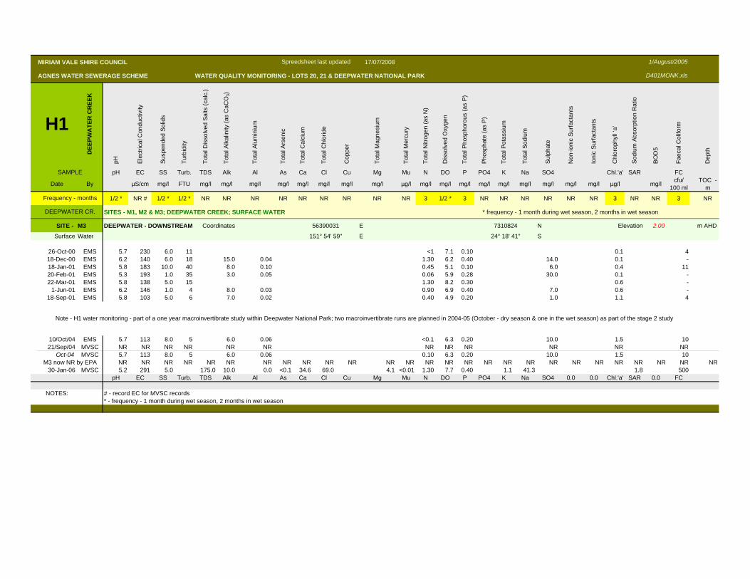
SITE - M3 DEEPWATER - DOWNSTREAM Coordinates 56390031 E 7310824 N Elevation 2.00 m AHD
Surface Water 151° 54' 59" E 24° 18' 41" S
26-Oct-00 EMS 5.7 230 6.0 11 <1 7.1 0.10 0.1 418-Dec-00 EMS 6.2 140 6.0 18 15.0 0.04 1.30 6.2 0.40 14.0 0.1 -18-Jan-01 EMS 5.8 183 10.0 40 8.0 0.10 0.45 5.1 0.10 6.0 0.4 1120-Feb-01 EMS 5.3 193 1.0 35 3.0 0.05 0.06 5.9 0.28 30.0 0.1 -22-Mar-01 EMS 5.8 138 5.0 15 1.30 8.2 0.30 0.6 -
1-Jun-01 EMS 6.2 146 1.0 4 8.0 0.03 0.90 6.9 0.40 7.0 0.6 -18-Sep-01 EMS 5.8 103 5.0 6 7.0 0.02 0.40 4.9 0.20 1.0 1.1 4
10/Oct/04 EMS 5.7 113 8.0 5 6.0 0.06 <0.1 6.3 0.20 10.0 1.5 1021/Sep/04 MVSC NR NR NR NR NR NR NR NR NR NR NR NR
Oct-04 MVSC 5.7 113 8.0 5 6.0 0.06 0.10 6.3 0.20 10.0 1.5 10NR NR NR NR NR NR NR NR NR NR NR NR NR NR NR NR NR NR NR NR NR NR NR NR NR NR NR
30-Jan-06 MVSC 5.2 291 5.0 175.0 10.0 0.0 <0.1 34.6 69.0 4.1 <0.01 1.30 7.7 0.40 1.1 41.3 1.8 500pH EC SS Turb. TDS Alk Al As Ca Cl Cu Mg Mu N DO P PO4 K Na SO4 0.0 0.0 Chl.'a' SAR 0.0 FC
NOTES: # - record EC for MVSC records* - frequency - 1 month during wet season, 2 months in wet season
M3 now NR by EPA
Note - H1 water monitoring - part of a one year macroinvertibrate study within Deepwater National Park; two macroinvertibrate runs are planned in 2004-05 (October - dry season & one in the wet season) as part of the stage 2 study
MIRIAM VALE SHIRE COUNCIL 17/07/2008
AGNES WATER SEWERAGE SCHEME WATER QUALITY MONITORING - LOTS 20, 21 & DEEPWATER NATIONAL PARK
H2W
ATE
R T
O L
AN
D
pH Ele
ctric
al C
ondu
ctiv
ity
Sus
pend
ed S
olid
s
Turb
idity
Tota
l Dis
solv
ed S
alts
(cal
c.)
Tota
l Alk
alin
ity (a
s C
aCO
3)
Tota
l Alu
min
ium
Tota
l Ars
enic
Tota
l Cal
cium
Tota
l Chl
orid
e
Cop
per
Tota
l Mag
nesi
um
Tota
l Mer
cury
Tota
l Nitr
ogen
(as
N)
Dis
solv
ed O
xyge
n
Tota
l Pho
spho
rous
(as
P)
Pho
spha
te (a
s P
O4)
Pho
spha
te (a
s P
)
Tota
l Pot
assi
um
Tota
l Sod
ium
Sul
phat
e
Non
-ioni
c S
urfa
ctan
ts
Ioni
c S
urfa
ctan
ts
Chl
orop
hyll
‘a’
Sod
ium
Abs
orpt
ion
Rat
io
BO
D5
Faec
al C
olifo
rm
Dep
th
SAMPLE pH EC SS TDS Alk Al As Ca Cl Cu Mg Hg N DO P PO4 PO4 K Na SO4 N-IS IS Chl.'a' SAR BOD5 FC
Date By µS/cm mg/l FTU mg/l mg/l mg/l mg/l mg/l mg/l mg/l mg/l µg/l mg/l mg/l mg/l mg/l mg/l mg/l mg/l mg/l mg/l mg/l µg/l mg/l cfu/ 100 ml
TOC -m
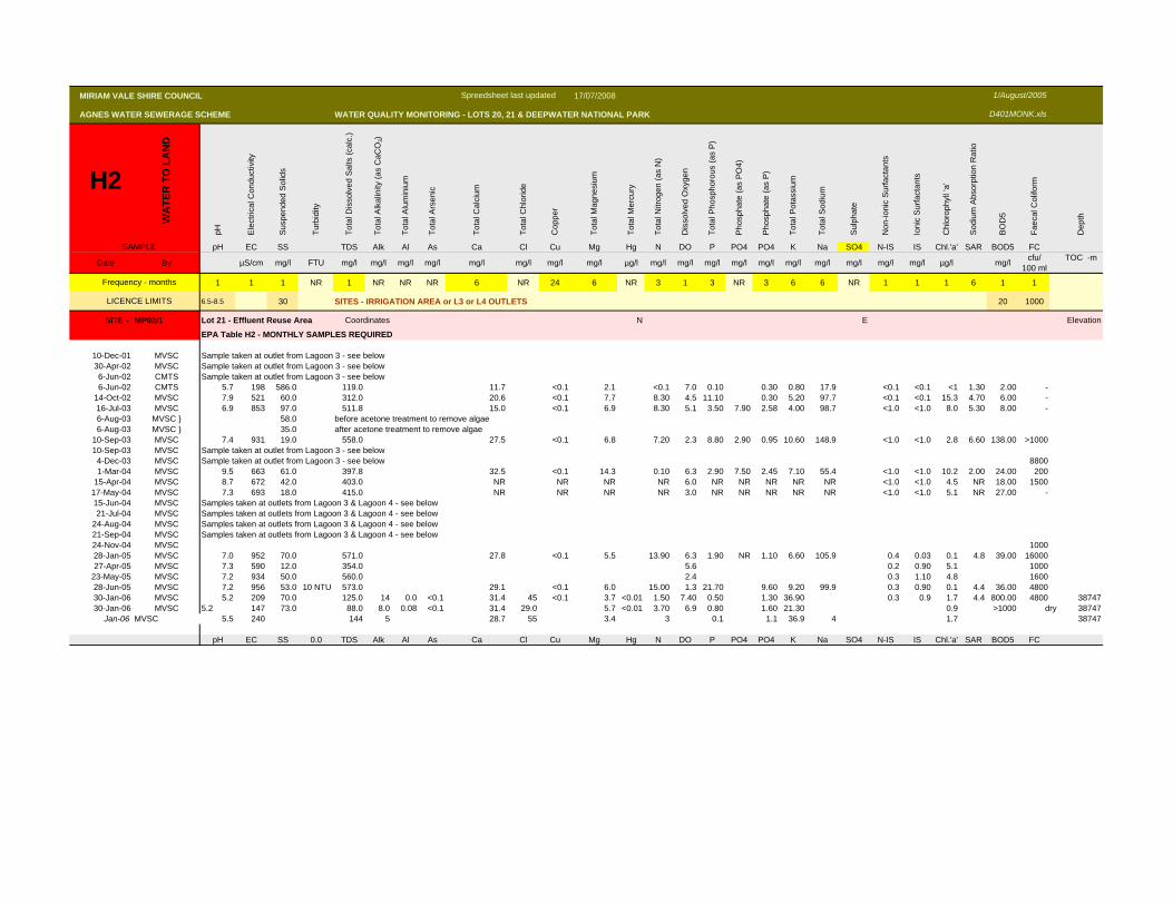
1 1 1 NR 1 NR NR NR 6 NR 24 6 NR 3 1 3 NR 3 6 6 NR 1 1 1 6 1 1
6.5-8.5 30 SITES - IRRIGATION AREA or L3 or L4 OUTLETS 20 1000
SITE - MP02/1 Lot 21 - Effluent Reuse Area Coordinates N E Elevation
EPA Table H2 - MONTHLY SAMPLES REQUIRED
10-Dec-01 MVSC Sample taken at outlet from Lagoon 3 - see below30-Apr-02 MVSC Sample taken at outlet from Lagoon 3 - see below6-Jun-02 CMTS Sample taken at outlet from Lagoon 3 - see below6-Jun-02 CMTS 5.7 198 586.0 119.0 11.7 <0.1 2.1 <0.1 7.0 0.10 0.30 0.80 17.9 <0.1 <0.1 <1 1.30 2.00 -
14-Oct-02 MVSC 7.9 521 60.0 312.0 20.6 <0.1 7.7 8.30 4.5 11.10 0.30 5.20 97.7 <0.1 <0.1 15.3 4.70 6.00 -16-Jul-03 MVSC 6.9 853 97.0 511.8 15.0 <0.1 6.9 8.30 5.1 3.50 7.90 2.58 4.00 98.7 <1.0 <1.0 8.0 5.30 8.00 -6-Aug-03 MVSC } 58.0 before acetone treatment to remove algae6-Aug-03 MVSC } 35.0 after acetone treatment to remove algae
10-Sep-03 MVSC 7.4 931 19.0 558.0 27.5 <0.1 6.8 7.20 2.3 8.80 2.90 0.95 10.60 148.9 <1.0 <1.0 2.8 6.60 138.00 >100010-Sep-03 MVSC Sample taken at outlet from Lagoon 3 - see below
4-Dec-03 MVSC Sample taken at outlet from Lagoon 3 - see below 88001-Mar-04 MVSC 9.5 663 61.0 397.8 32.5 <0.1 14.3 0.10 6.3 2.90 7.50 2.45 7.10 55.4 <1.0 <1.0 10.2 2.00 24.00 200
15-Apr-04 MVSC 8.7 672 42.0 403.0 NR NR NR NR 6.0 NR NR NR NR NR <1.0 <1.0 4.5 NR 18.00 150017-May-04 MVSC 7.3 693 18.0 415.0 NR NR NR NR 3.0 NR NR NR NR NR <1.0 <1.0 5.1 NR 27.00 -15-Jun-04 MVSC Samples taken at outlets from Lagoon 3 & Lagoon 4 - see below21-Jul-04 MVSC Samples taken at outlets from Lagoon 3 & Lagoon 4 - see below
24-Aug-04 MVSC Samples taken at outlets from Lagoon 3 & Lagoon 4 - see below21-Sep-04 MVSC Samples taken at outlets from Lagoon 3 & Lagoon 4 - see below24-Nov-04 MVSC 100028-Jan-05 MVSC 7.0 952 70.0 571.0 27.8 <0.1 5.5 13.90 6.3 1.90 NR 1.10 6.60 105.9 0.4 0.03 0.1 4.8 39.00 1600027-Apr-05 MVSC 7.3 590 12.0 354.0 5.6 0.2 0.90 5.1 1000
23-May-05 MVSC 7.2 934 50.0 560.0 2.4 0.3 1.10 4.8 160028-Jun-05 MVSC 7.2 956 53.0 10 NTU 573.0 29.1 <0.1 6.0 15.00 1.3 21.70 9.60 9.20 99.9 0.3 0.90 0.1 4.4 36.00 480030-Jan-06 MVSC 5.2 209 70.0 125.0 14 0.0 <0.1 31.4 45 <0.1 3.7 <0.01 1.50 7.40 0.50 1.30 36.90 0.3 0.9 1.7 4.4 800.00 4800 3874730-Jan-06 MVSC 5.2 147 73.0 88.0 8.0 0.08 <0.1 31.4 29.0 5.7 <0.01 3.70 6.9 0.80 1.60 21.30 0.9 >1000 dry 38747
Jan-06 MVSC 5.5 240 144 5 28.7 55 3.4 3 0.1 1.1 36.9 4 1.7 38747
pH EC SS 0.0 TDS Alk Al As Ca Cl Cu Mg Hg N DO P PO4 PO4 K Na SO4 N-IS IS Chl.'a' SAR BOD5 FC
Frequency - months
LICENCE LIMITS
1/August/2005
D401MONK.xls
Spreedsheet last updated
MIRIAM VALE SHIRE COUNCIL 17/07/2008
AGNES WATER SEWERAGE SCHEME WATER QUALITY MONITORING - LOTS 20, 21 & DEEPWATER NATIONAL PARK
H2W
ATE
R T
O L
AN
D
pH Ele
ctric
al C
ondu
ctiv
ity
Sus
pend
ed S
olid
s
Turb
idity
Tota
l Dis
solv
ed S
alts
(cal
c.)
Tota
l Alk
alin
ity (a
s C
aCO
3)
Tota
l Alu
min
ium
Tota
l Ars
enic
Tota
l Cal
cium
Tota
l Chl
orid
e
Cop
per
Tota
l Mag
nesi
um
Tota
l Mer
cury
Tota
l Nitr
ogen
(as
N)
Dis
solv
ed O
xyge
n
Tota
l Pho
spho
rous
(as
P)
Pho
spha
te (a
s P
O4)
Pho
spha
te (a
s P
)
Tota
l Pot
assi
um
Tota
l Sod
ium
Sul
phat
e
Non
-ioni
c S
urfa
ctan
ts
Ioni
c S
urfa
ctan
ts
Chl
orop
hyll
‘a’
Sod
ium
Abs
orpt
ion
Rat
io
BO
D5
Faec
al C
olifo
rm
Dep
th
SAMPLE pH EC SS TDS Alk Al As Ca Cl Cu Mg Hg N DO P PO4 PO4 K Na SO4 N-IS IS Chl.'a' SAR BOD5 FC
Date By µS/cm mg/l FTU mg/l mg/l mg/l mg/l mg/l mg/l mg/l mg/l µg/l mg/l mg/l mg/l mg/l mg/l mg/l mg/l mg/l mg/l mg/l µg/l mg/l cfu/ 100 ml
TOC -m
1 1 1 NR 1 NR NR NR 6 NR 24 6 NR 3 1 3 NR 3 6 6 NR 1 1 1 6 1 1
6.5-8.5 30 SITES - IRRIGATION AREA or L3 or L4 OUTLETS 20 1000
Frequency - months
LICENCE LIMITS
1/August/2005
D401MONK.xls
Spreedsheet last updated
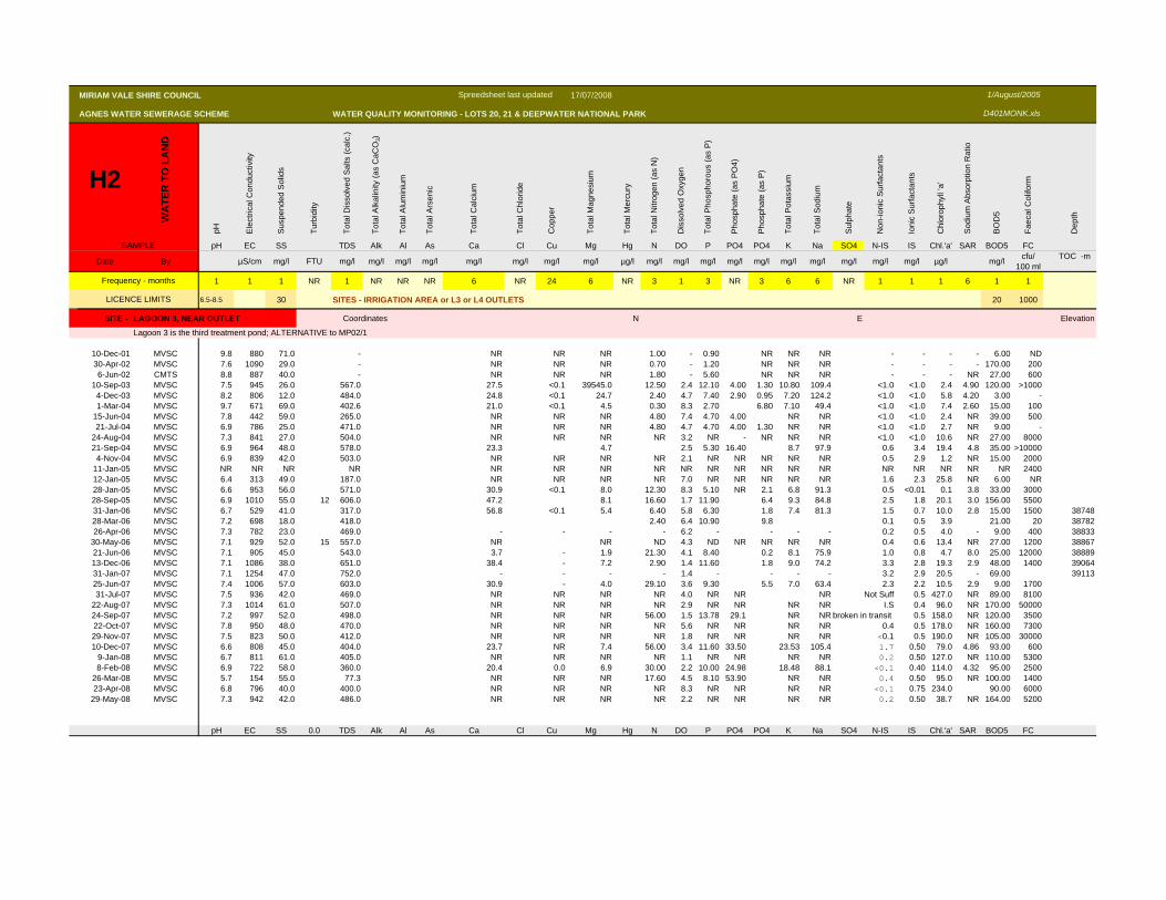
SITE - LAGOON 3, NEAR OUTLET Coordinates N E Elevation
Lagoon 3 is the third treatment pond; ALTERNATIVE to MP02/1
10-Dec-01 MVSC 9.8 880 71.0 - NR NR NR 1.00 - 0.90 NR NR NR - - - - 6.00 ND30-Apr-02 MVSC 7.6 1090 29.0 - NR NR NR 0.70 - 1.20 NR NR NR - - - - 170.00 2006-Jun-02 CMTS 8.8 887 40.0 - NR NR NR 1.80 - 5.60 NR NR NR - - - NR 27.00 600
10-Sep-03 MVSC 7.5 945 26.0 567.0 27.5 <0.1 39545.0 12.50 2.4 12.10 4.00 1.30 10.80 109.4 <1.0 <1.0 2.4 4.90 120.00 >10004-Dec-03 MVSC 8.2 806 12.0 484.0 24.8 <0.1 24.7 2.40 4.7 7.40 2.90 0.95 7.20 124.2 <1.0 <1.0 5.8 4.20 3.00 -1-Mar-04 MVSC 9.7 671 69.0 402.6 21.0 <0.1 4.5 0.30 8.3 2.70 6.80 7.10 49.4 <1.0 <1.0 7.4 2.60 15.00 100
15-Jun-04 MVSC 7.8 442 59.0 265.0 NR NR NR 4.80 7.4 4.70 4.00 NR NR <1.0 <1.0 2.4 NR 39.00 50021-Jul-04 MVSC 6.9 786 25.0 471.0 NR NR NR 4.80 4.7 4.70 4.00 1.30 NR NR <1.0 <1.0 2.7 NR 9.00 -
24-Aug-04 MVSC 7.3 841 27.0 504.0 NR NR NR NR 3.2 NR - NR NR NR <1.0 <1.0 10.6 NR 27.00 800021-Sep-04 MVSC 6.9 964 48.0 578.0 23.3 4.7 2.5 5.30 16.40 8.7 97.9 0.6 3.4 19.4 4.8 35.00 >10000
4-Nov-04 MVSC 6.9 839 42.0 503.0 NR NR NR NR 2.1 NR NR NR NR NR 0.5 2.9 1.2 NR 15.00 200011-Jan-05 MVSC NR NR NR NR NR NR NR NR NR NR NR NR NR NR NR NR NR NR NR 240012-Jan-05 MVSC 6.4 313 49.0 187.0 NR NR NR NR 7.0 NR NR NR NR NR 1.6 2.3 25.8 NR 6.00 NR28-Jan-05 MVSC 6.6 953 56.0 571.0 30.9 <0.1 8.0 12.30 8.3 5.10 NR 2.1 6.8 91.3 0.5 <0.01 0.1 3.8 33.00 300028-Sep-05 MVSC 6.9 1010 55.0 12 606.0 47.2 8.1 16.60 1.7 11.90 6.4 9.3 84.8 2.5 1.8 20.1 3.0 156.00 550031-Jan-06 MVSC 6.7 529 41.0 317.0 56.8 <0.1 5.4 6.40 5.8 6.30 1.8 7.4 81.3 1.5 0.7 10.0 2.8 15.00 1500 3874828-Mar-06 MVSC 7.2 698 18.0 418.0 2.40 6.4 10.90 9.8 0.1 0.5 3.9 21.00 20 3878226-Apr-06 MVSC 7.3 782 23.0 469.0 - - - - 6.2 - - - - 0.2 0.5 4.0 - 9.00 400 38833
30-May-06 MVSC 7.1 929 52.0 15 557.0 NR NR ND 4.3 ND NR NR NR NR 0.4 0.6 13.4 NR 27.00 1200 3886721-Jun-06 MVSC 7.1 905 45.0 543.0 3.7 - 1.9 21.30 4.1 8.40 0.2 8.1 75.9 1.0 0.8 4.7 8.0 25.00 12000 3888913-Dec-06 MVSC 7.1 1086 38.0 651.0 38.4 - 7.2 2.90 1.4 11.60 1.8 9.0 74.2 3.3 2.8 19.3 2.9 48.00 1400 3906431-Jan-07 MVSC 7.1 1254 47.0 752.0 - - - - 1.4 - - - - 3.2 2.9 20.5 - 69.00 3911325-Jun-07 MVSC 7.4 1006 57.0 603.0 30.9 - 4.0 29.10 3.6 9.30 5.5 7.0 63.4 2.3 2.2 10.5 2.9 9.00 170031-Jul-07 MVSC 7.5 936 42.0 469.0 NR NR NR NR 4.0 NR NR NR Not Suff 0.5 427.0 NR 89.00 8100
22-Aug-07 MVSC 7.3 1014 61.0 507.0 NR NR NR NR 2.9 NR NR NR NR I.S 0.4 96.0 NR 170.00 5000024-Sep-07 MVSC 7.2 997 52.0 498.0 NR NR NR 56.00 1.5 13.78 29.1 NR NR broken in transit 0.5 158.0 NR 120.00 350022-Oct-07 MVSC 7.8 950 48.0 470.0 NR NR NR NR 5.6 NR NR NR NR 0.4 0.5 178.0 NR 160.00 730029-Nov-07 MVSC 7.5 823 50.0 412.0 NR NR NR NR 1.8 NR NR NR NR <0.1 0.5 190.0 NR 105.00 3000010-Dec-07 MVSC 6.6 808 45.0 404.0 23.7 NR 7.4 56.00 3.4 11.60 33.50 23.53 105.4 1.7 0.50 79.0 4.86 93.00 600
9-Jan-08 MVSC 6.7 811 61.0 405.0 NR NR NR NR 1.1 NR NR NR NR 0.2 0.50 127.0 NR 110.00 53008-Feb-08 MVSC 6.9 722 58.0 360.0 20.4 0.0 6.9 30.00 2.2 10.00 24.98 18.48 88.1 <0.1 0.40 114.0 4.32 95.00 2500
26-Mar-08 MVSC 5.7 154 55.0 77.3 NR NR NR 17.60 4.5 8.10 53.90 NR NR 0.4 0.50 95.0 NR 100.00 140023-Apr-08 MVSC 6.8 796 40.0 400.0 NR NR NR NR 8.3 NR NR NR NR <0.1 0.75 234.0 90.00 6000
29-May-08 MVSC 7.3 942 42.0 486.0 NR NR NR NR 2.2 NR NR NR NR 0.2 0.50 38.7 NR 164.00 5200
pH EC SS 0.0 TDS Alk Al As Ca Cl Cu Mg Hg N DO P PO4 PO4 K Na SO4 N-IS IS Chl.'a' SAR BOD5 FC
MIRIAM VALE SHIRE COUNCIL 17/07/2008
AGNES WATER SEWERAGE SCHEME WATER QUALITY MONITORING - LOTS 20, 21 & DEEPWATER NATIONAL PARK
H2W
ATE
R T
O L
AN
D
pH Ele
ctric
al C
ondu
ctiv
ity
Sus
pend
ed S
olid
s
Turb
idity
Tota
l Dis
solv
ed S
alts
(cal
c.)
Tota
l Alk
alin
ity (a
s C
aCO
3)
Tota
l Alu
min
ium
Tota
l Ars
enic
Tota
l Cal
cium
Tota
l Chl
orid
e
Cop
per
Tota
l Mag
nesi
um
Tota
l Mer
cury
Tota
l Nitr
ogen
(as
N)
Dis
solv
ed O
xyge
n
Tota
l Pho
spho
rous
(as
P)
Pho
spha
te (a
s P
O4)
Pho
spha
te (a
s P
)
Tota
l Pot
assi
um
Tota
l Sod
ium
Sul
phat
e
Non
-ioni
c S
urfa
ctan
ts
Ioni
c S
urfa
ctan
ts
Chl
orop
hyll
‘a’
Sod
ium
Abs
orpt
ion
Rat
io
BO
D5
Faec
al C
olifo
rm
Dep
th
SAMPLE pH EC SS TDS Alk Al As Ca Cl Cu Mg Hg N DO P PO4 PO4 K Na SO4 N-IS IS Chl.'a' SAR BOD5 FC
Date By µS/cm mg/l FTU mg/l mg/l mg/l mg/l mg/l mg/l mg/l mg/l µg/l mg/l mg/l mg/l mg/l mg/l mg/l mg/l mg/l mg/l mg/l µg/l mg/l cfu/ 100 ml
TOC -m
1 1 1 NR 1 NR NR NR 6 NR 24 6 NR 3 1 3 NR 3 6 6 NR 1 1 1 6 1 1
6.5-8.5 30 SITES - IRRIGATION AREA or L3 or L4 OUTLETS 20 1000
Frequency - months
LICENCE LIMITS
1/August/2005
D401MONK.xls
Spreedsheet last updated
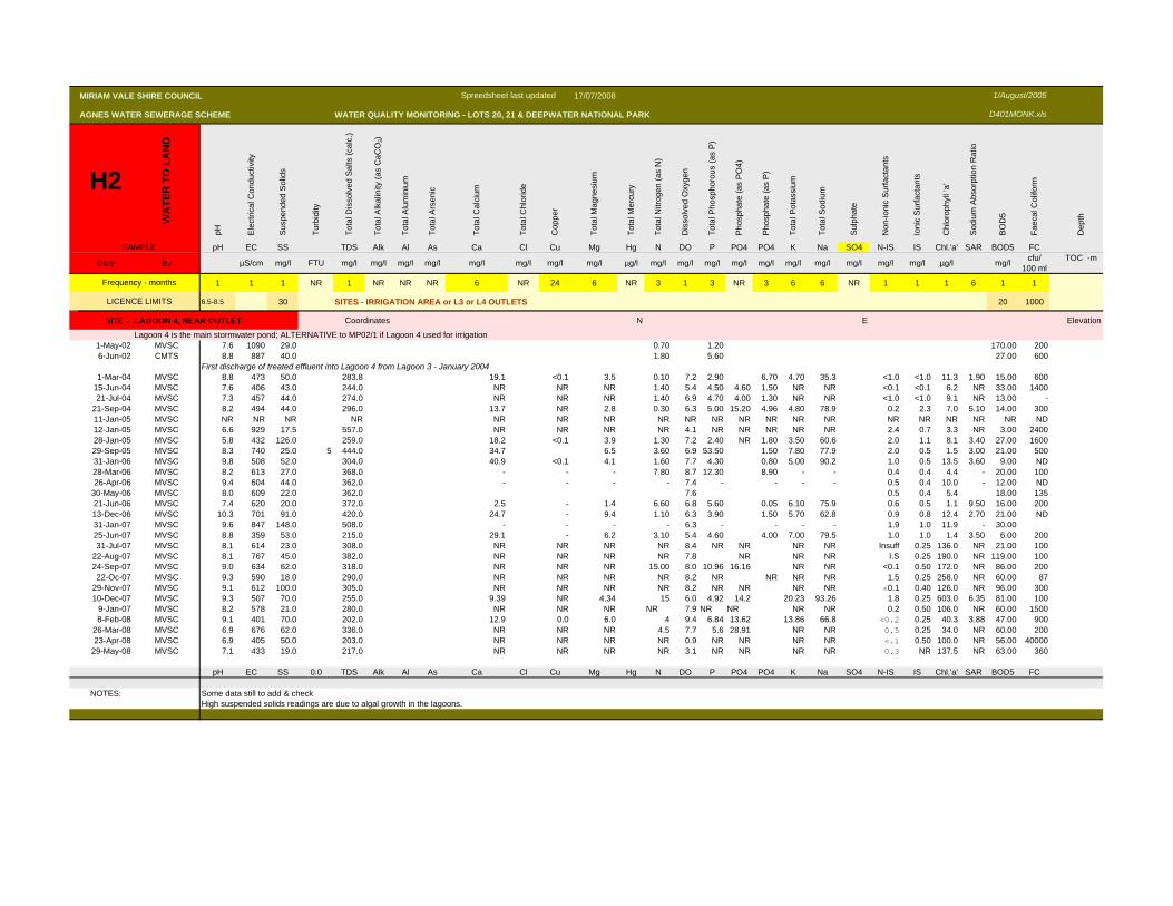
SITE - LAGOON 4, NEAR OUTLET Coordinates N E Elevation
Lagoon 4 is the main stormwater pond; ALTERNATIVE to MP02/1 if Lagoon 4 used for irrigation1-May-02 MVSC 7.6 1090 29.0 0.70 1.20 170.00 2006-Jun-02 CMTS 8.8 887 40.0 1.80 5.60 27.00 600
First discharge of treated effluent into Lagoon 4 from Lagoon 3 - January 20041-Mar-04 MVSC 8.8 473 50.0 283.8 19.1 <0.1 3.5 0.10 7.2 2.90 6.70 4.70 35.3 <1.0 <1.0 11.3 1.90 15.00 600
15-Jun-04 MVSC 7.6 406 43.0 244.0 NR NR NR 1.40 5.4 4.50 4.60 1.50 NR NR <0.1 <0.1 6.2 NR 33.00 140021-Jul-04 MVSC 7.3 457 44.0 274.0 NR NR NR 1.40 6.9 4.70 4.00 1.30 NR NR <1.0 <1.0 9.1 NR 13.00 -
21-Sep-04 MVSC 8.2 494 44.0 296.0 13.7 NR 2.8 0.30 6.3 5.00 15.20 4.96 4.80 78.9 0.2 2.3 7.0 5.10 14.00 30011-Jan-05 MVSC NR NR NR NR NR NR NR NR NR NR NR NR NR NR NR NR NR NR NR ND12-Jan-05 MVSC 6.6 929 17.5 557.0 NR NR NR NR 4.1 NR NR NR NR NR 2.4 0.7 3.3 NR 3.00 240028-Jan-05 MVSC 5.8 432 126.0 259.0 18.2 <0.1 3.9 1.30 7.2 2.40 NR 1.80 3.50 60.6 2.0 1.1 8.1 3.40 27.00 160029-Sep-05 MVSC 8.3 740 25.0 5 444.0 34.7 6.5 3.60 6.9 53.50 1.50 7.80 77.9 2.0 0.5 1.5 3.00 21.00 50031-Jan-06 MVSC 9.8 508 52.0 304.0 40.9 <0.1 4.1 1.60 7.7 4.30 0.80 5.00 90.2 1.0 0.5 13.5 3.60 9.00 ND28-Mar-06 MVSC 8.2 613 27.0 368.0 - - - 7.80 8.7 12.30 8.90 - - 0.4 0.4 4.4 - 20.00 10026-Apr-06 MVSC 9.4 604 44.0 362.0 - - - - 7.4 - - - - 0.5 0.4 10.0 - 12.00 ND
30-May-06 MVSC 8.0 609 22.0 362.0 7.6 0.5 0.4 5.4 18.00 13521-Jun-06 MVSC 7.4 620 20.0 372.0 2.5 - 1.4 6.60 6.8 5.60 0.05 6.10 75.9 0.6 0.5 1.1 9.50 16.00 20013-Dec-06 MVSC 10.3 701 91.0 420.0 24.7 - 9.4 1.10 6.3 3.90 1.50 5.70 62.8 0.9 0.8 12.4 2.70 21.00 ND31-Jan-07 MVSC 9.6 847 148.0 508.0 - - - - 6.3 - - - - 1.9 1.0 11.9 - 30.0025-Jun-07 MVSC 8.8 359 53.0 215.0 29.1 - 6.2 3.10 5.4 4.60 4.00 7.00 79.5 1.0 1.0 1.4 3.50 6.00 20031-Jul-07 MVSC 8.1 614 23.0 308.0 NR NR NR NR 8.4 NR NR NR NR Insuff 0.25 136.0 NR 21.00 100
22-Aug-07 MVSC 8.1 767 45.0 382.0 NR NR NR NR 7.8 NR NR NR I.S 0.25 190.0 NR 119.00 10024-Sep-07 MVSC 9.0 634 62.0 318.0 NR NR NR 15.00 8.0 10.96 16.16 NR NR <0.1 0.50 172.0 NR 86.00 20022-Oc-07 MVSC 9.3 590 18.0 290.0 NR NR NR NR 8.2 NR NR NR NR 1.5 0.25 258.0 NR 60.00 87
29-Nov-07 MVSC 9.1 612 100.0 305.0 NR NR NR NR 8.2 NR NR NR NR <0.1 0.40 126.0 NR 96.00 30010-Dec-07 MVSC 9.3 507 70.0 255.0 9.39 NR 4.34 15 6.0 4.92 14.2 20.23 93.26 1.8 0.25 603.0 6.35 81.00 100
9-Jan-07 MVSC 8.2 578 21.0 280.0 NR NR NR NR 7.9 NR NR NR NR 0.2 0.50 106.0 NR 60.00 15008-Feb-08 MVSC 9.1 401 70.0 202.0 12.9 0.0 6.0 4 9.4 6.84 13.62 13.86 66.8 <0.2 0.25 40.3 3.88 47.00 900
26-Mar-08 MVSC 6.9 676 62.0 336.0 NR NR NR 4.5 7.7 5.6 28.91 NR NR 0.5 0.25 34.0 NR 60.00 20023-Apr-08 MVSC 6.9 405 50.0 203.0 NR NR NR NR 0.9 NR NR NR NR <.1 0.50 100.0 NR 56.00 40000
29-May-08 MVSC 7.1 433 19.0 217.0 NR NR NR NR 3.1 NR NR NR NR 0.3 NR 137.5 NR 63.00 360
pH EC SS 0.0 TDS Alk Al As Ca Cl Cu Mg Hg N DO P PO4 PO4 K Na SO4 N-IS IS Chl.'a' SAR BOD5 FC
NOTES: Some data still to add & checkHigh suspended solids readings are due to algal growth in the lagoons.
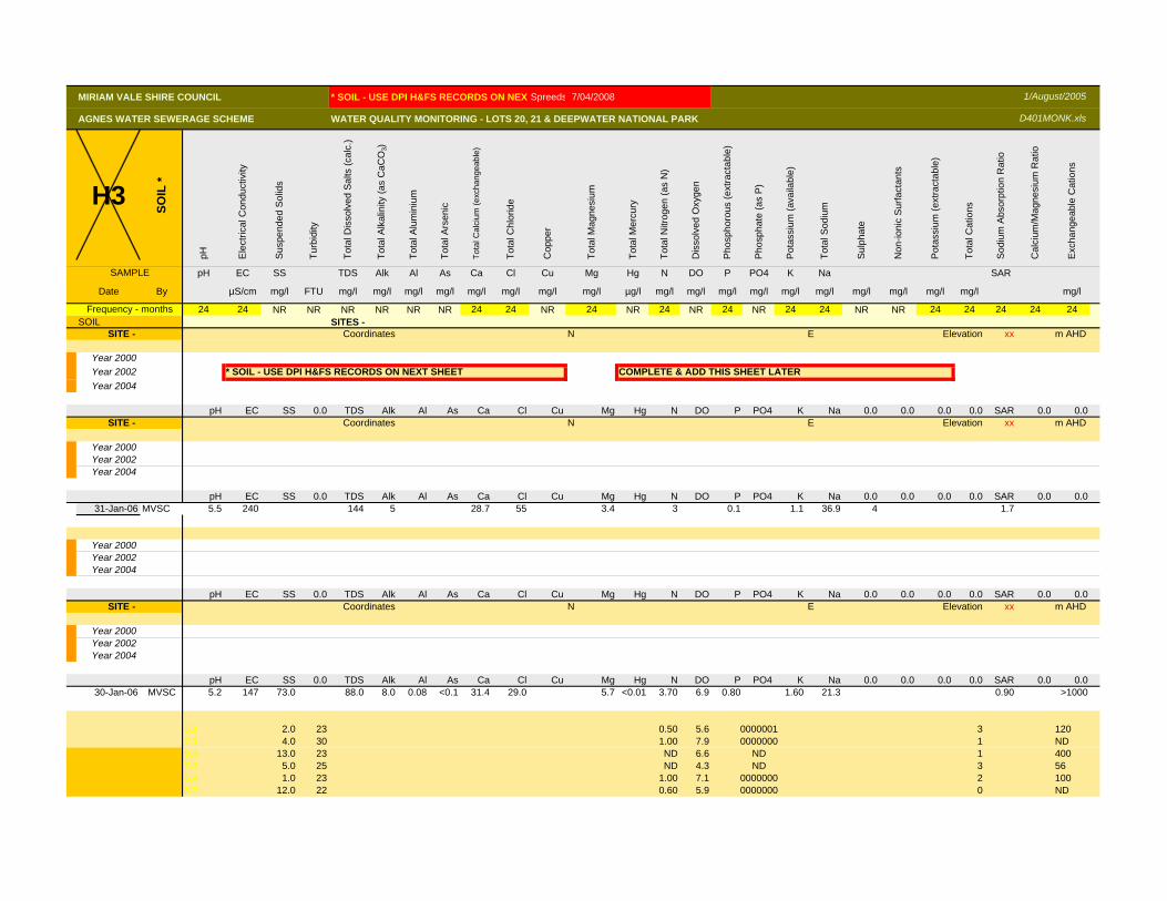
MIRIAM VALE SHIRE COUNCIL * SOIL - USE DPI H&FS RECORDS ON NEXTSpreeds 7/04/2008
AGNES WATER SEWERAGE SCHEME WATER QUALITY MONITORING - LOTS 20, 21 & DEEPWATER NATIONAL PARK
H3SO
IL *
pH Ele
ctric
al C
ondu
ctiv
ity
Sus
pend
ed S
olid
s
Turb
idity
Tota
l Dis
solv
ed S
alts
(cal
c.)
Tota
l Alk
alin
ity (a
s C
aCO
3)
Tota
l Alu
min
ium
Tota
l Ars
enic
Tota
l Cal
cium
(exc
hang
eabl
e)
Tota
l Chl
orid
e
Cop
per
Tota
l Mag
nesi
um
Tota
l Mer
cury
Tota
l Nitr
ogen
(as
N)
Dis
solv
ed O
xyge
n
Pho
spho
rous
(ext
ract
able
)
Pho
spha
te (a
s P
)
Pot
assi
um (a
vaila
ble)
Tota
l Sod
ium
Sul
phat
e
Non
-ioni
c S
urfa
ctan
ts
Pot
assi
um (e
xtra
ctab
le)
Tota
l Cat
ions
Sod
ium
Abs
orpt
ion
Rat
io
Cal
cium
/Mag
nesi
um R
atio
Exc
hang
eabl
e C
atio
ns
SAMPLE pH EC SS TDS Alk Al As Ca Cl Cu Mg Hg N DO P PO4 K Na SAR
Date By µS/cm mg/l FTU mg/l mg/l mg/l mg/l mg/l mg/l mg/l mg/l µg/l mg/l mg/l mg/l mg/l mg/l mg/l mg/l mg/l mg/l mg/l mg/l
24 24 NR NR NR NR NR NR 24 24 NR 24 NR 24 NR 24 NR 24 24 NR NR 24 24 24 24 24SOIL SITES -
SITE - Coordinates N E Elevation xx m AHD
Year 2000Year 2002 * SOIL - USE DPI H&FS RECORDS ON NEXT SHEET COMPLETE & ADD THIS SHEET LATERYear 2004
pH EC SS 0.0 TDS Alk Al As Ca Cl Cu Mg Hg N DO P PO4 K Na 0.0 0.0 0.0 0.0 SAR 0.0 0.0SITE - Coordinates N E Elevation xx m AHD
Year 2000Year 2002Year 2004
pH EC SS 0.0 TDS Alk Al As Ca Cl Cu Mg Hg N DO P PO4 K Na 0.0 0.0 0.0 0.0 SAR 0.0 0.031-Jan-06 MVSC 5.5 240 144 5 28.7 55 3.4 3 0.1 1.1 36.9 4 1.7
Year 2000Year 2002Year 2004
pH EC SS 0.0 TDS Alk Al As Ca Cl Cu Mg Hg N DO P PO4 K Na 0.0 0.0 0.0 0.0 SAR 0.0 0.0SITE - Coordinates N E Elevation xx m AHD
Year 2000Year 2002Year 2004
pH EC SS 0.0 TDS Alk Al As Ca Cl Cu Mg Hg N DO P PO4 K Na 0.0 0.0 0.0 0.0 SAR 0.0 0.030-Jan-06 MVSC 5.2 147 73.0 88.0 8.0 0.08 <0.1 31.4 29.0 5.7 <0.01 3.70 6.9 0.80 1.60 21.3 0.90 >1000
5.1 2.0 23 0.50 5.6 0000001 3 1207.1 4.0 30 1.00 7.9 0000000 1 ND9.3 13.0 23 ND 6.6 ND 1 4007.4 5.0 25 ND 4.3 ND 3 565.4 1.0 23 1.00 7.1 0000000 2 1005.7 12.0 22 0.60 5.9 0000000 0 ND
Frequency - months
1/August/2005
D401MONK.xls
MIRIAM VALE SHIRE COUNCIL * SOIL - USE DPI H&FS RECORDS ON NEXTSpreeds 7/04/2008
AGNES WATER SEWERAGE SCHEME WATER QUALITY MONITORING - LOTS 20, 21 & DEEPWATER NATIONAL PARK
H3SO
IL *
pH Ele
ctric
al C
ondu
ctiv
ity
Sus
pend
ed S
olid
s
Turb
idity
Tota
l Dis
solv
ed S
alts
(cal
c.)
Tota
l Alk
alin
ity (a
s C
aCO
3)
Tota
l Alu
min
ium
Tota
l Ars
enic
Tota
l Cal
cium
(exc
hang
eabl
e)
Tota
l Chl
orid
e
Cop
per
Tota
l Mag
nesi
um
Tota
l Mer
cury
Tota
l Nitr
ogen
(as
N)
Dis
solv
ed O
xyge
n
Pho
spho
rous
(ext
ract
able
)
Pho
spha
te (a
s P
)
Pot
assi
um (a
vaila
ble)
Tota
l Sod
ium
Sul
phat
e
Non
-ioni
c S
urfa
ctan
ts
Pot
assi
um (e
xtra
ctab
le)
Tota
l Cat
ions
Sod
ium
Abs
orpt
ion
Rat
io
Cal
cium
/Mag
nesi
um R
atio
Exc
hang
eabl
e C
atio
ns
SAMPLE pH EC SS TDS Alk Al As Ca Cl Cu Mg Hg N DO P PO4 K Na SAR
Date By µS/cm mg/l FTU mg/l mg/l mg/l mg/l mg/l mg/l mg/l mg/l µg/l mg/l mg/l mg/l mg/l mg/l mg/l mg/l mg/l mg/l mg/l mg/l
24 24 NR NR NR NR NR NR 24 24 NR 24 NR 24 NR 24 NR 24 24 NR NR 24 24 24 24 24SOIL SITES -
Frequency - months
1/August/2005
D401MONK.xls
5.6 5.0 12 ND 7.2 ND 2 ND5.8 15 58 <0.1 3.6 0.5 6.1 34
Year 2000Year 2002Year 2004
pH EC SS 0.0 TDS Alk Al As Ca Cl Cu Mg Hg N DO P PO4 K Na 0.0 0.0 0.0 0.0 SAR 0.0 0.0SITE - Coordinates N E Elevation xx m AHD
Year 2000Year 2002Year 2004
pH EC SS 0.0 TDS Alk Al As Ca Cl Cu 39545.0 Hg N DO P PO4 K Na 0.0 0.0 0.0 0.0 SAR 0.0 0.0
30-Jan-06 MVSC 5.2 209 70.0 125 14 0.0 <0.1 31.4 45 3.7 <0.01 1.5 7.4 0.5 1.3 36.9 1.7 800
MVSC AGNES WATER SEWAGE EFFLUENT REUSE PROJECT - Lot 21 Parish of Uxbridge DPI H&FS
19/Oct/2001 Initial soil sample before sewage effluent irrigationCollected 19th Oct 2001 sampled plots 1,7& 9. *Soil samples collected from soil test pitsLaboratory soil analysis for Experiment 417 Hardwoods
Sample* pH Organic ESPDepth (cm) units dS/m µS/cm Carbon % Ca Mg K Na CEC %
0-10 5.2 0.035 35 1.38 0.036 0.202 0.055 0.118 5.088 2.3310-20 5.34 0.031 31 0.93 0.015 0.194 0.037 0.178 3.424 5.2020-40 5.65 0.044 44 0.57 0.013 0.352 0.041 0.344 3.452 9.9640-60 5.76 0.134 134 0.50 0.012 1.432 0.070 0.635 7.589 8.3760-80 5.25 0.217 217 0.16 0.013 3.099 0.101 1.300 13.491 9.64
Sample* Al B Mn K tot Pav NtotDepth (cm) % Clay % Csand % Fsand % Silt %
0-10 0.240 0.310 0.0006 265.18 1.669 0.051 3 11.76 51.24 3410-20 0.173 0.178 <0.0005 284.39 1.169 0.035 5 18.12 46.88 3020-40 0.107 0.155 <0.0005 380.78 0.911 0.023 7 25.68 40.32 2740-60 0.027 0.292 <0.0005 723.06 0.608 0.024 23 15.92 34.08 2760-80 0.022 0.521 <0.0005 1420.92 1.063 0.015 43 10.20 25.80 21
31/01/2006 MVSC 5.5 240 144 5 28.7 #
Soil samples collected 4th April 2003 **Soils collected using hand augerSample** pH Organic ESP
Depth (cm) units dS/m µS/cm Carbon % Ca Mg K Na CEC %
0-10 6.12 0.067 67 1.120 0.074 0.161 0.073 0.573 4.262 13.4410-20 5.84 0.039 39 0.547 0.026 0.134 0.033 0.278 2.590 10.720-40 6.25 0.060 60 0.246 0.014 0.287 0.024 0.379 1.795 37.940-60 7.25 0.163 163 0.205 <0.012 2.652 0.098 2.001 9.329 21.4
0-10 5.28 0.051 51 1.824 0.196 0.364 0.079 0.250 5.939 4.210-20 5.57 0.049 49 1.084 0.034 0.401 0.039 0.307 4.017 7.620-40 5.29 0.073 73 0.596 0.015 0.919 0.043 0.610 4.316 14.140-60 6.24 0.152 152 0.324 0.018 1.440 0.042 1.304 4.735 27.5
30/01/2006 MVSC 5.2 147 73 88 8 0.08 <0.1 31.4 #
Sample** Al B Mn K tot Ptot Ntot Cu Zn5.1 2 237.1 4 30
9.3 13 237.4 5 255.4 1 235.7 12 225.6 5 12
5.8 15 58
Depth (cm) % mg/kg mg/kg
0-10 0.082 0.30 0.001 320 21.69 0.041 <0.4 <0.4 H310-20 0.092 0.22 <0.001 301 13.65 0.024 <0.4 <0.420-40 0.022 0.23 <0.001 291 10.60 0.017 <0.4 <0.4 SOIL
D401MONK.xls1/August/2005
Exchangeable Cations (cmol/kg)
Particle size analysiscmol/kg mg/kg
Conductivity
mg/kg
Conductivity
Control, non-irrigated
Irrigated
Exchangeable Cations (cmol/kg)
cmol/kgIrrigated
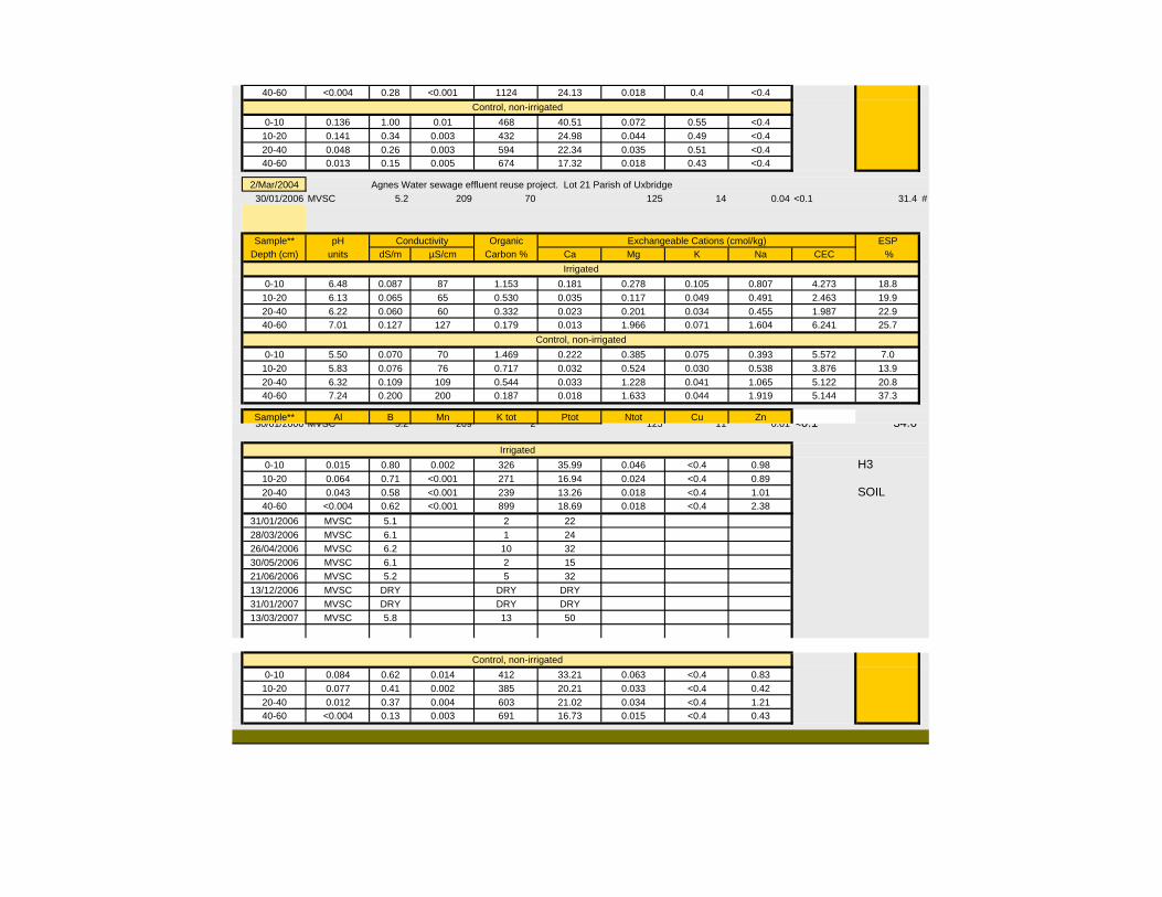
40-60 <0.004 0.28 <0.001 1124 24.13 0.018 0.4 <0.4
0-10 0.136 1.00 0.01 468 40.51 0.072 0.55 <0.410-20 0.141 0.34 0.003 432 24.98 0.044 0.49 <0.420-40 0.048 0.26 0.003 594 22.34 0.035 0.51 <0.440-60 0.013 0.15 0.005 674 17.32 0.018 0.43 <0.4
2/Mar/2004 Agnes Water sewage effluent reuse project. Lot 21 Parish of Uxbridge30/01/2006 MVSC 5.2 209 70 125 14 0.04 <0.1 31.4 #
Sample** pH Organic ESPDepth (cm) units dS/m µS/cm Carbon % Ca Mg K Na CEC %
0-10 6.48 0.087 87 1.153 0.181 0.278 0.105 0.807 4.273 18.810-20 6.13 0.065 65 0.530 0.035 0.117 0.049 0.491 2.463 19.920-40 6.22 0.060 60 0.332 0.023 0.201 0.034 0.455 1.987 22.940-60 7.01 0.127 127 0.179 0.013 1.966 0.071 1.604 6.241 25.7
0-10 5.50 0.070 70 1.469 0.222 0.385 0.075 0.393 5.572 7.010-20 5.83 0.076 76 0.717 0.032 0.524 0.030 0.538 3.876 13.920-40 6.32 0.109 109 0.544 0.033 1.228 0.041 1.065 5.122 20.840-60 7.24 0.200 200 0.187 0.018 1.633 0.044 1.919 5.144 37.3
Sample** Al B Mn K tot Ptot Ntot Cu Zn30/01/2006 MVSC 5.2 209 2 125 11 0.01 <0.1 34.6
0-10 0.015 0.80 0.002 326 35.99 0.046 <0.4 0.98 H310-20 0.064 0.71 <0.001 271 16.94 0.024 <0.4 0.8920-40 0.043 0.58 <0.001 239 13.26 0.018 <0.4 1.01 SOIL40-60 <0.004 0.62 <0.001 899 18.69 0.018 <0.4 2.38
31/01/2006 MVSC 5.1 2 2228/03/2006 MVSC 6.1 1 2426/04/2006 MVSC 6.2 10 3230/05/2006 MVSC 6.1 2 1521/06/2006 MVSC 5.2 5 3213/12/2006 MVSC DRY DRY DRY31/01/2007 MVSC DRY DRY DRY13/03/2007 MVSC 5.8 13 50
0-10 0.084 0.62 0.014 412 33.21 0.063 <0.4 0.8310-20 0.077 0.41 0.002 385 20.21 0.033 <0.4 0.4220-40 0.012 0.37 0.004 603 21.02 0.034 <0.4 1.2140-60 <0.004 0.13 0.003 691 16.73 0.015 <0.4 0.43
Control, non-irrigated
Irrigated
Control, non-irrigated
Exchangeable Cations (cmol/kg)Conductivity
Irrigated
Control, non-irrigated
MIRIAM VALE SHIRE COUNCIL Spreeds 7/04/2008
AGNES WATER SEWERAGE SCHEME WATER QUALITY MONITORING - LOTS 20, 21 & DEEPWATER NATIONAL PARK
H4
STO
RM
WA
TER
pH Ele
ctric
al C
ondu
ctiv
ity
Sus
pend
ed S
olid
s
Turb
idity
Tota
l Dis
solv
ed S
alts
(cal
c.)
Tota
l Alk
alin
ity (a
s C
aCO
3)
Tota
l Alu
min
ium
Tota
l Ars
enic
Tota
l Cal
cium
Tota
l Chl
orid
e
Cop
per
Tota
l Mag
nesi
um
Tota
l Mer
cury
Tota
l Nitr
ogen
(as
N)
Dis
solv
ed O
xyge
n
Tota
l Pho
spho
rous
(as
P)
Pho
spha
te (a
s P
)
Tota
l Pot
assi
um
Tota
l Sod
ium
Sul
phat
e
Non
-ioni
c S
urfa
ctan
ts
Ioni
c S
urfa
ctan
ts
Chl
orop
hyll
‘a’
Sod
ium
Abs
orpt
ion
Rat
io
BO
D5
Faec
al C
olifo
rm
Dep
th
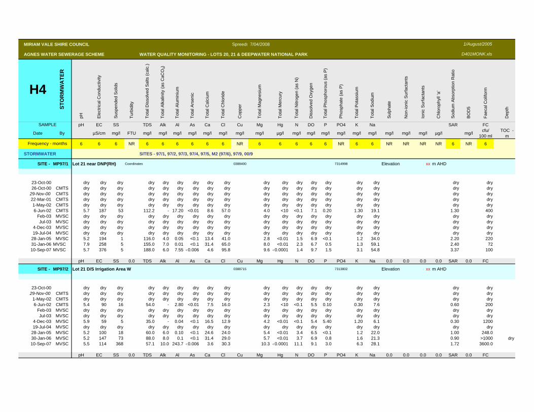
SAMPLE pH EC SS TDS Alk Al As Ca Cl Cu Mg Hg N DO P PO4 K Na SAR FC
Date By µS/cm mg/l FTU mg/l mg/l mg/l mg/l mg/l mg/l mg/l mg/l µg/l mg/l mg/l mg/l mg/l mg/l mg/l mg/l mg/l mg/l µg/l mg/l cfu/ 100 ml
TOC -m
6 6 6 NR 6 6 6 6 6 6 NR 6 6 6 6 6 NR 6 6 NR NR NR NR 6 NR 6
STORMWATER SITES - 97/1, 97/2, 97/3, 97/4, 97/5, M2 (97/6), 97/9, 00/9
SITE - MP97/1 Lot 21 near DNP(RH) Coordinates 0388400 7314998 Elevation xx m AHD
23-Oct-00 dry dry dry dry dry dry dry dry dry dry dry dry dry dry dry dry dry dry26-Oct-00 CMTS dry dry dry dry dry dry dry dry dry dry dry dry dry dry dry dry dry dry
29-Nov-00 CMTS dry dry dry dry dry dry dry dry dry dry dry dry dry dry dry dry dry dry22-Mar-01 CMTS dry dry dry dry dry dry dry dry dry dry dry dry dry dry dry dry dry dry1-May-02 CMTS dry dry dry dry dry dry dry dry dry dry dry dry dry dry dry dry dry dry6-Jun-02 CMTS 5.7 187 53 112.2 - 17.20 <0.01 8.6 57.0 4.0 <10 <0.1 7.1 0.20 1.30 19.1 1.30 400
Feb-03 MVSC dry dry dry dry dry dry dry dry dry dry dry dry dry dry dry dry dry dryJul-03 MVSC dry dry dry dry dry dry dry dry dry dry dry dry dry dry dry dry dry dry
4-Dec-03 MVSC dry dry dry dry dry dry dry dry dry dry dry dry dry dry dry dry dry dry19-Jul-04 MVSC dry dry dry dry dry dry dry dry dry dry dry dry dry dry dry dry dry dry
28-Jan-05 MVSC 5.2 194 1 116.0 4.0 0.05 <0.1 13.4 41.0 2.8 <0.01 1.5 6.9 <0.1 1.2 34.0 2.20 22031-Jan-06 MVSC 7.9 258 5 155.0 7.0 0.01 <0.1 31.4 65.0 8.0 <0.01 2.3 6.7 0.5 1.3 59.1 2.40 7210-Sep-07 MVSC 5.7 376 5 188.0 6.0 7.55 <0.006 4.6 95.8 9.6 <0.0001 1.4 9.7 1.5 3.1 54.8 3.37 100
pH EC SS 0.0 TDS Alk Al As Ca Cl Cu Mg Hg N DO P PO4 K Na 0.0 0.0 0.0 0.0 SAR 0.0 FC
SITE - MP97/2 Lot 21 D/S Irrigation Area W 0388715 7313802 Elevation xx m AHD
23-Oct-00 dry dry dry dry dry dry dry dry dry dry dry dry dry dry dry dry dry dry29-Nov-00 CMTS dry dry dry dry dry dry dry dry dry dry dry dry dry dry dry dry dry dry
1-May-02 CMTS dry dry dry dry dry dry dry dry dry dry dry dry dry dry dry dry dry dry6-Jun-02 CMTS 5.4 90 16 54.0 - 2.80 <0.01 7.5 16.0 2.3 <10 <0.1 5.5 0.10 0.30 7.6 0.60 200
Feb-03 MVSC dry dry dry dry dry dry dry dry dry dry dry dry dry dry dry dry dry dryJul-03 MVSC dry dry dry dry dry dry dry dry dry dry dry dry dry dry dry dry dry dry
4-Dec-03 MVSC 5.9 59 5 35.0 - 0.04 <0.1 16.5 12.9 4.2 <0.01 <0.1 5.4 5.40 1.20 6.1 0.30 120019-Jul-04 MVSC dry dry dry dry dry dry dry dry dry dry dry dry dry dry dry dry dry dry
28-Jan-05 MVSC 5.2 100 18 60.0 6.0 0.10 <0.1 24.6 24.0 5.4 <0.01 3.4 6.5 <0.1 1.2 22.0 1.00 248.030-Jan-06 MVSC 5.2 147 73 88.0 8.0 0.1 <0.1 31.4 29.0 5.7 <0.01 3.7 6.9 0.8 1.6 21.3 0.90 >1000 dry10-Sep-07 MVSC 5.5 114 368 57.1 10.0 243.7 <0.006 3.6 30.3 10.3 <0.0001 11.1 9.1 3.0 6.3 28.1 1.72 3600.0
pH EC SS 0.0 TDS Alk Al As Ca Cl Cu Mg Hg N DO P PO4 K Na 0.0 0.0 0.0 0.0 SAR 0.0 FC
Frequency - months
1/August/2005
D401MONK.xls
MIRIAM VALE SHIRE COUNCIL Spreeds 7/04/2008
AGNES WATER SEWERAGE SCHEME WATER QUALITY MONITORING - LOTS 20, 21 & DEEPWATER NATIONAL PARK
H4
STO
RM
WA
TER
pH Ele
ctric
al C
ondu
ctiv
ity
Sus
pend
ed S
olid
s
Turb
idity
Tota
l Dis
solv
ed S
alts
(cal
c.)
Tota
l Alk
alin
ity (a
s C
aCO
3)
Tota
l Alu
min
ium
Tota
l Ars
enic
Tota
l Cal
cium
Tota
l Chl
orid
e
Cop
per
Tota
l Mag
nesi
um
Tota
l Mer
cury
Tota
l Nitr
ogen
(as
N)
Dis
solv
ed O
xyge
n
Tota
l Pho
spho
rous
(as
P)
Pho
spha
te (a
s P
)
Tota
l Pot
assi
um
Tota
l Sod
ium
Sul
phat
e
Non
-ioni
c S
urfa
ctan
ts
Ioni
c S
urfa
ctan
ts
Chl
orop
hyll
‘a’
Sod
ium
Abs
orpt
ion
Rat
io
BO
D5
Faec
al C
olifo
rm
Dep
th
SAMPLE pH EC SS TDS Alk Al As Ca Cl Cu Mg Hg N DO P PO4 K Na SAR FC
Date By µS/cm mg/l FTU mg/l mg/l mg/l mg/l mg/l mg/l mg/l mg/l µg/l mg/l mg/l mg/l mg/l mg/l mg/l mg/l mg/l mg/l µg/l mg/l cfu/ 100 ml
TOC -m
6 6 6 NR 6 6 6 6 6 6 NR 6 6 6 6 6 NR 6 6 NR NR NR NR 6 NR 6
STORMWATER SITES - 97/1, 97/2, 97/3, 97/4, 97/5, M2 (97/6), 97/9, 00/9
Frequency - months
1/August/2005
D401MONK.xls
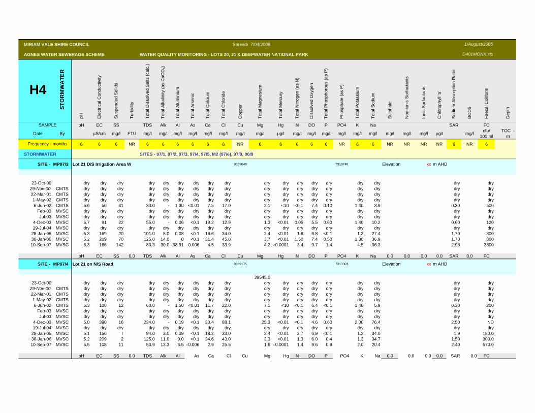
SITE - MP97/3 Lot 21 D/S Irrigation Area W 0389048 7313746 Elevation xx m AHD
23-Oct-00 dry dry dry dry dry dry dry dry dry dry dry dry dry dry dry dry dry dry29-Nov-00 CMTS dry dry dry dry dry dry dry dry dry dry dry dry dry dry dry dry dry dry22-Mar-01 CMTS dry dry dry dry dry dry dry dry dry dry dry dry dry dry dry dry dry dry1-May-02 CMTS dry dry dry dry dry dry dry dry dry dry dry dry dry dry dry dry dry dry6-Jun-02 CMTS 5.6 50 31 30.0 - 1.30 <0.01 7.5 17.0 2.1 <10 <0.1 7.4 0.10 1.40 3.9 0.30 500
Feb-03 MVSC dry dry dry dry dry dry dry dry dry dry dry dry dry dry dry dry dry dryJul-03 MVSC dry dry dry dry dry dry dry dry dry dry dry dry dry dry dry dry dry dry
4-Dec-03 MVSC 5.7 91 22 55.0 - 0.06 <0.1 19.2 12.9 1.3 <0.01 0.05 5.5 0.60 1.40 10.2 0.60 12019-Jul-04 MVSC dry dry dry dry dry dry dry dry dry dry dry dry dry dry dry dry dry dry
28-Jan-05 MVSC 5.3 169 20 101.0 8.0 0.08 <0.1 16.6 34.0 2.4 <0.01 1.6 6.8 <0.1 1.3 27.4 1.70 30030-Jan-06 MVSC 5.2 209 70 125.0 14.0 0 <0.1 31.4 45.0 3.7 <0.01 1.50 7.4 0.50 1.30 36.9 1.70 80010-Sep-07 MVSC 6.3 166 142 83.3 30.0 38.91 0.006 4.5 33.9 4.2 <0.0001 3.4 9.7 1.4 4.5 36.3 2.98 3300
pH EC SS 0.0 TDS Alk Al As Ca Cl Cu Mg Hg N DO P PO4 K Na 0.0 0.0 0.0 0.0 SAR 0.0 FC
SITE - MP97/4 Lot 21 on N/S Road 0389175 7313303 Elevation xx m AHD
39545.023-Oct-00 dry dry dry dry dry dry dry dry dry dry dry dry dry dry dry dry dry dry
29-Nov-00 CMTS dry dry dry dry dry dry dry dry dry dry dry dry dry dry dry dry dry dry22-Mar-01 CMTS dry dry dry dry dry dry dry dry dry dry dry dry dry dry dry dry dry dry1-May-02 CMTS dry dry dry dry dry dry dry dry dry dry dry dry dry dry dry dry dry dry6-Jun-02 CMTS 5.3 100 12 60.0 - 1.50 <0.01 11.7 22.0 7.1 <10 <0.1 6.4 <0.1 1.40 5.9 0.30 200
Feb-03 MVSC dry dry dry dry dry dry dry dry dry dry dry dry dry dry dry dry dry dryJul-03 MVSC dry dry dry dry dry dry dry dry dry dry dry dry dry dry dry dry dry dry
4-Dec-03 MVSC 5.0 390 16 234.0 - 0.19 <0.1 30.4 88.1 25.3 <0.01 <0.1 4.6 0.60 2.00 76.4 2.50 ND19-Jul-04 MVSC dry dry dry dry dry dry dry dry dry dry dry dry dry dry dry dry dry dry
28-Jan-05 MVSC 5.1 156 7 94.0 3.0 0.09 <0.1 18.2 33.0 3.4 <0.01 2.7 6.9 <0.1 1.2 34.0 1.9 180.030-Jan-06 MVSC 5.2 209 2 125.0 11.0 0.0 <0.1 34.6 43.0 3.3 <0.01 1.3 6.0 0.4 1.3 34.7 1.50 300.010-Sep-07 MVSC 5.5 108 11 53.9 13.3 3.5 <0.006 2.9 25.5 1.6 <0.0001 1.4 9.6 0.9 2.0 20.4 2.40 570.0
pH EC SS 0.0 TDS Alk Al As Ca Cl Cu Mg Hg N DO P PO4 K Na 0.0 0.0 0.0 0.0 SAR 0.0 FC
MIRIAM VALE SHIRE COUNCIL Spreeds 7/04/2008
AGNES WATER SEWERAGE SCHEME WATER QUALITY MONITORING - LOTS 20, 21 & DEEPWATER NATIONAL PARK
H4
STO
RM
WA
TER
pH Ele
ctric
al C
ondu
ctiv
ity
Sus
pend
ed S
olid
s
Turb
idity
Tota
l Dis
solv
ed S
alts
(cal
c.)
Tota
l Alk
alin
ity (a
s C
aCO
3)
Tota
l Alu
min
ium
Tota
l Ars
enic
Tota
l Cal
cium
Tota
l Chl
orid
e
Cop
per
Tota
l Mag
nesi
um
Tota
l Mer
cury
Tota
l Nitr
ogen
(as
N)
Dis
solv
ed O
xyge
n
Tota
l Pho
spho
rous
(as
P)
Pho
spha
te (a
s P
)
Tota
l Pot
assi
um
Tota
l Sod
ium
Sul
phat
e
Non
-ioni
c S
urfa
ctan
ts
Ioni
c S
urfa
ctan
ts
Chl
orop
hyll
‘a’
Sod
ium
Abs
orpt
ion
Rat
io
BO
D5
Faec
al C
olifo
rm
Dep
th
SAMPLE pH EC SS TDS Alk Al As Ca Cl Cu Mg Hg N DO P PO4 K Na SAR FC
Date By µS/cm mg/l FTU mg/l mg/l mg/l mg/l mg/l mg/l mg/l mg/l µg/l mg/l mg/l mg/l mg/l mg/l mg/l mg/l mg/l mg/l µg/l mg/l cfu/ 100 ml
TOC -m
6 6 6 NR 6 6 6 6 6 6 NR 6 6 6 6 6 NR 6 6 NR NR NR NR 6 NR 6
STORMWATER SITES - 97/1, 97/2, 97/3, 97/4, 97/5, M2 (97/6), 97/9, 00/9
Frequency - months
1/August/2005
D401MONK.xls
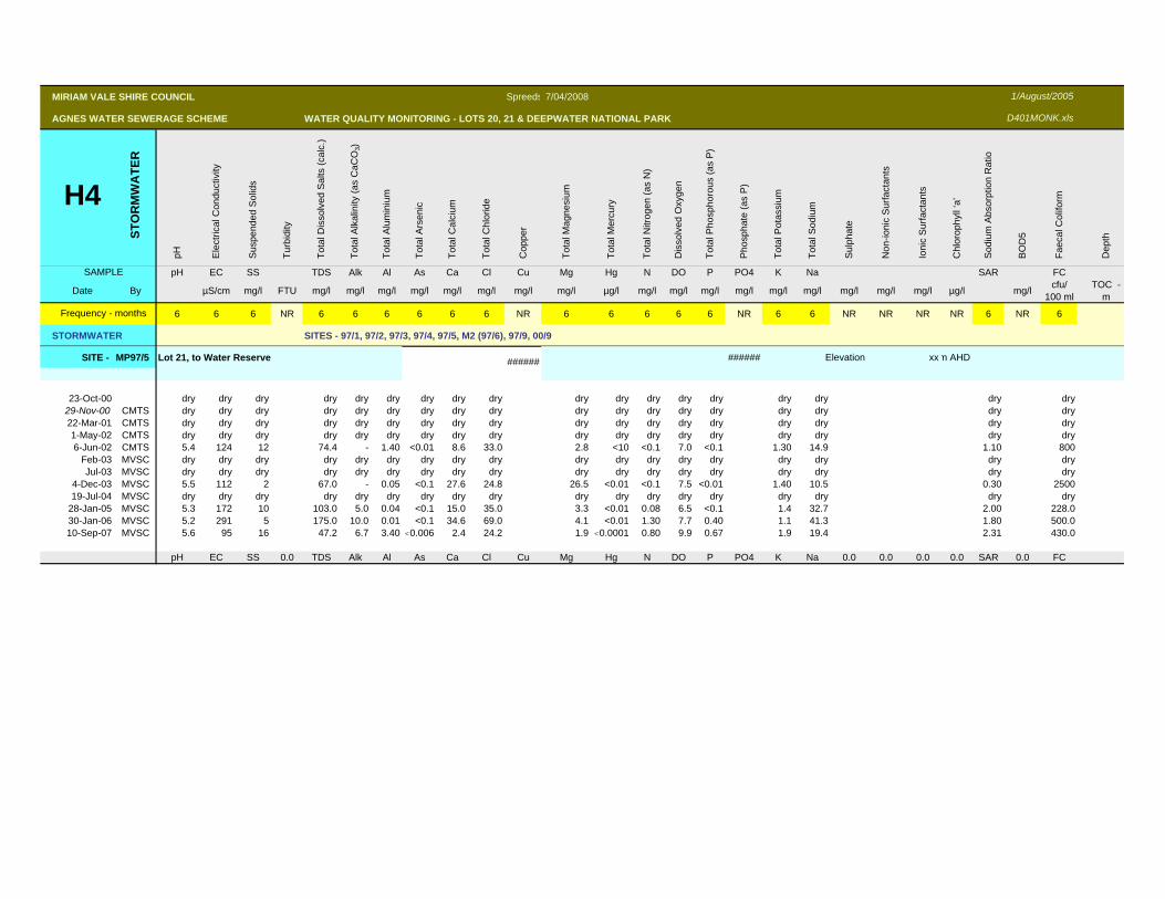
SITE - MP97/5 Lot 21, to Water Reserve ###### ###### Elevation xxm AHD
23-Oct-00 dry dry dry dry dry dry dry dry dry dry dry dry dry dry dry dry dry dry29-Nov-00 CMTS dry dry dry dry dry dry dry dry dry dry dry dry dry dry dry dry dry dry22-Mar-01 CMTS dry dry dry dry dry dry dry dry dry dry dry dry dry dry dry dry dry dry1-May-02 CMTS dry dry dry dry dry dry dry dry dry dry dry dry dry dry dry dry dry dry6-Jun-02 CMTS 5.4 124 12 74.4 - 1.40 <0.01 8.6 33.0 2.8 <10 <0.1 7.0 <0.1 1.30 14.9 1.10 800
Feb-03 MVSC dry dry dry dry dry dry dry dry dry dry dry dry dry dry dry dry dry dryJul-03 MVSC dry dry dry dry dry dry dry dry dry dry dry dry dry dry dry dry dry dry
4-Dec-03 MVSC 5.5 112 2 67.0 - 0.05 <0.1 27.6 24.8 26.5 <0.01 <0.1 7.5 <0.01 1.40 10.5 0.30 250019-Jul-04 MVSC dry dry dry dry dry dry dry dry dry dry dry dry dry dry dry dry dry dry
28-Jan-05 MVSC 5.3 172 10 103.0 5.0 0.04 <0.1 15.0 35.0 3.3 <0.01 0.08 6.5 <0.1 1.4 32.7 2.00 228.030-Jan-06 MVSC 5.2 291 5 175.0 10.0 0.01 <0.1 34.6 69.0 4.1 <0.01 1.30 7.7 0.40 1.1 41.3 1.80 500.010-Sep-07 MVSC 5.6 95 16 47.2 6.7 3.40 <0.006 2.4 24.2 1.9 <0.0001 0.80 9.9 0.67 1.9 19.4 2.31 430.0
pH EC SS 0.0 TDS Alk Al As Ca Cl Cu Mg Hg N DO P PO4 K Na 0.0 0.0 0.0 0.0 SAR 0.0 FC
MIRIAM VALE SHIRE COUNCIL Spreeds 7/04/2008
AGNES WATER SEWERAGE SCHEME WATER QUALITY MONITORING - LOTS 20, 21 & DEEPWATER NATIONAL PARK
H4
STO
RM
WA
TER
pH Ele
ctric
al C
ondu
ctiv
ity
Sus
pend
ed S
olid
s
Turb
idity
Tota
l Dis
solv
ed S
alts
(cal
c.)
Tota
l Alk
alin
ity (a
s C
aCO
3)
Tota
l Alu
min
ium
Tota
l Ars
enic
Tota
l Cal
cium
Tota
l Chl
orid
e
Cop
per
Tota
l Mag
nesi
um
Tota
l Mer
cury
Tota
l Nitr
ogen
(as
N)
Dis
solv
ed O
xyge
n
Tota
l Pho
spho
rous
(as
P)
Pho
spha
te (a
s P
)
Tota
l Pot
assi
um
Tota
l Sod
ium
Sul
phat
e
Non
-ioni
c S
urfa
ctan
ts
Ioni
c S
urfa
ctan
ts
Chl
orop
hyll
‘a’
Sod
ium
Abs
orpt
ion
Rat
io
BO
D5
Faec
al C
olifo
rm
Dep
th
SAMPLE pH EC SS TDS Alk Al As Ca Cl Cu Mg Hg N DO P PO4 K Na SAR FC
Date By µS/cm mg/l FTU mg/l mg/l mg/l mg/l mg/l mg/l mg/l mg/l µg/l mg/l mg/l mg/l mg/l mg/l mg/l mg/l mg/l mg/l µg/l mg/l cfu/ 100 ml
TOC -m
6 6 6 NR 6 6 6 6 6 6 NR 6 6 6 6 6 NR 6 6 NR NR NR NR 6 NR 6
STORMWATER SITES - 97/1, 97/2, 97/3, 97/4, 97/5, M2 (97/6), 97/9, 00/9
Frequency - months
1/August/2005
D401MONK.xls
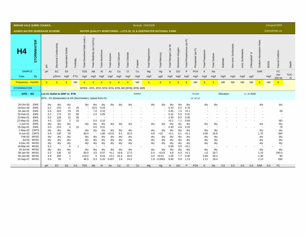
SITE - M2 Lot 21 Outlet to DNP nr. 97/6 0389927 7311632 Elevation xx m AHD
EPA - H1 (Deepwater) & H4 (Stormwater); repeat from H1 24° 18' 16"
26-Oct-00 EMS dry dry dry dry dry dry dry dry dry dry dry dry dry dry dry dry dry dry18-Dec-00 EMS 6.2 215 11 25 - 19.0 0.03 - - - - - - 0.10 6.2 0.70 - - - - - - - -18-Jan-01 EMS 5.9 323 19 25 - 7.0 0.10 - - - - - - 0.45 7.5 <0.1 - - - - - - - 5920-Feb-01 EMS 5.2 174 10 60 - 2.0 0.05 - - - - - - 0.32 5.5 0.31 - - - - - - - -22-Mar-01 EMS 5.6 128 12 35 - - - - - - - - - 2.30 8.2 0.40 - - - - - - - -22-May-01 EMS 4.5 232 2 15 - 0.0 0.10 - - - - - - <0.1 7.1 0.60 - - - - - - - ND
1-Jun-01 EMS dry dry dry dry dry dry dry dry dry dry dry dry dry dry dry dry dry dry18-Sep-01 EMS 5.5 214 4 10 - 9.0 0.01 - - - - - - 0.40 4.6 0.20 - - - - - - - 701-May-02 CMTS dry dry dry dry dry dry dry dry dry dry dry dry dry dry dry dry dry dry6-Jun-02 CMTS 5.5 139 25 83.4 - 1.80 <0.01 9.1 32.0 4.8 <10 <0.1 6.1 <0.1 0.90 25.8 1.70 300
Feb-03 MVSC dry dry dry dry dry dry dry dry dry dry dry dry dry dry dry dry dry dryJul-03 MVSC dry dry dry dry dry dry dry dry dry dry dry dry dry dry dry dry dry dry
4-Dec-03 MVSC dry dry dry dry dry dry dry dry dry dry dry dry dry dry dry dry dry dry16-Mar-04 MVSC 5.2 - 5 1 - - - - - - - - - 0.50 5.0 <0.1 - - - - - - - - -19-Jul-04 MVSC dry dry dry dry dry dry dry dry dry dry dry dry dry dry dry dry dry dry
28-Jan-05 MVSC 5.2 139 12 83.0 3.0 0.07 <0.1 19.8 27.0 5.4 <0.01 4.8 6.3 <0.1 1.0 20.7 1.10 240.030-Jan-06 MVSC 4.9 183 1 110.0 5 0.01 <0.1 31.4 42.0 4.0 <0.01 1.20 7.7 0.40 0.60 30.2 1.30 8010-Sep-07 MVSC 5.5 93 7 46.5 8.3 5.20 0.007 2.6 24.2 1.9 <0.0001 6.00 9.9 1.13 2.11 18.4 2.13 550
pH EC SS 0.0 TDS Alk Al As Ca Cl Cu Mg Hg N DO P PO4 K Na 0.0 0.0 0.0 0.0 SAR 0.0 FC
MIRIAM VALE SHIRE COUNCIL Spreeds 7/04/2008
AGNES WATER SEWERAGE SCHEME WATER QUALITY MONITORING - LOTS 20, 21 & DEEPWATER NATIONAL PARK
H4
STO
RM
WA
TER
pH Ele
ctric
al C
ondu
ctiv
ity
Sus
pend
ed S
olid
s
Turb
idity
Tota
l Dis
solv
ed S
alts
(cal
c.)
Tota
l Alk
alin
ity (a
s C
aCO
3)
Tota
l Alu
min
ium
Tota
l Ars
enic
Tota
l Cal
cium
Tota
l Chl
orid
e
Cop
per
Tota
l Mag
nesi
um
Tota
l Mer
cury
Tota
l Nitr
ogen
(as
N)
Dis
solv
ed O
xyge
n
Tota
l Pho
spho
rous
(as
P)
Pho
spha
te (a
s P
)
Tota
l Pot
assi
um
Tota
l Sod
ium
Sul
phat
e
Non
-ioni
c S
urfa
ctan
ts
Ioni
c S
urfa
ctan
ts
Chl
orop
hyll
‘a’
Sod
ium
Abs
orpt
ion
Rat
io
BO
D5
Faec
al C
olifo
rm
Dep
th
SAMPLE pH EC SS TDS Alk Al As Ca Cl Cu Mg Hg N DO P PO4 K Na SAR FC
Date By µS/cm mg/l FTU mg/l mg/l mg/l mg/l mg/l mg/l mg/l mg/l µg/l mg/l mg/l mg/l mg/l mg/l mg/l mg/l mg/l mg/l µg/l mg/l cfu/ 100 ml
TOC -m
6 6 6 NR 6 6 6 6 6 6 NR 6 6 6 6 6 NR 6 6 NR NR NR NR 6 NR 6
STORMWATER SITES - 97/1, 97/2, 97/3, 97/4, 97/5, M2 (97/6), 97/9, 00/9
Frequency - months
1/August/2005
D401MONK.xls
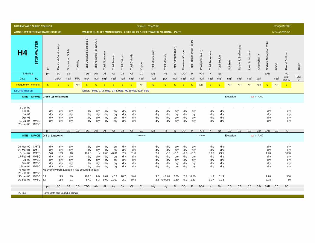
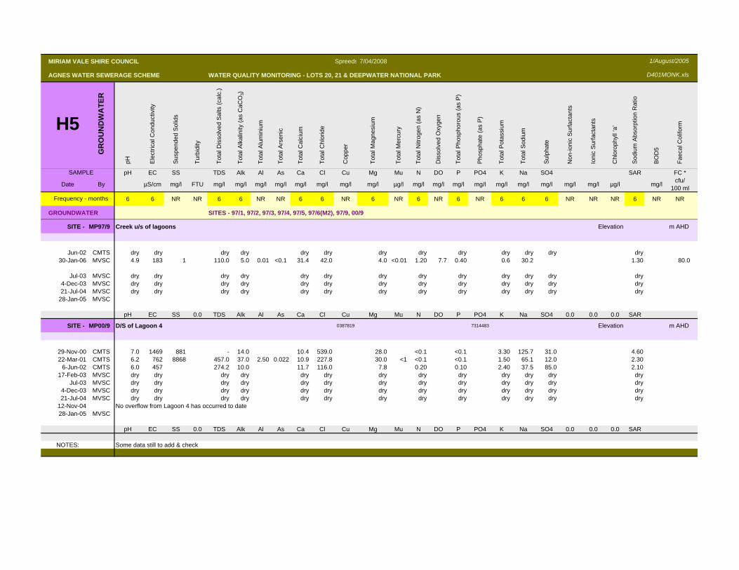
SITE - MP97/9 Creek u/s of lagoons Elevation xx m AHD
6-Jun-02 - - - - - - - - - - - - - - - - - - - - - - - - - -Feb-03 dry dry dry dry dry dry dry dry dry dry dry dry dry dry dry dry dry dryJul-03 dry dry dry dry dry dry dry dry dry dry dry dry dry dry dry dry dry dry
Dec-03 dry dry dry dry dry dry dry dry dry dry dry dry dry dry dry dry dry dry19-Jul-04 MVSC dry dry dry dry dry dry dry dry dry dry dry dry dry dry dry dry dry dry
28-Jan-05 MVSC
pH EC SS 0.0 TDS Alk Al As Ca Cl Cu Mg Hg N DO P PO4 K Na 0.0 0.0 0.0 0.0 SAR 0.0 FC
SITE - MP00/9 D/S of Lagoon 4 0387819 7314483 Elevation xx m AHD
29-Nov-00 CMTS dry dry dry dry dry dry dry dry dry dry dry dry dry dry dry dry dry dry22-Mar-01 CMTS dry dry dry dry dry dry dry dry dry dry dry dry dry dry dry dry dry dry
6-Jun-02 CMTS 5.6 183 18 109.8 - 0.60 <0.01 7.5 61.0 2.7 <10 <0.1 6.2 <0.1 0.90 23.5 1.90 300017-Feb-03 MVSC dry dry dry dry dry dry dry dry dry dry dry dry dry dry dry dry dry dry
Jul-03 MVSC dry dry dry dry dry dry dry dry dry dry dry dry dry dry dry dry dry dryDec-03 MVSC dry dry dry dry dry dry dry dry dry dry dry dry dry dry dry dry dry dry
19-Jul-04 MVSC dry dry dry dry dry dry dry dry dry dry dry dry dry dry dry dry dry dry9-Nov-04 No overflow from Lagoon 4 has occurred to date
28-Jan-05 MVSC30-Jan-06 MVSC 5.2 173 39 104.0 9.0 0.01 <0.1 28.7 40.0 3.0 <0.01 2.50 7.7 0.40 1.3 61.3 2.90 36010-Sep-07 MVSC 5.7 114 21 57.0 8.3 9.09 0.012 2.1 30.3 2.8 <0.0001 1.80 9.9 1.63 3.37 21.3 2.28 60
pH EC SS 0.0 TDS Alk Al As Ca Cl Cu Mg Hg N DO P PO4 K Na 0.0 0.0 0.0 0.0 SAR 0.0 FC
NOTES: Some data still to add & check
MIRIAM VALE SHIRE COUNCIL Spreeds 7/04/2008
AGNES WATER SEWERAGE SCHEME WATER QUALITY MONITORING - LOTS 20, 21 & DEEPWATER NATIONAL PARK
H5G
RO
UN
DW
ATE
R
pH Ele
ctric
al C
ondu
ctiv
ity
Sus
pend
ed S
olid
s
Turb
idity
Tota
l Dis
solv
ed S
alts
(cal
c.)
Tota
l Alk
alin
ity (a
s C
aCO
3)
Tota
l Alu
min
ium
Tota
l Ars
enic
Tota
l Cal
cium
Tota
l Chl
orid
e
Cop
per
Tota
l Mag
nesi
um
Tota
l Mer
cury
Tota
l Nitr
ogen
(as
N)
Dis
solv
ed O
xyge
n
Tota
l Pho
spho
rous
(as
P)
Pho
spha
te (a
s P
)
Tota
l Pot
assi
um
Tota
l Sod
ium
Sul
phat
e
Non
-ioni
c S
urfa
ctan
ts
Ioni
c S
urfa
ctan
ts
Chl
orop
hyll
‘a’
Sod
ium
Abs
orpt
ion
Rat
io
BO
D5
Faec
al C
olifo
rm
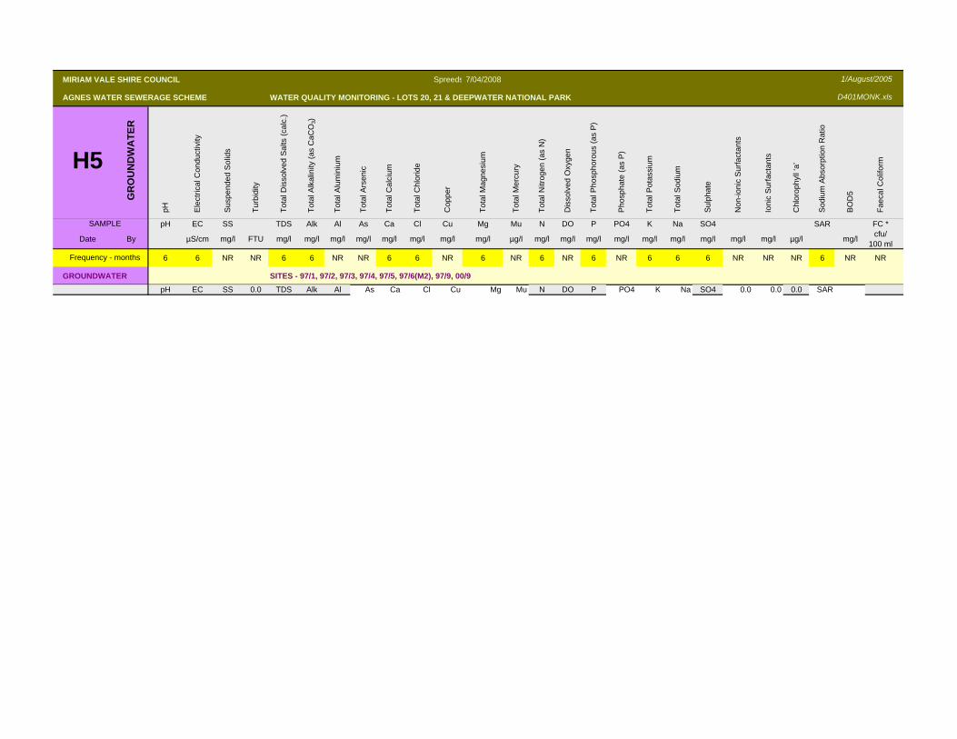
SAMPLE pH EC SS TDS Alk Al As Ca Cl Cu Mg Mu N DO P PO4 K Na SO4 SAR FC *
Date By µS/cm mg/l FTU mg/l mg/l mg/l mg/l mg/l mg/l mg/l mg/l µg/l mg/l mg/l mg/l mg/l mg/l mg/l mg/l mg/l mg/l µg/l mg/l cfu/ 100 ml
6 6 NR NR 6 6 NR NR 6 6 NR 6 NR 6 NR 6 NR 6 6 6 NR NR NR 6 NR NR
GROUNDWATER SITES - 97/1, 97/2, 97/3, 97/4, 97/5, 97/6(M2), 97/9, 00/9
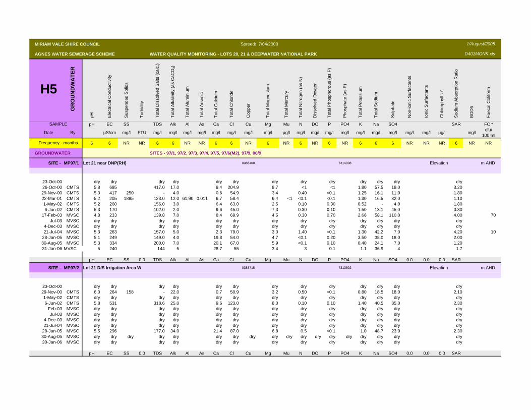
SITE - MP97/1 Lot 21 near DNP(RH) 0388400 7314998 Elevation m AHD
23-Oct-00 dry dry dry dry dry dry dry dry dry dry dry dry dry26-Oct-00 CMTS 5.8 695 417.0 17.0 9.4 204.9 8.7 <1 <1 1.80 57.5 18.0 3.2029-Nov-00 CMTS 5.3 417 250 - 4.0 0.6 54.9 3.4 0.40 <0.1 1.25 16.1 11.0 1.8022-Mar-01 CMTS 5.2 205 1895 123.0 12.0 61.90 0.011 6.7 58.4 6.4 <1 <0.1 <0.1 1.30 16.5 32.0 1.101-May-02 CMTS 5.2 260 156.0 3.0 6.4 63.0 2.5 0.10 0.30 0.52 - 4.0 1.806-Jun-02 CMTS 5.3 170 102.0 2.0 9.6 45.0 7.3 0.30 0.10 1.50 13.1 45.0 0.80
17-Feb-03 MVSC 4.8 233 139.8 7.0 8.4 69.9 4.5 0.30 0.70 2.66 58.1 110.0 4.00 70Jul-03 MVSC dry dry dry dry dry dry dry dry dry dry dry dry dry
4-Dec-03 MVSC dry dry dry dry dry dry dry dry dry dry dry dry dry21-Jul-04 MVSC 5.3 263 157.0 5.0 2.3 79.0 3.0 1.40 <0.1 1.30 42.2 7.0 4.20 10
28-Jan-05 MVSC 5.1 249 149.0 4.0 19.8 54.0 4.7 <0.1 0.20 3.50 38.0 18.0 2.0030-Aug-05 MVSC 5.3 334 200.0 7.0 20.1 67.0 5.9 <0.1 0.10 0.40 24.1 7.0 1.2031-Jan-06 MVSC 5 240 144 5 28.7 55 3.4 3 0.1 1.1 36.9 4 1.7
pH EC SS 0.0 TDS Alk Al As Ca Cl Cu Mg Mu N DO P PO4 K Na SO4 0.0 0.0 0.0 SAR
SITE - MP97/2 Lot 21 D/S Irrigation Area W 0388715 7313802 Elevation m AHD
23-Oct-00 dry dry dry dry dry dry dry dry dry dry dry dry dry29-Nov-00 CMTS 6.0 264 158 - 22.0 0.7 50.9 3.2 0.50 <0.1 0.80 18.5 18.0 2.101-May-02 CMTS dry dry dry dry dry dry dry dry dry dry dry dry dry6-Jun-02 CMTS 5.8 531 318.6 25.0 9.6 123.0 8.0 0.10 0.10 1.40 40.5 35.0 2.30
Feb-03 MVSC dry dry dry dry dry dry dry dry dry dry dry dry dryJul-03 MVSC dry dry dry dry dry dry dry dry dry dry dry dry dry
4-Dec-03 MVSC dry dry dry dry dry dry dry dry dry dry dry dry dry21-Jul-04 MVSC dry dry dry dry dry dry dry dry dry dry dry dry dry
28-Jan-05 MVSC 5.5 296 177.0 34.0 21.4 87.0 6.8 0.5 <0.1 1.0 48.7 23.0 2.3030-Aug-05 MVSC dry dry dry dry dry dry dry dry dry dry dry dry dry dry dry dry dry dry30-Jan-06 MVSC dry dry dry dry dry dry dry dry dry dry dry dry dry
pH EC SS 0.0 TDS Alk Al As Ca Cl Cu Mg Mu N DO P PO4 K Na SO4 0.0 0.0 0.0 SAR
Frequency - months
1/August/2005
D401MONK.xls
MIRIAM VALE SHIRE COUNCIL Spreeds 7/04/2008
AGNES WATER SEWERAGE SCHEME WATER QUALITY MONITORING - LOTS 20, 21 & DEEPWATER NATIONAL PARK
H5G
RO
UN
DW
ATE
R
pH Ele
ctric
al C
ondu
ctiv
ity
Sus
pend
ed S
olid
s
Turb
idity
Tota
l Dis
solv
ed S
alts
(cal
c.)
Tota
l Alk
alin
ity (a
s C
aCO
3)
Tota
l Alu
min
ium
Tota
l Ars
enic
Tota
l Cal
cium
Tota
l Chl
orid
e
Cop
per
Tota
l Mag
nesi
um
Tota
l Mer
cury
Tota
l Nitr
ogen
(as
N)
Dis
solv
ed O
xyge
n
Tota
l Pho
spho
rous
(as
P)
Pho
spha
te (a
s P
)
Tota
l Pot
assi
um
Tota
l Sod
ium
Sul
phat
e
Non
-ioni
c S
urfa
ctan
ts
Ioni
c S
urfa
ctan
ts
Chl
orop
hyll
‘a’
Sod
ium
Abs
orpt
ion
Rat
io
BO
D5
Faec
al C
olifo
rm
SAMPLE pH EC SS TDS Alk Al As Ca Cl Cu Mg Mu N DO P PO4 K Na SO4 SAR FC *
Date By µS/cm mg/l FTU mg/l mg/l mg/l mg/l mg/l mg/l mg/l mg/l µg/l mg/l mg/l mg/l mg/l mg/l mg/l mg/l mg/l mg/l µg/l mg/l cfu/ 100 ml
6 6 NR NR 6 6 NR NR 6 6 NR 6 NR 6 NR 6 NR 6 6 6 NR NR NR 6 NR NR
GROUNDWATER SITES - 97/1, 97/2, 97/3, 97/4, 97/5, 97/6(M2), 97/9, 00/9
Frequency - months
1/August/2005
D401MONK.xls
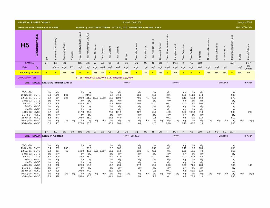
SITE - MP97/3 Lot 21 D/S Irrigation Area W 0389048 7313746 Elevation m AHD
23-Oct-00 dry dry dry dry dry dry dry dry dry dry dry dry dry29-Nov-00 CMTS 6.8 1349 809 - 244.0 9.2 241.8 26.0 <0.1 <0.1 1.60 111.8 24.0 4.3022-Mar-01 CMTS 6.4 664 332 398.0 101.0 15.20 0.018 12.5 150.5 48.3 <1 <0.1 <0.1 1.10 58.4 16.0 1.701-May-02 CMTS dry dry dry dry dry dry dry dry dry dry dry dry dry6-Jun-02 CMTS 6.4 808 484.8 85.0 14.9 165.0 10.5 0.10 <0.1 1.40 112.0 30.0 5.40
Feb-03 MVSC dry dry dry dry dry dry dry dry dry dry dry dry dryJul-03 MVSC dry dry dry dry dry dry dry dry dry dry dry dry dry
4-Dec-03 MVSC 6.2 529 317.0 34.0 22.0 101.9 12.1 <0.1 4.40 1.00 102.8 41.0 4.40 20021-Jul-04 MVSC dry dry dry dry dry dry dry dry dry dry dry dry dry
28-Jan-05 MVSC 5.8 343 205.0 68.0 24.6 44.0 8.3 0.8 <0.1 0.8 70.0 11.0 3.1030-Aug-05 MVSC dry dry dry dry dry dry dry dry dry dry dry dry dry dry dry dry dry dry dry dry dry dry dry dry dry dry ry30-Jan-06 MVSC 5.6 451 270.0 108.0 40.9 80.0 6.8 1.20 0.10 1.10 68.0 1.0 2.60
pH EC SS 0.0 TDS Alk Al As Ca Cl Cu Mg Mu N DO P PO4 K Na SO4 0.0 0.0 0.0 SAR
SITE - MP97/4 Lot 21 on N/S Road 0389175 39545.0 7313303 Elevation m AHD
23-Oct-00 dry dry dry dry dry dry dry dry dry dry dry dry dry29-Nov-00 CMTS 6.4 387 232 - 66.0 6.2 66.9 3.7 0.30 <0.1 1.10 18.8 10.0 1.5022-Mar-01 CMTS 6.0 264 65 148.0 47.0 9.20 0.017 18.1 51.5 53.3 <1 <0.1 <0.1 1.00 19.5 7.0 0.501-May-02 CMTS dry dry dry dry dry dry dry dry dry dry dry dry dry6-Jun-02 CMTS 6.1 409 245.4 25.0 17.0 87.0 6.7 0.10 <0.1 1.00 40.8 25.0 2.10
Feb-03 MVSC dry dry dry dry dry dry dry dry dry dry dry dry dryJul-03 MVSC dry dry dry dry dry dry dry dry dry dry dry dry dry
4-Dec-03 MVSC 6.0 382 229.0 18.0 19.2 79.2 17.5 <0.1 0.60 0.90 71.5 28.0 2.80 14021-Jul-04 MVSC dry dry dry dry dry dry dry dry dry dry dry dry dry
28-Jan-05 MVSC 5.7 505 303.0 74.0 38.9 62.0 7.6 0.5 <0.1 0.8 58.0 12.0 2.230-Aug-05 MVSC dry dry dry dry dry dry dry dry dry dry dry dry dry dry dry dry dry dry dry dry dry dry dry dry dry dry ry30-Jan-06 MVSC 5.4 428 256.0 80.0 44.1 69.0 5.6 1.5 0.1 0.8 76.9 1.0 2.90
MIRIAM VALE SHIRE COUNCIL Spreeds 7/04/2008
AGNES WATER SEWERAGE SCHEME WATER QUALITY MONITORING - LOTS 20, 21 & DEEPWATER NATIONAL PARK
H5G
RO
UN
DW
ATE
R
pH Ele
ctric
al C
ondu
ctiv
ity
Sus
pend
ed S
olid
s
Turb
idity
Tota
l Dis
solv
ed S
alts
(cal
c.)
Tota
l Alk
alin
ity (a
s C
aCO
3)
Tota
l Alu
min
ium
Tota
l Ars
enic
Tota
l Cal
cium
Tota
l Chl
orid
e
Cop
per
Tota
l Mag
nesi
um
Tota
l Mer
cury
Tota
l Nitr
ogen
(as
N)
Dis
solv
ed O
xyge
n
Tota
l Pho
spho
rous
(as
P)
Pho
spha
te (a
s P
)
Tota
l Pot
assi
um
Tota
l Sod
ium
Sul
phat
e
Non
-ioni
c S
urfa
ctan
ts
Ioni
c S
urfa
ctan
ts
Chl
orop
hyll
‘a’
Sod
ium
Abs
orpt
ion
Rat
io
BO
D5
Faec
al C
olifo
rm
SAMPLE pH EC SS TDS Alk Al As Ca Cl Cu Mg Mu N DO P PO4 K Na SO4 SAR FC *
Date By µS/cm mg/l FTU mg/l mg/l mg/l mg/l mg/l mg/l mg/l mg/l µg/l mg/l mg/l mg/l mg/l mg/l mg/l mg/l mg/l mg/l µg/l mg/l cfu/ 100 ml
6 6 NR NR 6 6 NR NR 6 6 NR 6 NR 6 NR 6 NR 6 6 6 NR NR NR 6 NR NR
GROUNDWATER SITES - 97/1, 97/2, 97/3, 97/4, 97/5, 97/6(M2), 97/9, 00/9
Frequency - months
1/August/2005
D401MONK.xls
pH EC SS 0.0 TDS Alk Al As Ca Cl Cu Mg Mu N DO P PO4 K Na SO4 0.0 0.0 0.0 SAR
MIRIAM VALE SHIRE COUNCIL Spreeds 7/04/2008
AGNES WATER SEWERAGE SCHEME WATER QUALITY MONITORING - LOTS 20, 21 & DEEPWATER NATIONAL PARK
H5G
RO
UN
DW
ATE
R
pH Ele
ctric
al C
ondu
ctiv
ity
Sus
pend
ed S
olid
s
Turb
idity
Tota
l Dis
solv
ed S
alts
(cal
c.)
Tota
l Alk
alin
ity (a
s C
aCO
3)
Tota
l Alu
min
ium
Tota
l Ars
enic
Tota
l Cal
cium
Tota
l Chl
orid
e
Cop
per
Tota
l Mag
nesi
um
Tota
l Mer
cury
Tota
l Nitr
ogen
(as
N)
Dis
solv
ed O
xyge
n
Tota
l Pho
spho
rous
(as
P)
Pho
spha
te (a
s P
)
Tota
l Pot
assi
um
Tota
l Sod
ium
Sul
phat
e
Non
-ioni
c S
urfa
ctan
ts
Ioni
c S
urfa
ctan
ts
Chl
orop
hyll
‘a’
Sod
ium
Abs
orpt
ion
Rat
io
BO
D5
Faec
al C
olifo
rm
SAMPLE pH EC SS TDS Alk Al As Ca Cl Cu Mg Mu N DO P PO4 K Na SO4 SAR FC *
Date By µS/cm mg/l FTU mg/l mg/l mg/l mg/l mg/l mg/l mg/l mg/l µg/l mg/l mg/l mg/l mg/l mg/l mg/l mg/l mg/l mg/l µg/l mg/l cfu/ 100 ml
6 6 NR NR 6 6 NR NR 6 6 NR 6 NR 6 NR 6 NR 6 6 6 NR NR NR 6 NR NR
GROUNDWATER SITES - 97/1, 97/2, 97/3, 97/4, 97/5, 97/6(M2), 97/9, 00/9
Frequency - months
1/August/2005
D401MONK.xls
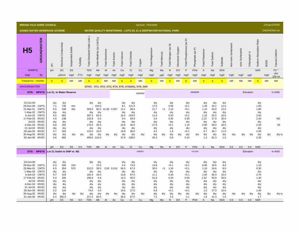
SITE - MP97/5 Lot 21, to Water Reserve ###### ###### Elevation m AHD
23-Oct-00 dry dry dry dry dry dry dry dry dry dry dry dry dry29-Nov-00 CMTS 7.1 735 441 - 154.0 8.1 121.9 17.0 0.50 <0.1 1.40 33.2 12.0 1.5022-Mar-01 CMTS 6.5 338 461 203.0 82.0 41.60 0.007 13.1 58.4 21.7 <1 2.10 <0.1 1.10 44.9 12.0 1.801-May-02 CMTS dry dry dry dry dry dry dry dry dry dry dry dry dry6-Jun-02 CMTS 6.5 662 397.2 82.0 16.0 143.0 11.6 0.20 <0.1 1.10 55.0 20.0 2.60
17-Feb-03 MVSC 4.9 238 142.8 6.0 9.4 59.9 5.0 0.40 0.30 2.22 37.8 30.0 2.50 NDJul-03 MVSC dry dry dry dry dry dry dry dry dry dry dry dry dry
4-Dec-03 MVSC 6.8 292 175.0 39.0 24.8 46.0 27.9 <0.1 1.10 0.90 59.9 30.0 2.00 5021-Jul-04 MVSC dry dry dry dry dry dry dry dry dry dry dry dry dry
28-Jan-05 MVSC 5.7 203 122.0 23.0 19.8 36.0 4.2 1.6 <0.1 0.7 36.7 11.0 2.0030-Aug-05 MVSC dry dry dry dry dry dry dry dry dry dry dry dry dry dry dry dry dry dry dry dry dry dry dry dry dry dry ry30-Jan-06 MVSC 5.6 682 409.0 110.0 37.8 138.0 34.3 0.8 0.10 1.3 81.3 1.0 2.30
pH EC SS 0.0 TDS Alk Al As Ca Cl Cu Mg Mu N DO P PO4 K Na SO4 0.0 0.0 0.0 SAR
SITE - MP97/6 Lot 21 Outlet to DNP nr. M2 0389927 7311642 Elevation m AHD
23-Oct-00 dry dry dry dry dry dry dry dry dry dry dry dry dry29-Nov-00 CMTS 6.3 405 243 - 70.0 4.4 73.9 13.8 <0.1 <0.1 0.90 19.6 8.0 1.1022-Mar-01 CMTS 6.5 354 570 212.0 39.0 2.00 0.014 56.3 67.3 30.0 <1 1.20 <0.1 1.10 24.6 8.0 0.301-May-02 CMTS dry dry dry dry dry dry dry dry dry dry dry dry dry6-Jun-02 CMTS 5.7 319 191.4 18.0 13.8 67.0 11.1 0.30 <0.1 1.00 56.3 15.0 2.70
17-Feb-03 MVSC 5.4 326 195.6 5.6 14.3 55.5 51.0 0.20 0.50 2.52 50.9 50.0 1.40Jul-03 MVSC dry dry dry dry dry dry dry dry dry dry dry dry dry
4-Dec-03 MVSC dry dry dry dry dry dry dry dry dry dry dry dry dry21-Jul-04 MVSC dry dry dry dry dry dry dry dry dry dry dry dry dry
28-Jan-05 MVSC 5.2 124 74.0 3.0 16.6 27.0 6.8 <0.1 <0.1 1.0 27.3 10.0 1.4030-Aug-05 MVSC dry dry dry dry dry dry dry dry dry dry dry dry dry dry dry dry dry dry dry dry dry dry dry dry dry dry ry31-Jan-06 MVSC 5.4 362.0 217.0 60.0 35.0 67.0 7.2 2.0 0.1 1.6 41.3 1.0 1.7
pH EC SS 0.0 TDS Alk Al As Ca Cl Cu Mg Mu N DO P PO4 K Na SO4 0.0 0.0 0.0 SAR
MIRIAM VALE SHIRE COUNCIL Spreeds 7/04/2008
AGNES WATER SEWERAGE SCHEME WATER QUALITY MONITORING - LOTS 20, 21 & DEEPWATER NATIONAL PARK
H5G
RO
UN
DW
ATE
R
pH Ele
ctric
al C
ondu
ctiv
ity
Sus
pend
ed S
olid
s
Turb
idity
Tota
l Dis
solv
ed S
alts
(cal
c.)
Tota
l Alk
alin
ity (a
s C
aCO
3)
Tota
l Alu
min
ium
Tota
l Ars
enic
Tota
l Cal
cium
Tota
l Chl
orid
e
Cop
per
Tota
l Mag
nesi
um
Tota
l Mer
cury
Tota
l Nitr
ogen
(as
N)
Dis
solv
ed O
xyge
n
Tota
l Pho
spho
rous
(as
P)
Pho
spha
te (a
s P
)
Tota
l Pot
assi
um
Tota
l Sod
ium
Sul
phat
e
Non
-ioni
c S
urfa
ctan
ts
Ioni
c S
urfa
ctan
ts
Chl
orop
hyll
‘a’
Sod
ium
Abs
orpt
ion
Rat
io
BO
D5
Faec
al C
olifo
rm
SAMPLE pH EC SS TDS Alk Al As Ca Cl Cu Mg Mu N DO P PO4 K Na SO4 SAR FC *
Date By µS/cm mg/l FTU mg/l mg/l mg/l mg/l mg/l mg/l mg/l mg/l µg/l mg/l mg/l mg/l mg/l mg/l mg/l mg/l mg/l mg/l µg/l mg/l cfu/ 100 ml
6 6 NR NR 6 6 NR NR 6 6 NR 6 NR 6 NR 6 NR 6 6 6 NR NR NR 6 NR NR
GROUNDWATER SITES - 97/1, 97/2, 97/3, 97/4, 97/5, 97/6(M2), 97/9, 00/9
Frequency - months
1/August/2005
D401MONK.xls
SITE - MP97/9 Creek u/s of lagoons Elevation m AHD
Jun-02 CMTS dry dry dry dry dry dry dry dry dry dry dry dry dry30-Jan-06 MVSC 4.9 183 1 110.0 5.0 0.01 <0.1 31.4 42.0 4.0 <0.01 1.20 7.7 0.40 0.6 30.2 1.30 80.0
Jul-03 MVSC dry dry dry dry dry dry dry dry dry dry dry dry dry4-Dec-03 MVSC dry dry dry dry dry dry dry dry dry dry dry dry dry21-Jul-04 MVSC dry dry dry dry dry dry dry dry dry dry dry dry dry
28-Jan-05 MVSC
pH EC SS 0.0 TDS Alk Al As Ca Cl Cu Mg Mu N DO P PO4 K Na SO4 0.0 0.0 0.0 SAR
SITE - MP00/9 D/S of Lagoon 4 0387819 7314483 Elevation m AHD
29-Nov-00 CMTS 7.0 1469 881 - 14.0 10.4 539.0 28.0 <0.1 <0.1 3.30 125.7 31.0 4.6022-Mar-01 CMTS 6.2 762 8868 457.0 37.0 2.50 0.022 10.9 227.8 30.0 <1 <0.1 <0.1 1.50 65.1 12.0 2.30
6-Jun-02 CMTS 6.0 457 274.2 10.0 11.7 116.0 7.8 0.20 0.10 2.40 37.5 85.0 2.1017-Feb-03 MVSC dry dry dry dry dry dry dry dry dry dry dry dry dry
Jul-03 MVSC dry dry dry dry dry dry dry dry dry dry dry dry dry4-Dec-03 MVSC dry dry dry dry dry dry dry dry dry dry dry dry dry21-Jul-04 MVSC dry dry dry dry dry dry dry dry dry dry dry dry dry
12-Nov-04 No overflow from Lagoon 4 has occurred to date28-Jan-05 MVSC
pH EC SS 0.0 TDS Alk Al As Ca Cl Cu Mg Mu N DO P PO4 K Na SO4 0.0 0.0 0.0 SAR
NOTES: Some data still to add & check