Embed Size (px)
Citation preview
United StatesDepartment ofAgriculture
A product of the NationalCooperative Soil Survey,a joint effort of the UnitedStates Department ofAgriculture and otherFederal agencies, Stateagencies including theAgricultural ExperimentStations, and localparticipants
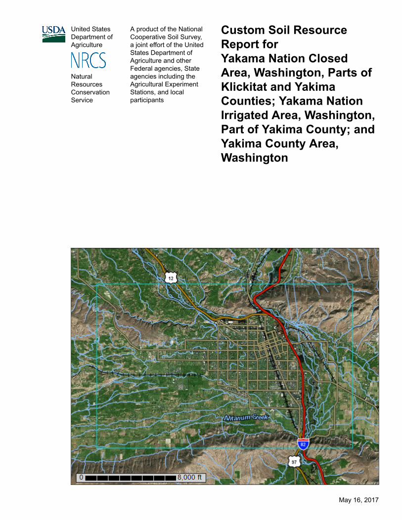
Custom Soil ResourceReport forYakama Nation ClosedArea, Washington, Parts ofKlickitat and YakimaCounties; Yakama NationIrrigated Area, Washington,Part of Yakima County; andYakima County Area,Washington
NaturalResourcesConservationService
May 16, 2017
PrefaceSoil surveys contain information that affects land use planning in survey areas.They highlight soil limitations that affect various land uses and provide informationabout the properties of the soils in the survey areas. Soil surveys are designed formany different users, including farmers, ranchers, foresters, agronomists, urbanplanners, community officials, engineers, developers, builders, and home buyers.Also, conservationists, teachers, students, and specialists in recreation, wastedisposal, and pollution control can use the surveys to help them understand,protect, or enhance the environment.
Various land use regulations of Federal, State, and local governments may imposespecial restrictions on land use or land treatment. Soil surveys identify soilproperties that are used in making various land use or land treatment decisions.The information is intended to help the land users identify and reduce the effects ofsoil limitations on various land uses. The landowner or user is responsible foridentifying and complying with existing laws and regulations.
Although soil survey information can be used for general farm, local, and wider areaplanning, onsite investigation is needed to supplement this information in somecases. Examples include soil quality assessments (http://www.nrcs.usda.gov/wps/portal/nrcs/main/soils/health/) and certain conservation and engineeringapplications. For more detailed information, contact your local USDA Service Center(https://offices.sc.egov.usda.gov/locator/app?agency=nrcs) or your NRCS State SoilScientist (http://www.nrcs.usda.gov/wps/portal/nrcs/detail/soils/contactus/?cid=nrcs142p2_053951).
Great differences in soil properties can occur within short distances. Some soils areseasonally wet or subject to flooding. Some are too unstable to be used as afoundation for buildings or roads. Clayey or wet soils are poorly suited to use asseptic tank absorption fields. A high water table makes a soil poorly suited tobasements or underground installations.
The National Cooperative Soil Survey is a joint effort of the United StatesDepartment of Agriculture and other Federal agencies, State agencies including theAgricultural Experiment Stations, and local agencies. The Natural ResourcesConservation Service (NRCS) has leadership for the Federal part of the NationalCooperative Soil Survey.
Information about soils is updated periodically. Updated information is availablethrough the NRCS Web Soil Survey, the site for official soil survey information.
The U.S. Department of Agriculture (USDA) prohibits discrimination in all itsprograms and activities on the basis of race, color, national origin, age, disability,and where applicable, sex, marital status, familial status, parental status, religion,sexual orientation, genetic information, political beliefs, reprisal, or because all or apart of an individual's income is derived from any public assistance program. (Notall prohibited bases apply to all programs.) Persons with disabilities who require
2

alternative means for communication of program information (Braille, large print,audiotape, etc.) should contact USDA's TARGET Center at (202) 720-2600 (voiceand TDD). To file a complaint of discrimination, write to USDA, Director, Office ofCivil Rights, 1400 Independence Avenue, S.W., Washington, D.C. 20250-9410 orcall (800) 795-3272 (voice) or (202) 720-6382 (TDD). USDA is an equal opportunityprovider and employer.
3
ContentsPreface.................................................................................................................... 2How Soil Surveys Are Made..................................................................................7Soil Map................................................................................................................ 10
Soil Map..............................................................................................................11Legend................................................................................................................12Map Unit Legend................................................................................................ 14Map Unit Descriptions........................................................................................ 18
Yakama Nation Closed Area, Washington, Parts of Klickitat and YakimaCounties................................................................................................... 21
NOTPUB—Not Public Information.............................................................. 21Yakama Nation Irrigated Area, Washington, Part of Yakima County.............. 22
AhA—Ahtanum silt loam, 0 to 2 percent slopes.......................................... 22EtA—Esquatzel silt loam, 0 to 2 percent slopes..........................................23EtB—Esquatzel silt loam, 2 to 5 percent slopes..........................................24Ks—Kittitas silt loam....................................................................................25Lg—Logy silt loam.......................................................................................26OnA—Onyx silt loam, 0 to 2 percent slopes................................................26OnB—Onyx silt loam, 2 to 5 percent slopes................................................27RtB—Ritzville silt loam, 2 to 5 percent slopes.............................................28RtC—Ritzville silt loam, 5 to 8 percent slopes.............................................29RtD—Ritzville silt loam, 8 to 15 percent slopes...........................................30RtE—Ritzville silt loam, 15 to 30 percent slopes.........................................31RtF—Ritzville silt loam, 30 to 65 percent slopes......................................... 32RuC—Ritzville silt loam, gravelly subsoil variant, 5 to 8 percent slopes..... 32RuD—Ritzville silt loam, gravelly subsoil variant, 8 to 15 percent slopes... 33RvE—Rock Creek very stony loam, 0 to 20 percent slopes........................34StA—Stanfield silt loam, 0 to 2 percent slopes........................................... 35ToA—Toppenish silt loam, 0 to 2 percent slopes.........................................36Tp—Toppenish silty clay loam.....................................................................37Um—Umapine silt loam...............................................................................38W—Water....................................................................................................39WfB—Warden silt loam, 2 to 5 percent slopes............................................39WfC—Warden silt loam, 5 to 8 percent slopes............................................40WfD—Warden silt loam, 8 to 15 percent slopes..........................................41WfE—Warden silt loam, 15 to 30 percent slopes........................................42WoA—Weirman fine sandy loam, 0 to 2 percent slopes............................. 43WoB—Weirman fine sandy loam, 2 to 5 percent slopes............................. 44
Yakima County Area, Washington.................................................................. 462—Ashue loam............................................................................................463—Bakeoven very cobbly silt loam, 0 to 30 percent slopes........................ 4718—Cleman very fine sandy loam, 0 to 2 percent slopes........................... 4819—Cleman very fine sandy loam, 2 to 5 percent slopes........................... 4920—Cleman very fine sandy loam, 5 to 8 percent slopes........................... 5021—Cleman very fine sandy loam, 8 to 15 percent slopes......................... 51
4
24—Cowiche loam, 2 to 5 percent slopes...................................................5225—Cowiche loam, 5 to 8 percent slopes...................................................5326—Cowiche loam, 8 to 15 percent slopes.................................................5427—Cowiche loam, 15 to 30 percent slopes...............................................5532—Esquatzel silt loam, 0 to 2 percent slopes........................................... 5633—Esquatzel silt loam, 2 to 5 percent slopes........................................... 5743—Gorst loam, 2 to 15 percent slopes......................................................5844—Gorst loam, 15 to 30 percent slopes....................................................5945—Gorst cobbly loam, 0 to 25 percent slopes.......................................... 6046—Harwood loam, 2 to 5 percent slopes.................................................. 6147—Harwood loam, 5 to 8 percent slopes.................................................. 6248—Harwood loam, 8 to 15 percent slopes................................................ 6349—Harwood loam, 15 to 30 percent slopes.............................................. 6450—Harwood-Burke-Wiehl silt loams, 2 to 5 percent slopes...................... 6552—Harwood-Burke-Wiehl silt loams, 8 to 15 percent slopes.................... 6753—Harwood-Burke-Wiehl silt loams, 15 to 30 percent slopes.................. 6954—Harwood-Burke-Wiehl silt loams, 30 to 60 percent slopes.................. 7165—Kiona stony silt loam, 15 to 45 percent slopes.................................... 7366—Kittitas silt loam....................................................................................7468—Lickskillet very stony silt loam, 5 to 45 percent slopes........................ 7569—Logy silt loam, 0 to 2 percent slopes................................................... 7680—Mikkalo silt loam, 5 to 15 percent slopes............................................. 7781—Mikkalo silt loam, 15 to 30 percent slopes........................................... 7883—Moxee silt loam, 2 to 15 percent slopes.............................................. 7984—Moxee silt loam, 15 to 30 percent slopes............................................ 8085—Moxee cobbly silt loam, 0 to 30 percent slopes................................... 8186—Naches loam........................................................................................8292—Outlook silt loam.................................................................................. 8393—Pits.......................................................................................................8495—Quincy loamy fine sand, 0 to 10 percent slopes.................................. 8499—Ritzville silt loam, 2 to 5 percent slopes...............................................85100—Ritzville silt loam, 5 to 8 percent slopes.............................................86101—Ritzville silt loam, 8 to 15 percent slopes...........................................87102—Ritzville silt loam, 15 to 30 percent slopes.........................................88103—Ritzville silt loam, 30 to 60 percent slopes.........................................89109—Rock Creek very stony silt loam, 0 to 30 percent slopes................... 90110—Rock Creek-Clint-Simcoe complex, 0 to 45 percent slopes...............90112—Roza clay loam, 8 to 15 percent slopes............................................. 92113—Roza clay loam, 15 to 30 percent slopes........................................... 93128—Selah silt loam, 2 to 5 percent slopes................................................ 94129—Selah silt loam, 5 to 8 percent slopes................................................ 95130—Selah silt loam, 8 to 15 percent slopes.............................................. 96131—Selah silt loam, 15 to 30 percent slopes............................................ 97136—Simcoe silt loam, 5 to 15 percent slopes........................................... 98137—Simcoe silt loam, 15 to 30 percent slopes......................................... 99140—Sinloc silt loam, 2 to 5 percent slopes............................................... 99141—Sinloc silt loam, 5 to 8 percent slopes............................................. 101142—Starbuck silt loam, 2 to 15 percent slopes....................................... 102143—Starbuck-Rock outcrop complex, 0 to 45 percent slopes................ 103144—Starbuck-Rock outcrop complex, 45 to 60 percent slopes.............. 104158—Tieton loam, 2 to 5 percent slopes...................................................105159—Tieton loam, 5 to 8 percent slopes...................................................106160—Tieton loam, 8 to 15 percent slopes.................................................107161—Tieton loam, 15 to 30 percent slopes...............................................108
Custom Soil Resource Report
5
162—Tieton-Rock outcrop complex, 0 to 30 percent slopes.....................109163—Toppenish silt loam.......................................................................... 110164—Torriorthents, steep...........................................................................111165—Track loam....................................................................................... 112169—Umapine silt loam, drained, 0 to 2 percent slopes........................... 113170—Umapine silt loam, drained, 2 to 5 percent slopes........................... 115176—Warden silt loam, 0 to 2 percent slopes........................................... 116177—Warden silt loam, 2 to 5 percent slopes........................................... 117178—Warden silt loam, 5 to 8 percent slopes........................................... 118179—Warden silt loam, 8 to 15 percent slopes......................................... 119180—Warden silt loam, 15 to 30 percent slopes.......................................120181—Weirman sandy loam, channeled.................................................... 121182—Weirman fine sandy loam................................................................ 121183—Weirman gravelly fine sandy loam...................................................122184—Weirman fine sandy loam, wet.........................................................123185—Wenas silt loam............................................................................... 124187—Willis silt loam, 2 to 5 percent slopes...............................................126188—Willis silt loam, 5 to 8 percent slopes...............................................127189—Willis silt loam, 8 to 15 percent slopes.............................................128190—Yakima silt loam...............................................................................129192—Zillah silt loam.................................................................................. 130193—Zillah silt loam, channeled............................................................... 131197—Water............................................................................................... 132
Soil Information for All Uses.............................................................................133Soil Reports...................................................................................................... 133
Soil Physical Properties................................................................................ 133Engineering Properties (Yakima Area of Interest)..................................... 133
References..........................................................................................................180
Custom Soil Resource Report
6
How Soil Surveys Are MadeSoil surveys are made to provide information about the soils and miscellaneousareas in a specific area. They include a description of the soils and miscellaneousareas and their location on the landscape and tables that show soil properties andlimitations affecting various uses. Soil scientists observed the steepness, length,and shape of the slopes; the general pattern of drainage; the kinds of crops andnative plants; and the kinds of bedrock. They observed and described many soilprofiles. A soil profile is the sequence of natural layers, or horizons, in a soil. Theprofile extends from the surface down into the unconsolidated material in which thesoil formed or from the surface down to bedrock. The unconsolidated material isdevoid of roots and other living organisms and has not been changed by otherbiological activity.
Currently, soils are mapped according to the boundaries of major land resourceareas (MLRAs). MLRAs are geographically associated land resource units thatshare common characteristics related to physiography, geology, climate, waterresources, soils, biological resources, and land uses (USDA, 2006). Soil surveyareas typically consist of parts of one or more MLRA.
The soils and miscellaneous areas in a survey area occur in an orderly pattern thatis related to the geology, landforms, relief, climate, and natural vegetation of thearea. Each kind of soil and miscellaneous area is associated with a particular kindof landform or with a segment of the landform. By observing the soils andmiscellaneous areas in the survey area and relating their position to specificsegments of the landform, a soil scientist develops a concept, or model, of how theywere formed. Thus, during mapping, this model enables the soil scientist to predictwith a considerable degree of accuracy the kind of soil or miscellaneous area at aspecific location on the landscape.
Commonly, individual soils on the landscape merge into one another as theircharacteristics gradually change. To construct an accurate soil map, however, soilscientists must determine the boundaries between the soils. They can observe onlya limited number of soil profiles. Nevertheless, these observations, supplementedby an understanding of the soil-vegetation-landscape relationship, are sufficient toverify predictions of the kinds of soil in an area and to determine the boundaries.
Soil scientists recorded the characteristics of the soil profiles that they studied. Theynoted soil color, texture, size and shape of soil aggregates, kind and amount of rockfragments, distribution of plant roots, reaction, and other features that enable themto identify soils. After describing the soils in the survey area and determining theirproperties, the soil scientists assigned the soils to taxonomic classes (units).Taxonomic classes are concepts. Each taxonomic class has a set of soilcharacteristics with precisely defined limits. The classes are used as a basis forcomparison to classify soils systematically. Soil taxonomy, the system of taxonomicclassification used in the United States, is based mainly on the kind and characterof soil properties and the arrangement of horizons within the profile. After the soil
7
scientists classified and named the soils in the survey area, they compared theindividual soils with similar soils in the same taxonomic class in other areas so thatthey could confirm data and assemble additional data based on experience andresearch.
The objective of soil mapping is not to delineate pure map unit components; theobjective is to separate the landscape into landforms or landform segments thathave similar use and management requirements. Each map unit is defined by aunique combination of soil components and/or miscellaneous areas in predictableproportions. Some components may be highly contrasting to the other componentsof the map unit. The presence of minor components in a map unit in no waydiminishes the usefulness or accuracy of the data. The delineation of suchlandforms and landform segments on the map provides sufficient information for thedevelopment of resource plans. If intensive use of small areas is planned, onsiteinvestigation is needed to define and locate the soils and miscellaneous areas.
Soil scientists make many field observations in the process of producing a soil map.The frequency of observation is dependent upon several factors, including scale ofmapping, intensity of mapping, design of map units, complexity of the landscape,and experience of the soil scientist. Observations are made to test and refine thesoil-landscape model and predictions and to verify the classification of the soils atspecific locations. Once the soil-landscape model is refined, a significantly smallernumber of measurements of individual soil properties are made and recorded.These measurements may include field measurements, such as those for color,depth to bedrock, and texture, and laboratory measurements, such as those forcontent of sand, silt, clay, salt, and other components. Properties of each soiltypically vary from one point to another across the landscape.
Observations for map unit components are aggregated to develop ranges ofcharacteristics for the components. The aggregated values are presented. Directmeasurements do not exist for every property presented for every map unitcomponent. Values for some properties are estimated from combinations of otherproperties.
While a soil survey is in progress, samples of some of the soils in the area generallyare collected for laboratory analyses and for engineering tests. Soil scientistsinterpret the data from these analyses and tests as well as the field-observedcharacteristics and the soil properties to determine the expected behavior of thesoils under different uses. Interpretations for all of the soils are field tested throughobservation of the soils in different uses and under different levels of management.Some interpretations are modified to fit local conditions, and some newinterpretations are developed to meet local needs. Data are assembled from othersources, such as research information, production records, and field experience ofspecialists. For example, data on crop yields under defined levels of managementare assembled from farm records and from field or plot experiments on the samekinds of soil.
Predictions about soil behavior are based not only on soil properties but also onsuch variables as climate and biological activity. Soil conditions are predictable overlong periods of time, but they are not predictable from year to year. For example,soil scientists can predict with a fairly high degree of accuracy that a given soil willhave a high water table within certain depths in most years, but they cannot predictthat a high water table will always be at a specific level in the soil on a specific date.
After soil scientists located and identified the significant natural bodies of soil in thesurvey area, they drew the boundaries of these bodies on aerial photographs and
Custom Soil Resource Report
8

identified each as a specific map unit. Aerial photographs show trees, buildings,fields, roads, and rivers, all of which help in locating boundaries accurately.
Custom Soil Resource Report
9
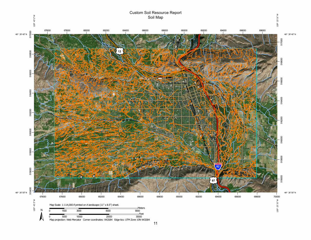
Soil MapThe soil map section includes the soil map for the defined area of interest, a list ofsoil map units on the map and extent of each map unit, and cartographic symbolsdisplayed on the map. Also presented are various metadata about data used toproduce the map, and a description of each soil map unit.
10
11
Custom Soil Resource ReportSoil Map
5154
000
5156
000
5158
000
5160
000
5162
000
5164
000
5166
000
5168
000
5170
000
5156
000
5158
000
5160
000
5162
000
5164
000
5166
000
5168
000
5170
000
676000 678000 680000 682000 684000 686000 688000 690000 692000 694000 696000 698000
676000 678000 680000 682000 684000 686000 688000 690000 692000 694000 696000 698000 700000
46° 39' 40'' N12
0° 4
3' 2
'' W46° 39' 40'' N
120°
23'
31'
' W
46° 30' 55'' N
120°
43'
2'' W
46° 30' 55'' N
120°
23'
31'
' W
N
Map projection: Web Mercator Corner coordinates: WGS84 Edge tics: UTM Zone 10N WGS840 5000 10000 20000 30000
Feet0 1500 3000 6000 9000
MetersMap Scale: 1:114,000 if printed on A landscape (11" x 8.5") sheet.
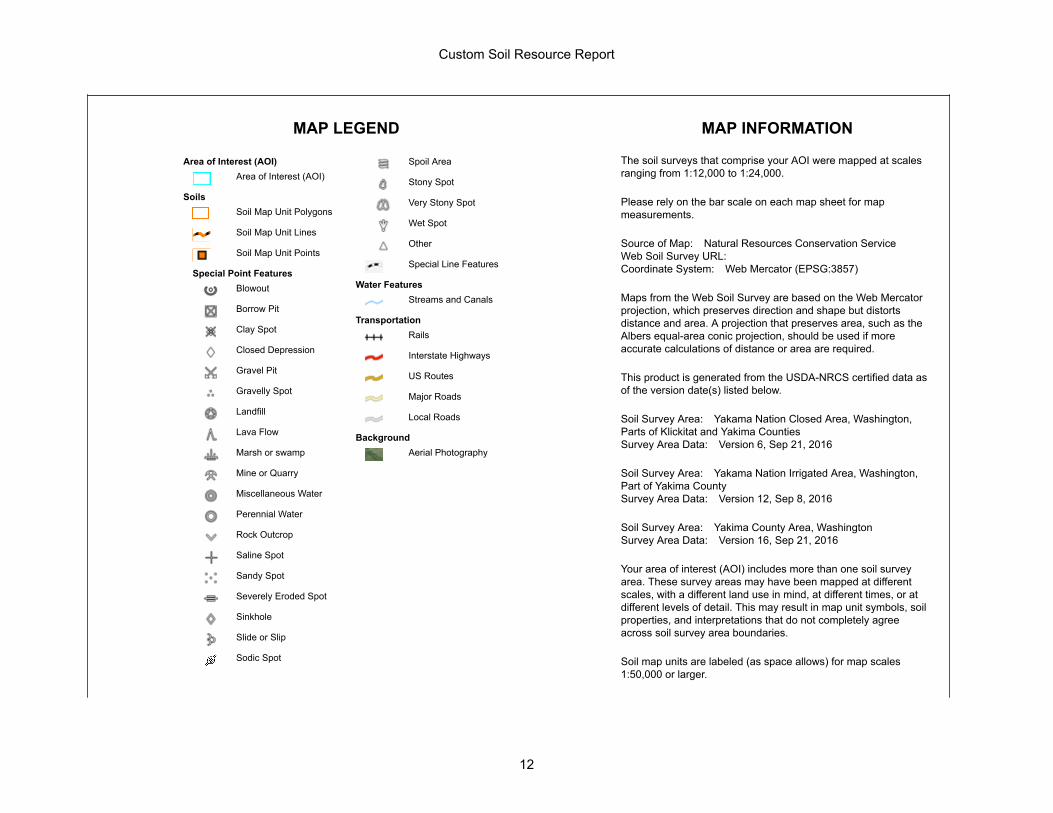
MAP LEGEND MAP INFORMATION
Area of Interest (AOI)Area of Interest (AOI)
SoilsSoil Map Unit Polygons
Soil Map Unit Lines
Soil Map Unit Points
Special Point FeaturesBlowout
Borrow Pit
Clay Spot
Closed Depression
Gravel Pit
Gravelly Spot
Landfill
Lava Flow
Marsh or swamp
Mine or Quarry
Miscellaneous Water
Perennial Water
Rock Outcrop
Saline Spot
Sandy Spot
Severely Eroded Spot
Sinkhole
Slide or Slip
Sodic Spot
Spoil Area
Stony Spot
Very Stony Spot
Wet Spot
Other
Special Line Features
Water FeaturesStreams and Canals
TransportationRails
Interstate Highways
US Routes
Major Roads
Local Roads
BackgroundAerial Photography
The soil surveys that comprise your AOI were mapped at scalesranging from 1:12,000 to 1:24,000.
Please rely on the bar scale on each map sheet for mapmeasurements.
Source of Map: Natural Resources Conservation ServiceWeb Soil Survey URL:Coordinate System: Web Mercator (EPSG:3857)
Maps from the Web Soil Survey are based on the Web Mercatorprojection, which preserves direction and shape but distortsdistance and area. A projection that preserves area, such as theAlbers equal-area conic projection, should be used if moreaccurate calculations of distance or area are required.
This product is generated from the USDA-NRCS certified data asof the version date(s) listed below.
Soil Survey Area: Yakama Nation Closed Area, Washington,Parts of Klickitat and Yakima CountiesSurvey Area Data: Version 6, Sep 21, 2016
Soil Survey Area: Yakama Nation Irrigated Area, Washington,Part of Yakima CountySurvey Area Data: Version 12, Sep 8, 2016
Soil Survey Area: Yakima County Area, WashingtonSurvey Area Data: Version 16, Sep 21, 2016
Your area of interest (AOI) includes more than one soil surveyarea. These survey areas may have been mapped at differentscales, with a different land use in mind, at different times, or atdifferent levels of detail. This may result in map unit symbols, soilproperties, and interpretations that do not completely agreeacross soil survey area boundaries.
Soil map units are labeled (as space allows) for map scales1:50,000 or larger.
Custom Soil Resource Report
12
MAP LEGEND MAP INFORMATION
Date(s) aerial images were photographed: Jul 19, 2010—Aug19, 2010
The orthophoto or other base map on which the soil lines werecompiled and digitized probably differs from the backgroundimagery displayed on these maps. As a result, some minorshifting of map unit boundaries may be evident.
Custom Soil Resource Report
13
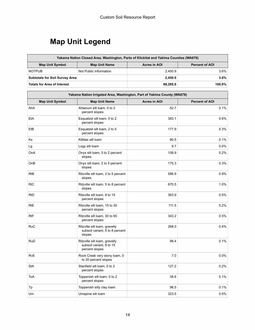
Map Unit Legend
Yakama Nation Closed Area, Washington, Parts of Klickitat and Yakima Counties (WA676)
Map Unit Symbol Map Unit Name Acres in AOI Percent of AOI
NOTPUB Not Public Information 2,450.9 3.6%
Subtotals for Soil Survey Area 2,450.9 3.6%
Totals for Area of Interest 68,285.6 100.0%
Yakama Nation Irrigated Area, Washington, Part of Yakima County (WA678)
Map Unit Symbol Map Unit Name Acres in AOI Percent of AOI
AhA Ahtanum silt loam, 0 to 2percent slopes
52.7 0.1%
EtA Esquatzel silt loam, 0 to 2percent slopes
383.1 0.6%
EtB Esquatzel silt loam, 2 to 5percent slopes
177.9 0.3%
Ks Kittitas silt loam 80.5 0.1%
Lg Logy silt loam 9.7 0.0%
OnA Onyx silt loam, 0 to 2 percentslopes
108.9 0.2%
OnB Onyx silt loam, 2 to 5 percentslopes
175.3 0.3%
RtB Ritzville silt loam, 2 to 5 percentslopes
586.9 0.9%
RtC Ritzville silt loam, 5 to 8 percentslopes
670.5 1.0%
RtD Ritzville silt loam, 8 to 15percent slopes
363.9 0.5%
RtE Ritzville silt loam, 15 to 30percent slopes
111.5 0.2%
RtF Ritzville silt loam, 30 to 65percent slopes
343.2 0.5%
RuC Ritzville silt loam, gravellysubsoil variant, 5 to 8 percentslopes
268.0 0.4%
RuD Ritzville silt loam, gravellysubsoil variant, 8 to 15percent slopes
98.4 0.1%
RvE Rock Creek very stony loam, 0to 20 percent slopes
7.0 0.0%
StA Stanfield silt loam, 0 to 2percent slopes
127.2 0.2%
ToA Toppenish silt loam, 0 to 2percent slopes
38.6 0.1%
Tp Toppenish silty clay loam 98.5 0.1%
Um Umapine silt loam 323.5 0.5%
Custom Soil Resource Report
14
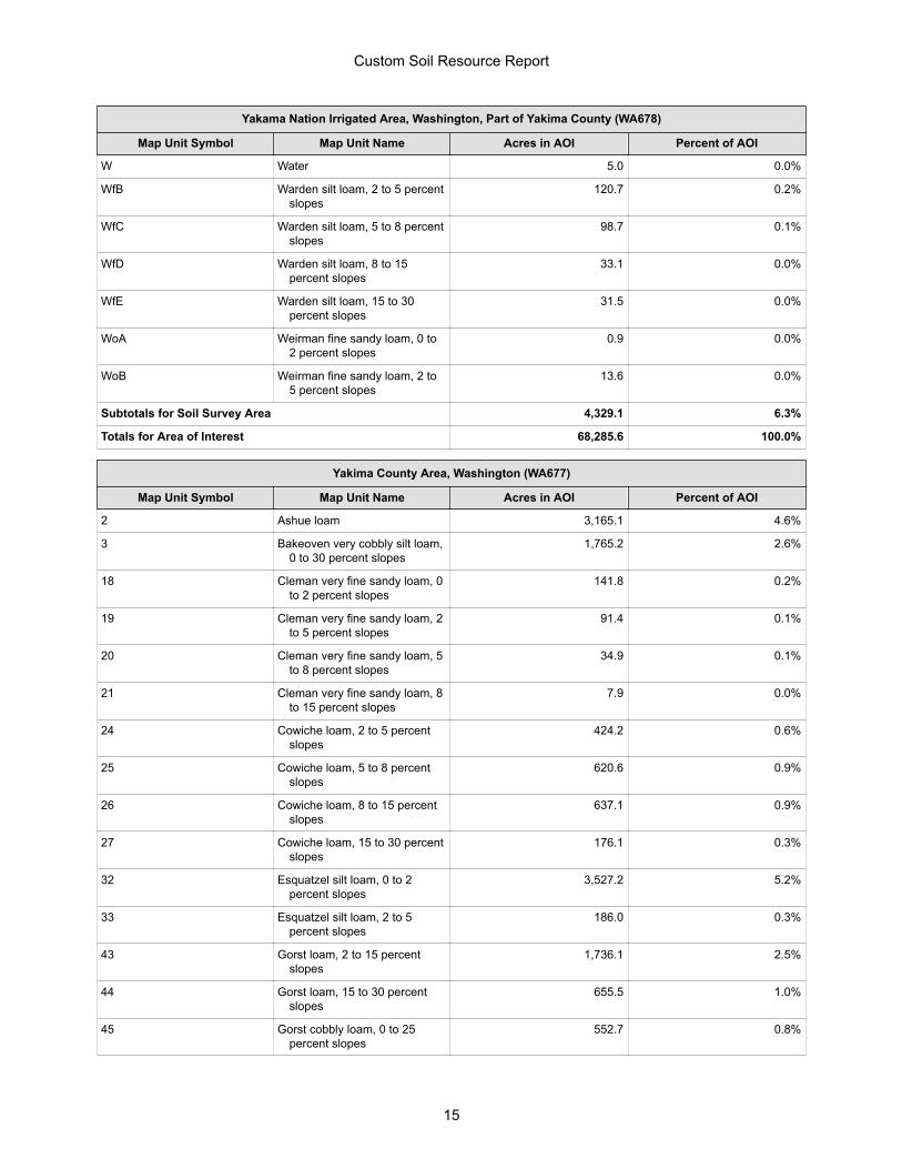
Yakama Nation Irrigated Area, Washington, Part of Yakima County (WA678)
Map Unit Symbol Map Unit Name Acres in AOI Percent of AOI
W Water 5.0 0.0%
WfB Warden silt loam, 2 to 5 percentslopes
120.7 0.2%
WfC Warden silt loam, 5 to 8 percentslopes
98.7 0.1%
WfD Warden silt loam, 8 to 15percent slopes
33.1 0.0%
WfE Warden silt loam, 15 to 30percent slopes
31.5 0.0%
WoA Weirman fine sandy loam, 0 to2 percent slopes
0.9 0.0%
WoB Weirman fine sandy loam, 2 to5 percent slopes
13.6 0.0%
Subtotals for Soil Survey Area 4,329.1 6.3%
Totals for Area of Interest 68,285.6 100.0%
Yakima County Area, Washington (WA677)
Map Unit Symbol Map Unit Name Acres in AOI Percent of AOI
2 Ashue loam 3,165.1 4.6%
3 Bakeoven very cobbly silt loam,0 to 30 percent slopes
1,765.2 2.6%
18 Cleman very fine sandy loam, 0to 2 percent slopes
141.8 0.2%
19 Cleman very fine sandy loam, 2to 5 percent slopes
91.4 0.1%
20 Cleman very fine sandy loam, 5to 8 percent slopes
34.9 0.1%
21 Cleman very fine sandy loam, 8to 15 percent slopes
7.9 0.0%
24 Cowiche loam, 2 to 5 percentslopes
424.2 0.6%
25 Cowiche loam, 5 to 8 percentslopes
620.6 0.9%
26 Cowiche loam, 8 to 15 percentslopes
637.1 0.9%
27 Cowiche loam, 15 to 30 percentslopes
176.1 0.3%
32 Esquatzel silt loam, 0 to 2percent slopes
3,527.2 5.2%
33 Esquatzel silt loam, 2 to 5percent slopes
186.0 0.3%
43 Gorst loam, 2 to 15 percentslopes
1,736.1 2.5%
44 Gorst loam, 15 to 30 percentslopes
655.5 1.0%
45 Gorst cobbly loam, 0 to 25percent slopes
552.7 0.8%
Custom Soil Resource Report
15
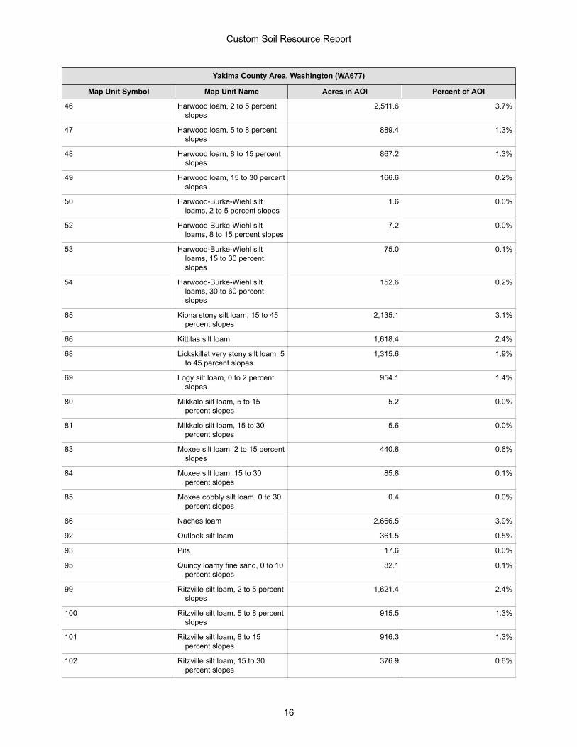
Yakima County Area, Washington (WA677)
Map Unit Symbol Map Unit Name Acres in AOI Percent of AOI
46 Harwood loam, 2 to 5 percentslopes
2,511.6 3.7%
47 Harwood loam, 5 to 8 percentslopes
889.4 1.3%
48 Harwood loam, 8 to 15 percentslopes
867.2 1.3%
49 Harwood loam, 15 to 30 percentslopes
166.6 0.2%
50 Harwood-Burke-Wiehl siltloams, 2 to 5 percent slopes
1.6 0.0%
52 Harwood-Burke-Wiehl siltloams, 8 to 15 percent slopes
7.2 0.0%
53 Harwood-Burke-Wiehl siltloams, 15 to 30 percentslopes
75.0 0.1%
54 Harwood-Burke-Wiehl siltloams, 30 to 60 percentslopes
152.6 0.2%
65 Kiona stony silt loam, 15 to 45percent slopes
2,135.1 3.1%
66 Kittitas silt loam 1,618.4 2.4%
68 Lickskillet very stony silt loam, 5to 45 percent slopes
1,315.6 1.9%
69 Logy silt loam, 0 to 2 percentslopes
954.1 1.4%
80 Mikkalo silt loam, 5 to 15percent slopes
5.2 0.0%
81 Mikkalo silt loam, 15 to 30percent slopes
5.6 0.0%
83 Moxee silt loam, 2 to 15 percentslopes
440.8 0.6%
84 Moxee silt loam, 15 to 30percent slopes
85.8 0.1%
85 Moxee cobbly silt loam, 0 to 30percent slopes
0.4 0.0%
86 Naches loam 2,666.5 3.9%
92 Outlook silt loam 361.5 0.5%
93 Pits 17.6 0.0%
95 Quincy loamy fine sand, 0 to 10percent slopes
82.1 0.1%
99 Ritzville silt loam, 2 to 5 percentslopes
1,621.4 2.4%
100 Ritzville silt loam, 5 to 8 percentslopes
915.5 1.3%
101 Ritzville silt loam, 8 to 15percent slopes
916.3 1.3%
102 Ritzville silt loam, 15 to 30percent slopes
376.9 0.6%
Custom Soil Resource Report
16
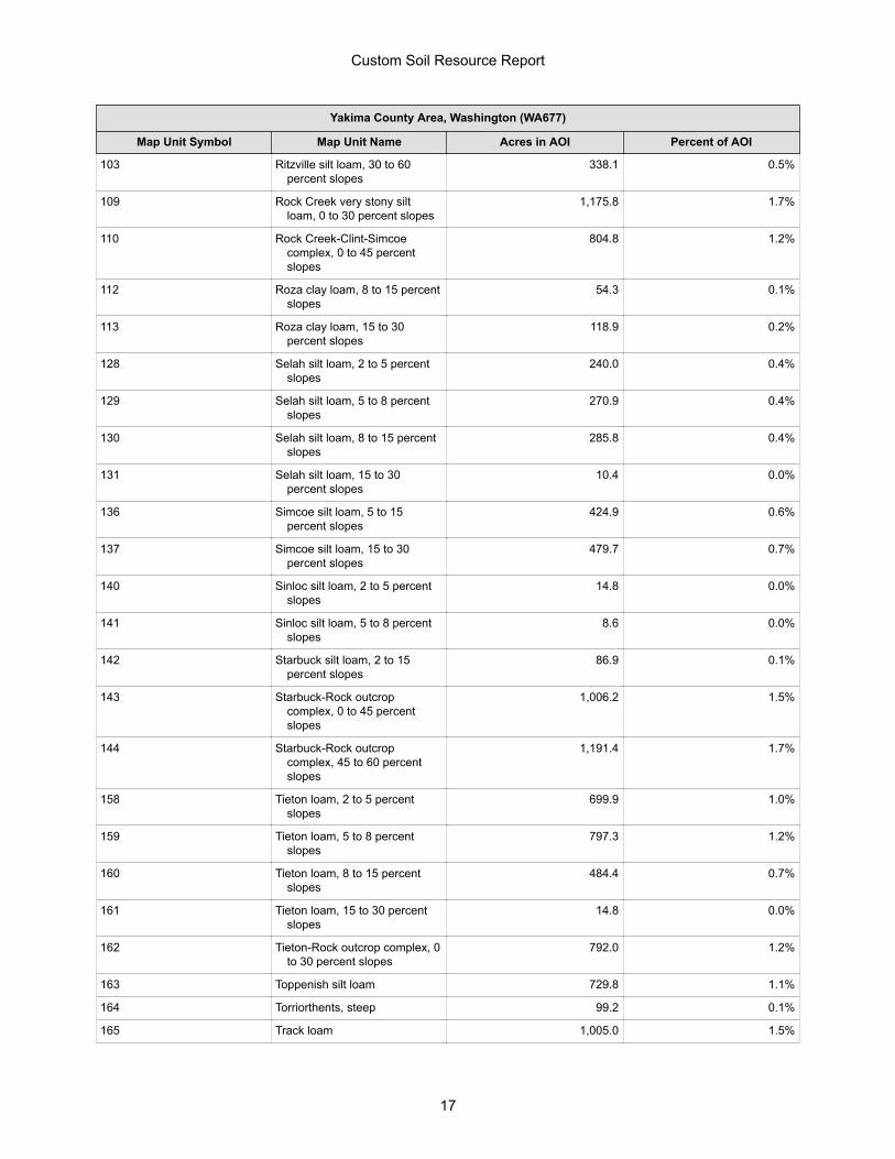
Yakima County Area, Washington (WA677)
Map Unit Symbol Map Unit Name Acres in AOI Percent of AOI
103 Ritzville silt loam, 30 to 60percent slopes
338.1 0.5%
109 Rock Creek very stony siltloam, 0 to 30 percent slopes
1,175.8 1.7%
110 Rock Creek-Clint-Simcoecomplex, 0 to 45 percentslopes
804.8 1.2%
112 Roza clay loam, 8 to 15 percentslopes
54.3 0.1%
113 Roza clay loam, 15 to 30percent slopes
118.9 0.2%
128 Selah silt loam, 2 to 5 percentslopes
240.0 0.4%
129 Selah silt loam, 5 to 8 percentslopes
270.9 0.4%
130 Selah silt loam, 8 to 15 percentslopes
285.8 0.4%
131 Selah silt loam, 15 to 30percent slopes
10.4 0.0%
136 Simcoe silt loam, 5 to 15percent slopes
424.9 0.6%
137 Simcoe silt loam, 15 to 30percent slopes
479.7 0.7%
140 Sinloc silt loam, 2 to 5 percentslopes
14.8 0.0%
141 Sinloc silt loam, 5 to 8 percentslopes
8.6 0.0%
142 Starbuck silt loam, 2 to 15percent slopes
86.9 0.1%
143 Starbuck-Rock outcropcomplex, 0 to 45 percentslopes
1,006.2 1.5%
144 Starbuck-Rock outcropcomplex, 45 to 60 percentslopes
1,191.4 1.7%
158 Tieton loam, 2 to 5 percentslopes
699.9 1.0%
159 Tieton loam, 5 to 8 percentslopes
797.3 1.2%
160 Tieton loam, 8 to 15 percentslopes
484.4 0.7%
161 Tieton loam, 15 to 30 percentslopes
14.8 0.0%
162 Tieton-Rock outcrop complex, 0to 30 percent slopes
792.0 1.2%
163 Toppenish silt loam 729.8 1.1%
164 Torriorthents, steep 99.2 0.1%
165 Track loam 1,005.0 1.5%
Custom Soil Resource Report
17
Yakima County Area, Washington (WA677)
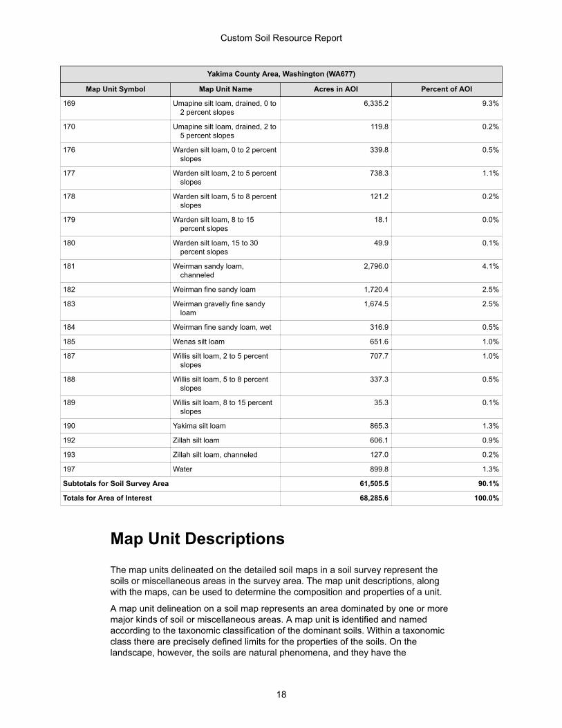
Map Unit Symbol Map Unit Name Acres in AOI Percent of AOI
169 Umapine silt loam, drained, 0 to2 percent slopes
6,335.2 9.3%
170 Umapine silt loam, drained, 2 to5 percent slopes
119.8 0.2%
176 Warden silt loam, 0 to 2 percentslopes
339.8 0.5%
177 Warden silt loam, 2 to 5 percentslopes
738.3 1.1%
178 Warden silt loam, 5 to 8 percentslopes
121.2 0.2%
179 Warden silt loam, 8 to 15percent slopes
18.1 0.0%
180 Warden silt loam, 15 to 30percent slopes
49.9 0.1%
181 Weirman sandy loam,channeled
2,796.0 4.1%
182 Weirman fine sandy loam 1,720.4 2.5%
183 Weirman gravelly fine sandyloam
1,674.5 2.5%
184 Weirman fine sandy loam, wet 316.9 0.5%
185 Wenas silt loam 651.6 1.0%
187 Willis silt loam, 2 to 5 percentslopes
707.7 1.0%
188 Willis silt loam, 5 to 8 percentslopes
337.3 0.5%
189 Willis silt loam, 8 to 15 percentslopes
35.3 0.1%
190 Yakima silt loam 865.3 1.3%
192 Zillah silt loam 606.1 0.9%
193 Zillah silt loam, channeled 127.0 0.2%
197 Water 899.8 1.3%
Subtotals for Soil Survey Area 61,505.5 90.1%
Totals for Area of Interest 68,285.6 100.0%
Map Unit DescriptionsThe map units delineated on the detailed soil maps in a soil survey represent thesoils or miscellaneous areas in the survey area. The map unit descriptions, alongwith the maps, can be used to determine the composition and properties of a unit.
A map unit delineation on a soil map represents an area dominated by one or moremajor kinds of soil or miscellaneous areas. A map unit is identified and namedaccording to the taxonomic classification of the dominant soils. Within a taxonomicclass there are precisely defined limits for the properties of the soils. On thelandscape, however, the soils are natural phenomena, and they have the
Custom Soil Resource Report
18
characteristic variability of all natural phenomena. Thus, the range of someobserved properties may extend beyond the limits defined for a taxonomic class.Areas of soils of a single taxonomic class rarely, if ever, can be mapped withoutincluding areas of other taxonomic classes. Consequently, every map unit is madeup of the soils or miscellaneous areas for which it is named and some minorcomponents that belong to taxonomic classes other than those of the major soils.
Most minor soils have properties similar to those of the dominant soil or soils in themap unit, and thus they do not affect use and management. These are callednoncontrasting, or similar, components. They may or may not be mentioned in aparticular map unit description. Other minor components, however, have propertiesand behavioral characteristics divergent enough to affect use or to require differentmanagement. These are called contrasting, or dissimilar, components. Theygenerally are in small areas and could not be mapped separately because of thescale used. Some small areas of strongly contrasting soils or miscellaneous areasare identified by a special symbol on the maps. If included in the database for agiven area, the contrasting minor components are identified in the map unitdescriptions along with some characteristics of each. A few areas of minorcomponents may not have been observed, and consequently they are notmentioned in the descriptions, especially where the pattern was so complex that itwas impractical to make enough observations to identify all the soils andmiscellaneous areas on the landscape.
The presence of minor components in a map unit in no way diminishes theusefulness or accuracy of the data. The objective of mapping is not to delineatepure taxonomic classes but rather to separate the landscape into landforms orlandform segments that have similar use and management requirements. Thedelineation of such segments on the map provides sufficient information for thedevelopment of resource plans. If intensive use of small areas is planned, however,onsite investigation is needed to define and locate the soils and miscellaneousareas.
An identifying symbol precedes the map unit name in the map unit descriptions.Each description includes general facts about the unit and gives important soilproperties and qualities.
Soils that have profiles that are almost alike make up a soil series. Except fordifferences in texture of the surface layer, all the soils of a series have majorhorizons that are similar in composition, thickness, and arrangement.
Soils of one series can differ in texture of the surface layer, slope, stoniness,salinity, degree of erosion, and other characteristics that affect their use. On thebasis of such differences, a soil series is divided into soil phases. Most of the areasshown on the detailed soil maps are phases of soil series. The name of a soil phasecommonly indicates a feature that affects use or management. For example, Alphasilt loam, 0 to 2 percent slopes, is a phase of the Alpha series.
Some map units are made up of two or more major soils or miscellaneous areas.These map units are complexes, associations, or undifferentiated groups.
A complex consists of two or more soils or miscellaneous areas in such an intricatepattern or in such small areas that they cannot be shown separately on the maps.The pattern and proportion of the soils or miscellaneous areas are somewhat similarin all areas. Alpha-Beta complex, 0 to 6 percent slopes, is an example.
An association is made up of two or more geographically associated soils ormiscellaneous areas that are shown as one unit on the maps. Because of presentor anticipated uses of the map units in the survey area, it was not considered
Custom Soil Resource Report
19
practical or necessary to map the soils or miscellaneous areas separately. Thepattern and relative proportion of the soils or miscellaneous areas are somewhatsimilar. Alpha-Beta association, 0 to 2 percent slopes, is an example.
An undifferentiated group is made up of two or more soils or miscellaneous areasthat could be mapped individually but are mapped as one unit because similarinterpretations can be made for use and management. The pattern and proportionof the soils or miscellaneous areas in a mapped area are not uniform. An area canbe made up of only one of the major soils or miscellaneous areas, or it can be madeup of all of them. Alpha and Beta soils, 0 to 2 percent slopes, is an example.
Some surveys include miscellaneous areas. Such areas have little or no soilmaterial and support little or no vegetation. Rock outcrop is an example.
Custom Soil Resource Report
20
Yakama Nation Closed Area, Washington, Parts of Klickitat and YakimaCounties
NOTPUB—Not Public Information
Map Unit CompositionNot public information: 100 percentEstimates are based on observations, descriptions, and transects of the mapunit.
Description of Not Public Information
Properties and qualitiesDepth to restrictive feature: More than 80 inchesDepth to water table: More than 80 inchesFrequency of flooding: NoneFrequency of ponding: None
Custom Soil Resource Report
21
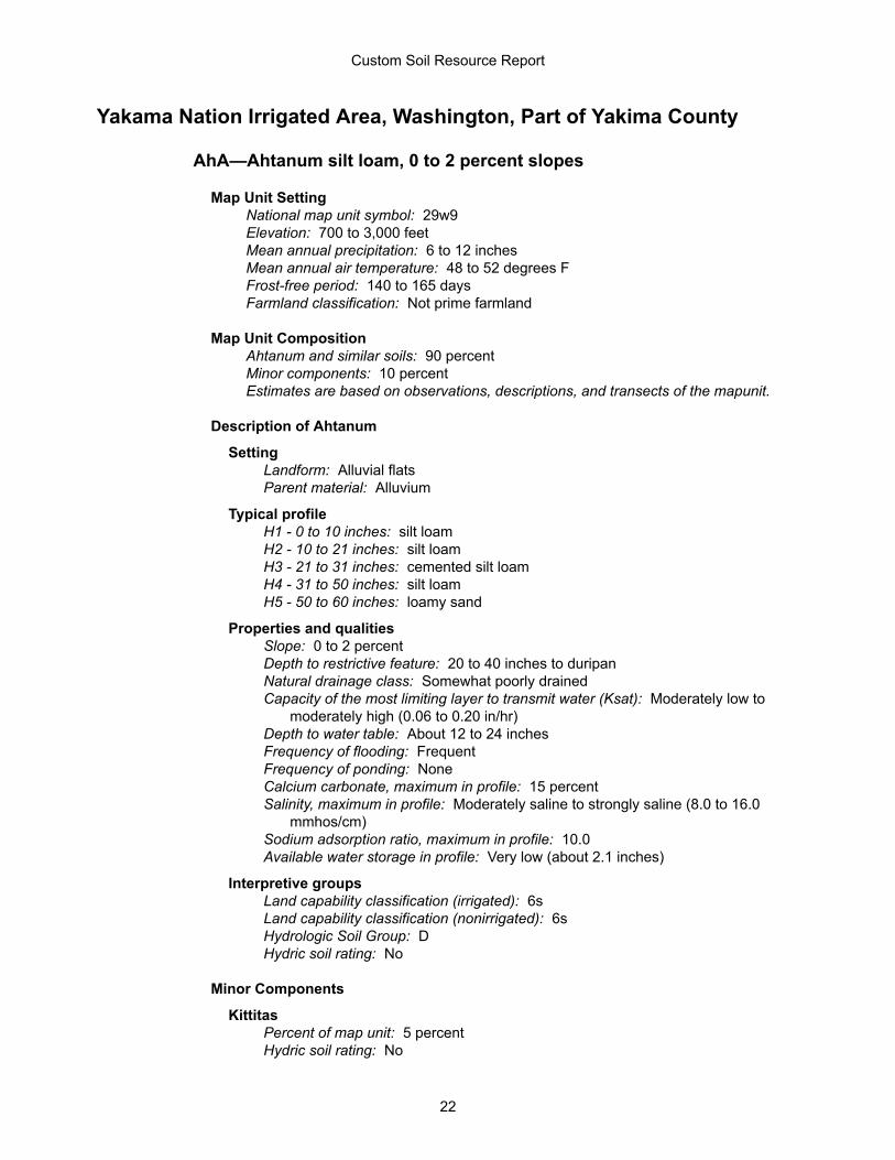
Yakama Nation Irrigated Area, Washington, Part of Yakima County
AhA—Ahtanum silt loam, 0 to 2 percent slopes
Map Unit SettingNational map unit symbol: 29w9Elevation: 700 to 3,000 feetMean annual precipitation: 6 to 12 inchesMean annual air temperature: 48 to 52 degrees FFrost-free period: 140 to 165 daysFarmland classification: Not prime farmland
Map Unit CompositionAhtanum and similar soils: 90 percentMinor components: 10 percentEstimates are based on observations, descriptions, and transects of the mapunit.
Description of Ahtanum
SettingLandform: Alluvial flatsParent material: Alluvium
Typical profileH1 - 0 to 10 inches: silt loamH2 - 10 to 21 inches: silt loamH3 - 21 to 31 inches: cemented silt loamH4 - 31 to 50 inches: silt loamH5 - 50 to 60 inches: loamy sand
Properties and qualitiesSlope: 0 to 2 percentDepth to restrictive feature: 20 to 40 inches to duripanNatural drainage class: Somewhat poorly drainedCapacity of the most limiting layer to transmit water (Ksat): Moderately low to
moderately high (0.06 to 0.20 in/hr)Depth to water table: About 12 to 24 inchesFrequency of flooding: FrequentFrequency of ponding: NoneCalcium carbonate, maximum in profile: 15 percentSalinity, maximum in profile: Moderately saline to strongly saline (8.0 to 16.0
mmhos/cm)Sodium adsorption ratio, maximum in profile: 10.0Available water storage in profile: Very low (about 2.1 inches)
Interpretive groupsLand capability classification (irrigated): 6sLand capability classification (nonirrigated): 6sHydrologic Soil Group: DHydric soil rating: No
Minor Components
KittitasPercent of map unit: 5 percentHydric soil rating: No
Custom Soil Resource Report
22
ToppenishPercent of map unit: 5 percentHydric soil rating: No
EtA—Esquatzel silt loam, 0 to 2 percent slopes
Map Unit SettingNational map unit symbol: 29wjElevation: 300 to 2,900 feetMean annual precipitation: 6 to 12 inchesMean annual air temperature: 48 to 54 degrees FFrost-free period: 130 to 200 daysFarmland classification: Prime farmland if irrigated
Map Unit CompositionEsquatzel and similar soils: 100 percentEstimates are based on observations, descriptions, and transects of the mapunit.
Description of Esquatzel
SettingLandform: Flood plainsParent material: Alluvium
Typical profileH1 - 0 to 9 inches: silt loamH2 - 9 to 30 inches: silt loamH3 - 30 to 60 inches: stratified fine sandy loam to silt loam
Properties and qualitiesSlope: 0 to 2 percentDepth to restrictive feature: More than 80 inchesNatural drainage class: Well drainedCapacity of the most limiting layer to transmit water (Ksat): Moderately high to
high (0.57 to 1.98 in/hr)Depth to water table: More than 80 inchesFrequency of flooding: NoneFrequency of ponding: NoneCalcium carbonate, maximum in profile: 5 percentSalinity, maximum in profile: Nonsaline to very slightly saline (0.0 to 2.0
mmhos/cm)Available water storage in profile: Very high (about 12.6 inches)
Interpretive groupsLand capability classification (irrigated): 2cLand capability classification (nonirrigated): 6cHydrologic Soil Group: BHydric soil rating: No
Custom Soil Resource Report
23
EtB—Esquatzel silt loam, 2 to 5 percent slopes
Map Unit SettingNational map unit symbol: 29wkElevation: 300 to 2,900 feetMean annual precipitation: 6 to 12 inchesMean annual air temperature: 48 to 54 degrees FFrost-free period: 130 to 200 daysFarmland classification: Prime farmland if irrigated
Map Unit CompositionEsquatzel and similar soils: 100 percentEstimates are based on observations, descriptions, and transects of the mapunit.
Description of Esquatzel
SettingLandform: Flood plainsParent material: Alluvium
Typical profileH1 - 0 to 9 inches: silt loamH2 - 9 to 30 inches: silt loamH3 - 30 to 60 inches: stratified fine sandy loam to silt loam
Properties and qualitiesSlope: 2 to 5 percentDepth to restrictive feature: More than 80 inchesNatural drainage class: Well drainedCapacity of the most limiting layer to transmit water (Ksat): Moderately high to
high (0.57 to 1.98 in/hr)Depth to water table: More than 80 inchesFrequency of flooding: NoneFrequency of ponding: NoneCalcium carbonate, maximum in profile: 5 percentSalinity, maximum in profile: Nonsaline to very slightly saline (0.0 to 2.0
mmhos/cm)Available water storage in profile: Very high (about 12.6 inches)
Interpretive groupsLand capability classification (irrigated): 2eLand capability classification (nonirrigated): 6eHydrologic Soil Group: BHydric soil rating: No
Custom Soil Resource Report
24
Ks—Kittitas silt loam
Map Unit SettingNational map unit symbol: 29wrElevation: 500 to 1,100 feetMean annual precipitation: 6 to 12 inchesMean annual air temperature: 48 to 52 degrees FFrost-free period: 130 to 180 daysFarmland classification: Not prime farmland
Map Unit CompositionKittitas, drained, and similar soils: 100 percentEstimates are based on observations, descriptions, and transects of the mapunit.
Description of Kittitas, Drained
SettingLandform: Alluvial flatsParent material: Alluvium
Typical profileH1 - 0 to 7 inches: silt loamH2 - 7 to 18 inches: silty clay loamH3 - 18 to 45 inches: silt loamH4 - 45 to 63 inches: stratified fine sandy loam to silty clay loam
Properties and qualitiesSlope: 0 to 2 percentDepth to restrictive feature: More than 80 inchesNatural drainage class: Somewhat poorly drainedCapacity of the most limiting layer to transmit water (Ksat): Moderately high (0.20
to 0.57 in/hr)Depth to water table: About 12 to 24 inchesFrequency of flooding: OccasionalFrequency of ponding: NoneCalcium carbonate, maximum in profile: 15 percentSalinity, maximum in profile: Slightly saline to moderately saline (4.0 to 8.0
mmhos/cm)Sodium adsorption ratio, maximum in profile: 5.0Available water storage in profile: High (about 11.3 inches)
Interpretive groupsLand capability classification (irrigated): 4wLand capability classification (nonirrigated): 6wHydrologic Soil Group: C/DHydric soil rating: Yes
Custom Soil Resource Report
25
Lg—Logy silt loam
Map Unit SettingNational map unit symbol: 29wtMean annual precipitation: 6 to 10 inchesMean annual air temperature: 50 degrees FFrost-free period: 130 to 180 daysFarmland classification: Prime farmland if irrigated
Map Unit CompositionLogy and similar soils: 100 percentEstimates are based on observations, descriptions, and transects of the mapunit.
Description of Logy
SettingLandform: Alluvial flatsParent material: Alluvium
Typical profileH1 - 0 to 12 inches: silt loamH2 - 12 to 19 inches: gravelly loamH3 - 19 to 39 inches: very gravelly sandy loamH4 - 39 to 60 inches: very gravelly coarse sand
Properties and qualitiesSlope: 0 to 5 percentDepth to restrictive feature: 20 to 40 inches to strongly contrasting textural
stratificationNatural drainage class: Well drainedCapacity of the most limiting layer to transmit water (Ksat): Moderately high to
high (0.57 to 1.98 in/hr)Depth to water table: More than 80 inchesFrequency of flooding: OccasionalFrequency of ponding: NoneAvailable water storage in profile: Low (about 3.9 inches)
Interpretive groupsLand capability classification (irrigated): 3wLand capability classification (nonirrigated): 6wHydrologic Soil Group: BHydric soil rating: No
OnA—Onyx silt loam, 0 to 2 percent slopes
Map Unit SettingNational map unit symbol: 29wy
Custom Soil Resource Report
26
Mean annual precipitation: 6 to 9 inchesMean annual air temperature: 48 to 52 degrees FFrost-free period: 130 to 180 daysFarmland classification: Prime farmland if irrigated
Map Unit CompositionOnyx variant and similar soils: 95 percentMinor components: 5 percentEstimates are based on observations, descriptions, and transects of the mapunit.
Description of Onyx Variant
SettingLandform: Flood plainsParent material: Alluvium
Typical profileH1 - 0 to 6 inches: silt loamH2 - 6 to 60 inches: silt loam
Properties and qualitiesSlope: 0 to 2 percentDepth to restrictive feature: More than 80 inchesNatural drainage class: Well drainedCapacity of the most limiting layer to transmit water (Ksat): Moderately high to
high (0.57 to 1.98 in/hr)Depth to water table: More than 80 inchesFrequency of flooding: OccasionalFrequency of ponding: NoneSalinity, maximum in profile: Nonsaline to very slightly saline (0.0 to 2.0
mmhos/cm)Available water storage in profile: High (about 12.0 inches)
Interpretive groupsLand capability classification (irrigated): 3wLand capability classification (nonirrigated): 6wHydrologic Soil Group: BHydric soil rating: No
Minor Components
ZillahPercent of map unit: 5 percentLandform: ChannelsHydric soil rating: Yes
OnB—Onyx silt loam, 2 to 5 percent slopes
Map Unit SettingNational map unit symbol: 29wzMean annual precipitation: 6 to 9 inches
Custom Soil Resource Report
27
Mean annual air temperature: 48 to 52 degrees FFrost-free period: 130 to 180 daysFarmland classification: Prime farmland if irrigated
Map Unit CompositionOnyx variant and similar soils: 100 percentEstimates are based on observations, descriptions, and transects of the mapunit.
Description of Onyx Variant
SettingLandform: Flood plainsParent material: Alluvium
Typical profileH1 - 0 to 6 inches: silt loamH2 - 6 to 60 inches: silt loam
Properties and qualitiesSlope: 2 to 5 percentDepth to restrictive feature: More than 80 inchesNatural drainage class: Well drainedCapacity of the most limiting layer to transmit water (Ksat): Moderately high to
high (0.57 to 1.98 in/hr)Depth to water table: More than 80 inchesFrequency of flooding: OccasionalFrequency of ponding: NoneSalinity, maximum in profile: Nonsaline to very slightly saline (0.0 to 2.0
mmhos/cm)Available water storage in profile: High (about 12.0 inches)
Interpretive groupsLand capability classification (irrigated): 3wLand capability classification (nonirrigated): 6wHydrologic Soil Group: BHydric soil rating: No
RtB—Ritzville silt loam, 2 to 5 percent slopes
Map Unit SettingNational map unit symbol: 29x2Elevation: 800 to 3,000 feetMean annual precipitation: 9 to 12 inchesMean annual air temperature: 48 to 52 degrees FFrost-free period: 100 to 180 daysFarmland classification: Prime farmland if irrigated
Map Unit CompositionRitzville and similar soils: 100 percentEstimates are based on observations, descriptions, and transects of the mapunit.
Custom Soil Resource Report
28
Description of Ritzville
SettingLandform: HillslopesParent material: Loess
Typical profileH1 - 0 to 9 inches: silt loamH2 - 9 to 33 inches: silt loamH3 - 33 to 60 inches: silt loam
Properties and qualitiesSlope: 2 to 5 percentDepth to restrictive feature: More than 80 inchesNatural drainage class: Well drainedCapacity of the most limiting layer to transmit water (Ksat): Moderately high to
high (0.57 to 1.98 in/hr)Depth to water table: More than 80 inchesFrequency of flooding: NoneFrequency of ponding: NoneCalcium carbonate, maximum in profile: 15 percentAvailable water storage in profile: High (about 12.0 inches)
Interpretive groupsLand capability classification (irrigated): 2eLand capability classification (nonirrigated): 3eHydrologic Soil Group: BHydric soil rating: No
RtC—Ritzville silt loam, 5 to 8 percent slopes
Map Unit SettingNational map unit symbol: 29x3Elevation: 800 to 3,000 feetMean annual precipitation: 9 to 12 inchesMean annual air temperature: 48 to 52 degrees FFrost-free period: 100 to 180 daysFarmland classification: Farmland of statewide importance
Map Unit CompositionRitzville and similar soils: 100 percentEstimates are based on observations, descriptions, and transects of the mapunit.
Description of Ritzville
SettingLandform: HillslopesParent material: Loess
Typical profileH1 - 0 to 9 inches: silt loamH2 - 9 to 33 inches: silt loam
Custom Soil Resource Report
29
H3 - 33 to 60 inches: silt loam
Properties and qualitiesSlope: 5 to 8 percentDepth to restrictive feature: More than 80 inchesNatural drainage class: Well drainedCapacity of the most limiting layer to transmit water (Ksat): Moderately high to
high (0.57 to 1.98 in/hr)Depth to water table: More than 80 inchesFrequency of flooding: NoneFrequency of ponding: NoneCalcium carbonate, maximum in profile: 15 percentAvailable water storage in profile: High (about 12.0 inches)
Interpretive groupsLand capability classification (irrigated): 3eLand capability classification (nonirrigated): 3eHydrologic Soil Group: BHydric soil rating: No
RtD—Ritzville silt loam, 8 to 15 percent slopes
Map Unit SettingNational map unit symbol: 29x4Elevation: 800 to 3,000 feetMean annual precipitation: 9 to 12 inchesMean annual air temperature: 48 to 52 degrees FFrost-free period: 100 to 180 daysFarmland classification: Farmland of unique importance
Map Unit CompositionRitzville and similar soils: 100 percentEstimates are based on observations, descriptions, and transects of the mapunit.
Description of Ritzville
SettingLandform: HillslopesParent material: Loess
Typical profileH1 - 0 to 9 inches: silt loamH2 - 9 to 33 inches: silt loamH3 - 33 to 60 inches: silt loam
Properties and qualitiesSlope: 8 to 15 percentDepth to restrictive feature: More than 80 inchesNatural drainage class: Well drainedCapacity of the most limiting layer to transmit water (Ksat): Moderately high to
high (0.57 to 1.98 in/hr)Depth to water table: More than 80 inchesFrequency of flooding: None
Custom Soil Resource Report
30
Frequency of ponding: NoneCalcium carbonate, maximum in profile: 15 percentAvailable water storage in profile: High (about 12.0 inches)
Interpretive groupsLand capability classification (irrigated): 4eLand capability classification (nonirrigated): 3eHydrologic Soil Group: BHydric soil rating: No
RtE—Ritzville silt loam, 15 to 30 percent slopes
Map Unit SettingNational map unit symbol: 29x5Elevation: 800 to 3,000 feetMean annual precipitation: 9 to 12 inchesMean annual air temperature: 48 to 52 degrees FFrost-free period: 100 to 180 daysFarmland classification: Farmland of unique importance
Map Unit CompositionRitzville and similar soils: 100 percentEstimates are based on observations, descriptions, and transects of the mapunit.
Description of Ritzville
SettingLandform: HillslopesParent material: Loess
Typical profileH1 - 0 to 9 inches: silt loamH2 - 9 to 33 inches: silt loamH3 - 33 to 60 inches: silt loam
Properties and qualitiesSlope: 15 to 30 percentDepth to restrictive feature: More than 80 inchesNatural drainage class: Well drainedCapacity of the most limiting layer to transmit water (Ksat): Moderately high to
high (0.57 to 1.98 in/hr)Depth to water table: More than 80 inchesFrequency of flooding: NoneFrequency of ponding: NoneCalcium carbonate, maximum in profile: 15 percentAvailable water storage in profile: High (about 12.0 inches)
Interpretive groupsLand capability classification (irrigated): 6eLand capability classification (nonirrigated): 4eHydrologic Soil Group: BHydric soil rating: No
Custom Soil Resource Report
31
RtF—Ritzville silt loam, 30 to 65 percent slopes
Map Unit SettingNational map unit symbol: 29x6Elevation: 800 to 3,000 feetMean annual precipitation: 9 to 12 inchesMean annual air temperature: 48 to 52 degrees FFrost-free period: 100 to 180 daysFarmland classification: Not prime farmland
Map Unit CompositionRitzville and similar soils: 100 percentEstimates are based on observations, descriptions, and transects of the mapunit.
Description of Ritzville
SettingLandform: HillslopesParent material: Loess
Typical profileH1 - 0 to 9 inches: silt loamH2 - 9 to 33 inches: silt loamH3 - 33 to 60 inches: silt loam
Properties and qualitiesSlope: 30 to 65 percentDepth to restrictive feature: More than 80 inchesNatural drainage class: Well drainedCapacity of the most limiting layer to transmit water (Ksat): Moderately high to
high (0.57 to 1.98 in/hr)Depth to water table: More than 80 inchesFrequency of flooding: NoneFrequency of ponding: NoneCalcium carbonate, maximum in profile: 15 percentAvailable water storage in profile: High (about 12.0 inches)
Interpretive groupsLand capability classification (irrigated): None specifiedLand capability classification (nonirrigated): 7eHydrologic Soil Group: BHydric soil rating: No
RuC—Ritzville silt loam, gravelly subsoil variant, 5 to 8 percent slopes
Map Unit SettingNational map unit symbol: 29x7
Custom Soil Resource Report
32
Mean annual precipitation: 9 to 12 inchesMean annual air temperature: 48 degrees FFrost-free period: 140 daysFarmland classification: Farmland of statewide importance
Map Unit CompositionRitzville variant and similar soils: 100 percentEstimates are based on observations, descriptions, and transects of the mapunit.
Description of Ritzville Variant
SettingLandform: HillslopesParent material: Loess over alluvium
Typical profileH1 - 0 to 9 inches: silt loamH2 - 9 to 22 inches: silt loamH3 - 22 to 60 inches: very cobbly silt loam
Properties and qualitiesSlope: 5 to 8 percentDepth to restrictive feature: More than 80 inchesNatural drainage class: Well drainedCapacity of the most limiting layer to transmit water (Ksat): Moderately high to
high (0.57 to 1.98 in/hr)Depth to water table: More than 80 inchesFrequency of flooding: NoneFrequency of ponding: NoneSalinity, maximum in profile: Nonsaline to very slightly saline (0.0 to 2.0
mmhos/cm)Available water storage in profile: Moderate (about 8.3 inches)
Interpretive groupsLand capability classification (irrigated): 3eLand capability classification (nonirrigated): 3eHydrologic Soil Group: BHydric soil rating: No
RuD—Ritzville silt loam, gravelly subsoil variant, 8 to 15 percent slopes
Map Unit SettingNational map unit symbol: 29x8Mean annual precipitation: 9 to 12 inchesMean annual air temperature: 48 degrees FFrost-free period: 140 daysFarmland classification: Farmland of unique importance
Map Unit CompositionRitzville variant and similar soils: 100 percentEstimates are based on observations, descriptions, and transects of the mapunit.
Custom Soil Resource Report
33
Description of Ritzville Variant
SettingLandform: HillslopesParent material: Loess over alluvium
Typical profileH1 - 0 to 9 inches: silt loamH2 - 9 to 22 inches: silt loamH3 - 22 to 60 inches: very cobbly silt loam
Properties and qualitiesSlope: 8 to 15 percentDepth to restrictive feature: More than 80 inchesNatural drainage class: Well drainedCapacity of the most limiting layer to transmit water (Ksat): Moderately high to
high (0.57 to 1.98 in/hr)Depth to water table: More than 80 inchesFrequency of flooding: NoneFrequency of ponding: NoneSalinity, maximum in profile: Nonsaline to very slightly saline (0.0 to 2.0
mmhos/cm)Available water storage in profile: Moderate (about 8.3 inches)
Interpretive groupsLand capability classification (irrigated): 4eLand capability classification (nonirrigated): 3eHydrologic Soil Group: BHydric soil rating: No
RvE—Rock Creek very stony loam, 0 to 20 percent slopes
Map Unit SettingNational map unit symbol: 29x9Elevation: 1,400 to 4,200 feetMean annual precipitation: 10 to 16 inchesMean annual air temperature: 48 to 50 degrees FFrost-free period: 120 to 170 daysFarmland classification: Not prime farmland
Map Unit CompositionRock creek and similar soils: 100 percentEstimates are based on observations, descriptions, and transects of the mapunit.
Description of Rock Creek
SettingLandform: HillslopesParent material: Residuum from basalt mixed with loess
Typical profileH1 - 0 to 2 inches: very stony loam
Custom Soil Resource Report
34
H2 - 2 to 14 inches: very cobbly clay loamH3 - 14 to 18 inches: unweathered bedrock
Properties and qualitiesSlope: 0 to 20 percentDepth to restrictive feature: 8 to 20 inches to lithic bedrockNatural drainage class: Well drainedCapacity of the most limiting layer to transmit water (Ksat): Moderately high (0.20
to 0.57 in/hr)Depth to water table: More than 80 inchesFrequency of flooding: NoneFrequency of ponding: NoneAvailable water storage in profile: Very low (about 0.8 inches)
Interpretive groupsLand capability classification (irrigated): None specifiedLand capability classification (nonirrigated): 7sHydrologic Soil Group: DHydric soil rating: No
StA—Stanfield silt loam, 0 to 2 percent slopes
Map Unit SettingNational map unit symbol: 29xmElevation: 300 to 3,500 feetMean annual precipitation: 8 to 12 inchesMean annual air temperature: 46 to 54 degrees FFrost-free period: 120 to 195 daysFarmland classification: Not prime farmland
Map Unit CompositionStanfield and similar soils: 95 percentMinor components: 5 percentEstimates are based on observations, descriptions, and transects of the mapunit.
Description of Stanfield
SettingLandform: Alluvial flatsParent material: Alluvium
Typical profileH1 - 0 to 4 inches: silt loamH2 - 4 to 23 inches: silt loamH3 - 23 to 27 inches: cemented material
Properties and qualitiesSlope: 0 to 2 percentDepth to restrictive feature: 20 to 40 inches to duripanNatural drainage class: Moderately well drainedCapacity of the most limiting layer to transmit water (Ksat): Very low to moderately
low (0.00 to 0.06 in/hr)Depth to water table: About 18 to 38 inches
Custom Soil Resource Report
35
Frequency of flooding: NoneFrequency of ponding: NoneCalcium carbonate, maximum in profile: 15 percentSalinity, maximum in profile: Nonsaline to slightly saline (0.0 to 4.0 mmhos/cm)Available water storage in profile: Low (about 3.8 inches)
Interpretive groupsLand capability classification (irrigated): 4sLand capability classification (nonirrigated): 6sHydrologic Soil Group: DHydric soil rating: No
Minor Components
AhtanumPercent of map unit: 5 percentLandform: DepressionsHydric soil rating: Yes
ToA—Toppenish silt loam, 0 to 2 percent slopes
Map Unit SettingNational map unit symbol: 29xpElevation: 700 to 1,800 feetMean annual precipitation: 6 to 9 inchesMean annual air temperature: 50 to 52 degrees FFrost-free period: 130 to 180 daysFarmland classification: Prime farmland if drained
Map Unit CompositionToppenish and similar soils: 95 percentMinor components: 5 percentEstimates are based on observations, descriptions, and transects of the mapunit.
Description of Toppenish
SettingLandform: Alluvial flatsParent material: Alluvium
Typical profileH1 - 0 to 6 inches: silt loamH2 - 6 to 31 inches: silty clay loamH3 - 31 to 46 inches: clay loamH4 - 46 to 60 inches: very gravelly sandy loam
Properties and qualitiesSlope: 0 to 2 percentDepth to restrictive feature: More than 80 inchesNatural drainage class: Somewhat poorly drained
Custom Soil Resource Report
36
Capacity of the most limiting layer to transmit water (Ksat): Moderately high (0.20to 0.57 in/hr)
Depth to water table: About 12 to 24 inchesFrequency of flooding: NoneFrequency of ponding: NoneCalcium carbonate, maximum in profile: 5 percentSalinity, maximum in profile: Nonsaline to slightly saline (0.0 to 4.0 mmhos/cm)Sodium adsorption ratio, maximum in profile: 10.0Available water storage in profile: Moderate (about 6.3 inches)
Interpretive groupsLand capability classification (irrigated): 4wLand capability classification (nonirrigated): 6wHydrologic Soil Group: C/DHydric soil rating: No
Minor Components
TrackPercent of map unit: 5 percentLandform: DepressionsHydric soil rating: Yes
Tp—Toppenish silty clay loam
Map Unit SettingNational map unit symbol: 29xrElevation: 700 to 1,800 feetMean annual precipitation: 6 to 9 inchesMean annual air temperature: 50 to 52 degrees FFrost-free period: 130 to 180 daysFarmland classification: Prime farmland if drained
Map Unit CompositionToppenish and similar soils: 95 percentMinor components: 5 percentEstimates are based on observations, descriptions, and transects of the mapunit.
Description of Toppenish
SettingLandform: Alluvial flatsParent material: Alluvium
Typical profileH1 - 0 to 6 inches: silty clay loamH2 - 6 to 31 inches: silty clay loamH3 - 31 to 46 inches: very gravelly clay loam, very gravelly loamH3 - 31 to 46 inches: very gravelly sandy loamH4 - 46 to 60 inches:
Custom Soil Resource Report
37
Properties and qualitiesSlope: 0 to 2 percentDepth to restrictive feature: More than 80 inchesNatural drainage class: Somewhat poorly drainedCapacity of the most limiting layer to transmit water (Ksat): Moderately high (0.20
to 0.57 in/hr)Depth to water table: About 12 to 24 inchesFrequency of flooding: NoneFrequency of ponding: NoneSalinity, maximum in profile: Nonsaline to slightly saline (0.0 to 4.0 mmhos/cm)Sodium adsorption ratio, maximum in profile: 10.0Available water storage in profile: Moderate (about 7.5 inches)
Interpretive groupsLand capability classification (irrigated): 4wLand capability classification (nonirrigated): 6wHydrologic Soil Group: C/DHydric soil rating: No
Minor Components
YostPercent of map unit: 5 percentLandform: DepressionsHydric soil rating: Yes
Um—Umapine silt loam
Map Unit SettingNational map unit symbol: 29xwElevation: 250 to 3,500 feetMean annual precipitation: 6 to 12 inchesMean annual air temperature: 48 to 50 degrees FFrost-free period: 110 to 195 daysFarmland classification: Not prime farmland
Map Unit CompositionUmapine and similar soils: 100 percentEstimates are based on observations, descriptions, and transects of the mapunit.
Description of Umapine
SettingLandform: Terraces, flood plainsParent material: Alluvium
Typical profileH1 - 0 to 5 inches: silt loamH2 - 5 to 60 inches: silt loam
Custom Soil Resource Report
38
Properties and qualitiesSlope: 0 to 2 percentDepth to restrictive feature: More than 80 inchesNatural drainage class: Somewhat poorly drainedCapacity of the most limiting layer to transmit water (Ksat): Moderately high to
high (0.57 to 1.98 in/hr)Depth to water table: About 24 to 42 inchesFrequency of flooding: OccasionalFrequency of ponding: NoneCalcium carbonate, maximum in profile: 15 percentSalinity, maximum in profile: Slightly saline to moderately saline (4.0 to 8.0
mmhos/cm)Sodium adsorption ratio, maximum in profile: 20.0Available water storage in profile: High (about 11.9 inches)
Interpretive groupsLand capability classification (irrigated): 6sLand capability classification (nonirrigated): 6sHydrologic Soil Group: CHydric soil rating: No
W—Water
Map Unit CompositionWater: 100 percentEstimates are based on observations, descriptions, and transects of the mapunit.
Description of Water
SettingParent material: Alluvium
WfB—Warden silt loam, 2 to 5 percent slopes
Map Unit SettingNational map unit symbol: 29y4Elevation: 600 to 1,300 feetMean annual precipitation: 6 to 9 inchesMean annual air temperature: 48 to 52 degrees FFrost-free period: 135 to 200 daysFarmland classification: Prime farmland if irrigated
Map Unit CompositionWarden and similar soils: 100 percentEstimates are based on observations, descriptions, and transects of the mapunit.
Custom Soil Resource Report
39
Description of Warden
SettingLandform: Hillslopes, terracesParent material: Loess over lacustrine deposits
Typical profileH1 - 0 to 12 inches: silt loamH2 - 12 to 22 inches: silt loamH3 - 22 to 60 inches: stratified very fine sandy loam to silt loam
Properties and qualitiesSlope: 2 to 5 percentDepth to restrictive feature: More than 80 inchesNatural drainage class: Well drainedCapacity of the most limiting layer to transmit water (Ksat): Moderately high to
high (0.57 to 1.98 in/hr)Depth to water table: More than 80 inchesFrequency of flooding: NoneFrequency of ponding: NoneCalcium carbonate, maximum in profile: 5 percentSalinity, maximum in profile: Nonsaline to very slightly saline (0.0 to 2.0
mmhos/cm)Available water storage in profile: High (about 11.8 inches)
Interpretive groupsLand capability classification (irrigated): 2eLand capability classification (nonirrigated): 6eHydrologic Soil Group: BHydric soil rating: No
WfC—Warden silt loam, 5 to 8 percent slopes
Map Unit SettingNational map unit symbol: 29y5Elevation: 600 to 1,300 feetMean annual precipitation: 6 to 9 inchesMean annual air temperature: 48 to 52 degrees FFrost-free period: 135 to 200 daysFarmland classification: Farmland of statewide importance
Map Unit CompositionWarden and similar soils: 100 percentEstimates are based on observations, descriptions, and transects of the mapunit.
Description of Warden
SettingLandform: Hillslopes, terracesParent material: Loess over lacustrine deposits
Custom Soil Resource Report
40
Typical profileH1 - 0 to 12 inches: silt loamH2 - 12 to 22 inches: silt loamH3 - 22 to 60 inches: stratified very fine sandy loam to silt loam
Properties and qualitiesSlope: 5 to 8 percentDepth to restrictive feature: More than 80 inchesNatural drainage class: Well drainedCapacity of the most limiting layer to transmit water (Ksat): Moderately high to
high (0.57 to 1.98 in/hr)Depth to water table: More than 80 inchesFrequency of flooding: NoneFrequency of ponding: NoneCalcium carbonate, maximum in profile: 5 percentSalinity, maximum in profile: Nonsaline to very slightly saline (0.0 to 2.0
mmhos/cm)Available water storage in profile: High (about 11.8 inches)
Interpretive groupsLand capability classification (irrigated): 3eLand capability classification (nonirrigated): 6eHydrologic Soil Group: BHydric soil rating: No
WfD—Warden silt loam, 8 to 15 percent slopes
Map Unit SettingNational map unit symbol: 29y6Elevation: 600 to 1,300 feetMean annual precipitation: 6 to 9 inchesMean annual air temperature: 48 to 52 degrees FFrost-free period: 135 to 200 daysFarmland classification: Farmland of unique importance
Map Unit CompositionWarden and similar soils: 100 percentEstimates are based on observations, descriptions, and transects of the mapunit.
Description of Warden
SettingLandform: Hillslopes, terracesParent material: Loess over lacustrine deposits
Typical profileH1 - 0 to 12 inches: silt loamH2 - 12 to 22 inches: silt loamH3 - 22 to 60 inches: stratified very fine sandy loam to silt loam
Properties and qualitiesSlope: 8 to 15 percent
Custom Soil Resource Report
41
Depth to restrictive feature: More than 80 inchesNatural drainage class: Well drainedCapacity of the most limiting layer to transmit water (Ksat): Moderately high to
high (0.57 to 1.98 in/hr)Depth to water table: More than 80 inchesFrequency of flooding: NoneFrequency of ponding: NoneCalcium carbonate, maximum in profile: 5 percentSalinity, maximum in profile: Nonsaline to very slightly saline (0.0 to 2.0
mmhos/cm)Available water storage in profile: High (about 11.8 inches)
Interpretive groupsLand capability classification (irrigated): 3eLand capability classification (nonirrigated): 6eHydrologic Soil Group: BHydric soil rating: No
WfE—Warden silt loam, 15 to 30 percent slopes
Map Unit SettingNational map unit symbol: 29y7Elevation: 600 to 1,300 feetMean annual precipitation: 6 to 9 inchesMean annual air temperature: 48 to 52 degrees FFrost-free period: 135 to 200 daysFarmland classification: Farmland of unique importance
Map Unit CompositionWarden and similar soils: 100 percentEstimates are based on observations, descriptions, and transects of the mapunit.
Description of Warden
SettingLandform: Hillslopes, terracesParent material: Loess over lacustrine deposits
Typical profileH1 - 0 to 12 inches: silt loamH2 - 12 to 22 inches: silt loamH3 - 22 to 60 inches: stratified very fine sandy loam to silt loam
Properties and qualitiesSlope: 15 to 30 percentDepth to restrictive feature: More than 80 inchesNatural drainage class: Well drainedCapacity of the most limiting layer to transmit water (Ksat): Moderately high to
high (0.57 to 1.98 in/hr)Depth to water table: More than 80 inchesFrequency of flooding: NoneFrequency of ponding: None
Custom Soil Resource Report
42
Calcium carbonate, maximum in profile: 5 percentSalinity, maximum in profile: Nonsaline to very slightly saline (0.0 to 2.0
mmhos/cm)Available water storage in profile: High (about 11.8 inches)
Interpretive groupsLand capability classification (irrigated): 6eLand capability classification (nonirrigated): 6eHydrologic Soil Group: BHydric soil rating: No
WoA—Weirman fine sandy loam, 0 to 2 percent slopes
Map Unit SettingNational map unit symbol: 29ybElevation: 400 to 2,200 feetMean annual precipitation: 6 to 14 inchesMean annual air temperature: 48 to 50 degrees FFrost-free period: 130 to 180 daysFarmland classification: Not prime farmland
Map Unit CompositionWeirman and similar soils: 90 percentMinor components: 10 percentEstimates are based on observations, descriptions, and transects of the mapunit.
Description of Weirman
SettingLandform: Alluvial flatsParent material: Alluvium
Typical profileH1 - 0 to 9 inches: fine sandy loamH2 - 9 to 20 inches: loamy fine sandH3 - 20 to 60 inches: very gravelly loamy sand
Properties and qualitiesSlope: 0 to 2 percentDepth to restrictive feature: More than 80 inchesNatural drainage class: Somewhat excessively drainedCapacity of the most limiting layer to transmit water (Ksat): High (1.98 to 5.95
in/hr)Depth to water table: About 36 to 60 inchesFrequency of flooding: OccasionalFrequency of ponding: NoneAvailable water storage in profile: Very low (about 2.9 inches)
Interpretive groupsLand capability classification (irrigated): 4sLand capability classification (nonirrigated): 4sHydrologic Soil Group: AHydric soil rating: No
Custom Soil Resource Report
43
Minor Components
TrackPercent of map unit: 5 percentLandform: DepressionsHydric soil rating: Yes
ZillahPercent of map unit: 5 percentLandform: ChannelsHydric soil rating: Yes
WoB—Weirman fine sandy loam, 2 to 5 percent slopes
Map Unit SettingNational map unit symbol: 29ycElevation: 400 to 2,200 feetMean annual precipitation: 6 to 14 inchesMean annual air temperature: 48 to 50 degrees FFrost-free period: 130 to 180 daysFarmland classification: Not prime farmland
Map Unit CompositionWeirman and similar soils: 100 percentEstimates are based on observations, descriptions, and transects of the mapunit.
Description of Weirman
SettingLandform: Alluvial flatsParent material: Alluvium
Typical profileH1 - 0 to 9 inches: fine sandy loamH2 - 9 to 20 inches: loamy fine sandH3 - 20 to 60 inches: very gravelly loamy sand
Properties and qualitiesSlope: 2 to 5 percentDepth to restrictive feature: More than 80 inchesNatural drainage class: Somewhat excessively drainedCapacity of the most limiting layer to transmit water (Ksat): High (1.98 to 5.95
in/hr)Depth to water table: About 36 to 60 inchesFrequency of flooding: OccasionalFrequency of ponding: NoneAvailable water storage in profile: Very low (about 2.9 inches)
Interpretive groupsLand capability classification (irrigated): 4sLand capability classification (nonirrigated): 4s
Custom Soil Resource Report
44

Hydrologic Soil Group: AHydric soil rating: No
Custom Soil Resource Report
45
Yakima County Area, Washington
2—Ashue loam
Map Unit SettingNational map unit symbol: 29sbElevation: 700 to 1,700 feetMean annual precipitation: 6 to 9 inchesMean annual air temperature: 48 to 52 degrees FFrost-free period: 130 to 180 daysFarmland classification: Prime farmland if irrigated
Map Unit CompositionAshue and similar soils: 90 percentMinor components: 10 percentEstimates are based on observations, descriptions, and transects of the mapunit.
Description of Ashue
SettingLandform: TerracesParent material: Alluvium
Typical profileH1 - 0 to 10 inches: loamH2 - 10 to 29 inches: very gravelly sandy clay loam, very gravelly loamH2 - 10 to 29 inches: very gravelly sandy loamH3 - 29 to 34 inches: extremely gravelly sandH4 - 34 to 60 inches:
Properties and qualitiesSlope: 0 to 2 percentDepth to restrictive feature: 20 to 40 inches to strongly contrasting textural
stratificationNatural drainage class: Well drainedCapacity of the most limiting layer to transmit water (Ksat): Moderately high (0.20
to 0.57 in/hr)Depth to water table: More than 80 inchesFrequency of flooding: NoneFrequency of ponding: NoneAvailable water storage in profile: Low (about 3.8 inches)
Interpretive groupsLand capability classification (irrigated): 3sLand capability classification (nonirrigated): 6sHydrologic Soil Group: CHydric soil rating: No
Minor Components
WeirmanPercent of map unit: 5 percentLandform: Alluvial conesHydric soil rating: Yes
Custom Soil Resource Report
46
ZillahPercent of map unit: 5 percentLandform: Alluvial conesHydric soil rating: Yes
3—Bakeoven very cobbly silt loam, 0 to 30 percent slopes
Map Unit SettingNational map unit symbol: 29spElevation: 540 to 2,400 feetMean annual precipitation: 9 to 16 inchesMean annual air temperature: 45 to 52 degrees FFrost-free period: 100 to 180 daysFarmland classification: Not prime farmland
Map Unit CompositionBakeoven and similar soils: 100 percentEstimates are based on observations, descriptions, and transects of the mapunit.
Description of Bakeoven
SettingLandform: Hillslopes, structural benchesParent material: Loess and residuum derived from basalt
Typical profileH1 - 0 to 4 inches: very cobbly silt loamH2 - 4 to 10 inches: very gravelly clay loamH3 - 10 to 14 inches: unweathered bedrock
Properties and qualitiesSlope: 0 to 30 percentDepth to restrictive feature: 4 to 10 inches to lithic bedrockNatural drainage class: Well drainedCapacity of the most limiting layer to transmit water (Ksat): Moderately high (0.20
to 0.57 in/hr)Depth to water table: More than 80 inchesFrequency of flooding: NoneFrequency of ponding: NoneAvailable water storage in profile: Very low (about 0.9 inches)
Interpretive groupsLand capability classification (irrigated): None specifiedLand capability classification (nonirrigated): 7sHydrologic Soil Group: DEcological site: VERY SHALLOW 10-16 PZ (R008XY301WA)Hydric soil rating: No
Custom Soil Resource Report
47
18—Cleman very fine sandy loam, 0 to 2 percent slopes
Map Unit SettingNational map unit symbol: 29rtElevation: 400 to 2,000 feetMean annual precipitation: 8 to 12 inchesMean annual air temperature: 48 to 54 degrees FFrost-free period: 135 to 200 daysFarmland classification: Prime farmland if irrigated
Map Unit CompositionCleman and similar soils: 100 percentEstimates are based on observations, descriptions, and transects of the mapunit.
Description of Cleman
SettingLandform: Alluvial fans, flood plainsParent material: Alluvium
Typical profileH1 - 0 to 10 inches: very fine sandy loamH2 - 10 to 40 inches: stratified loamy fine sand to silt loamH3 - 40 to 60 inches: stratified sand to loamy sand
Properties and qualitiesSlope: 0 to 2 percentDepth to restrictive feature: 20 to 40 inches to strongly contrasting textural
stratificationNatural drainage class: Well drainedCapacity of the most limiting layer to transmit water (Ksat): Moderately high to
high (0.57 to 1.98 in/hr)Depth to water table: More than 80 inchesFrequency of flooding: NoneFrequency of ponding: NoneSalinity, maximum in profile: Nonsaline to very slightly saline (0.0 to 2.0
mmhos/cm)Available water storage in profile: Low (about 5.8 inches)
Interpretive groupsLand capability classification (irrigated): 2eLand capability classification (nonirrigated): 3eHydrologic Soil Group: BEcological site: LOAMY BOTTOM 6-10 PZ (R007XY402WA)Hydric soil rating: No
Custom Soil Resource Report
48

19—Cleman very fine sandy loam, 2 to 5 percent slopes
Map Unit SettingNational map unit symbol: 29s5Elevation: 400 to 2,000 feetMean annual precipitation: 8 to 12 inchesMean annual air temperature: 48 to 54 degrees FFrost-free period: 135 to 200 daysFarmland classification: Prime farmland if irrigated
Map Unit CompositionCleman and similar soils: 100 percentEstimates are based on observations, descriptions, and transects of the mapunit.
Description of Cleman
SettingLandform: Flood plainsParent material: Alluvium
Typical profileH1 - 0 to 10 inches: very fine sandy loamH2 - 10 to 40 inches: stratified loamy fine sand to silt loamH3 - 40 to 60 inches: stratified sand to loamy sand
Properties and qualitiesSlope: 2 to 5 percentDepth to restrictive feature: 20 to 40 inches to strongly contrasting textural
stratificationNatural drainage class: Well drainedCapacity of the most limiting layer to transmit water (Ksat): Moderately high to
high (0.57 to 1.98 in/hr)Depth to water table: More than 80 inchesFrequency of flooding: NoneFrequency of ponding: NoneSalinity, maximum in profile: Nonsaline to very slightly saline (0.0 to 2.0
mmhos/cm)Available water storage in profile: Low (about 5.8 inches)
Interpretive groupsLand capability classification (irrigated): 2eLand capability classification (nonirrigated): 3eHydrologic Soil Group: BEcological site: LOAMY BOTTOM 6-10 PZ (R007XY402WA)Hydric soil rating: No
Custom Soil Resource Report
49
20—Cleman very fine sandy loam, 5 to 8 percent slopes
Map Unit SettingNational map unit symbol: 29scElevation: 400 to 2,000 feetMean annual precipitation: 8 to 12 inchesMean annual air temperature: 48 to 54 degrees FFrost-free period: 135 to 200 daysFarmland classification: Farmland of statewide importance
Map Unit CompositionCleman and similar soils: 100 percentEstimates are based on observations, descriptions, and transects of the mapunit.
Description of Cleman
SettingLandform: Alluvial fansParent material: Alluvium
Typical profileH1 - 0 to 10 inches: very fine sandy loamH2 - 10 to 40 inches: stratified loamy fine sand to silt loamH3 - 40 to 60 inches: stratified sand to loamy sand
Properties and qualitiesSlope: 5 to 8 percentDepth to restrictive feature: 20 to 40 inches to strongly contrasting textural
stratificationNatural drainage class: Well drainedCapacity of the most limiting layer to transmit water (Ksat): Moderately high to
high (0.57 to 1.98 in/hr)Depth to water table: More than 80 inchesFrequency of flooding: NoneFrequency of ponding: NoneSalinity, maximum in profile: Nonsaline to very slightly saline (0.0 to 2.0
mmhos/cm)Available water storage in profile: Low (about 5.8 inches)
Interpretive groupsLand capability classification (irrigated): 3eLand capability classification (nonirrigated): 3eHydrologic Soil Group: BEcological site: LOAMY BOTTOM 6-10 PZ (R007XY402WA)Hydric soil rating: No
Custom Soil Resource Report
50
21—Cleman very fine sandy loam, 8 to 15 percent slopes
Map Unit SettingNational map unit symbol: 29sdElevation: 400 to 2,000 feetMean annual precipitation: 8 to 12 inchesMean annual air temperature: 48 to 54 degrees FFrost-free period: 135 to 200 daysFarmland classification: Farmland of unique importance
Map Unit CompositionCleman and similar soils: 100 percentEstimates are based on observations, descriptions, and transects of the mapunit.
Description of Cleman
SettingLandform: Alluvial fansParent material: Alluvium
Typical profileH1 - 0 to 10 inches: very fine sandy loamH2 - 10 to 40 inches: stratified loamy fine sand to silt loamH3 - 40 to 60 inches: stratified sand to loamy sand
Properties and qualitiesSlope: 8 to 15 percentDepth to restrictive feature: 20 to 40 inches to strongly contrasting textural
stratificationNatural drainage class: Well drainedCapacity of the most limiting layer to transmit water (Ksat): Moderately high to
high (0.57 to 1.98 in/hr)Depth to water table: More than 80 inchesFrequency of flooding: NoneFrequency of ponding: NoneSalinity, maximum in profile: Nonsaline to very slightly saline (0.0 to 2.0
mmhos/cm)Available water storage in profile: Low (about 5.8 inches)
Interpretive groupsLand capability classification (irrigated): 4eLand capability classification (nonirrigated): 3eHydrologic Soil Group: BEcological site: LOAMY BOTTOM 6-10 PZ (R007XY402WA)Hydric soil rating: No
Custom Soil Resource Report
51

24—Cowiche loam, 2 to 5 percent slopes
Map Unit SettingNational map unit symbol: 29shElevation: 1,000 to 4,800 feetMean annual precipitation: 9 to 12 inchesMean annual air temperature: 48 to 50 degrees FFrost-free period: 135 to 185 daysFarmland classification: Prime farmland if irrigated
Map Unit CompositionCowiche and similar soils: 100 percentEstimates are based on observations, descriptions, and transects of the mapunit.
Description of Cowiche
SettingLandform: Mountain slopes, hillslopes
Typical profileH1 - 0 to 10 inches: loamH2 - 10 to 35 inches: loamH3 - 35 to 45 inches: loamH4 - 45 to 60 inches: loamy fine sand, very fine sandy loamH4 - 45 to 60 inches:
Properties and qualitiesSlope: 2 to 5 percentDepth to restrictive feature: More than 80 inchesNatural drainage class: Well drainedCapacity of the most limiting layer to transmit water (Ksat): Moderately high to
high (0.57 to 1.98 in/hr)Depth to water table: More than 80 inchesFrequency of flooding: NoneFrequency of ponding: NoneCalcium carbonate, maximum in profile: 15 percentSalinity, maximum in profile: Nonsaline to very slightly saline (0.0 to 2.0
mmhos/cm)Available water storage in profile: High (about 11.6 inches)
Interpretive groupsLand capability classification (irrigated): 2eLand capability classification (nonirrigated): 3eHydrologic Soil Group: BEcological site: COOL LOAMY 10-16 PZ (R008XY103WA)Hydric soil rating: No
Custom Soil Resource Report
52
25—Cowiche loam, 5 to 8 percent slopes
Map Unit SettingNational map unit symbol: 29sjElevation: 1,000 to 4,800 feetMean annual precipitation: 9 to 12 inchesMean annual air temperature: 48 to 50 degrees FFrost-free period: 135 to 185 daysFarmland classification: Farmland of statewide importance
Map Unit CompositionCowiche and similar soils: 100 percentEstimates are based on observations, descriptions, and transects of the mapunit.
Description of Cowiche
SettingLandform: Hillslopes, mountain slopes
Typical profileH1 - 0 to 10 inches: loamH2 - 10 to 35 inches: loamH3 - 35 to 45 inches: loamH4 - 45 to 60 inches: loamy fine sand, very fine sandy loamH4 - 45 to 60 inches:
Properties and qualitiesSlope: 5 to 8 percentDepth to restrictive feature: More than 80 inchesNatural drainage class: Well drainedCapacity of the most limiting layer to transmit water (Ksat): Moderately high to
high (0.57 to 1.98 in/hr)Depth to water table: More than 80 inchesFrequency of flooding: NoneFrequency of ponding: NoneCalcium carbonate, maximum in profile: 15 percentSalinity, maximum in profile: Nonsaline to very slightly saline (0.0 to 2.0
mmhos/cm)Available water storage in profile: High (about 11.6 inches)
Interpretive groupsLand capability classification (irrigated): 3eLand capability classification (nonirrigated): 3eHydrologic Soil Group: BEcological site: COOL LOAMY 10-16 PZ (R008XY103WA)Hydric soil rating: No
Custom Soil Resource Report
53

26—Cowiche loam, 8 to 15 percent slopes
Map Unit SettingNational map unit symbol: 29skElevation: 1,000 to 4,800 feetMean annual precipitation: 9 to 12 inchesMean annual air temperature: 48 to 50 degrees FFrost-free period: 135 to 185 daysFarmland classification: Farmland of unique importance
Map Unit CompositionCowiche and similar soils: 100 percentEstimates are based on observations, descriptions, and transects of the mapunit.
Description of Cowiche
SettingLandform: Hillslopes, mountain slopes
Typical profileH1 - 0 to 10 inches: loamH2 - 10 to 35 inches: loamH3 - 35 to 45 inches: loamH4 - 45 to 60 inches: loamy fine sand, very fine sandy loamH4 - 45 to 60 inches:
Properties and qualitiesSlope: 8 to 15 percentDepth to restrictive feature: More than 80 inchesNatural drainage class: Well drainedCapacity of the most limiting layer to transmit water (Ksat): Moderately high to
high (0.57 to 1.98 in/hr)Depth to water table: More than 80 inchesFrequency of flooding: NoneFrequency of ponding: NoneCalcium carbonate, maximum in profile: 15 percentSalinity, maximum in profile: Nonsaline to very slightly saline (0.0 to 2.0
mmhos/cm)Available water storage in profile: High (about 11.6 inches)
Interpretive groupsLand capability classification (irrigated): 4eLand capability classification (nonirrigated): 3eHydrologic Soil Group: BEcological site: COOL LOAMY 10-16 PZ (R008XY103WA)Hydric soil rating: No
Custom Soil Resource Report
54
27—Cowiche loam, 15 to 30 percent slopes
Map Unit SettingNational map unit symbol: 29slElevation: 1,000 to 4,800 feetMean annual precipitation: 9 to 12 inchesMean annual air temperature: 48 to 50 degrees FFrost-free period: 135 to 185 daysFarmland classification: Farmland of unique importance
Map Unit CompositionCowiche and similar soils: 100 percentEstimates are based on observations, descriptions, and transects of the mapunit.
Description of Cowiche
SettingLandform: Mountain slopes, hillslopes
Typical profileH1 - 0 to 10 inches: loamH2 - 10 to 35 inches: loamH3 - 35 to 45 inches: loamH4 - 45 to 60 inches: loamy fine sand, very fine sandy loamH4 - 45 to 60 inches:
Properties and qualitiesSlope: 15 to 30 percentDepth to restrictive feature: More than 80 inchesNatural drainage class: Well drainedCapacity of the most limiting layer to transmit water (Ksat): Moderately high to
high (0.57 to 1.98 in/hr)Depth to water table: More than 80 inchesFrequency of flooding: NoneFrequency of ponding: NoneCalcium carbonate, maximum in profile: 15 percentSalinity, maximum in profile: Nonsaline to very slightly saline (0.0 to 2.0
mmhos/cm)Available water storage in profile: High (about 11.6 inches)
Interpretive groupsLand capability classification (irrigated): 6eLand capability classification (nonirrigated): 4eHydrologic Soil Group: BEcological site: COOL LOAMY 10-16 PZ (R008XY103WA)Hydric soil rating: No
Custom Soil Resource Report
55

32—Esquatzel silt loam, 0 to 2 percent slopes
Map Unit SettingNational map unit symbol: 29ssElevation: 300 to 2,900 feetMean annual precipitation: 6 to 12 inchesMean annual air temperature: 48 to 54 degrees FFrost-free period: 130 to 200 daysFarmland classification: Prime farmland if irrigated
Map Unit CompositionEsquatzel and similar soils: 100 percentEstimates are based on observations, descriptions, and transects of the mapunit.
Description of Esquatzel
SettingLandform: Flood plainsParent material: Alluvium
Typical profileH1 - 0 to 17 inches: silt loamH2 - 17 to 60 inches: silt loamH3 - 60 to 64 inches: stratified fine sandy loam to silt loam
Properties and qualitiesSlope: 0 to 2 percentDepth to restrictive feature: More than 80 inchesNatural drainage class: Well drainedCapacity of the most limiting layer to transmit water (Ksat): Moderately high to
high (0.57 to 1.98 in/hr)Depth to water table: More than 80 inchesFrequency of flooding: NoneFrequency of ponding: NoneCalcium carbonate, maximum in profile: 5 percentSalinity, maximum in profile: Nonsaline to very slightly saline (0.0 to 2.0
mmhos/cm)Available water storage in profile: Very high (about 12.6 inches)
Interpretive groupsLand capability classification (irrigated): 2cLand capability classification (nonirrigated): 3cHydrologic Soil Group: BHydric soil rating: No
Custom Soil Resource Report
56
33—Esquatzel silt loam, 2 to 5 percent slopes
Map Unit SettingNational map unit symbol: 29stElevation: 300 to 2,900 feetMean annual precipitation: 6 to 12 inchesMean annual air temperature: 48 to 54 degrees FFrost-free period: 130 to 200 daysFarmland classification: Prime farmland if irrigated
Map Unit CompositionEsquatzel and similar soils: 100 percentEstimates are based on observations, descriptions, and transects of the mapunit.
Description of Esquatzel
SettingLandform: Flood plainsParent material: Alluvium
Typical profileH1 - 0 to 17 inches: silt loamH2 - 17 to 60 inches: silt loamH3 - 60 to 64 inches: stratified fine sandy loam to silt loam
Properties and qualitiesSlope: 2 to 5 percentDepth to restrictive feature: More than 80 inchesNatural drainage class: Well drainedCapacity of the most limiting layer to transmit water (Ksat): Moderately high to
high (0.57 to 1.98 in/hr)Depth to water table: More than 80 inchesFrequency of flooding: NoneFrequency of ponding: NoneCalcium carbonate, maximum in profile: 5 percentSalinity, maximum in profile: Nonsaline to very slightly saline (0.0 to 2.0
mmhos/cm)Available water storage in profile: Very high (about 12.6 inches)
Interpretive groupsLand capability classification (irrigated): 2eLand capability classification (nonirrigated): 3eHydrologic Soil Group: BHydric soil rating: No
Custom Soil Resource Report
57
43—Gorst loam, 2 to 15 percent slopes
Map Unit SettingNational map unit symbol: 29t5Elevation: 1,200 to 2,900 feetMean annual precipitation: 8 to 12 inchesMean annual air temperature: 48 to 52 degrees FFrost-free period: 130 to 170 daysFarmland classification: Not prime farmland
Map Unit CompositionGorst and similar soils: 100 percentEstimates are based on observations, descriptions, and transects of the mapunit.
Description of Gorst
SettingLandform: TerracesParent material: Loess and old alluvium
Typical profileH1 - 0 to 7 inches: loamH2 - 7 to 15 inches: loamH3 - 15 to 19 inches: cemented material
Properties and qualitiesSlope: 2 to 15 percentDepth to restrictive feature: 12 to 20 inches to duripanNatural drainage class: Well drainedCapacity of the most limiting layer to transmit water (Ksat): Very low to moderately
low (0.00 to 0.06 in/hr)Depth to water table: More than 80 inchesFrequency of flooding: NoneFrequency of ponding: NoneSalinity, maximum in profile: Nonsaline to very slightly saline (0.0 to 2.0
mmhos/cm)Available water storage in profile: Very low (about 2.5 inches)
Interpretive groupsLand capability classification (irrigated): 6sLand capability classification (nonirrigated): 6sHydrologic Soil Group: DEcological site: DRY STONY 10-16 PZ (R008XY201WA)Hydric soil rating: No
Custom Soil Resource Report
58
44—Gorst loam, 15 to 30 percent slopes
Map Unit SettingNational map unit symbol: 29t6Elevation: 1,200 to 2,900 feetMean annual precipitation: 8 to 12 inchesMean annual air temperature: 48 to 52 degrees FFrost-free period: 130 to 170 daysFarmland classification: Farmland of unique importance
Map Unit CompositionGorst and similar soils: 100 percentEstimates are based on observations, descriptions, and transects of the mapunit.
Description of Gorst
SettingLandform: TerracesParent material: Loess and old alluvium
Typical profileH1 - 0 to 7 inches: loamH2 - 7 to 15 inches: loamH3 - 15 to 19 inches: cemented material
Properties and qualitiesSlope: 15 to 30 percentDepth to restrictive feature: 12 to 20 inches to duripanNatural drainage class: Well drainedCapacity of the most limiting layer to transmit water (Ksat): Very low to moderately
low (0.00 to 0.06 in/hr)Depth to water table: More than 80 inchesFrequency of flooding: NoneFrequency of ponding: NoneSalinity, maximum in profile: Nonsaline to very slightly saline (0.0 to 2.0
mmhos/cm)Available water storage in profile: Very low (about 2.5 inches)
Interpretive groupsLand capability classification (irrigated): 6sLand capability classification (nonirrigated): 6sHydrologic Soil Group: DEcological site: DRY STONY 10-16 PZ (R008XY201WA)Hydric soil rating: No
Custom Soil Resource Report
59
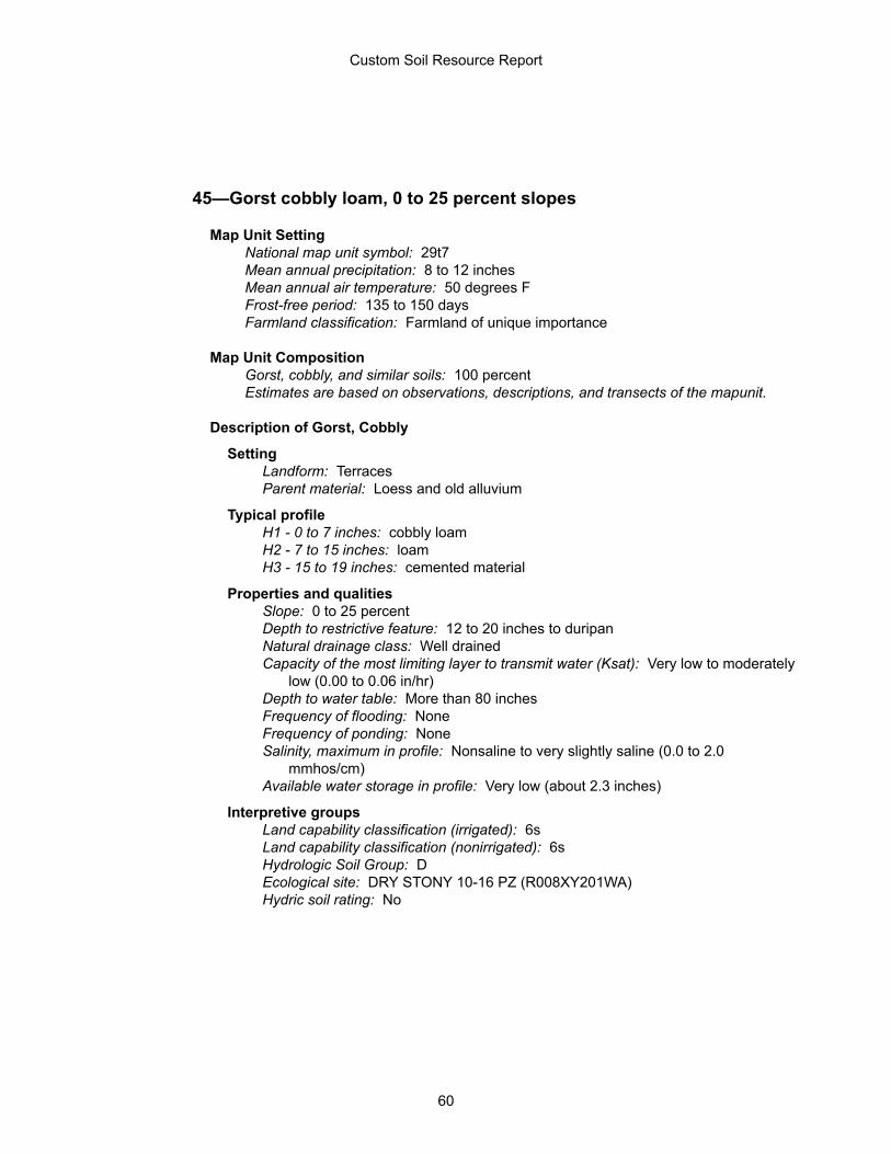
45—Gorst cobbly loam, 0 to 25 percent slopes
Map Unit SettingNational map unit symbol: 29t7Mean annual precipitation: 8 to 12 inchesMean annual air temperature: 50 degrees FFrost-free period: 135 to 150 daysFarmland classification: Farmland of unique importance
Map Unit CompositionGorst, cobbly, and similar soils: 100 percentEstimates are based on observations, descriptions, and transects of the mapunit.
Description of Gorst, Cobbly
SettingLandform: TerracesParent material: Loess and old alluvium
Typical profileH1 - 0 to 7 inches: cobbly loamH2 - 7 to 15 inches: loamH3 - 15 to 19 inches: cemented material
Properties and qualitiesSlope: 0 to 25 percentDepth to restrictive feature: 12 to 20 inches to duripanNatural drainage class: Well drainedCapacity of the most limiting layer to transmit water (Ksat): Very low to moderately
low (0.00 to 0.06 in/hr)Depth to water table: More than 80 inchesFrequency of flooding: NoneFrequency of ponding: NoneSalinity, maximum in profile: Nonsaline to very slightly saline (0.0 to 2.0
mmhos/cm)Available water storage in profile: Very low (about 2.3 inches)
Interpretive groupsLand capability classification (irrigated): 6sLand capability classification (nonirrigated): 6sHydrologic Soil Group: DEcological site: DRY STONY 10-16 PZ (R008XY201WA)Hydric soil rating: No
Custom Soil Resource Report
60

46—Harwood loam, 2 to 5 percent slopes
Map Unit SettingNational map unit symbol: 29t8Elevation: 1,200 to 2,000 feetMean annual precipitation: 8 to 12 inchesMean annual air temperature: 50 degrees FFrost-free period: 135 to 150 daysFarmland classification: Prime farmland if irrigated
Map Unit CompositionHarwood and similar soils: 100 percentEstimates are based on observations, descriptions, and transects of the mapunit.
Description of Harwood
SettingLandform: TerracesParent material: Loess and old alluvium
Typical profileH1 - 0 to 8 inches: loamH2 - 8 to 26 inches: loamH3 - 26 to 30 inches: gravelly loamH4 - 30 to 34 inches: cemented material
Properties and qualitiesSlope: 2 to 5 percentDepth to restrictive feature: 20 to 40 inches to duripanNatural drainage class: Well drainedCapacity of the most limiting layer to transmit water (Ksat): Very low to moderately
low (0.00 to 0.06 in/hr)Depth to water table: More than 80 inchesFrequency of flooding: NoneFrequency of ponding: NoneSalinity, maximum in profile: Nonsaline to very slightly saline (0.0 to 2.0
mmhos/cm)Available water storage in profile: Low (about 4.9 inches)
Interpretive groupsLand capability classification (irrigated): 3eLand capability classification (nonirrigated): 3sHydrologic Soil Group: CEcological site: LOAMY 10-16 PZ (R008XY102WA)Hydric soil rating: No
Custom Soil Resource Report
61

47—Harwood loam, 5 to 8 percent slopes
Map Unit SettingNational map unit symbol: 29t9Elevation: 1,200 to 2,000 feetMean annual precipitation: 8 to 12 inchesMean annual air temperature: 50 degrees FFrost-free period: 135 to 150 daysFarmland classification: Farmland of statewide importance
Map Unit CompositionHarwood and similar soils: 100 percentEstimates are based on observations, descriptions, and transects of the mapunit.
Description of Harwood
SettingLandform: TerracesParent material: Loess and old alluvium
Typical profileH1 - 0 to 8 inches: loamH2 - 8 to 26 inches: loamH3 - 26 to 30 inches: gravelly loamH4 - 30 to 34 inches: cemented material
Properties and qualitiesSlope: 5 to 8 percentDepth to restrictive feature: 20 to 40 inches to duripanNatural drainage class: Well drainedCapacity of the most limiting layer to transmit water (Ksat): Very low to moderately
low (0.00 to 0.06 in/hr)Depth to water table: More than 80 inchesFrequency of flooding: NoneFrequency of ponding: NoneSalinity, maximum in profile: Nonsaline to very slightly saline (0.0 to 2.0
mmhos/cm)Available water storage in profile: Low (about 4.9 inches)
Interpretive groupsLand capability classification (irrigated): 3eLand capability classification (nonirrigated): 3eHydrologic Soil Group: CEcological site: LOAMY 10-16 PZ (R008XY102WA)Hydric soil rating: No
Custom Soil Resource Report
62
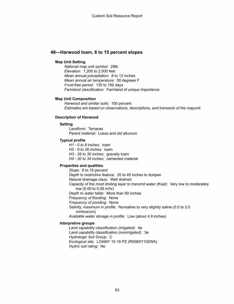
48—Harwood loam, 8 to 15 percent slopes
Map Unit SettingNational map unit symbol: 29tbElevation: 1,200 to 2,000 feetMean annual precipitation: 8 to 12 inchesMean annual air temperature: 50 degrees FFrost-free period: 135 to 150 daysFarmland classification: Farmland of unique importance
Map Unit CompositionHarwood and similar soils: 100 percentEstimates are based on observations, descriptions, and transects of the mapunit.
Description of Harwood
SettingLandform: TerracesParent material: Loess and old alluvium
Typical profileH1 - 0 to 8 inches: loamH2 - 8 to 26 inches: loamH3 - 26 to 30 inches: gravelly loamH4 - 30 to 34 inches: cemented material
Properties and qualitiesSlope: 8 to 15 percentDepth to restrictive feature: 20 to 40 inches to duripanNatural drainage class: Well drainedCapacity of the most limiting layer to transmit water (Ksat): Very low to moderately
low (0.00 to 0.06 in/hr)Depth to water table: More than 80 inchesFrequency of flooding: NoneFrequency of ponding: NoneSalinity, maximum in profile: Nonsaline to very slightly saline (0.0 to 2.0
mmhos/cm)Available water storage in profile: Low (about 4.9 inches)
Interpretive groupsLand capability classification (irrigated): 4eLand capability classification (nonirrigated): 3eHydrologic Soil Group: CEcological site: LOAMY 10-16 PZ (R008XY102WA)Hydric soil rating: No
Custom Soil Resource Report
63
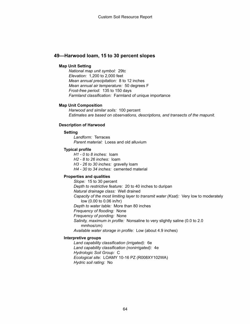
49—Harwood loam, 15 to 30 percent slopes
Map Unit SettingNational map unit symbol: 29tcElevation: 1,200 to 2,000 feetMean annual precipitation: 8 to 12 inchesMean annual air temperature: 50 degrees FFrost-free period: 135 to 150 daysFarmland classification: Farmland of unique importance
Map Unit CompositionHarwood and similar soils: 100 percentEstimates are based on observations, descriptions, and transects of the mapunit.
Description of Harwood
SettingLandform: TerracesParent material: Loess and old alluvium
Typical profileH1 - 0 to 8 inches: loamH2 - 8 to 26 inches: loamH3 - 26 to 30 inches: gravelly loamH4 - 30 to 34 inches: cemented material
Properties and qualitiesSlope: 15 to 30 percentDepth to restrictive feature: 20 to 40 inches to duripanNatural drainage class: Well drainedCapacity of the most limiting layer to transmit water (Ksat): Very low to moderately
low (0.00 to 0.06 in/hr)Depth to water table: More than 80 inchesFrequency of flooding: NoneFrequency of ponding: NoneSalinity, maximum in profile: Nonsaline to very slightly saline (0.0 to 2.0
mmhos/cm)Available water storage in profile: Low (about 4.9 inches)
Interpretive groupsLand capability classification (irrigated): 6eLand capability classification (nonirrigated): 4eHydrologic Soil Group: CEcological site: LOAMY 10-16 PZ (R008XY102WA)Hydric soil rating: No
Custom Soil Resource Report
64
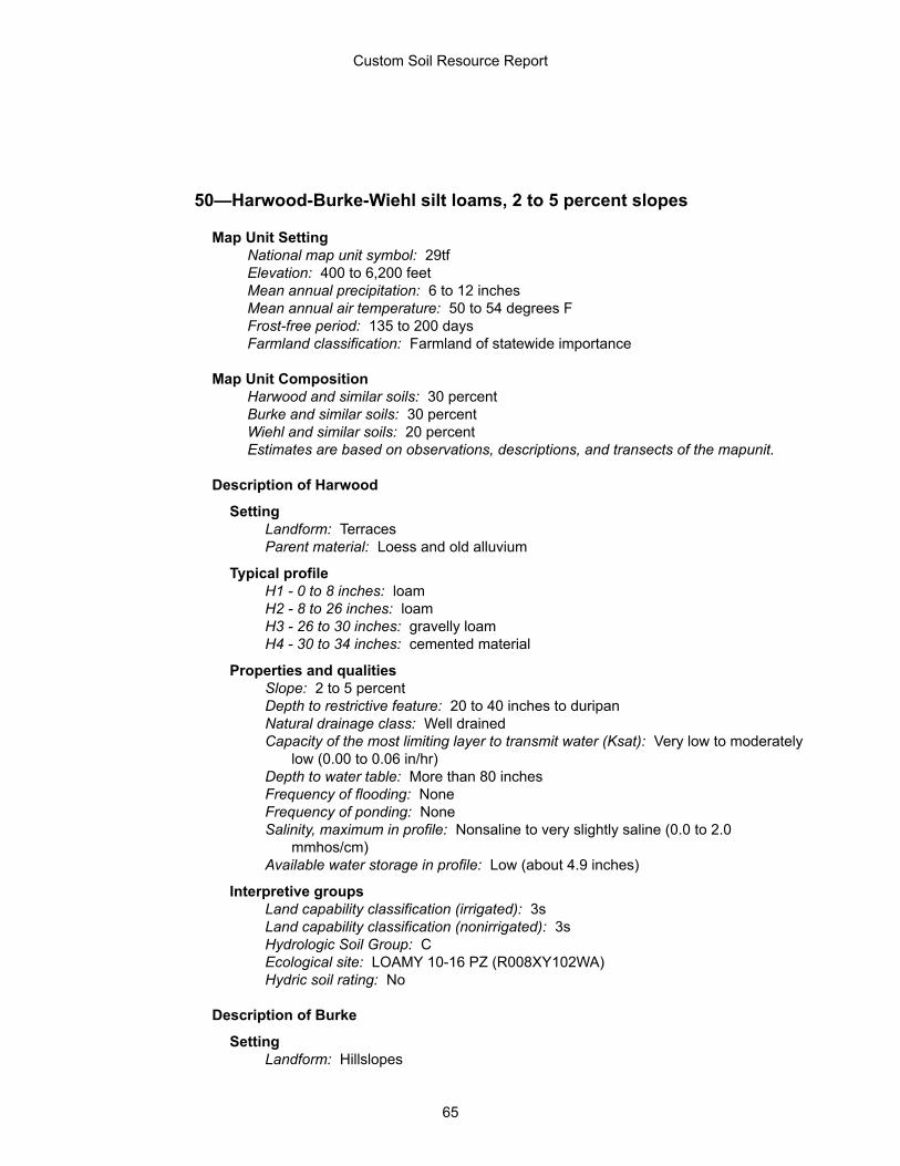
50—Harwood-Burke-Wiehl silt loams, 2 to 5 percent slopes
Map Unit SettingNational map unit symbol: 29tfElevation: 400 to 6,200 feetMean annual precipitation: 6 to 12 inchesMean annual air temperature: 50 to 54 degrees FFrost-free period: 135 to 200 daysFarmland classification: Farmland of statewide importance
Map Unit CompositionHarwood and similar soils: 30 percentBurke and similar soils: 30 percentWiehl and similar soils: 20 percentEstimates are based on observations, descriptions, and transects of the mapunit.
Description of Harwood
SettingLandform: TerracesParent material: Loess and old alluvium
Typical profileH1 - 0 to 8 inches: loamH2 - 8 to 26 inches: loamH3 - 26 to 30 inches: gravelly loamH4 - 30 to 34 inches: cemented material
Properties and qualitiesSlope: 2 to 5 percentDepth to restrictive feature: 20 to 40 inches to duripanNatural drainage class: Well drainedCapacity of the most limiting layer to transmit water (Ksat): Very low to moderately
low (0.00 to 0.06 in/hr)Depth to water table: More than 80 inchesFrequency of flooding: NoneFrequency of ponding: NoneSalinity, maximum in profile: Nonsaline to very slightly saline (0.0 to 2.0
mmhos/cm)Available water storage in profile: Low (about 4.9 inches)
Interpretive groupsLand capability classification (irrigated): 3sLand capability classification (nonirrigated): 3sHydrologic Soil Group: CEcological site: LOAMY 10-16 PZ (R008XY102WA)Hydric soil rating: No
Description of Burke
SettingLandform: Hillslopes
Custom Soil Resource Report
65
Parent material: Loess
Typical profileH1 - 0 to 7 inches: silt loamH2 - 7 to 25 inches: silt loamH3 - 25 to 29 inches: cemented material
Properties and qualitiesSlope: 2 to 5 percentDepth to restrictive feature: 20 to 40 inches to duripanNatural drainage class: Well drainedCapacity of the most limiting layer to transmit water (Ksat): Very low to moderately
low (0.00 to 0.06 in/hr)Depth to water table: More than 80 inchesFrequency of flooding: NoneFrequency of ponding: NoneCalcium carbonate, maximum in profile: 15 percentSalinity, maximum in profile: Nonsaline to very slightly saline (0.0 to 2.0
mmhos/cm)Available water storage in profile: Low (about 5.0 inches)
Interpretive groupsLand capability classification (irrigated): 3eLand capability classification (nonirrigated): 6eHydrologic Soil Group: CEcological site: LOAMY 6-10 PZ (R007XY102WA)Hydric soil rating: No
Description of Wiehl
SettingLandform: TerracesParent material: Eolian deposits over residuum weathered from sandstone and
siltstone
Typical profileH1 - 0 to 3 inches: silt loamH2 - 3 to 21 inches: silt loamH3 - 21 to 27 inches: gravelly silt loamH4 - 27 to 37 inches: weathered bedrock
Properties and qualitiesSlope: 2 to 5 percentDepth to restrictive feature: 20 to 40 inches to paralithic bedrockNatural drainage class: Well drainedCapacity of the most limiting layer to transmit water (Ksat): Moderately high to
high (0.57 to 1.98 in/hr)Depth to water table: More than 80 inchesFrequency of flooding: NoneFrequency of ponding: NoneCalcium carbonate, maximum in profile: 5 percentSalinity, maximum in profile: Nonsaline to very slightly saline (0.0 to 2.0
mmhos/cm)Available water storage in profile: Low (about 4.5 inches)
Interpretive groupsLand capability classification (irrigated): 3sLand capability classification (nonirrigated): 6s
Custom Soil Resource Report
66
Hydrologic Soil Group: CEcological site: LOAMY 6-10 PZ (R007XY102WA)Hydric soil rating: No
52—Harwood-Burke-Wiehl silt loams, 8 to 15 percent slopes
Map Unit SettingNational map unit symbol: 29thElevation: 400 to 6,200 feetMean annual precipitation: 6 to 12 inchesMean annual air temperature: 50 to 54 degrees FFrost-free period: 135 to 200 daysFarmland classification: Farmland of unique importance
Map Unit CompositionHarwood and similar soils: 30 percentBurke and similar soils: 30 percentWiehl and similar soils: 20 percentEstimates are based on observations, descriptions, and transects of the mapunit.
Description of Harwood
SettingLandform: TerracesParent material: Loess and old alluvium
Typical profileH1 - 0 to 8 inches: loamH2 - 8 to 26 inches: loamH3 - 26 to 30 inches: gravelly loamH4 - 30 to 34 inches: cemented material
Properties and qualitiesSlope: 8 to 15 percentDepth to restrictive feature: 20 to 40 inches to duripanNatural drainage class: Well drainedCapacity of the most limiting layer to transmit water (Ksat): Very low to moderately
low (0.00 to 0.06 in/hr)Depth to water table: More than 80 inchesFrequency of flooding: NoneFrequency of ponding: NoneSalinity, maximum in profile: Nonsaline to very slightly saline (0.0 to 2.0
mmhos/cm)Available water storage in profile: Low (about 4.9 inches)
Interpretive groupsLand capability classification (irrigated): 4eLand capability classification (nonirrigated): 3eHydrologic Soil Group: CEcological site: LOAMY 10-16 PZ (R008XY102WA)
Custom Soil Resource Report
67
Hydric soil rating: No
Description of Burke
SettingLandform: HillslopesParent material: Loess
Typical profileH1 - 0 to 7 inches: silt loamH2 - 7 to 25 inches: silt loamH3 - 25 to 29 inches: cemented material
Properties and qualitiesSlope: 8 to 15 percentDepth to restrictive feature: 20 to 40 inches to duripanNatural drainage class: Well drainedCapacity of the most limiting layer to transmit water (Ksat): Very low to moderately
low (0.00 to 0.06 in/hr)Depth to water table: More than 80 inchesFrequency of flooding: NoneFrequency of ponding: NoneCalcium carbonate, maximum in profile: 15 percentSalinity, maximum in profile: Nonsaline to very slightly saline (0.0 to 2.0
mmhos/cm)Available water storage in profile: Low (about 5.0 inches)
Interpretive groupsLand capability classification (irrigated): 4eLand capability classification (nonirrigated): 6eHydrologic Soil Group: CEcological site: LOAMY 6-10 PZ (R007XY102WA)Hydric soil rating: No
Description of Wiehl
SettingLandform: TerracesParent material: Eolian deposits over residuum weathered from sandstone and
siltstone
Typical profileH1 - 0 to 3 inches: silt loamH2 - 3 to 21 inches: silt loamH3 - 21 to 27 inches: gravelly silt loamH4 - 27 to 37 inches: weathered bedrock
Properties and qualitiesSlope: 8 to 15 percentDepth to restrictive feature: 20 to 40 inches to paralithic bedrockNatural drainage class: Well drainedCapacity of the most limiting layer to transmit water (Ksat): Moderately high to
high (0.57 to 1.98 in/hr)Depth to water table: More than 80 inchesFrequency of flooding: NoneFrequency of ponding: NoneCalcium carbonate, maximum in profile: 5 percent
Custom Soil Resource Report
68
Salinity, maximum in profile: Nonsaline to very slightly saline (0.0 to 2.0mmhos/cm)
Available water storage in profile: Low (about 4.5 inches)
Interpretive groupsLand capability classification (irrigated): 4eLand capability classification (nonirrigated): 6eHydrologic Soil Group: CEcological site: LOAMY 6-10 PZ (R007XY102WA)Hydric soil rating: No
53—Harwood-Burke-Wiehl silt loams, 15 to 30 percent slopes
Map Unit SettingNational map unit symbol: 29tjElevation: 400 to 6,200 feetMean annual precipitation: 6 to 12 inchesMean annual air temperature: 50 to 54 degrees FFrost-free period: 135 to 200 daysFarmland classification: Farmland of unique importance
Map Unit CompositionHarwood and similar soils: 30 percentBurke and similar soils: 30 percentWiehl and similar soils: 20 percentEstimates are based on observations, descriptions, and transects of the mapunit.
Description of Harwood
SettingLandform: TerracesParent material: Loess and old alluvium
Typical profileH1 - 0 to 8 inches: loamH2 - 8 to 26 inches: loamH3 - 26 to 30 inches: gravelly loamH4 - 30 to 34 inches: cemented material
Properties and qualitiesSlope: 15 to 30 percentDepth to restrictive feature: 20 to 40 inches to duripanNatural drainage class: Well drainedCapacity of the most limiting layer to transmit water (Ksat): Very low to moderately
low (0.00 to 0.06 in/hr)Depth to water table: More than 80 inchesFrequency of flooding: NoneFrequency of ponding: NoneSalinity, maximum in profile: Nonsaline to very slightly saline (0.0 to 2.0
mmhos/cm)
Custom Soil Resource Report
69
Available water storage in profile: Low (about 4.9 inches)
Interpretive groupsLand capability classification (irrigated): 6eLand capability classification (nonirrigated): 4eHydrologic Soil Group: CEcological site: LOAMY 10-16 PZ (R008XY102WA)Hydric soil rating: No
Description of Burke
SettingLandform: HillslopesParent material: Loess
Typical profileH1 - 0 to 7 inches: silt loamH2 - 7 to 25 inches: silt loamH3 - 25 to 29 inches: cemented material
Properties and qualitiesSlope: 15 to 30 percentDepth to restrictive feature: 20 to 40 inches to duripanNatural drainage class: Well drainedCapacity of the most limiting layer to transmit water (Ksat): Very low to moderately
low (0.00 to 0.06 in/hr)Depth to water table: More than 80 inchesFrequency of flooding: NoneFrequency of ponding: NoneCalcium carbonate, maximum in profile: 15 percentSalinity, maximum in profile: Nonsaline to very slightly saline (0.0 to 2.0
mmhos/cm)Available water storage in profile: Low (about 5.0 inches)
Interpretive groupsLand capability classification (irrigated): 6eLand capability classification (nonirrigated): 6eHydrologic Soil Group: CEcological site: LOAMY 6-10 PZ (R007XY102WA)Hydric soil rating: No
Description of Wiehl
SettingLandform: TerracesParent material: Eolian deposits over residuum weathered from sandstone and
siltstone
Typical profileH1 - 0 to 3 inches: silt loamH2 - 3 to 21 inches: silt loamH3 - 21 to 27 inches: gravelly silt loamH4 - 27 to 37 inches: weathered bedrock
Properties and qualitiesSlope: 15 to 30 percentDepth to restrictive feature: 20 to 40 inches to paralithic bedrockNatural drainage class: Well drained
Custom Soil Resource Report
70
Capacity of the most limiting layer to transmit water (Ksat): Moderately high tohigh (0.57 to 1.98 in/hr)
Depth to water table: More than 80 inchesFrequency of flooding: NoneFrequency of ponding: NoneCalcium carbonate, maximum in profile: 5 percentSalinity, maximum in profile: Nonsaline to very slightly saline (0.0 to 2.0
mmhos/cm)Available water storage in profile: Low (about 4.5 inches)
Interpretive groupsLand capability classification (irrigated): 6eLand capability classification (nonirrigated): 6eHydrologic Soil Group: CEcological site: LOAMY 6-10 PZ (R007XY102WA)Hydric soil rating: No
54—Harwood-Burke-Wiehl silt loams, 30 to 60 percent slopes
Map Unit SettingNational map unit symbol: 29tkElevation: 400 to 6,200 feetMean annual precipitation: 6 to 12 inchesMean annual air temperature: 50 to 54 degrees FFrost-free period: 135 to 200 daysFarmland classification: Not prime farmland
Map Unit CompositionHarwood and similar soils: 30 percentBurke and similar soils: 30 percentWiehl and similar soils: 20 percentEstimates are based on observations, descriptions, and transects of the mapunit.
Description of Harwood
SettingLandform: TerracesParent material: Loess and old alluvium
Typical profileH1 - 0 to 8 inches: loamH2 - 8 to 26 inches: loamH3 - 26 to 30 inches: gravelly loamH4 - 30 to 34 inches: cemented material
Properties and qualitiesSlope: 30 to 60 percentDepth to restrictive feature: 20 to 40 inches to duripanNatural drainage class: Well drained
Custom Soil Resource Report
71
Capacity of the most limiting layer to transmit water (Ksat): Very low to moderatelylow (0.00 to 0.06 in/hr)
Depth to water table: More than 80 inchesFrequency of flooding: NoneFrequency of ponding: NoneSalinity, maximum in profile: Nonsaline to very slightly saline (0.0 to 2.0
mmhos/cm)Available water storage in profile: Low (about 4.9 inches)
Interpretive groupsLand capability classification (irrigated): None specifiedLand capability classification (nonirrigated): 7eHydrologic Soil Group: CEcological site: LOAMY 10-16 PZ (R008XY102WA)Hydric soil rating: No
Description of Burke
SettingLandform: HillslopesParent material: Loess
Typical profileH1 - 0 to 7 inches: silt loamH2 - 7 to 25 inches: silt loamH3 - 25 to 29 inches: cemented material
Properties and qualitiesSlope: 30 to 40 percentDepth to restrictive feature: 20 to 40 inches to duripanNatural drainage class: Well drainedCapacity of the most limiting layer to transmit water (Ksat): Very low to moderately
low (0.00 to 0.06 in/hr)Depth to water table: More than 80 inchesFrequency of flooding: NoneFrequency of ponding: NoneCalcium carbonate, maximum in profile: 15 percentSalinity, maximum in profile: Nonsaline to very slightly saline (0.0 to 2.0
mmhos/cm)Available water storage in profile: Low (about 5.0 inches)
Interpretive groupsLand capability classification (irrigated): None specifiedLand capability classification (nonirrigated): 6eHydrologic Soil Group: CEcological site: LOAMY 6-10 PZ (R007XY102WA)Hydric soil rating: No
Description of Wiehl
SettingLandform: TerracesParent material: Eolian deposits over residuum weathered from sandstone and
siltstone
Typical profileH1 - 0 to 3 inches: silt loamH2 - 3 to 21 inches: silt loam
Custom Soil Resource Report
72
H3 - 21 to 27 inches: gravelly silt loamH4 - 27 to 37 inches: weathered bedrock
Properties and qualitiesSlope: 30 to 60 percentDepth to restrictive feature: 20 to 40 inches to paralithic bedrockNatural drainage class: Well drainedCapacity of the most limiting layer to transmit water (Ksat): Moderately high to
high (0.57 to 1.98 in/hr)Depth to water table: More than 80 inchesFrequency of flooding: NoneFrequency of ponding: NoneCalcium carbonate, maximum in profile: 5 percentSalinity, maximum in profile: Nonsaline to very slightly saline (0.0 to 2.0
mmhos/cm)Available water storage in profile: Low (about 4.5 inches)
Interpretive groupsLand capability classification (irrigated): None specifiedLand capability classification (nonirrigated): 7eHydrologic Soil Group: CEcological site: LOAMY 6-10 PZ (R007XY102WA)Hydric soil rating: No
65—Kiona stony silt loam, 15 to 45 percent slopes
Map Unit SettingNational map unit symbol: 29tyElevation: 400 to 2,500 feetMean annual precipitation: 6 to 9 inchesMean annual air temperature: 48 to 54 degrees FFrost-free period: 140 to 210 daysFarmland classification: Not prime farmland
Map Unit CompositionKiona and similar soils: 100 percentEstimates are based on observations, descriptions, and transects of the mapunit.
Description of Kiona
SettingLandform: HillslopesParent material: Loess and colluvium derived from basalt
Typical profileH1 - 0 to 5 inches: stony silt loamH2 - 5 to 14 inches: very cobbly loamH3 - 14 to 60 inches: very cobbly silt loam
Custom Soil Resource Report
73
Properties and qualitiesSlope: 15 to 45 percentDepth to restrictive feature: More than 80 inchesNatural drainage class: Well drainedCapacity of the most limiting layer to transmit water (Ksat): Moderately high to
high (0.57 to 1.98 in/hr)Depth to water table: More than 80 inchesFrequency of flooding: NoneFrequency of ponding: NoneCalcium carbonate, maximum in profile: 35 percentSalinity, maximum in profile: Nonsaline to very slightly saline (0.0 to 2.0
mmhos/cm)Available water storage in profile: Low (about 4.9 inches)
Interpretive groupsLand capability classification (irrigated): None specifiedLand capability classification (nonirrigated): 6eHydrologic Soil Group: BEcological site: LOAMY 6-10 PZ (R007XY102WA)Hydric soil rating: No
66—Kittitas silt loam
Map Unit SettingNational map unit symbol: 29tzElevation: 500 to 1,100 feetMean annual precipitation: 6 to 12 inchesMean annual air temperature: 48 to 52 degrees FFrost-free period: 130 to 180 daysFarmland classification: Farmland of statewide importance
Map Unit CompositionKittitas and similar soils: 90 percentMinor components: 10 percentEstimates are based on observations, descriptions, and transects of the mapunit.
Description of Kittitas
SettingLandform: Flood plainsParent material: Alluvium
Typical profileH1 - 0 to 19 inches: silt loamH2 - 19 to 41 inches: silt loamH3 - 41 to 60 inches: stratified fine sandy loam to silty clay loam
Properties and qualitiesSlope: 0 to 2 percentDepth to restrictive feature: More than 80 inchesNatural drainage class: Somewhat poorly drained
Custom Soil Resource Report
74
Capacity of the most limiting layer to transmit water (Ksat): Moderately high (0.20to 0.57 in/hr)
Depth to water table: About 0 to 6 inchesFrequency of flooding: NoneFrequency of ponding: NoneCalcium carbonate, maximum in profile: 15 percentSalinity, maximum in profile: Very slightly saline to slightly saline (2.0 to 4.0
mmhos/cm)Available water storage in profile: High (about 11.4 inches)
Interpretive groupsLand capability classification (irrigated): 4wLand capability classification (nonirrigated): 4wHydrologic Soil Group: C/DHydric soil rating: Yes
Minor Components
ToppenishPercent of map unit: 5 percentLandform: DepressionsHydric soil rating: Yes
Kittitas, undrainedPercent of map unit: 5 percentLandform: Flood plainsHydric soil rating: Yes
68—Lickskillet very stony silt loam, 5 to 45 percent slopes
Map Unit SettingNational map unit symbol: 29v1Elevation: 200 to 3,600 feetMean annual precipitation: 10 to 16 inchesMean annual air temperature: 45 to 52 degrees FFrost-free period: 100 to 180 daysFarmland classification: Not prime farmland
Map Unit CompositionLickskillet and similar soils: 100 percentEstimates are based on observations, descriptions, and transects of the mapunit.
Description of Lickskillet
SettingLandform: Hillslopes, ridgesParent material: Residuum and colluvium weathered from basalt, and loess
Typical profileH1 - 0 to 3 inches: silt loamH2 - 3 to 20 inches: very gravelly loam, very cobbly loam
Custom Soil Resource Report
75
H2 - 3 to 20 inches: unweathered bedrockH3 - 20 to 24 inches:
Properties and qualitiesSlope: 5 to 45 percentDepth to restrictive feature: 12 to 20 inches to lithic bedrockNatural drainage class: Well drainedCapacity of the most limiting layer to transmit water (Ksat): Moderately high to
high (0.57 to 1.98 in/hr)Depth to water table: More than 80 inchesFrequency of flooding: NoneFrequency of ponding: NoneCalcium carbonate, maximum in profile: 5 percentSalinity, maximum in profile: Nonsaline to very slightly saline (0.0 to 2.0
mmhos/cm)Available water storage in profile: Low (about 3.8 inches)
Interpretive groupsLand capability classification (irrigated): None specifiedLand capability classification (nonirrigated): 7sHydrologic Soil Group: CEcological site: DRY STONY 10-16 PZ (R008XY201WA)Hydric soil rating: No
69—Logy silt loam, 0 to 2 percent slopes
Map Unit SettingNational map unit symbol: 29v2Mean annual precipitation: 6 to 10 inchesMean annual air temperature: 50 degrees FFrost-free period: 130 to 180 daysFarmland classification: Prime farmland if irrigated
Map Unit CompositionLogy and similar soils: 95 percentMinor components: 5 percentEstimates are based on observations, descriptions, and transects of the mapunit.
Description of Logy
SettingLandform: Flood plainsParent material: Alluvium
Typical profileH1 - 0 to 12 inches: silt loamH2 - 12 to 33 inches: extremely gravelly loamH3 - 33 to 60 inches: extremely gravelly coarse sand, extremely cobbly coarse
sandH3 - 33 to 60 inches:
Properties and qualitiesSlope: 0 to 2 percent
Custom Soil Resource Report
76
Depth to restrictive feature: 20 to 40 inches to strongly contrasting texturalstratification
Natural drainage class: Well drainedCapacity of the most limiting layer to transmit water (Ksat): Moderately high to
high (0.57 to 1.98 in/hr)Depth to water table: More than 80 inchesFrequency of flooding: OccasionalFrequency of ponding: NoneAvailable water storage in profile: Low (about 4.2 inches)
Interpretive groupsLand capability classification (irrigated): 3wLand capability classification (nonirrigated): 6wHydrologic Soil Group: BHydric soil rating: No
Minor Components
WeirmanPercent of map unit: 5 percentLandform: Flood plainsHydric soil rating: Yes
80—Mikkalo silt loam, 5 to 15 percent slopes
Map Unit SettingNational map unit symbol: 29vhElevation: 900 to 2,500 feetMean annual precipitation: 9 to 12 inchesMean annual air temperature: 48 to 54 degrees FFrost-free period: 130 to 180 daysFarmland classification: Farmland of unique importance
Map Unit CompositionMikkalo and similar soils: 100 percentEstimates are based on observations, descriptions, and transects of the mapunit.
Description of Mikkalo
SettingLandform: Ridges, hillslopes, plateausParent material: Loess over residuum weathered from basalt
Typical profileH1 - 0 to 5 inches: silt loamH2 - 5 to 30 inches: silt loamH3 - 30 to 34 inches: unweathered bedrock
Properties and qualitiesSlope: 5 to 15 percentDepth to restrictive feature: 20 to 40 inches to lithic bedrock
Custom Soil Resource Report
77

Natural drainage class: Well drainedCapacity of the most limiting layer to transmit water (Ksat): Moderately high to
high (0.57 to 1.98 in/hr)Depth to water table: More than 80 inchesFrequency of flooding: NoneFrequency of ponding: NoneCalcium carbonate, maximum in profile: 15 percentSalinity, maximum in profile: Nonsaline to very slightly saline (0.0 to 2.0
mmhos/cm)Available water storage in profile: Low (about 5.7 inches)
Interpretive groupsLand capability classification (irrigated): 4eLand capability classification (nonirrigated): 3eHydrologic Soil Group: CEcological site: LOAMY 10-16 PZ (R008XY102WA)Hydric soil rating: No
81—Mikkalo silt loam, 15 to 30 percent slopes
Map Unit SettingNational map unit symbol: 29vjElevation: 900 to 2,500 feetMean annual precipitation: 9 to 12 inchesMean annual air temperature: 48 to 54 degrees FFrost-free period: 130 to 180 daysFarmland classification: Farmland of statewide importance
Map Unit CompositionMikkalo and similar soils: 100 percentEstimates are based on observations, descriptions, and transects of the mapunit.
Description of Mikkalo
SettingLandform: Hillslopes, plateaus, ridgesParent material: Loess over residuum weathered from basalt
Typical profileH1 - 0 to 5 inches: silt loamH2 - 5 to 30 inches: silt loamH3 - 30 to 34 inches: unweathered bedrock
Properties and qualitiesSlope: 15 to 30 percentDepth to restrictive feature: 20 to 40 inches to lithic bedrockNatural drainage class: Well drainedCapacity of the most limiting layer to transmit water (Ksat): Moderately high to
high (0.57 to 1.98 in/hr)Depth to water table: More than 80 inchesFrequency of flooding: NoneFrequency of ponding: None
Custom Soil Resource Report
78
Calcium carbonate, maximum in profile: 15 percentSalinity, maximum in profile: Nonsaline to very slightly saline (0.0 to 2.0
mmhos/cm)Available water storage in profile: Low (about 5.7 inches)
Interpretive groupsLand capability classification (irrigated): None specifiedLand capability classification (nonirrigated): 4eHydrologic Soil Group: CEcological site: LOAMY 10-16 PZ (R008XY102WA)Hydric soil rating: No
83—Moxee silt loam, 2 to 15 percent slopes
Map Unit SettingNational map unit symbol: 29vlElevation: 900 to 2,000 feetMean annual precipitation: 8 to 12 inchesMean annual air temperature: 48 to 50 degrees FFrost-free period: 125 to 160 daysFarmland classification: Not prime farmland
Map Unit CompositionMoxee and similar soils: 95 percentMinor components: 5 percentEstimates are based on observations, descriptions, and transects of the mapunit.
Description of Moxee
SettingParent material: Loess
Typical profileH1 - 0 to 7 inches: silt loamH2 - 7 to 11 inches: silt loamH3 - 11 to 18 inches: gravelly silt loamH4 - 18 to 22 inches: cemented material
Properties and qualitiesSlope: 2 to 15 percentDepth to restrictive feature: 10 to 20 inches to duripanNatural drainage class: Well drainedCapacity of the most limiting layer to transmit water (Ksat): Very low to moderately
low (0.00 to 0.06 in/hr)Depth to water table: More than 80 inchesFrequency of flooding: NoneFrequency of ponding: NoneCalcium carbonate, maximum in profile: 15 percentSalinity, maximum in profile: Nonsaline to very slightly saline (0.0 to 2.0
mmhos/cm)Available water storage in profile: Low (about 3.4 inches)
Custom Soil Resource Report
79
Interpretive groupsLand capability classification (irrigated): 6sLand capability classification (nonirrigated): 6sHydrologic Soil Group: DEcological site: DRY STONY 10-16 PZ (R008XY201WA)Hydric soil rating: No
Minor Components
RiverwashPercent of map unit: 5 percentLandform: Alluvial conesHydric soil rating: Yes
84—Moxee silt loam, 15 to 30 percent slopes
Map Unit SettingNational map unit symbol: 29vmElevation: 900 to 2,000 feetMean annual precipitation: 8 to 12 inchesMean annual air temperature: 48 to 50 degrees FFrost-free period: 125 to 160 daysFarmland classification: Farmland of unique importance
Map Unit CompositionMoxee and similar soils: 100 percentEstimates are based on observations, descriptions, and transects of the mapunit.
Description of Moxee
SettingParent material: Loess
Typical profileH1 - 0 to 7 inches: silt loamH2 - 7 to 11 inches: silt loamH3 - 11 to 18 inches: gravelly silt loamH4 - 18 to 22 inches: cemented material
Properties and qualitiesSlope: 15 to 30 percentDepth to restrictive feature: 10 to 20 inches to duripanNatural drainage class: Well drainedCapacity of the most limiting layer to transmit water (Ksat): Very low to moderately
low (0.00 to 0.06 in/hr)Depth to water table: More than 80 inchesFrequency of flooding: NoneFrequency of ponding: NoneCalcium carbonate, maximum in profile: 15 percent
Custom Soil Resource Report
80
Salinity, maximum in profile: Nonsaline to very slightly saline (0.0 to 2.0mmhos/cm)
Available water storage in profile: Low (about 3.4 inches)
Interpretive groupsLand capability classification (irrigated): 6sLand capability classification (nonirrigated): 6sHydrologic Soil Group: DEcological site: DRY STONY 10-16 PZ (R008XY201WA)Hydric soil rating: No
85—Moxee cobbly silt loam, 0 to 30 percent slopes
Map Unit SettingNational map unit symbol: 29vnElevation: 900 to 2,000 feetMean annual precipitation: 8 to 12 inchesMean annual air temperature: 48 to 50 degrees FFrost-free period: 125 to 160 daysFarmland classification: Farmland of unique importance
Map Unit CompositionMoxee, cobbly, and similar soils: 100 percentEstimates are based on observations, descriptions, and transects of the mapunit.
Description of Moxee, Cobbly
SettingParent material: Loess
Typical profileH1 - 0 to 7 inches: cobbly silt loamH2 - 7 to 11 inches: silt loamH3 - 11 to 18 inches: gravelly silt loamH4 - 18 to 22 inches: cemented material
Properties and qualitiesSlope: 0 to 30 percentDepth to restrictive feature: 10 to 20 inches to duripanNatural drainage class: Well drainedCapacity of the most limiting layer to transmit water (Ksat): Very low to moderately
low (0.00 to 0.06 in/hr)Depth to water table: More than 80 inchesFrequency of flooding: NoneFrequency of ponding: NoneCalcium carbonate, maximum in profile: 15 percentSalinity, maximum in profile: Nonsaline to very slightly saline (0.0 to 2.0
mmhos/cm)Available water storage in profile: Low (about 3.2 inches)
Interpretive groupsLand capability classification (irrigated): 6sLand capability classification (nonirrigated): 6s
Custom Soil Resource Report
81
Hydrologic Soil Group: DEcological site: DRY STONY 10-16 PZ (R008XY201WA)Hydric soil rating: No
86—Naches loam
Map Unit SettingNational map unit symbol: 29vpMean annual precipitation: 6 to 9 inchesMean annual air temperature: 50 degrees FFrost-free period: 130 to 180 daysFarmland classification: Prime farmland if irrigated
Map Unit CompositionNaches and similar soils: 100 percentEstimates are based on observations, descriptions, and transects of the mapunit.
Description of Naches
SettingLandform: TerracesParent material: Alluvium
Typical profileH1 - 0 to 9 inches: loamH2 - 9 to 21 inches: loamH3 - 21 to 34 inches: gravelly loamH4 - 34 to 60 inches: extremely gravelly sand
Properties and qualitiesSlope: 0 to 2 percentDepth to restrictive feature: 20 to 40 inches to strongly contrasting textural
stratificationNatural drainage class: Well drainedCapacity of the most limiting layer to transmit water (Ksat): Moderately high to
high (0.57 to 1.98 in/hr)Depth to water table: More than 80 inchesFrequency of flooding: NoneFrequency of ponding: NoneSalinity, maximum in profile: Nonsaline to very slightly saline (0.0 to 2.0
mmhos/cm)Available water storage in profile: Moderate (about 6.2 inches)
Interpretive groupsLand capability classification (irrigated): 2sLand capability classification (nonirrigated): 6eHydrologic Soil Group: BHydric soil rating: No
Custom Soil Resource Report
82
92—Outlook silt loam
Map Unit SettingNational map unit symbol: 29vxElevation: 300 to 2,000 feetMean annual precipitation: 6 to 12 inchesMean annual air temperature: 50 to 52 degrees FFrost-free period: 130 to 160 daysFarmland classification: Not prime farmland
Map Unit CompositionOutlook, drained, and similar soils: 90 percentMinor components: 10 percentEstimates are based on observations, descriptions, and transects of the mapunit.
Description of Outlook, Drained
SettingLandform: Flood plainsParent material: Alluvium
Typical profileH1 - 0 to 8 inches: fine sandy loamH2 - 8 to 60 inches: silt loam
Properties and qualitiesSlope: 0 to 2 percentDepth to restrictive feature: More than 80 inchesNatural drainage class: Somewhat poorly drainedCapacity of the most limiting layer to transmit water (Ksat): Moderately high to
high (0.57 to 1.98 in/hr)Depth to water table: About 12 to 48 inchesFrequency of flooding: NoneFrequency of ponding: NoneCalcium carbonate, maximum in profile: 25 percentSalinity, maximum in profile: Slightly saline to moderately saline (4.0 to 8.0
mmhos/cm)Sodium adsorption ratio, maximum in profile: 5.0Available water storage in profile: High (about 10.5 inches)
Interpretive groupsLand capability classification (irrigated): 3wLand capability classification (nonirrigated): 4sHydrologic Soil Group: CHydric soil rating: Yes
Minor Components
SinlocPercent of map unit: 5 percentLandform: DepressionsHydric soil rating: Yes
Custom Soil Resource Report
83
Outlook, undrainedPercent of map unit: 5 percentLandform: Alluvial conesHydric soil rating: Yes
93—Pits
Map Unit CompositionPits: 100 percentEstimates are based on observations, descriptions, and transects of the mapunit.
Description of Pits
Interpretive groupsLand capability classification (irrigated): None specifiedLand capability classification (nonirrigated): 8Hydric soil rating: No
95—Quincy loamy fine sand, 0 to 10 percent slopes
Map Unit SettingNational map unit symbol: 29w0Elevation: 200 to 4,500 feetMean annual precipitation: 6 to 12 inchesMean annual air temperature: 46 to 54 degrees FFrost-free period: 100 to 200 daysFarmland classification: Farmland of statewide importance
Map Unit CompositionQuincy and similar soils: 100 percentEstimates are based on observations, descriptions, and transects of the mapunit.
Description of Quincy
SettingLandform: TerracesParent material: Eolian sands
Typical profileH1 - 0 to 20 inches: loamy fine sandH2 - 20 to 60 inches: sand
Properties and qualitiesSlope: 0 to 10 percentDepth to restrictive feature: More than 80 inchesNatural drainage class: Excessively drainedCapacity of the most limiting layer to transmit water (Ksat): High to very high (5.95
to 19.98 in/hr)
Custom Soil Resource Report
84
Depth to water table: More than 80 inchesFrequency of flooding: NoneFrequency of ponding: NoneCalcium carbonate, maximum in profile: 3 percentSalinity, maximum in profile: Nonsaline to very slightly saline (0.0 to 2.0
mmhos/cm)Available water storage in profile: Moderate (about 6.2 inches)
Interpretive groupsLand capability classification (irrigated): 3sLand capability classification (nonirrigated): 4eHydrologic Soil Group: AHydric soil rating: No
99—Ritzville silt loam, 2 to 5 percent slopes
Map Unit SettingNational map unit symbol: 29w4Elevation: 800 to 3,000 feetMean annual precipitation: 9 to 12 inchesMean annual air temperature: 48 to 52 degrees FFrost-free period: 100 to 180 daysFarmland classification: Prime farmland if irrigated
Map Unit CompositionRitzville and similar soils: 100 percentEstimates are based on observations, descriptions, and transects of the mapunit.
Description of Ritzville
SettingLandform: HillslopesParent material: Loess
Typical profileH1 - 0 to 7 inches: silt loamH2 - 7 to 37 inches: silt loamH3 - 37 to 60 inches: silt loam
Properties and qualitiesSlope: 2 to 5 percentDepth to restrictive feature: More than 80 inchesNatural drainage class: Well drainedCapacity of the most limiting layer to transmit water (Ksat): Moderately high to
high (0.57 to 1.98 in/hr)Depth to water table: More than 80 inchesFrequency of flooding: NoneFrequency of ponding: NoneCalcium carbonate, maximum in profile: 15 percentSalinity, maximum in profile: Nonsaline to very slightly saline (0.0 to 2.0
mmhos/cm)Available water storage in profile: High (about 12.0 inches)
Custom Soil Resource Report
85
Interpretive groupsLand capability classification (irrigated): 2eLand capability classification (nonirrigated): 3eHydrologic Soil Group: BEcological site: LOAMY 10-16 PZ (R008XY102WA)Hydric soil rating: No
100—Ritzville silt loam, 5 to 8 percent slopes
Map Unit SettingNational map unit symbol: 29p0Elevation: 800 to 3,000 feetMean annual precipitation: 9 to 12 inchesMean annual air temperature: 48 to 52 degrees FFrost-free period: 100 to 180 daysFarmland classification: Farmland of statewide importance
Map Unit CompositionRitzville and similar soils: 100 percentEstimates are based on observations, descriptions, and transects of the mapunit.
Description of Ritzville
SettingLandform: HillslopesParent material: Loess
Typical profileH1 - 0 to 7 inches: silt loamH2 - 7 to 37 inches: silt loamH3 - 37 to 60 inches: silt loam
Properties and qualitiesSlope: 5 to 8 percentDepth to restrictive feature: More than 80 inchesNatural drainage class: Well drainedCapacity of the most limiting layer to transmit water (Ksat): Moderately high to
high (0.57 to 1.98 in/hr)Depth to water table: More than 80 inchesFrequency of flooding: NoneFrequency of ponding: NoneCalcium carbonate, maximum in profile: 15 percentSalinity, maximum in profile: Nonsaline to very slightly saline (0.0 to 2.0
mmhos/cm)Available water storage in profile: High (about 12.0 inches)
Interpretive groupsLand capability classification (irrigated): 3eLand capability classification (nonirrigated): 3eHydrologic Soil Group: BEcological site: LOAMY 10-16 PZ (R008XY102WA)Hydric soil rating: No
Custom Soil Resource Report
86

101—Ritzville silt loam, 8 to 15 percent slopes
Map Unit SettingNational map unit symbol: 29p1Elevation: 800 to 3,000 feetMean annual precipitation: 9 to 12 inchesMean annual air temperature: 48 to 52 degrees FFrost-free period: 100 to 180 daysFarmland classification: Farmland of unique importance
Map Unit CompositionRitzville and similar soils: 100 percentEstimates are based on observations, descriptions, and transects of the mapunit.
Description of Ritzville
SettingLandform: HillslopesParent material: Loess
Typical profileH1 - 0 to 7 inches: silt loamH2 - 7 to 37 inches: silt loamH3 - 37 to 60 inches: silt loam
Properties and qualitiesSlope: 8 to 15 percentDepth to restrictive feature: More than 80 inchesNatural drainage class: Well drainedCapacity of the most limiting layer to transmit water (Ksat): Moderately high to
high (0.57 to 1.98 in/hr)Depth to water table: More than 80 inchesFrequency of flooding: NoneFrequency of ponding: NoneCalcium carbonate, maximum in profile: 15 percentSalinity, maximum in profile: Nonsaline to very slightly saline (0.0 to 2.0
mmhos/cm)Available water storage in profile: High (about 12.0 inches)
Interpretive groupsLand capability classification (irrigated): 4eLand capability classification (nonirrigated): 3eHydrologic Soil Group: BEcological site: LOAMY 10-16 PZ (R008XY102WA)Hydric soil rating: No
Custom Soil Resource Report
87

102—Ritzville silt loam, 15 to 30 percent slopes
Map Unit SettingNational map unit symbol: 29p2Elevation: 800 to 3,000 feetMean annual precipitation: 9 to 12 inchesMean annual air temperature: 48 to 52 degrees FFrost-free period: 100 to 180 daysFarmland classification: Farmland of unique importance
Map Unit CompositionRitzville and similar soils: 100 percentEstimates are based on observations, descriptions, and transects of the mapunit.
Description of Ritzville
SettingLandform: HillslopesParent material: Loess
Typical profileH1 - 0 to 7 inches: silt loamH2 - 7 to 37 inches: silt loamH3 - 37 to 60 inches: silt loam
Properties and qualitiesSlope: 15 to 30 percentDepth to restrictive feature: More than 80 inchesNatural drainage class: Well drainedCapacity of the most limiting layer to transmit water (Ksat): Moderately high to
high (0.57 to 1.98 in/hr)Depth to water table: More than 80 inchesFrequency of flooding: NoneFrequency of ponding: NoneCalcium carbonate, maximum in profile: 15 percentSalinity, maximum in profile: Nonsaline to very slightly saline (0.0 to 2.0
mmhos/cm)Available water storage in profile: High (about 12.0 inches)
Interpretive groupsLand capability classification (irrigated): 6eLand capability classification (nonirrigated): 4eHydrologic Soil Group: BEcological site: LOAMY 10-16 PZ (R008XY102WA)Hydric soil rating: No
Custom Soil Resource Report
88
103—Ritzville silt loam, 30 to 60 percent slopes
Map Unit SettingNational map unit symbol: 29p3Elevation: 800 to 3,000 feetMean annual precipitation: 9 to 12 inchesMean annual air temperature: 48 to 52 degrees FFrost-free period: 100 to 180 daysFarmland classification: Not prime farmland
Map Unit CompositionRitzville and similar soils: 100 percentEstimates are based on observations, descriptions, and transects of the mapunit.
Description of Ritzville
SettingLandform: HillslopesParent material: Loess
Typical profileH1 - 0 to 7 inches: silt loamH2 - 7 to 37 inches: silt loamH3 - 37 to 60 inches: silt loam
Properties and qualitiesSlope: 30 to 60 percentDepth to restrictive feature: More than 80 inchesNatural drainage class: Well drainedCapacity of the most limiting layer to transmit water (Ksat): Moderately high to
high (0.57 to 1.98 in/hr)Depth to water table: More than 80 inchesFrequency of flooding: NoneFrequency of ponding: NoneCalcium carbonate, maximum in profile: 15 percentSalinity, maximum in profile: Nonsaline to very slightly saline (0.0 to 2.0
mmhos/cm)Available water storage in profile: High (about 12.0 inches)
Interpretive groupsLand capability classification (irrigated): None specifiedLand capability classification (nonirrigated): 7eHydrologic Soil Group: BEcological site: LOAMY 10-16 PZ (R008XY102WA)Hydric soil rating: No
Custom Soil Resource Report
89
109—Rock Creek very stony silt loam, 0 to 30 percent slopes
Map Unit SettingNational map unit symbol: 29p9Elevation: 1,400 to 4,200 feetMean annual precipitation: 10 to 16 inchesMean annual air temperature: 48 to 50 degrees FFrost-free period: 120 to 170 daysFarmland classification: Not prime farmland
Map Unit CompositionRock creek and similar soils: 100 percentEstimates are based on observations, descriptions, and transects of the mapunit.
Description of Rock Creek
SettingLandform: Ridges, plateausParent material: Loess and residuum weathered from basalt
Typical profileH1 - 0 to 2 inches: very stony silt loamH2 - 2 to 10 inches: very cobbly clayH3 - 10 to 14 inches: unweathered bedrock
Properties and qualitiesSlope: 0 to 30 percentDepth to restrictive feature: 8 to 20 inches to lithic bedrockNatural drainage class: Well drainedCapacity of the most limiting layer to transmit water (Ksat): Moderately high (0.20
to 0.57 in/hr)Depth to water table: More than 80 inchesFrequency of flooding: NoneFrequency of ponding: NoneAvailable water storage in profile: Very low (about 0.6 inches)
Interpretive groupsLand capability classification (irrigated): None specifiedLand capability classification (nonirrigated): 7sHydrologic Soil Group: DEcological site: VERY SHALLOW 10-16 PZ (R008XY301WA)Hydric soil rating: No
110—Rock Creek-Clint-Simcoe complex, 0 to 45 percent slopes
Map Unit SettingNational map unit symbol: 29pc
Custom Soil Resource Report
90
Elevation: 1,400 to 4,200 feetMean annual precipitation: 8 to 18 inchesMean annual air temperature: 46 to 50 degrees FFrost-free period: 110 to 170 daysFarmland classification: Not prime farmland
Map Unit CompositionRock creek and similar soils: 40 percentClint and similar soils: 20 percentSimcoe and similar soils: 20 percentEstimates are based on observations, descriptions, and transects of the mapunit.
Description of Rock Creek
SettingLandform: Plateaus, ridgesParent material: Loess and residuum weathered from basalt
Typical profileH1 - 0 to 2 inches: very stony silt loamH2 - 2 to 10 inches: very cobbly clayH3 - 10 to 14 inches: unweathered bedrock
Properties and qualitiesSlope: 0 to 45 percentDepth to restrictive feature: 8 to 20 inches to lithic bedrockNatural drainage class: Well drainedCapacity of the most limiting layer to transmit water (Ksat): Moderately high (0.20
to 0.57 in/hr)Depth to water table: More than 80 inchesFrequency of flooding: NoneFrequency of ponding: NoneAvailable water storage in profile: Very low (about 0.6 inches)
Interpretive groupsLand capability classification (irrigated): None specifiedLand capability classification (nonirrigated): 7sHydrologic Soil Group: DEcological site: VERY SHALLOW 10-16 PZ (R008XY301WA)Hydric soil rating: No
Description of Clint
SettingLandform: Hillslopes
Typical profileH1 - 0 to 10 inches: very stony loamH2 - 10 to 19 inches: very gravelly loamH3 - 19 to 28 inches: extremely gravelly loamH4 - 28 to 32 inches: unweathered bedrock
Properties and qualitiesSlope: 5 to 45 percentDepth to restrictive feature: 20 to 40 inches to lithic bedrockNatural drainage class: Well drainedCapacity of the most limiting layer to transmit water (Ksat): Moderately high to
high (0.57 to 1.98 in/hr)
Custom Soil Resource Report
91
Depth to water table: More than 80 inchesFrequency of flooding: NoneFrequency of ponding: NoneAvailable water storage in profile: Low (about 3.1 inches)
Interpretive groupsLand capability classification (irrigated): None specifiedLand capability classification (nonirrigated): 6sHydrologic Soil Group: CEcological site: STONY 16-24 PZ (R006XY202WA)Hydric soil rating: No
Description of Simcoe
SettingParent material: Loess and small amount volcanic ash and residuum weathered
from basalt
Typical profileH1 - 0 to 8 inches: silt loamH2 - 8 to 37 inches: silty clay loamH3 - 37 to 41 inches: unweathered bedrock
Properties and qualitiesSlope: 0 to 45 percentDepth to restrictive feature: 20 to 40 inches to lithic bedrockNatural drainage class: Well drainedCapacity of the most limiting layer to transmit water (Ksat): Moderately high (0.20
to 0.57 in/hr)Depth to water table: More than 80 inchesFrequency of flooding: NoneFrequency of ponding: NoneAvailable water storage in profile: Moderate (about 6.8 inches)
Interpretive groupsLand capability classification (irrigated): 7eLand capability classification (nonirrigated): 4eHydrologic Soil Group: CEcological site: LOAMY 10-16 PZ (R008XY102WA)Hydric soil rating: No
112—Roza clay loam, 8 to 15 percent slopes
Map Unit SettingNational map unit symbol: 29pfElevation: 1,100 to 4,600 feetMean annual precipitation: 8 to 12 inchesMean annual air temperature: 48 to 52 degrees FFrost-free period: 110 to 165 daysFarmland classification: Farmland of unique importance
Custom Soil Resource Report
92
Map Unit CompositionRoza and similar soils: 100 percentEstimates are based on observations, descriptions, and transects of the mapunit.
Description of Roza
SettingParent material: Alluvium and/or residuum derived from fine textured sediments
Typical profileH1 - 0 to 2 inches: clay loamH2 - 2 to 19 inches: silty clayH3 - 19 to 60 inches: clay loam
Properties and qualitiesSlope: 8 to 15 percentDepth to restrictive feature: More than 80 inchesNatural drainage class: Well drainedCapacity of the most limiting layer to transmit water (Ksat): Moderately low to
moderately high (0.06 to 0.20 in/hr)Depth to water table: More than 80 inchesFrequency of flooding: NoneFrequency of ponding: NoneCalcium carbonate, maximum in profile: 20 percentAvailable water storage in profile: High (about 9.7 inches)
Interpretive groupsLand capability classification (irrigated): 4eLand capability classification (nonirrigated): 3eHydrologic Soil Group: CEcological site: CALCAREOUS LOAM 10-16" pz (R008XY701WA)Hydric soil rating: No
113—Roza clay loam, 15 to 30 percent slopes
Map Unit SettingNational map unit symbol: 29pgElevation: 1,100 to 4,600 feetMean annual precipitation: 8 to 12 inchesMean annual air temperature: 48 to 52 degrees FFrost-free period: 110 to 165 daysFarmland classification: Farmland of unique importance
Map Unit CompositionRoza and similar soils: 100 percentEstimates are based on observations, descriptions, and transects of the mapunit.
Description of Roza
SettingParent material: Alluvium and/or residuum derived from fine textured sediments
Custom Soil Resource Report
93
Typical profileH1 - 0 to 2 inches: clay loamH2 - 2 to 19 inches: silty clayH3 - 19 to 60 inches: clay loam
Properties and qualitiesSlope: 15 to 30 percentDepth to restrictive feature: More than 80 inchesNatural drainage class: Well drainedCapacity of the most limiting layer to transmit water (Ksat): Moderately low to
moderately high (0.06 to 0.20 in/hr)Depth to water table: More than 80 inchesFrequency of flooding: NoneFrequency of ponding: NoneCalcium carbonate, maximum in profile: 20 percentAvailable water storage in profile: High (about 9.7 inches)
Interpretive groupsLand capability classification (irrigated): 6eLand capability classification (nonirrigated): 4eHydrologic Soil Group: CEcological site: CALCAREOUS LOAM 10-16" pz (R008XY701WA)Hydric soil rating: No
128—Selah silt loam, 2 to 5 percent slopes
Map Unit SettingNational map unit symbol: 29pzElevation: 1,100 to 2,900 feetMean annual precipitation: 8 to 15 inchesMean annual air temperature: 48 to 55 degrees FFrost-free period: 130 to 180 daysFarmland classification: Prime farmland if irrigated
Map Unit CompositionSelah and similar soils: 100 percentEstimates are based on observations, descriptions, and transects of the mapunit.
Description of Selah
SettingLandform: TerracesParent material: Loess and old alluvium
Typical profileH1 - 0 to 7 inches: silt loamH2 - 7 to 29 inches: silt loamH3 - 29 to 34 inches: clay loamH4 - 34 to 38 inches: cemented material
Properties and qualitiesSlope: 2 to 5 percent
Custom Soil Resource Report
94
Depth to restrictive feature: 20 to 40 inches to duripanNatural drainage class: Well drainedCapacity of the most limiting layer to transmit water (Ksat): Very low to moderately
low (0.00 to 0.06 in/hr)Depth to water table: More than 80 inchesFrequency of flooding: NoneFrequency of ponding: NoneCalcium carbonate, maximum in profile: 15 percentSalinity, maximum in profile: Nonsaline to very slightly saline (0.0 to 2.0
mmhos/cm)Available water storage in profile: Moderate (about 6.5 inches)
Interpretive groupsLand capability classification (irrigated): 3sLand capability classification (nonirrigated): 3sHydrologic Soil Group: CEcological site: LOAMY 10-16 PZ (R008XY102WA)Hydric soil rating: No
129—Selah silt loam, 5 to 8 percent slopes
Map Unit SettingNational map unit symbol: 29q0Elevation: 1,100 to 2,900 feetMean annual precipitation: 8 to 15 inchesMean annual air temperature: 48 to 55 degrees FFrost-free period: 130 to 180 daysFarmland classification: Farmland of statewide importance
Map Unit CompositionSelah and similar soils: 100 percentEstimates are based on observations, descriptions, and transects of the mapunit.
Description of Selah
SettingLandform: TerracesParent material: Loess and old alluvium
Typical profileH1 - 0 to 7 inches: silt loamH2 - 7 to 29 inches: silt loamH3 - 29 to 34 inches: clay loamH4 - 34 to 38 inches: cemented material
Properties and qualitiesSlope: 5 to 8 percentDepth to restrictive feature: 20 to 40 inches to duripanNatural drainage class: Well drainedCapacity of the most limiting layer to transmit water (Ksat): Very low to moderately
low (0.00 to 0.06 in/hr)Depth to water table: More than 80 inches
Custom Soil Resource Report
95
Frequency of flooding: NoneFrequency of ponding: NoneCalcium carbonate, maximum in profile: 15 percentSalinity, maximum in profile: Nonsaline to very slightly saline (0.0 to 2.0
mmhos/cm)Available water storage in profile: Moderate (about 6.5 inches)
Interpretive groupsLand capability classification (irrigated): 3eLand capability classification (nonirrigated): 3eHydrologic Soil Group: CEcological site: LOAMY 10-16 PZ (R008XY102WA)Hydric soil rating: No
130—Selah silt loam, 8 to 15 percent slopes
Map Unit SettingNational map unit symbol: 29q2Elevation: 1,100 to 2,900 feetMean annual precipitation: 8 to 15 inchesMean annual air temperature: 48 to 55 degrees FFrost-free period: 130 to 180 daysFarmland classification: Farmland of unique importance
Map Unit CompositionSelah and similar soils: 100 percentEstimates are based on observations, descriptions, and transects of the mapunit.
Description of Selah
SettingLandform: TerracesParent material: Loess and old alluvium
Typical profileH1 - 0 to 7 inches: silt loamH2 - 7 to 29 inches: silt loamH3 - 29 to 34 inches: clay loamH4 - 34 to 38 inches: cemented material
Properties and qualitiesSlope: 8 to 15 percentDepth to restrictive feature: 20 to 40 inches to duripanNatural drainage class: Well drainedCapacity of the most limiting layer to transmit water (Ksat): Very low to moderately
low (0.00 to 0.06 in/hr)Depth to water table: More than 80 inchesFrequency of flooding: NoneFrequency of ponding: NoneCalcium carbonate, maximum in profile: 15 percentSalinity, maximum in profile: Nonsaline to very slightly saline (0.0 to 2.0
mmhos/cm)
Custom Soil Resource Report
96
Available water storage in profile: Moderate (about 6.5 inches)
Interpretive groupsLand capability classification (irrigated): 4eLand capability classification (nonirrigated): 3eHydrologic Soil Group: CEcological site: LOAMY 10-16 PZ (R008XY102WA)Hydric soil rating: No
131—Selah silt loam, 15 to 30 percent slopes
Map Unit SettingNational map unit symbol: 29q3Elevation: 1,100 to 2,900 feetMean annual precipitation: 8 to 15 inchesMean annual air temperature: 48 to 55 degrees FFrost-free period: 130 to 180 daysFarmland classification: Farmland of unique importance
Map Unit CompositionSelah and similar soils: 100 percentEstimates are based on observations, descriptions, and transects of the mapunit.
Description of Selah
SettingLandform: TerracesParent material: Loess and old alluvium
Typical profileH1 - 0 to 7 inches: silt loamH2 - 7 to 29 inches: silt loamH3 - 29 to 34 inches: clay loamH4 - 34 to 38 inches: cemented material
Properties and qualitiesSlope: 15 to 30 percentDepth to restrictive feature: 20 to 40 inches to duripanNatural drainage class: Well drainedCapacity of the most limiting layer to transmit water (Ksat): Very low to moderately
low (0.00 to 0.06 in/hr)Depth to water table: More than 80 inchesFrequency of flooding: NoneFrequency of ponding: NoneCalcium carbonate, maximum in profile: 15 percentSalinity, maximum in profile: Nonsaline to very slightly saline (0.0 to 2.0
mmhos/cm)Available water storage in profile: Moderate (about 6.5 inches)
Interpretive groupsLand capability classification (irrigated): 6eLand capability classification (nonirrigated): 4eHydrologic Soil Group: C
Custom Soil Resource Report
97
Ecological site: LOAMY 10-16 PZ (R008XY102WA)Hydric soil rating: No
136—Simcoe silt loam, 5 to 15 percent slopes
Map Unit SettingNational map unit symbol: 29q8Mean annual precipitation: 8 to 12 inchesMean annual air temperature: 48 degrees FFrost-free period: 120 to 170 daysFarmland classification: Farmland of unique importance
Map Unit CompositionSimcoe and similar soils: 100 percentEstimates are based on observations, descriptions, and transects of the mapunit.
Description of Simcoe
SettingParent material: Loess and small amount volcanic ash and residuum weathered
from basalt
Typical profileH1 - 0 to 8 inches: silt loamH2 - 8 to 37 inches: silty clay loamH3 - 37 to 41 inches: unweathered bedrock
Properties and qualitiesSlope: 5 to 15 percentDepth to restrictive feature: 20 to 40 inches to lithic bedrockNatural drainage class: Well drainedCapacity of the most limiting layer to transmit water (Ksat): Moderately high (0.20
to 0.57 in/hr)Depth to water table: More than 80 inchesFrequency of flooding: NoneFrequency of ponding: NoneAvailable water storage in profile: Moderate (about 6.8 inches)
Interpretive groupsLand capability classification (irrigated): 4eLand capability classification (nonirrigated): 3eHydrologic Soil Group: CEcological site: LOAMY 10-16 PZ (R008XY102WA)Hydric soil rating: No
Custom Soil Resource Report
98
137—Simcoe silt loam, 15 to 30 percent slopes
Map Unit SettingNational map unit symbol: 29q9Mean annual precipitation: 8 to 12 inchesMean annual air temperature: 48 degrees FFrost-free period: 120 to 170 daysFarmland classification: Farmland of unique importance
Map Unit CompositionSimcoe and similar soils: 100 percentEstimates are based on observations, descriptions, and transects of the mapunit.
Description of Simcoe
SettingParent material: Loess and small amount volcanic ash and residuum weathered
from basalt
Typical profileH1 - 0 to 8 inches: silt loamH2 - 8 to 37 inches: silty clay loamH3 - 37 to 41 inches: unweathered bedrock
Properties and qualitiesSlope: 15 to 30 percentDepth to restrictive feature: 20 to 40 inches to lithic bedrockNatural drainage class: Well drainedCapacity of the most limiting layer to transmit water (Ksat): Moderately high (0.20
to 0.57 in/hr)Depth to water table: More than 80 inchesFrequency of flooding: NoneFrequency of ponding: NoneAvailable water storage in profile: Moderate (about 6.8 inches)
Interpretive groupsLand capability classification (irrigated): 6eLand capability classification (nonirrigated): 4eHydrologic Soil Group: CEcological site: LOAMY 10-16 PZ (R008XY102WA)Hydric soil rating: No
140—Sinloc silt loam, 2 to 5 percent slopes
Map Unit SettingNational map unit symbol: 29qfElevation: 500 to 1,200 feet
Custom Soil Resource Report
99
Mean annual precipitation: 6 to 9 inchesMean annual air temperature: 48 to 50 degrees FFrost-free period: 136 to 180 daysFarmland classification: Not prime farmland
Map Unit CompositionSinloc, drained, and similar soils: 90 percentMinor components: 10 percentEstimates are based on observations, descriptions, and transects of the mapunit.
Description of Sinloc, Drained
SettingLandform: TerracesParent material: Lacustrine deposits with a mantle of loess
Typical profileH1 - 0 to 3 inches: silt loamH2 - 3 to 15 inches: silt loamH3 - 15 to 45 inches: silt loamH4 - 45 to 60 inches: loamy fine sand
Properties and qualitiesSlope: 2 to 5 percentDepth to restrictive feature: More than 80 inchesNatural drainage class: Somewhat poorly drainedCapacity of the most limiting layer to transmit water (Ksat): Moderately high to
high (0.57 to 1.98 in/hr)Depth to water table: About 12 to 42 inchesFrequency of flooding: NoneFrequency of ponding: NoneCalcium carbonate, maximum in profile: 20 percentGypsum, maximum in profile: 5 percentSalinity, maximum in profile: Slightly saline to moderately saline (4.0 to 8.0
mmhos/cm)Sodium adsorption ratio, maximum in profile: 10.0Available water storage in profile: High (about 9.7 inches)
Interpretive groupsLand capability classification (irrigated): 3wLand capability classification (nonirrigated): 6sHydrologic Soil Group: CHydric soil rating: Yes
Minor Components
OutlookPercent of map unit: 5 percentLandform: Alluvial conesHydric soil rating: Yes
Sinloc, undrainedPercent of map unit: 5 percentLandform: DepressionsHydric soil rating: Yes
Custom Soil Resource Report
100
141—Sinloc silt loam, 5 to 8 percent slopes
Map Unit SettingNational map unit symbol: 29qgElevation: 500 to 1,200 feetMean annual precipitation: 6 to 9 inchesMean annual air temperature: 48 to 50 degrees FFrost-free period: 136 to 180 daysFarmland classification: Not prime farmland
Map Unit CompositionSinloc, drained, and similar soils: 95 percentMinor components: 5 percentEstimates are based on observations, descriptions, and transects of the mapunit.
Description of Sinloc, Drained
SettingLandform: TerracesParent material: Lacustrine deposits with a mantle of loess
Typical profileH1 - 0 to 3 inches: silt loamH2 - 3 to 15 inches: silt loamH3 - 15 to 45 inches: silt loamH4 - 45 to 60 inches: loamy fine sand
Properties and qualitiesSlope: 5 to 8 percentDepth to restrictive feature: More than 80 inchesNatural drainage class: Somewhat poorly drainedCapacity of the most limiting layer to transmit water (Ksat): Moderately high to
high (0.57 to 1.98 in/hr)Depth to water table: About 12 to 42 inchesFrequency of flooding: NoneFrequency of ponding: NoneCalcium carbonate, maximum in profile: 20 percentGypsum, maximum in profile: 5 percentSalinity, maximum in profile: Slightly saline to moderately saline (4.0 to 8.0
mmhos/cm)Sodium adsorption ratio, maximum in profile: 10.0Available water storage in profile: High (about 9.7 inches)
Interpretive groupsLand capability classification (irrigated): 3eLand capability classification (nonirrigated): 6wHydrologic Soil Group: CHydric soil rating: Yes
Custom Soil Resource Report
101
Minor Components
Sinloc, undrainedPercent of map unit: 5 percentLandform: DepressionsHydric soil rating: Yes
142—Starbuck silt loam, 2 to 15 percent slopes
Map Unit SettingNational map unit symbol: 29qhElevation: 400 to 2,700 feetMean annual precipitation: 6 to 12 inchesMean annual air temperature: 48 to 50 degrees FFrost-free period: 115 to 210 daysFarmland classification: Not prime farmland
Map Unit CompositionStarbuck and similar soils: 100 percentEstimates are based on observations, descriptions, and transects of the mapunit.
Description of Starbuck
SettingLandform: Hillslopes, structural benchesParent material: Loess and residuum derived from basalt
Typical profileH1 - 0 to 9 inches: silt loamH2 - 9 to 16 inches: gravelly silt loamH3 - 16 to 20 inches: unweathered bedrock
Properties and qualitiesSlope: 2 to 15 percentDepth to restrictive feature: 12 to 20 inches to lithic bedrockNatural drainage class: Well drainedCapacity of the most limiting layer to transmit water (Ksat): Moderately high to
high (0.57 to 1.98 in/hr)Depth to water table: More than 80 inchesFrequency of flooding: NoneFrequency of ponding: NoneAvailable water storage in profile: Very low (about 2.8 inches)
Interpretive groupsLand capability classification (irrigated): 6sLand capability classification (nonirrigated): 6sHydrologic Soil Group: DEcological site: STONY 6-10 PZ (R007XY202WA)Hydric soil rating: No
Custom Soil Resource Report
102
143—Starbuck-Rock outcrop complex, 0 to 45 percent slopes
Map Unit SettingNational map unit symbol: 29qjElevation: 400 to 2,700 feetMean annual precipitation: 6 to 12 inchesMean annual air temperature: 48 to 50 degrees FFrost-free period: 115 to 210 daysFarmland classification: Not prime farmland
Map Unit CompositionStarbuck and similar soils: 50 percentRock outcrop: 25 percentEstimates are based on observations, descriptions, and transects of the mapunit.
Description of Starbuck
SettingLandform: Hillslopes, structural benchesParent material: Loess and residuum derived from basalt
Typical profileH1 - 0 to 9 inches: silt loamH2 - 9 to 16 inches: gravelly silt loamH3 - 16 to 20 inches: unweathered bedrock
Properties and qualitiesSlope: 0 to 45 percentDepth to restrictive feature: 12 to 20 inches to lithic bedrockNatural drainage class: Well drainedCapacity of the most limiting layer to transmit water (Ksat): Moderately high to
high (0.57 to 1.98 in/hr)Depth to water table: More than 80 inchesFrequency of flooding: NoneFrequency of ponding: NoneAvailable water storage in profile: Very low (about 2.8 inches)
Interpretive groupsLand capability classification (irrigated): 7eLand capability classification (nonirrigated): 6eHydrologic Soil Group: DEcological site: STONY 6-10 PZ (R007XY202WA)Hydric soil rating: No
Description of Rock Outcrop
Properties and qualitiesSlope: 0 to 45 percentDepth to restrictive feature: 0 inches to lithic bedrock
Interpretive groupsLand capability classification (irrigated): None specified
Custom Soil Resource Report
103
Land capability classification (nonirrigated): 8Hydric soil rating: No
144—Starbuck-Rock outcrop complex, 45 to 60 percent slopes
Map Unit SettingNational map unit symbol: 29qkElevation: 400 to 2,700 feetMean annual precipitation: 6 to 12 inchesMean annual air temperature: 48 to 50 degrees FFrost-free period: 115 to 210 daysFarmland classification: Not prime farmland
Map Unit CompositionStarbuck and similar soils: 45 percentRock outcrop: 35 percentEstimates are based on observations, descriptions, and transects of the mapunit.
Description of Starbuck
SettingLandform: Hillslopes, structural benchesParent material: Loess and residuum derived from basalt
Typical profileH1 - 0 to 9 inches: silt loamH2 - 9 to 16 inches: gravelly silt loamH3 - 16 to 20 inches: unweathered bedrock
Properties and qualitiesSlope: 45 to 60 percentDepth to restrictive feature: 12 to 20 inches to lithic bedrockNatural drainage class: Well drainedCapacity of the most limiting layer to transmit water (Ksat): Moderately high to
high (0.57 to 1.98 in/hr)Depth to water table: More than 80 inchesFrequency of flooding: NoneFrequency of ponding: NoneAvailable water storage in profile: Very low (about 2.8 inches)
Interpretive groupsLand capability classification (irrigated): None specifiedLand capability classification (nonirrigated): 7eHydrologic Soil Group: DEcological site: STONY 6-10 PZ (R007XY202WA)Hydric soil rating: No
Description of Rock Outcrop
Properties and qualitiesSlope: 45 to 60 percent
Custom Soil Resource Report
104
Depth to restrictive feature: 0 inches to lithic bedrock
Interpretive groupsLand capability classification (irrigated): None specifiedLand capability classification (nonirrigated): 8Hydric soil rating: No
158—Tieton loam, 2 to 5 percent slopes
Map Unit SettingNational map unit symbol: 29r1Elevation: 1,200 to 2,500 feetMean annual precipitation: 11 to 15 inchesMean annual air temperature: 48 to 50 degrees FFrost-free period: 110 to 160 daysFarmland classification: Prime farmland if irrigated
Map Unit CompositionTieton and similar soils: 100 percentEstimates are based on observations, descriptions, and transects of the mapunit.
Description of Tieton
SettingLandform: Hillslopes, plateausParent material: Loess and residuum weathered from andesite
Typical profileH1 - 0 to 9 inches: loamH2 - 9 to 15 inches: loamH3 - 15 to 44 inches: silty clay loamH4 - 44 to 50 inches: loamH5 - 50 to 54 inches: unweathered bedrock
Properties and qualitiesSlope: 2 to 5 percentDepth to restrictive feature: 40 to 60 inches to lithic bedrockNatural drainage class: Well drainedCapacity of the most limiting layer to transmit water (Ksat): Moderately high (0.20
to 0.57 in/hr)Depth to water table: More than 80 inchesFrequency of flooding: NoneFrequency of ponding: NoneCalcium carbonate, maximum in profile: 5 percentAvailable water storage in profile: Moderate (about 8.8 inches)
Interpretive groupsLand capability classification (irrigated): 2eLand capability classification (nonirrigated): 2eHydrologic Soil Group: CEcological site: COOL LOAMY 10-16 PZ (R008XY103WA)
Custom Soil Resource Report
105
Hydric soil rating: No
159—Tieton loam, 5 to 8 percent slopes
Map Unit SettingNational map unit symbol: 29r2Elevation: 1,200 to 2,500 feetMean annual precipitation: 11 to 15 inchesMean annual air temperature: 48 to 50 degrees FFrost-free period: 110 to 160 daysFarmland classification: Farmland of statewide importance
Map Unit CompositionTieton and similar soils: 100 percentEstimates are based on observations, descriptions, and transects of the mapunit.
Description of Tieton
SettingLandform: Hillslopes, plateausParent material: Loess and residuum weathered from andesite
Typical profileH1 - 0 to 9 inches: loamH2 - 9 to 15 inches: loamH3 - 15 to 44 inches: silty clay loamH4 - 44 to 50 inches: loamH5 - 50 to 54 inches: unweathered bedrock
Properties and qualitiesSlope: 5 to 8 percentDepth to restrictive feature: 40 to 60 inches to lithic bedrockNatural drainage class: Well drainedCapacity of the most limiting layer to transmit water (Ksat): Moderately high (0.20
to 0.57 in/hr)Depth to water table: More than 80 inchesFrequency of flooding: NoneFrequency of ponding: NoneCalcium carbonate, maximum in profile: 5 percentAvailable water storage in profile: Moderate (about 8.8 inches)
Interpretive groupsLand capability classification (irrigated): 3eLand capability classification (nonirrigated): 3eHydrologic Soil Group: CEcological site: COOL LOAMY 10-16 PZ (R008XY103WA)Hydric soil rating: No
Custom Soil Resource Report
106
160—Tieton loam, 8 to 15 percent slopes
Map Unit SettingNational map unit symbol: 29r4Elevation: 1,200 to 2,500 feetMean annual precipitation: 11 to 15 inchesMean annual air temperature: 48 to 50 degrees FFrost-free period: 110 to 160 daysFarmland classification: Farmland of unique importance
Map Unit CompositionTieton and similar soils: 100 percentEstimates are based on observations, descriptions, and transects of the mapunit.
Description of Tieton
SettingLandform: Plateaus, hillslopesParent material: Loess and residuum weathered from andesite
Typical profileH1 - 0 to 9 inches: loamH2 - 9 to 15 inches: loamH3 - 15 to 44 inches: silty clay loamH4 - 44 to 50 inches: loamH5 - 50 to 54 inches: unweathered bedrock
Properties and qualitiesSlope: 8 to 15 percentDepth to restrictive feature: 40 to 60 inches to lithic bedrockNatural drainage class: Well drainedCapacity of the most limiting layer to transmit water (Ksat): Moderately high (0.20
to 0.57 in/hr)Depth to water table: More than 80 inchesFrequency of flooding: NoneFrequency of ponding: NoneCalcium carbonate, maximum in profile: 5 percentAvailable water storage in profile: Moderate (about 8.8 inches)
Interpretive groupsLand capability classification (irrigated): 4eLand capability classification (nonirrigated): 3eHydrologic Soil Group: CEcological site: COOL LOAMY 10-16 PZ (R008XY103WA)Hydric soil rating: No
Custom Soil Resource Report
107

161—Tieton loam, 15 to 30 percent slopes
Map Unit SettingNational map unit symbol: 29r5Elevation: 1,200 to 2,500 feetMean annual precipitation: 11 to 15 inchesMean annual air temperature: 48 to 50 degrees FFrost-free period: 110 to 160 daysFarmland classification: Farmland of unique importance
Map Unit CompositionTieton and similar soils: 100 percentEstimates are based on observations, descriptions, and transects of the mapunit.
Description of Tieton
SettingLandform: Hillslopes, plateausParent material: Loess and residuum weathered from andesite
Typical profileH1 - 0 to 9 inches: loamH2 - 9 to 15 inches: loamH3 - 15 to 44 inches: silty clay loamH4 - 44 to 50 inches: loamH5 - 50 to 54 inches: unweathered bedrock
Properties and qualitiesSlope: 15 to 30 percentDepth to restrictive feature: 40 to 60 inches to lithic bedrockNatural drainage class: Well drainedCapacity of the most limiting layer to transmit water (Ksat): Moderately high (0.20
to 0.57 in/hr)Depth to water table: More than 80 inchesFrequency of flooding: NoneFrequency of ponding: NoneCalcium carbonate, maximum in profile: 5 percentAvailable water storage in profile: Moderate (about 8.8 inches)
Interpretive groupsLand capability classification (irrigated): 6eLand capability classification (nonirrigated): 4eHydrologic Soil Group: CEcological site: COOL LOAMY 10-16 PZ (R008XY103WA)Hydric soil rating: No
Custom Soil Resource Report
108
162—Tieton-Rock outcrop complex, 0 to 30 percent slopes
Map Unit SettingNational map unit symbol: 29r6Elevation: 1,200 to 2,500 feetMean annual precipitation: 11 to 15 inchesMean annual air temperature: 48 to 50 degrees FFrost-free period: 110 to 160 daysFarmland classification: Not prime farmland
Map Unit CompositionTieton and similar soils: 60 percentRock outcrop: 25 percentEstimates are based on observations, descriptions, and transects of the mapunit.
Description of Tieton
SettingLandform: Hillslopes, plateausParent material: Loess and residuum weathered from andesite
Typical profileH1 - 0 to 9 inches: loamH2 - 9 to 15 inches: loamH3 - 15 to 44 inches: silty clay loamH4 - 44 to 50 inches: loamH5 - 50 to 54 inches: unweathered bedrock
Properties and qualitiesSlope: 0 to 30 percentDepth to restrictive feature: 40 to 60 inches to lithic bedrockNatural drainage class: Well drainedCapacity of the most limiting layer to transmit water (Ksat): Moderately high (0.20
to 0.57 in/hr)Depth to water table: More than 80 inchesFrequency of flooding: NoneFrequency of ponding: NoneCalcium carbonate, maximum in profile: 5 percentAvailable water storage in profile: Moderate (about 8.8 inches)
Interpretive groupsLand capability classification (irrigated): 6eLand capability classification (nonirrigated): 4eHydrologic Soil Group: CEcological site: COOL LOAMY 10-16 PZ (R008XY103WA)Hydric soil rating: No
Description of Rock Outcrop
Properties and qualitiesDepth to restrictive feature: 0 inches to lithic bedrock
Custom Soil Resource Report
109
Interpretive groupsLand capability classification (irrigated): None specifiedLand capability classification (nonirrigated): 8Hydric soil rating: No
163—Toppenish silt loam
Map Unit SettingNational map unit symbol: 29r7Elevation: 700 to 1,800 feetMean annual precipitation: 6 to 9 inchesMean annual air temperature: 50 to 52 degrees FFrost-free period: 130 to 180 daysFarmland classification: Prime farmland if protected from flooding or not frequently
flooded during the growing season
Map Unit CompositionToppenish, drained, and similar soils: 80 percentMinor components: 20 percentEstimates are based on observations, descriptions, and transects of the mapunit.
Description of Toppenish, Drained
SettingLandform: Flood plainsParent material: Alluvium
Typical profileH1 - 0 to 4 inches: silt loamH2 - 4 to 50 inches: silt loam, silty clay loamH2 - 4 to 50 inches: extremely gravelly sandH3 - 50 to 60 inches:
Properties and qualitiesSlope: 0 to 2 percentDepth to restrictive feature: 40 to 60 inches to strongly contrasting textural
stratificationNatural drainage class: Somewhat poorly drainedCapacity of the most limiting layer to transmit water (Ksat): Moderately high (0.20
to 0.57 in/hr)Depth to water table: About 24 to 48 inchesFrequency of flooding: NoneFrequency of ponding: NoneSalinity, maximum in profile: Nonsaline to slightly saline (0.0 to 4.0 mmhos/cm)Sodium adsorption ratio, maximum in profile: 10.0Available water storage in profile: Very high (about 12.8 inches)
Interpretive groupsLand capability classification (irrigated): 2wLand capability classification (nonirrigated): 6e
Custom Soil Resource Report
110
Hydrologic Soil Group: CHydric soil rating: Yes
Minor Components
WenasPercent of map unit: 5 percentLandform: DepressionsHydric soil rating: Yes
TrackPercent of map unit: 5 percentLandform: Flood plainsHydric soil rating: Yes
FianderPercent of map unit: 5 percentLandform: DepressionsHydric soil rating: Yes
KittitasPercent of map unit: 3 percentLandform: Flood plainsHydric soil rating: Yes
Toppenish, undrainedPercent of map unit: 2 percentLandform: DepressionsHydric soil rating: Yes
164—Torriorthents, steep
Map Unit SettingNational map unit symbol: 29r8Elevation: 350 to 1,000 feetMean annual precipitation: 6 to 12 inchesMean annual air temperature: 50 to 54 degrees FFrost-free period: 135 to 200 daysFarmland classification: Not prime farmland
Map Unit CompositionTorriorthents and similar soils: 100 percentEstimates are based on observations, descriptions, and transects of the mapunit.
Description of Torriorthents
SettingLandform: HillslopesParent material: Loess, and residuum and colluvium derived from soft tuffaceous
sandstone and/or old gravelly alluvium and/or lacustrine deposits
Custom Soil Resource Report
111
Typical profileH1 - 0 to 4 inches: gravelly sandy loamH2 - 4 to 31 inches: stratified very gravelly sand to clay loamH3 - 31 to 35 inches: weathered bedrock
Properties and qualitiesSlope: 30 to 60 percentDepth to restrictive feature: 10 to 40 inches to paralithic bedrockNatural drainage class: Well drainedCapacity of the most limiting layer to transmit water (Ksat): Moderately high (0.20
to 0.57 in/hr)Depth to water table: More than 80 inchesFrequency of flooding: NoneFrequency of ponding: NoneSalinity, maximum in profile: Nonsaline to very slightly saline (0.0 to 2.0
mmhos/cm)Available water storage in profile: Low (about 4.5 inches)
Interpretive groupsLand capability classification (irrigated): None specifiedLand capability classification (nonirrigated): 7eHydrologic Soil Group: CHydric soil rating: No
165—Track loam
Map Unit SettingNational map unit symbol: 29r9Elevation: 700 to 1,500 feetMean annual precipitation: 6 to 9 inchesMean annual air temperature: 50 to 52 degrees FFrost-free period: 130 to 180 daysFarmland classification: Not prime farmland
Map Unit CompositionTrack, drained, and similar soils: 85 percentMinor components: 15 percentEstimates are based on observations, descriptions, and transects of the mapunit.
Description of Track, Drained
SettingLandform: Flood plainsParent material: Alluvium
Typical profileH1 - 0 to 14 inches: loamH2 - 14 to 26 inches: very gravelly loamH3 - 26 to 60 inches: very gravelly loamy sand
Properties and qualitiesSlope: 0 to 2 percent
Custom Soil Resource Report
112
Depth to restrictive feature: 20 to 40 inches to strongly contrasting texturalstratification
Natural drainage class: Somewhat poorly drainedCapacity of the most limiting layer to transmit water (Ksat): Moderately high (0.20
to 0.57 in/hr)Depth to water table: About 24 to 48 inchesFrequency of flooding: NoneFrequency of ponding: NoneCalcium carbonate, maximum in profile: 5 percentSalinity, maximum in profile: Very slightly saline to slightly saline (2.0 to 4.0
mmhos/cm)Sodium adsorption ratio, maximum in profile: 5.0Available water storage in profile: Very low (about 3.0 inches)
Interpretive groupsLand capability classification (irrigated): 3sLand capability classification (nonirrigated): 6sHydrologic Soil Group: CHydric soil rating: Yes
Minor Components
ToppenishPercent of map unit: 5 percentLandform: DepressionsHydric soil rating: Yes
Track, undrainedPercent of map unit: 5 percentLandform: Flood plainsHydric soil rating: Yes
WeirmanPercent of map unit: 3 percentLandform: Alluvial conesHydric soil rating: No
ZillahPercent of map unit: 2 percentLandform: Alluvial conesHydric soil rating: No
169—Umapine silt loam, drained, 0 to 2 percent slopes
Map Unit SettingNational map unit symbol: 29rfElevation: 250 to 3,500 feetMean annual precipitation: 6 to 12 inchesMean annual air temperature: 48 to 50 degrees FFrost-free period: 130 to 195 daysFarmland classification: Not prime farmland
Custom Soil Resource Report
113
Map Unit CompositionUmapine, drained, and similar soils: 90 percentMinor components: 10 percentEstimates are based on observations, descriptions, and transects of the mapunit.
Description of Umapine, Drained
SettingLandform: Flood plains, terracesParent material: Alluvium
Typical profileH1 - 0 to 7 inches: silt loamH2 - 7 to 60 inches: silt loam
Properties and qualitiesSlope: 0 to 2 percentDepth to restrictive feature: More than 80 inchesNatural drainage class: Somewhat poorly drainedCapacity of the most limiting layer to transmit water (Ksat): Moderately high to
high (0.57 to 1.98 in/hr)Depth to water table: About 24 to 48 inchesFrequency of flooding: NoneFrequency of ponding: NoneCalcium carbonate, maximum in profile: 30 percentSalinity, maximum in profile: Very slightly saline to slightly saline (2.0 to 4.0
mmhos/cm)Sodium adsorption ratio, maximum in profile: 20.0Available water storage in profile: High (about 11.9 inches)
Interpretive groupsLand capability classification (irrigated): 4sLand capability classification (nonirrigated): 6sHydrologic Soil Group: CHydric soil rating: No
Minor Components
ToppenishPercent of map unit: 5 percentLandform: DepressionsHydric soil rating: Yes
KittitasPercent of map unit: 5 percentLandform: Flood plainsHydric soil rating: Yes
Custom Soil Resource Report
114
170—Umapine silt loam, drained, 2 to 5 percent slopes
Map Unit SettingNational map unit symbol: 29rhElevation: 250 to 3,500 feetMean annual precipitation: 6 to 12 inchesMean annual air temperature: 48 to 50 degrees FFrost-free period: 130 to 195 daysFarmland classification: Not prime farmland
Map Unit CompositionUmapine, drained, and similar soils: 95 percentMinor components: 5 percentEstimates are based on observations, descriptions, and transects of the mapunit.
Description of Umapine, Drained
SettingLandform: Flood plains, terracesParent material: Alluvium
Typical profileH1 - 0 to 7 inches: silt loamH2 - 7 to 60 inches: silt loam
Properties and qualitiesSlope: 2 to 5 percentDepth to restrictive feature: More than 80 inchesNatural drainage class: Somewhat poorly drainedCapacity of the most limiting layer to transmit water (Ksat): Moderately high to
high (0.57 to 1.98 in/hr)Depth to water table: About 24 to 48 inchesFrequency of flooding: NoneFrequency of ponding: NoneCalcium carbonate, maximum in profile: 30 percentSalinity, maximum in profile: Very slightly saline to slightly saline (2.0 to 4.0
mmhos/cm)Sodium adsorption ratio, maximum in profile: 20.0Available water storage in profile: High (about 11.9 inches)
Interpretive groupsLand capability classification (irrigated): 4sLand capability classification (nonirrigated): 6sHydrologic Soil Group: CHydric soil rating: No
Minor Components
ToppenishPercent of map unit: 5 percent
Custom Soil Resource Report
115
Landform: DepressionsHydric soil rating: Yes
176—Warden silt loam, 0 to 2 percent slopes
Map Unit SettingNational map unit symbol: 29rpElevation: 600 to 1,300 feetMean annual precipitation: 6 to 9 inchesMean annual air temperature: 48 to 52 degrees FFrost-free period: 135 to 200 daysFarmland classification: Prime farmland if irrigated
Map Unit CompositionWarden and similar soils: 100 percentEstimates are based on observations, descriptions, and transects of the mapunit.
Description of Warden
SettingLandform: TerracesParent material: Loess over lacustrine deposits
Typical profileH1 - 0 to 5 inches: silt loamH2 - 5 to 19 inches: silt loamH3 - 19 to 60 inches: stratified very fine sandy loam to silt loam
Properties and qualitiesSlope: 0 to 2 percentDepth to restrictive feature: More than 80 inchesNatural drainage class: Well drainedCapacity of the most limiting layer to transmit water (Ksat): Moderately high to
high (0.57 to 1.98 in/hr)Depth to water table: More than 80 inchesFrequency of flooding: NoneFrequency of ponding: NoneCalcium carbonate, maximum in profile: 5 percentSalinity, maximum in profile: Nonsaline to very slightly saline (0.0 to 2.0
mmhos/cm)Available water storage in profile: High (about 11.7 inches)
Interpretive groupsLand capability classification (irrigated): 2cLand capability classification (nonirrigated): 6cHydrologic Soil Group: BEcological site: LOAMY 6-10 PZ (R007XY102WA)Hydric soil rating: No
Custom Soil Resource Report
116
177—Warden silt loam, 2 to 5 percent slopes
Map Unit SettingNational map unit symbol: 29rqElevation: 600 to 1,300 feetMean annual precipitation: 6 to 9 inchesMean annual air temperature: 48 to 52 degrees FFrost-free period: 135 to 200 daysFarmland classification: Farmland of statewide importance
Map Unit CompositionWarden and similar soils: 100 percentEstimates are based on observations, descriptions, and transects of the mapunit.
Description of Warden
SettingLandform: TerracesParent material: Loess over lacustrine deposits
Typical profileH1 - 0 to 5 inches: silt loamH2 - 5 to 19 inches: silt loamH3 - 19 to 60 inches: stratified very fine sandy loam to silt loam
Properties and qualitiesSlope: 2 to 5 percentDepth to restrictive feature: More than 80 inchesNatural drainage class: Well drainedCapacity of the most limiting layer to transmit water (Ksat): Moderately high to
high (0.57 to 1.98 in/hr)Depth to water table: More than 80 inchesFrequency of flooding: NoneFrequency of ponding: NoneCalcium carbonate, maximum in profile: 5 percentSalinity, maximum in profile: Nonsaline to very slightly saline (0.0 to 2.0
mmhos/cm)Available water storage in profile: High (about 11.7 inches)
Interpretive groupsLand capability classification (irrigated): 2eLand capability classification (nonirrigated): 6eHydrologic Soil Group: BEcological site: LOAMY 6-10 PZ (R007XY102WA)Hydric soil rating: No
Custom Soil Resource Report
117

178—Warden silt loam, 5 to 8 percent slopes
Map Unit SettingNational map unit symbol: 29rrElevation: 600 to 1,300 feetMean annual precipitation: 6 to 9 inchesMean annual air temperature: 48 to 52 degrees FFrost-free period: 135 to 200 daysFarmland classification: Farmland of statewide importance
Map Unit CompositionWarden and similar soils: 100 percentEstimates are based on observations, descriptions, and transects of the mapunit.
Description of Warden
SettingLandform: TerracesParent material: Loess over lacustrine deposits
Typical profileH1 - 0 to 5 inches: silt loamH2 - 5 to 19 inches: silt loamH3 - 19 to 60 inches: stratified very fine sandy loam to silt loam
Properties and qualitiesSlope: 5 to 8 percentDepth to restrictive feature: More than 80 inchesNatural drainage class: Well drainedCapacity of the most limiting layer to transmit water (Ksat): Moderately high to
high (0.57 to 1.98 in/hr)Depth to water table: More than 80 inchesFrequency of flooding: NoneFrequency of ponding: NoneCalcium carbonate, maximum in profile: 5 percentSalinity, maximum in profile: Nonsaline to very slightly saline (0.0 to 2.0
mmhos/cm)Available water storage in profile: High (about 11.7 inches)
Interpretive groupsLand capability classification (irrigated): 3eLand capability classification (nonirrigated): 6eHydrologic Soil Group: BEcological site: LOAMY 6-10 PZ (R007XY102WA)Hydric soil rating: No
Custom Soil Resource Report
118

179—Warden silt loam, 8 to 15 percent slopes
Map Unit SettingNational map unit symbol: 29rsElevation: 600 to 1,300 feetMean annual precipitation: 6 to 9 inchesMean annual air temperature: 48 to 52 degrees FFrost-free period: 135 to 200 daysFarmland classification: Farmland of unique importance
Map Unit CompositionWarden and similar soils: 100 percentEstimates are based on observations, descriptions, and transects of the mapunit.
Description of Warden
SettingLandform: TerracesParent material: Loess over lacustrine deposits
Typical profileH1 - 0 to 5 inches: silt loamH2 - 5 to 19 inches: silt loamH3 - 19 to 60 inches: stratified very fine sandy loam to silt loam
Properties and qualitiesSlope: 8 to 15 percentDepth to restrictive feature: More than 80 inchesNatural drainage class: Well drainedCapacity of the most limiting layer to transmit water (Ksat): Moderately high to
high (0.57 to 1.98 in/hr)Depth to water table: More than 80 inchesFrequency of flooding: NoneFrequency of ponding: NoneCalcium carbonate, maximum in profile: 5 percentSalinity, maximum in profile: Nonsaline to very slightly saline (0.0 to 2.0
mmhos/cm)Available water storage in profile: High (about 11.7 inches)
Interpretive groupsLand capability classification (irrigated): 4eLand capability classification (nonirrigated): 6eHydrologic Soil Group: BEcological site: LOAMY 6-10 PZ (R007XY102WA)Hydric soil rating: No
Custom Soil Resource Report
119

180—Warden silt loam, 15 to 30 percent slopes
Map Unit SettingNational map unit symbol: 29rvElevation: 600 to 1,300 feetMean annual precipitation: 6 to 9 inchesMean annual air temperature: 48 to 52 degrees FFrost-free period: 135 to 200 daysFarmland classification: Farmland of unique importance
Map Unit CompositionWarden and similar soils: 100 percentEstimates are based on observations, descriptions, and transects of the mapunit.
Description of Warden
SettingLandform: TerracesParent material: Loess over lacustrine deposits
Typical profileH1 - 0 to 5 inches: silt loamH2 - 5 to 19 inches: silt loamH3 - 19 to 60 inches: stratified very fine sandy loam to silt loam
Properties and qualitiesSlope: 15 to 30 percentDepth to restrictive feature: More than 80 inchesNatural drainage class: Well drainedCapacity of the most limiting layer to transmit water (Ksat): Moderately high to
high (0.57 to 1.98 in/hr)Depth to water table: More than 80 inchesFrequency of flooding: NoneFrequency of ponding: NoneCalcium carbonate, maximum in profile: 5 percentSalinity, maximum in profile: Nonsaline to very slightly saline (0.0 to 2.0
mmhos/cm)Available water storage in profile: High (about 11.7 inches)
Interpretive groupsLand capability classification (irrigated): 6eLand capability classification (nonirrigated): 6eHydrologic Soil Group: BEcological site: LOAMY 6-10 PZ (R007XY102WA)Hydric soil rating: No
Custom Soil Resource Report
120
181—Weirman sandy loam, channeled
Map Unit SettingNational map unit symbol: 29rwElevation: 400 to 2,200 feetMean annual precipitation: 6 to 14 inchesMean annual air temperature: 48 to 50 degrees FFrost-free period: 130 to 180 daysFarmland classification: Not prime farmland
Map Unit CompositionWeirman and similar soils: 100 percentEstimates are based on observations, descriptions, and transects of the mapunit.
Description of Weirman
SettingLandform: Terraces, flood plainsParent material: Alluvium
Typical profileH1 - 0 to 8 inches: sandy loamH2 - 8 to 21 inches: loamy fine sandH3 - 21 to 60 inches: very gravelly loamy sand
Properties and qualitiesSlope: 0 to 5 percentDepth to restrictive feature: More than 80 inchesNatural drainage class: Somewhat excessively drainedCapacity of the most limiting layer to transmit water (Ksat): High (1.98 to 5.95
in/hr)Depth to water table: About 36 to 60 inchesFrequency of flooding: FrequentFrequency of ponding: NoneAvailable water storage in profile: Very low (about 2.7 inches)
Interpretive groupsLand capability classification (irrigated): None specifiedLand capability classification (nonirrigated): 4wHydrologic Soil Group: AEcological site: LOAMY BOTTOM 6-10 PZ (R007XY402WA)Hydric soil rating: Yes
182—Weirman fine sandy loam
Map Unit SettingNational map unit symbol: 29rx
Custom Soil Resource Report
121
Elevation: 400 to 2,500 feetMean annual precipitation: 7 to 14 inchesMean annual air temperature: 48 to 50 degrees FFrost-free period: 130 to 180 daysFarmland classification: Not prime farmland
Map Unit CompositionWeirman and similar soils: 95 percentMinor components: 5 percentEstimates are based on observations, descriptions, and transects of the mapunit.
Description of Weirman
SettingLandform: Flood plains, terracesParent material: Alluvium
Typical profileH1 - 0 to 8 inches: fine sandy loamH2 - 8 to 21 inches: loamy fine sandH3 - 21 to 60 inches: very gravelly loamy sand
Properties and qualitiesSlope: 0 to 2 percentDepth to restrictive feature: More than 80 inchesNatural drainage class: Somewhat excessively drainedCapacity of the most limiting layer to transmit water (Ksat): High (1.98 to 5.95
in/hr)Depth to water table: More than 80 inchesFrequency of flooding: NoneFrequency of ponding: NoneAvailable water storage in profile: Very low (about 2.9 inches)
Interpretive groupsLand capability classification (irrigated): 4sLand capability classification (nonirrigated): 4sHydrologic Soil Group: AHydric soil rating: No
Minor Components
ZillahPercent of map unit: 5 percentLandform: Alluvial conesHydric soil rating: Yes
183—Weirman gravelly fine sandy loam
Map Unit SettingNational map unit symbol: 29ryElevation: 400 to 2,500 feet
Custom Soil Resource Report
122
Mean annual precipitation: 7 to 14 inchesMean annual air temperature: 48 to 50 degrees FFrost-free period: 130 to 180 daysFarmland classification: Not prime farmland
Map Unit CompositionWeirman and similar soils: 95 percentMinor components: 5 percentEstimates are based on observations, descriptions, and transects of the mapunit.
Description of Weirman
SettingLandform: Flood plains, terracesParent material: Alluvium
Typical profileH1 - 0 to 8 inches: gravelly fine sandy loamH2 - 8 to 21 inches: loamy fine sandH3 - 21 to 60 inches: very gravelly loamy sand
Properties and qualitiesSlope: 0 to 5 percentDepth to restrictive feature: More than 80 inchesNatural drainage class: Somewhat excessively drainedCapacity of the most limiting layer to transmit water (Ksat): High (1.98 to 5.95
in/hr)Depth to water table: More than 80 inchesFrequency of flooding: NoneFrequency of ponding: NoneAvailable water storage in profile: Very low (about 2.9 inches)
Interpretive groupsLand capability classification (irrigated): 4sLand capability classification (nonirrigated): 4sHydrologic Soil Group: AHydric soil rating: No
Minor Components
ZillahPercent of map unit: 5 percentLandform: Alluvial conesHydric soil rating: Yes
184—Weirman fine sandy loam, wet
Map Unit SettingNational map unit symbol: 29rzElevation: 400 to 2,500 feetMean annual precipitation: 7 to 14 inches
Custom Soil Resource Report
123
Mean annual air temperature: 50 to 52 degrees FFrost-free period: 130 to 180 daysFarmland classification: Not prime farmland
Map Unit CompositionWeirman and similar soils: 95 percentMinor components: 5 percentEstimates are based on observations, descriptions, and transects of the mapunit.
Description of Weirman
SettingLandform: Flood plainsParent material: Alluvium
Typical profileH1 - 0 to 8 inches: fine sandy loamH2 - 8 to 21 inches: loamy fine sandH3 - 21 to 60 inches: very gravelly loamy sand
Properties and qualitiesSlope: 0 to 2 percentDepth to restrictive feature: More than 80 inchesNatural drainage class: Somewhat excessively drainedCapacity of the most limiting layer to transmit water (Ksat): High (1.98 to 5.95
in/hr)Depth to water table: About 0 to 24 inchesFrequency of flooding: OccasionalFrequency of ponding: NoneAvailable water storage in profile: Very low (about 2.9 inches)
Interpretive groupsLand capability classification (irrigated): 4wLand capability classification (nonirrigated): 6wHydrologic Soil Group: A/DHydric soil rating: No
Minor Components
ZillahPercent of map unit: 5 percentLandform: Alluvial conesHydric soil rating: Yes
185—Wenas silt loam
Map Unit SettingNational map unit symbol: 29s0Elevation: 1,100 to 1,800 feetMean annual precipitation: 8 to 12 inchesMean annual air temperature: 48 to 52 degrees F
Custom Soil Resource Report
124
Frost-free period: 130 to 150 daysFarmland classification: Prime farmland if drained
Map Unit CompositionWenas, drained, and similar soils: 85 percentMinor components: 13 percentEstimates are based on observations, descriptions, and transects of the mapunit.
Description of Wenas, Drained
SettingLandform: Flood plainsParent material: Alluvium
Typical profileH1 - 0 to 8 inches: silt loamH2 - 8 to 28 inches: silt loamH3 - 28 to 37 inches: silty clay loamH4 - 37 to 47 inches: sandy loamH5 - 47 to 60 inches: gravelly loamy sand
Properties and qualitiesSlope: 0 to 2 percentDepth to restrictive feature: More than 80 inchesNatural drainage class: Somewhat poorly drainedCapacity of the most limiting layer to transmit water (Ksat): Moderately high (0.20
to 0.57 in/hr)Depth to water table: About 24 to 42 inchesFrequency of flooding: NoneFrequency of ponding: NoneSalinity, maximum in profile: Very slightly saline to slightly saline (2.0 to 4.0
mmhos/cm)Sodium adsorption ratio, maximum in profile: 10.0Available water storage in profile: High (about 10.0 inches)
Interpretive groupsLand capability classification (irrigated): 2wLand capability classification (nonirrigated): 3sHydrologic Soil Group: CHydric soil rating: Yes
Minor Components
KittitasPercent of map unit: 5 percentLandform: Flood plainsHydric soil rating: Yes
ToppenishPercent of map unit: 5 percentLandform: DepressionsHydric soil rating: Yes
WenasPercent of map unit: 3 percentLandform: DepressionsHydric soil rating: Yes
Custom Soil Resource Report
125
187—Willis silt loam, 2 to 5 percent slopes
Map Unit SettingNational map unit symbol: 29s2Elevation: 1,000 to 3,000 feetMean annual precipitation: 9 to 12 inchesMean annual air temperature: 48 to 50 degrees FFrost-free period: 125 to 180 daysFarmland classification: Farmland of statewide importance
Map Unit CompositionWillis and similar soils: 100 percentEstimates are based on observations, descriptions, and transects of the mapunit.
Description of Willis
SettingParent material: Loess
Typical profileH1 - 0 to 6 inches: silt loamH2 - 6 to 22 inches: silt loamH3 - 22 to 34 inches: silt loamH4 - 34 to 38 inches: cemented material
Properties and qualitiesSlope: 2 to 5 percentDepth to restrictive feature: 20 to 40 inches to duripanNatural drainage class: Well drainedCapacity of the most limiting layer to transmit water (Ksat): Very low to moderately
low (0.00 to 0.06 in/hr)Depth to water table: More than 80 inchesFrequency of flooding: NoneFrequency of ponding: NoneCalcium carbonate, maximum in profile: 10 percentSalinity, maximum in profile: Nonsaline to very slightly saline (0.0 to 2.0
mmhos/cm)Available water storage in profile: Moderate (about 6.7 inches)
Interpretive groupsLand capability classification (irrigated): 3eLand capability classification (nonirrigated): 3eHydrologic Soil Group: CEcological site: LOAMY 10-16 PZ (R008XY102WA)Hydric soil rating: No
Custom Soil Resource Report
126
188—Willis silt loam, 5 to 8 percent slopes
Map Unit SettingNational map unit symbol: 29s3Elevation: 1,000 to 3,000 feetMean annual precipitation: 9 to 12 inchesMean annual air temperature: 48 to 50 degrees FFrost-free period: 125 to 180 daysFarmland classification: Farmland of statewide importance
Map Unit CompositionWillis and similar soils: 100 percentEstimates are based on observations, descriptions, and transects of the mapunit.
Description of Willis
SettingParent material: Loess
Typical profileH1 - 0 to 6 inches: silt loamH2 - 6 to 22 inches: silt loamH3 - 22 to 34 inches: silt loamH4 - 34 to 38 inches: cemented material
Properties and qualitiesSlope: 5 to 8 percentDepth to restrictive feature: 20 to 40 inches to duripanNatural drainage class: Well drainedCapacity of the most limiting layer to transmit water (Ksat): Very low to moderately
low (0.00 to 0.06 in/hr)Depth to water table: More than 80 inchesFrequency of flooding: NoneFrequency of ponding: NoneCalcium carbonate, maximum in profile: 10 percentSalinity, maximum in profile: Nonsaline to very slightly saline (0.0 to 2.0
mmhos/cm)Available water storage in profile: Moderate (about 6.7 inches)
Interpretive groupsLand capability classification (irrigated): 3eLand capability classification (nonirrigated): 3eHydrologic Soil Group: CEcological site: LOAMY 10-16 PZ (R008XY102WA)Hydric soil rating: No
Custom Soil Resource Report
127
189—Willis silt loam, 8 to 15 percent slopes
Map Unit SettingNational map unit symbol: 29s4Elevation: 1,000 to 3,000 feetMean annual precipitation: 9 to 12 inchesMean annual air temperature: 48 to 50 degrees FFrost-free period: 125 to 180 daysFarmland classification: Farmland of unique importance
Map Unit CompositionWillis and similar soils: 100 percentEstimates are based on observations, descriptions, and transects of the mapunit.
Description of Willis
SettingParent material: Loess
Typical profileH1 - 0 to 6 inches: silt loamH2 - 6 to 22 inches: silt loamH3 - 22 to 34 inches: silt loamH4 - 34 to 38 inches: cemented material
Properties and qualitiesSlope: 8 to 15 percentDepth to restrictive feature: 20 to 40 inches to duripanNatural drainage class: Well drainedCapacity of the most limiting layer to transmit water (Ksat): Very low to moderately
low (0.00 to 0.06 in/hr)Depth to water table: More than 80 inchesFrequency of flooding: NoneFrequency of ponding: NoneCalcium carbonate, maximum in profile: 10 percentSalinity, maximum in profile: Nonsaline to very slightly saline (0.0 to 2.0
mmhos/cm)Available water storage in profile: Moderate (about 6.7 inches)
Interpretive groupsLand capability classification (irrigated): 4eLand capability classification (nonirrigated): 3eHydrologic Soil Group: CEcological site: LOAMY 10-16 PZ (R008XY102WA)Hydric soil rating: No
Custom Soil Resource Report
128
190—Yakima silt loam
Map Unit SettingNational map unit symbol: 29s6Elevation: 500 to 1,600 feetMean annual precipitation: 9 to 14 inchesMean annual air temperature: 54 to 55 degrees FFrost-free period: 120 to 195 daysFarmland classification: Prime farmland if irrigated and either protected from flooding
or not frequently flooded during the growing season
Map Unit CompositionYakima and similar soils: 100 percentEstimates are based on observations, descriptions, and transects of the mapunit.
Description of Yakima
SettingLandform: Flood plainsParent material: Alluvium
Typical profileH1 - 0 to 13 inches: silt loamH2 - 13 to 30 inches: gravelly very fine sandy loamH3 - 30 to 60 inches: extremely gravelly coarse sand
Properties and qualitiesSlope: 0 to 2 percentDepth to restrictive feature: 20 to 40 inches to strongly contrasting textural
stratificationNatural drainage class: Well drainedCapacity of the most limiting layer to transmit water (Ksat): Moderately high to
high (0.57 to 1.98 in/hr)Depth to water table: More than 80 inchesFrequency of flooding: OccasionalFrequency of ponding: NoneAvailable water storage in profile: Low (about 4.7 inches)
Interpretive groupsLand capability classification (irrigated): 3wLand capability classification (nonirrigated): 3wHydrologic Soil Group: BHydric soil rating: No
Custom Soil Resource Report
129
192—Zillah silt loam
Map Unit SettingNational map unit symbol: 29s8Elevation: 600 to 1,000 feetMean annual precipitation: 6 to 9 inchesMean annual air temperature: 46 to 50 degrees FFrost-free period: 130 to 180 daysFarmland classification: Prime farmland if drained and either protected from flooding
or not frequently flooded during the growing season
Map Unit CompositionZillah and similar soils: 100 percentEstimates are based on observations, descriptions, and transects of the mapunit.
Description of Zillah
SettingLandform: Flood plainsParent material: Alluvium
Typical profileH1 - 0 to 12 inches: silt loamH2 - 12 to 42 inches: silt loamH3 - 42 to 60 inches: loamy sand
Properties and qualitiesSlope: 0 to 2 percentDepth to restrictive feature: 40 to 60 inches to strongly contrasting textural
stratificationNatural drainage class: Somewhat poorly drainedCapacity of the most limiting layer to transmit water (Ksat): Moderately high to
high (0.57 to 1.98 in/hr)Depth to water table: About 24 to 48 inchesFrequency of flooding: NoneFrequency of ponding: NoneSalinity, maximum in profile: Nonsaline to very slightly saline (0.0 to 2.0
mmhos/cm)Available water storage in profile: Moderate (about 8.4 inches)
Interpretive groupsLand capability classification (irrigated): 2wLand capability classification (nonirrigated): 6eHydrologic Soil Group: CHydric soil rating: No
Minor Components
ToppenishPercent of map unit: Landform: DepressionsHydric soil rating: Yes
Custom Soil Resource Report
130
WeirmanPercent of map unit: Landform: Alluvial conesHydric soil rating: Yes
193—Zillah silt loam, channeled
Map Unit SettingNational map unit symbol: 29s9Elevation: 600 to 1,500 feetMean annual precipitation: 6 to 12 inchesMean annual air temperature: 48 to 52 degrees FFrost-free period: 130 to 180 daysFarmland classification: Not prime farmland
Map Unit CompositionZillah and similar soils: 95 percentMinor components: 5 percentEstimates are based on observations, descriptions, and transects of the mapunit.
Description of Zillah
SettingLandform: Flood plainsParent material: Alluvium
Typical profileH1 - 0 to 12 inches: silt loamH2 - 12 to 42 inches: silt loamH3 - 42 to 60 inches: loamy sand
Properties and qualitiesSlope: 0 to 2 percentDepth to restrictive feature: 40 to 60 inches to strongly contrasting textural
stratificationNatural drainage class: Somewhat poorly drainedCapacity of the most limiting layer to transmit water (Ksat): Moderately high to
high (0.57 to 1.98 in/hr)Depth to water table: About 0 to 12 inchesFrequency of flooding: FrequentFrequency of ponding: NoneSalinity, maximum in profile: Nonsaline to very slightly saline (0.0 to 2.0
mmhos/cm)Available water storage in profile: Moderate (about 8.4 inches)
Interpretive groupsLand capability classification (irrigated): None specifiedLand capability classification (nonirrigated): 5wHydrologic Soil Group: B/DEcological site: LOAMY BOTTOM 10-16 PZ (R008XY402WA)
Custom Soil Resource Report
131
Hydric soil rating: Yes
Minor Components
WeirmanPercent of map unit: 5 percentLandform: Alluvial conesHydric soil rating: Yes
197—Water
Map Unit CompositionWater: 100 percentEstimates are based on observations, descriptions, and transects of the mapunit.
Custom Soil Resource Report
132
Soil Information for All Uses
Soil ReportsThe Soil Reports section includes various formatted tabular and narrative reports(tables) containing data for each selected soil map unit and each component ofeach unit. No aggregation of data has occurred as is done in reports in the SoilProperties and Qualities and Suitabilities and Limitations sections.
The reports contain soil interpretive information as well as basic soil properties andqualities. A description of each report (table) is included.
Soil Physical Properties
This folder contains a collection of tabular reports that present soil physicalproperties. The reports (tables) include all selected map units and components foreach map unit. Soil physical properties are measured or inferred from directobservations in the field or laboratory. Examples of soil physical properties includepercent clay, organic matter, saturated hydraulic conductivity, available watercapacity, and bulk density.
Engineering Properties (Yakima Area of Interest)
This table gives the engineering classifications and the range of engineeringproperties for the layers of each soil in the survey area.
Hydrologic soil group is a group of soils having similar runoff potential under similarstorm and cover conditions. The criteria for determining Hydrologic soil group isfound in the National Engineering Handbook, Chapter 7 issued May 2007(http://directives.sc.egov.usda.gov/OpenNonWebContent.aspx?content=17757.wba).Listing HSGs by soil map unit component and not by soil series is a new concept forthe engineers. Past engineering references contained lists of HSGs by soil series.Soil series are continually being defined and redefined, and the list of soil seriesnames changes so frequently as to make the task of maintaining a single nationallist virtually impossible. Therefore, the criteria is now used to calculate the HSGusing the component soil properties and no such national series lists will bemaintained. All such references are obsolete and their use should be discontinued.Soil properties that influence runoff potential are those that influence the minimumrate of infiltration for a bare soil after prolonged wetting and when not frozen. Theseproperties are depth to a seasonal high water table, saturated hydraulic conductivityafter prolonged wetting, and depth to a layer with a very slow water transmission
133
rate. Changes in soil properties caused by land management or climate changesalso cause the hydrologic soil group to change. The influence of ground cover istreated independently. There are four hydrologic soil groups, A, B, C, and D, andthree dual groups, A/D, B/D, and C/D. In the dual groups, the first letter is fordrained areas and the second letter is for undrained areas.
The four hydrologic soil groups are described in the following paragraphs:
Group A. Soils having a high infiltration rate (low runoff potential) when thoroughlywet. These consist mainly of deep, well drained to excessively drained sands orgravelly sands. These soils have a high rate of water transmission.
Group B. Soils having a moderate infiltration rate when thoroughly wet. Theseconsist chiefly of moderately deep or deep, moderately well drained or well drainedsoils that have moderately fine texture to moderately coarse texture. These soilshave a moderate rate of water transmission.
Group C. Soils having a slow infiltration rate when thoroughly wet. These consistchiefly of soils having a layer that impedes the downward movement of water orsoils of moderately fine texture or fine texture. These soils have a slow rate of watertransmission.
Group D. Soils having a very slow infiltration rate (high runoff potential) whenthoroughly wet. These consist chiefly of clays that have a high shrink-swellpotential, soils that have a high water table, soils that have a claypan or clay layer ator near the surface, and soils that are shallow over nearly impervious material.These soils have a very slow rate of water transmission.
Depth to the upper and lower boundaries of each layer is indicated.
Texture is given in the standard terms used by the U.S. Department of Agriculture.These terms are defined according to percentages of sand, silt, and clay in thefraction of the soil that is less than 2 millimeters in diameter. "Loam," for example, issoil that is 7 to 27 percent clay, 28 to 50 percent silt, and less than 52 percent sand.If the content of particles coarser than sand is 15 percent or more, an appropriatemodifier is added, for example, "gravelly."
Classification of the soils is determined according to the Unified soil classificationsystem (ASTM, 2005) and the system adopted by the American Association ofState Highway and Transportation Officials (AASHTO, 2004).
The Unified system classifies soils according to properties that affect their use asconstruction material. Soils are classified according to particle-size distribution ofthe fraction less than 3 inches in diameter and according to plasticity index, liquidlimit, and organic matter content. Sandy and gravelly soils are identified as GW, GP,GM, GC, SW, SP, SM, and SC; silty and clayey soils as ML, CL, OL, MH, CH, andOH; and highly organic soils as PT. Soils exhibiting engineering properties of twogroups can have a dual classification, for example, CL-ML.
The AASHTO system classifies soils according to those properties that affectroadway construction and maintenance. In this system, the fraction of a mineral soilthat is less than 3 inches in diameter is classified in one of seven groups from A-1through A-7 on the basis of particle-size distribution, liquid limit, and plasticity index.Soils in group A-1 are coarse grained and low in content of fines (silt and clay). Atthe other extreme, soils in group A-7 are fine grained. Highly organic soils areclassified in group A-8 on the basis of visual inspection.
If laboratory data are available, the A-1, A-2, and A-7 groups are further classifiedas A-1-a, A-1-b, A-2-4, A-2-5, A-2-6, A-2-7, A-7-5, or A-7-6. As an additionalrefinement, the suitability of a soil as subgrade material can be indicated by a group
Custom Soil Resource Report
134
index number. Group index numbers range from 0 for the best subgrade material to20 or higher for the poorest.
Percentage of rock fragments larger than 10 inches in diameter and 3 to 10 inchesin diameter are indicated as a percentage of the total soil on a dry-weight basis. Thepercentages are estimates determined mainly by converting volume percentage inthe field to weight percentage. Three values are provided to identify the expectedLow (L), Representative Value (R), and High (H).
Percentage (of soil particles) passing designated sieves is the percentage of the soilfraction less than 3 inches in diameter based on an ovendry weight. The sieves,numbers 4, 10, 40, and 200 (USA Standard Series), have openings of 4.76, 2.00,0.420, and 0.074 millimeters, respectively. Estimates are based on laboratory testsof soils sampled in the survey area and in nearby areas and on estimates made inthe field. Three values are provided to identify the expected Low (L), RepresentativeValue (R), and High (H).
Liquid limit and plasticity index (Atterberg limits) indicate the plasticitycharacteristics of a soil. The estimates are based on test data from the survey areaor from nearby areas and on field examination. Three values are provided to identifythe expected Low (L), Representative Value (R), and High (H).
References:
American Association of State Highway and Transportation Officials (AASHTO).2004. Standard specifications for transportation materials and methods of samplingand testing. 24th edition.
American Society for Testing and Materials (ASTM). 2005. Standard classification ofsoils for engineering purposes. ASTM Standard D2487-00.
Custom Soil Resource Report
135
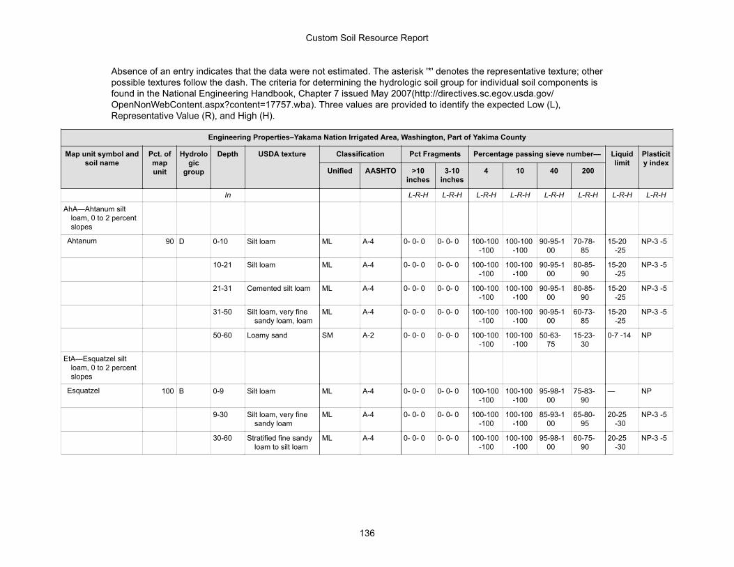
Absence of an entry indicates that the data were not estimated. The asterisk '*' denotes the representative texture; otherpossible textures follow the dash. The criteria for determining the hydrologic soil group for individual soil components isfound in the National Engineering Handbook, Chapter 7 issued May 2007(http://directives.sc.egov.usda.gov/OpenNonWebContent.aspx?content=17757.wba). Three values are provided to identify the expected Low (L),Representative Value (R), and High (H).
Engineering Properties–Yakama Nation Irrigated Area, Washington, Part of Yakima County
Map unit symbol andsoil name
Pct. ofmapunit
Hydrologic
group
Depth USDA texture Classification Pct Fragments Percentage passing sieve number— Liquidlimit
Plasticity index
Unified AASHTO >10inches
3-10inches
4 10 40 200
In L-R-H L-R-H L-R-H L-R-H L-R-H L-R-H L-R-H L-R-H
AhA—Ahtanum siltloam, 0 to 2 percentslopes
Ahtanum 90 D 0-10 Silt loam ML A-4 0- 0- 0 0- 0- 0 100-100-100
100-100-100
90-95-100
70-78-85
15-20-25
NP-3 -5
10-21 Silt loam ML A-4 0- 0- 0 0- 0- 0 100-100-100
100-100-100
90-95-100
80-85-90
15-20-25
NP-3 -5
21-31 Cemented silt loam ML A-4 0- 0- 0 0- 0- 0 100-100-100
100-100-100
90-95-100
80-85-90
15-20-25
NP-3 -5
31-50 Silt loam, very finesandy loam, loam
ML A-4 0- 0- 0 0- 0- 0 100-100-100
100-100-100
90-95-100
60-73-85
15-20-25
NP-3 -5
50-60 Loamy sand SM A-2 0- 0- 0 0- 0- 0 100-100-100
100-100-100
50-63-75
15-23-30
0-7 -14 NP
EtA—Esquatzel siltloam, 0 to 2 percentslopes
Esquatzel 100 B 0-9 Silt loam ML A-4 0- 0- 0 0- 0- 0 100-100-100
100-100-100
95-98-100
75-83-90
— NP
9-30 Silt loam, very finesandy loam
ML A-4 0- 0- 0 0- 0- 0 100-100-100
100-100-100
85-93-100
65-80-95
20-25-30
NP-3 -5
30-60 Stratified fine sandyloam to silt loam
ML A-4 0- 0- 0 0- 0- 0 100-100-100
100-100-100
95-98-100
60-75-90
20-25-30
NP-3 -5
Custom Soil Resource Report
136
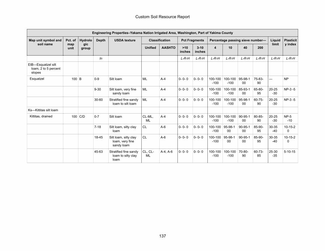
Engineering Properties–Yakama Nation Irrigated Area, Washington, Part of Yakima County
Map unit symbol andsoil name
Pct. ofmapunit
Hydrologic
group
Depth USDA texture Classification Pct Fragments Percentage passing sieve number— Liquidlimit
Plasticity index
Unified AASHTO >10inches
3-10inches
4 10 40 200
In L-R-H L-R-H L-R-H L-R-H L-R-H L-R-H L-R-H L-R-H
EtB—Esquatzel siltloam, 2 to 5 percentslopes
Esquatzel 100 B 0-9 Silt loam ML A-4 0- 0- 0 0- 0- 0 100-100-100
100-100-100
95-98-100
75-83-90
— NP
9-30 Silt loam, very finesandy loam
ML A-4 0- 0- 0 0- 0- 0 100-100-100
100-100-100
85-93-100
65-80-95
20-25-30
NP-3 -5
30-60 Stratified fine sandyloam to silt loam
ML A-4 0- 0- 0 0- 0- 0 100-100-100
100-100-100
95-98-100
60-75-90
20-25-30
NP-3 -5
Ks—Kittitas silt loam
Kittitas, drained 100 C/D 0-7 Silt loam CL-ML,ML
A-4 0- 0- 0 0- 0- 0 100-100-100
100-100-100
90-95-100
80-85-90
20-25-30
NP-5-10
7-18 Silt loam, silty clayloam
CL A-6 0- 0- 0 0- 0- 0 100-100-100
95-98-100
90-95-100
85-90-95
30-35-40
10-15-20
18-45 Silt loam, silty clayloam, very finesandy loam
CL A-6 0- 0- 0 0- 0- 0 100-100-100
95-98-100
90-95-100
85-90-95
30-35-40
10-15-20
45-63 Stratified fine sandyloam to silty clayloam
CL, CL-ML
A-4, A-6 0- 0- 0 0- 0- 0 100-100-100
100-100-100
70-80-90
60-73-85
25-30-35
5-10-15
Custom Soil Resource Report
137
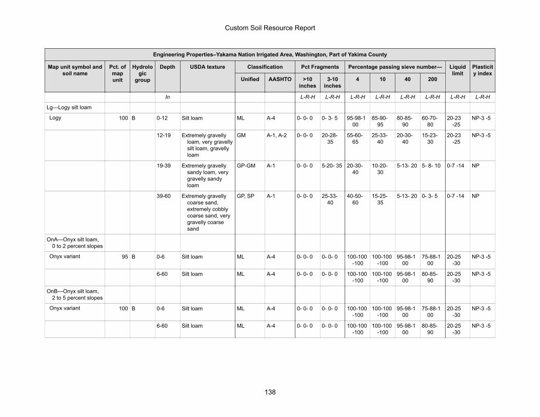
Engineering Properties–Yakama Nation Irrigated Area, Washington, Part of Yakima County
Map unit symbol andsoil name
Pct. ofmapunit
Hydrologic
group
Depth USDA texture Classification Pct Fragments Percentage passing sieve number— Liquidlimit
Plasticity index
Unified AASHTO >10inches
3-10inches
4 10 40 200
In L-R-H L-R-H L-R-H L-R-H L-R-H L-R-H L-R-H L-R-H
Lg—Logy silt loam
Logy 100 B 0-12 Silt loam ML A-4 0- 0- 0 0- 3- 5 95-98-100
85-90-95
80-85-90
60-70-80
20-23-25
NP-3 -5
12-19 Extremely gravellyloam, very gravellysilt loam, gravellyloam
GM A-1, A-2 0- 0- 0 20-28-35
55-60-65
25-33-40
20-30-40
15-23-30
20-23-25
NP-3 -5
19-39 Extremely gravellysandy loam, verygravelly sandyloam
GP-GM A-1 0- 0- 0 5-20- 35 20-30-40
10-20-30
5-13- 20 5- 8- 10 0-7 -14 NP
39-60 Extremely gravellycoarse sand,extremely cobblycoarse sand, verygravelly coarsesand
GP, SP A-1 0- 0- 0 25-33-40
40-50-60
15-25-35
5-13- 20 0- 3- 5 0-7 -14 NP
OnA—Onyx silt loam,0 to 2 percent slopes
Onyx variant 95 B 0-6 Silt loam ML A-4 0- 0- 0 0- 0- 0 100-100-100
100-100-100
95-98-100
75-88-100
20-25-30
NP-3 -5
6-60 Silt loam ML A-4 0- 0- 0 0- 0- 0 100-100-100
100-100-100
95-98-100
80-85-90
20-25-30
NP-3 -5
OnB—Onyx silt loam,2 to 5 percent slopes
Onyx variant 100 B 0-6 Silt loam ML A-4 0- 0- 0 0- 0- 0 100-100-100
100-100-100
95-98-100
75-88-100
20-25-30
NP-3 -5
6-60 Silt loam ML A-4 0- 0- 0 0- 0- 0 100-100-100
100-100-100
95-98-100
80-85-90
20-25-30
NP-3 -5
Custom Soil Resource Report
138
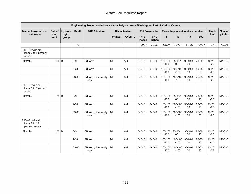
Engineering Properties–Yakama Nation Irrigated Area, Washington, Part of Yakima County
Map unit symbol andsoil name
Pct. ofmapunit
Hydrologic
group
Depth USDA texture Classification Pct Fragments Percentage passing sieve number— Liquidlimit
Plasticity index
Unified AASHTO >10inches
3-10inches
4 10 40 200
In L-R-H L-R-H L-R-H L-R-H L-R-H L-R-H L-R-H L-R-H
RtB—Ritzville siltloam, 2 to 5 percentslopes
Ritzville 100 B 0-9 Silt loam ML A-4 0- 0- 0 0- 0- 0 100-100-100
95-98-100
95-98-100
70-80-90
15-20-25
NP-3 -5
9-33 Silt loam ML A-4 0- 0- 0 0- 0- 0 100-100-100
100-100-100
95-98-100
80-85-90
15-20-25
NP-3 -5
33-60 Silt loam, fine sandyloam
ML A-4 0- 0- 0 0- 0- 0 100-100-100
100-100-100
95-98-100
75-83-90
15-20-25
NP-3 -5
RtC—Ritzville siltloam, 5 to 8 percentslopes
Ritzville 100 B 0-9 Silt loam ML A-4 0- 0- 0 0- 0- 0 100-100-100
95-98-100
95-98-100
70-80-90
15-20-25
NP-3 -5
9-33 Silt loam ML A-4 0- 0- 0 0- 0- 0 100-100-100
100-100-100
95-98-100
80-85-90
15-20-25
NP-3 -5
33-60 Silt loam, fine sandyloam
ML A-4 0- 0- 0 0- 0- 0 100-100-100
100-100-100
95-98-100
75-83-90
15-20-25
NP-3 -5
RtD—Ritzville siltloam, 8 to 15percent slopes
Ritzville 100 B 0-9 Silt loam ML A-4 0- 0- 0 0- 0- 0 100-100-100
95-98-100
95-98-100
70-80-90
15-20-25
NP-3 -5
9-33 Silt loam ML A-4 0- 0- 0 0- 0- 0 100-100-100
100-100-100
95-98-100
80-85-90
15-20-25
NP-3 -5
33-60 Silt loam, fine sandyloam
ML A-4 0- 0- 0 0- 0- 0 100-100-100
100-100-100
95-98-100
75-83-90
15-20-25
NP-3 -5
Custom Soil Resource Report
139
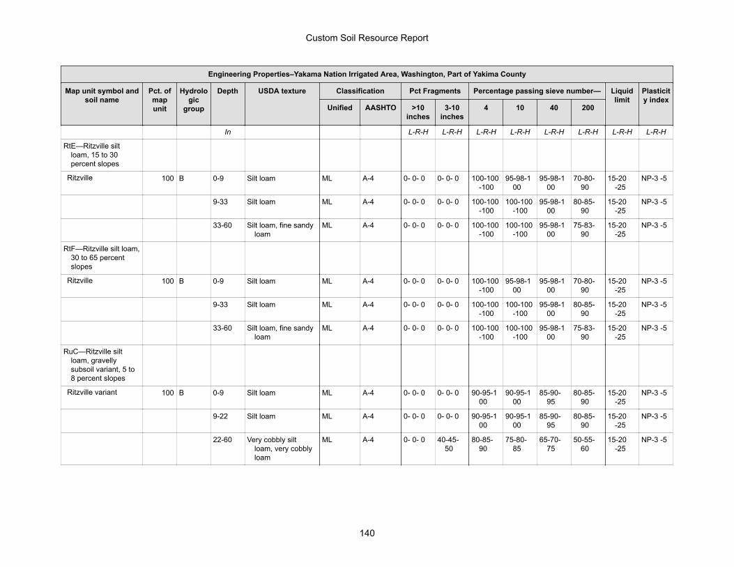
Engineering Properties–Yakama Nation Irrigated Area, Washington, Part of Yakima County
Map unit symbol andsoil name
Pct. ofmapunit
Hydrologic
group
Depth USDA texture Classification Pct Fragments Percentage passing sieve number— Liquidlimit
Plasticity index
Unified AASHTO >10inches
3-10inches
4 10 40 200
In L-R-H L-R-H L-R-H L-R-H L-R-H L-R-H L-R-H L-R-H
RtE—Ritzville siltloam, 15 to 30percent slopes
Ritzville 100 B 0-9 Silt loam ML A-4 0- 0- 0 0- 0- 0 100-100-100
95-98-100
95-98-100
70-80-90
15-20-25
NP-3 -5
9-33 Silt loam ML A-4 0- 0- 0 0- 0- 0 100-100-100
100-100-100
95-98-100
80-85-90
15-20-25
NP-3 -5
33-60 Silt loam, fine sandyloam
ML A-4 0- 0- 0 0- 0- 0 100-100-100
100-100-100
95-98-100
75-83-90
15-20-25
NP-3 -5
RtF—Ritzville silt loam,30 to 65 percentslopes
Ritzville 100 B 0-9 Silt loam ML A-4 0- 0- 0 0- 0- 0 100-100-100
95-98-100
95-98-100
70-80-90
15-20-25
NP-3 -5
9-33 Silt loam ML A-4 0- 0- 0 0- 0- 0 100-100-100
100-100-100
95-98-100
80-85-90
15-20-25
NP-3 -5
33-60 Silt loam, fine sandyloam
ML A-4 0- 0- 0 0- 0- 0 100-100-100
100-100-100
95-98-100
75-83-90
15-20-25
NP-3 -5
RuC—Ritzville siltloam, gravellysubsoil variant, 5 to8 percent slopes
Ritzville variant 100 B 0-9 Silt loam ML A-4 0- 0- 0 0- 0- 0 90-95-100
90-95-100
85-90-95
80-85-90
15-20-25
NP-3 -5
9-22 Silt loam ML A-4 0- 0- 0 0- 0- 0 90-95-100
90-95-100
85-90-95
80-85-90
15-20-25
NP-3 -5
22-60 Very cobbly siltloam, very cobblyloam
ML A-4 0- 0- 0 40-45-50
80-85-90
75-80-85
65-70-75
50-55-60
15-20-25
NP-3 -5
Custom Soil Resource Report
140
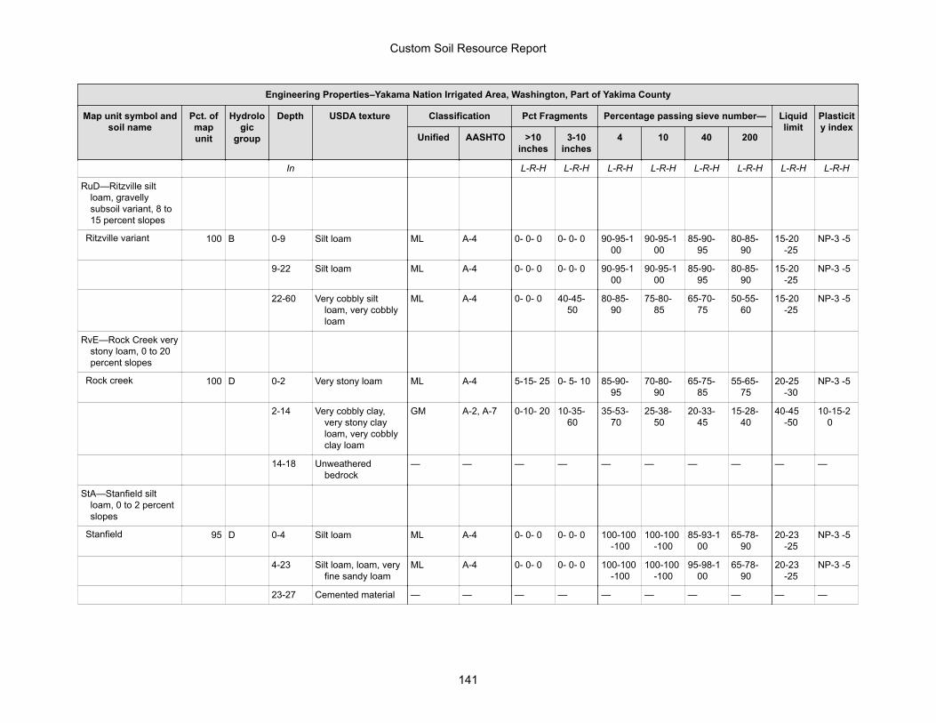
Engineering Properties–Yakama Nation Irrigated Area, Washington, Part of Yakima County
Map unit symbol andsoil name
Pct. ofmapunit
Hydrologic
group
Depth USDA texture Classification Pct Fragments Percentage passing sieve number— Liquidlimit
Plasticity index
Unified AASHTO >10inches
3-10inches
4 10 40 200
In L-R-H L-R-H L-R-H L-R-H L-R-H L-R-H L-R-H L-R-H
RuD—Ritzville siltloam, gravellysubsoil variant, 8 to15 percent slopes
Ritzville variant 100 B 0-9 Silt loam ML A-4 0- 0- 0 0- 0- 0 90-95-100
90-95-100
85-90-95
80-85-90
15-20-25
NP-3 -5
9-22 Silt loam ML A-4 0- 0- 0 0- 0- 0 90-95-100
90-95-100
85-90-95
80-85-90
15-20-25
NP-3 -5
22-60 Very cobbly siltloam, very cobblyloam
ML A-4 0- 0- 0 40-45-50
80-85-90
75-80-85
65-70-75
50-55-60
15-20-25
NP-3 -5
RvE—Rock Creek verystony loam, 0 to 20percent slopes
Rock creek 100 D 0-2 Very stony loam ML A-4 5-15- 25 0- 5- 10 85-90-95
70-80-90
65-75-85
55-65-75
20-25-30
NP-3 -5
2-14 Very cobbly clay,very stony clayloam, very cobblyclay loam
GM A-2, A-7 0-10- 20 10-35-60
35-53-70
25-38-50
20-33-45
15-28-40
40-45-50
10-15-20
14-18 Unweatheredbedrock
— — — — — — — — — —
StA—Stanfield siltloam, 0 to 2 percentslopes
Stanfield 95 D 0-4 Silt loam ML A-4 0- 0- 0 0- 0- 0 100-100-100
100-100-100
85-93-100
65-78-90
20-23-25
NP-3 -5
4-23 Silt loam, loam, veryfine sandy loam
ML A-4 0- 0- 0 0- 0- 0 100-100-100
100-100-100
95-98-100
65-78-90
20-23-25
NP-3 -5
23-27 Cemented material — — — — — — — — — —
Custom Soil Resource Report
141
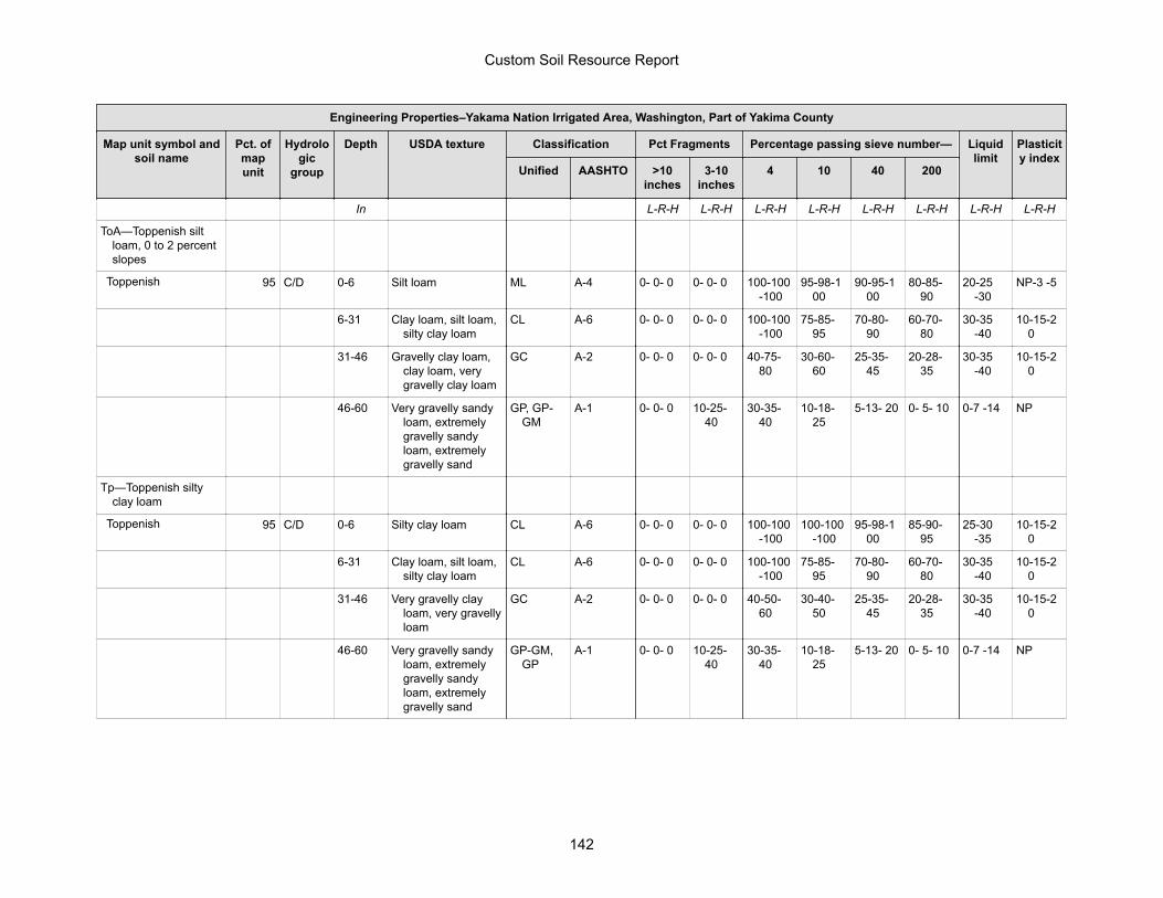
Engineering Properties–Yakama Nation Irrigated Area, Washington, Part of Yakima County
Map unit symbol andsoil name
Pct. ofmapunit
Hydrologic
group
Depth USDA texture Classification Pct Fragments Percentage passing sieve number— Liquidlimit
Plasticity index
Unified AASHTO >10inches
3-10inches
4 10 40 200
In L-R-H L-R-H L-R-H L-R-H L-R-H L-R-H L-R-H L-R-H
ToA—Toppenish siltloam, 0 to 2 percentslopes
Toppenish 95 C/D 0-6 Silt loam ML A-4 0- 0- 0 0- 0- 0 100-100-100
95-98-100
90-95-100
80-85-90
20-25-30
NP-3 -5
6-31 Clay loam, silt loam,silty clay loam
CL A-6 0- 0- 0 0- 0- 0 100-100-100
75-85-95
70-80-90
60-70-80
30-35-40
10-15-20
31-46 Gravelly clay loam,clay loam, verygravelly clay loam
GC A-2 0- 0- 0 0- 0- 0 40-75-80
30-60-60
25-35-45
20-28-35
30-35-40
10-15-20
46-60 Very gravelly sandyloam, extremelygravelly sandyloam, extremelygravelly sand
GP, GP-GM
A-1 0- 0- 0 10-25-40
30-35-40
10-18-25
5-13- 20 0- 5- 10 0-7 -14 NP
Tp—Toppenish siltyclay loam
Toppenish 95 C/D 0-6 Silty clay loam CL A-6 0- 0- 0 0- 0- 0 100-100-100
100-100-100
95-98-100
85-90-95
25-30-35
10-15-20
6-31 Clay loam, silt loam,silty clay loam
CL A-6 0- 0- 0 0- 0- 0 100-100-100
75-85-95
70-80-90
60-70-80
30-35-40
10-15-20
31-46 Very gravelly clayloam, very gravellyloam
GC A-2 0- 0- 0 0- 0- 0 40-50-60
30-40-50
25-35-45
20-28-35
30-35-40
10-15-20
46-60 Very gravelly sandyloam, extremelygravelly sandyloam, extremelygravelly sand
GP-GM,GP
A-1 0- 0- 0 10-25-40
30-35-40
10-18-25
5-13- 20 0- 5- 10 0-7 -14 NP
Custom Soil Resource Report
142
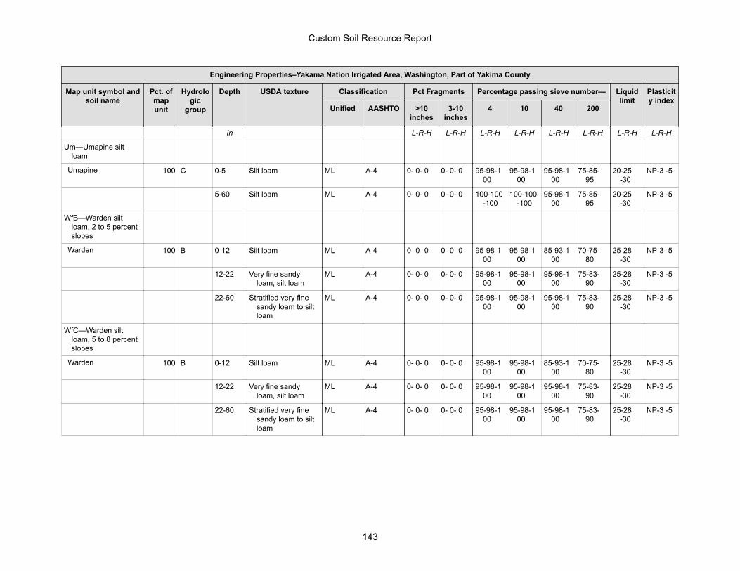
Engineering Properties–Yakama Nation Irrigated Area, Washington, Part of Yakima County
Map unit symbol andsoil name
Pct. ofmapunit
Hydrologic
group
Depth USDA texture Classification Pct Fragments Percentage passing sieve number— Liquidlimit
Plasticity index
Unified AASHTO >10inches
3-10inches
4 10 40 200
In L-R-H L-R-H L-R-H L-R-H L-R-H L-R-H L-R-H L-R-H
Um—Umapine siltloam
Umapine 100 C 0-5 Silt loam ML A-4 0- 0- 0 0- 0- 0 95-98-100
95-98-100
95-98-100
75-85-95
20-25-30
NP-3 -5
5-60 Silt loam ML A-4 0- 0- 0 0- 0- 0 100-100-100
100-100-100
95-98-100
75-85-95
20-25-30
NP-3 -5
WfB—Warden siltloam, 2 to 5 percentslopes
Warden 100 B 0-12 Silt loam ML A-4 0- 0- 0 0- 0- 0 95-98-100
95-98-100
85-93-100
70-75-80
25-28-30
NP-3 -5
12-22 Very fine sandyloam, silt loam
ML A-4 0- 0- 0 0- 0- 0 95-98-100
95-98-100
95-98-100
75-83-90
25-28-30
NP-3 -5
22-60 Stratified very finesandy loam to siltloam
ML A-4 0- 0- 0 0- 0- 0 95-98-100
95-98-100
95-98-100
75-83-90
25-28-30
NP-3 -5
WfC—Warden siltloam, 5 to 8 percentslopes
Warden 100 B 0-12 Silt loam ML A-4 0- 0- 0 0- 0- 0 95-98-100
95-98-100
85-93-100
70-75-80
25-28-30
NP-3 -5
12-22 Very fine sandyloam, silt loam
ML A-4 0- 0- 0 0- 0- 0 95-98-100
95-98-100
95-98-100
75-83-90
25-28-30
NP-3 -5
22-60 Stratified very finesandy loam to siltloam
ML A-4 0- 0- 0 0- 0- 0 95-98-100
95-98-100
95-98-100
75-83-90
25-28-30
NP-3 -5
Custom Soil Resource Report
143
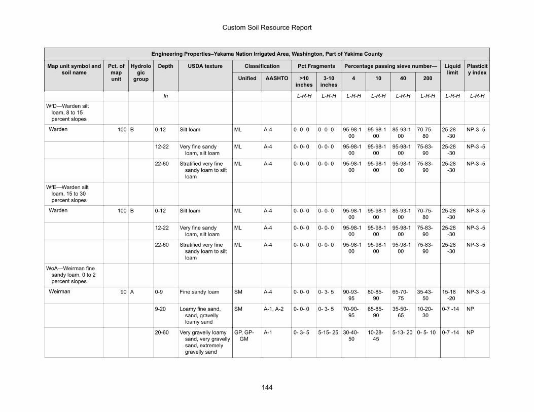
Engineering Properties–Yakama Nation Irrigated Area, Washington, Part of Yakima County
Map unit symbol andsoil name
Pct. ofmapunit
Hydrologic
group
Depth USDA texture Classification Pct Fragments Percentage passing sieve number— Liquidlimit
Plasticity index
Unified AASHTO >10inches
3-10inches
4 10 40 200
In L-R-H L-R-H L-R-H L-R-H L-R-H L-R-H L-R-H L-R-H
WfD—Warden siltloam, 8 to 15percent slopes
Warden 100 B 0-12 Silt loam ML A-4 0- 0- 0 0- 0- 0 95-98-100
95-98-100
85-93-100
70-75-80
25-28-30
NP-3 -5
12-22 Very fine sandyloam, silt loam
ML A-4 0- 0- 0 0- 0- 0 95-98-100
95-98-100
95-98-100
75-83-90
25-28-30
NP-3 -5
22-60 Stratified very finesandy loam to siltloam
ML A-4 0- 0- 0 0- 0- 0 95-98-100
95-98-100
95-98-100
75-83-90
25-28-30
NP-3 -5
WfE—Warden siltloam, 15 to 30percent slopes
Warden 100 B 0-12 Silt loam ML A-4 0- 0- 0 0- 0- 0 95-98-100
95-98-100
85-93-100
70-75-80
25-28-30
NP-3 -5
12-22 Very fine sandyloam, silt loam
ML A-4 0- 0- 0 0- 0- 0 95-98-100
95-98-100
95-98-100
75-83-90
25-28-30
NP-3 -5
22-60 Stratified very finesandy loam to siltloam
ML A-4 0- 0- 0 0- 0- 0 95-98-100
95-98-100
95-98-100
75-83-90
25-28-30
NP-3 -5
WoA—Weirman finesandy loam, 0 to 2percent slopes
Weirman 90 A 0-9 Fine sandy loam SM A-4 0- 0- 0 0- 3- 5 90-93-95
80-85-90
65-70-75
35-43-50
15-18-20
NP-3 -5
9-20 Loamy fine sand,sand, gravellyloamy sand
SM A-1, A-2 0- 0- 0 0- 3- 5 70-90-95
65-85-90
35-50-65
10-20-30
0-7 -14 NP
20-60 Very gravelly loamysand, very gravellysand, extremelygravelly sand
GP, GP-GM
A-1 0- 3- 5 5-15- 25 30-40-50
10-28-45
5-13- 20 0- 5- 10 0-7 -14 NP
Custom Soil Resource Report
144
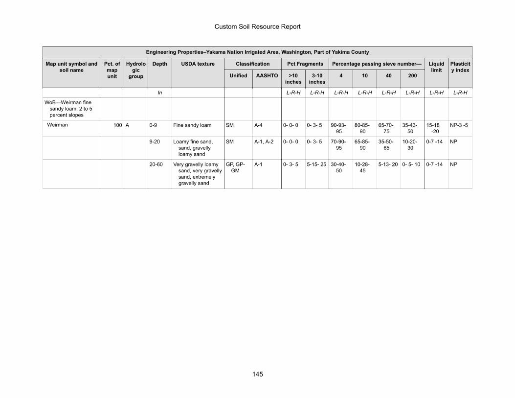
Engineering Properties–Yakama Nation Irrigated Area, Washington, Part of Yakima County
Map unit symbol andsoil name
Pct. ofmapunit
Hydrologic
group
Depth USDA texture Classification Pct Fragments Percentage passing sieve number— Liquidlimit
Plasticity index
Unified AASHTO >10inches
3-10inches
4 10 40 200
In L-R-H L-R-H L-R-H L-R-H L-R-H L-R-H L-R-H L-R-H
WoB—Weirman finesandy loam, 2 to 5percent slopes
Weirman 100 A 0-9 Fine sandy loam SM A-4 0- 0- 0 0- 3- 5 90-93-95
80-85-90
65-70-75
35-43-50
15-18-20
NP-3 -5
9-20 Loamy fine sand,sand, gravellyloamy sand
SM A-1, A-2 0- 0- 0 0- 3- 5 70-90-95
65-85-90
35-50-65
10-20-30
0-7 -14 NP
20-60 Very gravelly loamysand, very gravellysand, extremelygravelly sand
GP, GP-GM
A-1 0- 3- 5 5-15- 25 30-40-50
10-28-45
5-13- 20 0- 5- 10 0-7 -14 NP
Custom Soil Resource Report
145
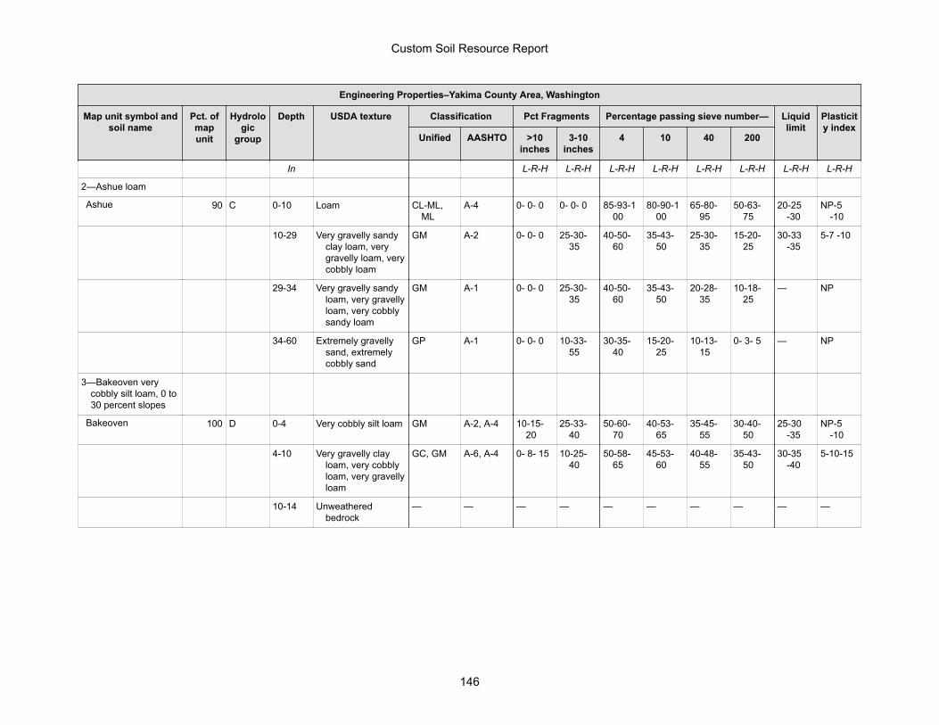
Engineering Properties–Yakima County Area, Washington
Map unit symbol andsoil name
Pct. ofmapunit
Hydrologic
group
Depth USDA texture Classification Pct Fragments Percentage passing sieve number— Liquidlimit
Plasticity index
Unified AASHTO >10inches
3-10inches
4 10 40 200
In L-R-H L-R-H L-R-H L-R-H L-R-H L-R-H L-R-H L-R-H
2—Ashue loam
Ashue 90 C 0-10 Loam CL-ML,ML
A-4 0- 0- 0 0- 0- 0 85-93-100
80-90-100
65-80-95
50-63-75
20-25-30
NP-5-10
10-29 Very gravelly sandyclay loam, verygravelly loam, verycobbly loam
GM A-2 0- 0- 0 25-30-35
40-50-60
35-43-50
25-30-35
15-20-25
30-33-35
5-7 -10
29-34 Very gravelly sandyloam, very gravellyloam, very cobblysandy loam
GM A-1 0- 0- 0 25-30-35
40-50-60
35-43-50
20-28-35
10-18-25
— NP
34-60 Extremely gravellysand, extremelycobbly sand
GP A-1 0- 0- 0 10-33-55
30-35-40
15-20-25
10-13-15
0- 3- 5 — NP
3—Bakeoven verycobbly silt loam, 0 to30 percent slopes
Bakeoven 100 D 0-4 Very cobbly silt loam GM A-2, A-4 10-15-20
25-33-40
50-60-70
40-53-65
35-45-55
30-40-50
25-30-35
NP-5-10
4-10 Very gravelly clayloam, very cobblyloam, very gravellyloam
GC, GM A-6, A-4 0- 8- 15 10-25-40
50-58-65
45-53-60
40-48-55
35-43-50
30-35-40
5-10-15
10-14 Unweatheredbedrock
— — — — — — — — — —
Custom Soil Resource Report
146
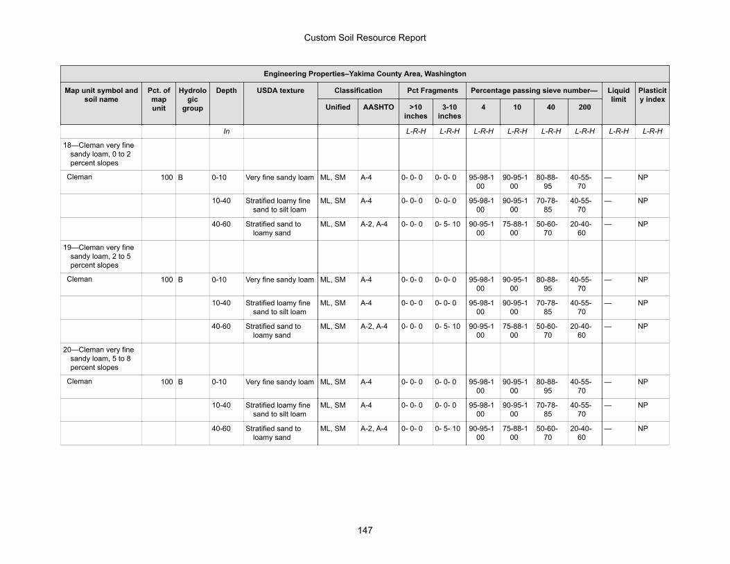
Engineering Properties–Yakima County Area, Washington
Map unit symbol andsoil name
Pct. ofmapunit
Hydrologic
group
Depth USDA texture Classification Pct Fragments Percentage passing sieve number— Liquidlimit
Plasticity index
Unified AASHTO >10inches
3-10inches
4 10 40 200
In L-R-H L-R-H L-R-H L-R-H L-R-H L-R-H L-R-H L-R-H
18—Cleman very finesandy loam, 0 to 2percent slopes
Cleman 100 B 0-10 Very fine sandy loam ML, SM A-4 0- 0- 0 0- 0- 0 95-98-100
90-95-100
80-88-95
40-55-70
— NP
10-40 Stratified loamy finesand to silt loam
ML, SM A-4 0- 0- 0 0- 0- 0 95-98-100
90-95-100
70-78-85
40-55-70
— NP
40-60 Stratified sand toloamy sand
ML, SM A-2, A-4 0- 0- 0 0- 5- 10 90-95-100
75-88-100
50-60-70
20-40-60
— NP
19—Cleman very finesandy loam, 2 to 5percent slopes
Cleman 100 B 0-10 Very fine sandy loam ML, SM A-4 0- 0- 0 0- 0- 0 95-98-100
90-95-100
80-88-95
40-55-70
— NP
10-40 Stratified loamy finesand to silt loam
ML, SM A-4 0- 0- 0 0- 0- 0 95-98-100
90-95-100
70-78-85
40-55-70
— NP
40-60 Stratified sand toloamy sand
ML, SM A-2, A-4 0- 0- 0 0- 5- 10 90-95-100
75-88-100
50-60-70
20-40-60
— NP
20—Cleman very finesandy loam, 5 to 8percent slopes
Cleman 100 B 0-10 Very fine sandy loam ML, SM A-4 0- 0- 0 0- 0- 0 95-98-100
90-95-100
80-88-95
40-55-70
— NP
10-40 Stratified loamy finesand to silt loam
ML, SM A-4 0- 0- 0 0- 0- 0 95-98-100
90-95-100
70-78-85
40-55-70
— NP
40-60 Stratified sand toloamy sand
ML, SM A-2, A-4 0- 0- 0 0- 5- 10 90-95-100
75-88-100
50-60-70
20-40-60
— NP
Custom Soil Resource Report
147
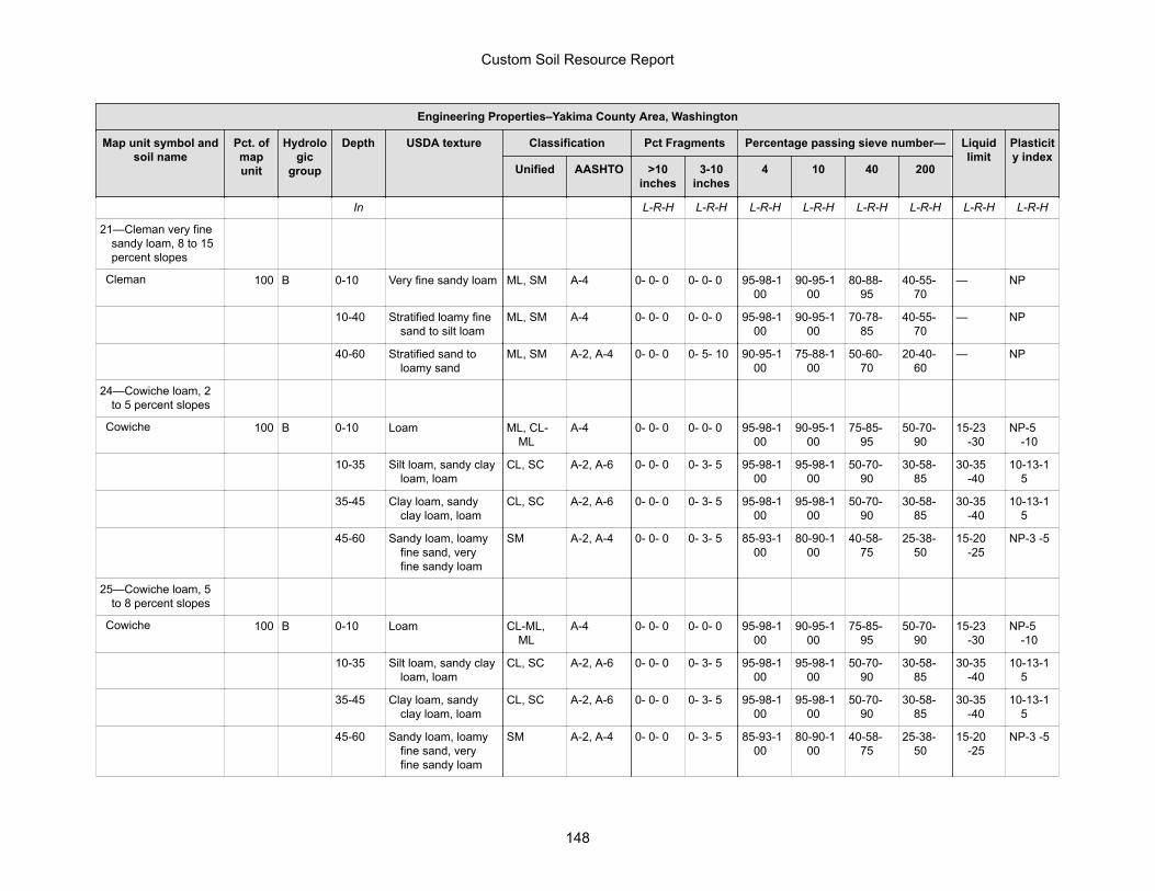
Engineering Properties–Yakima County Area, Washington
Map unit symbol andsoil name
Pct. ofmapunit
Hydrologic
group
Depth USDA texture Classification Pct Fragments Percentage passing sieve number— Liquidlimit
Plasticity index
Unified AASHTO >10inches
3-10inches
4 10 40 200
In L-R-H L-R-H L-R-H L-R-H L-R-H L-R-H L-R-H L-R-H
21—Cleman very finesandy loam, 8 to 15percent slopes
Cleman 100 B 0-10 Very fine sandy loam ML, SM A-4 0- 0- 0 0- 0- 0 95-98-100
90-95-100
80-88-95
40-55-70
— NP
10-40 Stratified loamy finesand to silt loam
ML, SM A-4 0- 0- 0 0- 0- 0 95-98-100
90-95-100
70-78-85
40-55-70
— NP
40-60 Stratified sand toloamy sand
ML, SM A-2, A-4 0- 0- 0 0- 5- 10 90-95-100
75-88-100
50-60-70
20-40-60
— NP
24—Cowiche loam, 2to 5 percent slopes
Cowiche 100 B 0-10 Loam ML, CL-ML
A-4 0- 0- 0 0- 0- 0 95-98-100
90-95-100
75-85-95
50-70-90
15-23-30
NP-5-10
10-35 Silt loam, sandy clayloam, loam
CL, SC A-2, A-6 0- 0- 0 0- 3- 5 95-98-100
95-98-100
50-70-90
30-58-85
30-35-40
10-13-15
35-45 Clay loam, sandyclay loam, loam
CL, SC A-2, A-6 0- 0- 0 0- 3- 5 95-98-100
95-98-100
50-70-90
30-58-85
30-35-40
10-13-15
45-60 Sandy loam, loamyfine sand, veryfine sandy loam
SM A-2, A-4 0- 0- 0 0- 3- 5 85-93-100
80-90-100
40-58-75
25-38-50
15-20-25
NP-3 -5
25—Cowiche loam, 5to 8 percent slopes
Cowiche 100 B 0-10 Loam CL-ML,ML
A-4 0- 0- 0 0- 0- 0 95-98-100
90-95-100
75-85-95
50-70-90
15-23-30
NP-5-10
10-35 Silt loam, sandy clayloam, loam
CL, SC A-2, A-6 0- 0- 0 0- 3- 5 95-98-100
95-98-100
50-70-90
30-58-85
30-35-40
10-13-15
35-45 Clay loam, sandyclay loam, loam
CL, SC A-2, A-6 0- 0- 0 0- 3- 5 95-98-100
95-98-100
50-70-90
30-58-85
30-35-40
10-13-15
45-60 Sandy loam, loamyfine sand, veryfine sandy loam
SM A-2, A-4 0- 0- 0 0- 3- 5 85-93-100
80-90-100
40-58-75
25-38-50
15-20-25
NP-3 -5
Custom Soil Resource Report
148
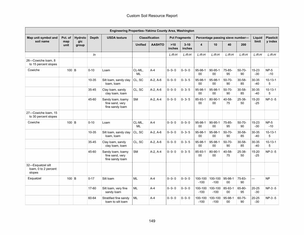
Engineering Properties–Yakima County Area, Washington
Map unit symbol andsoil name
Pct. ofmapunit
Hydrologic
group
Depth USDA texture Classification Pct Fragments Percentage passing sieve number— Liquidlimit
Plasticity index
Unified AASHTO >10inches
3-10inches
4 10 40 200
In L-R-H L-R-H L-R-H L-R-H L-R-H L-R-H L-R-H L-R-H
26—Cowiche loam, 8to 15 percent slopes
Cowiche 100 B 0-10 Loam CL-ML,ML
A-4 0- 0- 0 0- 0- 0 95-98-100
90-95-100
75-85-95
50-70-90
15-23-30
NP-5-10
10-35 Silt loam, sandy clayloam, loam
CL, SC A-2, A-6 0- 0- 0 0- 3- 5 95-98-100
95-98-100
50-70-90
30-58-85
30-35-40
10-13-15
35-45 Clay loam, sandyclay loam, loam
CL, SC A-2, A-6 0- 0- 0 0- 3- 5 95-98-100
95-98-100
50-70-90
30-58-85
30-35-40
10-13-15
45-60 Sandy loam, loamyfine sand, veryfine sandy loam
SM A-2, A-4 0- 0- 0 0- 3- 5 85-93-100
80-90-100
40-58-75
25-38-50
15-20-25
NP-3 -5
27—Cowiche loam, 15to 30 percent slopes
Cowiche 100 B 0-10 Loam CL-ML,ML
A-4 0- 0- 0 0- 0- 0 95-98-100
90-95-100
75-85-95
50-70-90
15-23-30
NP-5-10
10-35 Silt loam, sandy clayloam, loam
CL, SC A-2, A-6 0- 0- 0 0- 3- 5 95-98-100
95-98-100
50-70-90
30-58-85
30-35-40
10-13-15
35-45 Clay loam, sandyclay loam, loam
CL, SC A-2, A-6 0- 0- 0 0- 3- 5 95-98-100
95-98-100
50-70-90
30-58-85
30-35-40
10-13-15
45-60 Sandy loam, loamyfine sand, veryfine sandy loam
SM A-2, A-4 0- 0- 0 0- 3- 5 85-93-100
80-90-100
40-58-75
25-38-50
15-20-25
NP-3 -5
32—Esquatzel siltloam, 0 to 2 percentslopes
Esquatzel 100 B 0-17 Silt loam ML A-4 0- 0- 0 0- 0- 0 100-100-100
100-100-100
95-98-100
75-83-90
— NP
17-60 Silt loam, very finesandy loam
ML A-4 0- 0- 0 0- 0- 0 100-100-100
100-100-100
85-93-100
65-80-95
20-25-30
NP-3 -5
60-64 Stratified fine sandyloam to silt loam
ML A-4 0- 0- 0 0- 0- 0 100-100-100
100-100-100
95-98-100
60-75-90
20-25-30
NP-3 -5
Custom Soil Resource Report
149
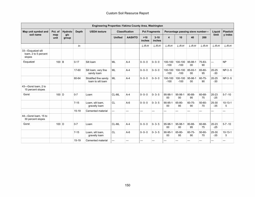
Engineering Properties–Yakima County Area, Washington
Map unit symbol andsoil name
Pct. ofmapunit
Hydrologic
group
Depth USDA texture Classification Pct Fragments Percentage passing sieve number— Liquidlimit
Plasticity index
Unified AASHTO >10inches
3-10inches
4 10 40 200
In L-R-H L-R-H L-R-H L-R-H L-R-H L-R-H L-R-H L-R-H
33—Esquatzel siltloam, 2 to 5 percentslopes
Esquatzel 100 B 0-17 Silt loam ML A-4 0- 0- 0 0- 0- 0 100-100-100
100-100-100
95-98-100
75-83-90
— NP
17-60 Silt loam, very finesandy loam
ML A-4 0- 0- 0 0- 0- 0 100-100-100
100-100-100
85-93-100
65-80-95
20-25-30
NP-3 -5
60-64 Stratified fine sandyloam to silt loam
ML A-4 0- 0- 0 0- 0- 0 100-100-100
100-100-100
95-98-100
60-75-90
20-25-30
NP-3 -5
43—Gorst loam, 2 to15 percent slopes
Gorst 100 D 0-7 Loam CL-ML A-4 0- 0- 0 0- 3- 5 95-98-100
95-98-100
80-88-95
60-68-75
20-23-25
5-7 -10
7-15 Loam, silt loam,gravelly loam
CL A-6 0- 0- 0 0- 3- 5 90-95-100
65-80-95
60-75-90
50-60-70
25-30-35
10-13-15
15-19 Cemented material — — — — — — — — — —
44—Gorst loam, 15 to30 percent slopes
Gorst 100 D 0-7 Loam CL-ML A-4 0- 0- 0 0- 3- 5 95-98-100
95-98-100
80-88-95
60-68-75
20-23-25
5-7 -10
7-15 Loam, silt loam,gravelly loam
CL A-6 0- 0- 0 0- 3- 5 90-95-100
65-80-95
60-75-90
50-60-70
25-30-35
10-13-15
15-19 Cemented material — — — — — — — — — —
Custom Soil Resource Report
150
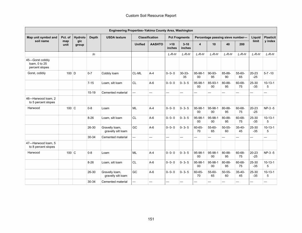
Engineering Properties–Yakima County Area, Washington
Map unit symbol andsoil name
Pct. ofmapunit
Hydrologic
group
Depth USDA texture Classification Pct Fragments Percentage passing sieve number— Liquidlimit
Plasticity index
Unified AASHTO >10inches
3-10inches
4 10 40 200
In L-R-H L-R-H L-R-H L-R-H L-R-H L-R-H L-R-H L-R-H
45—Gorst cobblyloam, 0 to 25percent slopes
Gorst, cobbly 100 D 0-7 Cobbly loam CL-ML A-4 0- 0- 0 30-33-35
95-98-100
90-93-95
85-88-90
55-60-65
20-23-25
5-7 -10
7-15 Loam, silt loam CL A-6 0- 0- 0 0- 3- 5 95-98-100
85-93-100
80-88-95
60-68-75
25-30-35
10-13-15
15-19 Cemented material — — — — — — — — — —
46—Harwood loam, 2to 5 percent slopes
Harwood 100 C 0-8 Loam ML A-4 0- 0- 0 0- 3- 5 95-98-100
95-98-100
80-88-95
60-68-75
20-23-25
NP-3 -5
8-26 Loam, silt loam CL A-6 0- 0- 0 0- 3- 5 95-98-100
95-98-100
80-88-95
60-68-75
25-30-35
10-13-15
26-30 Gravelly loam,gravelly silt loam
GC A-6 0- 0- 0 0- 3- 5 60-65-70
55-60-65
50-55-60
35-40-45
25-30-35
10-13-15
30-34 Cemented material — — — — — — — — — —
47—Harwood loam, 5to 8 percent slopes
Harwood 100 C 0-8 Loam ML A-4 0- 0- 0 0- 3- 5 95-98-100
95-98-100
80-88-95
60-68-75
20-23-25
NP-3 -5
8-26 Loam, silt loam CL A-6 0- 0- 0 0- 3- 5 95-98-100
95-98-100
80-88-95
60-68-75
25-30-35
10-13-15
26-30 Gravelly loam,gravelly silt loam
GC A-6 0- 0- 0 0- 3- 5 60-65-70
55-60-65
50-55-60
35-40-45
25-30-35
10-13-15
30-34 Cemented material — — — — — — — — — —
Custom Soil Resource Report
151
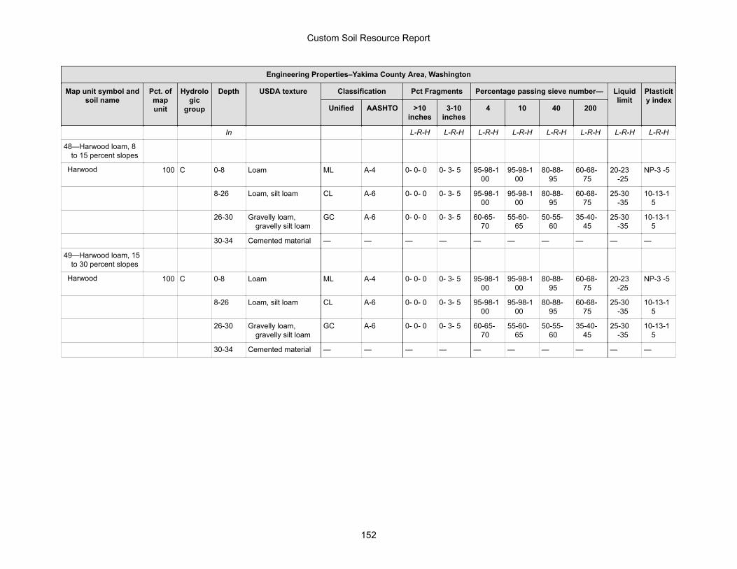
Engineering Properties–Yakima County Area, Washington
Map unit symbol andsoil name
Pct. ofmapunit
Hydrologic
group
Depth USDA texture Classification Pct Fragments Percentage passing sieve number— Liquidlimit
Plasticity index
Unified AASHTO >10inches
3-10inches
4 10 40 200
In L-R-H L-R-H L-R-H L-R-H L-R-H L-R-H L-R-H L-R-H
48—Harwood loam, 8to 15 percent slopes
Harwood 100 C 0-8 Loam ML A-4 0- 0- 0 0- 3- 5 95-98-100
95-98-100
80-88-95
60-68-75
20-23-25
NP-3 -5
8-26 Loam, silt loam CL A-6 0- 0- 0 0- 3- 5 95-98-100
95-98-100
80-88-95
60-68-75
25-30-35
10-13-15
26-30 Gravelly loam,gravelly silt loam
GC A-6 0- 0- 0 0- 3- 5 60-65-70
55-60-65
50-55-60
35-40-45
25-30-35
10-13-15
30-34 Cemented material — — — — — — — — — —
49—Harwood loam, 15to 30 percent slopes
Harwood 100 C 0-8 Loam ML A-4 0- 0- 0 0- 3- 5 95-98-100
95-98-100
80-88-95
60-68-75
20-23-25
NP-3 -5
8-26 Loam, silt loam CL A-6 0- 0- 0 0- 3- 5 95-98-100
95-98-100
80-88-95
60-68-75
25-30-35
10-13-15
26-30 Gravelly loam,gravelly silt loam
GC A-6 0- 0- 0 0- 3- 5 60-65-70
55-60-65
50-55-60
35-40-45
25-30-35
10-13-15
30-34 Cemented material — — — — — — — — — —
Custom Soil Resource Report
152

Engineering Properties–Yakima County Area, Washington
Map unit symbol andsoil name
Pct. ofmapunit
Hydrologic
group
Depth USDA texture Classification Pct Fragments Percentage passing sieve number— Liquidlimit
Plasticity index
Unified AASHTO >10inches
3-10inches
4 10 40 200
In L-R-H L-R-H L-R-H L-R-H L-R-H L-R-H L-R-H L-R-H
50—Harwood-Burke-Wiehl silt loams, 2 to5 percent slopes
Burke 30 C 0-7 Silt loam ML A-4 0- 0- 0 0- 0- 0 100-100-100
95-98-100
85-90-95
75-85-95
20-25-30
NP-3 -5
7-25 Silt loam, very finesandy loam
ML A-4 0- 0- 0 0- 0- 0 100-100-100
95-98-100
95-98-100
80-88-95
20-25-30
NP-3 -5
25-29 Cemented material — — — — — — — — — —
Harwood 30 C 0-8 Loam ML A-4 0- 0- 0 0- 3- 5 95-98-100
95-98-100
80-88-95
60-68-75
20-23-25
NP-3 -5
8-26 Loam, silt loam CL A-6 0- 0- 0 0- 3- 5 95-98-100
95-98-100
80-88-95
60-68-75
25-30-35
10-13-15
26-30 Gravelly loam,gravelly silt loam
GC A-6 0- 0- 0 0- 3- 5 60-65-70
55-60-65
50-55-60
35-40-45
25-30-35
10-13-15
30-34 Cemented material — — — — — — — — — —
Wiehl 20 C 0-3 Silt loam ML A-4 0- 0- 0 0- 0- 0 100-100-100
100-100-100
90-95-100
70-80-90
15-20-25
NP-3 -5
3-21 Fine sandy loam, siltloam, very finesandy loam
ML, SM A-4 0- 0- 0 0- 0- 5 100-100-100
100-100-100
80-85-95
40-55-65
15-20-25
NP-3 -5
21-27 Fine sandy loam,gravelly silt loam,very fine sandyloam
ML, SM A-4 0- 0- 0 0- 0- 5 70-85-100
60-80-100
55-70-95
40-55-65
15-20-25
NP-3 -5
27-37 Weathered bedrock — — — — — — — — — —
Custom Soil Resource Report
153

Engineering Properties–Yakima County Area, Washington
Map unit symbol andsoil name
Pct. ofmapunit
Hydrologic
group
Depth USDA texture Classification Pct Fragments Percentage passing sieve number— Liquidlimit
Plasticity index
Unified AASHTO >10inches
3-10inches
4 10 40 200
In L-R-H L-R-H L-R-H L-R-H L-R-H L-R-H L-R-H L-R-H
52—Harwood-Burke-Wiehl silt loams, 8 to15 percent slopes
Burke 30 C 0-7 Silt loam ML A-4 0- 0- 0 0- 0- 0 100-100-100
95-98-100
85-90-95
75-85-95
20-25-30
NP-3 -5
7-25 Silt loam, very finesandy loam
ML A-4 0- 0- 0 0- 0- 0 100-100-100
95-98-100
95-98-100
80-88-95
20-25-30
NP-3 -5
25-29 Cemented material — — — — — — — — — —
Harwood 30 C 0-8 Loam ML A-4 0- 0- 0 0- 3- 5 95-98-100
95-98-100
80-88-95
60-68-75
20-23-25
NP-3 -5
8-26 Loam, silt loam CL A-6 0- 0- 0 0- 3- 5 95-98-100
95-98-100
80-88-95
60-68-75
25-30-35
10-13-15
26-30 Gravelly loam,gravelly silt loam
GC A-6 0- 0- 0 0- 3- 5 60-65-70
55-60-65
50-55-60
35-40-45
25-30-35
10-13-15
30-34 Cemented material — — — — — — — — — —
Wiehl 20 C 0-3 Silt loam ML A-4 0- 0- 0 0- 0- 0 100-100-100
100-100-100
90-95-100
70-80-90
15-20-25
NP-3 -5
3-21 Fine sandy loam, siltloam, very finesandy loam
ML, SM A-4 0- 0- 0 0- 0- 5 100-100-100
100-100-100
80-85-95
40-55-65
15-20-25
NP-3 -5
21-27 Fine sandy loam,gravelly silt loam,very fine sandyloam
ML, SM A-4 0- 0- 0 0- 0- 5 70-85-100
60-80-100
55-70-95
40-55-65
15-20-25
NP-3 -5
27-37 Weathered bedrock — — — — — — — — — —
Custom Soil Resource Report
154
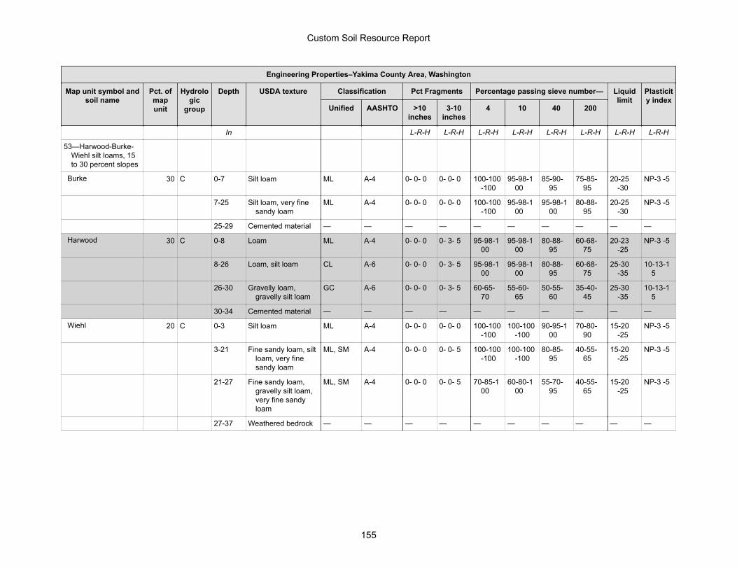
Engineering Properties–Yakima County Area, Washington
Map unit symbol andsoil name
Pct. ofmapunit
Hydrologic
group
Depth USDA texture Classification Pct Fragments Percentage passing sieve number— Liquidlimit
Plasticity index
Unified AASHTO >10inches
3-10inches
4 10 40 200
In L-R-H L-R-H L-R-H L-R-H L-R-H L-R-H L-R-H L-R-H
53—Harwood-Burke-Wiehl silt loams, 15to 30 percent slopes
Burke 30 C 0-7 Silt loam ML A-4 0- 0- 0 0- 0- 0 100-100-100
95-98-100
85-90-95
75-85-95
20-25-30
NP-3 -5
7-25 Silt loam, very finesandy loam
ML A-4 0- 0- 0 0- 0- 0 100-100-100
95-98-100
95-98-100
80-88-95
20-25-30
NP-3 -5
25-29 Cemented material — — — — — — — — — —
Harwood 30 C 0-8 Loam ML A-4 0- 0- 0 0- 3- 5 95-98-100
95-98-100
80-88-95
60-68-75
20-23-25
NP-3 -5
8-26 Loam, silt loam CL A-6 0- 0- 0 0- 3- 5 95-98-100
95-98-100
80-88-95
60-68-75
25-30-35
10-13-15
26-30 Gravelly loam,gravelly silt loam
GC A-6 0- 0- 0 0- 3- 5 60-65-70
55-60-65
50-55-60
35-40-45
25-30-35
10-13-15
30-34 Cemented material — — — — — — — — — —
Wiehl 20 C 0-3 Silt loam ML A-4 0- 0- 0 0- 0- 0 100-100-100
100-100-100
90-95-100
70-80-90
15-20-25
NP-3 -5
3-21 Fine sandy loam, siltloam, very finesandy loam
ML, SM A-4 0- 0- 0 0- 0- 5 100-100-100
100-100-100
80-85-95
40-55-65
15-20-25
NP-3 -5
21-27 Fine sandy loam,gravelly silt loam,very fine sandyloam
ML, SM A-4 0- 0- 0 0- 0- 5 70-85-100
60-80-100
55-70-95
40-55-65
15-20-25
NP-3 -5
27-37 Weathered bedrock — — — — — — — — — —
Custom Soil Resource Report
155
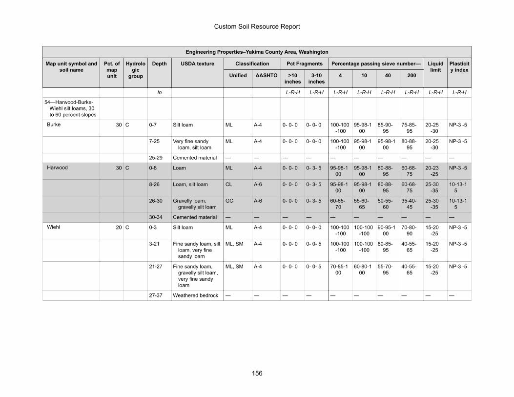
Engineering Properties–Yakima County Area, Washington
Map unit symbol andsoil name
Pct. ofmapunit
Hydrologic
group
Depth USDA texture Classification Pct Fragments Percentage passing sieve number— Liquidlimit
Plasticity index
Unified AASHTO >10inches
3-10inches
4 10 40 200
In L-R-H L-R-H L-R-H L-R-H L-R-H L-R-H L-R-H L-R-H
54—Harwood-Burke-Wiehl silt loams, 30to 60 percent slopes
Burke 30 C 0-7 Silt loam ML A-4 0- 0- 0 0- 0- 0 100-100-100
95-98-100
85-90-95
75-85-95
20-25-30
NP-3 -5
7-25 Very fine sandyloam, silt loam
ML A-4 0- 0- 0 0- 0- 0 100-100-100
95-98-100
95-98-100
80-88-95
20-25-30
NP-3 -5
25-29 Cemented material — — — — — — — — — —
Harwood 30 C 0-8 Loam ML A-4 0- 0- 0 0- 3- 5 95-98-100
95-98-100
80-88-95
60-68-75
20-23-25
NP-3 -5
8-26 Loam, silt loam CL A-6 0- 0- 0 0- 3- 5 95-98-100
95-98-100
80-88-95
60-68-75
25-30-35
10-13-15
26-30 Gravelly loam,gravelly silt loam
GC A-6 0- 0- 0 0- 3- 5 60-65-70
55-60-65
50-55-60
35-40-45
25-30-35
10-13-15
30-34 Cemented material — — — — — — — — — —
Wiehl 20 C 0-3 Silt loam ML A-4 0- 0- 0 0- 0- 0 100-100-100
100-100-100
90-95-100
70-80-90
15-20-25
NP-3 -5
3-21 Fine sandy loam, siltloam, very finesandy loam
ML, SM A-4 0- 0- 0 0- 0- 5 100-100-100
100-100-100
80-85-95
40-55-65
15-20-25
NP-3 -5
21-27 Fine sandy loam,gravelly silt loam,very fine sandyloam
ML, SM A-4 0- 0- 0 0- 0- 5 70-85-100
60-80-100
55-70-95
40-55-65
15-20-25
NP-3 -5
27-37 Weathered bedrock — — — — — — — — — —
Custom Soil Resource Report
156
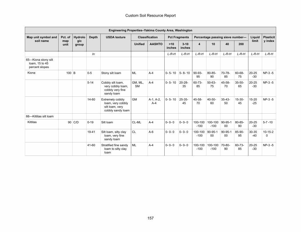
Engineering Properties–Yakima County Area, Washington
Map unit symbol andsoil name
Pct. ofmapunit
Hydrologic
group
Depth USDA texture Classification Pct Fragments Percentage passing sieve number— Liquidlimit
Plasticity index
Unified AASHTO >10inches
3-10inches
4 10 40 200
In L-R-H L-R-H L-R-H L-R-H L-R-H L-R-H L-R-H L-R-H
65—Kiona stony siltloam, 15 to 45percent slopes
Kiona 100 B 0-5 Stony silt loam ML A-4 0- 5- 10 5- 8- 10 90-93-95
80-85-90
70-78-85
60-68-75
20-25-30
NP-3 -5
5-14 Cobbly silt loam,very cobbly loam,cobbly very finesandy loam
GM, ML,SM
A-4 0- 5- 10 20-28-35
60-73-85
50-63-75
45-58-70
35-50-65
20-25-30
NP-3 -5
14-60 Extremely cobblyloam, very cobblysilt loam, verycobbly sandy loam
GM A-1, A-2,A-4
0- 5- 10 25-35-45
45-58-70
40-50-60
35-43-50
15-30-45
15-20-25
NP-3 -5
66—Kittitas silt loam
Kittitas 90 C/D 0-19 Silt loam CL-ML A-4 0- 0- 0 0- 0- 0 100-100-100
100-100-100
90-95-100
80-85-90
20-25-30
5-7 -10
19-41 Silt loam, silty clayloam, very finesandy loam
CL A-6 0- 0- 0 0- 0- 0 100-100-100
90-95-100
90-95-100
85-90-95
30-35-40
10-15-20
41-60 Stratified fine sandyloam to silty clayloam
ML A-4 0- 0- 0 0- 0- 0 100-100-100
100-100-100
70-80-90
60-73-85
20-25-30
NP-3 -5
Custom Soil Resource Report
157
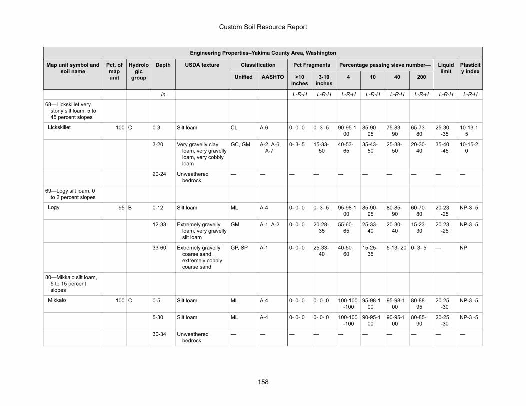
Engineering Properties–Yakima County Area, Washington
Map unit symbol andsoil name
Pct. ofmapunit
Hydrologic
group
Depth USDA texture Classification Pct Fragments Percentage passing sieve number— Liquidlimit
Plasticity index
Unified AASHTO >10inches
3-10inches
4 10 40 200
In L-R-H L-R-H L-R-H L-R-H L-R-H L-R-H L-R-H L-R-H
68—Lickskillet verystony silt loam, 5 to45 percent slopes
Lickskillet 100 C 0-3 Silt loam CL A-6 0- 0- 0 0- 3- 5 90-95-100
85-90-95
75-83-90
65-73-80
25-30-35
10-13-15
3-20 Very gravelly clayloam, very gravellyloam, very cobblyloam
GC, GM A-2, A-6,A-7
0- 3- 5 15-33-50
40-53-65
35-43-50
25-38-50
20-30-40
35-40-45
10-15-20
20-24 Unweatheredbedrock
— — — — — — — — — —
69—Logy silt loam, 0to 2 percent slopes
Logy 95 B 0-12 Silt loam ML A-4 0- 0- 0 0- 3- 5 95-98-100
85-90-95
80-85-90
60-70-80
20-23-25
NP-3 -5
12-33 Extremely gravellyloam, very gravellysilt loam
GM A-1, A-2 0- 0- 0 20-28-35
55-60-65
25-33-40
20-30-40
15-23-30
20-23-25
NP-3 -5
33-60 Extremely gravellycoarse sand,extremely cobblycoarse sand
GP, SP A-1 0- 0- 0 25-33-40
40-50-60
15-25-35
5-13- 20 0- 3- 5 — NP
80—Mikkalo silt loam,5 to 15 percentslopes
Mikkalo 100 C 0-5 Silt loam ML A-4 0- 0- 0 0- 0- 0 100-100-100
95-98-100
95-98-100
80-88-95
20-25-30
NP-3 -5
5-30 Silt loam ML A-4 0- 0- 0 0- 0- 0 100-100-100
90-95-100
90-95-100
80-85-90
20-25-30
NP-3 -5
30-34 Unweatheredbedrock
— — — — — — — — — —
Custom Soil Resource Report
158
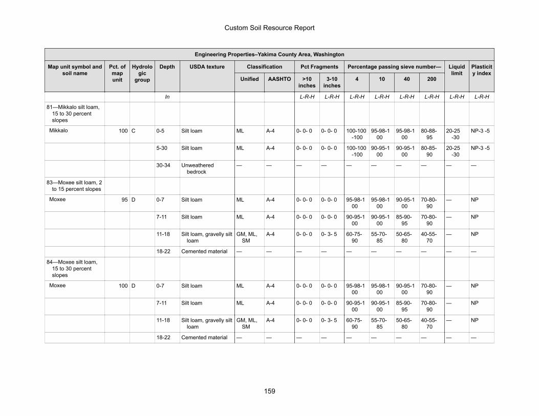
Engineering Properties–Yakima County Area, Washington
Map unit symbol andsoil name
Pct. ofmapunit
Hydrologic
group
Depth USDA texture Classification Pct Fragments Percentage passing sieve number— Liquidlimit
Plasticity index
Unified AASHTO >10inches
3-10inches
4 10 40 200
In L-R-H L-R-H L-R-H L-R-H L-R-H L-R-H L-R-H L-R-H
81—Mikkalo silt loam,15 to 30 percentslopes
Mikkalo 100 C 0-5 Silt loam ML A-4 0- 0- 0 0- 0- 0 100-100-100
95-98-100
95-98-100
80-88-95
20-25-30
NP-3 -5
5-30 Silt loam ML A-4 0- 0- 0 0- 0- 0 100-100-100
90-95-100
90-95-100
80-85-90
20-25-30
NP-3 -5
30-34 Unweatheredbedrock
— — — — — — — — — —
83—Moxee silt loam, 2to 15 percent slopes
Moxee 95 D 0-7 Silt loam ML A-4 0- 0- 0 0- 0- 0 95-98-100
95-98-100
90-95-100
70-80-90
— NP
7-11 Silt loam ML A-4 0- 0- 0 0- 0- 0 90-95-100
90-95-100
85-90-95
70-80-90
— NP
11-18 Silt loam, gravelly siltloam
GM, ML,SM
A-4 0- 0- 0 0- 3- 5 60-75-90
55-70-85
50-65-80
40-55-70
— NP
18-22 Cemented material — — — — — — — — — —
84—Moxee silt loam,15 to 30 percentslopes
Moxee 100 D 0-7 Silt loam ML A-4 0- 0- 0 0- 0- 0 95-98-100
95-98-100
90-95-100
70-80-90
— NP
7-11 Silt loam ML A-4 0- 0- 0 0- 0- 0 90-95-100
90-95-100
85-90-95
70-80-90
— NP
11-18 Silt loam, gravelly siltloam
GM, ML,SM
A-4 0- 0- 0 0- 3- 5 60-75-90
55-70-85
50-65-80
40-55-70
— NP
18-22 Cemented material — — — — — — — — — —
Custom Soil Resource Report
159
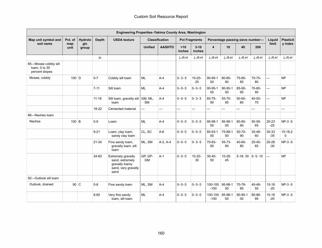
Engineering Properties–Yakima County Area, Washington
Map unit symbol andsoil name
Pct. ofmapunit
Hydrologic
group
Depth USDA texture Classification Pct Fragments Percentage passing sieve number— Liquidlimit
Plasticity index
Unified AASHTO >10inches
3-10inches
4 10 40 200
In L-R-H L-R-H L-R-H L-R-H L-R-H L-R-H L-R-H L-R-H
85—Moxee cobbly siltloam, 0 to 30percent slopes
Moxee, cobbly 100 D 0-7 Cobbly silt loam ML A-4 0- 3- 5 15-20-25
90-95-100
80-85-90
75-80-85
70-75-80
— NP
7-11 Silt loam ML A-4 0- 0- 0 0- 0- 0 90-95-100
90-95-100
85-90-95
70-80-90
— NP
11-18 Silt loam, gravelly siltloam
GM, ML,SM
A-4 0- 0- 0 0- 3- 5 60-75-90
55-70-85
50-65-80
40-55-70
— NP
18-22 Cemented material — — — — — — — — — —
86—Naches loam
Naches 100 B 0-9 Loam ML A-4 0- 0- 0 0- 0- 0 95-98-100
95-98-100
80-85-90
50-58-65
20-23-25
NP-3 -5
9-21 Loam, clay loam,sandy clay loam
CL, SC A-6 0- 0- 0 0- 0- 0 85-93-100
75-88-100
50-70-90
35-48-60
30-33-35
15-18-20
21-34 Fine sandy loam,gravelly loam, siltloam
ML, SM A-2, A-4 0- 0- 0 0- 3- 5 70-83-95
55-73-90
40-60-80
25-45-65
25-28-30
NP-3 -5
34-60 Extremely gravellysand, extremelygravelly loamysand, very gravellysand
GP, GP-GM
A-1 0- 0- 0 10-20-30
30-40-50
10-28-45
5-18- 30 0- 5- 10 — NP
92—Outlook silt loam
Outlook, drained 90 C 0-8 Fine sandy loam ML, SM A-4 0- 0- 0 0- 0- 0 100-100-100
95-98-100
70-78-85
40-48-55
15-18-20
NP-3 -5
8-60 Very fine sandyloam, silt loam
ML A-4 0- 0- 0 0- 0- 0 100-100-100
95-98-100
90-95-100
80-88-95
15-18-20
NP-3 -5
Custom Soil Resource Report
160
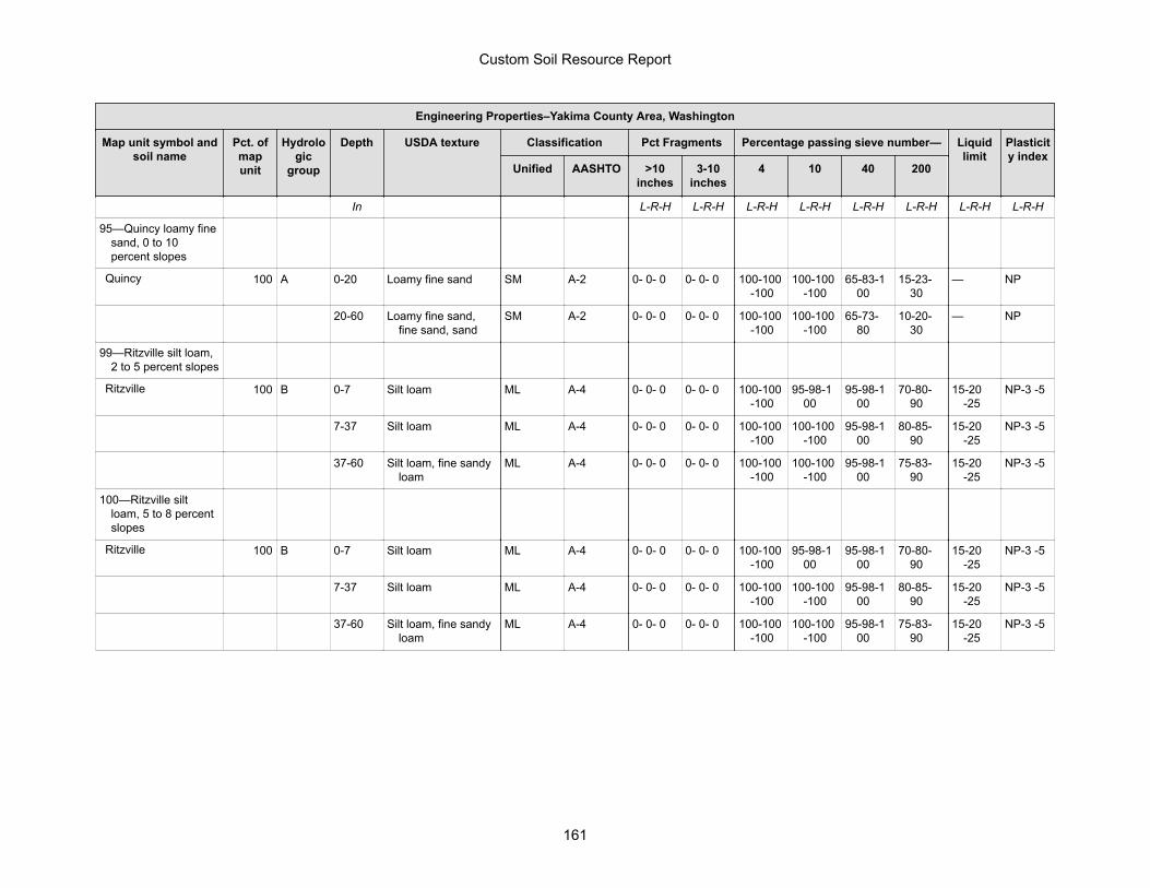
Engineering Properties–Yakima County Area, Washington
Map unit symbol andsoil name
Pct. ofmapunit
Hydrologic
group
Depth USDA texture Classification Pct Fragments Percentage passing sieve number— Liquidlimit
Plasticity index
Unified AASHTO >10inches
3-10inches
4 10 40 200
In L-R-H L-R-H L-R-H L-R-H L-R-H L-R-H L-R-H L-R-H
95—Quincy loamy finesand, 0 to 10percent slopes
Quincy 100 A 0-20 Loamy fine sand SM A-2 0- 0- 0 0- 0- 0 100-100-100
100-100-100
65-83-100
15-23-30
— NP
20-60 Loamy fine sand,fine sand, sand
SM A-2 0- 0- 0 0- 0- 0 100-100-100
100-100-100
65-73-80
10-20-30
— NP
99—Ritzville silt loam,2 to 5 percent slopes
Ritzville 100 B 0-7 Silt loam ML A-4 0- 0- 0 0- 0- 0 100-100-100
95-98-100
95-98-100
70-80-90
15-20-25
NP-3 -5
7-37 Silt loam ML A-4 0- 0- 0 0- 0- 0 100-100-100
100-100-100
95-98-100
80-85-90
15-20-25
NP-3 -5
37-60 Silt loam, fine sandyloam
ML A-4 0- 0- 0 0- 0- 0 100-100-100
100-100-100
95-98-100
75-83-90
15-20-25
NP-3 -5
100—Ritzville siltloam, 5 to 8 percentslopes
Ritzville 100 B 0-7 Silt loam ML A-4 0- 0- 0 0- 0- 0 100-100-100
95-98-100
95-98-100
70-80-90
15-20-25
NP-3 -5
7-37 Silt loam ML A-4 0- 0- 0 0- 0- 0 100-100-100
100-100-100
95-98-100
80-85-90
15-20-25
NP-3 -5
37-60 Silt loam, fine sandyloam
ML A-4 0- 0- 0 0- 0- 0 100-100-100
100-100-100
95-98-100
75-83-90
15-20-25
NP-3 -5
Custom Soil Resource Report
161
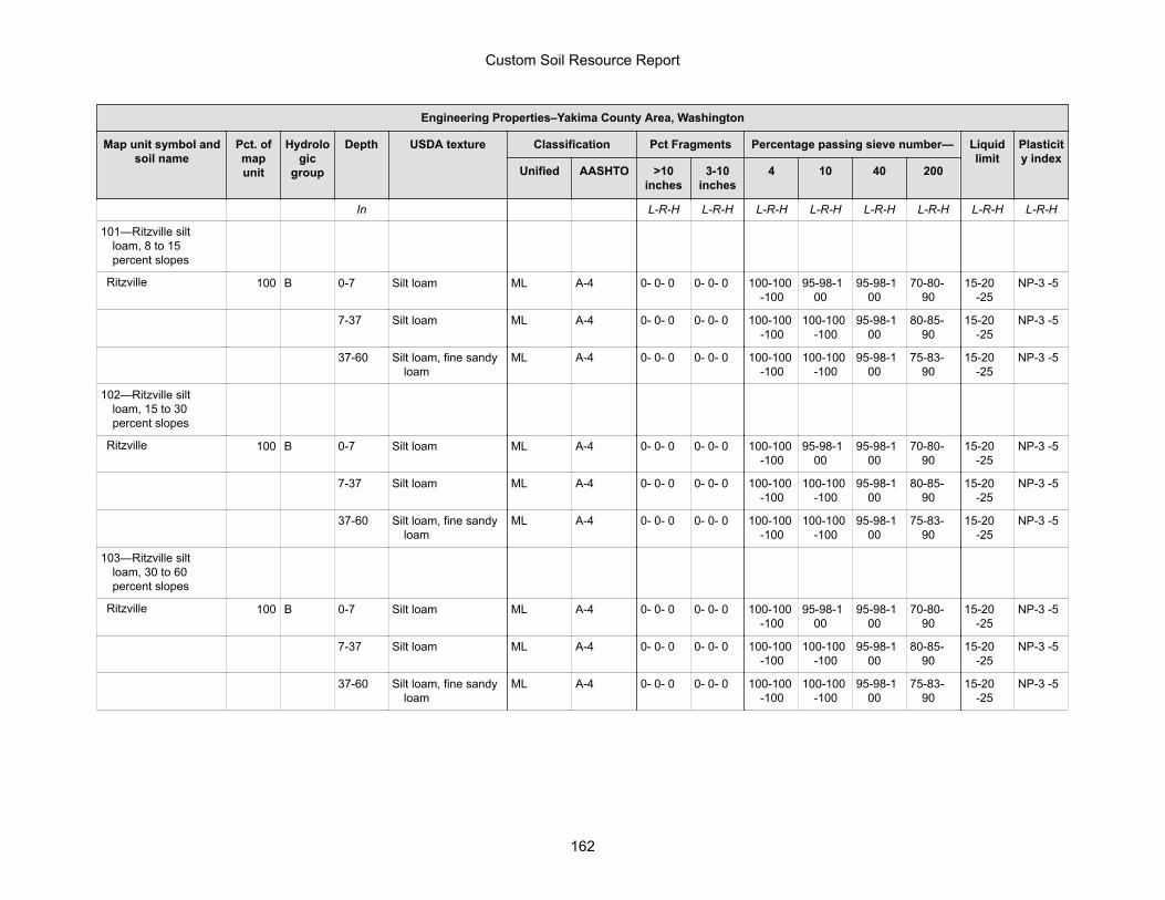
Engineering Properties–Yakima County Area, Washington
Map unit symbol andsoil name
Pct. ofmapunit
Hydrologic
group
Depth USDA texture Classification Pct Fragments Percentage passing sieve number— Liquidlimit
Plasticity index
Unified AASHTO >10inches
3-10inches
4 10 40 200
In L-R-H L-R-H L-R-H L-R-H L-R-H L-R-H L-R-H L-R-H
101—Ritzville siltloam, 8 to 15percent slopes
Ritzville 100 B 0-7 Silt loam ML A-4 0- 0- 0 0- 0- 0 100-100-100
95-98-100
95-98-100
70-80-90
15-20-25
NP-3 -5
7-37 Silt loam ML A-4 0- 0- 0 0- 0- 0 100-100-100
100-100-100
95-98-100
80-85-90
15-20-25
NP-3 -5
37-60 Silt loam, fine sandyloam
ML A-4 0- 0- 0 0- 0- 0 100-100-100
100-100-100
95-98-100
75-83-90
15-20-25
NP-3 -5
102—Ritzville siltloam, 15 to 30percent slopes
Ritzville 100 B 0-7 Silt loam ML A-4 0- 0- 0 0- 0- 0 100-100-100
95-98-100
95-98-100
70-80-90
15-20-25
NP-3 -5
7-37 Silt loam ML A-4 0- 0- 0 0- 0- 0 100-100-100
100-100-100
95-98-100
80-85-90
15-20-25
NP-3 -5
37-60 Silt loam, fine sandyloam
ML A-4 0- 0- 0 0- 0- 0 100-100-100
100-100-100
95-98-100
75-83-90
15-20-25
NP-3 -5
103—Ritzville siltloam, 30 to 60percent slopes
Ritzville 100 B 0-7 Silt loam ML A-4 0- 0- 0 0- 0- 0 100-100-100
95-98-100
95-98-100
70-80-90
15-20-25
NP-3 -5
7-37 Silt loam ML A-4 0- 0- 0 0- 0- 0 100-100-100
100-100-100
95-98-100
80-85-90
15-20-25
NP-3 -5
37-60 Silt loam, fine sandyloam
ML A-4 0- 0- 0 0- 0- 0 100-100-100
100-100-100
95-98-100
75-83-90
15-20-25
NP-3 -5
Custom Soil Resource Report
162
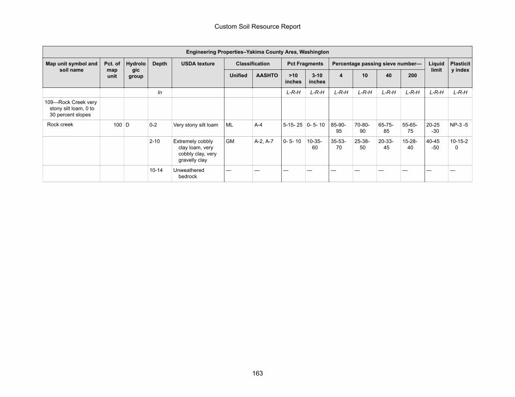
Engineering Properties–Yakima County Area, Washington
Map unit symbol andsoil name
Pct. ofmapunit
Hydrologic
group
Depth USDA texture Classification Pct Fragments Percentage passing sieve number— Liquidlimit
Plasticity index
Unified AASHTO >10inches
3-10inches
4 10 40 200
In L-R-H L-R-H L-R-H L-R-H L-R-H L-R-H L-R-H L-R-H
109—Rock Creek verystony silt loam, 0 to30 percent slopes
Rock creek 100 D 0-2 Very stony silt loam ML A-4 5-15- 25 0- 5- 10 85-90-95
70-80-90
65-75-85
55-65-75
20-25-30
NP-3 -5
2-10 Extremely cobblyclay loam, verycobbly clay, verygravelly clay
GM A-2, A-7 0- 5- 10 10-35-60
35-53-70
25-38-50
20-33-45
15-28-40
40-45-50
10-15-20
10-14 Unweatheredbedrock
— — — — — — — — — —
Custom Soil Resource Report
163
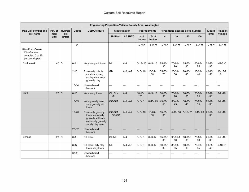
Engineering Properties–Yakima County Area, Washington
Map unit symbol andsoil name
Pct. ofmapunit
Hydrologic
group
Depth USDA texture Classification Pct Fragments Percentage passing sieve number— Liquidlimit
Plasticity index
Unified AASHTO >10inches
3-10inches
4 10 40 200
In L-R-H L-R-H L-R-H L-R-H L-R-H L-R-H L-R-H L-R-H
110—Rock Creek-Clint-Simcoecomplex, 0 to 45percent slopes
Rock creek 40 D 0-2 Very stony silt loam ML A-4 5-15- 25 0- 5- 10 85-90-95
70-80-90
65-75-85
55-65-75
20-25-30
NP-3 -5
2-10 Extremely cobblyclay loam, verycobbly clay, verygravelly clay
GM A-2, A-7 0- 5- 10 10-35-60
35-53-70
25-38-50
20-33-45
15-28-40
40-45-50
10-15-20
10-14 Unweatheredbedrock
— — — — — — — — — —
Clint 20 C 0-10 Very stony loam CL, CL-ML
A-4 10-18-25
0- 5- 10 80-85-90
70-80-90
60-73-85
50-58-65
25-28-30
5-7 -10
10-19 Very gravelly loam,very gravelly siltloam
GC-GM A-1, A-2 0- 3- 5 0-13- 25 45-50-55
35-40-45
30-35-40
20-28-35
25-28-30
5-7 -10
19-28 Extremely gravellyloam, extremelygravelly silt loam,extremely gravellysandy clay loam
GC-GM,GP-GC
A-1, A-2 0- 5- 10 10-20-30
15-25-35
5-18- 30 5-15- 25 5-13- 20 25-28-30
5-7 -10
28-32 Unweatheredbedrock
— — — — — — — — — —
Simcoe 20 C 0-8 Silt loam CL-ML A-4 0- 0- 0 0- 3- 5 95-98-100
90-95-100
90-95-100
70-80-90
25-28-30
5-7 -10
8-37 Silt loam, silty clayloam, clay loam
ML A-4, A-6 0- 0- 0 0- 3- 5 90-95-100
85-90-95
80-85-90
70-78-85
30-35-40
5-10-15
37-41 Unweatheredbedrock
— — — — — — — — — —
Custom Soil Resource Report
164
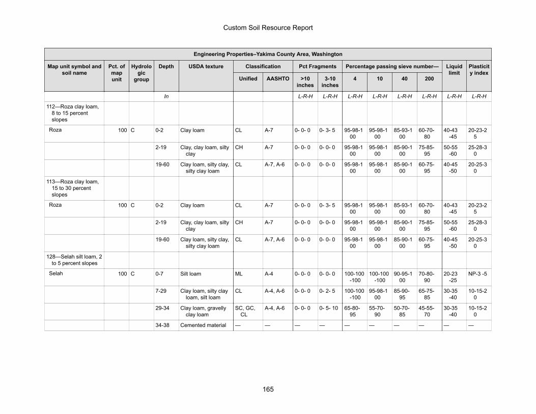
Engineering Properties–Yakima County Area, Washington
Map unit symbol andsoil name
Pct. ofmapunit
Hydrologic
group
Depth USDA texture Classification Pct Fragments Percentage passing sieve number— Liquidlimit
Plasticity index
Unified AASHTO >10inches
3-10inches
4 10 40 200
In L-R-H L-R-H L-R-H L-R-H L-R-H L-R-H L-R-H L-R-H
112—Roza clay loam,8 to 15 percentslopes
Roza 100 C 0-2 Clay loam CL A-7 0- 0- 0 0- 3- 5 95-98-100
95-98-100
85-93-100
60-70-80
40-43-45
20-23-25
2-19 Clay, clay loam, siltyclay
CH A-7 0- 0- 0 0- 0- 0 95-98-100
95-98-100
85-90-100
75-85-95
50-55-60
25-28-30
19-60 Clay loam, silty clay,silty clay loam
CL A-7, A-6 0- 0- 0 0- 0- 0 95-98-100
95-98-100
85-90-100
60-75-95
40-45-50
20-25-30
113—Roza clay loam,15 to 30 percentslopes
Roza 100 C 0-2 Clay loam CL A-7 0- 0- 0 0- 3- 5 95-98-100
95-98-100
85-93-100
60-70-80
40-43-45
20-23-25
2-19 Clay, clay loam, siltyclay
CH A-7 0- 0- 0 0- 0- 0 95-98-100
95-98-100
85-90-100
75-85-95
50-55-60
25-28-30
19-60 Clay loam, silty clay,silty clay loam
CL A-7, A-6 0- 0- 0 0- 0- 0 95-98-100
95-98-100
85-90-100
60-75-95
40-45-50
20-25-30
128—Selah silt loam, 2to 5 percent slopes
Selah 100 C 0-7 Silt loam ML A-4 0- 0- 0 0- 0- 0 100-100-100
100-100-100
90-95-100
70-80-90
20-23-25
NP-3 -5
7-29 Clay loam, silty clayloam, silt loam
CL A-4, A-6 0- 0- 0 0- 2- 5 100-100-100
95-98-100
85-90-95
65-75-85
30-35-40
10-15-20
29-34 Clay loam, gravellyclay loam
SC, GC,CL
A-4, A-6 0- 0- 0 0- 5- 10 65-80-95
55-70-90
50-70-85
45-55-70
30-35-40
10-15-20
34-38 Cemented material — — — — — — — — — —
Custom Soil Resource Report
165

Engineering Properties–Yakima County Area, Washington
Map unit symbol andsoil name
Pct. ofmapunit
Hydrologic
group
Depth USDA texture Classification Pct Fragments Percentage passing sieve number— Liquidlimit
Plasticity index
Unified AASHTO >10inches
3-10inches
4 10 40 200
In L-R-H L-R-H L-R-H L-R-H L-R-H L-R-H L-R-H L-R-H
129—Selah silt loam, 5to 8 percent slopes
Selah 100 C 0-7 Silt loam ML A-4 0- 0- 0 0- 0- 0 100-100-100
100-100-100
90-95-100
70-80-90
20-23-25
NP-3 -5
7-29 Clay loam, silty clayloam, silt loam
CL A-4, A-6 0- 0- 0 0- 2- 5 100-100-100
95-98-100
85-90-95
65-75-85
30-35-40
10-15-20
29-34 Clay loam, gravellyclay loam
SC, GC,CL
A-4, A-6 0- 0- 0 0- 5- 10 65-80-95
55-70-90
50-70-85
45-55-70
30-35-40
10-15-20
34-38 Cemented material — — — — — — — — — —
130—Selah silt loam, 8to 15 percent slopes
Selah 100 C 0-7 Silt loam ML A-4 0- 0- 0 0- 0- 0 100-100-100
100-100-100
90-95-100
70-80-90
20-23-25
NP-3 -5
7-29 Clay loam, silty clayloam, silt loam
CL A-4, A-6 0- 0- 0 0- 2- 5 100-100-100
95-98-100
85-90-95
65-75-85
30-35-40
10-15-20
29-34 Clay loam, gravellyclay loam
SC, GC,CL
A-4, A-6 0- 0- 0 0- 5- 10 65-80-95
55-70-90
50-70-85
45-55-70
30-35-40
10-15-20
34-38 Cemented material — — — — — — — — — —
131—Selah silt loam,15 to 30 percentslopes
Selah 100 C 0-7 Silt loam ML A-4 0- 0- 0 0- 0- 0 100-100-100
100-100-100
90-95-100
70-80-90
20-23-25
NP-3 -5
7-29 Clay loam, silty clayloam, silt loam
CL A-4, A-6 0- 0- 0 0- 2- 5 100-100-100
95-98-100
85-90-95
65-75-85
30-35-40
10-15-20
29-34 Clay loam, gravellyclay loam
SC, GC,CL
A-4, A-6 0- 0- 0 0- 5- 10 65-80-95
55-70-90
50-70-85
45-55-70
30-35-40
10-15-20
34-38 Cemented material — — — — — — — — — —
Custom Soil Resource Report
166
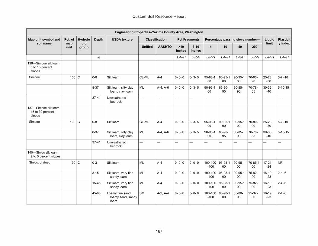
Engineering Properties–Yakima County Area, Washington
Map unit symbol andsoil name
Pct. ofmapunit
Hydrologic
group
Depth USDA texture Classification Pct Fragments Percentage passing sieve number— Liquidlimit
Plasticity index
Unified AASHTO >10inches
3-10inches
4 10 40 200
In L-R-H L-R-H L-R-H L-R-H L-R-H L-R-H L-R-H L-R-H
136—Simcoe silt loam,5 to 15 percentslopes
Simcoe 100 C 0-8 Silt loam CL-ML A-4 0- 0- 0 0- 3- 5 95-98-100
90-95-100
90-95-100
70-80-90
25-28-30
5-7 -10
8-37 Silt loam, silty clayloam, clay loam
ML A-4, A-6 0- 0- 0 0- 3- 5 90-95-100
85-90-95
80-85-90
70-78-85
30-35-40
5-10-15
37-41 Unweatheredbedrock
— — — — — — — — — —
137—Simcoe silt loam,15 to 30 percentslopes
Simcoe 100 C 0-8 Silt loam CL-ML A-4 0- 0- 0 0- 3- 5 95-98-100
90-95-100
90-95-100
70-80-90
25-28-30
5-7 -10
8-37 Silt loam, silty clayloam, clay loam
ML A-4, A-6 0- 0- 0 0- 3- 5 90-95-100
85-90-95
80-85-90
70-78-85
30-35-40
5-10-15
37-41 Unweatheredbedrock
— — — — — — — — — —
140—Sinloc silt loam,2 to 5 percent slopes
Sinloc, drained 90 C 0-3 Silt loam ML A-4 0- 0- 0 0- 0- 0 100-100-100
95-98-100
90-95-100
70-85-100
17-21-24
NP
3-15 Silt loam, very finesandy loam
ML A-4 0- 0- 0 0- 0- 0 100-100-100
95-98-100
90-95-100
75-82-90
16-19-23
2-4 -6
15-45 Silt loam, very finesandy loam
ML A-4 0- 0- 0 0- 0- 0 100-100-100
95-98-100
90-95-100
75-82-90
16-19-23
2-4 -6
45-60 Loamy fine sand,loamy sand, sandyloam
SM A-2, A-4 0- 0- 0 0- 0- 0 100-100-100
95-98-100
65-80-95
25-37-50
16-19-23
2-4 -6
Custom Soil Resource Report
167
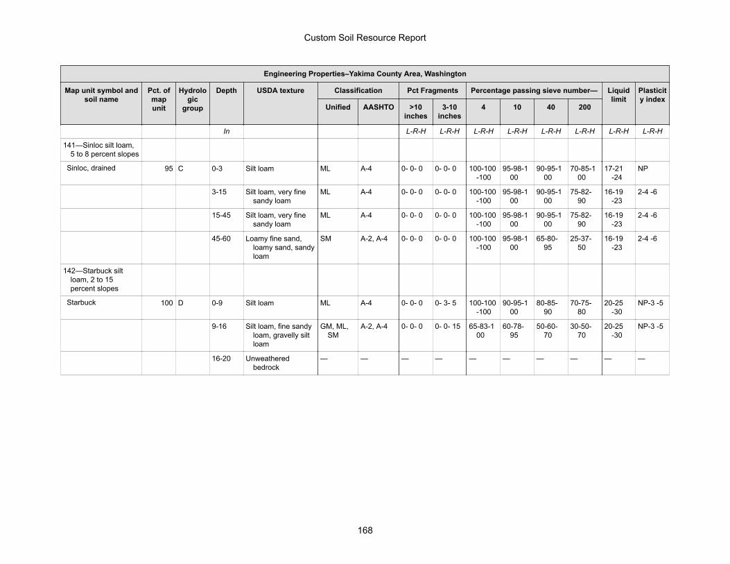
Engineering Properties–Yakima County Area, Washington
Map unit symbol andsoil name
Pct. ofmapunit
Hydrologic
group
Depth USDA texture Classification Pct Fragments Percentage passing sieve number— Liquidlimit
Plasticity index
Unified AASHTO >10inches
3-10inches
4 10 40 200
In L-R-H L-R-H L-R-H L-R-H L-R-H L-R-H L-R-H L-R-H
141—Sinloc silt loam,5 to 8 percent slopes
Sinloc, drained 95 C 0-3 Silt loam ML A-4 0- 0- 0 0- 0- 0 100-100-100
95-98-100
90-95-100
70-85-100
17-21-24
NP
3-15 Silt loam, very finesandy loam
ML A-4 0- 0- 0 0- 0- 0 100-100-100
95-98-100
90-95-100
75-82-90
16-19-23
2-4 -6
15-45 Silt loam, very finesandy loam
ML A-4 0- 0- 0 0- 0- 0 100-100-100
95-98-100
90-95-100
75-82-90
16-19-23
2-4 -6
45-60 Loamy fine sand,loamy sand, sandyloam
SM A-2, A-4 0- 0- 0 0- 0- 0 100-100-100
95-98-100
65-80-95
25-37-50
16-19-23
2-4 -6
142—Starbuck siltloam, 2 to 15percent slopes
Starbuck 100 D 0-9 Silt loam ML A-4 0- 0- 0 0- 3- 5 100-100-100
90-95-100
80-85-90
70-75-80
20-25-30
NP-3 -5
9-16 Silt loam, fine sandyloam, gravelly siltloam
GM, ML,SM
A-2, A-4 0- 0- 0 0- 0- 15 65-83-100
60-78-95
50-60-70
30-50-70
20-25-30
NP-3 -5
16-20 Unweatheredbedrock
— — — — — — — — — —
Custom Soil Resource Report
168
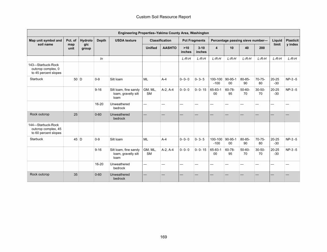
Engineering Properties–Yakima County Area, Washington
Map unit symbol andsoil name
Pct. ofmapunit
Hydrologic
group
Depth USDA texture Classification Pct Fragments Percentage passing sieve number— Liquidlimit
Plasticity index
Unified AASHTO >10inches
3-10inches
4 10 40 200
In L-R-H L-R-H L-R-H L-R-H L-R-H L-R-H L-R-H L-R-H
143—Starbuck-Rockoutcrop complex, 0to 45 percent slopes
Starbuck 50 D 0-9 Silt loam ML A-4 0- 0- 0 0- 3- 5 100-100-100
90-95-100
80-85-90
70-75-80
20-25-30
NP-3 -5
9-16 Silt loam, fine sandyloam, gravelly siltloam
GM, ML,SM
A-2, A-4 0- 0- 0 0- 0- 15 65-83-100
60-78-95
50-60-70
30-50-70
20-25-30
NP-3 -5
16-20 Unweatheredbedrock
— — — — — — — — — —
Rock outcrop 25 0-60 Unweatheredbedrock
— — — — — — — — — —
144—Starbuck-Rockoutcrop complex, 45to 60 percent slopes
Starbuck 45 D 0-9 Silt loam ML A-4 0- 0- 0 0- 3- 5 100-100-100
90-95-100
80-85-90
70-75-80
20-25-30
NP-3 -5
9-16 Silt loam, fine sandyloam, gravelly siltloam
GM, ML,SM
A-2, A-4 0- 0- 0 0- 0- 15 65-83-100
60-78-95
50-60-70
30-50-70
20-25-30
NP-3 -5
16-20 Unweatheredbedrock
— — — — — — — — — —
Rock outcrop 35 0-60 Unweatheredbedrock
— — — — — — — — — —
Custom Soil Resource Report
169

Engineering Properties–Yakima County Area, Washington
Map unit symbol andsoil name
Pct. ofmapunit
Hydrologic
group
Depth USDA texture Classification Pct Fragments Percentage passing sieve number— Liquidlimit
Plasticity index
Unified AASHTO >10inches
3-10inches
4 10 40 200
In L-R-H L-R-H L-R-H L-R-H L-R-H L-R-H L-R-H L-R-H
158—Tieton loam, 2 to5 percent slopes
Tieton 100 C 0-9 Loam ML A-4 0- 0- 0 0- 0- 0 95-98-100
95-98-100
80-85-95
60-67-75
20-22-25
NP-3 -5
9-15 Loam CL-ML A-4 0- 0- 0 0- 0- 0 95-98-100
95-98-100
80-85-95
60-67-75
20-22-25
5-8 -10
15-44 Clay loam, loam,silty clay loam
CL A-4, A-6 0- 0- 0 0- 0- 0 95-98-100
95-98-100
80-85-90
60-75-85
30-35-40
10-15-20
44-50 Clay loam, loam CL, CL-ML
A-4, A-6 0- 0- 0 0- 0- 0 95-98-100
95-98-100
80-85-90
60-65-70
25-30-40
5-15-20
50-54 Unweatheredbedrock
— — 0- 0- 0 0- 0- 0 95-98-100
95-98-100
— — — —
159—Tieton loam, 5 to8 percent slopes
Tieton 100 C 0-9 Loam ML A-4 0- 0- 0 0- 0- 0 95-98-100
95-98-100
80-85-95
60-67-75
20-22-25
NP-3 -5
9-15 Loam CL-ML A-4 0- 0- 0 0- 0- 0 95-98-100
95-98-100
80-85-95
60-67-75
20-22-25
5-8 -10
15-44 Clay loam, loam,silty clay loam
CL A-4, A-6 0- 0- 0 0- 0- 0 95-98-100
95-98-100
80-85-90
60-75-85
30-35-40
10-15-20
44-50 Clay loam, loam CL, CL-ML
A-4, A-6 0- 0- 0 0- 0- 0 95-98-100
95-98-100
80-85-90
60-65-70
25-30-40
5-15-20
50-54 Unweatheredbedrock
— — 0- 0- 0 0- 0- 0 95-98-100
95-98-100
— — — —
Custom Soil Resource Report
170
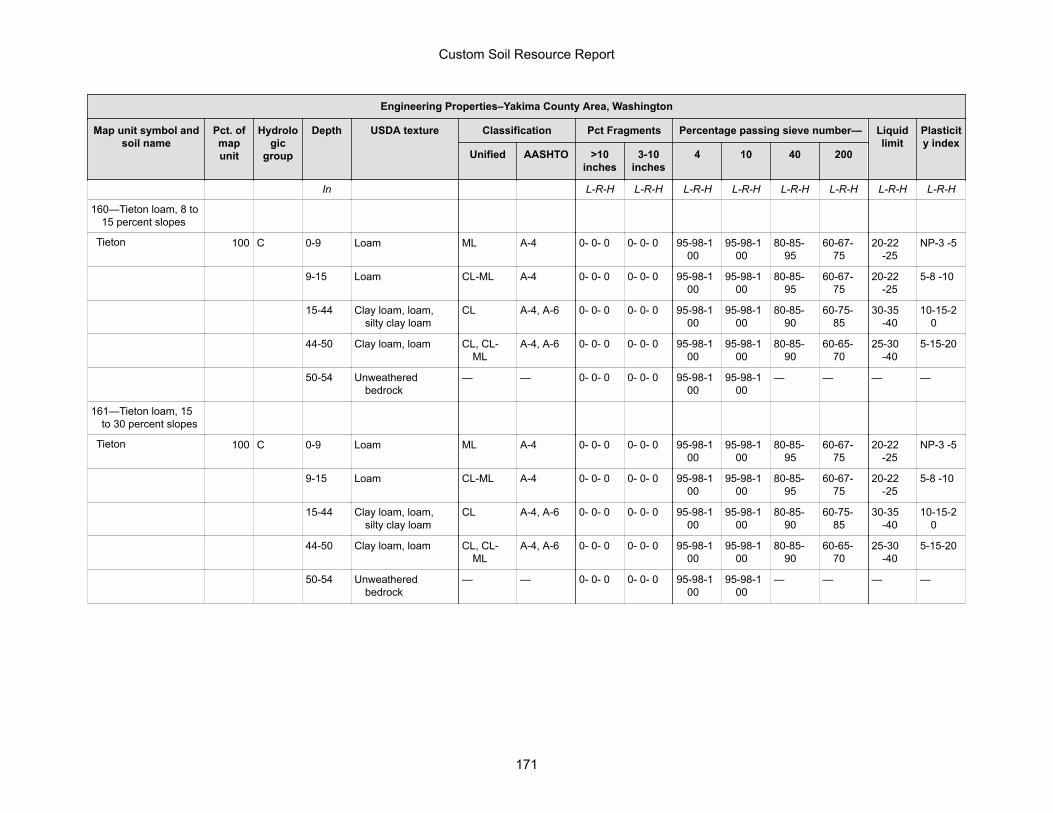
Engineering Properties–Yakima County Area, Washington
Map unit symbol andsoil name
Pct. ofmapunit
Hydrologic
group
Depth USDA texture Classification Pct Fragments Percentage passing sieve number— Liquidlimit
Plasticity index
Unified AASHTO >10inches
3-10inches
4 10 40 200
In L-R-H L-R-H L-R-H L-R-H L-R-H L-R-H L-R-H L-R-H
160—Tieton loam, 8 to15 percent slopes
Tieton 100 C 0-9 Loam ML A-4 0- 0- 0 0- 0- 0 95-98-100
95-98-100
80-85-95
60-67-75
20-22-25
NP-3 -5
9-15 Loam CL-ML A-4 0- 0- 0 0- 0- 0 95-98-100
95-98-100
80-85-95
60-67-75
20-22-25
5-8 -10
15-44 Clay loam, loam,silty clay loam
CL A-4, A-6 0- 0- 0 0- 0- 0 95-98-100
95-98-100
80-85-90
60-75-85
30-35-40
10-15-20
44-50 Clay loam, loam CL, CL-ML
A-4, A-6 0- 0- 0 0- 0- 0 95-98-100
95-98-100
80-85-90
60-65-70
25-30-40
5-15-20
50-54 Unweatheredbedrock
— — 0- 0- 0 0- 0- 0 95-98-100
95-98-100
— — — —
161—Tieton loam, 15to 30 percent slopes
Tieton 100 C 0-9 Loam ML A-4 0- 0- 0 0- 0- 0 95-98-100
95-98-100
80-85-95
60-67-75
20-22-25
NP-3 -5
9-15 Loam CL-ML A-4 0- 0- 0 0- 0- 0 95-98-100
95-98-100
80-85-95
60-67-75
20-22-25
5-8 -10
15-44 Clay loam, loam,silty clay loam
CL A-4, A-6 0- 0- 0 0- 0- 0 95-98-100
95-98-100
80-85-90
60-75-85
30-35-40
10-15-20
44-50 Clay loam, loam CL, CL-ML
A-4, A-6 0- 0- 0 0- 0- 0 95-98-100
95-98-100
80-85-90
60-65-70
25-30-40
5-15-20
50-54 Unweatheredbedrock
— — 0- 0- 0 0- 0- 0 95-98-100
95-98-100
— — — —
Custom Soil Resource Report
171
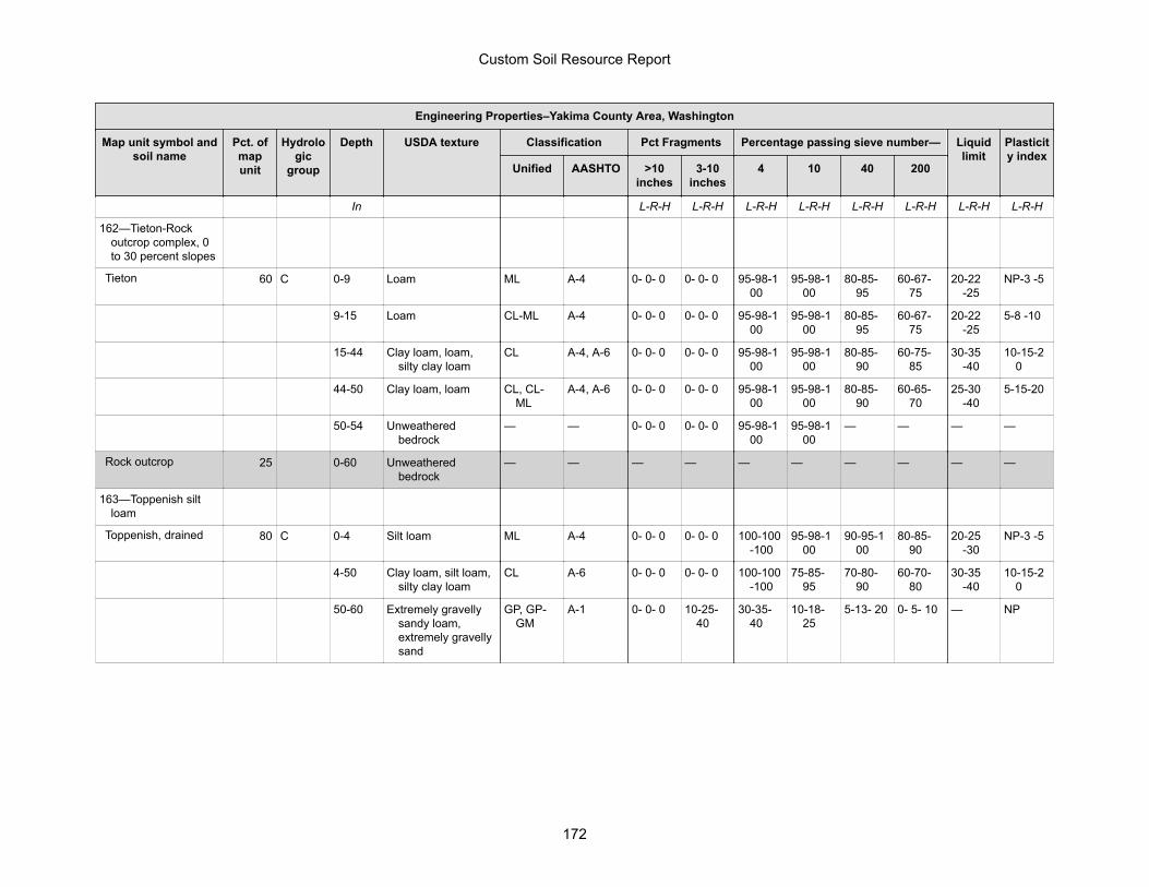
Engineering Properties–Yakima County Area, Washington
Map unit symbol andsoil name
Pct. ofmapunit
Hydrologic
group
Depth USDA texture Classification Pct Fragments Percentage passing sieve number— Liquidlimit
Plasticity index
Unified AASHTO >10inches
3-10inches
4 10 40 200
In L-R-H L-R-H L-R-H L-R-H L-R-H L-R-H L-R-H L-R-H
162—Tieton-Rockoutcrop complex, 0to 30 percent slopes
Tieton 60 C 0-9 Loam ML A-4 0- 0- 0 0- 0- 0 95-98-100
95-98-100
80-85-95
60-67-75
20-22-25
NP-3 -5
9-15 Loam CL-ML A-4 0- 0- 0 0- 0- 0 95-98-100
95-98-100
80-85-95
60-67-75
20-22-25
5-8 -10
15-44 Clay loam, loam,silty clay loam
CL A-4, A-6 0- 0- 0 0- 0- 0 95-98-100
95-98-100
80-85-90
60-75-85
30-35-40
10-15-20
44-50 Clay loam, loam CL, CL-ML
A-4, A-6 0- 0- 0 0- 0- 0 95-98-100
95-98-100
80-85-90
60-65-70
25-30-40
5-15-20
50-54 Unweatheredbedrock
— — 0- 0- 0 0- 0- 0 95-98-100
95-98-100
— — — —
Rock outcrop 25 0-60 Unweatheredbedrock
— — — — — — — — — —
163—Toppenish siltloam
Toppenish, drained 80 C 0-4 Silt loam ML A-4 0- 0- 0 0- 0- 0 100-100-100
95-98-100
90-95-100
80-85-90
20-25-30
NP-3 -5
4-50 Clay loam, silt loam,silty clay loam
CL A-6 0- 0- 0 0- 0- 0 100-100-100
75-85-95
70-80-90
60-70-80
30-35-40
10-15-20
50-60 Extremely gravellysandy loam,extremely gravellysand
GP, GP-GM
A-1 0- 0- 0 10-25-40
30-35-40
10-18-25
5-13- 20 0- 5- 10 — NP
Custom Soil Resource Report
172
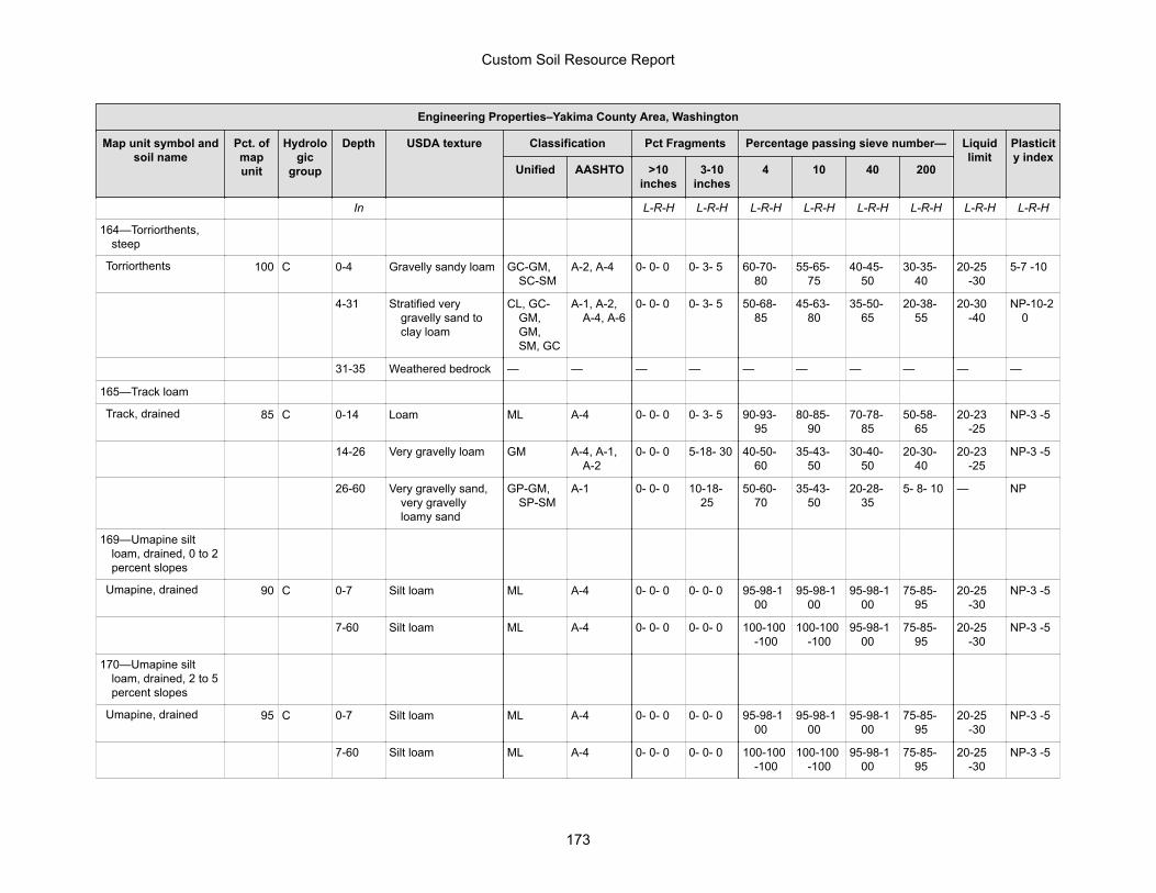
Engineering Properties–Yakima County Area, Washington
Map unit symbol andsoil name
Pct. ofmapunit
Hydrologic
group
Depth USDA texture Classification Pct Fragments Percentage passing sieve number— Liquidlimit
Plasticity index
Unified AASHTO >10inches
3-10inches
4 10 40 200
In L-R-H L-R-H L-R-H L-R-H L-R-H L-R-H L-R-H L-R-H
164—Torriorthents,steep
Torriorthents 100 C 0-4 Gravelly sandy loam GC-GM,SC-SM
A-2, A-4 0- 0- 0 0- 3- 5 60-70-80
55-65-75
40-45-50
30-35-40
20-25-30
5-7 -10
4-31 Stratified verygravelly sand toclay loam
CL, GC-GM,GM,SM, GC
A-1, A-2,A-4, A-6
0- 0- 0 0- 3- 5 50-68-85
45-63-80
35-50-65
20-38-55
20-30-40
NP-10-20
31-35 Weathered bedrock — — — — — — — — — —
165—Track loam
Track, drained 85 C 0-14 Loam ML A-4 0- 0- 0 0- 3- 5 90-93-95
80-85-90
70-78-85
50-58-65
20-23-25
NP-3 -5
14-26 Very gravelly loam GM A-4, A-1,A-2
0- 0- 0 5-18- 30 40-50-60
35-43-50
30-40-50
20-30-40
20-23-25
NP-3 -5
26-60 Very gravelly sand,very gravellyloamy sand
GP-GM,SP-SM
A-1 0- 0- 0 10-18-25
50-60-70
35-43-50
20-28-35
5- 8- 10 — NP
169—Umapine siltloam, drained, 0 to 2percent slopes
Umapine, drained 90 C 0-7 Silt loam ML A-4 0- 0- 0 0- 0- 0 95-98-100
95-98-100
95-98-100
75-85-95
20-25-30
NP-3 -5
7-60 Silt loam ML A-4 0- 0- 0 0- 0- 0 100-100-100
100-100-100
95-98-100
75-85-95
20-25-30
NP-3 -5
170—Umapine siltloam, drained, 2 to 5percent slopes
Umapine, drained 95 C 0-7 Silt loam ML A-4 0- 0- 0 0- 0- 0 95-98-100
95-98-100
95-98-100
75-85-95
20-25-30
NP-3 -5
7-60 Silt loam ML A-4 0- 0- 0 0- 0- 0 100-100-100
100-100-100
95-98-100
75-85-95
20-25-30
NP-3 -5
Custom Soil Resource Report
173
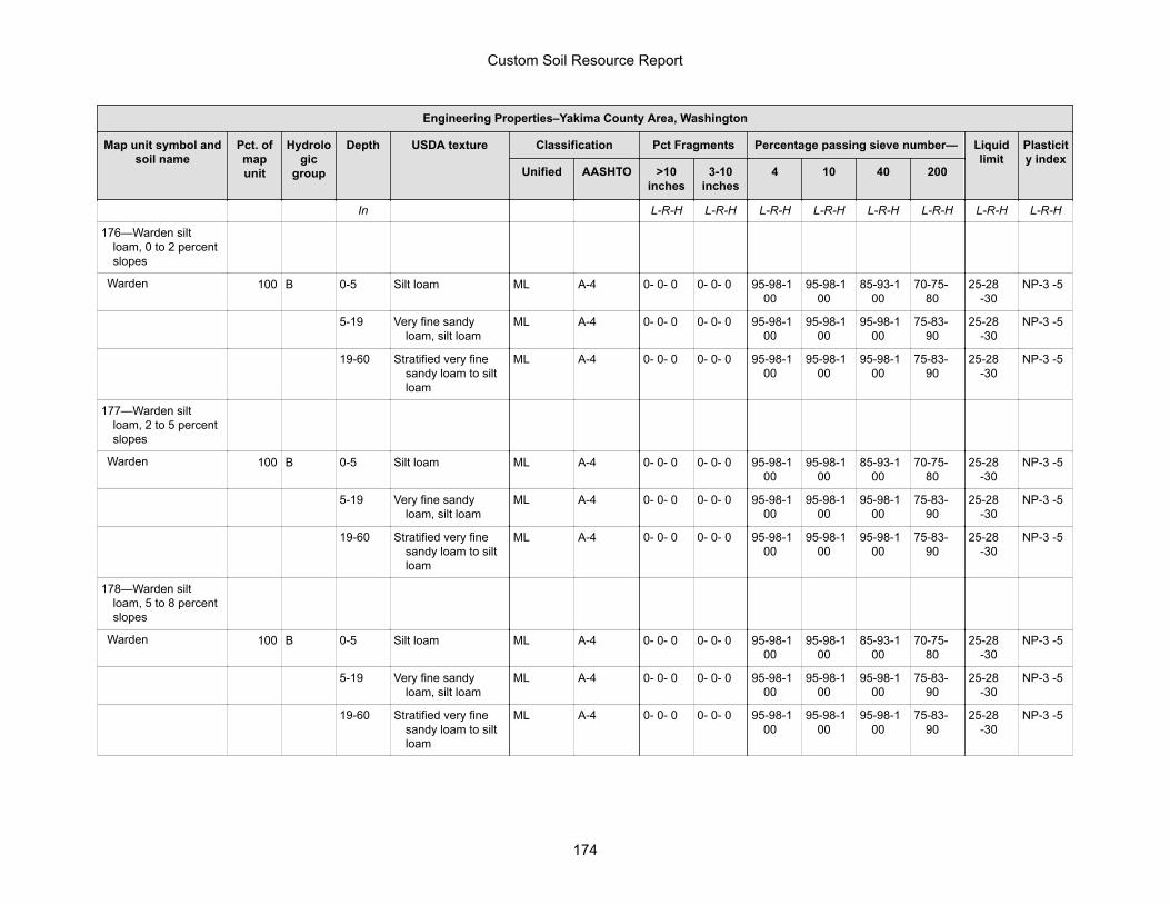
Engineering Properties–Yakima County Area, Washington
Map unit symbol andsoil name
Pct. ofmapunit
Hydrologic
group
Depth USDA texture Classification Pct Fragments Percentage passing sieve number— Liquidlimit
Plasticity index
Unified AASHTO >10inches
3-10inches
4 10 40 200
In L-R-H L-R-H L-R-H L-R-H L-R-H L-R-H L-R-H L-R-H
176—Warden siltloam, 0 to 2 percentslopes
Warden 100 B 0-5 Silt loam ML A-4 0- 0- 0 0- 0- 0 95-98-100
95-98-100
85-93-100
70-75-80
25-28-30
NP-3 -5
5-19 Very fine sandyloam, silt loam
ML A-4 0- 0- 0 0- 0- 0 95-98-100
95-98-100
95-98-100
75-83-90
25-28-30
NP-3 -5
19-60 Stratified very finesandy loam to siltloam
ML A-4 0- 0- 0 0- 0- 0 95-98-100
95-98-100
95-98-100
75-83-90
25-28-30
NP-3 -5
177—Warden siltloam, 2 to 5 percentslopes
Warden 100 B 0-5 Silt loam ML A-4 0- 0- 0 0- 0- 0 95-98-100
95-98-100
85-93-100
70-75-80
25-28-30
NP-3 -5
5-19 Very fine sandyloam, silt loam
ML A-4 0- 0- 0 0- 0- 0 95-98-100
95-98-100
95-98-100
75-83-90
25-28-30
NP-3 -5
19-60 Stratified very finesandy loam to siltloam
ML A-4 0- 0- 0 0- 0- 0 95-98-100
95-98-100
95-98-100
75-83-90
25-28-30
NP-3 -5
178—Warden siltloam, 5 to 8 percentslopes
Warden 100 B 0-5 Silt loam ML A-4 0- 0- 0 0- 0- 0 95-98-100
95-98-100
85-93-100
70-75-80
25-28-30
NP-3 -5
5-19 Very fine sandyloam, silt loam
ML A-4 0- 0- 0 0- 0- 0 95-98-100
95-98-100
95-98-100
75-83-90
25-28-30
NP-3 -5
19-60 Stratified very finesandy loam to siltloam
ML A-4 0- 0- 0 0- 0- 0 95-98-100
95-98-100
95-98-100
75-83-90
25-28-30
NP-3 -5
Custom Soil Resource Report
174
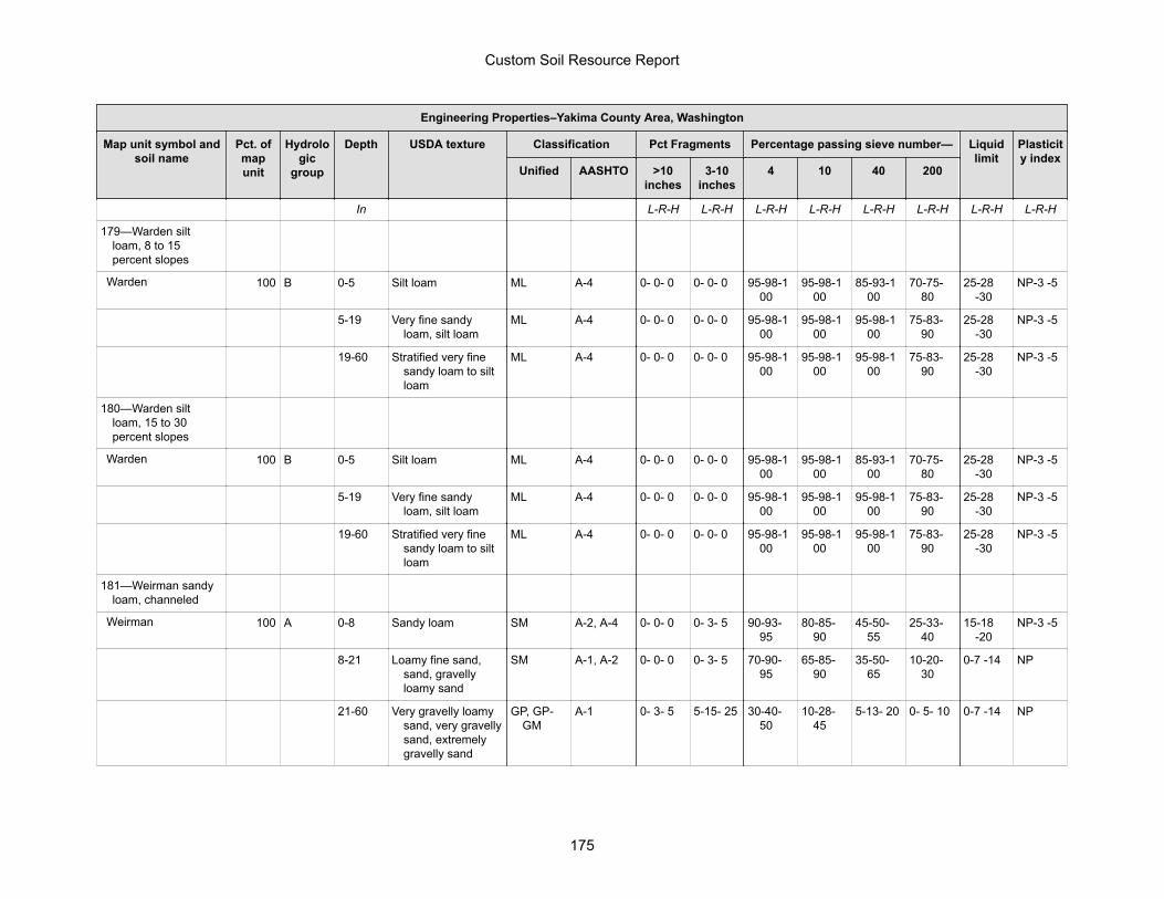
Engineering Properties–Yakima County Area, Washington
Map unit symbol andsoil name
Pct. ofmapunit
Hydrologic
group
Depth USDA texture Classification Pct Fragments Percentage passing sieve number— Liquidlimit
Plasticity index
Unified AASHTO >10inches
3-10inches
4 10 40 200
In L-R-H L-R-H L-R-H L-R-H L-R-H L-R-H L-R-H L-R-H
179—Warden siltloam, 8 to 15percent slopes
Warden 100 B 0-5 Silt loam ML A-4 0- 0- 0 0- 0- 0 95-98-100
95-98-100
85-93-100
70-75-80
25-28-30
NP-3 -5
5-19 Very fine sandyloam, silt loam
ML A-4 0- 0- 0 0- 0- 0 95-98-100
95-98-100
95-98-100
75-83-90
25-28-30
NP-3 -5
19-60 Stratified very finesandy loam to siltloam
ML A-4 0- 0- 0 0- 0- 0 95-98-100
95-98-100
95-98-100
75-83-90
25-28-30
NP-3 -5
180—Warden siltloam, 15 to 30percent slopes
Warden 100 B 0-5 Silt loam ML A-4 0- 0- 0 0- 0- 0 95-98-100
95-98-100
85-93-100
70-75-80
25-28-30
NP-3 -5
5-19 Very fine sandyloam, silt loam
ML A-4 0- 0- 0 0- 0- 0 95-98-100
95-98-100
95-98-100
75-83-90
25-28-30
NP-3 -5
19-60 Stratified very finesandy loam to siltloam
ML A-4 0- 0- 0 0- 0- 0 95-98-100
95-98-100
95-98-100
75-83-90
25-28-30
NP-3 -5
181—Weirman sandyloam, channeled
Weirman 100 A 0-8 Sandy loam SM A-2, A-4 0- 0- 0 0- 3- 5 90-93-95
80-85-90
45-50-55
25-33-40
15-18-20
NP-3 -5
8-21 Loamy fine sand,sand, gravellyloamy sand
SM A-1, A-2 0- 0- 0 0- 3- 5 70-90-95
65-85-90
35-50-65
10-20-30
0-7 -14 NP
21-60 Very gravelly loamysand, very gravellysand, extremelygravelly sand
GP, GP-GM
A-1 0- 3- 5 5-15- 25 30-40-50
10-28-45
5-13- 20 0- 5- 10 0-7 -14 NP
Custom Soil Resource Report
175
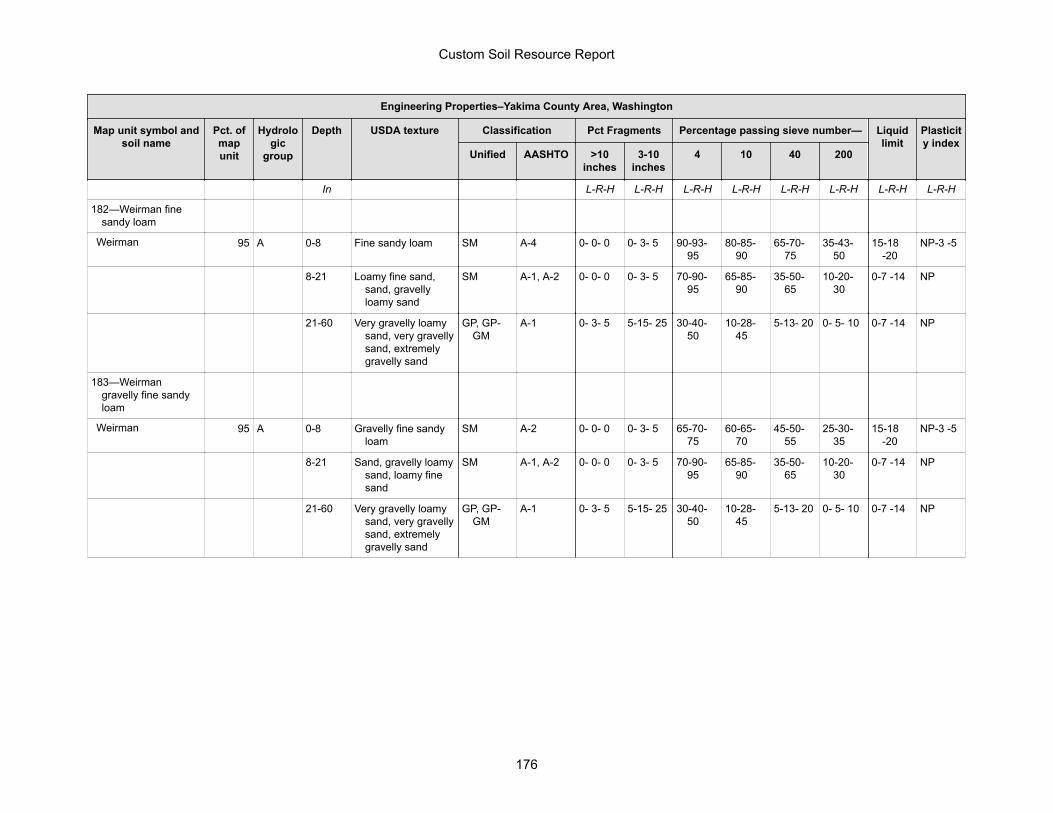
Engineering Properties–Yakima County Area, Washington
Map unit symbol andsoil name
Pct. ofmapunit
Hydrologic
group
Depth USDA texture Classification Pct Fragments Percentage passing sieve number— Liquidlimit
Plasticity index
Unified AASHTO >10inches
3-10inches
4 10 40 200
In L-R-H L-R-H L-R-H L-R-H L-R-H L-R-H L-R-H L-R-H
182—Weirman finesandy loam
Weirman 95 A 0-8 Fine sandy loam SM A-4 0- 0- 0 0- 3- 5 90-93-95
80-85-90
65-70-75
35-43-50
15-18-20
NP-3 -5
8-21 Loamy fine sand,sand, gravellyloamy sand
SM A-1, A-2 0- 0- 0 0- 3- 5 70-90-95
65-85-90
35-50-65
10-20-30
0-7 -14 NP
21-60 Very gravelly loamysand, very gravellysand, extremelygravelly sand
GP, GP-GM
A-1 0- 3- 5 5-15- 25 30-40-50
10-28-45
5-13- 20 0- 5- 10 0-7 -14 NP
183—Weirmangravelly fine sandyloam
Weirman 95 A 0-8 Gravelly fine sandyloam
SM A-2 0- 0- 0 0- 3- 5 65-70-75
60-65-70
45-50-55
25-30-35
15-18-20
NP-3 -5
8-21 Sand, gravelly loamysand, loamy finesand
SM A-1, A-2 0- 0- 0 0- 3- 5 70-90-95
65-85-90
35-50-65
10-20-30
0-7 -14 NP
21-60 Very gravelly loamysand, very gravellysand, extremelygravelly sand
GP, GP-GM
A-1 0- 3- 5 5-15- 25 30-40-50
10-28-45
5-13- 20 0- 5- 10 0-7 -14 NP
Custom Soil Resource Report
176
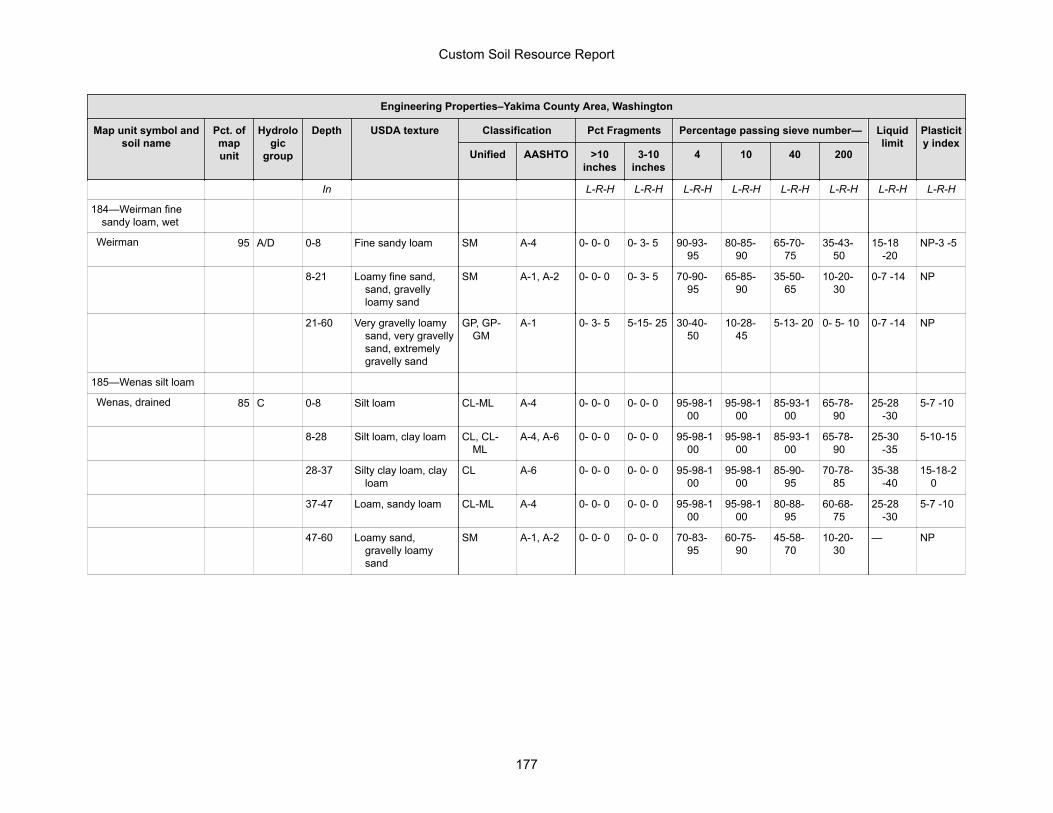
Engineering Properties–Yakima County Area, Washington
Map unit symbol andsoil name
Pct. ofmapunit
Hydrologic
group
Depth USDA texture Classification Pct Fragments Percentage passing sieve number— Liquidlimit
Plasticity index
Unified AASHTO >10inches
3-10inches
4 10 40 200
In L-R-H L-R-H L-R-H L-R-H L-R-H L-R-H L-R-H L-R-H
184—Weirman finesandy loam, wet
Weirman 95 A/D 0-8 Fine sandy loam SM A-4 0- 0- 0 0- 3- 5 90-93-95
80-85-90
65-70-75
35-43-50
15-18-20
NP-3 -5
8-21 Loamy fine sand,sand, gravellyloamy sand
SM A-1, A-2 0- 0- 0 0- 3- 5 70-90-95
65-85-90
35-50-65
10-20-30
0-7 -14 NP
21-60 Very gravelly loamysand, very gravellysand, extremelygravelly sand
GP, GP-GM
A-1 0- 3- 5 5-15- 25 30-40-50
10-28-45
5-13- 20 0- 5- 10 0-7 -14 NP
185—Wenas silt loam
Wenas, drained 85 C 0-8 Silt loam CL-ML A-4 0- 0- 0 0- 0- 0 95-98-100
95-98-100
85-93-100
65-78-90
25-28-30
5-7 -10
8-28 Silt loam, clay loam CL, CL-ML
A-4, A-6 0- 0- 0 0- 0- 0 95-98-100
95-98-100
85-93-100
65-78-90
25-30-35
5-10-15
28-37 Silty clay loam, clayloam
CL A-6 0- 0- 0 0- 0- 0 95-98-100
95-98-100
85-90-95
70-78-85
35-38-40
15-18-20
37-47 Loam, sandy loam CL-ML A-4 0- 0- 0 0- 0- 0 95-98-100
95-98-100
80-88-95
60-68-75
25-28-30
5-7 -10
47-60 Loamy sand,gravelly loamysand
SM A-1, A-2 0- 0- 0 0- 0- 0 70-83-95
60-75-90
45-58-70
10-20-30
— NP
Custom Soil Resource Report
177
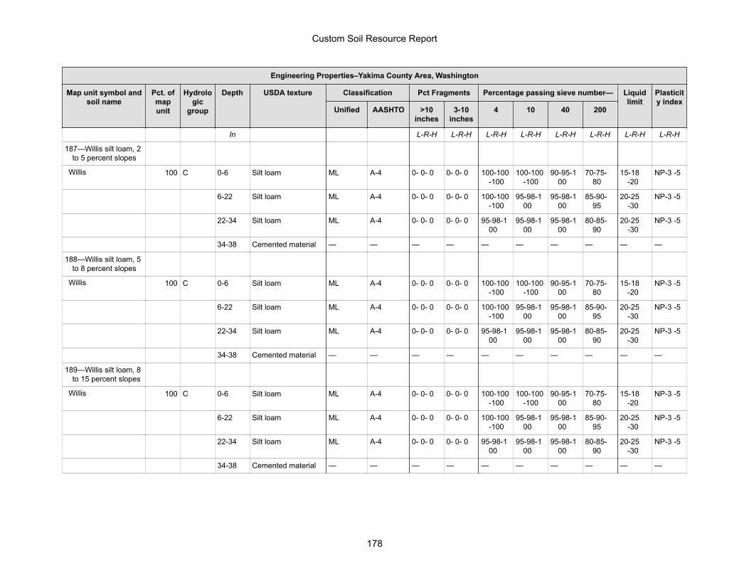
Engineering Properties–Yakima County Area, Washington
Map unit symbol andsoil name
Pct. ofmapunit
Hydrologic
group
Depth USDA texture Classification Pct Fragments Percentage passing sieve number— Liquidlimit
Plasticity index
Unified AASHTO >10inches
3-10inches
4 10 40 200
In L-R-H L-R-H L-R-H L-R-H L-R-H L-R-H L-R-H L-R-H
187—Willis silt loam, 2to 5 percent slopes
Willis 100 C 0-6 Silt loam ML A-4 0- 0- 0 0- 0- 0 100-100-100
100-100-100
90-95-100
70-75-80
15-18-20
NP-3 -5
6-22 Silt loam ML A-4 0- 0- 0 0- 0- 0 100-100-100
95-98-100
95-98-100
85-90-95
20-25-30
NP-3 -5
22-34 Silt loam ML A-4 0- 0- 0 0- 0- 0 95-98-100
95-98-100
95-98-100
80-85-90
20-25-30
NP-3 -5
34-38 Cemented material — — — — — — — — — —
188—Willis silt loam, 5to 8 percent slopes
Willis 100 C 0-6 Silt loam ML A-4 0- 0- 0 0- 0- 0 100-100-100
100-100-100
90-95-100
70-75-80
15-18-20
NP-3 -5
6-22 Silt loam ML A-4 0- 0- 0 0- 0- 0 100-100-100
95-98-100
95-98-100
85-90-95
20-25-30
NP-3 -5
22-34 Silt loam ML A-4 0- 0- 0 0- 0- 0 95-98-100
95-98-100
95-98-100
80-85-90
20-25-30
NP-3 -5
34-38 Cemented material — — — — — — — — — —
189—Willis silt loam, 8to 15 percent slopes
Willis 100 C 0-6 Silt loam ML A-4 0- 0- 0 0- 0- 0 100-100-100
100-100-100
90-95-100
70-75-80
15-18-20
NP-3 -5
6-22 Silt loam ML A-4 0- 0- 0 0- 0- 0 100-100-100
95-98-100
95-98-100
85-90-95
20-25-30
NP-3 -5
22-34 Silt loam ML A-4 0- 0- 0 0- 0- 0 95-98-100
95-98-100
95-98-100
80-85-90
20-25-30
NP-3 -5
34-38 Cemented material — — — — — — — — — —
Custom Soil Resource Report
178
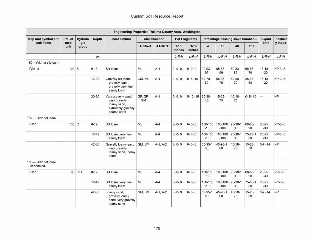
Engineering Properties–Yakima County Area, Washington
Map unit symbol andsoil name
Pct. ofmapunit
Hydrologic
group
Depth USDA texture Classification Pct Fragments Percentage passing sieve number— Liquidlimit
Plasticity index
Unified AASHTO >10inches
3-10inches
4 10 40 200
In L-R-H L-R-H L-R-H L-R-H L-R-H L-R-H L-R-H L-R-H
190—Yakima silt loam
Yakima 100 B 0-13 Silt loam ML A-4 0- 0- 0 0- 0- 0 90-93-95
85-88-90
80-83-85
65-68-70
15-18-20
NP-3 -5
13-30 Gravelly silt loam,gravelly loam,gravelly very finesandy loam
GM, ML A-4 0- 0- 0 0- 5- 10 60-70-80
55-65-75
50-60-70
35-48-60
15-18-20
NP-3 -5
30-60 Very gravelly sand,very gravellyloamy sand,extremely gravellycoarse sand
GP, GP-GM
A-1 0- 0- 0 5-10- 15 30-38-45
15-25-35
10-18-25
0- 5- 10 — NP
192—Zillah silt loam
Zillah 100 C 0-12 Silt loam ML A-4 0- 0- 0 0- 0- 0 100-100-100
100-100-100
95-98-100
80-85-90
20-25-30
NP-3 -5
12-42 Silt loam, very finesandy loam
ML A-4 0- 0- 0 0- 0- 0 100-100-100
100-100-100
95-98-100
75-88-100
20-25-30
NP-3 -5
42-60 Gravelly loamy sand,very gravellyloamy sand, loamysand
GM, SM A-1, A-2 0- 0- 0 0- 0- 0 50-95-100
45-90-100
40-58-75
15-23-30
0-7 -14 NP
193—Zillah silt loam,channeled
Zillah 95 B/D 0-12 Silt loam ML A-4 0- 0- 0 0- 0- 0 100-100-100
100-100-100
95-98-100
80-85-90
20-25-30
NP-3 -5
12-42 Silt loam, very finesandy loam
ML A-4 0- 0- 0 0- 0- 0 100-100-100
100-100-100
95-98-100
75-88-100
20-25-30
NP-3 -5
42-60 Loamy sand,gravelly loamysand, very gravellyloamy sand
GM, SM A-1, A-2 0- 0- 0 0- 0- 0 50-95-100
45-90-100
40-58-75
15-23-30
0-7 -14 NP
Custom Soil Resource Report
179
ReferencesAmerican Association of State Highway and Transportation Officials (AASHTO).2004. Standard specifications for transportation materials and methods of samplingand testing. 24th edition.
American Society for Testing and Materials (ASTM). 2005. Standard classification ofsoils for engineering purposes. ASTM Standard D2487-00.
Cowardin, L.M., V. Carter, F.C. Golet, and E.T. LaRoe. 1979. Classification ofwetlands and deep-water habitats of the United States. U.S. Fish and WildlifeService FWS/OBS-79/31.
Federal Register. July 13, 1994. Changes in hydric soils of the United States.
Federal Register. September 18, 2002. Hydric soils of the United States.
Hurt, G.W., and L.M. Vasilas, editors. Version 6.0, 2006. Field indicators of hydricsoils in the United States.
National Research Council. 1995. Wetlands: Characteristics and boundaries.
Soil Survey Division Staff. 1993. Soil survey manual. Soil Conservation Service.U.S. Department of Agriculture Handbook 18. http://www.nrcs.usda.gov/wps/portal/nrcs/detail/national/soils/?cid=nrcs142p2_054262
Soil Survey Staff. 1999. Soil taxonomy: A basic system of soil classification formaking and interpreting soil surveys. 2nd edition. Natural Resources ConservationService, U.S. Department of Agriculture Handbook 436. http://www.nrcs.usda.gov/wps/portal/nrcs/detail/national/soils/?cid=nrcs142p2_053577
Soil Survey Staff. 2010. Keys to soil taxonomy. 11th edition. U.S. Department ofAgriculture, Natural Resources Conservation Service. http://www.nrcs.usda.gov/wps/portal/nrcs/detail/national/soils/?cid=nrcs142p2_053580
Tiner, R.W., Jr. 1985. Wetlands of Delaware. U.S. Fish and Wildlife Service andDelaware Department of Natural Resources and Environmental Control, WetlandsSection.
United States Army Corps of Engineers, Environmental Laboratory. 1987. Corps ofEngineers wetlands delineation manual. Waterways Experiment Station TechnicalReport Y-87-1.
United States Department of Agriculture, Natural Resources Conservation Service.National forestry manual. http://www.nrcs.usda.gov/wps/portal/nrcs/detail/soils/home/?cid=nrcs142p2_053374
United States Department of Agriculture, Natural Resources Conservation Service.National range and pasture handbook. http://www.nrcs.usda.gov/wps/portal/nrcs/detail/national/landuse/rangepasture/?cid=stelprdb1043084
180
United States Department of Agriculture, Natural Resources Conservation Service.National soil survey handbook, title 430-VI. http://www.nrcs.usda.gov/wps/portal/nrcs/detail/soils/scientists/?cid=nrcs142p2_054242
United States Department of Agriculture, Natural Resources Conservation Service.2006. Land resource regions and major land resource areas of the United States,the Caribbean, and the Pacific Basin. U.S. Department of Agriculture Handbook296. http://www.nrcs.usda.gov/wps/portal/nrcs/detail/national/soils/?cid=nrcs142p2_053624
United States Department of Agriculture, Soil Conservation Service. 1961. Landcapability classification. U.S. Department of Agriculture Handbook 210. http://www.nrcs.usda.gov/Internet/FSE_DOCUMENTS/nrcs142p2_052290.pdf
Custom Soil Resource Report
181