Embed Size (px)
Citation preview
AGU Chapman Conference on Hawaiian Volcanoes: From Source to Surface Site
Waikolao, Hawaii20 - 24 August 2012
Conveners
Michael Poland, USGS – Hawaiian Volcano Observatory, USA Paul Okubo, USGS – Hawaiian Volcano Observatory, USA Ken Hon, University of Hawai'i at Hilo, USA
Program Committee
Rebecca Carey, University of California, Berkeley, USA Simon Carn,Michigan Technological University, USA Valerie Cayol, Obs. de Physique du Globe de Clermont-FerrandHelge Gonnermann, Rice University, USA Scott Rowland, SOEST, University of Hawai'i at Mnoa, USA
Financial Support
2

AGU Chapman Conference on Hawaiian Volcanoes: From Source to Surface Site
Meeting At A Glance Sunday, 19 August 20121600h – 1700h Welcome Reception1700h – 1800h Introduction and Highlights of Kilauea’s Recent Eruption Activity
Monday, 20 August 20120830h – 0900h Welcome and Logistics0900h – 0945h Introduction – Hawaiian Volcano Observatory: Its First 100 Years of
Advancing Volcanism0945h – 1215h Magma Origin and Ascent I1030h – 1045h Coffee Break1215h – 1330h Lunch on Your Own1330h – 1430h Magma Origin and Ascent II1430h – 1445h Coffee Break1445h – 1600h Magma Origin and Ascent Breakout Sessions I, II, III, IV, and V1600h – 1645h Magma Origin and Ascent III1645h – 1900h Poster Session
Tuesday, 21 August 20120900h – 1215h Magma Storage and Island Evolution I1215h – 1330h Lunch on Your Own1330h – 1445h Magma Storage and Island Evolution II1445h – 1600h Magma Storage and Island Evolution Breakout Sessions I, II, III, IV,
and V1600h – 1645h Magma Storage and Island Evolution III1645h – 1900h Poster Session
Wednesday, 22 August 20120800h – 1700h Optional Field Trips
Trip #1: Mauna KeaTrip #2: Explosive KlaueaTrip #3: Mauna UluTrip #4: Mauna Loa North FlankTrip #5: Mauna Loa Southwest Rift ZoneTrip #6: HuallaiTrip #7: KohalaTrip #8: Circle-Island Counter-ClockwiseTrip #9: Circle-Island Clockwise
1700h – 2100h Conference Dinner
3

Thursday, 23 August 20120900h – 1215h Eruptions and Degassing I0930h – 0945h Coffee Break1215h – 1330h Lunch on Your Own1330h – 1430h Eruptions and Degassing II1430h – 1445h Coffee Break1445h – 1600h Eruptions and Degassing Breakout Sessions I, II, III, IV, and V1600h – 1645h Eruptions and Degassing III1645h – 1900h Poster Session
Friday, 24 August 20120900h – 1215h The Future of Geoscience Research In Hawaii I1030h – 1045h Coffee Break1215h – 1330h Lunch on Your Own1330h – 1530h The Future of Geoscience Research In Hawaii I, II, III, IV, and V1530h – 1615h The Future of Geoscience Research In Hawaii II1615h – 1700h The Future of Geoscience Research In Hawaii – Discussion and Wrap-up
4

SUNDAY, 19 AUGUST
1600h – 1700h Icebreaker Reception
Introduction - Highlights of Kilauea’s Recent Eruption ActivityPresiding: Michael P. PolandNaupaka, I, II, III, IV
1700h – 1800h Tim R. Orr | Hightlights of Kilauea’s recent eruption activity
MONDAY, 20 AUGUST
0830h – 0900h Introduction - Welcome and Logistics
Introduction - Hawaiian Volcano Obervatory: Its First 100 Yearsof Advancing VolcanismPresiding: Michael P. PolandNaupaka, I, II, III, IV
0900h – 0945h Robert I. Tilling | Hawaiian Volcano Obseratory: Its First 100 Years OfAdvancing Volcanology (INVITED)
Magma Origin and Ascent IPresiding: Helge M. GonnermannNaupaka, I, II, III, IV
0945h – 1030h Garrett Ito | Seismic Structure and Dynamics of the Hawaiian MantlePlume (INVITED)
1030h – 1045h Coffee Break
1045h – 1130h Dominique Weis | What Do We Know About Mantle Plumes, What CanHawaiian Volcanoes Tell Us About The Earth’s Mantle And How Do TheyCompare to Other Oceanic Islands? (INVITED)
1130h – 1215h Donald J. DePaolo | Deep Drilling Results and Models for the Growth andChemical Evolution of Hawaiian Volcanoes
1215h – 1330h Lunch on Your Own (Monday)
5
SCIENTIFIC PROGRAM

Magma Origin and Ascent IIPresiding: Helge M. GonnermannNaupaka, I, II, III, IV
1330h – 1345h Robert S. White | Magma Migration through the Crust beneath Iceland
1345h – 1400h Erik H. Hauri | Volatile Element Systematics of Hawaiian Shield Volcanoes
1400h – 1415h Megan Pickard | A Microanalytical Approach to Understanding the Originof Cumulate Xenoliths from Mauna Kea, Hawaii
1415h – 1430h John M. Rhodes | Mauna Loa Magmas in Space and Time
1430h – 1445h Coffee Break
1445h – 1600h Magma Origin and Ascent - Breakout Session I
1425h – 1540h Magma Origin and Ascent - Breakout Session II
1445h – 1600h Magma Origin and Ascent - Breakout Session III
1445h – 1600h Magma Origin and Ascent - Breakout Session IV
1445h – 1600h Magma Origina and Ascent - Breakout Session V
Magma Origin and Ascent IIINaupaka, I, II, III, IV
1600h – 1645h Peter W. Lipman | Growth of the Island of Hawaii: Deep-WaterPerspectives (INVITED)
1645h – 1900h Poster Session - MondayNaupaka, V, VI & VI
M-1 Rita A. Cabral | Oceanic gabbro signature in Mangaia melt inclusions:Source versus assimilation
M-2 Sofya Chistyakova | Magma differentiation and crystallization in basalticconduits by two competing petrogenetic processes
M-3 Rohan Kundargi | Melting and dehydration within mantle plumes and theformation of sub-parallel volcanic trends at intra-plate hotspots
M-4 Jake Jordan | Partial Melt Migration in a Heterogeneous Mantle DuringActive Upwelling
M-5 Richard M. Allen | Comparative plumeology: Contrasting seismicconstraints on mantle plumes
M-6 Nikolai S. Bagdassarov | Hindered crystal settling in magma chambers
6

M-7 Ashton Flinders | A 3D Gravity Inversion of the Hawaiian Islands: FromNiihau to Loihi
M-8 Guillaume Girard | From mantle to ash cloud: quantifying magma ascentrates and degassing processes at Kilauea using short-lived U-seriesradionuclide disequilibria
M-9 Falk Amelung | Numerical modeling of flank motion at Kilauea Volcano,Hawai’i
M-10 Nicole C. Lautze | Geothermal Resources and the Geologic Evolution ofHawaii’s Volcanoes
M-11 Ken Hon | Petrologic evidence for a large, actively convecting summitmagma chamber within Kilauea volcano
M-12 Chiara Montagna | The migration of pressure transients within elasticallydeforming magma pathways
M-13 V. Dorsey Wanless | Petrogenesis of High-Silica Magmas in Basalt-Dominated Systems
M-14 Philippe Kowalski | Evolution of monitoring networks of Piton de laFournaise volcano over 30 years
M-15 Falk Amelung | Top-down inflation and deflation at the summit ofKilauea volcano, Hawaii, observed with InSAR
M-16 Margherita Polacci | Vesiculation and degassing in basaltic magmas: anexample from Ambrym volcano, Vanuatu Arc
M-17 Ellen M. Syracuse | High-resolution seismic imaging of Kilauea volcano’ssummit region: Combined datasets, comparison of tomographic methods,and updated seismic velocity models
M-18 Guoqing Lin | Three-dimensional velocity structure of Kilauea and MaunaLoa volcanoes from local seismic tomography
M-19 Jun Oikawa | Crustal deformation and volcanic earthquakes associatedwith the 2008-2011 Shinmoe-dake eruption
M-20 Nicole Richter | Small-scale deformation associated with the summiteruption of Kilauea Volcano, Hawai‘i, from TerraSAR-X Interferometry
M-21 Daniel Dzurisin | Our Emerging Understanding of Hawaiian andYellowstone Volcanism: A Historical Perspective
M-22 Itsushi Uno | Eruption of Mt. Kilauea impacted Cloud Droplet andRadiation Budget over North Pacific
M-23 Robin M. Tuohy | Magma Transport, Storage, and Energetic Fountainingduring Kilauea’s 1955 Puna and 1960 Kapoho Eruptions
M-24 Ashley G. Davies | Kilauea, Hawai’i, as an analogue for Io’s volcanoes
M-25 Edward Ficker | Volcano Mapper - A web-based GIS Application
7

M-26 Mike Burton | Recent advances in measuring and interpreting volcanic gasemissions
M-27 Nickles B. Badger | Infrasonic jetting from the Kamoamoa fissureeruption, Kilauea Hawaii, 5–9 March 2011
M-28 Robert A. Craddock | Basaltic Sand Dunes In The Ka’u Desert And TheirRelationship To Kilauea Phreatic Eruptions
M-29 Robert Wright | Imaging Volcanic Plumes Using a Sagnac Interferometer
M-30 Jacob E. Bleacher | Comparison of inflation processes at the 1859 MaunaLoa Flow, HI, and the McCartys flow field, NM
M-31 Jacob E. Bleacher | A volcanic origin for sinuous and branching channelson Mars: Evidence from Hawaiian analogs
M-32 John Lockwood | THE ROLE OF PYRODUCTS (AKA “LAVA TUBES”) INGOVERNING THE LENGTHS OF LAVA FLOWS
M-33 Christoph Kern | Ultraviolet SO2 imaging systems allow insights intodegassing processes occurring on short timescales at Kilauea’s summit
M-34 Eric M. Dunham | Wave Propagation in Basaltic Fissure Eruptions
M-35 David J. Ferguson | Magma recharge and ascent during episode 1 of the1959 Kilauea Iki eruption
M-36 Milton A. Garces | A Decade of Infrasound Array Measurements in Hawaii:Discovery, Science, and Applications
M-37 Tamar Elias | Degassing highlights during the 2011-2012 eruptive activityat Kilauea Volcano, Hawai’i
TUESDAY, 21 AUGUST
Magma Storage and Island Evolution IPresiding: Valerie CayolNaupaka, I, II, III, IV
0900h – 0945h Aaron J. Pietruszka | Geometry of the Summit Magma Storage Reservoirof Kilauea Volcano: A View from High-Precision Pb Isotopes (INVITED)
0945h – 1030h Eleonora Rivalta | Effects of Magma Compressibility on VolcanoDeformation and Seismicity (INVITED)
1030h – 1115h Nikolai M. Shapiro | Studying Piton de la Fournaise Volcano Based onCorrelations of Ambient Seismic Noise (INVITED)
1115h – 1130h Coffee Break
1130h – 1215h Paul Segall | Volcano Deformation, Seismicity, and Magma-FaultingInteractions (INVITED)
8

1215h – 1330h Lunch on Your Own (Thursday)
Magma Storage and Island Evolution IIPresiding: Valerie CayolNaupaka, I, II, III, IV
1330h – 1345h Andrea Di Muro | The plumbing system of Piton de la Fournaise volcano(Réunion Island): a geochemical perspective
1345h – 1400h Harmony V. Colella | Seismicity rates changes during episodic fountainingin the early stages of Pu`u O`o at Kilauea volcano, Hawaii and possibleimplications for magma storage and supply to Pu’u O’o
1400h – 1415h Vincent Famin | A unified model for the deformation of basaltic volcanoes
1415h – 1430h Marco Bagnardi | The Galápagos style: space-geodetic observations ofintrusions and eruptions at Fernandina and other Galápagos volcanoes
1430h – 1445h Coffee Break
1445h – 1600h Magnum Storage and Island Evolution - Breakout Session I
1445h – 1600h Magnum Storage and Island Evolution - Breakout Session II
1445h – 1600h Magnum Storage and Island Evolution - Breakout Session IIi
1445h – 1600h Magnum Storage and Island Evolution - Breakout Session IV
1445h – 1600h Magnum Storage and Island Evolution - Breakout Session V
Magnum Storage and Island Evolution IIIPresiding: Valerie CayolNaupaka, I, II, III, IV
1600h – 1645h Julia K. Morgan | Observationally and Geophysically ConstrainedGeodynamic Models of Hawaiian Volcanoes (INVITED)
1645h – 1900h Poster Session - TuesdayNaupaka, V, VI & VI
TU-1 Anna M. Courtier | Structure of the Transition Zone and Upper Mantlebeneath the Hawaiian Islands: Implications for Mantle Heterogeneity andUpwelling
TU-2 Paul Hall | Mantle plume-migrating mid-ocean ridge interaction and thebend in the Hawaii-Emperor Seamount Chain
9

TU-3 Helge M. Gonnermann | Dynamic coupling of Mauna Loa and Kilaueavolcanoes, Hawai‘i
TU-4 Jeffrey M. Zurek | Linking Gravitational Spreading and Magma ChamberGrowth through Gravity Studies
TU-5 Jessica H. Johnson | A Background of Seismic Anisotropy at KilaueaVolcano and Changes Associated with the Summit Eruptive Vent
TU-6 Valerie Cayol | Magma assisted extension in an immature continental rift,based on InSAR observations of Nyamuragira and Nyiragongo Volcanoes
TU-7 Valérie Cayol | NINE YEARS OF INSAR MONITORING AT PITON DELA FOURNAISE RESULTS AND PERSPECTIVES
TU-8 Sarah Menassian | Characterization of deformation source geometry forthe October 2010 eruption at Piton de la Fournaise volcano, RéunionIsland: a numerical modeling approach
TU-9 Andrew Greene | Temporal Geochemical Variations in Lavas fromKilauea’s Puu Oo Eruption (1983-2012): The Changing Roles of Sourceand Crustal Processes
TU-10 Silke Ballmer | Studying temporal velocity changes with ambient seismicnoise at Hawaiian volcanoes
TU-11 Marie Chaput | Sill zones and stress permutations: an alternative to theHawaiian model of basaltic volcano deformation
TU-12 Kevin J. Seats | 3D Ambient Noise Tomography of the Sierra Negra ShieldVolcano in the Galapagos
TU-13 Paul Okubo | The hunt for tectonic tremor during Kilauea’s slow slipevents
TU-14 Christelle Wauthier | Magma Sources Involved in the 2002 NyiragongoEruption, as Inferred from an InSAR Analysis
TU-15 Kyle R. Anderson | The Shallow Magmatic System at Kilauea Volcano:Insights from Episodic Ground Tilt
TU-16 Carl R. Thornber | Petrologic Testament to Changes in Shallow MagmaStorage and Transport Associated with Prolonged Recharge and Eruptionat Kilauea
TU-17 Dara K. Merz | Well-Constrained Hypocenters at Lo`ihi Volcano, Hawai`iUsing a Network of Ocean Bottom Seismometers
TU-18 Michael O. Garcia | Controls on eruption of homogeneous magmas andtheir common failure to differentiate at Kilauea Volcano
TU-19 M. Belachew | Imaging magma storage reservoirs beneath Sierra Negravolcano, Galápagos, Ecuador
TU-20 Manahloh Belachew | Dynamics of Dike Intrusions and 3D VelocityStructure beneath an Incipient Seafloor Spreading Center in Afar, Ethiopia
10

TU-21 Einat Lev | Investigating Lava Rheology Using Video Analysis andNumerical Models of Experimental and Natural Lava Flows
TU-22 Alexander Sehlke | Characterizing Kilauea: The role of chemistry andcrystallinity on rheology
TU-23 Thomas Staudacher | 60 years of volcanic eruptions at Piton de laFournaise volcano
TU-24 Thomas Staudacher | Permanent and cinematic GPS network at Piton dela Fournaise
TU-25 Katharina Unglert | Towards a parameter space for volcanic tremor:Dependence of tremor amplitude on magma rheology
TU-26 Simon A. Carn | Three decades of satellite monitoring of Hawaiianvolcanic sulfur dioxide emissions
TU-27 Paul Lundgren | Source models for the March 5-9, 2011 Kamoamoa fissureeruption, Kilauea Volcano, Hawai`i, constrained by InSAR and GPSobservations
TU-28 Marco Bagnardi | Evidence for interaction between the Galapagos Islandsvolcanoes
TU-29 Samuel A. Soule | Airborne Laser Swath Mapping (ALSM) and PhysicalVolcanology of Hawaiian Volcanoes
TU-30 Carolyn E. Parcheta | Hawaiian Fountain Styles
TU-31 Vincent J. Realmuto | Thermal Infrared Remote Sensing of SO2 Emissionsfrom Kilauea Volcano: Lessons Learned and Future Plans
TU-32 Chelsea J. Mack | VOLCANIC DEGASSING AND ERUPTIVE BEHAVIORAT WEST MATA VOLCANO, LAU BASIN
TU-33 Mary E. Rumpf | Understanding lava–substrate heat transfer on Hawaiiand the Moon using thermodynamic modeling and laboratory-scale lavaflows
TU-34 Erik H. Hauri | Pyroclastic Volcanism on the Moon and at Kilauea Iki:Similarities and Differences
TU-35 Paule-Annick Davoine | Improving Volcanological Data Management byInnovative Geomatics Approaches: Application to the Piton de la FournaiseVolcano Data
11

WEDNESDAY, 22 AUGUST
0800h – 1700h Optional Field Trips
Conference Dinner - Key Note TalkNaupaka, I, II, III, IV
1900h – 1945h James G. Moore | Hawaiian Pillow Lava (INVITED)
1900h – 2100h Conference Dinner
THURSDAY, 23 AUGUST
Eruptions and Degassing IPresiding: Simon A. CarnNaupaka, I, II, III, IV
0900h – 0915h Sylvie Vergniolle | From Reservoirs to Conduits: the Role of Bubbles inDriving Basaltic Eruptions (INVITED)
0915h – 0930h Marie Edmonds | Volatile Degassing in Basaltic Magmas (INVITED)
0930h – 0945h Coffee Break
0945h – 1000h Bruce F. Houghton | Explosive Eruptions at Basaltic Volcanoes (INVITED)
1000h – 1015h Andrew Harris | Effusion Rate: Measurement from Space and Input intoLava Flow Modelling (INVITED)
1215h – 1330h Lunch on Your Own (Thursday)
Eruptions and Degassing IIPresiding: Simon A. CarnNaupaka, I, II, III, IV
1330h – 1345h A J. Sutton | Eruptive processes revealed by variations in Kilauea gas releasehighlight the value of thoughtful care and feeding of long runningdatasets
1345h – 1400h Frank Trusdell | Does Activity at Kilauea Influence Eruptions at Mauna Loa?
1400h – 1415h Richard S. Fiske | Ultra-Energetic, Jet-Like Eruption at Kilauea: TheKulanaokuaiki-3 Tephra (~850-950 CE)
1415h – 1430h Michael S. Ramsey | Thermal emission from molten silicates: Implicationsfor lava flow emplacement and hazards
1430h – 1445h Coffee Break
12

1445h – 1600h Eruptions and Degassing - Breakout Session I
1445h – 1600h Eruptions and Degassing - Breakout Session II
1445h – 1600h Eruptions and Degassing - Breakout Session III
1445h – 1600h Eruptions and Degassing - Breakout Session IV
1445h – 1600h Eruptions and Degassing - Breakout Session V
Eruptions and Degassing IIIPresiding: Simon A. CarnNaupaka, I, II, III, IV
1600h – 1645h Donald Swanson | Effusive and Explosive Cycles at Kilauea: What do TheyMean? (INVITED)
1645h – 1900h Poster Session - ThursdayNaupaka, V, VI & VI
TH-1 Erika Gasperikova | Kilauea Volcano 3D Imagining Using MagnetotelluricData
TH-2 Janine Kavanagh | The Influence of Pre-Existing Structures on aQuaternary Fissure Vent Eruption: The Mt Eccles Volcanic Complex, TheNewer Volcanics Province, Australia
TH-3 Frederick A. Frey | The Longevity of Geochemical Differences BetweenLavas Erupted Along the Loa and Kea Spatial Trends Defined by theHawaiian Islands
TH-4 Lauren Harrison | Li Isotopes of Hawaiian Lavas: Loa Trend SourceVariation
TH-5 Samuel M. Howell | Numerical Modeling of Mantle Convection beneaththe Aegir Ridge, a Shadow in the Iceland Hotspot
TH-6 Michael P. Poland | Kilauea’s magma plumbing system
TH-7 Christina King | Ambient Noise Non-Linear Time Correction for OceanBottom Seismometers
TH-8 Manoochehr Shirzaei | Aseismic faulting of the south flank of Kilauearevealed by wavelet analysis of InSAR and GPS time series
TH-9 Jared P. Marske | Magma transport, mixing, and storage in Kilauea’s riftzones: a high-resolution geochemical perspective from 1790-2011 AD lavas
TH-10 Alan G. Whittington | Thermo-rheological feedbacks during cooling andcrystallization of basaltic lava
13

TH-11 Rosalind L. Helz | Evidence for a large range of melts present in Kilauea’ssummit reservoir
TH-12 Eleonora Rivalta | The Stress Shadow Induced by the 1975-1984 KraflaRifting Event
TH-13 Eleonora Rivalta | On the physical links between the dynamics of the IzuIslands 2000 dike intrusions and the statistics of the induced seismicity
TH-14 Bill Chadwick | Comparison of Inflation/Deflation Cycles at HawaiianVolcanoes and at Axial Seamount
TH-15 Jennifer Nakata | Seismic Monitoring at Kilauea with Evolving NetworkCapabilities Through a Long-Lived Eruption
TH-16 Robin S. Matoza | Systematic Re-Analysis of Seismicity on Hawaii Islandfrom 1992 to 2009
TH-17 Diana C. Roman | Intermediate-term seismic precursors to the 2007Father’s Day intrusion and eruption at Kilauea Volcano, Hawai’i
TH-18 Jackie Caplan-Auerbach | Multiplet Analysis of Earthquake Swarms and T-phases at Lo`ihi Submarine Volcano
TH-19 Weston A. Thelen | A MODEL FOR RECENT SEISMICITY ONKILAUEA’S UPPER EAST RIFT ZONE
TH-20 Cyndi L. Kelly | Imaging Seismic Source Variations Throughout a Volcano’sEruptive Sequence Using Back-Projection Methods
TH-21 John M. Sinton | Ka‘ena: The most recently discovered Hawaian volcanoand its effect on the evolution of the island of O‘ahu, Hawai‘i
TH-22 Samantha Jacob | Post-shield magmatic processes: New insights fromHaleakala ankaramites
TH-23 Kelly Wooten | Controls of DEM quality on lava flow modeling: Test casesfrom Kilauea Volcano, Hawai`i, and Piton de la Fournaise volcano,Réunion Island
TH-24 Marie Edmonds | Halogen and trace metal emissions from the ongoing2008 summit eruption of Kilauea volcano Hawai`i
TH-25 Marie Edmonds | Degassing and lava fountain dynamics during the 1959Kilauea Iki eruption, Kilauea Volcano, Hawai’i
TH-26 Marie Edmonds | Volatiles in gases and melt inclusions during the 2008-present summit activity at Kilauea Volcano, Hawai’i
TH-27 Hannah R. Dietterich | Complex Channel Networks in Hawai‘i and theInfluence of Underlying Topography on Flow Emplacement
TH-28 Rachel Teasdale | Opportunities for classroom use of near-real-timemonitoring data of Kilauea Volcano with the Volcanoes ExplorationProject: Pu’u ‘O’o (VEPP)
14

TH-29 Rebecca J. Carey | Shallow triggered renewed bubble nucleation in basalticmagmas: Halema’uma’u 2008
TH-30 Patricia A. Nadeau | Examining the Role of Degassing in Recent SummitActivity, Kilauea Volcano, Hawaii
TH-31 Atsuko Namiki | Experiments on shear induced generation of large gasslugs
TH-32 Thomas Shea | Post shield-stage volcanism at Hualalai (Hawaii): shiftsbetween explosive and effusive activities during the Pu’u Wa’a Wa’a-Pu’uAnahulu eruption (~114 ka)
TH-33 Verity J. Flower | Synergistic monitoring of Hawaiian volcanic activity fromspace
TH-34 Anna B. Perttu | Halema’uma’u’s Infrasonic Signatures: Reawakening toPresent
TH-35 Julie A. Herrick | Lava inundation probability for the north flank ofMauna Loa
TH-36 Sarah A. Fagents | Photogrammetric and global positioning systemmeasurements of active pahoehoe lava lobe emplacement on Kilauea,Hawai`i
TH-37 Matthew R. Patrick | Tracking the hydraulic connection between Kilauea’ssummit and east rift zone using lava level data from 2011
TH-38 Leif Karlstrom | Coupling between magmatic landscape construction andfluvial erosion on ocean islands
TH-39 James Foster | Meteorology and Volcano Monitoring
TH-40 Keith A. Horton | Early Monitoring Results from the Halema`uma`u VogMeasurement and Prediction FLYSPEC Array
TH-41 Patricia G. MacQueen | Using Forward Modeling to Optimize theGeometry of Geophysical Networks at the Summit of Kilauea Volcano: AMatter of Great Gravity
FRIDAY, 24 AUGUST
The Future of Geoscience Research in Hawaii INaupaka, I, II, III, IV
0900h – 0945h Matthew G. Jackson | The Deep Mantle Feeding Hawaiian Volcanism: NewPerspectives on Old Models (INVITED)
0945h – 1030h Peter M. Shearer | Characterizing fault zones and volcanic conduits atKilauea and Mauna Loa volcanoes by large-scale mapping of earthquakestress drops and high precision relocations
15

1030h – 1045h Coffee Break
1045h – 1130h Sonia Calvari | Monitoring Active Basaltic Volcanoes: New Techniques andNovel Results
1130h – 1215h James H. Dieterich | Recent developments in regional simulations of faultand earthquake processes: Applications to volcanic systems
1215h – 1330h Lunch on Your Own (Friday)
1330h – 1530h The Future of Geoscience Research in Hawaii - Breakout Session I
1330h – 1530h The Future of Geoscience Research in Hawaii - Breakout Session II
1330h – 1530h The Future of Geoscience Research in Hawaii - Breakout Session III
1330h – 1530h The Future of Geoscience Research in Hawaii - Breakout Session IV
1330h – 1530h The Future of Geoscience Research in Hawaii - Breakout Session V
The Future of Geoscience Research in Hawaii IINaupaka, I, II, III, IV
1530h – 1615h David Clague | A 200-year look at Hawaiian volcanism—the last and thenext 100 years
1615h – 1700h The Future of Geoscience Research in Hawaii - Discussion andWrap-up
16

Allen, Richard M.Comparative plumeology: Contrasting seismicconstraints on mantle plumesAllen, Richard M.1; Cheng, Cheng1; Porritt, Robert1
1. Earth and Planetary Science, Univ California Berkeley,Berkeley, CA, USA
Ever since the whole mantle plume hypothesis was firstproposed there has been a vigorous debate over the originsof volcanic hotspots. Many hoped that the ability of seismictomography to image 3D velocity structure, when applied tohotspot locations, would resolve this question. This has notbeen the case. Today we have global tomography models thatare interpreted to show mantle plumes and others that donot. Temporary seismic deployments in hotspot locationshave been designed specifically to provide higher resolutionimages of mantle structure to constrain the origins ofhotspots. While they usually show low velocities in the uppermantle beneath hotspots, they usually lack the simplevertical cylindrical structure predicted by simple geodynamicmodels. This again leads to multiple varied interpretations.Here we take a comparative approach in an effort tounderstand the real differences, or similarities, in mantlestructure beneath hotspots. We use seismic data from denseregional seismic deployments above Hawaii, Yellowstone andIceland and compare the mantle structures resolved beneatheach. We account for the variable station distribution andidentify where differences in mantle velocity structure reallyexist. We then compare the relative seismic structures toother constraints on mantle processes beneath each hotspotin an effort to identify whether a single mantle process canexplain all three hotspots.
Amelung, FalkNumerical modeling of flank motion at KilaueaVolcano, Hawai’iPlattner, Christina1; Baker, Scott2; Amelung, Falk2; Govers,Rob3; Poland, Mike4
1. Geomatics Engineering, Florida Atlantic University, PortSt. Lucie, FL, USA
2. Marine Geology and Geophysics, University of Miami,RSMAS, Miami, FL, USA
3. Geoscienes, Utrecht University, Utrecht, Netherlands4. Hawaiian Volcano Observatory, US Geological Survey,
Volcano NP, HI, USA
Multiple causes have been suggested for the seawardmotion of Kilauea’s south flank, including forceful dikeintrusions into the rift zone, and magmaticoverpressurization or gravitational spreading of a deeppartial-melt carrying olivine cumulate. The continuity of theflank motion during inflation and deflation of Kilaueasummit suggest that gravity plays a substantial role. Using
numerical modeling we test whether motion of the southernflank of Kilauea volcano can be understood as a ‘secular’(continuous) gravity collapse that is modulated byintrusions or earthquake events. For comparison of ourmodel results we use geodetic velocities based on data from atime period that shows little effect of episodic magmatic andtectonic events (2000-2003), which show the seaward motionof the south flank and subsidence at Kilauea summit. Wefind that gravity-only driven models can reproduce thegeodetic surface velocities if we incorporate a regionaldecollement fault, and a shallow, low viscosity magmachamber. A rift above the magma chamber was necessary toadd to the model geometry in order to allow reaching steady-state velocities, for which we estimate the magma mushviscosity to ~ 1 x 10¹⁹ Pa.s, with about half of the subsidenceamplitude at Kilauea summit to be explained by flankmotion only.
Amelung, FalkTop-down inflation and deflation at the summit ofKilauea volcano, Hawaii, observed with InSARAmelung, Falk1; Baker, Scott1
1. Marine Geology and Geophysics, University of Miami -RSMAS, Miami, FL, USA
We use interferometric synthetic aperture radar (InSAR)to study the inflation-deflation sequence of the summitcaldera at Kilauea volcano during 2000-2008, which led tothe 2007 intrusion in the east rift zone and a summiteruption that started in 2008. The data set consists of smallbaseline subset (SBAS) time-series generated from 270acquisitions on 3 separate beam modes from the Radarsat-1satellite. We identify 12 time periods with distinct patternsof displacement that we attribute until 2004 to seculartectonic-driven deformation and from 2004-2008 to fourdifferent sources in the summit area. The shallow magmaticsystem consists of a spherical reservoir at 1.9 km depth tothe northeast of Halema’uma’u (source 1) and 3 verticallystacked sills at greater depths in the southern caldera area(sources 2 at the southern edge of the caldera at 2.9 kmdepth, source 3 to the south-southeast of the caldera at 3.6km depth, and source 4 south of the caldera at 3.6 kmdepth). The sequence for filling and emptying these shallowsummit reservoirs reveal a top-down process, with theshallow sources being the first to inflate as well as the firstto deflate. Inflation of source 3 is coincident with seismicswarm activity in the upper east rift zone in February 2006and May 2007. Source 4 is elongated toward the southwestrift zone and also shows elevated seismicity that extendstoward the southwest rift. The activation of the deeper sills(sources 3 and 4) correlates with the time-varying strength ofthe upper east rift zone. When the rift zone is strong (suchas during 2006) magma cannot break into the rift. Dikeintrusions fail and the deeper sills inflate. When the rift
17
ABSTRACTSlisted by name of presenter

zone is weak (such as in 2007 following several M4+earthquakes), the magma can pass through this zone tointrude as dikes further down the rift. Inflation of thedeeper sills may serve as a proxy for the degree ofpressurization in Kilauea’s shallow system. We also willdiscuss 2008-2011 InSAR data and their implications formagma storage within Kilauea’s rift zone.
Anderson, Kyle R.The Shallow Magmatic System at Kilauea Volcano:Insights from Episodic Ground TiltAnderson, Kyle R.1; Poland, Michael1; Miklius, Asta1
1. Hawaiian Volcano Observatory, Hawaii National Park, HI,USA
Episodic ground tilt has been observed at the summit ofKilauea Volcano for more than a decade. These deflationaryand inflationary tilt cycles, termed “DI” events, typically last1-4 days and are often followed after a delay of 30-90minutes by similar behavior at the Pu`u `O`o eruptive vent,20 km from the summit. While the events are most likelyrelated to cycles of pressurization and depressurization inthe magmatic plumbing system, the cause of this behavior isunclear. To date, more than 300 events have been recorded.To gain insight into the DI source mechanism, its evolutionwith time, and its relation to other volcanic processes, wecarry out an investigation using tilt data collected since1999, inverting the data using a kinematic model of amagma chamber in a homogenous elastic medium. Weinvert to estimate, among other parameters, the location ofthe source and its magnitude (volume times pressurechange). Although simple kinematic models of this typecannot generally be used to independently constrain boththe volume of the source and its pressure change, thesummit lava level (when present) has closely tracked tiltevents and suggests that both respond to variations inshallow magma reservoir pressure. Variations in lake levelcan be used to help constrain changes in magma reservoirpressure associated with tilt events, and therefore to placebounds on absolute volume of the reservoir. Future workwill involve development of a physics-based model of DIevents which will also allow us to use additional datasets(e.g., seismic, gravity, gas emissions, etc.) to constraininversions, and will help us to explain the time evolution ofthe tilt signal during events and the relationship to tilt atPu`u `O`o.
Badger, Nickles B.Infrasonic jetting from the Kamoamoa fissureeruption, Kilauea Hawaii, 5–9 March 2011Badger, Nickles B.1; Garces, Milton A.1; Perttu, Anna B.1;Poland, Michael2; Thelen, Weston2
1. Infrasound Laboratory, HIGP, University of Hawaii atManoa, Kailua Kona, HI, USA
2. USGS Hawaiian Volcano Observatory, Hawaii VolcanoesNational Park, HI, USA
Following months of elevated seismic tremor andinflation at Kilauea Volcano, Pu`u `O`o andHale`mau`mau craters underwent rapid deflationassociated with the 5 March opening of the Kamoamoaeruptive fissure. This eruption sequence was captured in itsentirety by a four-element infrasound array located ~12.5 kmNW of the fissure and orthogonal to its strike. Acousticsignals from this array provided real-time, high-fidelityspatial and temporal constraints on volcanic jettingassociated with the fissure eruption. Fountaining along the~2.3 km fissure varied substantially both spatially and inintensity. We carry out array processing of infrasonic jettingsignatures in the 0.5 – 10 Hz frequency band, which appearto be associated with fountaining activity. Infrasonicobservations over the course of the eruptive episode suggestthat the fissure progressed away from Pu`u `O`o andtoward Napau crater, with at least four clear shifts in jettingactivity between opposite ends of the fissure. We also observemultiple spatially-separated source regions with distinctinfrasonic signatures, suggesting different yet synchronousacoustic source processes. In addition we note a reduction inmean infrasonic frequency over time, which may be relatedto changes in the volume flux and fissure geometry as theeruption evolved.
Bagdassarov, Nikolai S.Hindered crystal settling in magma chambersBagdassarov, Nikolai S.1
1. Institut for Geowissenschaften, J W Goethe UnivFrankfurt, Frankfurt Main, Germany
Hindered settling of crystals in magmatic systemscontaining about 40 or more vol.% of crystals is a widespreadphenomenon. It is called hindered settling for a reason — theadded number of crystals in an enclosed area creates aslower-moving sedimentation mixture than would normallybe expected from Stokes sedimentation. Hindered settling ofmagmatic crystals play a decisive role in time scaling ofgravitational cumulates formation in crystallizing magmachambers, sills, or lava lakes of typically mafic to ultramaficcomposition. The laboratory study of hindered crystalsettling can be performed by using a centrifuge furnace. Aseries of crystal settling experiments in partially molten twopyroxene gabbro is conducted in order to understand therelations between cumulus texture and evolution of thechemical composition at grain boundaries and in interior ofmagma chamber during the crystal-melt settling-floatingprocess. The settling-floating experiments were conducted in
18

a centrifuging furnace at 1235°C under atmosphericpressure during 6 hours and with an acceleration rangebetween 1g to 1000g of partially molten gabbro samples withthe grain size 100m. One experiment at 1290°C with ahigher degree of partial melting is conducted in order toappreciate the influence of temperature on cumulate andsettling-floating compaction. The total formation time ofadcumulates does not simply correspond to the addedperiods necessary for crystal settling and chemicalcompaction, as chemical compactions begins as soon as afew layers of crystals are settled. Nevertheless, gravitationalcrystal settling is about two orders of magnitude faster thanchemical compaction and thus becomes negligible for theadcumulate forming process. Similar, the lithostatic pressureat the bottom of the crystal column increase with increasingcompaction, but also this is a second order effect. Finally, thenumerical modelling has been used to mimic the centrifugeexperiments using a hindered sedimentation model and tocompare with the experimental data. The centrifugeexperiments and numerical model provide a good agreementfor a chosen value of a hindrance exponent 4,7. Formationtime and melt fraction evolution of Muskox layeredintrusion have been revisited using the hinderedsedimentation model calculations.
Bagnardi, MarcoThe Galápagos style: space-geodetic observationsof intrusions and eruptions at Fernandina andother Galápagos volcanoesBagnardi, Marco1; Baker, Scott1; Amelung, Falk1
1. Marine Geology and Geophysics, RSMAS - University ofMiami, Miami, FL, USA
Like in Hawai’i, the volcanism in the Galápagos Islandsis presumably originated by a mantle hot-spot. However, thedynamics of magma intrusion and eruption seem to besubstantially different. Twenty years of geodetic observationshave provided the opportunity to study multiple eruptions,subvolcanic intrusions and the inter-eruptive dynamics ofmagma storage at different volcanoes. A time history (1998 –2011) of the surface displacement at Wolf, Darwin, Alcedo,Sierra Negra, Cerro Azul and Fernandina volcanoes isgenerated using Intereferometric Synthetic Aperture Radar(InSAR) data from multiple satellites. We identify periods ofinflation and deflation at the summit of each volcanorepresenting phases of magma accumulation and withdrawalwithin shallow reservoirs. Rates of deformation reach thehighest values at Sierra Negra Volcano with peaks of severaltens of cm/year. We also find evidence for subtle interactionsbetween neighboring volcanoes. The latest eruptions atFernandina (1995, 2005 and 2009) and Cerro Azul (1998 and2008) volcanoes are covered by an incredible set of InSARmeasurements that provides evidence for characteristic stylesof dike intrusion. Eruptions from radial and circumferentialfissures, the typical eruptive pattern in the westernGalápagos Islands, are both observed. Models for theseeruptions show that, at least at Fernandina, they are fed byintrusive bodies that start as sub-horizontal sills
propagating from a shallow reservoir and rotate as theypropagate toward the surface. Depending on the status ofstress within the volcanic edifice they either propagatevertically and feed circumferential fissures around thesummit or slightly rotate about a horizontal axis and eruptas shallow dipping dikes feeding radial fissures on the flanksof the volcano. At Fernandina we also study the occurrenceof two subvolcanic intrusions that are associated withmoderate seismicity. The InSAR data spanning these eventsrepresents the first geodetic evidence for this type of activityin the Galapagos Islands. The occurrence of subvolcanicintrusions could provide the explanation for enigmaticvolcanic events such as the rapid uplift at Punta Espinoza in1927 (Fernandina), at Urvina Bay in 1954 (Alcedo) and thecaldera collapse at Fernandina in 1968.
Bagnardi, MarcoEvidence for interaction between the GalapagosIslands volcanoesBaker, Scott1, 2; Bagnardi, Marco1; Amelung, Falk1
1. Marine Geology and Geophysics, RSMAS, Miami, FL,USA
2. UNAVCO, Inc, Boulder, CO, USA
The Galapagos Islands volcanoes are some of the mostactive in the world producing 7 eruptions at 4 differentvolcanoes in the last 20 years. Given the remote location andthe difficulties involved with in situ measurements, multi-satellite interferometric synthetic aperture radar (InSAR)time series provide an ideal method for measuring surfacedisplacements by providing both spatially and temporallycontinuous measurements at these volcanoes for monitoringpast and ongoing activity. We present results from smallbaseline subset (SBAS) InSAR time series that showcorrelations between neighboring volcanoes and we provideevidence supporting the nature of the observed interactions.Surface displacement measurements from space geodeticdata provide evidence for four interactions between thevolcanoes related to earthquake and eruptive activity. First,in late 2006 and 2007, earthquakes located near Fernandinaand Alcedo influenced deformation at each of thesevolcanoes. The earthquakes are located along a lineamentrunning between Fernandina, Alcedo and Darwin and areassociated with deflation at the summit of Fernandina (Dec2006 and Aug 2007) and Alcedo (Feb 2007). Second, the2009 eruption at Fernandina marks the end of a period ofrapid inflation at Alcedo (occurring since the Feb 2007earthquake) as well as an end to steady inflation at Wolf thathad been happening for over 10 years. Third, the 2008eruption of Cerro Azul creates a lull in the rapid inflation ofSierra Negra that was occurring since it last erupted in 2005.Fourth, a rapid deflation event at Alcedo in May 2010correlates with a pause in rapid inflation occurring atFernandina since the end of the 2009 eruption. The timeseries analysis provides timing for these interactions andclues to the nature of the processes occurring at eachvolcano.
19

Ballmer, SilkeStudying temporal velocity changes with ambientseismic noise at Hawaiian volcanoesBallmer, Silke1; Wolfe, Cecily J.2; Okubo, Paul G.3; Haney,Matthew M.4; Thurber, Clifford H.5
1. Department of Geology&Geophysics, University ofHawaii at Manoa, Honolulu, HI, USA
2. Hawaii Institute of Geophysics&Planetology, Universityof Hawaii at Manoa, Honolulu, HI, USA
3. USGS Hawaiian Volcano Observatory, Volcano, HI, USA4. Alaska Volcano Observatory, USGS, Anchorage, AK, USA5. Department of Geosciences, University of Wisconsin,
Madison, WI, USA
In order to understand the dynamics of volcanoes andto assess the associated hazards, the analysis of ambientseismic noise – a continuous passive source - has been usedfor both imaging and monitoring temporal changes inseismic velocity. Between pairs of seismic stations, surfacewave Green’s functions can be retrieved from thebackground ocean-generated noise being sensitive to theshallow subsurface. Such Green’s functions allow themeasurement of very small temporal perturbations inseismic velocity with a variety of applications. In particular,velocity decreases prior to some volcanic eruptions have beendocumented and motivate our present study. Here weperform ambient seismic noise interferometry to studytemporal changes in seismic velocities within the shallow(<5km) subsurface of the Hawaiian volcanoes. Our study isthe first to assess the potential for using ambient noiseanalyses as a tool for Hawaiian volcano monitoring. For ouranalysis, we use data from the USGS Hawaiian VolcanoObservatory (HVO) seismic network from 05/2007 to12/2009. Our study period includes the Father’s Day dikeintrusion into Kilauea’s east rift zone in mid-June 2007 aswell as increased summit activity commencing in late 2007and leading to several minor explosions in early 2008. Thesevolcanic events are of interest for the study of potentialassociated seismic velocity changes. However, we find thatvolcanic tremor complicates the measurement of velocitychanges. Volcanic tremor is continuously present duringmost of our study period, and contaminates the recoveredGreen’s functions for station pairs across the entire island.Initial results suggest that a careful quality assessment (i.e.visually inspecting the Green’s functions and filtering toremove tremor) diminishes the effects of tremor and allowsfor resolution of relative velocity changes on the order of lessthan 1%. The observed velocity changes will be comparedwith known volcanic activity in space and time, andinterpreted in view of underlying processes.
Belachew, M.Imaging magma storage reservoirs beneath SierraNegra volcano, Galápagos, EcuadorEbinger, Cynthia J.1; Belachew, M.1; Ruiz, M.2; Tepp, G.1;Cote, D.1; Rychert, C.3
1. Earth and Environ Sciences, University of Rochester,Rochester, NY, USA
2. IGEPN, Quito, Bolivia3. SOC, Southampton, United Kingdom
Ocean island volcanoes initiate and grow throughrepeated eruptions and intrusions of primarily basalticmagma that thicken the oceanic crust above meltproduction zones within the mantle. The movement ofoceanic plates over the hot, melt-rich upwellings produceschains of progressively younger basaltic volcanoes, as in theHawaiian chain. As the magma chambers feeding thesevolcanic systems discharge or fill, causing pressure changes,rapid vertical crustal movements and/or faulting may occur.Nowhere are these surface variations more pronounced thanalong the chain of 7 active volcanoes in the westernGalápagos, each of which has a large, deep summit caldera.We report the distribution of seismicity from double-difference earthquake relocations using waveformcross-correlation, including a magma intrusion event on thesouth flank during June 2010. Seismicity on Isabela isprimarily localized to the ring fault system and the sinuousridge marking the trap-door fault system within the 10 km-wide caldera. The sinuous ridge is characterized by veryshallow seismicity and compressional earthquakes,consistent with the Jonsson et al. [2005] model. Our resultsindicate that the circumferential faults are steep reversefaults. The zone of persistent, sometimes deep seismicity onthe eastern rim may be the next eruption site. Three-dimensional visualization allows for better understanding ofzones that have been interpreted as hydrofracture along themargins of the magma chamber(s), and establishes aframework for wavespeed and ambient noise tomographicimaging and geodetic-seismic state-of-stress investigations.With these results, we can revise and improve models ofcrustal accretion above mantle hotspots, and predictivemodels of ocean island eruptions.
Belachew, ManahlohDynamics of Dike Intrusions and 3D VelocityStructure beneath an Incipient Seafloor SpreadingCenter in Afar, EthiopiaBelachew, Manahloh1; Ebinger, Cynthia1; Roecker, Steve2
1. EES, University of Rochester, Rochester, NY, USA2. EES, Rensselaer Polytechnic Institute, Troy, NY, USA
A rifting episode started in September 2005 with anintrusion of a 60 km-long mega-dike along the Dabbahu-Manda Hararo (DMH) rift segment in Afar, Ethiopia.Between 2005 and 2009 thirteen smaller volume dikesintruded different portions of the rift segment. Out of the13 dikes, 9 were recorded on a temporary network of 44
20

three-component broadband stations. The dynamics of thedike intrusions are studied using the detailed analysis of thespatial and temporal distribution of dike-inducedearthquakes and their source mechanisms. In addition, a 3Dmodel of seismic velocity structure is determined using localearthquake travel time tomography algorithm. The dike-induced migration patterns of the earthquakes show thedikes were fed from a ~5 km-radius zone at the middle ofthe DMH segment, and traveled northward and southwardalong the rift axis. The dikes that propagated north of themid-segment have higher propagation rates and shortmigration duration relative to the dikes that propagatedsouth. Faulting and graben formation above the dikes occurshours after the passage of the dike tip, coincident with theonset of low-frequency earthquakes, and accounts for thelarge percentage of seismic energy release during anintrusion. The large deficit between total seismic andgeodetic moment estimates, and the similarity between totalseismic slip and geodetic slip estimates on normal faultsabove the dikes indicates that dike inflation and most ofplate boundary deformation occurs largely “aseismically”.Local earthquake travel time tomography reveals low velocityzones at depths >13 km beneath the Dabbahu volcaniccomplex, and a broad zone of low velocity beneath the mid-segment. These regions are interpreted to be the magmasource zones at different stages of the rifting cycle along theDMH rift segment. However, the lack of migrating seismicityoriginating from the Dabbahu volcano suggest that only themagma source zone beneath the Ado’Ale Volcanic Complexis actively feeding the dikes. The DMH rift segment is at themagmatic stage of the tectono-magmatic cycle proposed forslow spreading ridges, where magma intrusion from a mid-segment magma reservoir accommodates most of the plateboundary deformation, and tectonic forces are lessimportant.
Bleacher, Jacob E.Comparison of inflation processes at the 1859Mauna Loa Flow, HI, and the McCartys flow field,NMBleacher, Jacob E.1; Garry, W. B.3; Zimbelman, James R.2;Crumpler, Larry S.4
1. Planetary Geodynamics Lab, NASA GSFC, Greenbelt,MD, USA
2. Center for Earth and Planetary Studies, SmithsonianNational Air and Space Museum, Washington, DC, USA
3. Planetary Science Institute, Tuscon, AZ, USA4. New Mexico Museum of Natural History and Science,
Albuquerque, NM, USA
Basaltic lavas typically form channels or tubes duringflow emplacement. However, the importance of sheet flow inthe development of basaltic terrains received recognitionover the last 15 years. George Walker’s research on the 1859Mauna Loa Flow was published posthumously in 2009. Inthis paper he discusses the concept of endogenous growth,or inflation, for the distal portion of this otherwise channel-dominated lava flow. We used this work as a guide when
visiting the 1859 flow to help us better interpret theinflation history of the McCartys flow field in NM. Bothwell preserved flows display similar clues about the processof inflation. The McCartys lava flow field is among theyoungest (~3000 yrs) basaltic lava flows in the continentalUnited States. It was emplaced over slopes of <1 degree,which is similar to the location within the 1859 flow whereinflation occurred. Although older than the 1859 flow, theMcCartys is located in an arid environment and is amongthe most pristine examples of sheet flow morphologies. Atthe meter scale the flow surface typically forms smooth,undulating swales that create a polygonal terrain. Theliterature for similar features includes multiple explanatoryhypotheses, original breakouts from adjacent lobes, orinflation related upwarping of crust or sagging alongfractures that enable gas release. It is not clear which of theseprocesses is responsible for polygonal terrains, and it ispossible that one explanation is not the sole cause of thismorphology between all inflated flows. Often, these smoothsurfaces within an inflated sheet display lineated surfacesand occasional squeeze-ups along swale contacts. Weinterpret the lineations to preserve original flow directionand have begun mapping these orientations to betterinterpret the emplacement history. At the scale of 10s to100s of meters the flow comprises multiple topographicplateaus and depressions. Some depressions display levelfloors with surfaces as described above, while some are bowlshaped with floors covered in broken lava slabs. Theboundaries between plateaus and depressions are alsotypically smooth, grooved surfaces that have been tilted toangles sometimes approaching vertical. The upper margin ofthese tilted surfaces displays large cracks, sometimescontaining squeeze-ups. The bottom boundary with smoothfloored depressions typically shows embayment by youngerlavas. It appears that this style of terrain represents theemplacement of an extensive sheet that experiences inflationepisodes within preferred regions where lateral spreading ofthe sheet is inhibited, thereby forming plateaus. Depressionsare often the result of non-inflation and can be clearlyidentified by lateral squeeze-outs along the pit walls thatform when the rising crust exposes the still liquid core of thesheet. Our current efforts are focused on detailed mappingof the McCartys flow field and modeling of the inflationprocess.
21
Bleacher, Jacob E.A volcanic origin for sinuous and branchingchannels on Mars: Evidence from HawaiiananalogsBleacher, Jacob E.1; de Wet, Andrew3; Garry, W. B.4;Zimbelman, James R.2
1. Planetary Geodynamics Lab, NASA GSFC, Greenbelt,MD, USA
2. Center for Earth and Planetary Studies, SmithsonianNational Air and Space Museum, Washington, DC, USA
3. Earth and Environment, Franklin and Marshall College,Lancaster, PA, USA
4. Planetary Science Institute, Tuscon, AZ, USA
Observations of sinuous and branching channels onplanets have long driven a debate about their origin, fluvialor volcanic processes. In some cases planetary conditionsrule out fluvial activity (e.g. the Moon, Venus, Mercury).However, the geology of Mars leads to suggestions thatliquid water existed on the surface in the past. As a result,some sinuous and branching channels on Mars are cited asevidence of fluvial erosion. Evidence for a fluvial historyoften focuses on channel morphologies that are unique froma typical lava channel, for instance, a lack of detectable flowmargins and levees, islands and terraces. Although thesefeatures are typical, they are not necessarily diagnostic of afluvial system. We conducted field studies in Hawai‘i tocharacterize similar features in lava flows to better definewhich characteristics might be diagnostic of fluvial orvolcanic processes. Our martian example is a channel systemthat originates in the Ascraeus Mons SW rift zone from afissure. The channel extends for ~300 km to the SE/E. Theproximal channel displays multiple branches, islands,terraces, and has no detectable levees or margins. Weconducted field work on the 1859 and 1907 Mauna Loaflows, and the Pohue Bay flow. The 51-km-long 1859 Floworiginates from a fissure and is an example of a paired ‘a‘a–
and pa–hoehoe lava flow. We collected DGPS data across a500 m long island. Here, the channel diverted around a pre-existing obstruction in the channel, building vertical wallsup to 9 m in height above the current channel floor. Thecomplicated emplacement history along this channelsection, including an initial ‘a‘a– stage partially covered by pa–
hoehoe overflows, resulted in an appearance of terracedchannel walls, no levees and diffuse flow margins. The 1907Mauna Loa flow extends > 20 km from the SW rift zone. Thedistal flow formed an ‘a‘a– channel. However the proximalflow field comprises a sheet that experienced drainage andsagging of the crust following the eruption. The lateralmargins of the proximal sheet, past which all lava flowed tofeed the extensive channel, currently display a thickness of <20 cm. Were this area covered by a dust layer, as is theTharsis region on Mars, the margins would be difficult toidentify. The Pohue Bay flow forms a lava tube. Open roofsections experienced episodes of overflow and spill out. Inseveral places the resultant surface flows appear to havemoved as sheet flows that inundated the preexisting meterscale features. Here the flows developed pathways around
topographic highs, and in so doing accreted lava onto thosefeatures. The results are small islands within the multiplebranched channels that display steep, sometimesoverhanging walls. None of these features alone proves thatthe martian channel networks are the result of volcanicprocesses, but analog studies such as these are the first steptowards identifying which morphologies are truly diagnosticof fluvial and volcanic channels.
Burton, MikeRecent advances in measuring and interpretingvolcanic gas emissionsBurton, Mike1
1. INGV Pisa, Pisa, Italy
Volcanic gas emissions are surface manifestations of thesub-surface magmatic processes which drive volcanic activity,and as such their measurement and interpretation can be ofcritical importance in forecasting eruptions and quantifyingmass budgets for magmatic systems. Recent advances in gasflux measurements, particularly of SO2 (thanks to itsfortuitous ultraviolet absorption spectrum), now allowunprecedented insight into such processes. Here I present areview of three different approaches which have revealedtime series variations in SO2 emissions using a variety ofdiverse but related methods. I conclude by examining thecurrent challenges which exist in our ability to accuratelyinterpret results arising from these novel methods.
Cabral, Rita A.Oceanic gabbro signature in Mangaia meltinclusions: Source versus assimilationCabral, Rita A.1; Jackson, Matthew G.1; Rose-Koga, EstelleF.2; Day, James M.3; Koga, Ken T.2; Shimizu, Nobu4;Whitehouse, Martin J.5; Price, Allison A.1
1. Earth Sciences, Boston University, Boston, MA, USA2. Laboratoire Magmas et Volcans, Universite Blaise Pascal,
Clermont-Ferrand, France3. Geosciences Research Division, Scripps Institution of
Oceanography, La Jolla, CA, USA4. Geology and Geophysics, Woods Hole Oceanographic
Institution, Woods Hole, MA, USA5. Laboratory for Isotope Geology, Swedish Museum of
Natural History, Stockholm, Sweden
Lavas from Mangaia are isotopically homogeneous andexhibit an extreme HIMU (high-, or high 238U/204Pb)signature that has been attributed to the melting of ancientrecycled oceanic crust within their mantle source. In alandmark study, Saal et al. (1998), measured extreme leadisotopic diversity in melt inclusions from Mangaia despiteobserving homogeneous whole rock Pb-isotope ratios. In Pb-isotopic space, data from the melt inclusions span half ofthe global range observed in ocean island basalts (OIBs) anddisplay a trend towards an unradiogenic end member similarto MORB. However, the origin of Pb-isotope diversity andthe identity of the unradiogenic end member could not beunambiguously resolved due to lack of coupled major-trace-
22
volatile element abundances for the melt inclusions. Thisstudy examines homogenized olivine-hosted melt inclusionsin Mangaia lavas. We present the first coupledmeasurements of major-trace-volatile element abundancesand Pb-isotopic measurements on the same melt inclusions.Critically, the Pb-isotopic ratios correlate with ratios ofmajor, trace, and volatile elements. For example, theanomalous melt inclusions with Pb-isotopic ratios trendingtoward MORB exhibit geochemical signatures associatedwith oceanic gabbro, including elevated Sr/Nd and Ca/Al,and signatures associated with seawater alteration, includingelevated (Cl, K, H2O)/La. It is difficult to constrain theorigin—the modern Pacific plate beneath Mangaia or ancientrecycled lithosphere—of the gabbroic signature in Mangaiamelt inclusions. One hypothesis is that the gabbroicsignature in the melt inclusions derives from melting of thegabbroic section of ancient, recycled oceanic crust.Alternatively, Saal et al. (1998) suggested that a gabbroicsignature in OIB lavas could derive from shallowassimilation of gabbros during magmatic ascent. Theprimary difference between these two hypotheses is that theformer requires gabbros processed in a subduction zone, andthe latter does not. The elevated (Cl, K, H2O)/La in theanomalous melt inclusions is not consistent withsubduction zone processing, as Cl, K, and H2O are fluidmobile and should be lost from the down-going slab. Bycontrast, altered oceanic gabbros have elevated (Cl, K,H2O)/La. Based on the current dataset, we favor thehypothesis that the anomalous gabbro signature (and Pb-isotopic diversity) in Mangaia melt inclusions owes toassimilation of Pacific oceanic crust during magmaticascent. This work has implications for melt inclusion studiesdone at other OIB localities through the use of coupledmajor-trace-volatile element abundances and Pb-isotopicmeasurements in the same inclusion. It also suggests thatassimilation of oceanic crust during magmatic ascent mayplay an important role in modifying the geochemisty of meltinclusions, thereby providing insight to how assimilationprocesses can modify the geochemistry of whole rock lavas.
Calvari, SoniaMonitoring Active Basaltic Volcanoes: NewTechniques and Novel ResultsCalvari, Sonia1
1. Sezione di Catania, INGV, Catania, Italy
The first, most common and widespread monitoringsystem applied to active basaltic volcanoes comprises aseismic network, used especially for detecting volcano unrest,the opening of eruptive fissures, or magma movementwithin the crust. This might be integrated by grounddeformation systems such as tiltmeters, GPS (GlobalPositioning Systems) and/or EDM (electro-optical distancemeasurements). All together, these instruments allow acharacterization of the shallow feeding system wherepersistent explosive activity might concentrate. They are alsoused to detect, localize and follow dikes emplacement, andtheir rise through the crust. Seismicity and ground
deformations can also be useful to identify volcanoinstability, such as spreading, sliding or collapsing. After the2001 and 2002-03 eruptions at Etna, forecasting lavafountains for air traffic safety became essential. Importantinformation on impending lava fountain events at Etna andStromboli volcanoes (southern Italy) have been recentlyfurnished by a network of UV scanners, that allows us acontinuous detection of the SO2 flux released by the summitcraters during the day. The accumulation of a foam of gas-rich magma at depth is in fact forecasted by a significantreduction of the SO2 flux released by the summit craters afew hours before the start of the explosive event. SO2 fluxthen increases by a factor of 10 or more after the conduit isopened by the emission of the gas-poor magma accumulatedat the top, giving rise to the start of a fountain event. Oncethat the magma has found its way to the surface, it isimportant to follow its spreading in the air or on the groundwhen it forms lava fountain jets, sustained eruptive columnsor lava flows. This is essential in order to describe the event,quantify the erupted material, and thus prepare thepopulation to face the hazard and forecast its evolution.Significant results to this aim have been obtained by thermalimagery, using either portable or fixed cameras, and morerecently especially from thermal sensors installed onsatellites. Remote sensing thermal imagery allows a fast andsafe update of the eruptive phenomena, a quantification ofthe erupted volume, and the collection of data that can beused in models predicting lava flow spreading or ash plumedispersion. Based on lava flow cooling curves, we have alsodeveloped a method of retrieving lava volume from satellitethermal images even when ash clouds obscure these. Low-cost radiometers installed in fixed positions close to theeruptive vents have also provided an important first alert,suggesting the possible start of explosive activity. Electricdevices installed at Stromboli close to the eruptive vents haveprovided a quantification and characterization of theerupted ejecta, allowing recognizing the contribution ofmagma-water interaction in producing powerful vulcanian-type events. But the most striking results up to date havebeen obtained by the recently installed strainmeters, that onboth Etna and Stromboli volcanoes evidenced deep processesoccurring in the plumbing system, detecting medium todeep magma storage zones and allowing also an estimationof the speed of rising magma.
Caplan-Auerbach, JackieMultiplet Analysis of Earthquake Swarms and T-phases at Lo`ihi Submarine VolcanoCaplan-Auerbach, Jackie1; Thurber, Cliff2
1. Geology Department, Western Washington University,Bellingham, WA, USA
2. Department of Geoscience, University of Wisconsin,Madison, WI, USA
As the only example of a Hawaiian volcano still in thesubmarine phase, Lo`ihi provides an excellent opportunityto investigate the youthful stage of volcanic evolution. Aprimary means by which volcanic activity may be studied is
23

through analysis of a volcano’s earthquakes: hypocentrallocations, temporal distribution, and the types of eventsrecorded. Seismic monitoring of Lo`ihi has taken place for~50 years, during which time numerous earthquake swarmshave been recorded, providing insight into the volcano’s levelof activity and internal magmatic processes. Unlikeearthquakes recorded at the older subaerial Hawaiianvolcanoes, Lo`ihi’s earthquakes do not clearly align with itssummit and rift zones. Swarm events locate beneath Lo`ihi’snortheast and southwest flanks, with the exception 1996and 2005 swarms which locate beneath the summitplatform. All of these locations are compromised, however,by Lo`ihi’s position outside of the permanent seismicnetwork operated by the Hawaiian Volcano Observatory. Inthis re-examination of Lo`ihi earthquake swarms we usecross-correlation to further investigate the types ofearthquakes occurring beneath Lo`ihi and evaluate therelationship between earthquake swarms. Cross correlationof events in the 1996 swarm shows that the swarmcomprised a large number of multiplets, clusters ofearthquakes that are highly similar in time series. Similarevents represent a repeating earthquake source, but cataloglocations of these events span several kilometers, confirmingthat the events are poorly located. Using cross-correlatedarrival times we relocate Lo`ihi earthquakes using a relativelocation technique in order to further investigate therelationship between the swarm and subsurface eruptiveprocesses. While catalog locations extend over a broad regionthe multiplets locate in a tight cluster. Absolute locations arepoorly constrained, but comparisons to catalog locations forthe largest, and presumably best located events within thecluster places the cluster beneath the summit platform. Themultiplets overlap one another temporally, and many endurefor days or weeks. We propose that these events representslip on a plug overlying a magma reservoir, the sinking ofwhich generated the crater known as Pele’s Pit. In contrast,earthquakes recorded in 1995 and 2005 show relatively littlesimilarity, with only a few multiplets recorded on land-basedstations. Seismograms from shallow Lo`ihi earthquakesrecorded on coastal stations exhibit strong T-phases thatalso show waveform similarity. Correlations between T-phases are weaker than correlations between their associatedbody waves. Variations in T-phases could provide insightinto subtle changes in earthquake locations.
Carey, Rebecca J.Shallow triggered renewed bubble nucleation inbasaltic magmas: Halema’uma’u 2008Carey, Rebecca J.1; Manga, Michael2; Houghton, Bruce3;Degruyter, Wim2; Patrick, Matthew4; Orr, Tim4; Swanson,Donald4
1. School of Earth Science, University of Tasmania, Hobart,TAS, Australia
2. Earth and Planetary Science, University of California atBerkeley, Berkeley, CA, USA
3. Geology and Geophysics, University of Hawaii at Manoa,Honolulu, HI, USA
4. Hawaiian Volcano Observatory, USGS, Volcano, HI, USA
Kilauea volcano on the Big Island of Hawai’i has beencontinuously active since 1983, and is one of the most wellstudied volcanoes on Earth. Recent new eruptive activityfrom the summit crater of Kilauea has provided anexceptional opportunity to probe and further theunderstanding of basaltic magmatic processes. Theproximity of the Hawaiian Volcano Observatory (HVO) tothe recent activity, diverse range of monitoring networks,and expertise of the HVO scientists have provided theresearch community with a wealth of data and observationsof both ‘open system’ passive degassing, and explosivepunctuations of this activity. Background activity at the newsummit vent in March - October 2008 reflected conditionsof relatively open-system degassing. Rockfalls into the activelava lake have enlarged the vent from 35m to presently 150m. These rockfalls into the lava lake have triggered explosiveeruptions and punctuated the steady degassing at thesummit. The direct role of rockfalls inducing more explosivebehavior is complex and elusive. The microtextures oferupted clasts are the only record of the state of the magmaat the time of explosive fragmentation, and combined withtheory and laboratory experiments, can be related back tomagma ascent and degassing processes. I will presentmicrotextural observations and data from erupted clasts in2008, and propose a new model for a potential mechanismfor the explosive punctuations.
Carn, Simon A.Three decades of satellite monitoring of Hawaiianvolcanic sulfur dioxide emissionsCarn, Simon A.1; Krotkov, Nickolay A.2; Krueger, Arlin J.3
1. Geological and Mining Engineering and Sciences,Michigan Technological University, Houghton, MI, USA
2. Laboratory for Atmospheric Chemistry and Dynamics,code 614, NASA Goddard Space Flight Center, Greenbelt,MD, USA
3. Retired; Joint Center for Earth Systems Technology,University of Maryland Baltimore County, Baltimore,MD, USA
As any resident of Kona or Honolulu will attest, theactive Hawaiian volcanoes (Kilauea and Mauna Loa) can bestrong sources of sulfur dioxide (SO2) and derived sulfateaerosol (‘vog’) in the otherwise relatively pristine atmosphere
24

of the central Pacific region. In addition to the impacts ofvolcanic emissions on health and air quality, SO2 productionhas also been used as a proxy for lava effusion rate atKilauea. Hence the Hawaiian Volcano Observatory (HVO)has monitored SO2 emissions from Kilauea on a regularbasis since 1979 [Elias et al., 1998]. Global satellitemonitoring of SO2 emissions began with the ultraviolet (UV)Total Ozone Mapping Spectrometer (TOMS) instruments in1978. TOMS was not sensitive to most passive volcanicdegassing of SO2, but beginning in January 1983 the sensordid detect SO2 emissions associated with lava fountainingevents during 44 of the 48 episodes of the 1983-86 Pu’u ‘O’o– Kupaianaha eruption. The onset and duration of the lavafountaining events is accurately constrained by eruptiontremor, or other eruptive manifestations such as glow oraudible roar. Knowledge of the timing of the TOMSoverpasses permits calculation of SO2 fluxes that areindependent of wind speed, which can be a major source oferror in SO2 flux evaluation. The TOMS observationsprovide some unique constraints on SO2 emission rates, andby proxy lava production rates, during the lava fountainingepisodes, only 11 of which were captured by airborneCOSPEC measurements [Casadevall et al., 1987]. Theairborne measurements also suffered from saturation due tothe high abundances of SO2 in the fountain-fed plumes.Constraints on degassing in lava fountains are importantsince gas release exerts a control on the residual gas contentand vesicularity of fountain-fed lava flows, which in turnaffects lava rheology and hence subsequent flow behavior.TOMS also detected SO2 emitted during the March 1984eruption of Mauna Loa, which coincided with episode 17 ofthe Pu’u ‘O’o – Kupaianaha eruption. The Mauna Loaeruption produced daily SO2 loadings of ~200 kilotons ormore, the highest measured to date in Hawaii. The resultingsulfate haze affected visibility at airports throughout thePacific and reached Guam, more than 6000 km WSW ofHawaii. Since September 2004 the UV Ozone MonitoringInstrument (OMI) on NASA’s Aura satellite has monitoredSO2 emissions from space, replacing TOMS. OMI hasincreased sensitivity to passive volcanic degassing, anddetects the tropospheric SO2 plume from Kilauea on a dailybasis, providing valuable information on SO2 emissions andplume dispersion. We will summarize ~8 years of OMImeasurements of SO2 degassing from Kilauea, includingtheir relationship to major events such as the onset of thesummit Halema’uma’u eruption in March 2008, but alsomore subtle, transient events such as lava high-stands andvent blockages, validating the use of OMI as a usefulmonitoring tool.
http://so2.gsfc.nasa.gov
Cayol, ValerieMagma assisted extension in an immaturecontinental rift, based on InSAR observations ofNyamuragira and Nyiragongo VolcanoesCayol, Valerie1, 6; Wauthier, Christelle2, 3; Kervyn, François2;d’Oreye, Nicolas4, 5
1. Lab. Magmas et Volcans, CNRS, UMR 6524, Clermont-Ferrand, France
2. Earth Sciences, Royal Museum for Central Africa,Tervuren, Belgium
3. ArGEnCo, University of Liege, Liege, Belgium4. Geophysics/Astrophysics, National Museum of Natural
History, Luxembourg, Luxembourg5. European Center for Geodynamics and Seismology,
Walferdange, Luxembourg6. Lab. Magmas et Volcans, Univ. jean Monnet, St Etienne,
France
The active Nyamuragira and Nyiragongo volcanoesbelong to the western branch of the east African rift. Bothvolcanoes are characterized by different preferencial dikingdirections associated with different eruptive behavior,suggesting that plate extension controls the eruptive style.Most of Nyamuragira dikes trend 40° from the rift axis,indicating that their direction is probably controlled byPrecambrian basement faults [Smets et al., 2010], whereasNyiragongo dikes trend parallel to the rift axis indicatingthat their direction is controlled by rifting. Nyamuragiraerupts every other year, whereas only two historicaleruptions of Nyiragongo have been recorded, in 1977 and2002. Modelling of InSAR displacements show thatNyamuragira’s recent eruptions are characterized by a ratioof intruded to erupted magma volume of 0.1, similar to theratio determined at basaltic shield volcanoes such as Pitonde la Fournaise [Fukushima et al., 2010] or Kilauea [Cayol etal., 2000; Poland et al., 2012]. On the other hand, the 2002Nyiragongo eruption is characterized by an intruded toerupted magma volume ratio of 10, lower than the ratiodetermined in other rift contexts, but similar to the ratiodetermined at the end of the Krafla rifting episodes whenrift extension was balanced by successive dike intrusions[Buck et al., 2006]. These volume ratios are inconsistent withthis part of the rift extension driven uniquely by plateseparation. At both volcanoes, we infer low overpressures (1 –10 MPa) for the dikes, which is not predicted for a rift drivenby plate tectonics. These values are consistent with isotropiclithostatic stresses close to the dikes, which can be attributedto the high eruption rate producing compressive stresseswhich are too great to be relaxed by the rift extension. As aconsequence, Nyiragongo preferencial intrusion direction isprobably not controlled by stresses but rather by a reducedtensile strength, inherited from previous rift intrusions.Such a stress state is incompatible with stretching of thecrust via normal faulting and indicates that, although therift is considered immature, strain localizes in magmaticsegments and the rift extension is accommodated by thesupply of magma from depth, rather than by faulting. Thesmall amount of thinning in the western branch of the East
25

African Rift indicates that magma is not generated byadiabatic decompression of the mantle, but instead isprobably supplied by a lateral flow of the mantle plumebeneath East Africa [Ebinger, 1999].
Cayol, ValérieNINE YEARS OF INSAR MONITORING AT PITONDE LA FOURNAISE RESULTS AND PERSPECTIVESFroger, Jean-Luc1; Cayol, Valérie1; Augier, Aurélien1; Bato,Mary Grace1; Villeneuve, Nicolas2; Souriot, Thierry1;Menassian, Sarah3, 1; Eschbach, Bastien1; Durand, Philippe4;Staudacher, Thomas5; Di Muro, Andrea5; Fruneau,Bénédicte6; Rabaute, Thierry7; Tinel, Claire4
1. Laboratoire Magmas & Volcans, Observatoire de Physiquedu Globe de Clermont-Ferrand, Université Blaise Pascal,Clermont-Ferrand, France
2. CREGUR (Université de La Réunion), Saint-Denis,Reunion
3. Department of Geological and Mining Engineering andSciences, Michigan Technological University, Houghton,MI, USA
4. Centre National d’Etudes Spatiales, Toulouse, France5. Observatoire Volcanologique du Piton de la Fournaise, La
Plaine des Cafres, Reunion6. Equipe GTMC Université Paris-Est, Marne-la-Vallée,
France7. CS, Toulouse, France
Since 2003, systematic InSAR monitoring of the Pitonde la Fournaise volcano, Reunion Island, has been carriedout at the “Observatoire de Physique du Globe de Clermont-Ferrand”. In 2010, this monitoring activity was integrated asa component of the French National Service forVolcanological Observations. In the framework of thismonitoring, ENVISAT-ASAR, ALOS-PALSAR, RADARSAT-2,TerraSAR-X, TanDEM-X and COSMO-SkyMed data,supplied for free or low cost by ESA, JAXA, CSA-MDA, DLRand ASI, were used to produce interferograms. Based onthese interferograms, the ground surface displacementsrelated to 23 successive eruptions (from August 2003 toDecember 2010) have been measured. The interferometricdata reveal two main categories of eruptions in terms ofdisplacement pattern produced. Proximal eruptions (i.e.,from vents localized at the summit or on the flank of thePiton de la Fournaise Central Cone) generally give anasymmetric displacement pattern, typical for eruptivefissures resulting from dike injection. In contrast, distaleruptions (i.e., from vents localized more than 3-4 km fromthe Central Cone) give a large displacement pattern assumedto be related to sill intrusion. The 2007 eruption differssignificantly from this general scheme as the interferogramsspanning this eruption show the superimposition of classicintrusion-related displacements with a large seaward slidingof the eastern flank of Piton de la Fournaise. Here we willpresent examples of these different eruptions as imaged withInSAR and will discuss ways in which the displacements canbe used to provide information on the physical nature of themagma feeder system and on the way in which magma
moves through this feeder zone. We will also show how thehigh resolution interferograms obtained by combining newX-band radar (TSX, TDX, CSK) with a 5 m lidar DEMproduced on Reunion Island in 2008-2009 offer newapplications for volcano monitoring, such as accuratecharacterization of the volume of material emplaced duringan eruption.
http://wwwobs.univ-bpclermont.fr/SO/televolc/volinsar/indexEN.php
Chadwick, BillComparison of Inflation/Deflation Cycles atHawaiian Volcanoes and at Axial SeamountChadwick, Bill1; Nooner, Scott2
1. Hatfield Marine Science Ctr, Oregon State Univ/NOAA,Newport, OR, USA
2. Earth and Environmental Sciences, Columbia University,New York, NY, USA
Axial Seamount is a basaltic submarine hotspot volcanoon the Juan de Fuca spreading ridge, located 270 miles fromthe Oregon coast in the NE Pacific. It has a summit calderathat is 3 x 8 km across, ~100 m deep, with a floor at ~1500m depth, and it has two rift zones extending north andsouth from the summit. It is the only submarine volcano inthe world where an inflation/deflation cycle has beendocumented, using precise pressure sensors to measurevertical movements of the seafloor at the volcano’s summit.Large (2-3 m), brief (6 day) deflation events were recordedduring the last two eruptions at Axial Seamount in January1998 and April 2011. Both of these eruptions occurred onthe south rift zone and were fed by major dike intrusionsthat extend 30-50 km away from the summit (sub-caldera)magma reservoir. In the 13 years between the 1998 and 2011eruptions, gradual inflation was measured at an average rateof 15 cm/yr. This pattern of re-inflation was used tosuccessfully forecast the timing of the 2011 eruption, withina relatively wide time window of several years. In addition,for several months before and after both the 1998 and 2011eruptions at Axial, the inflation rate was markedly higher,suggesting different pre- and post-eruption processesaffecting the magma reservoir system. Here, we compare theinflation/deflation record at Axial Seamount to those atKilauea and Moana Loa volcanoes in Hawaii to highlightsimilarities and differences between their patterns ofdeformation and examine implications for their underlyingmagmatic cycles. Specific comparisons will include: long-term inflation and magma supply rates between eruptions,rates of deflation and volumes of magma removed fromsummit reservoirs during diking events, rates of lateral dikepropagation, both long-term (months-years) and short-term(minutes-hours) precursory signals before intrusions anderuptions, and the feasibility for eruption forecasting basedon these data. One of the goals of this study is to assesswhether or not the inflation/deflation cycle at AxialSeamount may be more repeatable (and thereforepredictable) than at basaltic volcanoes on land, due to itslocation on thin oceanic crust at a seafloor spreading center.
26

Chaput, MarieSill zones and stress permutations: an alternative tothe Hawaiian model of basaltic volcanodeformationChaput, Marie1; Famin, Vincent1; Michon, Laurent1
1. Laboratoire Géosciences Réunion, Institut de Physiquedu Globe de Paris, CNRS, UMR 7154, 15 avenue RenéCassin, BP 7151, 97715 Saint-Denis messag cedex9,Reunion
The deformation of Hawaiian volcanoes commonlyimplies the combined influence of a slip along a basaldecollement and recurrent dike injections in linear riftzones. Such interplay between magma intrusions anddeformation was investigated on Piton des Neiges (LaRéunion Island), one of the world’s largest basaltic shieldvolcano (200 km in diameter, 7000 m high). Intenseerosion incised deep depressions around the summit inwhich the volcano inner structure outcrops. In the lowerstructural units of the northern depression (Salazie), piles of50 sheeted sills (i.e., sill zones), dipping 30° to the north,are intruded between a gabbroic body and debris avalanchedeposits. Two perpendicular dike trends are evidenced inSalazie, oriented N90-130° and N00-40°. In thenorthwestern depression (Mafate), a rift zone trendingN120-140° constitutes the western continuity of the N90-130° dike trend of Salazie. Fault-slip data analysis reveals thedominance of two perpendicular extensions N20° andN110° in the whole edifice. Compressive stress fields are alsorecorded, but only in the sill zones. The consistency betweenintrusion and stress orientations suggests a strong interplaybetween magma input mechanisms and stress organizationon Piton des Neiges. Perpendicular extensions are explainedby stress permutations caused by recurrent magmainjections in rift zones. The final step of stress permutationyields to compression that enables sill injections. Sills tendto promote the lateral creep of the volcano flank andconsequently restore extensive conditions and subsequentdike intrusions. Thus, sill zones constitute outward dippingdetachment planes in the edifice. According to our results,two models of basaltic shield volcano deformation have to beconsidered: - The “Hawaiian” model, implying slip along abasal decollement. The constant extensive conditions favorrepeated dike intrusions in well-developed rift zones, asevidenced in Kilauea and Mauna Loa volcanoes. - Analternative model of volcano deformation, the “Réunion”model, implying no or a poorly active basal decollement.Recurrent magma intrusions lead to stress permutations,which favor perpendicular rift zones and sill injections inoutward detachments. This model may explain silldevelopment and volcano destabilization for La Palma, LaGomera or Kauai volcanoes.
Chistyakova, SofyaMagma differentiation and crystallization inbasaltic conduits by two competing petrogeneticprocessesChistyakova, Sofya1; Latypov, Rais1
1. Department of Geosciences, Oulu University, Oulu,Finland
Magma differentiation processes that operate inconduits delivering basaltic magmas towards the Earth’ssurface still remain poorly understood. To get insight intothis problem we have studied in detail whole-rockgeochemistry of one section across a large dolerite dyke (21m thick) and three sections across its narrow apophysis (69cm, 29 cm and 17 cm thick) from the Fennoscandian Shield,Russia. The dyke is remarkably fresh, phenocryst-free withno apparent in situ contamination by crustal rocks.Chemical zonation is found to systematically change with adecreasing thickness of studied sections. In particular, atendency to become more primitive inwards in a large dyke(e.g. an increase in MgO, Mg-number, normative An contentand a decrease in P2O5) gives way to an opposite tendency tobecome more evolved inwards in narrow apophysis sections(e.g. a decrease in MgO, Mg-number, normative An contentand an increase in P2O5). In addition, the chemical zonationof the apophysis is compositionally anomalous sincecompatible and incompatible components behave in amanner inconsistent with predictions of fractionalcrystallization of basaltic magma. To explain the spatialchemical zonation, we introduce a novel concept thatattributes compositional trends in mafic dykes to acompetitive operation of two petrogenetic processes. Theseare (a) the filling of dykes with magmas that becomeincreasingly more evolved with time as a result of magmafractionation in deeper parts of conduits and (b) in situcumulate growth against dyke sidewalls accompanied byeffective removal of an evolved liquid boundary layer fromgrowing crystals by the continuously inflowing magmas.The processes have opposite effects on rock geochemistry,with the first making dykes more evolved and the secondmore primitive inwards. A key idea is that dykes becomemore evolved inwards when quenching of inflowing magmascontrols the distribution of all components, and becomemore primitive inwards when in situ cumulate growthgoverns the distribution of all components. Anomalouscompositional trends develop when these two processescontrol the distribution of different groups of chemicalcomponents. The studied spatial chemical zonation can beattributed to a change from rocks mostly produced byquenching of progressively more evolved magmas (anapophysis) towards those predominantly formed by in situcumulate growth of these magmas (a large dyke). Thishappens in response to the decreasing extent of magma(super)cooling in this direction. We believe that thecombined operation of two competing petrogeneticprocesses is likely a general feature of magma differentiationand crystallization in basaltic conduits.
27

Clague, DavidA 200-year look at Hawaiian volcanism—the lastand the next 100 yearsClague, David1
1. Monterey Bay Aquiarium Research Institute, MossLanding, CA, USA
In the past 100 years, our understanding of Hawaiianvolcanoes has benefitted from increasingly sophisticatedtechnologies and modeling of the partial melt origins of thelavas, the geometry of the magma transport and storagesystem, magmatic processes that occur along that pathway,and eruption dynamics and flow emplacement. At the sametime, the long-term evolution of the volcanoes has beendefined and refined and is still evolving as additionalmapping and sampling of the subaerial and submarine partsof the volcanoes continues, with new and better geochemicalstudies and age dating of the flows. Many questions abouthow volcanoes work remain to be solved in the next 100years. A primary question that remains is the depth at whichHawaiian magmas are generated. The best constraints fromgeophysics are the ~60 km depth of the deepest earthquakesrelated to magma migration and, from petrology, the phaseequilibria of mantle xenoliths transported to the surface insome early and late alkalic magmas. A second question is abetter understanding of the triggers that separate a smallslippage of the island flanks from the catastrophiclandslides that extensively modify the landscape and causegiant tsunami. Data like seismicity, deformation, gasemissions, and observations on the ground will almostsurely continue to be the routine monitoring data that willbe collected, but the equipment used to collect these dataand its analysis will become ever more automated andremote. Models of what these data streams are telling us avolcano is doing or is about to do will become moresophisticated and more accurate as ever more differentvolcanoes and types of volcanoes are routinely monitored ina world where ever more people live within high hazardzones. Volcanologists are likely to provide and assess real-time data on a global scale, much like current weather orsevere weather reports and warnings. The role ofvolcanologists will evolve from data collection andinterpretation primarily to improve our understanding ofvolcano behavior, to working with government agencies,non-government organizations, and companies who planland use, develop emergency plans, respond to emergencies,and minimize risk to people and property to a far greaterdegree. All these changes will require a much greater role ofscientists in public education so the populations living inhazardous areas understand their surroundings. TheHawaiian Volcano Observatory should continue to play asignificant role in public education and in training the nextgeneration of volcanologists within the USGS, US andforeign academics, and from government agencies in thedeveloping world, where the greatest risk from volcanicactivity is concentrated. Kilauea (and Mauna Loa) remainsamong the safer active volcanoes in which to learn the toolsof the trade. Activity in Hawaii will also change in the next
100 years with eruptions to monitor from Kilauea, MaunaLoa, and perhaps from Hualalai or Haleakala as well. Are weready?
Colella, Harmony V.Seismicity rates changes during episodicfountaining in the early stages of Pu`u O`o atKilauea volcano, Hawaii and possible implicationsfor magma storage and supply to Pu’u O’oColella, Harmony V.1, 2; Dieterich, James H.2
1. Department of Geology, Miami University of Ohio,Oxford, OH, USA
2. Department of Earth Sciences, University of California,Riverside, Riverside, CA, USA
The early stages of the Pu’u O’o-Kupaianaha eruptionMarch 1983 – June 1986 allows for observation of theevolution of a lateral conduit system. During this time theKilauea summit experienced 47 inflation-deflation eventcycles with periods of approximately 30 days. Periods ofinflation were characterized by accelerating rates of shallowtectonic earthquakes, or short period events, and punctuatedby rapid deflation of the summit, a spike in volcanicearthquakes, or long period events, and fountaining at Pu’uO’o. This cycle is understood to be driven by magmaaccumulation beneath the summit followed by downrifttransport to the eruption site. We employ the earthquakerate formulation from rate-state dependent friction toquantify Coulomb stress changes during deflation cycles atKilauea volcano. The cumulative number of short periodevents during this phase of the eruption exhibits threedistinct increases in earthquake rates, which coincide withincreases in rates of deflation at the end of each cycle.Coulomb stress changes reveal the strongest stress change, adecrease in stress, occurs during deflation and is locatedaway from the summit near Puhimau pit crater. We proposethe increase in earthquake rates represent the breakdown orclearing of obstructions near the summit region, while theincrease in deflation rates represents a shift from a “clogged”conduit to a more “free flowing” conduit between theKilauea summit to the Pu’u O’o-Kupaianaha eruption site.Additionally, results from Coulomb stress changes suggest apossible secondary magma reservoir along the East RiftZone or the location of the “clog” in the conduit.
Courtier, Anna M.Structure of the Transition Zone and Upper Mantlebeneath the Hawaiian Islands: Implications forMantle Heterogeneity and UpwellingCourtier, Anna M.1; Huckfeldt, Matthew1; Leahy, Garrett M.2
1. Geology & Environmental Sci, James Madison University,Harrisonburg, VA, USA
2. Geology & Geophysics, Yale University, New Haven, CT,USA
Using recently available data from the Hawaiian Plume-Lithosphere Undersea Melt Experiment (PLUME), we are
28

able to present new images of upper mantle structurebeneath the Hawaiian Swell. We conducted a detailedanalysis of Ps converted waves, yielding a model of themantle transition zone beneath the Hawaiian Islands andsurrounding area. We find that there is substantial thinningin the transition zone over a broad region beneath theislands, consistent with the presence of a thermal anomaly atdepth. We observe transition zone thinning both in thepresumed plume location ”upwind’’ of the Big Island, as wellas beneath the islands of Maui and Hawaii. In addition totopographic variability along the boundary between theupper mantle and transition zone (the 410-kilometerdiscontinuity), we observe a low-velocity zone in the deepupper mantle beneath a significant portion of the studyarea. Similar features have been interpreted as signals ofvolatile-induced melting in other tectonic settings, though adifferent mechanism may be required to explain theseobservations beneath ocean islands. The low-velocity zonecould also be a signature related to the base of small-scaleconvection in the upper mantle, perhaps related to localupper mantle anisotropy. The observations presented in thisstudy represent key new data for testing chemical,mechanical, and dynamical models of the oceanic uppermantle.
Craddock, Robert A.Basaltic Sand Dunes In The Ka’u Desert And TheirRelationship To Kilauea Phreatic EruptionsCraddock, Robert A.1
1. MRC-315/Room 3762, Smithsonian Institution,Washington, DC, USA
Dark, fine-grained sediment is distributed over much ofthe surface of Mars. Frequently this sediment accumulates asdunes on the floors of craters or against topographicobstacles. Analyses of the mineralogy of these materials frommultispectral data has established that they are dominantlymafic in composition and are most likely derived fromvolcanic tephra and the weathering of basaltic lavas. Whilecommon features on Mars, dunes consisting of basalticsediments are rare on Earth. However, the dunes that haveresulted from phreatic eruptions at Kilauea are one notableexception. The objectives of this study are to (1) determinethe emplacement history of basaltic dunes located in theKa’u Desert of Hawaii and their relationship to past phreaticeruptions in order to assess the extent to which sedimentshave been transported and reworked, (2) determine thechanges in physical and chemical characteristics of basalticsediments derived from the Keanaka–ko‘i Tephra as they aretransported by eolian processes, and to (3) acquire the visibleto near-infrared spectra of terrestrial basaltic sediments inorder to better interpret remote sensing data from Mars.There are several dune types in the Ka’u Desert, includingboth climbing and falling dunes, parabolic dunes, crescenticdunes, and sand sheets. I will present the techniques were aredeveloping to analyze and age-date the dunes in the Ka’uDesert with particular emphasis on a large, climbing dunelocated along the Kalanaokuaiki Pali fault scarp at 19° 20’
39” N, 155° 18’ 26” W. This dune is ~6-7 m high and ~700m long. Its surface is dominated by coarse-grained basalticsand composed primarily of lithic and vitric fragments,olivine, feldspar, and pyroxene. Augering reveals that thisbasaltic sand occurs to depths of ~3 meters although a thin(<15 cm) clay-rich interbed also occurs at variable depthswithin this unit. Cross-bedding is well developed throughoutmost of this deposit, suggesting that it has aggraded overtime from eolian activity. Below ~3 m depths the dune iscomposed of vitric-rich sand. Our preliminary analyses showthat many of these particles are fragile (e.g., consisting ofglass rods). When compared to the vitric-rich part of theKeanakako’i Tephra, it is clear that these deposits have alsobeen transported by eolian processes, suggesting that tephrawas being reworked as it was being emplaced.
A climbing dune located along the Mauna Iki Trail. At 6.7 m high,this may be the largest basaltic climbing dune in the world. Duneforms such as these are common features on the surface of Mars.
Davies, Ashley G.Kilauea, Hawai’i, as an analogue for Io’s volcanoesDavies, Ashley G.1
1. MS 183-401, JPL, Pasadena, CA, USA
The jovian satellite Io is intensely volcanic [1] with awide range of styles of explosive and effusive activity [1,2].Although Io’s eruptions have effusion rates that dwarf thoseof their terrestrial contemporaries, Kilauea is an excellentterrestrial analogue for much of Io’s volcanic activity. As seenby visible and short-wavelength infrared instruments on theNASA Voyager, Galileo and Cassini spacecraft, and utilizingmulti-decadal ground-based telescope observations, many ofIo’s volcanic eruptions are very similar to what is seen almostevery day at Kilauea. The Io volcano Prometheus, forexample, is persistently active; shows episodic activity; hasemplaced extensive lava flows with pahoehoe-like insulatedcrusts, probably through a lava tube system; is likelysupplied from a shallow reservoir [e.g., 1]; and creates a dustand gas plume through interaction with volatiles on thesurface as well as from the main vent. At other locations onIo, as in Hawai’i, larger-volume eruptions create open-channel, possibly turbulent, lava flows. Kilauea’s persistentlava lakes have contemporaries at Pele and (perhaps) JanusPatera on Io, where thermal emission spectra are similar to
29

those of active terrestrial lava lakes undergoing regular, rapidresurfacing. In other locations on Io, lava fountains eruptalong fissures. All of these processes are observed andrecognized by workers studying Kilauea. The difference withIo is that effusion rates are generally one or more orders ofmagnitude larger than at Kilauea. Io’s lava flow fields coverthousands to hundreds of thousands of km2. Io’s lava lakesmay have areas of hundreds or thousands of km2. The shapeof the infrared thermal emission spectrum of an eruption,and how this changes with time, yields many clues as to thestyle of eruption taking place [2]. It is useful to quantify the2:5-m radiant flux ratio, radiant flux density, andtemperatures and areas from fitting black-body thermalemission models [e.g., 2], and then apply models of lava flowcooling adapted to Io’s environment and likely lavacompositions. Kilauea is a prime study area for examiningand understanding remote-sensing techniques for designingobservations, instruments, and operational constraints togather data of lava lakes, lava fountains, and lava tubeskylights, in order to answer the biggest questions about Io’svolcanic activity: the composition of Io’s dominant silicatemagma (ultramafic or basaltic?). Knowing the answerimmediately applies constraints on the state of Io’s interior.Study of hot lava will aid understanding of Io remote-sensing data by quantifying the variability of emissivity ofhot lava as a function of temperature and wavelength. Thepossibility that Io is erupting ultramafic magmas in somelocations tantalizingly offers the promise that theemplacement of such lava bodies, so important in Earth’sgeological history, can be studied on Io. References. [1]Davies, A. G. (2007) Volcanism on Io – A Comparison withEarth. Cam. Univ. Press, 372 pages. [2] Davies, A. G., et al.(2010) JVGR, 194, 75-99. Acknowledgements. This work wasperformed at the Jet Propulsion Laboratory–CaliforniaInstitute of Technology, under contract to NASA. © 2012Caltech. AGD is supported by NASA PG&G and OPRProgram grants.
Davoine, Paule-AnnickImproving Volcanological Data Management byInnovative Geomatics Approaches: Application tothe Piton de la Fournaise Volcano DataDavoine, Paule-Annick1; Villanova, Marlène1; Snoussi,Mouna1; Saint-Marc, Cécile1; Boissier, Patrice2; Di Muro,Andrea2; Staudacher, Thomas2
1. Laboratoire d’Informatique de Grenoble, Grenoble,France
2. Observatoire Volcanologique du Piton de la Fournaise, LaRéunion, France
The Geographical Information Systems (GIS) are widelyrecognized for their capacity to manage spatial information.However, these tools are not suitable for managing the large,heterogeneous and multidimensional spatio-temporal dataacquired by the volcanological observatories. In the frame ofthe conception and realization of a GIS for datamanagement at the Volcanological Observatory of Piton dela Fournaise (OVPF, La Réunion, France), we have identified
limitations of these systems, especially in terms ofstructuring, modeling, querying data and cartographicvisualization. These limitations lead us to proposeformalisms and tools (1) to evaluate the heterogeneity andquality of data, (2) to specify metadata, (3) to definemethods to homogeneize and to make the datainteroperable, and (4) to visualize geophysical, geological andgeochemical data. We have specified functionalities based onweb and XML technologies and a multidimensionalgeovisualization interface allowing the users to accesssimultaneously to a set of data (seismic, geochemical, surfaceobservations) for a given period of time and a given area. Theaim is to conduct interactive spatio-temporal analysis, takinginto account the characteristics of data in terms of quality,completeness and uncertainty. The data model is based onthe MADS approach (Modelling Application Data Spatial),allowing the integration of spatial and temporal dimensionsof the various phenomena of volcanological processes. Thevisualization interface is organized following severalcomponents. (1) A cartographic component, which displaysthe user-selected phenomena related to the volcanic activity(lava, .....) on a 2D or 3D object representing the volcanicedifice. (2) A temporal component, which displays thesequences of eruptions at different levels of granularity (year,month, day). This temporal component also allows the dataselection by date or time period chosen by the user. (3) Aninformation component which allows the user-selecteddisplay of the available data and their metadata. Theproposed application, dedicated to the Piton de la Fournaisevolcano, will be used to show how recent advances inmethodological and technological fields of geomatics andGIS can contribute to improve volcanological datamanagement.
DePaolo, Donald J.Deep Drilling Results and Models for the Growthand Chemical Evolution of Hawaiian VolcanoesDePaolo, Donald J.1, 2
1. Dept Earth & Planetary Sci, Univ of California Berkeley,Berkeley, CA, USA
2. Earth Sciences Division, Lawrence Berkeley Lab, Berkeley,CA, USA
The Hawaii Scientific Drilling Program (1993 to 2007)added a new dimension to the study of Hawaiian volcanoesthrough the recovery of 4600 meters of core from MaunaKea and Mauna Loa. The core has been intensivelycharacterized, including geochronology, petrology andgeochemistry. The ages from the cores extend to 600,000 to700,000 years and hence cover 2/3 of the lifetime of theMauna Kea volcano. The results yield a clearer view of thetimescale of volcano construction, and allow us to developmodels for the island’s growth and evolution that present aconsiderably different picture than that formed from near-surface sample studies. Such models allow us to deduce theinternal structure of the island, understand better howmagma production relates to volcano growth, how to mapgeochemical and petrological variations in the lavas to
30

structure in the mantle plume, and ultimately, infergeochemical structure near the base of the mantle. To first-order, we can account for the formation and evolution of theIsland of Hawaii “from the bottom up,” starting withgeodynamical models for mantle flow and melting rates, andusing HSDP geochronology as a guide. Using the volume ofHawaii (215,000 km3) as a further constraint, the volcanicoutput of the plume is about 0.15 km3/yr over the past 1.5m.y. The total output is usually distributed unevenly amongthree volcanoes at any one time. The implied ages of thevolcanoes are older than those inferred from study of near-surface lavas. Kohala must have originated on the seafloorabout 1.4 m.y. ago, and presumably almost all of its volumewas formed by 0.6 m.y. Mauna Kea was already a largevolcano at 0.4 m.y., when the HSDP drill site was located atits shoreline. The age and size of Mauna Kea makes itdifficult to imagine a configuration that would allow for thelower part of the ridge northeast of Hilo to be part ofKohala. The volcano growth models used by DePaolo andStolper (JGR, 1996) and revisited in DePaolo et al. (Gcubed,2000) are still only loosely based on geodynamic models.There may be more to learn, but it would require a newgeneration of geodynamic model that accounts for meltingand its effects on plume rheology and subsidence. Themodel of Farnetani and Hofmann (EPSL, 2010), does notintegrate melting and flow, but can be used for furtherevaluation of volcano growth models. A major unknown ishow to relate the magma supplied to a particular volcano toa melting region within the plume. The growth history ofMauna Kea, and its relation to isotopic geochemicalstructure, supports a relatively simple model. If the wholeEarth is non-chondritic, as suggested by Nd-142 data, someof the isotopic characteristics of the plume are close to thoseof primitive (non-chondritic) mantle. The high He-3 signalin the plume appears to be restricted to an even smaller-diameter portion of the center of the plume, suggesting itcomes from closest to the core-mantle boundary and is notdistributed over as great a vertical distance as other isotopicanomalies.
Di Muro, AndreaThe plumbing system of Piton de la Fournaisevolcano (Réunion Island): a geochemicalperspectiveDi Muro, Andrea1, 2; Métrich, Nicole2; Allard, Patrick2;Staudacher, Thomas1, 2; Bachelery, Patrick3; Aiuppa,Alessandro4; Burton, Mike5
1. Observatoire volcanologique, IPGP, Bourg Murat, France2. LGSV, IPGP, Paris, France3. LMV, OPGC, Clermont Ferrand, France4. INGV, Palermo, Italy5. INGV, Pisa, Italy
Volcanic activity (intrusive and eruptive) occursscattered on the whole massif of Piton de la Fournaisevolcano. Activity has relatively long return times on theflanks (decades on the eastern flank, centuries on thewestern flank) and its frequency increases when moving
closer to the summit cone (1 eruption/year, on average).Central activity is related to magma ascent below thesummit cone and possible further lateral propagation, whichin most cases remains confined inside the horseshoe shapedcaldera of Enclos Fouqué. Composition of magmas emittedfrom central activity is bimodal, ranging from Mg-poorcotectic basalts (MgO < 7wt%) to olivine-rich end-members(MgO up to 30wt%). Olivine rich basalts are emittedeverywhere, while cotectic basalts appear concentrated closeto volcano summit. Primitive basalts are very rare inside theEnclos Fouqué caldera, while occur scattered on the westernflank. Degassing activity is also bimodal, with emission ofSO2 limited to the syn-eruptive phases and permanentemissions of H2O-rich and S-depleted vapours during intraeruptive phases. Volatile content of melt inclusions inolivines (H2O< 1.7 wt%; CO2 < 4400 ppm) permits to trackmagma ascent and storage in the pressure range shallowerthan 7.2 kbar (<22-27 km depth). Trapping pressure ofcotectic and olivine-rich basalts (Fo< 85) is systematicallylow (<0.5 kbar) and is associated with shallow seismicitylocated inside the subaerial portion of the PdF edifice, belowthe summit craters (Bory-Dolomieu). Rare deeper magmasare associated with deeper seismic swarms (up to 7 km belowsea level). We discuss a model in which differentiation ofdeep magmas (> 7 km bsl) occurs in a shallow storage range(2-3 km bsl), but deep enough to result in only weakpermanent degassing emissions. Ascent of low volumes ofdeep magmas triggers the ascent and eventualeruption/shallow intrusion of magmas located at shallowerdepth. Only major rushes of deep and CO2-rich magmas canbypass the upper system, and in most cases they deviatelaterally with respect to the central system. These eventsrepresent the most hazardous ones at Piton de la Fournaiseas they can potentially affect densely inhabited areas.
Dieterich, James H.Recent developments in regional simulations offault and earthquake processes: Applications tovolcanic systemsDieterich, James H.1
1. Earth Sciences, University of California, Riverside,Riverside, CA, USA
Volcanic systems are preeminent natural laboratorieswhere magmatic, deformation, and earthquake processes aretightly coupled. This coupling means that investigation ofvolcanoes has a profoundly multidisciplinary characteristic,and advances in understanding at the system level couldgreatly benefit from coordinated efforts by the entireresearch community. System-scale simulations have thepotential to integrate the wide range of observations fromactive volcanoes into a more comprehensive and predictivemultidisciplinary science. Earthquake and fault slipsimulation capabilities, which have recently been developedand are being applied to plate-boundary fault systems, couldcontribute to, or possibly serve as a model for, regionalsystem-level modeling of active volcanoes. The Earthquakeand Fault System Dynamics Project, which is supported by
31

the NSF Frontiers in Earth Systems Dynamics Program, hasparticipants from seven institutions and seeks to developlarge-scale regional models the North American plateboundary fault systems. The simulations span intervals>10,000yrs and generate earthquake catalogs of over onemillion events. In addition to earthquakes, the simulationsinclude continuous fault creep where it is documented tooccur, and slow slip events (SSEs) along the Cascadiamegathrust. Applications of this simulation approach toKilauea volcano will be presented.
Dietterich, Hannah R.Complex Channel Networks in Hawai‘i and theInfluence of Underlying Topography on FlowEmplacementDietterich, Hannah R.1; Cashman, Katharine V.2, 1
1. Geological Sciences, University of Oregon, Eugene, OR,USA
2. School of Earth Sciences, University of Bristol, Bristol,United Kingdom
Lava flows in Hawai‘i often feature complex channelnetwork geometries. New LiDAR data of the Mauna Loa1984 and Kilauea December 1974 flows reveal numerousflow bifurcations and confluences that make up intricatelava distribution systems. In order to investigate the originsof these channel networks, we analyze morphologic datagathered from (1) these LiDAR datasets, (2) a pre-eruptiveDEM of the Mauna Loa 1984 flow reconstructed from aerialphotographs, and (3) new SAR coherence maps of theongoing eruption of the east rift zone of Kilauea. We alsoperform experiments with both syrup (an isothermalanalogue fluid) and cooling molten basalt to explore theformation of a bifurcation as a flow encounters an obstacleand the creation of a confluence as the flow rejoins below it.This work reveals a strong topographic control on theformation of channel networks by way of the underlyingslope and obstacles. We find that pre-eruptive slopecorrelates positively with both the number of parallelchannels across the flow and flow width. Topographicobstacles in the flow path play a dual role, acting either tosplit the flow or confine it. Interactions with obstaclestherefore yield numerous bifurcations throughout theMauna Loa 1984 flow, as well as multiple large confluencesin the Kilauea December 1974 flow. These observationssuggest that the ratio of the flow height to obstacle height,as well as the size and geometry of the obstacle, controls thepresence or absence of bifurcations. When the flow thinsover high slopes, obstacles are more likely to influence theflow path. This effect is not apparent in the syrup analogueexperiments, in which a bow wave forms behind the obstacleat high slopes and causes overtopping. Cooling also plays arole in confluence formation. In isothermal analogueexperiments, flow lobes produced by a bifurcation rejoinbecause of lateral spreading. However, in cooling basaltexperiments, these confluences can be prevented by leveeformation. The implications of channel network geometryand underlying topography are significant for flow behavior,
as well as for flow prediction and diversion attempts. Bycontrolling the distribution of lava flux from the ventthrough the flow, the channel network can govern both thefinal flow length and advance rate. Flow advance datacollected during the early episodes of the Pu‘u ‘O‘o eruptionshow reductions in flow front velocity caused by flowbifurcations. Conversely, topographic focusing may allowflows to travel further and faster. The channel network, andthe underlying topography that produces it, are thereforekey parameters that must be incorporated into futuremodels for flow prediction in Hawaii. The scale andgeometry of underlying topography that can split or confinethe flow can also inform the size and placement of diversionbarriers.
Dunham, Eric M.Wave Propagation in Basaltic Fissure EruptionsDunham, Eric M.1; Lipovsky, Brad P.1
1. Department of Geophysics, Stanford University,Stanford, CA, USA
We have developed a code that couples flow of a viscous,compressible magma through a deformable volcanic conduitwith plane strain elastodynamic response of the surroundingwall rock. Magma is described by a nonlinear equation ofstate that accounts for compressibility changes caused by gasexsolution. We apply this code to basaltic fissure eruptions,first finding a steady state solution featuring a depth-dependent dike width determined self-consistently with thedistribution of excess pressure. Self-excited oscillations fromflow instabilities do not arise in our model, leading us toinvestigate the role of external forcing as a mechanism forvolcanic tremor. We therefore study the ability of varioustypes of perturbations, in either the fluid or solid part of thesystem, to excite seismic and acoustic waves. Fluid-solidcoupling is most pronounced below the exsolution depth, soperturbations within the conduit (e.g., bursting of gasbubbles) efficiently excite crack waves along the conduitwalls that convert to seismic waves at both the exsolutionsurface and the edge of the dike. In contrast, fluidperturbations in the upper part of the conduit primarilyexcite acoustic waves within the highly compressible magma,with minimal coupling to the solid. We also investigate thesystem response to moment tensor sources (e.g.,earthquakes) in the conduit wall rock. Our aim is to quantifythe amplitude and type of sustained perturbations requiredto explain observed levels of continuous volcanic tremor inthese systems. This approach can also provide linear transferfunctions relating the amplitude and location of smallperturbations in the fluid or solid to seismic waves recordedon the surface. These transfer functions, which are sensitiveto conduit geometry and steady state flow, could be used ininversion studies to determine source processes responsiblefor exciting volcanic tremor.
32

Dzurisin, DanielOur Emerging Understanding of Hawaiian andYellowstone Volcanism: A Historical PerspectiveDzurisin, Daniel1
1. Cascades Volcano Observatory, USGS, Vancouver, WA,USA
“Science is a social process. It happens on a time scalelonger than a human life. If I die, someone takes my place.You die; someone takes your place. What’s important is toget it done.” (Alfred L. Wegener, originator of the theory ofcontinental drift) Three years after Thomas A. Jaggarfounded the Hawaiian Volcano Observatory a century ago,Alfred A. Wegener published his ideas on the breakup anddispersal of a protocontinent he named Pangaea. Histreatise, “The Origin of Continents and Oceans,” waspublished in 1915 and met with general skepticism longafter his death in 1930—until compelling evidence for platetectonics emerged in the 1960s. A crucial piece of thatevidence came from the site of this conference. In 1963, J.Tuzo Wilson proposed that the distinctive linear trend of theHawaiian Islands–Emperor Seamounts chain resulted fromthe Pacific Plate moving over a deep magma source beneaththe current location of the Big Island. Eight years later, W.Jason Morgan (Nature, 1971) proposed that “…hotspots aremanifestations of convection in the lower mantle whichprovides the motive force for continental drift.” Thus begana multi-decade period of discovery that revolutionized Earthscience. In 1972, sixty years after HVO came into being andone hundred years after Yellowstone National Park wasestablished, Morgan (GSA Memoir, 1972) postulated thatthe Snake River Plain–Yellowstone volcanic provincerepresented the hotspot track formed by the NorthAmerican plate moving across a fixed mantle plume. Thatsame year, D.A. Swanson (Science, 1972) proposed that themagma supply rate from the mantle source region toHawai‘i’s Kilauea volcano is nearly constant. Three yearslater, in response to the M 6.1 Yellowstone Park earthquakein June 1975, the U.S. Geological Survey and the Universityof Utah began releveling the Yellowstone vertical controlnetwork that had been established by the U.S. Coast andGeodetic Survey in 1923. When the resurvey was completedin 1977, a surprising result emerged. The central part of theYellowstone caldera had been uplifted more than 70 cmsince the 1923 survey—spurring another period of intenseinvestigation and discovery. Much has been learned aboutthe nature and causes of ground deformation at Yellowstoneduring the ensuing 35 years. We know that the floor movesdown as well as up, and that there are at least threedeformation centers that interact with each other ontimescales of a few months or less. The flux of basalticmagma required to produce the measured heat flow, CO2output, and ground deformation at Yellowstone iscomparable (within a factor of 3) to the magma supply rateto Hawai‘i’s volcanoes over timescales ranging from a fewyears to a few million years. Since 2001, much of the researchthat led to these discoveries has been conducted under theauspices of the Yellowstone Volcano Observatory. Both at
Yellowstone and in Hawai‘i, multidisciplinary research bygovernment and university scientists continues to elucidatethe interrelationships among magma generation, transport,storage, and eruption. Thus, one hundred years after Jaggarushered in the era of observatory science in volcanology,HVO and its continental cousin, YVO, are poised to makeadditional inroads into our understanding of hotspotvolcanism.
Edmonds, MarieVolatile Degassing in Basaltic Magmas (INVITED)Edmonds, Marie1; Aiuppa, Alessandro2, 3
1. Earth Sciences, University of Cambridge, Cambridge,United Kingdom
2. Dipartimento DiSTeM, Universita` di Palermo, Palermo,Italy
3. Sezione di Palermo, Istituto Nazionale di Geofisica eVulcanologia, Palermo, Italy
Volatiles play an important role in the dynamics ofbasaltic magma transport and eruption. Kilauea Volcano hasbeen the focus of studies of degassing since the birth ofvolcanology and many of the synoptic insights in the fieldhave been prompted by observations made here over the past30 years. Volatile behavior in basaltic melts is governed bysolubility and by the geochemical and rheological propertiesof the melt. Eruption style at basaltic volcanoes is largelydependent on how volatiles behave under variable magmaascent rates and on the plumbing system. In order tounderstand volatile behavior in melts and in the gas phase aholistic approach is required, combining gas geochemistry,petrology and thermodynamic modeling. In recent years,there have been a number of technological developmentsthat have improved our observations of the gas phase, suchas automated sensor packages to measure multiple gasspecies and sophisticated spectroscopy applications in bothUV and IR. In the melt phase, it is now possible to achievelower detection limits for SIMS analysis of melt inclusions,and we have new integrated methods to characterize thetotal volatile concentration of melt inclusions, such as usingRaman spectroscopy to measure the CO2 content of thebubbles. The ability to measure the abundances of theprimary magmatic volatiles H2O, CO2 and SO2 at a hightemporal resolution from central eruptive vents using multi-species gas sensors and FTIR have allowed remarkabledatasets to be amassed. These datasets, in combination withpetrological and other monitoring data, allow developmentof models to describe melt degassing, melt-gas segregationand eruption processes. We will use examples from Kilauea,Etna and Stromboli volcanoes, as well as from other systems,to illustrate the important processes operating in basalticvolcanic systems, such as pervasive “fluxing” of storedmagmas by CO2-rich gases, the contrasting influence of H2Oand CO2 on lava fountain dynamics, mixing of deep andshallow-derived gases, and magma convection in conduitsand lava lakes. We will explore the difficulties associatedwith measurements of basaltic degassing and the challengesfor the future. An important goal is associated withunderstanding of the CO2 budget of basaltic volcanism.
33

Owing to the low solubility of CO2, melt inclusions recordonly a fraction of the original CO2 and gas measurementsmay include CO2 exsolved from unerupted magma.Understanding the origin and segregation processes of CO2is key to both quantifying the carbon budget and formonitoring.
Edmonds, MarieHalogen and trace metal emissions from theongoing 2008 summit eruption of Kilauea volcanoHawai`iMather, Tamsin A.1; Witt, Melanie L.1; Pyle, David M.1;Aiuppa, Alessandro2, 3; Bagnato, Emanuela2; Martin, RobertS.4; Sims, Ken W.5; Edmonds, Marie6; Sutton, A. J.7;Ilyinskaya, Evgenia8
1. Dept Earth Sciences, University of Oxford, Oxford,United Kingdom
2. Università di Palermo, Palermo, Italy3. INGV, Palermo, Italy4. Dept Geography, University of Cambridge, Cambridge,
United Kingdom5. University of Wyoming, Laramie, WY, USA6. Dept Earth Sciences, University of Cambridge,
Cambridge, United Kingdom7. HVO, USGS, Hawaii National Park, HI, USA8. Icelandic Meteorological Office, Reykjavik, Iceland
Volcanic plume samples taken in 2008 and 2009 fromthe Halema`uma`u eruption provide new insights intoKilauea’s degassing behaviour. The Cl, F and S gassystematics are consistent with syn-eruptive East Rift Zonemeasurements suggesting that the new Halema`uma`uactivity is fed by a convecting magma reservoir shallowerthan the main summit storage area. Comparison withdegassing models suggests that plume halogen and Scomposition is controlled by very shallow (<3 m depth)decompression degassing and progressive loss of volatiles atthe surface. Compared to most other global volcanoes,Kilauea’s gases are depleted in Cl with respect to S. Similarly,our Br/S and I/S ratio measurements in Halema`uma`u’splume are lower than those measured at arc volcanoes,consistent with contributions from the subducting slabaccounting for a significant proportion of the heavierhalogens in arc emissions. Plume concentrations of manymetallic elements (Rb, Cs, Be, B, Cr, Ni, Cu, Mo, Cd, W, Re,Ge, As, In, Sn, Sb, Te, Tl, Pb, Mg, Sr, Sc, Ti, V, Mn, Fe, Co, Y,Zr, Hf, Ta, Al, P, Ga, Th, U, La, Ce, Pr, Nd, Sm, Eu, Gd, Tb,Dy, Er, Tm) are elevated above background air. There isconsiderable variability in metal to SO2 ratios but our ratios(generally at the lower end of the range previously measuredat Kilauea) support assertions that Kilauea’s emissions aremetal-poor compared to other volcanic settings. Our aerosolRe and Cd measurements are complementary to degassingtrends observed in Hawaiian rock suites although measuredaerosol metal/S ratios are about an order of magnitude lowerthan those calculated from degassing trends determinedfrom glass chemistry. Plume enrichment factors with respectto Hawaiian lavas are in broad agreement with those from
previous studies allowing similar element classificationschemes to be followed (i.e., lithophile elements having lowervolatility and chalcophile elements having higher volatility).The proportion of metal associated with the largest particlesize mode collected (>2.5 m) and that bound to silicate issignificantly higher for lithophiles than chalcophiles. Manymetals show higher solubility in pH 7 buffer solution thandeionised water suggesting that acidity is not the sole driverin terms of solubility. Nonetheless, many metals are largelywater soluble when compared with the other sequentialleachates suggesting that they are delivered to theenvironment in a bioavailable form. Preliminary analyses ofenvironmental samples show that concentrations of metalsare elevated in rainwater affected by the volcanic plume andeven more so in fog. However, metal levels in grass samplesshowed no clear enrichment downwind of the active vents.
Edmonds, MarieDegassing and lava fountain dynamics during the1959 Kilauea Iki eruption, Kilauea Volcano, Hawai’iSides, Isobel1; Edmonds, Marie1; Houghton, Bruce2;Swanson, Don3; Maclennan, John1
1. Earth Sciences, University of Cambridge, Cambridge,United Kingdom
2. Geology & Geophysics, University of Hawaii, Honolulu,HI, USA
3. Hawaiian Volcano Observatory, United States GeologicalSurvey, Hawaii Volcanoes National Park, HI, USA
We present a study of volatile degassing during the 1959Kilauea Iki eruption, which was associated with a sequenceof high lava fountains. We have analysed olivine-hosted meltinclusions from tephra associated with episodes 1-3, 5-8, 10and 15-16 for major, trace and volatile elements. The aims ofthe work are to investigate the contrasting roles of H2O andCO2 in fountain dynamics, and to establish whether thegeochemistry of the melts supplied to the volcanodetermines eruptive style. The trends in the melt inclusionsare consistent with changes in eruption parameters and wepropose that they record syn-eruptive geochemical changes.The melt inclusions show a trend of decreasing MgOcontent through episodes 1 to 16, and the host olivinecompositions become less forsteritic with time. Traceelement concentrations in melt inclusions and glasses showthat both mixing and fractionation must be operating toproduce the range in magma compositions. The meltinclusions record changes in the volatile content of the meltswith time, becoming poorer in H2O as the eruptionproceeded. The CO2 concentration of the melt inclusionscorrelates inversely with fountain height; whereas H2Oshows no correlation with fountain height. There is aninverse correlation between the cumulative volume ofdrained-back lava and the H2O concentration in the meltinclusions. The CO2 concentration of the melt inclusionscorrelates positively with the Mg# of the matrix glass. Wesupport a model whereby drained-back lava mixes with bothsummit-stored, and more primitive magma from depth.After mixing of summit-stored magma with drained-back
34

lava, the melt becomes undersaturated with respect to H2Oand CO2. Even in the absence of fresh magma supply, thereis a continual flux of CO2-rich vapour from depth, whichacts to further dehydrate and enrich the magmas in CO2with time. The CO2 content of the magmas is determined bythe relative magnitudes of the deep flux of CO2 gas, versusmixing of the magma with drained back lava. Melt CO2content has a direct impact on fountain dynamics: the richerthe melt in CO2, the lower the lava fountain.
Edmonds, MarieVolatiles in gases and melt inclusions during the2008-present summit activity at Kilauea Volcano,Hawai’iSides, Isobel1; Edmonds, Marie1; Martin, Robert2; Swanson,Don3; Sawyer, Georgina2; Mather, Tamsin A.4; Witt, MelanieL.4; Sutton, A. J.3; Elias, Tamar3; Werner, Cindy5
1. Earth Sciences, University of Cambridge, Cambridge,United Kingdom
2. Department of Geography, University of Cambridge,Cambridge, United Kingdom
3. Hawaiian Volcano Observatory, United States GeologicalSurvey, Hawaii Volcanoes National Park, HI, USA
4. Earth Sciences, University of Oxford, Oxford, UnitedKingdom
5. Alaska Volcano Observatory, United States GeologicalSurvey, Anchorage, AK, USA
The 2008-present summit eruption at Kilauea Volcanooffers a unique opportunity to characterise the volatileconcentrations in both gases and melts that originatedirectly from the summit magma reservoir. We conducted avariety of gas and aerosol measurements during a fieldcampaign in April-May 2009. Electrochemical sensors andNDIR spectrometers analysed the concentrations of SO2,H2S and CO2, while SO2 flux was measured using bothscanning and traverse-mode DOAS. Gas and aerosolconcentrations were measured using filter packs. In this way,we were able to characterise the plume arising from theeruptive vent in Halema’uma’u at the summit of KilaueaVolcano during this period. We collected tephra samplesproduced during four discrete explosions that occurred in2008 and 2010. Olivine-hosted melt inclusions and matrixglasses were analysed for major, trace and volatile elements.The melt inclusion and glass compositions are more evolvedthan many previous historical summit lavas erupted withinHalema`uma`u, indicating more prolonged storage andextensive fractionation at shallow crustal levels prior toeruption. Melt inclusion CO2 and H2O concentrations spana restricted compositional range from 39 – 337 ppm and0.13 – 0.36 wt% respectively. These concentrations aresignificantly lower than those erupted during fissure orfountain-producing eruptions at the summit of Kilauea inhistorical times. H2O and S concentrations both decreasewith time throughout the sampled events. We infer that themelts have been progressively depleted in volatiles due toextensive degassing prior to entrapment at pressures lessthan 100MPa. We surmise that the magma has previously
degassed the bulk of its CO2 during residence in the mainsummit storage reservoir, the locus of which lies to the eastof the current active vent. The magmas have undergoneshallow crystallisation and equilibration with respect to H2Oand sulphur. The high proportion of vapour over melterupted from this vent implies efficient melt-gas segregation,as well as shallow magma overturn. The gas and meltgeochemistry together indicate that pre-eruptive degassingduring the current eruption occurs under open-systemconditions and is consistent with geophysical models whichsuggest that the explosive events in 2008-10 were triggeredby external conduit processes rather than volatile-drivenmagma ascent and fragmentation.
Elias, TamarDegassing highlights during the 2011-2012 eruptiveactivity at Kilauea Volcano, Hawai’iElias, Tamar1; Sutton, A. J.1
1. USGS, HVO, Hawaii National Park, HI, USA
An exciting era of innovative technologies has allowedthe cultivation of gas measurement methods with muchimproved temporal resolution. UV camera systems, scanningspectrometer networks, stationary spectrometer arrays, FTIRmeasurements, and continuous sensor-based instrumentsfacilitate comparisons of gas emission data to a range ofgeophysical datasets. Through the use of these techniques,the potential for revealing relationships between degassingand other geophysical phenomena has been greatlyimproved, and many heretofore untold mysteries are beinguncovered. In a nod to the still useful legacy techniques,however, this presentation examines the highlights ofchanges in gas emission activity at Kilauea during thedynamic 2011, and still evolving 2012 summit and rifteruptive sequences by reviewing campaign style emissionrate, and continuous sensor-based data. Notable 2011-2012gas events include: record low east rift SO2 emissions due, atleast in part, to prior degassing from the summit lava pondwithin the Overlook vent; record high (11,000 tonnes perday) but short-lived SO2 emissions associated with the 2011Kamoamoa fissure eruption; an increase in east rift SO2emissions leading up to the August 2011 intrusion andbreakout at Pu`u `O`o; an increase in SO2 accompanyingthe September 2011 fissure eruption on the east flank ofPu`u `O`o; and gas emission variations accompanyingseismic tremor and lava level fluctuations at the summit (aspreviously noted by Patrick, et al., 2010, Nadeau et al., 2010).The campaign style SO2 measurements confirm thecontinuing shallow nature of the summit degassing activity,and provide information on storage and timing details ofeast rift intrusive and eruptive events. While dynamiceruptive events are often reflected as short (days to weeks)pulses in SO2 release, longer term (months to years)emissions at Kilauea are in decline. Total SO2 emissions forKilauea decreased by 38% and 20% for 2010 - 2012 ascompared to 2008 and 2009 respectively (table 1) and areamong the lowest annual emissions measured since theonset of the current rift activity in 1983 (Elias and Sutton,
35
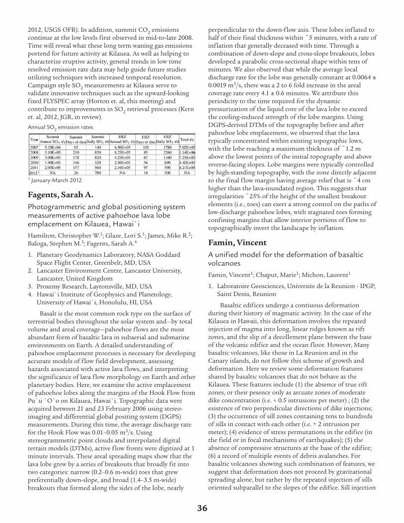
2012, USGS OFR). In addition, summit CO2 emissionscontinue at the low levels first observed in mid-to-late 2008.Time will reveal what these long term waning gas emissionsportend for future activity at Kilauea. As well as helping tocharacterize eruptive activity, general trends in low timeresolved emission rate data may help guide future studiesutilizing techniques with increased temporal resolution.Campaign style SO2 measurements at Kilauea serve tovalidate innovative techniques such as the upward-lookingfixed FLYSPEC array (Horton et. al, this meeting) andcontribute to improvements in SO2 retrieval processes (Kernet. al, 2012, JGR, in review).
Annual SO2 emission rates
1 January-March 2012
Fagents, Sarah A.Photogrammetric and global positioning systemmeasurements of active pahoehoe lava lobeemplacement on Kilauea, Hawai`iHamilton, Christopher W.1; Glaze, Lori S.1; James, Mike R.2;Baloga, Stephen M.3; Fagents, Sarah A.4
1. Planetary Geodynamics Laboratory, NASA GoddardSpace Flight Center, Greenbelt, MD, USA
2. Lancaster Environment Centre, Lancaster University,Lancaster, United Kingdom
3. Proxemy Research, Laytonsville, MD, USA4. Hawai`i Institute of Geophysics and Planetology,
University of Hawai`i, Honolulu, HI, USA
Basalt is the most common rock type on the surface ofterrestrial bodies throughout the solar system and—by totalvolume and areal coverage—pahoehoe flows are the mostabundant form of basaltic lava in subaerial and submarineenvironments on Earth. A detailed understanding ofpahoehoe emplacement processes is necessary for developingaccurate models of flow field development, assessinghazards associated with active lava flows, and interpretingthe significance of lava flow morphology on Earth and otherplanetary bodies. Here, we examine the active emplacementof pahoehoe lobes along the margins of the Hook Flow fromPu`u `O`o on Kilauea, Hawai`i. Topographic data wereacquired between 21 and 23 February 2006 using stereo-imaging and differential global positing system (DGPS)measurements. During this time, the average discharge ratefor the Hook Flow was 0.01–0.05 m3/s. Usingstereogrammetric point clouds and interpolated digitalterrain models (DTMs), active flow fronts were digitized at 1minute intervals. These areal spreading maps show that thelava lobe grew by a series of breakouts that broadly fit intotwo categories: narrow (0.2–0.6 m-wide) toes that grewpreferentially down-slope, and broad (1.4–3.5 m-wide)breakouts that formed along the sides of the lobe, nearly
perpendicular to the down-flow axis. These lobes inflated tohalf of their final thickness within ~5 minutes, with a rate ofinflation that generally deceased with time. Through acombination of down-slope and cross-slope breakouts, lobesdeveloped a parabolic cross-sectional shape within tens ofminutes. We also observed that while the average localdischarge rate for the lobe was generally constant at 0.0064 0.0019 m3/s, there was a 2 to 6 fold increase in the arealcoverage rate every 4.1 0.6 minutes. We attribute thisperiodicity to the time required for the dynamicpressurization of the liquid core of the lava lobe to exceedthe cooling-induced strength of the lobe margins. UsingDGPS-derived DTMs of the topography before and afterpahoehoe lobe emplacement, we observed that the lavatypically concentrated within existing topographic lows,with the lobe reaching a maximum thickness of ~1.2 mabove the lowest points of the initial topography and abovereverse-facing slopes. Lobe margins were typically controlledby high-standing topography, with the zone directly adjacentto the final flow margin having average relief that is ~4 cmhigher than the lava-inundated region. This suggests thatirregularities ~25% of the height of the smallest breakoutelements (i.e., toes) can exert a strong control on the paths oflow-discharge pahoehoe lobes, with stagnated toes formingconfining margins that allow interior portions of flow totopographically invert the landscape by inflation.
Famin, VincentA unified model for the deformation of basalticvolcanoesFamin, Vincent1; Chaput, Marie1; Michon, Laurent1
1. Laboratoire Geosciences, Universite de la Reunion - IPGP,Saint Denis, Reunion
Basaltic edifices undergo a contiuous deformationduring their history of magmatic activity. In the case of theKilauea in Hawaii, this deformation involves the repeatedinjection of magma into long, linear ridges known as riftzones, and the slip of a decollement plane between the baseof the volcanic edifice and the ocean floor. However, Manybasaltic volcanoes, like those in La Reunion and in theCanary islands, do not follow this scheme of growth anddeformation. Here we review some deformation featuresshared by basaltic volcanoes that do not behave as theKilauea. These features include (1) the absence of true riftzones, or their pesence only as arcuate zones of moderatedike concentration (i.e. < 0.5 intrusions per meter) ; (2) theexistence of two perpendicular directions of dike injections;(3) the occurrence of sill zones containing tens to hundredsof sills in contact with each other (i.e. > 2 intrusion permeter); (4) evidence of stress permutations in the edifice (inthe field or in focal mechanisms of earthquakes); (5) theabsence of compressive structures at the base of the edifice;(6) a record of multiple events of debris avalanches. Forbasaltic volcanoes showing such combination of features, wesuggest that deformation does not proceed by gravitationalspreading alone, but rather by the repeated injection of sillsoriented subparallel to the slopes of the edifice. Sill injection
36

results from the permutation of principal stresses afterseveral dike injections in the two perpendicular directions.These sills act as detachement planes accomodating large co-and inter-intrusion displacements, which may occasionnallylead to rapid destabilizations of the edifices. Because sillinjections induce larger displacements in the vertical axis,monitoring networks may need some improvement to detectthese kinds of intrusions and better assess the hazardrepresented by non-Kilauea-like active basaltic volcanoes.
http//www.geosciencesreunion.fr
Ferguson, David J.Magma recharge and ascent during episode 1 ofthe 1959 Kilauea Iki eruptionFerguson, David J.1; Plank, Terry1; Crowley, Megan1; Hauri,Erik2; Gonnermann, Helge3; Houghton, Bruce4; Swanson,Don5
1. LDEO, Columbia University, Pallisades, NY, USA2. Carnegie Institution, Washington, DC, USA3. Rice University, Houston, TX, USA4. University of Hawaii, Honolulu, HI, USA5. HVO, USGS, Hawaii National Park, HI, USA
The 1959 eruption at Kilauea Iki crater produced thehighest Hawaiian fountains yet recorded and resulted in theformation of the Kilauea Iki lava lake and an exceptionallywell preserved tephra fall. Episode 1 lasted for 7 days andinvolved fountain heights of up to 380 m, which depositedmaterial up to 5 km downwind of the vent [1]. This was alsothe only episode of the 1959 eruption that was notinfluenced by lava drain-back into the conduit. Tounderstand the processes leading to the initiation of theeruption and the dynamics of magma ascent duringfountaining episodes, we measured compositional profilesacross olivine crystals erupted during the most vigorous partof episode 1 as well as the volatile contents of meltinclusions hosted within the crystals. To minimize theeffects of post-entrapment re-equilibration or water-loss ofthe melt inclusions, we restricted our analysis to free crystals(<500 microns in diameter) found in fall deposits. Core torim profiles of crystal composition measured by LA-ICP-MSreveal a population of crystals with reverse Fo zonation (Mg-rich crystal rims), implying mixing with a more mafic meltat a late stage in their growth. Modeling the timescales of Fe-Mg diffusion between these high Fo crystal rims and lowerFo cores allows us to estimate the timing between this maficrecharge and the eruption, which is on the order of months.This is the same timescale as the onset of deep-seatedvolcanic tremor (~55 km depth), which has been linked toascending melt from the mantle [2]. Thus both the diffusionchronometers and seismic records point to an influx of meltto shallow levels beneath Kilauea in the months leading upto the eruption. Several volatile species (CO2, H2O, S, Cl,and F) derived from the melt inclusion data followremarkably simple degassing trends, consistent with magmaascent from depths of ~3.5 km. We find no evidence for CO2gas fluxing, and our results suggest that excess volatiles werenot involved in driving the eruption. [1] W. K. Stovall et al.
(2012), Bull. Volcanol. 73, 511-529 [2] J. P. Eaton & K. J.Murata. (1960), Science. 132, 3432
Ficker, EdwardVolcano Mapper - A web-based GIS ApplicationFicker, Edward1
1. App Geoscience, Fort Worth, TX, USA
The “Volcano Mapper”, is a web-based GIS applicationthat adapts spatial data contained in the Digital Database ofthe Geologic Map of the Island of Hawai‘i, released in 2005by Frank A. Trusdell et al [available on the World Wide Webat http://pubs.usgs.gov/ds/2005/144/ ] and the GoogleMaps application programming interface (API). The GoogleMaps API is provided for free in accordance with Google’sTerms of Service and is easily incorporated into a webpage ormobile framework. The JavaScript API utilizes source codeand image tiling techniques to display two dimensionalmaps and imagery at fixed zoom levels. In addition, the APIincludes methods to incorporate outside data sets such aspoints, lines, polygons, and raster images similar to desktopGIS software that store data in shapefiles, KML,geodatabases, etc. Unlike desktop GIS systems, Google mapsis familiar to the public and being incorporated with GPSdevices on “smart phones”, tablets, and other mobile devices.The interactive aspect and functionality of Google maps islargely responsible for the popularity of “AJAX” methods inweb and mobile app development and provides an idealmeans to transfer knowledge between scientists in differentdisciplines and career levels. The Volcano Mapper usesHTML select forms (drop-down boxes & check boxes) totrigger server-side PHP scripts that query and select tabulardata stored in a MySQL database. Similarly, image tiles areadded or removed in a seamless manner. These types ofasynchronous exchanges performed “behind the scenes” todisplay the age-based framework of geologic map units,structures, 14C samples, or chemical data demonstrateexciting potential to disseminate Hawaii’s geologicinformation to a wide and varied audience.
Fiske, Richard S.Ultra-Energetic, Jet-Like Eruption at Kilauea: TheKulanaokuaiki-3 Tephra (~850-950 CE)Fiske, Richard S.1; Rose, Tim2; Swanson, Don3
1. NMNH MRC-119, Smithsonian Inst, Washington, DC,USA
2. Smithsonian Inst., Washington, DC, USA3. HVO, USGS, HVNP, HI, USA
Far-traveled lithic clasts, contained in a thin, small-volume scoria deposit, provide clues that a highly energetic,jet-like eruption took place at Kilauea. The driver for thisevent is interpreted to have been the voluminous eruption ofCO2, known to be a dominant gas phase (after water)released at the summit (e.g. TM Gerlach). Evidence for thisevent, overlooked by previous workers, is best seen on a~2000-year old pahoehoe surface preserved on the volcano’ssouth flank. Lithic clasts erupted during the event, all of
37

which are fresh, consist mostly of a wide variety of lava-flowlithologies; ~18 % are fine-coarse gabbro (some containinginterstitial, vesicular glass). No pillow fragments or clasts ofhyaloclastite debris have been found. The most accessibleKulana-3 lithics occur as lag clasts, where the host scoria hasbeen eroded away— leaving them, much like Easter eggs,waiting to be found. Using a sampling grid 700 m on a sideand containing 112 collecting sites, we document that clastnominal diameters decrease regularly toward the south;grapefruit-size clasts occur near Kulanaokuaiki Pali (7-8 kmsouth of the summit) and “golf-ball rocks” are widelyscattered along the south coast of the island (17 km distant).Kulana-3 scoria, 2-12 cm thick, hosts the lithic clasts and ismassive at most south-flank sites. In places, however, a thinlayer of medium ash separates the scoria into two subunits.Whole-rock XRF analyses of cm-by-cm “slices” through thedeposit revealed cryptic internal zonation. MgO values ofthe lower subunit are variable, averaging ~8 wt %; those inthe upper subunit increase regularly upward from ~9-11 wt% to a maximum of ~14% MgO. The upside-downcompositional pattern of the upper Kulana-3 subunitextends over an area of >70 sq km and suggests a zonedmagma source and a highly organized dispersal process.Estimated volumes of the lower and upper Kulana-3subunits (~7 million and 13 million cubic meters,respectively) correspond to eruptions having VEI values inthe mid 2s to lowermost 3s. Such events are about twoorders of magnitude too small to explain the remarkabledistances traveled by the large and dense lithic clasts. A smallpiece of marine limestone (containing fragments of afilamentous cyanobacterial mat) was discovered in reworkedKulana-3 scoria about 900 m above sea level (far abovetsumani range)— suggesting a deep origin for at least part ofthe K-3 event… but how deep? Our data files contain thelocations (e.g. estimated distances traveled) and nominaldiameters of about 1100 lag lithic clasts. Specific gravitieshave been determined for about half of these clasts. Thisunique body of information will be useful to those interestedin modeling the structure and kinetics of the jet-like columnthat must have risen high above Kilauea’s summit. Andbuilding on the kimberlite-related interpretations of LWilson and JW Head (Nature, v 447, 2007), the relevance ofdownward traveling decompression waves to the deep andvoluminous release of CO2 may emerge as being especiallyimportant.
Flinders, AshtonA 3D Gravity Inversion of the Hawaiian Islands:From Niihau to LoihiFlinders, Ashton1; Ito, Garrett2; Garcia, Michael O.2; Taylor,Brian2
1. University of Rhode Island, Narragansett, RI, USA2. University of Hawaii at Manoa, Honolulu, HI, USA
While the Hawaiian Islands are part of the mostgeologically studied intra-plate volcanic island chain world-wide, surprisingly, the only chain wide compilation ofmarine and terrestrial gravity data is now more than 40 years
old. Early terrestrial studies conducted by J. G. Moore, H.LKrivoy, G. P. Woollard, W. E Strange and others in the early1960’s were meant to serve as reconnaissance surveys only. Inaddition, early marine surveys were limited in both accuratepositioning and data density. Detailed analysis of the crustaldensity structure of the island chain was limited. We presenta new chain-wide gravity compilation incorporating theoriginal island-specific survey data, recently published dataon the island of Kauai and Hawaii, as well as more than 10years of newly incorporated marine data collected aboard theUniversity of Hawaii’s R/V Kilo Moana. This data wassupplemented by surveys aboard the R/V Farnella amongothers. We present free-air (FAA), simple/complete Bouguer,and residual gravity maps on an unprecedented resolutionand geographical extent for the area. We invert the residualgravity anomaly to calculate a model of the 3D densitystructure of magmatic plumbing system of island formation,including both island centered reservoirs and rift zones.
Flower, Verity J.Synergistic monitoring of Hawaiian volcanicactivity from spaceFlower, Verity J.1; Carn, Simon A.1; Wright, Robert2
1. Dept. of Geological and Mining Engineering andSciences, Michigan Tech University, Houghton, MI, USA
2. Hawaii Institute of Geophysics and Planetology,University of Hawaii at Manoa, Honolulu, HI, USA
Hawaiian volcanoes produce a rich variety of eruptivephenomena including lava lakes, lava flows, lava fountains,strombolian activity, ash plumes and persistent degassing.Satellite remote sensing at ultraviolet (UV) and thermalinfrared (TIR) wavelengths can be used to detect andmonitor sulfur dioxide (SO2) emissions and radiative heatfluxes associated with such activity, but despite the potentialbenefits of analyzing space-based SO2 and TIRmeasurements in concert, there have been few efforts toexploit this synergy. The initial aim of this work is to build adatabase of characteristic SO2 and heat fluxes, and theirtemporal variability, for different styles of activity at basalticvolcanoes including Kilauea (Hawaii), Etna (Italy), Ambrym(Vanuatu), Nyiragongo (DR Congo) and Piton de laFournaise (Réunion). Kilauea, Ambrym and Nyiragongo allhost active lava lakes, whilst Etna has produced frequentparoxysmal lava fountaining events in 2011-12. Ourhypothesis is that it may be possible to distinguish differentstyles of activity remotely based on these characteristicsignals, and ultimately develop an improved satellite-basederuption warning or monitoring system. We focus onoperational SO2 measurements made by the OzoneMonitoring Instrument (OMI) on NASA’s Aura satellite, andTIR MODVOLC data derived from the Moderate ResolutionImaging Spectroradiometer (MODIS) on the Aqua platform.Both Aqua/MODIS and Aura/OMI are in NASA’s A-Trainsatellite constellation, providing daily, near-coincidentobservations of SO2 emissions and heat flux at activevolcanoes. OMI data can be used to estimate SO2 emissionrates, whilst MODVOLC radiance data provide constraints
38
on lava effusion rates or magma flux rates at volcanoes withactive lava flows or lava lakes. Synergy between OMI andMODIS measurements offers several advantages, e.g., OMISO2 observations could permit screening of some non-volcanic TIR hot-spots from the MODVOLC dataset, on theassumption that significant SO2 emissions would beexpected from a hot volcanic vent. Conversely, high SO2column amounts in the absence of a TIR signal couldindicate an optically thick volcanic plume obscuring hot lavabelow, or perhaps a deep magma source. We will also assesswhether any systematic changes in heat and SO2 flux priorto known eruptions can be identified in the satellitemeasurements. Statistical techniques will be used to analyzethe OMI and MODIS time-series data and extract anyinformation on characteristic timescales and patterns ofactivity. Given the nature of volcanic datasets, we plan toexplore stochastic techniques that permit thecharacterization of behavior based on sparse time-seriescontaining data gaps, and statistical methods for analysis ofnon-stationary time-series, such as Fourier functions andwavelet analysis.
Foster, JamesMeteorology and Volcano MonitoringFoster, James1; Businger, Steven1; Hobiger, Thomas2;Cherubini, Tiziana1; Brooks, Benjamin1
1. School of Ocean and Earth Science and Technology,Honolulu, HI, USA
2. National Institute of Information and Communications,Tokyo, Japan
The atmosphere is inextricably linked to many volcanomonitoring techniques. The refraction of radio waves by theatmosphere impacts any measurements based on these typesof signals, such as GPS, one of the workhorses fordeformation monitoring. Many of the deformationprocesses observed at active volcanoes, like Kilauea andMauna Loa, have temporal periods of minutes to hours andspatial scales of kilometers. These scales are similar to thecharacteristic scales for the transport and evolution of watervapor perturbations in the atmosphere, leading toconsiderable ambiguity between ground motion andatmospheric artifacts. For sub-daily GPS positioning, theatmosphere over Hawaii is one of the primary factorslimiting the accuracy of the solutions. To mitigate this noisesource, we have installed a near-real-time numerical weathermodel ray-tracing package, “KARAT”, which uses weatherpredictions for the Big Island from the Mauna Kea WeatherCenter to predict the atmospheric refraction along each raypath and correct the GPS data files. We explore the impactof this mitigation technique using a data base of one year ofnear-real-time sub-daily position solutions for the jointHVO/UH/Stanford GPS network. The impact of theatmosphere on volcano monitoring is not always just anegative one however. Correlating the arrival ofperturbations in the GPS estimates of atmospheric delaybetween GPS sites in the Big Island network provides directinsight into the wind field. We generate estimates of the“water vapor wind” vector field over the network and show
that this has promise as a “nowcasting” technique fortracking the transport of the volcanic plume: a significanthazard to local communities.
Frey, Frederick A.The Longevity of Geochemical Differences BetweenLavas Erupted Along the Loa and Kea SpatialTrends Defined by the Hawaiian IslandsFrey, Frederick A.1; Xu, Guangping2; Abouchami, Wafa3;Blichert-Toft, Janne4; Clague, David A.5
1. MIT, Cambridge, MA, USA2. Colorado State University, Fort Collins, CO, USA3. MPI, Mainz, Germany4. Ecole Normale Superieure de Lyon, Lyon, France5. Monterey Bay Aquarium Research Institute, Moss
Landing, CA, USA
Differences in Pb isotope ratios between lavas from Loa-and Kea-trend volcanoes have been used to infer geochemicalzonation in the Hawaiian plume [1,2]. However, thesignificance of Kea geochemical signatures in Loa-trendvolcanoes and vice versa is debated [3]. The longevity ofthese differences is also uncertain; Weis et al. [2] claim thatgeochemical zonation has persisted “for at least 5 millionyears”, but Abouchami et al. [1] suggested that thegeochemical differences “terminate at the Molokai FractureZone” (~2 Ma). We have determined the geochemicalcharacteristics of three contemporaneous volcanoes whosestrike crosses that of the Loa- and Kea-trends (Fig. 1),specifically late shield and postshield lavas, ~1.5 to 1.75 Ma,from East Molokai volcano, the northernmost Kea trendvolcano recognized by Jackson et al. [4], shield andpostshield lavas, ~1.7 to 1.9 Ma, from West Molokai volcano,a Loa trend volcano, and shield lavas, undated but inferredto be 1.8 to 2.0 Ma, from the submarine Penguin Bankvolcano which we infer to be a distinct Hawaiian volcanowest of the Loa trend. These Loa- and Kea-trend volcanoesare distinguished by incompatible element abundance ratios(Zr/Nb) as well as isotopic ratios of Sr, Nd, Hf and Pb. EastMolokai lavas are clearly Kea-like whereas West Molokai andPenguin Bank lavas range from Loa-like to Kea-like (Fig. 2).This result is consistent with more geochemicalheterogeneity in Loa volcanoes than in Kea volcanoes [1,2].These results are consistent with a randomly distributedheterogeneity model [5,6] with Loa volcanoes sampling ahigher proportion of components with low solidii, perhapsrecycled oceanic crust and sediment (black color), whereasKea volcanoes, which are closer to the plume center, sample ahigher proportion of components (grey background) withhigh solidii such as peridotites (Fig. 3). References 1.Abouchami et al., 2005, Nature, 434:851-856; 2. Weis et al.,2011, Nature Geoscience, 4:831–838; 3. Rhodes et al., 2012,Geochem. Geophys. Geosyst. doi10.1029/2011GC003812; 4.Jackson et al., 1972, GSA Bulletin, 83:601-618; 5. Huang &Frey, 2005, EOS Trans. AGU 86(52):V51A-1466; 6. Ren et al.,2005, Nature, 436:837-840.
39
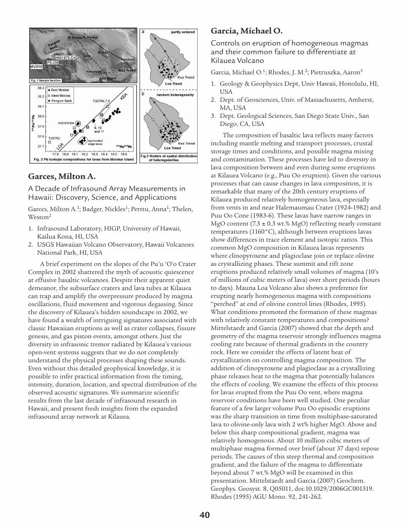
Garces, Milton A.A Decade of Infrasound Array Measurements inHawaii: Discovery, Science, and ApplicationsGarces, Milton A.1; Badger, Nickles1; Perttu, Anna1; Thelen,Weston2
1. Infrasound Laboratory, HIGP, University of Hawaii,Kailua Kona, HI, USA
2. USGS Hawaiian Volcano Observatory, Hawaii VolcanoesNational Park, HI, USA
A brief experiment on the slopes of the Pu’u ‘O’o CraterComplex in 2002 shattered the myth of acoustic quiescenceat effusive basaltic volcanoes. Despite their apparent quietdemeanor, the subsurface craters and lava tubes at Kilaueacan trap and amplify the overpressure produced by magmaoscillations, fluid movement and vigorous degassing. Sincethe discovery of Kilauea’s hidden soundscape in 2002, wehave found a wealth of intriguing signatures associated withclassic Hawaiian eruptions as well as crater collapses, fissuregenesis, and gas piston events, amongst others. Just thediversity in infrasonic tremor radiated by Kilauea’s variousopen-vent systems suggests that we do not completelyunderstand the physical processes shaping these sounds.Even without this detailed geophysical knowledge, it ispossible to infer practical information from the timing,intensity, duration, location, and spectral distribution of theobserved acoustic signatures. We summarize scientificresults from the last decade of infrasound research inHawaii, and present fresh insights from the expandedinfrasound array network at Kilauea.
Garcia, Michael O.Controls on eruption of homogeneous magmasand their common failure to differentiate atKilauea VolcanoGarcia, Michael O.1; Rhodes, J. M.2; Pietruszka, Aaron3
1. Geology & Geophysics Dept, Univ Hawaii, Honolulu, HI,USA
2. Dept. of Geosciences, Univ. of Massachusetts, Amherst,MA, USA
3. Dept. Geological Sciences, San Diego State Univ., SanDiego, CA, USA
The composition of basaltic lava reflects many factorsincluding mantle melting and transport processes, crustalstorage times and conditions, and possible magma mixingand contamination. These processes have led to diversity inlava composition between and even during some eruptionsat Kilauea Volcano (e.g., Puu Oo eruption). Given the variousprocesses that can cause changes in lava composition, it isremarkable that many of the 20th century eruptions ofKilauea produced relatively homogeneous lava, especiallyfrom vents in and near Halemaumau Crater (1924-1982) andPuu Oo Cone (1983-6). These lavas have narrow ranges inMgO content (7.3 0.3 wt.% MgO) reflecting nearly constanttemperatures (1160°C), although between eruptions lavasshow differences in trace element and isotopic ratios. Thiscommon MgO composition in Kilauea lavas representswhere clinopyroxene and plagioclase join or replace olivineas crystallizing phases. These summit and rift zoneeruptions produced relatively small volumes of magma (10’sof millions of cubic meters of lava) over short periods (hoursto days). Mauna Loa Volcano also shows a preference forerupting nearly homogeneous magma with compositions“perched” at end of olivine control lines (Rhodes, 1995).What conditions promoted the formation of these magmaswith relatively constant temperatures and compositions?Mittelstaedt and Garcia (2007) showed that the depth andgeometry of the magma reservoir strongly influences magmacooling rate because of thermal gradients in the countryrock. Here we consider the effects of latent heat ofcrystallization on controlling magma composition. Theaddition of clinopyroxene and plagioclase as a crystallizingphase releases heat to the magma that potentially balancesthe effects of cooling. We examine the effects of this processfor lavas erupted from the Puu Oo vent, where magmareservoir conditions have been well studied. One peculiarfeature of a few larger volume Puu Oo episodic eruptionswas the sharp transition in time from multiphase-saturatedlava to olivine-only lava with 2 wt% higher MgO. Above andbelow this sharp compositional gradient, magma wasrelatively homogenous. About 10 million cubic meters ofmultiphase magma formed over brief (about 37 days) reposeperiods. The causes of this steep thermal and compositiongradient, and the failure of the magma to differentiatebeyond about 7 wt.% MgO will be examined in thispresentation. Mittelstaedt and Garcia (2007) Geochem.Geophys. Geosyst. 8, Q05011, doi:10.1029/2006GC001519.Rhodes (1995) AGU Mono. 92, 241-262.
40

Gasperikova, ErikaKilauea Volcano 3D Imagining UsingMagnetotelluric DataGasperikova, Erika1; Newman, Gregory1; Hoversten, Gary2, 1;Ryan, Michael3; Kauakihaua, James4; Cuevas, Nestor5;Commer, Michael1
1. LBNL, Berkeley, CA, USA2. Chevron-Texaco, San Ramon, CA, USA3. USGS, Reston, VA, USA4. USGS, HVO, HI, USA5. Schlumberger-EMI, Berkeley, CA, USA
Kilauea Volcano, Hawaii, is currently the world’s mostactive and most intensively studied volcano in the world. Acollaborative effort of several institutions has beenundertaken to study the Kilauea volcano in Hawaii using theMagnetotelluric (MT) technique. Total of 70 MT stationswere acquired in two field campaigns during 2002-2003. MTdata were acquired over the Southwest (SWRZ) and EasternRift Zones (ERZ), including the central caldera,Halema’uma’u and Pu’u O’o areas, using a recording systemwith up to eight stations operating simultaneously, withmultiple remote reference sites, and using multi-stationrobust data processing techniques. Good-to-excellent qualitydata were recorded even in the harshest conditions, such asthose encountered on the fresh lava flows of the ERZ, whereelectrical contact resistances are extremely high. In three-dimensional (3D) MT inversion (Newman and Alumabugh,2000) data sensitivity to the magmatic structure beneath thevolcano was increased by accurately accounting for islandtopography and coastal effects. The derived conductivity(inverse of resistivity) structure correlated well withpreviously reported seismic velocity anomalies beneathKilauea. In particular, we have been able to map regions ofactive magma transport and storage beneath the locus ofERZ activity near the Pu’u O’o-Kupaianaha vents, and inadjacent areas. In addition, we have resolved upper portionsof the vertical magma ascent conduit beneath the summitcaldera, as well as low-resistivity domains of magma storagebeneath Halema’uma’u and the southwestern caldera region.Active fault zones imaged by seismic velocity tomography aslow velocity zones tie to low resistivity zones beneath theinverted MT lines. We have resolved groundwater-saturatedregions within the Kaoiki fault zone, and regions of inferredsaline waters, forming conductive domains within thesefractures over the depth range of 1 to >6 km in the Hilinafault zone. Our results demonstrate successful acquisitionand interpretation of MT data in the challengingenvironment found on Kilauea. Foremost among thechallenges were the rough topography, extremely highcontact resistance on fresh lava flows, and difficult access toareas of interest around active volcanic activity. In additionto acquisition difficulties were the interpretationaldifficulties imposed by the necessity of modeling bothtopography and costal effects on the MT data. This paperwill present the first 3D conductivity structure beneathKilauea and its rift zones derived from MT data inversion.The imaging of this data set and its correlations with
previous work illustrate that MT data can provide structuralinformation about the magma transport and storage regionsof an active volcano, and their hydrothermal surroundings.The ultimate goal is to integrate our 3D conductivity modelfrom MT inversion with existing gravity, seismic and otherelectrical data to provide an improved understanding of theinternal structure of the volcano.
Girard, GuillaumeFrom mantle to ash cloud: quantifying magmaascent rates and degassing processes at Kilaueausing short-lived U-series radionuclide disequilibriaGirard, Guillaume1; Reagan, Mark K.1; Sims, Ken W.2;Waters, Christopher L.3; Garcia, Michael O.4; Pietruszka,Aaron J.5; Thornber, Carl R.6
1. Department of Geosciences, University of Iowa, IowaCity, IA, USA
2. Department of Geology and Geophysics, University ofWyoming, Laramie, WY, USA
3. Sripps Institution of Oceanography, San Diego StateUniversity, San Diego, CA, USA
4. Department of Geology and Geophysics, University ofHawai’i, Honolulu, HI, USA
5. Department of Geological Sciences, San Diego StateUniversity, San Diego, CA, USA
6. Cascades Volcano Observatory, US Geological Survey,Vancouver, WA, USA
We analyzed basalt lavas, scoria and tephra eruptedbetween 1982 and 2008 from Halema’uma’u Crater and theeast rift zone (Pu’u ‘O’o Crater) of Kilauea Volcano, Hawaii,for 238U-234U-230Th-226Ra-210Pb-210Po disequilibria. Therelative activities of these nuclides help quantify rates andtiming of magma evolution processes including magmaascent and storage, and degassing. The 2008 samples wereanalyzed multiple times for 210Po in order to assess 210Poingrowth towards secular equilibrium and calculate (210Po)0and (210Pb)0 values at time of eruption. Lavas and scoriafrom both vents exhibit (210Po)0 ~ 0, suggesting that Po hadentirely degassed from the magma at time of eruption. Bycontrast, 2008 Halema’uma’u ash and Pele’s hair sampleshave very high (210Po)0 that resulted from degassed Pocondensing on tephra particles. Activities of (210Pb)0 in theash and Pele’s hair are higher by a factor of ~ 1.5 – 2 thanthat of scoria and lavas. These samples also have higher Pbconcentrations than other 2008 samples. Hence, they likelygained fumarolic Pb shortly before or during eruption. Lavaand scoria samples erupted since 1982 have (210Pb)/(226Ra)0 =0.75 – 1.04; with most samples having 210Pb deficits. Thereappears to be no clear difference in this ratio betweensummit and rift samples, or between scoria and lavas, and noclear temporal variations could be identified. However,(210Pb)/(226Ra)0 variations from 0.75 to near equilibrium areobserved among samples erupted within a few days of eachother. Plagioclase-phyric lavas erupted in episode 54 havenear equilibrium (210Pb)/(226Ra)0. Since Kilauea ispersistently degassing and erupts with (210Po) ~ 0, it isreasonable to assume that magmas also entirely degas 222Rn
41

before eruption. The repeated (210Pb)/(226Ra)0 ~ 0.75 – 0.80suggest that this degassing occurs for up to ~ 8 years beforeeruption. We speculate that CO2-rich gases carrying Rncontinually emanate from magmas as they rise to the surfacefrom the base of the crust over this interval of time. Theshifts towards equilibrium (210Pb)/( 226Ra)0 values at somephases of eruptions suggest a reduced efficiency of Rndegassing, faster ascent rates, or prolonged storage of somemagmas in the rift-zone before they erupt. The nearequilibrium (210Pb)/(226Ra)0 values for the differentiatedepisode 54 lavas illustrate that these eruptions involvedmagmas that were stored for ~ 3 decades in the east rift zonebefore they erupted at Na–pau Crater, in agreement withexisting petrologic models (Thornber et al., 2003, J. Petrol.44:1525-1559).
Gonnermann, Helge M.Dynamic coupling of Mauna Loa and Kilaueavolcanoes, Hawai‘iGonnermann, Helge M.1; Foster, James H.2; Poland,Michael3; Wolfe, Cecily J.2, 4; Brooks, Benjamin A.2; Miklius,Asta3
1. Earth Science, Rice University, Houston, TX, USA2. Hawaii Institute of Geophysics and Planetology, SOEST,
University of Hawaii, Honolulu, HI, USA3. Hawai`ian Volcano Observatory, U.S. Geological Survey,
Hawai`i National Park, HI, USA4. Department of Terrestrial Magnetism, Carnegie
Institution of Washington, Washington, DC, USA
Global Positioning System (GPS) records reveal thatKilauea, which was actively erupting, and Mauna Loa, whichhas not erupted since 1984, inflated concurrently during thepast decade. This raises the questions whether and how bothvolcanoes might be dynamically connected (Miklius &Cervelli, Nature, 2003), and if an eruption of Mauna Loawould be more likely in the near future. Here we show howstress transfer by pore pressure diffusion, within anasthenospheric melt layer, is a viable mechanism forcoupling both volcanoes, potentially causing them to eruptsimultaneously. Paradoxically, by the same mechanism theeruption of one volcano may, in turn, inhibit that of anadjacent one. Using a lumped parameter model weinvestigate the interplay between changes in asthenosphericmelt supply (Poland et al., Nature Geosci., 2012), magmaeffusion and shallow intrusive activity at both Kilauea andMauna Loa. The model is constrained by SO2 emission ratesat Kilauea’s east rift zone and is able to explain a full decadeof deformation (2001-2011) at both volcanoes. We find thatstress transfer by pore-pressure diffusion is consistent withtime constraints for asthenospheric magma flow from U-series disequilibria (Sims et al., Geochim. Cosmochim. Acta,1999). To erupt isotopically distinct magmas (DePaolo et al.,J. Geophys. Res., 1996; Weis, et al., Nature Geosci., 2011),each volcano’s relatively open lithospheric plumbing systemhas to sample melt from different parts of an isotopicallyheterogeneous melt accumulation layer. This is consistentwith porous melt flow, where each volcano’s lithospheric
plumbing system is analogous to an artesian well that can‘capture’ geochemically distinct regions of melt. Changes inpore pressure may affect the rates of upward magma flowinto each volcano’s plumbing system and summit reservoirswithout significantly altering horizontal flow paths withinthe porous layer. Likewise, changes in summit magmastorage will affect reservoir pressure and, hence, upward flowfrom and melt pressure within the porous layer. The modelpredicts that over the past decade the estimated volume ofmagma added to Mauna Loa’s crustal reservoir is similar tohistorical eruptions at Mauna Loa. Had Kilauea not gonethrough a period of heightened eruptive and intrusiveactivity, pressures within the asthenospheric porous meltaccumulation zone, and consequently within Mauna Loa’ssummit reservoir, would have been higher.
Greene, AndrewTemporal Geochemical Variations in Lavas fromKilauea’s Puu Oo Eruption (1983-2012): TheChanging Roles of Source and Crustal ProcessesGreene, Andrew1; Garcia, Michael O.2; Marske, Jared2;Pietruszka, Aaron J.3; Weis, Dominique4; Rhodes, J. M.5;Norman, M. D.6
1. Dept. of Natural Sciences, Hawaii Pacific University,Kaneohe, HI, USA
2. Dept. of Geology & Geophysics, University of Hawaii,Honolulu, HI, USA
3. Dept. of Geol. Sciences, San Diego State University, SanDiego, CA, USA
4. Dept. of Earth and Ocean Sciences, University of BritishColumbia, Vancouver, BC, Canada
5. Dept. of Geosciences, University of Massachusetts,Amherst, MA, USA
6. Research School of Earth Sciences, Australian NationalUniversity, Canberra, ACT, Australia
Geochemical time-series analysis of lavas from Kilauea’songoing Puu Oo eruption chronicle mantle and crustalprocesses during a single, prolonged (1983 to present)magmatic event. This eruption has shown dramaticvariations in eruption style (episodic high lava fountainingto continuous effusion) and magma effusion rates (nearlytwo-fold increase), both of which correlate with geochemicalvariations. Here we present an update of our monitoring ofthe geochemical variations of Puu Oo lavas and the resultsof a new high-precision isotopic (Pb, Sr) study. Detailedisotopic measurements, made of lavas erupted at ~6 monthintervals for the entire eruption, show gradual variationsand a reversal in the long-term composition for Kilauea. Thegeochemical and isotopic trends for the first half of theeruption (until ~2000), including the early episodic, highfountaining period (1983-1986) and the continuous effusionat Kupaianaha and Puu Oo vents, continued the 20thcentury Kilauea geochemical trends. Starting in ~2000, thesetrends reversed towards Mauna Loa lava compositions for Pband Sr isotopes, some trace element ratios and normalizedSiO2 abundances. A surge in magma supply began in 2003(Poland et al., 2012), which was followed about a year later by
42

a return to the long-term geochemical variation trends forKilauea. The rate, range and pattern of Pb-Sr isotope andgeochemical variations for lavas from the Puu Oo eruptionprovide insights about melting dynamics and structure ofthe Hawaiian plume. The overall isotopic and geochemicalvariations for this single eruptive sequence requirecontributions from at least three distinct mantle sourcecomponents with the early Puu Oo lavas deviating in Pb-Srspace from the overall Kilauea-Mauna Loa trend. Short-termperiodicity of Pb isotope ratios (two cycles lasting 10 years)may reflect melt extraction from mantle with a fine-scalepattern of repeating source heterogeneities. Crustalprocesses were highlighted by two brief uprift lava outbreaksin and near Napau Crater in 1997 and 2011. These lavas havemajor and trace elements indicating mixing of new maficand stored evolved magmas prior to this episode. Thus, theeast rift zone contains multiple pockets of magma that wereperiodically intruded, differentiated for variable periods andwere locally tapped (with or without mixing with newmagma) as the stress regime within the volcano evolved. Thecooperation of the Hawaiian Volcano Observatory staff overthe 29 years of this eruption is gratefully acknowledged.Poland et al., 2012, Nature Geoscience 5:295-300.
Hall, PaulMantle plume-migrating mid-ocean ridgeinteraction and the bend in the Hawaii-EmperorSeamount ChainHall, Paul1
1. Earth Sciences, Boston University, Boston, MA, USA
Paleomagnetic data obtained from the Hawaii-EmperorSeamount Chain (HESC), the most iconic of all hotspottraces, suggests that the Hawaiian hotspot moved rapidly(~40 mm/yr) southward relative to the Earth’s magneticpoles during the period of 81 – 47 Ma before coming to restat its present latitude, and that this abrupt change in themotion of the hotspot created the well-known bend in theHESC [Tarduno et al., 2003]. Subsequently, Tarduno et al.[2009] proposed that the period of rapid hotspot motionfrom 81 – 47 Ma might have been the surface expression ofthe conduit of the presumed Hawaiian plume returning to alargely vertical orientation after having been entrained andtilted by the passage of a migrating mid-ocean ridge (thePacific-Kula ridge system) over the plume. While geophysicaland geochemical observations have suggested that ridges caninfluence the dispersion of plumes in the upper mantle atgreat distances (>1000 km), much about the interactionbetween mantle plumes and mid-ocean ridges remainspoorly understood. I report on a series of complementary 2-D numerical and 3-D analog geodynamic experimentsdesigned to characterize the evolution of a plume conduit asa migrating mid-ocean ridge approaches, moves over theconduit, and then continues to move away. Numericalexperiments model the upper 400 km of the mantle as aBoussinesq fluid with infinite Prandtl number and atemperature dependent diffusion creep rheology using theCOMSOL Multiphysics finite element modeling package.
Analog experiments were conducted in a clear acrylic tank(150 cm x 50 cm x 50 cm) filled with commercial grade high-fructose corn syrup. Plate-driven flow is modeled bydragging two sheets of Mylar film (driven by independentDC motors) in opposite directions over the surface of thefluid. Ridge migration is achieved by moving the point atwhich the mylar sheets diverge using a separate motor drive.Buoyant plume flow is generated using a small electricalheater placed at the bottom of the tank. Results show thatthe range of plume-ridge separation distances over whichplume material will appear at the ridge axis increases withincreasing plume temperature, increasing migration rate,and decreasing spreading rate. The location at which theplume conduit impinges on the overriding plate, a proxy forthe surface location of hotspot volcanism, is tracked overtime in each experiment and the resulting hotspot migrationvelocities compared to those from the HESC.
Harris, AndrewEffusion Rate: Measurement from Space and Inputinto Lava Flow Modelling (INVITED)Harris, Andrew1
1. Laboratoire Magmas et Volcans, Universite Blaise Pascal,Clermont Ferrand, France
Lava discharge rate could be argued to be one of thefundamental measures of effusive activity. It can control lavaflow length and innudation area, is a primary source termfor most lava flow emplacement models and is, itself,controlled by the dynamics of the erupting system. However,it can be one of the most difficult parameters to measure,and errors on measurements are usually large if, that is,measurement is possible. This talk will review means tomeasure lava discharge rate, with a special focus onobtaining this key measurement, in real-time, using satellitethermal data. The review will cover the progress that hasbeen made over the last 20 years, concluding with recentattempts to extract, and validate, lava flow discharge ratesfrom geostationary (SEVIRI) data. Such data have a spatialresolution of 15 minutes, but a pixel size of 3 km. As a result,realiable volumes for lava effused during short (hour-scale)fountaining events on Etna have been extracted from SEVIRIdata during the last year. However, recent debate has alsofocused on the assumptions underlying the methodologyused to convert between thernal flux and discharge rates,and the limits within which the conversion can be applied.We will finish by reviewing models available to simulate lavaflow emplacement, and a consideration of recent attempts torun such models in real-time using discharge ratesautomatically extracted from on-reception satellite data.This raises the thorny problem of (information)dissementation issues.
43

Harrison, LaurenLi Isotopes of Hawaiian Lavas: Loa Trend SourceVariationHarrison, Lauren1; Weis, Dominique1; Barnes, Elspeth1;Garcia, Mike2; Hanano, Diane1
1. Pacific Center for Isotope & Geochemical Research(PCIGR), Department of Earth, Ocean, and AtmosphericSciences, University of British Columbia, Vancouver, BC,Canada
2. Department of Geology & Geophysics, University ofHawaii, Honolulu, HI, USA
Hawaiian volcanism delineates into two distinctivegeographical series, the Kea and the Loa trends, which arealso identified by their geochemical and isotopiccharacteristics. Traditionally, the geochemical differencesamong volcanoes have been attributed to mixing of differentcomponents in the source of the Hawaiian mantle plume,mainly an enriched end-member (Ko’olau) characterized bythe presence of recycled oceanic crust sediment, a moredepleted end-member (Kea) with high Nd, Hf, and206Pb/204Pb, and a more primitive component defined byhigh 3He/4He (Lo’ihi). Because of the sizeable fractionationof lithium isotopes in low temperature environments,lithum serves as a powerful tracer for the presence of alteredoceanic crust and sediments in the sources of oceanic islandbasalts. Lithium can thus be used to help distinguish thesource components of Hawaiian lavas. This study examinedforty-two samples of Hawaiian shield lavas for Li isotopes,expanding on analysis of post-shield and rejuvenated lavas.Shield basalts exhibit the highest 7Li among Hawaiianlavas, ranging from 3.03 0.27‰ to 5.19 1.07‰, with adifference between Kea (higher 7Li) and Loa (lower 7Li)volcanoes. Li isotopes also correlate positively with Pb andNd isotopes. This correlation suggests that Li isotopicsignatures survive billion-year residence times in the deepmantle and are suitable tracers of ancient subducted oceaniccrust and/or sediments in Loa-trend shield lavas [1]. In206Pb/204Pb and Nd vs
7Li diagrams, Loa shield lavas havelower 7Li, Nd and
206Pb/204Pb and plot along the extensionof Kea-trend shield lavas. Enriched Loa shield lavas fromWest Ka’ena Ridge, the Mile High Section of Mauna Loa,and Ko’olau exhibit higher 7Li than other Loa-trendvolcanoes, and their lower Nd and
206Pb/204Pb define sub-parallel trends that indicate there are at least two enrichedend-members in the Loa source, one in Ko’olau [2] and onein Mauna Loa lavas older than 120 ka [3]. In addition, Liisotopic analysis of Cretaceous oceanic crust near Hawaii(ODP Site 843) will be investigated to evaluate the possibilelithospheric contamination of Hawaiian lavas [4]. Li isotopesmay contribute valid information on this question becausethe Li isotopic signature of altered oceanic crust issignificantly heavier than both fresh MORB and OIB due toincorporation of Li from seawater (7Li~32‰). Addition ofthis heavy 7Li may account for some of the Hawaiian lavaoutliers. In Hawaiian shield basalts, Li isotopes not only mayreflect the presence of a recycled component in Loa shieldlavas, they also help distinguish between Loa enriched source
components. Further characterization of the trends inlithium isotopes may unearth some additional insights intothe source of Loa-type volcanism [5]. [1] Vlastélic et al (2009)Earth and Planetary Science Letters 286, 456-466. [2] Tanakaet al. (2007) Earth and Planetary Science Letters 265, 450-465. [3] Weis et al. (2011) Nature Geoscience 4, 831-838. [4]Fekiacova et al (2007) Earth and Planetary Science Letters,261, 65-83. [5] Hanano et al (2010) G3 11,doi:10.1029/2009GC002782
Hauri, Erik H.Volatile Element Systematics of Hawaiian ShieldVolcanoesHauri, Erik H.1; Marske, Jared P.1; Garcia, Michael2;Pietruszka, Aaron3
1. Dept Terrestrial Magnetism, Carnegie Inst Washington,Washington, DC, USA
2. Dept. Geology & Geophysics, University of Hawaii,Honolulu, HI, USA
3. Dept. Geological Sciences, San Diego State University,San Diego, CA, USA
The compositions of shield-stage lavas erupted fromHawaiian volcanoes are characterized by distinctive ranges inmajor elements, trace elements and radiogenic isotopes.These distinctions are also observed within stratigraphicsections from Kilauea, Mauna Loa, Mauna Kea and Koolauwhere major elements, trace elements and isotopecompositions all vary in correlated fashion over thetimespan of each volcano’s shield stage evolution. Thisvariability is undoubtedly related to variations in thecomposition of several different mantle sources presentwithin the Hawaiian mantle plume that contribute toHawaiian volcanism. Given this variability, we wish todiscern whether there are related differences in theabundances of volatile elements (H2O, CO2, F, S, Cl, others)and isotope ratios of hydrogen (D/H) among the differentcomponents present in erupted Hawaiian lavas. To this end,we have undertaken ion microprobe measurements of theconcentrations of H2O, CO2, F, S and Cl and the isotopiccomposition of hydrogen in shield-stage submarine glassesand melt inclusions from Loihi, Kilauea, Mauna Loa, MaunaKea and Koolau volcanoes. Published data for submarineglasses and populations of olivine-hosted melt inclusions [1-13] show large ranges in volatile contents that reflect severalpre- and syn-eruptive processes, such as degassing (decreasesin CO2, H2O and S) and assimilation of seawater-derivedcomponents (increases in Cl and Cl/Nb ratios). Post-eruptiveloss of H2O from melt inclusions is also commonly observedin olivines separated from surface lava flows, which rapidlydegas their water and set up diffusion gradients betweenolivine-hosted inclusions and the external melt; whencooling rates are slow, these inclusions lose water via protondiffusion through olivine, with consequent positive shifts inthe D/H ratios of the residual hydrogen in the meltinclusion. For this reason, melt inclusions from ash, tephraand scoria deposits are preferred in order to maximize theretention of water in olivine-hosted melt inclusions. In total,
44

the sparse data for reliable volatile concentrations insubmarine glasses and rapidly-cooled melt inclusions showhints of systematic differences between Loa- and Kea-trendvolcanoes, but there is a paucity of data from all thevolcanoes mentioned above. Further work on selectsubmarine glass samples, and melt inclusions collected fromshield-stage scoria cones (Pu’u) will shed further light on thepossibility of volatile-element heterogeneity in the sub-Hawaiian mantle. [1] Rison & Craig (1983) EPSL 66, 407. [2]Kyser & O’Neil (1984) GCA 48, 2123. [3] Byers et al. (1985)GCA 49, 1887. [4] Garcia et al. (1989) JGR 94, 10525. [5]Dixon et al. (1991) J. Geol. 99, 371. [6] Clague et al. (1995) J.Petrol. 36, 299. [7] Garcia et al. (1998) Bull. Volc. 59, 577. [8]Wallace & Anderson (1998) Bull. Volc. 59, 327. [9] Kent et al.(1999) Chem Geol 156, 299. [10] Kent et al. (1999) GCA 63,2749. [11] Dixon & Clague (2001) J. Petrol. 42, 627. [12]Hauri (2002) Chem. Geol. 183, 115. [13] Schipper et al.(2010) EPSL 295, 497.
Hauri, Erik H.Pyroclastic Volcanism on the Moon and at KilaueaIki: Similarities and DifferencesWetzel, Diane T.1; Hauri, Erik H.2; Saal, Alberto1; Houghton,Bruce3; Van Orman, James4; Rutherford, Malcolm1
1. Geological Sciences, Brown University, Providence, RI,USA
2. Dept. of Terrestrial Magnetism, Carnegie Inst.Washington, Washington, DC, USA
3. Dept. of Geology & Geophysics, University of Hawaii,Honolulu, HI, USA
4. Dept. of Geological Sciences, Case Western ReserveUniversity, Cleveland, OH, USA
The Moon is thought to have formed in a giant impactcollision between a Mars-sized object and an early-formedproto-Earth [1]. Though all of the inner planets, includingEarth, are depleted in water and other volatiles whencompared with primitive meteorites, the more extremedepletion of volatiles in lunar volcanic rocks has long beentaken as key evidence for a giant impact that resulted in hightemperature catastrophic degassing of the material thatformed the Moon [2,3]. However, recent work on rapidlyquenched lunar pyroclastic glasses [4] has detected thepresence of water dissolved in lunar magmas atconcentrations up to 46 parts per million (ppm), and thestudied glass beads exhibit clear diffusion profiles indicativeof kinetic degassing. These results not only indicate that theMoon is not a perfectly anhydrous planetary body, the alsosuggest that some fraction of the Moon’s observed depletionin highly volatile elements may be the result of magmaticdegassing during the pyroclastic eruption of lunar magmasinto the near vacuum of the Moon’s surface. This suggestionis supported by the ~100X higher water contents of olivine-hosted melt inclusions from the Moon [5]. The 1959 KilaueaIki fire fountain eruption has often been viewed as aterrestrial analogue of the types of eruptions that producedthe lunar volcanic glasses, as it also produced spherical glassbeads of varying size. To this end, we measured volatile
abundances in several size fractions of Kilauea Iki glassbeads. Compared with Kilauea Iki melt inclusions, theKilauea Iki glass beads have water contents that are lower bya factor of 5-8 and CO2 contents lower by an order ofmagnitude, indicative of syn-eruptive degassing. However,none of the Kilauea Iki glasses exhibit the kinds ofkinetically-driven diffusion profiles exhibited by lunar glassbeads; indeed, Kilauea Iki glasses appear to be largelyhomogeneous and this observation is independent of beadsize. In addition, the D/H ratios of Kilauea Iki beads are onaverage 20‰ lower than Kilauea Iki melt inclusions, and thisis consistent with equilibrium degassing of H2O-rich vapor.Kilauea Iki glass beads are much more vesicular than lunarglass beads, which rarely contain vesicles; Kilauea Iki beadsdisplay vesicles in virtually all size fractions, and it is likelythat several differences in both magma properties anderuption environment
Helz, Rosalind L.Evidence for a large range of melts present inKilauea’s summit reservoirHelz, Rosalind L.1; Clague, David A.2; Mastin, Larry G.3;Rose, Tim R.4
1. USGS, Reston, VA, USA2. MBARI, Moss Landing, CA, USA3. USGS, Vancouver, WA, USA4. Smithsonian Institution, Washington, DC, USA
We have over a century’s worth of petrologicobservations on Kilauean lavas, including abundantmicroprobe analyses of glasses (= quenched melts). Thesemelt compositional data show the range of melts available inKilauea’s summit reservoir over time. Compositionalvariation of melts erupted effusively within the caldera islimited, ranging from 6.4-7.5 weight percent (wt.%) MgO.Kilauea has erupted such melts almost continually over thelast two centuries. These crystal-poor melts representmagma from the top of the reservoir, but are notrepresentative of the entire reservoir. Effusive extracalderasummit lavas of the 1959, 1971, and 1974 eruptions containmelts with up to 10.2, 8.9, and 8.2 wt.% MgO respectively.The ongoing presence of more magnesian liquids is furthersupported by the occurrence of Pele’s tears containing up to8.7 wt.% MgO in the 1924 tephra. The pattern of eruptionsuggests that the more MgO-rich liquids are stored atgreater depth, and implies the presence of a (density?)barrier within the upper part of the caldera, such that, in theabsence of major explosive activity, such liquids erupt onlyaround its edges. Histograms of melt compositions in themajor explosive episodes at Kilauea show large ranges ofMgO contents for the Keanakako‘i (1500-1800 A.D.), Kulana(400-1000 A.D.) and Pahala (older than 10 ka) tephra units(figure); the 1959 summit eruption is shown for comparison.Important features of the histograms include: (1) the overallrange of MgO is similar (6.5-11.0 wt.% for 1959 andKeanakako‘i, with a small tail extending to 12% MgO forKulana and Pahala ashes, and rare shards >13% MgO in thePahala). (2) The dominant melt compositions lie at 7-10
45

wt.% MgO, mostly higher than typical intracaldera glasseserupted from the top of the reservoir. (3) Two histograms(Keanakako‘i, Kulana) are bimodal, which raises thepossibility that there is preferential magma storage at twodifferent depths. A further important feature of the tephradata is that individual vitric layers are of two types: the firsthave a limited range of MgO, while the other show a widerange of glass MgO within a thin layer. The stratigraphicposition of these layers is random. These observationsestablish that Kilauea’s summit reservoir contains meltsranging from at least 6.5 to 11.0 wt.% MgO, and that suchmelts were available for sampling instantaneously andrepeatedly over centuries. The former belief that the summitreservoir contains only melts lying at the low end of thisrange is not supported by current observations.
Herrick, Julie A.Lava inundation probability for the north flank ofMauna LoaRonchin, Erika1; Herrick, Julie A.2; Trusdell, Frank3
1. Institute of Earth Sciences Jaume Almera (CSIC), Grupode Volcanología de Barcelona (GVB-CSIC), SIMGEO (UB-CSIC), Barcelona, Spain
2. Smithsonian Institution, Mineral Sciences, Washington,DC, USA
3. USGS, Hawaiian Volcano Observatory, Hawaii NationalPark, HI, USA
The NOAA Mauna Loa Observatory (MLO), locatedhigh on the north flank of Mauna Loa, provides the worldwith CO2 baseline data used to track global warming. Thefacility is located within 4 km of the junction of the summitcaldera (Moku`aweoweo) and the North East Rift Zone(NERZ), and is therefore at risk from future lava flows.Having already weathered the eruption of 1975, NOAAconstructed a lava inundation barrier built in 1986 as aprecaution against potential damage from future eruptions.Mauna Loa erupts frequently. Over the past 3,000 years,Mauna Loa has erupted lava flows, on average, every 6 years.The volcano has erupted 33 times since 1843, averaging oneeruption every 5 years. The NOAA MLO facility suffered aclose encounter with lava during the 1984 eruption, whenthe observatory’s power lines were cut off by `a`a flows fromthe NERZ. Results from a field mapping campaign, covering
a 2.5 x 5.5 km area, provided the basis for a lava flowinundation analysis. Using geospatial analysis methods, weinvestigated the probability of inundation from radial vent,rift zone, and summit eruptions. We also focused an analysison the 1.0 x 1.0 km area of the NOAA facility. Lava flowsoriginating from all three potential source regions have beenmapped in the study area. We combined two DEM-basedsimulation models to examine lava flow paths with thepurpose of developing a hazard assessment for the NOAAfacility. Two GIS programs (BASIN1 and VORIS) were usedto analyze the digital terrain, based on a 10 m DEM in orderto outline possible inundation zones. The BASIN1 resultsprovide clear delineation of the flow network, allowingpreliminary inundation zones to be drawn. Additionalinformation provided by VORIS defined the probabilities ofeach flow network branch being inundated. By overlappingthe inundation zones with the map of inundationprobability within a 50-year time interval, it is clear that theNOAA facility is not likely to be affected by lava flowsoriginating from the NERZ. Its main threats are posed bylava flows originating from the western edge ofMoku`aweoweo and the formation of radial vents.
46

Hon, KenPetrologic evidence for a large, actively convectingsummit magma chamber within Kilauea volcanoHon, Ken1; Thornber, Carl2
1. University of Hawaii, Hilo, Hilo, HI, USA2. US Geological Survey, Cascades Volcano Observatory,
Vancouver, WA, USA
Convection can transfer heat, volatiles, and new magmabetween stably stratified layers in magma chambers.Magmatic convection has previously only been inferred bystatic compositional variation, crystal zonation, laboratoryexperiments, and modeling. We document temporalvariations in crystal content, temperature, composition, andmineral chemistry from Kilauea lava samples that areconsistent with an actively convecting large magma chamber(10-20 km3) Throughout the current eruption, magma hasmoved from the summit chamber through the east rift overperiods of hours to weeks. From mid–1986 to mid–1990,lava erupted from Kupaianaha with little or no local storage,providing a clear record of processes within the summitmagma chamber. Geochemical data show broad positivelycorrelated fluctuations in MgO content and temperature forboth rocks and glasses. Measured and calculated olivinecompositions suggest that olivine was in equilibrium withthe higher MgO whole–rock compositions for a short periodin late 1986. By mid–1987, most olivine phenocrysts werenearly in equilibrium with lower MgO host glasses indicativeof olivine entrainment. Sulfur contents (800-1200 ppm) ofolivine melt-inclusions from Kupaianaha indicate an originin the summit magma chamber. Olivine crystals with high-sulfur melt inclusions also have a range of MgO contentsthat record a strong roofward cooling gradient in thesummit chamber (1200–1170°C). Roofward cooling isaccompanied by degassing of SO2 and H2O fromHalema‘uma‘u Crater. Water loss increases the density of themagma creating denser descending plumes that convectivelystir the underlying magma. During vigorous convection,small (<1 mm) olivine crystals are kept in suspensionproducing the observed semi-annual sinusoidal MgO andtemperature fluctuations. The opening of the new ventwithin Halema‘uma‘u in 2008 increased degassing by nearlyan order of magnitude and provided evidence of convectionwithin the summit magma chamber. Lava samples from thenew vent showed a rapid increase in temperature from 1155to nearly 1170°C, followed by a slow decline back to 1155°Cover the next 3 years. In addition, hot, olivine-only lavareappeared at Pu‘u ‘O‘o for the first time in a decade. Thetemperature rise and fall was coupled with a dramatic spikein SO2 (and probably H2O) followed by a drop in sulfurcontent of olivine glass inclusions. The strong degassingassociated with opening of the vent initiated vigorousconvection that has mixed, cooled, and degassed asignificant portion of the uppermost magma chamber. Wealso hypothesize that stronger convective stirring occurredduring past eruptions, such as those of Mauna Ulu,disrupted thermal and chemical zonation of the summitmagma chamber and caused relatively rapid compositional
47
shifts. Convection and mixing is probably ongoing at thebase of the summit chamber as new, CO2 rich magma isintroduced. Vigorous injections may trigger eruptions, suchas the 1959 Kilauea Iki eruption. Major explosive andtectonic events, appear to cause widespread convectiveoverturn and chaotic mixing within the summit magmachamber followed by major geochemical changes.
Horton, Keith A.Early Monitoring Results from the Halema`uma`uVog Measurement and Prediction FLYSPEC ArrayHorton, Keith A.1; Garbeil, Harold1; Sutton, A. J.2; Elias,Tamar2; Businger, Steven3
1. HIGP, University of Hawaii, Honolulu, HI, USA2. Hawaiian Volcano Observatory, Hawaii National Park, HI,
USA3. Meteorology, University of Hawaii at Manoa, Honolulu,
HI, USA
From early 2010 to late 2011, a multifaceted feasibilityproject called Vog Measurement and Prediction (VMAP), wascarried out by the University of Hawaii at Manoa and theUSGS Hawaiian Volcano Observatory (HVO). The two tasksdistinguishing VMAP were: (1) develop, deploy and test anarray of FLYSPEC UV spectrometer systems that couldprovide continuous, near real-time measurements of SO2emissions from the Halema`uma`u eruptive vent at thesummit of Kilauea Volcano during daylight hours; (2) createa real-time volcanic gas modeling and forecast capability topredict the concentration and dispersion of SO2 and sulfateaerosol particles (PM2.5) from Kilauea’s summit based ongas dispersion and numerical wind prediction models. Thegoal was to feed the new high-temporal resolution SO2source measurements from the first task into the predictioncapabilities of the second task. This presentation highlightssome of the early results from the VMAP FLYSPEC array. Wehave modified the commercially available FLYSPECinstrument, which is used routinely by HVO for campaign-style measurements, to be operated remotely in a stand-alonefashion. We have, in collaboration with HVO, deployed anarray of 10 of these stand-alone sensor packages linkedthrough a WiFi communications node to transmit the datacollected by each instrument back to HVO in real-time. Thecentral location of the array at F0, is also the location of theWiFi communications node. A high gain directional antennais used to relay data back to HVO, approximately 5km away.The array is deployed along a 3 km long arc approximately2.7 km downwind from the summit eruptive vent. Units F0and F1 are aligned along the average trade wind axis and areapproximately 200m apart. SO2 path-concentration data,which is calculated in real-time by each of the 10 field units,is transmitted to a base computer at HVO, whichautomatically calculates the current emission rate, nominallyat 1 Hz. Units F0 and F1 are used to calculate the plumevelocity along the most likely plume direction throughcorrelation techniques described in Williams-Jones, et al.(2006). In the event that the primary plume direction shifts,existing weather stations near the vent can be used to
substitute wind velocities to calculate the emission rates.Examples of the variability of the gas burden from the ventfor any variable interval can be shown. The overall systemcollects these data for 8-9 hours per day. Initial comparisonsof VMAP array gas data to Real-time Seismic-AmplitudeMeasurements (RSAM), which represent a general measureof seismicity, show encouraging correlation. Kilauea is anideal real-world laboratory in which a highly monitoredvolcano can bring multiple techniques and monitoringdisciplines together. The new VMAP FLYSPEC array canprovide continuous measurement inputs relating to thedriving force of volcanism and gas emissions, in a way thathas been unavailable until now.
Houghton, Bruce F.Explosive Eruptions at Basaltic Volcanoes(INVITED)Houghton, Bruce F.1; Carey, Rebecca J.1, 2; Swanson, Don A.3;Gonnermann, Helge M.4
1. 1680 East-West Road, Univ Hawaii Manoa, Honolulu, HI,USA
2. CODES, University of Tasmania, Hobart,, TAS, Australia3. Hawaiian Volcano Observatory, USGS, HVNP, HI, USA4. Earth Science, Rice University, Houston, TX, USA
Eruption parameters suggest that basaltic eruptionscover a weak to moderately strong range of explosivity,equating to discharge rates of 102 to 108 kg/s and eruptedvolumes of 103 to 109 m3. Current classification systems forexplosive eruptions offer a 2D perspective that quantifiessome measure of mass discharge rate versus involvement ofexternal water from the eruptive products. Basaltic systemsfit this space awkwardly and really require at least two extraparameters: to constrain how sustained/steady the eruptionswere and the vent/conduit shape. Studies at 3 frequentlyactive volcanoes strongly influence our current picture ofbasaltic explosive volcanism: Kilauea, Stromboli and Etna.Key factors that we discuss in considering the mechanismsfor basaltic explosive eruptions are: - Pre-eruption volatilecontents and the role of outgassing of CO2. - Depth andtime scales of shallow melt storage and mingling. - Natureand depth of generation of the gas phase that powerseruption. - Relevant times scales of bubble nucleation,growth and relaxation. - Rheological state of the magma atfragmentation. - Vesiculation state and crystallinity of themelt phase - Extent to which the gas phase(s) is mechanicallycoupled. - External triggering of explosions. - Active versuspassive roles of external water and wall rock in theexplosions and plumes. We focus principally on the complexrelationships between melt and exsolved volatiles in basalticexplosive eruptions, and the applicability ofcouple/decoupled or open/closed system behaviors to lowviscosity magmas.
48

Howell, Samuel M.Numerical Modeling of Mantle Convectionbeneath the Aegir Ridge, a Shadow in the IcelandHotspotHowell, Samuel M.1; Ito, Garrett1; Breivik, Asbjorn2; Hanan,Barry3; Sayit, Kaan3; Vogt, Peter4; Mjelde, Rolf5
1. Department of Geology and Geophysics, University ofHawaii at Manoa, Honolulu, HI, USA
2. Department of Geosciences, University of Oslo, Oslo,Norway
3. Department of Geological Sciences, San Diego StateUniversity, Sandiego, CA, USA
4. Marine Science Institute, University of Santa Barbara,Santa Barbara, CA, USA
5. Department of Earth Science, University of Bergen,Bergen, Norway
The Iceland Hotspot has produced extensive volcanismspanning much of the ocean basin between Greenland andNorway, forming one of the world’s largest igneousprovinces. However, an apparent igneous “shadow” inhotspot activity is observed at the fossil Aegir Ridge, whichaccommodated seafloor spreading northeast of present dayIceland from continental breakup ~55 Ma until ~25 Ma. Atthis point, the spreading center ceased to produce new crustand all spreading moved west to the Kolbeinsey Ridge, whichopened ~30 Ma. Enigmatically, normal-to-anomalously thincrust formed along the Aegir ridge, despite its closeproximity to the Iceland Hotspot. To address this disparity,we use three-dimensional numerical models to simulate theinteraction between a mantle plume, rifting continentallithosphere, and the time-evolving North Atlantic ridgesystem. Two end-member hypotheses for Aegir’sanomalously low production are investigated. First, thatmaterial emanating from the hotspot was diverted awayfrom the Aegir Ridge by the thick lithosphere of the JanMayen Microcontinent, starting ~30 Ma, as the KolbeinseyRidge began rifting it apart from Greenland just east of theprojected center of the Iceland hotspot. Second, that plumematerial was not blocked and did reach the ridge, but hadalready experienced partial melting closer to the hotspot.This material was then unable to produce melt volumes atthe Aegir Ridge comparable to those of pristine mantle. Totest these hypotheses, model predictions are compared withseismologically constrained crustal thicknesses, boundariesin seafloor geology, and preliminary geochemistry analysisto explore likely and unlikely scenarios which result in theobserved Aegir shadow.
Ito, GarrettSeismic Structure and Dynamics of the HawaiianMantle Plume (INVITED)Ito, Garrett1; Wolfe, Cecily1; Ballmer, Maxim1
1. SOEST, Univ Hawaii, Honolulu, HI, USA
Seismic observations and geodynamic models provideinsights into the origin of the Hawaiian hotspot. The
regional PLUME experiment involved deployments of landand ocean seismometers to image the mantle seismicstructure at high resolution. Surface waves constrainstructure down to ~200 km depth, and reveal anomalouslylow velocities in the lower lithosphere and asthenosphereextending along the island chain beneath the Hawaiianswell. P and S wave tomography produce consistent results.The body waves also reveal a low velocity anomaly SE of thechain that protrudes downward well into the topmost lowermantle. Thus, the seismic structure is consistent with amantle plume rising from the lower mantle, tilting withplate motion, and feeding a hot ponded layer beneath thelithosphere, all as predicted by classical plume theory. Oneproblem, however, is that the anomaly beneath thelithosphere is too asymmetric and far too thick to beexplained by a classical thermal plume. Geodynamic modelsof a thermochemical Hawaiian plume provide anexplanation for these enigmatic seismic features.Calculations of a plume composed of peridotite andchemically dense eclogite predict plume material to pool in alayer within the depths of 300 to 410 km where mineralphysics studies indicate that the density excess of eclogiteshould be maximal. Material escaping out of the top of thisdeep pool feeds the shallow ponded layer beneath thelithosphere. Seismic resolution tests show that this double-layering can explain the large seismic anomaly beneath thelithosphere. Furthermore, thermochemical plumes candisplay strong time-dependence and spatial asymmetry,behaviors that, respectively, can account for observations oflong-term variability in Hawaiian volcanic activity as well asbilateral asymmetries in the swell topography, upper mantleseismic structure and geochemistry. PLUME may thereforebe revealing the first seismic evidence for a thermochemicalplume even though geochemical evidence for suchcompositional heterogeneity has been known for over adecade. It has further been suggested that the Hawaiianplume is part of a thermochemical upwelling rising from thenorthern margin of the Pacific Large Low S-wave VelocityProvince in the lowermost mantle, a feature imaged by globaltomography. The PLUME project also shows evidence forseismic anisotropy beneath the Hawaiian hotspot. Shear-wave splitting (SWS) analyses show average fast polarizationdirections that roughly parallel the local fracture zones. Thesimplest interpretation is that SWS is dominated by fossilmineral fabric in the lithosphere. However, geodynamicmodels of plume-plate interaction and mineral fabricdevelopment show that mineral fabric in the lithosphereplus fabric in the plume can explain much of the variabilityin the SWS directions. Thus Hawaii is a case where SWS isheavily influenced by the lithosphere and has a small plumesignal, whereas other simulations show that SWS at the Eifeland Iceland hotspots probably originates primarily in theplume and has a small lithosphere signal. The physical andchemical dynamics of the Hawaiian hotspot as well as otherhotspots worldwide are rich in processes that have yet to bewell explored with integrated studies involving geodynamicmodeling, computational seismology, and seismicobservations.
49
Jackson, Matthew G.The Deep Mantle Feeding Hawaiian Volcanism:New Perspectives on Old Models (INVITED)Jackson, Matthew G.1
1. Dept. of Earth Sciences, Boston University, Boston, MA,USA
The Earth’s mantle is a dynamic environment wherecrustal materials are injected into the mantle at subductionzones and stirred in the ambient mantle on geologictimescales. Subducted crust is stretched and thinned and itsgeochemical identity is likely greatly attenuated, and theultimate fate of material sent into the mantle is not wellknown. The geochemistry of Hawaiian lavas may providesome important clues. Strong evidence is emerging for therecycling of subducted materials into the mantle beneathHawaii, where they are melted and thus complete the mantlerecycling circuit. Ancient subducted materials contributeenriched isotopic signatures and major elementheterogeneity to the Hawaiian mantle that give rise tounusual melt compositions. The unparalleled geochemicaldatabase available for Hawaiian lavas reveals strikingrelationships between major elements and radiogenicisotopic compositions that suggest long-term isolation ofdistinctive, mafic lithologies that must have their origins inancient subduction zones. In order to better constrain theorigin of recycled material in Hawaii, it is important to placethe geochemistry of Hawaiian lavas in the context of theinitial starting compositions of the Bulk Silicate Earth(BSE). A recent, landmark discovery demonstrated thatmodern terrestrial lavas have 142Nd/144Nd ratios ~18 ppmhigher than chondrites (Boyet and Carlson, Science, 2005).The new result implies that the 143Nd/144Nd composition ofthe BSE is ~0.5130—a value closer to MORB than tochondritic—and this ratio may now be the standard fordetermining whether a reservoir is considered “enriched”(<0.5130) or “depleted” (>0.5130). In a chondritic world, allreservoirs with 143Nd/144Nd > 0.51263 (i.e., the chondriticratio) are considered depleted, and reservoirs with143Nd/144Nd < 0.51263 are enriched. Therefore, it is the rangeof 143Nd/144Nd ratios from 0.51263 to 0.5130 that is affectedby a change of reference frame: considered “depleted” in anon-chondritic world, lavas with 143Nd/144Nd ratios from0.51263 to 0.5130 would be considered “enriched” in thenon-chondritic BSE model. Hawaiian lavas plot almostentirely within this range of values, and would be consideredgeochemically depleted (i.e., 143Nd/144Nd ratios are most >0.51264) relative to a chondritic Earth; this would imply ahistory of depletion in the mantle source of Hawaiian lavas,which is contrary to the commonly held notion that hotspotlavas sample a dominantly enriched mantle. However, if theEarth is non-chondritic, the bulk of Hawaiian shield lavasare actually enriched (143Nd/144Nd < 0.5130), which implies ahistory of geochemical enrichment for this plume relative tothe composition of BSE. Another implication of the142Nd/144Nd discovery is that that surviving primitivereservoirs in the mantle may have a very different isotopicmake-up than traditionally believed. If the Earth’s primitive
mantle is not chondritic, the best candidate for a survivingportion may be the mantle reservoir sampled by lavas withthe highest 3He/4He. The highest 3He/4He lavas from Loihihave Nd-isotopic compositions consistent with sampling acomponent of the primitive (but not chondritic) mantle.
Jacob, SamanthaPost-shield magmatic processes: New insights fromHaleakala ankaramitesJacob, Samantha1; Welsch, Benoit1; Hammer, Julia1; Sinton,John1
1. Geology and Geoyphysics, University of Hawaii at Manoa,Honolulu, HI, USA
Volcanic rocks are envisioned as probes of the magmaticplumbing system that created them, with reservoirtemperatures and pressures revealed by well-calibratedmineral-melt thermobarometers. Because Ca-clinopyroxene(cpx) is a dominant phenocryst phase in mildly alkalicmagmas and cation exchange equilibria are sensitive totemperature and pressure, cpx-melt thermobarometry is apromising tool for inferring the depth and thermal structureof post-shield magma reservoirs. Do cpx crystals in Hawaiianpost-shield magmas grow at near-equilibrium conditions, assuggested by faceted surfaces and inferred in assessment ofmagma chamber pressure (Chatterjee 2005, JVGR 145, 1-22)?An ankaramite lava (194-230 ka) representing Kula stagepostshield volcanism (Stearns and Macdonald 1942, DivHydrol Bull 7) is the basis for our morphological,petrographic, and microanalytical study of cpx typical ofHaleakala ankaramite. Crystal forms and three-dimensionalsurface features of phenocrysts are exceptionally well-preserved in single crystals that weather out from the lava.The dominant forms of these euhedral 2/m crystals are the(010) pinacoid, (110) prism, and (111) prism, in order ofincreasing prominence. In addition, crystals arecharacterized by crystallographically-aligned contactcrystals, or “buds”, attributed in olivine (Welsch, in press, JPetrol) to maturation of dendritic crystals. Spongy margins(~400 m thick) are compositionally heterogeneous; theabsence of spongy margins on the slowest-growing (111)faces suggests that spongy texture is a growth phenomenonrather than a resorption feature. Electron microprobetransects across regions of high BSE contrast revealconcentrations of Al3+, Ti4+, Na+ and other non-stoichiometric cations anticorrelated with Ca(Mg,Fe)Si2O6.These compositional trends are nearly identical to results ofdynamic cooling experiments on Etnean basalt (Mollo et al.,in review, J Petrol), in which the concentrations of non-stoichiometric cations progressively increase as cooling rateincreases. We suggest the compositional and morphologicalfeatures of Haleakala ankaramite are the product of extremefluctuations in crystal growth rate. Rapid growth connotescpx supersaturation, a situation that is incompatible withsteady-state magmatic conditions usually associated withpost-shield magma storage reservoirs. Rather, fluctuationsin crystal growth rate may occur in mushy margins ofmagma reservoir where thermal gradients are steepest, and
50

as magma ascends during volcanic eruptions. If cpx growspredominantly at far-from-equilibrium conditions, cpx-meltthermobarometry yields erroneously high crystallizationpressure and temperature. Thus, distinguishing variousorigins of intra-crystal cpx compositional heterogeneity isprofoundly important for understanding of magmaticplumbing systems.
Johnson, Jessica H.A Background of Seismic Anisotropy at KilaueaVolcano and Changes Associated with the SummitEruptive VentJohnson, Jessica H.1, 2; Poland, Michael P.1; Okubo, Paul G.1
1. HVO, USGS, Hawaii National Park, HI, USA2. Center for the Study of Active Volcanoes, University of
Hawaii at Hilo, Hilo, HI, USA
Using shear wave splitting analysis, we have analyzedvolcano-tectonic earthquakes at Kilauea Volcano, Hawaii,recorded since April 2007, for anisotropy using shear wavesplitting. We use an automatic algorithm and assume thatthe polarization of the fast shear wave is parallel to themaximum horizontal compressive stress or the orientationof strong geologic structures. Stations more than 5 km fromKilauea’s summit eruptive vent record fast directions that arestrongly aligned in a NE-SW direction, consistent withstudies in the 1980s and 1990s and suggesting that regionalstress is stable over decadal time periods. We also observefast directions aligned with prominent faults trendingobliquely to the regional shear wave splitting direction ofNE-SW when the stations are close ( < 1 km) to the fault,and fast directions tangential to the summit caldera, parallelto the caldera ring faults, at stations close to the summiteruptive vent. Our observations indicate that highlyfractured zones associated with faulting overprint theanisotropy from micro-cracks that are aligned with theregional stress. We observe significant temporal variationsover time-scales of months to years at stations on the calderafloor, suggesting that we might be able to measure changesin the local stress associated with volcanic activity. Weobserve the fast direction of anisotropy to be radial to thesummit vent at these stations in 2008 and tangential to thesummit vent at all other times. The variations in anisotropymost likely reflect stresses associated with the formation ofthe summit eruptive vent in March 2008. These stresses maynot be transmitted through the caldera bounding faults,preventing these changes from being observed at stationsoutside the caldera. The return of the local anisotropy to itsbackground state correlates with a major collapse of the ventwall and a pause in the eruption in late 2008. Additionalcomparison with local travel-time tomography andnumerical models will complement interpretations oftemporal changes in seismic anisotropy at Kilauea.
Jordan, JakePartial Melt Migration in a Heterogeneous MantleDuring Active UpwellingJordan, Jake1
1. Jackson School of Geoscience, University of Texas atAustin, Austin, TX, USA
We explore the effect of heterogeneities on partialmelting and melt migration during active upwelling in theEarth’s mantle. To examine heterogeneity and its dynamicaffects on porosity, temperature and chemical compositionof the (Mg,Fe) solid solution in partial melts of olivine wehave constructed simple, explicit nonlinear models in onedimension. The two component solid solution, isrepresented by a phase loop where concentration, 0corresponds to fayalite and 1 is forsterite. We havenormalized temperature such that 0 is the initial meltingtemperature and 1 represents a completely fluid solution. Westudy the evolution of an Fe-rich heterogeneity in animposed, background flow field with a constant fluid flux.Preliminary results, as shown in the figure, show that theMg-rich material can advect through Fe-rich material as apulse. As the surrounding Mg-rich material flows throughthe Fe-rich inclusion, the concentration pulse splits. At thefront of the inclusion the Mg-rich wave pulse widens inslope under the influence of the higher porosity materialand develops asymmetry. The Fe-rich region remains in placeand is further depleted of Mg. The temperature and porositypulses associated with the initial condition advect alongwith the Mg-rich wave once they have exited the initial Mg-poor inclusion. After the pulses pass out of the location ofthe initial condition, they stabilize and advect with constantspeed. The area left behind by the initial condition is furtherdepleted in Mg, and the moving wave is fortified with Mg. Inthis preliminary simulation, we observed an Fe-richinclusion with a Mg number 1.33% lower and a temperatureabout 8.5 degrees K higher than the ambient surroundings.The small inclusion had a porosity of 34% volume fractionwithin a 7.6 % background. After the fluid of high Mgnumber advected through the Fe-rich inclusion, a spike of32% porosity remained while 5.8% of the initial porosityspike advected along with the temperature pulse, resulting ina moving peak of 9.2% porosity. The depleted Mg numberwas 8.04% lower than the ambient surroundings, about 6times lower than the initial condition, after the pulseadvected through. This seemingly, simple initial conditionyielded counterintuative results suggesting that a morecomprehensive study on heterogenity is needed.
51

Karlstrom, LeifCoupling between magmatic landscapeconstruction and fluvial erosion on ocean islandsKarlstrom, Leif1; Perron, J. Taylor2
1. Stanford University, Stanford, CA, USA2. Massachusetts Institute of Technology, Cambridge, MA,
USA
Volcanic ocean island landscapes are defined byconstruction through magmatism, an evolving boundarycondition for dissection by geomorphic processes. We areinterested in the interactions between magmatic landscapeconstruction and erosion, during and after shield building.The combination of subsurface intrusions and surface flowsprovides surface roughness for physical weathering and rawmaterials for chemical weathering. We focus here on fluvialdissection and the coupling to magmatism. Lava flows fill intopography. Incision removes mass, affecting thedistribution of topographic elastic stresses. If mass removalhappens quickly, an active crustal magma column magmamay respond through increased eruption rates. Mosteffective during edifice flank collapse, slower fluvialsculpting might also affect eruption rates and locations. Wefocus on 1) what are the characteristics of channel networksin a constructional environment? 2) Are evolving rates ofmagmatism recorded by channel networks when bothprocesses are active? 3) Can fluvial incision modulateeruption rates or locations? To address these questions, wemodify a landscape evolution model (Perron et al., 2008,2009) by adding an elevation source term for lava flowemplacement. Volcanic vent locations are set by topography,an approach that allows for mass removal to affect vents viaanalytic scalings for perturbations to elastic stresses by
incision. Lava flow emplacement is stochastic (Favalli et al.,2005), accounting for thickness variations, flow over smalltopographic barriers and length constraints (Harris andRowland, 2009). We allow a stochastic number of flows pertime step, constraining only the time-averaged eruption rate.We measure how magmatic surface roughness is imprintedon channel networks and how channels competing with lavaflows differ from the null case of no lava. By varying initialroughness, lava effusion and erosion parameters, we quantifyevolving drainage density and incision efficacy compared tolava emplacement. Although incision and lava flows bothfocus towards convergent areas, positive feedbacks indrainage basin growth promote azimuthal asymmetry inchannel development. Initial results are shown in figure 1,which shows that lava flows act to restrict both the arealextent and the magnitude of erosion.
Example calculations with a lava effusion rate of 10 m^3/year,distance in meters. Initial topography is a cone with red noise assurface roughness. A. Normalized erosion after 200 ka, for the nullmodel of no lava. B. Normalized erosion after 200 ka, including lavaflows.
Kavanagh, JanineThe Influence of Pre-Existing Structures on aQuaternary Fissure Vent Eruption: The Mt EcclesVolcanic Complex, The Newer Volcanics Province,AustraliaKavanagh, Janine1; Cas, Ray1; Trowbridge, Rebecca1
1. Geosciences, Monash University, Clayton, VIC, Australia
Mt Eccles Volcanic Complex (MEVC; 38°3.66’S,141°55.34’E) comprises a spectacular NW-SE trendingfissure vent system that is aligned with several smallsouthern cinder and spatter cones, forming a ~2 km longarray. Hawaiian fire-fountaining was a dominant eruptivestyle at the MEVC, with minor Strombolian andphreatomagmatic behaviour. The fissure vent is breached tothe north by a substantial lava field that is thought tooriginate from a lava lake that once filled the fissure vent.The longest of these lavas, the Tyrendarra flow, extends over50 km in length reaching the current coastline to the south.These sizeable flows indicate a sustained high effusive phasein the MEVC eruption that allowed the development of anextensive lava tube network (preserved as numerous lavacaves), channels and tumuli. Fluctuations in magma ascentrate, and occasional interaction with ground water, waslikely responsible for the range of eruptive behavioursrecorded. The MEVC eruptive period was likely short-lived,
52
with punctuated events lasting in total several weeks tomonths. The MEVC forms part of the Newer Volcanicsprovince (NVP) of south-eastern Australia, the site ofAustralia’s most recent volcanic activity. This Quaternaryvolcanism (the MEVC has been dated as young at 7 ka)occurred in an intra-plate setting where the contemporaryregional stress field was compressive. The development oftrans-tensional windows has been invoked as a method toinstigate magma ascent in the region, with large-scale crustalstructures then assisting and focusing the volcanism. Thestrong alignment of the MEVC fissure vent and cone arraysuggests dykes utilized pre-existing structures duringmagma ascent, a hypothesis supported by the array trendbeing sub-parallel with other large-scale faults in the area.The MEVC is the only known preserved fissure vent systemin Australia and represents a unique opportunity to studythis type of eruptive behaviour in an intra-plate PlainsProvince setting. The erupted products are composed ofhawaiites, nepheline-hawaiites, basanites and alkali-olivinebasalts. They have a strong Ocean Island Basalt characterthat is consistent with other erupted products in the NVP.There are similarities between the MEVC and Hawaiianvolcanoes, and though on a smaller scale, the MEVCrepresents a ‘snap-shot’ into the intermediate stages ofshield volcano development. Further work will focus on therisks associated with this type of volcanism to the fivemillion residents of Australia’s second largest city,Melbourne, whose homes are in part built on deposits fromthe NVP.
Kelly, Cyndi L.Imaging Seismic Source Variations Throughout aVolcano’s Eruptive Sequence Using Back-ProjectionMethodsKelly, Cyndi L.1; Lawrence, Jesse1
1. Geophysics, Stanford University, Stanford, CA, USA
Our knowledge of the mechanisms and plumbing atwork within volcanic systems is limited by our ability tomeasure weak motions within the Earth using remoteobservations. Seismic records from volcanoes typicallycontain apparently noisy records that are actually acompilation of many overlapping low-magnitudedisplacements. Prior studies traditionally focused on shortbursts within the “noise” associated with high-amplitudesignals from a relatively small number of events thatoccurred during only a very small percentage of the totaleruption cycle time. However, it has been shown that themuch more abundant low-magnitude events in the “noise”are directly linked to magma and fluid movement at depthin volcanic systems and therefore likely contain criticalinformation about the system’s subsurface dynamics andproperties. This study provides seismic observations of verysmall seismic events at depth in volcanic systems in order tomap out plumbing networks as they develop through aneruption cycle. A back-projection search algorithm is used todetermine where coherent seismic signal is coming fromduring distinct phases of a volcano’s eruption cycle. This
approach utilizes data from the entire seismic record before,during and after volcanic activity and allows for a morecomplete understanding of how the seismic source changesthrough time during an eruptive sequence rather than onlyduring a particular event or an active eruption. Thisinformation helps to 1) answer fundamental geologicquestions about volcano-tectonic processes, and 2) makemore accurate assessments of volcanic hazards. This methodis currently being tested on various volcanoes around theglobe and the feasibility of applying it to Hawaiian volcanoesis being assessed.
Kern, ChristophUltraviolet SO2 imaging systems allow insights intodegassing processes occurring on short timescalesat Kilauea’s summitKern, Christoph1; Elias, Tamar2; Kelly, Peter1; Mastin, Larry1;Sutton, A. Jeff2; Thelen, Wes2; Werner, Cynthia3
1. Cascades Volcano Observatory, USGS, Vancouver, WA,USA
2. Hawaiian Volcano Observatory, USGS, Hawaii VolcanoesNat’l Park, HI, USA
3. Alaska Volcano Observatory, USGS, Anchorage, AK, USA
Ultraviolet (UV) cameras facilitate the two-dimensionalimaging of SO2 distributions at temporal resolutions on theorder of 1Hz. Optical bandpass filters that selectivelytransmit only radiation of the UV wavelengths at which SO2absorption occurs (or, for reference, radiation of wavelengthsat which absorption is negligible) are positioned in thecamera’s optical system, thus providing selective sensitivityto SO2. Behind H2O, SO2 is the second most abundantvolatile species emitted at Kilauea’s Overlook vent, locatedwithin Halema`uma`u crater. Once in the atmosphere, SO2is chemically converted to neutral and acidic sulfate aerosolswhich (together with oxygen and moisture) form the mainconstituents of acid rain and volcanic smog (vog). Theseproducts are known to impact vegetation down wind, andhave also negatively affected agricultural crops, livestock andhuman respiratory health. Impressive imagery is readilyobtained from UV camera systems, but some challengesregarding the SO2 retrieval process remained until recently.First, when dealing with high SO2 column densities andlarge plume aerosol optical thicknesses (conditionsrepresentative of recent activity at Kilauea’s summit),accurate calibration of the instrument requirescompensating for the complex radiative transfer in andaround the volcanic plume. Next, the ability to derive hightemporal resolution SO2 emission rates truly representativeof instantaneous volcanic output requires thatmeasurements be made from a location close enough to thevent to capture degassing behavior before it is skewed byatmospheric dynamics. In addition to applying radiativetransfer corrections, closer measurement position and widerangle lenses to compensate for the challenges above, we havedeveloped sophisticated image processing algorithms inorder to obtain velocity fields in the plume, thus furtherimproving the quality of the derived emission rates. The
53

improved time resolution of UV imaging systems whencompared to conventional spectroscopic techniques (e.g.COSPEC, FLYSPEC, mini-DOAS) allows a direct comparisonof degassing behavior with other geophysical measurements(e.g. seismicity, deformation). Nadeau et al. (2010) havealready identified differences in SO2 release at Kilauea’ssummit depending on the level of the lava lake within theactive vent. The measurements presented here build on thework of Nadeau et al. (2010) but were recorded in closerproximity to the vent (2 km instead of 7 km) and with abetter view of the vent itself. This has allowed us toinvestigate links between processes observed to be occurringon shorter time scales, e.g. linking individual gas clouds tosingle seismic or rock fall events, or identifying seismicfrequencies directly correlated to SO2 release. These linksmay now be more straightforwardly interpreted in regard totheir connection to physical processes occurring within thevolcanic system.
King, ChristinaAmbient Noise Non-Linear Time Correction forOcean Bottom SeismometersKing, Christina1; Shen, Yang1
1. Graduate School of Oceanography, University of RhodeIsland, Narragansett, RI, USA
Ambient noise analysis of Ocean Bottom Seismometers(OBS) has lead to realization that clock times may vary non-linearly with deployment. Modern methods include linearinterpolation between deployment and recovery of the OBS.Linear interpolation thus leaves significant error that affectsall time based seismic analysis and tomography. We use 24OBS stations from the PLUME 2005 deployment and 4 landstations from the Global Seismograph Network andGEOFON network to complete this study. We preformedEarthquake response removal, frequency filtering andresampling to 20 samples per second on daily seismic traces.Between station pairs, we calculate the Empirical Green’sFunction (EGF), stacking daily EGFs into 2-month stacksand cross correlating these stacks with a reference EGF.Least squares optimization of our data shows that the meanabsolute clock drift is 0.08s with a maximum time drift of0.3s. Variance in the residuals, the difference between thedata and calculated clock drift, constrains our uncertainty.
Kowalski, PhilippeEvolution of monitoring networks of Piton de laFournaise volcano over 30 yearsKowalski, Philippe1; Boissier, Patrice1; Brenguier, Florent1;Catherine, Philippe1; Di Muro, Andrea1; Ferrazzini, Valérie1;Lauret, Frederic1; Lebreton, Jacques1; Meric, Ombeline1;Staudacher, Thomas1
1. Observatoire volcanologique du Piton de la Fournaise,Institut de Physique du Globe de Paris, La Plaine descafres, France
Piton de la Fournaise volcano (Reunion Island, IndianOcean) is one of the most active volcanoes in the world with
more than 200 eruptions and intrusions over the last 2centuries. The volcanological observatory of the Institut dePhysique du Globe de Paris (IPGP) has been built in 1980, inthe aftermaths of 1977 eruption, whose lava invaded thevillage of St. Rose. During 30 years, geophysical andgeochemical networks have been progressively developed andextended initially over Piton de la Fournaise Volcano andthen on the whole island. We focus here on the comparedevolutions of these networks, the technological constraints,and the consequences for improving our understanding ofvolcano behaviour. Over the first half of the 1980’s, theobservatory deployed approximately 15 analog seismicstations, 6 magnetic stations and 6 geodetic stations. Nearlyall these sensors were located close to volcano summit andinside the horseshoe-shaped Enclos Fouqué caldera, wheremost recent eruptions have been confined. During the1990’s, the networks has evolved according to recenttechnological jumps and increasing knowledge of thevolcano plumbing system. On one side, the quality ofsensors has significantly improved the signal to noise ratio.On the other side, the spreading of the seismic network wasassociated with the first deployment of real-time differentialGPS stations. The most important changes have occurred inthe period 2000-2012. Former magnetic, Radon,distancimeter, extensometer networks were basicallydismissed and remplaced by (D)GPS network and newgeochemical networks (DOAS + Multigaz). In this period,the DGPS network (25 station) has for the first time allowedthe measurement of the slow but continuous sliding of theeastern volcano flank. Enlargement of the seismic networkwill permit for the first time to track deep seismicity withthe aim at assessing its link with the phases of unrest ofPiton de la Fournaise.
Kundargi, RohanMelting and dehydration within mantle plumes andthe formation of sub-parallel volcanic trends atintra-plate hotspotsKundargi, Rohan1; Hall, Paul S.1
1. Earth Sciences, Boston University, Boston, MA, USA
One of the defining characteristics of plume-fedhotspots is the formation of a linear chain of age-progressivevolcanoes [Wilson, 1963; Morgan, 1971; Courtillot, 2003].The most prominent example of this is the Hawaii-EmperorSeamount Chain, a 6000-km long age-progressive chain ofvolcanoes that stretch from the present-day island of Hawaiito the Aleutian Trench [van Ark and Lin, 2004; Sharp andClague, 2006] However, recent volcanism at Hawaii does notform a simple linear trend, but rather is organized into twophysically distinct sub-parallel chains, known as the Loa andKea trends [Jackson, 1972]. Furthermore, recent studies haverevealed that volcanism at several other hotspots, includingthe Samoa [Workman et al., 2004], Marquesas [Chauvel etal., 2009; Huang et al., 2011], and Society [Payne et al.,submitted] hotspots is similarly organized into sub-paralleltrends. Hieronymus and Bercovici [1999] developed a modelin which lithospheric flexure in response to loading,
54

combined with a change in plate motion, could generatesub-parallel trends of discrete volcanoes at plume-fedhotspots. Here, we develop an alternative mechanism for theformation of dual-chain volcanism at hotspots in whichmelting and dehydration of upwelling material within theplume conduit creates a buoyant, highly viscous plug ofresiduum that extends downwards from the base of thelithosphere above the plume conduit, causing the flow tobifurcate [Hall and Kincaid, 2003]. We report on a series of3-D numerical experiments using CitcomCU in which anupwelling plume impinges on the base of an overridingoceanic plate. These experiments employ a diffusion creeprheology that includes the effect of water content onviscosity. Melting and dehydration are modeled using aLagrangian particle method. The experiments encompass arange of plume diameters, excess temperatures, and platespeeds. Our results demonstrate the formation of theproposed viscous plug is plausible under within a range ofparameter space relevant to the Earth. The presence of thisplug inhibits upwelling directly above the plume conduit,diverting plume flow to the edges of the plug and effectivelybifurcating magma production in the mantle in the process.
Lautze, Nicole C.Geothermal Resources and the Geologic Evolutionof Hawaii’s VolcanoesLautze, Nicole C.1; Thomas, Donald1
1. Hawaii Institute of Geophysics and Planetology,University of Hawaii, Manoa, Honolulu, HI, USA
Hawaii’s location in the mid-Pacific and origin due tohot-spot volcanism make it a fascinating natural laboratoryfor fields including oceanography, biology, astronomy, andvolcanology. At the same time, as an island state, our ~90%energy dependence on outside oil is increasinglyproblematic. The Hawaii Clean Energy Initiative declares agoal of achieving a 25% clean energy economy by 2020, 70%by 2030, and 100% in decades following. Geothermalpresents what is arguably the most promising clean energysource, because, unlike wind and solar, it can provide aconstant, non-fluctuating energy supply. This presentationwill give a brief history of geothermal resource developmentin the state, and discuss three active projects that have (orinclude) a goal of advancing this prospect. The projects areto: 1) digitize and serve up all geothermal informationrelevant to Hawaii that is not currently in digital form(funded by DOE), 2) conduct magnetotulluric surveys inareas of the Big Island, Maui, and Oahu (funded by DOEand the State of Hawaii), and 3) drill at least one (possibly 2)~ 2km deep, continuously-cored, boreholes in the PohakuloaTraining Area (PTA; near the Saddle Road) of the Big Island(funded by the US Army). Analysis of the core recovered inthe last project (and from anticipated future drilling as partof geothermal exploration) would promise to enhance ourunderstanding of the development of Hawaii’s volcanoes.From the PTA core for example, fundamental outstandingquestions regarding Mauna Kea’s evolution (including itsexplosive history) could be addressed.
Lev, EinatInvestigating Lava Rheology Using Video Analysisand Numerical Models of Experimental andNatural Lava FlowsLev, Einat1; Spiegelman, Marc1; Karson, Jeffery2; Wysocki,Robert2
1. Lamont-Doherty Earth Observatory, Palisades, NY, USA2. Syracuse University, Syracuse, NY, USA
The mechanical and thermal properties of lava play akey role in controlling lava flow dynamics. It is very difficultto measure these properties at field conditions or tocorrectly extrapolate from the lab scale. We present a newmethodology for investigating lava properties through acombination of video analysis and numerical forwardmodeling, and demonstrate it on controlled lava flowexperiments, as well as on field data. Our experimentalsetup, part of the Syracuse University Lava Project, includes afurnace capable of melting up to 450 Kg of basalt, attemperatures well above the liquidus. The lava is pouredonto a variety of fabricated substrates to produce meters-long flows. Above the flow we place the LDEO lava filmingapparatus – a high-resolution visible-light video camera andan infrared camera, to document the evolution of the flowvelocity and temperature, respectively. Thermocouples areused to measure temperatures within the lava and in thesubstrate. We analyze the recorded footage for lavadeformation using Differential Optical Flow (DOF), whichuses the time-variations of the spatial gradients of the imageintensity to estimate flow velocity. We verify that the DOFresults agree with other measures of the flow velocity, andestimate the error to be under 30 percent of the measuredvelocity. Figure A displays a velocity field for an unconfinedflow of 10 degrees slope. We compare the measured lavadeformation and temperature fields to those predicted byanalytical and numerical models. We employ a multiphysicsfinite-element package that contains multiple rheologiesand solves the equations on an unstructured mesh (FigureB). Our models explore a range of rheological and thermalproperties, including the lava’s apparent viscosity, the power-law exponent m and the thermal activation energy. Ourmeasurements of apparent viscosity agree well withpredictions of the composition-based Shaw (1972) and GRDmodel (Giordano, Russell and Dingwell 2008). We find thatin the high-temperature portion of the flow, lava behaves asa weakly shear-thinning or Newtonian rheology (m>0.7). Weare currently exploring ways to make the inversion processmore formal, for example using Monte Carlo simulations.Finally, our methodology can also be applied to natural lavaflows where video recordings are available. We display highlydetailed surface velocity fields for natural flows in Hawai’i(e.g., Figure C), and discuss the implication for flowconditions and lava properties.
http://www.ldeo.columbia.edu/~einatlev/Research.htmlhttp://lavaproject.syr.edu
55

Results and modeling setup: (A) Snapshot of an experimentalunconfined lava flow, on a sand bed with a 10-degree slope.Contours show velocity magnitude in cm/sec. (B) FEM model forthe flow shown in panel A. Color indicates prescribed temperatures.The inset shows mesh resolution and style. (C) Velocity analysis of alava cascade, during the September 2011 eruption of Pu’u o’o,Hawai’i. The maximum velocity, assuming the cascade width is 3m,is 6 cm/sec. Arrows show velocity direction and magnitude.
Lin, GuoqingThree-dimensional velocity structure of Kilauea andMauna Loa volcanoes from local seismictomographyLin, Guoqing1; Shearer, Peter M.2; Okubo, Paul G.3; Wolfe,Cecily J.4; Amelung, Falk1
1. University of Miami, Miami, FL, USA2. University of California, San Diego, La Jolla, CA, USA3. Hawaiian Volcano Observatory, USGS, Hawaii National
Park, HI, USA4. University of Hawaii at Manoa, Honolulu, HI, USA
We present a new model of the three-dimensionalcrustal and upper mantle seismic velocity structure atKilauea and Mauna Loa volcanoes, Hawaii. The seismic datafor our tomographic inversions are the first-arrival times ofthe compressional and shear waves from about 53,000 eventsrecorded on and near the island of Hawaii between 1992 and2009 by the Hawaiian Volcano Observatory. In order to takeadvantage of the vast majority of the available picks and toimprove model resolution especially for Vp/Vs, we apply therecently developed composite event selection method. Thecomposite picks are computed by adding source-specificstation terms, which are the average residuals of all thenearby events recorded by each station, to the theoreticaltravel times calculated from a one-dimensional (1-D) velocitymodel. This method results in 1,817 events consisting of64,863 P- and 25,438 S-wave picks. We input thesecomposite events and picks to our tomographic inversions.Our model has a uniform horizontal node spacing of 3 kmand depth nodes positioned at -1, 1, 3, 6, 9, 12, 15, 20, 25 and35 km (relative to mean sea level). We apply the simul2000tomography approach and algorithm to solve for Vp, Vp/Vsvariations, and earthquake locations. Our Vp modelgenerally agrees with previous studies, showing high-velocityanomalies beneath Mauna Loa and Kilauea calderas fromthe surface to about 6 to 9 km depth. The most significantdifference between our model and previous ones is in Vp/Vs.Our Vp/Vs model is dominated by low values (1.6 to 1.7)from the surface to ~5 km depth and high values (1.75 to1.85) below 6 km depth. We also observe an anomalousregion with low Vp, low Vs and high Vp/Vs beneath Kilauea’supper east rift zone at ~9 km depth, which might be seismicexpression for the deep magma body proposed by previousstudies. The new 3-D velocity model is used to relocate allthe seismicity of Kilauea and Mauna Loa for improved
absolute locations and ultimately to develop a high-precisionearthquake catalog using waveform cross-correlation data.
Lipman, Peter W.Growth of the Island of Hawaii: Deep-WaterPerspectives (INVITED)Lipman, Peter W.1; Sisson, Thomas W.1; Calvert, Andrew T.1
1. USGS, Menlo Park, CA, USA
In the 25 years since the HVO Diamond Jubilee,underwater studies of Hawaiian volcanoes have providednew perspectives on the growth of intraplate ocean-islandvolcanoes. Studies have been especially productive for theIsland of Hawaii, where USGS GLORIA surveys, dives anddredging by Univ. Hawaii vessels, and collaboration with theJapan Marine Science and Technology Center (JAMSTEC)have complemented on-land scientific drilling and abundantdata from HVO. New age, composition, and volume datafrom underwater samples document that the evolutionarystages during volcano growth on Hawaii Island have variedmore than previously recognized. Common division intopreshield, shield, and postshield stages primarily reflectssubaerial morphology, and modeling of these stagescommonly has assumed uniformly progressing compositionsand magma production as an oceanic plate moves across ahot spot. Independently of edifice morphology and whetheron land or underwater, edifice growth increasingly can betracked by composition and magma-production rate: waxingalkalic, sustained tholeiitic, and waning alkalic stages.Eruption frequency and volume can vary over wide timeranges during any stage, and prior distinction betweenpostshield and rejuvenated stages seems inapplicable tomany volcanoes. Among recent results, samples from thedeep south flank of Kilauea define a waxing alkalic stage of~150 ky duration. Element compositions are more diverse(e.g., nephelinite, tephriphonolite) than at Loihi, mergingwith the most alkalic known for waning stages at oldervolcanoes. Mauna Loa lavas underlie Kilauea rocks on thesouth flank, constraining Kilauea’s volume (~10,000 km3)and volcano inception (<300 ka) to be smaller and youngerthan previously estimated. In contrast, Kohala volcano ismuch larger than previously recognized; its long east riftzone includes the Hilo Ridge. Transitional-compositionbasalts, erupted there at ~1,150 ka, document developmentof long rift zones early during submarine growth andprovide the first measured duration of a complete tholeiiticstage (~870 ky) for any Hawaiian volcano. Other datasuggest that durations and magma-production rates varysubstantially among Hawaiian volcanoes; for example, thetholeiitic stage of Mauna Kea, estimated at about 600 kyfrom results of the HSDP drill hole, is only about 2/3 thatfor Kohala. Yet volume and eruption rate of the alkalicwaning stage at Mauna Kea (875 km3 since 250 ka) aremuch larger than for the large Haleakala edifice on Maui(300 km3 since 950 ka). Hilo Ridge results also demonstratethat Mauna Kea is a relatively small-volume (but high)volcano on the flank of a much larger Kohala, consistentwith geophysical evidence for absence of sizable rift zones on
56

Mauna Kea. Sparse alkali and transitional basalt onsubmarine flanks of Kilauea and Mauna Loa may indicatecontinued availability during sustained tholeiitic volcanism,or just relatively recent transition to tholeiite at Kilauea andincipient waning at Mauna Loa. Recent underwaterobservations have also augmented understanding of thescale and frequency of flank failures and attendantcatastrophic landslides and tsunami, as well as stabilityversus mobility of rift zones. Such results permit improvedgeometric, temporal and compositional models for growthof Hawaiian volcanoes.
Lockwood, JohnTHE ROLE OF PYRODUCTS (AKA “LAVA TUBES”)IN GOVERNING THE LENGTHS OF LAVA FLOWSLockwood, John1
1. Geohazards Consultants International, Inc., Volcano, HI,USA
Many factors govern the distances lava flows travel, andthus impact their threats to communities on the slopes ofeffusive volcanoes. As was discussed by Walker (1973), chiefamongst these factors are the volumes of lava ultimatelyproduced, lava production rates, lava chemical compositions,and the steepness of the slopes over which flows travel. Thephysical nature of the flows is also critical, since ‘a’a flowshave greater aspect ratios than do pahoehoe flows and thustravel less far, other factors being equal. So far as the lengthsof pahoehoe flows, the principal factor governing theirultimate lengths is related to the constancy of supply rates,and thus to whether or not pyroducts are formed and aremaintained as supply conduits. Constant lava productionrates at source vents is conducive to the formation of singlepyroduct systems that can transport lava efficiently greatdistances to flow fronts without significant heat loss. Ifproduction rates vary, pyroducts may not form, or if they doare subject to collapse when flow rates wane. Subsequentwaxing of production will likely form alternate supplyconduits and resultant flows will consist of multiple flowunits and thick flows that do not travel so far as do flows fedby single pyroducts. Monitoring of pyroduct formation isthus essential for determination of the lava flow hazardsassociated with long-lived pahoehoe flows.
Lundgren, PaulSource models for the March 5-9, 2011 Kamoamoafissure eruption, Kilauea Volcano, Hawai`i,constrained by InSAR and GPS observationsLundgren, Paul1; Poland, Michael2; Miklius, Asta2; Yun,Sang-Ho1; Fielding, Eric1; Liu, Zhen1; Tanaka, Akiko3;Szeliga, Walter4; Hensley, Scott1
1. Jet Propulsion Laboratory, California Institute ofTechnology, Pasadena, CA, USA
2. 2Hawaiian Volcano Observatory, U.S. Geological Survey,Hawaiian Volcanoes Nat’l Park, HI, USA
3. 3Geological Survey of Japan, AIST, Tsukuba, Japan4. 4Dept. of Geological Sciences, Central Washington
University, Ellensburg, WA, USA
On March 5, 2011, the Kamoamoa fissure eruptionbegan along the east rift zone (ERZ) of Kilauea Volcano. Itfollowed several months of pronounced inflation atKilauea’s summit and was the first dike intrusion into theERZ since June 2007. The eruption began in the lateafternoon of March 5, 2011 (Hawaii Standard Time; UTC-10:00 hrs) with rapid deflation beginning at Pu’u ’O’o crateralong the ERZ and followed about 30 minutes later at thesummit. Magma from both locations fed the intrusion andan eruption that included lava fountaining along a set ofdiscontinuous eruptive fissures ~2 km in length locatedbetween Napau and Pu’u ’O’o craters. Eruptive activityjumped between fissure segments until it ended on the nightof March 9. A rich interferometric synthetic aperture radar(InSAR) data set exists for this eruption from the COSMO-SkyMed (CSK), TerraSAR-X (TSX), ALOS PALSAR, andUAVSAR sensors. By March 11, after the eruption had ended,we had three CSK acquisitions and one ALOS scene acquiredand processed. A total of 7 satellite SAR acquisitions forMarch 6-11 are used in the analysis. UAVSAR airborne SARdata were acquired in early May 2011 and provided threeviewing directions. These SAR data allowed us to examinedike opening during and after the eruption. We used acombination of unwrapped interferograms, azimuthal pixeloffsets, and data from the Hawaiian Volcano Observatory(HVO) continuous GPS network to constrain source models.To model the Kamoamoa dike we first use a Bayesianapproach to solve for the dike dip, and then use a whole-Kilauea model consisting of near vertical rift dikes from theSW-summit-ERZ (the latter modified smoothly to accountfor the Kamoamoa dip to the SE), plus a 9 km deephorizontal detachment fault, to solve for the distributed dikeopening and detachment motion. Preliminary models of thedike show ~1.5 m of dike opening at the beginning of theeruption, reaching ~2.8 m meters of opening by the end ofthe eruption. UAVSAR and GPS constrained models fromearly May 2011 show additional dike opening at depth. Themain portion of the dike plunges from the surface up-rift toa depth of ~3 km. A secondary arm extends towards P`u`O`o between 1.5-2 km depth. Progression of the dikeopening gives dike volumes of ~13, 16, and 22 MCM(million cubic meters) for the early, end, and 8 weeksfollowing the eruption, respectively. Initial estimates of the
57

net volume losses from Kilauea summit, P`u `O`o, and theerupted lava is ~4 MCM. This 4x dike volume at the end ofthe eruption is consistent with magma compressibility anddike compliancy in accounting for volume ratios of 4-5[Rivalta and Segall, 2008].
Mack, Chelsea J.VOLCANIC DEGASSING AND ERUPTIVEBEHAVIOR AT WEST MATA VOLCANO, LAUBASINMack, Chelsea J.1; Caplan-Auerbach, Jackie1; Dziak, RobertP.2
1. Western Washington University, Bellingham, WA, USA2. Oregon State University, Newport, OR, USA
West Mata submarine volcano is located in thenortheast Lau Basin, with its summit at approximately 1.5km below the sea surface. It was found to be erupting in late2008. The composition of the magma erupted at West Matais primarily boninitic, composed of magnesium and silicarich rocks formed in the mantle wedge above the subductingPacific Plate. Because West Mata’s depth is comparable tothat of Lo’ihi in Hawai’i (about 1 km depth), studying itseruptive behavior can provide a window into how Hawaiianvolcanoes may erupt during early stages of volcano-buildingactivity. For a period of five months in 2009-2010 scientistsfrom the National Oceanic and Atmospheric Association(NOAA) deployed a network of 4 moored hydrophonessurrounding the volcano to listen to its eruptive behavior.These are the only existing continuous data recorded duringthe eruption. The eruption lasted for the entire duration ofthe deployment, and it is speculated that it lasted for morethan this time period. We examined durations of the signaltypes (individually and over the course of the 5-monthdeployment) to determine how the eruptive behaviorchanges over time. Most signals are one of two types: (1)diffuse, broadband (10-400 Hz) signals that last for severalseconds to several minutes, vary in amplitude, and usuallyhave a gradual onset and abrupt termination, and (2) short,lower frequency (0-25 Hz) discrete signals, that can occur upto several times per second. The diffuse signal is thought torepresent continuous degassing at the summit, and discretesignals are thought to represent single lava bubble bursts.Video footage of the eruption suggests that degassing is amix of passive and active over the 5 months of data.Typically, the data show only one signal type at a time,lasting up to several hours or a few days, but these signaltypes can be mixed. Overall the 5-month deployment, about40% of the activity is discrete, and 60% diffuse. The firstmonth of data (December) shows more discrete signals,evolving to a steady increase of diffuse activity. The lastmonth of data (April) is dominantly diffuse activity. Some ofthe data also show low-frequency (<5 Hz) signals suggestiveof volcanic tremor, which would indicate magma below thevolcano is moving through cracks and the conduit. Usingtechniques that have been done with subaerial studies, wehave estimated the eruption velocities for both the diffuseand the discrete signals. Comparing these data to those
recorded on subaerial volcanoes allows us to infer the typesof eruptive activity occurring at West Mata, because thesestudies have already identified specific eruptive types fordistinct acoustic waveforms. Studying why and how eruptiontypes at West Mata are different from those at subaerialvolcanoes will give us a window into volcanic processes inthe early stages of volcano building.
MacQueen, Patricia G.Using Forward Modeling to Optimize theGeometry of Geophysical Networks at the Summitof Kilauea Volcano: A Matter of Great GravityMacQueen, Patricia G.1, 2; Cashman, Katharine V.1; Poland,Michael P.3; Schmidt, David A.1; Williams-Jones, Glyn2
1. Geological Sciences, University of Oregon, Eugene, OR,USA
2. Earth Sciences, Simon Fraser University, Burnaby, BC,Canada
3. Hawaiian Volcano Observatory, U.S. Geological Survey,Hawaii National Park, HI, USA
Small changes in the gravitational field of a volcano cangive early warning of subsurface magma accumulation orwithdrawal, sometimes before other more traditionalprecursors (e.g., seismic, deformation, degassing, etc.).Gravity data also are an important compliment to othergeophysical, geochemical, and geological data. Gravitychanges have been monitored across a network of stations atthe summit of Kilauea Volcano, Hawaii, for decades, andthese data sets have yielded valuable insight into volcanicactivity at Kilauea. Until recently, however, we have had apoor understanding of the detection capabilities of theKilauea gravity network or any bias imposed by the networkgeometry. Forward modeling of three known magma storageareas beneath Kilauea’s summit indicates that the currentnetwork can distinguish volume changes as small as 8x10⁶
m3 at depths from 0 to 8 km from sources nearHalema`uma`u Crater and Keanakakoi Crater (assuming amagma/crust density contrast of 300 kg m-3). Furthermore,additional station coverage is needed to decrease bias of 10s-of-Gal from network geometry in the south caldera region— known to be the primary magma storage reservoir beneaththe summit. Our modeling has also shown that stationswithin the caldera are most useful for monitoring knownsources of subsurface magma storage, suggesting that moredistal stations could be surveyed less frequently. To optimizethe network’s ability to detect smaller changes in the southcaldera, the addition of only 3 new measurement sites in thesouth caldera area can reduce bias from network geometryby 85%. These stations were added to the Kilauea gravitynetwork starting in 2011. This work shows that even simpleforward modeling can be a powerful tool to improve dataacquisition strategies on active volcanic systems.
58

Marske, Jared P.Magma transport, mixing, and storage in Kilauea’srift zones: a high-resolution geochemicalperspective from 1790-2011 AD lavasMarske, Jared P.1, 2; Garcia, Michael2; Pietruszka, Aaron3;Rhodes, J. Michael4; Norman, Marc5; Heaton, Daniel3
1. Carnegie Institute of Washington, Washington, DC, USA2. University of Hawaii, Manoa, HI, USA3. San Diego State University, San Diego, CA, USA4. University of Massachusetts, Amherst, MA, USA5. Australian National University, Canberra, ACT, Australia
Over 220 years of frequent, voluminous (~4.5 km3), andcompositionally variable (5-18 wt. % MgO) eruptions atKilauea’s summit, and east (ERZ) and southwest (SWRZ) riftzones provide an excellent opportunity to delineate thevolcano’s magmatic architecture, and to infer shallowmagma storage times. Here, we present Pb, Sr, and Ndisotopic ratios, and major- and trace-element abundances for66 historical Kilauea rift lava samples (1790-2011 A.D),which significantly expand our existing data set for this timeperiod. These data allow us to trace the passage ofgeochemically distinct batches of magma within the volcanoin unparalleled detail. Overall, olivine-controlled historicalKilauea rift and summit lavas (>7 wt. % MgO) displayoverlapping temporal geochemical variations (e.g. Nb/Y,87Sr/86Sr, and 206Pb/204Pb) indicating that theyoriginated from similar parental magmas for a given timeperiod. The compositional variation of most Kilauea rifteruptions (e.g. 1790, 1840, 1868, 1919-23, 1955, 1960-74, andthe short-lived Puu Oo eruptive episodes in 1983, 1997,2011) is a consequence of mixing new mantle-derivedmagma with stored or hybrid magmas residing in thevolcano’s summit and rift zone reservoirs. Olivine,clinopyroxene, and plagioclase fractionation and/oraccumulation are superimposed on these processes. MELTSmodeling indicates most ERZ and SWRZ magmasfractionate over a narrow range of pressures (0.5-1.5 kbars)equivalent to a depth of ~2-5 km. Geochemical similaritiesbetween coeval summit and SWRZ lavas indicate historicalSWRZ eruptions were shallowly fed from Kilauea’s uppersummit reservoir or directly from active caldera lava lakes,consistent with deformation studies, visual observations,and geologic mapping. Most historical ERZ magmas aredelivered to the volcano’s summit reservoir before enteringand erupting along the rift zones, although lavas fromprolonged ERZ eruptions (i.e. 1969-74 Mauna Ulu and 1983-present Puu Oo) may partially bypass the summit reservoirand/or intrude directly from deeper levels of the ERZ. Themore evolved (<6 wt. % MgO) ERZ lavas (1790, 1955, 1977,1983, 1997, and 2011, and the Puna dacite drilled in 2005)plot off the temporal geochemical trends suggesting theyoriginated from differentiated, rift-stored magmas. Highprecision Pb isotopic ratios provide a precise method todetermine the magma residence time in the rift zone prior toeruption based on the offset of evolved lavas from thesystematic temporal trends of summit lavas. Overall, themagma storage times in the ERZ increase from the upper
(~0.2-7 years) to middle (~12-48 years) to lower (~31-165years) rift zone. These estimates are generally shorter thanprevious estimates of magma storage times in the ERZ (~30to >500 years).
Matoza, Robin S.Systematic Re-Analysis of Seismicity on HawaiiIsland from 1992 to 2009Matoza, Robin S.1; Shearer, Peter M.1; Lin, Guoqing2; Wolfe,Cecily J.3; Okubo, Paul G.4
1. UC San Diego, La Jolla, CA, USA2. University of Miami, Miami, FL, USA3. University of Hawaii at Manoa, Honolulu, HI, USA4. Hawaiian Volcano Observatory, USGS, Hawaii National
Park, HI, USA
The interpretation of seismicity from mantle depths tothe surface plays a key role in understanding how Hawaiianvolcanoes work. We present preliminary results from acomprehensive re-analysis of waveforms from more than130,000 seismic events recorded by the USGS HawaiianVolcano Observatory (HVO) seismic network from 1992 to2009. We have produced a comprehensive multi-year catalogof relocated seismicity for all of Hawaii Island usingwaveform cross-correlation and cluster analysis. Weconverted all waveform data to a standard format tofacilitate fast and systematic analysis, and performed high-precision relative relocation, using methods similar to thosedeveloped for Southern California seismicity [Lin et al.,2007]. The 17 years of relocated seismicity exhibits adramatic sharpening of earthquake clustering along faultsand magmatic features, consistent with previous studies thathave focused on specific regions of Hawaii. We are nowestimating spectra systematically from every event recordedat every station to aid with event discrimination and toanalyze spatial variations in Brune-type stress drop of shear-failure earthquakes. Lin, G., P. Shearer and E. Hauksson(2007), Applying a three-dimensional velocity model,waveform cross correlation, and cluster analysis to locatesouthern California seismicity from 1981 to 2005, J.Geophys. Res., 112, B12309, doi:10.1029/2007JB004986
59

Menassian, SarahCharacterization of deformation source geometryfor the October 2010 eruption at Piton de laFournaise volcano, Réunion Island: a numericalmodeling approachMenassian, Sarah1, 2; Froger, Jean-Luc2; Bato, Mary Grace2;Cayol, Valérie2; Di Muro, Andrea3; Staudacher, Thomas3;Souriot, Thierry2
1. Department of Geological and Mining Engineering andSciences, Michigan Technological University, Houghton,MI, USA
2. Laboratoire Magmas et Volcans, Observatoire dePhysique du Globe de Clermont-Ferrand, UniversitéBlaise Pascal, Clermont-Ferrand, France
3. Observatoire Volcanologique du Piton de la Fournaise,Institut de Physique du Globe de Paris, La Plaine desCafres, Reunion
Following the 24 September intrusion and the 14–31October, 2010 eruption at Piton de la Fournaise volcano,Réunion Island, surface displacements near the eruption sitewere observed with TerraSAR-X InSAR data. Displacementmaps produced from unwrapped interferograms showdisplacement patterns along an approximately north-southaxis running from the Dolomieu Crater to the eruptionfissure, located 2.2 km southeast of the main crater. Theeast-west displacement components indicate opening of ~40cm along this axis and the vertical displacement componentsshow general uplift up to ~30 cm along the axis. Thepresence of both opening and uplift patterns is typical fordisplacements stemming from the injection of a dike. Theamplitude of these displacements increases from north tosouth, with the maximum vertical displacements occurringjust east of the eruption site. This suggests the depth of thesource changes along this trajectory, becoming shallowertoward the eruption site. We attempted to model the sourceof the observed surface displacements using a method thatcombines a mixed boundary element model with anexploration of the source parameter space using aneighborhood algorithm. This first approach did notsatisfactorily reproduce the surface displacements, perhapsbecause of the complexity of the source geometry. To betterconstrain the geometry of the source, we implemented asecond approach in which the subsurface was discretizedinto a regular grid of unit sources whose volume changesproduce surface displacements. During each model run welooked for the most influential sources and refined thespatial extent and resolution of the grid accordingly.Through this iterative process we were able to reach a moreprecise estimate of the source geometry.
Merz, Dara K.Well-Constrained Hypocenters at Lo`ihi Volcano,Hawai`i Using a Network of Ocean BottomSeismometersMerz, Dara K.1; Caplan-Auerbach, Jackie1; Thurber, Cliff2
1. Geology, Western Washington University, Bellingham,WA, USA
2. Department of Geosciences, University of Wisconsin-Madison, Madison, WI, USA
As Lo`ihi Submarine Volcano is the youngest expressionof Hawaiian volcanism, it is fundamental to theunderstanding of the initial stages of hot-spot volcanoevolution. Assuming that all Hawaiian volcanoes evolve inthe same fashion, Lo`ihi is a prime example of theadolescent stage of an evolving hot spot volcano. Previousstudies of Lo`ihi seismicity using predominantly the HVOnetwork calculated epicenters northwest and southeast ofLo`ihi’s summit, but with large epicentral uncertainty dueto the distribution of the HVO network in relation to thevolcano. Because the HVO network sits >30km from thesummit of Lo`ihi, many of the smaller earthquakesassociated with the volcano go undetected, and ones that arerecorded have poorly constrained depths. To address this, anetwork of 12 ocean bottom seismometers (OBS) wasdeployed on and around Lo`ihi in September 2010 andretrieved July 2011, recording continuous seismic andhydroacoustic data. With a local network of OBSs,approximately 100 Lo`ihi area events were recorded whilethe HVO network recorded less than 30, confirming thatsmall Lo`ihi events go undetected by the land-basednetwork. A number of proposed Lo`ihi area events identifiedin the HVO catalog were not visible in the OBS data,suggesting these events are not, in fact, near Lo`ihi. Duringthe ~9 month deployment we recorded many Lo`ihiearthquakes, as well as earthquakes originating fromKilauea’s summit, East and the Southwest Rift Zones, theactive ocean entry, Kilauea’s submarine South Flank, anddeep seismic zone beneath Pahala. Many signals thought tobe submarine landslides were also detected by the seismicnetwork and associated hydrophones. Events locating deepbeneath the area of Pahala, thought to be associated withrecharge from the deep plume feeding Lo`ihi, Kilauea andMauna Loa, are also better constrained by the offshorenetwork. We calculated earthquake hypocenters using theAntelope software package (dbloc2) and the Loihi-3 velocitymodel (Caplan-Auerbach and Duennebier, 2001). Wherepossible, data from both the OBS and HVO networks wereused to best constrain earthquake locations and depths. Theaddition of the OBS data to the HVO catalog resulted in ashift in hypocentral location, often toward Hawai`i Island,with Lo`ihi area events moving a greater distance thanevents located near or on shore. We present both catalog andrelocated hypocenters for Lo`ihi and other offshore quakes,using HypoDD, and including adjusted station elevationsand a 3D P-wave velocity model.
60

Montagna, ChiaraThe migration of pressure transients withinelastically deforming magma pathwaysMontagna, Chiara1; Gonnermann, Helge1; Poland, Michael2
1. Earth Science, Rice University, Houston, TX, USA2. USGS - Hawaiian Volcano Observatory, Hawaii National
Park, HI, USA
Volcanic eruptions are often accompanied byspatiotemporal migration of ground deformation, aconsequence of pressure changes within magma reservoirsand pathways (e.g., Tryggvason, J. Volcanol. Geotherm. Res.,1986; Sturkell et al., J. Volcanol. Geotherm. Res., 2006; Wolfe,USGS Prof. Pap., 1988; Cervelli & Miklius, USGS Prof. Pap.,2003). For example, tilt measurements between 1983 and1986 at Kilauea volcano, Hawai`i, show that the onset oferuptive episodes at Pu`u `O`o was typically accompaniedby abrupt deflation and followed by gradual inflationduring repose periods. Approximately 18 km to thenorthwest, tilt of Kilauea’s summit underwent similarpatterns of deflation and inflation, albeit with a time delayof several hours (Wolfe, USGS Prof. Pap., 1988). Analogously,during the past decade tilt records at Kilauea’s summitreveal events of deflation that are followed by inflation andare often also observable at Pu`u `O`o, but with a timedelay of minutes to hours (Cervelli & Miklius, USGS Prof.Pap., 2003). Here we show how such spatiotemporal patternsof deflation and inflation can be produced by thepropagation of pressure transients during magma flowwithin an elastically deforming elliptical conduit. AtKilauea’s summit, deflation and inflation are likely causedby changes in pressure within a shallow magma reservoirbeneath Halemau`ma`u crater (Cervelli & Miklius, USGSProf. Pap., 2003). A magmatic pathway associated withKilauea’s east rift zone (ERZ) connects this summit reservoirwith a shallow magma storage reservoir at Pu`u `O`o.Under certain conditions dispersive pressure transients canpropagate between Kilauea’s summit and Pu`u `O`o, andproduce measurable surface deformation. We model thepropagation of such pressure transients using a convection-diffusion model for the averaged flow of a viscous,incompressible magma through an elastic medium (Bokhoveet al., Theor. Comput. Fluid Dyn., 2005). We find that theattenuation and time delay of pressure transients and, hence,surface deformation, depends on the elasticity of the wallrock, conduit dimensions, magma viscosity, as well asamplitude of the perturbations themselves. Forcombinations of these parameters that are well within rangefor Kilauea and Pu`u `O`o, it appears that a variety ofbehavior may arise. Consistent with observations, pressuretransients may propagate between summit and Pu`u `O`owith negligible to nearly complete dissipation in amplitudeand time delays ranging from minutes to several hours.
Measured and modeled tilt at Kilauea summit and Pu`u `O`oduring eruptive episode 17 (left) and March 21, 2010 deflation-inflation event (right).
Moore, James G.Hawaiian Pillow Lava (INVITED)Moore, James G.1; Tepley, Lee2
1. USGS, Menlo Park, CA, USA2. Moonlight Productions, Kailui-Kona, HI, USA
HVO spearheaded some of the earliest marineinvestigations of pillow lava. Among the first deepwaterphotographs of pillows ever taken were those on thesubmarine East Rift Zone of Kilauea in 1962 using an earlyEdgerton, Germerhausen, and Grier camera. The firstsubmarine investigation of pillows on a historic lava flowwas made on the 1801 Hualalai flow in 1969. Many datedhistoric lavas that crossed the shoreline were then sampledby diving to evaluate the rate of weathering(palagonitization) of glassy basalt, useful as a dating tool.This led in 1970-73, when the opportunity presented itself,to dives on live shore-crossing lava flows, which enabled thefirst observations and motion pictures of the actualformation of pillow lava. The film, released as Fire under theSea, revealed for the first time how pillows actually grow.The pillows commonly enlarge and develop new crust by theopening of spreading cracks, which expose the glowingmolten interior. As the crack walls separate, quenching andsolidification of their outer margins keeps pace withspreading so that the crack maintains about the same widthof incandescence even though pillow enlargement andgrowth of new crust is rapid. The sliding of new crust awayfrom the spreading crack imposes shear on the underlyingmelt initiating longitudinal rolls, which generatecorrugations in the crust at right angles to the spreadingcrack. Glassy submarine pillow lava erupted and quenchedunder pressure is unique in that it retains much of itsoriginal volatile content. Analyses of these rocks collected bydredging off Hawaii provided some of the first data on theoriginal CO2, H2O, and S content of basaltic melt. Themovie, Fire under the Sea, is a common staple inundergraduate geology courses. A number of professionalresearchers have told us that when they were exposed to it asstudents, it provided the stimulus that caused them tochoose earth or marine sciences as a life work.
61

Morgan, Julia K.Observationally and Geophysically ConstrainedGeodynamic Models of Hawaiian Volcanoes(INVITED)Morgan, Julia K.1
1. Dept Earth Sciences/MS 126, Rice University, Houston,TX, USA
In recent decades, we have gained significantunderstanding about the present day structure anddynamics of Hawaiian volcanoes. This knowledge stemsfrom extensive onshore monitoring of volcanic and geodeticactivity and seismicity, as well as a range of geophysicalstudies. Offshore studies, including bathymetric mapping,seismic surveys, and direct submersible observations andsampling, yielded constraints about the submarine flanks ofthe volcanoes. Onshore-offshore tomographic and gravityinversions provide additional insights into the internalstructure of Hawaiian volcanoes. The integrated view arisingfrom these studies has led to a new understanding of thelong- and short-term dynamics of the of Hawaiianvolcanoes, and new hypotheses in need of rigorous testing.Geodynamic models offer an efficient means to testhypotheses relating to the growth, internal structure, anddynamics of Hawaiian volcanoes. We conducted numericalsimulations using the discrete element method (DEM),constrained by observations and interpretations. Thesestudies explore the influences of basal decollement strength,a dense ductile cumulate core, and edifice interactions. Theresults demonstrate the fundamental role of gravitationally-driven processes in the long-term volcanotectonic evolutionof Hawaii volcanoes, and also capture the intermittentnature of dynamic events, such as landsliding and deep flankearthquakes. A weak decollement proves to be key togenerating the shallow volcanic slopes observed in Hawaii,and enables continuous outward displacement of Kilauea’ssouth flank. The presence of a weak substrate and a weakductile core (e.g., of cumulate mush) enables summitsubsidence, consistent with present-day geodeticobservations at Kilauea and near-summit normal faults thataccommodate such subsidence. In addition, axial subsidencedrives the outward displacement of the volcano flanks, andresults in inward dipping strata and thrust faulting alongthe distal flanks, consistent with the frontal benches foundat many Hawaiian volcanoes. The interaction of activevolcanoes also leads to complex evolution. Edifice overlapinfluences dynamic behavior significantly. The degree ofvolcanic buttressing depends on the relative positions of thetwo edifices. If a new edifice grows high upon the flanks ofan older edifice, outward spreading of the underlying flankis enhanced. If the younger edifice is built low upon the pre-existing flanks, spreading of the underlying flank isprevented and possibly reversed. Furthermore, as the secondedifice grows, it subsides into the underlying flank,partitioning it into a mobile downslope region entrained byspreading of the second edifice, and a comparatively stableupper flank region. These results suggest that much of themass of Kilauea volcano may lie deeply buried within the
underlying flank of Mauna Loa, while older Mauna Loarocks may lie far from their source beneath the mobile flankof the younger volcano.
Nadeau, Patricia A.Examining the Role of Degassing in Recent SummitActivity, Kilauea Volcano, HawaiiNadeau, Patricia A.1; Werner, Cynthia A.2; Waite, Gregory P.3;Brewer, Ian D.2; Carn, Simon A.3; Elias, Tamar4; Sutton, A. J.4
1. Department of Earth and Planetary Sciences, AmericanMuseum of Natural History, New York, NY, USA
2. Volcano Science Center, USGS Alaska VolcanoObservatory, Anchorage, AK, USA
3. Department of Geological and Mining Engineering andSciences, Michigan Technological University, Houghton,MI, USA
4. USGS Hawaiian Volcano Observatory, Hawaii VolcanoesNational Park, HI, USA
Measurements of volcanic SO2 emission rates have beenpart of routine volcano monitoring since the advent ofCOSPEC measurements in the 1970s. However innovative atthe time, such data were limited in their temporal resolutionand were generally scaled up to a daily average emission rate.Improved technologies in later years (e.g., mini-DOAS,FLYSPEC) did not offer substantial advances with respect tohigher temporal resolution. Recent years have seen theadvent of UV cameras as a means to measure SO2 emissionrates at a rate (~1 Hz) more comparable to those of othergeophysical datasets such as seismicity and infrasound.Kilauea is already one of the world’s best-studied volcanoes,outfitted with a range of geophysical instruments, and iscurrently experiencing concurrent flank and summiteruptive activity. By integrating high temporal resolutionSO2 emission rates from a UV camera with datasets likeinfrasound and seismicity, we aim to better decipher therelationships between degassing and other geophysicalphenomena in the summit eruption. UV camerameasurements at Kilauea volcano, Hawaii, in May of 2010captured two occurrences of lava filling and draining withinthe summit vent. During these high lava stands we observeddiminished SO2 emission rates, decreased seismic andinfrasonic tremor, minor deflation of the entire summitarea, and slowed motion of the convecting lava lake surface.Similar events at Kilauea and other volcanoes, and inmodeling experiments, have been linked to deep gas slugrise, gas accumulation beneath a viscous crust, cyclicpressure variations, and variable convection regimes.Previous work (Patrick et al., 2010) has indicated thataccumulation of gas beneath a viscous crust is the likelycause of the recent events at the summit of Kilauea. Werevisit the gas accumulation model using UV camera dataand develop a gas budget in an attempt to evaluateplausibility. Our analysis of UV camera data time-series givescredence to the likelihood of shallow gas accumulation asthe cause of such events. We further exploit the high-temporal resolution SO2 data by comparing degassing toother geophysical phenomena. Reference: Patrick, M., T. Orr,
62
D. Wilson, A. J. Sutton, T. Elias, D. Fee, and P. A. Nadeau(2010), Evidence for gas accumulation beneath the surfacecrust driving cyclic rise and fall of the lava surface atHalema`uma`u, Kilauea Volcano, Abstract V21C-2339presented at 2010 Fall Meeting, American GeophysicalUnion, San Francisco, Calif., 13-17 Dec.
Nakata, JenniferSeismic Monitoring at Kilauea with EvolvingNetwork Capabilities Through a Long-LivedEruptionNakata, Jennifer1; Okubo, Paul1; Koyanagi, Robert1
1. U S Geological Survey, Hawaiian Volcano Observatory,Hawaii National Park, HI, USA
Kilauea’s frequent eruptions offer many opportunitiesto observe a volcano’s often-spectacular behaviors. Perhapsno eruption has offered a greater opportunity than thecurrent east rift zone eruption centered at Pu`u O`o, whichhas been associated with a concurrent eruption at Kilauea’ssummit caldera since 2008. With established geodetic andseismographic monitoring networks that have been inoperation for a significant part of the Hawaiian VolcanoObservatory’s (HVO) first one hundred years, observationsand data are available to better understand processes andinteractions between Kilauea’s caldera, rift zones, andadjacent flanks. Recent improvements to HVO’s monitoringnetworks offer new and more detailed analytical andinterpretive capabilities. At the same time, the long-termrecord offers a framework for newer and improvedinterpretations to be integrated or tested. Pu`u O`o’s earlyhigh-fountaining episodes between 1983 and 1986, withconsistently repeating patterns of seismicity and tilt,afforded new insights into inflation and deflation cycles atKilauea’s summit. These observations led to the need formore detailed classifications of summit seismicity that havesince been routinely applied first-order interpretations of themonitoring data streams. Improved tilt-monitoring hasrevealed smaller-scale deflation-inflation cycles centered nearHalema`uma`u that have become more prominent since thestart of the eruption in 2008 at Halema`uma`u. We arecurrently looking for parallels between the present patternsof seismicity and tilt and those recognized during Pu`uO`o’s early fountaining episodes. Geodetic measurementsmade along Kilauea’s south flank revealed surfacedeformations suggestive of stress build-up prior to the 1975M7.7 Kalapana earthquake. While details of the 1975earthquake rupture process are difficult to infer due to lackof adequate strong-motion instrumentation, it is reasonableto suspect that the earthquake helped establish conditionsthat led to brief eruptions, intrusions, and, eventually, thePu`u O`o eruption. Now, due to numerous continuouslyrecording GPS instruments, we recognize that significantKilauea flank movement occurs aseismically in slow slipevents (SSE). While SSEs are a relatively recent discovery, wehave to view these also as fundamental behaviors at Kilaueathat, along with microearthquakes and large earthquakes,
should be incorporated into a better understanding ofKilauea’s behavior.
Namiki, AtsukoExperiments on shear induced generation of largegas slugsNamiki, Atsuko1
1. Earth and Planetary Sciences, University of Tokyo, Tokyo,Japan
Basaltic magmas sometimes release volcanic gasesexplosively accompanied by very long period (VLP) seismicsignals. Expansion and burst of a large gas slug may causesuch an explosive gas emission. If there is a geometrical trapin a conduit, small bubbles coalesce so that a large slugforms (Jaupart and Vergniolle, 1988). During the recentsummit eruptive activity at Kilauea, the bursting slug hasbeen detected by seismological observations (Chouet et al.,2010). The slug ascends from a depth of < 150 m. It is notobvious whether there exists a geometrical trap at such ashallow depth. Here I perform a series of model experimentsto test whether the shear deformation of bubbly magmaascending in a volcanic conduit can make a large gas slug.Syrup foam including CO2 gas as an analogue of bubblymagma is deformed by using a timing belt. When theimposed shear strain is large enough, shear localization ofsyrup foam makes large bubbles or a crack-like void space.Measured CO2 concentration above the foam increases afterbursting of the large bubbles. The asymmetric shape of thetime dependent CO2 concentration in which sharp rises andslow drops are observed is similar to the time series ofvolcanic gas measurements during explosive gas emissions.Experiments also show that the height of the foam decreasesafter the gas emission indicating that outgassing occurs.There is a critical strain,, above which outgassing occursdepending on the Capillary number, Ca, > 1 for Ca < 1 and> Ca^-1 for Ca > 1. Here is the ratio of the ascendingdistance and conduit radius. Experimental results suggestthat continuously ascending magma more than conduitradius can make large gas slugs.
63
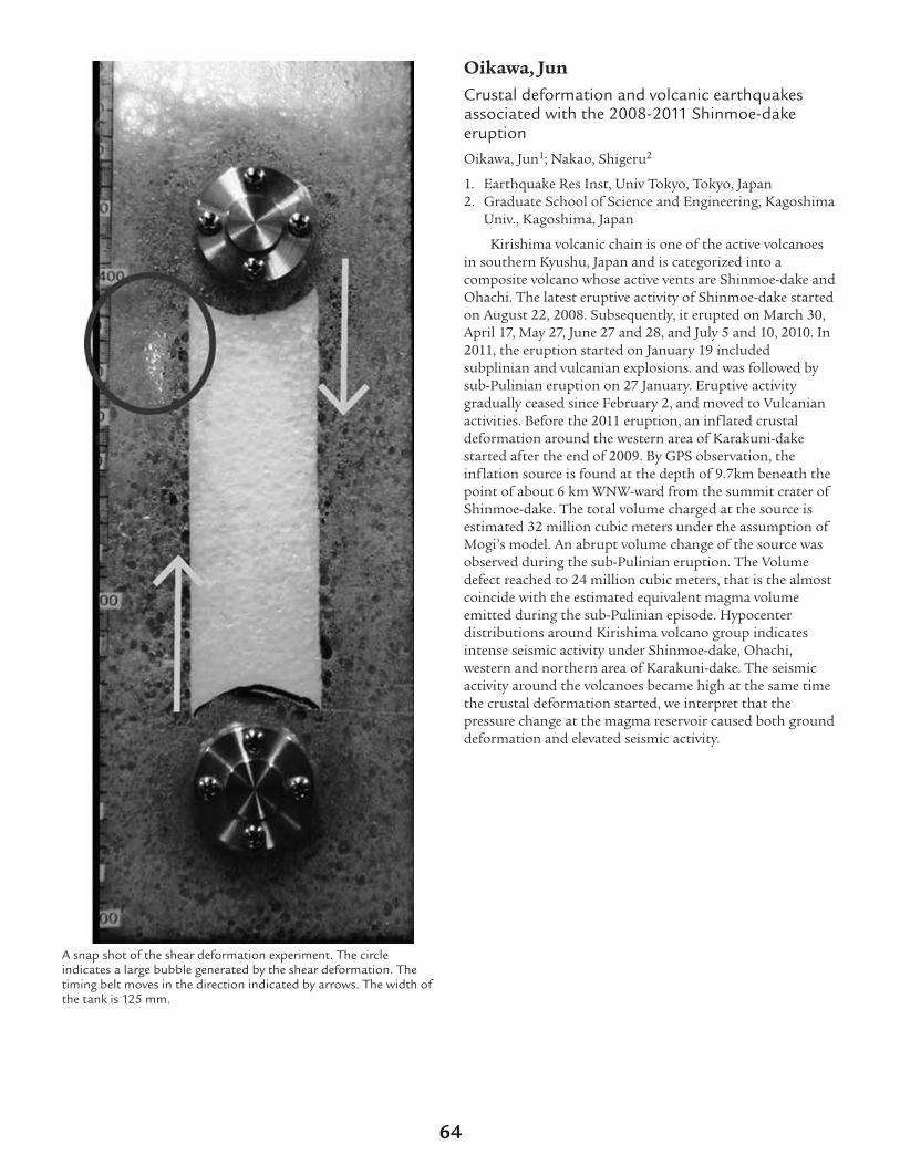
A snap shot of the shear deformation experiment. The circleindicates a large bubble generated by the shear deformation. Thetiming belt moves in the direction indicated by arrows. The width ofthe tank is 125 mm.
Oikawa, JunCrustal deformation and volcanic earthquakesassociated with the 2008-2011 Shinmoe-dakeeruptionOikawa, Jun1; Nakao, Shigeru2
1. Earthquake Res Inst, Univ Tokyo, Tokyo, Japan2. Graduate School of Science and Engineering, Kagoshima
Univ., Kagoshima, Japan
Kirishima volcanic chain is one of the active volcanoesin southern Kyushu, Japan and is categorized into acomposite volcano whose active vents are Shinmoe-dake andOhachi. The latest eruptive activity of Shinmoe-dake startedon August 22, 2008. Subsequently, it erupted on March 30,April 17, May 27, June 27 and 28, and July 5 and 10, 2010. In2011, the eruption started on January 19 includedsubplinian and vulcanian explosions. and was followed bysub-Pulinian eruption on 27 January. Eruptive activitygradually ceased since February 2, and moved to Vulcanianactivities. Before the 2011 eruption, an inflated crustaldeformation around the western area of Karakuni-dakestarted after the end of 2009. By GPS observation, theinflation source is found at the depth of 9.7km beneath thepoint of about 6 km WNW-ward from the summit crater ofShinmoe-dake. The total volume charged at the source isestimated 32 million cubic meters under the assumption ofMogi’s model. An abrupt volume change of the source wasobserved during the sub-Pulinian eruption. The Volumedefect reached to 24 million cubic meters, that is the almostcoincide with the estimated equivalent magma volumeemitted during the sub-Pulinian episode. Hypocenterdistributions around Kirishima volcano group indicatesintense seismic activity under Shinmoe-dake, Ohachi,western and northern area of Karakuni-dake. The seismicactivity around the volcanoes became high at the same timethe crustal deformation started, we interpret that thepressure change at the magma reservoir caused both grounddeformation and elevated seismic activity.
64

Figure shows daily number of earthquakes from July, 2008 toJanuary, 2011 around Shinmoe-dake (a), western and northern areaof Karakuni-dake (b). (c) indicates the inflated crustal deformationaround the western area of Karakuni-dake started after the end of2009. Since the seismic activity around the volcanoes became highat the same time, magma activity such as pressure change of magmareservoir causes the seismic activity to be high.
Okubo, PaulThe hunt for tectonic tremor during Kilauea’s slowslip eventsMontgomery-Brown, Emily1; Okubo, Paul2; Thurber, Cliff1;Wolfe, Cecily J.3
1. Geoscience, Univ. of Wisconsin - Madison, Madison, WI,USA
2. USGS, Hawaiian Volcano Observatory, Hawaii NationalPark, HI, USA
3. Hawaii Institute of Geophysics & Planetology, Universityof Hawaii at Manoa, Honolulu, HI, USA
Ten slow slip events have occurred at Kilauea volcanosince the installation of the continuous GPS network in1996. Kilauea’s slow slip events are somewhat similar tocommonly observed subduction zone slow slip events induration and magnitude, but occur on a decollementstructure 8 km beneath the volcano’s surface. In each of theevents, fault slip typically lasted about two days, and releasedan amount of energy similar to a regular Mw 5.4-6.0earthquake. While slow slip events in subduction zones arecommonly associated with tectonic tremor, a persistent butvery low amplitude shaking, Kilauea’s slow slip events have
lacked tremor observations. Instead, Kilauea’s slow slipevents produce significant triggered earthquakes, which arerarely seen during subduction zone slow slip events. Here weanalyze the continuous seismic waveforms during slow slipevents, identified geodetically, for evidence of tectonictremor using several published methods including:waveform envelope cross correlation, beamforming,autocorrelation, template matching, and moving windowcross correlation. Although we find ample volcanic tremor,tectonic tremor is not detected using any of these methods.If we are simply not able to observe tectonic tremor, it couldbe that the background noise levels in Hawaii are too high todetect low-amplitude tectonic tremor, or that the volcano’shigh attenuation affects the observability of tremor. It is alsopossible that pressure and temperature conditions onKilauea’s decollement are not conducive to tremorgeneration.
Orr, Tim R.Hightlights of Kilauea’s recent eruption activityOrr, Tim R.1; Patrick, Matt1
1. USGS, Hawaiian Volcano Observatory, Hawaii Natl Park,HI, USA
Over the past 3 decades, Kilauea’s eruptive activity hasbeen focused mostly at and near the Pu`u `O`o vent on theeast rift zone (ERZ). This activity changed dramatically inthe last 5 years, driven, at least in part, by a doubling of therate of magma supply from the mantle that has since ended.Perhaps the most significant of these changes was theopening of a vent on the SE side of Halema`uma`u Crater,at Kilauea’s summit, in March 2008. This marks the firstdocumented period of prolonged, simultaneous ERZ andsummit eruptions at Kilauea. The Halema`uma`u“Overlook” vent, initially 35 m across, has evolved since intoa 160-m-wide collapse crater containing a semi-permanentlava lake. This lake is currently one of the largest and mostdynamic on Earth. Ready access to the Overlook vent hasallowed us to compile a comprehensive set of measurementsand observations describing the lava lake’s behavior.Kilauea’s ERZ began to pressurize in late 2010, presumablyin response to a slowly developing constriction in theconduit supplying the ERZ eruptive vent active at that time.The Pu`u `O`o crater began to fill with lava, and the lavalake at Kilauea’s summit rose to the highest levels recordedto that time. In March 2011, the engorged dike uprift fromPu`u `O`o ruptured, feeding the 5-day-long Kamoamoafissure eruption. The lava lake in the Overlook vent drained,and the floor of the Pu`u `O`o crater collapsed. Eruptiveactivity, however, was re-established at Pu`u `O`o after a 3-week hiatus there, and lava was soon overflowing onto theflanks of the Pu`u `O`o cone. Within months, the ERZshowed signs of becoming fully pressurized again. In August2011, the western flank of the Pu`u `O`o edifice waspushed up as a shallow-dipping dike intruded beneath thatsector of the cone, feeding a short-lived breakout near thecone’s western base. Following cessation of the breakout,eruptive activity resumed at Pu`u `O`o, and lava was soonoverflowing the Pu`u `O`o crater. Again, the ERZ began to
65
pressurize, and, in September 2011, a new fissure eruptionbegan on the eastern flank of Pu`u `O`o. Since then, a newtube system has developed, transporting lava continuouslyfrom the vent to a growing flow field. 2011 was an excitingyear at Kilauea, each outbreak representing a differenteruptive scenario—a fissure eruption up-rift from Pu`u`O`o, a Pu`u `O`o up-rift flank breakout, and a Pu`u `O`odown-rift fissure eruption. Despite these differences, eachwas preceded by similar and recognizable patterns of activity,specifically, rising lava levels at Pu`u `O`o and the Overlookvent, extension across Kilauea’s summit and upper ERZ, andincreasing seismic activity along the upper ERZ. Recognitionof this pattern allowed scientists at the Hawaiian VolcanoObservatory to prepare an eruption response well beforeeach of 2011’s eruptive changes. Since September 2011,Kilauea’s eruptive activity has been relatively steady, with fewnotable variations. As of April 2012, however, slowly risinglava levels at both Pu`u `O`o and Kilauea’s summit,accompanied by increasing earthquake frequency along theupper ERZ, suggest that the volcano may be building to thenext eruptive perturbation. We are watching this activitywith heightened interest and preparing a scientific andmonitoring response in anticipation of this possible change.
Parcheta, Carolyn E.Hawaiian Fountain StylesParcheta, Carolyn E.1; Houghton, Bruce1; Swanson, Don2
1. Geology and Geophysics, VGP Division, University ofHawaii at Manoa, Honolulu, HI, USA
2. Hawaiian Volcano Observatory, USGS, Volcano, HI, USA
Hawaiian fountains, named so because Kilauea is thearchetypical locality of these weak explosive eruptions, spana wide spectrum of behaviors, often in a single eruption. Indefining the style, physical volcanology has focused on andsampled single, circular-sourced, high fountains because they1) are typically well documented in historical times, 2)produce a significant non-welded tephra deposit in themedial and distal regimes, and 3) pose the largest hazard(compared to weaker, fissure-sourced Hawaiian fountains).Here, for the first time, we present vesicularity and densitydata for a complete suite of Hawaiian fountaining styles.Our data derives from 4 of the 12 Mauna Ulu episodes in1969, and compares pyroclast vesicularities and bubbletextures of fountains from fissure, dual, and point sources.We also compare pyroclastic vesicularities and bubbletextures of low (<100 m), med (100-300 m), and high (>300m) fountains across multiple episodes. Finally, we contrastvesicle textures through a single episode (pre-fountainspatter, peak discharge, and post-fountain spatter) of thedual up-to 375 m high fountain from episode 5 at MaunaUlu. This is the most comprehensive and in-depthvesicularity study to date on Hawaiian fountainingeruptions. The following inferences can be linked tomagmatic ascent on Kilauea’s east rift zone and the factorsmodulating contrasts in 1) fountain behavior and 2)vesiculation and fragmentation. Bubble number densityscales with fountain height, reflecting higher ascent rates inthe shallow conduit with a better approximation to closed
system behavior. A marked coarsening and decline in bubblenumber density in melt erupted between high fountainingepisodes suggests variation in gas flux is the drivingcomponent in defining episodicity of the 1969 fountains.
Patrick, Matthew R.Tracking the hydraulic connection betweenKilauea’s summit and east rift zone using lava leveldata from 2011Patrick, Matthew R.1; Orr, Tim1
1. Hawaiian Volcano Observatory, US Geological Survey,Hawaii National Park, HI, USA
The ongoing eruptions at Kilauea’s summit and east riftzone offer the first opportunity to make prolongedsimultaneous measurements of lava level for the summit andrift zone, thus providing insight into the nature of thehydraulic connection within Kilauea’s magmatic system. Weshow measurements of lava level during 2011 at the lava lakewithin the Overlook vent in Halema`uma`u crater (summit)and at the lava surface within Pu`u `O`o crater (east riftzone), which are separated by a distance of 20 km and anabsolute difference in elevation of about 100 m. The 2011time period encompasses three cycles of coupled lava levelrise in each vent, with each cycle culminating in a structuralfailure of the magmatic system and establishment of a newvent. Lava level trends at Halema`uma`u and Pu`u `O`ofollow one another closely, attesting to a good hydraulicconnection, with the level in the Halema`uma`u Overlookvent being 40-120 m higher than that in Pu`u `O`o at anygiven time. This height difference may be thought of as“head loss” in a hydraulic system, which normally originatesfrom frictional forces in the system. Assuming a simple pipeflow model and using the Darcy-Weisbach formula, we canrelate the frictional force to the diameter of the conduitlinking the summit and east rift zone vent. Initial resultsusing this approach suggest reasonable conduit diameters(<10 m), which, in turn, imply magma travel times of hoursto several tens of hours between the summit and Pu`u `O`o,given current magma supply rates. We further explore thesuitability of this approach, interpreting results in thecontext of geodetic and petrologic data. The summit-rifthydraulic connection and observed cycles in 2011 havebroader implications as well. First, they indicate that the lavalevel can be a useful proxy for pressurization in themagmatic system, and thus the Halema`uma`u Overlookvent lava lake height serves as a convenient pressure gaugefor judging the likelihood of future intrusions in the riftzone. This is supported by the changes in lava level in 2011that mirror trends in summit tilt and GPS line length. Theobservations and demonstrated hydraulic connectivity alsoshow that local effects can have a dramatic impact on thesystem as a whole, illustrated by the partial draining ofHalema`uma`u that was triggered by a local structuralfailure of Pu`u `O`o cone in August 2011. Lava level,therefore, provides an effective tool for anticipating changesin eruptive activity and associated hazards.
hvo.wr.usgs.gov
66

Perttu, Anna B.Halema’uma’u’s Infrasonic Signatures:Reawakening to PresentPerttu, Anna B.1; Garces, Milton1; Badger, Nickles1; Thelen,Wes2
1. Infrasound Laboratory, HIGP, University of Hawaii atManoa, Kailua-Kona, HI, USA
2. USGS Hawaiian Volcano Observatory, Hawaii VolcanoesNational Park, HI, USA
Kilauea’s volcanic soundscape is rich with infrasonicdiversity. Over the last decade of infrasound research, activityat Kilauea has transitioned from one main source regionassociated with the Pu’u O’o Crater Complex, to a persistentdual source system after the reawakening of Halema’uma’uCrater. The MENE infrasound array (which has providedreal-time data since 2006) is located 6.81 km fromHalema’uma’u Crater and 12.65 km from Pu’u O’o Crater,with ample angular separation to differentiate acousticsignals from the two source regions. Since the March 2008vent-clearing burst, the infrasonic signature fromHalema’uma’u is predominantly characterized by atonalharmonic tremor punctuated by long-period transients andepisodic tremor events. Each of these distinct infrasonicsignatures has recognizable temporal and spectral featuresthat are representative of the different fluid-dynamicprocesses at play. This study considers various physicalinterpretations of the diverse signal features observed fromHalema’uma’u Crater since its recent reawakening.
Pickard, MeganA Microanalytical Approach to Understanding theOrigin of Cumulate Xenoliths from Mauna Kea,HawaiiPickard, Megan1; Dorais, Michael J.2; Christiansen, Eric H.2;Fodor, R. V.3
1. Department of Geosciences, Pennsylvania StateUniversity, University Park, PA, USA
2. Department of Geological Sciences, Brigham YoungUniversity, Provo, UT, USA
3. Department of Marine, Earth and Atmospheric Sciences,North Carolina State University, Raleigh, NC, USA
Cumulate xenoliths offer an opportunity to study thedifferentiation in magma bodies that otherwise might beinaccessible. Accordingly, we examined cumulate xenolithsthat erupted with hawaiite Laupahoehoe magma from apost-shield cinder cone on the southern flank of MaunaKea, Hawaii to better understand and constrain the originand interaction of magmas in a multi-stage volcanic system.We identified a variety of mafic and ultramafic cumulatexenoliths. Major element compositions of clinopyroxene,olivine and plagioclase in these xenoliths are ambiguouswith respect to characterizing whether their parentalmagmas are tholeiitic, transitional, or alkalic. To help clarifythe parental magma compositions, we analyzedincompatible trace element concentrations in clinopyroxene
from a variety of xenoliths by LA-ICPMS and calculated thetrace element compositions of their equilibrium liquidsusing published partition coefficients. Calculated liquids allhave REE patterns with negative slopes and are enriched inlight REE. The REE patterns for liquids calculated fromclinopyroxene in pyroxenites, olivine gabbros, gabbros, andgabbronorites are similar to the REE patterns of Mauna Keapost-shield Hamakua tholeitic and alkalic lavas.Concentrations of trace elements calculated for theseequilibrium liquids (e.g. Sr 210-600 ppm, Ba 5-625 ppm, Ti10,000-20,000 ppm, and Zr 10-375 ppm) are also similar tothose of the Hamakua lavas. In contrast, calculated liquidsfor a wehrlite and an olivine gabbronorite have REE patternsand Sr (200-400 ppm), Ba (10-200 ppm), Ti (5000-15,000ppm), and Zr (10-120 ppm) concentrations similar to thoseof tholeiitic shield basalts. No calculated liquids match thehighly alkalic hawaiite Laupahoehoe post-shield lavas thatserve as hosts for the xenoliths. Thus, these Mauna Keaxenoliths are plutonic representatives of shield stagetholeiitic and post-shield Hamakua magmas entrained inthe younger Laupahoehoe hawaiite magma. From this, weinfer that Laupahoehoe post-shield lavas only sampledcumulates from shield and Hamakua post-shield magmasand propose this is evidence that Laupahoehoe magmasformed at deeper depths than shield and Hamakua magmas.As a result, shield and Hamakua cumulates were entrainedas Laupahoehoe magmas rose to the surface. Given the goodmatch between the calculated liquids and erupted shield andHamakua post-shield lavas, we conclude that this techniqueof analyzing clinopyroxene in cumulates by LA-ICPMS fortrace elements and calculating equilibrium liquids offers thepotential for more thorough studies of Hawaiian liquid linesof descent and augments records available from lavas.
Pietruszka, Aaron J.Geometry of the Summit Magma Storage Reservoirof Kilauea Volcano: A View from High-Precision PbIsotopes (INVITED)Pietruszka, Aaron J.1; Heaton, Daniel E.1; Marske, Jared P.2;Burns, Dale H.1; Garcia, Michael O.2
1. Department of Geological Sciences, San Diego StateUniversity, San Diego, CA, USA
2. Department of Geology and Geophysics, University ofHawaii, Honolulu, HI, USA
The summit magma storage reservoir of KilaueaVolcano is one of the most important components of thevolcano’s magmatic plumbing system, but its geometry ispoorly known. We will (1) present a summary of previousviews on the size, shape, and number of magma bodies thatmake up Kilauea’s summit reservoir, and (2) use high-precision Pb isotopic analyses of historical Kilauea summitlavas (1823-2010) to define the minimum number of magmabodies within the summit reservoir and their volumes. The206Pb/204Pb ratios of these lavas display a systematictemporal fluctuation characterized by low values in 1823, anincrease to a maximum in 1921, an abrupt drop to relativelyconstant intermediate values from 1929 to 1959, and a rapid
67

decrease to 2010. These variations indicate that Kilauea’ssummit reservoir is being supplied by rapidly changingparental magmas derived from a mantle source that isheterogeneous on a small scale. Analyses of multiple lavasfrom some individual eruptions reveal small but significantdifferences in 206Pb/204Pb. The extra-caldera lavas fromAug. 1971 and Jul. 1974 display significantly lower Pbisotope ratios and higher MgO contents (10 wt. %) than theintra-caldera lavas (MgO ~7-8 wt. %) from each eruption.From 1971 to 1982, the 206Pb/204Pb ratios of the lavasdefine two separate decreasing temporal trends. The intra-caldera lavas from 1971, 1974, 1975, Apr. 1982 and the lowerMgO lavas from Sep. 1982 have higher 206Pb/204Pb ratiosat a given time (compared to the extra-caldera lavas and thehigher MgO lavas from Sep. 1982). These trends require thatthe intra- and extra-caldera lavas (and the Sep. 1982 lavas)were supplied from two separate magma bodies. Numerousstudies by HVO scientists (e.g., Fiske and Kinoshita, 1969;Klein et al., 1987) have long identified the locus of Kilauea’ssummit reservoir ~2 km southeast of Halemaumau (HMM)at a depth of ~2-7 km, but more recent investigations havediscovered a second magma body located <1 km below thesoutheast rim of HMM (e.g., Battaglia et al., 2003; Johnsonet al., 2010). The association between the vent locations ofthe extra-caldera lavas near the southeast rim of the calderaand their higher MgO contents suggest that these lavastapped the deeper magma body. In contrast, the lower MgOintra-caldera lavas were likely derived from the shallowmagma body beneath HMM. Residence time modeling basedon the Pb isotope ratios of the lavas suggests that themagma volume of the deeper body is ~0.2 km3, whereas theshallow body holds a minimum of ~0.04 km3 of magma.These estimates are much smaller than our previouscalculation of ~2-3 km3 for Kilauea’s summit reservoirbased on trace element ratios (Pietruszka and Garcia, 1999),but are similar to the volume of the magma body thatunderlies Piton de la Fournaise Volcano on Réunion Island(Albarède, 1993).
Polacci, MargheritaVesiculation and degassing in basaltic magmas: anexample from Ambrym volcano, Vanuatu ArcPolacci, Margherita1; Baker, Don R.2; LaRue, Alexandra2;Mancini, Lucia3; Allard, Patrick4
1. Sezione di Pisa, INGV, Pisa, Italy2. EPS, McGill University, Montreal, QC, Canada3. SYRMEP Group, Sincrotrone Trieste, Basovizza, Trieste,
Italy4. IPGP, Paris, France
Scoria clasts collected from a fallout deposit in the innerterrace of Ambrym volcano Benbow active crater wereanalyzed through series of synchrotron X-ray computedmicrotomographic experiments, as well as permeabilitymeasurements and simulations. Our goal was to reconstructand visualize scoria textures in 3D and to quantifyvesicularity, permeability, vesicle sizes and distributions inorder to understand how gas moves in and out of Ambrym
basaltic magma. We find that vesicle size distributions in thevolume range between ~10^3 and 10^10 m^3 define twoscoria classes. Vesicle size distributions in the low-to-moderately (0.44-0.67) vesicular samples can be fit by powerlaws with an exponent of 10.2; distributions in the highlyvesicular (0.86-0.88) samples can be fit by power laws with ahigher exponent (1.4 to 1.7), as well as by exponential fits.Highly vesicular samples exhibit a very pronounced largevesicle, consisting of networks of smaller, interconnectedvesicles, that is more than three orders of magnitude largerin volume than all other vesicles in each distribution. Thistype of vesicle is not found in the low-to-moderatelyvesicular samples. In addition, vesicle number densitynegatively correlates with vesicularity: less vesicular sampleshave the highest number density and vice versa, and containfar more numerous small-to-medium-sized vesicles thanhighly vesicular samples. Measured and calculated viscous(Darcian) permeabilities overlap in the range 10^-13 and 10^-9 m^2, with higher values in the more vesicular samples. Weascribe these differences in the textural and physicalproperties of the scoria clasts to their derivation fromdistinct magma portions in the conduit that were driven byconvective overturn and underwent different vesiculationhistories and gas transport dynamics. Comparing basalticscoria clasts from Ambrym to those from mild explosiveactivity at Stromboli volcano (Italy) reveals that differencesin their vesicle size distributions may result from theinfluence of different crystal contents and shapes on thevesiculation and permeability of the respective magmas.Finally, we highlight how rheological properties have afundamental role in determining the degassing behaviour ofbasaltic magma at Ambrym and other volcanoes in general.
Poland, Michael P.Kilauea’s magma plumbing systemPoland, Michael P.1; Miklius, Asta1; Montgomery-Brown,Emily2
1. Hawaiian Volcano Observatory, U.S. Geological Survey,Hawaii National Park, HI, USA
2. Department of Geoscience, University of Wisconsin,Madison, WI, USA
Based on the 100-year record of geophysical, geological,and geochemical data collected by the Hawaiian VolcanoObservatory and collaborators, we propose a detailed modelof Kilauea’s magma plumbing that we hope will provide arefined framework for studies of Kilauea’s eruptive andintrusive activity. None of the elements of our model isnew—each has been proposed previously, but separately, byvarious authors. In an effort to develop an overall view ofmagma storage and transport at Kilauea, we present aunification of these models while adding insights from highspatial- and temporal-resolution geodetic data collected overthe past decade, which indicate discrete magma storage areasbeneath the summit and a continuous molten core along theeast rift zone. Kilauea’s summit reservoir is made up of atleast two hydraulically linked magma accumulation zones.The larger zone is centered at ~3 km depth beneath thesouth caldera, while a smaller one is located at ~1 km depth
68

east of Halema`uma`u Crater. The main structural riftzones radiate southeast and southwest from the primarystorage area, also at about 3 km depth. Magma isoccasionally stored where these two rift zones intersect thesummit (in the upper southwest rift zone and nearKeanakako`i Crater), and both rift zones support a moltencore that allows rapid transport of magma from the summitto the flanks. Small, isolated pods of magma exist withinboth rift zones, as indicated by deformation measurements,seismicity, petrologic data, and geothermal drilling results.These magma bodies are relicts of past intrusions anderuptions and can be highly fractionated. Magma storagewithin the deep rift zones, between about 3 km and 9 kmdepth, is hypothesized based on surface deformation thatcan be interpreted as deep rift opening. Magma that entersthe deep rift zone may pass through the summit reservoirsystem into the molten core, eventually descending togreater depths. Shallow (~1 km depth) secondary riftsystems also branch from the Halema`uma`u magmareservoir, as indicated by alignments of eruptive vents andfracture systems to the east and west from Halema‘uma‘uCrater. Although inactive in recent decades, large historicaleruptions have occurred through these rift systems,including Kilauea Iki in 1959 (east) and Mauna Iki in 1919–20 (west).
Ramsey, Michael S.Thermal emission from molten silicates:Implications for lava flow emplacement andhazardsRamsey, Michael S.1; Lee, Rachel J.1; Harburger, Aleeza M.1
1. Geology and Planetary Science, University of Pittsburgh,Pittsburgh, PA, USA
Active basaltic volcanoes produce glass-rich flows thatrapidly form a chilled glassy crust after emplacement. Thiscrust on a pahoehoe flow commonly has a lower percentageof vesicles than the lava directly beneath it. With time, thecrust will thicken, fold, and cool with the uppermost surfaceeither spalling off due to continued vesiculation and/or theemplacement of new lava below. The crust can also remainintact and later disrupted on a larger scale due to flowinflation. The crust thickness, glassiness, and thermalinfrared (TIR) emissivity all combine to directly impact theinterpretation of ground, air, and space-based TIR data. TheTIR wavelengths are sensitive to the characterization ofsilicate material because of the presence of strong absorptionbands (dominantly Si-O and also Al-O). Furthermore, thereis a scientific debate on whether molten materials havedramatically lower TIR emissivities than their solidifiedcounterparts. This unknown not only impacts the derivedspectral information, but also feeds into models of theradiative cooling efficiency and flow formation. We havedeveloped a novel laboratory-based micro-furnace to acquirethe first measurements of TIR emissivity data of moltensilicates. Preliminary results appear to confirm that loweremissivity appears with phase change. We have also collectedand analyzed field-based TIR data of active pahoehoe flows
at Kilauea volcano, Hawaii over several years. These data havebeen used to both validate the laboratory-based spectral dataas well calculate the thickness and crustal viscosity for thefirst time on active flows. The results allow us to moreaccurately model basaltic crust formation, flowemplacement rates, and produce a better understanding ofthe response of TIR data to these active processes.
Realmuto, Vincent J.Thermal Infrared Remote Sensing of SO2Emissions from Kilauea Volcano: Lessons Learnedand Future PlansRealmuto, Vincent J.1; Hook, Simon J.1
1. Earth Surface Science Group, Jet Propulsion Laboratory,Pasadena, CA, USA
NASA’s Advanced Spaceborne Thermal Emission andReflection Radiometer (ASTER) and Moderate ResolutionImaging Spectrometer (MODIS) have been collecting dataover Kilauea Volcano since early 2000, and a second MODISinstrument has been collecting data since mid-2002. Wepresent an overview of these data records, with a focus onthe use of thermal infrared (TIR) radiance measurements todetect and map SO2 emissions from Kilauea. ASTER andMODIS are the heritage instruments for the TIR componentof the upcoming Hyperspectral Infrared Imager (HyspIRI)mission, and our study of these data has direct applicationto the design and development of HyspIRI. The long-termdata records illustrate the strengths of TIR-based SO2mapping together with the challenges of remote sensing intropical environments. TIR measurements do not depend onsolar radiance and the combination of data from day- andnight-time overpasses increased the frequency with which weobserve the volcano. The spatial resolution of MODIS (1 kmat nadir) and ASTER (90 m) affords high sensitivity to SO2,allowing us to resolve and characterize passive emissions ofSO2. A more comprehensive study of the ASTER andMODIS data records will include comparisons with SO2retrievals from other space-borne instruments, ground-basedSO2 measurements, and contemporaneous records ofground deformation and seismicity. The strength of the SO2signal in the TIR is a function of species concentrationtogether with the contrast between the temperatures of theplume and underlying surface, with temperature contrastbeing the dominant factor. The main challenges to mappingpassive emissions of SO2 in warm and humid tropicalenvironments are low contrast between the plume andsurface temperature together with cloudy viewingconditions. The high spatial resolution of ASTER increasesour sensitivity to SO2, relative to MODIS, and allows us topeer through any openings in a cloud deck. However,constraints on the operation of ASTER limit the frequencywith which ASTER observes Kilauea. ASTER can acquirefour observations of Kilauea (2 daytime + 2 night-time) every16 days, but intervals of 10 to 30 or more days betweenobservations are more commonplace. The current designspecifications for HyspIRI-TIR call for a 5-day intervalbetween observations at the equator and spatial resolution
69

of 60 m (at nadir) over a swath of ~ 600 km. Our study ofthe ASTER and MODIS records for Kilauea SO2 emissionswill help to define the spectral response of the HyspIRI TIRbands, detection limits for SO2, and operational scenariosfor observations of volcanoes in tropical environments. Thisresearch was conducted at the Jet Propulsion Laboratory,California Institute of Technology, under contract to theNational Aeronautics and Space Administration.
Rhodes, John M.Mauna Loa Magmas in Space and TimeRhodes, John M.1; Trusdell, Frank A.2; Jicha, Brian B.3; Weis,Dominique4; Garcia, Michael O.5; Norman, Marc D.6
1. Dept. Geosciences, University Massachusetts, Amherst,MA, USA
2. U.S. Geological Survey, Hawaii Volcano Observatory,Kilauea, HI, USA
3. Dept. Geosciences, University Wisconsin, Madison, WI,USA
4. Dept. of Earth and Ocean Sciences, University BritishColumbia, Vancouver, BC, Canada
5. Dept. of Geology and Geophysics, University Hawaii atManoa, Honolulu, HI, USA
6. Research School Earth Sciences, Australian NationalUniversity, Canberra, ACT, Australia
We have a magmatic history of Mauna Loa volcano thatextends back to around 600 ka, based on the record ofhistorical flows (1843 - 1984 AD), 14C constraints onprehistoric lavas (0.2 - 36 ka), the Hawaii Scientific DrillingProject drill core (1.5 - ~ 120 ka) and Ar/Ar dating ofsubmarine lavas (59 - ~ 660 ka). Over this time, the majorelement compositions of the vast majority of the lavas aredefined by strongly linear olivine-control trends. Thesetrends result from mixing olivine (Fo87 - 89) with an evolved,steady-state, reservoir magma (~7 % MgO) and picriticparental magmas (13 - 18 % MgO). The reservoir magmas areprevalent among lavas erupted along the two subaerial riftzones, but are significantly less frequent among summitoverflow lavas, which are thought to reflect periods of higheruption rates. They are relatively rare along the submarineSW rift zone which is dominated by picritic lavas and is alsothe site of high eruption rates. The remarkable uniformity ofMgO-normalized major element concentrations (especiallySiO2) over ~600 ka presents something of a conundrum. Itimplies essentially constant proportions of source lithologies(peridotite vs pyroxenite) and relatively uniform magmageneration processes, including temperature, extent ofmelting and depth of magma segregation. This is at oddswith the hypothesis that over the past 600 ka Mauna Loawill have traversed approximately 50 -60 km across athermally and compositionally zoned Hawaiian plume. Traceelement and isotopic data tell a different story. Submarinelavas older than ~ 250 ka tend to have lower incompatibleelement ratios (e.g. K/Y, La/Yb) and higher Ni at a givenMgO, probably indicative of greater melting in the earlierhistory of the volcano. There are two distinct trends in Nb-Zr-Y systematics and Pb isotopic ratios [Weis et al., 2011] .The dominant trend contains lavas of all ages (<0.1 - ~ 660
ka) and has similar Zr/Nb (13 - 15) and a well-defined Pbisotopic array (206Pb 18.05 - 18.26). In contrast, a divergingtrend, restricted to lavas > 250 ka, has variable Zr/Nb (10 -15). Most lavas on this trend have Pb isotopes trendingtowards, and overlapping with Loihi values (206Pb 18.40) butsome have increasing 208Pb for a given 206Pb. Note, however,that the major element compositions are typical of those ofMauna Loa. These results indicate that the mantle plumesource of Mauna Loa was more varied in the past, at a timewhen it was located 25 - 60 km closer to the present positionof Loihi, than in the last 250 ka.
Richter, NicoleSmall-scale deformation associated with thesummit eruption of Kilauea Volcano, Hawai‘i, fromTerraSAR-X InterferometryRichter, Nicole1; Poland, Michael2; Lundgren, Paul3
1. Earth Observation, Friedrich-Schiller-University Jena,Jena, Germany
2. USGS Hawaiian Volcano Observatory, Hawaii NationalPark, HI, USA
3. NASA Jet Propulsion Laboratory, Pasadena, CA, USA
On 19 March 2008, a new eruptive vent formed alongthe east wall of Halema’uma’u Crater at the summit ofKilauea Volcano, Hawai’i. The ongoing summit eruption ischaracterized by degassing, seismic activity with varyingfrequencies (including very-long period), and the presence ofan active lava lake within the Halema’uma’u summit vent ata level ranging from 60 – 200 m below its floor. Over time,Halema’uma’u has grown as collapses of the unstable ventrim and wall increased the size of the crater. These collapsesare typically accompanied by seismicity and a dusty plume ofdebris and volcanic gas and often result in the deposition ofejecta on the rim of Halema’uma’u Crater—a significantlocal hazard. There is currently no method for identifyingtimes of an increased possibility for vent collapses. Syntheticaperture radar interferometry (InSAR) measurements ofsurface displacements using the German Space AgencyTerraSAR-X (TSX) satellite were used to identify and analyzesmall-scale surface deformation at Kilauea’s summit eruptivevent during June 2008 to 2012. The X-band (3.1 cmwavelength) satellite has the advantage of very high spatialand temporal resolutions (pixel size ~ 2 m and repeat time of11 days; compared to ~ 6 – 20 m and 46 – 35 days for theJapanese ALOS and European Space Agency ENVISATsatellites, respectively). To take advantage of this high spatialresolution, we constructed a 3-m-resolution digital elevationmodel (DEM) from LIDAR data acquired of Kilauea’ssummit in 2009. Combining the LIDAR DEM and TSX dataallows us to track small-scale surface deformation in thevicinity of Kilauea’s summit eruptive vent. We calculateddisplacements over time using the SBAS approach andfound variable subsidence of the vent rim over space andtime, which may provide an indication of which portions ofthe summit eruptive vent are likely to fail in future collapses.Our results demonstrate excellent prospects for continueduse of TerraSAR-X as an operational volcano monitoring and
70

research tool (with low temporal latency between imageacquisition and interferogram generation), particularly atlocations where small-scale deformation is an importantindicator of volcanic activity.
Rivalta, EleonoraEffects of Magma Compressibility on VolcanoDeformation and Seismicity (INVITED)Rivalta, Eleonora1; Maccaferri, Francesco1; Passarelli, Luigi1;Dahm, Torsten1
1. Institute of Geophysics, University of Hamburg,Hamburg, Germany
Lateral dike injections are often accompanied by thedeflation of one or more magma chambers that fed theintrusion. The volume gained by the dikes is often muchlarger (typically two to four times larger) than the volumelost by the magma chambers. The usual interpretation isthat some magma must have originated from additionaldeep sources, whose deflation cannot be resolved from theinversion of crustal deformation data. In fact, a possibilitymight be that the interaction between vertically displacedmagma chambers results in an ill-posed inversion; thisperspective will be discussed on the basis of numericalresults. Alternatively, Rivalta and Segall (2008) demonstratedthat the volume mismatch can be explained by consideringthe effects of magma and rock compressibility, and byassuming that mass (rather than volume) conservation holdsduring the feeding process. In this presentation, I will givean overview of the multiple lateral dike injection eventswhere this type of mismatch has been observed (Kilauea,Hawaii; Manda-Harraro segment in the Afar rift, Ethiopia;Izu Islands, Japan; Fernandina, Galapagos), and illustratehow magma and rock compressibility may cause this‘volume multiplication’. Additionally, I will show howmagma and rock compressibility may be responsible of otherrecurrent patterns and effects, such as the characteristictrend observed for the seismicity forefront linked to thepropagation of the dike tip, or the significant isotropic andCLVD components often found in moment tensor solutionsin volcanic areas.
Rivalta, EleonoraThe Stress Shadow Induced by the 1975-1984Krafla Rifting EventMaccaferri, Francesco1, 2; Rivalta, Eleonora1, 2; Passarelli,Luigi1, 2; Jónsson, Sigurjón3
1. ZMAW, Hamburg University, Hamburg, Germany2. Earthquake Risk and Early Warning, GFZ, Helmholtz
Centre, Potsdam, Germany3. KAUST, King Abdullah University of Science and
Technology, Thuwal, Saudi Arabia
Stress changes on seismically active areas can favor orinhibit the occurrence of earthquakes. While increases inearthquake rate have been studied extensively from atheoretical point of view and demonstrated in several cases,stress shadows are rarely observed and addressed. The 1975 -
1984 Krafla rifting event is held responsible for a significantdrop in the earthquake rate on the Húsavík Flatey fault(HFF), although this has never been quantitativelydemonstrated. Here we model the Coulomb stress changeinduced by the rifting event to interpret the low seismicactivity observed during the last 17 years compared tohistorical accounts. We find a strong correlation betweentheoretical predictions from the rate-and-state earthquakenucleation theory and observations from the SIL earthquakecatalogue (from 1995 to 2011). We observe the seismicityrate in this time interval to depend strongly on the distancefrom the dike swarm, and we find significant changes intime for regions of the HFF with small negative CFF values:there, the seismicity rate shows a relatively abrupt recoveryduring the analyzed time interval, the earlier in time thefarer away from the dike swarm.
Rivalta, EleonoraOn the physical links between the dynamics of theIzu Islands 2000 dike intrusions and the statisticsof the induced seismicityPassarelli, Luigi1, 2; Rivalta, Eleonora1, 2; Maccaferri,Francesco1, 2; Aoki, Yosuke3
1. Institute of Geophysics, University of Hamburg,Hamburg, Germany
2. Earthquake Risk and Early Warning, GFZ- HelmholtzCentre Potsdam, Potsdam, Germany
3. Earthquake Research Institute, University of Tokio,Tokio, Japan
The frequency-magnitude distribution (FMD) ofearthquakes has been widely studied in a variety of settings,from global to laboratory scale. The b-value of the FMD is ingeneral close to one on a global scale; however, on a regionalscale it is found to deviate significantly from this behavior,for example when linked to different states of stress of thecrust: reverse faults tend to have higher b-values than strike-slip faults, which in turn have higher b-values than normalmechanisms. In pure tectonic environments, the seismogenicproperties seem stationary over long periods of time; on theother hand, spatio-temporal variations of the b-value havebeen evidenced around major fault systems, in subductingslabs as well as in volcanic and geothermal areas. In volcanicsareas in particular, transient phenomena associated withmagma movements can drastically change the state of thestress within the crust; rock fracturing, massive presence offluids and large temperature gradients can be investigated bystudying the variations of the parameters of the FMD. Inthis study, we focus on the seismic swarm whichaccompanied the well-studied 2000 Izu islands (Japan) dikeintrusion, with the aim of linking the intrusion dynamics totemporal and spatial variations of the b-value of the FMD.In particular we calculate the b-value associated with theseismic cloud accompanying the dike propagation andemplacement. We find the b-value to be spatially varying: itis high close to Miyakejima volcano, in correspondence ofthe rock volume first interested by the propagation, and itdecreases gradually towards the areas reached at a later stage
71

by the dike. The interaction between dike and pre-existingfaults also causes the b-value to decrease. A small spatialregion at depth with a high b-value can be evidenced, whichpossibly indicates a second injection point. We also calculatetemporal variations of the b-value for the dike propagationphase, which lasted for the first 5 days of the swarm; we findthe b-value to be systematically lower for the frontal portionof the propagating seismic cloud (which can be associatedwith the propagating tip of the dike), than for the rearportion of the seismic cloud (loosely associated with thebody of the dike). The b-value linked to the dike ‘body’decreases with time, while the b-value linked to the dike‘front’ does not vary significantly. Finally, we calculatetheoretically the effects of the dike-induced stress on theinduced seismicity through a very simple dike propagationmodel, and compare it with the pattern of the observedseismicity. We find the dike-induced stresses to inhibitseismicity over large areas, with this effect still lasting today,and to cause a moving stress shadow accompanying thepropagation.
Roman, Diana C.Intermediate-term seismic precursors to the 2007Father’s Day intrusion and eruption at KilaueaVolcano, Hawai’iRoman, Diana C.1
1. Department of Terrestrial Magnetism, CarnegieInstitution of Washington, Washington, DC, USA
For two days beginning on June 17 (Father’s Day), 2007and following a four-year-long period of summit inflation,magma intruded into Kilauea’s East Rift Zone and eruptedthrough a new vent near the Makaopuhi Crater, ~7 km westof the long-lived Pu’u O’o vent. On the basis of concurrentsummit deflation and observations of lava chemistry andtemperature, the June 17-19 Father’s Day event has beeninterpreted as the result of forcible intrusion driven by highmagma pressure at the summit, as opposed to a passiveresponse to rifting (Poland et al., 2012). The Father’s Dayevent was preceded by a) two shallow M4+ normal-faultingearthquakes along the outermost caldera faults on 24 May2007, and b) a strong swarm of shallow volcano-tectonic(VT) earthquakes beginning on June 17 and signaling theonset of intrusion into the ERZ. However, little is knownabout any intermediate-term precursors that may haveoccurred between these two sets of earthquakes. TheHawaiian Volcano Observatory catalog (Nakata and Okubo,2008) contains 260 located events during this period,approximately 70% of which are shallow and located in thesouth or east portion of Halema’uma’u caldera, along thesouth flank of Kilauea, and in the Kaoiki fault zone to thenorthwest of the caldera. Additionally, small-magnitudeearthquakes not in the HVO catalog were identified inseveral areas along the lower east rift zone (LERZ), includingnear the site of the Father’s Day eruption. Significant peaksin the seismicity rate occur several times during theintermediate-term precursory period. Here, seismic eventsoccurring between May 25-June 16, 2007, are analyzed in
detail to shed additional light on the nature of the transitionfrom summit inflation to ERZ intrusion and eruption, andon the relationship between the Father’s Day event andrifting processes along the east flank of Kilauea.
Rumpf, Mary E.Understanding lava–substrate heat transfer onHawaii and the Moon using thermodynamicmodeling and laboratory-scale lava flowsRumpf, Mary E.1; Fagents, Sarah A.1; Hamilton, ChristopherW.2; Wright, Robert1; Crawford, Ian A.3
1. HIGP, University of Hawaii, Honolulu, HI, USA2. NASA GSFC, Greenbelt, MD, USA3. Birkbeck, UCL, London, United Kingdom
We have performed numerical modeling and laboratoryexperiments investigating heat transfer from molten basaltinto solid and particulate substrates. This work wasmotivated by a desire to understand the preservationpotential of solar wind particles in the lunar regolith;however, the results also provide insights into lavaemplacement and hazards on Earth. The Moon lacks asignificant atmosphere and magnetosphere, so the surfaceregolith passively collects impinging particles from solarwind, solar flares, and galactic sources. Regolith depositscontaining implanted particles may be protected fromfurther bombardment by an overlying lava flow, therebyproviding a discrete snapshot of solar wind composition andstrength. However, the flow will heat the regolith, potentiallycausing loss of volatiles to some depth beneath the flow.Understanding thermal and mechanical interactionsbetween a lava flow and its substrate is key to determiningthe preservation potential of extra-lunar particles and forforming exploration strategies during future lunar missions.Our numerical model of lava–substrate heat transferincludes temperature-dependent thermophysical propertiesand determines the depths reached by a heat pulse withinvarious substrates underlying a lava flow. We find thatparticulate materials, such as sands, soils, and lunar regolith,act as insulators, resisting the downward passage of heat andhelping to maintain high temperatures within the lava core.Implanted particles may survive at relatively shallow depthsbeneath the flow. In contrast, solid substrates heat up morereadily, drawing heat from the interior of the flow. Themodeling therefore suggests that substrate materialproperties can influence lava flow emplacement processes bydecreasing the rate of basal cooling and allowing the interiorof the flow to remain mobile for longer periods of timerelative to flows emplaced over solid substrates. To validatethe numerical model, we performed laboratory experiments.In collaboration with the Department of Art & Art Historyat the University of Hawaii, ~5–6 kg of remelted Kilaueabasalt was poured onto particulate or solid basalt substrateshoused in boxes constructed of calcium silicate sheeting. Theevolution of internal and surface temperature distribution ofthe system was monitored by an array of thermocouplesembedded within the boxes, and a Forward Looking Infrared(FLIR) camera. Fitting simulation results to experimental
72

data has allowed us to refine the definition of the thermalconductivity of our lunar regolith simulant, which waspoorly constrained at high temperatures. The experimentaldata also reveal the latent heat released as the lavacrystallizes. Our assessment of the thermal budget ofcooling lava, including heat transfer into the underlyingsubstrate, has potentially important implications for lavaflow hazard predictions. Lava erupting from Kilauea orMauna Loa volcanoes may encounter many different terraintypes, e.g. solid basalt, tephra, organic soil, and sand.Understanding how each of these substrates may affect thecooling and mobility of the flow is a potentially usefulrefinement to lava emplacement models.
Seats, Kevin J.3D Ambient Noise Tomography of the Sierra NegraShield Volcano in the GalapagosSeats, Kevin J.1; Lawrence, Jesse F.1; Ebinger, Cynthia J.2
1. Geophysics, Stanford Univ-Geophysics Dept, Stanford,CA, USA
2. Earth & Environmental Sciences, University of Rochester,Rochester, NY, USA
This study examines the notion of generating 3Dambient seismic noise tomographic images for Sierra Negra,the most active volcano on the Galapagos Islands. By crosscorrelating ambient seismic ‘noise’ data at two stations,noise correlation functions (NCFs) can be extracted, andthese NCFs can provide vital information on the seismicvelocity structure between the stations, with the addedbenefit of not requiring seismicity in a region. We use datafrom a temporary network of 16 seismic stations, from July2009 to June 2011, combined with a permanent station inthe Galapagos, to generate surface wave group velocityestimates for periods between 5 and 40 s. These groupvelocity estimates, for the 136 station pair combinations, arethen inverted for 2D group velocities at each period. We alsotest the spatial resolution for the network via checkerboardtests. The seismic network provides ample sampling beneathSierra Negra to generate images of structures beneath thecaldera. By comparing results generated with data fromdifferent time periods, it is possible to illustrate where andwhen large structural changes occur. These changes can becompared to other observations of seismicity, and upliftmeasured from InSAR to gain a better understanding of thephysical processes responsible for Sierra Negra’s dynamicmagmatic processes. The methodology we use is providingexcellent results in Yellowstone, and allows exciting researchexpansions to other geophysically active regions, of all sizesand scales, such as Sierra Negra, or Kilauea in Hawaii.
Segall, PaulVolcano Deformation, Seismicity, and Magma-Faulting Interactions (INVITED)Segall, Paul1
1. Dept Geophysics, Stanford, CA, USA
As magma moves through the crust it deforms theearth’s surface in ways that can be measured by both groundand space-based sensors. In the brittle crust these strainscommonly generate volcano-tectonic (VT) earthquakes.Deformation and seismicity are thus the main geophysicalmethods for monitoring volcanoes, and have beenextensively studied in Hawaii over the past century. By theearly 20th century T.A. Jaggar noted cycles of magmaaccumulation, “inflation”, ending with “deflation” asmagma either erupted or intruded into rift zones. Increasingmagma pressure stresses the crust, triggering seismicity andultimately leading to dike injection. Dike intrusions generatecharacteristic deformation patterns, are usually associatedwith propagating earthquake swarms, both of which havebeen observed several hours prior to eruption onset. While itis generally assumed that VT earthquakes are induced bystress changes accompanying diking, quantitative modelsrelating deformation and seismicity have been lacking. I willreport on efforts to use models of seismicity rate variationsresulting from stress alterations due to J. Dieterich tointegrate deformation and seismicity into self-consistentinversions for the spatio-temporal evolution of dikegeometry and excess magma pressure. This approach shouldlead to improved resolution and perhaps improved real-timeforecasts. Mechanical analysis of the coupled dike-magmachamber system provides insight into factors determiningwhether a dike will reach the surface and erupt, or end withintrusion. Hawaiian volcanoes also exhibit earthquakes dueto gravitationally driven flank motion, generally believed tooccur on a basal décollement in sediments containing over-pressured pore-fluids. The basal fault beneath Kilauea’ssouth flank creeps in a quasi-steady fashion on decadal timescales, but also experiences earthquakes, including the 1975Mw 7.7 Kalapana earthquake. With the advent of continuousGPS it has become clear that the south flank also exhibitsslow slip events (SSE) with durations of roughly 2 days andmagnitudes Mw 5.3 to 6.0. SSE are associated with swarmsof small earthquakes on the décollement landward of theSSE source areas. Flank earthquakes, including the 1975aftershocks, are restricted to a narrow band parallel to thecoastline, with few if any earthquakes close to the summitmagma system, or offshore. Yet, modeling of the tsunami,geodetic, and seismic data require offshore slip in the1975quake. This suggests that the décollement near themagmatic axis is too hot to deform brittlely, whereas thefault offshore is incapable of nucleating earthquakes. Slowslip events appear to be somewhat intermediate in behaviorand location. I will discuss inversions of contemporarygeodetic data to assess whether the south flank can beseparated into distinct regions of quasi-steady creep andepisodic SEE, or whether they must overlap. Repeatingsources of moderate earthquakes suggest localized,
73

frictionally unstable (velocity-weakening) fault patches,surrounded by stable (velocity-strengthening) fault. Onepossibility is that through-going ruptures, such as the 1975quake, activate high-speed weakening mechanisms (such asthermal pressurization) that allow rupture on nominallystable fault segments.
Sehlke, AlexanderCharacterizing Kilauea: The role of chemistry andcrystallinity on rheologySehlke, Alexander1; Whittington, Alan G.1; Bollasina,Anthony J.1; Harris, Andrew J.2
1. Geological Sciences, University of Missouri - Columbia,COLUMBIA, MO, USA
2. Laboratoire Magmas et Volcans, Université Blaise Pascal,Clermont Ferrand, France
The rheology of silicate magmas, controls the eruptionstyle of volcanoes and the emplacement of lava flows, isgoverned by the temperature, chemical composition of themelt and volume fraction of crystals (c) and bubbles (b).We studied a water quenched pahoehoe lava flow eruptedfrom Kilauea in 1999 by parallel plate and concentriccylinder viscometry to determine lava properties as afunction of temperature, chemistry and crystal fraction. Thenatural lava was remelted in a high temperature box furnaceat 1600°C under atmospheric conditions to produceanhydrous and crystal-free remelts. Viscosity data () werecollected above the liquidus (between 8 Pa.s at 1594°C and130 Pa.s at 1309°C) and on supercooled melts above theglass transition temperature (between 3.7108 Pa.s at 739°Cand 2.51011 Pa.s at 665°C). The viscosity is markedly non-Arrhenian, as is typical for basaltic melts. The chemicalcomposition of natural rock glass matrix and remelt glasshas been analyzed by electron micro-probe and shows thatearly crystallization only produces significant changes inSiO2 and MgO content, which show respective increase anddecrease in the residual melt. The calculated degree of meltpolymerization, which is correlated to viscosity, expressed asNBO/T (nonbridging oxygen, NBO, per tetrahedrallycoordinated cation, T), decreases from 0.81 in the remelt to0.74 in the glassy matrix of naturally quenched samples.These calculations assume all iron is Fe2+, whereas in factiron in the melt will become more oxidized duringemplacement in air, which in turn increases the amount ofFe3+ and the polymerization of the melt. For example, wet-chemical ferrous iron determination yields a Fe2+/Fe2+ of0.77 0.03 for the natural lava, while the sample remelted inair for 2 hours is more oxidized with a lower ratio of 0.560.01. During the early stages of lava emplacement, viscosityincreases due to a combination of cooling and increasingpolymerization of the residual melt are relatively minor. Theevolving lava viscosity is also strongly affected by the physicaleffect of crystals and vesicles. To investigate the effect ofcrystal fraction (c) on viscosity, we are conducting a seriesof annealing experiments, allowing the magma to crystallizeto different degrees, after which time the viscosity ismeasured by the parallel-plate method. Data on lava from
Stromboli indicate that the effect of crystals on basalticmagma viscosity is much greater than predicted by currentphysical models (~4 orders of magnitude increase inapparent viscosity for ~40% crystals), although this is in partdriven by changing residual melt composition. Experimentaldata on samples from Kilauea and Mauna Ulu will bepresented, and compared with current models for meltviscosity and magma rheology.
Shapiro, Nikolai M.Studying Piton de la Fournaise Volcano Based onCorrelations of Ambient Seismic Noise (INVITED)Shapiro, Nikolai M.1; Brenguier, Florent1, 2; Clarke, Daniel1;Campillo, Michel3; Ferrazzini, Valerie2; Nercessian,Alexandre1; Kowalski, Philippe2; Boissier, Patrice2
1. Department de Sismologie, Institut de Physique duGlobe, Paris, France
2. Observatoire Volcanologique du Piton de la Fournaise,Institut de Physique du Globe de Paris, La Plaine desCafres, France
3. Institut des Sciences de la Terre, Grenoble, France
Nowadays, the seismic networks are producingcontinuous recordings of the ground motion. These hugeamounts of data consist mostly of so called seismic noise, apermanent vibration of the Earth due to natural orindustrial sources. Theoretically, the time correlation of theseismic noise measured at two distant points allowsretrieving the Green function between the points when thenoise sources are distributed randomly and homogeneously.We use this property to develop imaging and monitoringmethods. Surface waves extracted from correlations ofambient seismic noise lead to subsurface imaging on scalesranging from thousands of kilometres to very shortdistances. We applied this approach to continuous recordsby permanent seismological stations run by the Piton de laFournaise Volcanological Observatory. Our results clearlyshow an intrusive high velocity body located below the maincaldera between the surface and the likely depth of theshallow magma reservoir. This structure is surrounded by alow-velocity ring interpreted as effusive products associatedto the construction of the Piton de la Fournaise volcano onthe flank of the older Piton des Neiges volcano (Brenguier etal., 2007). One of the advantages of using continuous noiserecords to characterize the earth materials is that ameasurement can easily be repeated. This led recently to theidea of a continuous monitoring of the crust based on themeasurements of wave speed variations. The principle is toapply a differential measurement to correlation functions,considered as virtual seismograms. The technique developedfor repeated earthquakes (doublets), proposed by Poupinet etal., 1984, can be used with correlation functions. In aseismogram, or a correlation function, the delayaccumulates linearly with the lapse time when the mediumundergoes a homogeneous wave speed change and a slightchange can be detected more easily when considering latearrivals. With using the coda waves, it is possible to measurevery small velocity changes (< 0.1%). The application of that
74

method to Piton de la Fournaise Volcano shows velocitydecreases preceding eruptions (Brenguier et al., 2008).Moreover, analysis of noise cross-correlations over 10 yearsallow to detect transient velocity changes that could be dueto long-lasting intrusions of magma without eruptiveactivity or to pressure buildup associated to the replenishingof the magma reservoir (Brenguier et al., 2011). The strongestobserved seismic velocity reduction is likely related to thewidespread flank movement observed during the strong2007 eruption.
Shea, ThomasPost shield-stage volcanism at Hualalai (Hawaii):shifts between explosive and effusive activitiesduring the Pu’u Wa’a Wa’a-Pu’u Anahulu eruption(~114 ka)Shea, Thomas1; Hammer, Julia E.1; Hellebrand, Eric1
1. Geology and Geophysics, University of Hawaii, Honolulu,HI, USA
The Pu’u Wa’a Wa’a trachytic pumice cone (~1.6 km indiameter) and the associated thick (>275 m) Pu’u Anahulutrachytic lava flow represent a puzzling feature of Hawaiianvolcanism. Combined, these two landforms amount to thelargest known single-volume eruption known within Hawaii(~5.5 km3, Moore et al., 1987). While its age andgeochemical traits are established (Cousens et al. 2003), itseruptive characteristics are comparatively unconstrained.Proximal fall deposits at the cone contain a range of clasttypes, from pumice to obsidian, including some scoria, allwithin a single stratigraphic level. Previous chemical analyseshave shown that pumice and obsidian from the cone haveindistinguishable compositions that are also similar to lavaflow samples (Table 1). Individual pumice clasts oftendisplay spectacular textural heterogeneities (shear-zones,banding and localized formation of vesicle-free obsidian,Figure 1), that reveal spatial variations in degassing duringmagma ascent. Preliminary measurements of H2O insamples recently collected between the pumiceous zones(~2.5-3.5% wt.), and the denser zones (~0.5% wt.), suggestimportant degassing differences at the clast scale. Herein, weexamine the transition from explosive activity and closed-system degassing (i.e., trachytic pumice) to effusive activityand open-system degassing (i.e., trachytic flow) using bothfield evidence and volatile analyses (H2O, Cl) in addition tomajor element geochemistry. We also address the perplexingobservation that products reminiscent of effusive activity(i.e., obsidian) are enclosed within pumice layers: are they thefragmented products of an initial effusive phase, or did theyform by shear-induced outgassing during magma ascent?
Major element analyses of Pu’u Wa’aWa’a and Pu’u Anahulusamples (from Cousens et al. 2003)
Shearer, Peter M.Characterizing fault zones and volcanic conduits atKilauea and Mauna Loa volcanoes by large-scalemapping of earthquake stress drops and highprecision relocationsShearer, Peter M.1; Matoza, Robin S.1; Wolfe, Cecily J.2; Lin,Guoqing4; Okubo, Paul G.3
1. Scripps Inst. of Oceanography, Univ. California SanDiego, La Jolla, CA, USA
2. Hawaii Inst. of Geophysics & Planetology, Univ. ofHawaii, Honolulu, HI, USA
3. Hawaiian Volcano Observatory, U.S. Geological Survey,Hawaii Volcanoes National Park, HI, USA
4. Rosenstiel School of Marine and Atmospheric Science,Univ. Miami, Miami, FL, USA
Because of ongoing time-dependent variations involcanism, geodetically observed deformation, andearthquakes, Hawaii’s value as a natural laboratory forstudying the interactions between magmatic and tectonicprocesses has long been recognized. We describe initialresults of a comprehensive analysis of waveforms from theseismic network operated by the Hawaiian VolcanoObservatory (HVO) between 1992 and 2009, using methodssimilar to those we have successfully applied to network datain southern California. Our analysis includes records fromover 130,000 earthquakes at a variety of depths, includingshallow seismicity associated with Kilauea volcano and theeast rift zone, intermediate depth events along magmaconduits, deeper events along a detachment fault zone near30 km depth, and long-period earthquakes near 40 kmdepth beneath Mauna Loa. We have converted all thewaveform data to a standard format and are now applyingboth waveform cross-correlation and spectral analysis to theHVO waveforms. While prior studies have focused onindividual regions, our analyses provide the first
75

comprehensive catalog of relocated earthquakes across theentire Island of Hawaii. The results provide a sharper view offault (tectonic) and conduit (magmatic) structures,including improved characterization of detachment faultson the south and west flanks of Hawaii. In addition, we areperforming a systematic analysis of P-wave spectra tocharacterize the varying frequency content of the sourcesand to estimate Brune-type earthquake stress drops. Spatialvariations in stress drop provide insights regarding therelationship between stress drop and fault geometry. Inaddition, there have been several large earthquakes, dikeintrusions, and slow slip events that provide targets toinvestigate possible temporal variations in stress drop thatmay be associated with changes in absolute stress levels.
Shirzaei, ManoochehrAseismic faulting of the south flank of Kilauearevealed by wavelet analysis of InSAR and GPS timeseriesShirzaei, Manoochehr1; Bürgmann, Roland1; Foster, James2;Brooks, Benjamin2
1. Dept. of Earth and Planetary S, Univ. of California,Berkeley, CA, USA
2. School of Ocean and Earth Science and Technology,University of Hawaii, Honolulu, HI, USA
The Hilina Fault System (HFS) is located on the southflank of Kilauea volcano and is thought to represent thesurface expression of an unstable edifice sector that is activeduring seismic events, such as the 1975 Kalapanaearthquake. Despite its potential for hazardous landslidingand associated tsunamis, no fault activity has yet beendetected by means of modern geodetic methods since the1975 earthquake. Using wavelet transforms in a statisticalframework, we jointly analyze InSAR and continuous GPSdeformation data from 2003 to 2010 to resolve a subtledeformation signal about the HFS normal fault scarps. Thisintegrated analysis reveals localized deformationcomponents in the InSAR deformation time series that areoverprinted by the coherent motion of Kilauea’s south flank,and contaminated by artefacts such as atmosphericturbulences. The analysis of InSAR and GPS data revealsthat the temporal properties of the deformation field varyover the Hilina fault system. This result suggests a block-wisemovement across the Hilina fault system. Since nosignificant shallow seismicity is observed over the studyperiod, we conjecture that this deformation occurredaseismically.
Sinton, John M.Ka‘ena: The most recently discovered Hawaianvolcano and its effect on the evolution of the islandof O‘ahu, Hawai‘iSinton, John M.1; Tardona, Mary1; Pyle, Doug1; Flinders,Ashton F.2; Guillou, Hervé3; Mahoney, John1
1. Dept Geology & Geophysics, Univ Hawaii, Honolulu, HI,USA
2. University of Rhode Island, Narragansett, RI, USA3. Laboratoire des Sciences du Climat et de L’Environment,
CEA-CNRS, Gif sur Yvette, France
The submarine Ka‘ena Ridge extends >80 km to thenorthwest of the island of O‘ahu, Hawai‘i. It’s anomalousbathymetry and location suggest that it is unlikely to be asubmarine extension of the NW rift zone of the nearbyWai‘anae Volcano. Rather we propose that it represents apreviously unrecognized Hawaiian shield volcano thatevolved independently from volcanic systems that form thepresent island of O‘ahu. New geological observations,samples and geophysical surveys support this alternativehypothesis as follows: (1) The extension of the Wai‘anae NWrift zone occurs as a dike complex ~6 km to the south of theKa‘ena Ridge topographic axis. (2) A significant (~50 mgal)gravity anomaly is displaced more than 15 km to the northof the Wai‘anae rift zone anomaly, suggesting a separate,long-lived magma system in this area. (3) Petrologic dataindicate that Ka‘ena evolved from tholeiitic to transitional(late-shield) stage of evolution while still submarine; thesubmarine to subaerial transition occurred within the late-shield stage, reaching a maximum ~500 m above sea level. (4)Ka‘ena samples are isotopically distinct from Wai‘anae inhaving higher 208Pb/204Pb and lower epsilon Nd for a given206Pb/204Pb. (5) Preliminary age data suggest the transitionto late-shield compositions occurred ~3.6 Ma, ~ 0.5 Maprior to the transition of Wai‘anae. Thus, structural,petrological and geochronological data all indicate thatKa‘ena represents a previously unrecognized major Hawaiianshield volcano that is distinct from Wai‘anae Volcano andthat aborted in a barely subaerial, late-shield stage ofevolution. Recognition of an independent Ka‘ena Volcanolying to the NW of, and providing a pre-existing buttress to,Wai‘anae explains several previous enigmas of HawaiianRidge structure, including spacing of volcanoes east ofKaua‘i, why the Wai‘anae Slump failed to the south, and whydikes of the buttressed Wai‘anae NW rift zone are so stronglyaligned while those in the unbuttressed south are moreradial.
76

Soule, Samuel A.Airborne Laser Swath Mapping (ALSM) andPhysical Volcanology of Hawaiian VolcanoesSoule, Samuel A.1; Cashman, Kathy2; Nakata, Samantha1;Dietterich, Hannah2
1. Geology and Geophysics, WHOI, Woods Hole, MA, USA2. Department of Geosciences, University of Oregon,
Eugene, OR, USA
The history of volcanic activity and the dynamics ofindividual eruptions of Hawaiian Volcanoes are recorded ontheir surfaces in the form of superposed lava flows, volcaniccones, eruptive fissures, and tectonic faults. The longtradition of field-based mapping on the Hawaiian Islandshas generated a comprehensive catalog of these features.Satellite remote sensing has added to this catalog byproviding regional scale information on the relief,roughness, and spectral character of volcanic surfaces.Recently, airborne laser swath mapping (ALSM) hasprovided a new tool for characterizing volcanic surfaces thatprovides the benefits of regional-scale coverage along withincreased resolution relative to satellite-derived data that canresolve small-scale features relevant to lava flowemplacement. We describe four new high-resolution ALSMsurveys on Mauna Loa and Kilauea Volcanoes that supportsub-meter resolution gridded elevation and backscatterintensity data. We demonstrate the utility of these data forimproving geologic mapping of volcanic surfaces and theidentification and interpretation of intra-flow volcanic andtectonic features. Specifically we use these data todiscriminate lava flow boundaries, characterize roughnessrelated lava flow surface morphology, and identify faults andfissures, proximal vent facies, lava channels, channeloverflows, flow stagnation fronts, longitudinal folding, andpyroclastic deposits. The four surveys are conducted overwell-studied regions and lava flows so that we mayunambiguously evaluate our interpretations. They include:Kilauea Caldera, the July 1974 eruption of Kilauea’s SW RiftZone, Moku’aweoweo Caldera (Mauna Loa), and the upperportion of the 1984 lava flow of Mauna Loa. For each ofthese data sets, we use laser backscatter intensities to definelava flow boundaries for comparison to existing geologicmaps. Backscatter intensities increase with eruption age, butare modulated by local climate and its influence on re-vegetation. In addition, each of these data sets offers aunique opportunity to evaluate the ability of ALSM toresolve specific volcanic and tectonic features on Hawaiianvolcanoes. For the summit caldera of Mauna Loa and theKilauea July 1974 flow (i.e., Koae fault zone), we use the datato identify faults that are difficult to resolve in satelliteremote sensing or aerial photography due to their small size.For the Kilauea July 1974 eruption and the Mauna Loa 1984eruption we examine along-flow changes in surfaceroughness. We find that signatures of surface roughness,although dominated by flow margins and channel levees,show variability with flow surface morphology (pahoehoeand ‘a’a) and may be used as a tool to discriminate channeloverflows and down-flow morphology transitions related to
cooling and crystallization. In the Kilauea Caldera data setwe examine the morphologic signature of pyroclasticdeposits. Collectively, these data sets illustrate the power ofALSM for investigating the physical volcanology of Hawaiianeruptions.
Staudacher, Thomas60 years of volcanic eruptions at Piton de laFournaise volcanoStaudacher, Thomas1, 2; Di Muro, Andrea1, 2; Peltier, Aline2;Roult, Geneviève2; Team, Ovpf1, 2
1. Observatoire volcanologique du Piton de la Fournaise(OVPF), Institut de Physique du Globe de Paris, La Plainedes Cafres, Reunion
2. Institut de Physique du Globe de Paris, Paris, France
Ile de la Réunion is situated at 21°S and 55°30’E in thewestern Indian Ocean. It is composed by three volcanoes.The main volcano, Piton des Neiges (3070m), was activeuntil about 15000 years ago. The volcan des Alizés, whichwas highlighted by magnetic and gravimetric studies,(Malengreau et al., 1999; Lénat et al., 2001) is completelyeroded. The presently active volcano is the Piton de laFournaise. Since 1980, date of the creation of thevolcanological observatory du Piton de la Fournaise, theInstitut de Physique du Globe de Paris is in charge of thesurvey of the volcano and the research on volcanology atPiton de la Fournaise. For this purpose several networks havebeen implemented on the volcano, in particular a seismicnetwork and deformation networks, tiltmeter, extensometerand since 2004 a permanent GPS network. With 99eruptions within the last 50 years Piton de la Fournaise isamongst the most active volcanoes in the world in terms ofnumber of eruptions. It produced some 1000 Mm3 of lavawithin the last 50 years, including 470 Mm3 within the lastdecade. Duration of eruptions vary between 8 hours (Nov.2009) and 6½ months (March to Sept. 1998) with an averageof 23 days. The erupted volumes range between 0.1Mm3(Nov. 2008) and 240Mm3 (April 2007) with a mean volumeof 10Mm3. On average Piton de la Fournaise is active for 32days per year and produces about 15Mm3 of lava. Most ofthe eruptions occur inside the U-shaped Enclos Fouquécaldera, which is open to the sea. They take place eitherwithin the summit crater or start in the summit crater andprogress outside of it, or they start on the flank of thecentral cone. Some cross the national road in the GrandBrûlé area and reach the sea, but represent no direct dangerfor inhabitants. Only few eruptions take place in the so-called “north east” and “south east” rift zone outside of thecaldera. In 2007, the Dolomieu crater collapsed into themagma chamber during the most important eruption of thelast two centuries. Since then the eruptive activity remains ata low level.
77

Staudacher, ThomasPermanent and cinematic GPS network at Piton dela FournaiseStaudacher, Thomas1; Peltier, Aline2; Kowalski, Philippe1; DiMuro, Andrea1; Lauret, Frédérick1; Brenguier, Florent1;Walpersdorf, Andrea3
1. Observatoire volcanologique du Piton de la Fournaise,Institut de Physique du Globe de Paris, La Plaine desCafres, Reunion
2. Institut de Physique du Globe de Paris, Paris, France3. Lab. de Géophysique Interne et Tectonophysique,
Observatoire de Grenoble, Grenoble, France
The Piton de la Fournaise volcano at La Réunion Islandin the western Indian Ocean is amongst the most activevolcanoes in the world with a mean over 2 centuries of oneeruption every 9 month. Since 1998 up to 4 eruptionsoccurred per year. The volcanological observatory (IPGP) isin charge of the monitoring of the volcanic activity and theprediction of eruptions. We will focus here on the DGPSnetwork. The permanent GPS network consist in 23 stations,5 stations around the summit craters “Bory” and“Dolomieu”, 5 stations at the base of the central cone and 6stations on the eastern flank of the horseshoe shapedcaldera of Enclos Fouqué. Four basis stations are situatedfarther away outside of the caldera Fouqué at high and lowelevation. First permanent GPS data were obtained since2004; the central network, covering the volcanic cone wasupgraded till 2006. In 2010 the steep and highly vegetatedeastern flank was equipped for the first time. GPS data arerecorded every 30 seconds. Data files are transmitted byradio every day and evaluated on real-time. Software upgradefrom Winprism to Gamit produces in some cases moreprecise results, in particular when stations with verycontrasting elevations are compared. The cinematic GPSnetwork consists today in 78 sites, equipped with stainlesssteel rods cemented in the rock or fixed on metallic tripods.These sites are measured routinely one or two times per year,or more often in case of eruptions or particular events. TheGPS data, and in particular the base line changes, whichseem to be slightly more precise than DGPS, allowed toforecast eruptions, but also to follow the general behaviourof the volcanic massif. The later shows a systematic changeafter the 2007 collapse of the Dolomieu crater. Aftereliminating rapid and short-lived deformations due toeruptive and intrusive events, the base lines show a generalincrease (or inflation) of Piton de la Fournaise central cone
in the period 2004-2007, while after the summit collapse in2007 a continuous and still ongoing deflation is recorded.The continuous monitoring of Grandes Pentes and theGrand Brûlé areas reveals a continuous and slow eastwardtranslation of the eastern flank of Piton de la Fournaise witha rate of up to 2.8 cm per year and a subsidence of up to 4cm per year.
*Observatoire volcanologique du Piton de la Fournaise,Institut de Physique du Globe de Paris – Sorbonne ParisCité, 14 Rn3, 97418 La Plaine des Cafres, CNRS, UMR 7154**Lab. de Géophysique Interne et Tectonophysique, CNRS,Observatoire de Grenoble, F-38041 Grenoble, France
Sutton, A J.Eruptive processes revealed by variations in Kilaueagas release highlight the value of thoughtful careand feeding of long running datasetsSutton, A J.1; Elias, Tamar1; Poland, Mike1; Miklius, Asta1;Patrick, Matt1; Okubo, Paul1
1. Hawaiian Volcano Observatory, USGS, Hawaii NationalPark, HI, USA
This presentation considers the multi-year buildup tothe 2008 Halema`uma`u summit eruption and the ensuingsummit and rift interplay, 2008 – 2012 from a gas studiesperspective, but with eyes towards using integratedgeochemical and geophysical data and observations tointerpret eruptive processes. Volcanic emission monitoringtechniques at Kilauea have faithfully recorded gas releaseattending the volcano’s enduring east rift eruption. Inaddition to recording discrete geophysical events associatedwith activity at and near the rift zone eruption site at Pu`u`O`o, such as eruptive pauses or escalation of activity, theseregular measurements of ambient gas concentrations, bulkgas emission rates and fumarole gas chemistry established anearly twenty-year-long baseline of passive summit emissionsdata against which Kilauea’s summit magmatic renewalcould be readily studied. The gas time series data revealed asystematic increase in CO2 emitted from Kilauea’s summit,beginning in 2003. This increase, along with coincidentgeophysical data streams showing the renewed extension anduplift across the summit caldera after a 20-year perioddominated by deflation, indicated that the magma supply tothe volcano had increased (Poland et al., 2012). Record-high
78
east rift SO2 emissions and accelerated inflation of thesummit demonstrated convincingly that supply outpacedeffusion between 2004 and 2007, as magma accumulatedbeneath Kilauea’s summit caldera. This accumulationreached a critical point in June 2007 when magma withdrewfrom beneath the summit to feed an upper east riftintrusion and eruption. The overall trend once againswitched to deflation. The decompression attending themagma withdrawal caused summit SO2 emissions to spike,then revert to a steady but somewhat elevated baseline forseveral months (Poland et al, 2009). As this deflationprogressed through the end of 2007 and into early 2008,summit seismicity ramped up, and summit SO2 fluxincreased fourfold. Along with this, and more than a monthprior to the official start of the summit eruption, fumaroleemissions had already evolved to a 0.2 molar CO2/SO2, TypeII eruptive gas state. Noteworthy, the first FTIR analyses ofgases released from the newly formed summit “OverlookVent” also carried this signature. The dynamic character ofthe summit eruption buildup and the continued activitythrough 2012 required monitoring techniques and thedesign of experiments be consistent and stable enough forlong term measurements, and at the same time responsive tosometimes dramatic changes in the nature of gas release.One clear message throughout the course of the manyeruptive events occurring from 2000 through 2012 is thatthe eruptive insights were gained, in large part, becauseconsistent, long term datasets were available to test modelsand hypotheses.
Swanson, DonaldEffusive and Explosive Cycles at Kilauea: What doThey Mean? (INVITED)Swanson, Donald1; Rose, Tim3; Mucek, Adonara2; Garcia,Mike2; Fiske, Dick3; Mastin, Larry4
1. USGS-HVO, Hawaii National Park, HI, USA2. Univ. Hawaii, Honolulu, HI, USA3. Smithsonian, Washington, DC, USA4. USGS, Vancouver, WA, USA
Kilauea’s eruptive behavior for the past 2,500 years canbe divided into alternating cycles of dominantly effusive anddominantly explosive activity, each cycle lasting severalcenturies. This interpretation is based on nearly 200calendar-calibrated 14C ages split evenly between lava flowsand tephra. One effusive cycle, underway in 500-200 BCE,was succeeded by an explosive cycle that formed theUwekahuna Ash and lasted for 1200 years (200 BCE to 1000CE). It was followed by a 500-year-long period of effusionfrom 1000 to 1500 CE, which built the Observatory shield.The next cycle returned to mostly explosive activity,producing the Keanakako`i Tephra during a 300-year periodending in the early 1800s. The modern period of dominantlyeffusive activity has lasted for about 200 years. Most (thoughnot all) significant Kilauea explosive eruptions are thoughtto be phreatomagmatic or phreatic, driven by superheatedgroundwater at or just below the water table. The longdurations of the two explosive cycles (about 300 and 1200
years) therefore suggest either extended periods when partsof the caldera floor were about as deep as the water table(today ca. 615 m below the high point on the caldera rimand ca. 500 m below the present caldera floor), or episodicpartial fillings followed by collapses that dropped the floorto water table depths. Comparison of erupted volumescalculated from a geologic map of Kilauea shows thatmagma supply rate to the subaerial edifice duringdominantly explosive cycles was 1-2 percent that duringdominantly effusive cycles. What would cause these supplyrates to drop so drastically during the presence of a (perhapsepisodically) deep caldera? There is no obvious reason whythe collapse of a caldera by classical means (large eruption orintrusion into one of the rift zones) would decrease thesucceeding magma supply. If, however, the caldera collapsedbecause of diminished supply, the two processes of collapseand lessened supply rate could be linked. A reduction inmagma supply by 50-100 times seems extreme, however.Alternatively, the supply rate could have remained steady ifmost of the magma never reached the shallow summitreservoir, instead diverting at greater depth to erupt on thesubmarine flanks or intrude the volcanic edifice orunderlying oceanic crust. Microprobe analyses of someglassy ash show relatively high MgO, up to almost 11 percentin the Keanakako`i and almost 13 percent in theUwekahuna. These are the most magnesian glasses found onsubaerial Kilauea in the past 10 ka. They suggest that storagein a shallow magma reservoir was minimal prior to eruptionand that the reservoir system was only partly developedduring periods of a deep caldera. Kilauea is not a steady-statevolcano, as its past 2,500 years of cyclic activity shows. Thishas important ramifications not only for understanding theprocesses that drive Kilauea’s eruptions but also for dealingwith the hazards created by centuries-long cycles ofdominantly explosive activity.
Syracuse, Ellen M.High-resolution seismic imaging of Kilaueavolcano’s summit region: Combined datasets,comparison of tomographic methods, andupdated seismic velocity modelsSyracuse, Ellen M.1; Okubo, Paul G.2; Thurber, Clifford H.1
1. Dept of Geoscience, University of Wisconsin, Madison,WI, USA
2. USGS – Hawaiian Volcano Observatory, Hawai’i NationalPark, HI, USA
Kilauea’s East Rift Zone and south flank areas have beenthe subjects of several recent small-scale local earthquakeseismic tomography studies (Haslinger et al., 2000; Hansenet al., 2004; Syracuse et al., 2010). A number of larger orregional-scale studies have imaged all of southern Hawai`i(Okubo et al., 1997; Monteiller et al., 2005; Park et al., 2009).At the same time, however, Kilauea’s summit region has notreceived much seismic imaging attention since a moderatelyhigh-resolution seismic velocity model was developed fromdata acquired during a temporary deployment of dozens ofseismometers within the summit caldera (Dawson et al.,
79

1999; Okubo et al., 2009). Considering the ongoing activityat Halema’uma’u within Kilauea’s summit caldera, we mightreasonably expect to be able to resolve not only small-scalevelocity heterogeneity indicating where magma possiblyaccumulates, but also time-varying distributions of velocityheterogeneity reflecting magma movement. We haveassembled a unique local earthquake dataset including datafrom a number of temporary array deployments and thepermanent HVO network, with the goals of determiningupdated 3D models of P- and S-wave velocity and Poisson’sratio (from Vp/Vs) and exploring the feasibility of 4Dseismic imaging of Kilauea’s active summit caldera complex.In order to evaluate the robustness of results and assess thestrengths of respective approaches, we also employ twodifferent tomography methods: the double-differencetomography code of Zhang and Thurber (2003) and thefinite-difference code of Benz et al. (1996). The combineddatasets allow us to image the caldera and surrounding areaat a scale of about a kilometer, and to also assess thepotential for imaging temporal changes in seismic velocitystructure afforded by local earthquake tomography andnetwork stations in and around the caldera.
Teasdale, RachelOpportunities for classroom use of near-real-timemonitoring data of Kilauea Volcano with theVolcanoes Exploration Project: Pu’u ‘O’o (VEPP)Teasdale, Rachel1; Kraft, Kaatje2; Poland, Michael3
1. Dept Geosciences, CSU Chico, Chico, CA, USA2. Physical Science, Mesa Community College, Mesa, AZ,
USA3. HVO, USGS, Hawaii NP, HI, USA
The Volcanoes Exploration Project: Pu’u ‘O’o (VEPP)Web site is an educational resource that provides access, innear-real time, to geodetic, seismic, and geologic data fromthe Pu’u ‘O’o eruptive vent on Kilauea Volcano, Hawai‘i,along with background and context information. Real- andnear-real-time datasets are an increasingly common tool formonitoring Earth processes, particularly geohazards, and arecommonly available via the Internet. Such monitoringinformation represents an important potential resource forgeoscience education, but relatively few comprehensivedatasets are available, and for those that are, backgroundinformation to aid interpretation is often lacking. To providean on-line, near-real-time educational resource, the U.S.Geological Survey’s (USGS) Hawaiian Volcano Observatory,in collaboration with NASA and the University of Hawai‘i,Ma–noa, established the VEPP Web site(http://vepp.wr.usgs.gov). A time series query tool allowsusers to interact with continuous geophysical data, while anarchive of Webcam images allows visual assessment ofchanges in volcanic activity. Lava flow field maps and resultsfrom episodic kinematic GPS campaigns are posted as dataare collected. Background information on volcanosurveillance and the history of the 1983-present Pu‘u ‘O’o -Kupaianaha eruption put the available monitoring data incontext. In July 2010, a week-long workshop was held at
Kilauea Volcano with 25 participants representing a diversecross-section of higher learning. The workshop resulted inthe creation of over 20 new teaching modules based on theVEPP Web site that have been posted for community use(http://www.nagt.org/nagt/vepp/index.html), hosted byNational Association for Geoscience Teachers. The primarygoal of the VEPP Web site is to take advantage of highvisibility monitoring data for use as an educational resource.In doing so, the VEPP project provides a geoscienceeducation tool that highlights state-of-the-art technology,demonstrates the dynamic nature of volcanoes, andpromotes excitement about the process of scientificdiscovery through hands-on learning. Instructors have usedVEPP in classroom activities at a broad spectrum ofinstitutions including University of Puerto Rico, Penn State,University of Wisconsin, Oshkosh, California StateUniversity, Chico, Pasadena City College, and UC SantaCruz. Implementation of one activity developed during theworkshop indicates that a majority of students learn aboutnew techniques affiliated with volcanic monitoring, andstudents enjoy the use of real data and working with datasets used by USGS geologists. In a paired t-test analysis,these shifts in attitude were found to be statisticallysignificant with a moderate effect size (t = 2.23, p = 0.05; d =0.31). This indicates the strength of developing classroomlessons that are peer- reviewed and created collaborativelywith volcanologists and educators. With continuedavailability of near-real-time VEPP data, the collaborationsbetween field geologists and classroom instructors providewell-supported learning opportunities for students.
Thelen, Weston A.A MODEL FOR RECENT SEISMICITY ONKILAUEA’S UPPER EAST RIFT ZONEThelen, Weston A.1; Patrick, Matthew1
1. Hawaiian Volcano Observatory, Hawai‘i National Park,HI, USA
Earthquakes are common on the upper east rift zone(UERZ) of Kilauea during pressurization of the summit andprior to eruptions on the middle east rift zone. Previousstudies have attributed this seismicity to intrusions into theupper east rift. Typically, no transient deformation isassociated with the swarm activity. Analyzing seismic datafrom between September 2010 and November 2011, we findthat the seismicity on the UERZ is dominated by multiplets(repeating earthquakes). Many multiplet sources exist andtheir occurrence spans different episodes of eruptive activity.This repeatability excludes an intrusion as the source of theseismicity, as an intrusion would probably destroy theseismic source as it passed and permanently alterneighboring stresses. Relocated seismicity outlines a lineartrace between the Kilauea summit and Mauna Ula, and focalmechanisms, when available, are dominantly left-lateralstrike slip with one fault plane following the trace of therelocated earthquakes UERZ. Comparing event rates on theUERZ to the lava level within the Halema`uma`u eruptivevent at Kilauea’s summit indicates an increase in seismicity
80

when the lava lake is less than approximately 100 m belowthe rim of the collapse pit. Further, when the lava lake levelfluctuates to depth less than 100 m we see a correlationbetween event rates on the UERZ and lava lake depths.Assuming hydrostatic pressure conditions and a perfectplumbing connection between the summit and Pu‘u ‘O‘oeruptive vents, we estimate average pressure changes withinthe plumbing system associated with the fluctuations inmagma level to be approximately 1.7 MPa. With such smallpressures affecting the seismicity rates on the UERZ and therepeatability of seismic sources across episodes, we favor amodel of faulting on strike-slip faults above a slightlydilating structure that transports magma to Pu‘u ‘O‘o.
Thornber, Carl R.Petrologic Testament to Changes in ShallowMagma Storage and Transport Associated withProlonged Recharge and Eruption at KilaueaThornber, Carl R.1; Orr, Tim R.2
1. USGS-CVO, Vancouver, WA, USA2. USGS-HVO, Hawaii Nat’l Park, HI, USA
The current Kilauea eruptive era began with summiteruptions in 1982. By 1983, magma pathways were forgedthrough the east rift zone to Pu‘u ‘O‘o. The ensuingeruption, still ongoing, constitutes the most prolific shield-building activity in over half a millennia. Since 2008,simultaneous summit and rift eruptions attest to aburgeoning supply of magma, and identical trace-elementsignatures confirm magmatic continuity between the vents.Petrology of ongoing eruption products provides insightinto how the plumbing system that feeds and regulates ventactivity has evolved to accommodate 30 years of surges andlulls in magma recharge and lava effusion. Most rift lavaerupted prior to 2001 was olivine-phyric. Cyclic bulk-MgOvariations during ebb and flow of steady-state effusion wereconsistent with changes in eruptive vigor and summitdeformation. Bulk MgO limits of 9.8-7.5 wt% constrainolivine-saturated end-member conditions steadily tappedfrom a circulating open-system summit reservoir. Apersistent MgO difference between bulk lava and matrixglasses erupted at 1170 – 1150°C is partly inherited from thesummit chamber but largely the result of equilibriumgrowth of olivine during rift-conduit transit in ~40 hours.In 2001, after bulk MgO declined from a 1998 high of 9.5down to 7.5 wt%, Pu‘u ‘O‘o lava shifted from olivine-phyricto olivine-pyroxene-plagioclase-phyric. From 2003–2007,coincident with a surge in magma supply to the edifice(Poland et al. 2012), Pu‘u ‘O‘o issued steady volumes of low-temperature (1145-1140°C), low-MgO (6.8 7.5 Wt %)multi-phyric lava. Phenocryst texture and mineralogy, alongwith assessments of low-pressure magmatic sulfur degassingtracked by melt-inclusions, indicate a disruptive anddynamic shallow regime of co-magmatic mingling betweenhotter, sulfur-rich magma and denser, cooler, degassedmagma. Such magma-mingling suggested forced flushing ofcooler multi-phyric zones along active rift-magma pathwaysduring the surge in supply. Edifice inflation culminated in
June 2007 with a small up-rift eruption of more primitivemagma (8.0-9.0 wt% MgO), setting the stage for emergenceof similar olivine-phyric magma at the summit in March2008. A corresponding pulse of “olivine-only” lava movedthrough the rift zone to erupt at Pu‘u ‘O‘o with a maximumof 8.0 wt% MgO in Fall 2008, before effusion graduallyreturned to a quasi-static low-MgO, multi-phryic conditionduring 2009-2010. Effects of an over-pressurized shallow rift-zone plumbing system continued to impact eruptivebehavior throughout 2011. Continued effusion of comingledmagma at the lowest bulk-MgO sustainable by olivine-saturated recharge of a multi-tectic magma points to apersistent and volumetrically significant open-systemreservoir that was either activated or developed during thesurge. This reservoir serves as a buffer-zone for magmamoving down-rift and, like an “aneurysm” along theconduit, may have burst and bled through older dike magmaduring the March 2011 Kamoamoa eruption. While thepresence of an active shallow open-system reservoir uprift ofPu‘u ‘O‘o is apparent, its exact location is not, althoughmagma storage in the vicinity of Makaopuhi has beensuggested by geophysical data.
Tilling, Robert I.Hawaiian Volcano Obseratory: Its First 100 YearsOf Advancing Volcanology (INVITED)Tilling, Robert I.1
1. Volcano Science Center, USGS, Menlo Park, CA, USA
At the dawn of the 20th century, geologist Thomas A.Jaggar had a vision: To establish America’s first volcanoobservatory. He chose Hawaii as the site for both pragmaticand scientific reasons, especially the abundant opportunitiesto study its frequent earthquakes and eruptions. Jaggar’svision became the Hawaiian Volcano Observatory (HVO),now celebrating its centennial in 2012. Jaggar considered theobservatory’s primary functions to be two-fold: 1) “see ormeasure the whole volcano inside and out with all of scienceto help”; and 2) “the main object of the work should behumanitarian...prediction and methods of protecting lifeand property on the basis of sound scientific achievement.”Since its founding, HVO has adhered to these axioms andhas utilized multi-disciplinary approaches and the bestavailable techniques in volcano-monitoring studies, hazardsassessments, and related topical research to betterunderstand how Hawaiian volcanoes work—before, during,and after eruptions. Then as now, HVO scientists havecollaborated extensively with colleagues in many academicand other organizations. HVO’s contributions tovolcanology have involved the long-term measurement anddocumentation of the seismic, ground-deformation,eruptive, and gas-emission processes of the active Hawaiianvolcanoes (principally Kilauea and Mauna Loa). For example,the variation in summit tilt at Kilauea has been recordedessentially continuously since 1912, and the time-series ofSO2 emissions at Kilauea acquired from 1979 to the presentconstitutes the longest-duration dataset of its type for anyvolcano in the world. Data from such long-term monitoring
81

define the “baseline” behavior of the volcanic system, therebyenabling diagnostic, early detection of any departures thatmight augur atypical, and possibly, hazardous activity. Alsoof special importance is HVO’s systematic collection oferuptive products for petrologic, geochemical, and isotopicanalyses, thereby affording opportunities to comparevariations in the time-series analytical data with real-time ornear-real-time seismic and other geophysical monitoringdata. Long-term geophysical datasets, combined withreconstruction of eruptive history and detaileddocumentation of eruptions, constitute the basis foreruption forecasts and hazards assessments. HVO regularlyand effectively disseminates observatory-acquired data to theglobal scientific community, emergency-managementauthorities, and the media and general public. Collaborationwith the public and civil agencies has had a direct impact onreduction of volcano risk. Although HVO is an ideal naturallaboratory for studies of basaltic volcanism, the data itcollects also provide context and “ground truth” in thedesign and interpretation of theoretical, experimental, andmodeling studies of magma/eruption dynamics of volcanoesin intraplate as well as other tectonic settings. Equallyimportant, as evident from the broad topical foci of thisChapman Conference, studies conducted in and around theHawaiian Islands—by HVO and other groups—haveimplications that extend well beyond volcanology and helprefine our understanding of deep Earth processes—such asmagma generation and ascent, plate tectonics, and mantleconvection and thermal plumes (“hotspots”).
Trusdell, FrankDoes Activity at Kilauea Influence Eruptions atMauna Loa?Trusdell, Frank1
1. USGS, Hawaiian Volcano Observatory, Hawaii NationalPark, HI, USA
Currently, we are in Mauna Loa’s longest inter-eruptiveinterval in HVO’s 100 years of operation. Some observershave stated that Mauna Loa is a dying volcano. However, iterupts frequently—over the past 3,000 years it has eruptedlava flows, on average, every 6 years. Since 1843, Mauna Loahas erupted 33 times, averaging one eruption every 5 years.When will the next eruption of Mauna Loa take place?Historically, several researchers (Moore 1970; Klein 1982;Rhodes and others 1989) have noted that eruptive periods atKilauea and Mauna Loa volcanoes appear to be inverselycorrelated. These observations were based on historicalaccounts—approximately 170 years of eruptive activity. Iconcur with these initial observations and present a long-term look at Mauna Loa’s eruptive history, through geologicmapping and radiometric dating, that spans the last 2,500years. In the past, when Mauna Loa was exceptionally active,Kilauea was in repose, recovery, or in sustained lava-lakeactivity. Swanson and co-workers noted that Kilauea’seruptive behavior over the past 2,500 years cycles betweenperiods dominated by explosive activity, followed by periodsdominated by effusive activity. Specifically, Swanson and co-
workers, using 200 newly acquired and publishedradiocarbon ages, identify the time periods between 200B.C.E.–1000 C.E and 1500–1800 C.E. as explosive. They alsoprovide evidence for low magma supply and few flankeruptions on Kilauea’s subaerial surface during theseperiods. During the former explosive period, Mauna Loa wasexceedingly active, covering approximately 37% of itssurface—an area larger than Kilauea. This period is alsomarked by nearly 500 years of sustained summit activity atMauna Loa. In the 1500–1800 C.E. period, Mauna Loa wasconspicuously active, with 29 eruptions. In the late 19th andearly 20th century, Kilauea was dominated by nearlycontinuous lava-lake activity. Conversely, Mauna Loa wasfrequently active, with 24 eruptions from 1843 C.E. to 1919C.E., for an average repose time of 3.5 years. What is thereason for this apparent inverse activity level between thevolcanoes? Could it be related to magma piracy, where onevolcano snatches the magma supply from the other? From ageochemical perspective, the magmas supplied to thevolcanoes are distinct, and thus piracy cannot be the reason.Furthermore, there are numerous intervals in which bothvolcanoes were in eruption (e.g., 1855–56, 1859, 1880–81,and 1984), thus arguing against magma piracy as theprinciple mechanism for the inverse activity betweenvolcanoes. Periods of explosive or lava lake activity at Kilaueado not seem to impact Mauna Loa’s ability to erupt. All ofthe previously mentioned paired eruptions occurred duringKilauea’s lava lake activity. I propose a hypothesis thateruptive activity at one volcano may affect eruptions at theother, due to factors that include magma supply, volcanicplumbing, magma pressure, and flank motion(deformation). This hypothesis is predicated on the notionthat rift-zone eruptions of Kilauea drive its mobile southflank seaward. Mauna Loa’s southeast flank is, then, nolonger buttressed. Consequently, asymmetrical spreading ofMauna Loa occurs, resulting in dilation of the magmastorage centers, culminating in decreased magma pressureand, therefore, lessened ability to erupt.
Tuohy, Robin M.Magma Transport, Storage, and EnergeticFountaining during Kilauea’s 1955 Puna and 1960Kapoho EruptionsTuohy, Robin M.1; Wallace, Paul1
1. Department of Geological Sciences, University of Oregon,Eugene, OR, USA
The classic model of Kilauea’s eruptive and deformationbehavior is based on observations made by the HawaiianVolcano Observatory during the 1955 and 1959-1960eruptions. Although the 1959 Kilauea Iki eruption producedthe highest lava fountain observed at Kilauea (580 m), the1960 Kapoho eruption on Kilauea’s lower East Rift Zone(ERZ) produced fountains >400 m in height. Lava fountainsare common to Hawaiian-style volcanism, but themechanisms that produce fountains are still debated (e.g.,exsolving volatiles or collapse of bubble-rich foam). Apossible explanation for high fountains on the lower ERZ is
82

that they involve a component of undegassed, CO2-richmagma that has bypassed the summit reservoir and shallowrift system. Alternatively, they may involve rapid supply ofmagma to the rift zone from the summit magma chamber.This project is going to test whether any of the energeticmid-20th century Kilauea eruptions on the lower ERZ werefed by deeply sourced magmas, with high CO2concentrations, that had bypassed the summit and shallowrift systems. We are investigating this hypothesis bydetermining crystallization pressures for melt inclusions inolivine from the 1955 Puna and 1960 Kapoho eruptions onthe lower ERZ. Melt inclusions commonly develop shrinkagebubbles during post-entrapment cooling due to bothcrystallization along the inclusion walls and the greaterthermal contraction of the melt compared with the hostmineral. Because of low CO2 solubility in silicate melts,formation of a shrinkage bubble can strongly deplete themelt of dissolved CO2 that was present at the time ofentrapment. To investigate the loss of CO2 into shrinkagebubbles, we will experimentally reheat naturally glassy meltinclusions to redissolve the CO2 in the shrinkage bubble.The inclusions will then be analyzed for H2O and CO2 byFTIR. The results will allow us to calculate the pressures atwhich the inclusion-bearing olivines formed, and thus inferthe pressures of magma storage. While we expect to findolivines that have mostly formed at low pressure within theshallow rift zone, we will look specifically at high fountainphases to see if there is any component of higher-pressureolivine that was sourced at greater depths. This study willcomplement ongoing efforts to measure the CO2 inshrinkage bubbles from Kilauea melt inclusions usingRaman spectroscopy (Sides, Edmonds, MacLennan,unpublished data). The results from our study will establishmagma storage depths within Kilauea volcano that can becompared with the results of geophysical studies. Our datamay also provide insights on hypothesized cumulate-richzone depths in the lower East Rift Zone that were flushedfrom the rift zone during high flux events such as the 1960Kapoho eruption.
Unglert, KatharinaTowards a parameter space for volcanic tremor:Dependence of tremor amplitude on magmarheologyUnglert, Katharina1; Jellinek, A. M.1; McNutt, Stephen R.2
1. Department of Earth, Ocean and Atmospheric Sciences,The University of British Columbia, Vancouver, BC,Canada
2. Alaska Volcano Observatory, Geophysical Institute,University of Alaska, Fairbanks, AK, USA
Volcanoes exhibit a variety of seismic signals before,during and after eruptions1. Volcanic tremor is one type ofseismic signal that is characterized by its emergent onset andrelatively low frequencies (0.5 - 10 Hz)2. It is typicallyharmonic or monochromatic and can have a durationranging from minutes to weeks. We investigate tremorcharacteristics such as amplitude, frequency, and temporal
evolution in relation to magma rheology. To a first order,higher SiO2-content can be indicative of higher magmaviscosity, which in turn tends to result in higher explosivityof volcanic eruptions3,4. SiO2-content of erupted productsfor a set of volcano eruptions is taken from the literature.Reduced displacement (RD) as a measure for tremoramplitude5 has been calculated for each eruptive episodebased on the maximum amplitude value2. The data suggestsa tendency towards higher tremor amplitudes for higherweight percent SiO2 (Fig. 1). For a set of volcanoes withsimilar amounts of SiO2 (e.g. around 50 wt. % for Shishaldin,Alaska; Kilauea, Hawaii; Piton de la Fournaise, La Réunion;and Pacaya, Guatemala), however, a range of RD values canbe observed (Fig. 1). Further research will include more datato validate a relation between RD and SiO2-content, and willreveal which other rheological factors (e.g. volatile content,bubble content, crystallinity) could be responsible for therange of tremor amplitudes observed at volcanoes withsimilar SiO2-content. We will investigate why Kilaueaappears to reach the same maximum tremor amplitude overthe course of several months, whereas Shishaldin tremorexhibits peak amplitude variations of half an order ofmagnitude within just a few days. References: [1] McNutt, S.Annual Review of Earth and Planetary Sciences (2005). [2]McNutt, S. and Nishimura, T. Journal of Volcanology andGeothermal Research (2008). [3] Gonnermann, H. andManga, M. Annual Review of Fluid Mechanics (2007). [4]Giordano, D., Russell, J., and Dingwell, D. Earth andPlanetary Science Letters (2008). [5] Aki, K. and Koyanagi, R.Journal of Geophysical Research (1981).
Figure 1: Reduced displacement versus weight % SiO2.
Uno, ItsushiEruption of Mt. Kilauea impacted Cloud Dropletand Radiation Budget over North PacificUno, Itsushi1; Eguchi, Kenta1; Yumimoto, Keiya2
1. Res Inst Applied Mechanics, Kyushu Univ, Fukuoka,Japan
2. Meteorological Research Institute, Tsukuba, Japan
Mount Kilauea Volcano began to erupt on 19 March2008 and continued to release large amounts of volcanic gas
83

until the end of 2008. The volcanic SO2 was oxidized tosulfate aerosol. The impact of the sulfate aerosol from thiseruption on cloud microphysical properties was clearlyobserved by MODIS satellite. Mt. Kilauea is located in aclean maritime environment characterized by the steadyeasterly trade wind, ubiquitous cumulus clouds and withoutany large anthropogenic emission sources. This condition isideal for studying the impact of aerosol on cloud physicaland radiative properties. Here we report our originalfindings for the 2008 eruption of the Mt. Kilauea volcanoand its impact on cloud properties. Figure 1 shows theMODIS AOD measurements for August 2008. A significantincrease in AOD is evident in the downwind regionextending from the Hawaiian Islands to the western NorthPacific, with a zonal extent of 5000 km and a meridionalextent of 1500 km. The volcanic aerosol layer persisted over alarge area of the remote North Pacific, where cumulusclouds are ubiquitous. The effect of aerosol particles on thecloud radius (CDR) and properties is known as the Twomeyeffect. We examined that the CDR distribution and thedifference between August of average in 2003 – 2007 and2008. Over the study region, the average CDR was 17.6 m in2003 – 2007 before the eruption and decreased to 13.7 m(~23 % decrease) during the eruption. Meanwhile, theaveraged cloud fractional coverage increased from 9.1% in2003 – 2007 to 13.4% in 2008 (a relative increase of ~37 %).The aerosol index (AI; product of AOD and the Ångströmexponent) is a measure of the aerosol column numberconcentration. It is approximated by CDR = 10.8 AI^(-0.19)based on MODIS measurements. The CDR rapidly decreasedas the volcanic aerosol number increased. This relationshipbetween the CDR and the surrounding sulfate aerosol willprovide an important foundational reference for climatechange studies.
Vergniolle, SylvieFrom Reservoirs to Conduits: the Role of Bubblesin Driving Basaltic Eruptions (INVITED)Vergniolle, Sylvie1
1. Dynamique des fluides geologiques, Institut de Physiquedu Globe, Paris, France
Gas in basaltic systems have long been recognised as akey factor in driving eruptions. Different technics are nowavailable to constrain the amount of gas at the surface andat depth from geological samples to geophysical or chemicalmeasurements. The gas volume at the vent can be estimatedby using: 1) a FTIR, which constrains gas ratios such asCO2/SO2, H2O/SO2, ect..., asociated with a directmeasurement of the SO2 flux; 2) a radar which measures thegas velocity; 3) acoustic records by either using acousticpower, a series of 2 successive integrations of acousticpressure or by inverting acoustic waveforms. Combiningthese technics with video or thermal images has also beenvery fruitful to constrain physical processes at the vent. Therange of bubble sizes in basaltic eruptions is enormous, frommicrons to millimeters in shallow magmatic reservoirs or inbasaltic scoria to several centimeters up to several meters atthe vent. The different processes responsible for such a largerange will be reviewed, including bubble nucleation, growthand coalescence both in reservoirs and in conduit. Magmareservoirs, viewed as a large structure or as a network of sillsand dikes, play a crucial role in the initiation and thebehaviour of an eruption. The question and the size of largereservoirs, deduced from petrology or geochemistry, will bediscussed versus the lack of their seismic detection. Opensystems such as lava lakes, can also be useful inunderstanding shallow magma reservoirs as they provide awindow into their behaviour. In particular, the level of lavalakes fluctuates in response to changes in volume at depth,either by adding or removing new magma within theplumbing system or by forming or growing new bubbles.Long-time recording of the lava lake level can be donedirectly or by using satellites. Some volcanoes, such as Etna,Piton de la Fournaise or Erta Ale, shows that the series oferuptions known for more than a century present decadalcycles. These cycles can be interpreted as resulting from asingle large magmatic reinjection at depth every few decades,which generates eruptions associated with a large volume ofmagma. These major eruptions are followed by severalsuccessive eruptions associated with a smaller magmavolume, which can be explained by a self-inducedmechanism producing new bubbles without invoking a newmagmatic reinjection. The question of whether eacheruption on a basaltic volcano is necessarily triggered by amagmatic reinjection from depth will be also discussed.
84

Wanless, V. DorseyPetrogenesis of High-Silica Magmas in Basalt-Dominated SystemsWanless, V. Dorsey1; Perfit, Michael2
1. Dept Of Geology and Geophysics, WHOI, Woods Hole,MA, USA
2. Department of Geological Sciences, University of Florida,Gainesville, FL, USA
Ocean island volcanoes, which typically produce basalticlavas, can also erupt high-silica dacites and rhyolites.However, despite decades of debate, there is no overallconsensus on how these high-silica lavas form in thesebasalt-dominated systems. Petrologic processes that may beinvolved in their formation include 1) extensive fractionalcrystallization from a basaltic parental magma, 2) partialmelting of crustal material and/or 3) assimilation andfractional crystallization (AFC). To better understand howhigh-silica lavas are formed at ocean islands, we comparethese lavas to dacites erupted at several mid-ocean ridges(East Pacific Rise, Juan de Fuca Ridge, and GalapagosSpreading Center). Mid-ocean ridge dacites have remarkablysimilar major and trace element compositions that areconsistent with petrogenesis by AFC processes. Chlorineconcentrations are too high and oxygen isotope ratios aretoo low to be produced by fractional crystallization aloneand instead, require assimilation of seawater-altered crust. Incontrast, high-silica lavas erupted at ocean islands have awide range of compositions, suggesting that numerousprocesses may be involved in their formation. For example,extensive fractional crystallization of basaltic parent magmashas been advocated for the formation of dacites at AlcedoVolcano in the Galapagos Islands, which is supported bymagmatic oxygen isotope ratios in the erupted lavas.However, both assimilation and fractional crystallization arerequired to explain the oxygen isotope signatures observed inlavas erupted from several Icelandic volcanoes. Mid-oceanridge dacites are only erupted in unique ridge environments,such as segment ends and propagating ridge tips, where thebalance between magmatic and crustal temperaturesfacilitates both extensive fractional crystallization andassimilation. This suggests that the tectono-magmaticenvironment is critical for dacite petrogenesis on mid-oceanridges. Here we compare both the compositions and geologicsettings of several high-silica lavas erupted from oceanislands and mid-ocean ridges, to determine if the tectono-magmatic setting inhibits or promotes crustal assimilationin ocean island magmas. We hypothesize that assimilationon ocean islands may be greater in rift zone settings or at theedges of magma chambers, which may be analogous tosegment ends at mid-ocean ridges.
Wauthier, ChristelleMagma Sources Involved in the 2002 NyiragongoEruption, as Inferred from an InSAR AnalysisWauthier, Christelle1, 3; Cayol, Valerie4; Kervyn, Francois2;d’Oreye, Nicolas5, 6
1. Department of Terrestrial Magnetism, CarnegieInstitution of Washington, Washington, D.C., DC, USA
2. Earth Sciences Dept., Royal Museum for Central Africa,Tervuren, Belgium
3. GeMMe Unit - Georesources & Geo-Imaging, Universityof Liege, Liege, Belgium
4. Lab. Magmas et Volcans, Université Blaise Pascal, UMR6524, OPGC, Clermont-Ferrand, France
5. Dept. of Geophysics/Astrophysics, National Museum ofNatural History, Luxembourg, Luxembourg
6. European Center for Geodynamics and Seismology,Walferdange, Luxembourg
On 17 January 2002, Nyiragongo volcano (Dem. Rep. ofCongo) erupted along a 20 km-long fracture networkextending from the volcano to the city of Goma. InSAR datafrom the ERS-2 and RADARSAT-1 satellites captured theground deformation associated with the eruption. Acombination of 3D mixed boundary elements numericalmodeling and inversions is used to analyze thesedisplacements. A model with two subvertical dikes is themost likely explanation for the 2002 InSAR deformationsignal. A first, shallow dike, 2 km high, is associated with theeruptive fissure, and a second, deeper dike, 6 km high and 40km long, lies about 3 km below the city of Goma. As thedeep dike extends laterally for 20 km beneath the gas-richLake Kivu, the interaction of magma and dissolved gasshould be considered as a significant hazard for futureNyiragongo eruptions. A likely scenario for the eruption isthat the magma supply to a deep reservoir started tenmonths before the eruption, as indicated by LP events andtremors. Stress analysis indicates that the deep dike couldhave triggered the injection of magma from the lake andshallow reservoir into the eruptive dike. The deep dikeinduced the opening of the southern part of this shallowdike, to which it transmitted magma though a narrow dike.This model is consistent with the geochemical analysis, thelava rheology and the pre- and post-eruptive seismicity. Weinfer low overpressures (1 – 10 MPa) for the dikes. Thesevalues are consistent with lithostatic crustal stresses close tothe dikes and low magma pressure. In this area of the EastAfrican rift, magmatic activity is intense enough to relaxtensional stresses associated with the rift extension.
85

Weis, DominiqueWhat Do We Know About Mantle Plumes, WhatCan Hawaiian Volcanoes Tell Us About The Earth’sMantle And How Do They Compare to OtherOceanic Islands? (INVITED)Weis, Dominique1
1. Earth and Ocean Sciences, University of BritishColumbia, Vancouver, BC, Canada
The origin, scale and source of mantle heterogeneitieshave been the subject of debate since their firstdocumentation through the study of ocean island basalts(OIB) 50 years ago (Gast et al., 1964). One of the mostcommon approaches is to analyze the geochemistry ofoceanic basalts brought to the surface by mantle plumes,sampled either on oceanic islands or by drilling oceanicplateaus. Improved analytical precision for radiogenicisotopes, combined with statistical data treatment, hasprovided a finer resolution necessary for identifying fine-scale geochemical variations in OIB that relate to shallowand deep plume structure. A key factor is the acquisition ofcontinuous datable sequences of lavas (DePaolo & Weis,2007). The Hawaiian mantle plume represents >80 Myr ofvolcanic activity in a pure oceanic setting and with a highmagmatic flux. Identification of two clear geochemicaltrends (Loa and Kea) among Hawaiian volcanoes(Tatsumoto, 1978; Abouchami et al., 2005) in all isotopesystems (Weis et al., 2011), together with the recurrence ofsimilar isotopic signatures at >350 kyr intervals identified inthe HSDP cores, have implications for the dynamics andinternal structure of the Hawaiian mantle plume conduit(Farnetani & Hofmann, 2009, 2010). In this review, I willpresent a compilation of recent isotopic data for samplesfrom shield lavas on Hawaiian volcanoes, focusingspecifically on high-precision Pb isotopic data (MC-ICP-MSor DS, TS-TIMS) integrated with Sr, Nd and Hf isotopes. Allisotopic systems indicate source differences for Loa- andKea-trend volcanoes that are maintained throughout the ~1Myr activity of each volcano and that extend back in time onall the Hawaiian Islands (to ~5 Ma). The Loa-trend source ismore heterogeneous in all isotope systems than the Kea-trend source by a factor of ~1.5, and this heterogeneity canbe traced to the core-mantle boundary. When projected tothe CMB, many mantle plumes occur at the edges of ultra-low velocity zone (ULVZ) material. The Hawaiian mantleplume overlies the boundary between typical Pacific lowermantle on the Kea side and a sharp, seismically defined, layerof apparently different ULVZ material that occurs on theLoa side of the plume. The geochemical differences betweenthe Kea and Loa trends reflect preferential sampling of thesetwo distinct sources of deep mantle material at the core-mantle boundary. Similar indications of preferentialsampling at the edges of the African ULVZ are found inKerguelen and Tristan da Cunha basalts in the Indian andAtlantic oceans, respectively. The anomalous low-velocityzones at the core–mantle boundary store geochemicalheterogeneities that are enriched in recycled material (EM-Itype) and are sampled by strong mantle plumes such as
Hawaii and Kerguelen. Smaller islands in the Pacific such asSamoa, Marquesas, Societies (Huang et al., 2011; Chauvel etal., sub.; Payne et al., sub.) also show geochemical zoning, ata much smaller scale and sample different mantle zones (i.e.not ULVZ). Implications for the origin of oceanic mantlecomponents will be discussed.
White, Robert S.Magma Migration through the Crust beneathIcelandWhite, Robert S.1, 2; Tarasewicz, Jon1; Key, Janet1;Brandsdottir, Bryndis2; Mitchell, Michael1; Martens, Hilary1;Greenfield, Tim1
1. Earth Sciences, Cambridge University, Cambridge, UnitedKingdom
2. Institute of Earth Sciences, University of Iceland,Reykjavik, Iceland
We have tracked magma rising 30 km through the crustbeneath three Icelandic volcanic systems: Askja,Upptyppingar and Eyjafjallajökull. The magma route fromthe mantle to mid-crustal sills and shallow magma chambersis marked by well-defined microseismicity with typical localmagnitudes of ~1. Askja is an evolved central volcano in theNorthern rift zone, part of the mid-Atlantic Ridge passingthrough Iceland. Mid-lower crustal microseismicity atdepths of 12-30 km has recurred consistently in the samelocations beneath Askja during our 6 year monitoringperiod. This suggests that magma pathways from the mantleare used repeatedly, feeding magma sills at different levels inthe mid-crust. Earthquakes occur in the normally ductilepart of the crust, below the brittle-ductile boundary, so wepostulate that the seismicity is caused by high strain ratesgenerated by melt movement. At Upptyppingar, east ofAskja, melt injection was a once-off event lasting 10 months,with 10,000 earthquakes above magnitude 0.8. The meltmigrated episodically up from 18 km along a 5 km wide, ~1m thick dyke before freezing at 13 km below sea level.Moment tensor solutions show that the fractures causingthe microearthquakes lie in the same plane as themacroscopic dip of the dyke itself. Surprisingly, alternationsfrom thrust to normal faulting on the same planes occurwithin a minute for events that are co-located to within theaccuracy of our double difference relocations (approx. 50 m).We interpret this as due to fragments of frozen melt in the50° dipping conduit breaking along either the top or thebottom boundary of the dyke. The stresses set up by themid-crustal intrusion led to a subsequent burst of right-lateral strike-slip faulting in the overlying 6 km thick brittlecrust. The shallow faults re-used rift-parallel fracturesalready in existence, but which were originally left-lateral. Weshow that this reversal can be modelled by the stressesgenerated by opening the dyke at depth. BeneathEyjafjallajökull, a stratovolcano in the propagatingsoutheastern rift zone, we have mapped microearthquakescaused by magma migration preceding and during the flankand summit eruptions in March–May 2010. The majority ofthe 10,000 microearthquakes produced immediately before
86

and during the eruption come from the shallow magmachambers and associated feeders at less than 6 km below sealevel. But a sequence of 386 microearthquakes producedduring the summit eruption, located by double-differencerelative relocation, defines a sub-linear trend inclined ~5–10° from vertical extending from the upper mantle at ~30km depth to the summit crater. All the microearthquakesdisplay characteristics of brittle fracture, with several subsetsof events exhibiting closely similar waveforms withinclusters. This suggests similar, repetitive source processes.This sequence includes two major clusters at ~19 km and~24 km depth, each containing >100 earthquakes. LikeUpptyppingar, they may be caused by fracturing solidifiedmagma plugs that form constrictions in an otherwiseaseismic melt conduit. Or they may occur at exit points frommelt sills, in which case they indicate positions of magmastorage at depth.
Whittington, Alan G.Thermo-rheological feedbacks during cooling andcrystallization of basaltic lavaWhittington, Alan G.1; Sehlke, Alexander1; Nabelek, Peter1;Hofmeister, Anne2
1. University of Missouri, Columbia, MO, USA2. Earth and Planetary Sciences, Washington University, St
Louis, MO, USA
Magma has two potential end-member fates: tocrystallize, or quench to glass. Many thin basaltic sheetintrusions and lava flows achieve only partial crystallizationbefore solidifying, where solidification implies cooling belowthe glass transition temperature of the interstitial melt,and/or crystallizing to the extent that increasing effectiveviscosity and/or yield strength prevent flow. The thermaland rheological histories are intimately related by variousfeedback mechanisms, and a combination of internal factors(e.g. crystallization kinetics, latent heat of crystallization,non-Newtonian rheology) and external factors (e.g. magmaflux, insulation via lava tubes), add additional dimensionsthat make simple parameterization of rheology as a functionof temperature difficult even for a single lava composition.We are quantifying the thermophysical properties of basalticlavas, including tholeiites from Hawaii, Iceland, and the EastPacific Rise. These include viscosity (), heat capacity (CP),latent heat of crystallization (H), thermal diffusivity (D)and thermal conductivity (k = DCP), where is density.Melt viscosity is a strong function of temperature andcomposition. Both CP and D are strongly T-dependent forglasses and crystals, and melts have higher CP and lower Dthan crystals or glasses, suggesting that changes in thermalproperties accompanying partial melting of the mantle orcrystallization of basalt may be important. Basaltic meltshave exceptionally low thermal diffusivities, so that melt-lined conduits and lava tube systems will be particularlyefficient thermal insulators, facilitating rapid transport. Wemodeled the two end-member scenarios for a coolingbasaltic sheet intrusion: simple quenching withoutcrystallization, and equilibrium crystallization (including
latent heat release, implemented numerically as extra heatcapacity over the crystallization interval). Models confirmfield observations that basaltic sheet intrusions almostalways crystallize, even at sheet margins, because theiremplacement temperature (~1200 °C) is sufficiently highthat the country rock adjacent to the sheet will be raisedabove the Tg of the melt (~650 °C). The long period of timespent above Tg, combined with the rapid crystallizationkinetics of basaltic melts, ensures that crystallization is near-complete, even if the crystal size is small, except whereunusually rapid chilling occurs due to efficient convective orradiative losses (for example subaerial, subaqeous orsubglacial lava flows). The rheological history of theintrusions is more complex, because solidification isachieved in the case of quenching by cooling to Tg, and inthe case of crystallization by increasing crystal fraction suchthat effective magma viscosities become too high.Crystallization results in a longer cooling timescale (due tolatent heat release), but a short mobility timescale (due tocrystals) than quenching. Equilibrium crystal fractionsexceed 60% within 50-100 °C of the liquidus temperature,before residual melts become silica-rich in the later stages ofcrystallization. This suggests that the main controls on therheology of flowing basaltic lava are crystal and bubblefractions.
Wooten, KellyControls of DEM quality on lava flow modeling:Test cases from Kilauea Volcano, Hawai`i, andPiton de la Fournaise volcano, Réunion IslandWooten, Kelly1, 2; Harris, Andrew2; Orr, Tim3; Patrick,Matthew3; Froger, Jean-Luc2; Bato, Mary Grace2; Rowland,Scott4
1. Department of Geological Engineering and Sciences,Michigan Technological University, Houghton, MI, USA
2. Laboratoire Magmas et Volcans, Université Blaise Pascal,Clermont-Ferrand, France
3. USGS Hawaiian Volcano Observatory, Hawaii NationalPark, HI, USA
4. Geology & Geophysics/SOEST, University of Hawaii,Honolulu, HI, USA
Lava flow modeling can be a powerful tool in hazardassessments; however, the ability to produce accurate modelsis usually limited by a lack of high resolution, up-to-dateDEMs. Using test cases on Kilauea Volcano, Hawai`i, andPiton de la Fournaise volcano, Réunion Island, we examinethe effects of using an updated versus an outdated highspatial-resolution DEM on the trajectory and extent ofmodeled lava flows. We used the Harris and Rowland (2001)FLOWGO model to recreate three recent lava flows, thenexamined their topographic profiles to understand the effectof the DEM on the model. In our first case study, wemodeled the initial flow from Fissure D during the July 21,2007 fissure eruption on Kilauea’s east rift zone. The flowwas modeled and recreated successfully using the 30 mresolution, 2000 SRTM DEM of Hawai`i Island. Becausethere were no subsequent lava flows emplaced in close
87

proximity to the fissures after the DEM was created (i.e.,“post-DEM”), both the modeled and actual flow simplyfollowed a topographic low created by older lava flows. Oursecond case looked at the Thanksgiving Eve Breakout (TEB)flow, which originated from the same vent, four monthslater. We were able to recreate the upper portion of this flowfield using the same DEM, but on the coastal plain, themodeled flow incorrectly sent the lava straight to the ocean.The actual flow encountered considerable post-DEMtopography (many years’ worth of inflated pahoehoe), andcurved well to the east toward the town of Kalapana beforeheading to the ocean. In the third case, we conducted acomparison study to examine a similar-style flank eruptionon Piton de la Fournaise. First we modeled the lava flowpaths from the October 2010 eruption using a highresolution, 7.5 m lidar DEM from 2008-2009, and adischarge rate found by MODIS imagery. We then comparedthe modeled flow field area with an InSAR-derived lavathickness map of the eruption. Finally, we used a 2012 DEM(7.5 m resolution) to model a new eruption with the samevent location and discharge rate. This procedure allows us tounderstand the influence the new topography has on theemplacement of subsequent lava flows. These results showthat DEMs can quickly become out-of-date at activevolcanoes after the emplacement of new flows, and highlightthe importance of using updated DEMs for modeling lavaflow hazards.
Wright, RobertImaging Volcanic Plumes Using a SagnacInterferometerWright, Robert1; Lucey, Paul1; Horton, Keith1; Wood, Mark1;Garbeil, Harold1; Crites, Sarah1
1. Hawaii Institute of Geophysics and Planetology,Honolulu, HI, USA
This presentation will provide an overview of how animaging interferometer can be used to provide high spectraland spatial resolution image data regarding the compositionof volcanic plumes. Traditional approaches for remotesensing of volcanic plumes have relied on either highspectral resolution non-imaging techniques (OP-FTIR,COSPEC-type) or imaging techniques which are eitherspecific to one plume component (UV cameras) or sensitiveto more than one plume component but of low spectralresolution (the “FLIR plus filter-wheel” approach). Thetechnique we propose offers the possibility to allow highspectral resolution imaging of volcanic emissions in thethermal infrared, a region in which silicate ash, sulfurdioxide and carbon dioxide have spectrally distinct (andmeasureable) absorption features. The instrument (THI:Thermal Hyperspectral Imager) has been developed forinclusion on a small satellite platform. THI acquiresapproximately 40 separate spectral bands in the 8 to 13micrometer wavelength region, at 15 wavenumberresolution. Rather than using filtering or dispersion togenerate the spectral information, THI uses aninterferometric technique. Light from the scene is focused
onto an uncooled microbolometer detector array through astationary interferometer (Sagnac configuration), causingthe light incident at each detector at any instant in time tobe phase shifted by an optical path difference that varieslinearly across the array in the along-scan dimension. Byscanning across the scene at 30 Hz (equal to a spatialsampling of one pixel per frame), an interferogram can begenerated for each scene element. Spectral radiance as afunction of wavelength is subsequently obtained for eachscene element using standard Fourier transform techniques.The sensor yields image data with signal-to-noise ratios ofapproximately 100:1 at approximately 9 microns, but as highas 500:1 in the 10-12 micron region, and takes about 10seconds to acquire an image cube. This presentation willprovide an overview of the instrument as configured forspace-flight, the image acquisition technique, and somelaboratory and field data illustrating how the instrumentcould be used for ground-based imaging of volcanic plumecomposition at high spectral and spatial resolution.
Zurek, Jeffrey M.Linking Gravitational Spreading and MagmaChamber Growth through Gravity StudiesZurek, Jeffrey M.1; William-Jones, Glyn1; Poland, Mike2;Dzurisin, Daniel3
1. Department of Earth Sciences, Simon Fraser University,Burnaby, BC, Canada
2. Hawaiian Volcano Observatory, United States GeologicalSurvey, Hawai`i Volcanoes National Park, HI, USA
3. Cascade Volcano Observatory, United States GeologicalSurvey, Vancouver, WA, USA
We revisit the hypothesis of a link between themovement rate of Kilauea’s south flank and magmachamber growth based on recent gravity and deformationstudies. A Bouguer gravity study within the summit calderadisplayed a positive 20 mGal oval-shaped anomaly offsetnortheast from Halema`uma`u Crater, within Kilaueacaldera. Inversions of the gravity data suggest a cylindricalregion with an anomalous density contrast that begins ~500m above sea level (asl) and continues to the bottom of themodel (-1000 m asl). Using density from down-holegeophysical surveys at Keller Well, the model was convertedto true density by assuming separate zero density contrasts(1200 to 600 m asl at 2330 kg m-3, 600 to 100 m asl at 2500kg m-3, and 100 to – 1000 m asl at 2600 kg m-3). The resultsshow that 8% of the model (equivalent to a volume of 5.5km3) has a density of 2800 kg m-3 or greater, probablyrepresenting a large intrusive complex. While the inversionshelp to describe subsurface density structures, they do notexplain why the Bouguer anomaly is offset from the summitchambers, nor if the density structure of the subsurface hasimplications for caldera formation. A recent dynamic gravitystudy shows a positive anomaly that grew to 450 Gal over33 years (1975 to 2008), irrespective of volcanic activity,centered just east of Halema`uma`u. The study’s preferredmodel to explain the continual mass increase is the slowaccumulation of magma in void space that was initially
88

created as a result of the 1975 M7.7 earthquake. Analternative hypothesis is that rifting of the summit,accompanied by magma infilling, results in the observeddynamic gravity increase and may be responsible for theposition and shape of the positive Bouguer gravity anomalywithin the caldera. Deformation studies indicate seawardmotion of Kilauea’s south flank as a result of either rift zoneintrusions or gravitational spreading, or a combination ofthe two processes. The south flank instability causes riftingof the summit region. Simple gravitational spreadingmodels, assuming summit extension of 3 cm yr-1 (at leastafter 1975) and magma infilling, can account for 330 Galof the dynamic gravity signal. This suggests that south flankmovement plays an important role in the evolution andgrowth of Kilauea’s summit magma storage system.Furthermore, this raises the possibility that magma chambergrowth due to gravitational spreading is a factor in calderaformation. However, a longer dynamic gravity dataset inconjunction with deformation measurements is required totest this hypothesis.
89