Embed Size (px)
Citation preview

March 2004
WS Atkins Consultants Limited
Thomson House, Birchwood Science Park, Warrington WA3 6AT Tel: (01925) 622000 Fax: (01925) 622054
Ainsdale Sand Dunes National Nature Reserve
Environmental Impact Assessment of Options for Management of Seaward Areas
Environmental Statement


JOB NUMBER: 5014344 DOCUMENT REF: sm/1070/25552
1 DRAFT FINAL S Muddiman
P Hunter R Collinson
N Roberts March 2004
00 DRAFT S Muddiman
P Hunter R Collinson
N. Roberts Jan 2004
Originated Checked Reviewed Authorised Date
Revision Purpose Description
WS ATKINS CONSULTANTS LIMITED


Ainsdale Sand Dunes NNR Environmental Statement
i Environmental Statement
CONTENTS
1. INTRODUCTION 1-1
2. SITE DESCRIPTION 2-1
3. DESCRIPTION OF THE PROPOSALS 3-1
4. PLANNING POLICIES AND GUIDELINES 4-1
5. BIODIVERSITY AND NATURE CONSERVATION 5-1
6. LANDSCAPE 6-1
7. PHYSICAL PROCESSES 7-1
8. RECREATION AND TOURISM 8-1
9. TEMPORARY CLEARANCE ISSUES 9-1
10. QUESTIONNAIRE 10-1
11. CONCLUSIONS 11-1
12. REFERENCES 12-1

Ainsdale Sand Dunes NNR Environmental Statement
ii Environmental Statement
Tables
Table 1.1 - EIA Issues from Scoping Process 1-4 Table 5.1 - Terrestrial habitat types 5-5 Table 5.2 - Importance of species recorded from the Consultation Area 5-23 Table 5.3 - Evaluation of features 5-28 Table 5.4 - Evaluation of features in Consultation Area 5-29 Table 5.5 - Scale of impacts 5-30 Table 5.6 - Predicted impacts – pine woodland 5-31 Table 5.8 - Annex 1 habitats within the Consultation Area 5-32 Table 5.9 - Predicted impacts – shifting dunes with marram 5-33 Table 5.10 - Predicted impacts – fixed dunes with herbaceous vegetation 5-33 Table 5.11 - Predicted impacts – humid dune slack 5-34 Table 5.12 - Predicted impacts – red squirrel 5-35 Table 5.13 - Predicted impacts – bats 5-36 Table 5.14 - Predicted impacts – birds 5-38 Table 5.15 - Predicted impacts – natterjack toad 5-39 Table 5.16 - Predicted impacts – great crested newt 5-40 Table 5.17 - Predicted impacts – sand lizard 5-40 Table 5.18 – Prediction of impacts – vernal mining bee 5-41 Table 5.19 – Prediction of impacts – hybrid willows 5-41 Table 5.20 – Prediction of impacts – dune helleborine 5-42 Table 5.21 – Prediction of impacts – hybrid rush 5-43 Table 5.22 – Significance matrix 5-43 Table 5.23 – Table of significance – short term 5-44 Table 5.24 – Table of significance – long term 5-44 Table 5.25 – Residual impacts – short term 5-51 Table 5.26 – Residual impacts – long term 5-52 Table 6.1 - Coastal Dunes – Land Description Units. 6-2 Table 6.2 - Comparison of Options against Landscape-related Policy and Objectives 6-9 Table 7.1 - Water Level Trends (Sep 1991 – Sep 2003) 7-4 Table 7.2 - Potential Predicted Rise in Sea Levels 7-14 Table 7.3 – Summary of physical processes impacts 7-19 Table 8.1 - Summary of recreation and tourism impacts 8-7 Table 9.1 - Summary of Temporary operational impacts 9-5 Table 11.1 – Biodiversity and nature conservation – Summary of residual impacts 11-2

Ainsdale Sand Dunes NNR Environmental Statement
iii Environmental Statement
NON TECHNICAL SUMMARY
The Forestry Commission have determined that an Environmental Impact Assessment (EIA) is required to assess the implications of future management proposals for the seaward part of Ainsdale Sand Dunes National Nature Reserve. This has been carried out in accordance with the Environmental Impact Assessment (Forestry) (England and Wales) Regulations 1999.
Habitat fragmentation within the larger area of the Sefton Coast (including the SSSI and cSAC) is not considered in this EIA, since co-ordinated action by a number of stakeholders would be required in order to address this issue.
This Environmental Statement assesses all relevant environmental effects of each of the four options for management of the Consultation Area under five themes, identified through scoping. This assessment leads to the provision of information to assist English Nature in the selection of an option for management which is considered to fulfil the legislative requirements for the Reserve and have the minimum possible negative environmental impacts. English Nature will consider the findings of this EIA and, if necessary, will apply for a felling license from the Forestry Commission if tree removal is required.
In addition to the EIA, an Appropriate Assessment for any option involving deforestation will be undertaken by English Nature.
As part of the overall EIA process, it is important to identify the major issues which require consideration during the EIA and preparation of the Environmental Statement. These issues were identified during the scoping phase of the process. The following major themes were identified:
• landscape and visual amenity;
• physical processes;
• biodiversity and nature conservation;
• recreation and tourism;

Ainsdale Sand Dunes NNR Environmental Statement
iv Environmental Statement
In addition, the theme of temporary operational impacts, including noise and traffic control was also identified for assessment.
The Consultation Area, the options for management of which are the subject of this EIA, is 44.5ha in extent, and comprises 22.4ha of frontal pinewoods, 9.8ha of mixed scrub and 14.31ha of dunes with scattered scrub.
The habitats of primary conservation importance within the Consultation Area (those which contribute to the nature conservation designations) are the shifting dunes with marram, fixed dunes with herbaceous vegetation and humid dune slacks.
Species of national and international significance also occur within the Consultation Area, including great crested newt (Triturus cristatus), sand lizard (Lacerta agilis) and natterjack toad (Bufo calamita) which are of international importance, together with red squirrel (Sciurus vulgaris) which is of national importance.
The Consultation Area lies wholly within Ainsdale Sand Dunes National Nature Reserve, which forms part of larger areas with national and international conservation designations. It forms part of the Sefton Coast Site of Special Scientific Interest (SSSI), the Sefton Coast candidate Special Area of Conservation (cSAC), the Ribble and Alt Special Protection Area (SPA) (the Consultation Area lies outside this designation) and the Ribble and Alt Estuaries Ramsar site.
The need for the construction of a new forest road has been identified, whether woodland removal is proposed or not. It is required for emergency access, management and wardening of the frontal area. Under Options A and B (see below), the road would pass through woodlands and would be classed as a Forest Road under the EIA Regulations. Therefore, the Forestry Commission would determine, if either of these Options were selected, whether an EIA would be required prior to its construction. Under Options C or D most of the woodland would be removed from the Consultation Area. The road would be constructed to aid in the extraction of timber, and would therefore be defined as an extraction route. As woodland would be largely be removed under these options it would not be considered to constitute a Forest Road.
The following four options for management are considered in this EIA:
Option A - ‘The do minimum option.’
This represents the least possible intervention in the frontal woodlands whilst improving access and maintaining levels of public safety. Management of the frontal woodlands

Ainsdale Sand Dunes NNR Environmental Statement
v Environmental Statement
would be limited to activities such as extinguishing fires, making safe any trees which are destabilised through windthrow or as a result of coastal erosion and the control of any future scrub invasion of existing open habitats.
This option would result in the retention of 22.4ha of pine plantation, leaving 14.31ha of open dunes with scattered scrub and 9.8ha of mixed scrub within the Consultation Area.
Option B - ‘Woodland management.’
This option would incorporate the management of the frontal woodlands into the scheme for managing the rear woodlands. The management would aim to create a varied habitat structure with a diverse age range of trees and scrub and a healthy habitat structure.
Option B would lead to similar quantities of habitat present within the Consultation Area as Option A. However, there may be some slight temporary increase in open habitats. This option would improve the quality of the frontal woodlands for associated species, notably red squirrel.
Option C - ‘Incomplete felling.’
The removal of a major percentage of tree and scrub cover within the existing frontal woodland area would be carried out.
A total initial tree and scrub component of 10 to 15% of the existing cover would be retained, decreasing to approximately 10% by 2024. No more than 50% of the remaining tree/scrub will occur on the features of SSSI/cSAC significance i.e. dunes and slacks.
The aim of this option will be to re-establish and maintain a spectrum of habitats including bare dunes, dune slacks, scrub and scattered groups of trees suitable for a wide range of associated species without compromising the continuity of the designated species and habitats. The design of this option has taken account of a Landscape Statement for the Dune Restoration Project, together with consultation with key stakeholders (Cass Associates 2003).
Option D - ‘Complete clearfell’
This Option would result in the eventual removal of all the pines within the Consultation Area, with the retention of some willow and alder, amounting to no more than 5% cover. This is the maximum allowable scrub cover for humid dune slack, dunes with creeping willow and fixed dune grassland.

Ainsdale Sand Dunes NNR Environmental Statement
vi Environmental Statement
The aims of this option are to create mobile dunes and associated floral and faunal communities in the areas presently occupied by frontal pine plantations and to reduce the rate of natural succession to scrub woodland in the fixed dunes immediately landward of the frontal pine plantations.
The establishment and maintenance of favourable condition within the Consultation Area is a requirement under the Habitats Directive. According to Article 6 of the Directive, all Member States are required to draw up conservation measures. These are positive and apply to all the significant natural habitat types of Annex I and the species of Annex II present on the sites. The ecological requirements of those natural habitat types and species involve all the ecological needs necessary to ensure their favourable conservation status.
In addition, Article 6(2) of the Directive requires member states to take preventative measures to avoid deterioration and disturbances connected with a predictable event. From this it would appear that the proposed dune restoration proposals (Options C and D) within the Consultation Area will serve to contribute to the maintenance of the integrity of the designated features of the cSAC. This is provided that appropriate action is undertaken by other landowners along the coast, in accordance with the Habitats Directive.
The following features of biodiversity and nature conservation importance within the Consultation Area were evaluated and assessed against each of the four options for management:
• woodlands;
• sand dune habitats;
• red squirrels;
• bats;
• birds;
• natterjack toads;
• great crested newt;
• sand lizard;
• vernal mining bee;

Ainsdale Sand Dunes NNR Environmental Statement
vii Environmental Statement
• dune helleborine;
• rare hybrid willows;
• rare hybrid rushes.
The assessment concluded that, following appropriate mitigation measures, there would be greater biodiversity and nature conservation gains through the adoption of either Options C or D over Options A or B. This was mainly dues to gains of internationally important habitats and species under Options C and D. These benefits were particularly evident in the long term (over 10 years). There was little difference between Options C or D under this theme.
The information on landscape issues are derived directly from information contained within an assessment of dune restoration proposals commissioned by English Nature from Cass Associates: ‘Landscape Statement – Dune Restoration Project’ (May 2003).
It is anticipated that the landscape condition of the Consultation Area will continue to deteriorate with coastal retreat. However, it is anticipated that the existing clearfell areas in the remainder of the Reserve, which were created during Phases 1 and 2 of the dune restoration project, will continue to re-establish and improve as open dunes with appropriate management.
The Strategy within the Landscape Statement produced by Cass Associates recommends actions generally in line with management Option C. It therefore follows that, in landscape terms, the other options involving removal of pine plantation (Option D and, to some extent, Option B) are less favourable.
An assessment of each of the options was made against policy objectives relating to landscape. Option A complies substantially less with landscape objectives than Option B, especially in the longer term. Options A and B have better compliance in the short-term than the long-term, but Options C and D appear to have the best long-term compliance with landscape-related policy objectives.
The following physical processes were assessed in terms of their response to the four proposed management options:
• soils;
• groundwater levels;

Ainsdale Sand Dunes NNR Environmental Statement
viii Environmental Statement
• off site drainage;
• sand blow;
• climate/sea level change;
• carbon dioxide balance.
It is predicted that Options A and B would have negative impacts on physical processes, in terms of restricting the response of the coast to the predicted effects of sea level and climate change. Under these options there is no means by which coastal squeeze may be mitigated. Options C and D would have positive impacts through the return of underlying soils to a natural condition, the increase in groundwater levels due to tree removal and restoration of limited natural sand blow. These options would also allow natural coastal processes to operate in response to changes in sea levels and climate.
The following aspects of the recreation and tourism theme were assessed:
• public access;
• public use of the Reserve;
• public safety;
• information;
• education and research.
The only negative impacts within this theme relate to the public use of the Reserve. These result from the eventual deterioration of frontal woodlands under Option A, and the removal of the frontal pinewoods under Option D, both of which result in loss of amenity value. Options B, C and D all have potential positive impacts with regard to public access, information, education and research. This is through the enhancement/creation of new routes through the Consultation Area and new fields of study which would be created through changes in management practice.
The following temporary impacts were assessed:
• habitat disturbance;

Ainsdale Sand Dunes NNR Environmental Statement
ix Environmental Statement
• visual issues;
• public safety;
• noise and traffic;
• waste management.
With the implementation of appropriate mitigation measures, the temporary operational impacts of carrying out any of the proposals within the Consultation Area will be minimal, and will be undetectable within 1-2 years of the operations having been carried out.
In addition to the above assessments, a questionnaire was distributed to local householders to obtain information regarding the local use of the Reserve and what features of the Reserve were considered to be the most important. There were 288 responses received to the 16,550 questionnaires distributed.
In addition to the questions asked, 27% of respondees (78 in total) made additional comment in the form of a letter or comments entered on the form. 58 of these, or 20% of respondees, expressed antipathy to the felling of any woodland.
Responses to questions regarding use of the Reseve were very much in line with the answers given to a previous CMACS ‘free press’ survey. However, a greater number in this survey responded that they ‘always’ visit beach, coastal dunes and woodland and a lower number visited the woodland dunes.
Of the theme elements, red squirrels, birds, woodland habitat, bats and public access ranked highest. Public use, relationship with adjacent woodlands and coastal erosion were next in importance. Drainage, soils, groundwater, aesthetic value and windthrow/salt damage ranked lowest. The ranking of the themes found Biodiversity and Nature Conservation was highest, then Recreation and Tourism, Landscape and Visual Amenity and finally Physical Processes.
From the assessments carried out, it is concluded that Options C and D both represent significant biodiversity and nature conservation gains and benefits in terms of physical processes over Options A and B. Options A and B are more compliant with landscape plans and policies in the short term, but Options C and D are more so over a longer timescale.

Ainsdale Sand Dunes NNR Environmental Statement
x Environmental Statement
There is no overwhelmingly superior option in a comparison of Options C and D. However, either of these options represents a better solution than A or B with regard to the management of the Consultation Area.

Ainsdale Sand Dunes NNR Environmental Statement
1-1 Environmental Statement
1. INTRODUCTION
THE NEED FOR AN ENVIRONMENTAL ASSESSMENT
1.1 The Forestry Commission, as the decision making body, have determined that an Environmental Impact Assessment (EIA) is required to assess the implications of future management proposals for the seaward part (the Consultation Area) of Ainsdale Sand Dunes National Nature Reserve (the Reserve) (Figure 1). This has been carried out in accordance with the Environmental Impact Assessment (Forestry) (England and Wales) Regulations 1999 (the EIA Regulations), as the works may involve the deforestation of land and the establishment of a new forest road. This is required since the Consultation Area falls within a National Nature Reserve (NNR), the Sefton Coast Site of Special Scientific Interest (SSSI) and the Sefton Coast candidate Special Area of Conservation (cSAC) (Figure 2).
1.2 The EIA process follows the Forestry Commission guidance document ‘Undertaking an Environmental Impact Assessment in Forestry and Preparing an Environmental Statement’.
1.3 This Environmental Statement forms the report of the EIA of the four proposed options for the management of the seaward areas of Ainsdale Sand Dunes National Nature Reserve (the Consultation Area, Figure 1) in terms of possible restoration of dune habitat and as a response to ongoing coastal erosion. The EIA Regulations specify that the statement shall include:
• a description of the project, comprising information about the site of the project and the design and extent of the proposed operation;
• the data necessary to identify and assess the significant effects which the project is likely to have on the environment;
• a description of the likely significant effects of the project, direct and indirect, on the environment, explained by reference to its possible impact on human beings, flora, fauna, soil, water, air, climate and the landscape;

Ainsdale Sand Dunes NNR Environmental Statement
1-2 Environmental Statement
• the interaction between any of the foregoing material assets (including the architectural and archaeological heritage);
• the cultural heritage;
• where significant adverse effects are identified with respect to any of the foregoing, a description of the measures envisaged in order to avoid, reduce or remedy those effects; and
• a summary in non technical language of the information specified above.
1.4 Habitat fragmentation within the larger area of the Sefton Coast (including the SSSI and cSAC) is not considered in this EIA, since co-ordinated action by a number of stakeholders would be required in order to address this issue. However, any dune restoration activities within the Consultation Area would contribute to the integrity of the designated features of the cSAC.
1.5 This Environmental Statement assesses all relevant environmental effects of each of the four options for management of the Consultation Area under five themes which were identified through the scoping process (see below). This assessment leads to the provision of information to assist English Nature in the selection of an option for management which is considered to fulfil the legislative requirements for the Reserve and have the minimum possible negative environmental impacts. English Nature will consider the findings of this EIA and, if necessary, will apply for a felling license from the Forestry Commission if tree removal is required.
1.6 The preferred option, if it is likely to have a significant effect on either or both of the European sites will be subject to an Appropriate Assessment under the Conservation (Natural Habitats &c.) Regulations (1994). The following English Nature policies on Appropriate Assessment in National Nature Reserves will be followed:
• where the NNR contains more than one international site or interest, to ensure that the works proposed to manage one interest do not adversely affect another, it is advised that an appropriate assessment be undertaken to demonstrate that the plan or project will not have an adverse effect on the interest concerned, or any other international interest within, or adjacent to the site;

Ainsdale Sand Dunes NNR Environmental Statement
1-3 Environmental Statement
• where the NNR management plan contains large or novel or contentious works, even if (English Nature) conclude that they are directly connected with or necessary to the management of the international interest, it is advised that a shadow Appropriate Assessment is undertaken to demonstrate no adverse effect;
• English Nature has specific responsibilities under the Habitats Directive and PPG9, to ensure that the management of international sites within the National Nature Reserve series meet the requirements of the Directive and also to apply the tests contained within the Regulations where consenting or permitting operations affecting international sites.
RESULTS OF THE SCOPING PROCESS
1.7 As part of the overall EIA process, it is important to identify the major issues which require consideration during the EIA and preparation of the Environmental Statement. These issues were identified during the scoping phase of the process and resulted in the production of a Scoping Report (Atkins, August 2003) and a supplement (Atkins, January 2004).
1.8 In carrying out the scoping procedure, reference was made to the extensive literature database and previous work undertaken for the area, together with discussions with statutory consultees and major stakeholders. Public consultation exercises were also undertaken, including site visits and a workshop open to all interested parties. A list of consultees is included in Appendix A.
1.9 The scoping exercise identified four major themes for consideration:
• landscape and visual amenity;
• physical processes;
• biodiversity and nature conservation;
• recreation and tourism;
1.10 In addition, the theme of temporary operational impacts, including noise and traffic control was also identified for assessment.
Ainsdale Sand Dunes NNR Environmental Statement
1-4 Environmental Statement
1.11 The Scoping Report was issued for consultation and feedback from consultees has been taken into account in the EIA process. Further details on the issues identified are provided in the Scoping Report and supplementary information updating the Scoping Report as a result of consultation.
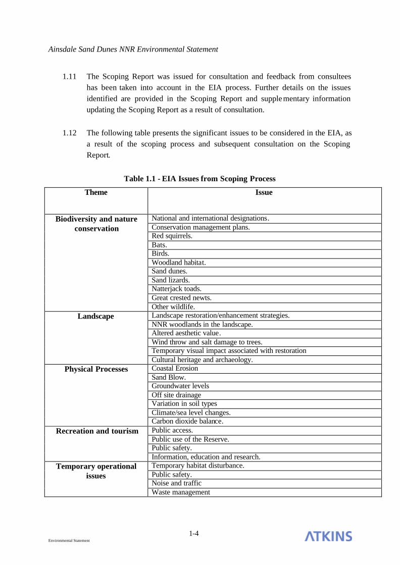
1.12 The following table presents the significant issues to be considered in the EIA, as a result of the scoping process and subsequent consultation on the Scoping Report.
Table 1.1 - EIA Issues from Scoping Process
Theme Issue
National and international designations. Conservation management plans. Red squirrels. Bats. Birds. Woodland habitat. Sand dunes. Sand lizards. Natterjack toads. Great crested newts.
Biodiversity and nature conservation
Other wildlife. Landscape restoration/enhancement strategies. NNR woodlands in the landscape. Altered aesthetic value. Wind throw and salt damage to trees. Temporary visual impact associated with restoration
Landscape
Cultural heritage and archaeology. Coastal Erosion Sand Blow. Groundwater levels Off site drainage Variation in soil types Climate/sea level changes.
Physical Processes
Carbon dioxide balance. Public access. Public use of the Reserve. Public safety.
Recreation and tourism
Information, education and research. Temporary habitat disturbance. Public safety. Noise and traffic
Temporary operational issues
Waste management

Ainsdale Sand Dunes NNR Environmental Statement
2-1 Environmental Statement
2. SITE DESCRIPTION
BACKGROUND
2.1 Ainsdale Sand Dunes National Nature Reserve (‘the Reserve’, Figure 1) comprises foreshore, neutral grassland, open dunes and foredunes, frontal pinewood, scrub and rear woodland. These habitats support a rich, diverse and unusual assemblage of plant and animal species and it is for these reasons that the Reserve has a number of statutory designations.
2.2 The Consultation Area lies wholly within the Reserve, which forms part of larger areas with national and international conservation designations. It forms part of the Sefton Coast Site of Special Scientific Interest (SSSI), the Sefton Coast candidate Special Area of Conservation (cSAC), the Ribble and Alt Special Protection Area (SPA) (the Consultation Area lies outside this designation) and the Ribble and Alt Estuaries Ramsar site. Each of these designations is discussed below, with details of these designations provided in Appendix B.
The Consultation Area
2.3 The Consultation Area, the options for management of which are the subject of this EIA, is 44.5ha in extent, and comprises 22.4ha of frontal pinewoods, 9.8ha of mixed scrub and 12.3ha of dunes with scattered scrub.
2.4 The Consultation Area lies in the south western portion of the Reserve and is bounded to the south by Formby Golf Club, to the east by the rear woodlands of the Reserve, to the west by the foreshore areas of the Reserve and to the north by the areas clearfelled during Phases 1 and 2 of the dune restoration project.
2.5 The habitats of primary conservation importance within the Consultation Area (those which contribute to the designations described below) are the shifting dunes with marram, fixed dunes with herbaceous vegetation and humid dune slacks. These are currently in unfavourable/declining condition.

Ainsdale Sand Dunes NNR Environmental Statement
2-2 Environmental Statement
2.6 Species of national and international significance also occur within the Consultation Area, including great crested newt (Triturus cristatus), sand lizard (Lacerta agilis) and natterjack toad (Bufo calamita) which are of international importance, together with red squirrel (Sciurus vulgaris) which is of national importance.
2.7 Further details of the habitats and species occurring within the Consultation Area, and their significance are presented in Section 5 of this EIA. The conservation designations which apply to the Consultation Area are described below.
National Nature Reserve (NNR)
2.8 The Ainsdale Sand Dunes National Nature Reserve is situated in the district of Sefton, in the County of Merseyside, North West England. It is located on the coast 1.5 miles south of Ainsdale village. OS Grid Reference: centre of the site: SD 288 106. The site is wholly owned by English Nature.
2.9 The Reserve is part of an extensive sand dune system stretching from Crosby to Southport, on the north west coast of England. It lies within a dune landscape formed from sand blown up from the wide beaches of the Lancashire coast. Nowadays just over half the original sand dune area remains after losses to development. However, an important stretch of dunes has survived in a near natural state, regarded as the finest example of calcareous sand dunes on the north-west coast of England.
2.10 The Reserve was designated an NNR in 1965, due to its national importance arising from the varied conditions in the dunes. These favour an unusually interesting and diverse flora and fauna which range from the dry shifting sand of the dunes to marshy slacks. Material from broken shells enriches the sand with lime, making it alkaline and this has led to the development of a diverse flora.
2.11 The landscape of the reserve has been modified to some degree by human activities, principally through the planting of the pinewoods, but also through leveling of dune landscapes on the landward edge.
2.12 The pinewoods support a healthy population of red squirrels and together with associated scrub, are also home to birds, plants, and fungi. The variety of scenery found amongst the pinewoods, dunes, wet slacks and scrub areas, gives this coast a distinctive character.

Ainsdale Sand Dunes NNR Environmental Statement
2-3 Environmental Statement
2.13 The landscape value of the NNR is important within the surrounding area because it contrasts with the adjacent developed and urban areas. From within the NNR one of the most attractive features of the site is the feeling of 'countryside' or even remoteness within what is a predominantly urban setting
2.14 Most of the typical sand dune habitat types are well represented. In addition to the main habitat types a number of ecotones occur, notably at the junction of the yellow dune/grey dune/scrub/woodland. Without the intervention of man through the planting of pine on the site the habitat types would be less diverse but there would be far larger areas of the more diverse fixed dune habitat.
2.15 The reserve occupies a central position within the Sefton Coast sand dune cSAC. It comprises some 11% of this site by area and because of its position it contains a high proportion of fixed dune and dune slack habitat. The sand dune and foreshore features of the Reserve are covered by the statutory designations described below.
Sefton Coast Site of Special Scientific Interest (SSSI)
2.16 Sefton Coast SSSI covers 4605.32 ha, and was designated in 2000 under the terms of the Wildlife and Countryside Act 1981 (as amended) and the Countryside and Rights of Way Act (2000). Ainsdale Sand Dunes NNR is completely contained within the above SSSI.
2.17 Sefton Coast SSSI extends for over 20 km between Southport and Crosby. The site is of interest for its intertidal mud and sandflats, embryonic shifting dunes, mobile dunes, dunes with creeping willow (Salix repens ssp argentea), humid dune slacks, fixed dunes, dune grasslands and dune heath. Its assemblages of vascular and non-vascular plants are also of importance.
2.18 The SSSI is significant for its populations of internationally important wintering wildfowl and its nationally and internationally important populations of individual waders. Its populations of sand lizard (Lacerta agilis), natterjack toad (Bufo calamita) and great crested newt (Triturus cristatus) are also of particular importance, as are the populations of the sandhill rustic moth (Luperina nickerlii gueneei) which is a Red Data Book species.

Ainsdale Sand Dunes NNR Environmental Statement
2-4 Environmental Statement
2.19 The Sefton Coast SSSI is also noteworthy for its coastal geomorphology, including the mobile dune system and multiple sand bars that occur on the foreshore. The conservation objective for the geomorphological features of the SSSI is to maintain the active processes of the site comprising the extensive beach and foreshore, backed by a series of active low dunes and inland a large complex of relict high dunes. The geomorphological conservation objectives and definitions of Favourable Condition are presented in Appendix B.
2.20 Most of the Sefton Coast pinewoods (including those on the Reserve) are within the SSSI but are not protected features.
Conservation Objectives for the European Interest
2.21 The conservation objectives for the European Interest of the SSSI are:
• Subject to natural change, to maintain∗ , in favourable condition the following Annex I habitat types, fixed dunes with herbaceous vegetation, Eu-Atlantic decalcified dunes, dunes with (Salix repens), humid dune slacks, embryonic shifting dunes, and shifting dunes along the shoreline supporting marram (Ammophila arenaria);
• Subject to natural change, to maintain∗ , in favourable condition, the habitats which support populations of the Annex II species great crested newt (Triturus cristatus) on the Sefton Coast cSAC, with particular reference to terrestrial habitats and ponds;
• Subject to natural change, to maintain∗ , in favourable condition, the habitats which support populations of the Annex II plant petalwort (Petalophyllum ralfsii) on the Sefton Coast cSAC, with particular reference to dune slacks.
Sefton Coast Candidate Special Area of Conservation (cSAC)
2.22 4563.97 ha of the Sefton Coast is a designated candidate Special Area of Conservation (cSAC) under the terms of the Habitats Directive 92/43/EEC,
∗ maintenance implies restoration if the feature is not currently at favourable condition. For the full Favourable Condition tables see Appendix B.

Ainsdale Sand Dunes NNR Environmental Statement
2-5 Environmental Statement
implemented in Britain through the Conservation (Natural Habitats &c.) Regulations 1994. This makes it one of the largest sand flat and dune complex cSAC sites in Britain. The Reserve forms 11% of the Sefton Coast cSAC including 157ha of open dunes and foredunes.
2.23 Annex I to the Habitats Directive lists natural habitat types whose conservation requires the designation of Special Areas of Conservation. Annex II lists animal and plant species with similar requirements.
2.24 The main features of the cSAC are given below.
Annex I habitats that are a primary reason for selection of this site:
• Embryonic shifting dunes of the northern, lyme-grass (Leymus arenarius) type;
• Shifting dunes along the shoreline with marram (Ammophila arenaria) (white dunes). Marram usually dominates these mobile dunes along with considerable areas of blown sand. Where sand deposition declines, additional species are able to grow including lyme-grass, sea holly (Eryngium maritimum), cat’s-ear (Hypochaeris radicata), red fescue (Festuca rubra) and spreading meadow-grass (Poa humilis);
• Fixed dunes with herbaceous vegetation, which show considerable variation from alkaline to acidic ;
• Dunes with creeping willow (Salix repens ssp argentea): extensive dune slacks are dominated by this vegetation type at the Reserve. 43% of the total English resource of this dune slack community occurs in this cSAC (Radley 1994);
• Humid dune slacks. Some active slack formation can still be seen along this coastline and a variety of successional stages are represented in the cSAC.
Annex I habitats present as a qualifying feature, but are not a primary reason for selection of this site
• Atlantic decalcified fixed dunes.

Ainsdale Sand Dunes NNR Environmental Statement
2-6 Environmental Statement
Annex II species that are a primary reason for selection of this site
• Petalwort (Petalophyllum ralfsii): a large population of this rare non-vascular plant occurs in the cSAC, where it prefers damp edges around recently formed dune slacks.
Annex II species that are present as a qualifying feature, but not a reason for selection of this site
• Great crested newt (Triturus cristatus).
Appendix B contains a copy of the Reasons for Recommendation, giving full details.
2.25 The Consultation Area contributes to the cSAC due to the habitats, flora and fauna it supports.
Ribble and Alt Estuaries Ramsar site
2.26 The Ribble and Alt Estuaries Ramsar site was declared in 1985, under the terms of the Ramsar Convention on Wetlands of International Importance especially as Waterfowl Habitat. The Ramsar site is 13,464.10 ha in size and is deemed a wetland of international importance because:
• Its supports up to 40% of the Great Britain population of natterjack toads.
• In the non-breeding season the area regularly supports in excess of 289,000 individual waterbirds.
• In the breeding season the area regularly supports over 29,000 individual waterbirds.
• It regularly supports 1% of the individuals in the populations of 19 species or subspecies of waterbird in any season.
2.27 The Consultation Area primarily contributes to the Ramsar site through the presence of natterjack toad.
2.28 For a full list of the ideal long term management objectives for all the designated features refer to Appendix B.

Ainsdale Sand Dunes NNR Environmental Statement
3-1 Environmental Statement
3. DESCRIPTION OF THE PROPOSALS
BACKGROUND TO THE DUNE RESTORATION PROJECT
3.1 As early as 1976, concerns regarding the encroachment of scrub species into dune habitats on the Reserve and the Consultation Area, including dune slacks, initiated the concept of restoring dune habitats through the removal of frontal woodland and scrub habitats. In 1986 the removal of frontal woodland was proposed in the then Management Plan for the NNR.
3.2 English Nature (then the Nature Conservancy Council) initially applied for a felling license from the Forestry Commission in 1987. However, following the expression of reservations from Sefton MBC and the Joint Countrys ide Advisory Service (JCAS), the application was withdrawn.
3.3 A revised plan for felling the frontal woodlands from north to south in four phases was then produced by English Nature, taking into account the reservations expressed and following further consultation with Sefton MBC and the Forestry Commission. An application for Phase 1 of the frontal woodland removal was submitted in 1990. The first phase was seen as experimental, and if this activity was deemed acceptable through review of monitoring data and consultation with members of the Sefton Coast Management Scheme (SCMS), a further three phases were planned to continue as a rolling programme.
3.4 Phase 1 of the project (Figure 3) involved the removal of 4.5ha of pines and associated scrub, together with some timber from the rear woodlands as part of the forestry management objectives for the Reserve. This involved the thinning of trees to allow natural regeneration. Tree stumps from the clearance were left in situ and brashings from the pines were gathered into discrete areas and burnt. Large amounts of scrub and trees were stored adjacent to Massams Slack until 1993 to allow them to dry before being burnt. All fire sites were buried and capped with clean sand. The cleared area was managed by grazing with Herdwick sheep to control scrub encroachment. However, additional control was required, and a selective herbicide was applied in 1993.

Ainsdale Sand Dunes NNR Environmental Statement
3-2 Environmental Statement
3.5 Following the tree and scrub removal, English Nature held site review visits including a visit by members of the Forestry Commission. Monitoring data were submitted to the Forestry Commission and Sefton MBC. The work carried out in Phase 1 was accepted by the SCMS, so English Nature then began procedures for undertaking the remaining phases of the project.
3.6 In 1995 English Nature applied for a felling license for Phase 2 of the restoration project (Figure 3), which was approved and subsequently undertaken in 1996.
3.7 This operation involved the removal of 9.3ha of pine woodland and associated scrub. Following removal, the tree stumps were left in situ. The stumps of deciduous scrub were treated with herbicides, thus reducing the need for follow up treatment. The treatment of cut material and follow up grazing was conducted in the same way as for Phase 1.
3.8 Subsequent phases of remova l were planned to be undertaken in 2000 and 2004. However, public concerns regarding the restoration project has meant that English Nature put all tree felling on hold and commissioned an independent review. Therefore, Phases 3 and 4 have not been undertaken.
3.9 Following changes in the legislation relating to the need for an Environmental Impact Assessment, the Forestry Commission advised that an EIA would be required in October 2002.
3.10 English Nature have identified four options for the future management of the remaining frontal woodlands within the Consultation Area. Each is described in the following sections.
PROPOSED MANAGEMENT OPTIONS
3.11 The current Ainsdale Sand Dunes NNR Management Plan (English Nature 2003) sets out a series of management objectives for the Reserve. These are a key factor in the development of the management proposals for the Consultation Area and are as follows:
• to maintain in favourable condition sand flats, yellow dunes, fixed dunes, rearward woodland, sand lizard, natterjack toad and great crested newt;

Ainsdale Sand Dunes NNR Environmental Statement
3-3 Environmental Statement
• to maintain a viable red squirrel population in the rearward woodland as part of the West Lancashire and Merseyside population;
• to develop the landscape value of the NNR commensurate with its nature conservation objectives, in consultation with the local community;
• encourage public access and recreational use of the NNR commensurate with its nature conservation and other objectives;
• use the NNR to convey the value of nature and interpret English Nature’s work to the local community and wider audiences;
• encourage research projects that directly relate to the management of the NNR or to English Nature’s wider objectives;
• comply with all organisational and legal requirements relating to the NNR;
• comply with all statutory responsibilities, to plan asset management efficiently, to implement cost-effective provision, replacement and maintenance programmes for buildings and site infrastructures and to secure optimum benefits from NNR property.
NEW FOREST ROAD
3.12 The need for the construction of a new forest road has been identified, whether woodland removal is proposed or not. It is required for emergency access, management and wardening of the frontal area.
3.13 The forest road would involve the removal of trees along its route and the reprofiling of one dune ridge, involving the movement of approximately 5m3 of sand from the top to the bottom of the slope. The road would be unsurfaced and negotiable by four-wheel drive vehicles, it would be maintained by occasional mowing.
3.14 Under Options A and B (see below), the road would pass through woodlands and would be classed as a Forest Road under the EIA Regulations. Therefore, the Forestry Commission would determine, if either of these Options were selected, whether an EIA would be required prior to its construction. Under Options C or D most of the woodland would be removed from the Consultation Area. The road

Ainsdale Sand Dunes NNR Environmental Statement
3-4 Environmental Statement
would be constructed to aid in the extraction of timber, and would therefore be defined as an extraction route. As woodland would be largely be removed under these options it would not be considered to constitute a Forest Road.
OPTION A - ‘THE DO MINIMUM OPTION.’
3.15 The ‘do minimum’ option (Figure 4) represents the least possible intervention in the frontal woodlands whilst improving access and maintaining levels of public safety. A new forest road would be constructed, to allow access to the frontal woodlands. Management of the frontal woodlands would be limited to activities such as extinguishing fires, making safe any trees which are destabilised through windthrow or as a result of coastal erosion and the control of any future scrub invasion of existing open habitats. Works would only be conducted on an as-required basis with no proactive management undertaken.
3.16 This option would result in the retention of 22.4ha of pine plantation, leaving 14.31ha of open dunes with scattered scrub and 9.8ha of mixed scrub within the Consultation Area.
3.17 In the short term, this option would serve to maintain frontal woodland and scrub within the Consultation Area as it currently exists. However, it is likely that some deterioration in the frontal woodlands would occur over time as a result of increasing senescence of trees, windthrow and losses due to coastal erosion. The effects of coastal erosion would result in the initial loss of coastal habitats, and eventually the loss of woodland habitat within the Consultation Area. The predicted situation in 2050 is presented in Figure 5. Although there will be an increase in mobile dune habitat by this time, the area will be in unfavourable condition i.e. it will not display the features which confer conservation importance on this habitat type, as it will be adversely affected by dead standing and fallen trees.
OPTION B - ‘WOODLAND MANAGEMENT.’
3.18 This option would incorporate the management of the frontal woodlands (Figure 4) into the scheme for managing the rear woodlands. The management would aim to create a varied habitat structure with a diverse age range of trees and scrub and a healthy habitat structure. A forest road would also be constructed.
3.19 The management of the rear woodlands on the Reserve is aimed primarily at production of high quality habitat for red squirrels, the incorporation of the

Ainsdale Sand Dunes NNR Environmental Statement
3-5 Environmental Statement
frontal woodlands into the management of the rest of the woodland on the Reserve would have the same primary aim.
3.20 The operational objectives for the rear woodlands (EN 2003) are as follows:
• to maintain the present woodland mosaic and variety of structure;
• to create a ‘healthy’ or normal woodland age profile;
• to maintain the focus on pine species as a food source for the red squirrel and to retain the existing woodland character;
• to maintain areas of indigenous small-seeded broadleaf species, up to but no more than 10% of the total area;
• to provide suitable habitats within the woodland structure for all appropriate species, especially those designated as Priority Species (national and local BAP species, notable flora);
• to ensure and economic return where feasible.
3.21 Under Option B, the above objectives would be adopted for the management of the frontal woodlands within the Consultation Area.
3.22 Option B would lead to similar quantities of habitat present within the Consultation Area as Option A. However, there may be some slight temporary increase in open habitats where clearance of over mature trees is carried out and natural regeneration/replanting is undertaken. This option would improve the quality of the frontal woodlands for associated species, notably red squirrel. However, the quality of habitat for red squirrel in the more exposed parts of the frontal pine plantation is unlikely to ever be as good as that in the rear, due to wind exposure nearer the sea.
3.23 As in Option A, coastal erosion is likely to result in the loss of frontal woodland and seaward dune habitats over time (Figure 5). Although there will be an increase in mobile dunes, they will be in unfavourable condition i.e. without the features which confer conservation importance on this habitat.

Ainsdale Sand Dunes NNR Environmental Statement
3-6 Environmental Statement
OPTION C - ‘INCOMPLETE FELLING.’
3.24 The removal of a major percentage of tree and scrub cover within the existing frontal woodland area (Figure 6) would be carried out. Under this option a road will be established within the Consultation Area, as described above, and will remain as additional site access following the works. The selection of long term tree retention areas is based on the following criteria:
• Retained trees will be at least 100m from existing or restored slacks (Forestry Commission 2002). The distance adopted will need to be tested by further work to better establish the distance at which slack hydrology is significantly affected. This may be as a result of ongoing Forestry Commission work, or require further data collection.
• Clearance will take place on high dunes and windward slopes, so as to allow active geomorphological processes to operate.
• In areas greater than 100m from slacks, unsightly dead areas, and those vulnerable to wind throw should not be retained.
• Retain stable, wind-firm trees where possible.
• Retain character trees, e.g. maritime pine and wind-sculpted trees where possible.
• Minimise the creation of unsightly new edges.
• Retain trees where they are of greatest benefit to the visual landscape.
3.25 It should be noted that any retained tree cover represents a potential seed source for subsequent invasion and that sufficient trees should be removed to allow for dune mobility and beneficial hydrological effects on dune slacks to occur.
3.26 The Habitat Monitoring Guidance for sand dune habitats produced by the JNCC Chief Scientist Group (2004), notes that 5% is the maximum allowable scrub cover for humid dune slack, dunes with creeping willow and fixed dune grassland. Therefore a maximum of 1.9ha of tree and scrub cover could be retained in these areas. In addition long term pine retentions at 100m from slack features could result in a fur ther 1.38ha of woodland being retained. This gives a

Ainsdale Sand Dunes NNR Environmental Statement
3-7 Environmental Statement
potential total tree and scrub cover of 3.28ha, representing approximately 10% of the existing tree and scrub cover.
3.27 A block of 0.46ha of pine (in the extreme western corner of the Consultation Area) is already beginning to be buried under frontal dune rollover. It is estimated (English Nature) that the fixed dune grassland features restored in the Consultation Area would take at least 20 years to reach favourable condition. By this time, as small tree blocks at right angles to the shore do not appear to present a significant barrier to sand movement, the western corner of the Consultation Area is likely to have been replaced entirely by shifting dunes along the shoreline with marram (a cSAC feature). The features of the cSAC are therefore likely to reach favourable condition in this vicinity without management. This block of pine could therefore be removed from the calculations described above. This then allows for the retention of scattered and lone pines within the Consultation Area, as a result of natural regeneration. As these trees mature they would increase the tree cover as the western block is lost.
3.28 Under these circumstances a total initial tree and scrub component of 10 to 15% of the existing cover would be retained, decreasing to approximately 10% by 2024. No more than 50% of the remaining tree/scrub will occur on the features of SSSI/cSAC significance i.e. dunes and slacks.
3.29 The proposed retentions of tree and scrub under this option are shown graphically in Appendix C.
3.30 The aim of this option will be to re-establish and maintain a spectrum of habitats including bare dunes, dune slacks, scrub and scattered groups of trees suitable for a wide range of associated species without compromising the continuity of the designated species and habitats. The design of this option has taken account of a Landscape Statement for the Dune Restoration Project, together with consultation with key stakeholders (Cass Associates 2003).
3.31 Option C principally consists of:
• a mixed scrub margin to the retained rear woodland of up to 75% cover, all species;

Ainsdale Sand Dunes NNR Environmental Statement
3-8 Environmental Statement
• a belt of fixed dune grassland and slack habitats with 5-10% tree cover comprising pines, hybrid willow and Rosaceae (hawthorn, wild rose species, guelder rose);
• open dunes with a few scattered pines and hawthorn;
• areas where some pines could be retained. It should be noted, however, that due to the poor quality and large lodgepole pine component of the frontal woodlands there is limited scope for retention and stands which are to remain will require careful selection.
3.32 This option incorporates the removal of tree and scrub cover from the vicinity of humid dune slack features and in particular the removal or setback of tree cover from the southern side of wet slacks to prevent shading, the latter aspect being essential for the successful development of natterjack toad tadpoles.
3.33 In order to retain groups of mature pine it will be necessary to carry out progressive removal to create a protective edge to prevent windthrow. As a result, it is not possible to finalise the location of retained tree groups until work is underway. This is a landscape design issue which needs to be planned in parallel with ongoing operations on the ground. Any mature pine to be retained should be Corsican pine, as mature lodgepole pine is not windfirm in this situation. Young lodgepole could, however, be retained for its landscape value.
3.34 Works would be carried out in phases between 2004 and 2006. Under this option limited areas of woodland and scrub would be worked at any one time and tree stumps will be removed or cut to ground level. Some vegetation removal is proposed on the windward side of the dunes to encourage natural geomorphological processes to take place. Tree removal over a large proportion of the Consultation Area is likely to result in an increase of water tables in cleared areas, based on experience gained from the Phase 1 and 2 works.
3.35 Option C would increase the amount and quality of dune and dune slack habitat and associated species on the Reserve, whilst maintaining a limited wooded element in the landscape. This option would reduce the suitability of the frontal areas to red squirrels, which would be highly unlikely to populate the retained trees, as they would be isolated from the rear woodlands.
Ainsdale Sand Dunes NNR Environmental Statement
3-9 Environmental Statement
3.36 The predicted habitat arrangement by 2050, taking into account coastal erosion, is presented in Figure 7. The mobile dunes under this Option will have features of conservation importance by this time and will be in favourable condition.
OPTION D - ‘COMPLETE CLEARFELL’
3.37 Original English Nature proposals planned for the removal of frontal woodlands in four distinct phases, with phases 1 and 2 being completed in 1992 and 1996 respectively. Option D relates to the continued removal of frontal woodland, originally conceived as occurring in two further phases. It is, however, now envisaged that this removal will not include large clearfells as undertaken previously. This option requires that the same overall area is cleared of tree cover, but with smaller areas to be worked at any one time. As described above, a road will be constructed to allow access to the site for clearance, the road will remain as an additional access to the site once work has been completed (Figure 8). Some vegetation removal on the windward side of the dunes is proposed, to encourage natural geomorphological processes to take place (as in Option C). Tree removal over the Consultation Area is likely to result in an increase of water tables in cleared areas.
3.38 This Option would result in the eventual removal of all the pines within the Consultation Area, with the retention of some willow and alder, amounting to no more than 5% cover. This is the maximum allowable scrub cover for humid dune slack, dunes with creeping willow and fixed dune grassland according to the Habitat Monitoring Guidance for sand dune habitats produced by the JNCC Chief Scientist Group (2004).
3.39 The aims of this option are:
• to create mobile dunes and associated floral and faunal communities in the areas presently occupied by frontal pine plantations;
• to reduce the rate of natural succession to scrub woodland in the fixed dunes immediately landward of the frontal pine plantations.
3.40 Sand dune and dune slack habitats and associated flora and fauna would be increased on the Reserve as a result of this option.

Ainsdale Sand Dunes NNR Environmental Statement
3-10 Environmental Statement
3.41 Clearance under this option would be carried out between 2004 and 2006. The predicted outcome of this Option by 2050, taking into account coastal erosion, is presented in Figure 9. The mobile dunes under this Option will be in favourable condition by this time, supporting habitat features of conservation importance..

Ainsdale Sand Dunes NNR Environmental Statement
4-1 Environmental Statement
4. PLANNING POLICIES AND GUIDELINES
4.1 This section presents a summary of the planning and policy guidelines which relate to the Consultation Area.
Ainsdale Sand Dunes NNR Management Plan 2003-2004
4.2 English Nature have produced a plan for the management of the Reserve, covering the period 2003-2004. The plan provides information on the interest of the Reserve and presents details of how this interest will be maintained and enhanced during the period of the plan’s operation.
4.3 The NNR management plan considers the management issues and legal requirements for favourable condition relating to the Consultation Area (which falls within SSSI Unit 18). The plan puts forward arguments for the integrity of the overall cSAC and describes the damage to cSAC and SSSI features caused by the pine plantation. It also identifies the need to respond to coastal erosion through the setback of tree cover where the frontal pinewoods are causing coastal squeeze within the Consultation Area.
4.4 The management plan notes that ‘Fifty percent of the frontal woodland on the NNR has been removed over the last 10 years, which will allow retreat along the northern frontage of the NNR. The more urgent section of frontal woodland has yet to be removed and the frontal dunes here will be prevented from natural rollback within the timescale of this plan if the tree cover is not removed. If the integrity of the cSAC is to be maintained it is necessary to maintain continuity of cSAC feature habitats through the site.’
4.5 The plan states that small scale scrub removal should be continued within the Consultation Area, to allow dune rollback and restore yellow and fixed dune habitats.
Ainsdale Sand Dunes NNR Environmental Statement
4-2 Environmental Statement
4.6 The plan recommends that the Dune Restoration Project should continue in the Consultation Area. Further management is identified as being the subject of this EIA, so no further treatment is given to this issue in the Management Plan.
4.7 The ideal long term management objectives for the Reserve are as follows:
• Sand Flats (SPA and Ramsar Features) – Maintain the features in favourable condition.
• Yellow Dune (cSAC and SSSI Features) – Maintain the features in favourable condition.
• Fixed Dune (cSAC and SSSI Features) – Maintain the features in favourable condition.
• Rearward Woodland (conifer plantation with geological interest) – Maintain the feature in favourable condition.
• Sand lizard – Maintain the species in favourable condition.
• Natterjack toad – Maintain the species in favourable condition, implement prescriptions of Sefton Coast Natterjack Strategy/LBAP.
• Great crested newt – Maintain the species in favourable condition.
• Red Squirrel (Schedule 5 WCA, BAP) – Maintain a viable red squirrel population in the rearward woodland as part of the West Lancashire and Merseyside population.
• Landscape – Develop the landscape value of the NNR commensurate with its nature conservation objectives, in consultation with the local community.
• General access and recreation – Encourage public access and recreational use of the NNR commensurate with its nature conservation and other objectives.
• Education and Interpretation – Use the NNR to convey the value of nature and interpret English Nature’s work to the local community and wider audiences.

Ainsdale Sand Dunes NNR Environmental Statement
4-3 Environmental Statement
• Study and Research – Encourage research projects that directly relate to the management of the NNR or to English Nature’s wider objectives.
• Organisational/Legal requirements – Comply with all organisational and legal requirements relating to the NNR.
• Provision of facilities and property management – To comply with all statutory responsibilities, to plan asset management efficiently, to implement cost-effective provision, replacement and maintenance programmes for buildings and site infrastructure, to secure optimum benefits from NNR property.
Sefton UDP May 1995 and Deposit Draft 2003
4.8 The Sefton Unitary Development Plan (UDP) was formally adopted in May 1995. A revised Deposit Draft of the new UDP is currently at the public consultation stage. The current plan has the conservation and enhancement of the coastal environment as one of the eight planning objectives and priorities set out in Part 1 of the document (Policy GEN6). A separate section on the Coastal Planning Zone has a range of more detailed policies relating to the Sefton Coast, a number of which are relevant to the Reserve, as outlined below.
4.9 Policy CPZ 2 Coastal Defence: this policy seeks to restrict development which would increase the risk of flooding or coastal erosion or prejudice the capacity of the coast to form a natural sea defence or adjust to changes in condition without risk to life or property. In this context the need to consider the potential impacts of climate change and sea level rise is emphasised.
4.10 Policy CPZ 4 Nature Conservation Sites: in support of the wealth of designated nature conservation sites within the coastal zone, this policy seeks to prevent development which would destroy or adversely affect such areas.
4.11 Policy CPZ 7 Coastal Woodlands: Sefton as a whole has a relatively low leve l of tree cover and nearly two thirds of the Borough’s tree stock can be found in the coastal zone. The UDP notes that in the interests of better overall nature conservation management of Ainsdale NNR, removal of a certain area of woodland has been proposed, and states that the Council has accepted a limited felling programme in view of these special circumstances. This policy, however, resists any major removal of woodland and supports the management of existing

Ainsdale Sand Dunes NNR Environmental Statement
4-4 Environmental Statement
woodland and planting of new woodland in the context of the Coast Management Plan
4.12 Policy CPZ 8 Coastal Management Plan: this policy is superseded by the Sefton Coast Management Plan 1998 (see below). It sets out the general aims of the Sefton Coast Management Plan, which are to encourage:
• management of the open coast as an amenity area, with the emphasis on nature conservation, whilst making provision, where necessary, for low intensity recreational uses compatible with the carrying capacity of the area;
• maintenance and enhancement of the natural coastline, its habitats and wildlife, in a way compatible with sea defence and coast protection considerations;
• improvement of the landscape quality of the area where necessary and management of visitor pressure so that the environment and people’s enjoyment and understanding of it are enhanced;
• development and enhancement of the coast as an educational resource.
4.13 Policy CPZ 16 Public Access: this policy highlights the recreational significance of the Sefton Coast and in particular the Coastal Path and its associated footpath links. The policy seeks to protect the existing public access network and develop new links where opportunities arise.
4.14 Within the Environmental and Resources section of the UDP it states that the ‘coastal landscape should equally be considered as a Heritage Landscape’. The following policy is relevant:
4.15 Policy ENV 35 Safeguarding Heritage Landscape: emphasises the need to safeguard the historic interest and associated scientific, cultural, aesthetic and amenity value of such areas.
4.16 The latest Deposit Draft of the UDP (2003) includes policies relevant to this EIA, as follows:
• 11.28 The 1994 Habitats Regulations require the Plan to include policies encouraging the management of habitats and features of the landscape which

Ainsdale Sand Dunes NNR Environmental Statement
4-5 Environmental Statement
are of major importance for wild plants and animals. The relevant features in Sefton include the dune edge, the Leeds and Liverpool Canal, railway lines, river corridors, wetlands, ponds and ditches.
• 12.23 Regulation 37 of the 1994 Habitats Regulations states that development plan policies shall cover the management of features of the landscape which are of major importance for wild plants and animals, such as ‘linear and continuous structure(s which are) essential for the migration, dispersal and genetic exchange of wild species’.
• 12.24 The coastal landscape is such a linear and continuous feature. The policy aims to protect and support it and prevent it being broken up, for example through parts being lost or by the erection of barriers. This will allow the wild animals and plants there to migrate, disperse, live and breed successfully. This support will usually be through the landscape being enhanced or managed. How much enhancement is required will depend on the type, size and location of the development. This policy does not apply to proposals for house extensions in Hightown, as these will not have a significant impact on the coastal landscape.
Regional Planning Guidance for the North West (RPG13) 2003
4.17 The Regional Planning Guidance for the North West sets the context for the preparation of the region’s development plans.
4.18 Policies of relevance are as follows:
• ER2 Landscape Character: encourages the conservation and enhancement of the rich diversity of landscapes and their settings throughout the North West and supports retention of regional and sub-regional distinctiveness;
• ER5 Biodiversity and Nature Conservation: affords the strongest levels of protection to sites with international and national nature conservation designations and promotes the formulation of strategies to conserve, enhance and restore these priority habitats in accordance with UK and Local Biodiversity Action Plans (BAPs);
• ER6 Woodlands: seeks to increase the level of tree cover within the region by 10% by 2010 and by 15% by 2015. However, the policy also states that

Ainsdale Sand Dunes NNR Environmental Statement
4-6 Environmental Statement
opportunities for new planting must be balanced against impacts on natural and historic landscapes and biodiversity.
4.19 Appendix 1 of the Guidance sets out biodiversity targets for the Region as follows;
• Maintain habitat extent: ensure that there is no further loss in current habitat resource and that physical processes required to maintain the habitat are operating;
• Maintain habitat quality: maintain the quality of areas of habitat which are in good condition;
• Restore habitat quality: restore those areas of habitats which are degraded in quality to good condition through positive management, or the cessation of damaging practices. This includes achieving favourable condition of the habitat resources within SSSIs, and demonstrable improvements in the condition outside SSSIs;
• Expand habitat extent : increase the area of the habitat beyond its current extent. This includes the creation of lost habitat in areas where it formerly occurred. Wherever possible, habitat expansion should aim to link or extend existing areas of that particular habitat type.
4.20 In addition to biodiversity targets, maintenance targets are also set for habitats. The one which relates directly to the habitats present on the Reserve is:
• To restore the condition of degraded/improved dune grassland/heath in the North West Region to 780ha by 2010 and re-establish open dune vegetation lost to other land uses and erosion to 150ha by 2010.
Sefton Coast Management Plan 1998
4.21 This Plan, which sets the scene for coastal management within the Metropolitan Borough of Sefton, is non-statutory and provides an insight into locally agreed priorities for the Sefton Coast. It supersedes policy CPZ 8 of the Sefton UDP and has been produced by the Sefton Coast Partnership, to which English Nature belongs.

Ainsdale Sand Dunes NNR Environmental Statement
4-7 Environmental Statement
4.22 The vision for the Plan is for ‘the Sefton Coast to be managed to ensure the conservation of one of the most important coastal areas in Europe for nature while being an asset to a healthy local economy and providing a much needed area for the quiet enjoyment of the countryside. Specifically, we accept the joint responsibility to ensure that the integrity and natural value of the dune system and estuaries is protected in perpetuity as one of the series of European nature areas’.
4.23 Section 3 of the Plan covers nature conservation, landscape and land management. Its aim is ‘to conserve, protect and enhance the natural beauty and biodiversity of the coast, including its characteristic terrestrial, littoral and marine flora and fauna, geology, geomorphology, landscape and heritage features of architectural, historical, cultural and archaeological interest’.
4.24 The objective for wildlife conservation is ‘to maintain and enhance all natural and semi-natural terrestrial habitats, including areas outside conservation designations, with particular emphasis on designated areas, protected species and rare and fragmented habitats and to conserve and enhance the littoral and marine zones’. The following policies relating to this objective are of relevance to this Environmental Statement.
• Policy CMP 5 states that the conservation value of the dunes, dune heath, estuaries and marshes will be maintained and enhanced, wherever possible, by positive and co-ordinated actions by partners.
• Policy CMP 11 that partners will include landscape considerations in site management plans and habitat strategies, and will identify and enhance important landscape features only in accordance with other policies.
4.25 The objective for Woodland and Scrub Management is to achieve an acceptable balance between woodland and open dunes and to enhance the landward woodland and increase its value for nature conservation and amenity. These objectives are to be achieved through the following policies:
• Policy CMP 13: partners, including the Mersey Forest Team, will prepare and implement a coastwide woodland and scrub management strategy;
• Policy CMP 14: the strategy will ensure that the extent, protective function, landscape, ecology and amenity value of the existing landward woodland belt will be maintained;

Ainsdale Sand Dunes NNR Environmental Statement
4-8 Environmental Statement
• Policy CMP 15: areas of proposed new planting will be assessed against nature conservation, landscape and amenity criteria and, if appropriate, implemented as part of The Mersey Forest initiative. The removal of substantial blocks of woodland will also be assessed against nature conservation, landscape and amenity criteria.
Sefton Coast cSAC Conservation Strategy 1999
4.26 The strategy, which was prepared by the LIFe project and is in need of revision in the light of the most recent reasons for designation (see Section 2), gives the background for the sustainable management of the natural habitats and species of European interest within the Sefton Coast cSAC.
4.27 The aims of the strategy are to:
• develop conservation objectives, leading to the achievement of favourable condition for the priority, and other, Annex I habitat types and Annex II and Annex IV species (which are animal and plant species of community interest in need of strict protection). These are listed in the Habitats Directive on the Sefton dune coast and include sand lizard (Lacerta agilis) and natterjack toad (Bufo calamita), as a contribution to favourable conservation status across their whole range within the European Community;
• contribute to the strategic approach taken for the protection and management of the dune habitats and dune processes on the Sefton Coast, linked to shoreline management and planning.
4.28 The goals of the Conservation Strategy are to:
• conserve, enhance and, where possible, restore natural and semi-natural dune and dune heath habitats, including areas outside conservation designations, but with particular emphasis on designated areas and rare or fragmented habitats;
• contribute to the conservation of the natural biodiversity of the Sefton Coast with a particular emphasis on the habitats and species of European importance;

Ainsdale Sand Dunes NNR Environmental Statement
4-9 Environmental Statement
• ensure that management of the beach and dune system takes into account the possible responses of natural processes, species and habitats to climate change;
• maintain or enhance groundwater quality and quantity of the Sefton Coast to its highest achievable standards;
• conserve and, where appropriate, enhance the natural and cultural landscape character of the dune coast;
• support sustainable activities which contribute to the protection, maintenance or enhancement of the environmental quality of the Sefton Coast;
• support the development of environmental education and public awareness that improves the understanding, value and respect for nature on the dune coast, in the context of Natura 2000;
• integrate the strategy for the Sefton Coast cSAC with the existing management and reporting arrangements on the Sefton Coast;
• ensure that management plans take into account the need to achieve favourable condition for the habitats and species of European importance in accordance with this Strategy;
• further the strategic monitoring and understanding of the coastal environment to improve its use, management and condition.
Shoreline Management Plan
4.29 The Reserve lies within the boundaries of the Shoreline Management Plan for sub-cell 11b: Formby Point to the River Wyre. This is a non-statutory plan, produced by the Shoreline Management Partnership, but one which will have a strong influence over coastal management over the fifty year life of the plan. English Nature was consulted during its preparation.
4.30 The objectives of the Shoreline Management Plan relating to the Ainsdale to Formby shoreline are given below:
• Coastal Processes:

Ainsdale Sand Dunes NNR Environmental Statement
4-10 Environmental Statement
− CP1: to continue and enhance present coastal process monitoring to provide further data from which the scale and magnitude of policy actions can be defined.
− CP3: to allow natural processes, which sustain the shoreline, to continue
• Coastal Defence:
− CD7: to maintain, manage and encourage the development of natural coastal defences along the length of frontage and recommend appropriate measures to mitigate against problems arising from on-going erosion of Formby Point.
• Natural Environment:
− NE1: to ensure that the policy preserves the integrity and nature conservation value of the foreshore and dune areas and, in particular, statutory designated sites of environmental interest (SPA/Ramsar, SSSIs, cSAC, National and Local Nature Reserves) and sites of local biological interest, in a way that is compatible with sea defence and coast protection considerations.
− NE2: improvement of the landscape quality of the area, where necessary, and management of visitor pressure so that the environment is protected and people’s enjoyment and understanding of it is enhanced.
− NE3: to implement an effective monitoring scheme to determine the effect of the coastal defence activities on the nature conservation value of the coastal zone.
• Human and Built Environment:
− HAB7: management of the open coast as an amenity area, with the emphasis on nature conservation, whilst making provision, where appropriate within specifically identified areas of foreshore, for recreational uses compatible with the capacity of the area.

Ainsdale Sand Dunes NNR Environmental Statement
4-11 Environmental Statement
− HAB9: where appropriate, to maintain and if possible improve access to the foreshore for emergency vehicles, recreational usage and other shoreline interests.
− HAB10: to minimise and mitigate against any adverse impacts that coastal defence works may have on archaeological and historic environment resource.
Sefton Coast Woodland and Scrub Strategy 1999
4.31 The aim of this strategy is to provide a co-ordinated approach to woodland management on the Sefton Coast and to provide guidance on sustainable management to landownwers. Key issues of the Strategy are nature and landscape conservation, recreation provision and good forestry management practice. The Strategy also provides guidance on the removal of scrub where its presence is considered undesirable.
4.32 Within the Sefton Coast Management Scheme, the Strategy has the following management objectives:
• enhance the quality and continuity of woodland and scrub resources where appropriate.
• increase woodland cover where appropriate.
• maintain and enhance nature conservation value of woodland and scrub where appropriate.
• ensure that decisions about the removal of woodland and scrub for open dune restoration accord with international, national and local nature conservation priorities.
• extend community use of the woodland and scrub resource, where compatible with other management objectives. Encourage community involvement in decisions about management of coastal woodlands and scrub.
• develop mechanisms for monitoring the implementation of this strategy and indicators for the sustainable management of woodland and scrub.

Ainsdale Sand Dunes NNR Environmental Statement
4-12 Environmental Statement
The Sefton Coast Woodlands – a 20 year working plan 2003-2023
4.33 This plan was commissioned by a partnership between the Forestry Commission, local landowners, managers, interest groups and local residents. The document has drawn on a number of key planning and background documents, namely: A working Plan for Woodlands on the Sefton Coast, 1986; Forest Plan, The Mersey Forest; A Management Plan for the Rearward Woodlands, Ainsdale Sand Dunes National Nature Reserve; The Sefton Coast Management Plan, Second Review, 1997-2006; The England Forestry Strategy: A New Focus for England’s Woodlands, Strategic Priorities and Programmes; The Sefton Coast Woodland and Scrub Management Strategy and The Sands of Time – an Introduction to the Sand Dunes of the Sefton Coast.
4.34 The major issues addressed in the Plan include:
• Over mature and underthinned pinewoods
• Red squirrel refuge
• High levels of public access
• Important conservation objectives
• High landscape value
• Dynamic coastal environment
4.35 The Plan provides management principles to address the issues as follows:
• to work towards a ‘normal’ age profile using ‘coupe’ felling to minimise canopy disturbance and use patterns.
• to develop a regular schedule of thinning, cleaning and coppicing to maintain health of woodlands.
• to maintain a focus on pine as a red squirrel food source and maintain broadleaf content at about 10% to discourage grey squirrel invasion.

Ainsdale Sand Dunes NNR Environmental Statement
4-13 Environmental Statement
• to foster a mosaic of species, age and vegetation type to retain landscape character and interest.
• to recommend the retention of dead wood and the provision of nesting and roosting boxes where possible to improve habitat range.
• to schedule regular review of management and natural processes, with the view to adjusting management to deal with issues as they arise.
• to provide for an economic return where possible and promotes work in partnerships to reduce unit costs and improve market returns.
4.36 The Plan notes that English Nature has been engaged in a process of Dune Restoration on the Reserve, and states that the Plan does not include the frontal woodland compartments on the Reserve within the management recommendations, including the 22.4ha of pine plantation within the Consultation Area. However, the 9.8ha of mixed scrub within the Consultation Area does fall within the plan and is subject to its management recommendations.
4.37 The areas calculated in the plan with regard to areas of woodland within the Reserve for annual felling and replanting for woodland age class re-structuring may be subject to re-calculation.
Natural Areas – Liverpool Bay
4.38 ‘Natural Areas’ in the North West Region have been identified by English Nature for use by the Regional Development Agency, the Government Regional Office and the Regional Chambers, when making Regional Policy.
4.39 The Key Wildlife Habitat Objective for Liverpool Bay is to ‘maintain all key habitats within the Natural Area and, where appropriate, enhance the extent, distribution andf quality of the most important and characteristic types. Redevelop the natural transitions between sand/mudflats, foreshore, saltmarsh, sand dune, grassland and heath communities and promote the recovery of degraded habitats to a more favourable condition.
4.40 The Reserve contains two key habitats for which there are management targets:

Ainsdale Sand Dunes NNR Environmental Statement
4-14 Environmental Statement
Coastal Sand Dunes:
• protect the existing sand dune habitat along the Sefton, Fylde and Wirral coasts from further losses (subject to natural change). Ensure that shoreline management plans promote policies which will allow natural processes for the creation and maintenance of dunes to operate, where practicable, and so sustain the area and quality of this habitat. Maintain 2170 hectares by 2010.
• maintain, and where necessary (particularly along the Sefton Coast), restore water levels to ensure dune slacks and their associated plant and amphibian communities are not lost through drying out, and to prevent further deterioration of the quality of dune slack habitats.
• maintain the current extent and distribution of dune grassland/heath currently in favourable condition, by ensuring that they continue to receive appropriate management. Improve the condition of 500ha of dune grassland and heaths that are degraded by neglect or inappropriate management, by 2010.
• seek opportunities to reinstate 90ha of sand dune habitat lost to forestry/agriculture, or other human activity by 2010 and encourage natural sand dune processes.
Mudflats:
• Increase the estuary area creating new areas of mudflats taking into account national guidance (200ha) by 2015. Promote the managed retreat option to provide new areas of intertidal habitat, (in particular mudflats and saltmarsh) which will be of value to birds. Link to saltmarsh and grazing marsh HAP targets.
• Maintain and safeguard current extent of intertidal mudflats within Liverpool Bay. Ensure that Shoreline Management Plans promote policies which will allow natural processes for the creation and maintenance of intertidal mudflats to operate, where practicable, and so sustain the area and quality of this habitat. Maintain 25500ha by 2015.
• Restore estuarine water quality to ensure existing mudflats fulfil their important ecological and conservation importance, (aiming to achieve water quality objectives and nutrient standards), by 2010.

Ainsdale Sand Dunes NNR Environmental Statement
4-15 Environmental Statement
4.41 Species present on the Reserve that are of importance in the Liverpool Bay Natural Area include the following:
• Sand lizard (Lacerta agilis) • Natterjack toad (Bufo calamita) • Great crested newt (Triturus cristatus) • Red squirrel (Sciurus vulgaris) • Skylark (Alauda arvensis) • Northern dune tiger beetle (Cicindela hybrida) • Long-leaved threadmoss (Bryum neodamense) • Lesser bearded stonewort (Chara curta)
UK Biodiversity Action Plan 1994
4.42 The aims of the UK Biodiversity Action Plan (UKBAP) are ‘to conserve and enhance biological diversity within the UK, and to contribute to the conservation of global biodiversity through all appropriate mechanisms’.
4.43 The UKBAP identified a number of Priority Habitats and Species and outlined UK Habitat Action Plans (HAPs) and Species Action Plans (SAPs) to conserve them. Features of the Reserve /Consultation Area which are covered by the UKBAP are presented in Appendix D. Those habitats and species which are known to occur within the Consultation Area are considered in Section 5 of this report.
North Merseyside Biodiversity Action Plan
4.44 Following the production of the UKBAP, the UK Biodiversity Steering Group was established. It produced a report (1995), which provides a detailed programme of action including the production of Local Biodiversity Action Plans (LBAPs) as a means of implementing the UK Action Plan. In accordance with this, the North Merseyside Biodiversity Action Plan has been produced, which implements individual habitat and species Action Plans at the local level. It also aims to raise public awareness and to promote environmental education.
4.45 Habitats and species included in the North Merseyside Biodiversity Action Plan are presented in Appendix C.
Ainsdale Sand Dunes NNR Environmental Statement
4-16 Environmental Statement
Sefton Coast Natterjack Toad Strategy 2001-2005
4.46 This strategy has a Species Action Plan (SAP) format and includes a review of the last strategy (1992-2000). The plan notes that as a result of previous strategies, a good start has been made to restore the natterjack toad’s historical distribution on the Sefton Coast. The range is being restored landward by translocation projects and seawards by dune accretion and natural colonisation. Details of the strategy are given below.
Management on Ainsdale Sand Dunes NNR 1992 – 2000
4.47 This site has been improved by the open dune restoration work. The clearance of 50% the frontal pine woods in 1992 and 1996 has had a beneficial effect by creating a large area of terrestrial and aquatic breeding habitat. Pockets of scrub and re-growth have been removed from the open dunes. The grazing area has been extended and now 250 Herdwick sheep graze 100 hectares during the winter. Most of the site prescriptions have been carried out. Some scrapes in the Phase 1 and 2 areas may require reprofiling in the future. One of the pools in the area has been lost to erosion and sand blow.
4.48 Deep scrapes in the north dunes were partially in-filled in July 1992 , although, those in the south still require treatment. Common toads and spawn are removed from key natterjack pools.
Effect on natterjack population 1992-2000
4.49 There has been substantial increase in the number of spawn strings, with a fourfold increase compared to the early 1990s.
Objectives and targets 2001-2005
• Maintain current population and distribution in favourable condition with an
annual minimum of 150 spawn strings and a target of 750 by 2005 and 1000 by 2010, in three out of five consecutive years.
• Restore natterjacks to their recent historical range by re-establishing breeding
at certain slacks where breeding used to occur and the northern fixed dunes and nearby slacks by 2005. By controlled de-stabilisation of the seaward facing dunes promote the natural development of dune slacks.

Ainsdale Sand Dunes NNR Environmental Statement
4-17 Environmental Statement
Proposed actions 2001-2005
• Re-profile pools, with due consideration given to any great crested newt
interest. • Remove scrub from pools and adjacent slacks and ridges. • The future of the Open Dune Restoration Project (ODRP) will depend upon
the outcome of this EIA • Make progress with the scrub clearance in the final ODRP area at the south
end of the reserve. • Extend the grazing area to ideally include all of the final ODRP area and
Massam’s Slack. • Reinstate the slack mowing programme. • Maintain the natterjack breeding pools free of common toads as far as
possible. • Monitor tadpole development and toadlet emergence using established Sefton
Coast methodology.
England Forestry Strategy
4.50 The England Forestry Strategy describes how the Government will deliver its forestry policies in England through the Forestry Commission. It sets out the Government’s priorities and programmes for forestry for the next five to ten years.
4.51 The section ‘Forestry for the Environment and Conservation’ notes that the felling regulations already provide a robust basis for ensuring that woodland is not converted to other land uses. The Forestry Commission will continue to prosecute in all cases where there is clear evidence of illegal felling and will operate the existing legal arrangements which require replanting where convictions for illegal felling are obtained. It will continue to exercise a general presumption against the conversion of woodland to other land uses unless there are overriding public benefits, for example to restore important semi-natural habitats. In these situations the Forestry Commission will seek to ensure that equivalent areas of new woodland are planted in compensation.

Ainsdale Sand Dunes NNR Environmental Statement
4-18 Environmental Statement
4.52 The Forest Strategy recognises that some of England’s forests were planted on habitats like lowland heath before the special value of these areas was recognised. A major restoration project in Dorset, launched in 1991, has already restored 150 hectares of heathland, linking Sites of Special Scientific Interest fragmented by forest planting and increasing populations of key endangered species including sand lizard, Dartford warbler and nightjar.
The UK Forestry Standard
4.53 In the section regarding Ecological Impact, the Standard notes ‘In areas where open ground habitat is rare, it can sometimes be successfully restored by clearance of plantations. Restoration of these habitats may form part of the UK Biodiversity Action Plan and owners considering such a proposal should discuss it with the FA/DANI and the appropriate conservation agency.’
4.54 In Appendix 3 of the Standard, which concerns nature conservation, the following legislation/guidelines are considered:
• EU Birds Directive and EU Habitats and Species Directive requires that habitats and species which are rare or endangered at EU level are maintained at favourable conservation status through designating land as Special Protection Areas (SPA) or Special Areas of Conservation (SAC), and implementing conservation measures for those species and habitats on undesignated land. Collectively, the series of designated sites is known as Natura 2000. Any forestry or other activity within, or likely to affect, Natura 2000 sites must be undertaken in ways which do not damage their value for the designated habitat or species, and only after consultation with the statutory conservation organisation. There are circumstances where the EU Directives have an overriding authority to affect forestry proposals in undesignated areas, especially where the ‘priority’ habitats or species are found. Examples of priority habitats include: Caledonian Pinewoods; some other categories of semi-natural woodland; active blanket bogs and active raised bogs. Undesignated areas can be important, particularly for wide ranging species listed in the Directives, such as bats. Advice on the Directives is available from the statutory conservation agencies or the Forestry Authority.
• UK Biodiversity Action Plan sets out a programme of action to conserve and
enhance biological diversity throughout the UK. It includes action plans for key habitats and species, and cross-sectoral programmes to encourage

Ainsdale Sand Dunes NNR Environmental Statement
4-19 Environmental Statement
biodiversity conservation within all land uses and business activities. Local Biodiversity Action Plans integrate these measures at local or regional level. The emphasis is on agreeing targets for joint action by public bodies, business, landowners and environmental organisations. Forestry is expected to contribute through helping to deliver habitat and species action plans (especially native woodland plans), wider diversification measures in woodlands, avoiding planting on valuable open habitats and restoring some which have been planted in the past.
A joint statement of intent between English Nature and the Forestry Commission (England)
4.55 The statement notes that the England Forestry Strategy expresses the Government’s aims for trees, woodland and forestry in England. It has four programmes and biodiversity is relevant to all four:
• Rural Development • Economic Regeneration • Environment and Conservation • Recreation, Access and Tourism
4.56 It records that both organisations need to work closely together in the area of designated sites, this includes promotion and approval of management of woodland within SSSIs, and the management of other habitats within the FC estate through:
• Approval of grant schemes and felling licence applications for SSSIs • Removal of woodland from non-woodland SSSIs • Creation and management of NNRs on the FC estate

Ainsdale Sand Dunes NNR Environmental Statement
5-1 Environmental Statement
5. BIODIVERSITY AND NATURE CONSERVATION
BASELINE
Conservation Designations
5.1 The Consultation Area lies wholly within the Reserve, which is designated an NNR and is subject to a Management Plan (English Nature 2003) which defines the activities to be carried out on the Reserve to maintain and enhance its conservation importance. In addition to this, the Consultation Area lies within the Sefton Coast SSSI, Sefton Coast cSAC and the Ribble and Alt Estuaries Ramsar site (see Section 2).
5.2 The designations of the site have resulted in the production of a series of conservation objectives for the Reserve. Some of these are also applicable to adjacent areas, where the Reserve only forms a portion of the designated area, such as the SSSI, cSAC and Ramsar site. The conservation objectives for the Reserve as an NNR follow those of the larger designated area. The conservation objectives for the European interest in the SSSI are (English Nature 2003):
• subject to natural change, to maintain∗ , in favourable condition, the fixed dunes with herbaceous vegetation, Eu-Atlantic decalcified fixed dunes, dunes with Salix arenaria, humid dune slacks, embryonic shifting dunes and shifting dunes along the shoreline with Ammophila arenaria;
• subject to natural change, to maintain∗ , in favourable condition, the habitats which support populations of the Annex II species Triturus cristatus (great crested newt) on the Sefton Coast cSAC, with particular reference to terrestrial habitats and ponds;
∗ maintenance implies restoration if the feature is not currently at favourable condition. For the full Favourable
Condition tables see Appendix B.

Ainsdale Sand Dunes NNR Environmental Statement
5-2 Environmental Statement
• subject to natural change, to maintain in favourable condition, the habitats which support populations of the Annex II species Petalophyllum ralfsii (petalwort) on the Sefton Coast cSAC with particular reference to sand dune slacks.
5.3 The Consultation Area comprises the majority of the SSSI Unit 18. The sand dune features within this Unit will remain in unfavourable declining/no change condition under options which retain the frontal woodlands due to a range of factors as described below:
• continued decrease in extent;
• lack of natural mobility;
• lack of natural zonation of habitats;
• insufficient frequency of characteristic species/species of local distinctiveness;
• insufficient frequency of bare sand;
• presence of negative indicator species;
• presence of scrub/trees.
5.4 Under options which involve the removal of the frontal pine woodlands (with suitable follow up management) the sand dune features within the Consultation Area would enter unfavourable recovering condition and progress towards favourable condition (JNCC 2004).
5.5 The establishment and maintenance of favourable condition is a requirement under European legislation. The Habitats Directive (Directive 92/43/EEC) refers to the need for measures to be taken to maintain or restore certain habitats and species to favourable conservation status. This legislation is implemented in the UK through the Conservation (Natural Habitats, &c.) Regulations 1994, as this legislation makes a requirement in Section 3(4) for every competent authority (including English Nature) to have regard to the requirements of the Habitats Directive.

Ainsdale Sand Dunes NNR Environmental Statement
5-3 Environmental Statement
5.6 Article 6 is the most relevant portion of the Habitats Directive in relation to these proposals. It is the key part of the chapter of the Directive entitled ‘Conservation of natural habitats and habitats of species’ and sets out the framework for site conservation and protection.
5.7 According to Article 6, all Member States are required to draw up conservation measures. These are positive and apply to all the significant natural habitat types of Annex I and the species of Annex II present on the sites. The ecological requirements of those natural habitat types and species involve all the ecological needs necessary to ensure their favourable conservation status. They can only be defined on a case-by-case basis and on the basis of scientific knowledge.
5.8 Article 6(2) of the Habitats Directive requires member states to take preventative measures to avoid deterioration and disturbances connected with a predictable event. From this it would appear that the proposed dune restoration proposals (Options C and D) within the Consultation Area will serve to contribute to the maintenance of the integrity of the designated features of the cSAC. This is provided that appropriate action is undertaken by other landowners along the coast, in accordance with the Habitats Directive. As noted in the introduction, the requirement for co-operative action from a number of stakeholders to deal with the issue of habitat fragmentation means that it is not considered directly in this EIA, although Options C and D would contribute to maintaining a continuity of sand dune habitats along the coast.
5.9 The UK Government policy statement on Ramsar Sites (DETR, 2000) notes that all terrestrial areas within listed Ramsar sites in England are currently SSSIs. As such they are subject to the same arrangements as for other SSSIs notified by English Nature, which is charged with ensuring promotion of the conservation and wise use of all Ramsar sites through management and various other measures. In May 2000, 70% of Ramsar sites were in favourable or improving condition. English Nature’s objective is to increase this to 75% by 2002 and to 80% by 2004 and to exceed 95% by 2010. The Consultation Area is current ly in unfavourable condition due to the poor condition of appropriate slacks and associated terrestrial habitat for natterjack toad.
5.10 The requirements of the Habitats Directive is reflected in the biodiversity and nature conservation elements of the policie s and plans described in Section 4. As such, the Habitats Directive and its implementation through domestic legislation is of primary importance with regard to the impacts of the four options under consideration within this theme.
Ainsdale Sand Dunes NNR Environmental Statement
5-4 Environmental Statement
Land use
5.11 There is archaeological evidence to suggest that there has been human activity and use of the Sefton Coast from the Mesolithic period. Footprints of cattle in peat exposures dating from the iron age suggest that grazing livestock were using the dunes during this period. In the 9th and 10th centuries Norse settlers were present along the coast, and probably grazed the dunes with animals, using the back dune areas for agriculture (Smith 1999a).
5.12 Asparagus growing and the establishment of managed rabbit warrens are thought to date from the late 16th Century. From 1710, it became the duty of tenants to plant marram grass (Ammophila arenaria) in order to stabilise the dunes. An Act of Parliament implemented in 1742 prevented the cutting of marram and in the eighteenth and nineteenth centuries bye- laws on planting and usage were implemented, leading to the management of the dunes as rabbit warrens. Throughout the nineteenth century, the restrictions on rights on the dunes continued to be enforced, affecting activities such as rabbiting, grazing and turf-cutting. Manorial orders in 1829 still demanded that tenants spend six days each year planting marram for dune stabilisation (Bateman 1990).
5.13 Dune stabilisation activities such as the use of brushwood fencing and the planting of marram meant that by 1855, a total of 61ha of former dune habitat was being rented as grazing land. In the region of Formby Point, on the Formby and Blundell estates, landowners had developed techniques for dune stabilisation by the end of the nineteenth century, probably for the protection of asparagus fields which were a major land use on the coast at that time.
5.14 During the late nineteenth century, Charles Weld Blundell and Jonathon Formby began actively planting trees in the area, mainly Corsican pine (Pinus nigra laricio). Between 1905 and 1920 a large proportion of the area between Freshfield and Ainsdale was planted at a rate of 1000s of trees per year. The majority of tree planting on what is now the Reserve took place at the beginning of the twentieth century (English Nature 2003).
5.15 The present pattern of coastal woodland was largely in place by 1925, at which time sea buckthorn (Hippophae rhamnoides) was introduced to offer protection to the exposed seaward margins of the pine plantations.
5.16 In the first half of the twentieth century, the estates that had converted areas of the dunes into a form of productive land use through management and

Ainsdale Sand Dunes NNR Environmental Statement
5-5 Environmental Statement
enforcement, went into decline. However, the importance of the Sefton Coast for nature conservation was formally recognised. The Ainsdale and Freshfield dunes were included in the 1915 survey of areas worthy of protection undertaken by the Society for the Promotion of Nature Reserves. The Reserve was eventually purchased to create a National Nature Reserve by the Nature Conservancy (later the Nature Conservancy Council and now English Nature) in 1965 and was the first nature reserve to be established on the Sefton Coast.
Habitats
5.17 The following table presents the extent of the habitat types which occur within the Consultation Area, the Reserve and the Sefton Coast cSAC. The figure for pine woodland is related to the Sefton Coast woodlands as a whole, as some of this habitat type falls outside of the cSAC boundary, but is included for context.
Table 5.1 - Terrestrial habitat types
Habitat type Consultation Area NNR cSAC Sefton Coast (pine woodland only)
Pine woodland 22.4ha 130.5ha Not available 263ha
Broadleaf woodland and mixed scrub
9.8ha* 32.81ha Not Available -
Embryonic shifting dunes
0ha 0ha 5ha -
Shifting dunes with marram
1.11ha 8ha 130ha -
Dunes with creeping willow
0ha 0.7ha 8.5ha -
Fixed dunes with herbaceous vegetation
7.38ha 117.6ha 434.42ha -
Humid dune slack 6.93ha* 49.4ha 110ha -
*3.12ha of humid dune slack is currently covered with scrub and is included in both figures. The actual Consultation Area is therefore 44.5ha.
5.18 The Reserve is a particularly diverse system on a relatively small area (Figure 10). In addition to the main habitat types, a number of intermediate habitat types occur, notably at the junction of the yellow and fixed dunes, and between the scrub and woodland. These produce a gradient of vegetation types which add to the overall diversity of the site.

Ainsdale Sand Dunes NNR Environmental Statement
5-6 Environmental Statement
Woodlands
5.19 The woodland on the Reserve is mostly pine plantations, extending to approximately 130.5ha, with 22.4ha occurring within the Consultation Area. Small amounts of deciduous woodland occur around West End Lodge and there are three small areas of alder woodland at the southern end of the Consultation Area adjacent to Fishermans Path. Patches of birch woodland are also present in the frontal woodland areas.
5.20 Within the Reserve, the woodlands can be divided into two distinct areas, namely the rear woodlands at the landward edge of the reserve and the frontal woodlands which are situated between the rear woodlands and seaward mobile dunes. The woodland consists mostly of single species, even-aged blocks of pines (predominantly Corsican pine) with the ground flora being absent or very limited in species. However, the pine woodland does contain several rarities, notably dune helleborine (which also occurs outside the woodland) and green flowered helleborine (Epipactis phyllanthes). The continued presence of lesser twayblade (Listera cordata) is in doubt as it has not been recorded since 1992.
5.21 There is a diverse fungal flora on the Reserve with many species present because of the woodland, together with a rich spider community associated with pine needles and brashings, and a population of red squirrels (see below for details). Two ponds at slack 13 and West End Pond, originally excavated for the benefit of natterjack toads during a series of dry years in the early seventies, have become permanent water bodies adding further diversity to the site.
5.22 The woodland composition of age classes shows a move toward largely over mature woodland. It is desirable to regenerate the woodland in order to create a more balanced age structure with a more varied species composition, and for it to be managed as continuous cover woodland. This will ensure a more sustainable seed source for red squirrel, aid future natural regeneration of the woodland, and maintain continuity of the woodland as a landscape feature.
5.23 Corsican pine, the predominant species on the Reserve, is very successful at natural regeneration on the Reserve, providing suitable areas of light and space are available beneath the woodland canopy.
5.24 The deciduous woodland on this site is largely of planted origin. However, natural regeneration is now occurring, along with pine, within the three main fire breaks and along the seaward edge.

Ainsdale Sand Dunes NNR Environmental Statement
5-7 Environmental Statement
5.25 A woodland thinning programme was introduced following the Ainsdale Sand Dunes NNR designation in 1965. There have also been felling programmes over the years. Between 1977 and 1982 three firebreaks were cut through the rear pinewoods on the reserve. Belts of trees up to 150 metres wide and 500 metres long were felled. These fire breaks now support naturally regenerated mixed woodland.
5.26 In the last 2 years the woodlands on the Reserve have been subject to coupe felling and replanting, together with the development of a new firebreak, under the Sefton Coast Woodlands Forest Plan.
Scrub
5.27 Sea buckthorn was introduced at the turn of the 20th century, to shelter young trees and stabilise dunes and this has spread in to many dune slacks and dune grasslands. Other deciduous scrub species such as willow and poplar and in particular birch, have also colonised the Consultation Area due to the favourable conditions created by the sheltering effect from the planted pines. This has again resulted in scrub encroachment into dune slacks and natural dune grasslands. Some of the birch has developed into semi-mature birch woodland in its own right.
5.28 Since 1988 there has been an intensive combined operation of phased scrub removal, the removal of half of the frontal woodland to return the area to open dune and the implementation of a stock grazing programme to further manage these areas. Grazing has resulted in large areas within the enclosures being dominated by short turf and an increase in bare sand patches favouring natterjack toad. There has been a general policy to remove scrub from the open dunes unless it is of particular landscape value. A buffer zone on the seaward edge of the rearward woodland is left to protect the woodland edge and improve both the wildlife and landscape interest. Some scrub species can provide significant benefits for dune invertebrate species and landscape, but this needs to be carefully balanced against the capacity for invasive spread of scrub species into adjacent areas of dune.
5.29 Scrub also provides some shelter and supplementary feeding opportunities for red squirrel. If this scrub is left unmanaged, however, it is likely to develop into broad leaved woodland, which could possibly encourage colonisation of the area by grey squirrel.

Ainsdale Sand Dunes NNR Environmental Statement
5-8 Environmental Statement
Sandflats
5.30 These make up 24% of the Reserve and are relatively uniform. They are an important feeding area for both waders and gulls. However, there is no habitat of this type within the Consultation Area.
Shifting dunes with marram
5.31 The distribution of this habitat type within the Consultation Area is presented in Figure11. The strandline is noticeably absent and the fore dunes poorly represented with the high, man made frontal dune face (constructed in the 19th Century), slumping along the greater part of its length due to the present cycle of erosion. Botanical diversity is typically low being restricted by sand deposition and exposure to salt spray.
5.32 The reduction in height of the man-made frontal dune ridge through slumping, combined with a natural roll-over effect from wind blown sand, is creating a more natural dune profile at the southern end of the frontal ridge. In time it is possible, with a new na tural dune profile, for wet slacks to form, which will provide ideal habitat and breeding ponds for natterjack toads. Massam’s Slack, the old beach level, is already drying out through gradual build up of blown sand and may eventually be lost. However, mobile yellow dunes are, by their nature, dynamic and where possible, it is preferable to allow this mobility. The dune roll-over is restricted by the remaining frontal pine woodland and associated scrub, and there is now a foreseeable likelihood of a break in the continuity of yellow dune between Ainsdale and Formby. The open dune habitat, both shifting and fixed (see below), are the habitats upon which the current national and international designations are based.
5.33 Individually, shifting dunes are very fragile, in that they are readily broken down and rebuilt. In an accreting system however, they are stable with new embryo dunes being formed to seaward this, however is not occurring on the Reserve. Approximately 90% (2002) of the dune face on the Reserve is being eroded with the remaining dune face maintaining its position. Accreting dune starts beyond the northern boundary of the Reserve in the Ainsdale Local Nature Reserve (LNR), which shows typical embryo dune formation.

Ainsdale Sand Dunes NNR Environmental Statement
5-9 Environmental Statement
Fixed dunes with herbaceous vegetation
5.34 The present distribution of fixed dunes with herbaceous vegetation within the Consultation Area is presented in Figure 12. The fixed dunes are a complex mosaic of slacks, ridges and bare sand patches. They exhibit the greatest botanical and invertebrate diversity and are prime habitat for rare reptiles and amphibians, where the mosaic includes grazed areas and bare sand patches. In common with dune systems around the UK, there has been a considerable decrease in the mobility and bare sand over the last 40 years. This has slowed the rate of new slack formation and led to an over- fixing of the dune landscape. The planting of the frontal woodland (see below) and the growth of associated scrub have resulted in the loss of large areas of once open dune. Continuity of fixed dunes along the Sefton Coast as a whole has been lost due to these factors, in combination with coastal erosion.
5.35 Scrub and rank vegetation within the fixed dunes has been greatly reduced over the last seven years due to the manual removal of all large scrub and the introduction of stock grazing. 40 hectares (15 ha pine) of pine and scrub have been removed from a frontal area of the fixed dunes since 1992, releasing damp slack habitat (see below) and creating bare sand areas where pines once stood. High diversity is sometimes a feature of dynamic or disturbed sites, with pioneer species now colonising these areas, thereby increasing diversity and opportunity for natural vegetation succession.
5.36 Useful comparisons can be drawn between the Reserve and Ainsdale Local Nature Reserve (LNR) which is further along the coast to the north. The LNR frontal dune system is of mainly natural form and was not subject to sand trap fencing works at the turn of the century. It consists of a series of low yellow dune ridges and damp incipient slacks which provide ideal habitat for natterjack toads and sand lizards. A more extensive transition zone from yellow to fixed dune exists than on the Reserve. No afforestation occurred on the LNR so a shelter belt effect (fossilisation of dune geomorphology and modification of the hydrological system) did not occur with consequences for vegetation type and structure. It is reasonable to assume that had the Reserve not been affected by major management it could be very similar to the LNR. However, it should be noted that the coastal erosion which is active along the front of the Reserve is replaced by an area of accretion along the seaward edge of the LNR.
5.37 Dunes and slacks within and behind the remaining frontal woodland are extremely fragile and are being lost through drying out and scrub invasion, with

Ainsdale Sand Dunes NNR Environmental Statement
5-10 Environmental Statement
consequent decrease in diversity and suitability for sand dune species. This rapid succession seems to be caused by the shelterbelt effect of the frontal woodlands and the consequent lowering of the water table due to increased interception and evapotranspiration rates under pine cover.
Humid dune slacks and dunes with creeping willow
5.38 The distribution and extent of humid dune slack habitat within the Consultation Area is presented in Figure 13. The slacks are the most botanically diverse areas on the Reserve with a wide range of slack type represented. Dune slack vegetation progresses through a succession of communities, becoming more vegetated and then increasingly dominated by creeping willow or, in wetter sites, fen type vegetation. In addition, natural sand blow causes a gradual shallowing of the slacks. In common with most dune systems in the UK, the rate of new slack formation appears to be insufficient to maintain the full range of zonation and succession of humid dune slack communities, including early successional slacks providing optimal natterjack toad breeding habitat. Slacks are prone to rapid invasion by birch and willow species in particular.
5.39 Massam’s Slack, immediately landward if the yellow dunes, is very fragile and vulnerable to blowing sand from the eroding frontal dunes, causing the floor of the slack to become raised and dry out. Dense scrub has already colonised some areas and without management this would continue to develop and spread.
5.40 The majority of species found within the dune slacks benefit from sheep grazing. The habitat is vulnerable to colonisation by the non-native New Zealand pigmyweed (Crassula helmsii) while it remains on site.
Flora
5.41 The flora of this site are well recorded and species and maps are filed at the NNR office. There are 460 species of flowering plants, with 33 locally, regionally or nationally rare plants recorded for the site. Higher plant assemblages on the Reserve are a designated feature of the Sefton Coast SSSI, together with the presence of individual species, as listed in Appendix B. An NVC survey was carried out in 1988 which covered the woodland edge and slack vegetation but not the scrub and coniferous communties. The NNR is nationally important for three groups:

Ainsdale Sand Dunes NNR Environmental Statement
5-11 Environmental Statement
Helleborines
5.42 Notable species include the nationally rare dune helleborine (Epipactis leptochila v. dunensis) which is present on the Reserve in significant numbers (estimated at 51% of the Sefton Coast population) and the nationally scarce green flowered helleborine (Epipactis phyllanthes). Both of these species occur within the Consultation Area. The majority of the helleborines are found just outside the pine woodland canopy or on the narrow strip within the woodland edge, others being associated with Salix repens on the fixed dune area (Gateley, 1990).
5.43 Densities of dune helleborine for various parts of the Reserve, including the Consultation Area are as follows (given in mean densities/ha):
• Frontal woodland 198 (all in Consultation Area) • Dune restoration area so far 6.52 • grazed virgin dune 2.49 • rear woodland 11.1 • scrub 10.7 (some in Consultation Area) • ungrazed virgin dunes 17.2 (some in Consultation Area)
5.44 As can be seen, the frontal woodlands support an extremely high density of this species
Rushes
5.45 Sharp club rush (Schoenoplectus pungens) was transplanted from its original location in Massam’s Slack to West End pond in 1972 to avoid the inundation of the slack by sand and subsequent drying out. This transplant has since died out. In 1992 clones were transplanted to suitable habitat at Tagg’s Island on the Ainsdale and Birkdale LNR and an annual monitoring programme started. It is planned to reintroduce the plant to the Reserve from this stock.
5.46 Two Nationally rare Baltic rush hybrids (Juncus balticus x J. effusus and J balticus x J. inflexus), occur on the Reserve as transplants. The original NNR clone of the inflexus hybrid died out due to sand-blow; this hybrid is endemic to Britain, being confined to Lytham St Anne’s, Lancashire and the Sefton Coast. This hybrid has been recorded within the Consultation Area on slacks 13a and 13c. The effusus hybrid has only ever been found on the Sefton Coast in Britain (Smith, 1984, Merseyside Biodiversity Group, 2001).

Ainsdale Sand Dunes NNR Environmental Statement
5-12 Environmental Statement
Willows
5.47 There are three nationally rare willow hybrids on the Reserve, their locations being marked on the rare species map for the site at the EN Reserve office. Some additional survey work on these willows was carried out in July 2003.
• Salix x friesiana is restricted to about four localities in Britain, including the Sefton Coast, where it is fairly common. It was recorded from slack 13a (within the Consultation Area) in 2003.
• Salix x angusensis, is endemic to Britain and was known only from a site in Scotland before it was discovered in slack 65 on the Reserve in 1993. Later studies showed it to be widespread in the Sefton Coast dune system. It was recorded from slack 13a (within the Consultation Area) in 2003.
• Salix x doniana is known from only one Scottish locality beside the Sefton Coast, where it is scarce. On the Reserve it is present in slacks 8,17 and 96.
5.48 In addition to plants, the fungal flora on the Reserve is very rich with more than 426 species having been recorded. The Reserve is the only known UK site for Bovista limosa and only the second site for Russula persicina.
Fauna
Red squirrels
5.49 Red squirrels (Sciurus vulgaris) occur throughout the coniferous woodland within the Reserve, including the woodlands within the Consultation Area. The red squirrels on the Reserve form part of a population which is present within the woodlands along the Sefton Coast as a whole, including the urban areas of Formby and Southport. Red squirrels are protected under Schedule 5 of the Wildlife and Countryside Act 1981 (as amended) and are included in the National and North Merseyside Biodiversity Action Plans. Their existence within the Reserve is due at least partly to introductions of European red squirrels (dates unknown) mixing with the local population and colonising the young plantations in the area. The latest estimate of the population within the Reserve is approximately 200 individuals (Shuttleworth, 1997). This forms part of a larger population on the Sefton Coast of 1200-1500 individuals (Lancashire Wildlife Trust, response to Draft EIA, 2004). The success of red squirrels in this area is due to the large area of pine woodland available and an absence of the grey
Ainsdale Sand Dunes NNR Environmental Statement
5-13 Environmental Statement
squirrel (Sciurus carolinensis) up to the present. However, grey squirrels have been recently seen in the vicinity, with 8 reported sightings in the Ainsdale area in 2003.
5.50 Annual monitoring of red squirrels in Merseyside has been undertaken in the past 2 years. This has involved a visual survey on 26 transects which are recorded three times in spring and three times in autumn each year by volunteers. The results to date appear to show a decline in numbers between 2002 and 2003. However, this reduction is not statistically significant and no firm conclusions on population fluctuations can be drawn. The Sefton Coast continues to support above average densities of red squirrels.
5.51 A doctoral thesis (Shuttleworth 1996), which studied red squirrels within the rearward woodlands of the Sefton Coast, reported spring densities of 3.5 individuals per hectare at Formby and 2 per hectare at Ainsdale. Work carried out on the population densities of red squirrels in the frontal woodlands (Shuttleworth 1997) found them to support a pre-breeding population of approximately 1 animal per hectare.
5.52 Red squirrels require large areas of coniferous woodland to provide a food source and home ranges. Grey squirrels have recently been reported in the Sefton coastal woodlands occupied by red squirrels and they could move into the pine woodland. Any large increase in deciduous species, particularly large seeded varieties, would make the woodland more attractive to grey squirrels.
5.53 Within the current management plan for the Reserve (English Nature 2003), there is an objective to maintain a viable red squirrel population in the rearward woodland as part of the west Lancashire and Merseyside population.
Bats (all species)
5.54 Species known to be present on the Reserve include brown long-eared bats (Plecotus auritus) which use the wood-shed as a roost during the autumn following breeding roost dispersal and the underground bunker at Windy Gap in winter. Pipistrelles (Pipistrellus pipistrellus) and noctules (Nyctalus nyctalus) also occur.
5.55 All bats and their roosts are protected under the Wildlife and Countryside Act (1981) and are listed under Annex IV of the Habitats Directive. Pipistrelle is a UKBAP priority species.

Ainsdale Sand Dunes NNR Environmental Statement
5-14 Environmental Statement
5.56 To rectify the relative lack of bat data in the frontal woodlands of the Reserve, surveys were undertaken in April 2003 (Irwin 2003). The survey concluded that the slacks in the woodland supported a high degree of foraging activity by pipistrelles, the surveys indicated that the highest rate of foraging activity was found in these areas. The bats probably originated from one or two colonies to the north and/or south of the site. It was likely that these roosts were situated in nearby residential properties.
5.57 It was noted that the pines and scrub create a sheltered environment around the slacks which lead to a concentration of invertebrates providing forage for bats. Paths and tracks, woodland edge and associated low vegetation and trees are used as commuting flightlines. Daytime inspection revealed abundant tree holes which offer roost potential for tree dependent species such as noctules. Although there was no indication of use by bats at the time of the survey, occasional use for breeding or hibernation could not be ruled out.
5.58 From the recording of echo locations and subsequent analysis of these calls, the presence of Nathusius’ pipistrelle (Pipistrellus nathusii) was suspected, but could not be confirmed. The presence of this species would represent the first record within Merseyside.
5.59 Noctule bats have been recorded using the Phase 1 Dune Restoration area (NNR files), they are also known to feed over the open dune habitats of the Reserve (NNR files).
Badgers
5.60 Badgers, which are protected under the Protection of Badgers Act 1992, have only been recorded in the frontal woodland in 1966/7 (NCC Assistant Regional Officer in a letter, March 1985) and 1992 (record provided by Lancashire Badger Group). No other records for badger exist for the Reserve and no setts have been recorded.
Other mammals
5.61 Weasel, stoat, fox, rabbit, hedgehog, mole, pygmy shrew, common shrew, short tailed vole, bank vole and woodmouse are also present on the Reserve. In addition there are small numbers of brown hare at the southern end of the Reserve adjacent to the golf course.
Ainsdale Sand Dunes NNR Environmental Statement
5-15 Environmental Statement
Birds (General)
5.62 A full species list for the Reserve is presented in Appendix G.
5.63 As is the case with most sand dunes sites, breeding bird interest is limited. In recent years the spread of one species nationally has been noted on the Reserve, namely the siskin (Carduelis spinus). This has bred on the site in 1993, 1994, 1995 and was present in 1996, 1997, 2000, 2001 and 2002. The meadow pipit (Anthus pratensis) has also spread into the dune restoration area as a breeding bird, together with skylark (Alaudia arvensis), grey partridge (Perdix perdix) and lapwing (Vanellus vanellus). These last three species are all UKBAP and North Merseyside BAP species.
5.64 Species lost as breeding birds include nightjar (Caprimulgus aegyptuis) and ringed plovers (Charadrius hiatcula), due to loss of habitat and human disturbance. In 1995 a pair of ringed plover unsuccessfully attempted to breed in the dune restoration project phase 1 area. In recent years several sightings have been made of green woodpeckers (Picus viridis) on the Reserve.
5.65 The shore holds important wintering populations of various waders and gulls and is a nationally and internationally important site for wintering sanderling (Calidris alba), knot (Calidris canutus) and grey plover (Pluvialis squatarola) – see statutory designation descriptions for the Ribble and Alt Estuaries Special Protection Area and Ramsar site in Section 2 for further details.
5.66 Crossbills (Loxia curvirostra) are regular visitors in recent years, using all areas of the pinewoods from November to March. However, there have been no signs of breeding.
5.67 Bird surveys carried out to supplement the information on the frontal woodlands (Casella 2003) recorded 27 species. Of these, 17 were confirmed breeding on the Reserve. A greater diversity of birds was found in the surrounding willow and sea buckthorn than in the pine woodland. The commonest passerine seen in all habitats was the chaffinch (Fringilla coelebs). Most species recorded were not locally, nationally or internationally rare or endangered. However, lesser whitethroat (Sylvia communis) is of only local distribution in Lancashire, and song thrush (Turdus philomelos) and skylark (Alauda arvensis) are both included in the North Merseyside BAP.

Ainsdale Sand Dunes NNR Environmental Statement
5-16 Environmental Statement
5.68 All breeding birds are protected under the Wildlife and Countryside Act 1981 (as amended).
Natterjack toads
5.69 Natterjack toad (Bufo calamita) is listed on Appendix II of the Bern Convention and Annex IVa of the EC Habitats Directive. It is protected by Schedule 2 of the Conservation (Natural Habitats, etc.) Regulations, 1994, and Schedule 5 of the Wildlife and Countryside Act (as amended) 1981. In addition it is a national and local Biodiversity Action Plan species and a feature in the designation of the Sefton Coast Ramsar site and SSSI.
5.70 Natterjack toads have had the greatest amount of work expended on their conservation and received more attention on the Reserve than any other species. There is systematic monitoring of its breeding activity, management of the system of excavated ponds for breeding and maintaining of adjacent open dune habitat. The minimum estimate of population within the Reserve in 2002 was 400 breeding adults (English Nature 2003). Within the Consultation Area natterjack have bred in slacks 13 (a, b, c, and d) in 1976 to 1978 (dozens of strings), and 1985 to 1988 (ones and twos of strings), 8, 9 and 10 in 1977 (dozens of spawn strings) and 1985 to 1988 (ones and twos of spawn strings), and again in 9 and 10 in 2002 and 2003 (3s and 4s of spawn strings). The Reserve population could form up to 20% of the UK population of this species.
5.71 In the dune restoration area, natterjacks have been successfully spawning in the restored slacks since 1998, the maximum recorded number of spawn strings in the restoration area was 198, recorded in 2003. Over the NNR as a whole, natterjack tadpoles were recorded at 16 slacks in 2003. Toadlets were recorded from 7 locations, but others may have been missed during the survey.
5.72 Natural slacks form ideal natterjack breeding habitat. However, this habitat type is under-represented on the Reserve. Controlled sand re-mobilisation would allow natural slack formation to re-commence with a minimum of management input. Without the formation of natural wet slacks by blowouts in or immediately behind the frontal dunes, it is necessary to maintain a series of excavated ponds suitable as natterjack breeding sites on the Reserve.
5.73 The natterjack toad population is fragile in terms of habitat/management balance. Its habitat is vulnerable to succession towards scrub and woodland although the

Ainsdale Sand Dunes NNR Environmental Statement
5-17 Environmental Statement
dune restoration project, scrub removal and grazing projects are now increasing areas of suitable habitat. This species is vulnerable to replacement by common toad in the presence of rank vegetation and semi-permanent water bodies.
5.74 Natterjack toads are sensitive to ground water levels and are at a competitive advantage to common toad in ponds which are present in the spring but dry out during the summer months.
5.75 A number of habitat changes, mostly man induced, have affected the suitability of natterjack breeding pools at the Reserve, as follows:
• The planting of the pinewoods has excluded natterjacks from a large part of the Reserve area and the likely lowering of the water table affects slacks within and near to the pinewood areas.
• Scrub encroachment associated with the pinewood areas has further reduced the area available to natterjacks.
• Large scale excavations were made in certain slacks around the seaward edge of the large enclosure in the 1970’s. These became poor for natterjack breeding due to dense aquatic vegetation, high invertebrate predator densities, high common toad and common frog populations and succession of the surrounding terrestrial habitat to scrub. These are now managed by periodic re-profiling and mowing to maintain their suitability.
• Natural slacks, when relatively young, bare and sandy, provide excellent natterjack habitat with little management input. Older natural slacks have been abandoned by natterjacks, having been filled in with blown sand and dead plant material.
5.76 Coastal squeeze between the retreating shoreline and the frontal pinewoods has resulted in a lack of embryo dunes and primary slacks and a reduction in the total area of shifting dune, reducing habitat suitable for natterjack toad (for foraging and for suitable breeding ponds). With erosion at the front of the shifting dunes and the frontal plantation of pines with associated scrub behind, the mobile shifting dunes are truncated and constrained which limits the suitable habitat available for natterjacks. The frontal woodland provides ideal habitat for common amphibians, particularly toads, whose tadpoles can out-compete those of natterjacks in the breeding ponds.

Ainsdale Sand Dunes NNR Environmental Statement
5-18 Environmental Statement
5.77 Natterjack toads will spawn in almost any available water body in good years. However, they require early successional dune slack pools for sustainable levels of toadlet emergence. This is due to the requirement for rapid tadpole development to be balanced against low predator/competitor population levels in the breeding pools. Natterjack tadpoles are predated by dragonfly and beetle larvae, large water boatmen, probably by great crested newt adults and larvae, and suffer severe competition from common frog and toad tadpoles. These latter species are more typical of deeper and later successional stage slacks. Favourable features for natterjack tadpole development are shallow, sandy pools with a tendency to dry earlier, supporting little vegetation, with lower predator numbers and higher water temperatures in spring.
5.78 EN is a partner within the Conservation Strategy for Natterjack on the Sefton coast (2001–2005). The English Nature (2003) ideal management objective is to maintain the population of natterjack toads on the Reserve in favourable condition. Natterjack toad is also subject to the current Sefton Coast Natterjack Toad Strategy and Biodiversity Action Plan (2001- 2005).
Great crested newts
5.79 The great crested newt (Triturus cristatus) is listed in Annexes II and IV of the EC Habitats Directive and Appendix II of the Bern Convention. It is protected under Schedule 2 of the Conservation (Natural Habitats, etc.) Regulations, 1994, (Regulation 38) and Schedule 5 of the WCA 1981 (as amended). In addition, it is included in the national and local Biodiversity Action Plans and is also a feature of the cSAC and SSSI designations for the Sefton Coast.
5.80 Great crested newt are present and breed in almost all permanent and seasonal water bodies throughout the Reserve, including slacks occurring within the Consultation Area. On the Reserve they are known to breed in exposed water bodies and the presence of sheltered terrestrial habitats such as nearby tall vegetation, scrub and woodland appears to be less critical for this population. Large areas of sand, however, may act as a barrier to their movements.
5.81 The true total number of adults present on the Reserve is unknown, but is estimated at between 600 and 10,000 (in 2002) (English Nature 2003). The breeding habitat for the great crested newt occurs at distances greater than 500m from areas of scrub in both natural and artificially deepened slacks. Due to the distances involved, it would appear that the great crested newt on the site are not dependent on scrub as terrestrial habitat However, the growth of scrub associated

Ainsdale Sand Dunes NNR Environmental Statement
5-19 Environmental Statement
with the planting of the coniferous woodland provided greater variety of land habitat for the species. Coniferous woodland is likely to be the species least favoured habitat within the Reserve (Latham et al, 1996).
5.82 In 2001 Cheshire Ecological Services undertook a series of great crested newt surveys when a total of 37 separate water-bodies were examined. Breeding presence of great crested newt was detected within 33 of the water bodies. This equates to a great crested newt breeding presence within approximately 89% of the water bodies surveyed, thus indicating a widespread population of great crested newt within the Reserve. The presence of eggs and larvae, however, does not indicate that successful metamorphosis occurred, as temporary ponds may dry out before adult newts have emerged. Despite this, it seems that although originally concentrated in slack 13 and in West End Pond, the Reserve now supports a strong population of great crested newts across the entire site.
5.83 The current English Nature management plan’s ideal objective for this species is to maintain the feature in favourable condition.
Other amphibians
5.84 There is a large population of common toad (Bufo bufo) living in the rank scrubby vegetation in fixed dune slacks along with common frog (Rana temporaria) and smooth newt (Triturus vulgaris).
Sand lizards
5.85 Sand lizards (Lacerta agilis) are listed on Annex IV of the Habitats Directive and Annex II (and Recommendation 26) of the Bern Convention. It is protected under Schedule 2 of the Conservation (Natural habitats &c) Regulations 1994 and Schedule 5 of the WCA (as amended). These provide strict protection for the species and its habitats. In addition, it is included in both the national and local BAP and is a feature of the Sefton Coast SSSI.
5.86 The population is at its most northern boundary on the Sefton Coast sand dunes and at the northwestern edge of its European range. It is isolated from its nearest British neighbours in southern England, with its sand dune habitat markedly different from the heathland of the southern populations.
5.87 The Merseyside population declined substantially in the 20th Century and is fragile because of its scattered and small foci (centres of population). Its habitat is

Ainsdale Sand Dunes NNR Environmental Statement
5-20 Environmental Statement
vulnerable to succession towards scrub and woodland and also to disturbance on the boundaries of the Reserve. Grassfires, especially in the frontal dunes, are an occasional but severe danger related to the degree of public access. The frontal dunes are considered to form some of the best habitat for the species on the Sefton Coast, yet are under pressure from coastal retreat. A conservation strategy funded by EN, the “Sand Lizard Strategy for the Sefton Coast”, Environmental Advisory Unit Ltd (1992), is held at the Reserve office, which covers this population in detail.
5.88 The optimum habitat for the sand lizard usually occurs in the transitional zone between the yellow and the vegetated fixed dunes. Optimal habitat was found as having an aspect of SE-S, a slope of 30-40o, sand cover of 5 – 34%, cover of low vegetation (up to 5cm) of up to 19%, medium vegetation (5-30cm) of at least 20%, tall vegetation (30 – 100cm) of at least 15% and scrub cover of up to 9% (NCC 1991). On the Reserve there has been a reduction in ideal habitat within the yellow dune area, caused by erosion of the frontal dunes and constraints imposed by the pine plantation and associated scrub immediately behind the frontal dunes.
5.89 The Merseyside population is considered very vulnerable having undergone a major decline in the last 50 years. Surveillance of sand lizard populations is undertaken on the Reserve at three known locations, but total numbers of the species on the Reserve remain unknown. There are two records of sand lizard from the Consultation Area, both from 1972.
5.90 A captive breeding project using sand lizards from the Reserve has been undertaken in the past and is continuing at Chester Zoo and at other locations. This is being carried out with a view to maintain the NW sand lizard gene pool and assist re-introduction. Stock originating from the Sefton Coast has been used for reintroductions to North Wales.
5.91 The Species Action Plan for Sefton Coast and the Wirral (draft 04/2000) notes that an estimated 95% of the population has been lost in Merseyside and there is a current estimated population of 300 adults spread over widely fragmented sites. This is considered the rarest of the three “geographical races” of sand lizard in Britain (Merseyside stock). Current population status in NW England is unfavourable, with the species being extinct in Cheshire and the Wirral. It is currently only known to exist on the Sefton Coast Dunes.
5.92 Current factors causing loss or decline include:
Ainsdale Sand Dunes NNR Environmental Statement
5-21 Environmental Statement
• Loss, deterioration and fragmentation of habitat; • Interruption of dune accretion processes and lack of mobility of sand leading to
over- fixing of dunes and absence of new dunes; • Tree and scrub encroachment of dune and heathland habitats; • Uncontrolled fires; • Shortage of breeding sand on heathlands; • Predation by cats; • Rabbit gassing, especially on golf links.
5.93 Action plans and objectives to assist in the maintenance/increase in sand lizard population are found within the Species Action Plan (SAP). These include releasing captive bred animals to new areas and reversing the fragmentation of habitats by habitat re-creation and management.
5.94 The ideal management objective of the English Nature management plan for the Reserve is to maintain the feature in favourable condition.
Common lizard
5.95 Common lizard has also been recorded on the Reserve.
Invertebrates
5.96 The invertebrate fauna of the Consultation Area is not known in detail, although the vernal mining bee (Colletes cunicularis) is known to occur in the Consultation Area (see below).
5.97 The Reserve is listed as a Grade A site in the Invertebrate Site Register, indicating it is of national importance for its invertebrate fauna. Species of note on the Reserve, including those included as features of the Sefton Coast SSSI are presented in Appendix C. There are two known Red Data Book (RDB) category 1 (endangered) species, Aegilia rufa (Fabricus ) and Aphodius brevis (Erichson) and two RDB2 (vulnerable) species, Hypocaccus rugiceps and Cicindela hybrida. There are also seven RDB3 (rare), four notable A and fourteen notable B species. These species are all associated with dune habitats on the Reserve.
5.98 The northern dune tiger beetle (Cicindela hybrida) is currently classified as a Red Data Book 2 (vulnerable) species and a local BAP species. It favours dune environments and requires bright sunlight and a surface temperature above

Ainsdale Sand Dunes NNR Environmental Statement
5-22 Environmental Statement
twenty degrees to be active. It was found that the beetles prefer areas of bare ground with a south facing aspect (Starkings, 1999). The orientation of dunes is therefore a significant factor in the maintenance of populations of this species on the Reserve. This species occurs throughout the dune restoration area, where suitable habitat is present.
5.99 The ruddy darter dragonfly (Sympetrum sanguineum) has a mainly southern and eastern distribution in England. However, it has become well established in the central area of the Reserve. Its breeding habitats are the shallow ponds excavated in the early 1970s. It was confirmed as still present in Slack 13 in 1999.
5.100 The scarce mining bee (Colletes cunicularius) nests at at least 12 locations on the Reserve, including the Consultation Area, based on volunteer observations in 2002. They appear to require sun, shelter, firm sand for nesting at a well drained site with Salix cinerea and Salix repens catkins within reach. Where there are no sandy slopes available the bees will use flat areas to nest.
5.101 In a student report, (Hammond, 1998) it was found that ground beetle communities were less species-rich within woodland than within dune habitats or cleared areas.
Fish
5.102 Goldfish and koi carp are present in the pond in slack 39. The fish of the Reserve are of no conservation importance.
Importance of species
5.103 The following table summarises the abundance, status and significance of the most important species present on the Reserve likely to be affected by the proposals.

Ainsdale Sand Dunes NNR Environmental Statement
5-23 Environmental Statement
Table 5.2 - Importance of species recorded from the Consultation Area
ABUNDANCE SPECIES
Local Regional National GB
STATUS SIGNIFICANCE
Red squirrel (Sciurus vulgaris)
C R R P M
Pipistrelle (Pipistrellus pipistrellus)
C C C P, E M
Natterjack toad (Bufo calamita)
C R EN P, E H
Great crested newt (Triturus cristatus)
C C R P, E M
Sand lizard (Lacerta agilis)
EN EN EN P, E H
Vernal colletes mining bee (Colletes cunicularis)
R R R _ M
Dune helleborine (Epipactis leptochila var dunensis)
R R EN R M
Hybrid rush (Juncus balticus x inflexus)
R R EN - M
Hybrid willow (Salix x friesiana)
C R EN - M
Hybrid willow (Salix x angusensis)
R R EN - M
Abundance: C = Common, R = Rare, EN = Endangered Status: P = Protected (UK legislation), E = Protected (European legislation), R = Red Data Book species Significance: H = High, M = Medium (project may need to take into account), L = Low (unlikely to need further
consideration).
Dune Geomorphology
5.104 In addition to the biological interest present, the Reserve, as part of the SSSI supports geomorphological features which are part of the SSSI designation. This includes the mobile dune system and sand bars occurring on the foreshore. Natural processes, such as wind and wave action on the exposed sand lead to a dynamic dune system which is of National significance.

Ainsdale Sand Dunes NNR Environmental Statement
5-24 Environmental Statement
Effects of the dune restoration project on flora and fauna
5.105 Previous pilot studies involving the removal of pine woodland and scrub in the frontal area of the Reserve provide background data as to the likely effects of any woodland removal in the Consultation Area. These effects of this removal as identified through survey and monitoring activities on the Reserve are described below.
Vegetation
5.106 Early work established the potential fo r dune habitat restoration on the Reserve. A small area of frontal dunes in the south of the reserve was clearfelled in 1989 to study the process of revegetation prior to English Nature planning a larger programme of dune restoration (Sturgess, 1991). The four phased programme of clearfelling was put in place by English Nature, the first two phases of which were cleared in 1992 and 1996 respectively.
5.107 Twenty year old lodgepole pine in slack 16 was felled in 1980. At that time there was virtually no ground flora, but by 1991 a typical natural slack flora was present with a species count of 44, including round-leaved wintergreen (Pyrola rotundifolia) (Payne, 1979). Monitoring of vegetation in the Phase 1 dune restoration area (felled in 1992) commenced in July and August 1993, when 4 plots of 50m x 50m were established (Gee 1993). Each plot was subdivided into 25 10m x 10m quadrats and plant species within each square were recorded. This monitoring was repeated in September 1995 (Gateley 1995).
5.108 By 1998, the vegetation had developed sufficiently such that the monitoring programme was revised to identify vegetation types as defined in the National Vegetation Classification (NVC) (Gateley 1998). This methodology was repeated in 2000 (The Environment Partnership 2000) and 2002 (Skelcher 2002).
5.109 Over the monitoring period there appears to be a steady alteration in the plant communities present towards more ‘natural’ vegetation, as shown by the increasing goodness of fit to NVC types. In addition, an increasing proportion of quadrats show a recognisable sand dune or slack community, whereas the number supporting ruderal weed communities is decreasing. This suggests that successional change towards open dune communities is occurring.
5.110 In some of the wet dune slack habitats there appeared to be a shift from SD16 Salix-Holcus dune slack in 1998 and 2000 to the wetter SD15 Salix repens –

Ainsdale Sand Dunes NNR Environmental Statement
5-25 Environmental Statement
Calliergon cuspidatum dune slack community in 2002. This appears to demonstrate an increase in the wetness of the dune slack areas following tree cover removal (see also Hydrology section).
5.111 Duckels (1995) noted that the higher water tables and clearance of scrub has resulted in a greater number of aquatic plants present in the Phase 1 clearance area. It also notes that vegetation monitoring in the clear-fell area has indicated that remnant dune-slack habitats can quickly recover once scrub and tree species have been removed. The presence of dune helleborine was also recorded in a cleared area.
5.112 In a record of 1999 observations on the Dune Restoration Project (Brown 1999) the following significant plant species were recorded:
• Large displays of bird’s-foot trefoil across slack bottoms in slacks 15, 16, 17, 18 and 116;
• Approximately 6500 spikes of yellow bartsia recorded through slacks 16 and 17, additional 37 spikes seen seaward to slack 123;
• Bee orchid seen by gate near slack 40;
• Approximately 1200 pyramidal orchid recorded in the frontal dunes along the side of the dune path, from the beginning of Phase 2 to the LNR boundary;
• Early and southern marsh orchids recorded in numerous slacks;
• Approximately 7500 marsh helleborine recorded in slack 15;
• Grass of Parnassus recorded throughout slacks 15, 16, 17 and 48;
• Adders tongue fern towards the northern edge of slack 15.
5.113 Subsequent counts of yellow bartsia have shown increases in the numbers and distribution of this species within the dune restoration area.
5.114 Two further notable plants were recorded in the restoration area in 2000, these were common cudweed (Filago vulgaris), which was last seen on the Sefton Coast in 1930 and smooth cat’s-ear (Hypochaeris glabra), which has not been

Ainsdale Sand Dunes NNR Environmental Statement
5-26 Environmental Statement
recorded since before 1970. Both species are listed as species of conservation importance in North West England (Regional Biodiversity Steering Group, 1999).
Birds
5.115 Duckels (1995) recorded the following breeding birds in the clearfell Phase 1 area: mallard; shelduck; moorhen; coot; lapwing; meadow pipit; linnet and reed bunting. Willow warbler and whitethroat established territories in the clearfell as summer migrants. The open areas also attracted wheatear on passage. It was noted that there were smaller numbers of species associated with scrub and woodland, but an increase in overall bird diversity as the area becomes more attractive to dune/wetland species.
5.116 In the 1999 record of observations (Brown 1999) wheatear, stonechat, linnet and shelduck were recorded using the area whilst lapwing, skylark, meadow pipit, reed bunting and grey partridges were recorded breeding. A survey of skylark carried out on the Reserve in 2000 showed a comparable density of skylarks within Phase 1 and 2 of the dune restoration area as in virgin open dunes.
Natterjack toads
5.117 Dune slacks occurring within the Phase 1 dune restoration area include slacks 16, 17 and 119. Slacks within the Phase 2 area include numbers 15, 116 and 118.
5.118 The survey in 1999 recorded tadpoles in slacks 15, 16 and 119, all of which fall within areas restored under Phases 1 and 2 of the restoration project. In the 2000 annual survey toadlets were produced from slacks 15, 16, 17 and the excavated part of 119. In contrast to this, no evidence of natterjacks were found in the slacks which were still wooded.
5.119 Using the number of spawn strings recorded as a guide to the number of female natterjacks present (which is equivalent to approximately half the adult population), recording in the restoration area from 1998 to 2003 demonstrates an average population of 192 adult natterjacks in the in the 38.3ha restoration area, giving a density of toads in restored areas of approximately 5/ha.
5.120 This evidence shows that dune restoration has allowed natterjacks to extend their breeding range within the Reserve.
Ainsdale Sand Dunes NNR Environmental Statement
5-27 Environmental Statement
5.121 In addition to breeding sites, natterjacks require associated terrestrial habitat that will allow toads to hunt their invertebrate prey and to burrow to escape summer and winter temperature extremes. For this they require open unshaded habitat with extensive areas of unvegetated or minimally vegetated ground in close association with breeding ponds. These features have been created within the dune restoration areas.
Great Crested Newt
5.122 Between 1985 and the start of the dune restoration project, great crested newts were noted in only one slack where tree removal was planned (Slack 13 – Long slack).
5.123 Newts were recorded over the period 1997-2000 during the natterjack toad surveys. Their presence was noted within 14 permanent and temporary waterbodies within the Reserve, with breeding confirmed in four of them. The waterbodies where newts were recorded included slacks in open dunes, as well as scrub areas.
5.124 Intensive surveys for eggs, larvae and adult great crested newts were undertaken in 2001 (Cheshire Ecological Services 2001a, b, c). These surveys concluded that great crested newts are breeding within almost every suitable water body (33 out of the 37 examined) within the slack system.
5.125 These results show an expansion in range of great crested newts over recent years. Loss of terrestrial tree and scrub habitat does not appear to have impeded this expansion.
Sand lizard
5.126 Sand lizard have been recorded along the front of the Phase 1 dune restoration area in September 1993 (Duckels 1995) and 2003 (Rob Wolstenholme pers.comm.). In addition, reintroduced individuals have been recorded in the summer of 2003 in the south east corner of the Phase 2 restoration area. These two localities represent the locations of suitable habitat for this species.

Ainsdale Sand Dunes NNR Environmental Statement
5-28 Environmental Statement
PREDICTION OF IMPACTS AND EVALUATION
Evaluation of the features within the Consultation Area
5.127 The features under consideration are evaluated for their relative ecological importance according to the following table:
Table 5.3 - Evaluation of features
Level of evaluation Context Examples
District Borough of Sefton • Habitat type which is included within the North Merseyside BAP.
• A species included within the North Merseyside BAP.
Regional North West England: Lancashire; Cumbria; Greater Manchester; Merseyside and Cheshire
• Areas of key habitat significant at a regional level.
• Any regularly occurring locally significant population of a nationally scarce species.
National United Kingdom • A nationally designated site (e.g. SSSI, NNR).
• Habitats and species included in the UK BAP.
• Species which are included in the national Red Data Book, or protected under the Wildlife and Countryside Act 1981.
International Europe and beyond • An internationally designated site or candidate site (e.g. cSAC, Ramsar site).
• Any habitat or species included within the Annexes of the Habitats Directive or quoted as a feature in an international designation.
• Any species included in the IUCN international Red Data Books.
5.128 When a feature falls into more that one category, the highest level is considered to be the level at which the feature is evaluated.
5.129 The evaluation of each of the significant habitats and species occurring within the Consultation Area is presented in the following table:

Ainsdale Sand Dunes NNR Environmental Statement
5-29 Environmental Statement
Table 5.4 - Evaluation of features in Consultation Area
Feature Evaluation Reason for evaluation
Pine woodland District Included as a habitat in the North Merseyside BAP
Shifting dunes with marram International Listed in Annex I of the Habitats Directive
Fixed dunes with herbaceous vegetation
International Listed in Annex I of the Habitats Directive
Humid dune slack International Listed in Annex I of the Habitats Directive
Red squirrel National Listed in the UK BAP
Bats International Listed in Annex IV of the Habitats Directive
Breeding birds National Protected under the Wildlife and Countryside Act
Natterjack toad International Listed in Annex IV of the Habitats Directive
Great crested newt International Listed in Annex IV of the Habitats Directive
Sand lizard International Listed in Annex IV of the Habitats Directive
Vernal colleted mining bee District Included in the North Merseyside BAP
Hybrid willows District Included in the North Merseyside BAP
Dune helleborine National Priority species in the UK BAP
Hybrid rush District Included in the North Merseyside BAP
Assessment of impacts
Methodology
5.130 In order to assess the impacts of the proposed options for management of the Consultation Area on the features (receptors) evaluated above, it is necessary to apply a scale which describes the degree of each predicted impact. The following scale of impacts is recommended for use by the Institute for Ecology and Environmental Management (IEEM, 2002) and has been adopted for this assessment:

Ainsdale Sand Dunes NNR Environmental Statement
5-30 Environmental Statement
Table 5.5 - Scale of impacts
Impact description Criteria
Major Negative The change is likely to cause a permanent adverse effect on the integrity of an ecological receptor.
Negative The change adversely affects the valued ecological receptor, but there will probably be no permanent effect on its integrity.
Neutral No effect
Positive The change is likely to benefit the receptor in terms of its conservation status, but not so far as to achieve favourable conservation status.
Major positive The change is likely to restore an ecological receptor to favourable conservation status, or to create a feature of recognisable value.
5.131 In addition to the magnitude of each impact, the duration of its influence is also taken into account. Impacts may operate in the short term (0-10 years) or the long term (10-50 years).
Pine woodland
5.132 The pine woodland within the Consultation Area represents part of a resource of District importance along the Sefton Coast.
5.133 The options for management will have the following predicted impacts on pine woodland:

Ainsdale Sand Dunes NNR Environmental Statement
5-31 Environmental Statement
Table 5.6 - Predicted impacts – pine woodland
Option A Option B Option C Option D
Short term No alteration in existing situation.
Neutral impact
Improvement in age structure of woodland habitat through some tree removal and replanting
Positive impact
Loss of 22.4ha of frontal pinewoods, 3ha of trees retained but habitat type lost. Loss of approximately 8.5% of pine wood resource on Sefton Coast
Negative impact
Loss of 22.4ha of frontal pinewoods lost, representing approximately 8.5% of pinewood resource on Sefton Coast
Negative impact
Long term Ongoing senescence of frontal pine woodland
Negative impact
Continued enhancement of age structure through ongoing managment
Positive impact
Loss of 22.4ha of frontal pinewoods, 3ha of trees retained but habitat type lost. Loss of approximately 8.5% of pine wood resource on Sefton Coast
Negative impact
Loss of 22.4ha of frontal pinewoods lost, representing approximately 8.5% of pinewood resource on Sefton Coast
Negative impact
5.134 The rearward woodland on the Reserve is to remain under all options for future management and will be managed on the Reserve. It is a major landscape feature on the coast and is highly regarded by the local community. It supports red squirrel and a high proportion of the Sefton coast dune helleborine (Epipactis leptochila v. dunensis) population. It is a substantial capital asset and a sustainable resource capable of providing annual revenue at times through the sale of timber, dependent on market conditions. The long term management of the woodland has now been incorporated into the Sefton Coast Woodlands Forest Plan. This plan should be consulted for more detailed information.
Sand dune habitats
5.135 Table 5.6 shows the Annex 1 habitats and their condition within the Consultation Area by 2007 and by 2050. It should be noted that although coastal processes will result in an increase in the amount of shifting dunes by 2050 under Options A and B, the habitat will be in ‘unfavourable no change’ condition. This condition status means that the characteristic features of the habitat which confer conservation importance are not present, and it will not improve in the future without intervention. In this case the mobile dunes would be adversely affected by fallen, dead and dying trees.

Ainsdale Sand Dunes NNR Environmental Statement
5-32 Environmental Statement
Table 5.7 - Annex 1 habitats within the Consultation Area
OPTION Fixed dunes with herbaceous vegetation 2007
Fixed dunes with herbaceous vegetation 2050 (predicted outcome)
Humid dune slacks 2007
Humid dune slacks 2050 (predicted outcome)
Shifting dunes along the shoreline with marram 2007
Shifting dunes along the shoreline with marram 2050 (predicted outcome)
A 7.38 ha unfavourable declining / unfavourable no change1
7.38 ha destroyed
6.93 ha unfavourable declining / unfavourable no change3
6.93 ha destroyed3
1.11 ha unfavourable declining
6 to 7 ha unfavourable no change
B 7.38 ha unfavourable declining / unfavourable no change1
7.38 ha destroyed
6.93 ha unfavourable declining / unfavourable no change3
6.93 ha destroyed3
1.11 ha unfavourable declining
6 to 7 ha unfavourable no change
C c. 32 ha unfavourable recovering2
26.99 ha favourable
6.93 ha unfavourable recovering3
5.8 ha at least, favourable3
1.11 ha unfavourable recovering
8.79 ha favourable 4
D 36.77 ha unfavourable recovering2
27.84 ha favourable
6.93 ha unfavourable recovering3
5.8 ha at least favourable3
1.11 ha unfavourable recovering
8.79 ha favourable 4
1Based on 1988 NVC survey (Edmondson et al 1988). 2Total potential area including area of restoration plus enhancement (In the areas of the SSSI covered in pine at notification removing the trees would be counted as enhancement works not restoration to favourable condition. These areas of pine would however need to be removed to restore the integrity of the cSAC and would therefore enhance the habitats of the SSSI and cSAC) 3 Based on 1988 NVC (Edmondson et al 1988) and 1999 slack survey data, and best fit between survey data sets. 4Based on estimated average natural width of mobile dune zone in retreating coastal zone in Edmondson et al 1988.

Ainsdale Sand Dunes NNR Environmental Statement
5-33 Environmental Statement
5.136 Impacts of the options for management on the Annex I habitats present within the Consultation Area are presented in the following tables:
Table 5.8 - Predicted impacts – shifting dunes with marram
Option A Option B Option C Option D
Short term Existing situation maintained : 1.11ha of this habitat type in unfavourable declining condition
Neutral impact
Existing situation maintained : 1.11ha of this habitat type in unfavourable declining condition
Neutral impact
1.11ha of this habitat type in unfavourable recovering condition
Positive impact
1.11ha of this habitat type in unfavourable recovering condition
Positive impact
Long term Coastal processes take place leading to a predicted 6 to 7 ha of this habitat in unfavourable no change condition
Neutral impact
Coastal processes take place leading to a predicted 6 to 7 ha of this habitat in unfavourable no change condition
Neutral impact
Due to coastal processes and tree removal, 8.79 ha of this habitat type will be present in favourable condition
Major positive impact
Due to coastal processes and tree removal, 8.79ha of this habitat type will be present in favourable condition
Major positive impact
Table 5.9 - Predicted impacts – fixed dunes with herbaceous vegetation
Option A Option B Option C Option D
Short term Existing situation maintained : 7.38ha in unfavourable declining/unfavourable no change condition
Neutral impact
Existing situation maintained : 7.38ha in unfavourable declining/unfavourable no change condition
Neutral impact
33.22ha of this habitat type present in unfavourable recovering condition
Positive impact
36.74ha of this habitat type present in unfavourable recovering condition
Positive impact
Long term 7.38ha destroyed
Major negative impact
7.38ha destroyed
Major negative impact
26.99 ha of this habitat type present in favourable condition
Major positive impact
27.84 ha of this habitat type present in favourable condition
Major positive impact

Ainsdale Sand Dunes NNR Environmental Statement
5-34 Environmental Statement
Table 5.10 - Predicted impacts – humid dune slack
Option A Option B Option C Option D
Short term Existing situation maintained : 6.93ha in unfavourable declining/destroyed
Neutral impact
Existing situation maintained : 6.93ha in unfavourable declining/destroyed
Neutral impact
6.93ha of this habitat type present in unfavourable recovering condition
Positive impact
6.93ha of this habitat type present in unfavourable recovering condition
Positive impact
Long term 6.93ha of this habitat type destroyed
Neutral impact
6.93ha of this habitat type destroyed
Neutral impact
5.8ha of this habitat type present in favourable condition
Major positive impact
5.8ha of this habitat type present in favourable condition
Major positive impact
Red Squirrel
5.137 It is estimated that red squirrels occur in the frontal pinewoods at a density of approximately 1/ha (Shuttleworth 1997). The scrub in the frontal area cannot support a population of red squirrels in its own right, but a proportion acts as a source of supplementary feeding, maintaining the calculated densities in the woodland, although the majority of the scrub comprises birch and willow, which has no direct value for this species. Using the figure of 1 adult /ha, it is estimated that the frontal woodlands in the Consultation Area support 23 adult red squirrels. These squirrels form part of a population of at least 1200 individuals along the Sefton Coast, and represent approximately 2% of this overall population.
5.138 The assessment of impacts on red squirrels is presented in the following table:
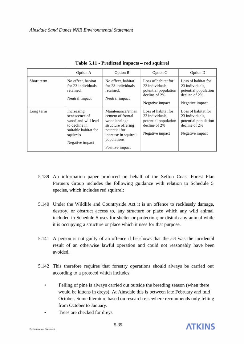
Ainsdale Sand Dunes NNR Environmental Statement
5-35 Environmental Statement
Table 5.11 - Predicted impacts – red squirrel
Option A Option B Option C Option D
Short term No effect, habitat for 23 individuals retained.
Neutral impact
No effect, habitat for 23 individuals retained.
Neutral impact
Loss of habitat for 23 individuals, potential population decline of 2%
Negative impact
Loss of habitat for 23 individuals, potential population decline of 2%
Negative impact
Long term Increasing senescence of woodland will lead to decline in suitable habitat for squirrels
Negative impact
Maintenance/enhancement of frontal woodland age structure offering potential for increase in squirrel populations
Positive impact
Loss of habitat for 23 individuals, potential population decline of 2%
Negative impact
Loss of habitat for 23 individuals, potential population decline of 2%
Negative impact
5.139 An information paper produced on behalf of the Sefton Coast Forest Plan Partners Group includes the following guidance with relation to Schedule 5 species, which includes red squirrel:
5.140 Under the Wildlife and Countryside Act it is an offence to recklessly damage, destroy, or obstruct access to, any structure or place which any wild animal included in Schedule 5 uses for shelter or protection; or disturb any animal while it is occupying a structure or place which it uses for that purpose.
5.141 A person is not guilty of an offence if he shows that the act was the incidental result of an otherwise lawful operation and could not reasonably have been avoided.
5.142 This therefore requires that forestry operations should always be carried out according to a protocol which includes:
• Felling of pine is always carried out outside the breeding season (when there would be kittens in dreys). At Ainsdale this is between late February and mid October. Some literature based on research elsewhere recommends only felling from October to January.
• Trees are checked for dreys

Ainsdale Sand Dunes NNR Environmental Statement
5-36 Environmental Statement
• Tree containing likely dreys are not felled where this is possible.
5.143 This protocol should be documented. The individual assessments could also be recorded.
5.144 Taking into care / euthanasia. A person is not guilty of an offence if he shows that the animal is taken into captivity to be tended and is then released. Similarly the person is not guilty of an offence in killing the animal if he shows if it is so severely disabled that there is no chance of recovery. In both instances this should be documented.
Bats
5.145 The baseline in this section presented the results of the bat survey of the frontal woodlands. It concluded that slacks within the area were used for foraging and commuting by pipistrelle bats, which are likely to be roosting in nearby residential properties. It was also noted that some of the trees in the woodland were suitable for use as roosts by tree dependent species such as noctule bats. In addition, historical records from the NNR indicate that noctule bats use open dune habitats on the Reserve for feeding.
5.146 The predicted impacts on bats are presented in the following table:
Table 5.12 - Predicted impacts – bats
Option A Option B Option C Option D
Short term No effect
Neutral impact
Creation of additional flightlines and opportunities for foraging
Positive impact
Loss of some potential roosting locations in trees, flightlines and sheltered foraging habitat
Negative impact
Loss of some potential roosting locations in trees, flightlines and sheltered foraging habitat
Negative impact
Long term No effect
Neutral impact
Creation of additional flightlines and opportunities for foraging
Positive impact
Loss of some potential roosting locations in trees, flightlines and sheltered foraging habitat
Negative impact
Loss of some potential roosting locations in trees, flightlines and sheltered foraging habitat
Negative impact

Ainsdale Sand Dunes NNR Environmental Statement
5-37 Environmental Statement
5.147 An information paper produced on behalf of the Sefton Coast Forest Plan Partners Group includes the following guidance with relation to European Protected species, which includes bats:
5.148 Forestry operations should always be carried out according to a protocol which includes:
• Known bat roosts must only be felled if a hazard to the public and other reasonable methods of making safe are not practicable. A licence may be required. Tree roost sites are very hard to identify, although none are known on the NNR.
• Other safety felling is carried out outside the hibernation season (when there would be dormant bats in roosts) when possible (i.e. do annual tree inspection in September).
• Trees containing likely roost sites are not felled where this is possible. If they must be felled, trees with holes, splits, loose bark, ivy etc that may contain roosts are lowered gently to the ground where possible and safe.
• If bats are found during woodland work English Nature Bat Advice contractor is contacted for specific guidance. Handling must be carried out according to safety guidance (in prep).
5.149 This protocol should be documented. The individual assessments could also be recorded.
Birds
5.150 The results of a recent bird survey of the frontal woodlands within the Consultation Area (Casella 2003) found that 17 species were breeding in the vicinity of the frontal woodlands, but that willow and sea buckthorn scrub supported a grater diversity of birds than the frontal woodlands. Some of the species recorded feature in the North Merseyside Biodiversity Action Plan. As breeding birds are protected under the Wildlife and Countryside Act (1981) (as amended) they should be considered significant at a national scale. Duckels (1995) noted a higher diversity of birds in clearfell areas compared to woodland and scrub habitats, although numbers of tree and scrub nesting species had fallen
5.151 The following table presents the predicted impacts of the four options on birds:

Ainsdale Sand Dunes NNR Environmental Statement
5-38 Environmental Statement
Table 5.13 - Predicted impacts – birds
Option A Option B Option C Option D
Short term No effect
Neutral impact
Increased habitat for scrub/woodland edge nesting birds
Positive impact
Reduction in numbers of woodland and scrub nesting birds, increase in open habitat species. Overall increase in BAP species
Positive imp act
Reduction in numbers of woodland and scrub nesting birds, increase in open habitat species. Overall increase in BAP species
Positive impact
Long term No effect
Neutral impact
Increased habitat for scrub/woodland edge nesting birds
Positive impact
Reduction in numbers of woodland and scrub nesting birds, increase in open habitat species. Overall increase in BAP species
Positive impact
Reduction in numbers of woodland and scrub nesting birds, increase in open habitat species. Overall increase in BAP species
Positive impact
5.152 Removal of woodlands has the potential to negatively impact of breeding woodland birds. As breeding birds occur in the frontal woodlands, no felling activity should take place in the bird breeding season (February to September inclusive), without first checking for the presence of birds. All breeding birds are legally protected from disturbance under the Wildlife and Countryside Act (1981).
Natterjack toads
5.153 The Consultation Area contributes to the Ribble and Alt Estuaries Ramsar Site through the presence of intertidal sand flats and the population of natterjack toads (Bufo calamita) which it supports. Of these features, the presence of natterjack toads and the requirement to maintain their population in favourable status is relevant to this assessment.
5.154 The Consultation Area does support some natterjack toads, but the numbers are relatively low (3s and 4s of spawn strings)

Ainsdale Sand Dunes NNR Environmental Statement
5-39 Environmental Statement
5.155 Monitoring of natterjacks in the Phase 1 and 2 restoration areas indicates that an average density of 5 adult natterjacks per hectare has been achieved between 1998 and 2003. Further restoration of the 44.5ha within the Consultation Area would therefore provide suitable habitat for an additional 223 adults.
5.156 The predicted impacts of the options under consideration on natterjack toad are presented in the following table:
Table 5.14 - Predicted impacts – natterjack toad
Option A Option B Option C Option D
Short term No effect
Neutral impact
No effect
Neutral impact
Increase in population of natterjack toads, additional habitat for up to 223 adults
Positive impact
Increase in population of natterjack toads, additional habitat for up to 223 adults
Positive impact
Long term Habitat loss due to erosion
Negative impact
Habitat loss due to erosion
Negative impact
Increase in population of natterjack toads, additional habitat for up to 223 adults
Positive impact
Increase in population of natterjack toads, additional habitat for up to 223 adults
Positive impact
Great Crested Newt
5.157 The presence of great crested newt on the Reserve represents a feature of international significance. Surveys carried out in 2001 show that this species occurs and breeds within the areas restored under Phases 1 and 2. It has also been recorded within the Consultation Area. However, the information available is insufficient to allow an accurate population estimate to be undertaken. It is considered likely that the clearance of the majority or all of the frontal woodlands will result in an increased availability of breeding and associated terrestrial habitat for this species.
5.158 Potential impacts of the four options under consideration for great crested newt are presented in the following table:

Ainsdale Sand Dunes NNR Environmental Statement
5-40 Environmental Statement
Table 5.15 - Predicted impacts – great crested newt
Option A Option B Option C Option D
Short term No effect
Neutral impact
No effect
Neutral impact
Increased availability of breeding and terrestrial habitat
Positive impact
Increased availability of breeding and terrestrial habitat
Positive impact
Long term Habitat loss due to erosion
Negative impact
Habitat loss due to erosion
Negative impact
Increased availability of breeding and terrestrial habitat
Positive impact
Increased availability of breeding and terrestrial habitat
Positive impact
Sand Lizard
5.159 Sand lizard are of international significance. They have very rarely been recorded from within the Consultation Area. There are no estimates available of current population size.
5.160 Predicted impacts of the four options on sand lizard are presented in the following table:
Table 5.16 - Predicted impacts – sand lizard
Option A Option B Option C Option D
Short term No effect
Neutral impact
No effect
Neutral impact
Increased availability of suitable habitat
Positive impact
Increased availability of suitable habitat
Positive impact
Long term Habitat loss due to erosion
Negative impact
Habitat loss due to erosion
Negative impact
Increased availability of suitable habitat
Positive impact
Increased availability of suitable habitat
Positive impact
Vernal colletes mining bee
5.161 This species, which is included within the North Merseyside BAP, has been recorded from within the Consultation Area. It breeds in sparsely vegetated or bare south facing slopes with a sandy substrate. Adults feed almost exclusively

Ainsdale Sand Dunes NNR Environmental Statement
5-41 Environmental Statement
on the pollen of creeping willow. The following table presents the predicted impacts of the four options on this species.
Table 5.17 – Prediction of impacts – vernal mining bee
Option A Option B Option C Option D
Short term No effect
Neutral impact
No effect
Neutral impact
Increased habitat available for this species
Positive impact
Increased habitat available for this species
Positive impact
Long term Loss of habitat through erosion
Negative impact
Loss of habitat through erosion
Negative impact
Increased habitat available for this species
Positive impact
Increased habitat available for this species
Positive impact
Hybrid willows
5.162 Rare hybrid willows have been recorded around slack 13 in the Consultation Area. There locations have been recorded. The following table present the predicted impacts of the options under consideration on the rare willow hybrids.
Table 5.18 – Prediction of impacts – hybrid willows
Option A Option B Option C Option D
Short term No effect
Neutral impact
No effect
Neutral impact
Retention of willows around slack 13 as part of the scrub component of this option
Neutral impact
Potential loss of willows as part of scrub removal
Negative impact
Long term No effect
Neutral impact
No effect
Neutral impact
Retention of willows around slack 13 as part of the scrub component of this option
Neutral impact
Potential loss of willows as part of scrub removal
Negative impact
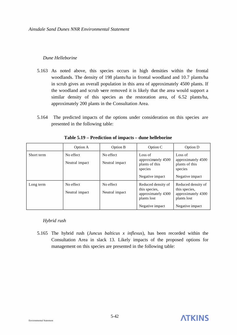
Ainsdale Sand Dunes NNR Environmental Statement
5-42 Environmental Statement
Dune Helleborine
5.163 As noted above, this species occurs in high densities within the frontal woodlands. The density of 198 plants/ha in frontal woodland and 10.7 plants/ha in scrub gives an overall population in this area of approximately 4500 plants. If the woodland and scrub were removed it is likely that the area would support a similar density of this species as the restoration area, of 6.52 plants/ha, approximately 200 plants in the Consultation Area.
5.164 The predicted impacts of the options under consideration on this species are presented in the following table:
Table 5.19 – Prediction of impacts – dune helleborine
Option A Option B Option C Option D
Short term No effect
Neutral impact
No effect
Neutral impact
Loss of approximately 4500 plants of this species
Negative impact
Loss of approximately 4500 plants of this species
Negative impact
Long term No effect
Neutral impact
No effect
Neutral impact
Reduced density of this species, approximately 4300 plants lost
Negative impact
Reduced density of this species, approximately 4300 plants lost
Negative impact
Hybrid rush
5.165 The hybrid rush (Juncus balticus x inflexus), has been recorded within the Consultation Area in slack 13. Likely impacts of the proposed options for management on this species are presented in the following table:

Ainsdale Sand Dunes NNR Environmental Statement
5-43 Environmental Statement
Table 5.20 – Prediction of impacts – hybrid rush
Option A Option B Option C Option D
Short term No effect
Neutral impact
No effect
Neutral impact
Proposals will not impact on slack vegetation
Neutral impact
Proposals will not impact on slack vegetation
Neutral impact
Long term No effect
Neutral impact
No effect
Neutral impact
Proposals will not impact on slack vegetation
Neutral impact
Proposals will not impact on slack vegetation
Neutral impact
SIGNIFICANT IMPACTS AND MITIGATION
Impact significance
5.166 Having evaluated each feature and assessed the likely impacts of each of the four options on them, the next stage is to consider the significance of each impact.
5.167 The following matrix relating the degree of impact against the evaluated level of importance of each feature has been used to derive the significance of each impact.
Table 5.21 – Significance matrix
District Regional National International
Major negative Moderate negative Moderate to High negative
High negative Critical negative
Negative Minor negative Moderate negative Moderate negative High negative
Neutral No impact – not significant
Positive Minor positive Moderate positive Moderate positive High positive
Major positive Moderate positive Moderate to High positive
High positive Critical positive
5.168 By applying the significances established in the above matrix, the following tables of significance for the short and long term impacts are derived. It should be

Ainsdale Sand Dunes NNR Environmental Statement
5-44 Environmental Statement
noted that this represents the significance of the predicted impacts before any mitigation measures have been formulated.
Table 5.22 – Table of significance – short term
Feature Option A Option B Option C Option D
Pine woodland Not significant Minor positive Minor negative Minor negative
Shifting dunes with marram
Not significant Not significant High positive High positive
Fixed dunes with herbaceous vegetation
Not significant Not significant High positive High positive
Humid dune slack Not significant Not significant High positive High positive
Red squirrel Not significant Not significant Moderate negative Moderate negative
Bats Not significant High positive High negative High negative
Birds Not significant Moderate positive Moderate positive Moderate positive
Natterjack toad Not significant Not significant High positive High positive
Great crested newt Not significant Not significant High positive High positive
Sand lizard Not significant Not significant High positive High positive
Vernal mining bee Not significant Not significant Minor positive Minor positive
Hybrid willows Not significant Not significant Not significant Minor negative
Dune helleborine Not significant Not significant Moderate negative Moderate negative
Hybrid rush Not significant Not significant Not significant Not significant
Table 5.23 – Table of significance – long term
Feature Option A Option B Option C Option D
Pine woodland Minor negative Minor positive Minor negative Minor negative
Shifting dunes with marram
Not significant Not significant Critical positive Critical positive
Fixed dunes with herbaceous vegetation
Critical negative Critical negative Critical positive Critical positive
Humid dune slack Not significant Not significant Critical positive Critical positive
Red squirrel Moderate negative Moderate positive Moderate negative Moderate negative
Bats Not significant High positive High negative High negative
Birds Not significant Moderate positive Moderate positive Moderate positive

Ainsdale Sand Dunes NNR Environmental Statement
5-45 Environmental Statement
Natterjack toad High negative High negative High positive High positive
Great crested newt High negative High negative High positive High positive
Sand lizard High negative High negative High positive High positive
Vernal mining bee Minor negative Minor negative Minor positive Minor positive
Hybrid willows Not significant Not significant Not significant Minor negative
Dune helleborine Not significant Not significant Moderate negative Moderate negative
Hybrid rush Not significant Not significant Not significant Not significant
Mitigation
5.169 The tables of significances in the above section represent impacts which may arise from the four options prior to mitigation. The following section presents means by which significant negative impacts on each feature may be reduced, and presents a table of residual impacts i.e. those impacts which remain following the successful implementation of the recommended mitigation measures.
Pine Woodland
5.170 Option A has a minor negative impact on the frontal pine woodlands in the long term, as the habitat deteriorates through absence of management and the effects of coastal erosion. These impacts cannot be mitigated under this option, but Option B represents management of the frontal woodlands to enhance this habitat type over time and represents a minor positive impact over the short and long term.
5.171 Options C and D involve the removal of the majority and all of the frontal pinewoods within the Consultation Area respectively. The groups and individual trees retained under option C do not constitute woodland habitat, so the effects of both options are considered to be the same. Both options have a minor negative impact in the short- long term on the overall pine woodland resource along the Sefton Coast. These losses cannot be compensated for through replanting on the cSAC as such action would detrimentally affect habitats and features of international importance. Opportunities for planting or other woodland enhancement in the wider countryside should be sought, provided such areas do not aid the spread of grey squirrels or damage existing habitats of conservation importance. Due to the uncertainty of finding suitable alternative locations for tree planting, the impacts of pine woodland removal under these options will remain as residual impacts in this assessment.

Ainsdale Sand Dunes NNR Environmental Statement
5-46 Environmental Statement
Sand dune habitats
5.172 Loss of sand dune habitat will occur in the long term due to ongoing coastal erosion. This will have a negative effect, particularly on the fixed dune with herbaceous vegetation habitat, which will be destroyed under Options A and B. These losses cannot be mitigated.
Red squirrel
5.173 In the long term, Option A will have a moderate negative impact on the red squirrel populations of the frontal woodlands, as the uniform age structure and ongoing senescence will result in a decline in available food resource for this species. This decline cannot be mitigated under this option.
5.174 Options C and D will have moderate negative impact on the red squirrel population, as the loss of habitat for up to 23 individuals will occur. This represents approximately 2% of the Sefton Coast population, which will remain viable in the long term.
5.175 The provision of supplementary feeding in the rear woodlands as mitigation is not considered appropriate, due to the fact that it may encourage invasion by grey squirrels and enhance the possibility of disease transmission. Opportunities for disease transmission would also be increased if a translocation scheme were to be implemented.
5.176 As a responsible approach to management on the Reserve, the rear woodlands are being managed in line with the Sefton Coast Woodlands Forest Plan. In particular, management seeks to maintain a continuing pine cone supply which is a chief food source for the red squirrel. The planting of additional conifer species, in particular Scots pine, in the rear woodlands should be considered as essential to enhance cone production. Further thinning operations (of the rear woodlands) should target relatively small habitat units, widely spread throughout the site rather than blanket application over large areas.
5.177 This represents some mitigation in advance of the removal of the frontal woodlands. The development of additional food sources in the rear woodlands over time would increase the carrying capacity of the rear woodlands for red squirrel and would in the long term be likely to lead to an increase in population numbers in these areas, resulting in an overall neutral impact on this species in

Ainsdale Sand Dunes NNR Environmental Statement
5-47 Environmental Statement
the long term. This mitigation also applies to the senescence of the frontal woodland under Option A.
5.178 The guidance on protected species and woodland work, particularly in relation to timing of any woodland removal under Options C or D as described in 5.135-5.140 should be adopted with relation to red squirrel.
5.179 Annual monitoring of the red squirrel population in the rear woodlands should be undertaken to assess the effects of rear woodland management activities on the density of this species.
Bats
5.180 Options C and D both have significant negative impacts on the bat populations of the frontal woodlands, due to potential losses of roosts and foraging habitat as a result of tree removal.
5.181 The mitigation proposals for bats comprise the following elements (English Nature, 2004):
• avoidance of deliberate killing, injury or disturbance – taking all reasonable steps to ensure works do not harm individuals by altering working methods or timing to avoid bats. The seasonal occupation of most roosts provides good opportunities for this;
• roost creation, restoration or enhancement – to provide appropriate replacements for roosts to be lost or damaged;
• long-term habitat management and maintenance – to ensure the population will persist;
• post-development population monitoring – to assess the success of the scheme and to inform management or remedial operations.
5.182 In the first instance, a summer bat survey of the frontal woodlands should be carried out in order to determine the species and numbers of bats present within the Consultation Area, so that an appropriate number and style of replacement artificial roosts can be constructed in the rear woodlands.

Ainsdale Sand Dunes NNR Environmental Statement
5-48 Environmental Statement
5.183 Bat populations within the Reserve should be maintained or increased through the installation of specific bat houses or bat boxes in the rear woodland areas. This installation should be carried out well in advance of any tree removal, to give bats the opportunity to find new roost locations. An excess of roosting structures should be installed, compared to the existing roosting opportunities in the frontal woodlands. Careful selection of the type of structure should be made, in association with a more detailed examination of the species using the Reserve, so that the artificial roost used favours the species present and that it matches the type of roost it is to replace.
5.184 It is unlikely that it will be possible to determine with certainty whether roosts are breeding or hibernation sites, as many of the trees with holes in the Consultation Area are likely to be unsafe to climb. Felling should therefore be timed to avoid the most likely periods of bat usage. Prior to any works, an experienced bat worker should survey the area to be felled and identify any trees which have potential to support bat roosts. Felling of likely roost trees should be timed to take place in September. The alder trees to the south of the Consultation Area should be retained, as surveys have already indicated that they have high potential for roosting.
5.185 A licensed bat worker should be in attendance during felling operations of likely roost trees, in order to check each tree as it is felled and before they are cut up on the ground, which is when most bats are inadvertently killed.
5.186 With regard to bats, forestry operations should always be carried out according to the protocol included in the guidance on protected species and woodland work, as described in paragraph 5.144.
5.187 Adjacent to the rear woodlands, a diverse woodland edge habitat should be created, including young trees and scrub, this will enhance the area for foraging, and will contribute to the replacement of habitat lost within the Consultation Area. The ongoing management of the rear woodlands should also aim to provide sheltered, but open areas within the woodlands which would also provide suitable additional foraging habitat for bats, to replace that being lost through woodland removal.
5.188 Annual monitoring of the replacement roosts and foraging areas should be undertaken to determine species and densities of bats present. Results of the monitoring activities should be used to determine the success of the mitigation

Ainsdale Sand Dunes NNR Environmental Statement
5-49 Environmental Statement
measures undertaken and inform any additional mitigation activity which may be necessary.
5.189 Implementation of these measures should result in the maintenance of the existing bat populations on the Reserve, resulting in a neutral impact.
Birds
5.190 Although the removal of frontal woodlands under Options C and D will not adversely affect the overall bird interest of the area, as woodland and scrub species will be replaced by those typical of open habitats, it will lead to a decline in available habitat for tree and scrub nesting species. This negative impact can be mitigated through the installation of nesting boxes in the rear woodlands to provide alternative nesting sites for a variety of common woodland birds. In addition, retention and management of hawthorn scrub areas along the margin of the rear woodlands is recommended. This habitat type is favoured for nesting by chaffinch and other species. The leaders of the scrub should be pruned out, in order to create a ‘cradle’ of regrowth.
5.191 In addition to the provision of nest boxes in the rear woodlands, nesting bundles should also be installed, these are attractive to song thrush and other species which nest off the ground but do not use nest boxes. They comprise a bundle of vegetation, made into a u shape and tied to a tree trunk.
5.192 Nesting birds are protected under the Wildlife and Countryside Act 1981 (as amended), therefore woodland and scrub removal should take place outside of the bird breeding season, March to August inclusive.
5.193 Monitoring of the nest boxes and other measures should be undertaken to determine numbers and species of birds using the mitigation measures.
Natterjack toad
5.194 In the long term there will be negative impacts on this species under Options A and B. This is due to ongoing habitat loss within the Consultation Area as a result of coastal erosion. This impact cannot be mitigated.

Ainsdale Sand Dunes NNR Environmental Statement
5-50 Environmental Statement
Great crested newt
5.195 Coastal erosion will lead to the loss of suitable habitat for this species under Options A and B, representing a negative impact. This cannot be mitigated under these options.
Sand lizard
5.196 Loss of suitable habitat for this species within the Consultation Area will occur as a result of coastal erosion. This represents a negative impact under Options A and B, as it cannot be mitigated.
Vernal mining bee
5.197 Loss of suitable breeding habitat is likely to occur under Options A and B. This cannot be mitigated.
Hybrid willows
5.198 Removal of all the scrub and trees in the Consultation Area would result in the loss of the hybrid willows around Slack 13. The locations of these willows are known, therefore, prior to any felling or clearance taking place these willows should be clearly marked using tree marker paint and avoided by the clearance works.
5.199 Retention of these species will result in a neutral impact.
Dune helleborine
5.200 Removal of the frontal woodlands and scrub under Options C and D is likely to result in a reduction in numbers of this species present in the Consultation Area, to densities more typical of the open dune habitats within the Phase 1 and 2 clearfell areas.
5.201 There are no measures which can be implemented to mitigate the decline of this species in the Consultation Area, as the most suitable habitat will be lost.

Ainsdale Sand Dunes NNR Environmental Statement
5-51 Environmental Statement
Hybrid rush
5.202 No impacts on hybrid rushes are predicted under any of the options under consideration. However to avoid inadvertent damage, it is recommended that contractors are prohibited from entering slack areas with machinery, to prevent mechanical damage.
Residual impacts
5.203 The following tables present the residual impacts (impacts remaining following the implementation of mitigation measures) of the Options under consideration in the short and long term.
Table 5.24 – Residual impacts – short term
Feature Option A Option B Option C Option D
Pine woodland Not significant Minor positive Minor negative Minor negative
Shifting dunes with marram
Not significant Not significant High positive High positive
Fixed dunes with herbaceous vegetation
Not significant Not significant High positive High positive
Humid dune slack Not significant Not significant High positive High positive
Red squirrel Not significant Not significant Moderate negative Moderate negative
Bats Not significant High positive Not significant Not significant
Birds Not significant Moderate positive Moderate positive Moderate positive
Natterjack toad Not significant Not significant High positive High positive
Great crested newt Not significant Not significant High positive High positive
Sand lizard Not significant Not significant High positive High positive
Hybrid willows Not significant Not significant Not significant Not significant
Dune helleborine Not significant Not significant Moderate negative Moderate negative
Hybrid rush Not significant Not significant Not significant Not significant

Ainsdale Sand Dunes NNR Environmental Statement
5-52 Environmental Statement
Table 5.25 – Residual impacts – long term
Feature Option A Option B Option C Option D
Pine woodland Minor negative Minor positive Minor negative Minor negative
Shifting dunes with marram
Not significant Not significant Critical positive Critical positive
Fixed dunes with herbaceous vegetation
Critical negative Critical negative Critical positive Critical positive
Humid dune slack Not significant Not significant Critical positive Critical positive
Red squirrel Not significant Moderate positive Not significant Not significant
Bats Not significant High positive Not significant Not significant
Birds Not significant Moderate positive Moderate positive Moderate positive
Natterjack toad High negative High negative High positive High positive
Great crested newt High negative High negative High positive High positive
Sand lizard High negative High negative High positive High positive
Hybrid willows Not significant Not significant Not significant Not significant
Dune helleborine Not significant Not significant Moderate negative Moderate negative
Hybrid rush Not significant Not significant Not significant Not significant

Ainsdale Sand Dunes NNR Environmental Statement
6-1 Environmental Statement
6. LANDSCAPE
INTRODUCTION
6.1 This section is derived directly from information contained within, and contains a summary of, a landscape assessment of dune restoration proposals commissioned by English Nature from Cass Associates. Their Final Report ‘Landscape Statement – Dune Restoration Project’ dated May 2003 (the ‘Landscape Statement’) should be read in association with this Environmental Statement.
BASELINE
6.2 The description of the landscape character of the Reserve is based upon the Supplementary Planning Guidance Note (SPGN) - Landscape Character Assessment of Sefton (Sefton MBC, 2002) and the Ainsdale Sand Dunes National Nature Reserve Landscape Statement – Dune Restoration Project (Cass Associates, 2003), which are taken as the definitive landscape studies for the Reserve, of which the Consultation Area is a part.
6.3 The Landscape Character Assessment of Sefton (Sefton SPGN) identifies three Local Landscape Character Types which are present within the Reserve. At this level, there is a clear transition away from the coast, from Sandy Foreshore, through Coastal Dunes to Dune Backlands throughout the Reserve. Only one of these types (Coastal Dunes) is currently dominant within the Consultation Area, and is described in the Sefton SPGN (2002) and Landscape Statement (Cass 2003) as quoted below:
6.4 ‘A visually diverse semi-natural landscape characterised by a small scale, undulating topography comprising ridges of mobile and fixed dunes, interspersed with occasional damp hollows. Landcover is dominated by extensive tracts of marram grass with localised areas of blown sand along the seaward side of the dunes. Views from within this landscape are typically short and enclosed by the undulating landform, creating a strong sense of visual containment. This impression is reinforced by the presence of pine plantations along the back of the

Ainsdale Sand Dunes NNR Environmental Statement
6-2 Environmental Statement
dunes, and is in contrast to the wider vistas and glimpses of the sea afforded from the summits of the seaward dunes. Although the dark mass of the pinewoods can appear somewhat incongruous, this impression is often balanced by the intricate nature of the transition between woodland and open dune. This dynamic relationship, which reflects successive phases of planting followed by piecemeal clearance, is indicative of the underlying character of the dune landscape’.
6.5 Key characteristics of this type are described as:
• Small scale undulating topography;
• Intimate, visually contained landscape;
• Wide vistas and glimpses of the sea from dune summits;
• Mobile dunes with areas of blown sand;
• Older fixed dunes dominated by marram grass;
• Occasional damp hollows with shallow pools;
• Localised pinewoods to the rear of the dunes.
6.6 Within the same documents, each Local Landscape Character Type is divided into a number of Land Description Units. The Coastal Dunes type, which is of direct relevance to the Consultation Area, is separated into three Land Description Units (LDU): SD01, SD02 and SD03, defined through variations in landscape elements and distinguishing features as shown in the following table.
Table 6.1 - Coastal Dunes – Land Description Units.
Land Description Unit Distinguishing Features
SD01 Young Dunes
Prominent Landform
Bare Sand
SD02 Old Dunes
Prominent Landform
Dune Vegetation
Ainsdale Sand Dunes NNR Environmental Statement
6-3 Environmental Statement
SD03 Pine Plantations
Dune Vegetation
6.7 At this level of LDU, a gradual transition from SD01 to SD02 to SD03 is found only within the north eastern extents of the Reserve. Within the Consultation Area, coastal erosion has resulted in the restriction in extent of Unit SD01, and absence of SD02, resulting in abrupt and limited transitions between the Sandy Foreshore and the Coastal Dunes landscape character types.
6.8 The Landscape Statement (Cass 2003) concludes that the overall landscape condition of the Reserve, including the Consultation Area, is declining/poor, due to the ongoing impacts upon landscape characteristics resulting from:
• the eroding coastline producing abrupt transitions between character areas;
• scrub encroachment displacing characteristic marram grass and dune slack vegetation;
• the skewed age profile and condition of pinewood plantations;
• the remaining tree stumps and limited vegetation establishment following the Phase 1 and 2 felling programmes (now removed).
6.9 As the predicted coastline for 2050 will be substantially further inland than its present position, it is anticipated that the declining landscape condition of the Consultation Area will deteriorate further as the SD01 Unit moves further into the SD03 Unit.
LANDSCAPE OBJECTIVES
6.10 The following summary of published landscape policies and objectives defines the context for landscape proposals and is extracted from the Landscape Statement (Cass 2003), which should be examined for further detail and explanation.

Ainsdale Sand Dunes NNR Environmental Statement
6-4 Environmental Statement
‘Summary of Landscape Objectives
6.11 The Character Map of England defines the Sefton Coast as a distinct landscape of national significance, with sand dunes and conifer plantations as prominent landscape features within a flat landscape. The need to create an acceptable and sustainable balance between conifer plantations and the open dune system is recognised.
6.12 The Landscape Character Assessment of Sefton identifies more detailed areas of distinct character with the Sefton Coast. A sequence of landscape types is established, from sandy foreshore, through coastal dunes to dune backland. Within the coastal dune landscape, key characteristics progress from young dunes, to old dunes to dune vegetation and pine plantation. The incongruous appearance of the pinewoods is balanced by the intricate nature of the transition between woodland and open dune. Localised scrub encroachment and forestry are identified as key landscape impacts.
6.13 The Mersey Forest Plan supports both the conservation and protection of open dunes and the management and replacement of ageing pine woodlands in a phased programme. Opportunities for new sites for planting around Formby, as landward expansion at Ainsdale is restricted by the Woodvale Aerodrome.
6.14 The Sefton UDP establishes the Sefton Coastal Planning Zone, within which a limited felling programme is accepted. The strategic importance of the coastal path and associated links is defined, as is the cultural, aesthetic and amenity value of the coastal area.
6.15 The Sefton Coast Management Plan has been developed in recognition of the international nature conservation significance of the sand dune system. The coast is defined as an area of prime biodiversity, within which the conservation value of dunes will be enhanced, working with natural processes. Conservation of open dunes is and will continue to be given priority on all duneland nature reserves to protect species. The dunes are recognised as overstabilised, with scrub and vegetation control required to maintain habitat species and diversity. Woodland management will need to pay particular attention to the requirements of the red squirrel population.
6.16 The character and integrity of the coastal landscape is to be conserved, enhancing and protecting landscape features of special historic value and character. The need for an appropriate balance between woodland areas and the

Ainsdale Sand Dunes NNR Environmental Statement
6-5 Environmental Statement
conservation of open dunes is defined, through enhancing landward woodlands and increasing their value for nature conservation and amenity. Whilst major removal of woodlands is resisted, where there is an overriding nature conservation argument, the interests of nature conservation should take precedence.
6.17 Continued coastal erosion is forcing the tree line back, which will result in some of the more seaward plantations being abandoned. Compensatory planting will be required, with the Forestry Authority recommending inland planting to alleviate competing conservation, amenity and recreational coastal pressures. Again, the impact on the red squirrel population will need to be considered.
6.18 Opportunities for quiet recreation, education and tourist activities consistent with the natural character and conservation value of the coast are supported. The Sefton Coast Footpath, a strategic regional link, passes through the Ainsdale Sand Dunes NNR.
6.19 Shoreline management is to be based on an understanding of coastal processes. Attempts to mitigate the effects of accreting and eroding foreshores have largely been abandoned.
6.20 The Sefton Coast Woodlands Working Plan sets out a 20 year strategy for woodland on the Sefton Coast, co-ordinating the objectives and activities of the 27 landowners. The coastal woodland is separated into management compartments, with the frontal woodlands within the Ainsdale Sand Dunes NNR excluded to allow for a wider discussion regarding their future.
6.21 The Plan seeks to ensure that the woodlands are managed to conserve historic elements, retain the viability of habitats, provide economic opportunities and allow for quiet recreation. A variety of structure, a normal age profile, a focus on pine as a food source, restricting broadleaf species to 10%, and the creation of habitats for Priority Species within the woodland structure are specific objectives.
6.22 The Ainsdale Management Plan identifies key features of nature conservation value, and sets out appropriate management objectives. The most diverse areas of the NNR are the open dunes, and it is within these areas that key priority species are supported. The rationale for the Dune Restoration Project is provided, being to increase areas of open dune in response to coastal erosion and increased scrub encroachment.

Ainsdale Sand Dunes NNR Environmental Statement
6-6 Environmental Statement
6.23 The Review of Dune Restoration provided an independent review of Phase 1 and 2 of the project by the Centre for Marine and Coastal Studies (CMACS), University of Liverpool. The review explored three potential options for future management, including Option 1, maintaining the existing frontal pinewoods in their present condition with woodland management for rear woodlands, and Option 2, clear felling of Blocks 3 (2001) and 4 (2004). A third option was supported, promoting the removal of Phase 3 and the north-west parts only of Phase 4, together with supporting landscape mitigation measures.
6.24 The above review of national, regional and local landscape context is summarised in Table 3: Landscape Objectives. This establishes key resources influencing the development of our landscape strategy (Landscape, Biological Diversity and Recreation), sets out key objectives and provides key indicators that may be applied in assessing whether objectives are being met.’
Landscape restoration/enhancement strategies
6.25 As stated above, it is anticipated that the landscape condition of the Consultation Area will continue to deteriorate with coastal retreat. However, it is anticipated that the existing clearfell areas in the remainder of the Reserve, which were created during Phases 1 and 2 of the dune restoration project, will continue to re-establish and improve as open dunes with appropriate management.
6.26 In the Design Guidance Section of the Landscape Statement, as a response to the above Policies and Objectives, Cass include a series of complementary proposals for the seaward sections of the reserve aimed at restoring and enhancing the landscape character and its visual structure, and improving access and recreation, without unduly compromising Nature Conservation objectives. These incorporate tree and scrub removal within the Consultation Area as in Options C and D of the proposed restoration strategies, although other elements could be incorporated to some extent whichever option is finally implemented. Option descriptions are included in Section 3 of this Statement. The Guidance comprises the following proposals, extracted from Section 4 of the Landscape Statement :
‘LandscapeCharacter
• removal of frontal pinewoods and scrub;
• retention and creation of undulating topography;
Ainsdale Sand Dunes NNR Environmental Statement
6-7 Environmental Statement
• encouragement of mobile dunes, with blown sand and marram grass;
• establishment of fixed dunes, with dune vegetation;
• creation and management of damp hollows and shallow pools;
• creation and management of a frontal mixed woodland/scrub belt;
• creation of a dynamic woodland edge, allowing open dunes and mixed woodland scrub to penetrate into the rear woodland areas. Extensions into the rear woodland areas may build upon existing features including firebreaks, existing broadleaf/scrub compartments, areas of lower ground/slacks and service/access routes.
Access and Recreation
• woodland footpaths to the northern pine woodland areas;
• woodland edge footpaths to the seaward edges of the rear woodland;
• open dune footpaths, limited to reduce intrusion into ecologically sensitive locations, to allow closer links with the dune landscape and characteristics.
Visual Structure
• phasing removal, allowing those tree groups most prominent from key viewing points to be retained until final restoration phases. This may involve retaining windfirm tree lines to the frontal woodlands until final phases;
• implementing dune restoration in response to the rate of erosion. This approach may prevent extensive open areas being created in advance of coastline movements, although some sand movement will be encouraged;
• retaining trees/tree groups as permanent landscape features, particularly those prominent from key access routes;
• removing tree stumps and target vegetation restoration works to those areas prominent from key access routes;

Ainsdale Sand Dunes NNR Environmental Statement
6-8 Environmental Statement
• restoring and enhancing key landscape characteristics, including dune topography and damp hollows, to demonstrate the benefits of the restoration works;
• provision of interpretation material to explain the rationale for the works;
• developing access routes passing through the transitional landscape from dune backlands to sandy foreshore, allowing a diverse range of landscapes to be explored.’
LANDSCAPE EFFECTS AND MITIGATION
6.27 The landscape consequences of the four management options are assessed with respect to the above Policies and Objectives published at National, Regional and Local level, defined as follows:
• National – in the context of the United Kingdom;
• Regional – within Sefton MBC, West Lancs and Merseyside;
• Local – within the context of the NNR
6.28 Each effect is assessed in both the short-term and long-term:
• Short-term - Effects for up to 10 years
• Long-term - Effects in excess of 10 years
6.29 The predominant ‘horizon’ for assessment of the effects of any management is affected by the position of the future predicted coastline. In this case, because of the extended time required for natural regeneration of dune habitat, the assessment is made against the position in 2050 and therefore ‘long-term’ effects take precedence.
Comparison of Options against Landscape-related Policy and Objectives
6.30 The following table assesses the compliance of the four options with the range of Policy and Objectives which are summarised earlier in this section and detailed in the Landscape Statement.

Ainsdale Sand Dunes NNR Environmental Statement
6-9 Environmental Statement
Table 6.2 - Comparison of Options against Landscape-related Policy and Objectives
Landscape Policy/Objective Option A –
Do Minimum Option B – Management
Option C – Partial Clear-fell
Option D – Clear-fell
Short-
term Long-term
Short-term
Long-term
Short-term
Long-term
Short-term
Long-term
National – Character of England Map (1996) • an acceptable and sustainable balance between coniferous woodland and
open dune systems along coastal sections X X X X X ü X ü • enhancement through woodland planting and increased access for
recreational use X X ü ü X X X X • integration of recreation and nature conservation on the sand dune system X X X X ü ü ü ü
Regional – Landscape Character Assessment of Sefton (1999) • transitional landscape through young dunes to old dunes to dune
vegetation to pine plantation X X X X X ü X ü • intricate nature of the transition between woodland and open dune X X X ü X ü X ü • localized scrub encroachment and forestry ü ü ü X X ü X ü
Regional – Mersey Forest Plan – (2001) • Conserve and protect open dune system, manage and replace ageing pine
woodlands in a phased programme (S1) X X ü ü X X X X • Seek new sites for planting around the fringes of Formby (S1) X X X X X X X X

Ainsdale Sand Dunes NNR Environmental Statement
6-10 Environmental Statement
Landscape Policy/Objective Option A –
Do Minimum Option B – Management
Option C – 85% Clear-fell
Option D – 100% Clear-fell
Regional – Sefton UDP (1995) – (under revision –See draft SPGN ‘Landscape Character Assessment of Sefton (2002))
• Conserve small-scale intimate and undulating topography and visual unity of the dune landscape ü X ü X X ü X ü
• Conserve sections of the existing pinewood plantations for purposes of habitat and amenity management X X ü ü X X X X
• Selective removal of pinewood areas with restoration of open dune and associated vegetation to agreed selected areas X X X X ü ü X X
• Conserve historical routes ….and enhance interpretation…(long and linear routes to be avoided) ü ü ü ü ü ü ü ü
• Conserve the rich variety of dune habitats X X X X ü ü ü ü • Conserve, or restore where feasible, additional areas of open dune
systems X X X X ü ü ü ü Regional - Sefton Coast Management Plan
• to ensure that the integrity and natural value of the dune system and estuaries is protected in perpetuity X X X X ü ü ü ü
• to conserve, protect and enhance the natural beauty……. X X X X X ü X ü • ……and biodiversity of the coast….(dune habitats/species, squirrels,
bats) ü X ü ü ü ü ü ü • conservation of geological and geomorphological processes…….and a
‘dynamic’ approach to coastal management X X X X ü ü ü ü • to conserve the character and integrity of the present-day coastal
landscape by direct action….. X X ü X X ü X ü • …..and to identify, enhance and protect landscapes and landscape
features of special histor ic value and character X X ü X ü ü ü ü
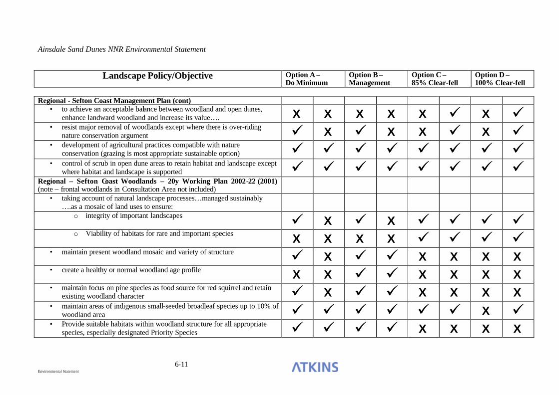
Ainsdale Sand Dunes NNR Environmental Statement
6-11 Environmental Statement
Landscape Policy/Objective Option A –
Do Minimum Option B – Management
Option C – 85% Clear-fell
Option D – 100% Clear-fell
Regional - Sefton Coast Management Plan (cont)
• to achieve an acceptable balance between woodland and open dunes, enhance landward woodland and increase its value…. X X X X X ü X ü
• resist major removal of woodlands except where there is over-riding nature conservation argument ü X ü X X ü X ü
• development of agricultural practices compatible with nature conservation (grazing is most appropriate sustainable option) ü ü ü ü ü ü ü ü
• control of scrub in open dune areas to retain habitat and landscape except where habitat and landscape is supported ü ü ü ü ü ü ü ü
Regional – Sefton Coast Woodlands – 20y Working Plan 2002-22 (2001) (note – frontal woodlands in Consultation Area not included)
• taking account of natural landscape processes…managed sustainably ….as a mosaic of land uses to ensure:
o integrity of important landscapes ü X ü X ü ü ü ü o Viability of habitats for rare and important species X X X X ü ü ü ü
• maintain present woodland mosaic and variety of structure ü X ü ü X X X X • create a healthy or normal woodland age profile X X ü ü X X X X • maintain focus on pine species as food source for red squirrel and retain
existing woodland character ü X ü ü X X X X • maintain areas of indigenous small-seeded broadleaf species up to 10% of
woodland area ü ü ü ü ü ü X ü • Provide suitable habitats within woodland structure for all appropriate
species, especially designated Priority Species ü ü ü ü X X X X

Ainsdale Sand Dunes NNR Environmental Statement
6-12 Environmental Statement
Landscape Policy/Objective Option A –
Do Minimum Option B – Management
Option C – 85% Clear-fell
Option D – 100% Clear-fell
Local – Ainsdale Sand Dunes NNR Management Plan (2003-2004)
• Enable the total area of yellow dune to be maintained or increased, maintaining successional stages… X X X X X ü X ü
• Increase the total area of fixed dune and associated sub-habitats… X X X X X ü X ü • Progressively create a more diverse (rear) woodland habitat…with
improved structure…. ü ü ü ü ü ü ü ü • Develop the landscape value of the NNR commensurate with nature
conservation objectives X X X X X ü X ü Compliance Score 13 7 19 14 15 27 13 26
Notes:-
• Relevant landscape policy and objectives extracted from Landscape Statement – Dune Restoration Project – Final report May 2003 (Cass Associates) • Sefton UDP Policy and Objectives reflected as current revision of the Landscape Character Assessment of Sefton SPGN (Draft Dec 2002) which supersedes
the current UDP.
Key X Policy/objective not supported
ü. Policy/objective supported

Ainsdale Sand Dunes NNR Environmental Statement
6-13 Environmental Statement
6.31 The Landscape Statement (Cass 2003) was provided in response to the following specific brief from English Nature:-
‘To provide an advice package on how the removal of pine plantation to restore sand dune habitats can be carried out in a way that incorporates landscape as a major objective.’
6.32 The Strategy within the Statement recommends actions generally in line with management Option C. It therefore follows that, in landscape terms, the other options involving removal of pine plantation (Option D and, to some extent, Option B) are less favourable. Option A can be seen from the previous table to comply substantially less with landscape objectives than Option B, especially in the longer term. Options A and B have better compliance in the short-term than the long-term, but Options C and D appear to have the best long-term compliance with landscape-related policy and objectives.
6.33 The following table has been extracted from the Landscape Statement (Table 5) and addresses the ‘opportunity’ (mitigation) possible for each landscape ‘impact/constraint’ (effect) for the recommended landscape strategy.
FACTOR IMPACT / CONSTRAINT PRINCIPLE / OPPORTUNITY
• Land ownership restricts wider design proposals / strategy
• To relate design issues to adjacent land uses and woodland locations
• To work with partners to develops strategic approach
Ownership Boundary
• Fences are visually intrusion • Position in hollows
• Keep close to woodland edge
• Change direction at regular intervals
• Avoid right angles
• Need to fell over short period so reducing range of felling ages
• To diversify age class by restocking over longer period
Age of Existing Stands
• The forest is all of a similar age
• To increase age variation at restocking
Soils • Poor soils limit species choice • Soils allow development of ‘classic’ dune vegetation

Ainsdale Sand Dunes NNR Environmental Statement
6-14 Environmental Statement
• Soils under pinewoods have been affected by litter fall / illumination
• To restore soil profile as appropriate to location
• Few windfirm boundaries other than straight lines of roads and rides, exposed natural regeneration groups and frontal woodland edges
• To create new future coupe boundaries that are windfirm.
• To retain windfirm natural regeneration groups
• Terminal heights are close to each other and occur very soon
• Some natural regeneration groups give a chance to retain some stands
Wind Throw Risk
• Felling boundaries will have to follow windfirm edges which may be geometric
• New windfirm edges can be planned at restocking
Rights of Way
• Existing use may conflict with forest and nature conservation operations
• To re-route and provide interpretation as proposed work proceeds
• Lack of open dune • To develop open space
• Lack of transitional woodland • To develop edge habitats
• Poor habitat value in woodland
• Create new open habitat and increase species diversity
Nature Conservation
• Dune slacks under trees / scrub cover and of little ecological benefit
• To open up slack areas and link into dune habitats
• Invasion of scrub into duneland
• To clear back the edge and limit invasive species
• To introduce sustainable scrub management practices
Landform • Topography limits visual influence of landform
• External margins, compartment boundaries, felled areas and shapes of species are prominent visual elements which may be developed to increase visual diversity
• Edges rise in hollows and fall in spurs

Ainsdale Sand Dunes NNR Environmental Statement
6-15 Environmental Statement
• Retreating coastline is creating coastal squeeze
• To create a dynamic landscape character responsive to the changing landscape
• To implement coastal process management techniques
• Existing woodland / scrub vegetation is threatened in the short term by mobile sand / rising ground levels and in the medium term by dune erosion
• To establish vegetation types able to adapt to changing ground conditions
• Eroding / dying woodland and scrub groups have a significant visual impact on the landscape
• Retain woodland / scrub groups likely to remain unaffected
• Remove woodland / scrub groups through a managed strategy which responds to visual concerns
Coastal Erosion
• Mobile sand required for the development of new dunes is trapped / restricted by existing tree / woodland groups
• To allow the free movement of mobile sand through the removal of obstructing tree / scrub groups
• Uniform woodland edge • Follow landform
• Avoid regularity / create curved ragged edges
• Planting methods and layout create angular / geometric edges and species groups which appear artificial in character
• To increase the diversity of edges
• To increase species diversity at edges
Shape
• Conifers appear out of scale in the landscape
• To retain part and redesign to blend better
• Increase diversity of woodland types
Edges • Woodlands are seen as edges • Introduce coupes / open spaces to add interest

Ainsdale Sand Dunes NNR Environmental Statement
6-16 Environmental Statement
• Height of trees and spaces within woodland are dominant
• Regular shaped coupes / spaces are not acceptable
• Open spaces and edges should be curvilinear shapes tapering away from well used viewpoints
• Decrease density of trees from woodland edge towards open space / footpath
• Introduce decreasing sizes of tree groups from woodland edge
• Increase spacing between trees and tree groups as from woodland edge
• Mix species at boundaries
• Little diversity within woodland / scrub groups
• Create a range of types of views
- Panoramic
- Feature
- Focal
- Filtered
• Identify features currently hidden and expose
• Avoid edges parallel to path
• Create an interesting sequence of views
• Emphasis changes in character
• Large fellings may be out of scale and result in significant visual impact
• To improve visual corridors and viewpoints along routes as forest works are implemented
Visual
• Sculptured trees / tree groups are distinctive vision feature
• To retain prominent trees / tree groups to keep sense of maturity in landscape and retain visual interest

Ainsdale Sand Dunes NNR Environmental Statement
6-17 Environmental Statement
• Natural features are scarce • Views and vistas should be created
• Emphasis minor undulation
• Retain / emphasis prominent trees / tree groups
Ainsdale Sand Dunes NNR Environmental Statement
7-1 Environmental Statement
7. PHYSICAL PROCESSES
BASELINE
Soils and Geology
7.1 A geological section taken through the Reserve shows a series of dune sand, unsaturated and saturated, overlaying Downholland silt, boulder clay and the Triassic Keuper series. The layer of Downholland silt beneath the dune sand is impermeable.
7.2 The soils on the Reserve can be divided into 3 main types:
• Sandwich series of shallow calcareous soils are found on the open embryonic and mobile dunes. These skeletal soils have high pH values, poor moisture retention values, are highly calcareous and have very low organic matter content. This means they are very poor substrate for plant growth, and only suitable adapted species, such as marram, can survive. As organic matter increases, conditions become more suitable for a range of species and are characteristic of fixed dunes.
• Greatstone series of waterlogged calcareous soils are present in the dune slack areas, with a thin layer of peat forming on the sand surface as a result of fluctuating water levels. This gives the soil a rusty brown mottled appearance as a result of oxidations of iron content and areas of pale grey where there is reduced iron. Such soils are relatively nutrient rich compared with others in the vicinity, which in combination with higher moisture content provide good conditions for plant growth.
• Organic acidified soils occur under the pine plantation. In this location an organic surface layer of pine needles with very low pH values overlies impoverished acidic sandy horizons. Below this the soil pH value increases to levels more usual in a sand dune environment.

Ainsdale Sand Dunes NNR Environmental Statement
7-2 Environmental Statement
7.3 A soils map of the Reserve is presented in Figure 14.
7.4 A survey of the soils of the Reserve (Purdie, 2002) demonstrated that organic acidified soils in the areas where trees have been removed during Phase 1 and 2 of the dune restoration project were returning to a calcareous condition.
Water and hydrology
Background
7.5 Hydrology has a major influence on the vegetation and species composition within sand dune habitats and also on the formation of dune slacks. Conversely, certain types of vegetation, particularly coniferous forest, may impact on the water table through the interception and re-evaporation of rainfall together with a transpirational lowering of levels contributing to the drying out of dune slacks and the encouragement of scrub encroachment. Interception of rainfall by conifers can account for between 11 and 47% of the total rainfall (Penman 1963). Water table levels in the Ainsdale Sand Dunes NNR have been monitored since the late 1960s when high water table levels were recorded in many of the slacks. However, between 1970 and 1972 water levels fell below ground level in the slacks and concern was raised by the Nature Conservancy Council (NCC) wardens of the potential impact on the flora and fauna. In response to their concern, eleven NCC dipwells were installed and monitored on a monthly basis with a further 3 added in 1991.
7.6 Woodland clearance on the Reserve was carried out in 2 phases, the first completed in 1992, and the second by 1997 (Figure 3). This clearfell programme aimed to restore wetland habitats associated with dune slack environments. Following clearfell, it is known that reduced interception of rainfall by the tree canopy allows more rainfall to reach the soil and the uptake of water through tree roots decreases along with reduced transpiration. Clearfell is, therefore, considered to result in wetter soils and increased water fluxes.
7.7 Gee (1991) monitored 25 dipwells in a matrix prior to and immediately after the first phase of the clearfell. These wells ceased to be monitored by Gee after 1993 but monitoring of the 25 dipwells recommenced in 2000 as part of the Dune Restoration Project, enabling a comparison between pre clearfell and present water levels to be undertaken. Eight of the NCC boreholes located throughout the reserve form the control sites as they are considered to be less affected by the

Ainsdale Sand Dunes NNR Environmental Statement
7-3 Environmental Statement
clearfell operations due to the areas in which they were located. The locations of the NCC boreholes and the clearfell borehole matrix are shown in Figure 15. As part of this EIA, existing unanalysed data from the dune restoration area dipwell network has been analysed to assess any temporal water table changes after felling and any spatial influence of the woodland removal on surrounding water table levels.
Analysis
7.8 Water levels for the control sites and the clearfell experimental boreholes have been analysed for any trends over time. Table 7-1 summarises the “average” water level rises for the period September 1991 to September 2003 and are illustrated in Figures E1 and E2 in Appendix E. Table 7-1 shows that the average water table rise is greater within the clearfell site than the control sites within the boundary of the NNR. These results indicate that there is some rebound in the water levels following the pine removal.
7.9 The identified increase in water levels within the clearfell area occurs against a background of a general groundwater rise along the Sefton Coast independent of management of the Reserve. Within the experimental clearfell borehole matrix of Gee (1991), the dipwells were classed according to 5 types of vegetation cover, ranging from open fixed dunes to coniferous woodland. Similarly, the NCC control boreholes are located in areas of different vegetation type. These different vegetation types are highlighted in Table 7-1 for each of the boreholes. Within the clearfell boreholes, water level rises in those holes originally within the woodland vegetation are higher than those originally part of the open fixed dune system. However, for the control boreholes, the vegetation type does not appear to have any relationship with the water level rise over time. Figure 7-1 compares a typical water level rise in a fixed open dune for a control borehole (BH4) and for a clearfell site (BHd), and illustrates that there is a steeper trend in water level rise within the clearfell site. The higher water levels in the clearfell fixed dunes in comparison to the fixed dune control boreholes indicates that the clearfell of the pinewoods within the Dune Restoration area matrix has had an impact on the water levels in the associated surrounding fixed dunes. Figure 7-2 shows that there is a greater difference in water level within the boreholes originally in coniferous woodland following clearfell. These results show that there is some rebound in the water levels following the pine removal.

Ainsdale Sand Dunes NNR Environmental Statement
7-4 Environmental Statement
Table 7.1 - Water Level Trends (Sep 1991 – Sep 2003)
Control Boreholes (NCC 1972 - present)
Average water level rise (m)
Clearfell Monitoring Boreholes (Gee 1991)
Average water level rise (m)
BH3 0.4 b 0.8 BH4 0.4 c 0.7
BH5 BH5 0.5 d 0.7 BH6 0.5 6e 0.8 BH7 0.3 f 0.3 BH10 0.7 s 0.9 BH11 0.6 t 0.8
BH9 BH9 0.7 w 0.8 BH12 0.5 p p 0.8 BH14 0.5 q q 1.0 BH13 0.5 9v 9v 1.0
x x 0.9
Key g 0.7
h 0.9
i 0.8 The following shading indicates the present vegetation cover for the control sites and the vegetation cover prior to clearfell. j j 0.8
l 0.9 Fixed Dune m 0.9 Deciduous Scrub n 0.8 Coniferous Woodland Edge r 1.0 Coniferous Woodland Frontal o 0.8 Coniferous Woodland Rear k 0.9 Dune Slack u 0.8

Ainsdale Sand Dunes NNR Environmental Statement
7-5 Environmental Statement
Figure 7-1 - Typical trend for Fixed Open Dune from a control b/h (BH4) and a clearfell monitoring b/h (d)
5
5.5
6
6.5
7
7.5
8
8.5
Jun-91 Oct-92 Mar-94 Jul-95 Dec-96 Apr-98 Aug-99 Jan-01 May-02 Oct-03
Water Table (mAOD) BH4
d
Figure 7-2 - Typical trend for Coniferous Woodland from a control b/h (BH14) and a clearfell monitoring b/h (h)
7.5
8
8.5
9
9.5
10
Jun-91 Oct-92 Mar-94 Jul-95 Dec-96 Apr-98 Aug-99 Jan-01 May-02 Oct-03
Water Table (mAOD) BH14
h

Ainsdale Sand Dunes NNR Environmental Statement
7-6 Environmental Statement
7.10 In addition to the analysis of data carried out for this EIA, previous studies have also considered the water table effects of pinewoods on the Reserve. Gee (1991) carried out well readings over a 13 week period which allowed water table contour maps to be drawn. These tentatively showed that the conifer plantations were having an effect on the water table. In an evaluation of the water resources of Southport and Sefton (Entec 1999), it is noted that groundwater levels in the NNR boreholes 3 and 5 have increased relative to borehole 4 by around 0.3m, and stated that this rise was believed to be a response to forest clearing operations permitting enhanced groundwater recharge. Royo (1999) considered the effects of pine removal on a single well (well 5) and noted that following clearfelling the trend was towards wetter conditions, this was tentatively attributed to reduced interception and evapotranspiration from the pinewoods, although there was also a background increase in rainfall following the tree removal which led to a general increase in water table at this time. A further investigation of the relationship between well 5 (in the dune restoration area) and well 9 (pinewood) between 1972-94 (before restoration) and 1996-99 (following restoration) demonstrated an average draw down of 30cm in the continuously wooded area compared to the clearfell area. A letter from John Ingram, a hydrogeologist for the Environment Agency, to English Nature in December 2001 confirmed that clearance of trees would reduce evapotranspiration and allow greater groundwater recharge to occur, thereby allowing groundwater levels to rise.
7.11 The ground water balance of the Reserve was the subject of a PhD study (Clarke, 1980).
7.12 Clarke concluded that on the NNR:
• The water table slopes gently to the sea with an inland peak near the railway line.
• The water table falls gently inland from the railway to the Downholland
Mosses east of the Ainsdale NNR.
• The railway line on the boundary of the reserve is the approximate watershed between the Ground water system of the reserve and the River Alt.
• The water table contour lines run parallel to the coast and Ground water flow
is almost parallel to both Northern and Southern boundaries of the NNR.
• This shows the Ground water system is separate and not subject to external influences on its inland side.

Ainsdale Sand Dunes NNR Environmental Statement
7-7 Environmental Statement
• The water table is subject to large fluctuations in level during the year and from one year to another due to the climate i.e. low levels of effective rainfall. This was clearly demonstrated in the winter of 1976/77 when extremely high rainfall occurred and there was a return to wet conditions after several years of dry weather.
• 1.5 metres is considered the maximum range of the water table level. It was
also noted that evapotranspiration from the pine plantation was a constant factor and would affect the extent of standing water on the reserve.
7.13 The effect that the conifer plantation has on the ground water levels as demonstrated by Clarke (1980) was as fo llows:
• The water table contours bend away from the coastline within the area of the
conifer plantation - the curvature of the water table begins almost directly beneath the boundary between the unforested and the partially forested areas of the Reserve.
• There is a reduction in the water table under the afforested dunes of up to 1
metre below that seen in the open dunes.
• There is also a narrowing of the distance between contours within the frontal woodland when compared to the open dunes to the north demonstrating a steepening of the water table gradient.
• Effective rainfall has a direct effect on the ground water table level. If the
water table levels were only a function of rainfall then the autumn would be the wettest time of year and the spring would be the driest, the reverse is true.
• Interception and evapotranspiration are important factors, especially in the
summer, when comparing the afforested areas and the open dune areas. Trees have large interception capacity and re-evaporation of water occurs in preference to transpiration. The estimated interception loss in the woodland is around 35% and evaporation loss estimated at 30 mm per month in mid-winter, which is 40% greater than for grasses.
Conclusions
7.14 Analysis of the water table fluctuations within the clearfell sites and the surrounding stable dunes has shown that there is evidence for an increase in the water table levels of approximately 0.3m within the former pinewood areas following clearfell. There is also a suggestion that clearfell can have an impact on the water levels in the area immediately surrounding the clearfell site, but the extent of this influence cannot be determined with the existing data.

Ainsdale Sand Dunes NNR Environmental Statement
7-8 Environmental Statement
7.15 The railway line to the east of the Reserve is likely to act as a hydrological cut off to the land further to the east, limiting the effects of tree removal in this direction. The Environment Agency consider that off site flooding is unlikely to occur
Ecological implications
7.16 As dune slacks are generally flat features, changes in water level of a few centimetres or more are highly significant in terms of their ecological effect. As slacks are formed by the wind blowing the sand away until the wet sand near the water table is reached, there is a close relationship between the natural level of the slack floor and the water table. This relationship is sensitive to water table levels, so that an increase in water levels of 0.3m is likely to have significant ecological benefits.
7.17 The following information on the ecological implications of higher water tables and humid dune slacks is derived from a guidance note on the hydrological requirements of habitats and species, produced jointly by the Countryside Council for Wales, English Nature and the Environment Agency.
7.18 Dune slacks are low-lying areas within dune systems that are seasonally flooded. They occur primarily on the larger dune systems in the UK, particularly in the west and north. The range of communities found in humid dune slacks is considerable and dependant on the structure of the dune system, its successional stage, the chemical composition of the dune sand, and the prevailing climatic conditions. Coastal slacks are considered transient features, liable to sea water flooding or to obliteration by the growth of embryo dunes.
7.19 Slacks usually have a free draining shingle base or a damp sand base; the nutrient levels of the soils are normally low with high calcium content. Dune slacks are often rich in plant species, the flora being chiefly composed of marsh plants, a few species are confined to the dune slack habitat.
7.20 Key influences on dune slacks relevant to this assessment are identified in the guidance as follows:
• dune slacks are predominantly fed by rain water. They are characterised by a pattern of pronounced annual water table fluctuations related to the landform of the dune system, climate, and the nature of the underlying sediment;

Ainsdale Sand Dunes NNR Environmental Statement
7-9 Environmental Statement
• the maintenance of suitable hydrological conditions is considered essential to the survival of this habitat type. Variations in the extent and duration of flooding of the dune surface are deemed very important in determining species composition and structure of dune slack vegetation. Such conditions can also influence the breeding of aquatic and amphibious species, including natterjack toad;
• the distribution of a number of species within dune slacks is critically related to the mean water table level. Some dune slack species are adapted to changes in the duration and depth of flooding, with a number noted to migrate up and down a height gradient in dune slacks in response to wet and dry periods;
• the vegetation of wet slacks is considered groundwater dependant. The groundwater table rarely falls more than 1.2m below the soil surface in well developed slacks, with winter flooding from 0.1 to 0.5m in depth;
• the effects of an increase in the average water table level are difficult to predict, it is not possible to separate the ecological effects of an increased nutrient load from an increase in mean groundwater level.
7.21 The predicted increase in average water tables of 0.3m in clearfelled areas would serve to enhance the hydrological condition of wet dune slacks, and also increase the dependant wet slack flora. It would also enhance slacks for use by natterjack toad.
Future work
7.22 Monitoring of water levels throughout the Reserve, including wells in open dune habitats, clearfelled areas and pine woodland should be continued for several years, in order to more clearly identify the hydrological effects of dune restoration activities on the Reserve.
Coastal Processes
Erosion
7.23 The current cycle of erosion occurring along most of the frontal dunes on the Reserve, including the Consultation Area, is due to both natural and man induced marine processes. This is reducing the already narrow yellow (frontal) dune area, particularly at the southern end of the site, and preventing the formation of

Ainsdale Sand Dunes NNR Environmental Statement
7-10 Environmental Statement
embryo dunes and primary slacks (area reduced by around 1.5ha 1996 – 2000). Any reduction in this habitat is undesirable, in particular for species such as sand lizard that have associated key populations. The shifting dunes with marram, dunes with creeping willow, humid dune slack and fixed dune grassland features of the cSAC are being restricted between the retreating coastline and remaining frontal woodlands.
7.24 Recent research indicates that erosion is likely to continue in the near future, but is likely to eventually reduce as a point of equilibrium is reached (Halcrow, 2002). A 50 year predicted retreat line has been predicted by Sefton MBC (Appendix F), representing an estimate based on an extrapolation of current trends together with an expert assessment of coastal behaviour, details of how this line was arrived at, together with background information and details of the processes operating along this section of the coast are presented in Appendix F, which was produced by the Coast Protection Authority.
7.25 In summary, a phase of coastal erosion in the vicinity of Formby Point began at the beginning of the 20th Century through a combination of human intervention associated with the Mersey and Ribble Estuaries and a change in storm conditions which altered the natural processes and caused a focussing of wave energy on Formby Point.
7.26 During the 20th century almost all of the land gained at Formby in the 19th Century has been lost by erosion. It has been estimated that Formby Point lost 700m between 1920 and 1970 with the erosion front having already reached the southern boundary of the NNR by 1945. Up to 200m of dunes were eroded from this point during the next 35 years, and the width of the erosion front extended to 500m north of Fishermans Path. Measurements made by the Engineer and Surveyors Department Sefton MBC since 1958 have shown that the most rapid rates of erosion have been between Dale Slack Gutter and Fishermans Path, with more than 40m of erosion since 1981.
7.27 The erosion of Formby Point is causing major coastline realignment and straightening as dune material is removed from Formby Point and deposited on the frontages to the north and south. However, the areas of accretion do not support the same habitats as those being lost within the cSAC. The area to the north (Birkdale) is forming saltmarsh habitats (which are not a feature of the Sefton Coast cSAC), whilst the accretion to the south is resulting in the development of shifting dunes along the shoreline.

Ainsdale Sand Dunes NNR Environmental Statement
7-11 Environmental Statement
7.28 This process of erosion and accretion should be viewed more as coastline re-orientation as opposed to a progressive linear retreat. According to recent research, this pattern of erosion is expected to continue in the near future but the extent of shoreline straightening is likely to reduce as it approaches a point of natural equilibrium (Halcrow, 2002). Should Formby Point reach a position of natural equilibrium, erosion will cease or at least reduce significantly, and the dunes are likely to then stabilise. Although erosion is still active at Formby Point, historically the annual rate of erosion has slowed and the system might be beginning to reach this equilibrium (Halcrow, 2002). It is, however, predicted to continue until at least 2050.
7.29 The past development of the coastline has been examined, using maps and charts from 1700 to 1950, assisted by aerial photographs and coastal surveys from 1950 to the present date. Examination of the measurements taken over the past 30 years reveals that, despite the attempts at control, the rates of change are sufficiently consistent to enable a realistic projection to be made for the next 30 to 50 years.
7.30 By the year 2050, the coastline between Sefton’s Lifeboat Road car park and the National Trust Victoria Road car park is likely to erode by approximately 150 metres. North of Victoria Road, the coastline is likely to erode up to 270 metres along the Formby Golf Club frontage. The “hinges” between erosion and accretion, located approximately at the Formby/Ainsdale boundary (1200 metres north of Fishermans Path) and at Alexandra Road (600 metres south of south of Lifeboat Road), are unlikely to change significantly. This represents a total loss of 91 hectares of land.
7.31 Since 2000, when the above prediction was made, monitoring of the coast has continued and there has been further work carried out to improve the confidence of the prediction for future coastal evolution, particularly in terms of associating confidence intervals with the prediction and attempting to make some allowance for climate change.
7.32 In order to obtain a comparable result on which to base any assessment of previous predictions, the methods employed to create those predictions were repeated. This entailed using the available data (i.e. the marker post data for 1980 – 2003) to construct a trend- line for the evolution of the coast over the past 23 years. This trend line can then be projected forward over the following 47 years to arrive at an equivalent prediction for the year 2050 for the purposes of comparison.

Ainsdale Sand Dunes NNR Environmental Statement
7-12 Environmental Statement
7.33 In the area around Fisherman’s Path there is broad agreement with previous predictions with the predicted line showing erosion in the order of 250m where previously the Coast Protection Authority had suggested 270m by the year 2050.
7.34 It should be noted that, although climate change is not specifically considered in the existing predictions, its effects would have been incorporated to some degree. Because the predictions are projections of past data, and since climate change will have had some effect on this past data, then some inclusion of climate change effects will have been incorporated by default.
7.35 There is some theoretical suggestion that the presence of woodland at the seaward edge of dunes not only prevents dune recovery from storm erosion but locally can temporarily increase the erosion rate as sand can easily be washed away from the roots by wave action and the trees pull up large areas of soil when they topple (Pethick, 2001). Whilst there is no geomorphological evidence or reasoning to suggest that dune woodland has any benefits in terms of coastal erosion or defence, equally, actual evidence to show they have a negative impact on coastal defence is lacking. Until scientific data become available, it is assumed that the effect of dune woodland on coastal erosion and defence is neutral. Nevertheless, it is clear that if the pine woodlands remain fixed in place, the continued erosion and coast realignment will result in a marked reduction in the extent of dune habitat between the shoreline and the woodlands.
Sand blow
7.36 Under all of the options considered there will be a minimum of 400m of dense tree cover between the open dunes and the nearest habitation. This will act as a significant barrier to inland movement of sand.
7.37 Sand movement in the area felled in the first phase of the dune restoration works on the Reserve (completed in 1992) was monitored using a series of long-profiles set up to investigate any major changes in topography as a result of pinewood removal and renewed sandblow. Recordings made between 1992 and 1994 showed no major changes in dune morphology. The Engineers Department of Sefton MBC were therefore assured that clearfelling had not led to any large-scale destabilisation of the frontal or cleared dunes, nor to any adverse coastal defence implications (Smith, 1996). However, the data are not sufficient to establish whether clearfelling resulted in enhanced inland sand transport from the shore.

Ainsdale Sand Dunes NNR Environmental Statement
7-13 Environmental Statement
7.38 The method of clearfelling used in Phases 1 and 2 of the dune restoration project has encouraged limited natural roll-over (approximately 1.7% of the restored area), identified through remote sensing carried out by the Environment Agency (Brown et al., 2003, Figure 16). However, the dune restoration has not caused mass movement of sand inland. Factors responsible for limiting sand movement may be the remaining tree stumps and the fact that existing vegetation and soils remained in place, preventing loose sand from being transported. Also the morphology of the frontal dunes coupled with their stability, through the presence of marram grass, may be such that the inland transfer of sand from the shoreline is limited.
7.39 Further monitoring of sand movements within the previously clearfelled areas through the use of LIDAR data, or through ground survey of linear transects, is recommended to provide information on sand movements as a response to tree removal.
Climate
General Setting
7.40 The nearest Meteorological Office climatological station to the Reserve is located in Southport and the Reserve has a station monitored by English Nature. The climate at Ainsdale is a maritime one, with cool wet winters, little snow, a relatively dry spring with summer becoming progressively but intermittently warmer, succeeded by a warm and often wet late summer and autumn. The Irish Sea is a major influence in determining the climate of the area, leading to relatively high winter minimum temperatures with summer temperatures kept relatively low, therefore creating an equitable climate. The recorded mean annual daily temperature is 9.5oC varying between 4 oC in the winter and 16 oC in the summer. The prevailing wind is north westerly, with a mean annual wind speed of 9 knots. Salt laden winds, potentially damaging to trees, blow throughout the period November to March and can rise to 70 or more knots during storms.
7.41 The seasonal distribution of the winds is an important factor influencing the climate of the area. Between April and September the prevailing winds are in the SW to NW sector and in dry weather these have helped to create the dune system. Between September and March easterlies are as frequent as westerlies blowing mainly from the NE to SE sector. Gales are recorded on an average of 19 days a
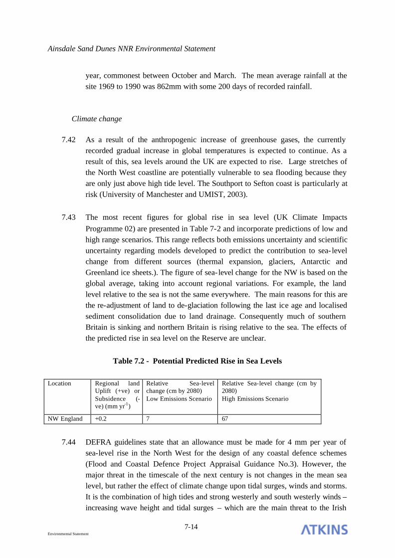
Ainsdale Sand Dunes NNR Environmental Statement
7-14 Environmental Statement
year, commonest between October and March. The mean average rainfall at the site 1969 to 1990 was 862mm with some 200 days of recorded rainfall.
Climate change
7.42 As a result of the anthropogenic increase of greenhouse gases, the currently recorded gradual increase in global temperatures is expected to continue. As a result of this, sea levels around the UK are expected to rise. Large stretches of the North West coastline are potentially vulnerable to sea flooding because they are only just above high tide level. The Southport to Sefton coast is particularly at risk (University of Manchester and UMIST, 2003).
7.43 The most recent figures for global rise in sea level (UK Climate Impacts Programme 02) are presented in Table 7-2 and incorporate predictions of low and high range scenarios. This range reflects both emissions uncertainty and scientific uncertainty regarding models developed to predict the contribution to sea- level change from different sources (thermal expansion, glaciers, Antarctic and Greenland ice sheets.). The figure of sea- level change for the NW is based on the global average, taking into account regional variations. For example, the land level relative to the sea is not the same everywhere. The main reasons for this are the re-adjustment of land to de-glaciation following the last ice age and localised sediment consolidation due to land drainage. Consequently much of southern Britain is sinking and northern Britain is rising relative to the sea. The effects of the predicted rise in sea level on the Reserve are unclear.
Table 7.2 - Potential Predicted Rise in Sea Levels
Location Regional land
Uplift (+ve) or Subsidence (-ve) (mm yr-1)
Relative Sea-level change (cm by 2080) Low Emissions Scenario
Relative Sea-level change (cm by 2080) High Emissions Scenario
NW England +0.2 7 67
7.44 DEFRA guidelines state that an allowance must be made for 4 mm per year of sea-level rise in the North West for the design of any coastal defence schemes (Flood and Coastal Defence Project Appraisal Guidance No.3). However, the major threat in the timescale of the next century is not changes in the mean sea level, but rather the effect of climate change upon tidal surges, winds and storms. It is the combination of high tides and strong westerly and south westerly winds – increasing wave height and tidal surges – which are the main threat to the Irish
Ainsdale Sand Dunes NNR Environmental Statement
7-15 Environmental Statement
Sea coastline. The effects upon the shoreline of the Reserve will depend upon the ability of the coastal dunes to respond naturally to storm events.
7.45 The MONARCH project (Harrison et al., 2001) has modelled natural resource responses to predicted climate change. This covered a number of habitat types, including sand dunes. The report concluded that sand dune habitats nationally face an uncertain future. It is predicted that climate change will affect sand dunes by changing sediment supply and through alterations in wind driven supply of sand. There is no clear prediction as to the effects of a changing climate on sand dunes, as changes in coastal processes could lead to both losses and gains in coastal habitats. The net result of climate change is considered to be dependent on the coastal defence strategy and whether dunes are allowed to move inland in the face of rising sea levels.
7.46 The following effects on sand dunes are predicted to occur in response to climate change (Harrison et al., 2001):
• increases in sea level will influence sediment supply and wave erosion;
• increases in sea level will move dunes onshore, carrying sediment further inland, where there are no physical barriers;
• changes in wind speed and direction will influence Aeolian transport of sand;
• changes in air temperature and rainfall will influence dune plant communities (and certain animal populations).
Carbon Dioxide Balance
7.47 All vegetation offers an opportunity to sequester carbon dioxide from the atmosphere. However on decomposition, the vegetation again releases the trapped carbon dioxide back into the atmosphere. Unless vegetation is in some way preserved, such as occurs in peat bogs and coal measures, carbon sequestration through vegetation is only temporary.
7.48 Trees, through existing for a relatively long time and having a large biomass, do have the potential to act as medium term carbon ‘sinks’, but the benefits of this trapping of atmospheric carbon dioxide only exist as long as the tree is alive or its wood is preserved.

Ainsdale Sand Dunes NNR Environmental Statement
7-16 Environmental Statement
PREDICTION OF IMPACTS AND EVALUATION
Scale of impacts
7.49 The responses of the physical processes to the proposed options for management are generally of relevance at a local scale i.e. within the context of the Consultation Area and the Reserve. The exception to this is the question of carbon dioxide balance, which as it involves the release of gasses into the atmosphere under certain options, is considered at a national/international scale.
7.50 The response of physical processes to the options for management are considered in the short term (up to 10 years) and the long term (over 10 years in duration).
7.51 Impacts of the management options on coastal processes may be either:
• positive - encouraging natural processes to operate or be restored;
• neutral – no observable effect;
• negative – interfering with natural processes or constraining their operation.
7.52 None of the Options will have any effect upon the rate of coastal erosion. Rather it is the effects of erosion along the Reserve, leading to habitat loss and coastal squeeze which is one of the primary reasons for investigating alternative management options for the Consultation Area. This topic is therefore not considered further in this section.
Soils
7.53 Of the three main soil types on the Reserve, the soils under the frontal woodlands tend to be acidified due to the organic surface layer of pine needles. Research within the Phase 1 and 2 restoration areas has demonstrated that organic acidified soils in the areas where trees have been removed may return to a calcareous condition within 10 years.
7.54 Under Options A and B the existing vegetation cover will remain, retaining the existing soil types, resulting in a neutral impact. Options C and D, however, will allow soils within the Consultation Area to return to a natural calcareous condition in the long term, representing a positive impact.

Ainsdale Sand Dunes NNR Environmental Statement
7-17 Environmental Statement
Groundwater levels and off site drainage
7.55 The hydrological study of the Reserve has demonstrated that a rise in groundwater levels of approximately 30cm will occur as a result of tree removal. This rise is in the context of an observed general rise in groundwater levels over time along the coastal strip as a whole. The study showed a distinct difference in groundwater levels in existing areas of dune restoration compared to locations around the boundary of the site. However, it was not possible to identify the distance from clearfell areas within which there was an influence of tree removal on groundwater levels.
7.56 Options A and B will have no effect on existing groundwater levels, the impacts of these options are therefore neutral. The effects of tree removal on groundwater caused by Options C and D will be a predicted rise of levels by approximately 30cm. This will operate in the short to long term and represents a positive impact, as such an increase will encourage the development of humid dune slacks with their associated flora and fauna.
7.57 Due to the hydrological cut off caused by the railway line, there are no predicted impacts on off site drainage by any of the options.
Sand blow
7.58 Sand movement in the area felled in Phase 1 of the dune restoration works was monitored and showed that clearfelling had not led to any large-scale destabilisation of the frontal or cleared dunes, nor to any adverse coastal defence implications. The results of topographic surveys and observations on natural rollover and embryo dune development suggest that any additional sandblow following clearfelling has not led to any major changes in dune morphology.
7.59 Options A and B will retain the existing situation with regard to sand movement and will have a neutral impact. Options C and D will involve methods to encourage natural geomorphological processes to take place through tree stump removal and the selective removal of vegetation on the windward side of dunes. These options will have a positive impact on dune morphology and natural processes in both the short and long term. The rearward woodlands and dune vegetation will prevent excessive sand blow into residential areas.

Ainsdale Sand Dunes NNR Environmental Statement
7-18 Environmental Statement
Climate/sea level changes
7.60 Long term alterations in sea level and climate are predicted to result in an increase in water levels and significant storms affecting this length of coastline. Although the results of this increase in storm events cannot be predicted with certainty, the stability of the coastal dunes will be dependent on whether the dunes will be allowed to move inland. This will to a certain extent be dependent upon the habitats present in the Consultation Area.
7.61 Under Options A and B the continued presence of frontal woodlands will impede natural coastal defence processes and continue the process of coastal squeeze, preventing natural dune processes which represents a negative impact on the Reserve in the long term. Removal of frontal woodlands under options will allow natural coastal processes to operate in response to climate change, which represents a long term positive impact.
Carbon dioxide balance
7.62 If carried out, approximately one third of the timber from the proposed clearance of frontal woodlands may be burnt, releasing sequestered carbon dioxide back into the atmosphere. Dependant on market forces, the remaining timber would be sold, retaining the carbon sequestration effects.
7.63 The existing frontal woodland will be currently acting as a carbon sink. However, on a global or national scale, the amount of carbon dioxide sequestered is negligible, representing a neutral impact with regard to options A and B and an insignificant negative impact under options C and D.

Ainsdale Sand Dunes NNR Environmental Statement
7-19 Environmental Statement
Summary of Physical Processes impacts
Table 7.3 – Summary of physical processes impacts
Feature Level of significance
Option A Nature of change Option B Nature of change Option C Nature of change Option D Nature of change
Variations in soil types
Local Neutral Nil Neutral Nil Positive Long term, permanent restoration of natural soil chemistry and structure
Positive Long term, permanent restoration of natural soil chemistry and structure
Ground water levels
Local Neutral Nil Neutral Nil Positive Permanent, short to long term (possible 30cm rise in groundwater levels)
Positive Permanent, short to long term (possible 30cm rise in groundwater levels)
Off site drainage Local Neutral Nil Neutral Nil Neutral Nil Neutral Nil
Sand Blow Local Neutral Nil Neutral Nil Positive Permanent, short to long term (approx. 1.7% of the restored area active in Phases 1 and 2)
Positive Permanent, short to long term (approx. 1.7% of the restored area active in Phases 1 and 2)
Climate/ sea level changes
Local Negative Long term, permanent. Restriction of natural processes
Negative Long term, permanent. Restriction of natural processes
Positive Long term, permanent. Natural dune processes restored
Positive Long term, permanent. Natural dune processes restored
Carbon dioxide balance
International/ National
Neutral Nil Neutral Nil Insignificant Insignificant Insignificant Insignificant

Ainsdale Sand Dunes NNR Environmental Statement
7-20 Environmental Statement
SIGNIFICANT IMPACTS AND MONITORING
Negative impacts
7.64 Only Options A and B present negative impacts, in terms of restricting the response of the coast to the predicted effects of sea level and climate change. Under these options there is no means by which coastal squeeze may be mitigated.
Positive impacts
7.65 Options C and D would have positive impacts through the return of underlying soils to a natural condition, the increase in groundwater levels due to tree removal and restoration of natural sand blow. These options would also allow natural coastal processes to operate in response to changes in sea levels and climate.
Monitoring
7.66 The establishment of monitoring programmes to quantify the response of physical processes to management within the Consultation Area are recommended as follows:
Soils
7.67 Under Options C or D a programme of soil sampling and testing every five years should be instigated, in order to determine how the soils within the Consultation Area are responding to the removal of the frontal woodlands.
Ground water levels
7.68 If either Options C or D are selected, groundwater monitoring points should be established within the Consultation Area and a process of long-term monthly water level monitoring should be established. This will provide information on the extent of water level rise resulting from the removal of the frontal woodlands and scrub.
Sand Blow
7.69 Monitoring of sand movement on the restored areas of the Reserve has shown that some active sand movement is taking place, leading to a resumption of
Ainsdale Sand Dunes NNR Environmental Statement
7-21 Environmental Statement
natural geomorphological processes with 1.7% of the area active. This programme of monitoring should be extended to the Consultation Area if either Options C or D are adopted, to determine how tree removal affects sand movement within the Consultation Area.
Climate/ sea level changes
7.70 The response of the habitats on the Reserve to increased storm events and rises in sea level will be identified as part of existing ongoing shoreline monitoring by Sefton MBC and by the regular habitat surveys of the Reserve. No additional monitoring is recommended.
Ainsdale Sand Dunes NNR Environmental Statement
8-1 Environmental Statement
8. RECREATION AND TOURISM
BASELINE
Public use
8.1 The Reserve is crossed by a number of footpaths. Fisherman’s Path, which forms the southern boundary of the Reserve, is a public right of way. All other paths are permissive footpaths. Fisherman’s Path provides local access to the beach from Freshfield and forms part of the Sefton Coastal Path. Another constituent part of the Sefton Coastal Path is the Woodland Path, which passes along the eastern edge of the Reserve. The Dune Path is situated along the seaward side of the Reserve provid ing access to Formby Point and Ainsdale Local Nature Reserve. In 2002 two new permissive paths were opened on the Reserve, namely West End Walk and Old Fisherman’s Path, giving an additional 2km of path on the Reserve (Sefton Coast Partnership Annual Report 2002).
8.2 The footpaths in the vicinity of the Reserve tend to run around its edge. Other paths exist through the Reserve, access to these is enabled through a permit system. Permits may be obtained from English Nature’s Assistant Site Manager and are freely available on application. In addition to permit holders, staff of the Reserve take groups of visitors on guided walks around the site, increasing the amount of public access to the Reserve.
8.3 The footpath network in the vicinity of the Reserve is well used and a series of visitor counts and surveys have been undertaken on Fisherman’s Path (CMACS 2000). Between 1975 and 2000 an average of 6.5% of visitors to the Formby Coast used Fisherman’s Path.
8.4 Detailed information on the use of Fisherman’s Path was obtained from the Merseyside Coastal Visitor Survey which was undertaken by Sefton MBC’s Town Watch Team during June, July and August in 2000. This study constituted a questionnaire survey and a total of 156 forms were completed by visitors using Fisherman’s Path.

Ainsdale Sand Dunes NNR Environmental Statement
8-2 Environmental Statement
8.5 The survey found that approximately half of the individuals using the path came from the Formby area and a further third came from other parts of Sefton. The Reserve is therefore of significant importance as a local and district level recreational resource. In terms of frequency of visits, 95% of the surveyed people had visited the reserve more than once in the last twelve months and 70% of visitors thought their visit would last more than one hour. A wide variety of reasons were given for visiting the area, the most frequent being walking, relaxation, scenery and visiting the beach. The most frequently cited factor which attracted visitors was the solitude and tranquil feel of the area.
8.6 In 2000 an extensive series of public consultations was conducted by the Centre for Marine and Coastal Studies (CMACS 2000). One of the aims of this study was to determine the nature and extent of amenity use of the Ainsdale Sand Dunes NNR within the context of the wider Sefton Coast.
8.7 The survey involved a doorstep survey of 750 households and the distribution of questionnaires in the local free press to households throughout Formby and Ainsdale. A total of 252 households were successfully interviewed and a total of 1140 responses were received from the free press survey.
8.8 A summary of the results of the randomised doorstep survey and comparisons with the free press distributed questionnaire are outlined below.
8.9 Respondents were asked how many times they visited the coast (beach, dunes and woodland) in the past year (1999-2000). The majority had visited either 2-10 times (38%) or 21 or more times (34.4%), with access being via Lifeboat Road (25.6%), Fisherman’s Path (19.4%) and the National Trust route (19%) to the coast.
8.10 Respondents were asked to identify which elements of the coast they visited most frequently, the area being divided into beach, dunes next to the beach, dunes further back from the beach and woodlands. The visits to each component were reasonably even, but those who always visited a particular element of the coast tended to visit woodland (49.4%), the beach (43%) or dunes next to the beach (39.4%). The majority of respondents noted walking as the primary activity during their visit to the coast.
8.11 The free press questionnaire demonstrated a slightly different pattern of usage. The pattern of visit s to the coast was similar, but a higher percentage visited 21 or more times over the twelve month period (44%). Respondents again visited

Ainsdale Sand Dunes NNR Environmental Statement
8-3 Environmental Statement
woodland most commonly, but dunes further back from the beach were much more commonly visited (47.6%) than for the interview survey. Walking was the most common activity, but Fisherman’s Path was the least used access point.
8.12 With regard to the conservation of coastal habitats and species, 80% of the people interviewed during the doorstep survey and over 78% of respondents in the free press survey felt that this issue was very important.
Cultural heritage
8.13 Although the Reserve has a long and varied history of human use, there are notably few features of cultural interest present. This is in part due to the constantly shifting nature of the terrain and also due to the transient nature of land uses.
8.14 In 1667, the sand dunes and warrens at Ainsdale were owned by the Formby and the Blundell Estates. To mark the boundary between the Estates, cast iron marker posts with the initial F facing north and B facing south, were placed along the south bank of Wicks Lane Path from Lark Hill to the shore. A few of these markers are still in existence.
8.15 In 1905 the boundary between Ainsdale and Formby was marked by a series of vertical iron pipes. This line crosses the present Reserve in a straight line from the shore to the railway, and some of the pipes can still be found today.
8.16 The Blundell Estate carried out a great deal of work upon the Reserve. This included the creation of some of the frontal dunes that exist today, which confers some historical interest to the area.
8.17 In 1934, I. Walmsey-Cotham, previous Manager of the Blundell Estate, described to the Liverpool Botanical Society that a series of numbered concrete posts were set out across the Reserve and plotted upon a plan to form a grid. This assisted those employed upon the Estate in knowing exactly where they were and in navigating across the area, some of which remain today.
8.18 In addition, an extensive system of drainage ditches and pipework, around 6 miles long, was dug between 1910 and 1940, but after 1958 was no longer maintained and sections were blocked or dammed. Parts of the drain system are still in evidence within the plantation woodland.
Ainsdale Sand Dunes NNR Environmental Statement
8-4 Environmental Statement
8.19 Both Ainsdale and Freshfield dunes were included in the first ever list of nature reserves, namely the 1915 Survey of Areas Worthy of Protection carried out by the Society for the Promotion of Nature Reserves.
PREDICTION OF IMPACTS AND EVALUATION
Scale of impacts
8.20 The majority of visitors to the Reserve are from Sefton, therefore the majority of impacts of the proposed management options for recreation and tourism are of relevance at a local (Ainsdale) to district (Sefton) scale. The site is of national to international importance for its wildlife and habitats (see Section 5). Due to this its value as a resource for education should be considered at this level.
8.21 The impacts of the options for management on recreation and tourism are considered in the short term (up to 10 years) and the long term (over 10 years in duration).
8.22 Impacts of the management options recreation and tourism issues may be either:
• positive - encouraging public use and enjoyment of the Consultation Area;
• neutral – no observable effect;
• negative – leading to a reduction in use of the Consultation Area.
Public access
8.23 The proposed restoration areas within the Reserve under Options C and D would be stock fenced. However, the existing fencelines and any new ones always have stiles or kissing gates, and English Nature are replacing old stiles with kissing gates as part of ongoing access improvements.
8.24 Public access on the reserve is managed through a combination of casual access pathways, casual access zones and permit only zones. Permits are freely available to anyone who requests one, with a few simple conditions attached, such as no dogs, thus enabling open access to the whole NNR. The study area at present is a permit only zone with casual access paths on the southern side. English Nature discourages access by dogs into the grazing enclosures by not providing kissing

Ainsdale Sand Dunes NNR Environmental Statement
8-5 Environmental Statement
gates into grazing enclosures adjacent to casual access paths where dogs are allowed.
8.25 Under Option A, public access to the Consultation Area will remain unchanged, leading to a neutral impact. Option B offers the potential for management to create new rides and pathways through the frontal woodlands, together with the installation of a new forest road. This would improve public access to these areas resulting in a positive impact. If Options C or D are adopted, fencing would enable a new casual access pathway to be put through the middle of the Consultation Area, between grazing enclosures. In addition, the new road to allow machinery access to the Consultation Area would also be open to the public under the Reserve’s permit system. Access would therefore be improved by the addition of the new casual access path, resulting in a positive impact.
Public use of the Reserve
8.26 The woodlands of the Reserve are the most commonly cited feature which is appreciated by visitors. Other features of significance include the beach and rear dunes. Public use of the Reserve is significant at a local to district level, as nearly 80% of visitors are from Sefton.
8.27 Options A and B will retain the frontal woodlands as a feature in the short term, representing a neutral impact. However, in the long term the frontal woodlands will deteriorate in amenity value as a result of ongoing coastal processes, resulting in a negative impact. Under Option C, retained groups of windfirm trees will lead to the retention of some feeling of a woodland area, although more open than the existing frontal woodlands. The rearward woodlands will be retained so a full spectrum of wooded habitats will be present on the Reserve. This option will result in a neutral impact. Removal of the frontal woodlands under Option D will result in the loss of 22.4ha of one of the most publicly appreciated habitats on the Reserve resulting in a negative impact.
Public safety
8.28 The options under consideration all include measures to maintain public safety as a priority, leading to an overall neutral impact in all cases. Under Option A the woodland management carried would ensure that unsafe trees were removed or made safe. If Option B was selected, the improved access to the area would enable public safety issues to be addressed by site staff. Only windfirm areas of trees would be retained under Option C, ensuring that windthrow of trees was

Ainsdale Sand Dunes NNR Environmental Statement
8-6 Environmental Statement
minimised. Storm events may lead to additional windthrow, but these will be very rare. Improved access of site staff through the installation of the new forest road would maintain public safety. The conversion of frontal woodlands to open dune habitats under Option D have few public safety implications. Improved access of site staff through the installation of the new forest road would maintain public safety.
Information, education and research
8.29 The provision of information about the Reserve includes on site interpretive material and articles in the local press about the Reserve and its wildlife.
8.30 Opportunities for additional information and interpretation do not occur under Option A, as the existing situation is maintained. Option B presents some opportunity to provide additional information on how the proposed works is aimed to enhance the frontal woodlands and provide further habitat for red squirrel, leading to a positive impact. Under Options C and D opportunities exist to present the purpose of the dune restoration project and provide details of the wildlife which the project aims to protect, leading to a positive impact.
8.31 Education and research represents range of activities, from local school projects to internationally funded projects researching aspects of the wildlife of the Reserve.
8.32 Under Option A the existing opportunities for education and research are maintained, with no additional opportunities arising, resulting in a neutral impact. The management of the frontal woodlands under Option B would provide opportunities to monitor the red squirrel populations of these areas and record population density response to management, this represents a positive impact. The proposed dune restoration options (C and D) offer a wide range of opportunities for research and monitoring of ecological features in relation to habitat restoration, resulting in a positive impact.
Cultural heritage and archaeology
8.33 The cultural heritage and archaeological evidence present on the Reserve is limited in extent and of local importance. None of the proposed options will have any effect on the features which remain on the Reserve. Impacts will, therefore, be neutral for all of the options under consideration.
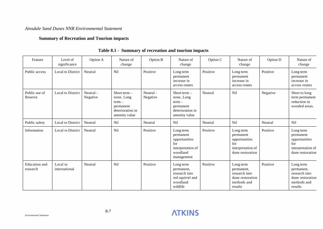
Ainsdale Sand Dunes NNR Environmental Statement
8-7 Environmental Statement
Summary of Recreation and Tourism impacts
Table 8.1 - Summary of recreation and tourism impacts
Feature Level of significance
Option A Nature of change
Option B Nature of change
Option C Nature of change
Option D Nature of change
Public access Local to District Neutral Nil Positive Long term permanent increase in access routes
Positive Long term permanent increase in access routes
Positive Long term permanent increase in access routes
Public use of Reserve
Local to District Neutral - Negative
Short term – none. Long term – permanent deterioration in amenity value
Neutral - Negative
Short term – none, Long term – permanent deterioration in amenity value
Neutral Nil Negative Short to long term permanent reduction in wooded areas.
Public safety Local to District Neutral Nil Neutral Nil Neutral Nil Neutral Nil
Information Local to District Neutral Nil Positive Long term permanent opportunities for interpretation of woodland management
Positive Long term permanent opportunities for interpretation of dune restoration
Positive Long term permanent opportunities for interpretation of dune restoration
Education and research
Local to international
Neutral Nil Positive Long term permanent, research into red squirrel and woodland wildlife
Positive Long term permanent, research into dune restoration methods and results
Positive Long term permanent, research into dune restoration methods and results

Ainsdale Sand Dunes NNR Environmental Statement
8-8 Environmental Statement
SIGNIFICANT IMPACTS AND MITIGATION
Negative impacts
8.34 The only negative impacts within this Section relate to the public use of the Reserve. These result from the eventual deterioration of frontal woodlands under Option A, and the removal of the frontal pinewoods under Option D, both of which result in loss of amenity value. This effect cannot be mitigated.
Positive impacts
8.35 Options B, C and D all have potential positive impacts with regard to public access, information, education and research. Through the enhancement/creation of new routes through the Consultation Area and new fields of study which would be created through changes in management practice.
Opportunities for recreation and tourism, education and research
8.36 A range of opportunities for the enhancement of recreation and tourism and the use of the Reserve for education and research arise as a result of the proposed Options. These are listed below.
Public access
8.37 Potentially significant improvements to public access on the frontal areas of the Reserve will occur under Options B, C and D through the establishment of new rides and/or paths through the restoration area. Option A will have no effect on public access.
Information
8.38 Significant opportunities for improvement in informing the public about management/restoration works exist under Options B, C and D. Option A offers no additional opportunities for the provision of information, as the existing situation will remain unchanged.
Education and research
8.39 Significant positive opportunities for education and research activities exist under Options B, C and D through investigations of management and red squirrel
Ainsdale Sand Dunes NNR Environmental Statement
8-9 Environmental Statement
populations (Option B) or through investigations into the effects of dune restoration (Options C and D).

Ainsdale Sand Dunes NNR Environmental Statement
9-1 Environmental Statement
9. TEMPORARY CLEARANCE ISSUES
PREDICTION OF IMPACTS AND EVALUATION
Scale of impacts
9.1 By definition, the temporary impacts discussed in this section will either operate in the immediate timescale at which works are carried out (such as noise) or will be indiscernible within one or two years of the work having been carried out (such as habitat disturbance).
9.2 All of the impacts discussed in this section are negative in nature, with the potential to cause a degradation of the environment in the immediate vicinity. They are all, therefore of importance at the local scale of influence.
Temporary habitat disturbance
9.3 The removal or management of the frontal woodlands will result in some temporary physical disturbance to the habitats in the vicinity as a result of the machinery used to carry out the works, such as extraction of felled trees. Such disturbance may include compaction or churning of the surface soil layers and damage to ground flora.
9.4 Under Options A and B there will be a requirement to gain access to the frontal woodlands for management activities. This will primarily be through the construction of a new forest road, which will be subject to a separate impact assessment. There will also be temporary access routes through the woodlands, to areas where works will be undertaken, resulting in temporary disturbance of the ground flora along such routes. This represents a negative impact. Options C and D will result in more extensive disturbance to the Consultation Area a result of felling and extracting trees, resulting in a negative impact.

Ainsdale Sand Dunes NNR Environmental Statement
9-2 Environmental Statement
Temporary visual issues
9.5 As a result of woodland works proposed under Options B, C and D there will be a negative visual impact, resulting from the woodland management or extraction operations. Such impacts will be least under Option B, and greatest for Option D.
Public safety
9.6 Any proposals which require the use of machinery will have implications for public safety on the Reserve.
9.7 Any proposed works will have the maintenance of public safety as a priority. This means that public access will be temporarily restricted from areas where works are carried out under any of the options under consideration. Therefore there will be an overall neutral impact in all cases.
Noise and traffic
9.8 Any works on the frontal woodlands are likely to result in some temporary increase in noise and traffic. The traffic for clearance proposals will require extraction routes from outside the site to the working area.
9.9 It has not been possible to carry out a detailed acoustic assessment of this project and no detailed, empirical background or baseline data has been available. The following assumptions have been made:
• It is understood that the works involve felling of trees in the Consultation
Area, situated on the seaward side of the Reserve. • The works will involve the use of petrol chain saws HGV's and other heavy
plant may be required on site. • No new access roads will be created near to residential properties. • The closest residential properties are approximately 800m from the site at
Formby (adjacent to Formby Golf Club and the railway station). • The existing, ambient noise climate in this predominantly suburban area is
relatively quiet.
9.10 Based on the above it is felt that the following are the main noise issues that may need to be addressed;
Ainsdale Sand Dunes NNR Environmental Statement
9-3 Environmental Statement
• Principle noise sources will arise from the movements of vehicles to and from
the site, particularly where this passes close to housing, and from the operation of the chainsaws and extraction machinery.
• The actual noise level from the works, incident upon the residential properties, is not expected to be significant; initial calculations of noise from the chainsaws (based on data and methodology given in BS 5228) suggest a sound pressure level in the region of 40 - 45 dB(A) at the residential premises, but the tonal nature of the noise from the saws may cause significant annoyance to residential occupiers regardless of the noise levels.
9.11 In order to give more detailed assessment further information on existing noise levels will be required, either by survey or from information already available. Predictions of noise will require more detailed information on the duration and extent of works and more specific source noise data for the machinery to be used on site.
9.12 It should be noted, however, that no adverse reports with regard to noise have been received due to the Phase 1 and 2 dune restoration operations, or through management activities in the rear woodlands.
9.13 Traffic will increase significantly during extraction operations carried out under Options C and D, particularly the numbers of vehicles entering and leaving the Reserve entrance. There will also be an increase of traffic during woodland management operations under Option B. This represents a negative impact.
9.14 There are no anticipated noise or traffic impacts under Option A, representing a neutral impact.
Waste management
9.15 Material from any management activity will require disposal or removal from site. All of the options under consideration will generate some waste, which will require control and disposal. English Nature have carried out an option assessment for the disposal of ‘lop and top’ and unmarketable timber on the Reserve. As a result of this assessment it has been determined that the only option suitable for employment in the pine areas is to burn the waste produced.
9.16 The predicted impact of waste management activities are as follows:

Ainsdale Sand Dunes NNR Environmental Statement
9-4 Environmental Statement
• Option A – Small amounts of waste will be generated under this option, comprising dead or unsafe trees and branches. These will be burn in discrete areas in accordance with the Environmental Management Plan, resulting in a temporary low negative impact as a result of atmospheric pollution and adverse visual impacts.
• Option B – A larger amount of waste will be generated under this option, than under Option A, but will still be small scale. Waste will be burnt in the same manner as Option A, resulting in a temporary low negative impact.
• Options C and D – Under these options economically viable timber would be extracted and the rest of the material from the clearance operations would be burnt. If the current market for timber remains, then approximately two thirds of the timber to be removed would be sold. The remaining material would be burnt over the period of the restoration project, resulting in low negative impacts over the short to medium term.

Ainsdale Sand Dunes NNR Environmental Statement
9-5 Environmental Statement
Summary of Temporary Operational impacts
Table 9.1 - Summary of Temporary operational impacts
Feature Level of significance
Option A Nature of change
Option B Nature of change
Option C Nature of change
Option D Nature of change
Temporary habitat disturbance
Local Negative Temporary access routes for works to trees
Negative Temporary access routes for works to trees
Negative Temporary ground disturbance as a result of forestry operations
Negative Temporary ground disturbance as a result of forestry operations
Temporary visual issues
Local Neutral Nil Negative Woodland regeneration activities
Negative Woodland removal
Negative Woodland removal
Public safety Local Neutral Nil Neutral Nil Neutral Nil Neutral Nil
Noise and traffic
Local Neutral Nil Negative Thinning operations and removal of some timber
Negative Increase in noise and traffic as a result of timber extraction
Negative Increase in noise and traffic as a result of timber extraction
Waste management
Local Negative Burning of material on site, subsequent burial of fire site
Negative Burning of material on site, subsequent burial of fire site
Negative Burning of approximately one third of material cut, burial of fire site. Rest removed from site (subject to market forces).
Negative Burning of approximately one third of material cut, burial of fire site. Rest removed from site (subject to market forces).

Ainsdale Sand Dunes NNR Environmental Statement
9-6 Environmental Statement
SIGNIFICANT IMPACTS AND MITIGATION
Temporary habitat disturbance
9.17 Temporary habitat disturbance as a result of forestry operations should be kept to a minimum. It is recommended that clearly marked extraction routes are established prior to works and that these are adhered to by the machinery used for extraction. This will restrict the amount of habitat disturbance caused by the management/extraction activities.
Temporary visual issues
9.18 The temporary visual impacts may be reduced by keeping the most prominent and visible areas of woodland until other, less visible, areas have been managed/felled.
9.19 Only small areas should be worked at any one time, and stumps should be removed at the same time as the works are carried out, rather than being left in situ, as was the case with Phases 1 and 2 of the restoration project.
Noise and traffic
9.20 Activities on site, including the movements of vehicles, should be restricted to reasonable hours wherever possible e.g. between 08:00 and 18:00 on weekdays with limited working on Saturdays and no working on a Sunday.
9.21 Wherever possible, modern, well maintained equipment, with suitable sound suppression fitted, should be employed.
9.22 The increase in traffic exiting the Reserve under Options C and D will require a left turn only policy to be implemented for road safety purposes.
Waste management
9.23 As burning unmarketable waste from forestry operations is considered the only viable option, The Environmental Management Plan for the Reserve notes that fires should be sited away from sensitive/valuable vegetation and the fire sites should be buried.

Ainsdale Sand Dunes NNR Environmental Statement
9-7 Environmental Statement
Residual impacts
9.24 With appropriate mitigation, as described above, the temporary operational impacts of carrying out any of the proposals within the Consultation Area will be minimal, and will be undetectable within 1-2 years of the operations having been carried out.

Ainsdale Sand Dunes NNR Environmental Statement
10-1 Environmental Statement
10. QUESTIONNAIRE
10.1 There were 288 responses received to the 16,550 questionnaires distributed in the ‘free press’ (1.7%). This section comprises an analysis of the responses to the questions and some discussion. Figures are provided in percentages throughout. Because not all respondees answered all questions, the percentages may not add up to 100% in all cases.
Q1 Did you respond to the questionnaire sent out in November
last year? Yes: 25
No 75 Q2 How many times have you visited the National Nature Reserve (beach, dunes
or woodland) in the last year? Never Once 2-10 times 11=20 times 21-52 times > 52 times 2 (1.2) 1 (3.2) 28 (29.8) 22(21.5) 23 22
In response to the previous CMACS questionnaire, the equivalent figures are given above in brackets where directly comparable. 44% said they visited more than 21 times. Q3 Which parts of this area do you usually go to when you visit? (Tick as many as
appropriate)
Beach Dunes (next to the
beach) Dunes (next to the
woodland) Woodlands A S N A S N A S N A S N
34(30) 57(66) 2(4) 38(36) 50(58) 2(6) 41(48) 48(46) 2(7) 63(48) 30(39) 1(3) Key:- A = always, S = sometimes, N = never Equivalent results from the equivalent CMACS survey are given in brackets. Q4 Have you read the Independent Review produced by
CMACS in Dec. 2000? Yes: 24
Q5 Have you read the Scoping Report produced by Atkins in
August 2003? Yes: 22
Q6 Have you read the Draft Environmental Statement just
published? Yes: 30
Q7 – See over page.
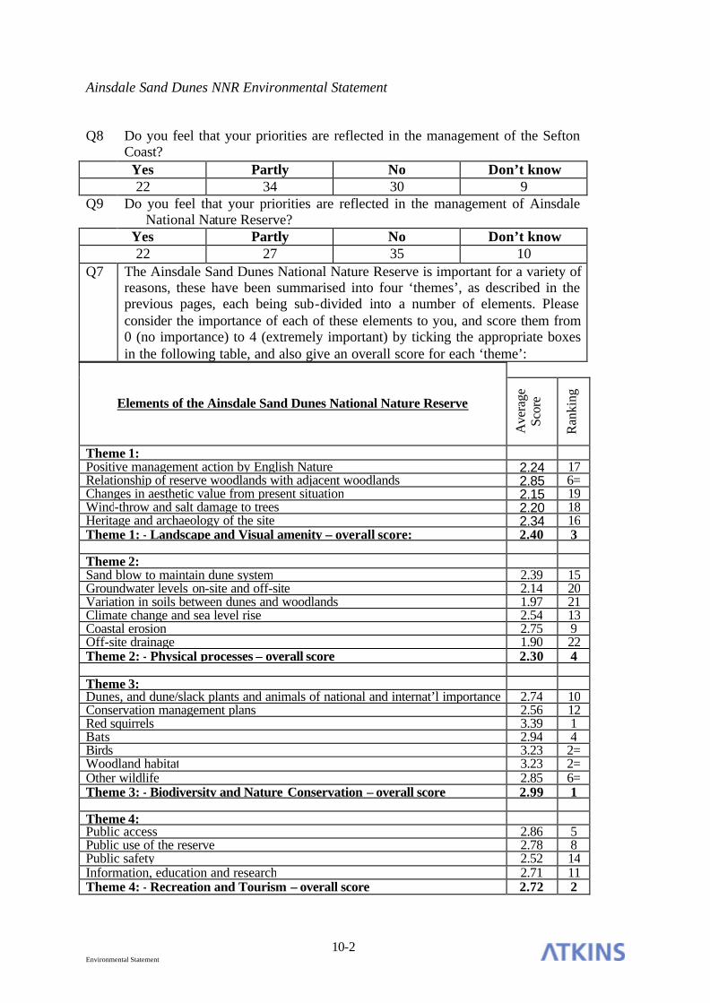
Ainsdale Sand Dunes NNR Environmental Statement
10-2 Environmental Statement
Q8 Do you feel that your priorities are reflected in the management of the Sefton Coast? Yes Partly No Don’t know 22 34 30 9
Q9 Do you feel that your priorities are reflected in the management of Ainsdale National Nature Reserve?
Yes Partly No Don’t know 22 27 35 10
Q7 The Ainsdale Sand Dunes National Nature Reserve is important for a variety of reasons, these have been summarised into four ‘themes’, as described in the previous pages, each being sub-divided into a number of elements. Please consider the importance of each of these elements to you, and score them from 0 (no importance) to 4 (extremely important) by ticking the appropriate boxes in the following table, and also give an overall score for each ‘theme’:
Elements of the Ainsdale Sand Dunes National Nature Reserve
Ave
rage
Sc
ore
Ran
king
Theme 1: Positive management action by English Nature 2.24 17 Relationship of reserve woodlands with adjacent woodlands 2.85 6= Changes in aesthetic value from present situation 2.15 19 Wind-throw and salt damage to trees 2.20 18 Heritage and archaeology of the site 2.34 16 Theme 1: - Landscape and Visual amenity – overall score: 2.40 3 Theme 2: Sand blow to maintain dune system 2.39 15 Groundwater levels on-site and off-site 2.14 20 Variation in soils between dunes and woodlands 1.97 21 Climate change and sea level rise 2.54 13 Coastal erosion 2.75 9 Off-site drainage 1.90 22 Theme 2: - Physical processes – overall score 2.30 4 Theme 3: Dunes, and dune/slack plants and animals of national and internat’l importance 2.74 10 Conservation management plans 2.56 12 Red squirrels 3.39 1 Bats 2.94 4 Birds 3.23 2= Woodland habitat 3.23 2= Other wildlife 2.85 6= Theme 3: - Biodiversity and Nature Conservation – overall score 2.99 1 Theme 4: Public access 2.86 5 Public use of the reserve 2.78 8 Public safety 2.52 14 Information, education and research 2.71 11 Theme 4: - Recreation and Tourism – overall score 2.72 2

Ainsdale Sand Dunes NNR Environmental Statement
10-3 Environmental Statement
10.2 In addition to the questions asked, 27% of respondees (78 in total) made additional comment in the form of a letter or comments entered on the form. 58 of these, or 20% of respondees, expressed antipathy to the felling of any woodland. Of this 58, some 14 were responding specifically to object, as elicited by a newspaper article originating from Sefton Coastwatch, and enclosed a copy of the article with the response.
10.3 Responses to Questions 2 and 3 are very much in line with the answers given to the previous CMACS ‘free press’ survey except that there were a greater number this time saying they ‘always’ visit Beach coastal dunes and woodland and a lower number visiting the woodland dunes.. However the response for that survey was much better at 1140 returns, compared with 288 this time.
10.4 Of the Theme elements, red squirrels, birds, woodland habitat and bats (Theme 3) and public access (Theme 4) ranked highest. Public use, relationship with adjacent woodlands and coastal erosion were next in importance. Drainage, soils, groundwater (Theme 2), aesthetic value and windthrow/salt damage (Theme 1) ranked lowest. The ranking of the themes with Biodiversity and Nature Conservation highest, then Recreation and Tourism, Landscape and Visual Amenity and Physical Processes lowest can be understood. However, woodland species and habitat are clearly ranked higher than dune and aquatic species and habitat in public perception.

Ainsdale Sand Dunes NNR Environmental Statement
11-1 Environmental Statement
11. CONCLUSIONS
11.1 As detailed in Section 5 of this EIA, there is a requirement for the features of International importance within the Consultation Area to be maintained in favourable condition, as defined by The Habitats Directive (Directive 92/43/EEC).
11.2 This requirement extends beyond the Consultation Area, and relates to the cSAC as a whole. The maintenance of this la rger area requires co-ordinated action from a number of stakeholders, and as such falls outside the scope of this EIA. Fragmentation of designated habitats along the Sefton Coast should be examined at a strategic level, with all landowners involved.
11.3 Removal of frontal pinewoods within the Consultation Area would contribute to the maintenance of the Annex I habitats within the cSAC, although such actions alone cannot fulfil the requirement to maintain habitat integrity along the Sefton Coast as a whole.
11.4 Removal of the frontal pinewoods within the Consultation Area would make an important contribution towards the restoration of the integrity of the cSAC. This action is regarded as essential towards achieving that objective.
11.5 Since the cSAC was designated in 1995, it has been calculated that 14ha of terrestrial dune habitat has been lost through coastal erosion. Any restoration of dune habitat within the Consultation Area will serve to redress these losses through the provision of additional habitat for which the cSAC was designated.
11.6 The Reserve was designated a SSSI in 1965, and was amalgamated into the larger Sefton Coast SSSI in 2000. The Consultation Area comprises Unit 18 of the Sefton Coast SSSI and its conservation status is based upon the habitats present at its original designation. Since that time coastal erosion has led to the loss of some of the frontal dune habitats and scrub invasion has led to the losses of a further 10ha of dune habitats. Therefore, removal of the majority of this scrub is necessary in order to return the area to favourable condition.

Ainsdale Sand Dunes NNR Environmental Statement
11-2 Environmental Statement
11.7 Section 5 of this assessment considered the biodiversity and nature conservation implications of each of the four options under consideration. The degree of significance of each of the residual impacts of each option in the short and long term are presented in the following table.
Table 11.1 – Biodiversity and nature conservation – Summary of residual impacts
Significance of impact
Option A Option B Option C Option D
Short Long Short Long Short Long Short Long
Critical Negative
1 1
High negative
3 3
Moderate negative
2 1 2 1
Minor Negative
2 1 1 1 1 1
Not significant
14 8 11 5 3 4 3 4
Minor positive
1 1 1 1 1 1
Moderate positive
1 2 1 1 1 1
High positive
1 1 6 3 6 3
Critical positive
3 3
11.8 The above table demonstrates that, in terms of biodiversity and nature conservation, Option A will result in an overall decline in value in the long term. Option B offers some conservation gains, through active management of the frontal woodlands, but in the long term there will be loss of fixed dune with herbaceous vegetation, an Annex I habitat type, representing a critical negative impact. The greatest conservation gains occur through the adoption of either Options C or D, although these do have negative impacts on certain aspects of the wildlife interest in the frontal area, they are outweighed by the critical positive impacts of restoring Annex I habitats to favourable condition in the long term, together with commensurate improvements in the populations of associated species of international importance. Both of these options have similar benefits,

Ainsdale Sand Dunes NNR Environmental Statement
11-3 Environmental Statement
and cannot be distinguished on the basis of biodiversity and nature conservation impacts.
11.9 Under Options A and B, the sand dune features in the Consultation Area would remain in unfavourable declining/no change condition due to the following factors:
• continued decrease in extent;
• lack of natural mobility;
• lack of natural zonation of habitats;
• insufficient frequency of characteristic species/species of local distinctiveness;
• insufficient frequency of bare sand;
• presence of negative indicator species;
• presence of scrub/trees.
11.10 Under Options C and D (with suitable follow up management) the sand dune features within the Consultation Area would enter unfavourable recovering condition and progress towards favourable condition (JNCC 2004).
11.11 Bringing the Consultation Area into favourable condition is necessary as a contribution to bringing the SSSI/cSAC into favourable condition as a whole. See Chapter 5 for the assessment of the component features
11.12 The restoration of sand dune habitats within the Reserve to a natural state is estimated to take approximately 30-40 years (English Nature Site Manager and Maritime Team Guidance), by which time further coastal erosion is likely to have occurred. Therefore, for dune habitats to be restored and maintained within the frontal area under consideration, trees will need to be removed to the point where the coastline will be in 40 years time, plus an additional buffer area to allow mature dune habitats to exist along the coast of the Reserve, despite the losses caused by erosion. Due to this, and the current coastal squeeze occurring at the seaward edge of the Consultation Area, it is necessary to undertake tree removal at the earliest opportunity.

Ainsdale Sand Dunes NNR Environmental Statement
11-4 Environmental Statement
11.13 Under Options C and D works would take place in 2004 to 2006. Immediate action is required as the integrity of the coatal area is already compromised through coastal squeeze as a result of erosion. A longer timescale for removal of the frontal pinewoods would mean that habitats would not be able to develop into a natural state before being lost to erosion. Such an approach would significantly reduce the long term habitat benefits of Options C or D.
11.14 Tree removal should be undertaken in limited areas at any one time, with the clearance taking place from the coast landward, rather than from north to south, as originally proposed.
11.15 English Nature have calculated the likely amount of tree clearance required based on the 50 year erosion line and an assumption of 40 years to restore the habitat to favourable condition. This calculation indicated the need for 475m of frontal woodland and scrub to be removed. If the woodland edge was to retreat landward an equal distance to the extent of coastal erosion, plus an additional distance to allow for the development of parabolic dunes, then the resultant habitat could be regarded as sustainable.
11.16 Section 6 of this assessment considers the compliance of the options under consideration with landcape planning and policy objectives, as presented in Table 6-1. This table demonstrates that, in the short term, Option B is the most compliant of the options under consideration. However, in the long term Option C complies most closely with the landscape objectives for the coast, although the benefits of this over Option D are small.
11.17 The landscape as seen from Fisherman’s Path should be taken particular account of in any restoration process. Tree groups which are prominent from the path should be retained until the final restoration phases. The removal of tree stumps should prioritise the areas visible from this well used access route.
11.18 Groups of windfirm trees should be retained within the clearance areas, for landscape and aesthetic reasons, particularly those groups which are prominent from viewpoints along Fisherman’s Path. Following tree removal, stumps would be removed and herbicide treatment of scrub re-growth would be carried out. Grazing would also be instigated to suppress scrub growth in the longer term. Some controlled destabilisation of the dunes would also be undertaken, to encourage natural geomorphological processes.

Ainsdale Sand Dunes NNR Environmental Statement
11-5 Environmental Statement
11.19 With regard to physical processes, as described in Section 7, only Options A and B have negative impacts, through the restriction of the ability of the natural coastline to respond to the predicted effects of sea level and climate change.
11.20 Options C and D offer a number of positive impacts with regard to coastal processes, including having a positive effect on soils, groundwater levels and sand blow. The Consultation Area sea frontage would also be responsive to the coastal processes perating as a result of sea level or climate changes.
11.21 Recreation and Tourism issues are assessed in Section 8. Options A and D both result in the loss of some amenity value within the Consultation Area, Option A would result in a decline in value due to ongoing senescence of woodland and the effects of erosion on the woodland habitat, and Option D results in the loss of frontal pinewoods.
11.22 Positive impacts on public access, information, education and research are anticipated under Options B, C and D.
11.23 From the assessment carried out, it is concluded that Options C and D both represent significant nature conservation gains and benefits in terms of physical processes over Options A and B. Options A and B are more compliant with landscape plans and policies in the short term, but Options C and D are more so over a longer timescale.
11.24 There is no overwhelmingly superior option in a comparison of Options C and D. However, either of these options represents a better solution than A or B with regard to the management of the Consultation Area.

Ainsdale Sand Dunes NNR Environmental Statement
12-1 Environmental Statement
12. REFERENCES
Anon, 2000 , Draft Sand Lizard (Lacerta agilis) Species Action Plan for the Sefton Coast and the Wirral.
Atkins, 2003, Ainsdale Sand Dunes NNR Environmental Impact Assessment of options for management of seaward areas – Scoping Report.
Atkins, 2004, Ainsdale Sand Dunes NNR Environmental Impact Assessment of options for management of seaward areas – Supplement to Scoping Report.
Bateman D, 1990, The Formby Landscape: Its Geological, Ecological and Historical Basis. Unpublished Thesis, University of Liverpool.
Brown K, Hambridge C and Matthews A, 2003, The development of remote sensing techniques for marine SAC monitoring. English Nature Research Reports 552.
Brown S, 1999, Summary of 1999 observations on the Dune Restoration Project (DRP) Ainsdale Sand Dunes NNR. English Nature Filenote.
Casella, 2003, Ainsdale Sands NNR Ornithological Survey. Unpublished Report.
Cass, 2003, Ainsdale Sand Dunes National Nature Reserve Landscape Statement, Dune Restoration Project, English Nature, Ainsdale National Nature Reserve.
Centre for Urban and Regional Ecology, University of Manchester and the Tyndall Centre North, UMIST. June 2003. Spatial Implications of Climate Change for the North West. Found on http:/rpg.nwra.gov.uk/rpg_docs/701057707633.pdf
Cheshire Ecological Services, 2001a, Ainsdale National Nature Reserve – Great Crested Newt Survey – Larval Survey for English Nature.
Cheshire Ecological Services, 2001b, Ainsdale National Nature Reserve – Great Crested Newt Survey – Night Torch Survey for English Nature.
Cheshire Ecological Services, 2001c, Ainsdale National Nature Reserve – Great Crested Newt Survey – Egg Survey for English Nature.

Ainsdale Sand Dunes NNR Environmental Statement
12-2 Environmental Statement
Clarke D, 1980, The groundwater balance of a coastal sand dune system; a study of the water table conditions in Ainsdale Sand Dunes National Nature Reserve. Unpublished PhD. Thesis, University of Liverpool.
CMACS, 2000, Review of Dune Restoration – Ainsdale Sand Dunes National Nature Reserve.
Conservation Strategy for Natterjacks on the Sefton Coast 2001 – 2005
Convention on the Conservation of Wetlands of International Importance as Waterfowl Habitat. Ramsar, Iran, 1971.
Department of the Environment Transport and the Regions, 2000, Ramsar Sites in England: A Policy Statement.
Department of the Environment Transport and the Regions, 2001, Guidance on the Methodology for Multi-Modal Studies.
Duckels T, 1995, Observations on wildlife within the clearfell Phase 1 area. English Nature file note.
Edmondson et. al., 1998, Vegetation monitoring survey of dune restoration area. Unpublished report to English Nature.
English Nature, 2003, Ainsdale Sand Dunes National Nature Reserve Management Plan 2003-2004.
English Nature, 2004, Bat mitigation guidelines.
ENTEC, 1999, Southport and Sefton Water Resources Evaluation. Environment Agency (North West)
Environmental Advisory Unit Ltd, 1991, Sand Lizard Conservation Strategy for the Merseyside Coast. Report for English Nature. Liverpool.
Environmental Impact Assessment (Forestry) (England and Wales) Regulations 1999.
European Commission, Conservation of Wild Birds Directive 79/409/EEC
European Commission, Habitats Directive 92/43/EEC
European Commission, 2000, Managing Natura 2000 Sites – The provisions of Article 6 of the Habitats Directive 92/43/EEC.

Ainsdale Sand Dunes NNR Environmental Statement
12-3 Environmental Statement
FCDPAG3. 1999. Flood and Coastal Defence Project Appraisal Guidance 3. DEFRA. Forestry Commission, 2002, Assessment of the Likely Significant Effect on the Sefton Coast candidate SAC from the Sefton Coast Woodlands Forest Plan. Gateley P S, 1990, The Status and Distribution of (Epipactis dunensis) on the Sefton Coast. English Nature. Gateley P S, 1995, Vegetation monitoring survey of dune restoration area. Unpublished report to English Nature. Gee M, 1991, The effect of a coniferous plantation upon the water table of a sand dune system, Postgraduate Diploma in Countryside Management, Manchester Polytechnic, (Unpublished). Gee M, 1993, Vegetation monitoring survey of dune restoration area. Unpublished report to English Nature. Gurnell J, Sainsbury A, and Venning T, 1996, Conserving the red squirrel in Thetford Forest. Part 1. Report to English Nature, PTES and the Forestry Commission.
Halcrow, 2002, Futurecoast. DEFRA.
Harrison P A, Berry P M and Dawson T P (eds), 2001, Climate Change and Nature Conservation in Britain and Ireland: Modelling natural resource responses to climate change (the MONARCH project), Summary Report, UKCIP, Oxford.
HMSO, Wildlife and Countryside Act 1981 (as amended)
HMSO, Conservation (Natural Habitats &c.) Regulations (1994)
HMSO, Countryside and Rights of Way Act (2000)
Ingoldby M J R, 2003, Reduction of frontal Pine woodland at Ainsdale National Nature Reserve, Unpublished Report to R. Wolstenholme.
Institute of Ecology and Environmental Management, 2002, Guidelines for Ecological Impact Assessment: Amended Pilot, November 2002.
Irwin S, 2003, Survey at Ainsdale NNR in relation to bats. Unpublished Report.
JNCC, 2004, Common Standards Monitoring Guidance for sand dune habitats.
Jones CR, Houston JA and Bateman D, 1993, A history of human influence on the coastal landscape in: The Sand Dunes of the Sefton Coast, Atkinson D and Houston J (eds.). National Museums and Galleries on Merseyside with Sefton MBC.

Ainsdale Sand Dunes NNR Environmental Statement
12-4 Environmental Statement
Latham DM, Oldham RS, Stevenson MJ, Duff R, Franklin P and Head SM, 1996, Woodland management and the conservation of the great crested newt (Triturus cristatus). Aspects of Applied Biology 44, 451-459.
Merseyside Biodiversity Group, 2001, North Merseyside Biodiversity Action Plan, 2001-2005.
NCC, 1991, Research and Survey in nature conservation No 41 The habitat of sand lizards in Merseyside.
Nesbitt A, 1981, The Distribution and Abundance of Sea Buckthorn (Hippophae rhamnoides) at Ainsdale and Birkdale Local Nature Reserve, Merseyside. Unpublished thesis, Liverpool Polytechnic.
Payne K, 1979, To monitor the colonisation and vegetation development within firebreaks and within the pinewoods on the NNR. Unpublished Internal NCC filenote.
Payne, K, 1983, Vegetational and Land Use History of Ainsdale Sand Dunes National Nature Reserve.
Penman H L, 1963, Vegetation and Hydrology. Technical Communication no. 53. Commonwealth Agricultural Bureaux.
Purdie J, 2002, A pH Survey of Ainsdale Sand Dunes National Nature Reserve, Merseyside. Unpublished Report to English Nature, Liverpool Hope University College.
Pye, K & Neal, A, 1994, Coastal Dune Erosion of Formby Point, North Merseyside, England: Courses and Mechanisms. Marine Geology 119, 39 – 56.
Radley, G P, 1994, Sand Dune Vegetation Survey of Great Britain, Part 1 – England. JNCC, Peterborough.
Royo A.M., 1999, A preliminary investigation on the behaviour of water table levels at Ainsdale Sand Dunes NNR, Sefton Coast (Merseyside). Unpublished BSc Research Project, University of Salford.
Sefton Coast Natterjack Toad Strategy and Biodiversity Action Plan 2001 – 2005
Sefton Coast Partnership Annual Report 2002, Sefton Coast Partnership.
Sefton Metropolitan Borough Council, 2002, Supplementary Planning Guidance Note, Landscape Character Assessment.

Ainsdale Sand Dunes NNR Environmental Statement
12-5 Environmental Statement
Shoreline Management Partnership, 1999, Ribble Estauary Shoreline Management Plan Partnership, Shoreline Management Plan, Sub-Cell 11b: Formby Point to River Wyre. Context Report, Plan document and Data Collation Report. Ribble Estuary Shoreline Management Partnership, Rossett, Chester.
Shuttleworth CM, 1996, The effect of supplemental feeding on the red squirrel (Sciurus vulgaris). Unpublished PhD thesis.
Shuttleworth CM, 1997, The impact of woodland management upon the red squirrel (Sciurus vulgaris) population in Ainsdale National Nature Reserve. English Nature Research Report GL73.
Skelcher G, 2002, Ainsdale Sand Dunes NNR, NVC monitoring of dune restoration area. Unpublished report to English Nature.
Smith, A J, 1996, Clear Felling of Frontal Woodland at Ainsdale National Nature Reserve: Coastal Defence Comment. Memorandum dated 16/05/96.
Smith, P H, 1984, The distribution, status and conservation of Juncus balticus Willd. In England. Watsonia 15, 15-26.
Smith, P H, 1999, Ruddy Darter (Sympetrum sanguineum) records in South Lancashire (Vice County 59) 1989 – 1995, with special reference to Ainsdale Sand Dunes National Nature Reserve. Unpublished.
Smith, P H, 1999a, The Sands of Time. An introduction to the sand dunes of the Sefton Coast. National Museums and Galleries on Merseyside.
Starkings, M J, 1999, Habitat Requirements of Adult and Larval Cicindela hybrida (L.)(Coleoptera:Cicindelidae) on the Sefton Coast Sand Dune System, Merseyside. Unpublished Msc Dissertation.
Sturgess, P W, 1991, Post- felling Vegetation Changes on Three Afforested Sand Dune Systems. PhD Thesis. University of Liverpool.
The Environment Partnership, 2000, Ainsdale Sand Dunes National Nature Reserve; NVC survey of dune restoration area. Unpublished report to English Nature.
UK Biodiversity Action Plan, 1994, HMSO.
UKCIP 2002. Climate Change scenarios for the United Kingdom. The UKCIP Scientific Report, Tyndall Centre for Climate Change Research, University of East Anglia, Norwich.