Embed Size (px)
Citation preview
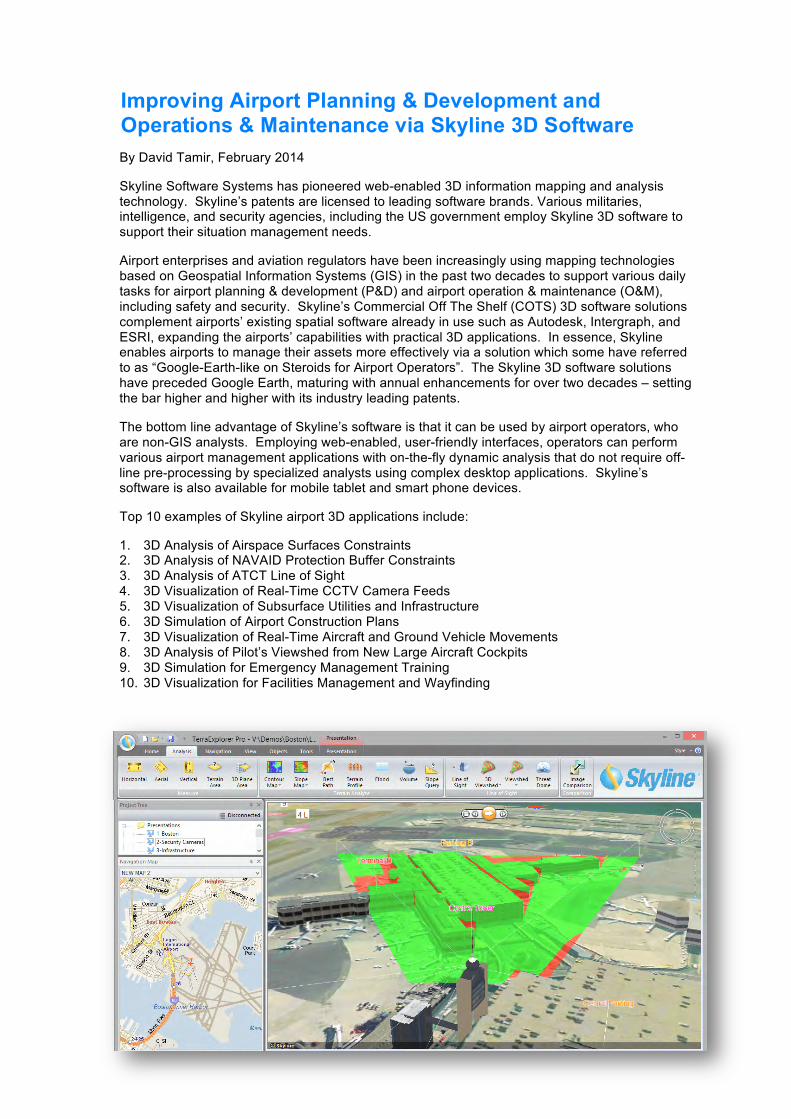
By David Tamir, February 2014
Skyline Software Systems has pioneered web-enabled 3D information mapping and analysis technology. Skyline’s patents are licensed to leading software brands. Various militaries, intelligence, and security agencies, including the US government employ Skyline 3D software to support their situation management needs.
Airport enterprises and aviation regulators have been increasingly using mapping technologies based on Geospatial Information Systems (GIS) in the past two decades to support various daily tasks for airport planning & development (P&D) and airport operation & maintenance (O&M), including safety and security. Skyline’s Commercial Off The Shelf (COTS) 3D software solutions complement airports’ existing spatial software already in use such as Autodesk, Intergraph, and ESRI, expanding the airports’ capabilities with practical 3D applications. In essence, Skyline enables airports to manage their assets more effectively via a solution which some have referred to as “Google-Earth-like on Steroids for Airport Operators”. The Skyline 3D software solutions have preceded Google Earth, maturing with annual enhancements for over two decades – setting the bar higher and higher with its industry leading patents.
The bottom line advantage of Skyline’s software is that it can be used by airport operators, who are non-GIS analysts. Employing web-enabled, user-friendly interfaces, operators can perform various airport management applications with on-the-fly dynamic analysis that do not require off-line pre-processing by specialized analysts using complex desktop applications. Skyline’s software is also available for mobile tablet and smart phone devices.
Top 10 examples of Skyline airport 3D applications include:
1. 3D Analysis of Airspace Surfaces Constraints 2. 3D Analysis of NAVAID Protection Buffer Constraints 3. 3D Analysis of ATCT Line of Sight 4. 3D Visualization of Real-Time CCTV Camera Feeds 5. 3D Visualization of Subsurface Utilities and Infrastructure 6. 3D Simulation of Airport Construction Plans 7. 3D Visualization of Real-Time Aircraft and Ground Vehicle Movements 8. 3D Analysis of Pilot’s Viewshed from New Large Aircraft Cockpits 9. 3D Simulation for Emergency Management Training 10. 3D Visualization for Facilities Management and Wayfinding
Improving Airport Planning & Development and Operations & Maintenance via Skyline 3D Software
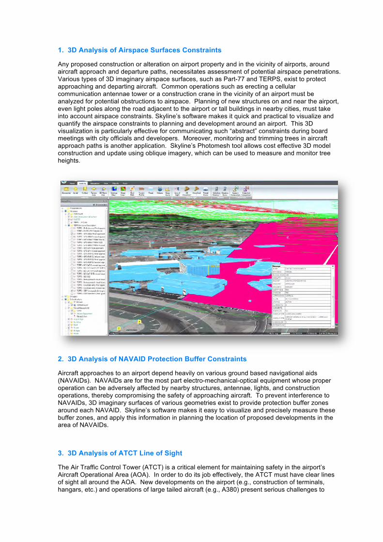
1. 3D Analysis of Airspace Surfaces Constraints
Any proposed construction or alteration on airport property and in the vicinity of airports, around aircraft approach and departure paths, necessitates assessment of potential airspace penetrations. Various types of 3D imaginary airspace surfaces, such as Part-77 and TERPS, exist to protect approaching and departing aircraft. Common operations such as erecting a cellular communication antennae tower or a construction crane in the vicinity of an airport must be analyzed for potential obstructions to airspace. Planning of new structures on and near the airport, even light poles along the road adjacent to the airport or tall buildings in nearby cities, must take into account airspace constraints. Skyline’s software makes it quick and practical to visualize and quantify the airspace constraints to planning and development around an airport. This 3D visualization is particularly effective for communicating such “abstract” constraints during board meetings with city officials and developers. Moreover, monitoring and trimming trees in aircraft approach paths is another application. Skyline’s Photomesh tool allows cost effective 3D model construction and update using oblique imagery, which can be used to measure and monitor tree heights.
2. 3D Analysis of NAVAID Protection Buffer Constraints
Aircraft approaches to an airport depend heavily on various ground based navigational aids (NAVAIDs). NAVAIDs are for the most part electro-mechanical-optical equipment whose proper operation can be adversely affected by nearby structures, antennae, lights, and construction operations, thereby compromising the safety of approaching aircraft. To prevent interference to NAVAIDs, 3D imaginary surfaces of various geometries exist to provide protection buffer zones around each NAVAID. Skyline’s software makes it easy to visualize and precisely measure these buffer zones, and apply this information in planning the location of proposed developments in the area of NAVAIDs.
3. 3D Analysis of ATCT Line of Sight
The Air Traffic Control Tower (ATCT) is a critical element for maintaining safety in the airport’s Aircraft Operational Area (AOA). In order to do its job effectively, the ATCT must have clear lines of sight all around the AOA. New developments on the airport (e.g., construction of terminals, hangars, etc.) and operations of large tailed aircraft (e.g., A380) present serious challenges to
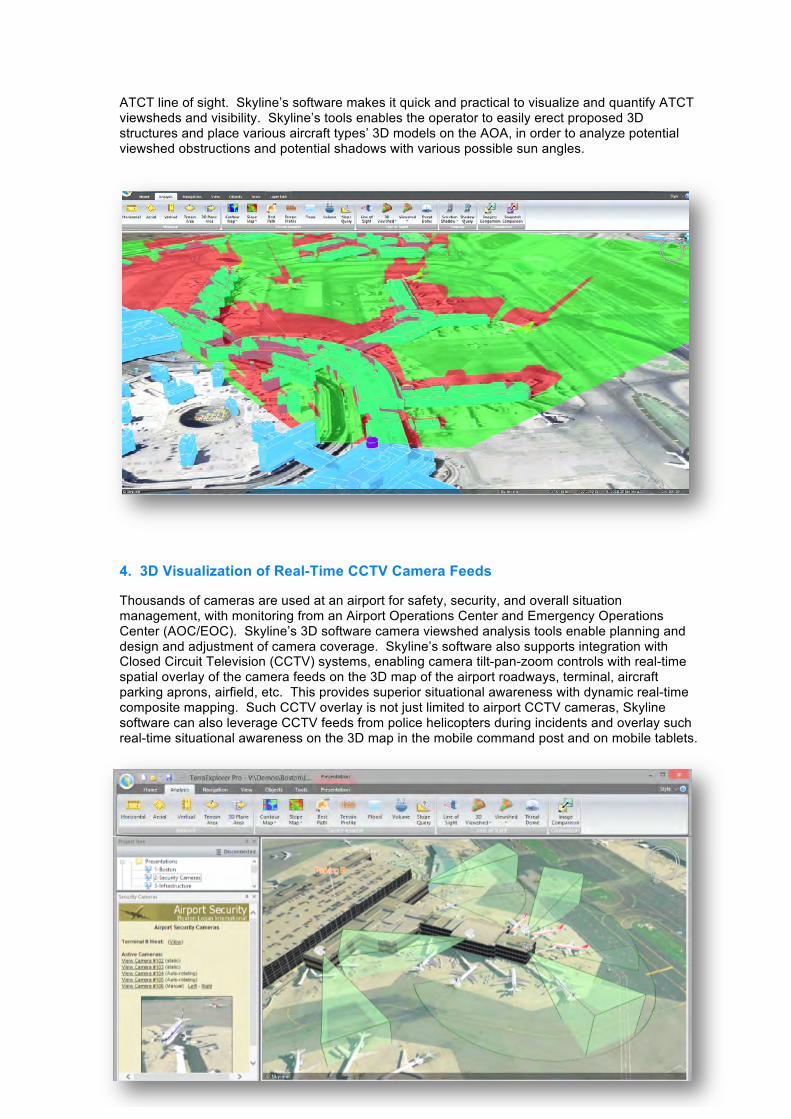
ATCT line of sight. Skyline’s software makes it quick and practical to visualize and quantify ATCT viewsheds and visibility. Skyline’s tools enables the operator to easily erect proposed 3D structures and place various aircraft types’ 3D models on the AOA, in order to analyze potential viewshed obstructions and potential shadows with various possible sun angles.
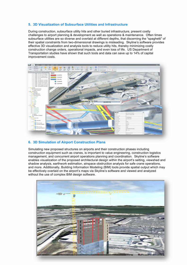
4. 3D Visualization of Real-Time CCTV Camera Feeds
Thousands of cameras are used at an airport for safety, security, and overall situation management, with monitoring from an Airport Operations Center and Emergency Operations Center (AOC/EOC). Skyline’s 3D software camera viewshed analysis tools enable planning and design and adjustment of camera coverage. Skyline’s software also supports integration with Closed Circuit Television (CCTV) systems, enabling camera tilt-pan-zoom controls with real-time spatial overlay of the camera feeds on the 3D map of the airport roadways, terminal, aircraft parking aprons, airfield, etc. This provides superior situational awareness with dynamic real-time composite mapping. Such CCTV overlay is not just limited to airport CCTV cameras, Skyline software can also leverage CCTV feeds from police helicopters during incidents and overlay such real-time situational awareness on the 3D map in the mobile command post and on mobile tablets.
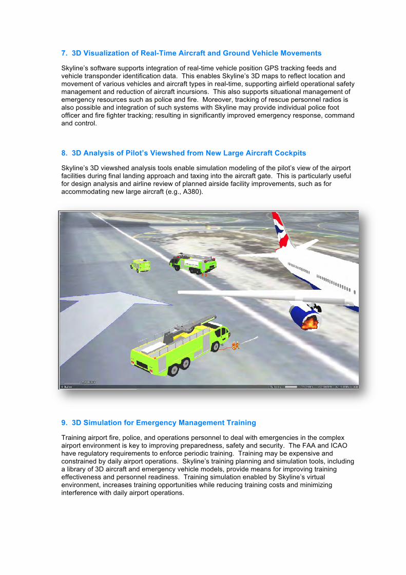
5. 3D Visualization of Subsurface Utilities and Infrastructure
During construction, subsurface utility hits and other buried infrastructure, present costly challenges to airport planning & development as well as operations & maintenance. Often times subsurface utilities are so diverse and overlaid at different depths, that discerning the “spaghetti” of their spatial constraints from two-dimensional drawings is misleading. Skyline’s software provides effective 3D visualization and analysis tools to reduce utility hits, thereby minimizing costly construction change orders, operational impacts, and even loss of life. US Department of Transportation studies have shown that such tools and data can save up to 14% of capital improvement costs.
6. 3D Simulation of Airport Construction Plans
Simulating new proposed structures on airports and their construction phases including construction equipment such as cranes, is important to value engineering, construction logistics management, and concurrent airport operations planning and coordination. Skyline’s software enables visualization of the proposed architectural design within the airport’s setting, viewshed and shadow analysis, earthwork estimation, airspace obstruction analysis for safe crane operations, and more. Additionally, Building Information Modeling (BIM) tools provide spatial output which may be effectively overlaid on the airport’s maps via Skyline’s software and viewed and analyzed without the use of complex BIM design software.
7. 3D Visualization of Real-Time Aircraft and Ground Vehicle Movements
Skyline’s software supports integration of real-time vehicle position GPS tracking feeds and vehicle transponder identification data. This enables Skyline’s 3D maps to reflect location and movement of various vehicles and aircraft types in real-time, supporting airfield operational safety management and reduction of aircraft incursions. This also supports situational management of emergency resources such as police and fire. Moreover, tracking of rescue personnel radios is also possible and integration of such systems with Skyline may provide individual police foot officer and fire fighter tracking; resulting in significantly improved emergency response, command and control.
8. 3D Analysis of Pilot’s Viewshed from New Large Aircraft Cockpits
Skyline’s 3D viewshed analysis tools enable simulation modeling of the pilot’s view of the airport facilities during final landing approach and taxing into the aircraft gate. This is particularly useful for design analysis and airline review of planned airside facility improvements, such as for accommodating new large aircraft (e.g., A380).
9. 3D Simulation for Emergency Management Training
Training airport fire, police, and operations personnel to deal with emergencies in the complex airport environment is key to improving preparedness, safety and security. The FAA and ICAO have regulatory requirements to enforce periodic training. Training may be expensive and constrained by daily airport operations. Skyline’s training planning and simulation tools, including a library of 3D aircraft and emergency vehicle models, provide means for improving training effectiveness and personnel readiness. Training simulation enabled by Skyline’s virtual environment, increases training opportunities while reducing training costs and minimizing interference with daily airport operations.
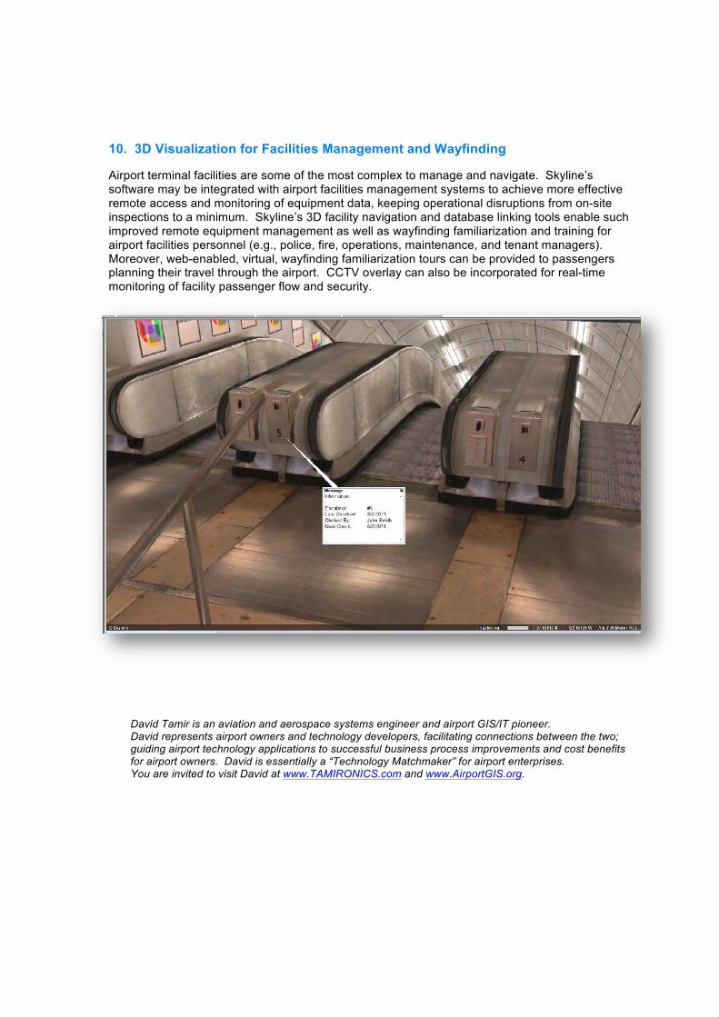
10. 3D Visualization for Facilities Management and Wayfinding
Airport terminal facilities are some of the most complex to manage and navigate. Skyline’s software may be integrated with airport facilities management systems to achieve more effective remote access and monitoring of equipment data, keeping operational disruptions from on-site inspections to a minimum. Skyline’s 3D facility navigation and database linking tools enable such improved remote equipment management as well as wayfinding familiarization and training for airport facilities personnel (e.g., police, fire, operations, maintenance, and tenant managers). Moreover, web-enabled, virtual, wayfinding familiarization tours can be provided to passengers planning their travel through the airport. CCTV overlay can also be incorporated for real-time monitoring of facility passenger flow and security.
David Tamir is an aviation and aerospace systems engineer and airport GIS/IT pioneer. David represents airport owners and technology developers, facilitating connections between the two; guiding airport technology applications to successful business process improvements and cost benefits for airport owners. David is essentially a “Technology Matchmaker” for airport enterprises. You are invited to visit David at www.TAMIRONICS.com and www.AirportGIS.org.