Embed Size (px)
Citation preview
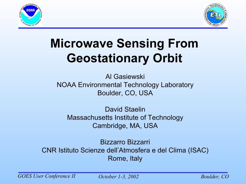
October 1-3, 2002 Boulder, COGOES User Conference II
Al GasiewskiNOAA Environmental Technology Laboratory
Boulder, CO, USA
David StaelinMassachusetts Institute of Technology
Cambridge, MA, USA
Bizzarro BizzarriCNR Istituto Scienze dell’Atmosfera e del Clima (ISAC)
Rome, Italy
October 1-3, 2002 Boulder, COGOES User Conference II
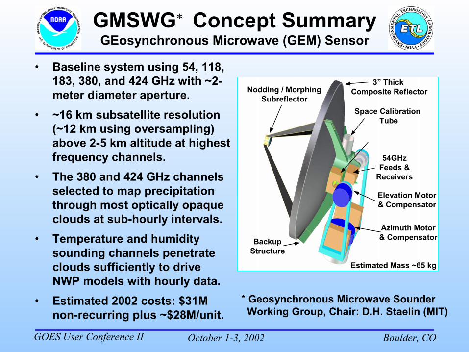
GMSWG� Concept SummaryGEosynchronous Microwave (GEM) Sensor
• Baseline system using 54, 118, 183, 380, and 424 GHz with ~2-meter diameter aperture.
• ~16 km subsatellite resolution (~12 km using oversampling) above 2-5 km altitude at highest frequency channels.
• The 380 and 424 GHz channels selected to map precipitation through most optically opaque clouds at sub-hourly intervals.
• Temperature and humidity sounding channels penetrate clouds sufficiently to drive NWP models with hourly data.
• Estimated 2002 costs: $31M non-recurring plus ~$28M/unit.
Azimuth Motor& Compensator
Elevation Motor& Compensator
Nodding / MorphingSubreflector
Space Calibration Tube
BackupStructure
3” Thick Composite Reflector
54GHz Feeds &
Receivers
* Geosynchronous Microwave Sounder Working Group, Chair: D.H. Staelin (MIT)
Estimated Mass ~65 kg
October 1-3, 2002 Boulder, COGOES User Conference II
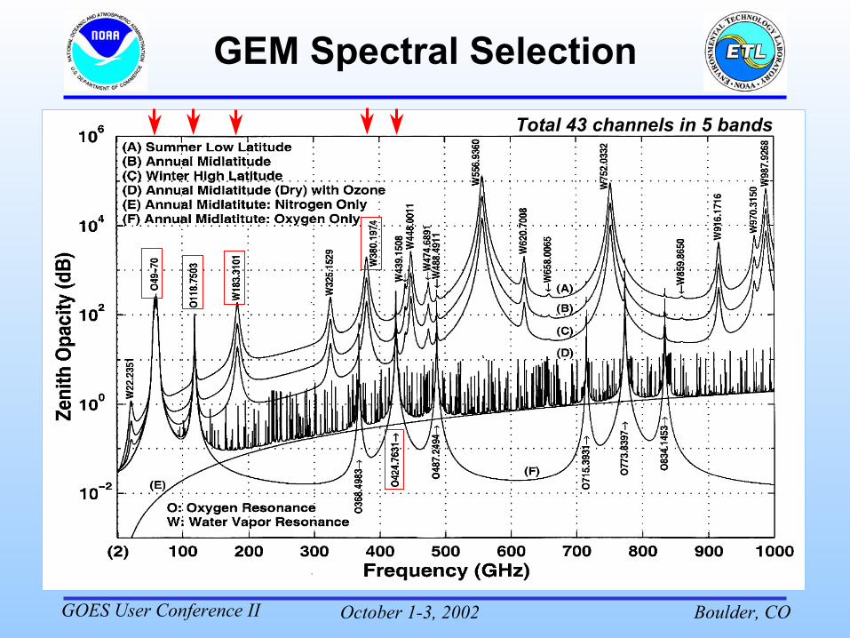
GEM Spectral SelectionTotal 43 channels in 5 bands
October 1-3, 2002 Boulder, COGOES User Conference II
−0.05 0 0.05 0.1 0.150
10
20
30
40118.7503 GHz
Alti
tud
e (
km)
Temperature IWF (km−1)
15−21
29−41
70−90
150−250300−500500−900
900−1300← 1300−1700
← 1700−2500← 2500−3500
4000−6000↓
0 0.05 0.1 0.15 0.2 0.250
10
20
30
40424.7631 GHz
Alti
tud
e (
km)
Temperature IWF (km−1)
25−35
60−80
120−180
250−350500−700800−12001200−1800
3500−4500
−2 0 2 4 60
5
10
15
20150−450
650−11501300−20002500−35004000−6000
← 6000−8000
15000−19000
183.3101 GHz
Alti
tud
e (
km)
Water Vapor IWF (K km−1)
−2 −1.5 −1 −0.5 0 0.50
5
10
15
2030−60
300−500
1250−1750
3550−4450
8000−1000017000−19000↑
380.1974 GHz & 340 GHzA
ltitu
de
(km
)
Water Vapor IWF (K km−1)
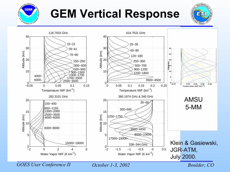
336−344 GHz Klein & Gasiewski, JGR-ATM, July 2000.
Clear-air incementalweighting functions
O2118.750 GHz424.763 GHz
H2O 183.310 GHz380.197/340
AMSU5-MM
October 1-3, 2002 Boulder, COGOES User Conference II
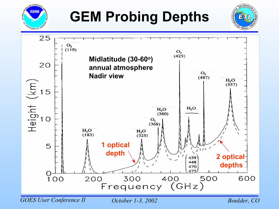
Mari???
Midlatitude (30-60o) annual atmosphereNadir view
1 opticaldepth 2 optical
depths
October 1-3, 2002 Boulder, COGOES User Conference II
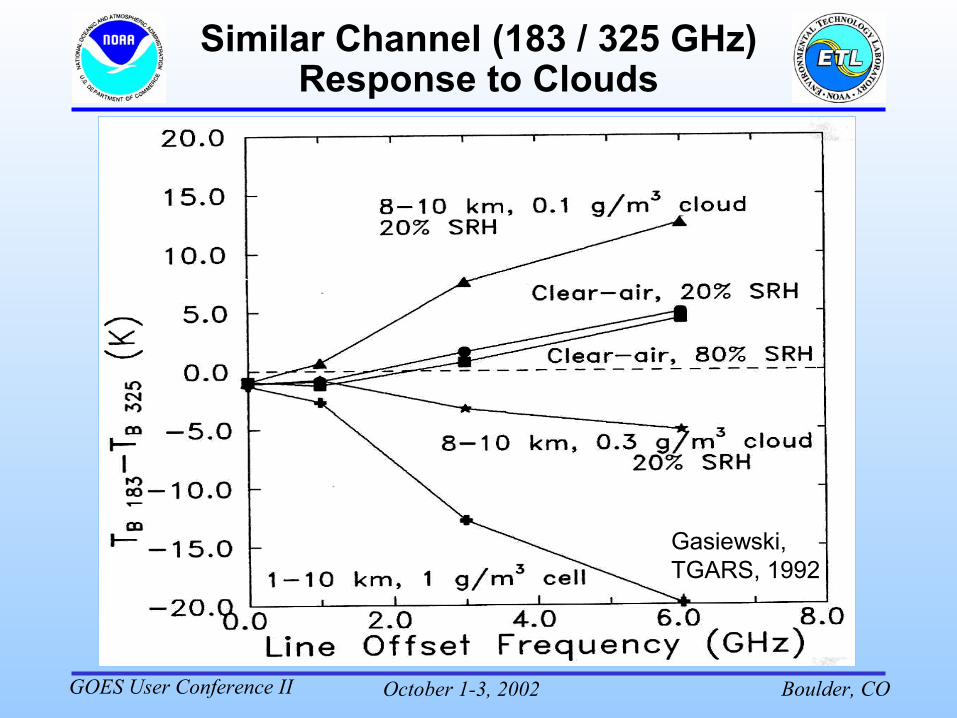
Similar Channel (183 / 325 GHz) Response to Clouds
Gasiewski, TGARS, 1992
October 1-3, 2002 Boulder, COGOES User Conference II
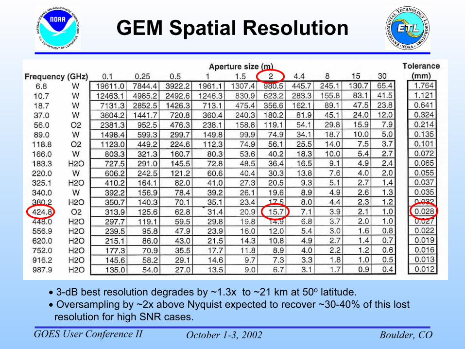
GEM Spatial Resolution
� 3-dB best resolution degrades by ~1.3x to ~21 km at 50o latitude.� Oversampling by ~2x above Nyquist expected to recover ~30-40% of this lost
resolution for high SNR cases.
October 1-3, 2002 Boulder, COGOES User Conference II
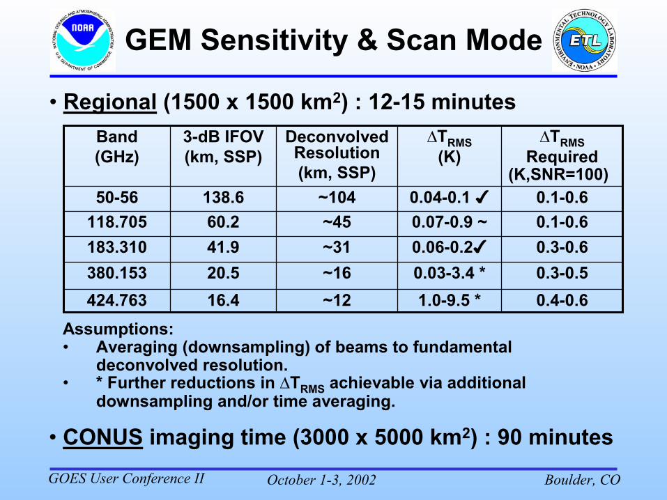
GEM Sensitivity & Scan Mode
Assumptions: • Averaging (downsampling) of beams to fundamental
deconvolved resolution.• * Further reductions in �TRMS achievable via additional
downsampling and/or time averaging.
• CONUS imaging time (3000 x 5000 km2) : 90 minutes
• Regional (1500 x 1500 km2) : 12-15 minutes
0.4-0.61.0-9.5 *~1216.4424.7630.3-0.50.03-3.4 *~1620.5380.1530.3-0.60.06-0.2�~3141.9183.3100.1-0.60.07-0.9 ~~4560.2118.7050.1-0.60.04-0.1 �~104138.650-56
�TRMSRequired
(K,SNR=100)
�TRMS(K)
DeconvolvedResolution(km, SSP)
3-dB IFOV(km, SSP)
Band(GHz)
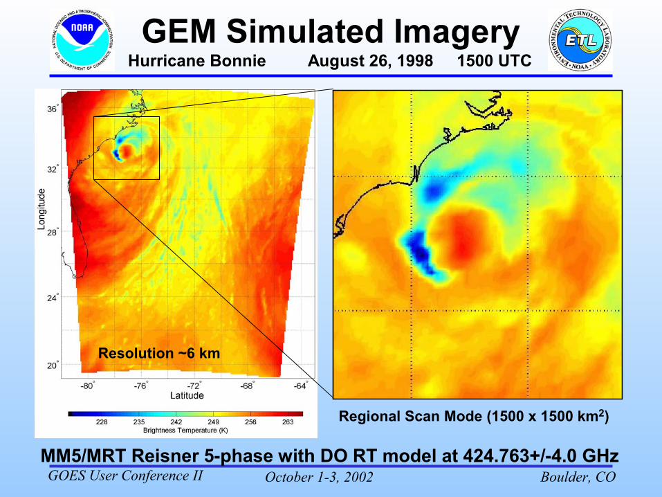
October 1-3, 2002 Boulder, COGOES User Conference IIMM5/MRT Reisner 5-phase with DO RT model at 424.763+/-4.0 GHz
Hurricane Bonnie August 26, 1998 1500 UTC
Regional Scan Mode (1500 x 1500 km2)
Resolution ~6 km
October 1-3, 2002 Boulder, COGOES User Conference II
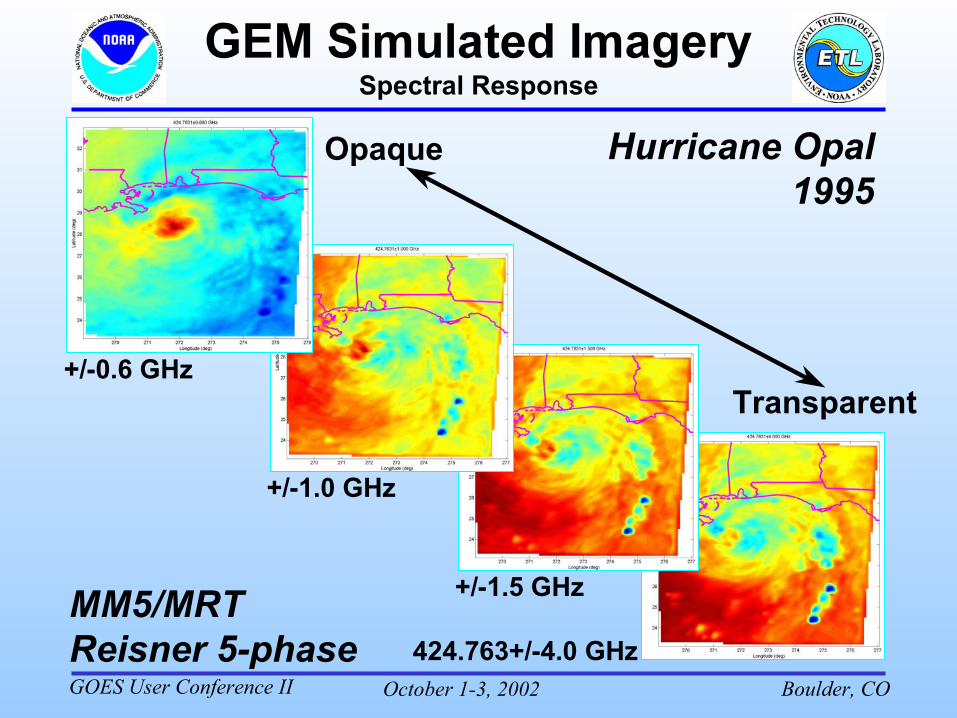
Spectral Response
Opaque
Transparent+/-0.6 GHz
+/-1.0 GHz
+/-1.5 GHz
424.763+/-4.0 GHz
Hurricane Opal1995
MM5/MRTReisner 5-phase
October 1-3, 2002 Boulder, COGOES User Conference II
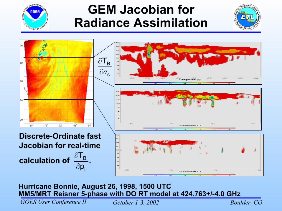
GEM Jacobian for Radiance Assimilation
MM5/MRT Reisner 5-phase with DO RT model at 424.763+/-4.0 GHz
Discrete-Ordinate fast Jacobian for real-time
calculation of .�TB
�pi
�TB
��s
Hurricane Bonnie, August 26, 1998, 1500 UTC
October 1-3, 2002 Boulder, COGOES User Conference II
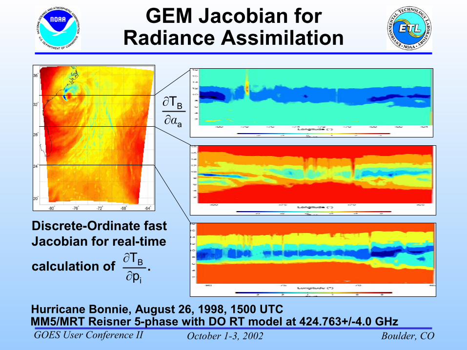
GEM Jacobian for Radiance Assimilation
MM5/MRT Reisner 5-phase with DO RT model at 424.763+/-4.0 GHz
Discrete-Ordinate fast Jacobian for real-time
calculation of .�TB
�pi
�TB
��a
Hurricane Bonnie, August 26, 1998, 1500 UTC
October 1-3, 2002 Boulder, COGOES User Conference II
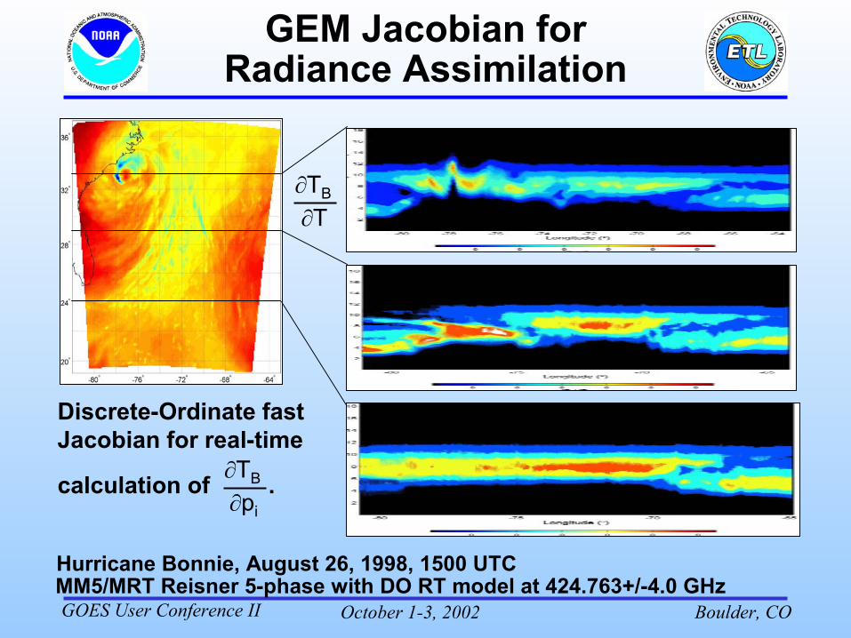
GEM Jacobian for Radiance Assimilation
MM5/MRT Reisner 5-phase with DO RT model at 424.763+/-4.0 GHzHurricane Bonnie, August 26, 1998, 1500 UTC
Discrete-Ordinate fast Jacobian for real-time
calculation of .�TB
�pi
�TB
�T
October 1-3, 2002 Boulder, COGOES User Conference II
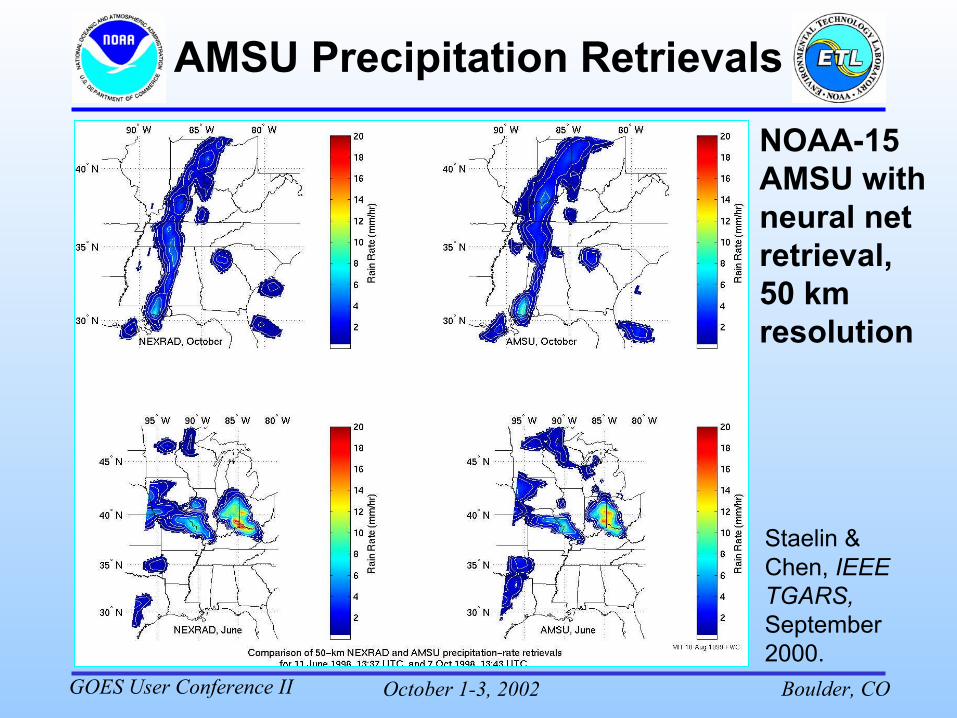
AMSU Precipitation Retrievals
NOAA-15 AMSU with neural net retrieval, 50 km resolution
Staelin & Chen, IEEE TGARS, September 2000.
October 1-3, 2002 Boulder, COGOES User Conference II
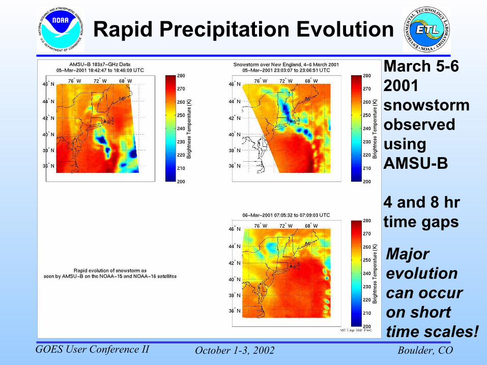
Rapid Precipitation EvolutionMarch 5-6 2001 snowstorm observed using AMSU-B
4 and 8 hr time gaps
Major evolution can occur on short time scales!
October 1-3, 2002 Boulder, COGOES User Conference II
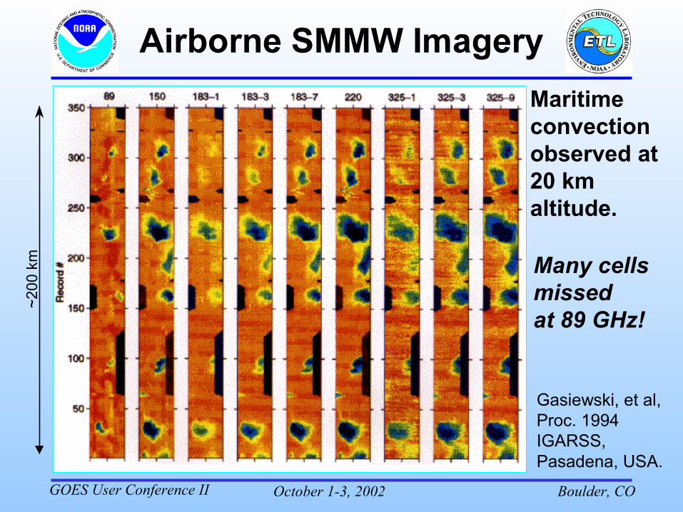
Maritime convection observed at 20 km altitude.
Many cells missedat 89 GHz!
~200
km
Gasiewski, et al, Proc. 1994 IGARSS, Pasadena, USA.
October 1-3, 2002 Boulder, COGOES User Conference II
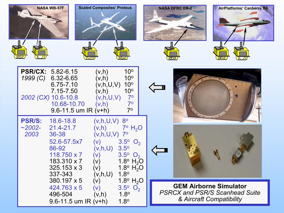
PSR/CX: 5.82-6.15 (v,h) 10o
1999 (C) 6.32-6.65 (v,h) 10o
6.75-7.10 (v,h,U,V) 10o
7.15-7.50 (v,h) 10o
2002 (CX) 10.6-10.8 (v,h,U,V) 7o
10.68-10.70 (v,h) 7o
9.6-11.5 um IR (v+h) 7o
PSR/S: 18.6-18.8 (v,h,U,V) 8o
~2002- 21.4-21.7 (v,h) 7o H2O 2003 36-38 (v,h,U,V) 7o
52.6-57.5x7 (v) 3.5o O286-92 (v,h,U) 3.5o
118.750 x 7 (v) 3.5o O2183.310 x 7 (v) 1.8o H2O325.153 x 3 (v) 1.8o H2O337-343 (v,h,U) 1.8o
380.197 x 5 (v) 1.8o H2O 424.763 x 5 (v) 3.5o O2496-504 (v,h) 1.8o
9.6-11.5 um IR (v+h) 1.8o
CX
VIR5.8 -7.5 &
10.7 GHz
GEM Airborne SimulatorPSRCX and PSR/S Scanhead Suite
& Aircraft Compatibility
V
IRS
18/21
50-5937
89 118
183
340325380
424
500
21
AirPlatforms’ Canberra B6
21
NASA DFRC ER-2
1
Scaled Composites’ Proteus
1 2
NASA WB-57F
October 1-3, 2002 Boulder, COGOES User Conference II
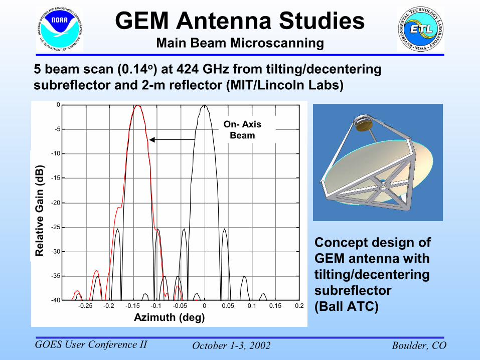
Main Beam Microscanning
-0.25 -0.2 -0.15 -0.1 -0.05 0 0.05 0.1 0.15 0.2-40
-35
-30
-25
-20
-15
-10
-5
0
On- AxisBeam
Azimuth (deg)
Rel
ativ
e G
ain
(dB
)
5 beam scan (0.14o) at 424 GHz from tilting/decentering subreflector and 2-m reflector (MIT/Lincoln Labs)
Concept design of GEM antenna with tilting/decentering subreflector(Ball ATC)
October 1-3, 2002 Boulder, COGOES User Conference II
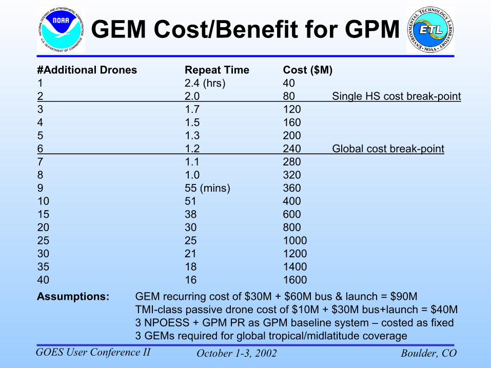
Assumptions: GEM recurring cost of $30M + $60M bus & launch = $90MTMI-class passive drone cost of $10M + $30M bus+launch = $40M3 NPOESS + GPM PR as GPM baseline system – costed as fixed3 GEMs required for global tropical/midlatitude coverage
#Additional Drones Repeat Time Cost ($M)1 2.4 (hrs) 402 2.0 80 Single HS cost break-point3 1.7 1204 1.5 1605 1.3 2006 1.2 240 Global cost break-point7 1.1 2808 1.0 3209 55 (mins) 36010 51 40015 38 60020 30 80025 25 1000 30 21 120035 18 140040 16 1600
October 1-3, 2002 Boulder, COGOES User Conference II
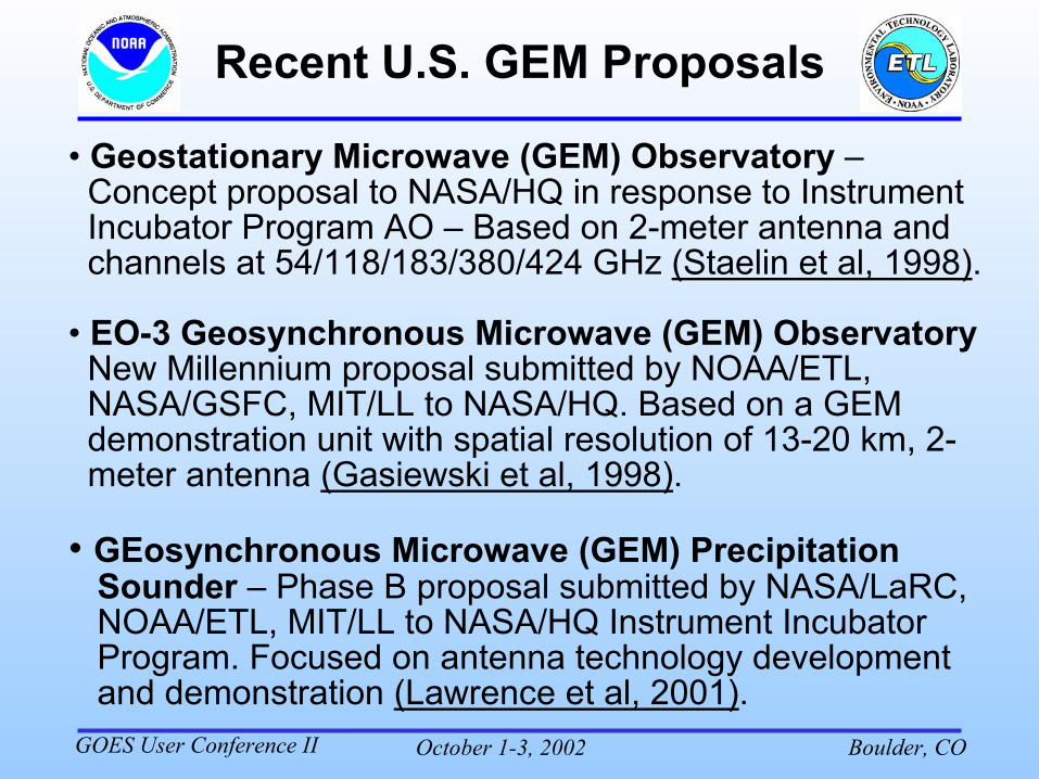
Recent U.S. GEM Proposals
• Geostationary Microwave (GEM) Observatory –Concept proposal to NASA/HQ in response to InstrumentIncubator Program AO – Based on 2-meter antenna andchannels at 54/118/183/380/424 GHz (Staelin et al, 1998).
• EO-3 Geosynchronous Microwave (GEM) ObservatoryNew Millennium proposal submitted by NOAA/ETL,NASA/GSFC, MIT/LL to NASA/HQ. Based on a GEMdemonstration unit with spatial resolution of 13-20 km, 2-meter antenna (Gasiewski et al, 1998).
• GEosynchronous Microwave (GEM) PrecipitationSounder – Phase B proposal submitted by NASA/LaRC,NOAA/ETL, MIT/LL to NASA/HQ Instrument IncubatorProgram. Focused on antenna technology developmentand demonstration (Lawrence et al, 2001).
October 1-3, 2002 Boulder, COGOES User Conference II
Recent U.S. GEM Proposals(cont’d)
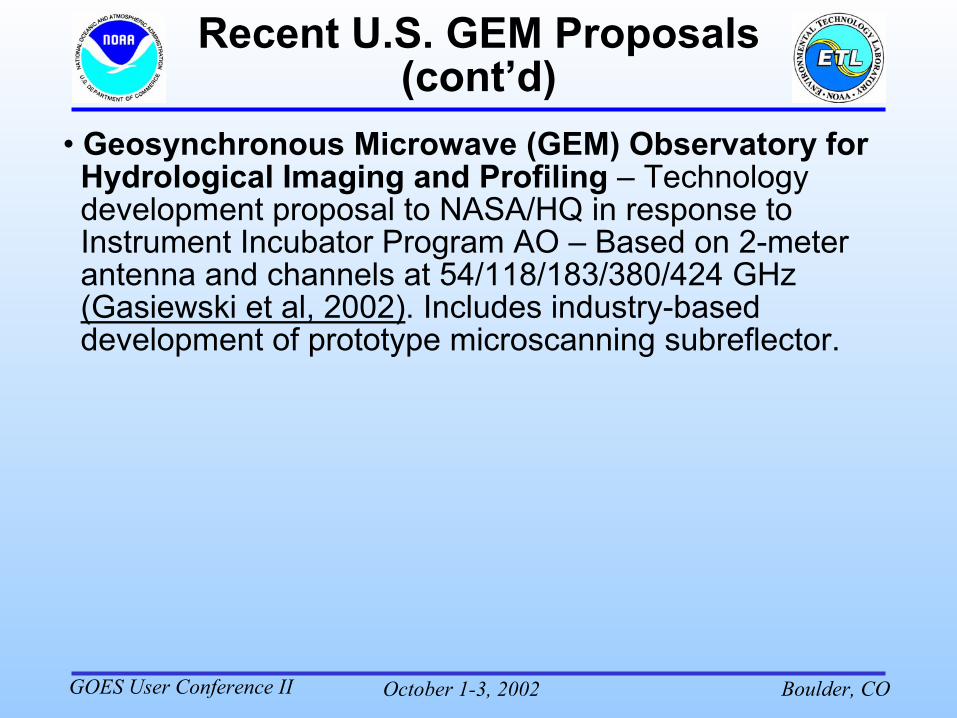
• Geosynchronous Microwave (GEM) Observatory forHydrological Imaging and Profiling – Technologydevelopment proposal to NASA/HQ in response toInstrument Incubator Program AO – Based on 2-meterantenna and channels at 54/118/183/380/424 GHz(Gasiewski et al, 2002). Includes industry-baseddevelopment of prototype microscanning subreflector.
October 1-3, 2002 Boulder, COGOES User Conference II
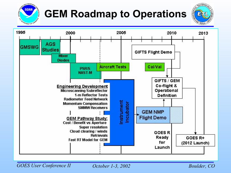
GEM Roadmap to Operations
October 1-3, 2002 Boulder, COGOES User Conference II
GOMAS Proposal to ESA� Proposal to ESA Earth Explorer Opportunity Missions:“Geostationary Observatory for MicrowaveAtmospheric Sounding” – submitted Jan 2002.
� PI: B. Bizzarri, many European and U.S. partners.
� Based on U.S. GEM baseline design, but free flyer withlarger antenna (3-m) to compensate for application athigher European latitudes (antenna cost ~d2.5).
� 3-year science demo phase, 5-yr design lifetime, 10 kmbest resolution w/o deconvolution, 15 minute bestupdate. Launch ~2008+, cost 160 M€ total, includingground segment
� To be considered for further scientific and technolog-ical study within ESA
October 1-3, 2002 Boulder, COGOES User Conference II
• GEM will be a cost-effective AMSU-like sounder/imager but with time-resolved observations of precipitation –complementary to HES, GIFTS.
• GEM concept study completed, antenna and scanning technology under development (MIT/LL, NOAA/ETL)
• Convective PR anticipated to be measurable over both land and water along with sounding products within clouds, ~15 km midlatitude spatial resolution.
• Demonstration of operational system possible within GPM and NPOESS timeframe. GOES R+ ~2012+ (?)
• Aircraft demonstrations under development (NOAA, MIT)
• European GOMAS concept proposal submitted to ESA (Jan 2002), GOMAS science studies planned (2003).
• RT model and retrieval simulations in progress (NOAA)