Embed Size (px)
DESCRIPTION
Fish consumption advisories issued by the Alabama Department of Public Health.
Citation preview

Alabama Fish Consumption
Advisories 2016
Created by the Alabama Department of Public Health (ADPH), in cooperation with the Alabama Department of Environmental Management (ADEM), and the
Alabama Department of Conservation and Natural Resources (ADCNR), and the Tennessee Valley Authority (TVA)

Alabama Fish Consumption Advisories, ADPH, Released June 2016 2
Table of Contents Introduction 3Statewide Advice for At‐Risk Women and Children 4Fishing and Your Health Frequently Asked Questions (FAQs) Why should I eat fish? 5 What is an advisory? 5 How does ADPH determine if a waterbody should have an advisory? 5 Why do we have advisories? 5 Are fish consumption advisories only in Alabama? 5 Why are some fish not safe to eat? 5 General rule of thumb 5 Why are only certain species of fish listed in the advisory? 6 How often are fish advisories updated? 6 How do fish become contaminated? 6 Why are the restrictions limited in area when actually fish travel? 6 What are the main contaminants in Alabama? 7 What do I need to know about mercury? 7 Health notes for adults 7 What do I need to know about PCBs? 7 What are the health effects of PCBs in pregnant women? 7 What do I need to know about PFOS? 8 Health information for adults 8 How can I reduce the health risks from contaminated fish? 8 What do I need to know about shellfish in Alabama to stay safe? 8 What about fish I buy instead of catch? 8 Does ADPH post signs on waterbodies with advisories? 9 Where can I get more information? 9Cleaning and cooking fish to reduce PCBs 10Understanding the Advisories 11Alabama Fish Consumption Advisories Basins 12 Area 1: Tennessee Basin 13 Area 2: Escatawpa/Tombigbee/Mobile Basin 17 Area 3: Black Warrior/Cahaba Basin 21 Area 4: Alabama/Coosa/Tallapoosa Basin 24 Area 5: Perdido‐Escambia/Choctawhatchee/Pea/Chipola/Chattahoochee Basin 28 Area 6: Alabama Gulf Coast 32Index of Listed Waterbodies 33
Alabama Fish Consumption Advisories, ADPH, Released June 2016 3
Introduction
Alabama has over 77,000 miles of rivers and streams, 41 public lakes and reservoirs, and some of the most varied fish habitat in the United States. Fishing is a popular sport in Alabama, and provides many benefits, such as recreation and procurement of healthy food. Fish are high in protein, low in fat and cholesterol, and low calorie when prepared healthily. Unfortunately, certain toxic chemicals have been found in some lakes and rivers in Alabama. Some of these chemicals can accumulate in fish. With some of the chemicals, higher levels of the contaminants can be found in older and/or larger fish. When chemical concentrations are elevated in fish, they can pose health risks to people who eat them. Sampling of fish provides the information (levels of contaminants) needed for issuing the advisories. This advisory booklet was developed to inform people who eat Alabama fish as to which species of fish in which waterbodies may present an elevated health hazard.

Alabama Fish Consumption Advisories, ADPH, Released June 2016 4
Statewide Advice for At‐Risk Women and Children*
At‐risk groups should follow the advice listed below. Advice for at‐risk groups:
Do NOT eat any king mackerel, shark, swordfish, or tilefish.
Limit white (albacore) tuna to 6 ounces a week.
Eat up to 12 ounces (2 average meals) a week of a variety of fish and shellfish that are lower in mercury.
Check local advisories about the safety of fish caught by family and friends in local lakes, rivers, and coastal areas.
Follow the recommendations listed above when feeding fish and shellfish to young children, but serve smaller portions.
*At‐risk groups include:
Babies
Children under 14
Women who are nursing
Women who are pregnant
Women who plan to become pregnant Why are these groups at a greater risk?
Developing bodies, such as infants and small children, are at a greater risk since their brains and nervous systems are still forming.
The body naturally removes small amounts of contaminants, like mercury, but contaminants can build up in the body if too much is consumed.
Health problems can occur when there are too many harmful chemicals in the body.
To find out more, visit Environmental Protection Agency’s (EPA) Website at www.epa.gov/ost/fish or go to the Food and Drug Administration’s (FDA) Website at http://www.fda.gov/Food/ResourcesForYou/Consumers/ucm110591.htm
Alabama Fish Consumption Advisories, ADPH, Released June 2016 5
Eating Fish & Your Health FAQs
Why should I eat fish?
Fish are low in fat and contain omega‐3 fatty acids (boosts heart health).
Fish are a great source of protein, vitamins, and minerals.
Eating fish regularly can reduce your chances of having a stroke or heart attack.
To get all the benefits, you should eat fish at least 2 meals each week, but remember to choose the right fish to eat. NOTE: Breading and frying fish decreases health benefits.
What is an advisory?
An advisory is a recommendation.
The advisory will list a lake, stream, or river in Alabama and tell you the type of fish and the amount of fish that is safe to eat.
If a waterbody or type of fish is not listed in the tables, it means that ADPH has not issued any consumption advice.
Here are the reasons that ADPH may not issue an advisory:
The waterbody has not been sampled
There is not enough data
The waterbody is privately owned
How Does the Alabama Department of Public Health (ADPH) determine a waterbody should have an advisory?
The Alabama Department of Environmental Management (ADEM) collects and tests fish from Alabama’s lakes, rivers, streams, estuaries, and offshore waters.
All fish are measured for length, weighed, and examined for overall condition.
Fish are filleted/processed to remove the entire edible portion of tissue. Samples are then transferred to the laboratory for analysis.
ADPH receives the fish tissue data from ADEM, and examines the data and issues fish consumption advisories where contaminated fish have been found.
Location where consumption advisories have been issued in the past are periodically re‐sampled by ADEM to verify and monitor chemical concentrations.
Why do we have advisories?
ADPH issues advisories to help ensure the fish you catch are safe to eat. Are fish consumption advisories only in Alabama?
No. Most states have issued fish consumption advisories. To look at other states’ advisories, go to http://www.epa.gov/waterscience/fish/states.htm
General rule of thumb:
Older and larger fish have eaten more and have been in the water longer, so there may be more contaminants in their bodies
Alabama Fish Consumption Advisories, ADPH, Released June 2016 6
Why are only certain species of fish listed in the advisory?
It is difficult to sample a wide variety of fish in a given location, as not all species that inhabit the specific waterbody will be found at the selected sampling location during the sampling time frame.
If a particular species is not listed in the advisory, it is prudent to assume similar species with similar feeding habits should be consumed with caution.
How often are fish advisories updated?
ADPH annually updates fish consumption advisories based on data collected the preceding fall by ADEM.
How do fish become contaminated?
Contaminants get into water from erosion, storm water runoff, industrial and municipal discharges, agricultural practices, nonpoint source pollution and other factors.
When it rains, chemicals from the land and in the air are washed into the water.
Contaminants are carried downstream by rivers and creeks into lakes, reservoirs, and estuaries.
Fish absorb PCBs, chlordane and other pesticides from water, suspended sediments, or their food.
Organic chemicals concentrate in the fat of fish tissue and in fatty fish such as carp and catfish.
Cleaning and cooking a fish to remove fat will lower the amount of PCBs, chlordane or other pesticides in a fish meal.
Larger, older fish and fish which eat other fish may accumulate more contaminants than smaller, younger fish.
Contaminants are often not measured in panfish such as crappie and bluegill because their food sources are lower on the food chain and bioaccumulate less. Once in the water, mercury is converted to methyl mercury by bacteria and other processes.
Fish absorb methyl mercury from their food and from water as it passes over their gills.
Mercury is bound to proteins in fish tissue, including muscle. Why are the restrictions limited in area when actually fish travel widely?
Fish movement in streams has not been extensively studied for most species.
The distance fish travel is highly variable, and can be due to the species of fish (salmon are famous for their long migration), recolonization of intermittent or disturbed streams, or spawning behavior.
Most travel is seasonal in nature and may be related to the avoidance of colder water or food availability.
Water temperature can affect fish movement, as in cooler temperature water fish do not travel as extensively.
Most species of fish will stay in their home range if it is sufficiently large, and within the same species there are some fish that will stay in their home range and some travel extensively.
Some species travel distances less than 10‐100 meters from the home pool. The distances a fish will travel on a daily/weekly/monthly/annual basis will not necessarily be only in an upstream/downstream direction, but may be perpendicular to the stream bank.
The state cannot test entire river basins as this would be labor and cost prohibitive.
The state gives the testing location as a guide for the angler to make a judgment call as to whether to consume fish from the location.
Alabama Fish Consumption Advisories, ADPH, Released June 2016 7
ADPH’s advisory is a recommendation to limit consumption of fish or to not eat fish from a given location.
What are the main contaminants in Alabama?
Mercury
Polychlorinated biphenyls (PCBs)
Perfluoralkyl sulfonate (PFOS) What do I need to know about mercury?
Mercury in the environment comes from natural sources and from pollution.
The largest sources of pollution have been from decades of burning fossil fuel and waste.
Mercury builds up in the tissue or muscle of the fish.
It can also build up in our tissues when we eat fish contaminated with mercury.
The risk is only in eating the fish, which means you can still enjoy water activities like catch and release fishing, swimming, boating, and other water recreational activities.
The mercury risk depends on how much and how often we eat certain types of fish.
Mercury in fish is an issue for the whole nation, not just Alabama. Health information for adults:
Too much consumption of fish with high levels of mercury may lead to heart disease in adults.
Health effects of mercury in adults can usually be corrected if a person stops eating fish that contain high levels of mercury.
If you are concerned about the amount of mercury in your body, see your doctor. What do I need to know about PCBs?
PCBs stand for polychlorinated biphenyls.
Man‐made compounds; banned in 1976.
PCBs were used as fluids for electrical transformers and products like cutting oils and carbonless copy paper.
They remain a problem today because they do not break down easily in the environment.
PCBs build up over time in the fatty parts of the fish.
PCBs can also build up in our bodies.
By cleaning or cooking fish to reduce fat, you can reduce the amount of PCBs you eat.
See page 10 for tips on how to clean and cook fish to reduce PCBs. What are the health effects of PCBs in pregnant women?
Lower birth weight
Smaller infant head size
Premature births
Developmental problems and learning disabilities
What do I need to know about PFOS?
PFOS is an organic molecule that contains fluorine. Prior to being phased out in 2002, PFOS was produced in large quantities.
PFOS was either used by itself, or as a starting material for larger molecules.

Alabama Fish Consumption Advisories, ADPH, Released June 2016 8
PFOS has also been named 1‐octanesulfonic acid, heptadecafluoro‐, 1‐perfluorooctanesulfonic acid, heptadecafluoro‐1‐octanesulfonic acid, perfluoro‐n‐octanesulfonic acid, perfluoroctanesulfonic acid, and perfluoroctylsulfonic acid.
PFOS is chemically and biologically stable. The molecule is very resistant to degradation; therefore it is extremely persistent in the environment.
PFOS has been shown to accumulate in fish tissues. Health information for adults:
PFOS can be found in small quantities in both human and wildlife blood samples nationwide.
Limited studies have indicated that fish consumption may be a route of human exposure to PFOS.
PFOS is readily absorbed after ingestion and accumulates primarily in the serum, kidney, and liver.
Due to its chemical nature, metabolism in the body is very slow. Therefore, it can stay in the body for a long time.
Animal studies have raised some concerns about potential health effects of PFOS.
Human toxicity is not well understood. Some epidemiological studies have shown an association between PFOS exposure and adverse health effects; however more research is needed.
PFOS is not considered to be a carcinogen in humans. How can I reduce the health risks from contaminated fish? You can reduce the health risks from any type of fish by following these tips:
Do not eat more fish than the advisory recommends.
Eat fish from lakes and rivers that do not have advisories.
Eat smaller fish, OR eat smaller portions of large fish
Eat different types of fish instead of just one type.
Clean and cook your fish the right way (only helps to reduce PCBs)
Enjoy fishing by catching and releasing the fish instead of eating them. What do I need to know about shellfish in Alabama to stay safe?
ADPH regularly test the waterbodies containing shellfish beds for bacteria.
ADPH will close the shellfish bed, if health standards are not met, or if conditions have changed to make the shellfish unsafe.
A closed shellfish bed means that it is unsafe to eat the shellfish in that area.
Testing ensures that the shellfish you collect and eat in Alabama are safe.
For more information on ADPH’s Shellfish Program, go to http://adph.org/foodsafety/Default.asp?id=1141
For shellfish closure updates, call (251) 432‐7618. What about fish I buy instead of catch?
The U.S. Food and Drug Administration (FDA) and the U.S. Environmental Protection Agency (EPA) have issued a national mercury advisory for fish that you buy.
The advisory includes fresh, frozen, and canned fish that you buy at a store or restaurant.
EPA and FDA advice for women in the at‐risk group: o Do not eat Shark, Swordfish, King Mackerel, or Tilefish.
Alabama Fish Consumption Advisories, ADPH, Released June 2016 9
o Eat up to 12 ounces (2 average meals) a week of a variety of fish and shellfish that are lower in mercury.
o Check local advisories in your state for fish caught by your family and friends.
Follow the same advice when feeding fish and shellfish to young children, only serve them a smaller portion.
Need more information about store bought fish? o FDA’s Website at http://www.fda.gov/Food/ResourcesForYou/Consumers/ucm077331.htm o EPA’s Website at http://www.epa.gov/mercury/advisories.htm o Health and Human Services’ (HHS) Website at
http://www.foodsafety.gov/keep/types/seafood/index.html
Does ADPH post signs on waterbodies with advisories?
Typically no. A fish advisory can vary from year to year and it would be impractical to continually replace signage. Vandalism (either sign defacement or theft) also makes posting signs problematic. There are limited locations in the state where emplacement of signs on public boat landings has occurred. These locations were posted because of agreements with federal agencies and companies performing cleanup of contaminated waterbodies.
Where can I get more information about topics discussed in this booklet?
For the ADPH Fish Consumption Advisory Website, go to http://adph.org/tox/index.asp?id=1360
You can also call ADPH’s toll free number at 1‐800‐338‐8374
For more information on fishing and Alabama’s Rules and Regulations, visit the Alabama Department of Conservation and Natural Resources (ADCNR) Website at http://www.outdooralabama.com/fishing/freshwater/regulations/
Alabama Fish Consumption Advisories, ADPH, Released June 2016 10
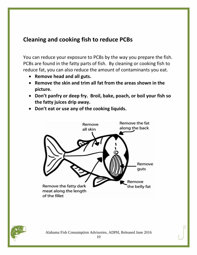
Cleaning and cooking fish to reduce PCBs
You can reduce your exposure to PCBs by the way you prepare the fish. PCBs are found in the fatty parts of fish. By cleaning or cooking fish to reduce fat, you can also reduce the amount of contaminants you eat.
Remove head and all guts.
Remove the skin and trim all fat from the areas shown in the picture.
Don’t panfry or deep fry. Broil, bake, poach, or boil your fish so the fatty juices drip away.
Don’t eat or use any of the cooking liquids.
Alabama Fish Consumption Advisories, ADPH, Released June 2016 11
Understanding the Advisories
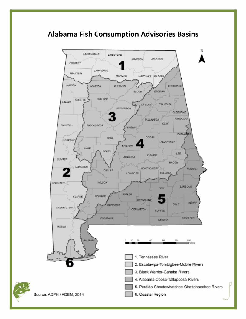
How to find an advisory Search by region The map of Alabama is divided into six areas (page 12). The waterbodies are listed in alphabetical order within each section. Find your waterbody of interest and follow the consumption advice related to that species of fish.
Search by waterbody If you have a specific waterbody you are looking for, go to page 31 for a complete index of waterbodies.
Eating fish from waterbodies under advisory** **See page 4‐additional advice for at‐risk women and children
Portion sizes Advisories are based on 1 meal of fish One meal of fish = ½ pound or 8 ounces (raw) of fish 8 ounces of raw fish = about the size of 2 decks of playing cards
Spacing your consumption When eating fish from waterbodies under advisory, you should space out your meals based on the advice given 1 meal a week = you may eat 8 ounces of fish once in that week 1 meal a month = you may eat 8 ounces of fish once in that month No restrictions = this means that you can eat that type of fish in that waterbody as often as you would like
Example Largemouth bass in the Bay Minette Creek have an advisory for 1 meal a month. Once you have eaten a meal of largemouth bass from Bay Minette Creek, you should not eat any more fish under a mercury advisory for the rest of the month. This includes other fish from Bay Minette Creek and anywhere else with an advisory.
Alabama Fish Consumption Advisories, ADPH, Released June 2016 12
Alabama Fish Consumption Advisories Basins
Alabama Fish Consumption Advisories, ADPH, Released June 2016 13
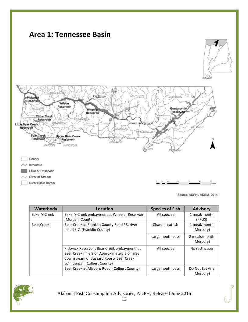
Area 1: Tennessee Basin
Waterbody Location Species of Fish Advisory Baker’s Creek
Baker’s Creek embayment at Wheeler Reservoir. (Morgan County)
All species 1 meal/month(PFOS)
Bear Creek
Bear Creek at Franklin County Road 53, river mile 95.7. (Franklin County)
Channel catfish
1 meal/month(Mercury)
Largemouth bass 2 meals/month(Mercury)
Pickwick Reservoir, Bear Creek embayment, at Bear Creek mile 8.0. Approximately 5.0 miles downstream of Buzzard Roost/ Bear Creek confluence. (Colbert County)
All species No restriction
Bear Creek at Allsboro Road. (Colbert County) Largemouth bass Do Not Eat Any(Mercury)
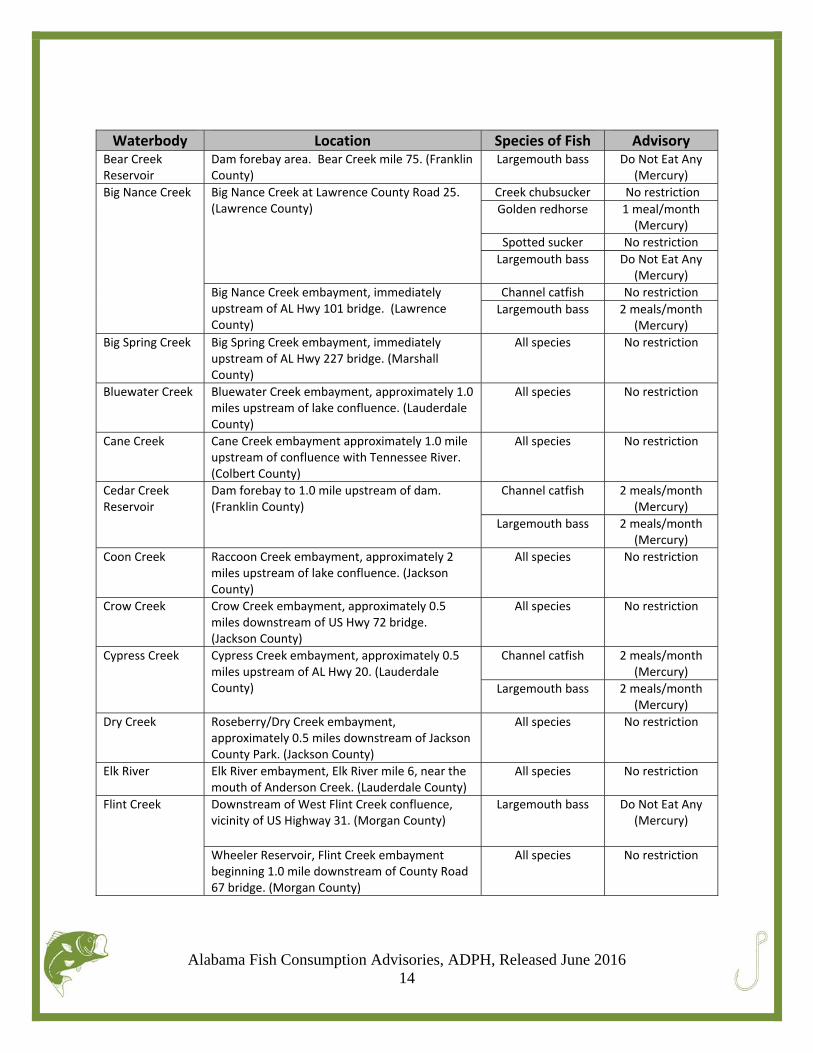
Alabama Fish Consumption Advisories, ADPH, Released June 2016 14
Waterbody Location Species of Fish Advisory Bear Creek Reservoir
Dam forebay area. Bear Creek mile 75. (Franklin County)
Largemouth bass Do Not Eat Any(Mercury)
Big Nance Creek
Big Nance Creek at Lawrence County Road 25. (Lawrence County)
Creek chubsucker No restriction
Golden redhorse 1 meal/month(Mercury)
Spotted sucker No restriction
Largemouth bass Do Not Eat Any(Mercury)
Big Nance Creek embayment, immediately upstream of AL Hwy 101 bridge. (Lawrence County)
Channel catfish No restriction
Largemouth bass 2 meals/month(Mercury)
Big Spring Creek
Big Spring Creek embayment, immediately upstream of AL Hwy 227 bridge. (Marshall County)
All species No restriction
Bluewater Creek Bluewater Creek embayment, approximately 1.0 miles upstream of lake confluence. (Lauderdale County)
All species No restriction
Cane Creek
Cane Creek embayment approximately 1.0 mile upstream of confluence with Tennessee River. (Colbert County)
All species No restriction
Cedar Creek Reservoir
Dam forebay to 1.0 mile upstream of dam. (Franklin County)
Channel catfish 2 meals/month(Mercury)
Largemouth bass 2 meals/month(Mercury)
Coon Creek Raccoon Creek embayment, approximately 2 miles upstream of lake confluence. (Jackson County)
All species No restriction
Crow Creek
Crow Creek embayment, approximately 0.5 miles downstream of US Hwy 72 bridge. (Jackson County)
All species No restriction
Cypress Creek
Cypress Creek embayment, approximately 0.5 miles upstream of AL Hwy 20. (Lauderdale County)
Channel catfish 2 meals/month(Mercury)
Largemouth bass 2 meals/month(Mercury)
Dry Creek
Roseberry/Dry Creek embayment, approximately 0.5 miles downstream of Jackson County Park. (Jackson County)
All species No restriction
Elk River
Elk River embayment, Elk River mile 6, near the mouth of Anderson Creek. (Lauderdale County)
All species No restriction
Flint Creek
Downstream of West Flint Creek confluence, vicinity of US Highway 31. (Morgan County)
Largemouth bass Do Not Eat Any(Mercury)
Wheeler Reservoir, Flint Creek embayment beginning 1.0 mile downstream of County Road 67 bridge. (Morgan County)
All species No restriction
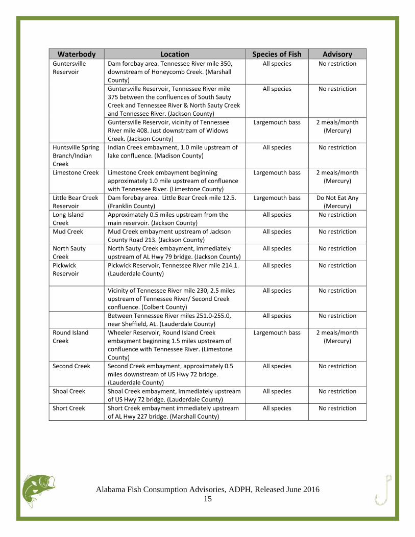
Alabama Fish Consumption Advisories, ADPH, Released June 2016 15
Waterbody Location Species of Fish Advisory Guntersville Reservoir
Dam forebay area. Tennessee River mile 350, downstream of Honeycomb Creek. (Marshall County)
All species No restriction
Guntersville Reservoir, Tennessee River mile 375 between the confluences of South Sauty Creek and Tennessee River & North Sauty Creek and Tennessee River. (Jackson County)
All species No restriction
Guntersville Reservoir, vicinity of Tennessee River mile 408. Just downstream of Widows Creek. (Jackson County)
Largemouth bass 2 meals/month(Mercury)
Huntsville Spring Branch/Indian Creek
Indian Creek embayment, 1.0 mile upstream of lake confluence. (Madison County)
All species No restriction
Limestone Creek
Limestone Creek embayment beginning approximately 1.0 mile upstream of confluence with Tennessee River. (Limestone County)
Largemouth bass 2 meals/month(Mercury)
Little Bear Creek Reservoir
Dam forebay area. Little Bear Creek mile 12.5. (Franklin County)
Largemouth bass Do Not Eat Any(Mercury)
Long Island Creek
Approximately 0.5 miles upstream from the main reservoir. (Jackson County)
All species No restriction
Mud Creek Mud Creek embayment upstream of Jackson County Road 213. (Jackson County)
All species No restriction
North Sauty Creek
North Sauty Creek embayment, immediately upstream of AL Hwy 79 bridge. (Jackson County)
All species No restriction
Pickwick Reservoir
Pickwick Reservoir, Tennessee River mile 214.1. (Lauderdale County)
All species No restriction
Vicinity of Tennessee River mile 230, 2.5 miles upstream of Tennessee River/ Second Creek confluence. (Colbert County)
All species No restriction
Between Tennessee River miles 251.0‐255.0, near Sheffield, AL. (Lauderdale County)
All species No restriction
Round Island Creek
Wheeler Reservoir, Round Island Creek embayment beginning 1.5 miles upstream of confluence with Tennessee River. (Limestone County)
Largemouth bass 2 meals/month(Mercury)
Second Creek
Second Creek embayment, approximately 0.5 miles downstream of US Hwy 72 bridge. (Lauderdale County)
All species No restriction
Shoal Creek
Shoal Creek embayment, immediately upstream of US Hwy 72 bridge. (Lauderdale County)
All species No restriction
Short Creek
Short Creek embayment immediately upstream of AL Hwy 227 bridge. (Marshall County)
All species No restriction
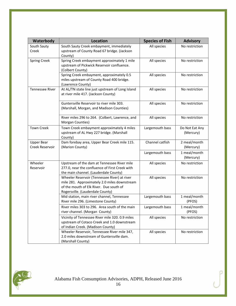
Alabama Fish Consumption Advisories, ADPH, Released June 2016 16
Waterbody Location Species of Fish Advisory South Sauty Creek
South Sauty Creek embayment, immediately upstream of County Road 67 bridge. (Jackson County)
All species No restriction
Spring Creek Spring Creek embayment approximately 1 mile upstream of Pickwick Reservoir confluence. (Colbert County)
All species No restriction
Spring Creek embayment, approximately 0.5 miles upstream of County Road 400 bridge. (Lawrence County)
All species No restriction
Tennessee River
At AL/TN state line just upstream of Long Island at river mile 417. (Jackson County)
All species No restriction
Guntersville Reservoir to river mile 303. (Marshall, Morgan, and Madison Counties)
All species No restriction
River miles 296 to 264. (Colbert, Lawrence, and Morgan Counties)
All species No restriction
Town Creek Town Creek embayment approximately 4 miles upstream of AL Hwy 227 bridge. (Marshall County)
Largemouth bass Do Not Eat Any(Mercury)
Upper Bear Creek Reservoir
Dam forebay area, Upper Bear Creek mile 115. (Marion County)
Channel catfish 2 meal/month(Mercury)
Largemouth bass 1 meal/month(Mercury)
Wheeler Reservoir
Upstream of the dam at Tennessee River mile 277.0, near the confluence of First Creek with the main channel. (Lauderdale County)
All species No restriction
Wheeler Reservoir (Tennessee River) at river mile 281. Approximately 2.0 miles downstream of the mouth of Elk River. Due south of Rogersville. (Lauderdale County)
All species No restriction
Mid station, main river channel, Tennessee River mile 296. (Limestone County)
Largemouth bass 1 meal/month(PFOS)
River miles 303 to 296. Area south of the main river channel. (Morgan County)
Largemouth bass 1 meal/month(PFOS)
Vicinity of Tennessee River mile 320. 0.9 miles upstream of Cotaco Creek and 1.0 downstream of Indian Creek. (Madison County)
All species No restriction
Wheeler Reservoir, Tennessee River mile 347, 2.0 miles downstream of Guntersville dam. (Marshall County)
All species No restriction
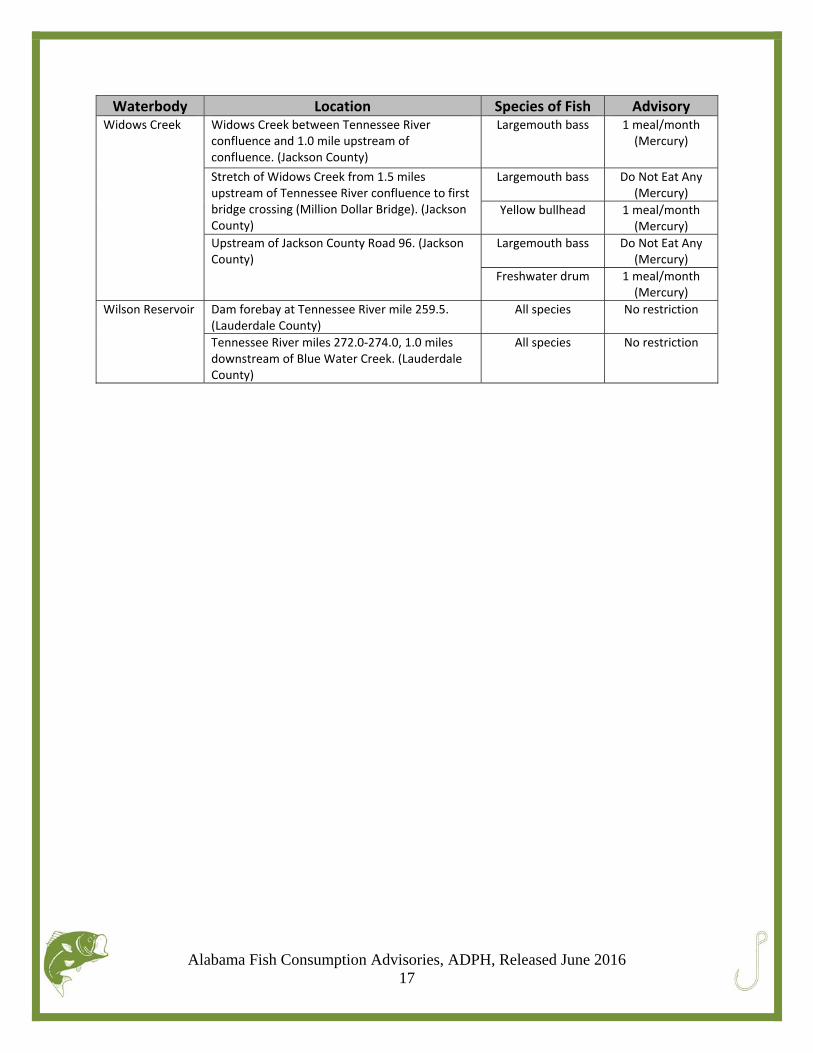
Alabama Fish Consumption Advisories, ADPH, Released June 2016 17
Waterbody Location Species of Fish Advisory Widows Creek
Widows Creek between Tennessee River confluence and 1.0 mile upstream of confluence. (Jackson County)
Largemouth bass 1 meal/month(Mercury)
Stretch of Widows Creek from 1.5 miles upstream of Tennessee River confluence to first bridge crossing (Million Dollar Bridge). (Jackson County)
Largemouth bass Do Not Eat Any(Mercury)
Yellow bullhead 1 meal/month(Mercury)
Upstream of Jackson County Road 96. (Jackson County)
Largemouth bass Do Not Eat Any(Mercury)
Freshwater drum 1 meal/month(Mercury)
Wilson Reservoir
Dam forebay at Tennessee River mile 259.5. (Lauderdale County)
All species No restriction
Tennessee River miles 272.0‐274.0, 1.0 milesdownstream of Blue Water Creek. (Lauderdale County)
All species No restriction
Alabama Fish Consumption Advisories, ADPH, Released June 2016 18
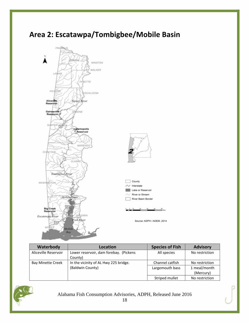
Area 2: Escatawpa/Tombigbee/Mobile Basin
Waterbody Location Species of Fish Advisory
Aliceville Reservoir
Lower reservoir, dam forebay. (Pickens County)
All species No restriction
Bay Minette Creek In the vicinity of AL Hwy 225 bridge. (Baldwin County)
Channel catfish No restriction
Largemouth bass 1 meal/month(Mercury)
Striped mullet No restriction
Alabama Fish Consumption Advisories, ADPH, Released June 2016 19
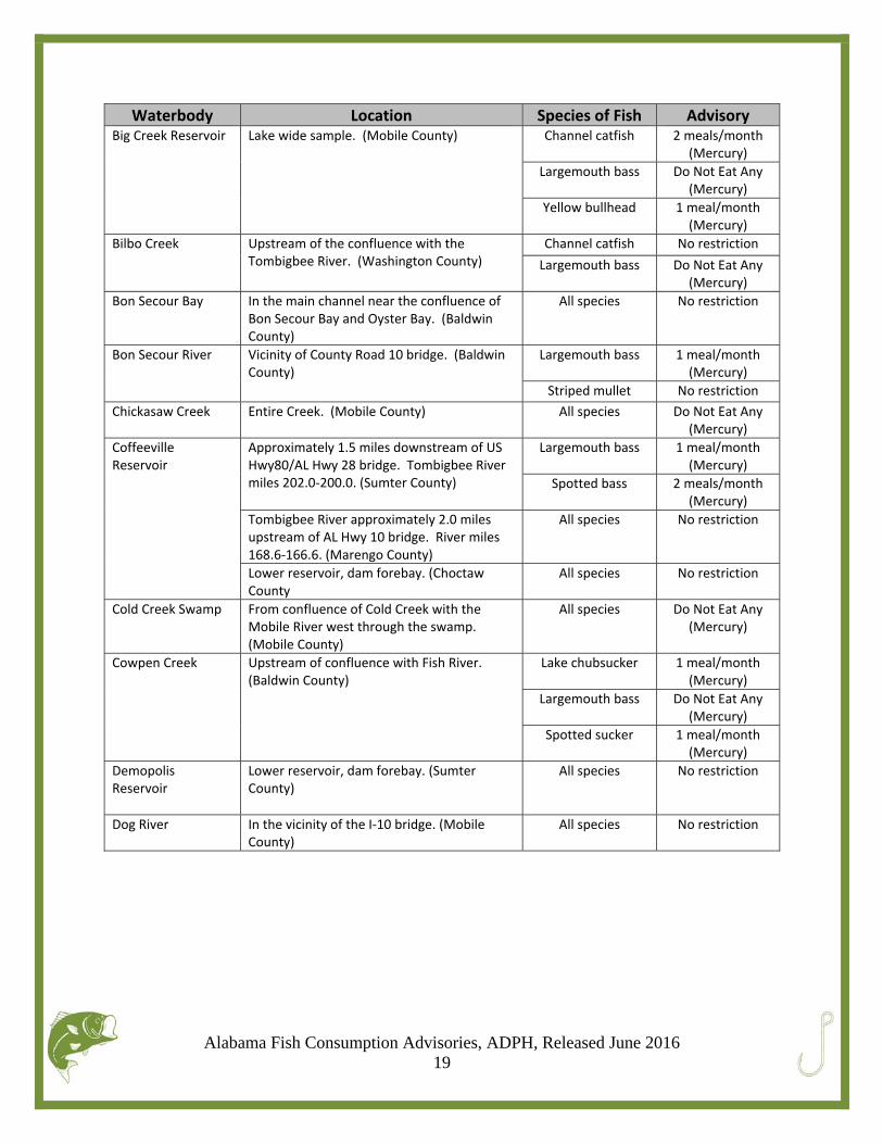
Waterbody Location Species of Fish Advisory Big Creek Reservoir
Lake wide sample. (Mobile County) Channel catfish 2 meals/month(Mercury)
Largemouth bass Do Not Eat Any(Mercury)
Yellow bullhead 1 meal/month(Mercury)
Bilbo Creek
Upstream of the confluence with the Tombigbee River. (Washington County)
Channel catfish No restriction
Largemouth bass Do Not Eat Any(Mercury)
Bon Secour Bay
In the main channel near the confluence of Bon Secour Bay and Oyster Bay. (Baldwin County)
All species No restriction
Bon Secour River
Vicinity of County Road 10 bridge. (Baldwin County)
Largemouth bass 1 meal/month(Mercury)
Striped mullet No restriction
Chickasaw Creek
Entire Creek. (Mobile County) All species Do Not Eat Any(Mercury)
Coffeeville Reservoir
Approximately 1.5 miles downstream of US Hwy80/AL Hwy 28 bridge. Tombigbee River miles 202.0‐200.0. (Sumter County)
Largemouth bass
1 meal/month(Mercury)
Spotted bass 2 meals/month(Mercury)
Tombigbee River approximately 2.0 miles upstream of AL Hwy 10 bridge. River miles 168.6‐166.6. (Marengo County)
All species No restriction
Lower reservoir, dam forebay. (Choctaw County
All species No restriction
Cold Creek Swamp
From confluence of Cold Creek with the Mobile River west through the swamp. (Mobile County)
All species Do Not Eat Any(Mercury)
Cowpen Creek
Upstream of confluence with Fish River. (Baldwin County)
Lake chubsucker 1 meal/month(Mercury)
Largemouth bass Do Not Eat Any(Mercury)
Spotted sucker 1 meal/month(Mercury)
Demopolis Reservoir
Lower reservoir, dam forebay. (Sumter County)
All species No restriction
Dog River
In the vicinity of the I‐10 bridge. (Mobile County)
All species No restriction
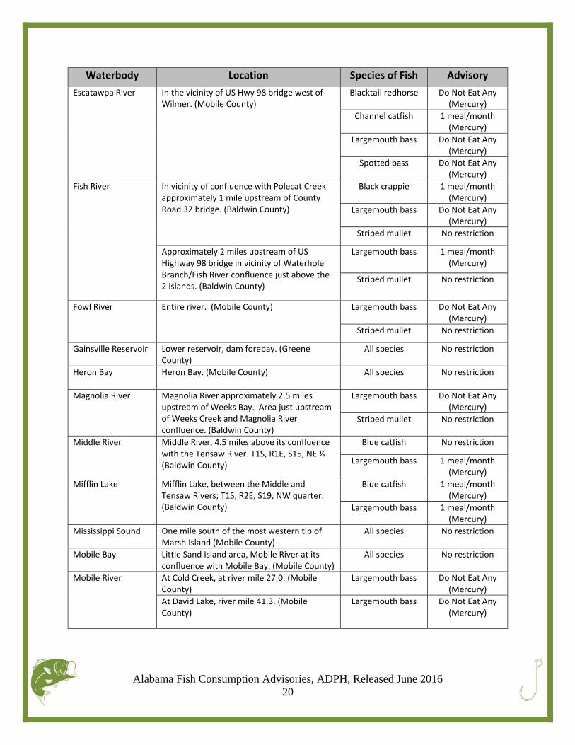
Alabama Fish Consumption Advisories, ADPH, Released June 2016 20
Waterbody Location Species of Fish Advisory
Escatawpa River
In the vicinity of US Hwy 98 bridge west of Wilmer. (Mobile County)
Blacktail redhorse Do Not Eat Any(Mercury)
Channel catfish 1 meal/month(Mercury)
Largemouth bass Do Not Eat Any(Mercury)
Spotted bass Do Not Eat Any(Mercury)
Fish River
In vicinity of confluence with Polecat Creek approximately 1 mile upstream of County Road 32 bridge. (Baldwin County)
Black crappie 1 meal/month(Mercury)
Largemouth bass Do Not Eat Any(Mercury)
Striped mullet No restriction
Approximately 2 miles upstream of US Highway 98 bridge in vicinity of Waterhole Branch/Fish River confluence just above the 2 islands. (Baldwin County)
Largemouth bass 1 meal/month(Mercury)
Striped mullet No restriction
Fowl River
Entire river. (Mobile County) Largemouth bass Do Not Eat Any(Mercury)
Striped mullet No restriction
Gainsville Reservoir
Lower reservoir, dam forebay. (Greene County)
All species No restriction
Heron Bay
Heron Bay. (Mobile County) All species No restriction
Magnolia River
Magnolia River approximately 2.5 miles upstream of Weeks Bay. Area just upstream of Weeks Creek and Magnolia River confluence. (Baldwin County)
Largemouth bass Do Not Eat Any(Mercury)
Striped mullet No restriction
Middle River
Middle River, 4.5 miles above its confluence with the Tensaw River. T1S, R1E, S15, NE ¼ (Baldwin County)
Blue catfish No restriction
Largemouth bass 1 meal/month(Mercury)
Mifflin Lake
Mifflin Lake, between the Middle and Tensaw Rivers; T1S, R2E, S19, NW quarter. (Baldwin County)
Blue catfish 1 meal/month(Mercury)
Largemouth bass 1 meal/month(Mercury)
Mississippi Sound One mile south of the most western tip of Marsh Island (Mobile County)
All species No restriction
Mobile Bay
Little Sand Island area, Mobile River at its confluence with Mobile Bay. (Mobile County)
All species No restriction
Mobile River
At Cold Creek, at river mile 27.0. (Mobile County)
Largemouth bass Do Not Eat Any(Mercury)
At David Lake, river mile 41.3. (Mobile County)
Largemouth bass Do Not Eat Any(Mercury)
Alabama Fish Consumption Advisories, ADPH, Released June 2016 21
Waterbody Location Species of Fish Advisory
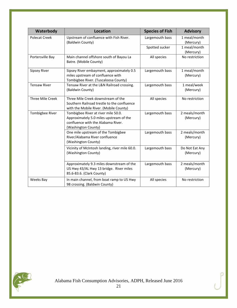
Polecat Creek
Upstream of confluence with Fish River. (Baldwin County)
Largemouth bass 1 meal/month(Mercury)
Spotted sucker 1 meal/month(Mercury)
Portersville Bay
Main channel offshore south of Bayou La Batre. (Mobile County)
All species No restriction
Sipsey River
Sipsey River embayment, approximately 0.5 miles upstream of confluence with Tombigbee River. (Tuscaloosa County)
Largemouth bass 1 meal/month(Mercury)
Tensaw River
Tensaw River at the L&N Railroad crossing. (Baldwin County)
Largemouth bass 1 meal/week(Mercury)
Three Mile Creek
Three Mile Creek downstream of the Southern Railroad trestle to the confluence with the Mobile River. (Mobile County)
All species No restriction
Tombigbee River
Tombigbee River at river mile 50.0. Approximately 5.0 miles upstream of the confluence with the Alabama River. (Washington County)
Largemouth bass 2 meals/month(Mercury)
One mile upstream of the Tombigbee River/Alabama River confluence (Washington County)
Largemouth bass 2 meals/month(Mercury)
Vicinity of McIntosh landing, river mile 60.0. (Washington County)
Largemouth bass Do Not Eat Any(Mercury)
Approximately 9.3 miles downstream of the US Hwy 43/AL Hwy 13 bridge. River miles 85.6‐83.6. (Clark County)
Largemouth bass 2 meals/month(Mercury)
Weeks Bay
In main channel, from boat ramp to US Hwy 98 crossing. (Baldwin County)
All species No restriction

Alabama Fish Consumption Advisories, ADPH, Released June 2016 22
Area 3: Black Warrior/Cahaba Basin
Waterbody Location Species of Fish Advisory Bankhead Reservoir
Lower reservoir, dam forebay. (Tuscaloosa County)
All species No restriction
Bayview Lake
Lower reservoir, dam forebay. (Jefferson County)
All species No restriction
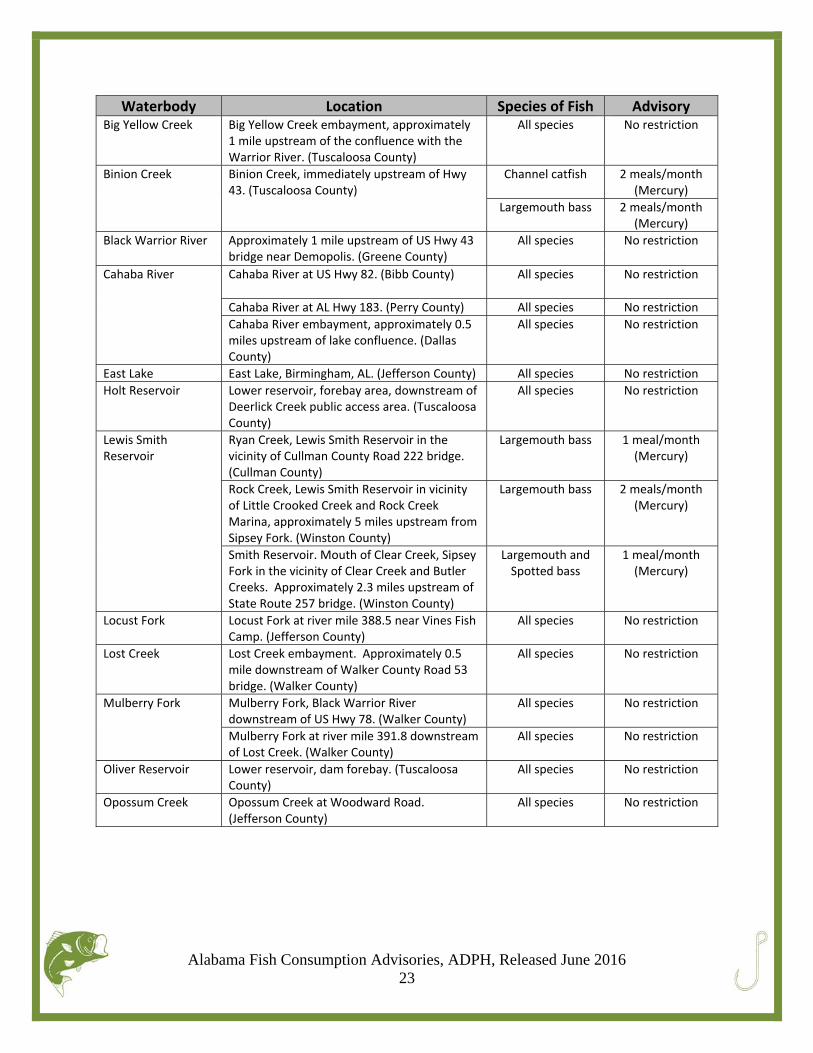
Alabama Fish Consumption Advisories, ADPH, Released June 2016 23
Waterbody Location Species of Fish Advisory Big Yellow Creek
Big Yellow Creek embayment, approximately 1 mile upstream of the confluence with the Warrior River. (Tuscaloosa County)
All species No restriction
Binion Creek
Binion Creek, immediately upstream of Hwy 43. (Tuscaloosa County)
Channel catfish 2 meals/month(Mercury)
Largemouth bass 2 meals/month(Mercury)
Black Warrior River Approximately 1 mile upstream of US Hwy 43 bridge near Demopolis. (Greene County)
All species No restriction
Cahaba River
Cahaba River at US Hwy 82. (Bibb County) All species No restriction
Cahaba River at AL Hwy 183. (Perry County) All species No restriction
Cahaba River embayment, approximately 0.5 miles upstream of lake confluence. (Dallas County)
All species No restriction
East Lake East Lake, Birmingham, AL. (Jefferson County) All species No restriction
Holt Reservoir
Lower reservoir, forebay area, downstream of Deerlick Creek public access area. (Tuscaloosa County)
All species No restriction
Lewis Smith Reservoir
Ryan Creek, Lewis Smith Reservoir in the vicinity of Cullman County Road 222 bridge. (Cullman County)
Largemouth bass 1 meal/month(Mercury)
Rock Creek, Lewis Smith Reservoir in vicinity of Little Crooked Creek and Rock Creek Marina, approximately 5 miles upstream from Sipsey Fork. (Winston County)
Largemouth bass 2 meals/month(Mercury)
Smith Reservoir. Mouth of Clear Creek, Sipsey Fork in the vicinity of Clear Creek and Butler Creeks. Approximately 2.3 miles upstream of State Route 257 bridge. (Winston County)
Largemouth and Spotted bass
1 meal/month(Mercury)
Locust Fork
Locust Fork at river mile 388.5 near Vines Fish Camp. (Jefferson County)
All species No restriction
Lost Creek
Lost Creek embayment. Approximately 0.5 mile downstream of Walker County Road 53 bridge. (Walker County)
All species No restriction
Mulberry Fork
Mulberry Fork, Black Warrior River downstream of US Hwy 78. (Walker County)
All species No restriction
Mulberry Fork at river mile 391.8 downstream of Lost Creek. (Walker County)
All species No restriction
Oliver Reservoir
Lower reservoir, dam forebay. (Tuscaloosa County)
All species No restriction
Opossum Creek
Opossum Creek at Woodward Road. (Jefferson County)
All species No restriction
Alabama Fish Consumption Advisories, ADPH, Released June 2016 24
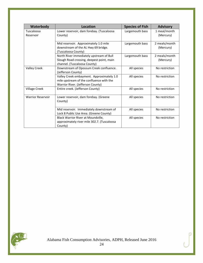
Waterbody Location Species of Fish Advisory Tuscaloosa Reservoir
Lower reservoir, dam forebay. (Tuscaloosa County)
Largemouth bass 1 meal/month(Mercury)
Mid reservoir. Approximately 1.0 miledownstream of the AL Hwy 69 bridge. (Tuscaloosa County)
Largemouth bass 2 meals/month(Mercury)
North River immediately upstream of Bull Slough Road crossing, deepest point, main channel. (Tuscaloosa County)
Largemouth bass 2 meals/month(Mercury)
Valley Creek
Downstream of Opossum Creek confluence. (Jefferson County)
All species No restriction
Valley Creek embayment. Approximately 1.0 mile upstream of the confluence with the Warrior River. (Jefferson County)
All species No restriction
Village Creek
Entire creek. (Jefferson County) All species No restriction
Warrior Reservoir
Lower reservoir, dam forebay. (Greene County)
All species
No restriction
Mid reservoir. Immediately downstream of Lock 8 Public Use Area. (Greene County)
All species
No restriction
Black Warrior River at Moundville, approximately river mile 302.7. (Tuscaloosa County)
All species No restriction
Alabama Fish Consumption Advisories, ADPH, Released June 2016 25
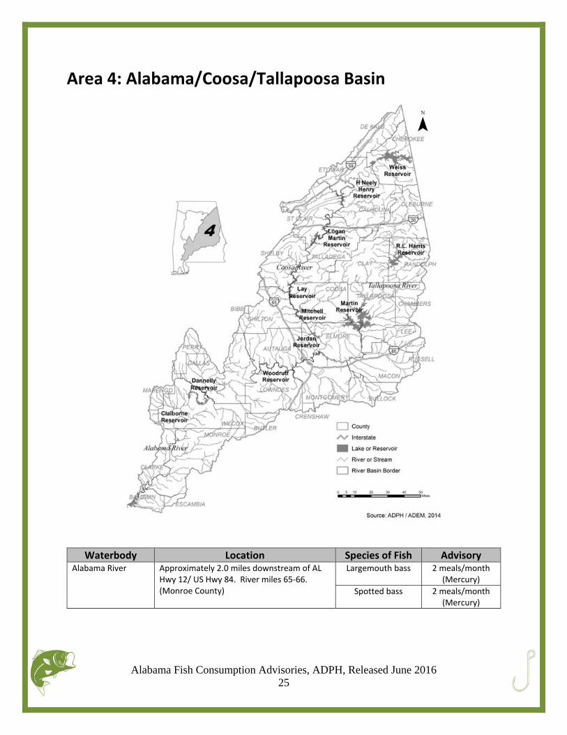
Area 4: Alabama/Coosa/Tallapoosa Basin
Waterbody Location Species of Fish Advisory Alabama River
Approximately 2.0 miles downstream of AL Hwy 12/ US Hwy 84. River miles 65‐66. (Monroe County)
Largemouth bass 2 meals/month(Mercury)
Spotted bass 2 meals/month(Mercury)
Alabama Fish Consumption Advisories, ADPH, Released June 2016 26
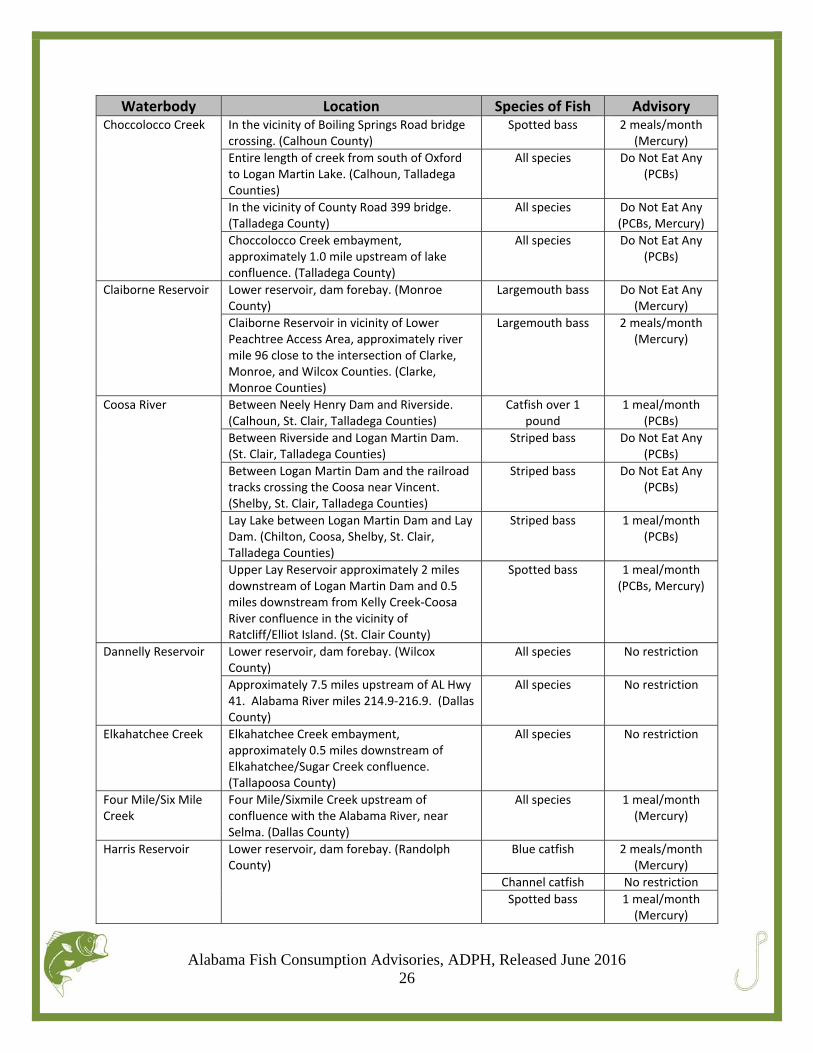
Waterbody Location Species of Fish Advisory Choccolocco Creek
In the vicinity of Boiling Springs Road bridge crossing. (Calhoun County)
Spotted bass 2 meals/month(Mercury)
Entire length of creek from south of Oxford to Logan Martin Lake. (Calhoun, Talladega Counties)
All species Do Not Eat Any(PCBs)
In the vicinity of County Road 399 bridge. (Talladega County)
All species Do Not Eat Any(PCBs, Mercury)
Choccolocco Creek embayment, approximately 1.0 mile upstream of lake confluence. (Talladega County)
All species Do Not Eat Any(PCBs)
Claiborne Reservoir
Lower reservoir, dam forebay. (Monroe County)
Largemouth bass Do Not Eat Any(Mercury)
Claiborne Reservoir in vicinity of Lower Peachtree Access Area, approximately river mile 96 close to the intersection of Clarke, Monroe, and Wilcox Counties. (Clarke, Monroe Counties)
Largemouth bass 2 meals/month(Mercury)
Coosa River
Between Neely Henry Dam and Riverside. (Calhoun, St. Clair, Talladega Counties)
Catfish over 1 pound
1 meal/month(PCBs)
Between Riverside and Logan Martin Dam. (St. Clair, Talladega Counties)
Striped bass Do Not Eat Any(PCBs)
Between Logan Martin Dam and the railroad tracks crossing the Coosa near Vincent. (Shelby, St. Clair, Talladega Counties)
Striped bass Do Not Eat Any(PCBs)
Lay Lake between Logan Martin Dam and Lay Dam. (Chilton, Coosa, Shelby, St. Clair, Talladega Counties)
Striped bass 1 meal/month(PCBs)
Upper Lay Reservoir approximately 2 miles downstream of Logan Martin Dam and 0.5 miles downstream from Kelly Creek‐Coosa River confluence in the vicinity of Ratcliff/Elliot Island. (St. Clair County)
Spotted bass 1 meal/month(PCBs, Mercury)
Dannelly Reservoir
Lower reservoir, dam forebay. (Wilcox County)
All species No restriction
Approximately 7.5 miles upstream of AL Hwy 41. Alabama River miles 214.9‐216.9. (Dallas County)
All species No restriction
Elkahatchee Creek
Elkahatchee Creek embayment, approximately 0.5 miles downstream of Elkahatchee/Sugar Creek confluence. (Tallapoosa County)
All species No restriction
Four Mile/Six Mile Creek
Four Mile/Sixmile Creek upstream of confluence with the Alabama River, near Selma. (Dallas County)
All species 1 meal/month(Mercury)
Harris Reservoir
Lower reservoir, dam forebay. (Randolph County)
Blue catfish 2 meals/month(Mercury)
Channel catfish No restriction
Spotted bass 1 meal/month(Mercury)
Alabama Fish Consumption Advisories, ADPH, Released June 2016 27
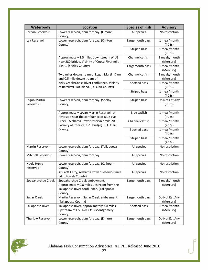
Waterbody Location Species of Fish Advisory Jordan Reservoir
Lower reservoir, dam forebay. (Elmore County)
All species No restriction
Lay Reservoir
Lower reservoir, dam forebay. (Chilton County)
Largemouth bass 1 meal/month(PCBs)
Striped bass 1 meal/month(PCBs)
Approximately 1.5 miles downstream of US Hwy 280 bridge. Vicinity of Coosa River mile 444.0. (Shelby County)
Channel catfish 2 meals/month(Mercury)
Largemouth bass 1 meal/month(Mercury)
Two miles downstream of Logan Martin Dam and 0.5 mile downstream of Kelly Creek/Coosa River confluence. Vicinity of Ratcliff/Elliot Island. (St. Clair County)
Channel catfish 2 meals/month(Mercury)
Spotted bass 1 meal/month(PCBs)
Striped bass 1 meal/month(PCBs)
Logan Martin Reservoir
Lower reservoir, dam forebay. (Shelby County)
Striped bass Do Not Eat Any(PCBs)
Approximately Logan Martin Reservoir at Riverside near the confluence of Blue Eye Creek. Alabama Power reservoir mile 20.0 (vicinity of Interstate 20 bridge). (St. Clair County)
Blue catfish 1 meal/month(PCBs)
Channel catfish 1 meal/month(PCBs)
Spotted bass 1 meal/month(PCBs)
Striped bass 1 meal/month(PCBs)
Martin Reservoir
Lower reservoir, dam forebay. (Tallapoosa County)
All species No restriction
Mitchell Reservoir
Lower reservoir, dam forebay. All species No restriction
Neely Henry Reservoir
Lower reservoir, dam forebay. (Calhoun County)
All species No restriction
At Croft Ferry, Alabama Power Reservoir mile 54. (Etowah County)
All species No restriction
Sougahatchee Creek
Sougahatchee Creek embayment. Approximately 0.8 miles upstream from the Tallapoosa River confluence. (Tallapoosa County)
Largemouth bass 2 meals/month(Mercury)
Sugar Creek
Martin Reservoir, Sugar Creek embayment. (Tallapoosa County)
Largemouth bass Do Not Eat Any(Mercury)
Tallapoosa River
Tallapoosa River, approximately 3.0 miles upstream of US Hwy 231. (Montgomery County)
Spotted bass 1 meal/month(Mercury)
Thurlow Reservoir
Lower reservoir, dam forebay. (Elmore County)
Largemouth bass Do Not Eat Any(Mercury)
Alabama Fish Consumption Advisories, ADPH, Released June 2016 28
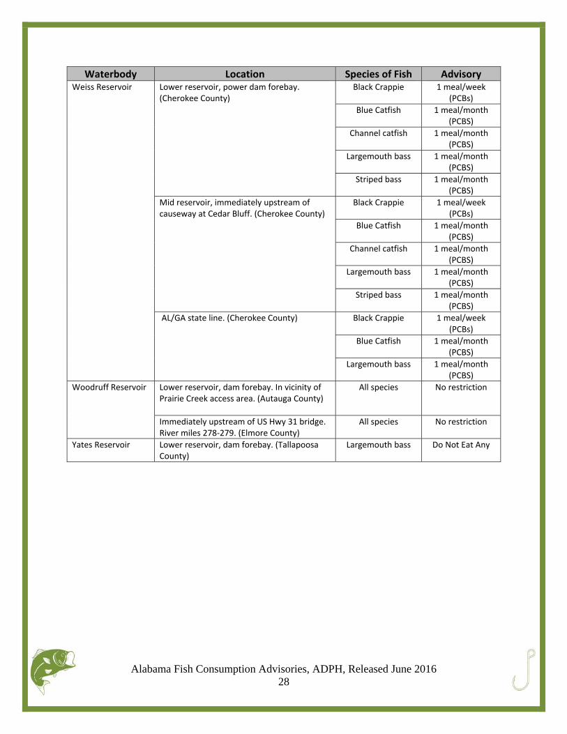
Waterbody Location Species of Fish Advisory Weiss Reservoir
Lower reservoir, power dam forebay. (Cherokee County)
Black Crappie 1 meal/week(PCBs)
Blue Catfish 1 meal/month(PCBS)
Channel catfish 1 meal/month(PCBS)
Largemouth bass 1 meal/month(PCBS)
Striped bass 1 meal/month(PCBS)
Mid reservoir, immediately upstream of causeway at Cedar Bluff. (Cherokee County)
Black Crappie 1 meal/week(PCBs)
Blue Catfish 1 meal/month(PCBS)
Channel catfish 1 meal/month(PCBS)
Largemouth bass 1 meal/month(PCBS)
Striped bass 1 meal/month(PCBS)
AL/GA state line. (Cherokee County) Black Crappie 1 meal/week(PCBs)
Blue Catfish 1 meal/month(PCBS)
Largemouth bass 1 meal/month(PCBS)
Woodruff Reservoir
Lower reservoir, dam forebay. In vicinity of Prairie Creek access area. (Autauga County)
All species No restriction
Immediately upstream of US Hwy 31 bridge. River miles 278‐279. (Elmore County)
All species No restriction
Yates Reservoir
Lower reservoir, dam forebay. (Tallapoosa County)
Largemouth bass Do Not Eat Any
Alabama Fish Consumption Advisories, ADPH, Released June 2016 29
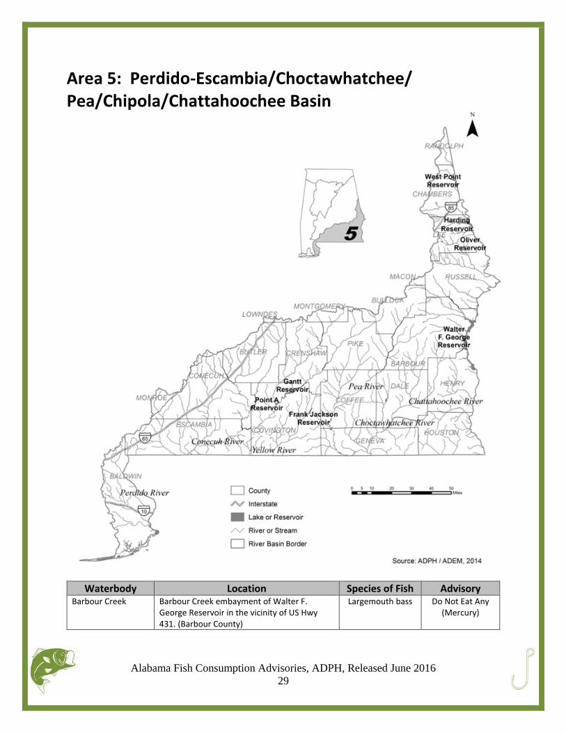
Area 5: Perdido‐Escambia/Choctawhatchee/ Pea/Chipola/Chattahoochee Basin
Waterbody Location Species of Fish Advisory Barbour Creek Barbour Creek embayment of Walter F.
George Reservoir in the vicinity of US Hwy 431. (Barbour County)
Largemouth bass Do Not Eat Any(Mercury)
Alabama Fish Consumption Advisories, ADPH, Released June 2016 30
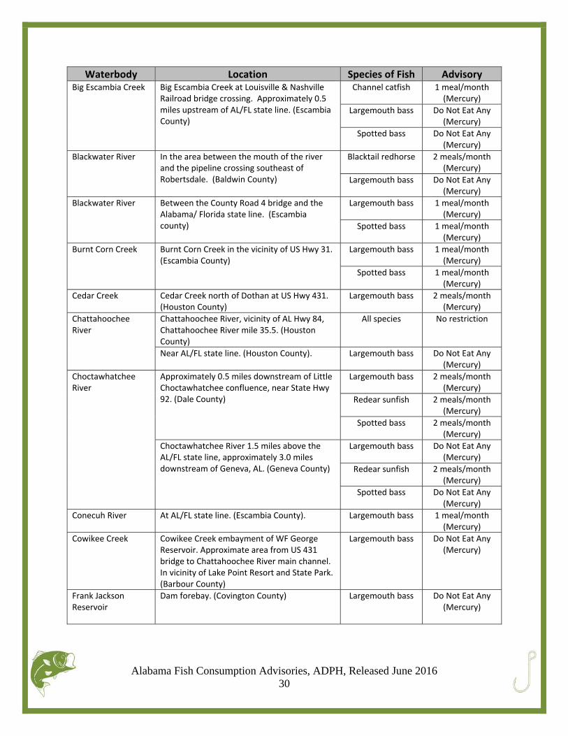
Waterbody Location Species of Fish Advisory Big Escambia Creek
Big Escambia Creek at Louisville & Nashville Railroad bridge crossing. Approximately 0.5 miles upstream of AL/FL state line. (Escambia County)
Channel catfish
1 meal/month(Mercury)
Largemouth bass Do Not Eat Any(Mercury)
Spotted bass Do Not Eat Any(Mercury)
Blackwater River
In the area between the mouth of the river and the pipeline crossing southeast of Robertsdale. (Baldwin County)
Blacktail redhorse 2 meals/month(Mercury)
Largemouth bass Do Not Eat Any(Mercury)
Blackwater River
Between the County Road 4 bridge and the Alabama/ Florida state line. (Escambia county)
Largemouth bass 1 meal/month(Mercury)
Spotted bass 1 meal/month(Mercury)
Burnt Corn Creek
Burnt Corn Creek in the vicinity of US Hwy 31. (Escambia County)
Largemouth bass 1 meal/month(Mercury)
Spotted bass 1 meal/month(Mercury)
Cedar Creek
Cedar Creek north of Dothan at US Hwy 431. (Houston County)
Largemouth bass 2 meals/month(Mercury)
Chattahoochee River
Chattahoochee River, vicinity of AL Hwy 84, Chattahoochee River mile 35.5. (Houston County)
All species No restriction
Near AL/FL state line. (Houston County). Largemouth bass Do Not Eat Any(Mercury)
Choctawhatchee River
Approximately 0.5 miles downstream of Little Choctawhatchee confluence, near State Hwy 92. (Dale County)
Largemouth bass 2 meals/month(Mercury)
Redear sunfish 2 meals/month(Mercury)
Spotted bass 2 meals/month(Mercury)
Choctawhatchee River 1.5 miles above the AL/FL state line, approximately 3.0 miles downstream of Geneva, AL. (Geneva County)
Largemouth bass Do Not Eat Any(Mercury)
Redear sunfish 2 meals/month(Mercury)
Spotted bass Do Not Eat Any(Mercury)
Conecuh River
At AL/FL state line. (Escambia County). Largemouth bass 1 meal/month(Mercury)
Cowikee Creek
Cowikee Creek embayment of WF George Reservoir. Approximate area from US 431 bridge to Chattahoochee River main channel. In vicinity of Lake Point Resort and State Park. (Barbour County)
Largemouth bass Do Not Eat Any(Mercury)
Frank Jackson Reservoir
Dam forebay. (Covington County) Largemouth bass Do Not Eat Any(Mercury)
Alabama Fish Consumption Advisories, ADPH, Released June 2016 31
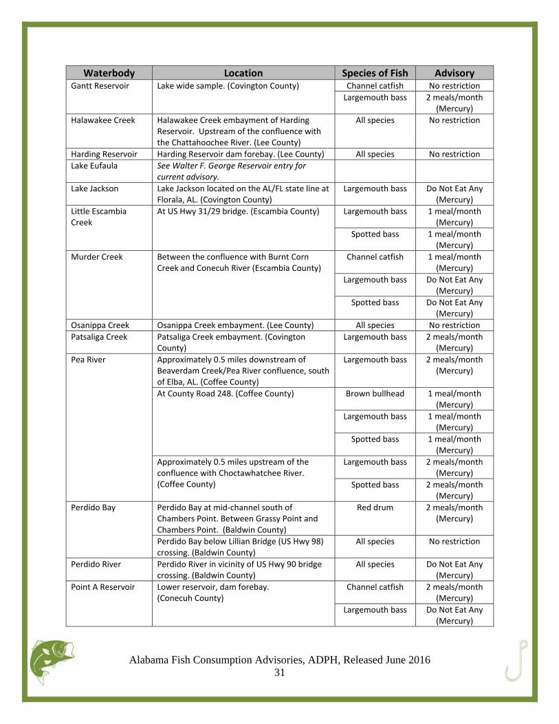
Waterbody Location Species of Fish Advisory Gantt Reservoir Lake wide sample. (Covington County) Channel catfish No restriction
Largemouth bass 2 meals/month(Mercury)
Halawakee Creek Halawakee Creek embayment of Harding Reservoir. Upstream of the confluence with the Chattahoochee River. (Lee County)
All species No restriction
Harding Reservoir Harding Reservoir dam forebay. (Lee County) All species No restriction
Lake Eufaula
See Walter F. George Reservoir entry for current advisory.
Lake Jackson Lake Jackson located on the AL/FL state line at Florala, AL. (Covington County)
Largemouth bass Do Not Eat Any(Mercury)
Little Escambia Creek
At US Hwy 31/29 bridge. (Escambia County) Largemouth bass 1 meal/month(Mercury)
Spotted bass 1 meal/month(Mercury)
Murder Creek
Between the confluence with Burnt Corn Creek and Conecuh River (Escambia County)
Channel catfish 1 meal/month(Mercury)
Largemouth bass Do Not Eat Any(Mercury)
Spotted bass Do Not Eat Any(Mercury)
Osanippa Creek Osanippa Creek embayment. (Lee County) All species No restriction
Patsaliga Creek
Patsaliga Creek embayment. (Covington County)
Largemouth bass 2 meals/month(Mercury)
Pea River
Approximately 0.5 miles downstream of Beaverdam Creek/Pea River confluence, south of Elba, AL. (Coffee County)
Largemouth bass 2 meals/month(Mercury)
At County Road 248. (Coffee County) Brown bullhead 1 meal/month(Mercury)
Largemouth bass 1 meal/month(Mercury)
Spotted bass 1 meal/month(Mercury)
Approximately 0.5 miles upstream of the confluence with Choctawhatchee River. (Coffee County)
Largemouth bass 2 meals/month(Mercury)
Spotted bass 2 meals/month(Mercury)
Perdido Bay
Perdido Bay at mid‐channel south of Chambers Point. Between Grassy Point and Chambers Point. (Baldwin County)
Red drum 2 meals/month(Mercury)
Perdido Bay below Lillian Bridge (US Hwy 98) crossing. (Baldwin County)
All species No restriction
Perdido River
Perdido River in vicinity of US Hwy 90 bridge crossing. (Baldwin County)
All species Do Not Eat Any(Mercury)
Point A Reservoir
Lower reservoir, dam forebay.(Conecuh County)
Channel catfish 2 meals/month(Mercury)
Largemouth bass Do Not Eat Any(Mercury)
Alabama Fish Consumption Advisories, ADPH, Released June 2016 32
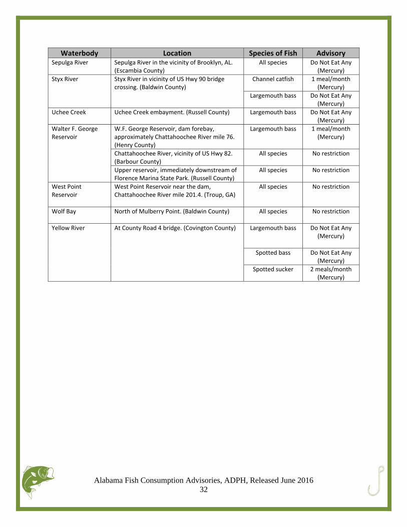
Waterbody Location Species of Fish Advisory Sepulga River
Sepulga River in the vicinity of Brooklyn, AL. (Escambia County)
All species Do Not Eat Any(Mercury)
Styx River
Styx River in vicinity of US Hwy 90 bridge crossing. (Baldwin County)
Channel catfish 1 meal/month(Mercury)
Largemouth bass Do Not Eat Any(Mercury)
Uchee Creek
Uchee Creek embayment. (Russell County) Largemouth bass Do Not Eat Any(Mercury)
Walter F. George Reservoir
W.F. George Reservoir, dam forebay, approximately Chattahoochee River mile 76. (Henry County)
Largemouth bass 1 meal/month(Mercury)
Chattahoochee River, vicinity of US Hwy 82. (Barbour County)
All species No restriction
Upper reservoir, immediately downstream of Florence Marina State Park. (Russell County)
All species No restriction
West Point Reservoir
West Point Reservoir near the dam, Chattahoochee River mile 201.4. (Troup, GA)
All species No restriction
Wolf Bay
North of Mulberry Point. (Baldwin County) All species No restriction
Yellow River
At County Road 4 bridge. (Covington County) Largemouth bass
Do Not Eat Any(Mercury)
Spotted bass Do Not Eat Any(Mercury)
Spotted sucker 2 meals/month(Mercury)
Alabama Fish Consumption Advisories, ADPH, Released June 2016 33
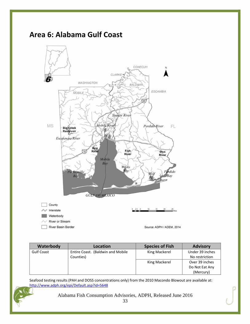
Area 6: Alabama Gulf Coast
Waterbody Location Species of Fish Advisory Gulf Coast
Entire Coast. (Baldwin and Mobile Counties)
King Mackerel Under 39 inchesNo restriction
King Mackerel Over 39 inchesDo Not Eat Any
(Mercury)
Seafood testing results (PAH and DOSS concentrations only) from the 2010 Macondo Blowout are available at: http://www.adph.org/epi/Default.asp?id=5648
Alabama Fish Consumption Advisories, ADPH, Released June 2016 34
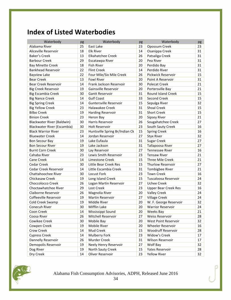
Index of Listed Waterbodies
Waterbody pg Waterbody pg Waterbody pgAlabama River 25 East Lake 23 Opossum Creek 23Aliceville Reservoir 18 Elk River 14 Osanippa Creek 31Baker’s Creek 13 Elkahatchee Creek 26 Patsaliga Creek 31Barbour Creek 29 Escatawpa River 20 Pea River 31Bay Minette Creek 18 Fish River 20 Perdido Bay 31Bankhead Reservoir 22 Flint Creek 14 Perdido River 31Bayview Lake 22 Four Mile/Six Mile Creek 26 Pickwick Reservoir 15Bear Creek 13 Fowl River 20 Point A Reservoir 31Bear Creek Reservoir 14 Frank Jackson Reservoir 30 Polecat Creek 21Big Creek Reservoir 19 Gainsville Reservoir 20 Portersville Bay 21Big Escambia Creek 30 Gantt Reservoir 31 Round Island Creek 15Big Nance Creek 14 Gulf Coast 33 Second Creek 15Big Spring Creek 14 Guntersville Reservoir 15 Sepulga River 32Big Yellow Creek 23 Halawakee Creek 31 Shoal Creek 15Bilbo Creek 19 Harding Reservoir 31 Short Creek 15Binion Creek 23 Heron Bay 20 Sipsey River 21Blackwater River (Baldwin) 30 Harris Reservoir 26 Sougahatchee Creek 27Blackwater River (Escambia) 30 Holt Reservoir 23 South Sauty Creek 16Black Warrior River 23 Huntsville Spring Br/Indian Ck 15 Spring Creek 16Bluewater Creek 14 Jordan Reservoir 27 Styx River 32Bon Secour Bay 19 Lake Eufaula 31 Sugar Creek 27Bon Secour River 19 Lake Jackson 31 Tallapoosa River 27Burnt Corn Creek 30 Lay Reservoir 27 Tennessee River 16Cahaba River 23 Lewis Smith Reservoir 23 Tensaw River 21Cane Creek 14 Limestone Creek 15 Three Mile Creek 21Cedar Creek 30 Little Bear Creek Res 15 Thurlow Reservoir 27Cedar Creek Reservoir 14 Little Escambia Creek 31 Tombigbee River 21Chattahoochee River 30 Locust Fork 23 Town Creek 16Chickasaw Creek 19 Long Island Creek 15 Tuscaloosa Reservoir 24Choccolocco Creek 26 Logan Martin Reservoir 27 Uchee Creek 32Choctawhatchee River 29 Lost Creek 23 Upper Bear Creek Res 16Claiborne Reservoir 26 Magnolia River 20 Valley Creek 24Coffeeville Reservoir 19 Martin Reservoir 27 Village Creek 24Cold Creek Swamp 19 Middle River 20 W. F. George Reservoir 32Conecuh River 30 Mifflin Lake 20 Warrior Reservoir 24Coon Creek 14 Mississippi Sound 20 Weeks Bay 21Coosa River 26 Mitchell Reservoir 27 Weiss Reservoir 28Cowikee Creek 30 Mobile Bay 20 West Point Reservoir 32Cowpen Creek 19 Mobile River 20 Wheeler Reservoir 16Crow Creek 14 Mud Creek 15 Woodruff Reservoir 28Cypress Creek 14 Mulberry Fork 23 Widow’s Creek 17Dannelly Reservoir 26 Murder Creek 31 Wilson Reservoir 17Demopolis Reservoir 19 Neely Henry Reservoir 27 Wolf Bay 32Dog River 19 North Sauty Creek 15 Yates Reservoir 28Dry Creek 14 Oliver Reservoir 23 Yellow River 32

Alabama Fish Consumption Advisories, ADPH, Released June 2016 35
For more information: Alabama Department of Public Health (ADPH) Epidemiology Division 1‐800‐338‐8374 Alabama Department of Environmental Management (ADEM) 1‐334‐271‐7700 Alabama Department of Conservation and Natural Resources (ADCNR) 1‐334‐242‐3471 Tennessee Valley Authority 1‐800‐882‐5263 This advisory document is available online at: http://adph.org/tox/index.asp?id=1360