Embed Size (px)
Citation preview
Albany County Zoning
Resolution
Adopted: August 1, 1997
General Update Adopted
July 21, 2015 and Effective
October 1, 2015
Amendments:
October 6, 2015 – Portable Storage Structures
October 20, 2015 – On Premise Signs
April 19, 2016 – Correction of Errors
June 20, 2017 – Zoning Certificate Process
August 1, 2017 – Application Withdrawal
November 5, 2019 – Landscaping Standards
September 15, 2020 – Wind Energy Regulations
October 6, 2020 – Solar Energy Regulations
March 2, 2021 – Wind Energy Regulations
July 6, 2021 – Site Plan Standards
November 2, 2021 – Aquifer Protection Overlay Zone Regulations
ii
Table of Contents
Chapter 1. General Provisions ........................................................................... 1-1
Section 1. Title and Authority. ................................................................................................ 1-1 Section 2. Purpose. .................................................................................................................. 1-1 Section 3. Jurisdiction. ............................................................................................................ 1-1 Section 4. Repeal. ................................................................................................................... 1-1
Section 5. Relationship to Other Resolutions or Laws. .......................................................... 1-1
Section 6. Severability. ........................................................................................................... 1-1
Section 7. Interpretation. ......................................................................................................... 1-1 Section 8. Amendments. ......................................................................................................... 1-1 Section 9. Expiration of Conditions. ....................................................................................... 1-1 Section 10. Violation. ............................................................................................................. 1-2
Section 11. Enforcement and Penalty. .................................................................................... 1-2 Section 12. Appeals. ............................................................................................................... 1-2
Section 13. Applicability of Zoning District/Classification Definitions. ............................... 1-2
Chapter 2. Definitions ....................................................................................... 2-1
Section 1. Purpose ................................................................................................................... 2-1 Section 2. Application. ............................................................................................................ 2-1 Section 3. Definitions Specific to this Zoning Resolution ...................................................... 2-1
Section 4. Appeals of Staff Interpretation of Definitions and Regulations ............................ 2-6
Chapter 3. Zoning .............................................................................................. 3-1
Section 1. Purpose. .................................................................................................................. 3-1
Section 2. Establishment of Zoning Districts. ........................................................................ 3-1 Section 3. Overlay Zones. ....................................................................................................... 3-4
Section 4. Official Zoning Maps. .......................................................................................... 3-18 Section 5. Zoning Change. .................................................................................................... 3-18 Section 6. Non-Conforming Lots, Structures, and Uses. ...................................................... 3-20
Chapter 4. Land Use .......................................................................................... 4-1
Section 1. Purpose. .................................................................................................................. 4-1 Section 2. Land Use Table Content Description. .................................................................... 4-1
Chapter 5. Land Use Permits and Procedures ................................................... 5-1
Section 1. Purpose. .................................................................................................................. 5-1 Section 2. Zoning Certificates Required. ................................................................................ 5-1 Section 3. Completed Applications. ....................................................................................... 5-1 Section 4. Site Plan. ................................................................................................................ 5-1
Section 5. Notice Requirements. ............................................................................................. 5-2 Section 6. Zoning Certificates—Permitted Uses .................................................................... 5-3 Section 7. Zoning Certificates—Conditional Uses. ................................................................ 5-3 Section 8. Outdoor Sign Permit. ............................................................................................. 5-6 Section 9. Tower Permit. ....................................................................................................... 5-10 Section 10. Temporary Tower Permit. .................................................................................. 5-14
iii
Section 11. Small Wind Energy System Permit. .................................................................. 5-14 Section 12. Commercial Wind Energy Siting Regulations and Permitting. ......................... 5-16
Section 13. Home Business Permit. ...................................................................................... 5-34 Section 14. Variances. ........................................................................................................... 5-35
Chapter 6. Development Standards .................................................................. 6-1
Section 1. Landscape Requirements. ...................................................................................... 6-1 Section 2. Outdoor Lighting. .................................................................................................. 6-3 Section 3. Adult Entertainment Standards. ............................................................................. 6-5 Section 4. Fireworks Stand Standards. Fireworks Stands shall not be located closer than one
(1) mile from the property lines of any residential property. ................................................... 6-6 Section 5. Non-mineral Mining Standards. ............................................................................ 6-6 Section 6. Parking. .................................................................................................................. 6-6
Section 7: Portable Storage Structures. ................................................................................... 6-7
Chapter 7. Administrative Matters .................................................................... 7-1
Section 1. Rural Addressing. .................................................................................................. 7-1 Section 2. Road Naming and Re-Naming. .............................................................................. 7-1 Section 3. Process for Road Name and Address Changes. ..................................................... 7-1
Section 4. Water & Sewage Disposal System Requirements. ................................................ 7-2 Section 5. On-site Inspections. ............................................................................................... 7-2 Section 6. Nuisance ................................................................................................................. 7-2

1-1
Chapter 1. General Provisions
Section 1. Title and Authority.
A. This Resolution shall be known and may be cited as the "Albany County Zoning
Resolution". This Resolution is adopted pursuant to W.S. § 18-5-201, et seq. and the
Wyoming Administrative Procedures Act (W.S. § 16-3-101 through § 16-3-115).
B. Pursuant to W.S. § 18-5-202, the Board of County Commissioners established a Planning
and Zoning Commission in 1975.
Section 2. Purpose. The purpose of this zoning resolution is to promote the public health,
safety, morals, and general welfare of the County, pursuant to W.S. § 18-5-201, and to protect
private property rights.
Section 3. Jurisdiction. This resolution shall apply to all unincorporated areas within Albany
County, Wyoming. State and Federal lands are exempt from this resolution.
Section 4. Repeal. This zoning resolution repeals and replaces all previous zoning regulations
in Albany County, Wyoming.
Section 5. Relationship to Other Resolutions or Laws. If municipal, county, state, or federal
law or regulations or adopted County Resolutions impose additional standards on land use within
the unincorporated areas of Albany County, the more restrictive standard of the entity with legal
jurisdiction shall apply.
Section 6. Severability. If any portion of this resolution or its application to specific
circumstances shall be held invalid by a court of competent jurisdiction, the remainder of this
resolution and its application to other circumstances shall be unaffected.
Section 7. Interpretation. In interpretation and application, the goals and policies contained in
this Resolution shall be held to be the minimum requirements for the promotion of the public
health, safety, morals, and general welfare.
Section 8. Amendments. Amendments to this Resolution may be made as specified in W.S. §
18-5-202 and in accordance with the Wyoming Administrative Procedures Act as specified in
W.S. § 16-3-101 through § 16-3-115.
Section 9. Expiration of Conditions. The Planning and Zoning Commission may require that
any qualifiers, conditions or contingencies of an approval recommendation be completed by a
deadline. If a required contingency is not completed by a specific deadline, the approval
recommendation expires and becomes void, unless extended by the Commission. The extension
must be initiated by the applicant.
1-2
Section 10. Violation.
A. Pursuant to W.S. § 18-5-204, no person shall locate, erect, construct, reconstruct, enlarge,
change, maintain, or use any building or use any land in violation of this zoning
resolution. Each day's continuation of such violation is a separate offense.
B. Falsification or distortion of information required on permits shall be considered a
violation of this zoning resolution.
C. Methods of construction, land conveyances, or other acts intended to evade the
regulations set forth in this zoning resolution are violations of the resolution.
Section 11. Enforcement and Penalty. Pursuant to W.S. § 18-5-204 through § 18-5-206.
A. Any violation of this zoning resolution shall be punishable as provided in the provisions
of the Wyoming Statutes applicable hereto. Enforcement of this zoning resolution may
be by injunction, mandamus, or abatement.
B. The penalty for violation of this zoning resolution shall be a fine not more than seven
hundred and fifty dollars ($750.00) for each offense. Each day in which a violation
continues shall be counted as a separate offense, except when an appeal is filed. The fine
shall be held in abeyance of pending findings.
C. Properties in violation with this resolution shall not be issued a land use permit until the
violation has been resolved to the satisfaction of the County. In addition, permits for
development shall not be issued on parcels of land conveyed in evasion of this resolution.
Section 12. Appeals. Pursuant to W.S. § 18-5-203, an applicant desiring to appeal the decision
of the Planning Director shall appeal to the Board of County Commissioners. The decision of the
Board of County Commissioners may be reviewed by the district court and by the Supreme
Court upon appeal in the same manner as provided in Rule 12 of the Wyoming Rules of
Appellate procedure, for review of decisions of boards of adjustment.
Section 13. Applicability of Zoning District/Classification Definitions. Zoning
districts/classifications, defined within this resolution, apply specifically to land use regulations
adopted by the Board of County Commissioners. Zoning districts/classifications established
within this resolution do not represent taxation classifications. Taxation classifications are
determined by the County Assessor’s Office.
Section 14. Acting County Engineer Review Fees. Any land use permit application or request
for a zoning change may be reviewed by the Acting County Engineer at the discretion of the
Planning Director. The applicant must reimburse the County for the cost of this review.
2-1
Chapter 2. Definitions
Section 1. Purpose. The purpose of this chapter is to provide definitions for terms that will be
used within this resolution.
Section 2. Application. Definitions found in this chapter apply to the entire zoning resolution.
Words that are not defined within this resolution shall be defined by the common usage of the
word.
Section 3. Definitions Specific to this Zoning Resolution.
Adult Entertainment Uses: Retail and/or entertainment establishments offering adult
entertainment, the sale of sexually explicit materials, and similar uses.
Agricultural Use: The production, keeping, or maintenance, for sale, lease, or personal
use, of plants and animals, useful to man, including but not limited to: forages and
sod crops; grains and seed crops; dairy animals and dairy products, poultry and
poultry products; livestock, including, but not limited to, beef cattle, sheep, swine,
equine, or goats or any mutations or hybrids thereof, including the breeding and
grazing of any or all of such animals; bees and apiary products; fur animals; trees
and forest products; fruits of all kinds, including grapes, nuts, and berries;
vegetables; lands devoted to a soil conservation or forestry management program.
Agricultural Operation, Incidental: The production, principally for use or consumption
of the property owners, of plants, animals, or their products and for sale to others
where such are incidental, including but not limited to: gardening, fruit
production, and poultry and livestock products.
Amateur Radio Operators: An operator who uses a radio and/or communication device
for non-commercial, personal use.
Animal Boarding/Shelter: The commercial boarding of four (4) or more small animals
(e.g. dogs, cats) for a temporary amount of time for a pet owner or for unwanted
animals. This includes boarding kennels, pet day cares, animal shelters, or other
similar uses.
Antenna: Any structure or device used for the purpose of collecting or transmitting
electromagnetic waves, including but not limited to directional antennas, such as
panels, microwave dishes, satellite dishes, and omni-directional antennas, such as
whip antennas.
Antenna, (attached): An antenna mounted on an existing building, silo, smokestack,
water tower, utility or power pole or a support structure other than an antenna
tower.
2-2
Accessory Building/Structure: A building that is incidental, detached, and subordinate
to the principal building on the premises and is not used as a residence.
Auditorium: A large building used for public meetings or performances.
Boarding Stable: A structure which may include an equestrian arena designed for the
feeding, housing, and exercising of equine not owned by the owner of the
premises and for which the owner of the premises receives compensation.
Business: A lawful endeavor for engagement in the purchase, sale, barter or exchange of
goods, wares, merchandise or services, including the maintenance or conduct of
offices, professions, warehouses, or recreation or amusement enterprises. Also see
Home Business.
Butcher Shop: A retail store supplying meat and poultry products. Processing of meat
may be associated with this use.
Co-location: Locating wireless communications equipment for more than one (1)
commercial wireless telecommunication service provider on a single structure.
Commercial Outdoor Event Venue, Limited: The use of property for small outdoor
events such as weddings, family reunions, or small private parties.
Commercial Use: Having qualities of a Business as defined in this Chapter.
Commercial Wireless Telecommunication Services: Licensed commercial wireless
telecommunication services including cellular, personal communication services
(PCS), specialized mobile radio (SMR), enhanced specialized mobile radio
(ESMR), paging, and similar services that are marketed to the general public.
Communication Tower: A tower which has equipment attached (usually an antenna) for
the purpose of sending and or receiving communication signals (e.g. radio towers
and cell towers).
Development: As defined by W.S. §18-5-203, the location, erection, construction,
reconstruction, enlargement, change, maintenance or use of any building or land.
Dwelling/Dwelling Unit: One (1) or more rooms providing complete living facilities for
a person, family or equivalent group of persons, including kitchen facilities or
equipment for cooking or provisions for same, and including a room or multiple
rooms for living, sleeping, bathing, and eating.
Dwelling, Single-Family: A building containing one (1) dwelling unit surrounded by
open space or yard, including mobile or modular homes.
Dwelling, Multi-Family: A building containing two (2) or more dwelling units.
Frontage: The front portion of a lot abutting a road.
2-3
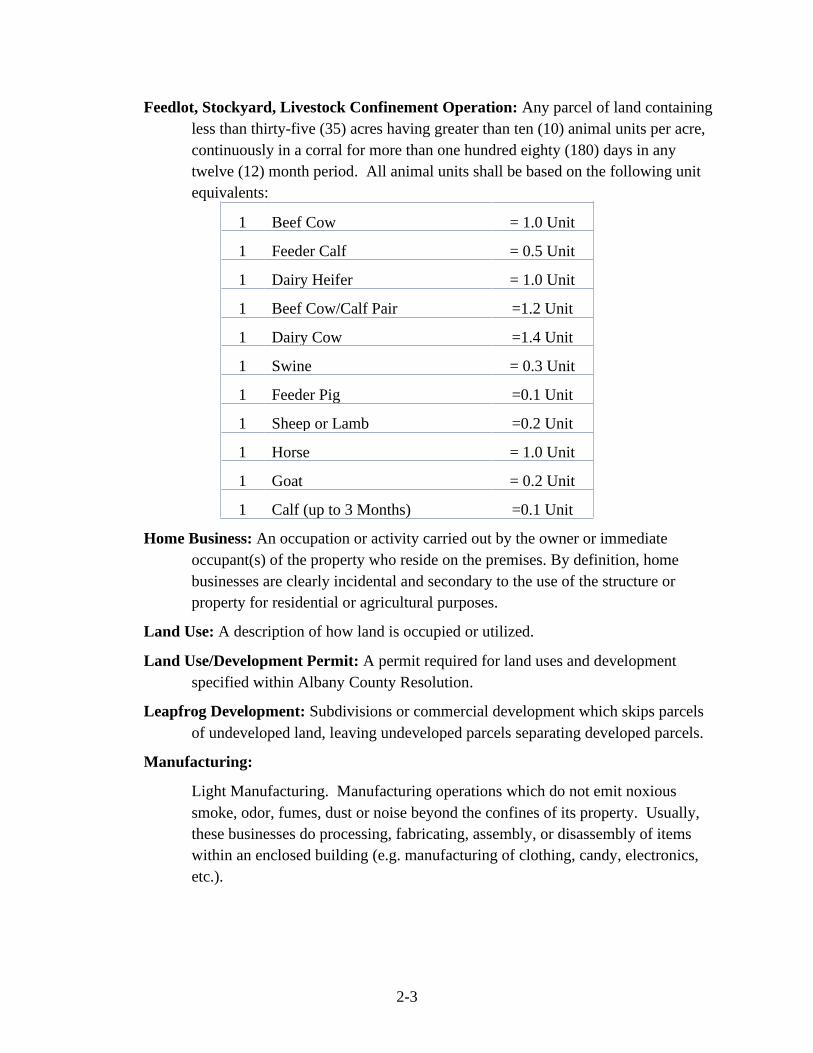
Feedlot, Stockyard, Livestock Confinement Operation: Any parcel of land containing
less than thirty-five (35) acres having greater than ten (10) animal units per acre,
continuously in a corral for more than one hundred eighty (180) days in any
twelve (12) month period. All animal units shall be based on the following unit
equivalents:
1 Beef Cow = 1.0 Unit
1 Feeder Calf = 0.5 Unit
1 Dairy Heifer = 1.0 Unit
1 Beef Cow/Calf Pair =1.2 Unit
1 Dairy Cow =1.4 Unit
1 Swine = 0.3 Unit
1 Feeder Pig =0.1 Unit
1 Sheep or Lamb =0.2 Unit
1 Horse = 1.0 Unit
1 Goat = 0.2 Unit
1 Calf (up to 3 Months) =0.1 Unit
Home Business: An occupation or activity carried out by the owner or immediate
occupant(s) of the property who reside on the premises. By definition, home
businesses are clearly incidental and secondary to the use of the structure or
property for residential or agricultural purposes.
Land Use: A description of how land is occupied or utilized.
Land Use/Development Permit: A permit required for land uses and development
specified within Albany County Resolution.
Leapfrog Development: Subdivisions or commercial development which skips parcels
of undeveloped land, leaving undeveloped parcels separating developed parcels.
Manufacturing:
Light Manufacturing. Manufacturing operations which do not emit noxious
smoke, odor, fumes, dust or noise beyond the confines of its property. Usually,
these businesses do processing, fabricating, assembly, or disassembly of items
within an enclosed building (e.g. manufacturing of clothing, candy, electronics,
etc.).
2-4
Heavy Manufacturing. Any manufacturing use that exceeds the definition of
Light Manufacturing shall be considered Heavy Manufacturing (e.g. fertilizer
plant, cement plant, etc.).
Meteorological (Met) Tower: A tower which has equipment attached to it which is
designed to assess wind resource. Generally a met tower will have anemometers,
wind direction vanes, temperature and pressure sensors, and other measurement
devices attached to it at various levels above the ground.
Mineral Mining: Extraction of minerals, as defined by State Statute (W.S. § 18-5-201,
W.S. § 35-11-101 et al. Seq., and clarified in River Springs Ltd. Liability Co. v.
Board of County Commissioners of the County of Teton, 899 P. 2d 1329 [Wyo.
1995]).
Mobile Home Park: Any lot or parcel of land, whether for rent, lease, hire, or otherwise,
where three (3) or more mobile homes are parked and used for living and/or
sleeping purposes. Three (3) mobile homes established on agricultural land, in
addition to owner or operators residence, and used as housing for agricultural
workers on the same property shall not be construed as a mobile home park.
Non-mineral Mining: Extraction of substances such as sand, gravel and limestone unless
they are rare and exceptional in character or possess a peculiar property giving
them special value, as for example sand that is valuable for making glass and
limestone of such quality that it may profitably be manufactured into cement.
Such substances, when they are useful only for building and road-making
purposes, are not regarded as minerals in the ordinary and generally accepted
meaning of the word (River Springs Ltd. Liability Co. v. Board of County
Commissioners of the County of Teton).
Overlay Zone: A zoning district that encompasses one (1) or more underlying zones and
that imposes additional requirements above that required by the underlying zone.
Parcel: A plot of land, usually a division of a larger area.
Principal Building/Structure: The building in which is conducted the main or principal
use of the property upon which the building is located. These buildings may be
agricultural, residential, commercial, or industrial buildings.
Pod Storage Structures: These structures are commonly known as portable on demand
storage (PODS). These structures are used for on-site storage. These structure
are moved by truck and can be used for temporary (6 months or less) or long-term
(over 6 months) storage on a property.
Public/Quasi Public Use: Areas or buildings available for the use of the general public
(parks, schools, cemeteries, etc.) or for churches, clubs, or related uses.
2-5
Residential Area: Two (2) or more dwelling units located on different lots within five
hundred (500) feet of one another as measured from the nearest points of the
foundations of those structures.
Residential Use: Land that is used for dwelling units.
Screening and Buffering: The use of berms, open space, fencing, landscaping, or other
approved means to visually screen abutting incompatible uses from each other.
Shooting Range: An area or structure used for the safe discharge of firearms for
shooting sports, target practice, or military or law enforcement firearm training.
This definition does not refer to private ranges used primarily for personal use by
the owner of the property.
Site Plan: A plan which illustrates proposed development on a parcel of land. These
plans include parcel dimensions, the dimensions of any proposed structures,
geographic features of the parcel (topography, waterways, etc.) and any other
information needed for the particular development.
Strip Development: A pattern of development, attracted by a major thoroughfare, which
is only one (1) lot or parcel deep along that thoroughfare and which creates
numerous accesses to it, usually for commercial uses.
Structures: A combination of materials to form a construction for use, occupancy, or
ornamentation whether installed on, above, or below the surface of land or water.
Subdivision: The creation or division of a lot, tract, parcel or other unit of land for the
immediate or future purpose of sale, building development or redevelopment, for
residential, recreational, industrial, commercial or public uses. The word
“subdivide” or any derivative thereof shall have reference to the term subdivision,
including mobile home courts, the creation of which constitutes a subdivision of
land.
Tower: Any ground, roof, or otherwise mounted pole, spire, structure, or combination
thereof that is thirty (30) feet or greater in height above the ground, including
supporting lines, cables, wires, braces, masts, or other structures, for the purpose
of mounting an antenna, meteorological device, or similar apparatus above
ground.
Utility Use: Structures and facilities related to the production and/or transportation of
electricity, gas, or oil.
Wind Energy Conversion System (WECS) Tower: See Chapter 5, Section 12, B.
Zoning Certificate: Statement issued by the Albany County Board of County
Commissioners that the proposed development is in compliance with this zoning
resolution.
2-6
Zoning District: A specifically delineated area or district in the county within which
uniform regulations and requirements govern the use, placement, spacing, size of
land, and buildings.
Section 4. Appeals of Staff Interpretation of Definitions and Regulations. The planning
staff shall interpret all definitions and regulations and their application in this zoning resolution.
Appeals of planning staff interpretation may be submitted to the Planning and Zoning
Commission for review and recommendation and to the Board of County Commissioners for
final determination.
Note: Some definitions in this chapter were taken or adapted from The New Illustrated Book of
Development Definitions by Harvey S. Moskowitz and Carl G. Lindbloom (1995).
3-1
Chapter 3. Zoning
Section 1. Purpose. The purpose of this chapter is to establish Zoning Districts.
Section 2. Establishment of Zoning Districts. This section establishes the zoning districts and
associated standards for Albany County. These districts include the following:
A. Agricultural (A)
1. Purpose: The purpose of the A zone is to promote the continuation of farming
and ranching operations and the retention of the rural character of the County.
Areas within this district have low levels of public service and are often in active
agricultural areas.
2. Density: One (1) dwelling unit per thirty-five (35.0) acres.
3. Minimum Lot Size: Thirty-five (35.0) acres.
4. Minimum Lot Frontage Width: None.
5. Minimum Setbacks: Principal and accessory structures must be set back twenty
(20) feet from all property lines. Setbacks for water wells shall be fifty (50) feet
from all property lines. Setbacks for sewage disposal systems shall be in
accordance with the County Resolution entitled “Design and Construction
Standards for Small Wastewater Facilities and Regulations for Permit to
Construct, Install or Modify Small Wastewater Facilities”.
B. Rural Residential (RR)
1. Purpose: The RR zone promotes single family dwellings on larger lots with
limited agricultural operations and provides the ability to store, maintain and
adequately care for limited numbers of livestock. Areas within this district
typically are not served by centralized water and sewer systems and available
utilities may be limited.
2. Density: One (1) dwelling unit per five (5.0) acres.
3. Minimum Lot Size: Two (2.0) acres.
4. Minimum Lot Frontage Width: One hundred (100) feet.
5. Minimum Setbacks: Principal and accessory structures must be set back ten (10)
feet from all property lines. Setbacks for water wells shall be fifty (50) feet from
all property lines. Setbacks for sewage disposal systems shall be in accordance
with the County Resolution entitled “Design and Construction Standards for
Small Wastewater Facilities and Regulations for Permit to Construct, Install or
Modify Small Wastewater Facilities”.
3-2
6. Dwelling Units per Parcel: A property owner is allowed one (1) zoning
certificate for a single-family dwelling per parcel. A zoning certificate for a
multi-family dwelling or one (1) additional zoning certificate for a single-family
dwelling may be allowed or conditionally permitted if specified in the land use
table and if in compliance with all County land use regulations.
C. Small Lot Residential (SLR)
1. Purpose: The SLR zone will provide for single-family dwellings.
2. Density: One (1) dwelling unit per two (2.0) acres
3. Minimum Lot Size: Two (2.0) acres
4. Minimum Lot Frontage Width: One hundred (100) feet
5. Minimum Setbacks: Principal and accessory structures must be set back ten (10)
feet from all property lines. Setbacks for water wells shall be fifty (50) feet from
all property lines. Setbacks for sewage disposal systems shall be in accordance
with the County Resolution entitled “Design and Construction Standards for
Small Wastewater Facilities and Regulations for Permit to Construct, Install or
Modify Small Wastewater Facilities”.
6. Dwelling Units per Parcel: A property owner is allowed one (1) zoning certificate
for a single-family dwelling per parcel.
D. Urban Residential (UR)
1. Purpose: The UR zone is primarily for single-family uses on individual lots with
centralized water and/or sewer systems, typically within water and sewer districts
or in areas that are connected to the City of Laramie water and/or sewer systems.
The use of a centralized water or sewer system is a requirement for subdivision in
this zone.
2. Density: One (1) dwelling unit per ten thousand (10,000) square feet.
3. Minimum Lot Size:
a. If a centralized water system and on-site sewage systems will be provided,
the minimum lot size shall be one (1) acre.
b. If on-site wells and a centralized sewage system will be provided, the
minimum lot size shall be fifteen thousand (15,000) square feet.
c. If both a centralized sewage and water system are employed, density shall
have a minimum lot size of ten thousand (10,000) square feet.
3-3
4. Minimum Lot Frontage Width:
a. Subdivisions requiring a minimum lot size of one (1) acre require a one
hundred (100) foot lot frontage width.
b. Subdivisions requiring a minimum lot size of fifteen thousand (15,000)
square feet requires a seventy-five (75) foot lot frontage width.
c. Subdivisions requiring a minimum lot size of ten thousand (10,000) square
feet requires a seventy-five (75) foot lot frontage width.
5. Minimum Setbacks: Principal and accessory structures must be set back a
minimum of ten (10) feet from all property lines. If an on-site water well is
employed, it must be a minimum of fifty (50) feet from all property lines. If an
on-site sewage disposal system is employed, setbacks shall be in accordance with
the County Resolution entitled “Design and Construction Standards for Small
Wastewater Facilities and Regulations for Permit to Construct, Install or Modify
Small Wastewater Facilities”.
6. Dwelling Units per Parcel: A property owner is allowed one (1) zoning certificate
for a single-family dwelling per parcel.
E. Neighborhood Business (NB)
1. Purpose: The purpose of the NB zone is to protect the character and property
values of residential neighborhoods, while allowing the operation of appropriate
neighborhood oriented businesses. Businesses shall be limited to professional
offices and small retail businesses that provide goods and services. These areas
should be located near major roads and have water and sewer available (on-site or
connected to centralized systems).
2. Minimum Lot Size: Lots must be large enough to site a water and wastewater
system (whether on-site or centralized) within required setback limitations.
3. Minimum Lot Frontage Width: One hundred (100) feet.
4. Minimum Setbacks: Structures must be set back ten (10) feet from all property
lines. If an on-site water well is employed, it must be fifty (50) feet from all
property lines. If an on-site sewage disposal system is employed, setbacks shall be
in accordance with the County Resolution entitled “Design and Construction
Standards for Small Wastewater Facilities and Regulations for Permit to
Construct, Install or Modify Small Wastewater Facilities”.
5. Neighborhood Compatibility Standards.
a. Building Height: The building height shall not exceed twenty-five (25)
feet from finished grade.
3-4
b. Operating Hours: Business shall not be open to the public between the
hours of 10 p.m. and 6 a.m.
F. Commercial (C)
1. Purpose: The purpose of the C zone is primarily to allow for commercial uses
within the County. A mix of uses will be allowed in this zone including both
commercial and residential uses. These areas should be located near major roads
and have water and sewer available (on-site or connected to centralized systems).
2. Minimum Lot Frontage Width: One hundred (100) feet.
3. Minimum Setbacks: Commercial structures must be set back ten (10) feet from
side and rear property lines and fifty (50) feet from frontage property lines. If an
on-site water well is employed, it must be 50 feet from all property lines. If an
on-site sewage disposal system is employed, setbacks shall be in accordance with
the County Resolution entitled “Design and Construction Standards for Small
Wastewater Facilities and Regulations for Permit to Construct, Install or Modify
Small Wastewater Facilities”.
G. Industrial (I)
1. Purpose: The I zone will be for areas or lands determined appropriate for
industrial uses. These uses include the use of land or buildings requiring
substantial applications of skill, capital, machinery, or labor in transforming
materials into other suitable forms, qualities, or properties.
2. Minimum Lot Size: One (1) acre
3. Minimum Lot Frontage Width: Two hundred (200) feet.
4. Minimum Setbacks: Principal and accessory structures must be set back ten (10)
feet from all property lines. Setbacks for water wells shall be fifty (50) feet from
all property lines. Setbacks for sewage disposal systems shall be in accordance
with the County Resolution entitled “Design and Construction Standards for
Small Wastewater Facilities and Regulations for Permit to Construct, Install or
Modify Small Wastewater Facilities”.
Section 3. Overlay Zones. This section establishes overlay zones which may include more than
one (1) underlying zoning district and/or overlay zone. Development, subdivision, or uses within
an overlay zone must meet the additional standards of the overlay, in addition to the underlying
zoning standards.
A. Floodplain Overlay. The Floodplain Overlay is established by the most recent Flood
Insurance Rate Maps (June 16, 2011) provided by the Federal Emergency Management
Agency. Any structure that will be built within the delineated Floodplain Overlay shall
obtain a Floodplain Development Permit from the Albany County Planning Office prior

3-5
to approval of an application for a Zoning Certificate and/or application for Small
Wastewater Treatment Facility. A Floodplain Development Permit will be issued in
accordance with the currently enacted Flood Damage Prevention Resolution (June 7,
2011).
B. 201 Intergovernmental Agreement Overlay. The "Intergovernmental Agreement for
Laramie Wastewater Treatment Facilities and Collection System" is a cooperative
agreement between the City of Laramie, Albany County, and the South of Laramie Water
and Sewer District (Effective November 1, 1997). This agreement establishes specific
standards for the construction of sewage collection lines, and establishes standards for
requiring connection to the City of Laramie sewer lines. See the agreement for the
specific standards and jurisdictional boundaries.
C. Neighborhood Conservation Overlay Zone (NCOZ).
1. Purpose: The purpose of the NCOZ is to avoid creating non-conforming
structures and lots for platted properties in existence prior to the adoption of the
Albany County Zoning Resolution in 1997. Future subdivisions of land in this
overlay zone must meet the standards of the underlying zone.
2. Minimum Lot Size: Existing lots under the minimum lot size standard for the
underlying zone are considered to be legal lots and within the standards of these
regulations.
3. Minimum Lot Frontage: None.
4. Minimum Setbacks: No setback is required for principal or accessory structures.
Setbacks for new water wells shall be a minimum of fifty (50) feet from all
property lines. Setbacks for new sewage disposal systems shall be in accordance
with the County Resolution entitled “Design and Construction Standards for
Small Wastewater Facilities and Regulations for Permit to Construct, Install or
Modify Small Wastewater Facilities”.
5. Land Uses: Land uses shall conform to those allowed and conditionally permitted
in the underlying zone designation (see land use table).
D. Aquifer Protection Overlay Zone.
1. Purpose. The purpose of the Aquifer Protection Overlay Zone (APOZ) is to
prevent degradation to the water quality within the Casper Aquifer.
2. These regulations incorporate the findings of Albany County’s Casper Aquifer
Protection Plan (CAPP) and its update. Approximately fifty (50) to sixty (60)
percent of the City of Laramie's municipal water supply and one hundred (100)
percent of the water to approximately four hundred fifty (450) rural residences
come from wells and springs in the Casper Aquifer. The delineated recharge area

3-6
of the Casper Aquifer in the Laramie area encompasses approximately seventy-
nine (79) square miles that lie east of the City and extends to the crest of the
Laramie Range, with the northern boundary approximately six (6) miles north and
the southern boundary six (6) miles south of City limits. The City of Laramie has
municipal well fields which draw water from this area. The Casper Formation is
exposed along the west side of the Laramie Range and is vulnerable to
contamination because:
a. Points of withdrawal (municipal and domestic wells) are in close
proximity to the recharge area;
b. The Casper Aquifer recharge area is fractured and has extensive exposures
of porous sandstones;
c. There are existing areas of residential and commercial development on the
recharge area and there is a potential for additional future development in
the recharge area; and
d. Interstate 80 (I-80), across which numerous hazardous substances are
transported each day, cuts through the entire thickness of the Casper
Formation. The Casper Aquifer is comprised of the saturated portions of
the Casper Formation which consists of approximately seven hundred
(700) feet of marine and eolian sandstones interbedded with marine
limestone and minor amounts of shale. The Sherman Granite provides an
effective lower confining layer for the Casper Aquifer and the low
permeability of the Satanka Shale provides an upper confining layer where
there is sufficient thickness. In general, the Satanka Shale effectively
retards the flow of water upward out of the Casper Aquifer and the flow of
water downward to the Casper Aquifer.
3. Because the bottom fifty (50) feet of the Satanka Shale may be fractured and in
hydraulic communication with the underlying Casper Aquifer, the City of
Laramie/Albany County Environmental Advisory Committee - Technical
Advisory Subcommittee (June, 1999) recommended that a minimum seventy-five
(75) foot vertical thickness of Satanka Shale be present above the Casper
Formation to provide an adequate safety factor to reduce the risk of potential
contamination to the Casper Aquifer. These regulations hereby incorporate the
Technical Advisory Subcommittee’s recommendation as the basis for defining the
APOZ.
4. Definitions. For the purpose of the Aquifer Protection Overlay Zone (APOZ)
regulations, the following words and terms shall have the meanings specified
herein:
3-7
a. Aquifer Protection Overlay Zone (APOZ) Development: Any
modification to the natural land surface that may result in the introduction of
contaminants and/or increasing the vulnerability of the aquifer to
contamination.
b. Best Available Control Technology: Use of equipment and management
practices to provide the maximum possible reduction in the release, or
possibility of release, of hazardous materials into the Casper Aquifer.
c. Improvement Site: The area that will receive improvements such as
structures, a septic system, roads, driveways, or other alterations to the
existing land.
d. Hazardous Material:
(i) Any hazardous substance as defined in 40 CFR 302.4 and listed therein at
Table 302.4;
(ii) Any hazardous waste as defined in Wyoming law including, but not
limited to, the Wyoming Department of Environmental Quality
Hazardous Waste Rules and Regulations as may be amended from time
to time;
(iii) Any pesticides as defined in Wyoming law; or
(iv) Any oil or petroleum. This definition does not include natural gas or
propane used for heating homes or businesses or other common
residential uses.
e. Person: Any individual, developer, homeowner’s association, group,
business, corporation, partnership, governmental body, or any other legal
entity.
f. Vulnerable Feature: Any physical feature that reduces the natural
protection of the aquifer at or near the ground surface including faults, folds,
open fractures that extend to the ground surface; shallow depth to
groundwater (any location where no effective confining layer is present over
the water-bearing strata within the Casper Formation and the depth to water
is less than seventy (70) feet); exposed bedrock; and drainages.
g. Other words used in these APOZ regulations shall be defined by the usage
in the Albany County Casper Aquifer Protection Plan, other County land use
regulations or by the common definition.
5. Aquifer Protection Overlay Zone Established.
a. There is established within the unincorporated area of Albany County an
Aquifer Protection Overlay Zone (APOZ). The APOZ is the area where
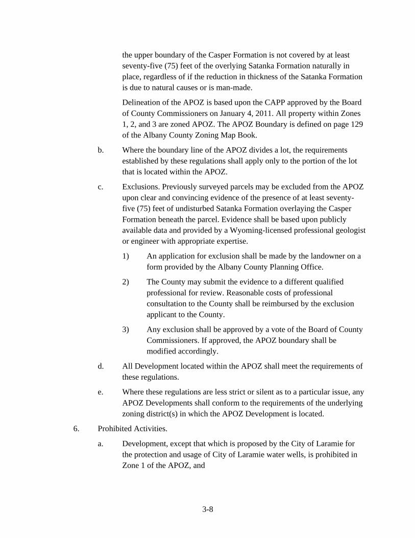
3-8
the upper boundary of the Casper Formation is not covered by at least
seventy-five (75) feet of the overlying Satanka Formation naturally in
place, regardless of if the reduction in thickness of the Satanka Formation
is due to natural causes or is man-made.
Delineation of the APOZ is based upon the CAPP approved by the Board
of County Commissioners on January 4, 2011. All property within Zones
1, 2, and 3 are zoned APOZ. The APOZ Boundary is defined on page 129
of the Albany County Zoning Map Book.
b. Where the boundary line of the APOZ divides a lot, the requirements
established by these regulations shall apply only to the portion of the lot
that is located within the APOZ.
c. Exclusions. Previously surveyed parcels may be excluded from the APOZ
upon clear and convincing evidence of the presence of at least seventy-
five (75) feet of undisturbed Satanka Formation overlaying the Casper
Formation beneath the parcel. Evidence shall be based upon publicly
available data and provided by a Wyoming-licensed professional geologist
or engineer with appropriate expertise.
1) An application for exclusion shall be made by the landowner on a
form provided by the Albany County Planning Office.
2) The County may submit the evidence to a different qualified
professional for review. Reasonable costs of professional
consultation to the County shall be reimbursed by the exclusion
applicant to the County.
3) Any exclusion shall be approved by a vote of the Board of County
Commissioners. If approved, the APOZ boundary shall be
modified accordingly.
d. All Development located within the APOZ shall meet the requirements of
these regulations.
e. Where these regulations are less strict or silent as to a particular issue, any
APOZ Developments shall conform to the requirements of the underlying
zoning district(s) in which the APOZ Development is located.
6. Prohibited Activities.
a. Development, except that which is proposed by the City of Laramie for
the protection and usage of City of Laramie water wells, is prohibited in
Zone 1 of the APOZ, and

3-9
b. No property within any zone of the APOZ may be used for any use listed
in the Table of Prohibited Activities set forth below or otherwise
prohibited or limited by operation of these APOZ regulations.
Table of Prohibited Activities
Prohibited Activity
The following activities are prohibited in the APOZ:
Examples of prohibited
activities
1. Activities involving any equipment for the storage or
transmission of any hazardous material to the extent that
it is not pre-empted by federal law.
Petroleum pipelines or
gasoline stations.
2. The discharge to groundwater of any regulated waste.
3. Commercial car or truck washes, unless all waste waters
from the activity are lawfully disposed of through a
connection to a Publicly Owned Treatment Works or
centralized wastewater treatment system.
Car or truck washes,
detail shops or car
dealership.
4. Commercial and home occupation/home business
production or refining of chemicals, including without
limitation, hazardous materials or asphalt.
Chemical, petroleum, or
asphalt manufacturer.
5. Commercial and home occupation/home business
clothes or cloth cleaning service which involves the use,
storage, or disposal of hazardous materials, including
without limitation, dry-cleaning solvents.
Dry cleaner.
6. Commercial and home occupation/home business
clothes or cloth cleaning service for any activity that
involves the cleaning of clothes or cloth contaminated
by hazardous material, unless all waste waters from the
activity are lawfully disposed of through a connection to
a Publicly Owned Treatment Works or centralized
wastewater treatment system.
Industrial laundry.
7. Commercial generation of electrical power by means of
fossil fuels except generation by means of natural gas or
propane.
8. Commercial and home occupation/home business
production or fabrication of metal products, electronic
Metal foundry, metal
finisher, metal
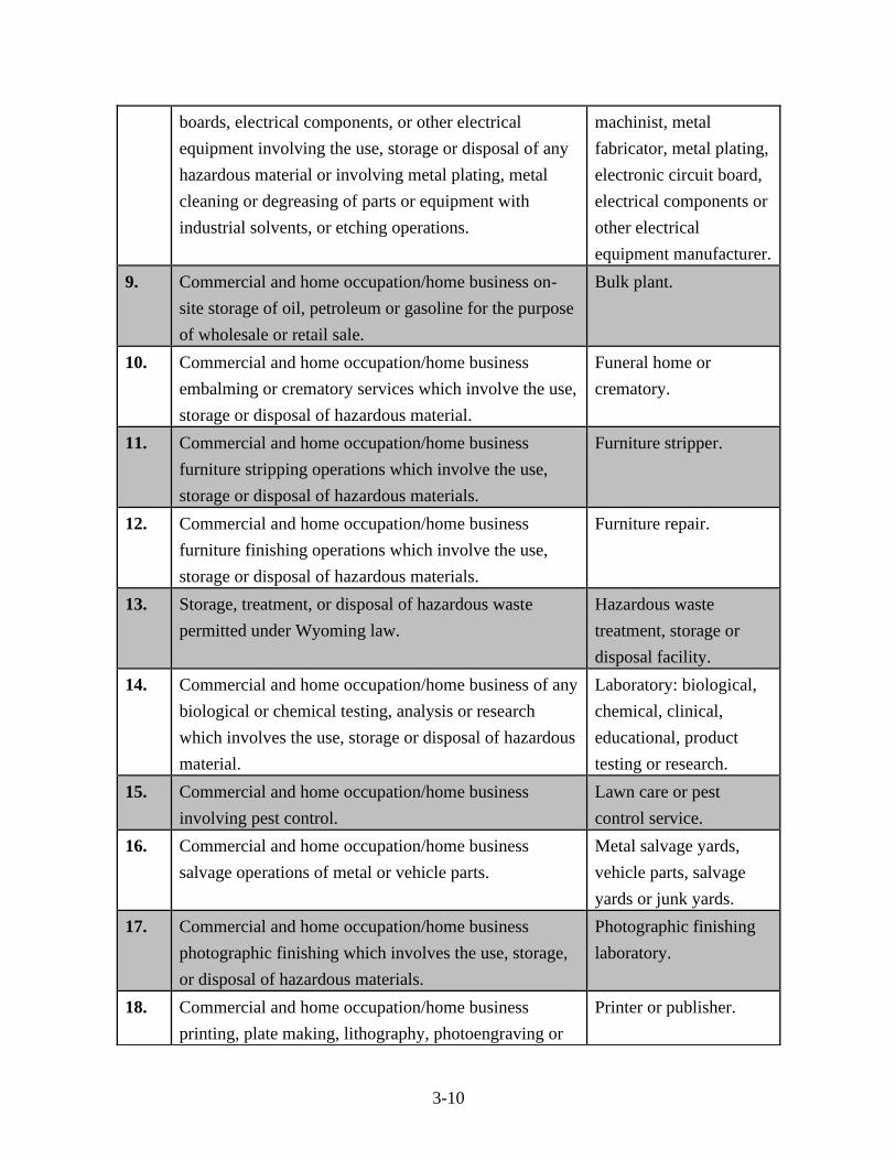
3-10
boards, electrical components, or other electrical
equipment involving the use, storage or disposal of any
hazardous material or involving metal plating, metal
cleaning or degreasing of parts or equipment with
industrial solvents, or etching operations.
machinist, metal
fabricator, metal plating,
electronic circuit board,
electrical components or
other electrical
equipment manufacturer.
9. Commercial and home occupation/home business on-
site storage of oil, petroleum or gasoline for the purpose
of wholesale or retail sale.
Bulk plant.
10. Commercial and home occupation/home business
embalming or crematory services which involve the use,
storage or disposal of hazardous material.
Funeral home or
crematory.
11. Commercial and home occupation/home business
furniture stripping operations which involve the use,
storage or disposal of hazardous materials.
Furniture stripper.
12. Commercial and home occupation/home business
furniture finishing operations which involve the use,
storage or disposal of hazardous materials.
Furniture repair.
13. Storage, treatment, or disposal of hazardous waste
permitted under Wyoming law.
Hazardous waste
treatment, storage or
disposal facility.
14. Commercial and home occupation/home business of any
biological or chemical testing, analysis or research
which involves the use, storage or disposal of hazardous
material.
Laboratory: biological,
chemical, clinical,
educational, product
testing or research.
15. Commercial and home occupation/home business
involving pest control.
Lawn care or pest
control service.
16. Commercial and home occupation/home business
salvage operations of metal or vehicle parts.
Metal salvage yards,
vehicle parts, salvage
yards or junk yards.
17. Commercial and home occupation/home business
photographic finishing which involves the use, storage,
or disposal of hazardous materials.
Photographic finishing
laboratory.
18. Commercial and home occupation/home business
printing, plate making, lithography, photoengraving or
Printer or publisher.
3-11
gravure, which involves the use, storage or disposal of
hazardous materials.
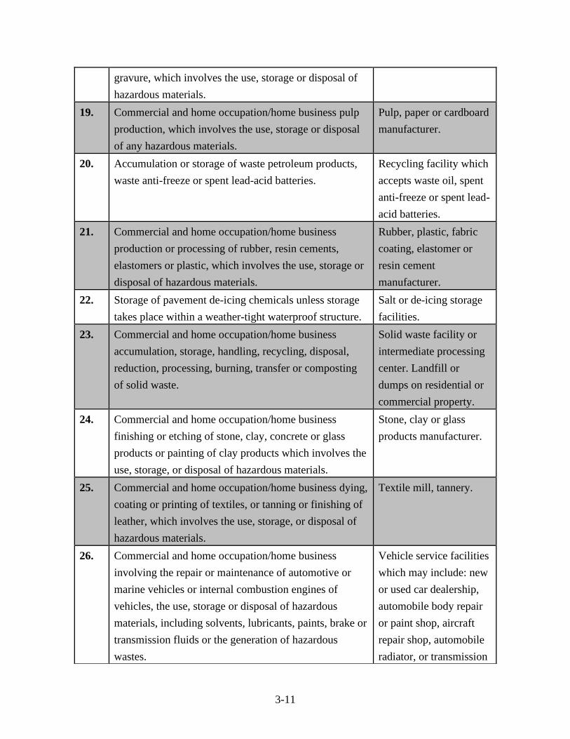
19. Commercial and home occupation/home business pulp
production, which involves the use, storage or disposal
of any hazardous materials.
Pulp, paper or cardboard
manufacturer.
20. Accumulation or storage of waste petroleum products,
waste anti-freeze or spent lead-acid batteries.
Recycling facility which
accepts waste oil, spent
anti-freeze or spent lead-
acid batteries.
21. Commercial and home occupation/home business
production or processing of rubber, resin cements,
elastomers or plastic, which involves the use, storage or
disposal of hazardous materials.
Rubber, plastic, fabric
coating, elastomer or
resin cement
manufacturer.
22. Storage of pavement de-icing chemicals unless storage
takes place within a weather-tight waterproof structure.
Salt or de-icing storage
facilities.
23. Commercial and home occupation/home business
accumulation, storage, handling, recycling, disposal,
reduction, processing, burning, transfer or composting
of solid waste.
Solid waste facility or
intermediate processing
center. Landfill or
dumps on residential or
commercial property.
24. Commercial and home occupation/home business
finishing or etching of stone, clay, concrete or glass
products or painting of clay products which involves the
use, storage, or disposal of hazardous materials.
Stone, clay or glass
products manufacturer.
25. Commercial and home occupation/home business dying,
coating or printing of textiles, or tanning or finishing of
leather, which involves the use, storage, or disposal of
hazardous materials.
Textile mill, tannery.
26. Commercial and home occupation/home business
involving the repair or maintenance of automotive or
marine vehicles or internal combustion engines of
vehicles, the use, storage or disposal of hazardous
materials, including solvents, lubricants, paints, brake or
transmission fluids or the generation of hazardous
wastes.
Vehicle service facilities
which may include: new
or used car dealership,
automobile body repair
or paint shop, aircraft
repair shop, automobile
radiator, or transmission
3-12
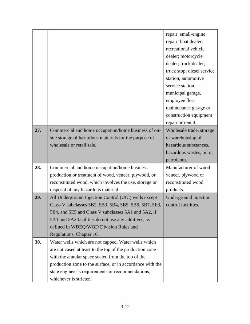
repair; small-engine
repair; boat dealer;
recreational vehicle
dealer; motorcycle
dealer; truck dealer;
truck stop; diesel service
station; automotive
service station,
municipal garage,
employee fleet
maintenance garage or
construction equipment
repair or rental.
27. Commercial and home occupation/home business of on-
site storage of hazardous materials for the purpose of
wholesale or retail sale.
Wholesale trade, storage
or warehousing of
hazardous substances,
hazardous wastes, oil or
petroleum.
28. Commercial and home occupation/home business
production or treatment of wood, veneer, plywood, or
reconstituted wood, which involves the use, storage or
disposal of any hazardous material.
Manufacturer of wood
veneer, plywood or
reconstituted wood
products.
29. All Underground Injection Control (UIC) wells except
Class V subclasses 5B2, 5B3, 5B4, 5B5, 5B6, 5B7, 5E3,
5E4, and 5E5 and Class V subclasses 5A1 and 5A2, if
5A1 and 5A2 facilities do not use any additives, as
defined in WDEQ/WQD Division Rules and
Regulations, Chapter 16.
Underground injection
control facilities.
30. Water wells which are not capped. Water wells which
are not cased at least to the top of the production zone
with the annular space sealed from the top of the
production zone to the surface, or in accordance with the
state engineer’s requirements or recommendations,
whichever is stricter.
3-13
7. Minimum Lot Size: Minimum lot size within the APOZ shall be 35 acres, with
one dwelling. Parcels smaller than 35 acres, as of the date of the adoption of these
regulations, shall be allowed one dwelling.
8. Setbacks from vulnerable features.
a. Vulnerable features requiring a setback include:
1) Faults, folds, or open fractures that extend to the ground surface;
2) Shallow depth to ground; and
3) Drainages.
b. No person shall install, maintain, or use any on-site wastewater treatment
system or wastewater storage system or any private connection to a public
wastewater system within one hundred (100) feet of a vulnerable feature
in the Casper Formation which requires a setback. However, this setback
may be lessened upon approval of the County Wastewater Engineer if
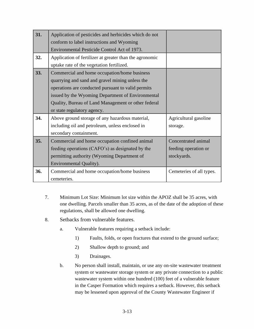
31. Application of pesticides and herbicides which do not
conform to label instructions and Wyoming
Environmental Pesticide Control Act of 1973.
32. Application of fertilizer at greater than the agronomic
uptake rate of the vegetation fertilized.
33. Commercial and home occupation/home business
quarrying and sand and gravel mining unless the
operations are conducted pursuant to valid permits
issued by the Wyoming Department of Environmental
Quality, Bureau of Land Management or other federal
or state regulatory agency.
34. Above ground storage of any hazardous material,
including oil and petroleum, unless enclosed in
secondary containment.
Agricultural gasoline
storage.
35. Commercial and home occupation confined animal
feeding operations (CAFO’s) as designated by the
permitting authority (Wyoming Department of
Environmental Quality).
Concentrated animal
feeding operation or
stockyards.
36. Commercial and home occupation/home business
cemeteries.
Cemeteries of all types.
3-14
documentation that the facility poses no significant threat to groundwater
is provided. This documentation must be provided by a professional
engineer or geologist, licensed in Wyoming, and should include the
following:
1. Evidence that no other location exists on the property that can
meet the required setback standards;
2. Evidence that ensures no significant threat to groundwater will
occur due to the installation of the proposed wastewater system;
and
3. If recommended, mitigation methods needed to protect the
groundwater are installed (e.g. installation of an advanced
wastewater system as defined by Wyoming Department of
Environmental Quality).
c. Additional location and setback constraints may be established as
determined by the results of Site Specific Investigation in Chapter 3,
Section 3, D. for the specifically proposed APOZ Development.
9. Site Specific Investigations (SSI).
a. An SSI shall be required with applications for a zoning certificate, subdivision
permit, conditional use, or zoning change. Zoning certificate applications
requiring an SSI shall be approved by the Board of County Commissioners.
b. SSI Purpose. The purpose of the SSI is to determine the vulnerability of the
Casper Aquifer to contamination by the proposed APOZ Development. The
SSI shall be completed by a professional engineer or geologist, with
appropriate expertise, licensed in the State of Wyoming.
c. The SSI and report shall include the following:
i. A search to determine the presence of Vulnerable Features on the
Improvement Site;
ii. A site narrative including historical information relating to previous
land use, existing or abandoned wells, known contamination of any
part of the property, underground tanks, septic systems, utilities, and
any other improvements on the Improvement Site;
iii. An on-site investigation to determine the presence of Vulnerable
Features not previously identified and of any other hydrogeologic
conditions relevant to the potential for compromising aquifer water
quality beneath the area considered on the Site Plan;
3-15
iv. Where subsurface wastewater disposal is proposed, documentation that
the facility will comply with Albany County’s Design and
Construction Standards for Small Wastewater Facilities and
Regulations for Permit to Construct, Install or Modify Small
Wastewater Facilities and all applicable Wyoming DEQ standards;
v. A delineation of the one hundred (100) year floodplain on the subject
property, if none is indicated on the FEMA Flood Insurance Rate Map,
and deemed necessary by the Albany County Planning Office;
vi. A determination of any necessary mitigation measures or setbacks as a
result of features or conditions as identified by iii, above;
vii. A determination of the depth to groundwater on the Improvement
Site. An attempt should be made to determine the groundwater at its
highest annual elevation, which typically occurs in late spring. Water
level(s) in a well on the site property are preferable for determining
depth to groundwater. Water levels from wells on adjoining properties
may be used if a well has not been drilled on the subject property. If a
well is not available for obtaining water levels, then maps depicting
the potentiometric surface of the Casper Aquifer at the subject
property may be used;
viii. An assessment and mitigation plan for any impacts to the Casper
Aquifer caused by storm water run-off;
ix. Evaluation of the potential impact of septic system effluent on any
member of the Casper Formation, for proposals involving subsurface
waste disposal;
x. A map illustrating the geologic formations on the Improvement Site
including the location of all existing and abandoned wells. A
potentiometric surface of the Casper Aquifer may be included on this
map; and
xi. A Site Plan shall be provided for the Improvement Site that shall
extend one hundred fifty (150) feet from the Improvement Site in all
directions, showing existing and planned structures, proposed small
wastewater systems, and other improvements (including but not
limited to roads, driveways, and utilities; landscaping improvements
shall indicate whether pesticides, fertilizers or herbicides will be used).
Any other information necessary to make an accurate analysis of the
property shall be included on the Site Plan.
3-16
d. A professional engineer, geologist, or other qualified professional licensed in
the State of Wyoming, other than the professional that performed the
investigation, will review the Site Specific Investigation (SSI). Reasonable
costs of professional consultation to the County shall be reimbursed to the
County by the property owner. The technical review will include the
following:
i. Qualifications of the individual and/or firm completing the review;
ii. Verification that the SSI includes all information required in Chapter
3, Section 3, D, 9;
iii. Assessment of compliance with state, federal and local regulatory
authorities;
iv. Assessment of whether the recommendations of the SSI will mitigate
potential negative impacts to the aquifer;
v. A review of the veracity and validity of the technical information
provided in the SSI;
vi. Identification of any errors or omissions within the SSI and of
elements of the SSI that need clarification, modification, or further
consideration; and
vii. An analysis of the quality and consistency of the data used to arrive at
any stated conclusions.
e. Exceptions. An SSI shall not be required for the following:
i. Any buildings or structures proposed on property zoned residential
before August 7, 2012. If a property receives approval of a zoning
change to a non-residential zone, the property will not be exempt by
this paragraph;
ii. Any buildings or structures proposed in a subdivision with a
subdivision permit approved prior to August 7, 2012. If a property
receives approval of a zoning change to a non-residential zone, the
property will not be exempt by this paragraph; or
iii. Any accessory buildings/structures or additions to existing
buildings/structures that are within and consistent with the zoning of
the property.
f. Modifications. Applications for modifications to any APOZ development
shall be submitted on a form supplied by the Albany County Planning Office.
The application must address how the modification meets the
recommendation of the SSI and technical review prepared for the original
3-17
development. The Board of County Commissioners shall vote on any
proposed modification.
10. Design standards for on-site wastewater treatment systems.
a. In addition to the design standards listed in the Albany County Small
Wastewater Regulations, all new and replacement of septic systems located
within the APOZ shall meet the Wyoming Department of Environmental
Quality standards for septic systems in the same aquifer that supplies a public
water supply well. This regulation does not grant the right to install a septic
system or small wastewater treatment system otherwise forbidden by County
or State regulations.
b. The installation, design, repair, and removal of septic systems located within
the APOZ must be in accordance with plans and specifications certified by a
registered professional engineer or geologist licensed to practice in the State
of Wyoming.
c. Septic systems must be pumped and maintained on a regular schedule by a
County licensed septage pumper/hauler. Pumping and a visual inspection of
the installed septic system shall be conducted when the ownership of the
property is transferred and reported to the Albany County Wastewater
Engineer on a form supplied by that office.
d. When a septic tank is pumped, the pumper/hauler shall visually inspect the
septic system, including its various components, for signs of failure or
impending failure. Any incidence of a septic system or any of its components
exhibiting signs of failure or impending failure shall be reported by the
septage pumper/hauler to the Albany County Wastewater Engineer on a form
provided by that office and copied to the Albany County Planning Office. The
form shall include the anticipated resolution of all noted issues and a schedule
for resolution, to be enforced by the Albany County Planning Office. No form
or report is required for a properly functioning septic system.
e. All new and replacement septic systems and leach fields within the APOZ
shall be inspected by the Albany County Wastewater Engineer before
backfilling in accordance with Albany County Small Wastewater Regulations.
f. If a septage pumper/hauler finds that a septic system is not adequately
designed or constructed to serve the use to which it is intended, it shall not be
used for the disposal of wastewater until it is cleaned, repaired, or otherwise
made to operate adequately as determined by the Albany County Wastewater
Engineer.
3-18
11. Nonconforming uses. If the nonconforming use is damaged due to conditions
beyond the control of the owner or operator, it may be repaired and resumed at the
same location, size, and scope.
a. The owner or operator shall submit a report to the Albany County
Planning Office. The report shall include:
1) A description of the damage;
2) A description of the planned repairs and how these will maintain
the same location, size or volume, and scope of the operation prior
to the damage;
3) Documentation demonstrating how the planned repairs incorporate
best available control technology to prevent hazardous materials
from entering the Casper Aquifer; and
4) Documentation demonstrating compliance with all county, state,
and federal rules and regulations.
b. Notwithstanding (a) above, repairs shall not be allowed to extend, enlarge,
or expand the use, as prohibited by Section 6 of this Chapter.
12. Proper abandonment of unused wells. All wells, including but not limited to
groundwater pumping wells and monitoring wells, which are no longer in use by
the owner must be properly abandoned by a well driller licensed in the State of
Wyoming in accordance with Chapter 11, Section 70 of the Wyoming Department
of Environmental Quality Rules and Regulations.
13. Existing law on aquifer contamination unaffected. The establishment of the
APOZ and the use of properties in the APOZ in accordance with these regulations
do not relieve any person from liability provided by law for contamination of the
aquifer. These APOZ regulations do not supersede or modify the requirements of
any federal, state, or local law imposing stricter requirements regarding aquifer
protection and/or contamination.
14. Severability. The provisions of these APOZ regulations are severable. If any
provision is declared to be invalid or unenforceable by any court of competent
jurisdiction, those provisions not so declared shall remain in effect.
Section 4. Official Zoning Maps. The boundaries of the zoning districts shall be determined
and defined by the Official Albany County Zoning Maps. Maps, displaying the date printed,
shall be available at the Albany County Planning Office, the Albany County GIS Office, the
Albany County Clerk’s Office, and the Albany County Real Estate Office.
Section 5. Zoning Change.
3-19
A. Initiation of a Zoning Change: A zoning change may be initiated at the request
of the Board of County Commissioners, the Planning and Zoning Commission,
planning staff, or a private entity (individual or business).
B. Application Submission: Applicant(s) and property owner(s) or an agent authorized by
the property owner(s) must complete, sign, and submit to the Albany County Planning
Office an application on a form prescribed by the Planning Director for a zoning change.
In the event the proposed zoning change is proposed in connection with a zoning
certificate for a permitted or conditional use or a subdivision permit, the application for
the proposed use may accompany the zoning change application.
C. Notification Requirements: See Chapter 5, Section 5.
D. Planning and Zoning Commission Review and Recommendation: The Planning and
Zoning Commission will review the request for a zoning change at a regular or special
meeting and make findings and a recommendation to the Board of County
Commissioners. The Planning and Zoning Commission shall make their
recommendation based on subsection F. below.
E. Board of County Commissioners Review and Action: The Board of County
Commissioners shall hold a public hearing prior to acting on the request for a zoning
change.
In order to give final approval of the zoning change, the Board of County Commissioners
must be able to make the required findings and conclusions of law.
F. Findings Necessary for Approval: As a condition for approval of the request for a
zoning change, the Board of County Commissioners must make the following findings:
1. The applicant has provided such site plans and/or survey maps as required.
2. The proposed zoning change generally follows the suggestions of the Albany
County Comprehensive Plan, including, but not limited to the Long Range
Growth Plan and the Priority Growth Areas (see Chapter 3 of the Albany County
Comprehensive Plan).
3. The applicant has adequately addressed the following impacts:
a. Compatibility with Surrounding Properties: The proposed zoning change
is compatible with the existing land use of surrounding properties.
b. Screening and Buffering of Incompatible Zoning Districts: Screening and
buffering must be provided if Industrial or Commercial zoning is proposed
adjacent to a Residential zone.
c. Consistent Patterns of Development: The proposed zoning change results
in a logical and orderly development pattern in the area and will not create

3-20
undesirable patterns of development such as leapfrog developments or
strip patterns of development.
d. Economic Impacts: Any complaints submitted as public comments
concerning negative economic impacts must be addressed.
e. Natural and Environmental Resource Impacts: The proposed zoning
change will not result in significant adverse impacts to natural and
environmental resources such as water quality, air quality, crucial wildlife
habitat, wetlands, streams, etc.
f. Cultural Resource Impacts: The proposed zoning change will not result in
significant adverse impacts on cultural resources such as historical or
archeological sites.
g. Road Network Impacts: The existing road network can accommodate any
increase in traffic generated by the zoning change.
h. Impacts on Public Services, Utilities, and Public Facilities: Public
services, utilities, and public facilities will adequately meet the needs of
the proposed zoning change.
G. Exempt Property: State and federal land is exempt from zoning. In the event that
exempt land is acquired by a non-exempt entity, it shall automatically be zoned
Agricultural.
Section 6. Non-Conforming Lots, Structures, and Uses.
A. General Provisions
1. It is recognized that there may exist, within the zoning districts established by this
Resolution, lots, structures, and uses which were lawful ("grandfathered") before
this Resolution became effective which would be prohibited, regulated, or
restricted under the terms of this Resolution. It is the intent of this Resolution to
permit those non-conformities to continue, providing said non-conformities are
not extended, enlarged or expanded.
2. There may be a change of tenancy, ownership, or management of a non-
conforming lot, structure, or use provided there is not a change in the nature or
character of said non-conformity.
3. Nothing in this Resolution shall prevent the restoring to a safe condition any
building or part thereof, declared to be unsafe by an official of Albany County or
of the State or Federal governments. Nothing in this Resolution shall prevent the
installation or repair of curbs, gutters, sidewalks, streets, storm sewers, or any
other capital improvement that is for the safety and general welfare of the public.
B. Non-Conforming Lots
3-21
1. The definition of a non-conforming ("grandfathered") lot is a platted lot or lot of
record which, on the effective date of this Resolution or as a result of subsequent
amendments thereto, does not comply with the lot size requirements for the zone
in which the lot is located.
2. In any zone in which a proposed use is permitted, notwithstanding limitations
imposed by other provisions of this Resolution, said use may be conducted and
necessary customary buildings may be erected on any single lot of record after the
effective date of this Resolution. This does not preclude the need of other permits
required by these regulations. This provision shall apply even though such lot
fails to meet the requirements for minimum lot size applicable to the zone,
providing the use and buildings must comply with all the regulations for the zone
in which such lot is located. If separately-created, contiguous lots are merged by
a recorded instrument, combining two (2) or more lots into a single legal
description, the new combined lot shall be regarded as a single lot.
C. Non-conforming Structures
1. The definition of a non-conforming ("grandfathered) structure is a structure
which, on the effective date of this Resolution or as a result of subsequent
amendments thereto, does not comply with the provisions of this resolution for
the zone in which the non-conforming structure is located.
2. Where a lawful structure exists at the effective date of adoption or amendment of
this Resolution that could not be built under the terms of this Resolution by reason
of restriction on open space, height, setbacks or other requirements of the
structure or its location on the lot, such structure may be continued so long as it
remains lawful, subject to the following provisions:
a. No such structure may be enlarged or altered in a way which increases its
non-conformity; unless an enlargement or structural alteration makes the
building more conforming or is required by law.
b. Should such structure be destroyed by any means to an extent of more
than fifty percent (50%) of its replacement cost at the time of destruction,
as determined by the County Assessor, it shall not be reconstructed except
in conformity with the provisions of this Resolution.
c. Should such structure be moved for any reasons for any distance whatever,
it shall thereafter conform to the regulations for the zone in which it is
located after it is moved.
D. Non-Conforming Uses
1. The definition of a non-conforming ("grandfathered") use is a use which, on the
effective date of this Resolution or as the result of subsequent amendments
3-22
thereto, does not conform to the permitted or conditional uses established for the
district in which the non-conforming use is located.
2. Where, at the effective date of adoption or amendment of this Resolution, a lawful
use exists that is no longer permissible under the terms of this Resolution as
adopted or amended, such use may be continued, subject to the following
provisions:
a. If active and continuous operation of a non-conforming use is
discontinued for a period of twenty-four (24) consecutive months, all
subsequent uses shall be in compliance with the scope and intensity of the
uses for the district in which the use is located.
b. No non-conforming use shall be expanded beyond the use in existence at
the time of adoption of this Resolution.
c. No non-conforming use shall be changed to another non-conforming use.
d. No non-conforming use shall be relocated unless moved to a location
where the use would no longer be non-conforming.

4-1
Chapter 4. Land Use
Section 1. Purpose. The land use table sets forth the land uses allowed for new development in
the established zoning districts. Any uses existing prior to the adoption of these regulations may
continue to exist; however change in use must conform to these regulations.
Section 2. Land Use Table Content Description.
A. Uses Allowed by Right (“A”): An “A” in the cell of the land use table indicates that the
use is allowed by right in that zone. If there are additional standards or a required special
use permit pertaining to the use, they are referenced in the far-right column of the land
use table. Uses allowed by right are subject to all other requirements found in these
zoning regulations.
B. Conditional Use (“C”): A “C” in the cell of the land use table indicates that the use is
allowed subject to approval of a conditional use permit. If there are additional standards
or a required special use permit pertaining to the use, they are referenced in the far-right
column of the land use table. Uses requiring a conditional use permit are subject to all
other requirements found in these zoning regulations.
C. Prohibited Uses (“P”): A “P” in the cell of the land use table indicates that the use is
prohibited in that zone. If a use existed in a zone prior to the adoption of these
regulations and is now prohibited, the use shall be allowed to continue according to
Chapter 3, Section 6 (Non-Conforming Lots, Structures and Uses) of these zoning
regulations.
D. Similar and Compatible Uses: If a proposed use is not listed within the land use table,
the Planning Director shall determine whether the proposed use is an allowed use, a
conditional use, or a prohibited use within the zone because the use is similar or
compatible to another use within the zone and that it falls within the intent of these
zoning regulations. The Planning Director’s decision may be appealed to the Planning
and Zoning Commission for review and recommendation and then to the Board of
County Commissioners for a final determination.
E. Exempted Land Use: Mineral mining extraction or production is exempt from zoning
(W.S. § 18-5-201). This provision does not inhibit the authority of the County to regulate
non-mineral mining.
4-2
Land Use Table 4.1
Zoning Classification
Uses A RR SLR UR C NB I Additional Use
Standards/Permit
Abbreviation: A = Allowed by Right C = Conditional Use Permit P = Prohibited
Agricultural Uses
Agricultural operation, incidental A A A A A A A
Boarding stables A C C C C C C
Commercial livestock production, grazing,
and storage of related equipment
A A C P C C C
Equestrian arena, commercial A C P P C C C
Feed lot, Stockyard, Livestock Confinement
Operation
A C P P C P C
Guest/dude ranch A C P P P P P
Incidental sale of agricultural product
produced on-site (e.g. hay, honey, vegetables,
etc.)
A A A C A A A
Timber harvesting and equipment storage A C P P C P A
Tree farm A A P P A P A
Residential Uses
Day care, home (secondary to residential use) A A C C P P P
Dwelling, multi-family A C P P A P P
Dwelling, single-family A A A A C P C
Mobile home park (3 or more mobile homes) P C C C A P P
Commercial Uses
Adult entertainment uses P P P P C P C Chapter 6, Section 3
Agricultural equipment and feed sales C C P P C P A
Amusement Park P P P P C P C
Animal Shelter/Kennel C C C P C P C
Assisted Living P C C C A C P
Auditorium (primary use) C P P P A P P
Automobile- mechanical repairs, sales, wash,
body shop
P P P P A P A
Automobile- wrecker service P P P P A P A
Bakery (small-scale) P P P P A A A
Bank, credit union, other financial institutions P P P P A A P
Bar, lounge, nightclub P P P P A P P
Bed and breakfast A C C C A A P
Bowling alley P P P P A P C
Butcher Shop A P P P A C A
Cinema, theater P P P P A P P
Coffee shop, donut shop P P P P A A P
Cold storage facility P P P P C P A
Commercial Outdoor Event Venue, Limited A P P P C P A
Convenience store (with fuel sales) P P P P A C A
Day care center (primary use) P P P P A A P
Department store, shopping mall P P P P A P P
Dinner theater C P P P A P P
Fireworks stand P P P P C P C Chapter 6, Section 4
Florist shop P P P P A A P
Food stand/concession stand (e.g. snack kiosk
or hot dog stand)
C C C C A A C
4-3
Land Use Table 4.1
Zoning Classification
Uses A RR SLR UR C NB I Special Use
Standards/Permit
Funeral home P P P P A P P
Green house/nursery, commercial C C P P A P A
Hangar/Aviation repair C P P P C P A
Health Spa C P P P A A P
Hotel/Motel P P P P A P A
Information Technology Facilities (e.g. data
center)
P P P P A P A
Laundromat P P P P A A A
Liquor sales P P P P A C A
Lumber sales and storage C P P P A P A
Medical or dental office/clinic P P P P A A P
Mini-storage P P P P A P A
Office building P P P P A A C
Office buildings with a mix of residential uses P P P P A A P
Outfitting business facilities A C P P A P A
Pharmacy P P P P A A P
Print shop/copy shop P P P P A A A
Radio, TV, Recording, Motion Picture Studio P P P P A P A
Retail uses, including those with a mix of
residential uses
P P P P A C P
Research lab and facilities P P P P A A A
Restaurant P P P P A C A
Supermarket/grocery store P P P P A C P
Truck stop, terminal P P P P C P A
Veterinary clinic C C P P A C P
Warehouse P P P P C P A
Industrial Uses
Asphalt plant/hot mix plant P P P P P P A
Compressor Station P P P P P P A
Construction yard/shop, Heavy P P P P C P A
Correctional facility C P P P P P C
Dairy processing (e.g. cheese factory) C P P P P P A
Heavy equipment sales and service P P P P C P A
Landfill, commercial C P P P P P C
Manufacturing, light P P P P C P A
Manufacturing, heavy P P P P P P A
Meat packing and slaughterhouse P P P P P P A
Mineral processing (mineral mining is exempt) C P P P P P C
Non-mineral mining C P P P P P C Chapter 6, Section 5
Refinery, petroleum and natural gas products P P P P P P C
Research and development P P P P C P A
Salvage yard P P P P P P C
Saw mill P P P P P P C
Saw mill, portable A P P P C P A
Storage, outdoor P P P P P P A
Telephone service garage P P P P P P A
Temporary hot-mix facility C P P P C P A
4-4
Note: Similar and Compatible Uses- If a proposed use is not listed within the land use table, the
Planning Director shall determine whether the proposed use is an allowed use, a conditional use,
or a prohibited use within the zoning district because the use is similar or compatible to another
use within the zoning district and that it falls within the intent of these zoning regulations. The
Planning Director’s decision may be appealed to the Planning and Zoning Commission for
review and recommendation and then to the Board of County Commissioners for a final
determination.
Land Use Table 4.1
Zoning Classification
Uses A RR SLR UR C NB I Special Use
Standards/Permit
Public and Quasi-public Uses
Campground/RV Park C P P P A P P
Cemetery C P P P C P P
Churches/religious facilities C C C C A C P
Club house/social or fraternal hall C C C C A P P
Cultural facilities (e.g. visitor/interpretive
center)
C C P P A P P
Hospital P P P P C P P
Library P C C C A A P
Parking garage/deck P P P P A P A
Parks, playgrounds, open space A A A A A A A
Post office C C C C A C P
Rail, bus, or air terminal P P P P A P A
Recreational facilities C C P P A P P Sheriff or fire station C C C C A C A
Shooting range C P P P C P C
School/educational facility C C C C C C P
Accessory Uses
Additional dwelling, single family (must meet
density requirements for zone)
A C P P C P P
Accessory building A A A A A A A
Agricultural Employee Housing A P P P P P P
Home business A A A A A A A Chapter 5, Section 13
Utility Uses
Commercial wind energy conversion systems C P P P P P C Chapter 5, Section 12
Power plant P P P P P P C
Re-generation structures for fiber optic cables A C C C C P A
Small wind energy systems A A A A A A A Chapter 5, Section 11
Solar energy facility, commercial C P P P P P C
Substations for electrical utilities C P P P C P C
Switching station buildings and electronic
enclosure building for phone lines
A C C C C P A
Temporary towers A A A A A A A Chapter 5, Section 10
Towers C C C C C P C Chapter 5, Section 9
5-1
Chapter 5. Land Use Permits and Procedures
Section 1. Purpose. This chapter establishes the land use permits required to develop land in
the County and the procedures by which the various permits may be obtained.
Section 2. Zoning Certificates Required. New uses, expansions of existing uses, conditional
uses, or changes of use are required to get a zoning certificate pursuant to W.S. § 18-5-203: "It is
unlawful to locate, erect, construct, reconstruct, enlarge, change, maintain or use any building or
use any land within any area included in a zoning resolution without first obtaining a zoning
certificate from the Board of County Commissioners or its designee and no zoning certificate
shall be issued unless the building plans for the proposed building, structure or use fully comply
with the zoning regulations then in effect. The Board of County Commissioners or its designee
shall act promptly upon any application filed with it and shall grant certificates when the
proposed construction or use complies with the requirements of the zoning resolution. If it
denies the application, the board or its designee shall specify the reasons for the denial." The
Board of County Commissioners authorizes the Planning Director to be its designee for zoning
certificate approvals where a public hearing is not required.
Accessory buildings one hundred forty-four (144) square feet or less shall not require a zoning
certificate. Zoning certificates shall expire after two (2) years unless the applicant can show
evidence of substantial progress and the applicant applies for a one (1) year extension. Zoning
certificates will expire after three (3) years.
Substantial progress may be satisfied by completion of a foundation and septic system and/or
fifty percent (50%) or more of the building’s exterior.
Section 3. Complete Application Submittal and Withdrawal.
A. Completed Applications. Applicants must complete, sign, and submit to the Albany
County Planning Office an application on a form prescribed by the Planning Office.
Planning staff shall make the determination of when an application is complete.
B. Application Withdrawal Process: The applicant may withdraw an application, in
writing, at any time prior to the final decision on the land use permit. The application fees
may be refunded, at the discretion of the Planning Director, if no county funds have been
expended for the application process (e.g. publication of notice) and staff time spent on
the application is unsubstantial.
Section 4. Site Plan.
A. Site Plan Required. A site plan shall accompany all zoning certificate or conditional use
permit applications, as prescribed by the Planning Director.
B. Standards for Site Plans in the Dedication Plat of Centennial.
5-2
1. Purpose. This subsection creates standards to ensure property owners make
improvements on their own property, avoid encroachment into public areas, and
subsequent legal issues. The Dedication Plat of Centennial was filed in 1901 and
it ignored the extreme topography in the area. The lots within this subdivision are
very small, and many of the roads were never built. This has led to a number of
problems for property owners. There are a number of instances where physical
improvements have extended outside of legal property boundaries and this is a
problem that has perpetuated for decades.
2. Application of Special Standards. The area to which these standards apply is
within the Dedication Plat of Centennial located in NE¼, Section 3, Township 15
North, Range 78 West of the 6th P.M., in Albany County, Wyoming as recorded
on August 12, 1901 at Plat Book Page 45 in the Albany County Clerk’s Office,
minus blocks 1-4 and 13-16 which were vacated on July 9, 1912.
3. Zoning certificates and conditional use applications for properties within the
Dedication Plat of Centennial must include a site plan stamped and signed by a
professional surveyor licensed in the State of Wyoming. The survey must be tied
to known monuments, show property boundaries, and the location and dimensions
of any requested improvements. If a prior survey for the property in question is on
file with the Planning Department, that existing survey can be used if updated to
reflect the location and dimension of the new requested improvements. All other
information required by the permit to be on the site plan must be included. If
improvements are not made in accordance with the survey, the permit will be
revoked.
Section 5. Notice Requirements.
A. Development Proposals: The notice requirements shall apply to land use changes,
conditional uses, variances, and telecommunication and utility facilities.
B. Fee: Applicant shall remit a fee in the amount of one hundred (100.00) dollars to cover
notice expenses at the time of filing a development proposal. This fee shall be in addition
to the application filing fee.
C. Notice Requirements:
1. Mail: Applicant shall be responsible for mailing notice, by certified mail, to
surrounding, contiguous property owners of the proposed development. If the
applicant is not the property owner of the proposed development site, notice shall
be sent in the described manner to the property owner(s). Notice of pending
proposals for development shall be given before both the Planning and Zoning
Commission and the Board of County Commissioners at least fourteen (14) days
prior to consideration. Rights-of-way and easements shall not be considered as

5-3
dividing properties. Names and addresses for the surrounding property owners
shall be obtained from the real estate records filed with the Albany County
Clerk’s Office or the assessment records on file with the Albany County
Assessor’s Office. Use of any information which is not up-to-date shall not
invalidate this notice requirement.
2. Affidavit of Mailing: Applicant shall submit to the Planning Office both an
affidavit of mailing of the certified mail notice and copies of the signed return by
recipients of the notice. The affidavit and the receipt copies shall be submitted to
the Planning Office at least five (5) days prior to the respective Planning and
Zoning Commission and Board of County Commissioners meetings.
3. Publication: The Planning Department shall propose and place in the local
newspaper a legal notice of the proposed development. The publication shall
provide at least fourteen (14) days notice of a development proposal before the
Planning and Zoning Commission and fourteen (14) days notice prior to the
Board of County Commissioners.
4. Signage: The applicant shall obtain at the time of the application submission, one
(1) sign to be placed along and clearly visible from each publicly used road
abutting the property. The sign shall state the property is being proposed for
development and shall give contact information for the Planning Department.
The sign(s) shall be posted at least fourteen (14) days prior to consideration of a
development proposal before the Planning and Zoning Commission and the Board
of County Commissioners. Applicant is responsible for return of the signs in as
good a condition as when obtained, except for reasonable wear and tear.
D. Contents of Notice: All mailed and publication notices shall include a brief description of
the development proposal including the owner, location and proposed use; contact
information for the Planning Department; and the location, date and time, and reviewing
body for the public meeting or hearing.
Section 6. Zoning Certificates—Permitted Uses. If the proposed use is allowed by right and
the planning staff has determined that the use complies with all minimum County standards, the
Planning Director shall approve a zoning certificate for the use. If a septic system will be
employed by a structure/building, a small wastewater permit application should accompany the
zoning certificate application.
Section 7. Zoning Certificates—Conditional Uses.
A. Purpose: Each zoning district contains not only permitted uses available as a matter of
right, but also conditional uses, which are neither permitted as a right nor prohibited by
law. Conditional uses are privileges, which must be applied for and approved by the
Planning and Zoning Commission and the Board of County Commissioners. Without
5-4
proper review, conditional uses can be incompatible with other uses within the vicinity.
The conditional use process allows for certain uses provided specified adverse impacts
are identified and mitigated.
B. Permit Runs with the Land: Unless otherwise noted, a conditional use permit runs with
the land and does not terminate when the property is sold. A new owner succeeds to the
benefits; however the successor is subject to the limitations in the permit.
C. Expiration:
1. A conditional use permit shall become void one (1) year after it is granted unless
put to use.
2. If a conditional use permit has been abandoned for one (1) year it becomes void
and the applicant must reapply.
3. Failure to meet required conditions will result in notification to the holder of the
conditional use permit that they have thirty (30) days to come into compliance
with all required conditions. At the end of this thirty (30) day period, if the
applicant remains incompliant, the conditional use permit becomes void and use
must be discontinued.
D. Process:
1. Application Submission: The applicant must submit a completed application to
the Planning Office. Planning staff shall have thirty (30) days to review the
application and solicit input from other agencies. By the end of the thirty (30) day
review period, staff will schedule a public hearing with the Planning and Zoning
Commission for their next regular meeting.
2. Notification Requirements: Chapter 5, Section 5.
3. Planning and Zoning Commission Review and Recommendation: The Planning
and Zoning Commission will review the request at a regular meeting and make
findings and a recommendation to the Board of County Commissioners.
4. Board of County Commissioners Review and Action: The Board of County
Commissioners shall hold a public hearing prior to acting on the request.
In order to give final approval of the conditional use permit, the Board of County
Commissioners must be able to make the required findings of fact and
conclusions of law, determining that each impact shall be mitigated, if deemed
necessary, providing reasonable compatibility with adjacent uses. Additional
conditions may be imposed by the Board of County Commissioners in order to
more adequately promote the public health, safety, morals, and general welfare of
the County.
5-5
5. Findings Necessary for Approval: The Board of County Commissioners must
make the following findings:
a. That the applicant has provided such site plans and/or survey maps as
required.
b. That the proposed conditional use shall not harm the public health, safety,
and welfare of the community.
c. That adequate public services are available for the proposed conditional
use without creating an undue financial burden on the County.
d. That the applicant has adequately addressed the following possible
impacts:
1) Comprehensive Plan: The proposed conditional use shall generally
reflect the suggestions put forth in the Albany County
Comprehensive Plan.
2) Leapfrog or Strip Patterns of Development: Avoid the creation of
scattered or strip development.
3) Economic: Demonstrate that the applicant has addressed any
complaints specified during the public comment period concerning
any negative economic impacts.
4) Air Quality: Mitigate any air quality impact at or beyond the
property line: fumes, smoke, odor, dust, heat, etc.
5) Water Quality: Mitigate any adverse water quality impacts.
6) Separation of Uses: Provide adequate separation from
incompatible adjacent uses through yards and open spaces.
7) Screening and Buffering: Provide separation from incompatible
adjacent uses by screening and buffering. Reference type,
dimensions, and character.
8) General Nuisances: Minimize light, glare, heat, noise, vibration,
odors, fumes, smoke, or other nuisances generated by the use.
9) Traffic: Provide ingress and egress to the property and the
proposed structures thereon, with particular reference to
automotive and pedestrian safety and convenience, traffic flow and
control, and access in case of fire or catastrophe.
10) Parking: Must meet standards found in Chapter 6, Section 6 of
these regulations.
5-6
11) Exterior Lighting: Must meet standards found in Chapter 6,
Section 2 of these regulations.
12) Refuse and Service Areas: Appropriately locate and provide
adequate refuse and service.
13) Signs: Show the location and size of proposed signs. Must meet
standards found in Chapter 5, Section 8 of these regulations.
Section 8. Outdoor Sign Permit. If the proposed outdoor sign meets the requirements stated in
this section and all requirements of this Zoning Resolution, the Planning Director shall approve
an Outdoor Sign Permit.
A. Definitions:
1. Sign: Any display, light, device, figure, painting, drawing, message, placard,
poster, billboard, or any other thing which is designed, intended, or used to
advertise or inform. The term "sign" includes the sign face and the sign structure.
2. Sign Face: That portion of a sign which is used for the purpose of graphic
illustration or display.
3. Sign Structure: That portion of a sign not used for the purpose of graphic
illustration or display and which serves as structural support for the sign face.
4. Abandoned Sign: A sign in which no one has an economic interest or a sign
which has displayed obsolete material or has been totally or partially obliterated
for over six (6) continuous months or shows signs of other economic
obsolescence. The continued need of substantial repair may also be deemed to
constitute abandonment.
5. Commercial or Industrial Area: Those areas which are occupied by three (3) or
more commercial or industrial activities where those activities are located within
two thousand (2000) feet of each other as measured from the nearest points on the
foundations of the most distant principal commercial or industrial structures.
6. Disrepair: When a sign has been allowed to deteriorate to the extent that the
message and/or display are incomplete, or the sign structure has been weakened,
or parts of the sign face or sign structure has been detached and is free to be
moved by the elements. A determination of "disrepair" will be made if the sign
face or structure is visibly altered or deteriorated from the original construction
drawings submitted with the application for the zoning certificate.
7. Exempt Sign: Any sign which is excluded from regulation under Subsection C
below and which complies with the General Requirements as stated in Subsection
B below.

5-7
8. Off-premise Sign: Any sign that advertises goods, products, services or facilities
or directs a person to an activity which is conducted at a property other than
where the sign is located.
9. On-premise Sign: Any sign that advertises goods, products, services, facilities,
or directs a person to an activity which is conducted on the property on which the
sign is located.
10. Projecting Sign: Any sign attached to a structure but which protrudes from that
structure greater than one (1) foot but less than five (5) feet.
11. Wall Sign: A sign which is permanently affixed to a wall and which protrudes
from a wall one (1) foot or less.
B. General Requirements. The following general requirements are applicable to all signs
erected subsequent to the date of adoption of this Zoning Resolution.
1. Illumination of a sign is permitted provided that no flashing lights or rotating or
revolving beams are used. All external light fixtures illuminating a sign shall be
shielded so that direct light is confined to the surface of the sign and is directed
downward and away from public roadways and residential areas.
2. No sign shall revolve or otherwise move in any fashion.
3. Relocation of a sign shall not be permitted as sign permits are granted on a site
specific basis.
4. No motor vehicles or trailers of any kind, except those trailers manufactured with
a sign face permanently attached to it specifically for the purpose of being used as
a mobile sign, shall be used as a sign.
5. Signs which display an advertising message by means of the systematic blinking
of lights or by systematic illumination of characters or symbols are prohibited.
C. Exempt Signs: The following shall be deemed to be excluded from regulation under this
Resolution.
1. Real estate signs used exclusively to advertise property for sale or lease and
where the sign face shall not exceed twenty-five (25) square feet in area. Such
signs shall be removed within thirty (30) days of the subject property being sold
or removed from the market.
2. Political campaign signs where the sign face shall not exceed thirty-two (32)
square feet in area.
3. Special event signs shall not exceed thirty-two (32) square feet in area that are
posted for a period no longer than thirty (30) days. Special events are those
events which occur annually or less frequently than annually.
5-8
4. Signs on the inside of store windows.
5. Official federal, state, and county regulatory and informational signs within the
right-of-way of a public highway.
6. Signs directing traffic on or to private property, but bearing no advertising matter
and not to exceed six (6) square feet in area or five (5) feet in height as measured
from the centerline of the nearest public roadway.
7. Memorial or historical plaques or tablets or other remembrances of persons or
events that are non-commercial in nature and less than four (4) square feet in area
and are erected by a public authority or by a recognized historical society or
organization identifying sites, buildings, or structures of recognized historical
significance.
8. Temporary decorations or displays clearly incidental and customary and
commonly associated with national, local, or religious holiday celebrations.
9. Fence signs within ball parks, arenas and other sporting events.
10. Signs used to identify a residence, a subdivision, an apartment complex, a farm, a
ranch, and/or the agricultural goods or services available on the premises. The
sign face shall not exceed one hundred (100) square feet in size.
D. Off-Premise Signs: All off-premise signs shall conform to the following requirements.
1. Location
a. Off-premise signs shall only be permitted within six hundred sixty (660)
feet of an active commercial or industrial area as measured from the
nearest point on the foundation of the principal commercial or industrial
structure.
b. No off-premise sign shall be located closer than five hundred (500) feet to
any other off-premise sign.
c. No off-premise sign shall be located within a road right-of-way nor will
the sign interfere with or distract a motorist's vision from normal safe
driving.
d. No off-premise sign shall be located closer than five hundred (500) feet to
a residential area as measured from the nearest point on the foundation of
the nearest residence.
e. No off-premise sign shall be located within three hundred (300) feet of an
intersection.
2. Size and Specifications
5-9
a. Off-premise signs shall have a sign face of no more than three hundred
(300) square feet if located adjacent to Interstate-80. Off premise signs
not located next to Interstate-80 shall have a face of no more than sixty-
four (64) square feet in area.
b. Double-faced signs shall be permitted provided such signs are mounted on
the same structure at no more than a forty-five (45) degree angle so that
only one (1) sign face is visible from any given direction.
c. No off-premise sign shall exceed twenty-five (25) feet in height, if located
adjacent to Interstate-80, or sixteen (16) feet in height if located
elsewhere, as measured from the centerline of the nearest roadway to the
highest point of the sign.
E. On-Premise Signs: All on-premise signs shall conform to the following regulations.
1. Location. No on-premise sign shall be located within a road right-of-way nor
interfere with or distract a motorist's vision from normal safe driving.
2. Size and Specifications
a. Total sign face area per site shall not exceed two (2) square feet per lineal
foot of building frontage of the principal commercial or industrial
structure; all on-premise signs shall be cumulative toward this total figure.
Total sign square footage shall not exceed one hundred (100) square feet.
b. Two (2) free-standing signs shall be permitted per road frontage; no one
(1) sign face shall exceed one hundred (100) square feet.
c. Free-standing sign structures shall not exceed twenty (20) feet in height as
measured from ground level at the sign location.
d. The surface area of wall signs shall not exceed twenty (20) percent of the
exposed building face of the wall to which it is attached, each wall to be
considered separately.
e. Projecting signs shall not be higher than the eaves or rafter line, or a point
even with the lowest point of the roof of the building to which the sign is
attached, whichever is higher. Projecting signs shall clear grade at ground
level below the sign by a minimum of eight (8) feet.
f. The display surface area of a projecting sign shall not exceed sixteen (16)
square feet. Only one (1) projecting sign per business shall be permitted
and a projecting sign shall not be permitted on property which has a free-
standing sign.
g. Roof signs shall not extend above the highest point of the roof to which
they are attached.
5-10
F. Home Business: A home business shall be limited to one (1) double sided sign face of
no more than six (6) square feet in area. The maximum height of the sign shall be six (6)
feet.
G. Maintenance:
1. Any sign which is found to be abandoned or in a state of disrepair shall be
removed within forty-five (45) days of written notification by the Albany County
Planning Director, unless otherwise corrected.
2. The copy area of the sign face shall be painted a solid color when display board
contains no copy.
H. Renewal of Sign Permit: All Off-Premise Sign permits must be renewed every three (3)
years.
1. Inspection Required: As part of the renewal application, the County will inspect
each Off-Premise Sign to ensure proper maintenance of each sign. If the sign is
properly maintained, the sign permit will be renewed. If the sign is not properly
maintained, the sign permit shall not be renewed and the provisions of subsection
G. 1 of this section will apply. An application fee will be charged for review of
the application and the inspection.
2. Renewal Date: All existing Off-Premise signs shall submit an application for a
Sign Permit renewal every three (3) years. All Off-Premise signs will follow the
same schedule. The initial renewal application will be due for all existing signs
July 1, 2012 with subsequent renewal applications due on July 1, 2015; July 1,
2018; etc. A prorated fee will be charged for signs erected less than three (3)
years from their first renewal date.
Section 9. Tower Permit. The following regulations outline the permitting process and
requirements associated with a tower permit.
A. Application Submission: An application for a tower permit shall be submitted on a
form provided by the Planning Office. To be considered complete, the application must
include:
1. A site plan prepared in accordance with requirements listed on the application
form.
2. A narrative description responding to the findings listed in paragraph D and E of
this section.
3. Co-location on existing towers is encouraged. If a new tower is proposed, the
application must include information regarding the availability of co-location
space within the area served by the proposed tower. If co-location space is
5-11
available the applicant must describe the reason(s) why that space is not suitable
for the applicant's purposes.
4. A statement that applicant agrees to allow Albany County to install a
communication antenna on the tower if feasible and if requested by Albany
County.
5. A letter from the Wyoming Game and Fish Department reviewing the
construction and operation of the site regarding impacts upon wildlife or
important wildlife habitats.
6. A letter of intent to remove the facility at the expense of the facility owner and/or
landowner if it is abandoned.
B. Planning Office Review: The County Planning Office staff shall review the application
for completeness. If the application is found to be complete, staff shall prepare a report
to the Planning and Zoning Commission for presentation.
C. Planning and Zoning Commission Review and Recommendation: The Planning and
Zoning Commission will review the request at a regular or special meeting and make
findings and a recommendation to the Board of County Commissioners.
D. Board of County Commissioners Review and Action: The Board of County
Commissioners shall hold a public hearing prior to acting on the request for a change in
land use classification. See Chapter 5, Section 5 for notice requirements.
In order to give final approval of the tower permit, the Board of County Commissioners
must be able to make the required findings and conclusions of law, determining that each
impact shall be mitigated, if deemed necessary, ensuring compatibility with adjacent
uses.
E. Findings Necessary for Approval: As a condition for approval of the request for tower
permit, the Board of County Commissioners must make the following findings:
1. That the proposed tower shall not adversely affect the public interest.
2. That the applicant has provided a site plan with the following requirement:
a. Identification of the intended users of the tower.
b. Site and any landscape plans drawn to scale that show the location and
legal description of the site; on-site land uses and zoning; adjacent
roadways; parking and access; setbacks from property lines; and the
location of the tower, including all related improvements and equipment.
c. The general capacity of the tower and its role in the network.
d. An analysis of the area containing topographical contours.
5-12
e. Construction plans and drawings certified by an engineer licensed in the
State of Wyoming that demonstrates the suitability of the tower site and
show the number and position of proposed tower(s). A foundation design
must be approved by the County Engineer prior to construction.
f. Details regarding the on-site lighting scheme.
3. That the applicant has adequately addressed the following possible impacts:
a. Visual Impacts: Towers must not unreasonably interfere with the view of
any natural scenic vista, historic building or monument, major view
corridor, or residential area.
b. Environmental Impacts: Towers must not be located in environmentally
sensitive areas.
c. Co-Location Requirement: The applicant must demonstrate that there are
no existing towers within the general region that will structurally,
technically, or otherwise meet the needs of the applicant applying for the
new tower and that there is a clear need for the erection of a new tower.
d. Exterior Lighting: Proposed exterior lighting with reference to light,
glare, traffic safety, economic effect, and compatibility with adjacent
properties in the district.
e. Screening and Buffering: Provide separation from incompatible adjacent
uses by screening and buffering. Reference type, dimensions and
character of screening and buffering.
f. General Nuisances: Minimize light, glare, heat, noise, vibration, odors,
fumes, smoke, or other off-site nuisances generated by the use.
g. Air Traffic Safety: If the proposed facility is determined by the Planning
Director to be near an airport or flight path, the applicant may be required
to provide an FAA response to the Notice of Proposed Construction or
Alteration from their FAA 7460-1 form (which is a formal airspace
evaluation) or other similar documentation.
4. A statement that applicant agrees to allow Albany County to install a
communication antenna on the tower if feasible and if requested by Albany
County. This shall not exempt the County from paying an appropriate fee.
F. Technical Issues and Expert Review: Commercial Wireless Telecommunications
Service facilities may involve technical issues that require review and input that is
beyond County staff. Albany County may require the applicant to pay reasonable costs
of a third-party technical study of a proposed Commercial Wireless Telecommunication
5-13
Service facility. Selection of expert(s) to review this proposal will be at the sole
discretion of the County.
G. Minimum Standards for Towers:
1. Minimum setbacks from all property lines (or lease lines) for Towers (and Tower
associated equipment) shall be one (1) foot for every foot in height of the tower.
The Board of County Commissioners can grant a variance from this setback
requirement if the applicant can provide structural drawings and plans, produced
by an engineer licensed in the State of Wyoming, that certifies that in the event
the Tower collapsed, relief from the standard setbacks requirement would not
pose a threat to the health and safety of adjacent property owners.
2. All towers and associated equipment shall not interfere with normal radio,
television, and/or telephone reception in the vicinity.
3. Commercial messages shall not be displayed on any tower. The only signs
permitted on the tower are warning and equipment identification signs, or other
applicable signs required by law.
4. Towers shall not be artificially lighted, unless required by the FAA or other
applicable authority. If lighting is required, the Board of County Commissioners
may review the available lighting alternatives and approve the design that would
cause the least disturbance to the surrounding property owners.
5. In order to protect the public from the unnecessary exposure to electromagnetic
radiation, the tower owner shall provide documentation indicating that the power
density standard levels do not exceed federally approved levels or American
National Standards Institute (ANSI) standards, whichever provides stricter
requirements.
6. In non-residential districts, towers are permitted on top of buildings or structures
(which are not tower accessory structures). The top of said towers shall not be
more than thirty (30) percent of the building's height above the building, nor shall
be seventy (70) feet above the building, whichever is less.
7. Co-location is encouraged. Additional users and associated equipment which do
not add to the tower height may be added, but a zoning certificate is required.
Additional users co-locating on an existing tower shall not in any way cause the
tower to violate the required standards described in items (a) through (f) of this
section.
8. Commercial Wireless Telecommunication Service providers must not
unreasonably exclude other providers from co-location on the same tower when
co-location is structurally, technically, or otherwise reasonably possible
(customary industry standards considered).
5-14
H. Abandonment: Tower facilities will be considered abandoned if they are unused for a
period of twelve (12) months. Determination of abandonment shall be made by the
Albany County Planner. The Planner may then send written notification to the tower
facility owner and land owner requesting removal within ninety (90) days or show cause
why such removal should not take place. Show cause hearings shall be scheduled before
the Planning and Zoning Commission, with appeal to the Board of County
Commissioners. If tower facilities are not removed within ninety (90) days of the notice
by the County Planner or within ninety (90) days of a final appeal decision, the County
may remove the facility at the facility owner's or land owner's expense. Upon
abandonment and removal, the County permit for the facility shall be considered expired.
I. Attached Antennas: Attached Antennas are permitted in all zoning districts and a
zoning certificate/same land use classification is required. Attached antennas may
include antennas attached to existing towers, utility poles, flagpoles, buildings, or other
structures. Attached Antennas on a roof may extend up to twenty (20) feet over the
height of the building on which they are located. Attached Antennas mounted on a
building or structure wall must be as flush to the wall as technically possible and shall not
extend more than twenty (20) feet over the top of the wall. Attached antennas to a tower
shall not add to the height of a tower.
J. Exemptions: Amateur radio operators using antennas for personal, non-commercial use,
including but not limited to television and ham radio antennas, are permitted and a zoning
certificate is not required.
Section 10. Temporary Tower Permit. Temporary Towers – Meteorological and other use
towers, where allowed as permitted uses, shall comply with the following criteria:
A. The proposed towers will be placed for a period of twenty-four (24) months or less.
B. The height of the tower will be less than two hundred (200) feet.
C. The tower location will be at least one thousand (1,000) feet from any residence unless
the residents sign a document indicating no objection to the tower in the proposed
location.
D. The tower shall be made more visible to low-flying aircraft if the tower exceeds seventy
(70) feet. At least thirty (30) feet of the uppermost portion of the tower shall be
alternating sections of red and white colored structure.
E. The impact to the site shall be minimal with no permanent fixtures.
Section 11. Small Wind Energy System Permit. Small wind energy systems, where allowed
as permitted uses, shall comply with the following criteria:
A. Definition of “small wind energy system”: a wind energy conversion system consisting
of a wind turbine, a tower, and associated control or conversion electronics which has a
5-15
rated capacity of not more than twenty-five (25) KW and which is intended to primarily
reduce on-site consumption of utility power.
B. Small wind energy systems shall be a permitted use in all zoning classes where
structures are allowed subject to the requirement listed below:
1. Total height: The total height of the structure, including the turbine and rotors,
shall not exceed one hundred (100) feet above grade.
2. Support Wires. The tower shall be:
a. A self-supporting structure without use of guy wires; or
b. A structure supported with the assistance of guy wires in a manner
recommended by the tower provider.
3. Set-backs. The tower shall be set back as follows:
a. One hundred fifty (150) feet or three (3) times the total height, whichever
is greater from the base of the structure to all property boundaries.
b. One and one tenth (1.1) times the total height of the structure from above
ground transmission and communication lines, road right-of-
way/easement, and railroad right-of-way.
c. The one hundred and fifty (150) or three (3) times the total height setback
requirement may be waived by all affected adjacent landowners. Any such
waiver shall cause the permit application to be reviewed for a
recommendation by the Planning and Zoning Commission and then taken
to the Board of County Commissioners for a decision permitting or
denying the waiver. Notice shall be provided pursuant to Chapter 5,
Section 5. An approved waiver shall be recorded with the Albany County
Clerk.
4. Noise. Small wind energy systems shall not produce noise exceeding fifty-five
(55) dBA, as measured at the property lines. The level may be exceeded during
short-term events such as utility outages and/or severe wind storms. The Planning
Office will investigate reasonable complaints about noise.
C. Interconnected Generator: Small wind energy systems shall not be installed until the
electric utility company has been informed of the customer’s intent to install an
interconnected generator and has approved the installation. Documentation of the
contact with the utility company shall be provided to the Planning Department. Off-grid
systems shall be exempt from this requirement.
D. New Technology: The Planning Office may waive any of the provisions of this section
if the applicant is using the new technology that alleviates the issues addressed by these
regulations. The applicant must provide clear and convincing evidence that these issues
5-16
have been addressed through the new technology. Documentation shall be provided with
the application.
Section 12. Commercial Wind and Solar Energy Siting Regulations and Permitting.
A. General Provisions:
1. Title: These Regulations shall amend the Albany County Zoning Resolution, to
be referred to as the Albany County Wind Energy and Solar Energy Siting
Regulations.
2. Purpose: These regulations have been adopted for the following purposes:
a. To assure that any development and production of wind-generated and
solar-generated electricity in Albany County is safe, effective, and that it
will minimize impacts to wildlife;
b. To acknowledge that these facilities are clearly visible and cannot be
hidden from view, however, design consideration should include
minimizing the degradation of the visual character of the area;
c. To facilitate economic opportunities for local residents;
d. To promote the supply of wind energy and solar energy in support of
Wyoming's goal of increasing energy production from renewable energy
sources;
e. To be consistent with the Albany County Comprehensive Plan.
3. Authority: The Albany County Wind Energy and Solar Energy Siting
Regulations are adopted under the authority granted by the following Wyoming
Statutes:
Title 18 Counties. Chapter 5 Planning and Zoning, Article 2. Planning and
Zoning Commission, W.S. §§18-5-201 to 18-5-207 and Article 5. Wind and Solar
Energy Facilities W.S. §§18-5-501 to 18-5-513.
Title 9 Administration of the Government. Chapter 8 Land Use Planning, Article
1. General Provisions, W.S. §§9-8-101 to 9-8-302.
4. Severability. If any section or provision of the Albany County Wind and Solar
Energy Siting Regulations is adjudged invalid for any reason, the adjudication
does not affect any other section or provision of these Regulations. These
Regulations are declared to be severable.
B. Definitions:
5-17
1. Applicant: The entity or person who submits to the County Planning Office an
application for the siting of any Wind Energy Conversion System (WECS),
WECS Project, Substation, or Solar Energy Facility Permit.
2. Enlarge or Enlargement: “Enlarge” or “enlargement” means adding additional
wind turbines which are or energy capacity that is not permitted as part of an
original permitting process. “Enlarge” or “enlargement” shall not include an
improvement made to a permitted wind turbine that maintains the same surface
space occupied by the structure that was previously permitted, regardless of the
cost of the improvement.
3. Financial Assurance: Reasonable assurance, at the discretion of the Board of
County Commissioners, from a credit worthy party that the costs associated with
but not limited to construction, maintenance, consequences from abandonment or
a failure to properly execute closure, post-closure costs are recoverable from
applicant(s) under these Regulations.
4. Operator: The entity responsible for the day-to-day operation and maintenance
of any WECS, WECS Project, Substation, or solar energy facility including any
third party subcontractors.
5. Owner: The entity or entities with an equity interest in the WECS or solar energy
facility, including their respective successors and assigns. Owner does not mean
(i) the property owner from whom land is leased for locating the WECS (unless
the property owner has an equity interest in the WECS) or solar energy facility; or
(ii) any person holding a security interest in the WECS or solar energy facility
solely to secure an extension of credit, or a person foreclosing on such security
interest, provided that after foreclosure such person seeks to sell the WECS or
solar energy facility at the earliest practicable date.
6. Primary Structure: Structures such as residences, commercial buildings,
hospitals, and day care facilities. Primary structure excludes structures such as
storage sheds and loafing sheds.
7. Professional Engineer: A qualified individual who is licensed as a professional
engineer in the State of Wyoming.
8. Solar Energy Facility: “Solar energy facility” means a commercial facility with
a rated power capacity of more than one-half (0.5) megawatt of electricity from
solar power or the energy produced is not for personal use of the property owner
that includes all lands where the owner or developer has rights to erect solar
energy facilities, including lands for energy storage.
5-18
9. Substation: The apparatus that connects the electrical collection system of the
WECS or solar energy facility and increases the voltage for connection with a
utility's transmission line(s).
10. Wind Energy Conversion System (WECS): All necessary devices that together
convert wind energy into electricity, including the rotor, nacelle, generator,
WECS Tower, electrical components, WECS foundation, transformer, and
electrical cabling from the WECS Tower to the Substation and their support
facilities, including transmission lines.
11. Wind Energy Facility: Wind energy facility” means any wind powered electrical
generation development consisting of an individual wind turbine or multiple wind
turbines rated by the manufacturer to generate more than one-half (0.5) megawatt
of electricity and includes all lands where the owner or developer has rights to
erect wind turbines.
12. WECS Project: The WECSs and associated support facilities including, but not
limited to, roads, substations, operation and maintenance buildings, and
permanent met towers as specified in the siting approval application and including
the project area as defined by the Owner.
13. WECS Tower: The support structure to which the nacelle and rotor are attached.
14. WECS Tower Height: The distance from the highest point of a vertical rotor
blade to the top surface of the WECS foundation.
C. Applicability: These Regulations govern the siting of solar energy facilities and WECS,
WECS Projects, and Substations that provide electricity to be sold to wholesale or retail
markets, except that owners of WECS with an aggregate generating capacity of twenty-
five (25) kW or less who locate the WECS on their own property are not subject to these
Regulations. WECS Towers shall be permitted in agricultural or industrial zoned
districts. Approval of any WECS Project Permit or a Solar Energy Facility Permit does
not preclude the need to obtain approved Zoning Certificates for individual structures,
additions, and changes.
D. Prohibition: It is unlawful to locate, erect, construct, or enlarge a solar energy facility or
a wind energy facility without first obtaining a WECS project permit or a Solar Energy
Facility Permit from the Board of County Commissioners, see §§18-5-502(a). WECS
projects shall be permitted by WECS project permits which allow each individual WECS
to be moved within the project boundary as the variables of the individual project dictate.
E. Penalties:
1. Any person violating subsection D above is liable for a civil penalty of not more
than ten thousand (10,000) dollars for each violation. Each day of a continuing
violation constitutes a separate offence.
5-19
2. Any wind turbine tower or wind generator erected in violation of this section shall
subject the owner of the wind turbine tower or wind generator to a penalty of
seven hundred and fifty (750) dollars per day for every tower or generator so
erected.
F. Siting Approval Application:
1. To obtain siting approval, the Applicant(s) must first submit a WECS Project
Permit application, fore a WECS Project, or a Solar Energy Facility Permit, for a
solar energy facility, to the County Planning Office.
2. The WECS Project Permit application shall contain or be accompanied by the
following information:
a. A Project Summary, including, to the extent available: (1) a general
description of the project, including its approximate name plate generating
capacity; the potential equipment manufacturer, type of WECSs, number
of WECS, and name plate generating capacity of each WECS; the
maximum height of the WECS Towers and maximum diameter of the
WECS rotor; the general location of the project; and (2) a description of
the Applicant, Owner and Operator, including their respective business
structures;
b. The names, addresses, and phone numbers of the Applicants, Owners and
Operators, and all property owners;
c. A site plan for the installation of a WECS Project showing the planned
location of each WECS Tower, anchor bases (if any), Primary Structures,
property lines (including identification of adjoining properties), setback
lines, public access roads and turnout locations, Substations, electrical
cabling from the WECS Tower to the Substations’ ancillary equipment,
transmission lines, and layout of all structures within the geographical
boundaries of any applicable setback;
d. All required studies, reports, certifications, and approvals demonstrating
compliance with the provisions of these regulations.
e. Letters of consent to construct from all surface property owners on which
the WECS Project is located; and
f. Any other information required by the County Planning Office as part of
its zoning regulations.
3. The Solar Energy Facility Permit application shall contain or be accompanied by
the following information:
5-20
a. A project summary, including, to the extent available: (1) a general
description of the project, including its approximate name plate generating
capacity; the potential equipment manufacturer, area of the entire project;
and (2) a description of the Applicant, Owner and Operator, including
their respective business structures;
b. The names, addresses, and phone numbers of the Applicants, Owners and
Operators, and all property owners;
c. A site plan for the installation of a solar energy facility showing the solar
arrays, Primary Structures, property lines (including identification of
adjoining properties), setback lines, public access roads and turnout
locations, Substations, electrical cabling from the solar array to the
Substations’ ancillary equipment, transmission lines, and layout of all
structures within the geographical boundaries of any applicable setback;
d. All required studies, reports, certifications, and approvals demonstrating
compliance with the provisions of these regulations.
e. Letters of consent to construct from all surface property owners on which
the solar energy facility is located; and
f. Any other information required by the County Planning Office as part of
its zoning regulations.
4. Application and Approval Process.
a. Application Submission. A completed application, signed by the owner(s)
and applicant shall be submitted to the County Planning Office.
b. Certified list of adjacent property owners. A certified list of adjacent
property owners shall be submitted to the Planning Office. Adjacent
property owners are defined as within a five (5) mile radius of the WECS
Project’s exterior boundaries or within a one (1) mile radius of a proposed
solar energy facility’s exterior boundaries.
This list shall be obtained from the real estate records filed with the
Albany County Clerk’s Office or the assessment records on file with the
Albany County Assessor’s Office or the appropriate governing body. Use
of any information which is not up-to-date shall not invalidate this notice
requirement. A title insurance company, a Professional Engineer, a
Professional Land Surveyor, or an attorney must certify the list.
c. Notice Requirements. The following notice requirements must be met. If
all notice requirements are not timely given, a WECS project permit or a
Solar Wind Energy Facility permit shall not be granted.
5-21
1) Mail: Applicant shall be responsible for mailing notice, by
certified mail, to property owners identified on the certified list of
property owners (see subsection b above), to Wyoming
Department of Transportation and to incorporated municipalities
within twenty (20) miles of the WECS Project or solar energy
facility. If the applicant is not the property owner of the proposed
development site, notice shall be sent in the described manner to
the property owner(s). Notice of pending proposals for
development shall be given at least fourteen (14) days prior to the
Planning and Zoning Commission meeting and at least twenty (20)
days prior to the Board of County Commissioners public hearing.
Right-of-way and easements shall not be considered as dividing
properties.
Applicant shall submit to the Planning Office both an affidavit of
mailing of the certified mail notice and copies of the signed return
by recipients of the notice. The affidavit and the receipt copies
shall be submitted to the Planning Office at least five (5) days prior
to the respective Planning and Zoning Commission and Board of
County Commissioners meetings.
2) Publication: the Planning Department shall propose and place in
the local newspaper a legal notice of the proposed development.
The publication shall provide at least fourteen (14) days notice of a
development proposal hearing before Planning and Zoning
Commission and twenty (20) days notice prior to the hearing
before the Board of County Commissioners.
3) Signage: The applicant shall obtain at the time of the application
submission, at least one (1) sign to be placed along and clearly
visible from each publicly used road abutting the property. The
sign shall state the property is being proposed for development and
shall give contact information for the Planning Department. The
sign(s) shall be posted at least fourteen (14) days prior to
consideration of a development proposal before the Planning and
Zoning Commission and the Board of County Commissioners.
Applicant is responsible for return of the sign(s) in as good a
condition as when obtained, except for reasonable wear and tear.
4) Fee: Applicant shall remit a fee in the amount of one hundred
(100) dollars to cover notice expenses at the time of filing a
development proposal. This fee shall be in addition to the
application filing fee.
5-22
5) Contents of Notice: All mailed and publication notices shall
include a brief description of the solar energy facility or WECS
Project including the name of the applicant, its location, the
projected number and capacity of turbines (for WECS projects),
and likely routes of ingress and egress and the likely location of
electric transmission and other related facilities; contact
information for the Planning Department; and invite the public to
submit comments, identify the location, date, time and reviewing
body for the public meeting or hearing.
6) Notice to record owners and claimants of mineral rights: Before
submitting the application, record owners of mineral rights located
on and under lands where the wind energy facility or the solar
energy facility will be constructed shall be notified. The notice
shall consist of a statement of the applicant’s intention to construct
the project, features of the project, a legal description of the
boundaries of the project, locations where the application may be
examined, and persons to contact for additional information.
Notice shall be provided by first class mail to all record owners of
mineral rights whose identity and current addresses are readily
obtainable from publicly available documents and notice shall be
published twice in a newspaper of general circulation. Copies of
the notice and any other pertinent documentation shall be provided
to the Planning Office with the application and will be part of the
record.
d. Planning and Zoning Review and Recommendation. The Planning and
Zoning Commission will review the application at a regular or special
meeting and make findings and certify a recommendation to the Board of
County Commissioners.
e. Board of County Commissioners Review and Decision.
1) Review of Application for Completeness: Upon receipt of an
application, the Board of County Commissioners shall conduct a
review of the application to determine completeness. If the
application is determined to be incomplete by the Board, a list of
deficiencies shall be provided to the applicant within thirty (30)
days of receipt of the application by the Board. The applicant will
then have thirty (30) days to correct the deficiencies. Once an
application is deemed complete, the applicant will be notified of
the date and time of the required public hearing before the Board.
5-23
2) Public Hearing: The Board of County Commissioners shall hold a
public hearing prior to acting on the application. The required
public hearing must be held no less than forty-five (45) days and
not more than sixty (60) days after determining that the application
is complete. Written comments on the application shall be
accepted for not less than forty-five (45) days after determining
that the application is complete.
3) Final Decision: In order to give final approval of the WECS
Project Permit or the solar energy facility, the Board of County
Commissioners must be able to make required findings of fact and
conclusions of law, determining that each impact shall be
mitigated, if deemed necessary, ensuring compatibility with
adjacent uses. The Board of County Commissioners must make a
decision to either approve or deny the application within forty-five
(45) days of a public hearing. A copy of the decision shall be
served upon the applicant.
f. Findings Necessary for Approval. The Board of County Commissioners
must make the following findings:
1) That the Applicant has provided such site plans and/or survey
maps as required.
2) That the proposed WECS Project or solar energy facility will not
adversely affect the public health, safety, and welfare of the
community.
3) That the proposed WECS Project or solar energy facility shall not
adversely affect the public interest by overburdening County
services.
4) That the applicant has adequately addressed the following impacts:
i. Economic or Social Impacts: Demonstrate that the
applicant has addressed any complaints specified during the
public comment period concerning any negative economic
or social impacts. In addition, other impacts identified by
studies or reports for the project concerning economic or
social impact shall be addressed.
ii. Air Quality: Mitigate any air quality impact at or beyond
the property line: fumes, smoke, odor, dust, heat, etc.
iii. Water Quality: Mitigate any water quality impacts.
5-24
iv. General Nuisances. Minimize light, glare, heat, noise,
vibration, odors, fumes, smoke, or other nuisances
generated by the WECS Project or solar energy facility that
may affect off-site property owners.
v. Soil Disturbance: Show that soil disturbance on the site
will be minimized and that appropriate measures will be
taken to restore disturbed areas to its former state.
vi. Wildlife Impacts: Show that the WECS Project or the solar
energy facility will not be a significantly negative impact
on wildlife species in the area. For WECS Projects
specifically, the applicant shall show that their project is
consistent with the Wyoming Game and Fish Department’s
document entitled “Wildlife Protection Recommendations
for Wind Energy Development in Wyoming” (November
17, 2010) and that it will follow recommendations made by
the Wyoming Game and Fish Department. Solar energy
facilities will follow recommendations of the Wyoming
Game and Fish Department. Any reports prepared for the
Wyoming Industrial Siting Council to address wildlife
impacts shall be provided.
vii. Cultural Resource Impacts. Show that appropriate
measures will be taken to mitigate disturbance of any
cultural resources on the site. Any reports prepared for the
Wyoming Industrial Siting Council to address cultural
resource impacts shall be provided.
viii. If this project requires review by Industrial Siting Council,
the applicant shall not be required to address vi) Wildlife
Impacts or vii) Cultural Resource Impacts of this
subsection.
5. The Applicant shall notify the County Planning Office of any changes to the
application information that occur while the WECS project or the solar energy
facility application is pending.
6. The WECS Project Permit or the Solar Energy Facility Permit expires within five
(5) years of its date of approval by the Board of County Commissioners unless:
a. The Applicant has substantially commenced WECS Project or solar
energy facility construction under an approved Albany County permit; or

5-25
b. The Applicant has submitted evidence acceptable to the Board of County
Commissioners that the WECS Project or the solar energy facility is still
viable and the delay in construction is caused by project management or
coordination issues that are pending resolution in the near future.
7. The Board of County Commissioners may renew the permit for an additional five
(5) year term. If the WECS Project or the solar energy facility is not completed
once the additional term ends, the applicant must apply for a new WECS Project
Permit or Solar Energy Facility Permit to proceed with the project.
G. Design and Installation:
1. Design Safety Certification for WECS Projects. Following the granting of WECS
Project under these Regulations, a Professional Engineer shall certify, as part of
the Zoning Certificate application, prior to construction that the foundation and
tower design of the WECS is within accepted professional standards, given local
soil and climate conditions.
2. Color for WECS Projects. Towers and blades shall be painted white or gray or
another non-reflective, unobtrusive color as agreed to by the County Planner and
the Applicant that will help the project blend with the natural visual character of
the area.
3. Noise for WECS Projects. Noise associated with WECS operation shall not
exceed fifty-five (55) dBA as measured at any point along the common property
lines between a non-participating property and a participating property.
a. This level may be exceeded during short-term events such as utility
outages, severe weather events, and construction or maintenance
operations.
b. This standard shall not apply along any portion of the common property
line where the participating property abuts state or federal property.
c. Noise levels may exceed the fifty-five (55) dBA limit along common
property lines if written permission, as recorded with the Albany County
Clerk, is granted by the affected adjacent non-participating property
owners.
d. A noise study shall be provided that documents noise levels at the property
lines will meet the standards above. The study must be completed by a
professional engineer licensed in the State of Wyoming.
4. Signage for WECS Projects. There shall be no signage, logo, advertising or
promotional lettering of any type allowed on the WECS Towers, Nacelles, or
blades with the exception of reasonable manufacturer safety warning and
5-26
emergency contact signs. Any other signage shall only be allowed as approved by
the County.
5. Warnings. A reasonably visible warning sign concerning voltage must be placed
at the base of all pad-mounted transformers and substations.
6. Climb Prevention for WECS Projects. All WECS Towers must be unclimbable
by design or protected by anti-climbing devices.
7. Setbacks for WECS Projects.
a. All WECS Towers shall be set back at least one-quarter (.25) mile or five
and one half (5.5) times the tower height, whichever is greater, from a
residential dwelling or occupied structure. The distance for the above
setback shall be measured from the point of the Primary Structure
foundation closest to the WECS Tower to the center of the WECS Tower
foundation. The owner of the Primary Structure may waive this setback
requirement. However, a WECS Tower shall not be located closer to a
Primary Structure than one and one-tenth (1.10) times the WECS Tower
Height.
b. All WECS Towers shall be set back a distance of at least one and one-
tenth (1.10) times the WECS Tower Height from third party transmission
lines and communication towers.
c. All WECS Towers shall be set back a distance of at least one and one-
tenth (1.10) times the WECS Tower Height from adjacent property lines.
This does not apply to property lines within WECS Projects.
d. All WECS Towers shall be set back a distance of one-half (.5) mile or five
and one-half (5.5) times the tower height, whichever is greater, from any
platted subdivision unless this restriction is waived in writing by the
owners of all lands included within the distance specified in this
paragraph; however, all WECS Project structures shall be set back a
distance of at least one and one-tenth (1.10) times the WECS Tower
Height from the adjacent property line.
e. All WECS Towers shall be set back a distance of one (1) mile from any
incorporated municipality.
f. All WECS Towers shall be set back a minimum of one-quarter (.25) mile
from the right-of-way of Interstate 80, Highway 34, 130 and 230, and U.S.
Highway 287/30.
g. All WECS Towers shall be set back a distance of at least one and one-
tenth (1.10) times the WECS Tower Height from public roads and
5-27
railroads. Setback shall be measured from the edge of the road or rail
right-of-way.
h. All WECS Towers shall be set back from State Parks and wildlife refuges
a minimum of one-quarter (.25) mile.
i. The applicant does not need to obtain a variance from the county upon
waiver by either a municipality or property owner of any of the above
setback requirements. Any waiver of any of the above setback
requirements shall run with the land and be recorded as part of the chain of
title in the deed of the subject property. Copies of the signed waivers shall
be furnished to the County Planning Office for inclusion in the application
file.
j. Setback distances may be modified at the discretion of the Board of
County Commissioners to minimize degradation, if any, of the visual,
environmental, or acoustic character of the area, additional performance
standards may be adopted by the Board of County Commissioners upon
formal consideration, review, and public hearings.
8. Setbacks for Solar Energy Facilities.
a. Solar energy facilities shall be setback three hundred (300) feet of an
occupied structure or residence unless waived in writing by the owner of
the structure or residence;
b. Solar energy facilities shall be setback one hundred (100) feet of any outer
boundary of the facility; and
c. Solar energy facilities shall be setback two hundred (200) feet of any public
road right-of-way.
d. The Board of County Commissioners may increase setbacks required from
public road right-of-way beyond those required in this section to
accommodate know big game animal migrations and frequent local wildlife
movements and to reduce the risk of motor vehicle and big game collisions.
The following may be consulted:
1) Wyoming Game and Fish Department for setbacks
from public roads;
2) Wyoming Department of Transportation for setbacks
from state highways;
3) Albany County Road and Bridge Department for
setbacks from county roads.
9. Use of Roads.
5-28
a. Applicants, Owners, or Operators proposing to use any county,
improvement district, municipal, or state roads, for the purpose of
transporting any solar energy facility equipment of materials, WECSs or
Substation parts and/or equipment for construction, operation, or
maintenance of the solar energy facility, WECSs, or Substations shall:
1) Identify all such public roads. Detailed mapping of haul routes
shall be submitted after the specific haul routes have been
identified. No public roads shall be used for construction activities
related to a WECS Project or solar energy facility until specific
haul routes have been identified and maps have been submitted to
the County Planning Office and appropriate approvals obtained.
2) Obtain access permits and utility crossing permits from the county.
3) The Applicants shall include a traffic study of any public roads
leading to and away from the proposed WECS Project or solar
energy facility, and at the discretion of the Board of County
Commissioners, may be requested to provide additional studies
and reports prepared by qualified professionals to determine if
impacts to public roads will occur.
If impacts are determined, a mitigation plan and/or long-term road
maintenance agreement between the Applicant and Albany County
will be required at the discretion of the Board of County
Commissioners. Wyoming Department of Transportation may also
require a road maintenance agreement with the Applicant for use
and maintenance of state highways. If required, the long-term road
maintenance agreement shall be fully executed prior to any
development within the project boundaries.
4) If potential road impacts are determined to extend beyond County
boundaries the Applicants will be responsible to contact all
potentially impacted jurisdictions (other states or counties) and to
provide written documentation of the contacts as well as written
statements from the jurisdictions that they are aware of the
potential impact.
b. The County Planning Office may require the Applicants, Owners, or
Operators to do the following:
1) Conduct a pre-construction baseline survey to determine existing
road conditions for assessing potential future damage; and

5-29
2) Secure Financial Assurance in a reasonable amount at the
discretion of the Board of County Commissioners for the purpose
of repairing any damage to public roads caused by constructing,
operating, or maintaining the WECS Project.
3) The use of public roads and other infrastructure shall be in
compliance of federal, state, and county regulations governing
such activities. If degradation to or damage of public roads or
other infrastructure by parties affiliated with the installation,
operation, or maintenance of a WECS Project or a solar energy
facility, these parties will bear all costs required to return the
public roads or other infrastructure to their original or better
condition prior to their use for the project. If Albany County has
entered into any Memorandum of Understanding with any other
counties in the proposed WECS Project, including counties in
other states as applicable, the Owner shall furnish proof of
compliance with the requirements of any such county.
c. Private Roads: The applicant shall describe how private roads within the
WECS Project or the solar energy facility will be designated as private
roads and acknowledge that the County is not required to accept the
dedication for public use, repair, or maintain any private road.
d. Access: The applicant must provide documentation that adequate legal
access is available to the WECS Project or solar energy facility.
10. Sediment Control. Owners or Operators shall do the following to minimize soil
erosion and damage to existing vegetation during construction and maintenance of
a WECS Project or solar energy facility:
a. Minimize disturbance and construction on erodible slopes.
b. Minimize the number of new roads and construction staging areas.
c. Minimize the grading width of roads. One-lane roadways with turn-outs
are recommended.
d. Owners or Operators shall reclaim areas disturbed by construction
activities with native vegetation as areas of the WECS Project or solar
energy facility complete construction.
11. Oversight of Project Construction. All phases of construction shall be routinely
inspected by a professional licensed in the State of Wyoming. The inspector shall
be contracted by the owner or operator of the project. The inspector shall inspect
construction of the project and all standards required in the adopted WECS
Permit. Monthly written reports shall be provided to the Albany County Planning
5-30
Office. Laramie Rivers Conservation District must be consulted to ensure
potential erosion impacts are mitigated and disturbed areas are revegetated with
native grasses.
H. Operation.
1. Maintenance.
a. The owner of the WECS or solar energy facility must maintain and
operate the WECS or solar energy facility in compliance with all state and
federal occupational and environmental health and safety regulations. All
WECS that remain inoperative for twelve (12) months or longer must be
removed unless the owner provides a written plan and schedule acceptable
to the County Planning Office for refurbishing and reactivating
inoperative WECS. The owner of the WECS shall submit to the County
Planning Office a statement on March 1st of each year that lists all WECS
currently inoperative for longer than twelve (12) months.
b. The Owners or Operators of the WECS or solar energy facility shall
control and eradicate noxious and invasive weed species as designated by
County Weed and Pest within the disturbed areas of the project, during
and for a minimum of five (5) years after the life of the operation. This
shall be maintained to the satisfaction of County Weed and Pest. The
Owners or Operators may choose to contract with the County or outside
services to control weeds. Disturbed areas shall be preliminarily
delineated at the time of application by the applicant and shall include, as
a minimum, the proposed future easements for new roads, transmission
lines, WECS, buildings, and any other property that may be disturbed or
accessed by the Owner. If the delineated disturbed areas change, the
Owner shall notify the County Weed and Pest District.
c. Periodic maintenance will include upkeep to all structures and grounds for
aesthetics. Routine scheduled maintenance shall include the repainting of
equipment and structures and ground work or landscaping as appropriate
to the location.
2. Interference for WECS Projects.
a. The Applicants shall provide the applicable microwave transmission
providers and local emergency service providers (911 operators) copies of
the project summary and site plan. To the extent that the above providers
demonstrate a likelihood of interference with its communications resulting
from the WECS, the Applicants shall take reasonable measures to mitigate
such anticipated interference. If these entities make subsequent changes to
5-31
their equipment and systems such that an existing WECS Project interferes
with their re-designed communications systems, the Board of County
Commissioners shall not require the existing WECS Project to be moved
or disassembled to remedy such interference.
b. If, after construction of the WECS the Owners or Operators receive a
written complaint related to interference with emergency services
communications, local broadcast of residential television, or other
communications venues, the Owners or Operators shall take steps to
respond to the complaint as reasonably feasible. The Owners or Operators
of the WECS will bear any costs incurred to mitigate interference.
c. The Owners or Operators shall mitigate light impact on existing residences
as reasonably feasible and still meet Federal Aviation Administration
(FAA) requirements. The Board of County Commissioners shall require
installation and maintenance of an aircraft detection lighting systems
(ADLS) in order to mitigate light impacts to nearby residential areas, if
approved by the FAA. If required, such FAA approved systems shall
require the turbine tower warning lights to be off except when necessary to
alert aircraft in the area. Lights shall remain off at night unless aircraft are
detected within FAA proximity minimums in the area by the ADLS or if
FAA requirements dictate otherwise. (Amended January 5, 2016)
3. Coordination with Local Emergency Response Agencies.
a. The Applicants, Owners, or Operators shall submit to the local fire
department and/or the Emergency Management Coordinator a copy of the
site plan.
b. The Applicant shall submit to the County Fire Warden, the Emergency
Management Coordinator, and the County Sheriff an emergency
management plan for review and comment prior to permit approval. If a
WECS Project Permit or Solar Energy Facility Permit is granted, the plan
shall be supplemental and revised following construction of the facility
and prior to its operation if there are any variations in the facility’s
construction which would materially impact the original emergency
management plan.
4. WECS Project Mapping. The Owners or Operators shall provide the County
Planning Office with a detailed map of the site within ninety (90) days of when
operation begins. This map will include the geographic coordinates of each
WECS structure, all roads within the WECS Project area, and public roads and
turnouts connecting to roads of the WECS Project. This Map shall be updated
5-32
every five (5) years or after the completion of any significant additional
construction, whichever occurs first.
I. Socio-Economic Impacts: Any reports prepared for the Wyoming Industrial Siting
Council that address economic and social impacts shall be provided for review and used
to determine proper mitigations of these impacts is proposed in the application.
J. Wyoming Game and Fish Department (WGF): The Applicants are advised to request,
during initial site selection, information from WGF on critical habitat of protected species
that may be present. The Applicant should obtain a letter from WGF verifying that the
Applicant has coordinated with WGF about the project site selection and describing any
annual monitoring of wildlife impacts and mortalities, as recommended by the WGF.
The Applicant will need to ensure access to the wind development area for the purposes
of annual wildlife monitoring activities, if required. The Applicant need not complete
duplicative studies, but shall provide the County Planning Office with wildlife studies
contained in existing environmental assessments and/or formal NEPA studies such as the
Environmental Impact Statements that cover the project area. The County Planning
Office will also route the application to WGF for comment and review of pertinent
reports. WGF will have thirty (30) days from the date it receives the application to
provide the County Planning Office with its comments concerning the application. If no
comments are received within thirty (30) days, the County Planning Office will assume
the application is in order with the WGF and proceed with the permitting process.
K. Archeological and Historical Resources: The Applicants are advised to seek comments
and approval from appropriate agencies for matters concerning archaeology studies,
historical importance, and any other relevant Federal, State and Local issues and to
include relevant reports in the application process. The Applicant need not complete
duplicative studies, but shall provide the County Planning Office with relevant historical
or archeological studies contained in reports required by other jurisdictions. The County
Planning Office will also route the application to the Wyoming State Historical
Preservation Office (SHPO) and any other relevant agencies for comment and review.
These agencies shall have thirty (30) days from the date they receive the application to
provide the County Planning Office with its comments concerning the application. If no
comments are received within thirty (30) days, the County Planning Office will assume
the application is in order and will proceed with the permitting process.
L. Liability Insurance: The Owners or Operators of the WECS Project or solar energy
facility shall maintain a current commercial general liability policy covering bodily injury
and property damage with limits of at least one (1) million dollars per occurrence and
five (5) million dollars in the aggregate. The Applicants shall provide a certificate of
insurance to the Board of County Commissioners prior to the Board's approval of the
submitted application, which certificate shall give no less than thirty (3) days’ notice if
the policy is cancelled or coverage is materially changed. If the application is approved,
5-33
the Owners or Operators of the WECS or the solar energy facility shall provide a
certificate of insurance to the Board of County Commissioners annually throughout the
life of the WECS Project. Notice of cancellation or material change, if not remedied prior
to loss of such insurance, shall constitute prima facie evidence requiring revocation of the
WECS Permit.
M. Waste Management Plan: A waste management plan that includes an inventory of
estimated solid wastes and proposed disposal program for the construction, operation,
and eventual decommissioning of the proposed WECS Project or solar energy facility.
On-site disposal of construction waste shall not be permitted.
N. Decommissioning and Reclamation:
1. Provide a site and facility reclamation and decommissioning plan which indicates
the planned life of the wind energy facility or the solar energy facility and the
means by which the facility and its site will be decommissioned and reclaimed at
the end of the facility’s life and which certifies that any property owner within the
wind energy facility and its site who is not the applicant has been consulted in
development of the reclamation and decommissioning plan. Such plan shall
comply with all requirements adopted by the industrial siting council under §§35-
12-105 (d). If the permit is granted, the plan shall be updated every five (5) years
until site reclamation and decommissioning is complete.
2. All applications for a WECS Permit or a Solar Energy Facility Permit shall meet
the requirements adopted pursuant to §§35-12-105 (d) and (e) regardless of
whether the facility is referred to the industrial siting council pursuant to §§18-5-
509 or is otherwise subject to the industrial siting act.
3. Albany County will request that the Wyoming Industrial Siting Council include
Albany County as an entity that can access the financial assurance provided for
decommissioning and reclamation of the project to ensure proper
decommissioning and reclamation occurs at the end of the project’s life.
O. Remedies:
1. Any party aggrieved by the final decision of the Board of County Commissioners
may have the decision reviewed by the district court pursuant to Rule 12 of the
Wyoming Rules of Appellate Procedure.
2. When a decision is issued after a hearing on an application for a WECS Permit or
a Solar Energy Facility Permit under these regulations, the decision is final for
purposes of judicial review.
P. Revocation or Suspension of a WECS Permit or Solar Energy Facility Permit:
5-34
1. The Applicant's, Owner's, or Operator's failure to materially comply with any of
the above provisions shall cause a WECS Permit or Solar Energy Facility Permit
to be revoked or suspended under these Regulations.
2. Any material false statement in the application or in accompanying statements or
studies required of the applicant, if a true statement would have warranted the
refusal to grant a permit shall justify the revocation or suspension of a WECS
Permit or Solar Energy Facility Permit.
3. Failure of a permitted WECS Project or solar energy facility to transmit electricity
created by wind energy or solar energy for a period of at least two (2) consecutive
years or the failure to maintain land rights necessary to operate the WECS Project
or solar energy facility shall justify the revocation or suspension of a WECS
Permit or Solar Energy Facility Permit.
4. Prior to implementation of the existing County procedures for the revocation or
suspension of a WECS Project Permit or Solar Energy Facility Permit, the
appropriate County body shall first provide written notice to the Owners and
Operators, setting forth the alleged reasoning for the revocation or suspension of
the WECS Project Permit or Solar Energy Facility Permit. Such written notice
shall provide the Owners and Operators a reasonable time period, not to exceed
sixty (60) days, for good faith negotiations to resolve the issues that have led to
the possible suspension or revocation of the WECS Project Permit or Solar
Energy Facility Permit.
5. If the Board of County Commissioners determines in its discretion, that the
parties cannot resolve the issues leading to the possible suspension or revocation
of the WECS Project Permit or Solar Energy Facility Permit within the good faith
negotiation period, the existing County regulation provisions addressing the
resolution of such default shall govern.
6. Enforcement. The provisions of these Regulations are enforceable by all
appropriate legal remedies including but not limited to injunctive relief or a writ
of mandamus.
Q. Referrals: The Board of County Commissioners may refer a WECS Project or solar
energy facility to the industrial siting council, if not already required to be permitted by
the council, for additional permitting in accordance with §§18-5-509 and §§15-5-510. A
referral shall be made only when the Board of County Commissioners finds there are
potentially significant adverse environmental, social, or economic issues. A referral shall
be made no longer than thirty (30) days after the application is deemed complete.
Section 13. Home Business Permit. Home business shall meet the following standards:
A. Agricultural Zone and Land Use Classification:

5-35
1. The use shall be conducted by the inhabitants of a dwelling unit on the property.
2. There shall be no offensive noise, vibration, smoke, dust, odors, heat, or glare
noticeable at or beyond the property line.
3. Generation or use of hazardous materials/wastes regulated by the Wyoming
Department of Environmental Quality is prohibited.
B. Residential Zones and Land Use Classification:
1. The use shall be conducted by the inhabitants of a dwelling unit on the property.
2. The architecture of the accessory structure constructed or used in the home
business shall be consistent with that normally found in the zone and be visually
harmonious with surrounding structures, and such accessory structures shall not
number more than one (1) or contain more than fifty percent (50%) of the square
footage of the primary residence.
3. Home business activities conducted outside of structures shall take place only
during normal daylight business hours.
4. Traffic and parking associated with the home business shall be minimal and
restricted to normal daylight business hours.
5. There shall be no offensive noise, vibration, smoke, dust, odors, heat, or glare
noticeable at or beyond the property line.
6. Generation or use of hazardous materials/wastes regulated by the Wyoming
Department of Environmental Quality is prohibited.
Section 14. Variances.
A. General Provisions: A variance is an authorization for the construction or maintenance
of a building or structure or for the establishment or maintenance of a use of land, which
is prohibited by a zoning resolution. A variance is a determination that the use allowed is
not offensive to the zoning resolution with regard to the particular circumstances. The
language of a variance will be construed against the party seeking it, except in matters of
triviality, such as a matter of inches constituting noncompliance.
A variance is granted to render justice in unique and individual cases of practical
difficulties or unnecessary hardship resulting from literal application of the zoning
resolution. It is designed to correct maladjustments and inequities in the operation of
general regulations.
B. Filing Requirements: An application for variance shall be filed with the Planning
Office, shall be accompanied by the required fee, and shall include materials setting forth
the following information:
1. The name and address of the owner or applicant;
5-36
2. A legal description or other information necessary to identify the site;
3. A site plan showing all existing and proposed structures or improvements on the
site and on adjacent lands that may be affected by the variance, and all natural
conditions relevant to the application;
4. A statement of the precise nature of the variance request, the development
standard or standards involved, and the non self-inflicted practical difficulty or
unnecessary physical hardship that would result from the strict or literal
enforcement of the development standard or standards.
C. Planning Office Action: The Planning Director shall review the application and
determine if the application is complete. If the application is not complete, the Planning
Director shall notify the applicant of the deficiencies. When a completed application has
been reviewed, the Planning Director shall present the application to the Planning and
Zoning Commission within forty-five (45) days after the completed application is
reviewed by the Planning Director.
D. Planning and Zoning Commission Action: The Planning and Zoning Commission
shall review the application at a regular or special meeting within forty-five (45) days
from its receipt of the completed application. Within forty-five (45) days after its review,
the Planning and Zoning Commission shall make findings and certify a recommendation
to the Board of County Commissioners that the Board grant the variance, grant the
variance subject to conditions or modifications, or deny the variance. In making its
recommendations the Planning and Zoning Commission shall consider the various
standards set forth in this chapter. See Chapter 5, Section 5 for Notice Requirements.
E. Board of County Commissioners' Action: The Board of County Commissioners shall
consider the application at a regularly scheduled meeting of the Board within forty-five
(45) days after the findings and recommendations of the Planning and Zoning
Commission have been received. The Board of County Commissioners may grant the
variance subject to conditions or modifications or deny the variance. The Board of
County Commissioners shall consider the variance standards set forth in this chapter in
making its decision.
F. Variance Standards: The following standards shall apply to all variance applications:
1. The granting of the variance will not be detrimental to the public health, safety or
welfare, or materially injurious to other properties in the vicinity;
2. The granting of the variance will not constitute a grant of special privilege
inconsistent with the limitations on use of other properties in the district;
3. The hardship which is the basis for the variance application was not self-inflicted
by the applicant;
5-37
4. The granting of the variance is justified for one or more of the following reasons:
a. Strict interpretation or enforcement of the development standards would
result in practical difficulty or unnecessary physical hardship inconsistent
with the purposes of this resolution;
b. Exceptional or extraordinary circumstances or conditions applicable to the
site of the variance that do not apply generally to other properties in the
same district;
c. Strict interpretation or enforcement of the development standards would
deprive the applicant of privileges enjoyed by other property owners in the
same district, or the variance will bring the applicant into substantial parity
with other property owners in the same district.
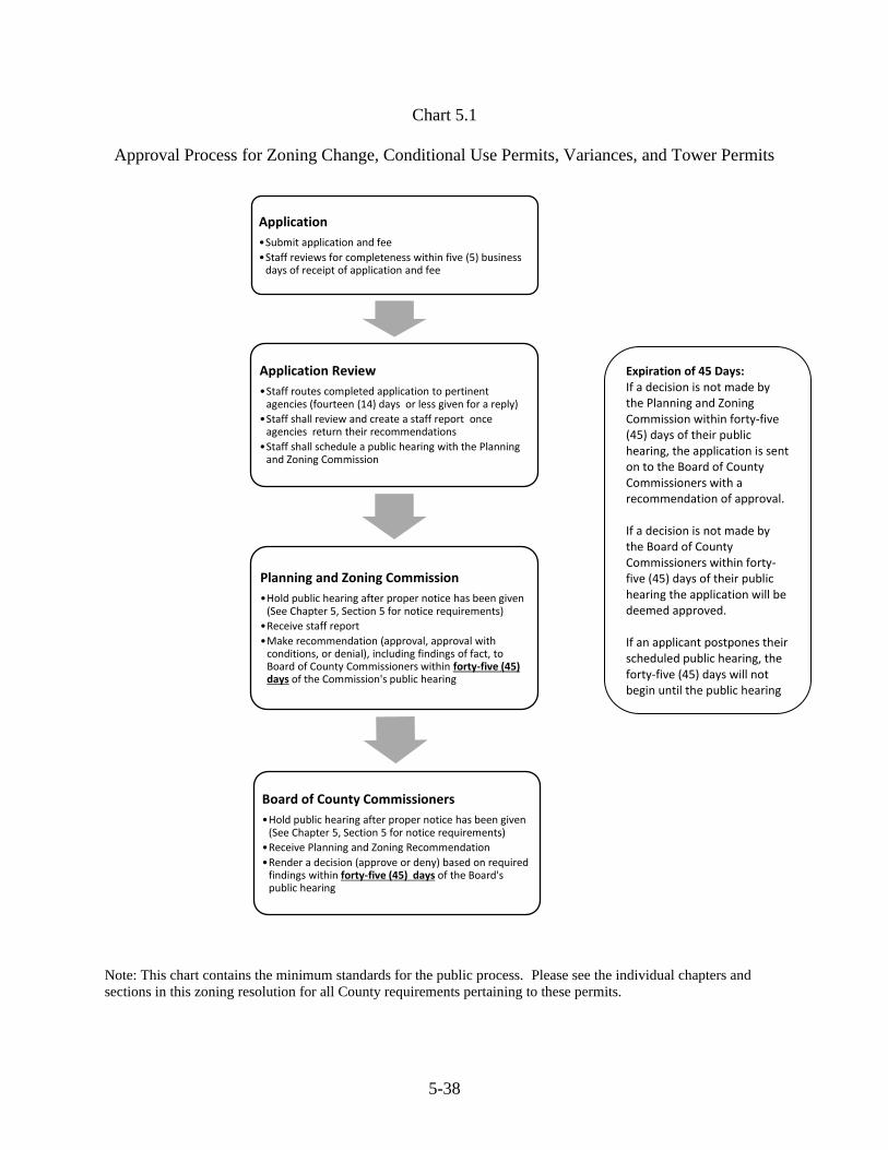
5-38
Chart 5.1
Approval Process for Zoning Change, Conditional Use Permits, Variances, and Tower Permits
Note: This chart contains the minimum standards for the public process. Please see the individual chapters and
sections in this zoning resolution for all County requirements pertaining to these permits.
Application
•Submit application and fee
•Staff reviews for completeness within five (5) business days of receipt of application and fee
Application Review
•Staff routes completed application to pertinent agencies (fourteen (14) days or less given for a reply)
•Staff shall review and create a staff report once agencies return their recommendations
•Staff shall schedule a public hearing with the Planning and Zoning Commission
Planning and Zoning Commission
•Hold public hearing after proper notice has been given (See Chapter 5, Section 5 for notice requirements)
•Receive staff report
•Make recommendation (approval, approval with conditions, or denial), including findings of fact, to Board of County Commissioners within forty-five (45) days of the Commission's public hearing
Board of County Commissioners
•Hold public hearing after proper notice has been given (See Chapter 5, Section 5 for notice requirements)
•Receive Planning and Zoning Recommendation
•Render a decision (approve or deny) based on required findings within forty-five (45) days of the Board's public hearing
Expiration of 45 Days: If a decision is not made by the Planning and Zoning Commission within forty-five (45) days of their public hearing, the application is sent on to the Board of County Commissioners with a recommendation of approval. If a decision is not made by the Board of County Commissioners within forty-five (45) days of their public hearing the application will be deemed approved. If an applicant postpones their scheduled public hearing, the forty-five (45) days will not begin until the public hearing is held.
6-1
Chapter 6. Development Standards
Section 1. Landscape Requirements.
A. Purpose: The purposes of these regulations are to provide for the enhancement of the
County image, buffer between incompatible land uses by reducing excessive noise, air,
water, and visual pollution; preserve the integrity of residential neighborhoods; and to
provide for the general health, safety, and welfare of the public by means of landscaping
during community development.
B. Relationship to Other Regulations and Laws: If other municipal, county, state and
federal laws and regulations or subsequent Albany County Resolutions place more
restrictive standards pursuant to landscaping, the most restrictive standards under the
appropriate jurisdiction will apply.
C. Affected Land Uses:
1. This section shall apply to all unincorporated areas within Albany County which
are zoned Industrial or Commercial.
2. The requirements shall not apply to any completed applications filed with the
Albany County Planning Office prior to the effective date of this resolution.
3. Existing Commercial and Industrial zoned properties shall not be subject to
compliance with these regulations, unless the gross floor space of structures upon
the property is increased by twenty-five percent (25%) or more within a period of
five years (5) or less or the property size (land area) is expanded.
4. In the event that these regulations create an unnecessary hardship due to water or
soil quality, exceptions to these regulations may be made on a case by case basis
under the direction of the Planning and Zoning Commission.
D. Definition of Terms:
1. Berm: An earthen mound designed to screen undesirable views and/or decrease
noise levels.
2. Buffer: Natural or man-made physical elements, such as plants, trees, fences or
walls, which separate and screen land uses from one another.
3. Caliper: A standard for trunk measurement of nursery stock that is measured
from a specified distance above the ground.
4. Coniferous: A plant with foliage that persists and remains green throughout the
year.
5. Deciduous: A plant with foliage that is shed annually.
6-2
6. Gross Floor Space: The sum of all-floor areas of a building used for human
habitation or for business operations.
7. Landscaping: The use of organic and inorganic materials and man-made
structures that present an expansion of natural and buffering scenery.
8. Organic Landscape Materials: Living vegetative material.
9. Shrub: A woody plant that usually remains low, produces shoots or stems from
the base and is not usually tree like or single-stemmed.
E. Process: Before final issuance of a zoning certificate or conditional use permit for
affected properties, show the location, landscaping components, and method of irrigation
or watering of the landscape, which plan shall be submitted to the Albany County
Planning Office for review and approval.
F. Landscape Standards:
1. These landscape standards will be the minimum requirements for compliance.
However, it is encouraged that homeowners and developers seek to exceed these
standards whenever reasonable and financially viable.
2. The following provisions shall be the minimum standards for the composition and
positioning of landscape elements when buffering between specified land uses:
a. Buffering of residential areas from commercial or industrial uses is
required. Buffering may include a fence, wall, trees, shrubs, vegetated
berm, or a combination which provide reasonable screening to a level of
six (6) feet high. If a fence or wall is constructed, it shall be consistent
with the surrounding area and property owners are encouraged to include
organic landscaping materials as well. This requirement may be modified
by the Planning Director, who will consult with Wyoming Department of
Transportation and the Albany County Road and Bridge Department, if
drifting of snow will significantly affect access to neighboring properties.
b. Adjacent to public road right-of-ways, the owner shall place one (1)
coniferous tree for every fifty (50) linear feet along the property's road
frontage within twenty (20) feet of the road right-of-way. Additionally,
there shall be placed four (4) tall shrubs, which shall reach a height of at
least four (4) feet at maturity for every fifty (50) linear feet along the
parcel's road frontage.
c. Two (2) deciduous trees may be substituted for any required coniferous
tree. The minimum caliper of deciduous trees shall be at least one and
one-half (1½) inches and a size of eight (8) feet in height. The minimum
6-3
height for coniferous trees shall be five (5) feet. The minimum size for
shrubs shall be a five-gallon (5) container.
d. Alternate landscaping plans, which may include clustering of organic
landscaping components or substituting more and smaller components,
may be submitted to the Planning Office for consideration as an
alternative plan.
3. A mixture of organic materials is encouraged. It is also encouraged that
landscaping material and design shall be produced with consideration for efficient
and effective water use under conditions of low water levels or drought.
4. Landscaping shall be placed so as not to have an adverse effect on access to
utilities, underground or overhead, or interference with vision at roadway
intersections.
5. Installation and maintenance responsibility of the landscaping shall lie with the
owner or the land-owner's designee. Dead trees or shrubs shall be replaced by
July 1 of every year with plant material, equivalent to type and size when planted.
6. Landscape features shall be kept reasonably free of refuse, noxious weeds,
clippings, and miscellaneous trash. Such weeds, refuse, clippings and
miscellaneous trash shall be disposed of in an appropriate and safe manner.
Noxious weeds are described in Section 11-12-104 of the Wyoming Statutes.
7. Landscaping plans may be referred to other appropriate agencies for their review
and comment. Agencies, for possible referrals, include the U.S. Natural
Resources Conservation Service, Laramie Rivers Conservation District, State
Forestry Office, Wyoming Department of Transportation, Albany County Road
and Bridge, and the Albany County Extension Office.
Section 2. Outdoor Lighting.
A. Definitions:
1. Glare: The sensation produced by light that is sufficiently greater than the light
to which the eyes are adapted to cause annoyance, discomfort, or loss in visual
performance or visibility.
2. Light bulb: The component of the light fixture that produces the actual light. A
bulb includes, without limitation, a lamp or tube.
3. Light fixture: The complete lighting unit.
4. Light pollution: Light that is emitted into the atmosphere that alters the
appearance of the night sky or interferes with astronomical observation.

6-4
5. Light trespass: Light projected onto a property or roadway from a light source
located on a different property.
B. Purpose: The purposes of the outdoor lighting standards are to:
1. Provide adequate lighting for safety and security;
2. Promote efficient and cost effective lighting and to conserve energy;
3. Reduce light pollution, light trespass and glare;
4. Provide a sensitive nighttime environment that includes the ability to view the
stars against a dark sky; and
5. Protect public health, safety and welfare.
C. Scope: Compliance with these requirements shall be required for all new development
and replacement of light fixtures for existing development. The Planning Office shall
encourage the public to utilize light fixtures and shielding consistent with the purposes of
these standards, shall provide educational materials, and engage in other public education
efforts.
D. Prohibitions:
1. Laser source lights or similar high intensity light used for outdoor advertising or
entertainment.
2. Searchlights used for advertising or entertainment.
E. Outdoor Light Sources: Light sources shall be concealed or shielded to the maximum
extent feasible to minimize glare, light pollution, and light trespass on adjacent property
and away from the vision of passing motorists. All lights shall be shielded to direct light
downward.
Light levels measured twenty (20) feet beyond the property line of the parcel where the
light fixture is located shall not exceed one-tenth (1/10) foot-candle as a direct result of
the adjacent property's lighting. This restriction shall only apply if the property upon
which the measurement is taken is used for residential purposes or a public right-of-way.
F. University Observatory Areas: Outdoor light fixtures shall utilize low pressure sodium
lights within three (3) miles radius of the University of Wyoming Observatories at Red
Buttes and Jelm Mountain. Existing non-conforming light fixtures may be continued
until the light fixture is replaced or until September 2, 2010.
G. Exceptions: These outdoor lighting standards shall not apply to the following types of
exterior lighting:
1. Ornamental Lighting: ornamental landscape lighting fixtures;
6-5
2. Government Required Lighting. Lighting for aviation, towers, street lights, or
other purposes which are required by state or federal law;
3. Seasonal lighting displays;
4. Illumination of United States flags as long as the light source is shielded and not
visible from any adjacent property; and
5. Customary agricultural practices, such as calving operations.
H. Variances & Temporary Exemptions:
1. Variance. The Planning Director may grant a variance from these provisions if
the Planning Director finds:
a. There are special circumstances or conditions applying to the land,
buildings, or outdoor light fixtures for which the variance is sought, which
circumstances or conditions are peculiar to such land, buildings, or
outdoor light fixtures and do not apply generally to the land, buildings, or
outdoor light fixtures in the neighborhood; or
b. Upon a finding by the Planning Director that outdoor lighting in specific
areas of the community is not adequate and additional lighting is
necessary to improve safety or security for the property; and
c. The granting of the variance will generally be consistent with the purpose
of this section and will not be injurious to the neighborhood or otherwise
detrimental to the public welfare; and
d. The variance is the minimum variance that provides the relief required.
2. Temporary Lighting Exemption. The Planning Director may grant an exemption
from the requirements for temporary outdoor activities that include without
limitation fairs, carnivals, sporting events, concerts, and promotional activities, if
the Planning Director finds the following:
a. The length of time that the temporary lighting is to be used is no longer
than thirty (30) days;
b. The proposed lighting is designed in such a manner as to minimize light
pollution, light trespass, and glare as much as feasible.
Section 3. Adult Entertainment Standards.
A. Setback: Adult Entertainment Uses shall not be located closer than one (1) mile from
the property boundary of a residential property, school, or daycare.
B. Access: Adult Entertainment Uses shall be located with direct access to a public (federal,
state, or county) road.
6-6
Section 4. Fireworks Stand Standards. Fireworks Stands shall not be located closer than one
(1) mile from the property lines of any residential property.
A. Access: Fireworks Stands shall be located with direct access to a public (federal, state, or
county) road.
B. Fire Suppression: Fireworks Stands shall provide fifteen hundred (1,500) gallons of on-
site water identified and available year-round for fire suppression purposes.
C. Manufacturing: Manufacturing or remanufacturing of fireworks is prohibited.
D. Building Code: Structures used for sale and storage of fireworks shall be constructed in
accordance with the requirements of the International Building Code.
E. Storage: Storage of fireworks shall be in accordance with the requirements of the
International Building Code.
F. Open Flames: Open flames or the detonation of fireworks on the Fireworks Stand site
is prohibited.
Section 5. Non-mineral Mining Standards.
A. Non-mineral mining activity shall not be located closer that one quarter (.25) mile from
the property lines of any residential property.
B. Non-mineral mining activity shall not be located closer than one thousand (1,000) feet
from any permitted water well existing at the time of application.
C. The setback requirements in Section 5, A or B may be lessened with written consent of
the affected property owner.
Section 6. Parking.
A. Development Standards: Development shall conform to the minimum parking
standards set forth below according to the type of development.
1. Offices and financial institutions: one (1) space per three hundred (300) square
feet of floor area; adequate loading area.
2. Churches and funeral homes: one (1) space for every three (3) seats in the main
assembly room.
3. Hotels, motels, or bed and breakfast: one (1) space per living/sleeping unit plus
one (1) space per employee; adequate loading area.
4. Industrial: one (1) space per employee plus one (1) stall for each company-owned
vehicle and visitor; adequate loading area.
5. Retail stores: one (1) space for each four hundred (400) square feet of floor area;
adequate loading area.
6-7
6. Service shop: one (1) space for each two hundred fifty (250) square feet of floor
area.
7. Residential (parking in mobile home parks shall be determined by mobile home
park regulations adopted by the County): two (2) spaces per dwelling unit.
8. Restaurants/Bars: One (1) space per three (3) seats; adequate loading area.
9. Mixed uses: The sum of the parking requirements for the individual uses. If
individual uses are more than three hundred (300) feet apart, uses cannot share
joint parking.
B. Parking Identification: Parking areas shall be clearly identified, have safe access to
public streets or alleys, and be designed with adequate maneuvering room. Each parking
space shall be a minimum of ten (10) feet by twenty (20) feet.
C. Loading/Unloading Zones: Loading and unloading shall not be allowed on county
roads unless prior permission is given by the Board of County Commissioners. The
Board of County Commissioners may require special improvements to the right-of-way
and road use agreements be made. In no event shall traffic be blocked or a safety hazard
created.
D. Loading/Unloading Identification: Loading areas shall be clearly marked to exclude
parking, have safe access to public streets or alleys, and be designed with adequate
maneuvering room to accommodate their anticipated use.
E. Joint Parking: Developments may utilize joint parking or loading areas if the proposed
parking area meets the number of stalls required above. Developments with differing
peak activity periods may utilize joint parking areas with reduction in parking space
requirements based on anticipated maximum parking demand at the peak hour of parking
use.
F. Parking Patterns: Parking spaces accommodating ten (10) or more vehicles shall: have
continuous (as opposed to dead-end) circulation patterns; be dust and mud free (not
necessarily paved) with adequate drainage (a minimum of one (1) percent and a
maximum of five (5) percent); and have a safe access to a public street and be adequately
lighted if intended for night use.
G. Disabled Parking: Proper disabled parking shall be provided per state and federal
standards (Title III, 28 CFR, Part 36).
Section 7: Portable Storage Structures.
A. Portable Storage Structures placed on any property for six (6) months or less shall be
considered temporary and will not require any permitting.
B. Portable Storage Structures placed on any property for more than six (6) months shall be
considered permanent and will be treated as an accessory building requiring a permit,

6-8
except when these structures are intended to be rented for use off-site by a properly
permitted business. In this case, these structures will be considered inventory of the
business.
C. Portable Storage Structures placed on property zoned Commercial or Industrial with the
intent of using for permanent storage on-site for either their business or to be rented for
on-site storage by customers. These structures will be considered accessory buildings
and will require a permit.
D. At the time of application, proposed portable storage structures to be placed permanently
on Commercial or Industrial zoned property shall be allowed up to ten (10) structures per
application and fee.
E. Portable Storage Structures shall not be used as a dwelling unless plans and application
for this use is approved by the County.
7-1
Chapter 7. Administrative Matters
Section 1. Rural Addressing. A rural address shall be assigned by the Planning Office for all
new developments which comply with the Albany County Zoning Resolution and in some cases
may be changed to ensure consistent addressing throughout the county. Addressing will be
assigned under one of the following procedures:
A. In conjunction with the approval of a zoning certificate for a principal building or any
other addressable structure.
B. The County Addressing Coordinator may change the assigned address of a previously
addressed structure in order to bring the address into compliance with the County’s
addressing system.
Section 2. Road Naming and Re-Naming. At the point in time when a second structure or
other development requiring a rural address uses an established/existing driveway for access, the
applicant shall file a Road Name Petition with the Planning Office. The Road Name Petition
must be signed by the applicant and the owner of the property using the existing driveway. The
road name requested within the Road Name Petition shall be substantially different from any
other established public or private road name as determined by the Planning Office.
Upon review and approval of a Road Name Petition by the Addressing Coordinator and the
Addressing Oversight Committee, a rural address shall be assigned to the petition applicant and
the existing addressed development using the former driveway shall be re-addressed to reflect
the naming of the driveway as a private roadway. Denial of a Road Name Petition by the
Planning Office may be appealed to the Planning and Zoning Commission and the Board of
County Commissioners.
Section 3. Process for Road Name and Address Changes. If it is determined by the
Addressing Coordinator and the Addressing Oversight Committee that it is necessary to change a
road name and/or re-address a property in order to be brought into conformance with the
County’s addressing/road naming system, the following steps shall be taken:
A. Property owners affected by an address change and/or a road name change shall be
notified in writing by the Addressing Coordinator within seven (7) business days of any
proposed road name/address change. The effective date of such changes shall be no less
than sixty (60) days following notification provided to the affected property owners.
Any affected property owners shall have the right of appeal to the Planning and Zoning
Commission and subsequently to the Board of County Commissioners. Any appeal shall
cause the proposed changes to road names and/or addresses to be held in abeyance until
such appeals are heard and the results determined.
7-2
B. The County Addressing Coordinator shall notify, in writing, the County Assessor’s
Office, the County Sheriff’s Office, Laramie/Albany County Records and
Communications, Laramie Fire Department, the Albany County Fire Warden/Albany
County Fire District #1, and any other relevant entities two (2) weeks prior to the
effective date of a road name or address change. Re-naming a road and/or re-addressing
a property may be postponed until any issues have been resolved. Periodic reports of
updates made to addressing or road names will be provided to agencies requesting them.
Section 4. Water & Sewage Disposal System Requirements. A water supply method and also
an approved sewage disposal system are required for every residential, commercial, and
industrial development. Appropriation of groundwater is permitted through the Wyoming State
Engineer’s Office. Individual septic systems for less than two thousand (2,000) gallons per day
of domestic effluent are permitted through the Albany County Planning Office under a
delegation agreement from the Wyoming Department of Environmental Quality (DEQ). Larger
systems or systems connected to more than one (1) structure are permitted through DEQ.
Section 5. On-site Inspections. Filing of an application for a zoning certificate or any other
permit in this chapter constitutes permission for County Staff, the Planning and Zoning
Commission and the Board of County Commissioners to conduct inspections of the proposed
development site.
Section 6. Nuisance
A. Intent: These regulations shall promote the health and safety of the county. Protection of
property from negative effects of nuisances and promoting the general welfare of the
county is a priority. These provisions shall not apply to any industrial facility and they
shall not infringe upon the rights afforded farm and ranch operations by the Wyoming
Right to Farm and Ranch Act.
B. Wyoming State Statute References: The state statutes support efforts by counties to
address nuisance situations. Those statutes include, but are not limited to, the following
sections W.S. §18-2-101, §18-2-115, §18-5-201, §31-13-105, §33-19-102, §35-10-101
and §35-10-104.
C. Definitions:
Abandoned or Junked vehicles: Any motor vehicle which cannot be moved under its
own power and cannot be operated lawfully on a public street or highway due to the lack
of an engine, transmission, wheels, tires, or other necessary parts and is not currently
registered and displaying current license or permits, or when such vehicle is totally or
partially suspended above the ground by jack, block or any other device. This section
also includes any travel trailers, motor homes, motorcycles, boats, buses, all terrain
vehicles, and snow machines.
7-3
Junk: Dismantled or wrecked vehicles or parts thereof; old or scrap copper, brass, iron,
steel, and other ferrous materials; rope, rags, batteries, paper, trash, tires, rubber, in-door
furniture, appliances, scrap concrete, pallets, wire, shingles, wood, sheetrock, glass,
plastic, and other debris and waste materials.
Nuisance: Any use or non-use of property, real or personal, which causes material injury
to others or which presents a threat to the health or safety of Albany County citizens or
which is otherwise defined by common law, Wyoming State Statute, or herein.
Screening: The method by which the view from one property to another property is
substantially shielded, concealed or hidden. Screening techniques include solid fences,
walls, hedges, berms, or other features approved by County staff. Covering with a tarp or
like material is not considered adequate screening. Screening shall be maintained so as to
provide the intended purpose, e.g. replacing broken fence boards, plastic slats in chain
link fencing, etc.
Farm or Ranch Operation: The science and art of production of plants and animals
useful to man except those listed under W.S. §23-1-101, including but not limited to, the
preparation of these products for man’s use and their disposal by marketing or otherwise,
and includes horticulture, floriculture, viticulture, silviculture, dairy, livestock, poultry,
bees, and any and all forms of farm and ranch products and farm and ranch production
(W.S. §11-44-102).
D. General:
1. A site, property, tract, lot, building grounds, area, or other property may be
declared a nuisance by the Board of Albany County Commissioners in
conformance with W.S. §18-2-115, if a nuisance exists on the site, property, tract,
lot, building grounds, area, or other property.
2. The following are declared by the Board of Albany County Commissioners to be
nuisances and are subject to enforcement proceedings:
a. failure to keep junk, or abandoned or junked vehicles, in an enclosed
building, in a closed container designed for such purposes, or screened;
b. the outside storage, keeping or maintenance of any inoperable and
unregistered vehicles within Albany County excepting those that are in
conformance with the regulations of a permitted business.
c. the unscreened and or unlicensed accumulation of debris, garbage, waste
recyclables, or other scrap or junk;
d. allowing any discharge into the environment of toxic or noxious materials
in such concentrations as to endanger the public health;
7-4
e. causing or allowing the effluent from any cesspool, septic tank, drain field,
or sewage disposal system to discharge upon the surface of the ground;
f. causing or allowing the contamination of any well, cistern, stream, lake,
groundwater, or other body of water by sewage, waste or other materials
or substances;
g. accumulations of manure from domestic animals and fowl that are
handled, stored, or disposed of in a manner that creates a health hazard;
h. burning garbage, weeds, and other debris in a manner that is dangerous to
the health and safety of the public;
i. accumulations of decayed animals, trash, rubbish, garbage, rotting lumber,
packing material, scrap metal, or any substance in which flies, mosquitoes,
disease carrying insects, rats, or other vermin can breed, live, nest or seek
shelter; (dead animals shall be dealt with in the manner prescribed in
W.S. § 35-10-104).
j. any chemical and/or biological material that is stored, used, or disposed of
in such quantity or manner that creates a public health hazard;
k. any condition or situation which renders a structure or any part thereof
unsanitary, unhealthy or unfit for human habitation, occupancy or use, or
renders any property unsanitary or unhealthy;
l. failure to comply with any law or rule regarding sanitation and health
including but not limited to:
a. water supplies, including wells and surface waters,
b. waste disposal,
c. storage of chemical pesticides or herbicides,
3. Violations of the foregoing provisions may be enforced through any method
authorized for enforcement of the Albany County Zoning Resolution, through the
provisions of W.S. § 18-2-115 through injunction, mandamus, or other form of
judicial action and any other applicable method under law including but not
limited to criminal citations. The selection of one remedy for enforcement shall
not prohibit the implementation of any other remedies available under law. All
remedies available may be used individually or cumulatively.
4. This Section shall apply to all unincorporated properties in Albany County other
than on State and Federal lands.
7-5
E. Exemptions:
1. This regulation shall not be construed to impair or modify any rights afforded to
farm or ranch operations pursuant to the Wyoming Right to Farm and Ranch Act.
A farm or ranch operation shall not be found to be a public or private nuisance by
reason of that operation if that farm or ranch operation:
a. Conforms to generally accepted agricultural management practices; and
b. Existed before a change in the land use adjacent to the farm or ranch land
and the farm or ranch operation would not have been a nuisance before the
change in land use or occupancy occurred, as per W.S. §11-44-101 to
W.S. §11-44-103.
2. Retention of farm products, supplies, equipment, and reusable materials at a
working farm or ranch shall not be considered a public nuisance as long as such
items and materials are kept in such a manner that would not constitute a threat to
public health and safety.
3. Buildings upon farm or ranch land that have historical or ancestral significance to
the owner of said farm or ranch land.
4. Buildings, sheds, and other enclosures upon farm or ranch land that are utilized
for agricultural operations.
5. Firewood that has been stored upon property.
6. Antique or historic motor vehicles as defined by W.S. §31-1-101(a) (xv) (A).
7. Compost piles.
8. Antique farm and ranch implements used as decoration in landscaping.