Embed Size (px)
Citation preview

Alluvial Fills Near Gallup, New Mexico
GEOLOGICAL SURVEY WATER-SUPPLY PAPER 1110-A
Alluvial Fills Near Gallup, New MexicoBy LUNA B. LEOPOLD and C. T. SNYDER
CONTRIBUTIONS TO HYDROLOGY, 1948-51
GEOLOGICAL SURVEY WATER-SUPPLY PAPER 1110-A
A study of erosion and deposition in late Pleistocene and Recent time
UNITED STATES GOVERNMENT PRINTING OFFICE, WASHINGTON : 1951

UNITED STATES DEPARTMENT OF THE INTERIOR
Oscar L. Chapman, Secretary
GEOLOGICAL SURVEY
W. E. Wrather, Director
For sale by the Superintendent of Documents, U. S. Government Printing Office Washington 25, D. C. - Price 15 cents
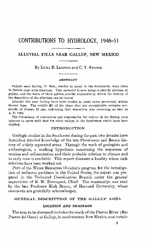
CONTENTS
PageAbstract __________________________________________________________ 1Introduction. _________ ____________________________________________ 1General description of the Gallup area_ ______________________________ 1
Location and drainage_________________________________________ 1Geologic history.__-_-____.-_____---_-___________-.____-___-___. 3
Stratigraphy of the alluvium._______________________________________ 3Gamerco formation ________________ ____________________________ 6Nakaibito formation____________________________________________ 9
General features at type locality___ ________________ _________ 9Differentiation within the formation _________________________ 11
Post-Nakaibito erosion and channeling, _ ____---____-._______--___ 12Conclusions: Correlation and interpretation.__________________________ 15References cited-________--__----__________________---____-__--.-___ 17Index._____________________________________________________ _____ 19
ILLUSTRATIONS
Page
FIGURE 1. Map showing location of Gallup area, N. Mex______________ 22. Puerco River channel east of Gallup, showing progress of
erosion.______________________________________________ 53. Caliche-veined Gamerco formation overlain by Nakaibito
formation in Puerco River channel____________ ___________ 64 Gamerco formation overlain by Nakaibito formation in arroyo
tributary to Puerco River _ ____________________________ 75. Contact betwaen Mesaverde formation and Gamerco forma
tion in Mexican Springs Wash, north of Gallup ___________ 86. Sketch map and cross section on Mexican Springs Wash______ 107. Stratigraphic relations of alluvial fills in area near Gallup____ 128. Filled channel, cut in Nakaibito formation, on Puerco River. _ 13
in

CONTRIBUTIONS TO HYDROLOGY, 1948-51
ALLUVIAL FILLS NEAR GALLUP, NEW MEXICO
By LUNA B. LEOPOLD and C. T. SNYDER
ABSTRACT
Valleys near Gallup, N. Mex., similar to many in the Southwest, were filled In Recent time with alluvium. This material is now being eroded by systems of gullies, and the walls of these gullies provide exposures by which the history of the deposition of the alluvium can be traced.
Alluvial fills near Gallup have been eroded at least twice previously within Recent time. The middle fill of the three that are recognizable contains pot sherds of Pueblo II age, indicating that deposition was occurring as late as A. D. 1200.
The chronology of alluviation and degradation for valleys in the Gallup area appears to agree with that for other valleys in the Southwest which have been studied.
INTRODUCTION
Geologic studies in the Southwest during the past two decades have furnished detailed knowledge of the late Pleistocene and Recent his tory of widely separated areas. Through the work of geologists and archeologists, a working hypothesis concerning the sequences of erosion and sedimentation and their probable relation to climate and to early man is available. This report discusses a locality where such relations have been worked out.
Part of the Water Resources Division's program for the investiga tion of sediment problems in the United States, the report was pre pared in the Technical Coordination Branch under the general supervision of R. W. Davenport, Chief. The manuscript was read by the late Professor Kirk Bryan, of Harvard University, whose comments are gratefully acknowledged.
GENERAL DESCRIPTION OF THE GALLUP AREA
LOCATION AND DRAINAGE
The area to be discussed includes the reach of the Puerco River (Rio Puerco del Oeste) at Gallup, in northwestern New Mexico, and certain
1

CONTRIBUTIONS TO HYDROLOGY,, 1948-51
ephemeral streams tributary to the Chaco River that drain the south end of the Chuska Mountains (fig. 1). These ephemeral streams are within the Mexican Springs Experiment Station, formerly under the jurisdiction of the U. S. Soil Conservation Service and now under the Bureau of Indian Affairs. The station is 18 miles north of Gallup on U. S. Highway 666.
Mexican Springs ' ES3'
Gallup
A -R I Z 0 N A / / N E \N
Chaco Canyon National Monument
\
Hoi brook...
'K-
iEXPLANATION
Areas discussed in this report
\
50 Miles
FIGURE 1. Map showing the location of the Gallup area, N. Mex.
The Puerco River rises in the Jurassic and Cretaceous sandstones and shales between the south face of the Dalton Plateau and the north edge of the Zuni Mountains; it flows westward through the town of Gallup toward the Little Colorado River. The streams in the Mexican Springs area head in the Eocene (?) Chuska sandstone and Tohatchi shale and flow eastward over extensive areas underlain by the Upper Cretaceous Mesaverde formation to join the Chaco River, a tributary of the San Juan.
ALLUVIAL FILLS NEAR GALLUP, NEW MEXICO 3
GEOLOGIC HISTORY
The late Tertiary and early Quaternary history of the area has been discussed by Reiche (1941). He mapped a series of eight graded erosion surfaces, generally gravel-capped, representing periods of temporary stability during the lowering of the local base level of Mexican Springs Wash and its predecessors. The erosion surfaces formed during these temporary halts are at successively lower alti tudes and are considered by Reiche to be stages during the Canyon erosion cycle (Pleistocene) as defined at the Grand Canyon (Fenne- man, 1931).
The Canyon erosion cycle was followed by the alluviation of the canyons. This process, which began while glaciers presumably still existed in the southern Rocky Mountains, was interrupted several times by erosion. The details of these alternating periods of erosion and deposition are the subject of the present discussion. Reiche, how ever, did not attempt to study these relatively recent episodes. He merely observes (1941, p. 56) : "The alluvium in the valley bottoms is a recent flood plain deposit with a thickness * * * in excess of thirty feet. It consists of silty clays and abundant if not pre dominant sandy members." He mentions, also, that "no single episode in the Quaternary history of the Mexican Springs district seems so characterized by wind action as the period between the No. 1 and No. 2 valley fills [Jeddito and Tsegi formations] described by Hack [1939; but see also 1942] for the Jeddito [Jadito] Valley, 90 miles to the west."
During the past century the present arroyos have cut into the allu vium and have exposed evidences of the previous periods of cutting and deposition on the gully walls, not only in the area described by Reiche, but also along the Puerco River near Gallup.
STRATIGRAPHY OF THE ALLUVIUM
The alluvium that fills the original valleys cut in the relatively soft shale and sandstone bedrock varies greatly in depth. At a point just above Gallup, the original valley of the Puerco River was cut to a level only 20 feet lower than the top of the alluvium, but borings at the new overpass on U. S. Highway 66, nine miles west of Gallup, have shown that bedrock lies 95 feet below the top of the alluvium at that locality.
This valley fill consists of bodies of alluvium separated by marked disconformities. The older alluvial fill is here called the Gamerco formation; it rests unconformably on bedrock and consists of sand and silt grading rapidly downward to gravel. On the eroded surface
4 CONTRIBUTIONS TO HYDROLOGY, 1948-51
of the Gamerco a distinct soil profile characterized by a zone of heavy caliche accumulation (B horizon) was observed. Just east of Gallup this surface lies about 15 feet below the top of the later alluvium.
After a period of strong erosion, a body of water-laid sand and silt containing lenses of fine gravel, here called the Nakaibito formation, was deposited on the eroded surface of the Gamerco. Potsherds of Pueblo I and Pueblo II types are found in this alluvium, which filled the Puerco River valley to the level of its present floor. A period of moderate to weak erosion followed, and in some localities long chan nels about 150 feet wide were cut. Ordinarily these channels were about 9 feet deep, but in places they reached a depth of 18 feet. They were probably discontinuous in many places but were nevertheless of appreciable size, and in them a third fill was deposited. In other localities examined, no erosion of consequence followed the deposition of the Nakaibito until, in modern times, the present arroyos were formed. Dune formation is now in progress, although most of the dunes are stabilized by vegetation.
Bryan (1925) showed that the year 1885 marked the general begin ning of arroyo cutting in the Southwest, but he indicated that in northern Arizona and southern Colorado the date is apparently earlier, perhaps soon after I860. This agrees in general with the notes of Beale (1858), who in 1857 observed that the Rio "Puaco" (Puerco), 2 days' journey by wagon west of Navajo Church near Gallup, was a "deep gulley." However, where the Puerco joins the Little Colorado, Beale found large cottonwoods in the river bottom which would indi cate no appreciable erosion at that place even though he had just cut down the banks of two arroyos "to admit passage of our wagons."
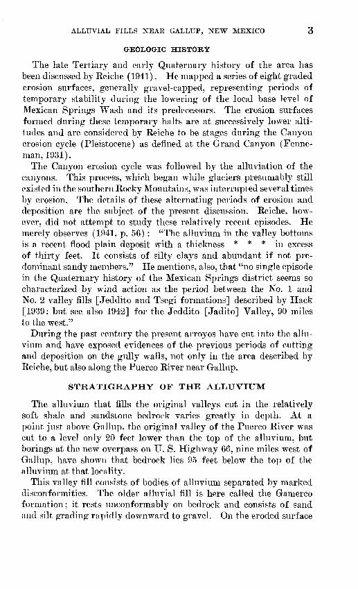
The modern arroyo, like many in the Southwest, probably began as a series of short discontinuous gullies. Figure 2 shows that the Puerco River above Gallup was about 6 feet deep in 1901 and suggests that a greater part of the erosion forming the present arroyo occurred in the period 1901-46 than in the 40 years prior to 1901.
ALLUVIAL FILLS NEAR GALLUP, NEW MEXICO
FIGURE 2. The Puerco River channel 2 miles east of Gallup, N. Mex., showing the progress of erosion in 45 years. The upper photograph was taken by N. H. Darton (USGS file no. 874) in 1901; the lower by L. B. Leopold in August 1946. The gully in 1901 was about 6 feet deep ; in 1946 it was 20 feet deep, and its walls were nearly vertical. Note that the road cut (A) in the 1901 view was filled with soil material when the railroad grade was moved; the old road now appears as light-colored fill (A) exposed in the gully wall just left of the center of the lower picture. The large rocks near which the man is standing in the lower photograph appear in the lower left of the upper photograph, showing the increase in the width of the gully.
947836 51-

6 CONTRIBUTIONS TO HYDROLOGY, 1948-51
GAMERCO FORMATION
The Gamerco formation (fig. 3) receives its name from a suburb of Gallup. At the type locality near the outskirts of the town, 300 yards east of the El Rancho Hotel, the Gamerco crops out in the gully wall of the Puerco River. It appears near the bed of the present stream as an eroded remnant of fossil soil, the complete profile of
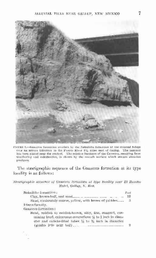
FIGURE 3. Caliche-veined Gamerco formation (A) overlain by sand and silt of the Nakaibito formation (B) in the Puerco River channel half a mile east of Gallup, N. Mex. The filled channel eroded in tlie Nakaibito appears at the top (C). Note the caliche veins protruding from the softer, stream-smoothed silt of the Gamerco formation.
which can be seen in only a few places. The formation occurs, also, in the arroyo tributary to the Puerco River where that tributary is bridged, iy2 miles east of Gallup, by the railroad and by Highway 66 (fig. 4). It is exposed in the walls of Mexican Springs Wash 18 miles north of Gallup and 4,000 feet west of Highway 666, which crosses ihe wash on a bridge, and it crops out in Deer Springs Wash, Black Creek Wash, and Chuska Wash, all in the general vicinity of Mexican Springs.
ALLUVIAL FILLS NEAR GALLTJP, NEW MEXICO
i
FIGURE 4. Gamerco formation overlain by the Nakaibito formation at the railroad bridge over an arroyo tributary to the Puerco River 1% miles east of Gallup. The hammer has been placed near the contact. The relative hardness of the Gamerco, resulting from weathering and calcification, is shown by the smooth surface which stream abrasion produces.
The stratigrapllic sequence of the Gamerco formation at its type locality is as follows:
Stratigraphic sequence of Gamerco formation at type locality near El RancJioHotel, Gallup, N. Hex.
Nakaibito formation: Feet Clay, brown-buff, and sand___________ _ _ _ 12 S'and, moderately coarse, yellow, with lenses of pebbles 3
Disconformity. Gamerco formation:
Sand, reddish to reddish-brown, silty, fine, compact, con taining hard, calcareous concretions % to 1 inch in diam eter and caliche-filled tubes % to % inch in diameter (grades into next bed)_ 2

8 CONTRIBUTIONS TO HYDROLOGY, 1948-51
Ptratiffrap/lie sequence of Oamcrco formation at type locality near El Runcho Hotel, Gallup, N. Hex. Continued
Gaiuerco formation Continued Feet Sand, brown, compact, silty, fine, with white mottling of
caliche. S'mall veins of caliche extend downward nearly to base of section : top 12 inches is particularly hard and forms cliffs ; whole compact layer is fluted and abraded by flow of present stream. Nodules and veins of caliche stand out in relief from water-worn surfaces (fig. 3)__ 4
Gravel, fine, partly cemented with caliche, containing sub- rounded pebbles of different types of rocks characterizing area; many pebbles covered with strong layer of caliche (fig. 5)_-_____________ ___ ____ 1-2
Disconformity.Bedrock: Shale and sandstone of Gibson coal member of Mesa-
verde formation (Upper Cretaceous), comprising floor of pres ent stream channel at this point.
FIGURE 5. Contact between the Mesaverde formation (Upper Cretaceous) below and the Gamerco formation above in Mexican Springs Wash, 4,000 feet upstream from Highway 666 and 18 miles north of Gallup, N. ilex. This is a good exposure of the Gamerco in that it shows the caliche-coated basal gravel overlain by the compact, cliff-forming 7> horizon of the fossil soil. The compactness results from the high content of caliche cementing the grains. The A horizon of the fossil soil is missing. The slopes above the vertical wall are composed of material of the Nakaibito formation, whose surface is hummocky with small stabilized dunes.
ALLUVIAL FILLS NEAR GALLUP, NEW MEXICO 9
The calichified horizon containing concretions is considered to be the B horizon of a fossil soil. The material of this layer, when ob served under a lens, is seen to be perforated with large numbers of minute, irregular holes and tubes, mostly lined with calcite, aragonite, or amorphous caliche. These minute tubes appear to have been formed by the decomposition of enclosed rootlets. No bones nor artifacts have yet been found in this formation.
Practically every exposure of the Gamerco formation occurs where bedrock, the Mesaverde formation, crops out in the gully channel. It appears that the few remnants of the Gamerco are preserved only where the bedrock locally prevented further deepening of the channel or inhibited complete erosion by lateral corrasion.
NAKAIBITO FOEMATION
GENERAL, FEATURES AT TYPE LOCALITY
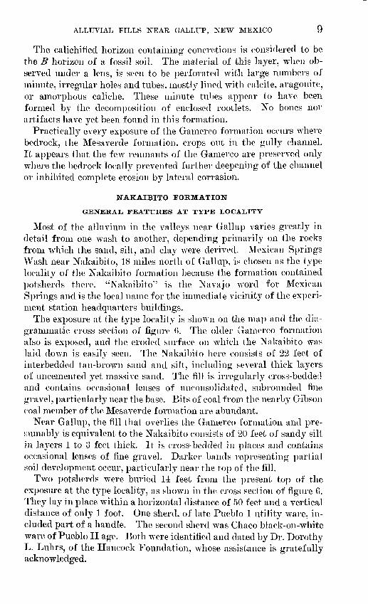
Most of the alluvium in the valleys near Gallup varies greatly in detail from one wash to another, depending primarily on the rocks from which the sand, silt, and clay were derived. Mexican Springs Wash near Nakaibito, 18 miles north of Gallup, is chosen as the type locality of the Nakaibito formation because the formation contained potsherds there. "Nakaibito"" is the Navajo word for Mexican Springs and is the local name for the immediate vicinity of the experi ment station headquarters buildings.
The exposure at the type locality is shown on the map and the dia grammatic cross section of figure f>. The older Gamerco formation also is exposed, and the eroded surface on which the Nakaibito was laid down is easily seen. The Nakaibito here consists of 22 feet of interbedded tan-brown sand and silt, including several thick layers of imcemented yet massive sand. The fill is irregularly cross-bedded and contains occasional lenses of unconsolidated, subrounded fine gravel, particularly near the base. Bits of coal from the nearby Gibson coal member of the Mesaverde formation are abundant.
Near Gallup, the fill that overlies the Gamerco formation and pre- wumably is equivalent to the Nakaibito consists of 20 feet of sandy silt in layers 1 to 3 feet thick. It is cross-bedded in places and contains occasional lenses of fine gravel. Darker bands representing partial soil development occur, particularly near the top of the fill.
Two potsherds were buried 14 feet from the present top of the exposure at the type locality, as shown in the cross section of figure 6. They lay in place within a horizontal distance of 50 feet and a vertical distance of only 1 foot. One sherd, of late Pueblo I utility ware, in cluded part of a handle. The second sherd was Chaco black-on-white ware of Pueblo II age. Both were identified and dated by Dr. Dorothy L. Luhrs, of the Hancock Foundation, whose assistance is gratefully acknowledged.
10 CONTRIBUTIONS TO HYDROLOGY, 1948-51
From plone-toble mop by Luna B. Leopold, October 10, 1949
EXPLANATION
Dunes and wind-worked colluvium
Gamerco formation sand and gravel
Mesoverde formation bedrock
FIGURE 6. Sketch map and cross section on Mexican Springs Wash, 18 mi'es north of Gallup, N. Mex., and 4,000 feet upstream from the bridge on Highway 666.
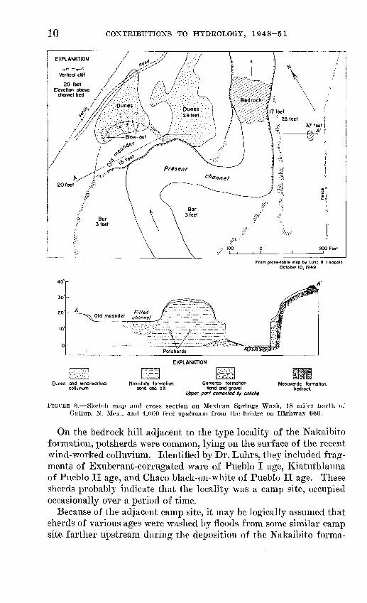
On the bedrock hill adjacent to the type locality of the Nakaibito formation, potsherds were common, lying on the surface of the recent wind-worked colluvium. Identified by Dr. Luhrs, they included frag ments of Exuberant-corrugated ware of Pueblo I age, Kiatuthlanna of Pueblo II age, and Chaco black-on-white of Pueblo II age. These sherds probably indicate that the locality was a camp site, occupied occasionally over a period of time.
Because of the adjacent camp site, it may be logically assumed that sherds of various ages were washed by floods from some similar camp site farther upstream during the deposition of the Nakaibito forma-
ALLUVIAL FILLS NEAR GALLTJP, NEW MEXICO 11
tion. The sherds in place in the fill indicate that alluviation was in progress at the type locality during or after Pueblo II time, or A. D. 900-1100.
DIFFERENTIATION WITHIN THE FORMATION
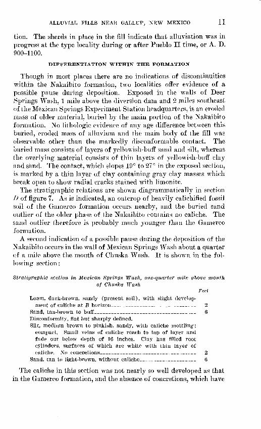
Though in most places there are no indications of discontinuities within the Nakaibito formation, two localities offer evidence of a possible pause during deposition. Exposed in the walls of Deer Springs Wash, 1 mile above the diversion dam and 2 miles southeast of the Mexican Springs Experiment Station headquarters, is an eroded mass of older material, buried by the main portion of the Nakaibito formation. No lithologic evidence of any age difference between this buried, eroded mass of alluvium and the main body of the fill was observable other than the markedly disconformable contact. The buried mass consists of layers of yellowish-buff sand and silt, whereas the overlying material consists of thin layers of yellowish-buff clay and sand. The contact, which slopes 19° to 27° in the exposed section, is marked by a thin layer of clay containing gray clay masses which break open to show radial cracks stained with limonite.
The stratigraphic relations are shown diagrammatically in section D of figure 7. As is indicated, an outcrop of heavily calichified fossil soil of the Gamerco formation occurs nearby, and the buried sand outlier of the older phase of the Nakaibito contains no caliche. The sand outlier therefore is probably much younger than the Gamerco formation.
A second indication of a possible pause during the deposition of the Nakaibito occurs in the wall of Mexican Springs Wash about a quarter of a mile above the mouth of Chuska Wash. It is shown in the fol lowing section:
Stratigraphic section in Mexican Springs Wash, one-quarter mile above mouthof Chuska Wash
FeetLoam, dark-brown, sandy (present soil), with slight develop
ment of caliche at B horizon____________________ 2Sand, tan-brown to buff_______________________ 6Disconformity, flat but sharply defined.Silt, medium brown to pinkish, sandy, with caliche mottling;
compact. Small veins of caliche reach to top of layer and fade out below depth of 16 inches. Clay has filled root cylinders, surfaces of which are white with thin layer of caliche. No concretions______________________ 2
Sand, tan to light-brown, without caliche_____________ 6
The caliche in this section was not nearly so well developed as that in the Gamerco formation, and the absence of concretions, which have
12 CONTRIBUTIONS TO HYDROLOGY, 1948-51
BLACK CREEK PUERCO RIVER
PUERCO RIVER DEER SPRINGS WASH
Horizontal scale50 Feet
Vertical scale
EXPLANATION
Modern colluvium
Channel deposits
Nakaibito formationsand and silt
Upper part is younger phase
Upper part cemented by caliche
Mesaverde formation bedrock
FIGURE 7. Stratigraphic relations of alluvial fills in the area near Gallup, N. Mex.
been found in every outcrop of the Gamerco, definitely shows that the alluvium just described is younger than the Gamerco. The mod erately well developed soil at the present ground surface of this section indicates greater stability of the upper surface here than over the wide areas of the Nakaibito occurring at lower altitudes, where soil development at the present surface is mostly absent.
The foregoing evidence indicates that the Nakaibito formation has two phases, the older of which is separated by erosion from the younger. This division, as will be shown, also is characteristic of Hack's (1942) Tsegi formation in the Hopi area and Albritton and JBryan's (1939) Calamity formation in trans-Pecos Texas.
POST-NAKAIBITO EEOSION AND CHANNELING
Channels of moderate size were cut and wholly or partly filled after the deposition of the Nakaibito formation was essentially com plete. In the 2-mile reach upstream from Gallup, a filled channel
ALLUVIAL FILLS NEAR GALLTJP, NEW MEXICO 13
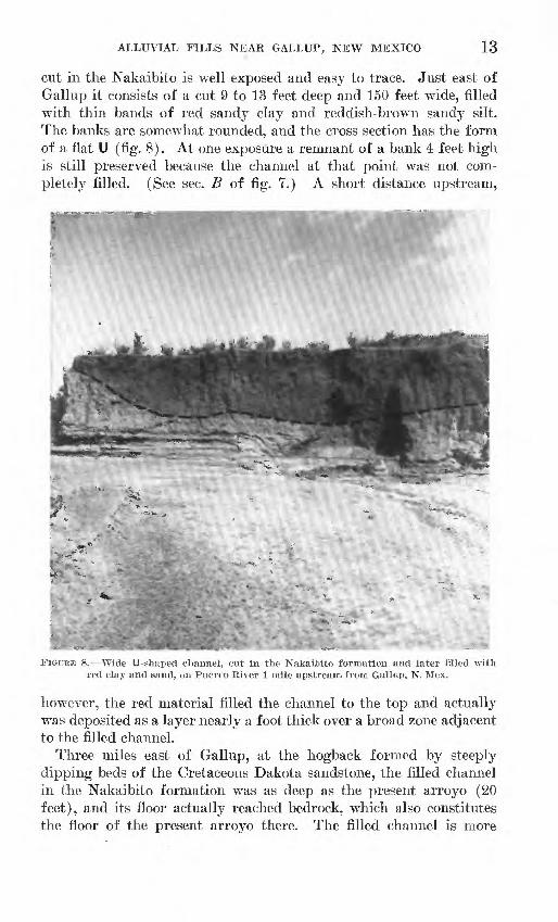
cut in the Nakaibito is well exposed and easy to trace. Just east of Gallup it consists of a cut 9 to 13 feet deep and 150 feet wide, filled with thin bands of red sandy clay and reddish-brown sandy silt. The banks are somewhat rounded, and the cross section has the form of a flat U (fig. 8). At one exposure a remnant of a bank 4 feet high is still preserved because the channel at that point was not com pletely filled. (See sec. B of fig. 7.) A short distance upstream,
FIGURE 8. Wide U-shaped channel, cut in the Nakaibito formation and later filled with red clay and sand, on Puerco River 1 mile upstream, from Gallup, N. Mex.
however, the red material filled the channel to the top and actually was deposited as a layer nearly a foot thick over a broad zone adjacent to the filled channel.
Three miles east of Gallup, at the hogback formed by steeply dipping beds of the Cretaceous Dakota sandstone, the filled channel in the Nakaibito formation was as deep as the present arroyo (20 feet), and its floor actually reached bedrock, which also constitutes the floor of the present arroyo there. The filled channel is more

14 CONTRIBUTIONS TO HYDROLOGY, 1948-51%
than 120 feet wide at this point, and its sides slope 60°. The lowest 10 feet is filled with thick layers of coarse reddish sand and a few thin layers of red silt. The upper 10 feet consists of thinly iiiterbedded red clay and lenses of reddish sand. (See sec. C of fig. 7.) The difference in color between the filled channel and the adjacent older alluvium is striking.
Upstream from the hogback, a large part of the alluvium is red and the buried channel was not traced in detail. Downstream from Gallup, the Puerco River channel becomes very shallow and its banks are no more than 4 feet in height. No evidence of fill channeling was observed. The fact that the main body of the fill loses its redness downstream indicates that tan alluvium from the lower tributaries masked the red material contributed by headwater tributaries. The old channel extended upstream in a continuous gully far enough to tap the predominantly red material with which it was filled. The disappearance of the red color downstream was not due to gradual shallowing of the buried channel, at least in the reach where exposures are found, although possibly this channel was discontinuous and shallowed downstream below the reach where its outcrops could be mapped.
At the type locality of the Nakaibito on Mexican Springs Wash, a filled channel, the bottom of which is only 3 feet above the present arroyo floor, is exposed. The top of the filled channel occurs at the level of an old meander scar, as can be seen in figure 6. Nu merous small tributaries in the vicinity were graded to the level of this well-preserved scar, 13 feet above the present channel. The buried channel seems to have been cut after the meander scar was de veloped and subsequently to have been filled to that same level. The contemporaneity of the filled channel and the meander must be con sidered tentative, however, because present-day wind action and rain wash have disturbed the surface material of the meander, somewhat obscuring the relations with the exposed filled channel.
Recent dunes have formed on the old meander, active blow-outs have reworked the surface layers, and the wind has drifted sand from the meander against the adjacent slopes. The dunes are mostly stabilized by rabbitbrush, saltbush, grass, and weeds.
Along Black Creek, near the south boundary of the Mexican Springs Experiment Station, channeling of the Nakaibito formation similar to that in Mexican Springs Wash is observed. A diagrammatic cross section of one of these buried channels is shown in section A of figure 7. Their depth is nearly as great as that of the present arroyo (17 feet). On Black Creek Wash the channels later were partly filled, and the present-day gully has left that surface as a well-marked ter race 12 feet above the present stream bed. The older fill is more high-
ALLUVIAL FILLS NEAR GALLUP, NEW MEXICO 15
ly consolidated than the younger and is lithologically distinct; the terrace was observed near the bridge where Black Creek crosses U. S. Highway 666 and intermittently upstream for at least a mile. This depositional terrace is similar to that seen on Mexican Springs Wash at the type locality of the Nakaibito formation and at nearly the same height above the stream bed.
CONCLUSIONS: CORRELATION AND INTERPRETATION
Though no bones nor artifacts were found in the Gamerco forma tion, the well-developed caliche layer, the nodules and caliche-filled tubes, and the stratigraphic position of the formation appear to make it comparable to the "intermediate alluvium" of Bryan and McCann (1943) at Grants, which is only 60 miles away. The authors have in spected some of the exposures at Grants described by Bryan and Mc Cann as contemporaneous with the Neville formation of the trans- Pecos region (Albritton and Bryan, 1939) and have found that the caliche-cemented gravels of the Neville seem to resemble those at the base of the Gamerco.
Only two potsherds were found in place in the Nakaibito formation. One was of Pueblo I and the other of Pueblo II age. This paucity of datable material makes any correlation tentative, but the fact that the sherds occur in the lower half of the upper part of the Nakaibito near Mexican Springs would indicate that alluviation was continu ing as late as A. D. 1200. Inasmuch as the Nakaibito rests on the eroded surface of a fill apparently comparable to Bryan and Mc- Cann's "intermediate alluvium" and the Neville formation, the Nakaibito seems to fit into the deposition 2 position of the Bryan-Mc- Cann chronology, making it comparable with the Tsegi of Hack (1942), the Calamity formation of the trans-Pecos region, and the Sand Canyon formation of Judson (1948).
The sparse yet unavoidable indications of a period of stability or erosion during the deposition of the Nakaibito formation are evidence, comparable to that found elsewhere, that deposition 2 consisted of a lower and an upper portion (Hack, 1942; Bryan and McCann, 1943). It would appear, then, that the older fill occurring as an outlier in the Nakaibito of Deer Springs Arroyo and the calichified lower part of the fill in upper Mexican Springs Wash correspond to the earlier por tion of deposition 2. It therefore seems probable that the main body of the Nakaibito formation which makes up most of the alluvium ex posed in the washes of the Gallup area is comparable in age to the up per portion of deposition 2. The present data add to the increasing volume of evidence indicating that the erosional break during deposi tion 2 was of considerable significance (Judson, 1948).
16 CONTRIBUTIONS TO HYDROLOGY, 1948-51
The period of channel erosion in the Nakaibito formation seems to correspond to the erosion period following the Tsegi formation of the Hopi country and that following the Calamity formation of the trans-Pecos region. Bryan and McCann (1943) tentatively assume that this period of erosion was more or less contemporaneous through out the localities in the Southwest that have been studied. On the basis of the tentative chronology for the Southwest, deposition 3 is be lieved to have begun about A. D. 1300; it was probably still continuing when present-day arroyo cutting began in the last quarter of the nineteenth century.
Deposition 3 is represented in the Hopi country by the Naha forma tion described by Hack (1942), in the trans-Pecos region by the Kokernot formation of Albritton and Bryan (1939), and at the west ern edge of the High Plains by the Wheatland formation of Judson (1948). The Naha formation represented a considerable volume of material but did not fill to the top the channel that was cut after deposition 2 (the Tsegi formation) was completed. In the trans- Pecos region, deposition 3 not only filled completely the channels cut in the earlier alluvium but covered the whole width of the valley with a thin sheet of alluvial material.
The Wheatland formation of Judson (1948) was a deposit that did not completely fill the channels in which it was laid down. In the Grants area, Bryan and McCann (1943) found deposition 3 to be small in amount of material compared with their deposition 2. These relative volumes are approximately those found in the Gallup region. The channels cut in the Nakaibito formation varied from 10 to 18 feet in depth near Gallup, and at that place the later fill was just sufficient in volume to fill the arroyo approximately to its former level.
In the Mexican Springs area, the erosion that followed deposition 2 cut a channel 19 feet deep. This channel was then filled about half way to the top (fig. 6). In Deer Springs Wash an indistinct ter race about 3 feet in height can be traced for a considerable distance. It is possible that this terrace marks the depth of cutting during the period between the end of the Nakaibito deposition and the initiation of the present-day arroyos. In Black Creek Wash, only a couple of miles away, the post-Nakaibito erosion cut a channel 17 feet deep, and deposition 3 refilled that channel to a level within 5 feet of the old valley floor.
These observations indicate that the relative sizes of channels cut in the erosion period after deposition 2 varied, not only between such \videly separated areas as the Hopi country and the trans-Pecos re gion, but even between closely adjacent localities in the Gallnp area.

ALLUVIAL FILLS NEAR GALLUP, NEW MEXICO 17
This is true, also, of the latest epicycle of erosion. At the present time wide differences exist in the size and depth of arroyos, not only between streams, but along the length of a single channel. Arroyos in the vicinity of Notam, Utah, reach 45 feet in depth and 30 feet in width. The channel of the Rio Puerco (del Oriente) varies from 10 to 40 feet in depth and has an average width of 600 to 800 feet through considerable reaches. Yet there are innumerable valleys with a drainage area comparable to that of Mexican Springs Wash above U. S. Highway 666 which have a much smaller arroyo than it contains.
These present-day conditions in no way detract from the pos sibility that the latest fills observed in various valleys of the South west are essentially contemporaneous despite the differences in their relative size.
The discontinuous channels and the lack of heavy alluviation dur ing the period A. D. 1400-1860 possibly indicate an instability of the fill. The climate was not quite humid enough to cause further al luviation, nor was it sufficiently arid to cause degradation. On such a stage, postsettlement grazing could play a quick-acting and decisive role.
REFERENCES CITED
ALBKITTON, C. C., and BRYAN, KIRK, 1939, Quaternary stratigraphy in the Davis Mountains, trans-Pecos Texas: Geol. Soc. America Bull., vol. 50, no. 9, pp. 1423-1474.
BEALE, E. F., 1858, Wagon road from Fort Defiance to the Colorado River: 35th Cong., 1st sess., H. Ex. Doc. 124, pp. 36-43.
BBYAN, KIRK, 1925, Date of channel trenching (arroyo cutting) in the arid Southwest: Science, new ser., vol. 62, no. 1607, pp. 338-344.
BRYAN, KIRK, and MCCANN, F. T., 1943, Sand dunes and alluvium near Grants, N. Mex.: Am. Antiquity, vol. 8, no. 3, pp. 281-295.
FENNEMAN, N. M., 1931, Physiography of western United States, New York, McGraw-Hill Book Co., Inc.
HACK, J. T., 1939, The late Quaternary history of several valleys of northern Arizona: Mus. [Northern Arizona] Notes, vol. 11, no. 11.
, 1942, The changing physical environment of the Hopi Indians of Arizona : Peabody Mus. Archaeology and Ethnology Papers, vol. 35, no. 1, Cam bridge, Harvard Univ.
JUDSON, S., 1948, Geologic antiquity of the San Jon site, eastern New Mexico (manuscript thesis, Harvard Univ.).
REICHE, PARRY, 1941, Erosion stages of the Arizona Plateau as reflected in a head water drainage area : Plateau, vol. 13, no. 4, pp. 53-64.

INDEX
PageBlack Creek Wash_________ 6, 14-15, J6 Bryaii, Kirk, assistance acknowledged- 1
views on arroyo cutting_____ 4 work near Grants (with Mc-
Cann) _____._____ 15,16
Calamity formation_________ 12, 15, 16 Caliche ____________ 4, 6. 7, 8, 9, 11, 15 Canyon erosion cycle__ -_ 8 Chuska Wash _______________ 6, 11 Correlation with other arcas_ 15-17
Deer Springs Wash____ ____-_ 6, 11, 16 Deposition, periods of__ _ _-_ 15-17 Drainage _ ______ _ 1-2Dunes __.__________________ 4, 8, 14
Gamerco formation_ 8-4, 6-9, 10, 11-12, 15 measured section___________ 7-8
Geologic history-_____________ 3 Gibson coal member of Mesaverde
formation ___________ 8, 9Grants, work near____ ___ _ 15, 16
Hopi country_______________ 12, 16
Jadito [Jeddito] Canyon. Jeddito formation____.
Kokernot forma tion- 16
Page Location of area____________ 1-2Lnhrs, Dorothy A., potsherds identi
fied by__________ 9-JO
Mesaverde formation________ 2, 8, 9, 10Mexican Springs Wash____ _ 3,
6. 8, 9, 10, 11, 14, 15, 17
Naha formation __ __ _ _ _ ____ 16 Nakaibito formation ______ 4, 6, 7, 8, 9-16
measured section - Neville formation
1115
Post-Nakaibito history______ 12-15 Potsherds _______________ 4, 9-11, 15 Puerco River________ 2, 3, 4, 5, 6, 12-11
Reiche, Parry, discussion of geologichistory by__ ______ 3
Rio Puerco (del Oeste). See Puerco River.
Rio Puerco (del Oriente)_________
Sand Canyon formation_____
____ 17
____ 15 Soil, fossil______________ 4, 6, 8, 9, 11Stratigraphy _______________ 3-17
Trans-Pecos region______ 12, 15, 16 Tsegi formation__________ 3, 12, 15, 16
Wheatland formation- 16
19
O