Embed Size (px)
Citation preview
3 Treeline patterns
This chapter will deal with the worldwide positionof treelines and the tree species that form them. Asa start, it will be asked what the characteristics ofclimatic treelines are and what may cause them tobe absent or deviate from expectations in certainregions.
3.1 Treeline taxa
Any tree species has an upper elevational limit. Forsome species this limit may be reached at the edgeof the tropical lowland forest, others have a lowermontane range limit. Only a few taxa worldwidereach the elevational limit of the life form tree, i.e.an elevation beyond which no trees can grow,irrespective of species. One can observe the grad-ual fading of tree diversity along any mountainslope. So there is an upper limit to palms, to walnuttrees, to apple trees, etc. whole plant families dis-appear as one approaches the tree limit. Forinstance, no treeline is formed by Fabaceae. Evenwithin taxonomically closely related species thereis a differentiation in maximum elevation, as forinstance in Erica species in equatorial Africa. Thepoorer and younger the local flora, and the moreisolated it is from cold regions, the more likely willtaxa be missing, which had been selected to copewith climatic treeline conditions. Fewer than 20plant families evolved taxa which are able to formtreelines (Table 3.1). Altogether, there may be notmore than 100 tree species worldwide which arecapable of living as trees at the climatic treeline. Atthe arctic treeline, it may be not more than 20species, all belonging to Pinaceae and Betulaceae.In the northern hemisphere, Pinaceae are clearlymost successful, but the world record in elevation
is hold by Rosaceae, with Polylepis tarpacanaforming 3.5 m tall and 30 cm diameter trees at4810 m elevation in the Bolivian Andes (Radaet al. 2001; Hoch and K€orner 2005), and byCupressaceae (Juniperus sp.) in Tibet, formingtrees between 4700 and 4900m elevation (Bosheng1993; Miehe et al. 2003, 2007).
If, for whatever reason, treeline taxa are missingin a certain region, there is also no climatictreeline, but there will be an upper limit for theregionally most tolerant tree species. It is oftenhard to differentiate such tree species limits fromthe true life form boundary for trees. Since localspecies may reach their elevational limit anywherein the montane climate belt, it becomes a lottery,where such species-specific treelines are formed inthe absence of treeline taxa. Such species-specifictreelines are not suitable for developing treelinetheory, because they reflect the peculiarities of theavailable taxa in a given region. Several degreewarmer temperatures measured at such species-specific treelines compared to temperatures com-monly found at the life form limit, underline theirpeculiarity (K€orner and Paulsen 2004). Treelinetaxa may be missing because of geographical isola-tion or past climatic changes. In the following Iwant to illustrate this important issue by threeexamples.
New Zealand, Tasmania and Chile shareNothofagus as the genus which forms the regionalspecies specific upper forest limit. Two indepen-dent pieces of evidence illustrate, however, thatNothofagus may not be a treeline-forming genus(Wardle 1985a, 1998). In New Zealand, where theNothofagus treeline is formed between 1000 and1300 m elevation, Pinus contorta grows well, andeven becomes an invasive nuisance at elevations
C. K€orner, Alpine Treelines,DOI 10.1007/978-3-0348-0396-0_3, © Springer Basel 2012

up to 1700m elevation. Both in New Zealand and inChile the temperatures measured at the Nothofagustreeline are substantially above those at any climatictreeline (K€orner and Paulsen 2004), but there is newevidence from the extremely oceanic fjord region ofNew Zealand that, at some locations, Nothofagusmenziessii may in fact grow very close to the truelife form limit (Mark et al. 2008), with temperaturesactually matching the global treeline isotherm (seeChap. 4).
Mediterranean treelines will be discussed later inmore detail (Sect. 4.3). For unknown reasons they areformed at elevations and by taxa (e.g. Fagus sylvaticain southern Italy or Abies cephalonica in southernGreece) of otherwise typicalmid-montane affiliation.Even pine treelines on Mount Olympus in northernGreece occur at comparatively mild temperatures,without water relations permitting an explanation.Transplant experiments with treeline-forming taxawould be needed to clarify this issue.
Volcanoes on oceanic islands commonly lacktreeline taxa. In the Hawaii archipelago there areonly few native tree size species growing at theupper edge of the native forest, on Haleakala,Metrosideros polymorpha (Myrtaceae), Santalumhaleakalaei (Santalaceae), Myrsine lessertiana(Myrsinaceae) and the tall shrub/tree Sophorachrysophylla (2–3 m, Fabaceae) at 2500–2600 mmaximum elevation, with only smaller/crippledindividuals at higher elevations. Old foresttree plantations at similar or higher elevationshow growth of Picea abies planted in 1910(now>25m at 2600m), and various warm temper-ate Pinus species (e.g. P. strobulus, P. contorta) andCryptomeria japonica (Cupressaceae; Fig. 3.1). Thuja(Cupressaceae) plantations also dowell onHaleakala,near the same elevations where the dominant nativespeciesMetrosideros and Acacia koa (Fabaceae) alsoare altitudinally limited. OnHawai’i island, curiously,Acacia koa appears to be the dominant canopy
Table 3.1. Plant families for which treeline-forming genera are known. Some families are represented by genera which growclose to the treeline and may form high elevation tree species lines in the absence of treeline taxa
Family Important genera forming true treelines
Pinaceae Pinus, Picea, Abies, Tsuga, Larix
Cupressaceae Juniperus, (syn. Sabina), Austrocedrus
Araucariaceae Araucaria
Podocarpaceae Dacrycarpus
Betulaceae Betula, Alnus
Ericaceae Erica, Vaccinium
Rosaceae Sorbus, Polylepis, Hesperomeles
Saxifragaceae Escallonia
Myrtaceae Eucalyptus, Leptospermum
Myrsinaceae Rapanea
Nothofagaceae Nothofagus
Asteraceae Gynoxys
Theaceae Schima
Families found close to the climatic treeline, some forming ‘species treelines’ in the absence of treeline forming taxa
Podocarpaceae Phyllocladus, Dacrydium
Rosaceae Hagenia
Nothofagaceae Nothofagus
Fagaceae Fagus, Quercus
Asteraceae Senecio, Espeletia
Various sources such as Hope (1976), Ohsawa (1990), Bendix and Rafiqpoor (2001) and the author’s personal observations.
3 Treeline patterns22

species (vs Metrosideros on Haleakala on Mauiisland). Far above theMetrosideros tree limit Austra-lian Eucalyptus species (ca. 20 m in size) are shadingthe Mauna Kea observatory parking area at 2800 m.So, there is no climatic treeline in such regions thatcorresponds to that on mainland mountains. Thespecific physiology of and the microclimate aroundthe regionally available taxa (Leuschner and Schulte1991; Cordell et al. 1999, 2000) determines theirspecies-specific elevational limit. Often these taxaare poorly adapted to life at high elevation, hencethe depressed native tree limit in such regions.
Although not appreciated by local conservationagencies, the unintended transplant experimentswith conifers conducted by foresters severaldecades ago are of great scientific value, becausethey represent a unique biological referenceagainst which regional treelines can be compared.It needs only a few individuals to be preserved tocontinue to serve this purpose (with cones regu-larly removed to prevent spreading in cases wherethere is a risk). Unfortunately this opportunity hasgone in New Zealand, with the uppermost maturepine stand at 1650 m elevation near Arthur’s Passdestroyed in 2004, with the best intent.
3.2 The summit syndrome and othertreeline depressions
Mountains need a certain height for true climatictreelines to be formed. The mere existence of abold summit does not mean that the forest limitat or below the summit resembles a treeline. Sheerforces of wind, loss of substrate through erosion,too small areas to establish populations and littleopportunities for upslope seed transfer commonlyeliminate tree taxa from summits, irrespective oftheir elevation. It needs several hundred metres ofmountain terrain above the climatic treeline eleva-tion for normal treeline establishment. For instance,there is an often debated ‘treeline’ in the BlackForest (Germany, 47� N) and the nearby VosgesMountains (France) near Basel (Switzerland) at1300–1500 m (Bogenrieder et al. 2001), 300–500 mbelow the expected, which is a classical case of thesummit syndrome and has nothing to do with theclimatic treeline. Forceful westerlies prevent anytree growth or recovery of forest at the bold summithumps after clearing for grazing, centuries ago.Strong winds also prevent tree growth or crippletrees in many coastal zones. Similar situations may
Fig. 3.1. The species-specific tree limit ofMetrosideros polymorpha at ca. 2600m elevation in Hawaii (left) is much lower than theclimatic treeline, as shown by the vigorous growth of exotic tree taxa at higher elevation, both in Haleakala National Park (e.g.Picea abies and Eucalyptus sp.) and, as exemplified here (right), by several Pinus and Eucalyptus species planted around theMauna Kea Observatory visitor centre at 2800 m
3.2 The summit syndrome and other treeline depressions 23

apply to the Appalachians (Cogbill and White1991). Mount Kinabalu (4095 m), the highestmountain of Borneo and Sumatra has a treeline atca. 3700 m (Ohsawa 1995; author’s personal obser-vation; Fig. 3.2) which is most likely suppressed, bythe lack of substrate (bare rock) and is compara-tively low because of the isolated summit position,lacking any ‘massenerhebungseffekt’. In NewGuinea, the treeline is 200 m higher (Hope 1976)in a climate similar to Kinabalu, but the treeline isovertopped by the 4509 m high Mount Wilhelmsummit, part of a larger mountain range, coveredby dense vegetation up to 50 m below the summit.
Other causes of treeline depression are related totopography and substrate, as discussed in Chap. 2.Rock fall areas, scree slopes, avalanche tracks,mudflows and loss of substrate are widespreadcauses for the absence of trees, not related to aspecific elevation. Sharp ridges may exert similareffects than summits. Such disturbed areas do notdevelop climatic treelines and are not exclusive tohigh mountains.
3.3 Mass elevation effect
Opposite to treeline depression, a phenomenonknown as ‘massenerhebungseffekt’ (from German;in English the mass elevation effect), causes
treelines to regionally rise to higher than averageelevations of a given mountain system (synthesisby Imhof 1900; reviewing works of the 19th cen-tury, Schr€oter 1908). However, it is only the metresabove sea level at treeline position and not theactual temperatures at treeline which change, asone moves from front ranges into central ranges oflarger mountain systems: the isotherms moveupslope (De Quervain 1904; Ellenberg 1963).‘Mass’ refers to the mass of mountains risingabove the surrounding plains. The greater the‘mass’ and thus elevation and areal extent ofthese mountains, the more do the central partsbecome favoured in terms of sunshine hours andtemperature, compared to the front ranges.
As air masses move toward elevated terrain andare forced upslope, they cool, atmospheric moisturecondenses, forming clouds, and precipitationbecomes enhanced at the periphery of a mountainsystems. The interior of mountains is thus drier andreceives more sunshine hours. This, combined withslope warming by enhanced irradiation and reducedevaporative cooling at landscape scale, causesisotherms to shift to higher elevations in the centreof mountain systems, and so do treelines and anyother temperature-related phenomena such assnowline or general vegetation boundaries (Fig. 3.3).
For example, treelines are formed between 3600and 3800melevation in the front ranges of the central
Fig. 3.2. In the absence of substrate, treelines can besuppressed to lower elevations, as exemplified here for MountKinabalu in Northern Borneo
Fig. 3.3. Schematic representation of the‘massenerhebungseffekt’ in large mountain systems
3 Treeline patterns24

and eastern Himalayas and rise to 4500–4700 m ele-vation at similar latitudes in Tibet. The treeline in thenorthern calcareous front ranges of theAlps is at 1600m, reaches 2000 m beyond the front range (e.g. nearInnsbruck) and is found at 2350 m in the centralSwiss Alps. On the Amazonian slope, the Andeantreeline is at 3800m in Bolivia, but climbs to 4800min the Altiplano region. As will be shown, the highesttreeline position on Sajama volcano (4810m, Bolivia)does not reflect an outstanding hardiness of Polylepistrees, but a peculiar warm local climate, as result ofthe ‘massenerhebungseffekt’. Mountains on smallislands or isolated small mountains in otherwiselow elevation surroundings show comparatively lowtreelines (no ‘massenerhebungseffekt’, see Sect. 3.2).These regional climatic peculiarities explain a largepart of the variation in treeline elevation as compiledfor instance by Hermes (1955; Fig. 3.4). Much of this
variation disappears when metres of elevation arereplaced by actual local temperatures.
3.4 Treeline elevation
Treeline elevation varies with latitude (Figs. 1.1,3.4). At ca. 72� N (central northern Siberia) andca. 68� N (Canadian Arctic) and 55.4� S (CapeHorn National Park, Chile), the Arctic and Antarc-tic lowland tundra and the tree limit are merging atsea level. At only 2–4� lower latitude high elevationtreelines can be found at 300–600 m above sealevel, and it rapidly climb to above 1000 m in thecentre of the boreal zone. In the temperate zone,treeline elevations may be anywhere between 1600and 3600 m depending on the regional climate,
Fig. 3.4. The latitudinal variation of treeline and snowline modelled by climatic drivers (K€orner 2007a; see also Chap. 5). Notethe parallel trend in the biological boundary (treeline) with the purely physics-driven snowline
3.4 Treeline elevation 25

continentality and the ‘massenerhebungseffekt’ inparticular. At the equator, treelines are foundbetween 3600 and 4000 m. The highest treelineelevations (4800–4900 m) occur in the semi-aridwarm-temperate or subtropical, continental landmasses on the interior flanks of the Himalayas andin the Andean Cordilleras facing the Altiplanoplateau. The humid equatorial climate suppressestreeline elevation. The drier subtropical climateelevates the treelines. The 2000 m amplitude seenwithin a narrow latitudinal belt in the temperatezone illustrates that latitude is a very imprecisepredictor of treeline elevation.
From Fig. 3.4 it is obvious that the natural highelevation treeline shows a close association with aphysics-driven boundary, the snow line, suggestinga common climatic driver. The great regional vari-ation in treeline elevation (when plotted by lati-tude), particularly in the temperate zone, reflectsregional climate variation, largely due to the‘massenerhebungseffekt’.
Cloudiness is always associated with moremoisture and cooler temperatures. As a rule ofthumb, treelines are lowest in moist and highestin comparatively dry areas. Up to a certain limit,which may be between 300 and 350 mm of annualprecipitation, treeline elevations continue to risewith a drier climate (Miehe et al. 2003, 2007). Bothof the world record treeline elevations (4800–4900m) mentioned above are in very dry, continentalregions. This observation should not be confusedwith periodic growth limitation by water shortage.These extreme high elevation trees would certainlygrow better in a moist compared to a dry year(Morales et al. 2004), but this is unlikely to affectthe general treeline elevation within a region.Under such conditions trees will be confined togullies where moisture accumulates, hence, thetreeline ecotone will be fragmented by topographyeffects.
Related geographical and climatological obser-vations were made a century ago (De Quervain1904; K€oppen 1919; D€aniker 1923; Daubenmire1954) and led to the conclusion that themajor deter-minant of treeline elevationmust be associatedwithtemperature and not with moisture or, if so, then
negatively (the more precipitation and thus,clouds, the cooler and lower the treeline elevation).There are a few places on earthwhere it is too dry fortree growth even at treeline elevations, such as theEastern Pamir. But such conditions can also befound at low elevation, hence, such situations donot assist in understanding the global treeline phe-nomenon. The ‘massenerhebungseffekt’ illustratesthat latitude and elevation have limited meaningper se for tree growth at high elevation (Jobbagyand Jackson 2000b). It thus needs actual climatedata to explain the treeline position. The followingchapter will explore this climate relatedness oftreelines.
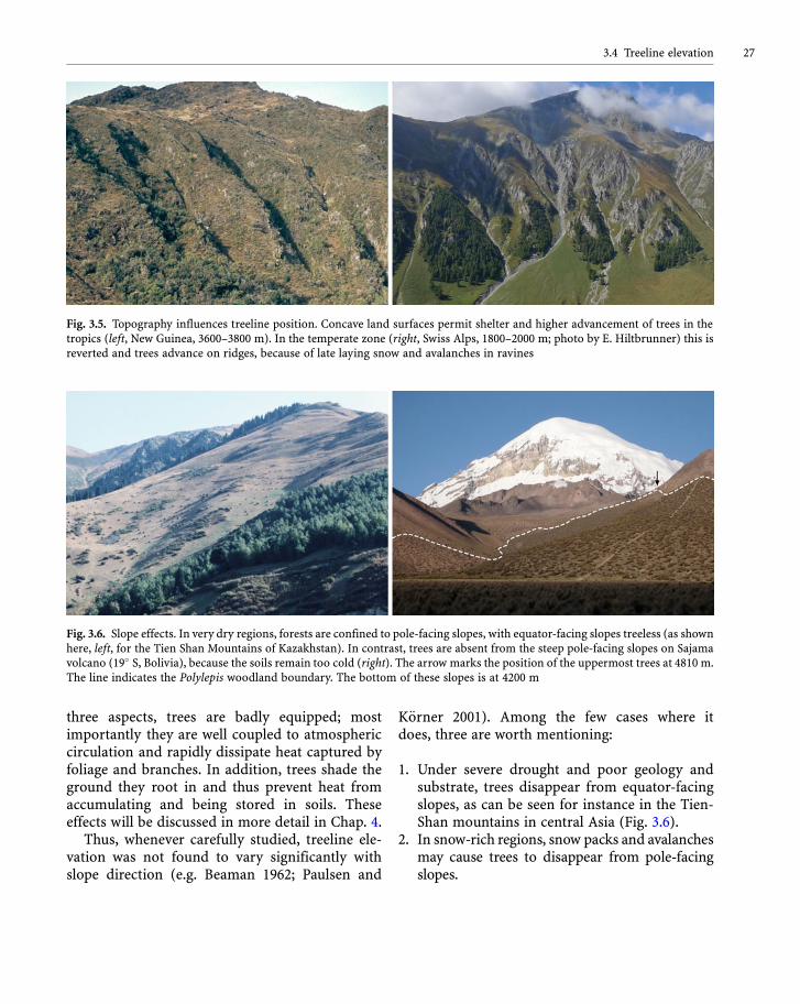
At much smaller scales, treeline elevation canvary with topography and slope exposure. One cannormally tell from a photograph, taken at greatdistance, whether it shows a tropical or a temperatezone treeline situation (Fig. 3.5). In the tropicsshelter provided by steep valleys, ravines or gulliespermits the treeline to advance higher than on theassociated ridges. Hence trees advance upslope inall concave landforms (except for mires). In con-trast, at high latitudes, these sheltered, warmerhabitats are often also snow beds or avalanchetracks; hence they lack trees. Under suchconditions, forests reach their highest elevationson ridges. These topographic effects on lifeconditions can greatly distort or fragment treelines(e.g. Bosheng 1993; Wesche 2002; Miehe et al. 2003).
Slope direction affects trees much less than isknown for low stature vegetation, at least whenmoisture supply is not prohibitive. It is one of theclassics in alpine ecology that the slope directioncontrols the daytime temperature of vegetationmore than actual elevation (Scherrer and K€orner2010a). The higher the elevation, the more impor-tant and pronounced such slope effects become(K€orner 2003a). However, trees should be muchless influenced by slope direction than low staturevegetation because of their size. For solar radiationto heat the immediate plant environment, it needsa collector, some insulation to prevent the heatfrom being convected to the surrounding airand a certain mass to store it - all things knownfrom solar water heating on house roofs. In all
3 Treeline patterns26
three aspects, trees are badly equipped; mostimportantly they are well coupled to atmosphericcirculation and rapidly dissipate heat captured byfoliage and branches. In addition, trees shade theground they root in and thus prevent heat fromaccumulating and being stored in soils. Theseeffects will be discussed in more detail in Chap. 4.
Thus, whenever carefully studied, treeline ele-vation was not found to vary significantly withslope direction (e.g. Beaman 1962; Paulsen and
K€orner 2001). Among the few cases where itdoes, three are worth mentioning:
1. Under severe drought and poor geology andsubstrate, trees disappear from equator-facingslopes, as can be seen for instance in the Tien-Shan mountains in central Asia (Fig. 3.6).
2. In snow-rich regions, snow packs and avalanchesmay cause trees to disappear from pole-facingslopes.
Fig. 3.6. Slope effects. In very dry regions, forests are confined to pole-facing slopes, with equator-facing slopes treeless (as shownhere, left, for the Tien Shan Mountains of Kazakhstan). In contrast, trees are absent from the steep pole-facing slopes on Sajamavolcano (19� S, Bolivia), because the soils remain too cold (right). The arrow marks the position of the uppermost trees at 4810m.The line indicates the Polylepis woodland boundary. The bottom of these slopes is at 4200 m
Fig. 3.5. Topography influences treeline position. Concave land surfaces permit shelter and higher advancement of trees in thetropics (left, New Guinea, 3600–3800 m). In the temperate zone (right, Swiss Alps, 1800–2000 m; photo by E. Hiltbrunner) this isreverted and trees advance on ridges, because of late laying snow and avalanches in ravines
3.4 Treeline elevation 27

3. At high elevation in subtropical mountains,night-time radiative cooling is so severe thatsoils become so cold that trees cannot establishon steep poleward-facing slopes (e.g. on Sajamavolcano in Bolivia; Hoch and K€orner 2005; seeFig. 4.13).
Land use and slope processes may mask purelyexposure-related tree occurrence (e.g. Schickhoff2005).
In all other cases, rapid heat convection andground shading prevent strong slope effects ontreelines. Tree crowns cause energy exchange tobe lifted from the ground to canopy level. So, it isnot the slope (its angle to the sun) but the individ-ual crown that interacts with solar radiation. Sincetrees are upright, the crown-sun interaction angledoes not differ with slope direction. Unresponsive-ness of treeline elevation to slope direction wasfound in a detailed study in the Swiss Alps usinggeographical information systems (Paulsen andK€orner 2001) and was also found for the distribu-tion of high elevation Polylepis remnants inVenezuela (a study of 256 sites by H. Arnal, citedby Goldstein et al. 1994) and for the treeline posi-tion in Mexico (Beaman 1962). In the subarctic, thealpine treeline does not show slope effects >50 mof elevation either, possibly related to the 24 h inso-lation in the high latitude summer (personalobservations in northern Sweden; Kj€allgren andKullmann 1998).
For the Alps and other humid mountains of thetemperate zone, these results, at first glance, seem
to be counter-experience. The perception ofdepressed treelines on north facing slopes resultsfrom their much greater fragmentation due tosnow pack and avalanches. The absolute elevationof treeline as defined in Sect. 2.3 is not affected(Paulsen and K€orner 2001) and the temperaturesmeasured at the treeline in different slopedirections in different mountain areas, indeed,do not differ (Table 3.2). The data shown inTable 3.2 are for various mountain areas, and inno case was the root zone temperature warmerunder forest growing on equator-facing slopes(see also Treml and Banas 2008). The variationrather reflects overall region to region variation inclimate. However, on very steep slopes in north-ern Scandinavia, Kj€allgren and Kullman (1998)did find moderate (<100 m) exposure effects ofBetula treeline elevation, not what is seen onmore gentle slopes beyond the polar circle(K€orner and Paulsen 2004).
From the above it is obvious that the actual lifeconditions need to be known or approximatedin order to identify those facets of the tempera-ture regime which matter for treeline position.The global pattern shown in Fig. 3.4 suggests acommon driver, but the variation around themean is large and it needs to be explored whetherthis variation (beyond the one explained by‘massenerhebungseffekt’ and other regional cli-mate peculiarities) is the variation in the commondriver or whether additional factors modulatethe common driver’s effect for both tree- andsnowline.
Table 3.2. Slope effect on the seasonal meantemperature and maximum daily amplitude(measured at -10 cm in soil under trees) atvarious northern hemisphere treeline sitesof contrasting exposure (calculated fromhourly readings). Note the similar numbersirrespective of slope direction (from K€ornerand Paulsen 2004)
Region North East South West All directions (mean � s.d.)
Seasonal mean (�C)Eastern Alps 7.3 6.7 6.9 7.4 7.0 � 0.3
Western Alps 7.7 6.3 7.1 7.3 7.1 � 0.6
Mexico 5.5 6.3 5.7 - 5.9 � 0.5
Maximum daily amplitude (K)
Eastern Alps 5.0 4.4 5.5 4.4 4.8 � 0.5
Western Alps 4.7 4.4 4.6 4.4 4.5 � 0.2
Mexico 3.2 3.1 3.2 - 3.2 � 0.1
3 Treeline patterns28

3.5 Time matters
The treeline patterns we see today are the long-term answer of trees to climatic impacts and dis-turbance regimes. Unless disturbance is severeand/or of a type unrelated to elevation specificphenomena, the treeline position reflects the cli-mate driven balance between re-growth and treemortality (Chap. 9). Given the longevity of trees,which is commonly>150 years at the treeline, withextremes of several thousand years in some pines(e.g. Pinus longaeva) and cupressoids (Juniper syn.Sabina sp.), there may well be a whole century withno successful recruitment, with little influence ontreeline position. Successful tree establishmentonce every 50–100 years would suffice to retaintreeline position in most cases. Such intervalshave been described for the Rocky MountainsFront Range in Colorado (Bugmann 2001). This iswhy the current treeline position is not the imme-diate answer to the current climatic conditions,but reflects the net outcome of climatic influencesover several hundred years (Daubenmire 1968;Ives and Hansen-Bristow 1983; Slatyer and Noble1992; Holtmeier 1993; Chap. 12). Trees at treelinemay live with hardly any growth for decades, andtree rings of 0.1mmwidth are common (e.g. Esper
et al. 1995; Paulsen et al. 2000). Once conditionsimprove, the very same trees may add 1–2 mmyear�1, as had occurred in recent decades in theAlps, after nearly a century of slow growthassociated with the ‘little ice age’ (Rolland et al.1998; Paulsen et al. 2000).
Isolated tree ‘methusalas’ are thus, themost unre-liable individuals for a functional interpretation oftreelines, although their long tree ring chronologiesare attractive (relative) proxies of climate. This isalso why treeline as defined in Chap. 2 does notrefer to such individuals, but to patches of forestwhich are more consistently positioned along acommon isotherm within a given mountain range.Similarly, seedlings and small saplings beyond thecurrent treeline do not really contribute to treelineunderstanding, because their position may reflect‘exploratory excursions’ during some favourableyears, with no tree establishment following(Fig. 3.7). As discussed in Chaps. 2 and 9, the criticaldevelopmental stage is the emergent sapling stage,when the young tree starts to decouple itself fromthe warm ground layer among low stature alpinevegetation or blockfields. The existence of seedlingsand crippled trees above the treeline only tells usthat the first step of recruitment was successful atsome time in the past, and a forest could establish,
Fig. 3.7. Seedlings of treeline conifers several hundred metres above treeline are confined to sheltered microhabitats and thus, arenot indicative of treeline position or its upslope migration. a Larix decidua, 300 m above treeline near Ronda, Mattertal. b Pinuscembra, 700 m above treeline near Arolla (both Swiss Central Alps)
3.5 Time matters 29

theoretically, if the climate would permit theseindividuals to grow in height.
While tree growth may rapidly respond to agood summer, the establishment of a new foreststand will always exhibit a very long lag to climaticchanges because a few bad summers could backsetemergent re-growth to point zero. The very strongresilience of treelines, on the other hand, makesthem the most reliable and robust bioclimatic ref-erence lines we have, provided they are natural, i.e.not shifted through historical human disturbancesor extreme events unrelated to a specific elevation(e.g. fire).
3.6 Forest structure near treeline
Because treelines are not straight, but oftenfragmented (Holtmeier 2000, 2009), the questionis whether this fragmentation is part of theclimate driven syndrome, or whether this reflectsdisturbances. If it mirrors general, altitude-relatedenvironmental patterns, it is of relevance fortreeline theory; if it reflects local disturbanceregimes, these patterns would be of less globalinterest. Tranquillini (1979) introduced his treelinemonography with two opposing views on the natu-ralness of open, fragmented treeline forests
(Fig. 3.8). According to his hypothesis 1, the grad-ual opening of the forest provides more light andground warming to the individual, ensuringgreater productivity but also more winter damage,so the gradual crippling of more and more patchyforests is seen as ‘natural’ (sensu stress-related).Tranquillini’s hypothesis 2 assumes that wherevera single tree occurs, a closed forest can also exist.This theory opposes the first in assuming thatclosed stands produce shelter and more favourablecrown climate. Tranquillini provides some evi-dence (all from temperate zone mountains) thatthe first theory partly leans on experience fromareas with a history of human disturbance and hepresents cases from remote, inaccessible areas andfrom the southern hemisphere where no such frag-mentation is seen. Accordingly, Bugmann (2001)suggests that regional differences in fragmentationare related to past disturbances, with humandisturbances more important in the Alps and wildfires more important in the Rocky Mountains. Nei-ther of these disturbances are elevation specific, butthey cause (in interaction with the slow recovery oftreeline trees) forest structure to differ fromwhat apurely temperature driven forest near treelinemight look like.
Except for situations with obvious pastdisturbances, alpine and arctic treeline patterns
Fig. 3.8. Closed (sharp; left) versus fragmented (right) treelines. The sharp Nothofagus treeline (here in Chile, 37� S) is supposedto result from the inability of seedlings to cope with life conditions in open terrain. The fragmented Pinus cembra treeline (Alps;photo by E. Hiltbrunner) reflects disturbance regimes and patchy recruitment, often caused by competition with dense shrubs
3 Treeline patterns30

differ. No question, stand opening and increas-ingly wide spacing of individuals is the rule inthe Arctic (Fig. 3.9), with crown forms commonlyshowing genotypic slenderness (i.e. irrespectivelyof whether there was disturbance by fire or not).There are two environmental explanations whichare very specific to the arctic treeline but areplaying little or no role in alpine treelines: lowsolar angles and soil freezing, including perma-frost. While soils under alpine treelines hardlyever freeze (see Chap. 4), they regularly do so atthe high latitude forest limit, and forests are abun-dant on permafrost, particularly when thick mosslayers insulate the ground during summer. Unlesstrees are widely spaced, soils will not thaw, or willnot thaw deep enough or not early enough (e.g.Ballard 1972; Scott et al. 1987). Any closing of treestands near the arctic treeline produces a negativecold root-zone feedback and may even cause wavemortality (Crawford et al. 2003; Crawford 2008)and cyclic changes in permafrost depth at centen-nial time scales. On very gentle slopes or plateaussuch as in parts of the northern Rocky Mountains,a similar opening of the forest over substantialdistances is observed (Butler et al. 2009).
Cooler soil temperatures under forest thanunder grass- or shrubland are a general phenome-non for any type of forest, and treeline forestsaround the globe are rooting in cooler substrate com-pared to adjacent open vegetation (for references, seeK€orner et al. 2003; K€orner and Paulsen 2004). Thisobservation would speak in favour of a positive effecton growth of increasingly wide spaced trees neartreeline, whereas forest fragmentation into pocketsof densely growing trees or krummholz would seemunfavourable for root temperatures. In fact, the worstclimatic conditions seem to occur under dense clonaltree islands, as they are found in parts of the RockyMountains. These slowly migrating thickets at thetreeline produce significantly colder rooting zonesthan is found under the grassland around (Holtmeierand Broll 1992). In the tropics, disturbances and thusfragmentation are also quite abundant at treeline, butthe forest-grassland transition can also be quite sharpin undisturbed places, with perhaps not more than 20m between closed 5–10 m tall tree stands and theadjacent low stature vegetation (e.g. in the Andesabove Merida, Venezuela).
Sharp natural treelines most likely reflect self-control through shelter effects on seedlings. ForNothofagus such effects were clearly evidenced(Wardle 1985a, 1993, 2008), but this may also begenus specific. Naturally sharp treelines could pos-sibly develop elsewhere without disturbance. Oncefragmented, re-growth and thus filling of those gapsis slower near the treeline. Following Tranquillini,undisturbed treelines would most commonly forma closed edge. Many of the disturbances that maycause this edge to become fragmented are notelevation-specific. The opening of stands in theArctic is a different phenomenon driven by soilheat balance (low solar angle, combined with ashort season and very cold winters). Fragmentedhigh elevation treelines do occur without distur-bance where uneven terrain and poor soil conditions(bare rock, water logging) create patchy ground, butthis is not treeline-specific either, but could occuranywhere.
Fig. 3.9. A typically open arctic treeline with natural widespacing of individuals, a situation not found in undisturbedalpine treelines (White Mountains, Alaska)
3.6 Forest structure near treeline 31


![In den Baum geschaut - Young Scienceyoung-science-magazin.com › ... › 2016 › 07 › YoungScience_6_IndenB… · [5] Körner, C. (2012) Alpine treelines. Functional ecology of](https://img.pdfslide.net/doc/110x75/5f0deda77e708231d43cc601/in-den-baum-geschaut-young-scienceyoung-science-a-a-2016-a-07-a-youngscience6indenb.jpg)