Embed Size (px)
Citation preview
Earth Science + Technology
Alternative Analysis Hazardous Materials Review
City of Tukwila - BNSF Intermodal Facility Access Tukwila, Washington
for David Evans and Associates, Inc.
June 2, 2016
Alternative Analysis Hazardous Materials Review
City of Tukwila - BNSF Intermodal Facility Access Tukwila, Washington
for David Evans and Associates, Inc.
June 2, 2016
1101 South Fawcett Avenue, Suite 200 Tacoma, Washington 98402 253.383.4940
Alternative Analysis Hazardous Materials Review
City of Tukwila - BNSF Intermodal Facility Access Tukwila, Washington
File No. 0259-055-00
June 2, 2016
Prepared for:
David Evans and Associates, Inc. 415 118th Avenue SE Bellevue, Washington 98005
Attention: Manual Feliberti, PE - Project Engineer
Prepared by:
GeoEngineers, Inc. 1101 South Fawcett Avenue, Suite 200 Tacoma, Washington 98402 253.383.4940
Tricia S. DeOme, LG Environmental Geologist
Terry R. McPhetridge, LG, LHG Associate
TSD:TRM:ch
Disclaimer: Any electronic form, facsimile or hard copy of the original document (email, text, table, and/or figure), if provided, and any attachments are only a copy of the original document. The original document is stored by GeoEngineers, Inc. and will serve as the official document of record.
June 2, 2016| Page i File No. 0259-055-00
Table of Contents
1.0 INTRODUCTION ................................................................................................................................. 1
2.0 SCOPE OF SERVICES – METHODOLOGY ......................................................................................... 2
3.0 SITE LOCATION AND SUBSURFACE CONDITIONS WITHIN PROJECT AREA .................................. 3
4.0 EXISTING CONDITIONS ..................................................................................................................... 3
4.1. Airport Way Alternative ................................................................................................................. 5 4.2. South 112th Street Alternative ..................................................................................................... 6 4.3. South 124th Street Alternative ..................................................................................................... 8 4.4. Gateway Drive Alternative ............................................................................................................ 9 4.5. 48th Avenue South Alternative ................................................................................................... 11
5.0 CONCLUSIONS AND RECOMMENDATIONS .................................................................................. 14
6.0 LIMITATIONS .................................................................................................................................. 15
LIST OF FIGURES
Figure 1. Vicinity Map Figure 2. Access Alternatives Figure 3. Airport Way Alternative Figure 4. South 112th Alternative Figure 5. South 124th Alternative Figure 6. Gateway Drive Alternative Figure 7. 48th Avenue South Alternative
APPENDICES
Appendix A. Regulatory Requirements Appendix B. Environmental Database Resources (EDR) Report (Included on Attached CD) Appendix C. References Appendix D. Report Limitations and Guidelines for Use
June 2, 2016| Page 1 File No. 0259-055-00
1.0 INTRODUCTION
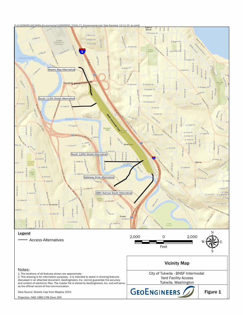
This report provides a summary of our environmental services performed for the City of Tukwila as part of the BNSF Railway Company (BNSF) Intermodal Yard Facility Access project located in Tukwila, Washington. The BNSF Intermodal Yard Facility is located between the Duwamish River and Interstate 5 (I-5). The northern boundary of the Intermodal Yard is defined by the South Boing Access Road overpass over I-5. The eastern boundary of the Intermodal Yard is defined by a slope that separates the yard and railroad tracks from I-5. This slope also forms the eastern edge of the Duwamish River Valley in the project area. The southern boundary of the BNSF Intermodal Facility is defined by the South 129th Street viaduct. The western edge of the Intermodal Yard is defined by residential and commercial neighborhoods. The vicinity of the Intermodal Facility Access project is shown on Figure 1.
Currently the intermodal facility is accessed via South 124th Street. Trucks enter the facility at an access point located near the intersection of South 124th Street and 51st Place South. The purpose of this project is to enhance access to the BNSF Intermodal Yard Facility in order to improve traffic flow through the surrounding neighborhoods.
The Tukwila Intermodal Yard Facility Access project is generally located west of the western boundary of the BNSF Intermodal Yard Facility from approximately 48th Avenue South to the south to just beyond South Boeing Access Road to the north of the Intermodal Yard Facility as shown on Figure 1.
Our understanding of the project is based on our discussions with the project team which included attending a kickoff meeting on May 19, 2015 and information provided including preliminary alignment plans and profiles provided to us via email on June 25, 2015. The access project at this stage consists of evaluating five alternative alignments to improve access to and from the BNSF Intermodal Facility to major surface streets and highways. Five alternative access routes have been identified at this time. The general location of the access points are shown on Figures 1 and 2. The five alternative sites are as follows from north to south:
■ Airport Way Alternative
■ South 112th Street Alternative
■ South 124th Street Alternative
■ Gateway Drive Alternative
■ 48th Avenue South Alternative
GeoEngineers, Inc. conducted a review and reconnaissance of potential sites of concern for each alternative. The results of this study form a basis to provide the design team with a preliminary, conceptual level summary of known or apparent environmental conditions relevant to the project design and construction. This report summarizes the outcome of our environmental review related to hazardous materials review of each alternative.
June 2, 2016| Page 2 File No. 0259-055-00
2.0 SCOPE OF SERVICES – METHODOLOGY
The following tasks were performed during this study at each of the alternative sites.
1. Site Screening Review/Regulatory Database Study – Reviewed the results of a federal, state, local and tribal environmental database search (Environmental Database Resources [EDR] Report; Appendix B) for listings of sites with known or suspected environmental conditions on or near each alternative site within the search distances specified by ASTM International (ASTM) Standard E 1527-05.
2. Field Reconnaissance/Windshield Survey – Conducted a windshield survey reconnaissance of the project boundary at each alternative site. The windshield survey focused on sites with known or suspected environmental concerns that could potentially affect acquisition or construction decisions. Properties being considered for right-of-way (ROW) acquisition were included in this effort if access was possible. The windshield survey was limited to features readily observed from public access corridors and we did not enter private properties. Information regarding the sites was recorded in field notes including photographs, as applicable.
3. File/Aerial Photograph Review – The overall project footprint was reviewed to identify suspect hazardous materials sites within or outside of the proposed alignment that have a potential to affect acquisition decisions and/or design/construction due to possible or known contaminants. Available historical records and agency files for suspect sites were reviewed to identify potential sources of contamination, the nature and extent of known contamination, remedial activities completed or in-process, and the possible affect these sites may have on the project. The following records were reviewed:
■ Publicly-available files and records from the Washington State Department of Ecology (Ecology) for preliminary sites of concern identified in the EDR database.
■ Historical use and development within and surrounding the project site based on available aerial photographs.
■ Current and historical tax assessor records available on the King County tax assessor website and Puget Sound archives for properties that may be acquired.
■ Available geologic literature and topographic maps to evaluate surface drainage paths as well as groundwater depths and flow direction within the area of impact.
4. Data Validation and Site Screening – Suspect sites were screened following review of existing information based on their location and position relative to planned acquisition areas and construction activities within the project footprint, hydrogeologic conditions and available soil and groundwater environmental data provided in regulatory agency files. This screening process resulted in identifying sites of environmental concern that represent potential to significantly affect ROW acquisition, design, or construction.
5. Prepare Report – Prepared this report summarizing the results regarding the potential for contamination by hazardous substances at each alternative site.
June 2, 2016| Page 3 File No. 0259-055-00
3.0 SITE LOCATION AND SUBSURFACE CONDITIONS WITHIN PROJECT AREA
The northern boundary of the Intermodal Yard is defined by the South Boing Access Road overpass over I-5. The eastern boundary of the Intermodal Yard is defined by a slope that separates the yard and railroad tracks from I-5. This slope also forms the eastern edge of the Duwamish River Valley in the project area. The southern boundary of the BNSF Intermodal Facility is defined by the South 129th Street viaduct. The western edge of the BNSF Intermodal Yard is defined by residential and commercial neighborhoods.
The site is situated within the Duwamish River valley, which is part of the Puget Lowland, an elongate topographic basin between the Cascade Range and Olympic Mountains. The area has been impacted by episodic glaciation throughout the past 2.4 million years and by tectonic deformation associated with the Cascadia Subduction Zone. The landscape has formed largely as a result of repeated cycles of glacial scouring and deposition, tectonic activity, and has also been modified by landslides, stream erosion and deposition, and human activity.
The Duwamish River was a natural distributary channel of the Cedar and Green Rivers as well as the White River prior to human modifications. These rivers originate on the flanks of Mount Rainier, a large active stratovolcano of the Cascade Range. After deglaciation of the most recent continental glacier, a glacially scoured fjord was revealed in the present location of the Duwamish River valley. This fjord was rapidly infilled with alluvial sand, silt, and gravel sediment derived from episodic volcanic debris flows (lahars) from Mount Rainier. These lahars caused the delta front to prograde rapidly towards its present position at the southeast end of Elliot Bay. Thin, peaty lake deposits also have formed in the alluvial floodplains of the Duwamish valley.
4.0 EXISTING CONDITIONS
Sites with environmental concerns were identified through the screening process. The relative risk (low, moderate or high) posed by each hazardous materials site refers to its potential to affect the environment, construction and/or City of Tukwila’s potential environmental liability during property acquisitions. Relative risk was assessed based on best professional judgment considering each site’s distance from the project footprint, type and duration of historical development, contaminated media, known and suspected chemicals of concern, regulatory cleanup status, surface topography, hydraulic gradient and contaminant migration potential. The depth of excavation or type of construction is not known at this time and was not considered in the evaluation.
Sites were classified as “low risk” if a suspect concern exists based on historical or current development, but the likelihood for conditions at the site to affect the project is assessed to be relatively low. Sites were classified as “moderate risk” if a documented hazardous materials concern exists based on historical or current development, and the conditions at the site may affect the project. If sufficient documentation to inform an opinion regarding risk was not available, these sites were also ranked as “moderate.” Sites were classified as “high risk” if a documented hazardous materials concern exists based on historical or current development, and documented contamination has a high probability to affect the project in some way. Study findings are summarized in Tables 1 through 5 and locations in relation to the alternatives are shown on Figures 2 through 7.
June 2, 2016| Page 4 File No. 0259-055-00
It should be noted that rankings of relative risk could change if additional historical records or environmental data are identified or if project design or construction assumptions change significantly from those known as the time of publishing this report.
The BNSF Intermodal Yard Facility is not listed as site of concern because it is relevant to each of the five access alternatives. Multiple spills and generation of hazardous materials have occurred at the BNSF Intermodal Yard Facility based on information provided in the EDR report. The design team should be aware that chemicals or hazardous materials may be encountered in media if construction work is necessary within the BNSF Intermodal Yard Facility.
The sites of concern are described below relative to the specific alternative. Some sites are listed multiple times in relation to the proximity of the alternatives to each other.
June 2, 2016 | Page 5 File No. 0259-055-00
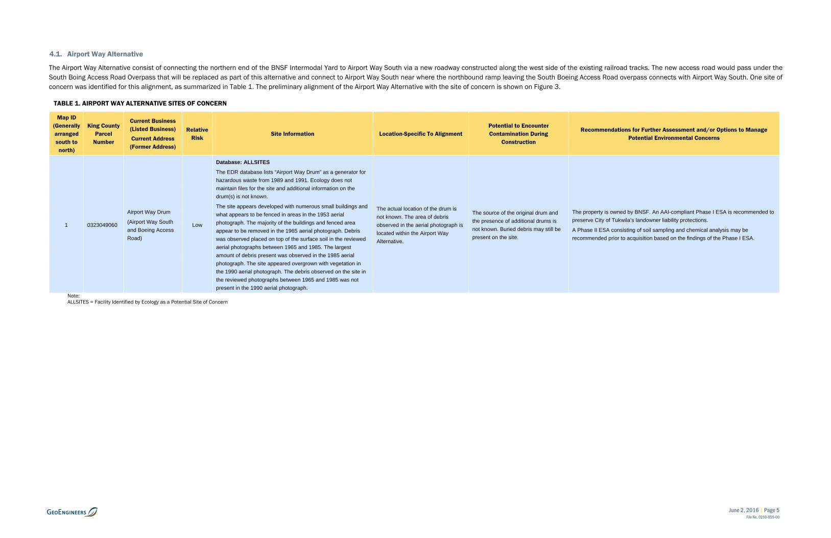
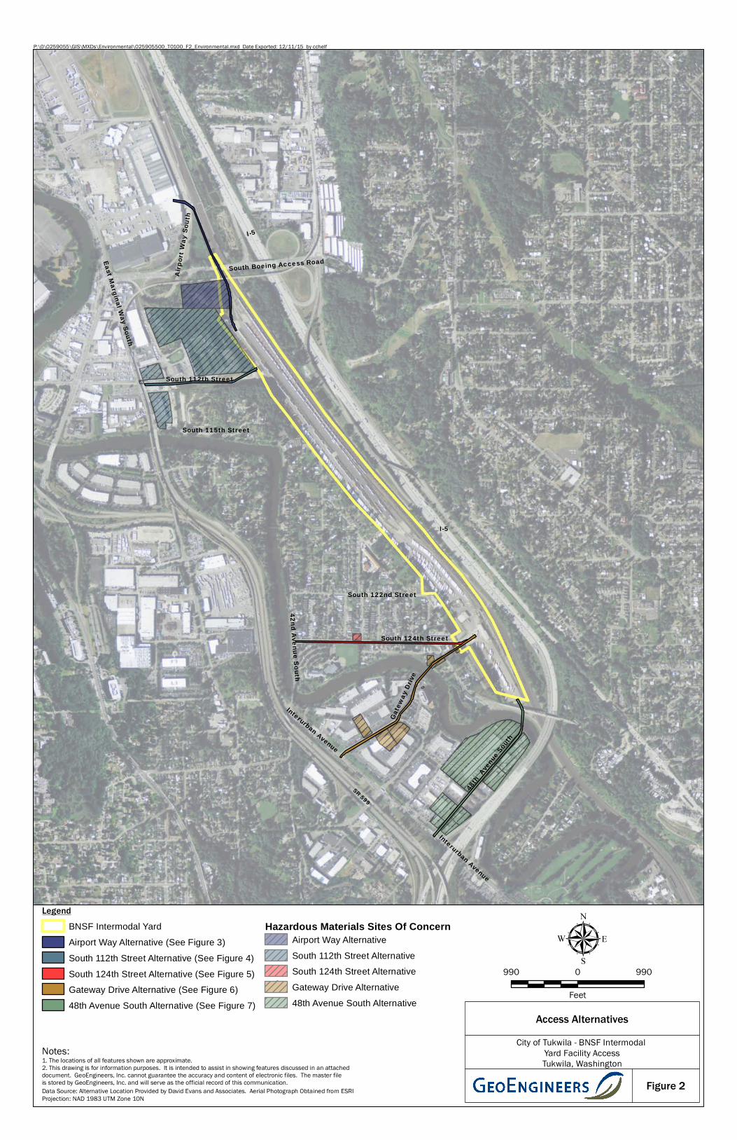
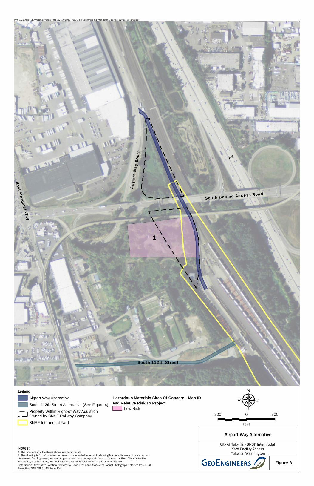
4.1. Airport Way Alternative
The Airport Way Alternative consist of connecting the northern end of the BNSF Intermodal Yard to Airport Way South via a new roadway constructed along the west side of the existing railroad tracks. The new access road would pass under the South Boing Access Road Overpass that will be replaced as part of this alternative and connect to Airport Way South near where the northbound ramp leaving the South Boeing Access Road overpass connects with Airport Way South. One site of concern was identified for this alignment, as summarized in Table 1. The preliminary alignment of the Airport Way Alternative with the site of concern is shown on Figure 3.
TABLE 1. AIRPORT WAY ALTERNATIVE SITES OF CONCERN
Map ID (Generally arranged south to north)
King County Parcel
Number
Current Business (Listed Business) Current Address (Former Address)
Relative Risk
Site Information Location-Specific To Alignment Potential to Encounter Contamination During
Construction
Recommendations for Further Assessment and/or Options to Manage Potential Environmental Concerns
1 0323049060
Airport Way Drum
(Airport Way South and Boeing Access Road)
Low
Database: ALLSITES
The EDR database lists “Airport Way Drum” as a generator for hazardous waste from 1989 and 1991. Ecology does not maintain files for the site and additional information on the drum(s) is not known.
The site appears developed with numerous small buildings and what appears to be fenced in areas in the 1953 aerial photograph. The majority of the buildings and fenced area appear to be removed in the 1965 aerial photograph. Debris was observed placed on top of the surface soil in the reviewed aerial photographs between 1965 and 1985. The largest amount of debris present was observed in the 1985 aerial photograph. The site appeared overgrown with vegetation in the 1990 aerial photograph. The debris observed on the site in the reviewed photographs between 1965 and 1985 was not present in the 1990 aerial photograph.
The actual location of the drum is not known. The area of debris observed in the aerial photograph is located within the Airport Way Alternative.
The source of the original drum and the presence of additional drums is not known. Buried debris may still be present on the site.
The property is owned by BNSF. An AAI-compliant Phase I ESA is recommended to preserve City of Tukwila’s landowner liability protections.
A Phase II ESA consisting of soil sampling and chemical analysis may be recommended prior to acquisition based on the findings of the Phase I ESA.
Note: ALLSITES = Facility Identified by Ecology as a Potential Site of Concern
June 2, 2016 | Page 6 File No. 0259-055-00
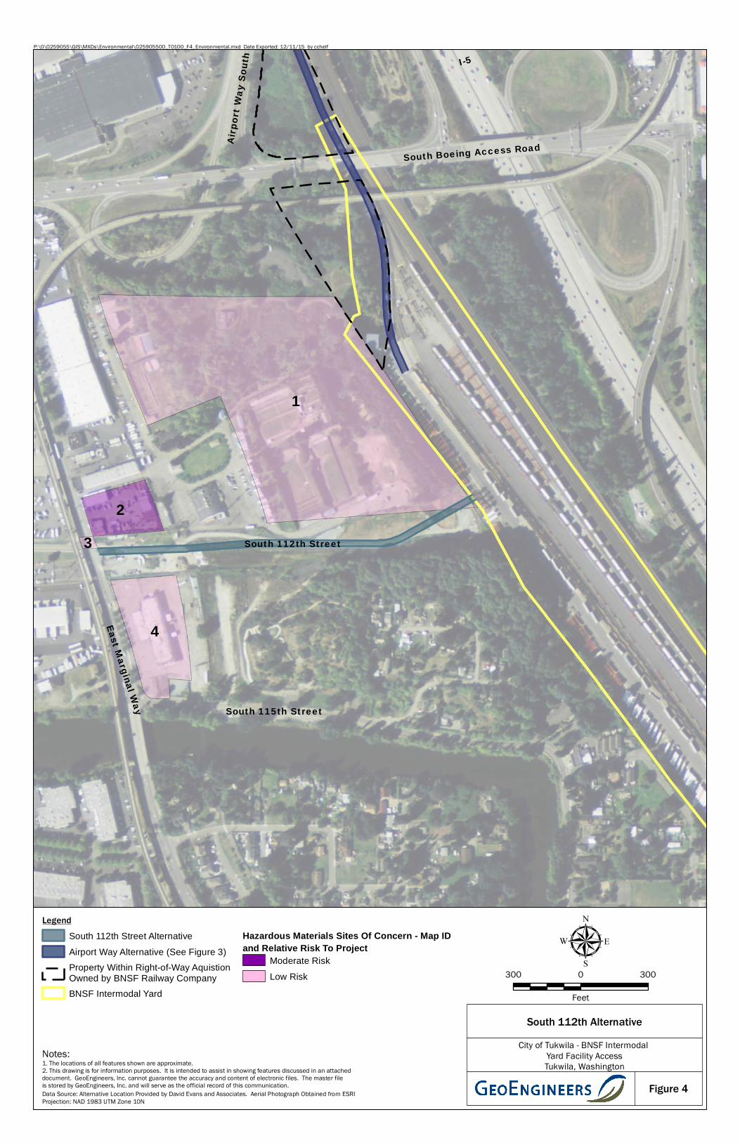
4.2. South 112th Street Alternative
The South 112th Street Alternative would connect East Marginal Way South with the BNSF Intermodal Yard via a new roadway constructed between intersection of East Marginal Way South and South 112th Street and the yard. Currently South 112th Street dead ends at East Marginal Way. Four sites of concern were identified for this alternative, as summarized in Table 2. The preliminary alignment of the South 112th Street Alternative with the site of concern is shown on Figure 4.
TABLE 2. SOUTH 112TH STREET ALTERNATIVE SITES OF CONCERN
Map ID (Generally arranged south to north)
King County Parcel
Number
Current Business (Listed Business) Current Address (Former Address)
Relative Risk
Site Information Location-Specific To Alignment Potential to Encounter Contamination During
Construction
Recommendations for Further Assessment and/or Options to Manage Potential Environmental Concerns
1 0323049099
Seattle Police Athletic Association Shooting
Range
(Police Firing Range)
11030 East Marginal Way South
Low
Database: ALLSITES, UST
The site is currently operated as a practice firing range for the Seattle Police Department. The site appears to have been used as a firing range since at least 1953 based on a review of the available aerial photographs. One UST (111 to 1,110 gallons) was installed in 1983 and removed from the site in 1996. Ecology was unable to locate the UST records in their files. Information provided on the EDR database does not indicate whether contamination was encountered during the UST removal process.
The southern portion of the site is located within the alignment. However it does not appear the actual firing range area is located within the area of the alignment boundary.
Metals and carcinogenic polycyclic aromatic hydrocarbons are typical contaminants of concern for firing ranges.
An AAI-compliant Phase I ESA is recommended to preserve City of Tukwila’s landowner liability protections.
A Phase II ESA consisting of soil sampling and chemical analysis may be recommended prior to acquisition based on the findings of the Phase I ESA.
2 0323049168
and 0323049129
Hayward Baker Construction Company
(Farwest Taxi Facility)
11022 and 11180 East Marginal Way
Moderate
Database: CSCSL NFA, ALLSITES, UST
The site is currently operated by Hayward Baker, a geotechnical construction company. Heavy equipment was observed on the site during the visual reconnaissance.
The site was previously operated as a Farwest Taxi facility. Two USTs (1,101 to 2,000 gallons) were removed in 2000 and a No Further Action (NFA) was issued by Ecology in 2011 based on information provided in the EDR database. Ecology was unable to locate the project files for the site.
The 11180 address was also listed as Bratch Auto Body and Parts in 2001 and JL Repair in 2002 in the EDR database report.
The existing buildings were constructed in 1957 and 1958 based on information observed on the King County tax assessor records. Varying amounts of vehicles and debris were observed on the site in the reviewed aerial photographs between 1965 to the present.
The site is located directly north and adjacent of this proposed alignment.
Maintenance activities likely have occurred and may continue to occur on the property. Spills and releases of chemicals used during maintenance operations may have impacted the soil and groundwater beneath the site and within the proposed alignment.
A Phase II ESA is recommended prior to construction to evaluate soil and possibly groundwater conditions. The results of the Phase II ESA will assist in evaluating the potential for contaminated media to be encountered during construction, estimating the potential costs to manage and dispose the construction-generated soil and/or groundwater, and establishing appropriate handling procedures to be implemented during the construction activities.
3
East Marginal
Way - Right of Way
KC Metro Transit
South 112th Street and East Marginal Way
Low
Database Listing: SPILLS
Approximately 75 gallons of gasoline fuel was released related to a punctured gas tank on a bus in 2006. Fuel was reported to have spilled onto the roadway and entered the nearby catch basins. The catch basins were reportedly cleaned. However, the lateral extent of the spill was not identified in the documents reviewed in the Ecology files.
The site is adjacent and west of the proposed alternative alignment.
It is unknown if the gasoline fuel has impacted soil within the proposed alignment based on the available information.
The contractor should refer to the contaminated soil identification and handling plan if impacted soil is encountered during construction activities in this area.
June 2, 2016 | Page 7 File No. 0259-055-00
Map ID (Generally arranged south to north)
King County Parcel
Number
Current Business (Listed Business) Current Address (Former Address)
Relative Risk
Site Information Location-Specific To Alignment Potential to Encounter Contamination During
Construction
Recommendations for Further Assessment and/or Options to Manage Potential Environmental Concerns
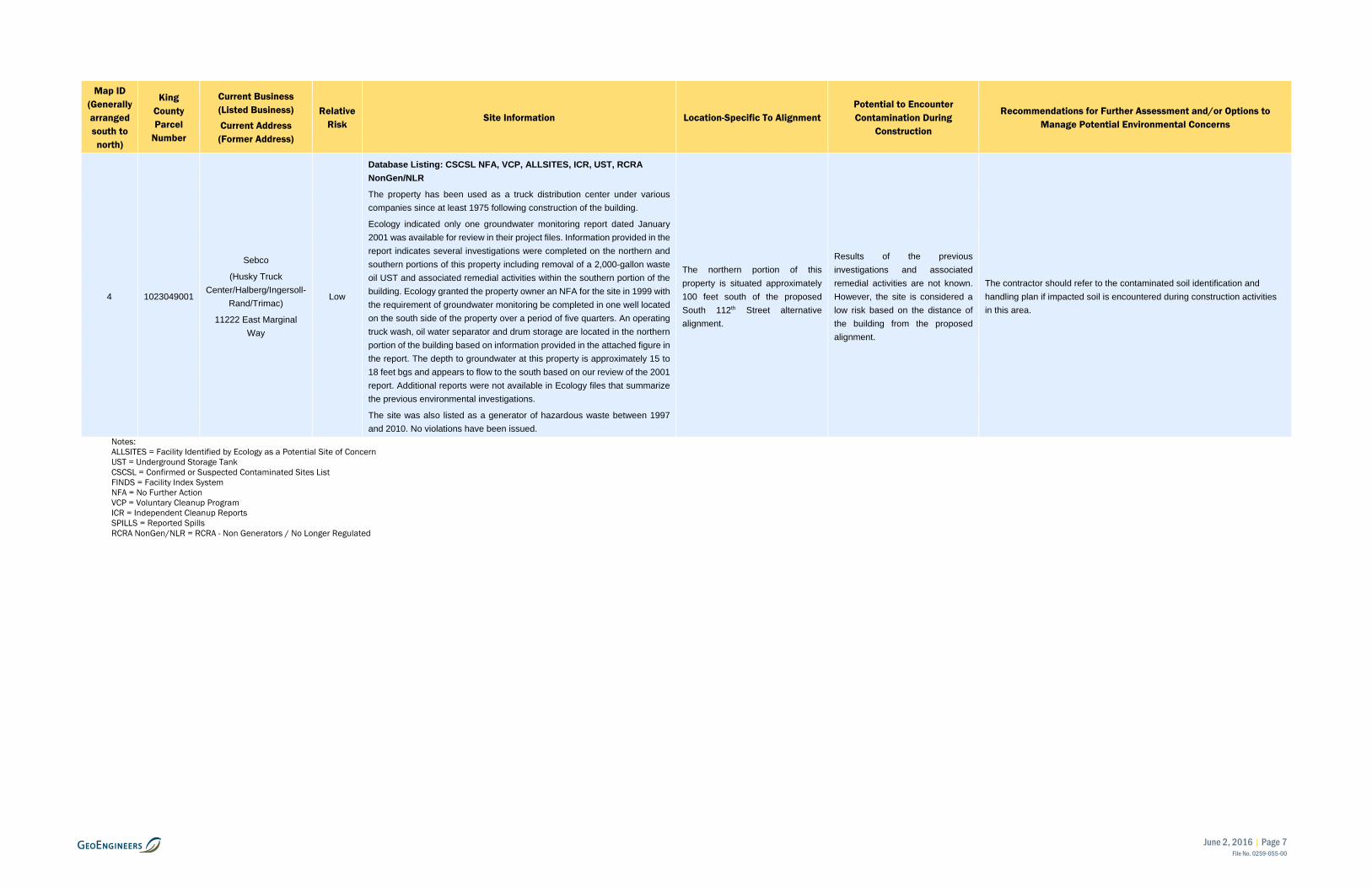
4 1023049001
Sebco
(Husky Truck Center/Halberg/Ingersoll-
Rand/Trimac)
11222 East Marginal Way
Low
Database Listing: CSCSL NFA, VCP, ALLSITES, ICR, UST, RCRA NonGen/NLR
The property has been used as a truck distribution center under various companies since at least 1975 following construction of the building.
Ecology indicated only one groundwater monitoring report dated January 2001 was available for review in their project files. Information provided in the report indicates several investigations were completed on the northern and southern portions of this property including removal of a 2,000-gallon waste oil UST and associated remedial activities within the southern portion of the building. Ecology granted the property owner an NFA for the site in 1999 with the requirement of groundwater monitoring be completed in one well located on the south side of the property over a period of five quarters. An operating truck wash, oil water separator and drum storage are located in the northern portion of the building based on information provided in the attached figure in the report. The depth to groundwater at this property is approximately 15 to 18 feet bgs and appears to flow to the south based on our review of the 2001 report. Additional reports were not available in Ecology files that summarize the previous environmental investigations.
The site was also listed as a generator of hazardous waste between 1997 and 2010. No violations have been issued.
The northern portion of this property is situated approximately 100 feet south of the proposed South 112th Street alternative alignment.
Results of the previous investigations and associated remedial activities are not known. However, the site is considered a low risk based on the distance of the building from the proposed alignment.
The contractor should refer to the contaminated soil identification and handling plan if impacted soil is encountered during construction activities in this area.
Notes: ALLSITES = Facility Identified by Ecology as a Potential Site of Concern UST = Underground Storage Tank CSCSL = Confirmed or Suspected Contaminated Sites List FINDS = Facility Index System NFA = No Further Action VCP = Voluntary Cleanup Program ICR = Independent Cleanup Reports SPILLS = Reported Spills RCRA NonGen/NLR = RCRA - Non Generators / No Longer Regulated
June 2, 2016 | Page 8 File No. 0259-055-00
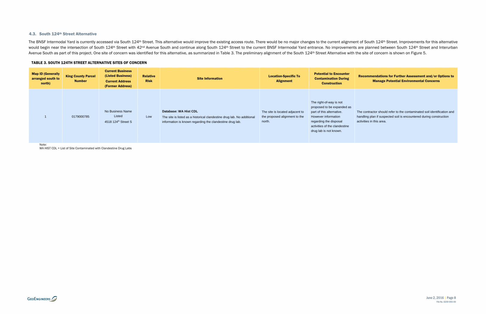
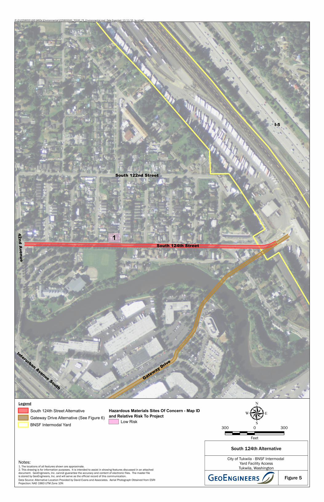
4.3. South 124th Street Alternative
The BNSF Intermodal Yard is currently accessed via South 124th Street. This alternative would improve the existing access route. There would be no major changes to the current alignment of South 124th Street. Improvements for this alternative would begin near the intersection of South 124th Street with 42nd Avenue South and continue along South 124th Street to the current BNSF Intermodal Yard entrance. No improvements are planned between South 124th Street and Interurban Avenue South as part of this project. One site of concern was identified for this alternative, as summarized in Table 3. The preliminary alignment of the South 124th Street Alternative with the site of concern is shown on Figure 5.
TABLE 3. SOUTH 124TH STREET ALTERNATIVE SITES OF CONCERN
Map ID (Generally arranged south to
north)
King County Parcel Number
Current Business (Listed Business) Current Address (Former Address)
Relative Risk
Site Information Location-Specific To
Alignment
Potential to Encounter Contamination During
Construction
Recommendations for Further Assessment and/or Options to Manage Potential Environmental Concerns
1 0179000785 No Business Name
Listed
4518 124th Street S Low
Database: WA Hist CDL
The site is listed as a historical clandestine drug lab. No additional information is known regarding the clandestine drug lab.
The site is located adjacent to the proposed alignment to the north.
The right-of-way is not proposed to be expanded as part of this alternative. However information regarding the disposal activities of the clandestine drug lab is not known.
The contractor should refer to the contaminated soil identification and handling plan if suspected soil is encountered during construction activities in this area.
Note: WA HIST CDL = List of Site Contaminated with Clandestine Drug Labs
June 2, 2016 | Page 9 File No. 0259-055-00
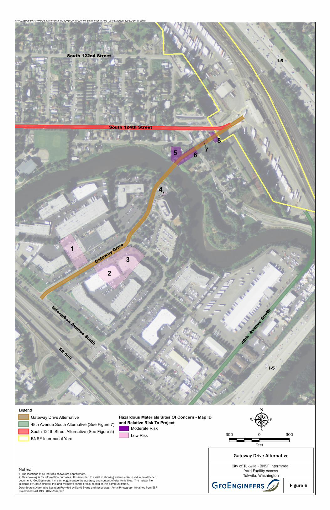
4.4. Gateway Drive Alternative
The Gateway Drive Alternative would connect the southern end of the BNSF Intermodal Yard to Interurban Avenue South via a new bridge over the Duwamish River, a new roadway though existing parking areas located on the east side of the river, and a new connection with Gateway Drive. Eight sites of concern were identified for this alternative, as summarized in Table 4. The preliminary alignment of the Gateway Drive Alternative with the sites of concern is shown on Figure 6.
TABLE 4. GATEWAY DRIVE ALTERNATIVE SITES OF CONCERN
Map ID (Generally arranged south to north)
King County Parcel
Number
Current Business (Listed Business) Current Address (Former Address)
Relative Risk
Site Information Location-Specific To
Alignment
Potential to Encounter Contamination During
Construction
Recommendations for Further Assessment and/or Options to Manage Potential Environmental Concerns
1 Western Portion of 2716000020
OmniCare of Seattle (G-Tech and OmniCare of
Seattle)
12674 Gateway Drive
Low
Database: SPILLS, FINDS, ALLSITES, MANIFEST
The facility was listed as a small quantity generator of hazardous waste starting in 2013.
A spill report also indicates ½ quart of hydraulic oil and an unknown amount of battery acid was released to the storm drain in 2005. The spill was properly cleaned up according to the spill report.
The site is located north and adjacent to the alignment.
Releases and spills of hazardous materials that were not reported or remediated may be encountered during construction.
The contractor should refer to the contaminated soil identification and handling plan if suspect soil is encountered during work in this area.
2 Portion of
2716000040
Not Known
(Boeing Company Gateway)
12687 Gateway Drive
Low
Database: RCRA-CESQG; ALLSITES; MANIFEST, FINDS
The facility was listed as a small quantity generator of hazardous waste starting in 1988. The EDR reports various types of unused products have been generated over the years. No violations have been reported.
The alternative is located directly north and adjacent to the site.
Releases and spills of hazardous materials that were not reported or remediated may be encountered during construction.
The contractor should refer to the contaminated soil identification and handling plan if suspect soil is encountered during work in this area.
3 Portion of
2716000060
Not Known
(Boeing Company Gateway)
12779 Gateway Drive
Low
Database: SPILLS, RCRA NonGen/NLR, FINDS, ALLSITES
The facility was listed as a small or large quantity generator of hazardous waste starting in 1993. The EDR indicates various types of unused products have been generated over the years. No violations have been reported.
A large sheen on the parking lot surface was reported in 2001 to Ecology. The spill report does not describe additional remedial activities.
This proposed alternative is located directly north and adjacent to the site.
Releases and spills of hazardous materials that were not reported or remediated may be encountered during construction.
The contractor should refer to the contaminated soil identification and handling plan if suspect soil is encountered during work in this area.
4 Portion of
2716000075 12770 Gateway Drive Low
Database: UST, ALLSITES, FINDS
A 550-gallon UST is present as shown on Figure 5. The UST system provides diesel for an emergency generator and pump for fire-protection system within the adjacent BECU building. A site assessment was completed 2008 prior to upgrades to the UST system. Groundwater was encountered 15-feet bgs and groundwater flow anticipated to be northeast. Petroleum impacts were not detected in the soil and groundwater at the site.
UST is located adjacent and south of the alignment.
Releases and spills of hazardous materials that were not reported or remediated may be encountered during construction.
The contractor should refer to the contaminated soil identification and handling plan if suspect soil is encountered during work in this area.
5 17900-2840 4925 South 125th Street Moderate
Database: None
The existing residence was constructed in 1920. The historical tax assessor records indicate the house was heated with oil. It is not known if the tank that stored the oil is still present.
The property is with the alignment and planned to be acquired.
Spills or releases of petroleum products from the UST may be encountered during construction.
An AAI-compliant Phase I ESA and hazardous material building survey is recommended to preserve City of Tukwila’s landowner liability protections.
A Phase II ESA is recommended prior to construction to evaluate soil and possibly groundwater conditions. The results of the Phase II ESA will assist in evaluating the potential for contaminated media to be encountered during construction, estimating the potential costs to manage and dispose the construction-generated soil and/or groundwater, and establishing appropriate handling procedures to be implemented during the construction activities.
June 2, 2016 | Page 10 File No. 0259-055-00
Map ID (Generally arranged south to north)
King County Parcel
Number
Current Business (Listed Business) Current Address (Former Address)
Relative Risk
Site Information Location-Specific To
Alignment
Potential to Encounter Contamination During
Construction
Recommendations for Further Assessment and/or Options to Manage Potential Environmental Concerns
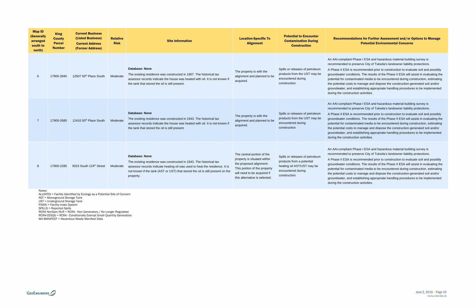
6 17900-2845 12507 50th Place South Moderate
Database: None
The existing residence was constructed in 1957. The historical tax assessor records indicate the house was heated with oil. It is not known if the tank that stored the oil is still present.
The property is with the alignment and planned to be acquired.
Spills or releases of petroleum products from the UST may be encountered during construction.
An AAI-compliant Phase I ESA and hazardous material building survey is recommended to preserve City of Tukwila’s landowner liability protections.
A Phase II ESA is recommended prior to construction to evaluate soil and possibly groundwater conditions. The results of the Phase II ESA will assist in evaluating the potential for contaminated media to be encountered during construction, estimating the potential costs to manage and dispose the construction-generated soil and/or groundwater, and establishing appropriate handling procedures to be implemented during the construction activities.
7 17900-2685 12410 50th Place South Moderate
Database: None
The existing residence was constructed in 1943. The historical tax assessor records indicate the house was heated with oil. It is not known if the tank that stored the oil is still present.
The property is with the alignment and planned to be acquired.
Spills or releases of petroleum products from the UST may be encountered during construction.
An AAI-compliant Phase I ESA and hazardous material building survey is recommended to preserve City of Tukwila’s landowner liability protections.
A Phase II ESA is recommended prior to construction to evaluate soil and possibly groundwater conditions. The results of the Phase II ESA will assist in evaluating the potential for contaminated media to be encountered during construction, estimating the potential costs to manage and dispose the construction-generated soil and/or groundwater, and establishing appropriate handling procedures to be implemented during the construction activities.
8 17900-2285 5023 South 124th Street Moderate
Database: None
The existing residence was constructed in 1943. The historical tax assessor records indicate heating oil was used to heat the residence. It is not known if the tank (AST or UST) that stored the oil is still present on the property.
The central portion of the property is situated within the proposed alignment. This portion of the property will need to be acquired if this alternative is selected.
Spills or releases of petroleum products from a potential heating oil AST/UST may be encountered during construction.
An AAI-compliant Phase I ESA and hazardous material building survey is recommended to preserve City of Tukwila’s landowner liability protections.
A Phase II ESA is recommended prior to construction to evaluate soil and possibly groundwater conditions. The results of the Phase II ESA will assist in evaluating the potential for contaminated media to be encountered during construction, estimating the potential costs to manage and dispose the construction-generated soil and/or groundwater, and establishing appropriate handling procedures to be implemented during the construction activities.
Notes: ALLSITES = Facility Identified by Ecology as a Potential Site of Concern AST = Aboveground Storage Tank UST = Underground Storage Tank FINDS = Facility Index System SPILLS = Reported Spills RCRA NonGen/NLR = RCRA - Non Generators / No Longer Regulated RCRA-CESQG = RCRA - Conditionally Exempt Small Quantity Generators WA MANIFEST = Hazardous Waste Manifest Data
June 2, 2016 | Page 11 File No. 0259-055-00
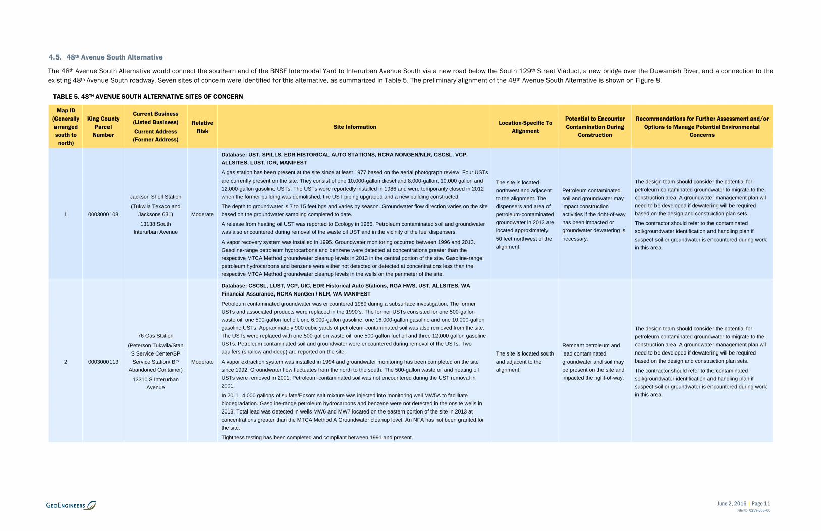
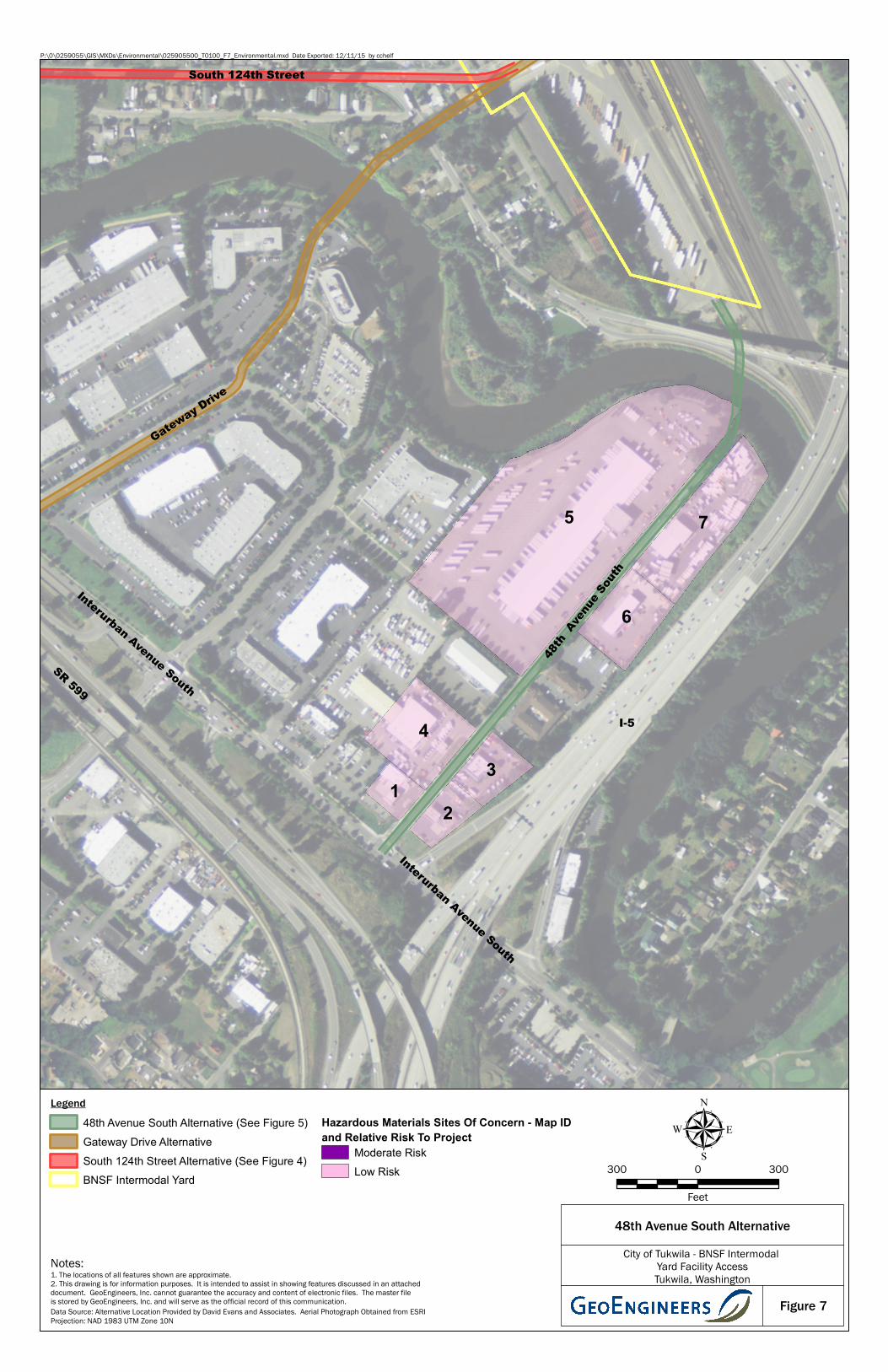
4.5. 48th Avenue South Alternative
The 48th Avenue South Alternative would connect the southern end of the BNSF Intermodal Yard to Interurban Avenue South via a new road below the South 129th Street Viaduct, a new bridge over the Duwamish River, and a connection to the existing 48th Avenue South roadway. Seven sites of concern were identified for this alternative, as summarized in Table 5. The preliminary alignment of the 48th Avenue South Alternative is shown on Figure 8.
TABLE 5. 48TH AVENUE SOUTH ALTERNATIVE SITES OF CONCERN
Map ID (Generally arranged south to north)
King County Parcel
Number
Current Business (Listed Business) Current Address (Former Address)
Relative Risk
Site Information Location-Specific To
Alignment
Potential to Encounter Contamination During
Construction
Recommendations for Further Assessment and/or Options to Manage Potential Environmental
Concerns
1 0003000108
Jackson Shell Station
(Tukwila Texaco and Jacksons 631)
13138 South Interurban Avenue
Moderate
Database: UST, SPILLS, EDR HISTORICAL AUTO STATIONS, RCRA NONGEN/NLR, CSCSL, VCP, ALLSITES, LUST, ICR, MANIFEST
A gas station has been present at the site since at least 1977 based on the aerial photograph review. Four USTs are currently present on the site. They consist of one 10,000-gallon diesel and 8,000-gallon, 10,000 gallon and 12,000-gallon gasoline USTs. The USTs were reportedly installed in 1986 and were temporarily closed in 2012 when the former building was demolished, the UST piping upgraded and a new building constructed.
The depth to groundwater is 7 to 15 feet bgs and varies by season. Groundwater flow direction varies on the site based on the groundwater sampling completed to date.
A release from heating oil UST was reported to Ecology in 1986. Petroleum contaminated soil and groundwater was also encountered during removal of the waste oil UST and in the vicinity of the fuel dispensers.
A vapor recovery system was installed in 1995. Groundwater monitoring occurred between 1996 and 2013. Gasoline-range petroleum hydrocarbons and benzene were detected at concentrations greater than the respective MTCA Method groundwater cleanup levels in 2013 in the central portion of the site. Gasoline-range petroleum hydrocarbons and benzene were either not detected or detected at concentrations less than the respective MTCA Method groundwater cleanup levels in the wells on the perimeter of the site.
The site is located northwest and adjacent to the alignment. The dispensers and area of petroleum-contaminated groundwater in 2013 are located approximately 50 feet northwest of the alignment.
Petroleum contaminated soil and groundwater may impact construction activities if the right-of-way has been impacted or groundwater dewatering is necessary.
The design team should consider the potential for petroleum-contaminated groundwater to migrate to the construction area. A groundwater management plan will need to be developed if dewatering will be required based on the design and construction plan sets.
The contractor should refer to the contaminated soil/groundwater identification and handling plan if suspect soil or groundwater is encountered during work in this area.
2 0003000113
76 Gas Station
(Peterson Tukwila/Stan S Service Center/BP Service Station/ BP
Abandoned Container)
13310 S Interurban Avenue
Moderate
Database: CSCSL, LUST, VCP, UIC, EDR Historical Auto Stations, RGA HWS, UST, ALLSITES, WA Financial Assurance, RCRA NonGen / NLR, WA MANIFEST
Petroleum contaminated groundwater was encountered 1989 during a subsurface investigation. The former USTs and associated products were replaced in the 1990’s. The former USTs consisted for one 500-gallon waste oil, one 500-gallon fuel oil, one 6,000-gallon gasoline, one 16,000-gallon gasoline and one 10,000-gallon gasoline USTs. Approximately 900 cubic yards of petroleum-contaminated soil was also removed from the site. The USTs were replaced with one 500-gallon waste oil, one 500-gallon fuel oil and three 12,000 gallon gasoline USTs. Petroleum contaminated soil and groundwater were encountered during removal of the USTs. Two aquifers (shallow and deep) are reported on the site.
A vapor extraction system was installed in 1994 and groundwater monitoring has been completed on the site since 1992. Groundwater flow fluctuates from the north to the south. The 500-gallon waste oil and heating oil USTs were removed in 2001. Petroleum-contaminated soil was not encountered during the UST removal in 2001.
In 2011, 4,000 gallons of sulfate/Epsom salt mixture was injected into monitoring well MW5A to facilitate biodegradation. Gasoline-range petroleum hydrocarbons and benzene were not detected in the onsite wells in 2013. Total lead was detected in wells MW6 and MW7 located on the eastern portion of the site in 2013 at concentrations greater than the MTCA Method A Groundwater cleanup level. An NFA has not been granted for the site.
Tightness testing has been completed and compliant between 1991 and present.
The site is located south and adjacent to the alignment.
Remnant petroleum and lead contaminated groundwater and soil may be present on the site and impacted the right-of-way.
The design team should consider the potential for petroleum-contaminated groundwater to migrate to the construction area. A groundwater management plan will need to be developed if dewatering will be required based on the design and construction plan sets.
The contractor should refer to the contaminated soil/groundwater identification and handling plan if suspect soil or groundwater is encountered during work in this area.
June 2, 2016 | Page 12 File No. 0259-055-00
Map ID (Generally arranged south to north)
King County Parcel
Number
Current Business (Listed Business) Current Address (Former Address)
Relative Risk
Site Information Location-Specific To
Alignment
Potential to Encounter Contamination During
Construction
Recommendations for Further Assessment and/or Options to Manage Potential Environmental
Concerns
3 0003000045 Peterson Tukwila 76
(Peterson Tukwila 76)
13100 48th Avenue S Low
Database: ALLSITES, UST
The property was redeveloped into a diesel service station in 2014 when three USTs were installed (capacities 25,000, 17,000 and 8,000 gallons).
The site is located south and adjacent to the alignment.
The USTs are less than one year old, therefore the risk of spills and releases associated with the USTs are low.
The contractor should refer to the contaminated soil identification and handling plan if suspect soil is encountered during work in this area.
4 0003000109
Husky International Trucks
13138 South Interurban Avenue
Low
Database: CSCSL, VCP, UST, ICR, RCRA NonGen/NLR, FINDS, ALLSITES, LUST, Financial Assurance
Petroleum-contaminated soil and groundwater were identified on the northwest side of the existing building during a subsurface investigation performed in 1995. A diesel UST and 235 tons of petroleum-contaminated soil was removed from the area in 1998. Monitoring wells were installed on the property between 2000 and 2006 to monitor groundwater quality. Free product mineral spirits were observed in monitoring well MW5 in 2005 in the northwest corner of the building near an oil water separator (located approximately 400 feet north of the alignment). Oxygen release compound was injected into monitoring well MW5 in 2006, a passive skimmer was installed in 2010/2011 and a product recovery well was installed in the area in 2012. Groundwater monitoring between 2000 to 2012 indicates petroleum-range hydrocarbons and petroleum constituents in groundwater samples collected in two monitoring wells (MW1 and MW4) located along the alignment have be not detected or detected at concentrations less than the MTCA Method A groundwater cleanup level. Groundwater is estimated to be 10 to 11 feet bgs and the flow direction varies between the west and the north.
A 10,000- to 19,999-gallon UST and a fuel dispenser area are located 40 feet north of the alignment. Spills and releases associated with this fueling system has not been documented.
Known petroleum contaminated soil and groundwater is located approximately 400 feet north of the alignment.
An operational UST system is located 40 feet north of the alignment.
Documented petroleum releases are not present in the alignment area. Petroleum contaminated soil and groundwater may impact construction activities if groundwater dewatering is necessary.
The design team should consider the potential for petroleum-contaminated groundwater to migrate to the construction area. A groundwater management plan will need to be developed if dewatering will be required based on the design and construction plan sets.
The contractor should refer to the contaminated soil/groundwater identification and handling plan if suspect soil or groundwater is encountered during work in this area.
5 0004800013
YRC Freight
(World Wide Inc./12855 48th Avenue South,
Overnight Transport, Yellow Transportation
Inc./Yellow Freight Systems/Time-DC
Trucking, NW Transport Service,
Yellow Freight Systems)
12855 48th Avenue South
Low
Database: HMIRS, RCRA NonGen/NLR, CSCSL NFA, VCP, SPILLS, ALLSITES, CSCSL NFA, ICR, RGA LUST
Over one hundred spills have been reported to Ecology. The spills are predominately related to release of hazardous material inside trailers, to the asphalt surface or in catch basins. All spills reported were cleaned up appropriately.
A 10,000-galllon diesel UST and associated petroleum-contaminated soil was removed from the western boundary of the property in 1997. Confirmation soil samples indicated that chemicals of concern were less than the current MTCA Method A ULU cleanup levels. An NFA was granted in 1998.
Hazardous waste has been generated periodically on the site since 1987. Violations have not been reported.
The majority of the site is northwest and adjacent of the alignment. The northeast corner of the property is planned to be acquired.
Releases and spills of hazardous materials that were not reported or remediated may be encountered during construction.
The contractor should refer to the contaminated soil identification and handling plan if suspect soil or groundwater is encountered during work in this area.
6 0004800005
Ditch Witch Northwest
(Hertz Rental)
12900 48th Avenue South
Low
Database: SPILLS, RGA LUST, VCP, CSCSL, FINDS, Financial Assurance, ALLSITES, LUST, ERNS, RGA HWS, UST
Two 550-gallon waste oil USTs were removed in 1996. The site was issues a non-compliance notice for the UST system in 2010 by Ecology. A 2500-gallon gasoline UST, 4,000 gallon diesel UST, 515 tons petroleum-contaminated soil and 11,200 gallons of water were removed in 2010. The USTs were located 120 feet south of the alignment.
Six monitoring wells were installed and groundwater monitoring occurred between 2011 and 2014. The depth to groundwater is approximately 8 to 15 feet. Groundwater flow is tidally influenced by the Duwamish River and varies from south to northwesterly.
Chemicals of concern were either not detected or detected at concentrations less than the respective MTCA Method A Groundwater cleanup level. A NFA determination was granted by Ecology in 2015.
Hazardous waste has been generated periodically on the site since 1997. Violations have not been reported.
The site is south and adjacent of the alignment. The area of the former USTs is 120 feet south of the alignment.
Releases and spills of hazardous materials that were not reported or remediated may be encountered during construction.
The contractor should refer to the contaminated soil identification and handling plan if suspect soil or groundwater is encountered during work in this area.
June 2, 2016 | Page 13 File No. 0259-055-00
Map ID (Generally arranged south to north)
King County Parcel
Number
Current Business (Listed Business) Current Address (Former Address)
Relative Risk
Site Information Location-Specific To
Alignment
Potential to Encounter Contamination During
Construction
Recommendations for Further Assessment and/or Options to Manage Potential Environmental
Concerns
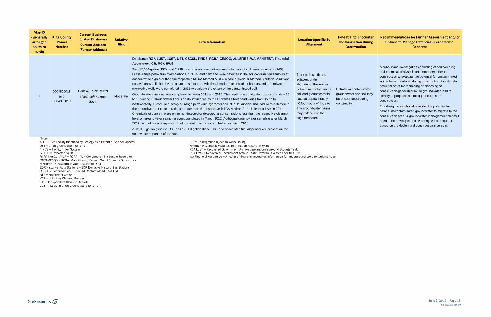
7 0004800018
and 0004800019
Penske Truck Rental
12840 48th Avenue South
Moderate
Database: RGA LUST, LUST, UST, CSCSL, FINDS, RCRA-CESQG, ALLSITES, WA MANIFEST, Financial Assurance, ICR, RGA HWS
Two 12,000-gallon USTs and 2,295 tons of associated petroleum-contaminated soil were removed in 2009. Diesel-range petroleum hydrocarbons, cPAHs, and benzene were detected in the soil confirmation samples at concentrations greater than the respective MTCA Method A ULU cleanup levels or Method B criteria. Additional excavation was limited by the adjacent structures. Additional exploration including borings and groundwater monitoring wells were completed in 2011 to evaluate the extent of the contaminated soil.
Groundwater sampling was completed between 2011 and 2012. The depth to groundwater is approximately 12 to 15 feet bgs. Groundwater flow is tidally influenced by the Duwamish River and varies from south to northwesterly. Diesel- and heavy oil-range petroleum hydrocarbons, cPAHs, arsenic and lead were detected in the groundwater at concentrations greater than the respective MTCA Method A ULU cleanup level in 2011. Chemicals of concern were either not detected or detected at concentrations less than the respective cleanup level on groundwater sampling event completed in March 2012. Additional groundwater sampling after March 2012 has not been completed. Ecology sent a notification of further action in 2013.
A 12,000 gallon gasoline UST and 12,000 gallon diesel UST and associated fuel dispenser are present on the southwestern portion of the site.
The site is south and adjacent of the alignment. The known petroleum-contaminated soil and groundwater is located approximately 40 feet south of the site. The groundwater plume may extend into the alignment area.
Petroleum-contaminated groundwater and soil may be encountered during construction.
A subsurface investigation consisting of soil sampling and chemical analysis is recommended prior to construction to evaluate the potential for contaminated soil to be encountered during construction, to estimate potential costs for managing or disposing of construction-generated soil or groundwater, and to identify appropriate handling procedures for construction.
The design team should consider the potential for petroleum-contaminated groundwater to migrate to the construction area. A groundwater management plan will need to be developed if dewatering will be required based on the design and construction plan sets.
Notes: ALLSITES = Facility Identified by Ecology as a Potential Site of Concern UIC = Underground Injection Wells Listing UST = Underground Storage Tank HMIRS = Hazardous Materials Information Reporting System FINDS = Facility Index System RGA LUST = Recovered Government Archive Leaking Underground Storage Tank SPILLS = Reported Spills RGA HWS = Recovered Government Archive State Hazardous Waste Facilities List RCRA NonGen/NLR = RCRA - Non Generators / No Longer Regulated WA Financial Assurance = A listing of financial assurance information for underground storage tank facilities. RCRA-CESQG = RCRA - Conditionally Exempt Small Quantity Generators MANIFEST = Hazardous Waste Manifest Data EDR Historical Auto Stations = EDR Exclusive Historic Gas Stations CSCSL = Confirmed or Suspected Contaminated Sites List NFA = No Further Action VCP = Voluntary Cleanup Program ICR = Independent Cleanup Reports LUST = Leaking Underground Storage Tank
June 2, 2016 | Page 14 File No. 0259-055-00
5.0 CONCLUSIONS AND RECOMMENDATIONS
This Alternative Analysis Hazardous Materials Review consisted of evaluating five alternative alignments to improve access into and exiting the Tukwila BNSF Intermodal Yard Facility to major surface streets and highways. This report identifies potential contaminated sites on or near the five alternative alignments that may have resulted in soil or groundwater contamination that could impact acquisitions, design, construction and/or related costs.
The recommendations for additional due diligence as well as mitigation for potential impacts are summarized in the following categories:
■ Phase I ESA, building material surveys and potential subsequent Phase II ESA where property acquisition is planned. If the Phase I ESAs identifies additional information regarding potentially contaminated soil and groundwater, that information should be provided to the construction contractors.
■ Subsurface investigations within the existing ROW where property acquisition is not anticipated.
■ Design considerations and construction methods for management of groundwater should be carefully evaluated with respect to known petroleum-contaminated groundwater near the alignments. Dewatering could influence the flow direction and/or extent of contaminated groundwater.
■ Soil and Groundwater Management Plan (SGMP) developed prior to beginning construction activities. The SGMP should include methods for identification, handling and management of potentially contaminated soil and groundwater (dewatering fluids) that may be generated during construction. The Project Requirements may also include HAZWOPER requirements for contractors working in the vicinity of known contaminated sites.
The following is a summary of findings and recommendations for each alternative. The specific sites are identified for each alternative on the tables including detailed information regarding the site information, location within alignment, and recommendation for further assessment. Sites identified for each alternative begin with Sites 1, 2, 3, etc.
■ Airport Way Alternative. One site (Site 1) was identified as a low risk under this alternative. A Phase I ESA was recommended for the site prior to acquisition. Results of the Phase I ESA may indicate that a Phase II ESA will be needed prior to acquisition.
■ South 112th Street Alternative. Three sites (Sites 1, 3 and 4) are considered low risk and one site (Site 2) was identified as a moderate risk during evaluation of this access alternative. A Phase I ESA is recommended on Site 1 and may be recommended on Site 1 based on the findings of the Phase I ESA. A Phase II ESA is recommended on Site 2 to evaluate soil and groundwater conditions that may be encountered during construction. We recommend a Soil and Groundwater Management Plan be developed and implemented during construction within the boundary of this access alternative to properly manage potentially contaminated media for the remainder of the sites (Sites 3 and 4).
■ South 124th Street Alternative. One low risk site (Site 1) was identified during evaluation of this access alternative. We recommend a Soil and Groundwater Management Plan be developed and implemented during construction within the boundary of this access alternative to properly manage potentially contaminated media.
June 2, 2016 | Page 15 File No. 0259-055-00
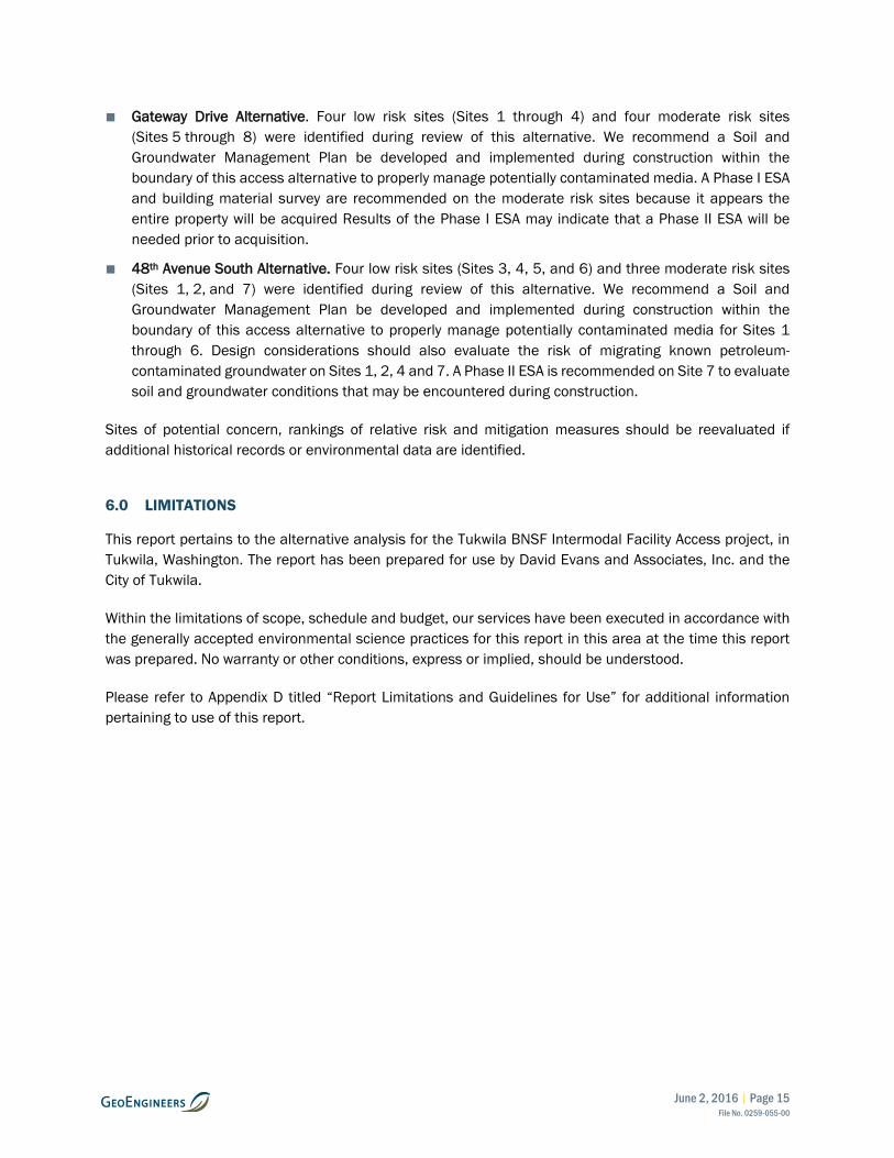
■ Gateway Drive Alternative. Four low risk sites (Sites 1 through 4) and four moderate risk sites (Sites 5 through 8) were identified during review of this alternative. We recommend a Soil and Groundwater Management Plan be developed and implemented during construction within the boundary of this access alternative to properly manage potentially contaminated media. A Phase I ESA and building material survey are recommended on the moderate risk sites because it appears the entire property will be acquired Results of the Phase I ESA may indicate that a Phase II ESA will be needed prior to acquisition.
■ 48th Avenue South Alternative. Four low risk sites (Sites 3, 4, 5, and 6) and three moderate risk sites (Sites 1, 2, and 7) were identified during review of this alternative. We recommend a Soil and Groundwater Management Plan be developed and implemented during construction within the boundary of this access alternative to properly manage potentially contaminated media for Sites 1 through 6. Design considerations should also evaluate the risk of migrating known petroleum-contaminated groundwater on Sites 1, 2, 4 and 7. A Phase II ESA is recommended on Site 7 to evaluate soil and groundwater conditions that may be encountered during construction.
Sites of potential concern, rankings of relative risk and mitigation measures should be reevaluated if additional historical records or environmental data are identified.
6.0 LIMITATIONS
This report pertains to the alternative analysis for the Tukwila BNSF Intermodal Facility Access project, in Tukwila, Washington. The report has been prepared for use by David Evans and Associates, Inc. and the City of Tukwila.
Within the limitations of scope, schedule and budget, our services have been executed in accordance with the generally accepted environmental science practices for this report in this area at the time this report was prepared. No warranty or other conditions, express or implied, should be understood.
Please refer to Appendix D titled “Report Limitations and Guidelines for Use” for additional information pertaining to use of this report.
§̈¦5
S. Boeing Access Rd
§̈¦5
UV599
South 112th Street Alternative
South 124th Street Alternative
Gateway Drive Alternative
48th Avenue South Alternative
Airport Way Alternative
BNSF Intermodal Yard
Vicinity MapCity of Tukwila - BNSF Intermodal
Yard Facility AccessTukwila, Washington
Figure 1
µ2,000 0 2,000
Feet
LegendAccess Alternatives
Notes:1. The locations of all features shown are approximate.2. This drawing is for information purposes. It is intended to assist in showing featuresdiscussed in an attached document. GeoEngineers, Inc. cannot guarantee the accuracyand content of electronic files. The master file is stored by GeoEngineers, Inc. and will serveas the official record of this communication.
Projection: NAD 1983 UTM Zone 10N
P:\0\0259055\GIS\MXDs\Environmental\025905500_T0100_F1_Environmental.mxd Date Exported: 12/11/15 by cchelf
Data Source: Streets map from Mapbox 2015
I-5
SR 599
Gatew
ay Dri
ve
Interurban Avenue
42nd Avenue South
South 124th Street
South 122nd Street
South 115th Street
South 112th Street
South Boeing Access Road
Airpor
t Way
South
East Marginal Way South
I-5
Interurban Avenue
48th Aven
ue South
Access AlternativesCity of Tukwila - BNSF Intermodal
Yard Facility AccessTukwila, Washington
Figure 2
µ990 0 990
Feet
LegendBNSF Intermodal Yard
Airport Way Alternative (See Figure 3)
South 112th Street Alternative (See Figure 4)
South 124th Street Alternative (See Figure 5)
Gateway Drive Alternative (See Figure 6)
48th Avenue South Alternative (See Figure 7)
Hazardous Materials Sites Of ConcernAirport Way Alternative
South 112th Street Alternative
South 124th Street Alternative
Gateway Drive Alternative
48th Avenue South Alternative
Notes:1. The locations of all features shown are approximate.2. This drawing is for information purposes. It is intended to assist in showing features discussed in an attacheddocument. GeoEngineers, Inc. cannot guarantee the accuracy and content of electronic files. The master fileis stored by GeoEngineers, Inc. and will serve as the official record of this communication.
Projection: NAD 1983 UTM Zone 10N
P:\0\0259055\GIS\MXDs\Environmental\025905500_T0100_F2_Environmental.mxd Date Exported: 12/11/15 by cchelf
Data Source: Alternative Location Provided by David Evans and Associates. Aerial Photograph Obtained from ESRI
South 112th Street
South Boeing Access Road
Airpor
t Way
South
East Marginal Way
I-5
1
Airport Way AlternativeCity of Tukwila - BNSF Intermodal
Yard Facility AccessTukwila, Washington
Figure 3
µ300 0 300
Feet
LegendAirport Way Alternative
South 112th Street Alternative (See Figure 4)Property Within Right-of-Way Aquistion Owned by BNSF Railway Company
BNSF Intermodal Yard
Hazardous Materials Sites Of Concern - Map ID and Relative Risk To Project
Low Risk
Notes:1. The locations of all features shown are approximate.2. This drawing is for information purposes. It is intended to assist in showing features discussed in an attacheddocument. GeoEngineers, Inc. cannot guarantee the accuracy and content of electronic files. The master fileis stored by GeoEngineers, Inc. and will serve as the official record of this communication.
Projection: NAD 1983 UTM Zone 10N
P:\0\0259055\GIS\MXDs\Environmental\025905500_T0100_F3_Environmental.mxd Date Exported: 12/11/15 by cchelf
Data Source: Alternative Location Provided by David Evans and Associates. Aerial Photograph Obtained from ESRI
East Marginal Way South 115th Street
South 112th Street
South Boeing Access RoadAirpor
t Way
South I-5
1
23
4
South 112th AlternativeCity of Tukwila - BNSF Intermodal
Yard Facility AccessTukwila, Washington
Figure 4
µ300 0 300
Feet
LegendSouth 112th Street Alternative
Airport Way Alternative (See Figure 3)Property Within Right-of-Way Aquistion Owned by BNSF Railway CompanyBNSF Intermodal Yard
Hazardous Materials Sites Of Concern - Map ID and Relative Risk To Project
Moderate Risk
Low Risk
Notes:1. The locations of all features shown are approximate.2. This drawing is for information purposes. It is intended to assist in showing features discussed in an attacheddocument. GeoEngineers, Inc. cannot guarantee the accuracy and content of electronic files. The master fileis stored by GeoEngineers, Inc. and will serve as the official record of this communication.
Projection: NAD 1983 UTM Zone 10N
P:\0\0259055\GIS\MXDs\Environmental\025905500_T0100_F4_Environmental.mxd Date Exported: 12/11/15 by cchelf
Data Source: Alternative Location Provided by David Evans and Associates. Aerial Photograph Obtained from ESRI
I-5
Gateway Drive
Interurban Avenue South
42nd Avenue
South 124th Street
South 122nd Street
1
South 124th Alternative
City of Tukwila - BNSF Intermodal Yard Facility AccessTukwila, Washington
Figure 5
µ300 0 300
Feet
Legend
South 124th Street Alternative
Gateway Drive Alternative (See Figure 6)
BNSF Intermodal Yard
Hazardous Materials Sites Of Concern - Map ID
and Relative Risk To Project
Low Risk
Notes:1. The locations of all features shown are approximate.2. This drawing is for information purposes. It is intended to assist in showing features discussed in an attacheddocument. GeoEngineers, Inc. cannot guarantee the accuracy and content of electronic files. The master fileis stored by GeoEngineers, Inc. and will serve as the official record of this communication.
Projection: NAD 1983 UTM Zone 10N
P:\0\0259055\GIS\MXDs\Environmental\025905500_T0100_F5_Environmental.mxd Date Exported: 12/11/15 by cchelf
Data Source: Alternative Location Provided by David Evans and Associates. Aerial Photograph Obtained from ESRI
Interurban Avenue S
outh
I-5
SR 599
Gateway Drive
South 124th Street
South 122nd Street
48th Avenue South
I-5
1
2
3
4
8
75 6
Gateway Drive Alternative
City of Tukwila - BNSF Intermodal Yard Facility AccessTukwila, Washington
Figure 6
µ300 0 300
Feet
Legend
Gateway Drive Alternative
48th Avenue South Alternative (See Figure 7)
South 124th Street Alternative (See Figure 5)
BNSF Intermodal Yard
Hazardous Materials Sites Of Concern - Map ID
and Relative Risk To Project
Moderate Risk
Low Risk
Notes:1. The locations of all features shown are approximate.2. This drawing is for information purposes. It is intended to assist in showing features discussed in an attacheddocument. GeoEngineers, Inc. cannot guarantee the accuracy and content of electronic files. The master fileis stored by GeoEngineers, Inc. and will serve as the official record of this communication.
Projection: NAD 1983 UTM Zone 10N
P:\0\0259055\GIS\MXDs\Environmental\025905500_T0100_F6_Environmental.mxd Date Exported: 12/11/15 by cchelf
Data Source: Alternative Location Provided by David Evans and Associates. Aerial Photograph Obtained from ESRI
Interurban Avenue S
outh
I-5
SR 599
Gateway Drive
South 124th Street
Interurban Avenue S
outh
48th Avenue South
5 7
6
3
1
4
2
48th Avenue South Alternative
City of Tukwila - BNSF Intermodal Yard Facility AccessTukwila, Washington
Figure 7
µ300 0 300
Feet
Legend
48th Avenue South Alternative (See Figure 5)
Gateway Drive Alternative
South 124th Street Alternative (See Figure 4)
BNSF Intermodal Yard
Hazardous Materials Sites Of Concern - Map ID
and Relative Risk To Project
Moderate Risk
Low Risk
Notes:1. The locations of all features shown are approximate.2. This drawing is for information purposes. It is intended to assist in showing features discussed in an attacheddocument. GeoEngineers, Inc. cannot guarantee the accuracy and content of electronic files. The master fileis stored by GeoEngineers, Inc. and will serve as the official record of this communication.
Projection: NAD 1983 UTM Zone 10N
P:\0\0259055\GIS\MXDs\Environmental\025905500_T0100_F7_Environmental.mxd Date Exported: 12/11/15 by cchelf
Data Source: Alternative Location Provided by David Evans and Associates. Aerial Photograph Obtained from ESRI
APPENDIX A Regulatory Requirements
June 2, 2016 | Page A-1 File No. 0259-055-00
APPENDIX A REGULATORY REQUIREMENTS
Applicable Federal and State Regulations
Numerous federal, state and local regulations and policies relate to hazardous materials. This appendix outlines many, but not all, of those federal and state regulations and is intended as a guide for potentially applicable hazardous materials considerations for construction projects. The project owner and their agents are typically responsible for regulatory applicability, relevant, appropriateness and compliance, which should be reviewed for each project.
Federal Regulations
Federal law and regulations relating to hazardous materials and wastes that affect the project include the following:
Comprehensive Environmental Response, Compensation, and Liability Act (CERCLA) and All Appropriate Inquiries (AAI) (40 CFR Part 312) Section 101(35)(B)(ii) and (iii) of CERCLA and the Superfund Amendments and Reauthorization Act (SARA) define liability for hazardous waste contamination and require liable parties to take responsibility for cleanup. 40 CFR Part 312, Standards and Practices for All Appropriate Inquiries, establishes specific regulatory requirements and standards for conducting AAI provisions necessary to qualify for certain landowner liability protections under CERCLA.
Resource Conservation and Recovery Act (RCRA) RCRA provides requirements for handling, transportation, treatment, storage, and disposal of hazardous materials and wastes. It includes provisions for identifying and classifying hazardous materials and wastes, and through the Hazardous and Solid Waste Amendments (HSWA), creates treatment standards for specific wastes. HSWA also establishes requirements for ownership, operation, maintenance and closure of underground storage tanks (USTs). Any removal, treatment or transportation of contaminated soils as part of the proposed project may need to be conducted in compliance with RCRA.
Occupational Safety and Health Act (OSHA) OSHA establishes requirements for site safety procedures, worker training, and worker safety and health standards for employees engaged in work related to hazardous materials. All work relating to the handling of, and potential exposure to, hazardous substances by workers while conducting activities associated with the project must be in compliance with the relevant sections of OSHA.
Clean Water Act (CWA) The CWA provides for comprehensive federal regulation of all sources of water pollution. Pollution of state waters is controlled by two administrative regulations that implement Chapter 90.48 RCW, Water Pollution Control Act; Chapter 173-201A WAC, Water Quality Standards for Surface Waters of the State of Washington; and Chapter 173-200 WAC, Water Quality Standards for Groundwater of the State of Washington.
Chapter 173-201 WAC indicates that toxic substances above natural background levels will not be introduced into waters of the state if the substance will: 1) singularly or cumulatively adversely affect characteristic water uses, 2) cause acute or chronic toxicity to the most sensitive biota dependent on the
June 2, 2016 | Page A-2 File No. 0259-055-00
water, or 3) adversely affect public health. Ecology would employ or require chemical toxicity testing and biological assessments as appropriate to evaluate compliance with the above-mentioned requirements. WAC 173-201A-160 lists the primary means for controlling municipal, commercial and industrial waste discharges through the issuance of waste disposal permits.
Several permit programs have been established to address the construction projects that may introduce hazardous substances to surface waters, including wetlands. The State Water Discharge Permit (WAC 173-216) program includes a variety of exemptions, most of which relate to discharges that are permitted under a National Pollution Discharge Elimination System (NPDES) permit or are otherwise authorized by a publicly owned treatment works (POTW) with an authorized pretreatment program. The NPDES General Stormwater Permit for Construction Activities requires the development and implementation of a Stormwater Pollution Prevention Plan.
National Environmental Policy Act (NEPA) NEPA requires that all actions sponsored, funded, permitted, or approved by federal agencies undergo planning to ensure that environmental considerations are given due weight in project decision-making. One of the major elements addressed in a NEPA assessment is environmental health. Assessment of impacts associated with hazardous materials and waste is a component of the environmental health evaluation.
Endangered Species Act (ESA) ESA regulates a wide range of activities affecting plants and animals designated as “endangered” or “threatened.” The ESA states that it is unlawful to “take” any animal listed as an endangered species. ESA lists “Endangered” animals or plants that are in danger of being extinct. ESA broadly defines a “take” to include, “harass, harm, pursue, hunt, shoot, wound, kill, trap, capture, or collect,” or an attempt to engage in such conduct.
National Emission Standards for Hazardous Air Pollutants (NESHAP) (Code of Federal Regulations, Title 40, Volume 5, Parts 61 to 71) The Environmental Protection Agency’s rules concerning the removal and disposal of asbestos-containing materials (ACM) were issued under NESHAP. NESHAP requires a thorough inspection for friable and nonfriable ACM within a structure prior to demolition activities. An accredited inspector as required by the Asbestos Hazard Emergency Response Act (AHERA) must conduct all inspections. The NESHAP regulation also includes specific notification, work practice, packaging, labeling and disposal requirements.
The Puget Sound Clean Air Agency (PSCAA) requires that a notice of intent be submitted prior to beginning any work on an asbestos demolition. The only exception is asbestos projects involving less than 48 square feet and the removal of nonfriable asbestos containing roofing material. An AHERA building inspector or competent person must make determinations regarding friability. There is a notification waiting period and fee required prior abatement work. Asbestos removed from buildings prior to demolition must be disposed in a landfill permitted to receive ACM.
State Regulations
Washington State implements many of the federal statues pertaining to hazardous materials and wastes along with its own, often more stringent, laws and regulations.
June 2, 2016 | Page A-3 File No. 0259-055-00
Model Toxics Control Act (MTCA) Regulations (Chapter 173-340 WAC) Chapter 173-340 Washington Administrative Code (WAC) implements MTCA, Revised Code of Washington (RCW) 70.105D. The State has published numerous guidance documents and policy related to MTCA. MTCA rules include requirements for site discovery and reporting, site assessment, hazardous site listing, cleanup and public participation. This regulation defines standard methods used to assess risk to human health and the environment. Cleanup standards are presented in WAC 173-340-700 through 173-340-760. WAC 173-340-450 sets forth the requirements for addressing USTs.
MTCA typically applies when environmental contamination that may pose a threat to human health and/or the environment is discovered.
Sediment Management Standards (Chapter 173-204 WAC) Chapter 173-340 Washington Administrative Code (WAC) implements the sediment management standards. The purpose of this chapter is to reduce and ultimately eliminate adverse effects on biological resources and significant health threats to humans from surface sediment contamination by: (a) establishing standards for the quality of surface sediments; (b) applying these standards as the basis for management and reduction of pollutant discharges; and (c) providing a management and decision process for the cleanup of contaminated sediments. The sediment quality standards of WAC 173-204-320 through 173-204-340 include chemical concentration criteria, biological effects criteria, human health criteria, other toxic, radioactive, biological, or deleterious substances criteria, and nonanthropogenically affected sediment quality criteria which are used to identify sediments that have no adverse effects on biological resources, and correspond to no significant health risk to humans. Designation determinations using the sediment quality standards of WAC 173-204-320 through 173-204-340 shall be conducted as stipulated in WAC 173-204-310, Sediment quality standards designation procedures.
Dangerous Waste Regulations (Chapter 173-303 WAC) Chapter 173-303 WAC implements RCRA and the Hazardous Waste Management Act, RCW 70.105 describing requirements and procedures for designating, storing, generating, transporting, treating and disposing of dangerous wastes in Washington State. Any handling, treatment or transport of hazardous waste associated with the project would be required to be in compliance with RCRA and also with Washington’s Dangerous Waste Regulations and Hazardous Waste Management Act. Contaminated materials generated during construction, including soil, water, and debris, would need to be properly designated before disposal (WAC 173-303-070 through 173-303-110. The requirements for generators of dangerous waste are included in WAC 173-303-170 through 173-303-230. A transporter of dangerous waste must comply with the procedures listed in WAC 173-303-240 through 173-303-270.
WAC 173-303-145 lists the reporting requirements for spills and discharges into the environment, except when otherwise permitted under state or federal law. This section of the WAC applies “when any dangerous waste or hazardous substance is intentionally or accidentally spilled or discharged into the environment such that human health or the environment is threatened, regardless of the quantity of dangerous waste or hazardous substance.” This portion of the regulation also details the required procedures for notification and mitigation should a spill occur on site.
Solid (Non-Dangerous) Waste Disposal (RCW 70.95, Chapter 173-304 WAC) The State Solid Waste Management Act, RCW 70.95, states that primary responsibility for managing solid waste is assigned to local government. The state, however, is responsible for assuring the establishment of effective local programs throughout the state.
June 2, 2016 | Page A-4 File No. 0259-055-00
The local jurisdiction’s Health Department regulates the handling and disposal of solid waste. The local Health Department evaluates whether a waste material is acceptable at one or more of the public and private solid waste facilities in the county. In some cases, testing may be required prior to disposal. Waste that is being shipped to a disposal facility out of the county, and soil treatment facilities, falls under the jurisdiction of the local Health Department.
WAC 173-304 lists the Minimum Functional Standards for Solid Waste Handling. WAC 173-304-200 designates the on-site containerized storage, collection and transportation standards for solid waste. The regulations apply to all persons storing containerized solid waste that is generated on site.
Oil Spill Contingency Act (Chapter 173-182 WAC) Chapter 173-182 WAC implements the requirements of the Oil Spill Contingency Act (Chapter 173-182 WAC). The purpose of this chapter is to establish covered vessel and facility oil spill contingency plan requirements (Part II), drill and equipment verification requirements (Part III), primary response contractor standards (Part IV) and recordkeeping and compliance information (Part V). The requirements provide in Part II of Chapter 173-182 WAC are typically used for contractors to develop spill prevention plans to be implemented during construction activities.
Water Pollution Control Act (RCW 90.48) RCW 90.48 implements two administrative regulations that control pollution in state waters. Water Quality Standards for Surface Waters of the State of Washington, Chapter 173-201A WAC, establishes standards for toxic substances, conventional parameters (i.e., pH, dissolved oxygen, temperature), and aesthetic values for marine and fresh surface waters. Water Quality Standards for Groundwater of the State of Washington contain similar regulations for groundwater, with special emphasis on radionuclides and carcinogens, due to potability issues. Any construction or operational activities associated with the project must comply with Washington’s water quality standards. Wastewater Discharges to Surface Waters, Chapter 173-220 WAC regulates discharges to surface water from construction projects. Under this program, it is unlawful to discharge polluting matter to surface waters without a National Pollutant Discharge Elimination System (NPDES) permit. Wastewater Discharges to the Ground, Chapter 173-216 WAC, regulates discharge of stormwater to detention basins if this water contains unacceptable concentrations of polluting matter.
Water Quality Standards for Surface Waters (Chapter 173-201A WAC) WAC 173-201A-040 is the section of the Water Quality Standards that specifically deals with toxic substances within surface waters of the state. The WAC indicates that toxic substances, above natural background levels, shall not be introduced into waters of the state if: 1) The substance will singularly or cumulatively adversely affect characteristic water uses, 2) cause acute or chronic toxicity to the most sensitive biota dependent on the water, or 3) adversely affect public health. The Washington State Department of Ecology shall employ or require chemical toxicity testing and biological assessments as appropriate to evaluate compliance with the above-mentioned requirements. WAC 173-201A-160 lists the primary means for controlling municipal, commercial and industrial waste discharges through the issuance of waste disposal permits.
Wastewater Discharges to Ground (Chapter 173-216 WAC) The State Water Discharge Permit program includes a variety of exemptions, most of which relate to discharges that are permitted under an NPDES permit or are otherwise authorized by a POTW with an authorized pretreatment program.
June 2, 2016 | Page A-5 File No. 0259-055-00
Underground Utilities (RCW 19.122) There are multiple operating utilities that exist within the project footprint. RCW 19.122 states that an excavator shall provide notice of the scheduled commencement of excavation to all owners of underground facilities through a one-number locator service. The RCW also states that all owners of underground facilities within a one-number locator service shall subscribe to the service. Notice needs to be communicated to the locator service no less than 2 days and no more than 10 days prior to the commencement of excavation activities. If the excavator discovers utilities that were not identified or damages a utility, the excavator will stop work and notify the locator service and the owner of the utility service if possible. If the damage causes an emergency situation, the excavator shall also alert the appropriate public health agencies and take all steps necessary to ensure public safety. A failure to notify the locator service of damage to a hazardous liquid or gas pipeline is subject to a civil penalty of not more than ten thousand dollars for each violation. Any excavator who willfully or maliciously damages a field-marked underground facility shall be liable for triple the costs incurred in repairing or relocating the facility.
Underground Storage Tank Statute and Regulations (RCW 90-76, Chapter 173-360 WAC) The purpose of RCW 90.76 and the Chapter 173-360 WAC regulations is to address the threat posed to human health and the environment by leaking underground storage tank (LUST) systems containing petroleum and other regulated substances. The regulations describe the enforcement, notification and reporting requirements. The regulations also detail the performance standards and operating and closure requirements.
Washington Industrial Safety and Health Act (WISHA) Occupational Health Standards Chapter 296-62 WAC implements RCW 49.17. RCW 49.17 also implements Safety Standards for Construction Work, Chapter 296-155 WAC, which contains the Safety Standards for Asbestos and Encapsulation Chapter 296-65 WAC. These safety requirements apply to construction activities, and the regulations are enforced by the Washington State Department of Labor and Industries (L&I).
The standards include rules covering operations at known hazardous waste sites and initial investigations conducted at sites before the presence or absence of hazardous substances has been determined. Rules are also included on site assessment and control, training, protective equipment and emergency response. Chapter 296-155 WAC requires employers to inform their workers of the potentially hazardous conditions of the workplace. Contractors are required to train their workers to recognize hazardous conditions in the workplace and train them how to respond to and report such conditions.
The safety requirements also provide specific procedures for work with asbestos-containing materials (ACM) and lead-based paint (LBP). L&I regulates asbestos and LBP removal and encapsulation (WAC 296-62 Part I-1 and 296-155). Contractors must be certified in asbestos and LBP removal and supervisors and laborers must be trained. For asbestos, L&I and the PSCAA must be notified of asbestos abatement or removal. ACM and LBP must be disposed of in a specially permitted landfill. This includes disposable clothing, respirator filters, and equipment, as well as the ACM and LBP itself.
Hazardous Waste Operations and Treatment, Storage, and Disposal Facilities (Chapter 296-62 WAC Part P, RCW 49.17) Chapter 296-62 WAC Part P includes all of the required procedures for work involving hazardous materials. Chapter 296-62 WAC Part P also details the requirements for handling drums and containers. Unlabeled drums and containers must be considered to contain hazardous waste and handled accordingly until the contents are positively identified and labeled. Drums and containers that cannot be moved without rupture,
June 2, 2016 | Page A-6 File No. 0259-055-00
leakage or spillage must be emptied into a sound container. Personal protective equipment (PPE) selection protocol is outlined in WAC 296-62-30605. The training requirements for site personnel are included within multiple sections of Part P depending upon the designation of contamination.
Safety Standards for Construction Work - Lead (Chapter 296-155 WAC) Chapter 296-1556 WAC indicates that workers may not be exposed to lead at concentrations greater than 50 micrograms per cubic meter (µg/m3) of air averaged over an 8-hour period. Chapter 296-166 WAC also outlines the PPE that shall be given to employees as well as medical surveillance procedures that are to be implemented for exposed personnel.
General Occupational Health Standards – Asbestos (Chapter 296-62 WAC Part I-1) Chapter 296-62 WAC requires that prior to commencement of work an owner must conduct a good faith inspection to determine whether materials to be worked on or removed contain asbestos. An accredited inspector must conduct the good faith inspection. Chapter 296-62 WAC Part I-1 requires that an employer ensure that no employee is exposed to an airborne concentration of asbestos in excess of 0.1 fiber per cubic centimeter (f/cc) of air as an 8-hour time-weighted average. Besides the permissible exposure limit, the regulation also requires appropriate respiratory protection as well as exposure assessment and monitoring.
APPENDIX B Environmental Database Research Reports
(Provided In Separate PDF File)
APPENDIX C References
June 2, 2016 | Page C-1 File No. 0259-055-00
APPENDIX C REFERENCES
Historical Tax Assessor Records for King County Parcel Numbers: 0179002045, 0179002050, 0179002285, 0179002275, 0179002685, 0179002665, 0179002845, 0179002840, 2716000070, 2716000075, 0323049060, 0323049138, 0323049065, 0323049138, 0003800003.
48th Avenue South Alternative
Environmental Data Resources, Inc., 2015, The EDR Aerial Photo Decade Package, 48th Ave Alternative 48th Avenue S/Interurban Avenue, Tukwila, WA 98168, Inquiry Number: 4340438.6, June 30, 2015.
Environmental Data Resources, Inc., 2015, The EDR-City Directory Abstract, 48th Ave Alternative 48th Avenue S/Interurban Avenue, Tukwila, WA 98168, Inquiry Number: 4340438.8, July 6, 2015.
Environmental Data Resources, Inc., 2015, The EDR Radius Map™ Report, 48th Ave Alternative 48th Avenue S/Interurban Avenue, Tukwila, WA 98168, Inquiry Number: 04340438.2r, June 29, 2015.
Environmental Data Resources, Inc., 2015, Certified Sanborn® Map Report, 48th Ave Alternative 48th Avenue S/Interurban Avenue, Tukwila, WA 98168, Inquiry Number: 4340438.7, June 29, 2015.
Environmental Data Resources, Inc., 2015, Historical Topographic Map, 48th Ave Alternative 48th Avenue S/Interurban Avenue, Tukwila, WA 98168, Inquiry Number: 4340438.5, June 30, 2015.
Yellow Transportation Inc./Yellow Freight Systems/Time-DC Trucking, 12855 48th Avenue S.
Ecology, 1998, Independent Remedial Action, No Further Action Letter, January 15, 1998.
Giles Engineering Associates, 1997, Phase II Environmental Site Assessment, July 10, 1997.
Giles Engineering Associates Inc., 1997, Final Independent Remedial Action Report. Yellow Freight Systems, September 30, 1997.
Whitman Environmental Sciences, 1997, Underground Storage Tank Excavation Assessment Report, May 22, 1997.
Penske Trucking, 12840 48th Avenue S.
Arcadis, 2009, Underground Storage Tank Closure and Independent Remedial Action Report, Penske Truck Leasing Facility, November 4, 2009.
Arcadis, 2012, Annual Groundwater Monitoring Report 2011-2012, Penske Truck Leasing Facility, 12840 48th Avenue South, Tukwila, WA, September 6, 2012.
Ecology, 2013, Status Update Letter, April 16, 2013.
June 2, 2016 | Page C-2 File No. 0259-055-00
Hertz Rental, 12900 48th Avenue S.
Ecology, 2015, No Further Action Letter, June 1, 2015.
Omega Services. 1996, Hertz Equipment Rental Facility Independent Cleanup Action.
Omega Services. 1996, UST Closure and Site Assessment Report, November 13, 1996.
Pacific Environmental Group, Inc., 1999, Supplemental Environmental Investigation, January 13, 1999.
Stantec, 2014, Technical Memorandum-Results of Additional Groundwater Assessment, August 8, 2014.
Stantec, 2013, Cleanup Action Report, October 7, 2013.
Stantec, 2012, Supplemental Site Assessment #2 Report, July 3, 2012.
Stantec, 2011, UST System Closure and Remedial Overexcavation Report, June 28, 2011.
Peterson Tukwila/Stan S Service Center- 13310 S Interurban Avenue
Arcadis, 2011, Remedial Action Plan Arco Facility, February 28, 2011.
Arcadis, 2011, Second Semiannual 2010 Groundwater Monitoring Report. February 17, 2011.
Arcadis, 2012, Annual Groundwater Monitoring Report 2012, December 18, 2012.
Arcadis, 2012, Subsurface Injection Completion Report, 13310 Interurban South, June 25, 2012.
Arcadis, 2014, Annual Site Status Report 2013, April 7, 2014.
Delta Consultants, 2009, Groundwater Monitoring Report, Former BP Facility No. 11064, September 25, 2009.
Charles A. Gove and Associates, Inc., 1994, Groundwater Monitoring and Sampling Report, 2nd Quarter 1994, November 30, 1994.
Charles A. Gove and Associates, Inc., 1995, Groundwater Monitoring and Sampling Report, 2nd Quarter 1994, August 29, 1994.
Charles A. Gove and Associates, Inc., 1995, Groundwater Monitoring and Sampling Report, 4th Quarter 1994, March 3 1995.
Charles A. Gove and Associates, Inc., 1995, Groundwater Monitoring and Sampling Report, 1st Quarter 1995, June 30, 1995.
Charles A. Gove and Associates, Inc., 1995, Groundwater Monitoring and Sampling Report, 3rd Quarter 1995, October 13, 1995.
Charles A. Gove and Associates, Inc., 1996, Groundwater Monitoring and Sampling Report, 4th Quarter 1995, January 12, 1996.
June 2, 2016 | Page C-3 File No. 0259-055-00
Charles A. Gove and Associates, Inc., 1997, Groundwater Monitoring and Sampling Report, 4th Quarter 1996, February 28, 1997.
Delta Consultants, 2007, Groundwater Monitoring Report, August 24, 2007.
RZRA AGRA, Inc., 1993, Fourth Quarterly Monitoring Status Report, February 4, 1993.
RZRA AGRA, Inc., 1993, Subsurface Investigation BP Service Station No. 11064, March 1993.
RZRA AGRA, Inc., 1994, Groundwater Monitoring Report, March 1994 Sampling Event BP Service Station No. 11064, April 1994.
Husky Truck Center/HALBERG/INGERSOLL-RAND/TRIMAC, 13123 48th Avenue South
Ecology, 2012, Opinion Letter Regarding Proposed Remedial Action, October 3, 2012.
Robinson and Noble, 2014, May 2014 Quarterly Groundwater Monitoring – Husdy International Trucks 13123 48th Avenue South, Tukwila, WA, July 17, 2014.
Robinson and Noble, 2014, February Groundwater Sampling, April 28, 2014.
Robinson and Noble, 2013, Interim Remedial Action Report, June 2013.
Robinson and Noble, 2011, Environmental Remediation Report, March 2011.
Former Unocal Facility, 13038 Interurban Avenue
Conoco Phillips/Secor, 2005, Groundwater Monitoring Report, February 7, 2005.
Ecology, 2005, No Further Action Granted for Soil and Groundwater After Remedial Action in 1997 and Groundwater Monitoring Between 2002 and 2005, February 14, 2005.
Environmental Resolutions, 2002, UST Decommissioning and Remedial Excavation Report, April 25, 2002.
GeoEngineers, Inc., 1990, Report of Geotechnical Services Subsurface Contamination Study, April 2, 1990.
GeoEngineers, Inc., 1989, Report of Remedial Action Underground Storage Tank, August 1989.
13138 Interurban Avenue – Texaco
Conestoga-Rovers & Associates, 2014, 2013 Annual Groundwater Monitoring Report, Conestoga-Rovers & Associates, February 2014.
Groundwater Technology, 1995, Compliance Sampling Results – Stage II Vapor Recovery Installation, June 19, 1995
Gateway Drive Alternative
Environmental Data Resources, Inc., 2015, The EDR Aerial Photo Decade Package, Gateway Alternative Gateway/Interurban, Seattle, WA 98168, Inquiry Number: 4340438.46, June 30, 2015.
June 2, 2016 | Page C-4 File No. 0259-055-00
Environmental Data Resources, Inc., 2015, The EDR-City Directory Abstract, Gateway Alternative Gateway/Interurban, Seattle, WA 98168, Inquiry Number: 4340438.48, June 30, 2015.
Environmental Data Resources, Inc., 2015, The EDR Radius Map™ Report, Gateway Alternative Gateway/Interurban, Seattle, WA 98168, Inquiry Number: 04340438.42r, June 29, 2015.
Environmental Data Resources, Inc., 2015, Certified Sanborn® Map Report, Gateway Alternative Gateway/Interurban, Seattle, WA 98168, Inquiry Number: 4340438.47, June 29, 2015.
Environmental Data Resources, Inc., 2015, Historical Topographic Map, Gateway Alternative Gateway/Interurban, Seattle, WA 98168, Inquiry Number: 4340438.45, June 30, 2015.
12270 Gateway Drive, BECU
Ecology, 2011, No Further Action Letter, November 14, 2011.
G-Logics, 2008, UST Site Assessment, emergency Generator UST Upgrade Project, BECU Tukwila Financial Center, September 25, 2008.
Airport Way Alternative
Environmental Data Resources, Inc., 2015, The EDR Aerial Photo Decade Package, Airport Way Alternative 10473 Airport Way S Tukwila, WA 98168, Inquiry Number: 4340438.36, June 30, 2015.
Environmental Data Resources, Inc., 2015, The EDR-City Directory Abstract, Airport Way Alternative 10473 Airport Way S Tukwila, WA 98168, Inquiry Number: 4340438.38, July 6, 2015.
Environmental Data Resources, Inc., 2015, The EDR Radius Map™ Report, Airport Way Alternative 10473 Airport Way S Tukwila, WA 98168, Inquiry Number: 04340438.32r, June 29, 2015.
Environmental Data Resources, Inc., 2015, Certified Sanborn® Map Report, Airport Way Alternative 10473 Airport Way S Tukwila, WA 98168, Inquiry Number: 4340438.37, June 30, 2015.
Environmental Data Resources, Inc., 2015, Historical Topographic Map, Airport Way Alternative 10473 Airport Way S Tukwila, WA 98168, Inquiry Number: 4340438.35, June 30, 2015.
9892 40th Avenue South, Paper Material Handling
CH2MHill, 1991, Subsurface Field Investigation, South Seattle Site Phase III, April 1991.
Delta Environmental Consultants, 2001, Results of subsurface Investigations and Recommendation for No Further Action Status for Soil, March 20, 2001.
Delta, 2001, March 29, 2001 Groundwater Monitoring Event Results and Recommendations for NFA, May 31, 2001.
Ecology, 2001, No Further Action Granted for Soil and Groundwater, June 5, 2001.
Summit Envirosolutions, Independent remedial Action report, Hyster Sales Facility, Feb 17, 1995.
June 2, 2016 | Page C-5 File No. 0259-055-00
10065 East Marginal Way – Humble Oil
Terra Associates, 1991, Site Remediation, Old “Humble Oil” Service Station”, 10056 East Marginal Way South, April 22, 1991.
South 112th Street Alternative
Environmental Data Resources, Inc., 2015, The EDR Aerial Photo Decade Package, 112th Street Alternative S. 112th Street/E. Marginal Way S, Seattle, WA 98168, Inquiry Number: 4340438.16, June 30, 2015.
Environmental Data Resources, Inc., 2015, The EDR-City Directory Abstract, 112th Street Alternative S. 112th Street/E. Marginal Way S, Seattle, WA 98168, Inquiry Number: 4340438.18, June 30, 2015.
Environmental Data Resources, Inc., 2015, The EDR Radius Map™ Report, 112th Street Alternative S. 112th Street/E. Marginal Way S, Seattle, WA 98168, Inquiry Number: 04340438.12r, June 29, 2015.
Environmental Data Resources, Inc., 2015, Certified Sanborn® Map Report, 112th Street Alternative S. 112th Street/E. Marginal Way S, Seattle, WA 98168, Inquiry Number: 4340438.17, June 29, 2015.
Environmental Data Resources, Inc., 2015, Historical Topographic Map, 112th Street Alternative S. 112th Street/E. Marginal Way S, Seattle, WA 98168, Inquiry Number: 4340438.15, June 30, 2015.
11222 East Marginal Way, Husky Truck Center
Ecology, 1999, No Further Action Letter, June 21, 1999.
GeoEngineers, 2001, Independent Remedial Action, Results of Groundwater Monitoring and Sampling and Request to Discontinue Sampling, September and December 2000, January 8, 2001 (245503403).
Yellow Freight, 11231 E Marginal Way
ENSR, 1990, Removal of UST at Yellow Freight Located at 11231 East Marginal Way, January 1990.
South 124th Street Alternative
DLH ENV Consulting, 2012, Final Cleanup Report, Beane Parsons LLC Property, 12218 51st Place South, May 31, 2012.
Ecology, 2012, No Further Action, October 5, 2012.
Environmental Data Resources, Inc., 2015, The EDR Aerial Photo Decade Package, 124th Street Alternative S 124th Street/46th Ave S, Tukwila, WA 98178, Inquiry Number: 4340438.26, June 30, 2015.
Environmental Data Resources, Inc., 2015, The EDR-City Directory Abstract, 124th Street Alternative S 124th Street/46th Ave S, Tukwila, WA 98178, Inquiry Number: 4340438.28, July 6, 2015.
Environmental Data Resources, Inc., 2015, The EDR Radius Map™ Report, 124th Street Alternative S 124th Street/46th Ave S, Tukwila, WA 98178, Inquiry Number: 04340438.22r, June 29, 2015.
June 2, 2016 | Page C-6 File No. 0259-055-00
Environmental Data Resources, Inc., 2015, Certified Sanborn® Map Report, 124th Street Alternative S 124th Street/46th Ave S, Tukwila, WA 98178, Inquiry Number: 4340438.27, June 29, 2015.
Environmental Data Resources, Inc., 2015, Historical Topographic Map, 124th Street Alternative S 124th Street/46th Ave S, Tukwila, WA 98178, Inquiry Number: 4340438.25, June 30, 2015.

APPENDIX D Report Limitations and Guidelines for Use
June 2, 2016 | Page D-1 File No. 0259-055-00
APPENDIX D REPORT LIMITATIONS AND GUIDELINES FOR USE1
This appendix provides information to help clients manage their risks with respect to the use of this report.
Environmental Services Are Performed For Specific Purposes, Persons and Projects
GeoEngineers structures our services to meet the specific needs of our clients. For example, an environmental site assessment study conducted for a property owner may not fulfill the needs of a prospective purchaser of the same property. Because each environmental study is unique, each environmental report is unique, prepared solely for the specific client and project site. No one except David Evans and Associates, Inc. and the City of Tukwila should rely on this environmental report without first conferring with GeoEngineers. We do not authorize, and will not be responsible for, the use of this report for any purposes or projects other than those identified in the report.
Within the limitations of our scope, schedule and budget for this study, our services have been executed in accordance with our Agreement with David Evans and Associates, Inc. and generally accepted environmental site assessment practices in this area at the time this report was prepared.
This Environmental Report is Based on a Unique Set of Project-Specific Factors
This report has been prepared for the City of Tukwila - BNSF Intermodal Yard Facility Access Project. GeoEngineers considered a number of unique, project-specific factors when establishing the scope of services for this project and report. Unless GeoEngineers specifically indicates otherwise, do not rely on this report if it was:
■ not prepared for you,
■ not prepared for your project,
■ not prepared for the specific site explored, or
■ completed before important project changes were made.
If important changes are made to the project or site after the date of this report, GeoEngineers should be retained to review our interpretations and recommendations and to provide written modifications or confirmation, as appropriate.
Reliance Conditions for Third Parties
If a lending agency or other parties intend to place legal reliance on the product of our services, we require that those parties indicate in writing their acknowledgement that the scope of services provided, and the general conditions under which the services were rendered including the limitation of professional liability, are understood and accepted by them. This is to provide our firm with reasonable protection against open-
1 Developed based on material provided by ASFE www.asfe.org.
June 2, 2016 | Page D-2 File No. 0259-055-00
ended liability claims by third parties with whom there would otherwise be no contractual limits to their actions.
Historical Information Provided by Others
GeoEngineers makes no warranties or guarantees regarding the accuracy or completeness of information provided or compiled by others. The information presented in this report is based on the above-described research and recent site visits. GeoEngineers has relied upon information provided by others in our description of historical conditions and in our review of regulatory databases and files. The available data do not provide definitive information with regard to all past uses, operations or incidents at the site or adjacent properties.
Uncertainty Remains Even After this Environmental Practices Study is Completed
No environmental assessment study can wholly eliminate uncertainty regarding the potential for environmental conditions of concern in connection with a property, site, facility or business. Performance of an environmental assessment study is intended to reduce, but not eliminate, uncertainty regarding the potential for environmental conditions of concern in connection with a property site, facility or business. There is always a potential that areas with contamination that were not identified during this environmental study exist at the site or in the project footprint. Further evaluation of such potential would require additional research, subsurface exploration, sampling and/or testing.
Environmental Regulations are Always Evolving
Some substances may be present in the site vicinity in quantities or under conditions that may have led, or may lead, to contamination, but are not included in current local, state or federal regulatory definitions of hazardous substances or do not otherwise present current potential liability. GeoEngineers cannot be responsible if the standards for appropriate inquiry, or regulatory definitions of hazardous substance, change or if more stringent environmental standards are developed in the future.
Report Recommendations Are Not Final
The recommendations included in this report are preliminary and should not be considered final. GeoEngineers’ recommendations can be finalized only by observing actual subsurface conditions revealed during construction.
We recommend that GeoEngineers be retained to monitor construction activities where hazardous materials are encountered to confirm that the conditions encountered are similar to those anticipated based on this environmental assessment, and to provide recommendations for design changes if the conditions revealed during the work differ from those anticipated.
Site Conditions Can Change
This environmental report is based on conditions that existed at the time the study was performed. The findings and conclusions of this report may be affected by the passage of time (for example, a Phase I ESA report is typically applicable for 180 days), by events such as a change in property use or occupancy, or by natural events, such as floods, earthquakes, slope instability or groundwater fluctuations. Always contact GeoEngineers before applying this report so that GeoEngineers may evaluate reliability of the report to changed conditions.
June 2, 2016 | Page D-3 File No. 0259-055-00
Read These Provisions Closely
Some clients, design professionals and contractors may not recognize that the geoscience practices (geotechnical engineering, geology and environmental science) are far less exact than other engineering and natural science disciplines. This lack of understanding can create unrealistic expectations that could lead to disappointments, claims and disputes. GeoEngineers includes these explanatory “limitations” provisions in our reports to help reduce such risks. Please confer with GeoEngineers if you are unclear how these “Report Limitations and Guidelines for Use” apply to your project or site.
Geotechnical, Geologic and Environmental Reports Should not be Interchanged
The equipment, techniques and personnel used to perform an environmental study differ significantly from those used to perform a geotechnical or geologic study and vice versa. For that reason, a geotechnical engineering or geologic report does not usually relate any environmental findings, conclusions or recommendations; e.g., about the likelihood of encountering underground storage tanks or regulated contaminants. Similarly, environmental reports are not used to address geotechnical or geologic concerns regarding a specific project.
Contractors Are Responsible for Site Safety on Their Own Construction Projects
Our recommendations are not intended to direct the contractor’s procedures, methods, schedule or management of the work site. The contractor is solely responsible for job site safety and for managing construction operations to minimize risks to on-site personnel and adjacent properties.
Biological Pollutants
GeoEngineers’ Scope of Work specifically excludes the investigation, detection, prevention, or assessment of the presence of Biological Pollutants in or around any structure. Accordingly, this report includes no interpretations, recommendations, findings, or conclusions for the purpose of detecting, preventing, assessing, or abating Biological Pollutants. The term “Biological Pollutants” includes, but is not limited to, molds, fungi, spores, bacteria, and viruses, and/or any of their byproducts.