Embed Size (px)
Citation preview

Ambrosia Lake Uranium Project 1 Broad Oak Associates
TECHNICAL REPORT
ON THE
URANIUM RESOURCES
AT
AMBROSIA LAKE URANIUM PROJECT
MCKINLEY COUNTY, NEW MEXICO, U.S.A.
ON BEHALF OF
TRANS AMERICA INDUSTRIES LTD. #300-905 West Pender Street Vancouver, British Columbia
V6C 1L0
Report for NI 43-101
BY:
G. S. CARTER, P. ENG.
May 30, 2008
BROAD OAK ASSOCIATES 365 Bay Street
Suite 304 Toronto, Ontario
Canada, M5H 2V1

Ambrosia Lake Uranium Project 2 Broad Oak Associates
TABLE OF CONTENTS Page Number 1.0 Title Page 1
2.0 Table of Contents 2
3.0 Summary 3
4.0 Introduction and Terms of Reference 4
5.0 Reliance on Other Experts 5
6.0 Property Description and Location 5
7.0 Accessibility, Climate, Local Resources, Infrastructure,
and Physiography 8
8.0 History 9
9.0 Geological Setting 16
10.0 Deposit Types 20
11.0 Mineralization 21
12.0 Exploration 31
13.0 Drilling 32
14.0 Sampling Method and Approach 32
15.0 Sample Preparation, Analyses and Security 32
16.0 Data Verification 33
17.0 Adjacent Properties 33
18.0 Mineral Processing and Metallurgical Testing 34
19.0 Mineral Resource and Mineral Reserve Estimates 34
20.0 Other Relevant Data and Information 34
21.0 Interpretation and Conclusions 34
22.0 Recommendations 35
23.0 References 44
24.0 Date and Signature Page 48
25.0 Additional Requirements for Technical Reports
on Development Properties and Production Properties 50
26.0 Illustrations 50 Consent of Author 51

Ambrosia Lake Uranium Project 3 Broad Oak Associates
3.0 Summary Trans America Industries Ltd. (“Trans America” or “Company”), is a mineral exploration company that is directing its attention to exploring and developing uranium deposits in the western United States. Trans America and its personnel have extensive experience in the exploration for and the development of uranium deposits in the United States. The Ambrosia Lake uranium project of NEI is situated on the southern flank of the San Juan Basin, approximately 60 miles (96.5 kilometres) west of the city of Albuquerque, New Mexico. The project is comprised of one State of New Mexico General Mining Lease (the Cliffside mine lease), 8 patented lode mining claims, and 345 unpatented lode mining claims that have been leased from various individuals. Collectively, NEI’s leased mining claims and State General Mining Lease cover an area of approximately 7,516 acres (3,041 hectares). The surface lands covering the patented and unpatented mining claims are managed by the US Bureau of Land Management and US Forest Service, and a private land owner. Trans America has entered into a joint venture agreement (dated April 28, 2006), with Neutron Energy, Inc. (“NEI”) of Phoenix, Arizona, United States, regarding the Ambrosia Lake properties. Under the terms of the agreement between the two parties, Trans America must expend US$5 million on exploration and development activities on the properties over a three year period in order to earn a 50% interest in the project. NEI is the operator of the joint venture. Uranium deposits on the subject lands and elsewhere in the Grants mineral belt are primarily hosted in sandstones within the Poison Canyon sandstone and the Westwater Canyon Member of the Jurassic-aged Morrison Formation. These uranium deposits are associated with channel sandstones within a broad fluvial and alluvial fan complex in the Brushy Basin and Westwater Canyon Members, and mimic the shape and geometry of the host channels. Uranium minerals coat sand grains, occasionally replace clastic fragments in the sandstones, and fill voids between individual sand grains. Within the lands that comprise the Ambrosia Lake project, NEI has identified four principal uranium target areas: East Roca Honda, Elizabeth, Mesa Redonda, and West Endy. Historical exploration data, which was collected prior to the adoption of National Instrument 43-101, indicate the presence of significant uranium mineralization at the East Roca Honda, Elizabeth, Mesa Redonda, and West Endy (Frosty-Ox and Cliffside mine) areas. More than 6 million pounds of U3O8 were mined from deposits on the Cliffside mine lease (McLemore and Chenoweth, 1991), and significant un-mined uranium resources are reportedly present at the other localities, as indicated by historical drill hole data held by NEI, and published maps and reports of the New Mexico Bureau of Geology and Mineral Resources and the New Mexico Geological Society. An historical “mineral resource” estimate (prepared by an independent third party) of 303,685 short tons averaging 0.165% eU3O8, containing 1,002,160 pounds of U3O8, was calculated for the “Frosty-Ox” deposit in the West Endy target area of the Ambrosia Lake project area. Historical data pertaining to the Elizabeth claims target details the existence of a further 924,198 short tons averaging 0.24% U3O8, containing 4,440,605 pounds of U3O8 (Schultze, 1985). The historical exploration drill hole data of Conoco and Homestake at East Roca Honda, which includes gamma ray logs from the subject drill holes (and hole locations

Ambrosia Lake Uranium Project 4 Broad Oak Associates
verified in the field), suggests the presence of an exploration target that may range from 2.75 to 4.5 million short tons in size, and have a grade range of 0.175 to 0.225% U3O8. All resource estimates quoted herein are based on historical data and reports prepared by former operators of the leased properties, and obtained by NEI. The historical resources were calculated using methods and procedures that were standard in the United States uranium industry at the time they were prepared. These historic resource estimates are considered to be relevant, and are believed to be reliable, based on the amount and quality of historic work completed. The Company has not yet undertaken the work necessary to independently verify the classification of the historical mineral resource estimates. Neither NEI, Trans America, nor Broad Oak are treating the mineral resource estimates as National Instrument 43-101 defined resources verified by a qualified person. In the opinion of Broad Oak, the Ambrosia Lake properties of NEI and Trans America hold excellent potential for the discovery of additional sandstone-hosted uranium deposits. The author recommends that NEI and Trans America acquire as much of the historical data as possible, and undertake confirmation drilling programs to verify this historical information. The historical data should be evaluated to determine the geologic controls that localized the uranium mineralization, and undertake drilling programs to expand the areas of known mineralization. These programs should be sufficient to define the presence of mineral deposits and determine the economic viability of individual deposits. Broad Oak believes that the Ambrosia Lake uranium project has merit, and is a significant project that should be pursued by its owner. 4.0 Introduction and Terms of Reference Broad Oak Associates (“Broad Oak”) was engaged by Trans America Industries Ltd. to provide an independent technical report. This report was prepared under the direction of Geoffrey S. Carter, a principal of Broad Oak and a Qualified Person. A site visit was made on Wednesday February 22, 2006, and several locations on the property were investigated for evidence of mineralization and previous drilling activity. Kelsey Boltz accompanied Geoffrey S. Carter on the visit. Mr. Boltz was active in the Ambrosia Lake area as a geologist and mine operator in the 1950’s when the district was experiencing a pronounced period of uranium exploration and mine development. He is a Qualified Person and is Chairman of the Board of Directors of NEI. A visit to the NEI office was made on March 21-23, 2007 by Geoffrey S. Carter, Q.P. The extensive data base that NEI has assembled in their offices has been made fully available to Broad Oak. Sources of Data and Information Contained in This Report: This report has been prepared using data (including down-hole gamma logs) collected by several mining and exploration companies, including United Nuclear, Homestake Mining, Enerdyne Corporation, and Continental Oil Company (Conoco), as well as internal (private) reports and studies undertaken by the previous property holders, studies and reports prepared on behalf of the property owners by third-party consultants, and published reports of the US Department of Energy, US Geological Survey, and the New Mexico Bureau of Mines and Mineral Resources. This
Ambrosia Lake Uranium Project 5 Broad Oak Associates
technical information, and the work that served as the basis of the information, was collected prior to the adoption of National Instrument 43-101. However, Broad Oak considers the information to be reasonable and reliable. Units of measurement used in this report are expressed in feet, miles (statute), pounds, short tons (2,000 pounds), etc. Uranium grades are expressed as % U3O8, the standard marketing unit for uranium concentrates (which is generally expressed as % eU3O8, or equivalent U3O8 determined by down-hole radiometric assaying). Extent of Field Involvement of the Qualified Person: Broad Oak has examined the data relating to the Ambrosia Lake Project, which serves as the basis of this report, has had extensive discussions with Michael W. Coleman, LRPG, Regional Geologist, who is a Qualified Person, and Dean T. Wilton, Vice President, Exploration of NEI, who is a Qualified Person and is currently working on the Ambrosia Lake project. Mr. Coleman and Mr. Wilton, as well as other NEI geologists have examined the historical data relating to the Ambrosia Lake project and have found it to have been appropriately obtained under the prevailing standards at the time it was prepared. NEI has provided Broad Oak, as of the date of this report, with Certification of Representation from Mr. Dean T. Wilton, Vice President, and Exploration for NEI, who is a Qualified Person.
5.0 Reliance on Other Experts Broad Oak relied upon Trans America as well as NEI, their legal counsel and land tenure specialist for information regarding the current status of legal title of the property, property agreements, corporate structure, and any outstanding environmental orders. The author of this report has relied, in part, upon data and unpublished reports prepared by others prior to the adoption of National Instrument 43-101, as well as published documents. An examination of this information suggests that the information is both reliable and relevant to the evaluation of the Ambrosia Lake project. Copies of all data cited in this report are held by NEI in its Phoenix, Arizona office, or the Albuquerque, New Mexico office. The author has had discussions with Michael W. Coleman, LRPG , Dan W. Dowers, PG, and Dean T. Wilton, PG all of Neutron Energy, Inc. relating to the project and the data for the project.
6.0 Property Description and Location NEI controls a significant land position within the Ambrosia Lake – San Mateo uranium mining district of west-central New Mexico. This land position, which is comprised of several individual property parcels containing (in total) 345 unpatented lode mining claims, 8 patented lode mining claims and one State of New Mexico mineral lease, covers an area of approximately 7,516 acres (3,041 hectares) in portions of six townships in McKinley County, New Mexico. All of the properties currently controlled by NEI are leased from third parties, and are subject to annual lease payments to the claim owners, assumption of annual rental obligations payable to
Ambrosia Lake Uranium Project 6 Broad Oak Associates
the State of New Mexico, and annual claim maintenance fees ($125.00 per claim per year) payable to the US Bureau of Land Management. Mineral production from the subject properties will require the payment of gross production royalties to the claim owners and the State of New Mexico (for production from the State lease only). The leases that NEI has executed with the claim holders make provisions for annual payments to the claim owners, and production royalties in the event mines are developed on the subject properties. The status of the leased mining claims has been reviewed by an independent land specialist and NEI’s New Mexico-based outside counsel. The attorney has reviewed all title documents and claim filings, and has prepared a “title opinion” which has been reviewed by the author of this report. The attorney concluded that the claims have been filed in accordance with State and Federal laws, and all annual holding fees have been paid. A copy of the General Mining Lease (HG-0078) issued to James A. Bonner has been provided to the author, and this lease appears to be in order. A title opinion, which was prepared by a Santa Fe, New Mexico-based attorney who is a specialist in mineral title matters, found the title to this lease to be in order. This lease has been assigned to NEI, in accordance with rules of the New Mexico Land Office. The properties that are covered by this report include the following parcels: State of New Mexico General Mining Lease HG-0078: Township 14 North, Range 9 West, Section 36: All, 640 acres. Endy Mining Claims, Enerdyne Endy Claims LLC (NMMC 171172-171333): Township 13 North, Range 8 West: Sections (all or parts): 2 through 6, 11 and 12; Township 14 North, Range 8 West: Sections (portions): 31 and 32. Altos Claims, James A. and Julianne K. Bonner (NMMC 171917-173164): Township 14 North, Range 10 West: Sections (all or parts): 12 and 14. BRK Claims, James A. and Julianne K. Bonner (NMMC 172749-173176): Township 14, Range 10 West: Sections (all or parts): 6, 8, and 18. Gil Claims, James A. and Julianne K. Bonner (NMMC 173422-173439, 174454): Township 13 North, Range 8 West: Sections (parts): 11 and 12; Township 12 North, Range 7 West: Section (part): 18. Zac Claims, James A. and Julianne K. Bonner (NMMC 172966-172977, 173284-173285, 172979-173286, 172980): Township 13 North, Range 9 West: Section (all or parts): 5, 6, 12, and 14; Township 14 North, Range 8 West: Section (all or parts): 31. Elizabeth Patented Claims, Enerdyne Endy Claims LLC (MS 2252): Township 14 North, Range 9 West, Section 26 (S ½ Sw ¼, S ½ Sw ¼ Se ¼)

Ambrosia Lake Uranium Project 7 Broad Oak Associates
Elizabeth # 9 Unpatented Mining Claim, Enerdyne Endy Claims, LLC (NMMC 176522): Township 14 North, Range 9 West, Section 26 ( S ½ Se ¼ Se ¼). The surface estate covering most of the Endy and Gil claims is managed by the US Forest Service (USFS). Surface management responsibilities for the Altos, most of the BRK, a portion of the Endy claims, portions of the Zac claims and the Elizabeth #9 claim are vested with the US Bureau of Land Management (BLM). Portions of the BRK, Zac, and the Elizabeth patented lode claims are located on lands in which the surface is owned by private individuals. The surface overlying the General Mining Lease HG-0078 is owned by the State of New Mexico. On April 28, 2006, NEI and Trans America entered into an Exploration, Development and Mine Operating Agreement and formed the Grants Uranium Project Joint-Venture. NEI is the managing partner in the joint venture. Trans America must contribute $5,000,000 to fund the joint venture’s operations and is entitled to earn a fifty percent participating interest in the Ambrosia Lake joint venture’s properties of East Roca Honda, Elizabeth, Mesa Redonda and West Endy. If Trans America fails to make its full $5,000,000 contribution, its interest will be transferred to NEI. Exploration and mining activities conducted on lands managed by the USFS and BLM are governed by agency rules and regulations (BLM surface management regulations 43 CFR 3809, and USFS locatable minerals regulations 36 CFR Part 228, Subpart “A”) under provisions of the National Environmental Policy Act (NEPA). Additional permits are required from the New Mexico Mining and Minerals Division of the Energy, Minerals and Natural Resources Department (EMNRD). The BLM, USFS and EMNRD entered into a Memorandum of Understanding (MOU), effective January 20, 2004, to provide for cooperation between the agencies and elimination of duplication of efforts between the agencies in the assessment and processing of exploration and mining permit applications. In addition to the requirements for permits to conduct exploration and mining activities the State requires that all drill holes be “plugged” to prevent contamination of ground water aquifers or communication between aquifers. The properties are located in the historic Grants Uranium Belt. There are no known environmental issues affecting the Ambrosia Lake project properties pending at this time. NEI holds a “minimal impact” exploration permit (MK013EM), issued by the New Mexico Energy, Mineral and Natural Resources February 21, 2007 for drilling on Section 36, Township 14 North, Range 9 West, McKinley County, New Mexico. NEI on behalf of Trans America, has carried out a drilling program on this prospect, as outlined in this permit. All of the drill holes in NEI’s drilling program were “plugged” and abandoned in compliance with applicable State regulations, and under supervision of the New Mexico regulatory authorities. All surface disturbances related to this work program were reclaimed in compliance with applicable State rules and regulations, and this work has been inspected and found to be in full compliance with the applicable regulations.

Ambrosia Lake Uranium Project 8 Broad Oak Associates
7.0 Accessibility, Climate, Local Resources, Infrastructure and Physiography
Fig. 1, Location Map

Ambrosia Lake Uranium Project 9 Broad Oak Associates
The Ambrosia Lake project is situated on the southern margin of the San Juan Basin of west-central New Mexico. The project area is generally characterized by a broad valley that contains the Ambrosia Lake mining district. The valley is surrounded by numerous small to large mesas that stand as much as 1,000 feet (304 metres) above the surrounding countryside. The dominant topographic feature in the vicinity of the project is Mount Taylor, a dormant volcano which has an elevation of 11,302 feet (3,445 metres) above sea level. Elsewhere in the project area, elevations range from 7,300 to more than 7,800 feet (2,250 to 2,377 metres). The overall topography of the project area is flat to gently sloping within the valley floor and on the mesa tops, while the flanks of the mesas are dominated by very rugged topographic features and steep slopes. The area is populated with sparse mixed grasses, with stands of juniper and pinion pine trees, and is in a semi-arid high desert climate. Temperatures at Grants (the nearest significant population center) range from lows of approximately 50° Fahrenheit to daytime highs of 80° Fahrenheit (9.9° to 26.6° Celsius) in the summer season, and 10° to 40° Fahrenheit (-12.2° to +4.4° Celsius) in the winter. The area receives approximately 11 inches (279 millimetres) of precipitation annually, much of which comes in the form of afternoon thundershowers during the months of July and August. Precipitation can be as much as 13 inches (330 millimetres) of snow during the winter months. Winter snows and summer thunderstorms may create muddy ground conditions that interrupt access for short periods of time. Other than these short periods of muddy ground conditions, mineral exploration and mining activities can be conducted mostly without interruption throughout the year. The project is located in west-central New Mexico, approximately 60 miles (96.5 kilometres) west-northwest of the city of Albuquerque, and 20 miles (32 kilometres) north-northeast of the town of Grants. A paved highway from the town of Milan (Grants) to the village of San Mateo and the Ambrosia Lake area provides excellent access to eastern and northern parts of the project area. Numerous dirt Forest Service and private ranch roads cross the project lands and provide access to nearly all parts of the project area. Rail service is available from the BNSF Railroad at Grants and Milan, and scheduled air service is available in Albuquerque. The project area has sufficient surface resources to support mining and processing operations, tailings ponds, and mine waste dumps. There are abundant sources of water for milling purposes, and electricity and fuel are readily available in the area. Personnel experienced in underground mining, construction and mineral processing reside in Grants and the surrounding area.
8.0 History The Ambrosia Lake area is the largest and most significant uranium producing area in the United States. Mineral exploration and development programs (including underground and small-scale open pit mining and milling) commenced in the early 1950’s and continued into the 1990’s. During that period of time nearly 190 million pounds of U3O8 were produced from sandstone and limestone-hosted deposits in the district, and an unknown, but significant amount of uranium mineralization remains in place in the area. During the period of operation of the Ambrosia Lake

Ambrosia Lake Uranium Project 10 Broad Oak Associates
mining district underground uranium mines were discovered, developed and operated by numerous companies, including Kerr McGee Nuclear, Homestake Mining Company, United Nuclear/UNC Resources, Phillips Petroleum, Ranchers Exploration, Gulf Mineral Resources, and others. Lands that make up the Ambrosia Lake project have been explored by several firms (including Conoco, Homestake Mining, Kerr-McGee, Bokum Resources, Pathfinder Mines and United Nuclear Corporation) intermittently since the mid-1950’s and numerous holes have been drilled on NEI’s leased properties. Much of the drilling and related data from several of these historical programs is in the possession of NEI, and has served as a portion of the basis of evaluating the mineral potential of the properties. This geological data provided a foundation for the identification of four key uranium target areas (and several other exploration targets) on NEI and Trans America’s properties:
• East Roca Honda; • Elizabeth; • Mesa Redonda; and • West Endy.

Ambrosia Lake Uranium Project 11 Broad Oak Associates
Fig. 2, Map Showing Target Locations

Ambrosia Lake Uranium Project 12 Broad Oak Associates
8.1 East Roca Honda The East Roca Honda target is situated on leased unpatented lode mining claims in Sections 3, 11, and 12, Township 13 North, Range 8 West. The target area is located west-northwest of the Mount Taylor mine (developed by Gulf Mineral Resources, and now owned by Rio Grande Resources) and immediately east of the Roca Honda project of Strathmore Minerals. While some initial exploration drilling was carried out on the target by Anaconda (who drilled 3 holes in Section 11), the target area was first explored in a comprehensive way by the minerals division of Continental Oil Company (Conoco) in the late 1970’s. Conoco drilled 14 holes (one hole was terminated prior to reaching the target horizon) in Section 11, and encountered significant uranium mineralization in Westwater Canyon sandstones, although they did not follow-up on this work, due to a precipitous drop in the uranium price. During the 1980’s Homestake Mining Company drilled one hole in the mineralized area, and encountered similar mineralization to what had been intersected by Conoco in the same area. There has been no work on the East Roca Honda target since the Homestake drilling program.
Target: EAST ROCA HONDA, Section 11, T13N-R8W, McKinley County, New Mexico
Hole Historical From To Thickness GradeNumber Operator (feet) (feet) (feet) (%e U3O8)
9-11-13-8 CONOCO 2,631.0 2,654.0 23.0Very thick gamma rerun zone
(includes :2,640'(top)-10.0'-0.30%)11-R-9 Homestake Mining 2,767.0 2,781.0 14.0 0.292
11-11-13-8 CONOCO 2,902.5 2,908.5 6.0 0.18(includes : 2003.0'-3.0'-0.22)
2,915.5 2,921.5 6.0 0.0212-11-13-8 CONOCO 2,942.5' 2,967.0 24.5 0.17
(includes: 2,952.0'-6.0'-0.26%)2,980.0 2,982.0 2.0 0.012,984.5 2,988.0 3.5 0.03
13-11-13-8 CONOCO 2,956.0 2,985.0 29.0 0.1214-11-13-8 CONOCO 2,960.0 2,982.0 22.0' 0.04
(includes : 2962.0'-6.0'-0.08%)3-11-13-8 CONOCO 2,572.0 2,580.0 8.0 0.06
2,591.0 2,606.5 15.5 0.15(includes : 2600.0'-6.5'-0.20%)
2-11-13-8 CONOCO 2,694.0 2,697.5 3.5 0.067-11-13-8 CONOCO 2,918.0 2,923.0 5.0 0.061-11-13-8 CONOCO 3,033.0 3,054.0 21.0 0.01
3,188.0 3,190.0 2.0 0.07 8.2 Elizabeth There are two known zones of uranium mineralization at the Elizabeth target, which is situated in the south half of Section 26, Township 14 North, Range 9 West. Considerable exploration
Ambrosia Lake Uranium Project 13 Broad Oak Associates
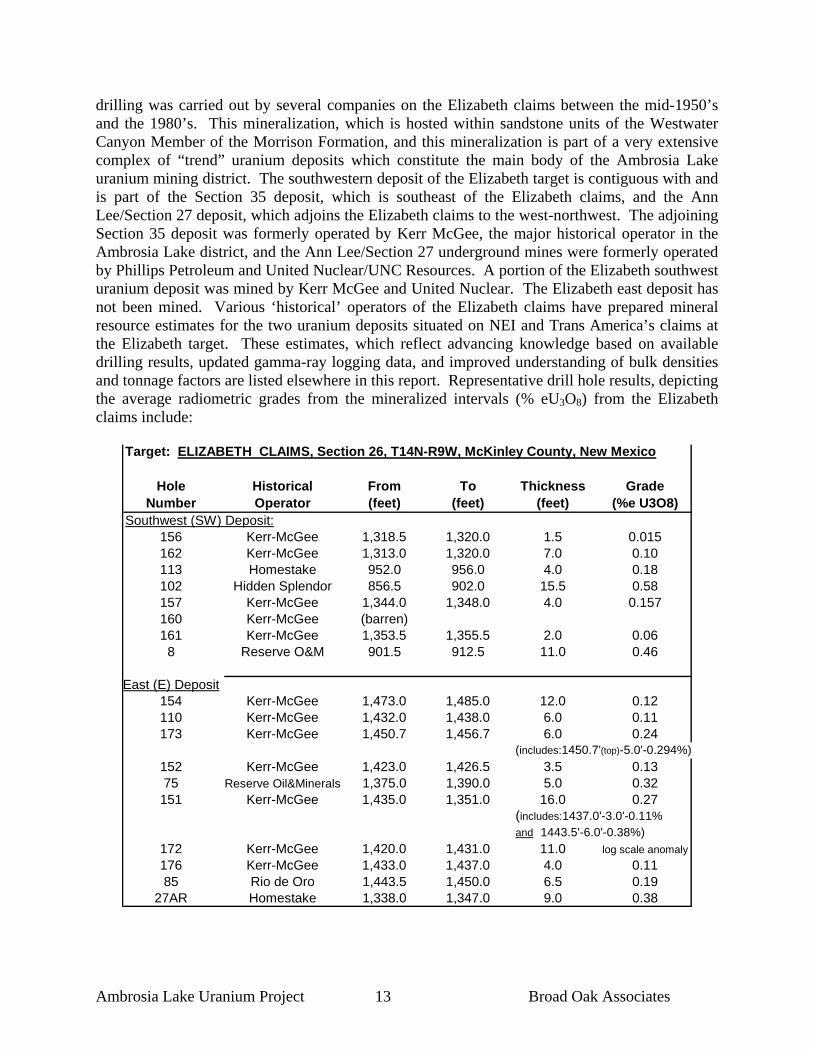
drilling was carried out by several companies on the Elizabeth claims between the mid-1950’s and the 1980’s. This mineralization, which is hosted within sandstone units of the Westwater Canyon Member of the Morrison Formation, and this mineralization is part of a very extensive complex of “trend” uranium deposits which constitute the main body of the Ambrosia Lake uranium mining district. The southwestern deposit of the Elizabeth target is contiguous with and is part of the Section 35 deposit, which is southeast of the Elizabeth claims, and the Ann Lee/Section 27 deposit, which adjoins the Elizabeth claims to the west-northwest. The adjoining Section 35 deposit was formerly operated by Kerr McGee, the major historical operator in the Ambrosia Lake district, and the Ann Lee/Section 27 underground mines were formerly operated by Phillips Petroleum and United Nuclear/UNC Resources. A portion of the Elizabeth southwest uranium deposit was mined by Kerr McGee and United Nuclear. The Elizabeth east deposit has not been mined. Various ‘historical’ operators of the Elizabeth claims have prepared mineral resource estimates for the two uranium deposits situated on NEI and Trans America’s claims at the Elizabeth target. These estimates, which reflect advancing knowledge based on available drilling results, updated gamma-ray logging data, and improved understanding of bulk densities and tonnage factors are listed elsewhere in this report. Representative drill hole results, depicting the average radiometric grades from the mineralized intervals (% eU3O8) from the Elizabeth claims include:
Target: ELIZABETH CLAIMS, Section 26, T14N-R9W, McKinley County, New Mexico
Hole Historical From To Thickness GradeNumber Operator (feet) (feet) (feet) (%e U3O8)
Southwest (SW) Deposit:156 Kerr-McGee 1,318.5 1,320.0 1.5 0.015162 Kerr-McGee 1,313.0 1,320.0 7.0 0.10113 Homestake 952.0 956.0 4.0 0.18102 Hidden Splendor 856.5 902.0 15.5 0.58157 Kerr-McGee 1,344.0 1,348.0 4.0 0.157160 Kerr-McGee (barren)161 Kerr-McGee 1,353.5 1,355.5 2.0 0.06
8 Reserve O&M 901.5 912.5 11.0 0.46
East (E) Deposit154 Kerr-McGee 1,473.0 1,485.0 12.0 0.12110 Kerr-McGee 1,432.0 1,438.0 6.0 0.11173 Kerr-McGee 1,450.7 1,456.7 6.0 0.24
(includes:1450.7'(top)-5.0'-0.294%)152 Kerr-McGee 1,423.0 1,426.5 3.5 0.1375 Reserve Oil&Minerals 1,375.0 1,390.0 5.0 0.32
151 Kerr-McGee 1,435.0 1,351.0 16.0 0.27(includes:1437.0'-3.0'-0.11%and 1443.5'-6.0'-0.38%)
172 Kerr-McGee 1,420.0 1,431.0 11.0 log scale anomaly176 Kerr-McGee 1,433.0 1,437.0 4.0 0.1185 Rio de Oro 1,443.5 1,450.0 6.5 0.19
27AR Homestake 1,338.0 1,347.0 9.0 0.38

Ambrosia Lake Uranium Project 14 Broad Oak Associates
8.3 Mesa Redonda The Mesa Redonda target, which is situated in Sections 6, 8, and 18, Township 14 North, Range 10 West, on the western edge of the Ambrosia Lake mining district is reported (McLemore and Chenoweth, 1991) to host several discrete uranium deposits in the Poison Canyon sandstone unit of the Morrison Formation (M. W. Coleman, 2008, personal communication). Detailed exploration drilling was carried out in the Mesa Redonda area by Pathfinder Mines and private interests in the late 1970’s and early 1980’s. Strong uranium mineralization was encountered in numerous drill holes on the Mesa Redonda properties, but neither NEI nor Trans America have any historical mineral resource estimates for the properties. The following table depicts average radiometric grades (% eU3O8) from historical drilling on the Mesa Redonda properties:
Target: MESA REDONDA Sections 6, 8, and 18, T14N-R10W, McKinley Co., New Mexico
Hole Historical From To Thickness GradeNumber Operator (feet) (feet) (feet) (%e U3O8)8-17-C Devilliers Nuclear 1,167.5 1,172.0 4.5 0.2878-68 Devilliers Nuclear 1,153.0 1,156.0 3.0 0.04
1,164.5 1,179.0 14.5 0.178-69 Devilliers Nuclear 1,138.0 1,145.0 7.0 0.06
1,159.0 1,167.5 8.5 0.648-305-Z-15 Homestake-UNC 1,059.5 1,100.5 1.0 0.064
1,113.5 1,115.5 2.0 0.05PM-14-10-8-1 Pathfinder Mines 1,155.0 1,161.5 6.5 0.103
1,166.5 1,170.0 3.5 0.159PM-14-10-8-3 Pathfinder Mines 1,173.0 1,180.0 7.0 0.52
(includes : 1174.5'-2.0'-0.788%)PM-14-10-8-5 Pathfinder Mines 1,177.0 1,180.0 3.5 0.19PM-14-10-8-6 Pathfinder Mines 1,166.0 1,170.5 4.5 0.53PM-14-10-8-7 Pathfinder Mines 1,174.5 1,183.0 8.5 0.16PM-14-10-8-8 Pathfinder Mines 1,185.0 1,186.5 1.5 0.13
1,194.0 1,194.5 0.5 0.13PM-14-10-8-9 Pathfinder Mines 1,205.0 1,206.0 1.0 0.195PM-14-10-8-10 Pathfinder Mines 1,216.0 1,218.5 2.5 0.144PM-14-10-8-13 Pathfinder Mines 1,177.5 1,179.5 2.0 0.142
R8-1 Ree-Co 1,138.0 1,144.5 6.5 0.0461,147.0 1,153.5 6.5 0.356
8.4 West Endy The West Endy target is comprised of two blocks of unpatented lode mining claims (the Endy and Zac claims) and one State of New Mexico general mining lease (site of the inactive Cliffside mine). At least 97 exploration holes have been drilled on the Endy and Zac claims by various companies (particularly Enerdyne Corporation, Homestake Mining Company and United Nuclear) since that time (Nakaoka, 1989). Zones of uranium mineralization have been outlined by drilling on the Endy and adjoining Zac claims in the “Frosty-Ox” area, Section 31, Township 14 North, Range 8 West; two discrete areas of mineralization in the west half of Section 6, Township 13 North, Range 8 West; and an area of mineralization in the southwest quarter of

Ambrosia Lake Uranium Project 15 Broad Oak Associates
Section 11, Township 13 North, Range 8 West. NEI holds copies of gamma ray logs for each of these mineralized areas. Average radiometric grades (% eU3O8) from representative historical drill holes in the West Endy target include:
Target: WEST ENDY/ZAC CLAIMS, Section 31, T14N-R8W, McKinley Co., New MexicoHole Historical From To Thickness Grade
Number Operator (feet) (feet) (feet) (% eU3O8)2904 United Nuclear 1,523.5 1,525.0 1.5 0.08
1,546.0 1,550.0 4.0 0.181,568.5 1,570.0 1.5 0.07
RW-2 Enerdyne Corp. 1,598.0 1,626.5 28.5 0.159(includes : 1,611.0'(top)-15.5’-.258)
1,642.5 1,644.5 2.0 0.031,647.5 1,663.5 16.0 0.2571,668.0 1,670.0 2.0 0.08
RW-10 Enerdyne Corp. 1,567.5 1,570.0 2.5 0.071,583.0 1,592.0 9.0 0.381,607.0 1,612.0 5.0 0.321,612.0 1,614.5 2.5 0.12
EE.3-26.1 Homestake Mining 1,642.5 1,645.0 2.5 0.0471,683.5 1,691.0 7.5 0.1241,703.5 1,709.0 5.5 0.182
(includes : 1703.5'-2.5'-0.246% and 1708.0'-1.0'-0.384%)
1,727.0 1,729.0 2.0 0.02431-DD.7-36.6C Homestake 1,727.0 1,743.5 16.5 0.144
(includes : 1,740-3.5'-0.289% and 1727-12.5'-0.115%)
31-HH.1-41.4 Homestake 1,996.5 1,999.0 2.5 0.0982,011.5 2,017.0 5.5 0.0512,021.0 2,027.0 6.0 0.201
2809 United Nuclear 1,689.5 1,708.0 18.5 0.2853002 United Nuclear 1,555.5 1,562.5 7.0 0.08
1,579.0 1,588.0 9.0 0.15 The Cliffside mine lease, which encompasses Section 36, Township 14 North, Range 9 West, is the site of the inactive Cliffside underground mine that was discovered in 1956, and brought into production in 1960 (Clark and Havenstrite, 1963). The Cliffside mine was one of the last mines to operate in the area, and was closed in 1985 (Chenoweth, 1989). Total production from the mine has been reported to be over 6 million pounds of U3O8 at an average grade of 0.41% U3O8 (McLemore and Chenoweth, 1991). Additionally, the West Endy target completely surrounds the eight mining claims that cover the Melrich uranium deposit of Laramide Resources, which is located in Section32, Township 14 North, Range 8 West. A mineral resource estimate for the western segment of the Frosty Ox deposit was prepared in 1989 by Robert Nakaoka of Geo-Management, Inc. on behalf of the property owner, Enerdyne Corporation. This estimate was prepared prior to the adoption of National Instrument 43-101. The resource estimate was prepared prior to the adoption of any current reserve and resource codes, particularly the current CIM code. As such, these resources cannot be classified under

Ambrosia Lake Uranium Project 16 Broad Oak Associates
this code. The Geo-Management resource estimate was prepared using geological and gamma-ray logs from fourteen holes that were drilled at the Frosty–Ox deposit, utilizing estimation methodology developed by the technical staff of Kerr-McGee Oil Industries, the principal exploration and mining operator in the Grants district at the time (Nakaoka, 1989). The criteria employed to develop the historical estimate were:
1. Radiometric assays were determined from gamma-ray logs of drill holes (% eU3O8); 2. A grade-thickness (radiometric grade times thickness) cut-off of 0.50 was utilized; 3. “Ore blocks” were defined with an outline of a fifty-foot radius, or half the distance to
the nearest hole (whichever was less); and 4. A tonnage factor of 15.00 cubic feet per short ton was used.
A “mineral resource” (not NI 43-101 compliant) of 303,685 short tons averaging 0.165% eU3O8, and containing 1,002,160 pounds of U3O8 was calculated for the “Frosty-Ox” deposit. These estimated resources were not segregated by any then-known classification, or by any current resource classification. Although historical maps indicated the presence of uranium mineralization in many more than the fourteen holes included in the estimate, data from these additional holes could not be verified at the time of the preparation of the resource estimate, and was not included in this historical resource estimate. Also, it is not clear that the data (that NEI holds) from these other drill holes were available to Geo-Management when they prepared the historical resource estimate. The author of this report has reviewed the resource estimation report, and the gamma-ray logs utilized in the preparation of the estimate, and have concluded that the data and the subsequent report are both reliable and relevant to the evaluation of the Ambrosia Lake project. Other exploration drilling on the Endy claim block encountered significant uranium mineralization adjoining the area for which the historical resource estimate was made. These additional historical drill holes (some of which are depicted on the accompanying longitudinal section), however, indicate potential for the discovery of additional mineralization of a similar tenor on the property. All resource estimates quoted herein are based on data and reports obtained and prepared by previous operators. This historic resource estimate is considered to be relevant, and is believed to be reliable based on the amount and quality of historic work completed. The Company has not completed the work necessary to independently verify the classification of the mineral resource estimates. Neither NEI, Trans America, nor Broad Oak are treating the mineral resource estimates as National Instrument 43-101 defined resources verified by a qualified person.

Ambrosia Lake Uranium Project 17 Broad Oak Associates
9.0 Geological Setting The Ambrosia Lake project is situated within the Grants mineral belt, on the southern flank of the San Juan Basin. The basin is a significant geological and topographic feature that covers much of the northwest portion of the state of New Mexico, and is a major geological and physiographic feature of the Colorado Plateau geologic province. The mineral belt is a west-northwest trending zone of sandstone-hosted (and some limestone-hosted deposits) uranium deposits that extends from the western edge of the Rio Grande Rift, east of the town of Laguna, west-north-westerly to the vicinity of the town of Gallup, for a distance of more than 100 miles (161 kilometres). Locally the belt attains a width of approximately 25 miles (40 kilometres). This belt of deposits includes mining districts north of Laguna, the Ambrosia Lake-San Mateo area (north of Grants), Smith Lake, Crownpoint, and Church Rock. Collectively, the deposits of the belt have provided more than 44 percent of all uranium produced in the United States, and approximately 20 percent of the free world’s uranium (Wright, 1980). One of the districts in the mineral belt, Ambrosia Lake, has produced nearly 190 million pounds of U3O8 (Chenoweth, 1989). Stratigraphy The principal uranium deposits of the Grants mineral belt (which includes the Ambrosia Lake project area) are hosted in fluvial sandstones of the Jurassic-aged Morrison Formation. The Morrison Formation has been subdivided into three formal Members (in ascending order):
• The Recapture Member is the lower-most unit of the Morrison Formation. The unit ranges from 70 to 250 feet (21 to 76 metres) in thickness in the Ambrosia Lake area, although it may locally be absent due to “scouring” by channels of the overlying Westwater Canyon Member. In the Ambrosia Lake area the Recapture Member is composed of clayey sandstone, sandy claystone, eolian sandstone, claystone and siltstone. The clayey sandstones and sandy claystones are pale red to “dusky” red in color, while the claystones and siltstones are reddish brown with mottled shades of grey. The sandstones are fine-grained and generally quartzose in composition, and are white to various shades of greenish, yellowish to purplish grey in color. The sandstones are moderately-to-poorly sorted. An upper-most sandstone lens is arkosic in composition and is light grey to orange-grey in color. This unit is lithologically identical to sandstones in the overlying Westwater Canyon Member (Santos, 1970), and may be difficult to distinguish from the Westwater Canyon;
• The Westwater Canyon Member overlies the Recapture Member, and is the principal unit
of economic interest in the Ambrosia Lake project area. The unit ranges from 90 to 290 feet (27.4 to 88.4 metres) in thickness in the Ambrosia Lake district. It regularly forms “ledgy” cliffs and grit-covered slopes. It ranges from red, reddish-grey, to yellowish-grey on outcrop and is reddish to grey in the subsurface, depending upon the oxidation state of the unit. It is a fine to very fine grained, and also contains locally conglomeratic, poorly sorted friable feldspathic sandstones (Condon and Peterson, 1986), and contains local zones and interbeds of variegated mudstone. The Westwater Canyon Member was deposited in a braided stream, fluvial environment;

Ambrosia Lake Uranium Project 18 Broad Oak Associates
Fig. 3, Stratigraphic Section

Ambrosia Lake Uranium Project 19 Broad Oak Associates
• A prominent sandstone, the Poison Canyon sandstone, of local usage, which hosts significant uranium deposits in the southern part of the Ambrosia Lake district, is present in the upper-most part of the Westwater Canyon, and it interfingers with the overlying Brushy Basin Member. There is some debate about the Poison Canyon, and whether it is an upper-most “tongue” of sandstone at the top of the Westwater Canyon Member or a distinct sandstone body in the lower portion of the overlying Brushy Basin Member. The Poison Canyon sandstone is approximately 20 to 90 feet (6 to 27 metres) thick, and is compositionally similar to sandstones of the Westwater Canyon (Santos, 1970).; and
• The upper-most unit of the Morrison Formation is the Brushy Basin member, which
ranges from 40 to 220 feet (12 to 67 metres) in thickness, overlies the Westwater Canyon member, and inter-fingers with the Poison Canyon sandstone. The unit attains a thickness of 40 to 220 feet (12 to 67 metres) and is predominantly clay facies, and ranges from claystone to very fine grained sandstones.
The Cretaceous-age Dakota Sandstone overlies the Brushy Basin Member of the Morrison Formation throughout the project area. The Dakota ranges from 135 to 250 feet (41 to 76 metres) in thickness. Overlying the Dakota is the Cretaceous-age Mancos Shale, a thick sequence (695 to 800 feet, or 212 to 244 metres) of shale with minor sandstones. The Gallup Sandstone and Crevasse Canyon Formation overly the Mancos Shale, particularly on the east side of the project area. Structure The project area is on the south flank of the San Juan Basin, an area that has been named the Chaco Slope. Regionally, the sediments on the south flank of the basin dip to the north and northeast into the basin, but dips have been modified locally by folds. The Ambrosia Lake area is the most structurally disrupted portion of the Chaco Slope (Santos, 1970), with numerous folds and faults in the area. Folds of particular importance include the Ambrosia Dome, an asymmetrical fold with steep dips on its south flank, and the similar San Mateo dome, which is located north of the Endy and Zac claims (Santos, 1966a). The project area is cut by numerous high angle faults that strike from north 10 degrees west to north 40 degrees east (Falkowski, 1980). Faults are generally down-dropped to the east (Santos, 1966a, 1966b, Santos and Thaden, 1966). Of particular note are the San Mateo and parallel San Rafael fault zones, which strike northeast and are down-dropped to the east-southeast. The San Mateo fault, which is on the western-most portion of the Ambrosia Lake project area, is the eastern boundary of a horst (Hazlett and Kreek, 1963). There is a major “tongue” of oxidation that extends toward the San Juan Basin for a distance of several thousand feet between the San Mateo and San Rafael fault zones, and it appears that these structures controlled the migration of oxidizing groundwater into the San Juan Basin.

Ambrosia Lake Uranium Project 20 Broad Oak Associates
10.0 Deposit Types Uranium mineralization in the Grants mineral belt (which includes the Ambrosia Lake-San Mateo district that encompasses the Ambrosia Lake project) occurs as sandstone-hosted deposits hosted primarily in fluvial clastic units of the Jurassic-aged Morrison Formation. Two major types of sandstone-hosted deposits have been identified in the area (Kittel, Kelley, and Melancon, 1967; Granger and Santos, 1986):
• Trend deposits, which have also been described as “pre-fault”, “primary” or “roll”. The trend deposits occur as broad, undulating layers of uranium mineralization controlled primarily by the stratigraphic characteristics of the host sandstones. Mineralization in the trend deposits was localized by humic acids (humates) which acted as the reductants to precipitate uranium from ground water; and
• Redistributed deposits, which have also been described as “post-fault”, “stack”, or
“secondary” deposits are irregularly shaped zones of mineralization that were controlled by both the stratigraphic characteristics of the host rocks, as well as structural features. The redistributed deposits are the product of destruction (or remobilization) of trend uranium deposits by oxidation, and have little, if any, humate remaining associated with the mineralization. Some geologic evidence suggests that a number of the redistributed deposits, including some on NEI and Trans America’s properties, have geological and geochemical characteristics that are very similar to “roll-front” deposits of Wyoming and south Texas.
Individual uranium deposits in the project area range in size from a few tons to several million tons. The deposits are roughly tabular and irregular in shape, and may be elongate in a west-northwest direction (reflecting some of the characteristics of the host channel sandstone units of the Westwater Canyon Member of the Morrison Formation). Individual deposits range in size from a few feet in width and length to deposits which may be several tens of feet in thickness, several hundred feet in width, and several thousand feet in length (Fitch, 1980).

Ambrosia Lake Uranium Project 21 Broad Oak Associates
11.0 Mineralization
Historical exploration drilling information, which was carried out prior to the adoption of National Instrument 43-101 , indicates numerous zones of uranium mineralization are present on the subject properties, including areas at the East Roca Honda, Elizabeth, Mesa Redonda and West Endy target areas. All of the important uranium mineralization in the project area is hosted in the Westwater Canyon member of the Morrison Formation, except at Mesa Redonda, where mineralization is hosted in the Poison Canyon sandstone unit of the Morrison Formation. 11.1 East Roca Honda Wide-spaced exploration drilling undertaken by the minerals division of Continental Oil Company (Conoco) and Homestake Mining Company during the late 1970’s and early 1980’s in Section 11, Township 13 North, Range 8 West (the East Roca Honda target) intersected a south-easterly extension of the adjoining Roca Honda deposit of Strathmore Minerals. The shape and orientation of the adjoining Roca Honda deposit (as well as the portion of the deposit situated on NEI’s claims) suggests that the Roca Honda and East Roca Honda mineral system is a “trend” deposit, although the nature of the mineralization and possible association with humate is not clear at this time. The drilling carried out in the late 1970’s and early 1980’s by Conoco and Homestake on NEI’s leased property has outlined a zone of strong uranium mineralization over a strike length of at approximately 4,000 feet (1,219 metres) and a width of approximately 400 to 700 feet (152 to 213 metres). The uranium mineralization in Section 11 is at depths ranging from 2,572 to 3,190 feet (784 to 972 metres), in the following holes: The following longitudinal section depicts the continuity and grades of uranium mineralization within the East Roca Honda mineralized zone. Accompanying this longitudinal section is a map displaying the location of the section, as well as the location of the Conoco and Homestake drill holes in the East Roca Honda target area.

Ambrosia Lake Uranium Project 22 Broad Oak Associates
Fig. 4, Project Map and Drill Hole Cross Section Index

Ambrosia Lake Uranium Project 23 Broad Oak Associates
Fig.5, East Roca Honda Longitudinal Section

Ambrosia Lake Uranium Project 24 Broad Oak Associates
Target: EAST ROCA HONDA, Section 11, T13N-R8W, McKinley County, New Mexico
Hole Historical From To Thickness GradeNumber Operator (feet) (feet) (feet) (%e U3O8)
9-11-13-8 CONOCO 2,631.0 2,654.0 23.0Very thick gamma rerun zone
(includes :2,640'(top)-10.0'-0.30%)11-R-9 Homestake Mining 2,767.0 2,781.0 14.0 0.292
11-11-13-8 CONOCO 2,902.5 2,908.5 6.0 0.18(includes : 2003.0'-3.0'-0.22)
2,915.5 2,921.5 6.0 0.0212-11-13-8 CONOCO 2,942.5' 2,967.0 24.5 0.17
(includes: 2,952.0'-6.0'-0.26%)2,980.0 2,982.0 2.0 0.012,984.5 2,988.0 3.5 0.03
13-11-13-8 CONOCO 2,956.0 2,985.0 29.0 0.1214-11-13-8 CONOCO 2,960.0 2,982.0 22.0' 0.04
(includes : 2962.0'-6.0'-0.08%)3-11-13-8 CONOCO 2,572.0 2,580.0 8.0 0.06
2,591.0 2,606.5 15.5 0.15(includes : 2600.0'-6.5'-0.20%)
2-11-13-8 CONOCO 2,694.0 2,697.5 3.5 0.067-11-13-8 CONOCO 2,918.0 2,923.0 5.0 0.061-11-13-8 CONOCO 3,033.0 3,054.0 21.0 0.01
3,188.0 3,190.0 2.0 0.07 The historical exploration drill hole data of Conoco and Homestake at East Roca Honda, which includes gamma ray logs from the subject drill holes (and hole locations verified in the field) suggests the presence of an exploration target that may range from 2.75 to 4.5 million short tons in size, and have a grade range of 0.175 to 0.225% U3O8. This exploration target has the potential to host between 9.625 and 20.25 million pounds of U3O8. This projection of exploration potential at East Roca Honda is based upon the projected strike length of the mineralized zone defined by the CONOCO and Homestake drill holes, as well as the thickness of the mineralized horizon and the width of the target zone, as defined by flanking unmineralized drill holes. The projection of potential is also based upon the geological model of tabular uranium deposits that are common in the Ambrosia Lake mining district.

Ambrosia Lake Uranium Project 25 Broad Oak Associates
11.2 Elizabeth There are two known zones of uranium mineralization at the Elizabeth target, which is situated in the south half of Section 26, Township 14 North, Range 9 West. Considerable exploration drilling was carried out on the Elizabeth claims between the mid-1950’s and the early 1980’s. This mineralization, which is hosted within sandstone units of the Westwater Canyon Member of the Morrison Formation, is part of a very extensive complex of “trend” uranium deposits which constitute the main body of the Ambrosia Lake uranium mining district. The southwestern deposit of the Elizabeth target is contiguous with and is part of the Section 35 deposit, which is southeast of the Elizabeth claims, and the Ann Lee/Section 27 deposit, which adjoins the Elizabeth claims to the west-northwest. The adjoining Section 35 deposit was formerly operated by Kerr McGee, the major historical operator in the Ambrosia Lake district, and the Ann Lee/Section 27 underground mines were formerly operated by Phillips Petroleum and United Nuclear/UNC Resources. A portion of the Elizabeth southwest uranium deposit was mined by Kerr McGee and United Nuclear. The Elizabeth east deposit has not been mined. The southwest mineralized area hosts tabular, reduced, primary trend ores, and possibly because the east deposit may be associated with local faulting, this mineralized body is characterized by thicker, potentially redistributed deposits resembling ‘stack’ ore. There may be oxidation roll front processes present, as some of the geophysical drill hole logs from the east area demonstrate ‘tails & spikes’ at the top and bottom of sandstone lenses, and ‘noses’ of thick ore grade mineralization down dip. If confirmation and exploration drilling demonstrates the east deposit to be redistributed, the area may prove to be amenable to leaching and in-situ recovery mining methods (ISR). Various ‘historical’ operators of the Elizabeth claims have prepared mineral resource estimates for the two uranium deposits situated on NEI’s claims at the Elizabeth target. These historical estimates, which reflect advancing knowledge based on available drilling results, updated gamma-ray logging data, and improved understanding of bulk densities and tonnage factors. The following table outlines the various historical mineral resources estimates:

Ambrosia Lake Uranium Project 26 Broad Oak Associates
Table Elizabeth Claims: Historic Mineral Resource Estimations (NOT 43-101 COMPLIANT)
Author Date TonsGrade % eU3O8 Pounds U3O8
Rock density factor utilized Criteria/ Comments
1.)John Q. St Clair (for Parador Mining, Inc.) Feb-58
SW: 395,191 0.30%
SW deposit: 2,286,591
14.0 cubic feet/ ton
Reserves calculated only for SW cor. 26; based on 85 holes; no drift info; cutoffs: 4.0'/0.13%; dilution factor 10%.
2.)St. Clair (updated for
Parador) Jun-58SW :
426,117 0.30%SW: 2,579,944 as above
Revision of 2/58 SW estimate: deposit expanded due to subsequent drilling; recalc'd. 10 key holes to new probe calib'n. Stds.; utilized drift info and repositioning of reserve polygons.
3.)
Hidden Splendor Mines (for Atlas Minerals) late 1958
SW: 2,050,000 a.a.
Presumed to be total project reserve. Reserve figure filed by HS under 1958 AEC Reserve Allocation Program;
4.)Henry Viscaino (for Kerr-McGee) 2-20-60
SW : 426,117 E: 96,766
SW : 0.303% E: 0.222%
SW: 2,579,994; & E: 429,289; Total = 3,009,283 a.a.
First reserves estimate to also include the East deposit; 10% dilution factor.
5.)
W.D. Collins (for Hidden Splendor / Atlas) 1-25-61
SW : 165900 0.242% SW : 802956 presumed a.a.
SW deposit area only; utilized a 20% dilution factor;
6.) Bokum Resources late 1960sSW :
713,215 0.196%SW : 2,807,900 a.a.(?)
SW deposit only, with their (unknown) estimate of prev. mining removed;
7.)
Colorado School of Mines Research Institute
date unknown but post-1972
SW : 409,426 E: 224,346
SW: 0.234%; E: 0.287%
SW: 2,105,619; E: 1,416,515; Total = 3,522,134
15.0 cubic ft./ ton
Computerized reserve study based on drilling thru 1972; data provided by Schultze; 10% dilution/90% extraction applied; unspecified previous prod'n. factored in.
8.) Bokum/K-Mc J.V. 1976Total = 1,102,139 0.19%
Total = 4,164,294 presumed a.a.
Includes 29 new holes. The project's total reserves were listed in Bokum's 1976 Annual Report. Estimated previous mining production was removed from the reserve estimate.
9.)Ray Schultze (for Parador Mining, Inc.) 1976 1,056,800 0.231%
Total = 4,945,824
Revised factor of 15.0 cubic
ft./ ton applied;
Utilized 172 gamma logs; avg. ore thickness=7.0 ft.; 15% dilution factor & GT cutoff of 4'/ .07% applied; but past production was not accounted for.
10.)Ray Schultze (for Parador Mining, Inc.) 1981 1,056,800 0.23%
Total = 4,945,824
15.0 cubic ft./ ton
Avg. ore thickness of 7.0 ft., GT cutoff of 4.0'/0.07%, and a 15% dilution factor applied.
11.)
Ray Schultze (correspondence with E. Adoor, Parador Mining, Inc.) 8-28-85
Total (SW + E) =
924,198 tons 0.24%
Total = *4,440,605 pounds*
Adjustments to the latest reserve estimate are the result of acquisition of the most complete information about past production, to date, conveyed to Schultze by former K-M manager, Hal Whitacre.
*Conclusion: The Bokum/Kerr-McGee reserve estimation in 1976 (at 4,164,294 lbs U3O8; with past production accounted for), is comparable to Schultze's final correspondence with Parador, if the generally accepted figure of 505,219 lbs. U3O8 in past production is subtracted from his 1981 reserves estimate, resulting in his 1985 total of 4,440,605 contained pounds U3O8 in both the Southwest and East Deposits.
11.3 Mesa Redonda Published data (McLemore and Chenoweth, 1991) indicate the presence of unmined uranium deposits on the BRK claims at Mesa Redonda, in Sections 6, 8, and 18, Township 14 North, Range 10 West. Neutron Energy, Inc. has numerous gamma-ray logs for mineralized drill holes from these areas, but is not in possession of any historical resource estimate reports.

Ambrosia Lake Uranium Project 27 Broad Oak Associates
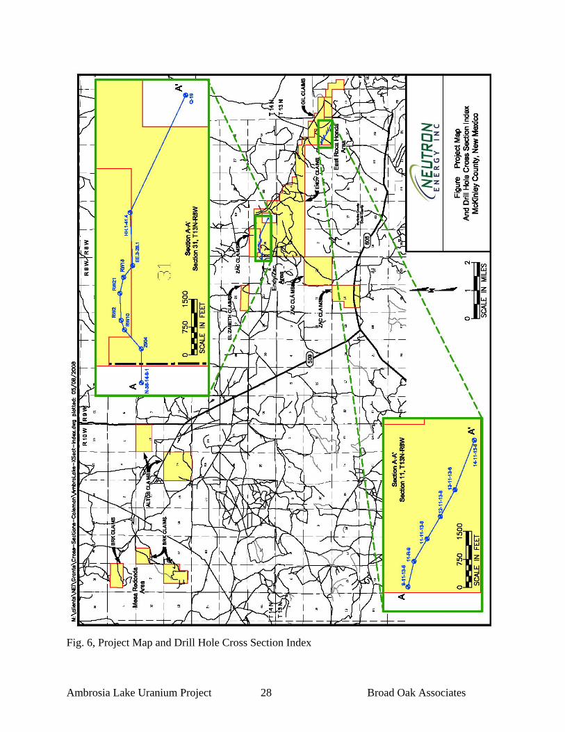
11.4 West Endy The West Endy target area includes the Frosty-Ox deposit, which is a generally east-west trending zone of mineralization that is located on the northwest boundary of the Endy and Zac claims. This mineralized zone appears to extend to the west onto the eastern end of the adjoining Cliffside mine State mineral lease. Within this deposit are two separate lenses of mineralization in sands (designated UB-1 and LB-2) of the upper portion of the Westwater Canyon, and these mineralized lenses overlap each other. Significant mineralization (stated uranium grades are average radiometric grades, utilizing a grade-thickness cut off of 0.50) was intersected in many holes, including fourteen holes that were employed by Geo-Management in their ‘historic’ mineral resource estimate: Intercept Thickness Hole No. (Beginning feet) (feet) Grade (%eU3O8) Lens RW-2 1,611 15.5 0.258 UB-1 1,647.5 16.0 0.257 LB-2 RW-7 1,592 8.0 0.33 UB-1 RW-8 29.0 0.062 UB-1 RW-10 1,589 27.0 0.23 LB-2 RW-12 1,677 6.0 0.23 LB-2 RW-15 1,622 8.0 0.10 UB-1 3002 1,555.5 7.0 0.08 UB-1 1,579 9.0 0.15 LB-2 3105 1,515 16.0 0.12 UB-1 1,588 9.0 0.19 LB-2 2904 1,548 6.0 0.12 UB-1 2809 1,689.5 18.5 0.285 LB-2 P-1 13.5 0.055 ? 19.0 0.077 LB-1 CC.1-1.1 1,572 20.0 0.121 LB-1 DD.6-5.5 1,543 16.0 0.111 UB-1 1,572 11.0 0.076 LB-2 BB-0.8 19.0 0.062 LB-1
Ambrosia Lake Uranium Project 28 Broad Oak Associates
Fig. 6, Project Map and Drill Hole Cross Section Index

Ambrosia Lake Uranium Project 29 Broad Oak Associates
Fig. 7, West Endy Longitudinal Section

Ambrosia Lake Uranium Project 30 Broad Oak Associates
The mineralization appears to correlate from hole to hole within the respective lenses, although additional drilling may be needed to confirm this observation. The orientation of the mineralized lenses in this deposit do not appear to follow that of typical “trend” deposits elsewhere in the Ambrosia Lake district (west-northwest), and more closely approximate the strike of several of the faults (although there are no faults with a strong northeast grain in the immediate vicinity of this mineralized zone) in the general vicinity. It is not clear, therefore, if the Frosty-Ox deposit is a trend or redistributed uranium deposit. The Frosty-Ox mineralized zone is situated within a broad tongue of oxidation that is located between the San Mateo and San Rafael fault zones. An historical “mineral resource” estimate (prepared by an independent third party) of 303,685 short tons averaging 0.165% eU3O8, containing 1,002,160 pounds of U3O8, was calculated for the “Frosty-Ox” deposit in the West Endy target area of the Ambrosia Lake project area. Other uranium deposits in the immediate vicinity (for instance, the Melrich deposit) also demonstrate more random orientations than the “trend” deposits west of the San Mateo fault, suggesting that these additional mineralized bodies may be “redistributed” rather than “trend” deposits. Data covering the adjoining State of New Mexico General Mining Lease (the “Cliffside mine” property) suggests that the Frosty-Ox deposit continues west onto the eastern portion of the State lease. Among the mineralized holes present on the east side of the Cliffside mine are: Hole No. Thickness(feet) Grade (%eU3O8) M 73 6.0 0.16 and 2.0 0.13 and 3.0 0.16 V 13 4.5 0.52 W 11 8.0 0.23 W 12 4.0 0.33 and 8.0 0.32 W 13 5.0 0.22 X 11 2.0 0.21 and 3.0 0.10 X 12 9.0 0.10 and 11.0 0.27 and 11.0 0.07 and 8.0 0.20 40 5.5 0.10 and 13.0 0.30 81 6.0 0.21 161 8.5 0.49 163 7.0 0.11 164 10.0 0.205 165 6.0 0.13 and 27.0 0.45 and 9.5 0.18

Ambrosia Lake Uranium Project 31 Broad Oak Associates
168 3.0 0.12 170 3.0 0.13 172 4.0 0.12 X 11 2.0 0.21 and 3.0 0.10 Other zones of mineralization on the Endy claims are located in the west half of Section 6, and Section 11, Township 13 North, Range 8 West. The orientation of one of the pods of mineralization in Section 6 follows that of the “trend” deposits in the main part of the Ambrosia Lake area, while the controls for the other zone in Section 6 are not clear.
12.0 Exploration In 2007, NEI on behalf of Trans America, carried out a six hole exploration drilling program at the West Endy target, situated on the Cliffside mine State lease (Section 36, Township 14 North, Range 9 West). This program, which was designed to test for extensions of that portion of the Frosty – Ox that extends onto the Cliffside mine lease encountered uranium mineralization as follows (please note that all mineralization is the average grade, expressed as % eU3O8 for the entire mineralized interval):,
Target: CLIFFSIDE STATE SECTION 36, T14N-R9W, McKinley County, New Mexico
Hole Historical From To Thickness GradeNumber Operator (feet) (feet) (feet) (%e U3O8)
Neutron Energy, Inc. Drilling: (July,August, 2007)N-36-14-9-1 NEI 1,472.5 1,489.0 16.5 0.099
(includes: 1474.5'(top)-3.5'-0.078%and 1478.5'-8.5'-0.141%)
1,497.5 1,517.0 19.5 0.157(includes: 1498.5-15.0'-0.182%and 1514.0'-2.5'-0.104%)
N-36-14-9-2 NEI 1,494.5 1,506.0 11.5 0.087(includes: 1498'-2.0'-0.134%)and 1503.5'-1.5'-0.108%)
N-36-14-9-3 NEI 1,462.5 1,467.5 5.0 0.051(includes: 1463.0'-2.5'-0.068%)
1,488.0 1,489.5 1.5 0.04(includes: 1488.5'-0.5'-0.062%)
N-36-14-9-4 NEI 1,413.0 1,414.5 1.5 0.02461,439.5 1,442.5 3.0 0.0261,443.0 1,445.5 2.50 0.052
(includes: 1443.5-1.5-.0702%)N-36-14-9-5 NEI 1,445.5 1,446.5 1.0 0.0398
All radiometric grades were calculated from gamma-ray logs that were run by Colog, an independent geophysical and down-hole logging contractor from Denver, Colorado, using Mount Sopris gross-gamma logging equipment and methodologies that are standard techniques

Ambrosia Lake Uranium Project 32 Broad Oak Associates
currently employed by the US uranium industry. No chemical assays have been performed on the drill cuttings from any of NEI’s holes.
13.0 Drilling As outlined in Section 12.0 “Exploration”, NEI, on behalf of Trans America, has completed one drilling program on a portion of the Ambrosia Lake project. Five conventional rotary drill holes, totalling 8,417 feet (2,565 metres) were completed on the project.
14.0 Sampling Method and Approach Exploration drilling carried out by the previous operators of the Ambrosia Lake project involved the use of conventional, or open-hole, rotary drilling to explore for and sample zones of uranium mineralization on the properties. Holes were designed to penetrate the target horizon, which is the Westwater Canyon Member of the Morrison Formation, and were terminated in the Recapture Member of the Morrison Formation. Samples of the rotary cuttings were collected at intervals of 5 or 10 feet (1.5 to 3.04 metres) and the samples were examined by a geologist, who prepared a lithologic log describing rock types, alteration, presence and nature of carbonaceous material, accessory minerals (including pyrite, hematite and/or limonite), oxidation state of the target sediments, and other geologic information. Drill cuttings samples were rarely used for geochemical analysis. The standard operating procedure in the US uranium industry during the time of the Ambrosia Lake exploration program was to continuously log each drill hole with a down-hole probe, which recorded gamma radioactivity, S-P (self potential), and single point resistivity values. Equivalent uranium (% eU3O8) grades, which are radiometric assays, were calculated from the resulting gamma ray logs using either the “half-amplitude” or 2KN calculation methods (Anonymous, 1973; Hallenburg, 1973, Fink, 1978; Parker. undated). As the target horizons on the Grants Uranium Project are at depths of 1,000 feet or more below the surface, neither NEI nor Trans America have collected any samples from the subject properties for geochemical analysis.
15.0 Sample Preparation, Analysis, and Security All of the historical drill holes completed in the Ambrosia Lake project area were logged with a continuous surface recording natural gamma-ray/S-P/resistivity probe unit. Gamma-ray log values were then used to calculate radiometric grades from all of the mineralized holes (Anonymous, 1973; Hallenburg, 1973, Fink, 1978; Parker. undated). Much of the gamma logging was done by Century Geophysical Corporation or Dalton Well Logging, experienced independent geophysical logging contractors, on behalf of Enerdyne Corporation, Homestake Mining Company, and United Nuclear Corporation. Additionally, some of the holes drilled on the properties by Homestake Mining and Pathfinder Mines Corporation were logged with company-owned equipment. The gamma logging equipment was periodically calibrated at “test pits” of the Department of Energy facilities near Grants, New Mexico and Grand Junction, Colorado. Although NEI has copies of the gamma-ray logs, it is not aware of any data to

Ambrosia Lake Uranium Project 33 Broad Oak Associates
indicate that core samples were collected from the mineralized horizons. The security of any samples would be that pertaining to industry standards prevailing at the time the samples were collected.
16.0 Data Verification Property Examination G. S. Carter visited the property on Wednesday February 22, 2006, and visits were made to several locations on the property to examine the geological setting and examine the different rocks where they outcropped. Mineralization from the deposits at the Ambrosia Lake project is not exposed at the surface, and underground mine workings are not currently accessible, therefore, no samples were collected for independent geochemical testing. Kelsey Boltz accompanied G. S. Carter on the site visit. However the author wishes to stress that all the available historical data for the property had not been prepared by any employees of NEI or Trans America. With the exception of the drill data relating to NEI’s 2007 drilling program on the West Endy/Cliffside target, all of the data cited in this report is of an historic nature, and was collected prior to the adoption of National Instrument 43-101. The author of this report has examined the cited data, including the gamma-ray/S-P/resistivity logs which served as the basis for the determination of radiometric assays for the mineralized zones. This data appears to meet the standards employed by the uranium exploration and mining industry in the United States at the time it was collected. The gamma-ray logging was done primarily by Century Geophysical Corporation and Dalton Well Logging, two very experienced and professional organizations who had a long history of providing logging services to the uranium industry. While the data which served as the basis for the historical resource estimates was not available for review and comparison, it is the author’s opinion that the historical work was undertaken under industry standards that prevailed at the time.
17.0 Adjacent Properties The project is situated within the Ambrosia Lake mining district, which is the largest producing mining district in the prolific Grants-Gallup mineral belt. There are numerous inactive underground uranium mines in the general vicinity of the project, and there are several mines and known mineral deposits which adjoin the project. Of particular note are the Mount Taylor uranium mine of Rio Grande Resources, which is located 1.5 miles south of the eastern end of the Endy and Gil claims (the East Roca Honda target of NEI), the undeveloped Roca Honda uranium project of Strathmore Minerals, which immediately adjoins the western edge of the East Roca Honda target , the Cliffside mine, which is contiguous with the western boundary of the Endy claims, and the Melrich deposit of Laramide Resources, which is completely surrounded by NEI’s claims in Section 32, Township 14 North, Range 8 West.

Ambrosia Lake Uranium Project 34 Broad Oak Associates
All of the adjoining properties contain uranium mineralization hosted by sandstone units of the Westwater Canyon member of the Morrison Formation, the same unit that hosts the uranium mineralization on the Grants project properties.
18.0 Mineral Processing and Metallurgical Testing Neither NEI, Trans America, nor Broad Oak are aware of any metallurgical tests, or process design studies carried out on mineralized samples from the Grants Project properties.
19.0 Mineral Resource and Mineral Reserve Estimates There are no NI 43-101 compliant reserves or resources on these properties.
20.0 Other Relevant Data and Information Broad Oak has no knowledge of other relevant data or information.
21.0 Interpretation and Conclusions While the cited resources attributable to the Grants Uranium Project are historical in nature, and have not been verified by NEI, Trans America, or Broad Oak, it is the opinion of the author that the historical estimates of uranium mineralization are both reliable and relevant to the evaluation of the project. Several of the properties that make up the Ambrosia Lake Project of NEI and Trans America host significant uranium mineralization, based on historical data, in the Poison Canyon sandstone and the Westwater Canyon Member of the Morrison Formation. The geology of these occurrences is very similar to that of most of the formerly producing mines of the prolific Ambrosia Lake mining district. While none of the mineralized zones reviewed by the author of this report have been sufficiently explored to determine if the outlined targets host ore deposits, it is clear from the available data that the mineralized targets are significant. These target zones require additional drilling to determine the full extent of the mineralization, as well as the continuity of mineralization between drill holes, and the effects (if any) of disequilibrium on the radiometric grades calculated from the gamma-ray logs. It appears from the data available on the Endy and Gil claims that two of the zones of uranium mineralization, the Frosty-Ox (West Endy) and East Roca Honda deposits, have not been fully constrained by drilling. The northeast trending Frosty-Ox deposit has been “closed off” by drilling to the northeast, but is not fully defined to the southwest, or along its margins to the north and south or westerly onto the adjoining Cliffside mine lease. The East Roca Honda mineralized zone has only been tested by thirteen holes in the south half of the Section, and only two of the holes are within 400 feet (122 metres) of each other.

Ambrosia Lake Uranium Project 35 Broad Oak Associates
22.0 Recommendations Geoffrey S. Carter, the Qualified Person preparing this Technical Report, believes that the character of this Grants Uranium Project is of sufficient merit to justify the following confirmation, exploration and evaluation drilling program at the four major target areas of the Ambrosia Lake project. The Ambrosia Lake project properties are well situated within the east Ambrosia Lake/San Mateo mining district of the Grants mineral belt - straddling the Ambrosia Lake mineral trend, and directly adjoining substantial uranium deposits at Roca Honda (south of the Endy claims) and the Melrich deposit (which is surrounded by the Endy and Gil claims). Historical drilling on the NEI controlled properties intersected strong uranium mineralization at the following locations within the Ambrosia Lake project:
1. At the East Roca Honda target, strong and wide-spread mineralization has been encountered in the Westwater Canyon Member, continuous with the adjoining Roca Honda project of Strathmore Minerals;
2. At the Elizabeth target, two zones of strong uranium mineralization have been outlined
in sandstones of the Westwater Canyon Member of the Morrison Formation;
3. At the Mesa Redonda target, significant mineralization has been intersected in the Poison Canyon sandstone; and
4. At the West Endy target, strong mineralization in the Westwater Canyon Member has been identified in several localities that were drilled previously. At one of the areas, the Frost–Ox deposit has been estimated (based upon historical data and reports) to contain approximately 1 million pounds of U3O8.
Based upon the analysis and geological assessment of considerable historical geological data it is clear that Ambrosia Lake is of considerable merit, and warrants substantial and first-hand geological, geochemical and geophysical work. The author of this report recommends the following work program for the Ambrosia Lake project:

Ambrosia Lake Uranium Project 36 Broad Oak Associates
• East Roca Honda Target:
A program of rotary and core drilling to confirm the historical drilling results, test the continuity of the known mineralized zones, and establish the physical limits of the mineralization at the East Roca Honda target is recommended. The program will require 51 drill holes of approximately 153,600 feet (46,817 metres) of rotary drilling and 2,500 feet (762 metres) of core “tails” on the rotary holes, as well as applicable geophysical logging, geochemical, geological and support services.
o Geological Services: (8 months @ $17,500/mo) $140,000 o Travel & Living: $35,000 o Permitting/Bonding: $300,000 o Surveying: $50,000 o Rotary Drilling: (151,100 ft @ $27.50/ft) $4,155,250 o Core Drilling: (2,500 ft @ $65/ft) $162,500 o Drill Hole Plugging: (151,100 ft @ $1.75/ft) $264,425 o Site Preparation & Reclamation: $100,000 o Geophysical Logging; (151,100 ft @ $1.00/ft) $151,100 o Geochemistry/Assaying: $75,000 o Support Services: (8 months @ $8,500/mo) $68,000
o Sub-Total, East Roca Honda: $5,501,275

Ambrosia Lake Uranium Project 37 Broad Oak Associates
Fig. 8, East Roca Honda Target

Ambrosia Lake Uranium Project 38 Broad Oak Associates
• Elizabeth Target:
A program of confirmation rotary and core drilling comprised of 30 holes is recommended for the Elizabeth target area. This program will be designed to confirm the results from the historical drilling programs and to further refine the limits of mineralization.
o Geological Services: (4 months @ $17,500/mo) $70,000 o Travel & Living: $15,000 o Permitting/Bonding: $75,000 o Surveying: $20,000 o Rotary Drilling: (53,000ft @ $23.50/ft) $1,245,500 o Core Drilling: (2,000 ft @ $65/ft) $130,000 o Drill Hole Plugging: (55,000 ft @ $1.75/ft) $96,250 o Site Preparation & Reclamation: $55,000 o Geophysical Logging; (55,000ft @ $1.00/ft) $55,000 o Geochemistry/Assaying: $50,000 o Support Services: (4 months @ $8,500/mo) $34,000
o Sub-Total, Elizabeth Target: $1,845,750

Ambrosia Lake Uranium Project 39 Broad Oak Associates
Fig. 9, Elizabeth Target

Ambrosia Lake Uranium Project 40 Broad Oak Associates
• Mesa Redonda Target:
A program that is designed to confirm the results from previous drilling at the Mesa Redonda target is recommended. This program is expected to require 25 rotary drill holes, with 5 “core tails”, for a combined total footage of 37,500 feet (11,430 metres).
o Geological Services: (4 months @ $17,500/mo) $70,000 o Travel & Living: $15,000 o Permitting/Bonding: $75,000 o Surveying: $20,000 o Rotary Drilling: (35,500ft @ $23.50/ft) $834,250 o Core Drilling: (2,000 ft @ $65/ft) $130,000 o Drill Hole Plugging: (37,500 ft @ $1.75/ft) $65,625 o Site Preparation & Reclamation: $125,000 o Geophysical Logging; (37,500ft @ $1.00/ft) $37,500 o Geochemistry/Assaying: $37,500 o Support Services: (4 months @ $8,500/mo) $34,000
o Sub-Total, Mesa Redonda Target: $1,443,875

Ambrosia Lake Uranium Project 41 Broad Oak Associates
Fig. 10, Mesa Redonda Target

Ambrosia Lake Uranium Project 42 Broad Oak Associates
• West Endy Target:
Considerable historical drilling has been carried out at the West Endy target area, and a significant confirmation drilling program is required for this target area. It is recommended that a 50 hole program of rotary and core drilling be undertaken at this target:
o Geological Services: (8 months @ $17,500/mo) $140,000 o Travel & Living: $35,000 o Permitting/Bonding: $150,000 o Surveying: $50,000 o Rotary Drilling: (90,500ft @ $23.50/ft) $2,126,750 o Core Drilling: (2,000 ft @ $65/ft) $130,000 o Drill Hole Plugging: (92,500 ft @ $1.75/ft) $161,875 o Site Preparation & Reclamation: $125,000 o Geophysical Logging; (92,500ft @ $1.00/ft) $92,500 o Geochemistry/Assaying: $40,000 o Support Services: (8 months @ $8,500/mo) $68,000
o Sub-Total, West Endy Target: $3,119,125

Ambrosia Lake Uranium Project 43 Broad Oak Associates
Fig. 11, West Endy Target

Ambrosia Lake Uranium Project 44 Broad Oak Associates
The recommended program will result in 156 drill holes, totalling 338,600 feet (103,205 metres) of combined core and conventional rotary drilling on NEI and Trans America’s Ambrosia Lake properties. The results of this comprehensive drilling program, if positive results are obtained, will provide a solid foundation for the final evaluation of the subject properties.
23.0 References Carter, G.S, P. Eng, Q.P., June 27, 2006, Broad Oak Associates; Technical Report on the Resources at The Grants Uranium Project on behalf of Trans America Industries Ltd. Carter, G.S, P. Eng, Q.P., May 15, 2007, Broad Oak Associates; Technical Report on the Uranium Resources at Ambrosia Lake Uranium Project on behalf of Trans America Industries Ltd. Carter, G.S, P. Eng, Q.P., May 15, 2007, Broad Oak Associates; Technical Report on the Uranium Resources at Ambrosia Lake Uranium Project on behalf of Neutron Energy, Inc. Adams, Samuel S. and A. E. Saucier, 1981; Geology and Recognition Criteria for Uraniferous Humate Deposits, Grants Uranium Region, New Mexico, Final Report; US Department of Energy Open File Report GJBX-2(81), 225 pp. and 9 plates. Anonymous, 1973; Uranium Log Interpretation: Society of Well Log Professional Analysts Fourteenth Annual Logging Symposium, May 6-9, 1973. Brookings, Douglas S., 1975; Uranium Deposits of the Grants, New Mexico Mineral Belt; US Energy Research and Development Administration report AT(05-1)-1636-1; 153 pp. Chenoweth, William L., 1989; Ambrosia Lake, New Mexico-A Giant Uranium District; in Anderson, Orin J., Spencer G. Lucas, David W. Love, and Steven M. Cather, eds., Southeastern Colorado Plateau Guidebook, New Mexico Geological Society Fortieth Annual Field Conference, p. 297-302. Clark, Dean S. and Stuart R. Havenstrite, 1963; Geology and Ore Deposits of the Cliffside Mine, Ambrosia Lake Area; in Kelly, Vincent C., compiler; Geology and Technology of the Grants Uranium Region; New Mexico Bureau of Mines and Mineral Resources Memoir 15; p. 108-116. Condon, Steven M. and Fred Peterson, 1986; Stratigraphy of Middle and Upper Jurassic Rocks of the San Juan Basin: Historical Perspective, Current Ideas, and Remaining Problems; in Turner-Peterson, Christine E., Elmer S. Santos and Neil S. Fishman, eds., A Basin Analysis Case Study: The Morrison Formation, Grants Uranium Region, New Mexico; American Association of Petroleum Geologists, AAPG Studies in Geology #22, p. 7-26. Craig, Lawrence C. and Others, 1955; Stratigraphy of the Morrison and Related Formations, Colorado Plateau Region – A Preliminary Report; US Geological Survey Bulletin 1009-E, 43 pp.

Ambrosia Lake Uranium Project 45 Broad Oak Associates
Falkowski, Stephen K., 1980; Geology and Ore Deposits of Johnny M Mine, Ambrosia Lake District; in Rautman, Christopher A., compiler, Geology and mineral technology of the Grants uranium region, 1979; New Mexico Bureau of Mines and Mineral Resources Memoir 38, p. 230-239. Fink, James B., 1978; On K-factors and gamma log calculations; Short Note; Geophysics, vol. 43, no. 7, p. 1546-1550. Fitch, David C., 1980; Exploration for Uranium Deposits, Grants Mineral Belt; in Rautman, Christopher A., compiler, Geology and mineral technology of the Grants uranium region, 1979; New Mexico Bureau of Mines and Mineral Resources Memoir 38, p. 40-51. Granger, Harry C. and Elmer S. Santos, 1986; Geology and Ore deposits of the Section 23 Mine, Ambrosia Lake District, New Mexico; in Turner-Peterson, Christine E., Elmer S. Santos and Neil S. Fishman, eds., A Basin Analysis Case Study: The Morrison Formation, Grants Uranium Region, New Mexico; American Association of Petroleum Geologists, AAPG Studies in Geology #22, p.185-210. Hallenburg, James K., 1973; Interpretation of Gamma-Ray Logs; Wyoming Geological Association Earth Science Bulletin; September, 1973, pp. 19-32. Hazlett, George W. and Justin Kreek, 1963; Geology and Ore deposits of the Southeastern Part of the Ambrosia Lake Area; in Kelly, Vincent C., compiler; Geology and Technology of the Grants Uranium Region; New Mexico Bureau of Mines and Mineral Resources Memoir 15; p. 82-89. Hilpert, Lowell S., 1969; Uranium Resources of Northwestern New Mexico; US Geological Survey Professional Paper 603, 166 pp. and 3 plates. Kelley, Vincent C. (compiler), 1963; Geology and Technology of the Grants Uranium Region; New Mexico Bureau of Mines and Mineral Resources Memoir 15, 277 pp. Kittel, Dale F., Vincent C. Kelley, and Paul E. Melancon, 1967: Uranium Deposits of the Grants Region; in Trauger, Frederick, editor, Guidebook of Defiance—Zuni-Mt. Taylor Region, Arizona and New Mexico; New Mexico Geological Society Eighteenth Field Conference, p.173-183. McLemore, Virginia T. and William L. Chenoweth, 1991; Uranium Mines and Deposits in the Grants district, Cibola and McKinley Counties, New Mexico; New Mexico Bureau of Mines and Mineral Resources Open-file Report 353, 33 pp. Nakaoka, Robert, 1989; Summary of Estimated Uranium Resources on the Frosty-Ox Claims, Ambrosia Lake Area, McKinley County, New Mexico; Private report from Geo-Management, Inc to Enerdyne Corporation, 155 pp. and 3 plates.

Ambrosia Lake Uranium Project 46 Broad Oak Associates
Parker, Harry M., undated; Surface Mining, 3.4: Application of Methods, 3.4.2 Reserve Estimation of Uranium Deposits. 12 p. Rautman, Christopher A. (compiler), 1980; Geology and mineral technology of the Grants uranium region, 1979; New Mexico Bureau of Mines and Mineral Resources Memoir 38, 400 pp. Santos, Elmer S., 1966 (a); Geological Map of the San Lucas Dam Quadrangle, McKinley County, New Mexico; US Geological Survey Map GQ-516. Santos, Elmer S., 1966 (b); Geological Map of the San Mateo Quadrangle, McKinley and Valencia Counties, New Mexico; US Geological Survey Map GQ-517. Santos, Elmer S. and Robert E. Thaden, 1966; Geologic Map of the Ambrosia Lake Quadrangle, McKinley County, New Mexico; US Geological Survey Map GQ-515. Santos, Elmer S., 1970; Stratigraphy of the Morrison Formation and Structure of the Ambrosia Lake District, New Mexico; US Geological Survey Bulletin 1271-E; 30 pp. and 1 plate. Saucier, A. E., 1979; Grants Uranium Region Guidebook, Albuquerque to Ambrosia Lake, New Mexico, 29 pp. Schultze, Ray, 1985; Update to Mineral Resource Estimation on the Elizabeth Patented Claims; private report to Parador Mining Co., Inc., 1 pg. and 3 illustrations. Smith, Robert B., compiler, 1970; Guidebook of the Grants Uranium Region, New Mexico; unpublished guidebook for Mobil Oil Corporation, Uranium Exploration Division. St. Clair, John Q., 1958; Addenda to 2-1-58 Report on Ore Reserves in Section 26, Township 14 North, Range 9 West; Private report to Rio de Oro Mines, Inc., 6 pp. and 6 tables. Turner-Peterson, Christine, 1986; Fluvial Sedimentology of a Major Uranium-Bearing Sandstone – A Study of the Westwater Canyon Member of the Morrison Formation, San Juan Basin, New Mexico; in n Turner-Peterson, Christine E., Elmer S. Santos and Neil S. Fishman, eds., A Basin Analysis Case Study: The Morrison Formation, Grants Uranium Region, New Mexico; American Association of Petroleum Geologists, AAPG Studies in Geology #22, p. 47-75. Turner-Peterson, Christine E., Elmer S. Santos, and Neil S. Fishman (editors), 1986; A Basin Analysis Case Study: The Morrison Formation, Grants Uranium Region, New Mexico; American Association of Petroleum Geologists, AAPG Studies in Geology #22, 391 pp. and 2 plates. Wentworth, David W., 2004: Endy Claims; Private report to Enerdyne Corporation, 4 pp.
Ambrosia Lake Uranium Project 47 Broad Oak Associates
Wright, Robert J., 1980; Grants and World Uranium; in Rautman, Christopher A., compiler, Geology and mineral technology of the Grants uranium region, 1979; New Mexico Bureau of Mines and Mineral Resources Memoir 38, p. 22-35.

Ambrosia Lake Uranium Project 48 Broad Oak Associates
24.0 Date and Signature Page
CERTIFICATE of AUTHOR I, Geoffrey S. Carter P. Eng., do hereby certify that: 1 I am a Principal of:
Broad Oak Associates 365 Bay Street, Suite 304 Toronto, Ontario, Canada, M5H 2V1
2. I graduated with an Honours Bachelor of Science (1968) degree in Mining Engineering from University of Wales, University College Cardiff, South Wales, UK in 1968
3. I am a member of the Professional Engineering Association of Manitoba, (5341) and I am
a Professional Engineer in Ontario, (100084354. I am also a member of the Canadian Institute of Mining and Metallurgy.
4. I have practiced my profession in excess of thirty five years. 5. I have read the definition of “qualified person” set out in National Instrument 43-101
(“NI 43-101”) and certify that by reason of my education and past relevant work experience, I fulfill with requirements to be a “qualified person” for the purposes of NI 43-101. This report is based on my personal review of information provided by the Issuer and on discussions with the Issuer’s representatives. My relevant experience for the purpose of this report is: • Anglo American Corporation 1968-1983, Mine Engineer, General Mine Foreman,
Hudson Bay Mining and Smelting Limited, Vice President Operations Inspiration Coal.
• Senior Mining Engineer - Project Technical Evaluation Hudson Bay Mining and Smelting Co. Limited 1980-1981
• Mining Analyst, Midland Doherty, 1983-1986 • Author of several Technical Reports, 2002-2007
6. I am responsible for the preparation of the technical report titled Technical Report and
dated May 15, 2007 (the Technical Report) related to Ambrosia Lake Uranium project. I visited the property on February 22, 2006.
7. I have had prior involvement with the properties that are the subject of the Technical
Report. I wrote the Technical Report titled the “Grants Uranium Project” dated June 27, 2006.

Ambrosia Lake Uranium Project 49 Broad Oak Associates
8. As of the date of this certificate, to the best of my knowledge, information and belief, the technical report contains all scientific and technical information that is required to be disclosed to make the technical report not misleading.
9. I am independent of the issuer applying all of the tests in section 1.4 of National
Instrument 43-101. 10. I have read National Instrument 43-101 and Form 43-101F1, and the Technical Report
has been prepared in compliance with that instrument and form. 11. I consent to the filing of the Technical Report with any stock exchange and other
regulatory authority and any publication by them for regulatory purposes, including electronic publication in the public company files on their websites accessible by the public, of the Technical Report.
Dated the 30th day of May, 2008
Geoffrey S. Carter
__________________________________ Printed name of Geoffrey S. Carter, P. Eng.
Geoffrey S. Carter Broad Oak Associates
365 Bay Street, Suite 304 Toronto, Ontario
Canada, M5H 2V1 Tel: 416-594-6672 Fax: 416-594-3446
Email: [email protected]

Ambrosia Lake Uranium Project 50 Broad Oak Associates
25.0 Additional Requirements for Technical Reports on Development Properties and Production Properties As there are no NI 43-101 compliant resources, this cannot be considered to be at the development or production stage.
26.0 List of Illustrations Page Fig. 1 Location Map 8 Fig. 2 Target Locations 11 Fig. 3 Stratigraphic Section 18 Fig. 4 Project Map & Drill Hole Cross Section 22 Fig. 5 East Roca Honda Longitudinal Section 23 Fig. 6 Project Map & Drill Hole Cross Section 28 Fig. 7 West Endy Longitudinal Section 29 Fig. 8 East Roca Honda Target 37 Fig. 9 Elizabeth Target 39 Fig. 10 Mesa Redonda Target 41 Fig. 11 West Endy Target 43

Ambrosia Lake Uranium Project 51 Broad Oak Associates
CONSENT OF AUTHOR
To: securities commissions and exchanges where filed I, Geoffrey S. Carter, do hereby consent to the filing of the written disclosure of the report titled Resources at the Ambrosia Lake Uranium project and dated May 30, 2008 (the Technical Report) and any extracts from or a summary of the Technical Report in the material change report Trans America Industries Ltd. and to the filing of the Technical Report with the securities regulatory authorities referred to above. I also certify that I have read the written disclosure being filed and that it fairly and accurately represents the information in the Technical Report that supports the disclosure of Trans America Industries Ltd.
Geoffrey S. Carter
__________________________________ Printed name of Geoffrey S. Carter, P. Eng
Copyright of Broad Oak Associates (A Division of 930531 Ontario Limited), Head Office: 365 Bay Street, Suite 304, Toronto, Ontario, Canada, M5H 2V1