Embed Size (px)
Citation preview
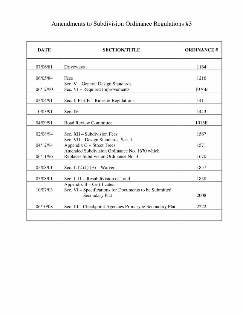
Amendments to Subdivision Ordinance Regulations #3
DATE
SECTION/TITLE
ORDINANCE #
07/06/81
Driveways
1164
06/05/84
Fees
1216
06/12/90
Sec. V – General Design Standards Sec. VI – Required Improvements
1076B
03/04/91
Sec. II Part B – Rules & Regulations
1411
10/03/91
Sec. IV
1443
04/09/91
Road Review Committee
1015E
02/08/94
Sec. XII – Subdivision Fees
1567
04/12/94
Sec. VII – Design Standards, Sec. 1 Appendix G – Street Trees
1571
06/11/96
Amended Subdivision Ordinance No. 1670 which Replaces Subdivision Ordinance No. 3
1670
05/08/01
Sec. 1.12 (1) (E) – Waiver
1857
05/08/01
Sec. 1.11 – Resubdivision of Land
1858
10/07/03
Appendix B – Certificates Sec. VI – Specifications for Documents to be Submitted Secondary Plat
2008
06/10/08
Sec. III – Checkpoint Agencies Primary & Secondary Plat
2222
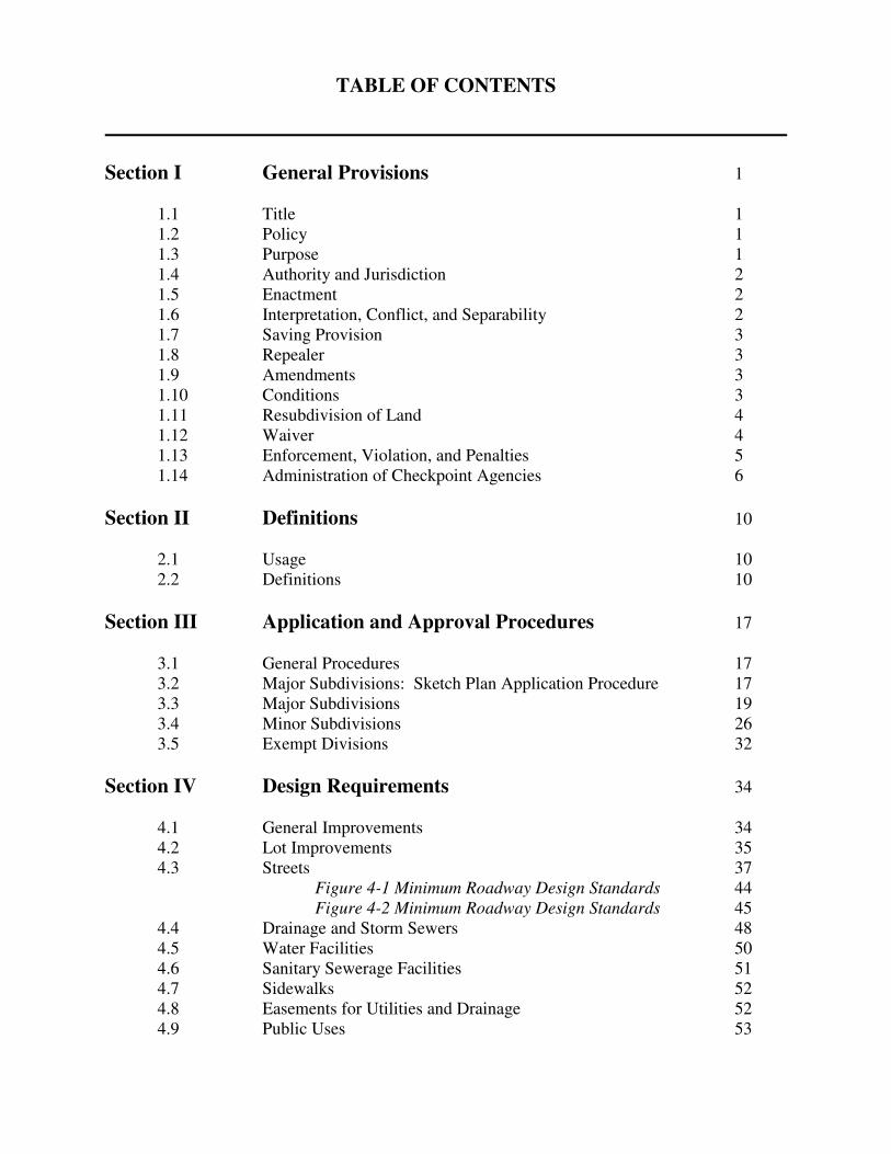
TABLE OF CONTENTS
Section I General Provisions 1 1.1 Title 1 1.2 Policy 1 1.3 Purpose 1 1.4 Authority and Jurisdiction 2 1.5 Enactment 2 1.6 Interpretation, Conflict, and Separability 2 1.7 Saving Provision 3 1.8 Repealer 3 1.9 Amendments 3 1.10 Conditions 3 1.11 Resubdivision of Land 4 1.12 Waiver 4 1.13 Enforcement, Violation, and Penalties 5 1.14 Administration of Checkpoint Agencies 6
Section II Definitions 10 2.1 Usage 10 2.2 Definitions 10
Section III Application and Approval Procedures 17 3.1 General Procedures 17 3.2 Major Subdivisions: Sketch Plan Application Procedure 17 3.3 Major Subdivisions 19 3.4 Minor Subdivisions 26 3.5 Exempt Divisions 32
Section IV Design Requirements 34 4.1 General Improvements 34 4.2 Lot Improvements 35 4.3 Streets 37 Figure 4-1 Minimum Roadway Design Standards 44 Figure 4-2 Minimum Roadway Design Standards 45 4.4 Drainage and Storm Sewers 48 4.5 Water Facilities 50 4.6 Sanitary Sewerage Facilities 51 4.7 Sidewalks 52 4.8 Easements for Utilities and Drainage 52 4.9 Public Uses 53
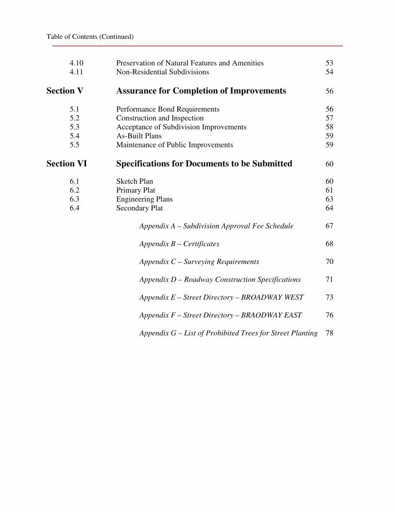
Table of Contents (Continued)
4.10 Preservation of Natural Features and Amenities 53 4.11 Non-Residential Subdivisions 54
Section V Assurance for Completion of Improvements 56 5.1 Performance Bond Requirements 56 5.2 Construction and Inspection 57 5.3 Acceptance of Subdivision Improvements 58 5.4 As-Built Plans 59 5.5 Maintenance of Public Improvements 59
Section VI Specifications for Documents to be Submitted 60
6.1 Sketch Plan 60 6.2 Primary Plat 61 6.3 Engineering Plans 63 6.4 Secondary Plat 64 Appendix A – Subdivision Approval Fee Schedule 67 Appendix B – Certificates 68 Appendix C – Surveying Requirements 70 Appendix D – Roadway Construction Specifications 71 Appendix E – Street Directory – BROADWAY WEST 73 Appendix F – Street Directory – BRAODWAY EAST 76 Appendix G – List of Prohibited Trees for Street Planting 78
Section I
General Provisions
1.1 Title
These regulations shall hereafter be known and cited as the Subdivision Regulations of
Lake County, Indiana.
1.2 Policy
(1) The policy of Lake County hereby is to consider the subdivision of land and the
subsequent development of the subdivided plat as subject to the official comprehensive plan and related policies (such as those embodied in the Zoning Ordinance of Unincorporated Lake County, Indiana) for the orderly, planned, efficient, and economical development of the unincorporated portions of Lake County, Indiana.
(2) Land to be subdivided shall be of such character that it can be developed without
peril to health from flood, fire or other menace, and land shall not be subdivided unless adequate public facilities and improvements exist or until provisions have been made for all the necessary public improvements including drainage, water, sewerage, transportation and any other improvements deemed necessary for the health and safety of the public.
(3) Both existing and proposed public facilities serving the subdivisions shall
properly relate and conform to the Comprehensive Plan of Lake County and all related policies and implementation programs including, but not limited to, the Building Codes and Zoning Ordinance.
1.3 Purpose
(1) To protect and provide for the public health, safety, and general welfare. (2) To guide the future growth and development in accordance with the Comprehensive Plan and related policies. (3) To provide for the safety, comfort, and soundness of the built environment and related open spaces. (4) To guide public and private policy and action in order to provide for adequate and efficient transportation, water, sewerage, schools, parks, and other public facilities. (5) To protect the compatibility, character, economic stability and orderliness of all development through reasonable design standards.
1
(6) To conserve natural resources such as woodlands, farmlands, open spaces and any other feature of extraordinary natural beauty both during and after development.
1.4 Authority and Jurisdiction
(1) This ordinance was enacted pursuant to Indiana Home Rule and Planning Enabling Legislation (Indiana Code 36-1-3-4 and the 36-7-4-700 series, as amended) and authorizes the Lake County Plan Commission to review and approve or disapprove plats for subdivisions throughout the geographic bounds of unincorporated Lake County. This authority extends to the development or Resubdivision of undeveloped portions of already recorded plats.
(2) No land shall be subdivided within legal boundaries until the subdivider or his
subdivision agent have met the requirements and stipulations of this Ordinance.
1.5 Enactment
In order that land may be subdivided in accordance with these purposes and policies,
these subdivision regulations are hereby adopted.
1.6 Interpretation, Conflict, and Separability
(1) In their interpretation and application, the provision of these regulations shall be
held to be the minimum requirements for the promotion of the public health, safety, and general welfare.
(2) Conflict with Public and Private Provisions.
(a) Public Provisions. The regulations of this Ordinance are not intended to
interfere with, abrogate, or annul any other ordinance, rule or regulation, statute or other provision of law. Where any provision of these regulations imposes restrictions different from those imposed by any other provision of these regulations or any other Ordinance, rule or regulation, or other provision of law, whichever provisions are more restrictive or impose higher standards shall control.
(b) Private Provisions. These regulations are not intended to abrogate any
easement, covenant or other private agreement or restriction, provided that where the provisions of these regulations are more restrictive or impose higher standards or regulations than such easement, covenant, or other private agreement or restriction, the requirements of these regulations shall govern.
(3) Separability. If any part of these regulations or application thereof to any person
or entity is held to be unconstitutional or invalid by any court of competent jurisdiction, such holding or decision shall not affect or impair the
2
Validity of this Ordinance as a whole or any part thereof, other than the part or provision so held to be unconstitutional or invalid.
1.7 Saving Provision
(1) These regulations shall not be construed as abating any action now pending under
or by virtue of, prior existing subdivision regulations, or as discontinuing, abating, modifying, or altering any penalty accruing or about to accrue, or as affecting the liability of any person or entity, or as waiving any right of the County under any section or provision existing at the time of adoption of these regulations, or as vacating or annulling any rights obtained by any person or entity by lawful action of the County except as shall be expressly provided for in these regulations.
(2) Any division of land or any action done prior to the enactment of this Ordinance
shall be subject to all remedies, penalties, procedures, defenses and time constraints under the previous, repealed Ordinance. The Lake County Plan Commission and all other relative agencies or entities shall follow the regulations of the repealed Ordinance in these cases where actions or divisions of land are still pending at the time of the enactment of this Ordinance.
1.8 Repealer
Upon adoption of this Ordinance, according to law, the Subdivision Ordinance of
Unincorporated Lake County, Indiana adopted October 28, 1963 and amended through April 12, 1994 is hereby repealed.
1.9 Amendments
For the purpose of providing for the public health, safety, and general welfare, the
County, on recommendation of the Commission, may from time to time amend the provisions imposed by these subdivision regulations. Public hearings on all proposed amendments shall be held by the Commission and/or County in the manner prescribed by law.
1.10 Conditions
Regulation of the subdivision of land and the attachment of reasonable conditions to land
subdivision is an exercise of valid police power delegated by the State of Indiana to Lake County. The developer has the duty of compliance with reasonable conditions laid down by the Commission for design, dedication, improvement, and restrictive use of the land in order to conform to the physical and economical development of unincorporated Lake County and to the safety and general welfare of the future plot owners in the subdivision and of the County at large.
3
1.11 Resubdivision of Land
(1) Procedure of Resubdivision. For any change in a plat of an approved or
recorded subdivision, including, but not limited to, a change affecting any street layout, area reserved thereon for public use, or any lot line, such plat may be considered by the Commission (under the same procedure, rules and regulations of a subdivision) only after a Waiver under Section 1.12 of this Ordinance is granted. Said Waiver shall be submitted to all participating jurisdictions under this Ordinance for their approval or rejection. Any Waiver for Resubdivision under these provisions shall be void without specific findings itemized under Section 1.12 of this Ordinance.
1.12 Waiver
(1) General. Where the Commission finds that extraordinary hardships or practical
difficulties may result from strict compliance with these regulations and/or the purposes of these regulations may be served to a greater extent by an alternative proposal, the Commission may approve waivers to these subdivision regulations so that substantial justice may be done and the public interest secured, provided that such waivers shall not have the effect of nullifying the intent and purpose of these regulations; and further provided the Commission shall not approve waivers unless findings shall be made based upon the evidence presented to the Commission in each specific case that:
(a) the granting of the waiver will not be detrimental to the public safety,
health, or welfare or injurious to other nearby property. (b) the conditions upon which the request for a waiver is based are unique to
the property for which the waiver is sought and are not applicable generally to other property;
(c) because of the particular physical surroundings, shape, or topographical
conditions of the specific property involved, a particular hardship to the owner would result, as distinguished from a mere inconvenience, if the strict letter of these regulations are carried out;
(d) the waiver will not in any manner conflict with the provisions of the
Zoning Ordinance or Comprehensive Plan as interpreted by the Plan Commission; and
(e) Waiver modifications submitted in writing to the Commission shall be
referred to the appropriate participating jurisdiction for their written recommendation of approval or denial. If such participating jurisdiction approves, denies or fails to act by the stipulated deadline, the Commission may modify such requirement, standards and specifications
4
so as to promote the public health, safety and welfare, and prevent detriment to the use and value of said land, provided however, that nothing herein shall be construed as altering or conflicting with the duties of the Board of Zoning Appeals pursuant to Title 36-7-4-900 series of the Indiana Statutes, as currently amended. The Commission’s decision to modify shall be based on findings specified in this Section (1.12).
(2) Conditions. In approving waivers, the Commission may require such
conditions as will, in the Commission’s judgment, secure substantially the objectives of the standards or requirements of these regulations.
(3) Procedures. A petition for any such waiver shall be submitted in writing by the
subdivider at the time when the Primary Plat is filed for the consideration of the Commission. The petition shall state fully the grounds for the application and all of the facts relied upon by the petitioner. The deadline for submitting waiver petition applications is the same as for Primary Plat applications.
1.13 Enforcement, Violation, and Penalties
(1) General.
(a) The duty of the Director of the Commission shall be to enforce this
Ordinance and to bring to the attention of the Commission Attorney any violations or lack of compliance herewith.
(b) The division of any land into a subdivision, as defined by this Ordinance,
by the use of metes and bounds description for the purpose of sale, or transfer, or lease resulting in the creation of one of more new building sites shall not be permitted. All such described divisions shall be subject to all of the appropriate requirements of this Ordinance.
(c) No building permit required under the Building Code, the Zoning
Ordinance, or this Ordinance shall be issued on any property subject to this Ordinance until the provisions of this Ordinance have been complied with.
(2) Limits of Land Transfers. No owner, subdivider, or subdivision agent of the
owner, of any land located in a proposed subdivision shall transfer or sell or lease any such land for purposes of subdivision as defined in this Ordinance before a Secondary Plat of such subdivision has been signed by the designated officials and recorded in accordance with the provisions of this Ordinance.
5
(3) Violations and Penalties. Any person or entity that violates a provision of this Ordinance or any regulations herein contained, shall be guilty of a misdemeanor and, upon conviction, shall be fined not less than ten dollars ($10.00) and not more than three hundred dollars ($300.00) for each day’s violation.
(4) Restraining Provisions.
(a) Any land within the jurisdiction of Lake County subdivided in violation of
the terms of this Ordinance after the effective date hereof, is hereby declared to be a common nuisance, which may be restrained, enjoined or abated in any appropriated action or proceeding.
(b) The Commission may institute an injunction suit requesting an individual
or entity be directed to remove a structure erected in violation of this Ordinance, or to make the same comply with its terms. If the Commission is successful in its suit, the respondent shall bear the costs of the action.
(c) The Commission may institute a suit for mandatory injunction requesting
an individual or entity be directed, where such individual or entity has violated any provisions of this Ordinance, to comply with the provisions of this Ordinance. If the Commission wins the suit, the respondent shall pay the Commission’s reasonable attorney fees and all costs related to the enforcement of this Ordinance.
1.14 Administration of Checkpoint Agencies
(1) Organization of County Officials and Specifications. The following offices are
concerned with the administration of this Ordinance and are also referred to herein as Checkpoint Agencies. For purposes of clarity, these offices and some of their pertinent functions are listed as follows:
(a) Lake County Plan Commission functions include, but are not limited
to, the review of the sketch plan, Primary Plat, and Secondary Plat and the exercise of responsibilities provided in this Ordinance. There is hereby created the Position of Plat Officer. The Executive Secretary of the County Plan Commission, or his appointed representative, is hereby designated to be the Plat Officer. The Plat Officer shall administer the provisions of this Ordinance and, in addition thereto, and in furtherance of said authority, he shall:
(i) Maintain permanent and current records of this Ordinance
including amendments hereto; (ii) Receive and file all sketch plans, Primary Plats, and Secondary
Plats (together with applications);
6
(iii) Identify with the Plan Commission Stamp Seal all copies of the sketch plan, Primary Plat, and Secondary Plat, and authorize the subdivider or his agent to deliver copies to other appropriate agencies for their recommendations and reports.
(iv) Assimilate all comments, recommendations and review from the
applicable Checkpoint Agencies and make recommendations for action to the Plan Commission on every subdivision plat, Primary or Secondary, which the Commission is to consider. The recommendations will be either for approval, disapproval, or continuance. Reasons for the recommendation shall be clearly stated:
(v) Receive and file copies of all Secondary Plats and check their
compliance with the Primary Plat.
(vi) Receive “as built” plans, as outlined in Section 5.4, and forward such plans to the proper governmental departments.
(vii) Inspect and make recommendations concerning approval or
disapproval of streets and improvements in accordance with the provisions of this Ordinance.
(viii) Make all other determinations required of him by the regulations
herein.
(b) The Land County Highway Department Superintendent shall:
(i) Make recommendations on street design and on storm drainage details in accordance with the provisions of this Ordinance and as required by applicable County Ordinance;
(ii) Make inspections of streets and improvements during their
construction in accordance with the provisions of this Ordinance; (iii) Inspect and make recommendations concerning approval or
disapproval of streets and improvements in accordance with the provisions of this Ordinance;
(iv) Make cost recommendations for appropriate Bonds.
(c) The Lake County Surveyor’s Office (County Surveyor) shall: (i) Check and verify the boundary closure on all subdivisions; (ii) Verify the installation of subdivision boundary monuments in
accordance with the provisions of this Ordinance.
7
(iii) Inspect and make recommendations on all subdivision engineering and construction plans, especially stormdrainage plans in accordance with the provisions of this Ordinance and in accordance with any other duly adopted ordinance involving storm drainage and/or sediment control.
(iv) Review and make recommendations on all development,
engineering and construction plans regarding the establishment of Property Owners Associations or other methods to provide proper maintenance of storm water systems and improvements.
(v) Establish cost and administration of appropriate Bonds, including
Bonds for construction and/or maintenance of storm water systems and improvements, including but not limited to detention and retention ponds.
(d) The Lake County Health Department (County Health Officer) shall:
(i) Make recommendations in regard to minimum lot size in instances where sewage treatment or domestic water facilities are to be installed separately on each individual lot.
(e) The Board of Commissioners of the County of Lake shall:
(i) Accept Subdivision Performance and Maintenance Bonds or escrow as herein required;
(ii) Accept into the County Highway System streets and improvements
designed and constructed in accordance with the provisions of this Ordinance.
(f) The Lake County Recorders Office shall:
(i) Be responsible for recording of the Secondary Subdivision Plat; (ii) Prepare copies of recorded document to be forwarded to appropriate
county offices.
(g) The Lake County Auditors Office shall: (i) Be responsible for records concerning platting of subdivision lots; (ii) Prepare Certified Lists of adjacent property owners.
8
(h) The Lake County Soil and Water Conservation District of Lake County shall:
(i) Review sketch plans and Primary Plats of proposed subdivisions
and comment on said plans in regard to accuracy of soil information, watershed, prime agricultural land, erosion factors, or any other pertinent information.
9
Section II
Definitions
2.1 Usage
(1) For the purpose of this Ordinance, certain terms and words used herein shall be
used, interpreted, and defined as set forth in the section. (2) Unless the context clearly indicates to the contrary, words used in the present
tense include the future tense; words used in the plural number include the singular; the word “herein” means “in the Ordinance”.
(3) This ordinance is intended to be gender neutral and equally applicable to all
persons so that if the masculine or feminine gender of a word is used it should be interpreted to mean both sexes unless otherwise indicated.
(4) A “person” includes an individual, a corporation, a partnership, and an
unincorporated association of persons such as a club; “shall” is always mandatory; “will” means the same as “shall”; “used” or “occupied” as applied to any land or building shall be construed to include the words “intended, arranged, or designed to be used or occupied”.
2.2 Definitions
Abbreviated Subdivision: (See Minor Subdivision)
Accessory Building: A subordinate structure, the use of which is incidental to that of
the dominant use of the primary building or land. Alley: A public or private vehicular right-of-way primarily designed to serve as
secondary access to the side or rear of those properties whose principal frontage is on some other street.
All Soil Types: Location of the predominant soil types, which may be determined by the
United States Department of Agriculture, Natural Resources Conservation Service, Lake County Soil Survey in the sketch plan and as determined by a certified professional soil scientist in the Primary Subdivision Plat.
Applicant: The owner of land proposed to be subdivided, or his agent, or his legal
representative. Block: A tract of land bounded on all sides by streets, or by a combination of streets and
public parks, cemeteries, railroad right-of-way, shorelines of water ways, or boundary lines of municipalities, or other types of definite boundaries.
10
Board of County Commissioners: Referred to herein as the County. Bond: Any form of security including a cash deposit, certificate of deposit, surety bond,
letter of credit, or instrument of credit. Buffer Landscaping: Any trees, shrubs, walls, fences, berms, or related landscaping
features required under this Ordinance or other applicable Ordinance on private lots and privately maintained for buffering lots from adjacent properties or public rights-of-way for the purpose of increasing privacy and/or otherwise minimizing detrimental environmental effects (i.e., noise, water runoff, etc.).
Building: Any structure having a roof supported by columns or walls for the housing or
enclosure of persons, animals, or chattel. When any portion thereof is completely separated from every other portion thereof by a division wall without openings, then each such portion shall be deemed to be a separate building.
Checkpoint Agency: A public agency or organization called upon by the Commission
to provide expert counsel with regard to a specific aspect of community development; also known as ‘participating jurisdiction’.
Commission: The County Plan Commission of the County of Lake, State of Indiana. Commission Attorney: The Attorney representing the Lake County Plan Commission. Comprehensive Plan: An overall plan for the physical, social, and economic
development of the County (and the constituent communities within its planning jurisdiction), prepared and adopted by the Commission pursuant to the State Acts, and including any part of such plan and/or policies separately adopted and any amendment to such plan and/or policies, or parts thereof; Master Plan.
Corner Lot: (see Lot, Corner) County Engineer (County Highway Engineer): The duly appointed engineer of the
Lake County Highway Department. County Government: That governmental body of the County empowered to adopt
planning and public policy ordinances; the Lake County Council, herein referred to only as the County.
County Inspection Officials: The County Surveyor, the County Highway
Superintendent, and the Plat Officer. Cul-de-Sac: A minor street having one open end and being permanently terminated by a
vehicle turnaround. Density: The number of dwelling units per gross acre computed by dividing the gross
acreage of the subdivision into the total number of dwelling units.
11
Director: The Executive Director of the Lake County Plan Commission. Easement: A grant by a property owner for the use by another, for a specific purpose, of
any designated part of his property. Erosion Control Plan: A written description and site plan of pertinent information
concerning erosion control measures to be installed under IN 327 15-5, “Rule 5”. Escrow: A deposit of cash with the County Board of Commissioners in lieu of an
amount required and still in force on a Performance or Maintenance Bond. Such escrow funds shall be held by the County.
Exempt Division: (see Subdivision) Frontage: That side of a lot abutting on a street and ordinarily regarded as the front of
the lot, except as provided for on a corner lot. Frontage Street: Any street to be constructed by the developer or any existing street in
which development shall take place on both sides. Grade: The slope of a road, street, or other public way. Gross Land Area (Gross Acreage): The entire area of a subdivision including lots,
streets, and alleys, measured to the center line of any bounding streets. Hobby Farms: A farm for personal enjoyment and not for commercial gain; in
subdivisions, according to the provisions of the Lake County Zoning Ordinance, such farms are permitted only when 80% or more of the platted lots are 5 acres or more in size (see Unincorporated Lake County Zoning Ordinance, Section 9.2 for further
information).
Lot: A parcel of land defined by metes and bounds or boundary lines in a recorded deed or on a recorded plat, fronting on a street. In determining lot area and boundary lines, no part thereof within the limits of the street shall be included.
Lot, Corner: A lot situated at the intersection of two (2) street, the interior angle of such
intersection not exceeding 135 degrees. Lot, Double Frontage (Through Lot): A lot which has a pair of opposite lot lines
along two substantially parallel street, and which is not a corner not. Lot Improvement: Any building, place, or other object, constituting a physical
betterment of real property, or any part of such betterment, which required an improvement.
12
Major Subdivision: Any subdivision not classified as a minor subdivision, including but not limited to subdivisions of six (6) or more lots, or any size subdivision requiring any new street or extension of the local governmental facilities, or the creation of any public improvements.
Master Plan: (see Comprehensive Plan)
Minor Subdivision: Any subdivision of not more than five (5) lots, all with frontage on
a perimeter street, or any further subdivision or Resubdivision of a nonresidential development whose lots may or may not have frontage on a perimeter street which does not include any improvement to a public road, provided such subdivision activity involves neither the construction of any new street or road, nor the imposition of any adverse effect upon the use of the remainder of the land or adjoining property as determined by the Commission, and provided such activity conflicts with neither any provisions or portion of the Comprehensive Plan, the Zoning Ordinance, nor any of the regulations set forth herein.
Model Home: A dwelling unit used initially for display purposes which exemplifies the
type of dwelling units that will be constructed within the subdivision. Such dwelling units may be utilized for the sole purpose of real estate offices as set forth in the provisions of this Ordinance.
Parcel: A part or portion of land having a legal description formally set forth in a
conveyance, together with the boundaries thereof, in order to make possible its easy identification.
Parent Parcel: The original lot, tract, or parcel of land as it existed upon the adoption of
the Subdivision Regulations #2 on October 28, 1963. The parent parcel is ascertained by the tax key numbers on record in the Office of the Lake County Auditor.
Parkway: A route intended to be used primarily by passenger vehicles and whose right-
of-way is, or is intended to be, developed in a park-like character. Perimeter Street: Any existing street to which the parcel of land to be subdivided abuts
on only one side. Plan Commission: The words Plan Commission or Commission, as used in this
Ordinance, refer to the Plan Commission of the County of Lake, Indiana. Plat: A plan, map, drawing, or chart on which the subdivider’s plan for the subdivision
of land is presented and which he submits for approval and intends to record in final form.
Plat Committee: A duly appointed committee created by the Plan Commission pursuant
to IC 36-7-4-701 for the sole purpose of minor subdivision review.
13
Plat of Correction: A replat proposal which proposes to replat any reasonable number of lots and lot lines to increase lot size. Reasonable number of lots shall be determined by the Plat Officer.
Plat, Final: (see Secondary Plat)
Plat, Preliminary: (see Primary Plat)
Plat, Primary: The drawings and documents presented for Primary Approval and as
described in this Ordinance. Plat, Tentative: (see Sketch Plan)
Plat, Vacation: The drawings and documents presented for a vacation of any existing
subdivision plat. Primary Approval: An approval (or approval with conditions imposed) granted to a
subdivision by the Commission after having determined in a public hearing that the subdivision complies with the standards prescribed in this Ordinance (pursuant to IC 36-7-4-700 series: Subdivision Control).
Principal Use Building: A building in which the principal use of the lot or parcel is
conducted. Standards recognized by the Indiana Administrative Building Council shall be used to determine whether a given structure constitutes one or more buildings in cases where ambiguities exist.
Real Yard: A yard as defined herein, encompassing the horizontal space between the
nearest foundation of a building to a rear lot line and that rear lot line, extending to the side lines of the lot and measure as the shortest distance from that foundation to the rear lot line. The rear yard of a corner lot shall be that yard at the opposite end of the lot from the front yard.
Resubdivision: A change in a map of a plat having secondary approval or a recorded
subdivision plat if such change affects any street layout on such map or area reserved thereon for public use, or any lot line, except as otherwise exempted in this Ordinance.
Right-of-Way: A strip of land occupied or intended to be occupied by a street,
pedestrian-way, crosswalk, railroad, electric transmission line, oil or gas pipeline, water main, sanitary or storm sewer main, special landscaping, or for another special use. The usage of the term right-of-way for land platting purposes shall mean that every right-of-way hereafter established and shown on a secondary plat is to be separate and distinct from the lots or parcels adjoining such right-of-way and not included within the dimensions or areas of such lots or parcels. Rights-of-way intended for streets, other use involving maintenance by a public agency shall be dedicated to public use by the subdivider on whose plat such right-of-way is established.
14
Roadway: The paved area within a street right-of-way intended for vehicular traffic, including all curb and gutter facilities.
Secondary Approval: The stage of application for formal Plan Commission approval of
a Secondary Plat of a subdivision, the construction of which has been completely or substantially completed, which if approved and signed by the designed officials may be submitted to the County Recorder for filing.
Secondary Plat: The drawings and documents presented for Secondary Approval and
described in this Ordinance. Sketch Plan: The initially submitted graphic representation of a proposed major
subdivision used for sketch plan review and drawn to the specifications of Section 6.1. Staff: The staff of the Lake County Plan Commission. Street, Approved: Any street meeting standards and specifications of Lake County,
Indiana. Street: A public way established by or maintained under public authority, a private way
open for public uses, and a private way, plotted or laid out for ultimate public use, whether or not constructed.
Street, Improved: Any public street with a minimum right-of-way of forty feet, with a
minimum 18 foot blacktop roadway surface and drained properly. Street, Collector: A street which carries traffic from minor streets to a thoroughfare,
including the principal entrance streets of residential development and the principal circulating streets within such a development.
Street, Marginal Access: A minor street which is parallel and adjacent to highways and
primary thoroughfares and which provides access to abutting properties and protection to local traffic from fast, through-moving traffic on the highways and primary thoroughfares.
Street, Minor: A street intended primarily as access to properties. Street, Oblique: A street that is not at a right angle to an intersection street. Street, Private: Any street which is under the jurisdiction of an individual, corporation,
or trustee, or any street which is privately owned or established. Street, Primary Arterial: A street intended to move through traffic to and from such
major attractors as central business districts, regional shopping centers, colleges and/or universities, military installations, major industrial areas, and similar traffic generators within the county; a major thoroughfare.
15
Street, Secondary Arterial: A street intended to collect and distribute traffic in a manner similar to primary arterials, except that these streets service minor traffic generating areas such as community-commercial areas, primary and secondary educational plants, hospitals, major recreational areas, churches, and offices, and/or designed to carry traffic from collector streets to the system or primary arterials.
Subdivider: Any person having a proprietary interest in land, who causes it to be
divided into a subdivision. Subdivision Agent: Any person who represents, or acts for or on behalf of, a subdivider
or developer, in selling, leasing, or developing, or offering to sell, lease, or develop any interest, lot, parcel, unit, site, or plat in a subdivision.
Subdivision: The division of a parcel of land into lots, parcels, sites, units, plats, or
interests for the purpose of offer, sale, lease, or development, either on the installment plan or upon any and all other plans, terms and conditions, including Resubdivision. Subdivision includes the division of development of land zoned for residential and nonresidential uses, whether by deed, metes and bounds descriptions, devise, intestacy, lease, map, plat, or other recorded instrument.
The following kinds of divisions are not subdivisions and are classified as Exempt
Divisions and are exempt from the rules of this Ordinance unless indicated otherwise. (a) Any division of land into 20 acre parcels or more; such a division must meet the
three critical requirements of adequate lot frontage, approved soil type, and conformance with the Subdivision Ordinance as detailed in Section 3.5.
(b) Parcels of land recorded prior to October 28, 1963; such a division must meet the
three critical requirements of adequate lot frontage, approved soil type, and conformance with the Subdivision Ordinance as detailed in Section 3.5.
(c) Parcels of land between 10 and 20 acres that existed between October 28, 1063
and January 31, 1980; such a division must meet the three critical requirements of adequate lot frontage, approved soil type, and conformance with the Subdivision Ordinance as detailed in Section 3.5.
Temporary Improvement: Improvements built and maintained by a subdivider during
construction of the subdivision and intended to be replaced by a permanent improvement prior to release of the Performance Bond or turnaround improvements at the ends of stub street intended to be replaced when the adjoining area is developed and the through street connection made.
Urbanized Area: The area so mapped and defined by the U. S. Bureau of the Census. Zoning Ordinance: The County Ordinance setting forth the regulations controlling the
use of land in the unincorporated areas. Also referred to a as the Unincorporated Lake
County, Indiana Zoning Ordinance.
16
Section III
Application and Approval Procedures
3.1 General Procedures
(1) Classification of Land Divisions. All land to be divided shall be categorized
into one of three (3) main classes of land division as they are defined in Section 2.2. These classes are:
(a) major subdivisions; (b) minor subdivisions; (c) exempt divisions. Exempt divisions are not subject to all requirements of this Ordinance. Before any permit shall be granted for a structure to be erected on land to be subdivided into a major or minor subdivision, the owner or his subdivider shall apply for and secure approval of the proposed subdivision in accordance with Section 3.2 and Section 3.3 or Section 3.4 of this Ordinance as appropriate. Before any permit shall be granted for a structure to be erected on a parcel of land to be created or altered by an exempt division, the land divider or his agent shall certify to the satisfaction of the Plan Commission that all requirements for exemption have been met, as detailed in Section 3.5 of this Ordinance, in order to exempt the land division from all other requirements of this Ordinance.
(2) Deadline for Application Submission, Holiday Extension. Any date or deadline of submission for subdivision application materials or agency comments shall be extended to the end of the next regular working day where such date or deadline falls on a weekend or holiday.
(3) Procedural Path for Major versus Minor Subdivisions. Subdivisions
classified as major subdivisions shall be directed to the Plan Commission for Primary and Secondary Approval as stipulated in Section 3.3. Subdivisions classified as minor subdivisions shall first be directed to the Plat Committee for Primary and Secondary Approval provided no waiver is being requested under the jurisdiction of the Plan Commission. If the Plat Committee fails to vote unanimously with at least four (4) of its five members, the minor subdivision shall then be referred to the Plan Commission for Primary and/or Secondary Approval as Section 3.4 stipulates.
3.2 Major Subdivisions: Sketch Plan Application Procedure (1) Application Requirements. In order to begin the subdivision process, the
applicant shall file an application for review of sketch plan with the Commission’s staff and be entitled to a signed receipt for same. This application shall:
17
(a) be made on forms available at the Office of the Commission and signed by the owner.
(b) The application shall advise as to the legal owner of the property, the
contract owner of the property, optionee of the property, and the date on which the contract of sale was executed.
(c) be accompanied by a minimum of ten (10) copies of the sketch plan; (d) be accompanied by a fee of one hundred dollars ($100.00). (e) include an address and telephone number of the subdivider of his agent
who shall be authorized to receive all notices required by this Ordinance.
(2) Checkpoint Submission. In order to fulfill the last application requirement for sketch plan, two (2) copies of the proposed plan shall be submitted to each of the following agencies so that their comment may be made to the staff:
(a) Lake County Surveyor; (b) Lake County Highway Superintendent; (c) Lake County Health Officer; (d) Lake County Soil & Water Conservation District Two (2) copies of the sketch plan shall remain with the Plat Officer. The
Director shall request that all officials and agencies to whom ma request for review has bee made, submit comments to him by the fifteenth (15th) day of the month two months prior to the month of the public hearing at which the subdivider intends to have his Primary Plat submission heard. It shall be the responsibility of the subdivider or his agent to ascertain if all county agency reports and recommendations have been filed with the Plat Officer within the specified date requirements. Failure to have all comments submitted by the stipulated deadlines shall delay Plan Commission consideration.
(3) Sketch Plan Review Process. On the third Wednesday of each month the planning staff shall hold a sketch plan
review meeting. This meeting shall be for any subdividers which have met the necessary deadlines for sketch plan submittal and have not yet received approval of the sketch plan. At this meeting the staff shall discuss with the subdivider pertinent aspects of the possible modifications and/or changes that may be suggested or required by this Ordinance. The Director shall request that a representative of each checkpoint agency be present to participate in the sketch plan review meeting. Taking into consideration the requirements of this Ordinance, particular attention shall be given to the arrangement, location, and width of street, their relation to the topography of the land, sewage disposal, drainage and wetlands, soil erosion control measures, lot size and arrangement,
18
the further development of adjoining lands as yet unsubdivided, and the requirements of the Comprehensive Plan and any other applicable plans.
(4) Official Submission Dates. The deadline for submittal of a sketch plan and
application shall be on the first (1st) of the month two months prior to the month of the public hearing at which the subdivider intends to have his Primary Plat submission heard and one month prior to the deadline for the submission of the Primary Plat.
3.3 Major Subdivisions
(1) General Procedures for Primary and Secondary Approval. In addition to a sketch plan which is reviewed by the staff and checkpoint agencies, the applicant seeking approval of a major subdivision shall submit a Primary Subdivision Plat to be approved, conditionally approved, or rejected by the Plan Commission at a public hearing. Then a Secondary Subdivision Plat shall be submitted which must be found in compliance with the Primary Plat as approved by the Plan Commission at a public hearing.
(2) Procedures for Primary Plat Approval.
(a) Submission Requirements. Following the submission, review and
report on the sketch plan application, the subdivider may file for Primary Plat Approval. This submission shall:
(i) Be made on forms available at the Office of the Commission and be
submitted with fee of five-hundred dollars ($500.00);
(ii) Include indication of all land which the applicant proposes to subdivide and all land immediately adjacent thereto.
(iii) Be presented to the Staff of the Commission no later than the first
(1st) of the month prior to the month of the regular meeting of the Commission at which it is intended to be heard.
(iv) Be accompanied by eighteen (18) copies of the Primary Plat as
described in this Ordinance. (v) Generally comply with the sketch plan as reviewed.
(b) Placement on the Commission Agenda. Subsequent to the submission for Primary Approval, the Commission shall place the matter on its next regular meeting agenda for formal action provided the application is received by the first (1st) day of the month prior to the month of the regular meeting and all necessary agency approvals are received by the fifteenth (15th) day of the month prior to the month of the regular meeting.
19
(c) Checkpoint Agencies. Upon receipt of the eighteen (18) copies, the Primary Plat shall be held for five (5) business days fro review by the Plat Officer to determine conformity with the Ordinance. If plats are determined to be in conformity, the Plat Officer shall affix the plans with the appropriate Plan Commission stamps, authorizing the subdivider to deliver one (1) copy to the post office, two (2) copies each to the Lake County Surveyor, Lake County Highway Superintendent, Lake County Health Officer, Lake County Soil and Water Conservation District, and three (3) copies each to the utility companies servicing the area, leaving two (2) copies with the Plat Officer. Only after the plans are stamped, may the subdivider pay the filing fees and be issued a receipt. Primary Plat is not considered filed until filing fees have been paid.
(i) In addition, the subdivider shall obtain comment from any other
groups or agencies deemed necessary by the Plat Officer including the State Board of Health and the Department of Natural Resources.
(ii) The officials who are in receipt of copies of the Primary Plat shall
review the plat and register in writing any comments they may have. These written comments shall be delivered to the Plan Commission Office by the fifteenth (15th) day of the month prior to the month for which Plan Commission consideration is requested. It shall be the responsibility of the subdivider or his agent to deliver all required comments, reports, and/or recommendations within the specified date requirements. Failure to have all required comments submitted by the stipulated deadline shall delay Commission consideration.
(d) Staff Review. Subsequent to placement on the agenda, and prior to the
date of public hearing, the Commission’s staff shall review the proposal and prepare a written report to the Commission and applicant indicating staff’s recommendation with regard to the subdivision being proposed.
(e) Public Hearing Notification. The Commission shall hold a public
hearing on the Primary Plat and notice of such hearing shall be in accordance with I.C. 5-3-1 at the applicant’s expense. Before the time of the public hearing, the applicant shall show proofs of publication that the Notices of Public Hearing were published at least ten (10) days prior to the public hearing. Interested parties shall be notified by first class mail of the time, date, place, and purpose of the public hearing on the subdivision at least ten (10) days in advance of the hearing.
(f) Approval of the Primary Plat. After the Commission has held a
hearing on the Primary Plat, the staff’s report, checkpoint recommendations, and testimony and exhibits submitted at the public
20
hearing, the applicant shall be advised of any required changes and/or additions. The Commission shall, at a public meeting, grant primary approval, conditional approval, continuance, or disapprove the Primary Plat. Not later than ten (10) days after the Plan Commission meeting, the Plat Officer shall notify the subdivider in writing of the Commission’s action on the Primary Plat giving reasons for any disapproval. Before the Commission grants Primary Approval of a plat showing park reservation or land for other local government unit, the Commission shall obtain approval of the park or land reservation from the participating jurisdiction. Primary approval by the Commission is subject to review by certiorari. Application for Secondary Approval of a subdivision cannot occur until Primary Approval has been granted by the Commission.
(g) Field Trip. The Commission, at its discretion, upon hearing the request
for Primary Approval, may elect to continue the matter until its next regularly scheduled public meeting, and may schedule a field trip to the site of the proposed subdivision, accompanied by the applicant or his representative.
(h) Effective Period of Primary Approval. Unless extended or
sectionalized according to Section 3.3-(4)-(h), the approval of a Primary Plat shall be effective for a period of twelve (12) months at the end of which time Secondary Approval on the entire subdivision must have been obtained and certified by the designated officials of the Commission. Any plats not receiving Secondary Approval within the time set forth herein shall be null and void, and the developer shall be required to resubmit a new application for sketch plan review subject to all the zoning restrictions and subdivision regulations and procedures in effect at the time of resubmission. Upon request of the applicant the Commission, finding reasonable grounds, may extend the Primary Approval of a plat twelve (12) months beyond an expiration date.
(3) Approval of Engineering Plans.
(a) Submission Procedure and Requirements. Before approval of the
Primary Plat, the applicant, if he wishes to proceed with the subdivision, shall submit five (5) copies of engineering plans prepared by a Civil Engineer or Surveyor registered in the State of Indiana pursuant to Section 6.3, and shall file with the Director of the Commission a request to start work on any improvements.
(b) Review Process. One (1) copy of these plans shall be referred to the
Lake County Highway Department, the Lake County Health Department, the Lake County Surveyor, and the Lake County Soil and Water Conservation District, retaining one copy for the planning staff. Upon receipt of approved engineering plans the applicant may proceed with the
installation of improvements provided there is an approved bond in place
21
for the cost of such improvements. In no event shall secondary approval be given prior to approval of the construction (engineering) plans.
(c) Installation of Improvements. The installation of improvements shall
be inspected by the appropriate participating jurisdiction. Such inspections are required in all instances regardless of whether the work is performed before or after secondary approval. Failure to request inspection of work performed after the date of this Ordinance and before Secondary Approval where applicable may be cause for denial of Secondary Approval.
(4) Secondary Subdivision Plat Procedure (Secondary Approval).
(a) Submission Requirements. Following Primary Approval and approval of engineering (construction) plans, the applicant, if he wishes to proceed with the subdivision, shall file with the staff a request for Secondary Approval of a subdivision plat. The application shall:
(i) Be submitted on forms available at the Office of the Plan
Commission and be submitted with a fee of two-hundred and fifty dollars ($250.00);
(ii) Include the entire subdivision, or section thereof which derives
access from an existing state, county, or local government roadway;
(iii) Be accompanied by eighteen (18) copies of the Secondary
Subdivision Plat as described in this Ordinance. (iv) Comply with the Ordinance and the terms and conditions of
Primary Approval; (v) Be accompanied by the Performance Bond, if required, in a form
satisfactory to the Commission Attorney and in an amount established by the Commission upon recommendation of the participating jurisdiction and shall guarantee the completion of all required subdivision and off-site public improvements.
(b) Checkpoint Agencies.
Upon receipt of the eighteen (18) copies, the Secondary Plat shall be held for five (5) business days for review by the Plat Officer to determine conformity with the Ordinance. If plats are determined to be in conformity, the Plat Officer shall affix the plans with the appropriate Plan Commission stamps, authorizing the subdivider to deliver one (1) copy to the post office, two (2) copies each to the Lake County Surveyor, Lake County Highway Superintendent, Lake County Health Officer, Lake County Soil and Water Conservation District, and three (3) copies each to
22
the utility companies servicing the area, leaving two (2) copies with the Plat Officer. Only after the plans are stamped, may the subdivider pay the filing fees and be issued a receipt. Secondary Plat is not considered filed until filing fees have been paid.
(i) The officials who are in receipt of copies of the Secondary Plat
shall review the plat and register in writing any comments they may have. These written comments shall be delivered to the Plan Commission Office by the fifteenth (15th) day of the month prior to the month for which Plan Commission consideration is requested. It shall be the responsibility of the subdivider or his agent to deliver all required comments, reports, and/or recommendations within the specified date requirements. Failure to have all required written comments submitted by the stipulated deadline shall delay Commission consideration.
(c) Determination of Conformance (Secondary Approval). In order to be
recorded, a Secondary Plat shall be found to be in conformance with the Primary Approval either by the Staff, or by the Commission at a public meeting. If the Secondary Subdivision Plat deviates from the Primary Plat that received Primary Approval, the subdivision shall be resubmitted to the Commission at a public meeting for a new Primary Approval. The subdivider submitting a Secondary Plat conforming to the Primary Approval shall have the Secondary Plat reviewed by the Commission at a public meeting. The subdivider shall request in writing Commission review no later than the first day of the month prior to the month of the public meeting at which he intends to have his Secondary Plat reviewed. The Commission shall place the matter on its next regular meeting agenda provided the application is submitted by the first (1st) of the month prior to the month of the regular Plan Commission meeting and all checkpoint agency approvals are received no later than the fifteenth (15th) day of the month prior to the month of the regular Plan Commission meeting. The Staff shall review the proposal and submit a written report and recommendations to the Commission and the applicant, and the Commission, at the public meeting shall grant Secondary Approval, continuance, or disapproval of the Secondary Plat. If granted Secondary Approval, it shall be signed by the designated officials. If not granted Secondary Approval, then the subdivider shall be informed as to the insufficiency of his submittal. Not later than ten (10) days after the Plan Commission meeting, the Plat Officer shall notify the subdivider in writing of the Commission’s action on the Secondary Plat.
(d) In no case shall a petitioner be permitted to file an application for
secondary approval prior to receiving primary approval and approved engineering plans.
23
(e) In stances where the subdivider proposes to construct a common sewage treatment facility or a common water supply system, or both, the Plan Commission shall not give Secondary Approval until:
(i) The State Board of Health and the Indiana Department of
Environmental Management give approval to the final engineering and construction plans for the facility.
(ii) The State and /or County, in the instance where a common sewage
treatment facility is to be constructed, has granted the subdivider or the appropriate corporation a Certificate of Territorial Jurisdiction. Furthermore, where the subdivider proposes to construct a common sewage treatment facility and/or a common water supply system, the Plat Officer, upon receipt of the engineering plans, shall immediately deliver one (1) copy of each of these plans to the County Health Officer.
(f) In instances where on-lot sewage disposal systems are proposed (septic
systems), the County Health Department requires that all Secondary Plats submitted for approval shall have a plat prepared which depicts all soil types (see Section 2.2, Definitions, “all soil types”), contour lines, drainage easements, and utility easements on the Secondary Plat. Non-compliance of this provision shall delay Secondary Approval.
(g) Where the sanitary treatment plant is to be installed by the subdivider, all
Secondary Plat approvals shall be granted by the Commission subject to the condition that no building permits will be issued until either:
(i) The sewage treatment facility is operative, as attested to by the
State Board of Heath; or until (ii) The subdivider has an adequate temporary sewage treatment
facility installed or an adequate proposal before the County Health Officer, who in turn will notify the Plat Officer by letter that a certain number of building permits may be authorized for issue based on temporary sewage treatment installations or proposals.
(h) Sectionalizing Plats. Prior to granting Secondary Approval of a major
subdivision plat, the Commission may permit the plat to be divided into two (2) or more sections and may impose such conditions upon the filing of the sections as deemed necessary to assure the orderly development of the plat. The Commission may require that the Performance Bond be in such amount as will be commensurate with the section or sections of the plat to be filed and may defer the remaining required Performance Bond principal amount until the remaining sections of the plat are offered for filing. Such sections must contain at least ten (10) lots, or ten percent
24
(10%) of the total number of lots contained in the approved plat, whichever is less. The approval of all remaining sections not filed with the staff shall automatically expire after five (5) years of the date of Primary Subdivision Approval of the subdivision plat, unless the expiration date has been extended.
(5) Signing and Recording a Plat.
(a) Signing of a Plat.
(i) When a bond is required, the designated officials shall endorse
secondary approval on the plat by signing and mylar after the bond has been approved, and all conditions of the Primary Approval have been satisfied.
(b) Recording of Plat.
(i) After the Plan Commission meeting, the subdivider shall submit to
the Plat Officer one (1) tracing of the Secondary Plat of the subdivision on drawing medium deemed satisfactory by the Commission. After the approval of the Secondary Plat, the original tracing shall be delivered by the Plat Officer to the County Surveyor. When directed, the County Surveyor shall process plat for recording.
(ii) The subdivider is responsible for the causation of the filing of the
Secondary Plat with the County Recorder within twelve (12) months of the date of signature by submitting the tracing said above to the Plat Officer.
(iii) Costs for the above are to be borne by the subdivider, i.e. County
Auditor, County Recorder, reproduction, etc. The Secondary Plat will remain in the County Surveyor’s Office for the permanent public record. If the Secondary Plat is not recorded within a period of twelve (12) months from the date of approval, the Secondary plat is void and the plat must again be submitted with a new filing fee to the Commission for Secondary Approval.
(iv) Building Permits shall not be issued in any subdivision until the
Secondary Plat is approved by the Commission and until the plat and any accompanying restrictive covenants are recorded in the Office of the County Recorder.
(6) Disapproval of Secondary Plat is warranted if: (a) There are more than minor deviations from the Primary Plat;
25
(b) More than twelve (12) months have elapsed since Primary Approval; (c) Engineering or construction plans and details for the subdivision
demonstrate that the subdivision improvements do not comply with the County standards and the requirements of this Ordinance.
(d) A new highway, pipeline, or other major feature has directly affected the
site. (e) There were certain conditions attached to the approval of the Primary
Approval, and those conditions have not been fulfilled.
3.4 Minor Subdivisions
(1) General Procedures. All divisions of land classified as minor subdivisions shall
first be referred to the Plat Committee provided that no waiver within the jurisdiction of the Plan Commission is requested. The applicant seeking approval of a minor subdivision shall submit a Primary Plat and a Secondary Plat to be approved, conditionally approved, or rejected by the Plan Commission or its Plat Committee, as appropriate, at a public hearing.
(2) Procedures for Primary Plat Approval.
(a) Submission Requirements. This submission shall:
(i) Be made on forms available at the Office of the Commission and be submitted with fee of five-hundred dollars ($500.00);
(ii) Include indication of all land which the applicant proposes to
subdivide and all land immediately adjacent thereto. (iii) Be presented to the Staff of the Commission no later than the first
(1st) of the month prior to the month of the regular meeting of the Commission at which it is intended to be heard.
(iv) Be accompanied by eighteen (18) copies of the Primary Plat as
described in this Ordinance.
(b) Placement on the Commission Agenda. Subsequent to the submission for Primary Approval, the Commission or its Plat Committee, as appropriate, shall place the matter on its next regular meeting agenda for formal action provided the application is received by the first (1st) day of the month prior to the month of the regular meeting and all necessary agency approvals are received by the fifteenth (15th) day of the month prior to the month of the regular meeting.
26
(c) Checkpoint Agencies. Upon receipt of the eighteen (18) copies, the Primary Plat shall be held for five (5) business days for review by the Plat Officer to determine conformity with the Ordinance. If plats are determined to be in conformity, the Plat Officer shall affix the plans with the appropriate Plan Commission stamps, authorizing the subdivider to deliver one (1) copy to the post office, two (2) copies each to the Lake County Surveyor, Lake County Highway Superintendent, Lake County Health Officer, Lake County Soil and Water Conservation District, and three (3) copies each to the utility companies servicing the area, leaving two (2) copies with the Plat Officer. Only after the plans are stamped, may the subdivider pay the filing fees and be issued a receipt. Primary Plat is not considered filed until filing fees have been paid.
(i) In addition, the subdivider shall obtain comment from any other
groups or agencies deemed necessary by the Plat Officer including the State Board of Health and the Department of Natural Resources.
(ii) The officials who are in receipt of copies of the Primary Plat shall
review the plat and register in writing any comments they may have. These written comments shall be delivered to the Plan Commission Office by the fifteenth (15th) day of the month prior to the month for which Plan Commission consideration is requested. It shall be the responsibility of the subdivider or his agent to deliver all required comments, reports, and/or recommendations within the specified date requirements. Failure to have all required comments submitted by the stipulated deadline shall delay Commission consideration.
(d) Staff Review. Subsequent to placement on the agenda, and prior to the
date of public hearing, the Commission’s staff shall review the proposal and prepare a written report to the Commission and applicant indicating staff’s recommendation with regard to the subdivision being proposed.
(e) Public Hearing Notification. The Commission or its Plat Committee, as
appropriate, shall hold a public hearing on the Primary Plat and notice of such hearing shall be in accordance with I.C. 5-3-1 at the applicant’s expense. At the time of the public hearing, the applicant shall show proofs of publication that the Notices of Public Hearing were published at least ten (10) days prior to the public hearing. Interested parties shall be notified by first class mail of the time, date, place, and purpose of the public hearing on the subdivision at least ten (10) days in advance of the hearing.
(f) Approval of the Primary Plat. After the Commission or its Plat
Committee, as appropriate, at a regularly scheduled meeting has examined the Primary Plat, Staff’s report, checkpoint recommendations and testimony and exhibits submitted, the Commission or its Plat Committee shall grant primary approval, conditional approval, continuance, or
27
disapprove the Primary Plat. Not later than ten (10) days after the Commission or Plat Committee meting, the Plat Officer shall notify the subdivider in writing of the action of the Commission or its Plat Committee on the Primary Plat giving any reasons for any approval, conditional approval, continuance, or disapproval. Primary approval by the Commission or its Plat Committee is subject to review by certiorari.
(i) Plat Committee Procedure. A division of land classified as a minor
subdivision shall be referred to the Plat Committee provided that the applicant is not requesting a waiver under the jurisdiction of the Commission. Any minor subdivision with a waiver request attached shall be referred to the Plan Commission. Primary Approval of a minor subdivision by the Plat Committee must be unanimous with at least four (4) of the five (5) members of the Plat Committee present and voting. If a minor subdivision is not unanimously approved by the Plat Committee as described herein then the Primary Approval, as yet undecided, shall be referred to the Plan Commission for consideration at their next regular monthly meeting. Thereafter, the minor subdivision shall stay with the Plan Commission for Secondary Approval if the applicant wishes to continue.
(3) Approval of Engineering Plans.
(a) Submission Procedure and Requirements. Before approval of the
Primary Plat, the applicant, if he wishes to proceed with the subdivision, shall submit five (5) copies of engineering plans prepared by a Civil Engineer or Surveyor registered in the State of Indiana pursuant to Section 6.3, and shall file with the Director of the Commission a request to start work on any improvements.
(b) Review Process. One (1) copy of these plans shall be referred to the
Lake County Highway Department, the Lake County Health Department, the Lake County Surveyor, and the Lake County Soil and Water Conservation District, retaining one copy for the planning staff. Upon receipt of approved engineering plans the applicant may proceed with the installation of improvements provided there is an approved bond in place for the cost of such improvements. In no event shall secondary approval be given prior to approval of the construction (engineering) plans.
(c) Installation of Improvements. The installation of improvements shall
be inspected by the appropriate participating jurisdiction. Such inspections are required in all instances regardless of whether the work is performed before or after secondary approval. Failure to request inspection of work performed after the date of this Ordinance and before secondary Approval where applicable may be cause for denial of Secondary Approval.
28
(4) Secondary Subdivision Plat Procedure (Secondary Approval).
(a) Application Requirements. The applicant shall file with the Staff an
application for Secondary Approval of a subdivision plat which must:
(i) Be submitted on forms available at the Office of the Commission.
(ii) Include the entire subdivision. (iii) Be accompanied by eighteen (18) copies of the Final Subdivision
Plat as described in this Ordinance. (iv) Be in compliance with this Ordinance and the terms and conditions
of Primary Approval.
(v) Be accompanied by the Performance Bond, if required, in a form satisfactory to the Attorney of the Commission and in an amount established by the Commission upon recommendation of the participating jurisdiction and shall guarantee the completion of all required subdivision and off-site public improvements.
(b) Checkpoint Agencies. Upon receipt of the eighteen (18) copies, the
Secondary Plat shall be held for five (5) business days for review by the Plat Officer to determine conformity with the Ordinance. If plats are determined to be in conformity, the Plat Officer shall affix the plans with the appropriate Plan Commission stamps, authorizing the subdivider to deliver one (1) copy to the post office, two (2) copies each to the Lake County Surveyor, Lake County Highway Superintendent, Lake County Health Officer, Lake County Soil and Water Conservation District, and three (3) copies each to the utility companies servicing the area, leaving two (2) copies with the Plat Officer. Secondary Plat in not considered filed until plans are affixed with the appropriate plan commission stamps.
(i) The officials who are in receipt of copies of the Secondary Plat
shall review the plat and register in writing any comments they may have. These written comments shall be delivered to the Plan Commission Office by the fifteenth (15th) day of the month prior to the month for which Plan Commission or Plat Committee consideration is requested. It shall be the responsibility of the subdivider or his agent to deliver all required comments, reports, and/or recommendations within the specified date requirements. Failure to have all required comments submitted by the stipulated deadline shall delay Commission or Plat Committee consideration.
(c) Determination of Conformance (Secondary Approval). In order to be
recorded, a Secondary Plat shall be found to be in conformance with the Primary Approval by the Commission or its Plat Committee, as
29
appropriate, at a public hearing. If the Secondary Subdivision Plat deviates from the Primary Plat that received Primary Approval, the subdivision shall be resubmitted to the Commission or its Plat Committee for a new Primary Approval.
(i) The Commission or its Plat Committee, as appropriate, shall review
the items submitted at a public hearing. The subdivider shall apply for Secondary Approval no later than the first day of the month prior to the month of the public meeting at which he intends to have his Secondary Plat reviewed. The Commission/Plat Committee shall place the matter on its next regular meeting agenda provided the application is submitted by the first (1st) of the month prior to the month of regular meeting and all checkpoint agency approvals are received no later than the fifteenth (15th) day of the month prior to the month of the said meeting. The Staff shall review the proposal and submit a written report and recommendations to the Commission/Plat Committee, and the Commission/Plat Committee, at the public meeting, shall approve or disapprove the Secondary Plat. If granted Secondary Approval, the mylar of the Secondary Plat shall be signed by the designated officials. If not granted Secondary Approval, then the subdivider shall be informed as to the insufficiency of his submittal. Not later than ten (10) days after the public meeting, the Plat Officer shall notify the subdivider in writing of the action of the Plat Committee or Commission on the Secondary Plat.
(ii) Plat Committee Procedure. Secondary Approval of a minor
subdivision by the Plat Committee must be unanimous with at least four (4) of the five (5) members of the Plat Committee present and voting. If a minor subdivision is not unanimously approved by the Plat Committee as described herein, then the Secondary Approval, as yet undecided, shall be referred to the Plan Commission for consideration at their next regular monthly meeting. In no case shall a minor subdivision be referred back to the Plat Committee once it is properly referred to the Plan Commission.
(d) In instances where the subdivider proposes to construct a common sewage
treatment facility or a common water supply system, or both, the Plan Commission or its Plat Committee, as appropriate, shall not give Secondary Approval until:
(i) The State Board of Health and the Indiana Department of
Environmental Management give approval to the final engineering and construction plans for the facility.
(ii) The State and/or County, in the instance where a common sewage
treatment facility is to be constructed, has granted the subdivider or
30
the appropriate corporation a Certificate of Territorial Jurisdiction. Furthermore, where the subdivider proposes to construct a common sewage treatment facility and/or a common water supply system, the Plat Officer, upon receipt of the engineering plans, shall immediately deliver one (1) copy of each of th4ese plans to the County Health Officer.
(e) In instances where individual sewage disposal systems are proposed
(septic systems), the County Health Department requires that all Secondary Plats submitted for approval shall have a plat prepared which depicts all soil types (see Section 2.2, Definitions, “all soil types”), contour lines, drainage easements, utility easements, on the Secondary Plat. Non-compliance of this provision shall delay Secondary Approval.
(f) Where the sanitary treatment plat is to be installed by the subdivider, all
Secondary Plat approvals shall be granted by the Commission or its Plat Committee, as appropriate, subject to the condition that no building permits will be issued until either:
(i) The sewage treatment facility is operative, as attested to by the
State Board of Health; or until (ii) The subdivider has an adequate temporary sewage treatment facility
installed or an adequate proposal before the County Health Officer, who in turn will notify the Plat Officer by letter that a certain number of building permits may be authorized for issue based on temporary sewage treatment installations or proposals.
(5) Signing and Recording a Plat.
(a) Signing of a Plat.
(i) When a bond is required, the designated officials shall endorse
Secondary Approval on the plat by signing the mylar after the bond has been approved, and all conditions of the Primary Approval have been satisfied.
(b) Recording of Plat.
(i) After the Plan Commission meeting, the subdivider shall submit to
the Plat Officer one (1) tracing of the Final Plat of the subdivision on drawing medium deemed satisfactory by the Commission. After the approval of the Secondary Plat, the original tracing shall be delivered by the Plat Officer to the County Surveyor. When directed, the County Surveyor shall process plat for recording.
31
(ii) The subdivider is responsible for the causation of the filing of the Secondary Plat with the County Recorder within twelve (12) months of the date of signature by submitting the tracing said above to the Plat Officer.
(iii) Costs for the above are to be borne by the subdivider, i.e. the
County Auditor, County Recorder, reproduction, etc. The Secondary Plat will remain in the County Surveyor’s Office for the permanent public record. If the Secondary Plat is not recorded within a period of twelve (12) months from the date of approval the Secondary Plat is void and the plat must again be submitted with a new filing fee to the Commission for Secondary Approval.
(iv) Building Permits shall not be issued in any subdivision until the
Secondary Plat is approved by the Commission and until the plat and any accompanying restrictive covenants are recorded in the Office of the County Recorder.
(6) Disapproval of Secondary Plat is warranted if:
(a) There are more than minor deviations from the Primary Plat; (b) More than twelve (12) months have elapsed since Primary Approval. (c) Engineering or construction plans and details for the subdivision
demonstrate that the subdivision improvements do not comply with the County standards and the requirements of this Ordinance.
(d) A new highway, pipeline, or other major feature has directly affected the
site. (e) There were certain conditions attached to the approval of the Primary
Approval and those conditions have not been fulfilled.
3.5 Exempt Divisions
(1) General Procedure. In order for a land division to be considered as an Exempt
Division, the applicant must show that it meets the definitional criteria (see Section 2.2, Subdivision) and the following three critical requirements:
(a) Adequate Lot Frontage as required for the zoning classification on a
dedicated, improved, public road at least 18 feet wide and at least gravel (this does not include private roads, easements of access or unimproved roads).
(b) Approved Soil Type for septic system installation.
32
(c) Conformance with the Lake County Subdivision Ordinance Regulations.
If the Staff determines that the division of land meets the definitional criteria and the three critical requirements of exempt divisions, then they shall issue to the subdivider a Statement of Compliance which indicates adherence to the applicable provisions of this Ordinance. Both the subdivider and the Staff shall hold copies of the Statement of Compliance. When the parcel so exempted by this Statement is conveyed to another party, the copy of the instrument of such conveyance shall be recorded with the County Recorder bearing a stamp of approval signed by the Director indicating that such Statement has been obtained as ascertained by the copy(s) of the Statement which have been held for this purpose.
33
Section IV
Design Requirements
4.1 General Improvements
(1) Conformance to Applicable Rules and Regulations. In addition to the
requirements established herein, all subdivision plats shall comply with the following laws, rules, and regulations:
(a) All applicable state and local statutory provisions; (b) The Unincorporated Lake County Zoning Ordnance, Building Codes, and
all other applicable laws and ordinances of the appropriate jurisdictions; (c) The Comprehensive Plan and all related plans of Lake County; (d) The special requirements of these regulations and any rules of the Lake
County Health Department and/or appropriate state agencies; (e) The rules and regulations of the Indiana Department of Transportation if
the subdivision or any lot contained therein abut a State highway or state frontage road;
(f) The highway and drainage standards and regulations adopted by the Lake
County Engineer, the Lake County Surveyor, and all boards, commissions, agencies, and officials of the county; and,
(g) All pertinent standards contained within written procedures and
guidelines adopted by the Lake County Plan Commission.
(2) Conformity. Plat approval may be withheld if a subdivision is not in conformity with the above guides and requirements or with the policies and purposes of these regulations established in Section 1.3 of this Ordinance.
(3) Plats Straddling Municipal Boundaries. Whenever access to the subdivision is
required across land in another jurisdiction, the Commission may request assurance from the County Attorney that such access is legally established, and from the County Engineer that the access road is adequately improved, or that a Performance Bond has been duly executed and is sufficient in the amount to assure the construction of the access road. Lot lines shall be laid out so as not to cross municipal boundary lines.
(4) Surveying Requirements (see Appendix C.)
(5) Character of the Land. Land which the Commission finds to be unsuitable for
subdivision or development because of flooding, improper drainage, steep slopes,
34
rock formations, adverse earth formations or topography, utility easements, or other features which might reasonably be harmful to th4e safety, health, and general welfare of the present or future inhabitants of the subdivision and/or its surrounding areas, shall not be subdivided or developed unless adequate methods are formulated by the developer and approved by the Commission, upon recommendation of the County Engineer and the Lake County Surveyor, to solve the problems created by the unsuitable land conditions. Such land shall be set aside for such uses permitted by the Zoning Ordinance as shall not involve any such danger.
(6) Subdivision Name. The proposed name of the subdivision shall not duplicate, or
too closely approximate phonetically, the name of any other subdivision in the area covered by these regulations. The Commission shall have final authority to reasonably designate the name of the subdivision which shall be determined at the time of Primary Approval.
(7) Minimum Design Standards. The design standards specified in this section are
the minimum considered necessary for the general health, welfare, safety and convenience of the public. Any improvements may be built to better standards of quality than those set forth in this Ordinance upon approval of the participating jurisdiction and the Commission.
4.2 Lot Improvements
(1) General.
(a) All lots shall meet the minimum width, depth, and area requirements of
the Lake County Zoning Ordinance. (b) The size, shape, and orientation of lots shall be appropriate for the
location of the subdivision, and for the type of development and use contemplated.
(c) Subdivisions shall contain no left-over pieces, corners, remnants of land
except that which is designated as public or community parks, open space, or other designated uses pertaining to the development.
(2) Lot Arrangement. The lot arrangement shall be such that there will be no
foreseeable difficulties for reasons of topography or other conditions in securing building permits to build on each of the created lots in compliance with the Zoning Ordinance and Health Regulations and in providing driveway access to buildings on such lots from the appropriate approved street.
(3) Lot Dimensions. Lot dimensions shall comply with the minimum standards in
the Zoning Ordinance. In general, side lot lines shall be at right angles to the street lines (or radial to curving street lines) unless a waiver from this rule will give a better street or lot plan. Dimensions of corner lots shall be large enough
35
to allow for erection of buildings, observing the minimum front yard setback from both streets. Depth and width of properties reserved or laid out for business, commercial, or industrial purposes shall be adequate to provide for all of the off-street parking and loading facilities required for the type of use and development contemplated, as established in the Zoning Ordinance. Excessive depth in relation to width shall be avoided. A proportion of 3.5 to 1 shall be considered a maximum.
(a) Lot widths shall be measured at the required building setback line except
that in the case of lots fronting on a cul-de-sac, the building setback line may be 80 feet back from the property line, providing the Commission approves this waiver.
(b) All lot corners shall be designated with 5/8” diameter rebar with cap
designating the surveyor who performed the survey.
(4) Double Frontage Lots and Access to Lots.
(a) Double Frontage Lots. Double frontage and reversed frontage lots shall
be avoided except where necessary to provide for the separation of residential development from the traffic on bordering arterials or to overcome specific disadvantages of topography and orientation or where a limited access highway, railroad right-of-way, major street or similar situation exists. In instances where double frontage lots are platted in this manner, the subdivider shall be required to provide and plat in some acceptable manner a strip of non-access land no less than fifteen feet (15’) wide on the highway side or rear yard of the lot. This strip of land is to be adequately landscaped with shrubs and trees so as to provide a sufficient screening or buffer area.
(b) Access to Public Street. Every lot shall front or abut on a public street.
The number of feet of width of lots is specified in the Unincorporated Lake County Zoning Ordinance. Lots in a minor subdivision with an access only to existing private drives, streets, or easements may be permitted only with the permission of the Commission.
(c) Access from Primary and Secondary Arterials. Lots shall not, in
general, derive access from a primary or secondary arterial street. Where driveway access from a primary or secondary arterial street may be the only possible access for several adjoining lots, the Commission may require that such lots be served by a marginal access street in order to limit possible traffic hazards from multiple access to such streets. Where possible, driveways should be designed and arranged so as to avoid requiring vehicles to back into traffic on primary or secondary arterials.
(5) Debris and Waste. No cut trees, debris, junk, rubbish, or other similar waste
materials shall be buried by the developer on any lot or street in the subdivision.
36
(6) Water Bodies and Watercourses. If a tract being developed contains a water body other than a temporary detention facility or portion thereof, lot lines shall either be so drawn as to distribute the entire ownership of the water body among the fees of adjacent lots, or the Commission may approve an alternative plan whereby the ownership of and responsibility for safe maintenance of the water body is so placed that it will not become a local government responsibility. No part of the minimum area of a lot required under the Zoning Ordinance may be satisfied by land which is underwater other than a temporary detention facility or portion thereof.
(7) Real Estate Sales Offices. Sales Offices for Real Estate may be permitted in
subdivisions provided that:
(a) Only sales of real estate concerning property within the subdivision in which the office is located are conducted;
(b) Only a Model Home can be used; (c) There shall be a mina office for the real estate firm and it shall remain in
operation; (d) No advertising device may be utilized other than a non-illuminated sign
not to exceed sixteen (16) square feet with no other printing other than Sales Office and the name of the real estate office;
(e) The residential character of the model home cannot change (no parking
lots for sales offices); (f) Sales offices are only permitted until 75% of lots have been sold by the
original developer; (g) Storage of contractor’s equipment and/or supplies is prohibited.
4.3 Streets
(1) General Requirements.
(a) Agency Jurisdiction and Recommendations. At minimum, the
following agencies or entities shall make recommendations to the Plan Commission pertaining to street design and street improvements in the subdivision:
(i) Plan Commission Staff; (ii) County Superintendent of Highways; (iii) County Surveyor;
(iv) Any other applicable participating jurisdiction, agency, or unit as deemed necessary by the Plat Officer.
37
(b) All streets shall be designed in substantial relation to:
(i) Topographic conditions and drainage; (ii) Soil conditions; (iii) Public convenience and safety; (iv) Existing and proposed land uses.
(c) Frontage on Improved Roads. No subdivision shall be approved unless the area to be subdivided shall have frontage on and two (2) points of access from an existing street as follows:
(i) an existing state, county, or local highway; or (ii) a street shown upon a plat approved by the Commission and
recorded by the County Recorder. Such street or highway must be suitably improved as required by the highway rules, regulations, specifications or order, or be secured by a Performance Bond required under this Ordinance. Whenever the area to be subdivided is to use an existing street frontage for access to any or all of the lots, such street shall be suitably improved as provided in Appendix D, Roadway Construction Specifications.
(d) Street Classification and Integration. The terms arterial and
thoroughfare mean the same. Local street and minor street are the same.
(i) Primary Arterials shall be those having inter-city or regional importance, and shall be properly integrated with the existing and proposed system or major streets and highways.
(ii) Secondary Arterials shall be inter-neighborhood streets and shall
be properly related to specific traffic generating facilities such as schools, churches, shopping and employment centers, to population densities, and to the major thoroughfares into which they feed.
(iii) Collector Streets shall be intra-neighborhood streets and shall be
laid out to traffic circulation within the subdivision or the neighborhood and shall be properly related to the existing and proposed arterial system.
38
(iv) Minor Streets shall be laid out to conform as much as possible to topography; to discourage use of through traffic; to permit efficient drainage and sewer system; and to require the minimum amount of street to provide convenient, safe access to adjacent property.
(e) Right-Of-Way Dedication. In instances where a proposed subdivision is
to be platted such that it utilizes an existing (improved) county road for access to part of or all all the lots, the subdivider shall dedicate additional land for right-of-way wherein the existing right-of-way is not adequate according to the official plan for streets and thoroughfares and improve roadway to meet minimum blacktop standards. Such right-of-way dedication shall at minimum be forty (40) feet or greater as determined by the Highway Superintendent.
(2) Topography and Alignment.
(a) All streets shall be properly integrated and aligned with the existing and
proposed system of thoroughfares and dedicated rights-of-way as established on the Comprehensive Plan, Highway Plan, or related plans.
(b) Rigid, rectangular “gridiron” street patterns are generally to be avoided,
and the use of casually curvilinear streets, cul-de-sacs, or loop streets shall be encouraged where such use will result in a more desirable lay-out and relate better to the existing topography. In general, innovative, varying geometrical street patterns shall be encouraged where they are likely to enhance visual interest and create a sense of place without undue risk to the health and safety of the public.
(c) Proposed streets shall be extended to the boundary lines of the tract to be
subdivided, unless prevented by topography or other physical conditions, or unless in the opinion of the Commission such extension is not necessary or desirable for the coordination of the layout or the most advantageous future development or adjacent tracts.
(3) Publicly Planned Streets. Streets shall be laid out in conformity to street or
highway plans officially adopted by the County. Wherever such a planned street or highway runs through a proposed subdivision, it shall be provided for in the place and with the width indicated on said plan. However, no more than 100 foot width right-of-way dedication shall be required for any street. Additional right-of-way specified on said plan shall be reserved for public traffic and utility service purposes by easement provisions. This subdivider shall not be required to install a pavement of greater width than that required for secondary streets.
39
(4) Blocks.
(a) The length, widths and shapes of blocks shall be such as are appropriate
for the locality and the type of development contemplated, but the block length in residential areas shall not exceed 1,500 feet.
(b) Blocks shall have sufficient width to provide for two (2) tiers of lots of
appropriate depths. Exceptions to this prescribed block width shall be permitted in unusual cases (i.e., adjacency to an arterial, railroad, etc.).
(c) Pedestrianways, bikeways, and/or crosswalks may be required by the
Commission at some point in blocks more than nine hundred feet (900’) long where deemed essential to provide circulation or access to schools, playgrounds, shopping centers, transportation, or other community facilities. The width and surface of the crosswalk and/or bikeway shall be of appropriate, standard engineering design. In the case of pedestrian crosswalks, the width shall be no less than six feet (6’) and no more than ten feet (10’) with a surface of bituminous topping (stone or concrete). Such paths for pedestrians and/or bicycles shall be inaccessible to all vehicular traffic excepting that required for maintenance purposes.
(5) Half Streets. Half Streets shall not be permitted except:
(a) To provide right-of-way for officially adopted planned streets or highways;
(b) Wherever an existing half street is adjacent to a tract to be subdivided, in
which case the other half of the street shall be platted within such tract to be subdivided, or the existing platted half street shall be vacated prior to Secondary Approval;
(c) Where the subdivider believes it is absolutely necessary to plat such, in
which case, realizing that the Commission expects this half street to be improved, the subdivider shall submit engineering and construction plans concerning this half street to the Plat Officer. The Plat Officer, after consultation with the County Surveyor and the County Highway Superintendent, shall make a recommendation concerning the proposed platting of said half street to the Plan Commission, who shall decide whether to permit the platting and improvement of it.
(6) Access to Collector Streets. Where possible, lots in single family residential
subdivisions fronting on collector streets shall be avoided, and lots at the corners of intersections between local and collector streets shall front on the local street and have driveway access to it only, and not to the collector street. In multiple family residential areas, entrances to group parking lots shall have access only to collector streets (where possible) and such entrances shall be widely spaced.
40
(7) Access to Primary Arterials. Where a subdivision borders on or contains an existing or proposed primary arterial, the Commission may require that access to it be limited by one of the following means:
(a) The subdivision of the lots so as to back onto the primary arterial and
front onto a parallel local street; no access shall be provided from the primary arterial, and screening shall be provided within a strip of land along the rear property line of such lots;
(b) A series of cul-de-sacs, or loop streets entered from, and designed
generally to be at right angles to an excess street that is at some distance from and parallel to the arterial street, with the rear lines of their terminal lots backing onto the arterial; and
(c) A marginal access or service road (separated from the primary arterial by
a landscaped and/or decoratively fenced grass strip and having access thereto at widely spaced suitable points). However, such marginal access or service roads shall generally be encouraged in residential subdivisions.
(8) Street Names and Street Signs. The Primary Plat, as submitted, shall indicate
names of proposed streets and be in compliance with the Street Naming
Resolution of Lake County. Street signs of the type approved by the County Highway Superintendent shall be installed on the northeast corner of each intersection and shall indicate the street names as shown in the Secondary Plat and as specified in the Street Naming Resolution (see Appendix E). Street signs shall be set in the ground according to the standard details obtainable from the County Highway Superintendent.
(9) Street Regulatory Signs. Traffic control devices (i.e., stop signs, speed zone
signs, or other such devices) shall be installed by the developer as required by the Lake County Board of County Commissioners, the Lake County Highway Department, and the Lake County Sheriffs Department.
(10) Street Trees. Street trees shall be planted on both sides of each proposed street
except where there are sufficient existing trees present and preserved as determined by the Plat Office. Street trees, namely planted, shall be no closer together than thirty (30) feet, nor further apart than sixty (60) feet. The type of trees shall be determined by the subdivider except that it must not be on the ‘list
of prohibited trees for street planting’ (see Appendix G). Newly planted street trees shall have at least a one and one-half (1-1/2) inch caliper, measured one (1) foot from the ground. Street trees shall be located such that they will not cause serious destruction to street and sidewalk installations.
(11) Construction of Streets.
(a) Construction of Streets other than Cul-de-sacs. The arrangement of
streets shall provide for the continuation of streets between adjacent
41
subdivisions or other properties when such continuation is necessary for the convenient movement of traffic, for effective fire protection, for efficient provision of utilities, and where such continuation is in accordance with the Comprehensive Plan. If the adjacent property is undeveloped and the street must be a dead-end street temporarily, the right-of-way shall be extended to the property lines unless prevented by topography or other physical conditions, or unless in the opinion of the Commission, such extension is not necessary or desirable for coordination of the layout or the most advantageous future development of adjacent tracts. A temporary T-shaped or L-shaped turnabout shall be provided on all temporary dead-end streets, with the notation on the subdivision plat that land outside the normal street right-of-way shall revert to the abuttors whenever the street is continued. The Commission may limit the length of temporary dead-end streets in accordance with the Design Standards of these regulations.
(b) Cul-de-Sacs (Permanent Dead-end Streets). Dead-end streets shall not
be permitted. Cul-de-sacs designed to be permanent may not be longer than 600 feet, measured along the centerline of the right-of-way from a point where the centerline of the right-of-way intersects the centerline of the right-of-way of the adjacent street to a point on the centerline or radial point of the turnaround. However, the Commission may approve a waiver for a longer length of cul-de-sac where justified. A right-of-way shall be provided, the diameter of which shall not be less than 156 feet for shoulder and ditch and not less than 140 feet where curb and gutter is used. The Plan Commission can authorize an equally safe and convenient turning space instead of the circular right-of-way mentioned above, providing the necessary engineering details and the other exhibits are satisfactory to the Plan Commission.
(12) Design Standards.
(a) General. In order to provide for streets of suitable location, width, and
improvement to accommodate prospective traffic and afford satisfactory access for police, fire-fighting, snow removal, sanitation, and street maintenance equipment, and to coordinate street location in order to achieve a convenient system and avoid undue hardships to adjoining properties, the following design standards for streets are hereby required.
(b) Minimum Design Standards (see Figures 4.1 and 4.2).
(c) Street Surfacing and Improvements. The subdivider shall construct all
required curb and gutters and shall surface or cause to be surfaced roadways to the widths pursuant to approved construction plans. All road pavement, shoulders, drainage improvements and structures, curbs, turnarounds and sidewalks shall conform to all construction standards and specifications provided for in this Ordinance (see Appendix D), and shall
42

be incorporated into the construction plans required to be submitted by the developer prior to Secondary Approval.
(d) Excess Right-of-Way. Right-of-way widths in excess of the standards
designated in this Ordinance shall be required whenever, because of topography, additional width is necessary to provide adequate earth slopes. Such slopes shall not be in excess of a ratio of two to one (2:1).
43
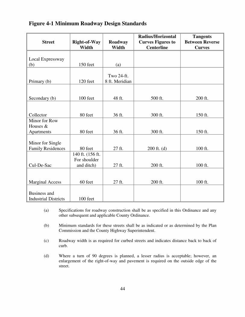
Figure 4-1 Minimum Roadway Design Standards
Street
Right-of-Way
Width
Roadway
Width
Radius/Horizontal
Curves Figures to
Centerline
Tangents
Between Reverse
Curves
Local Expressway (b)
150 feet
(a)
Primary (b)
120 feet
Two 24-ft.
8 ft. Meridian
Secondary (b)
100 feet
48 ft.
500 ft.
200 ft.
Collector
80 feet
36 ft.
300 ft.
150 ft.
Minor for Row Houses & Apartments
80 feet
36 ft.
300 ft.
150 ft.
Minor for Single Family Residences
80 feet
27 ft.
200 ft. (d)
100 ft.
Cul-De-Sac
140 ft. (156 ft. For shoulder
and ditch)
27 ft.
200 ft.
100 ft.
Marginal Access
60 feet
27 ft.
200 ft.
100 ft.
Business and Industrial Districts
100 feet
(a) Specifications for roadway construction shall be as specified in this Ordinance and any
other subsequent and applicable County Ordinance.
(b) Minimum standards for these streets shall be as indicated or as determined by the Plan Commission and the County Highway Superintendent.
(c) Roadway width is as required for curbed streets and indicates distance back to back of curb.
(d) Where a turn of 90 degrees is planned, a lesser radius is acceptable; however, an enlargement of the right-of-way and pavement is required on the outside edge of the street.
44
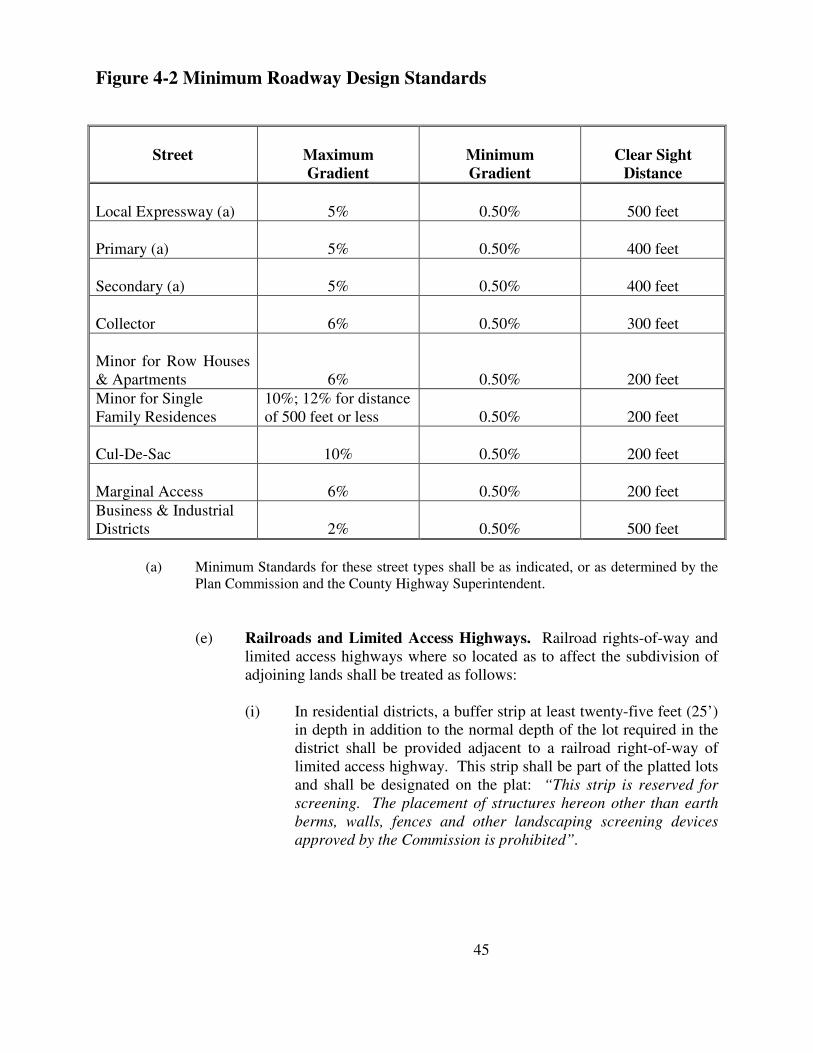
Figure 4-2 Minimum Roadway Design Standards
Street
Maximum
Gradient
Minimum
Gradient
Clear Sight
Distance
Local Expressway (a)
5%
0.50%
500 feet
Primary (a)
5%
0.50%
400 feet
Secondary (a)
5%
0.50%
400 feet
Collector
6%
0.50%
300 feet
Minor for Row Houses & Apartments
6%
0.50%
200 feet
Minor for Single Family Residences
10%; 12% for distance of 500 feet or less
0.50%
200 feet
Cul-De-Sac
10%
0.50%
200 feet
Marginal Access
6%
0.50%
200 feet
Business & Industrial Districts
2%
0.50%
500 feet
(a) Minimum Standards for these street types shall be as indicated, or as determined by the
Plan Commission and the County Highway Superintendent.
(e) Railroads and Limited Access Highways. Railroad rights-of-way and
limited access highways where so located as to affect the subdivision of adjoining lands shall be treated as follows: (i) In residential districts, a buffer strip at least twenty-five feet (25’)
in depth in addition to the normal depth of the lot required in the district shall be provided adjacent to a railroad right-of-way of limited access highway. This strip shall be part of the platted lots and shall be designated on the plat: “This strip is reserved for
screening. The placement of structures hereon other than earth
berms, walls, fences and other landscaping screening devices
approved by the Commission is prohibited”.
45
(ii) Streets parallel to a railroad when intersecting a street which crosses the railroad at grade shall, to the extent practicable, be at a distance of at least 150 feet from the railroad right-of-way.
(f) Intersections.
(i) Streets shall be laid out so as to intersect as nearly as possible at
right angles. A proposed intersection of two (2) new streets at an angle of less than seventy-five (75) degrees is prohibited. An oblique street should be approximately at right angles for at least one hundred feet (100’) therefrom. Not more than two (2) streets shall intersect at any one point unless specifically approved by the Commission.
(ii) Proposed new intersections along one side of an existing street
shall, wherever practicable, coincide with any existing intersection on the opposite side of such street. Street jogs with center-line offsets of less than 150 feet shall not be permitted except where the intersected street has separated, dual drives, without median breaks at either such intersection. Where local streets intersect with arterials, their alignment shall be continuous. Intersections of arterials shall be at least eight hundred feet (800’) apart.
(iii) Minimum outside street turning radius at intersections shall be
28’. (iv) Intersections shall be designed with a flat grade wherever
practical. At the approach to an intersection, a leveling area shall be provided having not greater than three percent (3%) grade at a distance of sixty feet (60’), measured from the nearest right-of-way line of the intersecting street.
(v) Where any street intersection will involve earth banks or existing
vegetation inside any lot corner that would create a traffic hazard by limiting visibility, the developer shall cut such ground and/or vegetation (including trimming trees) in connection with the grading of the public right-of-way to the extent deemed necessary by the County Engineer to provide an adequate sight distance and if necessary provide for excess right of way to allow for the above.
(g) Bridges of primary benefit to the applicant, as determined by the
Commission, shall be constructed at the full expense of the applicant without reimbursement from the County. The sharing of expense for the construction of bridges not of primary benefit to the applicant, as
46
determined by the Commission, will be fixed by special agreement between the County and the applicant. Said cost shall be charged to the applicant pro-rata as the percentage of his land developed and so served.
(This paragraph applies only to newly proposed bridges submitted with
the applicant’s subdivision). (h) Alleys.
(i) Alleys shall be provided in all commercial and in all industrial
districts, except that the Plan Commission may waive this requirement where other definite and assured provision is made for service access such as off-street loading and parking consistent with and adequate for the uses proposed;
(ii) Alleys shall not be approved in residential areas unless necessary
because of topography or other exceptional circumstances; (iii) The width of alleys shall not be less than 20 feet when permitted
in residential subdivisions and not less than 30 feet in all other instances;
(iv) Dead-end alleys are prohibited.
(13) Street Dedications and Reservations. Widening and Realignment of Existing
Streets. Where a subdivision borders an existing street, or when the Comprehensive Plan or zoning setback regulations indicate plans for realignment or widening of a street that would require use of some of the land in the subdivision, the applicant shall be required to improve and dedicate such streets at his own expense. Such frontage streets and other streets on which subdivision lots front shall be improved and dedicated by the applicant at his own expense to the full width required by these Subdivision Regulations. Land reserved for any street purposes may not be counted in satisfying the yard or area requirements of the Zoning Ordinance. Further, the subdivider shall:
(a) Improve the ingress, egress, or access to the proposed subdivision (see
Appendix D); (b) Make grading improvements in the right-of-way that adequate level area
for shoulder and ditches is established as required in this Ordinance and the drainage channel for the existing roadway is moved to its proper location adjacent to the road shoulder. This grading improvement, once constructed, shall be stabilized and held by sodding or by an approved stoning process (see Appendix D);
47
(c) Submit engineering and construction drawings to the Plat Officer, in five (5) copies, concerning these requirements.
(d) Minor Subdivisions. The above requirements shall be applied to minor
(abbreviated) subdivisions as deemed necessary by the County Highway Superintendent.
4.4 Drainage and Storm Sewers
(1) General Requirements.
(a) Agency Jurisdictions and Recommendations. At minimum, the
following agencies or entities shall make recommendations to the Plan Commission pertaining to the adequacy of drainage and storm sewers in the proposed subdivision.
(i) Plan Commission Staff; (ii) Lake County Superintendent of Highways; (iii) Lake County Surveyor; (iv) Lake County Soil and Water Conservation District; (v) Any other applicable participating jurisdiction, agency, or unit as
deemed necessary by the Plat Officer.
(b) As part of the approved construction plans, the subdivider shall submit plans for the approval of the Commission for an adequate storm water drainage system, which may include sewers, channels, and basins. The storm water drainage system shall be separate and independent of any sanitary sewer system. The subdivider shall use existing drainage channels whenever possible. Storm sewers where required shall be designed according to accepted engineering practice and consistent with any ordinance regulating storm drainage in Lake County, and a copy of design computations shall be submitted along with construction plans. Inlets shall be provided so that surface water is not carried across any intersection, nor for a distance in the gutter greater than indicated by the design computations submitted with the construction plans. When calculations indicate that curb capacities are exceeded at a point, no further allowance shall be made for flow beyond that point. Surface water drainage patterns shall be shown for each and every lot and block.
(2) Nature of Storm Water Facilities.
(a) Location. The subdivider may be required by the Commission to carry
away by pipe or open ditch any spring or surface water that may exist either previously to, or as a result of the subdivision. Such drainage facilities shall be located in the road right-of-way where feasible, or in unobstructed easements of appropriate width, and shall be constructed in accordance with the approved construction plans.
48
(b) Accessibility to Public Storm Sewers. Where a public storm sewer is
accessible, the subdivider shall install storm sewer facilities, or if no outlets are within a reasonable distance, adequate provision shall be made for the disposal of storm waters as shown on the approved construction plans. Inspection of facilities shall be conducted by the participating jurisdiction.
(c) Upstream and Downstream Drainage Areas. The County Surveyor
shall determine the effect of each proposed subdivision on existing drainage facilities outside the area of the subdivision downstream. The impact on the subdivision from upstream drainage shall also be determined. County drainage studies, together with such other studies as may be available and appropriate, shall serve as a guide to needed improvements. Where it is anticipated that the additional runoff incident to the development of the subdivision will overload an existing downstream drainage facility, the Commission may withhold Secondary Approval of the subdivision until provision (such as a storage facility) has been made for the improvement of said potential condition in such sum as the Commission shall determine. No subdivision shall be approved unless adequate drainage from it will be provided to an adequate drainage water course or facility.
(3) Design Standards.
(a) The design of the drainage system shall be based on the following
considerations:
(i) The drainage area as a whole: storm drainage upstream, downstream, and within the drainage area of which the subdivision is a part;
(ii) Calculations as to volume and frequency of water to be
accommodated; (iii) Design of culverts and storm sewer pipe sufficient in size to
eliminate unreasonable flooding or ponding of water; (iv) Establishment of finished land grades throughout the subdivision
so that there is no ponding of water on the land and that surface runoff will not be such as to cause serious erosion;
(v) Existing water courses. (vi) Such other factors as are outlined in any duly adopted stormwater
erosion control ordinance.
49
(b) Where ditches and swales are used to drain street construction, the following requirements shall be met:
(i) With grades to 4%, ditches shall have sod bottoms and banks; (ii) With grades from 4% to 8%, ditches shall have concrete ditch
checks spaced not more than 100 feet apart; (iii) With greater than 8% grades, ditches shall be rip-rapped or paved; (iv) Culverts shall be provided at all street intersections sized to
eliminate flooding or ponding of water, and with a minimum cover of twelve inches (12”). Culverts shall be constructed with flared end sections.
(v) All water inlet and outlet structures will provide for erosion
control protection.
4.5 Water Facilities
(1) General Requirements.
(a) Agency Jurisdiction and Recommendations. At minimum, the
following agencies or entities shall make recommendations to the Plan Commission pertaining to the adequacy of water supply and distribution systems in the subdivision.
(i) Plan Commission staff; (ii) County Superintendent of Highways; (iii) County Surveyor; (iv) County Health Department; (v) Any other applicable participating jurisdiction, agency, or unit as
deemed necessary by the Plat Officer.
(b) The applicant shall take all actions necessary to extend or create a water supply and distribution system capable or providing for domestic use and fire protection.
(c) Where a public water main is accessible, the subdivider shall install or
cause the installation of adequate water facilities (including fire hydrants) approved by the local fire department and/or the appropriate utility. All water mains shall be at least eight inches (8”) in diameter.
(2) Density Based Determination. In any subdivision wherein the density of
development as defined in Section 2.2 of this Ordinance is 4.0 or greater, the subdivider shall provide a complete public or private utility water supply and distribution system including all appurtenances for fire protection.
50
(3) Individual Wells and Central Water Systems. If a public water system is not available, individual wells may be used or a central water system provided in such a manner that an adequate supply of potable water will be available to every lot in the subdivision and all requirements of the State and County regulations are met. Water samples shall be submitted to the County Health Department for its approval for both individual wells and central water systems. Order of approval shall be submitted to the Commission.
4.6 Sanitary Sewerage Facilities
(1) General Requirements.
(a) Agency Jurisdiction and Recommendations. At minimum, the
following agencies or entities shall make recommendations to the Plan Commission Board pertaining to the adequacy of sanitary sewage facilities in the subdivision:
(i) Plan Commission staff; (ii) County Health Department; (iii) Any other applicable participating jurisdiction, agency, or unit as
deemed necessary by the Plat Officer.
(b) There shall be provided a complete sanitary sewer system including a service connection for each lot and a sewage treatment plant and/or disposal facilities which service the subdivision for all subdivisions where density of development is 1.0 or greater; however, this requirement may be waived and other means of sewage disposal permitted in those instances where the Commission finds that the particular soil conditions or other factors are such as to lend themselves to other means of sewage disposal which demonstrably will cause no pollution of the land and will promote the general purpose of this Ordinance.
(c) In any subdivision wherein the density of the development as defined by
this Ordinance is less than 1.0, individual sewage disposal systems may be installed, provided all the requirements of the State and County regulations with regard to soil type, percolation tests and size of disposal system are met.
(d) All community sewerage systems and all sanitary sewers shall be
designed in accordance with accepted modern sanitary engineering practice and shall be designed and constructed in accordance with the requirements of the County Health Department and the State Board of Health.
51
(e) Any discharge of any combined sewer system or other sewer system shall be required to first obtain approval from the Lake County Drainage Board pursuant to I.C. 36-9-27-1 et seq.
4.7 Sidewalks
(1) Required Improvements. Sidewalks shall be provided in the following areas:
(a) Industrial, commercial and business property shall be provided with concrete sidewalk five inches (5”) thick and a minimum of five feet (5’) wide.
(b) All subdivisions wherein the density of the entire development as defined
by this Ordinance is 1.8 or greater shall be provided with concrete sidewalks four inches (4”) thick and four feet (4’) wide, located on the property line on both sides of all streets; however, this requirement may be waived in those cases where the Plan Commission finds that the construction of sidewalks, because of the location or size of the subdivision, the topography, or other factors creates a practical and demonstrable hardship on the subdivider.
(c) In all subdivisions, depending on the relation of the proposed subdivision
to other community services such as schools, fire stations, etc., sidewalks may be required on collector, secondary and primary streets.
4.8 Easements for Utilities and Drainage
(1) Utility easements shall be provided at the rear of all residential lots and along the
side lot lines where required, and shall provide reasonable continuity from block to block. Such utility easements shall be at least fifteen feet (15’) wide, 7-1/2 feet on each side of the lot line, except that in stances where only pole guys or single utility installations are involved, an easement or lesser width may be allowed. Evidence shall be furnished to the Plat Officer that easements and any easement provisions to be incorporated on the plat or in the deeds have been reviewed by the individual utility companies or the organizations responsible for furnishing the service involved as required and provided for herein.
(2) In instances where an easement is proposed to be designed for drainage and
utility purposes, an easement width of thirty feet (30’) minimum may be required by the utility companies serving the project.
(3) In instances where a subdivision proposed density is .5 units per acre or greater,
underground utilities shall be required unless there is verification from the utility company servicing the proposed subdivision that it cannot provide said service; also, except in the case of a subdivision of five (5) lots or less not involving any interior street.
52
(4) Where a subdivision is traversed by water course, drainage-way, channel or stream, or other body of water, appropriate dedications or easement provisions with adequate width or construction to accommodate storm water drainage through and from the subdivision shall be made. The width of the easement or dedication shall be dependent on the area of land drained by the water course except that in no case shall the required width be more than 300 feet.
(5) A screen planting easement may be required between residential and commercial
or industrial lots, or along lot lines, to discourage the undesirable development of residential lots fronting on traffic arteries.
4.9 Public Uses
(1) Parks, Playgrounds, and Recreation Areas.
(a) Recreation Standards. In the case of a major subdivision the developer
may set aside land to be reserved for parks and playgrounds or other recreational purposes in locations where such reservations would be appropriate. Each reservation shall be of suitable size, dimension, topography, and general character and shall have adequate road access for the particular purposes envisioned by the developer. The area shall be shown and marked on the plat: “Reserved for Park and/or Recreational
Purposes”. The developer shall dedicate all such recreation areas to the Subdivision’s Homeowner’s Association. In any case, the assured improvement and continual maintenance of said recreation areas by the Homeowner’s Association shall be required as a condition of secondary approval.
4.10 Preservation of Natural Features and Amenities
(1) General. Existing features which would add value of the type of intended
development or to the County as a whole such as trees, historic spots, watercourses, and similar irreplaceable assets, shall be preserved wherever possible in the design of the subdivision.
(2) Street Trees Planted by Developer. As a requirement for Subdivision
Secondary Approval, the applicant shall plant trees on both sides of each proposed street except where there are sufficient existing trees present and preserved as determined by the Plat Officer. Street trees, namely planted, shall be no closer together than thirty feet (30’), nor further apart than sixty feet (60’). The type of trees shall be determined by the subdivider, except that it must not be on the list of “Prohibited Trees for Street Planting” (see Appendix F). Newly planted trees shall have at least a one and one-half inch (1-1/2”) caliper, measured one foot (1’) from the ground. Street trees shall be located such that they will not cause destruction to street and sidewalk installations.
53
4.11 Non-Residential Subdivisions
(1) General. If a proposed subdivision includes land that is zoned for commercial or
industrial purposes, the layout of the subdivision with respect to such land shall meet such special provisions as the Commission finds appropriate and requires. A non-residential subdivision shall also be subject to all the requirements set forth in the Zoning Ordinance. Site plan approval and non-residential subdivision plat approval may proceed simultaneously at the discretion of the Commission. A non-residential subdivision shall be subject to all the requirements of these regulations as well as such additional standards required by the Commission and shall conform to the proposed land use and standards established in the Comprehensive Plan, Zoning Ordnance, and related plans, except that were lot lines are to be established incrementally they need not be shown on the sketch plan or the Plat of Primary Approval. All shopping centers and other non-residential subdivisions of buildings for leasehold shall be subject to the relevant provisions of this Ordinance.
(2) Standards. In addition to the principles and standards in these regulations which
are appropriate to the planning of all subdivisions, the applicant shall demonstrate to the satisfaction of the Commission that street parcel, and block pattern proposed are appropriate for the uses anticipated and adequately take into account other uses in the vicinity. The following principles and standards shall be observed.
(a) Proposed commercial or industrial parcels shall be suitable in minimum
area and dimensions to the types of development anticipated. Proposals for incremental lot by lot subdivision must be made clear in a statement on the Primary Plat which is satisfactory to the Commission.
(b) Street rights-of-way and pavement construction shall be adequate to
accommodate the type and volume of traffic anticipated to be generated thereupon.
(c) Special requirements, where needed, may be imposed by the Commission
upon recommendation of the Highway Department and/or Commission staff with respect to street, curb, gutter, and sidewalk design and construction.
(d) Special requirements, where needed, may be imposed by the Commission
with respect to the installation of public utilities, including water, sewer, and storm water drainage and preprocessing of sewage.
(e) Every effort shall be made to protect adjacent residential areas from
potential nuisance from a proposed commercial or industrial subdivision, including the provision of extra depth in parcels backing onto existing or potential residential development and provision of a permanently landscaped buffer strip where necessary.
54
(f) Streets carrying nonresidential traffic, especially truck traffic, shall not normally be extended to the boundaries of adjacent existing or potential residential areas.
55
Section V
Assurance for Completion of Improvements
5.1 Performance Bond Requirements
(1) The Secondary Plat shall not be submitted to the Plan Commission for approval
until one of the following has been accomplished:
(a) The streets and other improvements required by this Ordinance, except sanitary sewage treatment facilities and appurtenances and common water supply systems, are accepted by the Board of County Commissioners, and all storm water systems and improvements including but not limited to detention and retention ponds, have been installed.
(b) A Performance Bond running to the Board of County Commissioners is
executed by the subdivider and is approved by the Board of County Commissioners. Said Performance Bond shall be 100% of the estimated cost of all streets and improvements, including all storm water management systems and improvements (which include but are not limited to detention and retention ponds) plus a 10% inflation add-on figure per year of Performance Bond which this Ordinance requires and which are shown on the approved plans and specifications, except that the Bond need not include the sanitary sewage treatment facilities and appurtenances, nor the common water supply system. The amount of the Bond shall be fixed by the County Highway Engineer based on costs which are current in the trades for like items of construction and for installation. All Bonds shall be with a company licensed to do business in the State of Indiana. Performance Bonds shall specify that all improvements will be installed within a period of two (2) years.
(i) Upon approval by the Plat Officer, three (3) separate Performance
Bonds may be posted – one for road construction, one for sidewalks, street signs, landscaping, monuments, etc., and one for storm water management systems.
(c) Cash, or other acceptable negotiable securities, is posted with the County
Treasurer in lieu of the Performance Bond.
(2) A combination of the above three alternatives may be employed, provided all improvements are covered in the guarantees.
(3) Furthermore, this Performance Bond shall assure all snow removal and other
maintenance of roads and other improvements as stated in aforementioned paragraphs to be rendered and completed prior to release of said Bond.
(4) This Bond shall cover as-built plans on said improvements.
56
(5) A further provision is that one extension for a period of one (1) year may be granted by the Plan Commission Board at current cost estimates. However, at no time will partial releases of Performance Bonds be permitted.
(6) No building permits shall be issued in a subdivision with delinquent Bonds.
5.2 Construction and Inspection
(1) When the subdivider begins construction of his improvements before the Plan
Commission has approved the Secondary Plat, written authorization shall be obtained from the Plat Officer, the Lake County Surveyor, the Lake County Highway Superintendent, and the Lake County Soil and Water Conservation District. In any event, no work shall begin before Primary Approval of the subdivision.
(2) When construction of improvements is started based upon Primary Approval, all
improvements, including the storm water management system and improvements, which includes but is not limited to detention or retention ponds, shall be completed within one (1) year from the date of such approval. Should unusual circumstances develop, or if the scope of the work is extremely large, the Commission may grant an extension for a period of one (1) year.
(3) During the course of construction of the improvements, the subdivider shall be
required to notify the County Highway Superintendent at least twenty-four (24) hours before each of the following operations in order that the Superintendent may make required inspections:
(a) Before stone base material is deposited in place for inspection of all street
subgrades, especially areas where backfilling was placed over subterranean construction, and curb and gutter construction;
(b) Before H.A.C. topping is placed on the stone base material for inspection
of the base construction.
(4) These inspections must be made in order for the county to ascertain the quality of construction preliminary to accepting improvements for public maintenance. The subdivider shall pay a fee for the required inspections. The total fee for a subdivision shall be determined on an individual lot basis and shall be Fifteen Dollars ($15.00) per lot with a minimum fee of Seventy-Five Dollars ($75.00). This fee is to be paid to the Lake County Highway Department with a certified check made payable to the Lake County Motor Vehicle Highway Fund. No later than five (5) days after the date of each inspection, the County Highway Superintendent shall notify the subdivider of the results of the inspection. Before the Board of County Commissioners accepts streets and improvements, all inspection fees as required above shall have been paid.
57
5.3 Acceptance of Subdivision Improvements
(1) Final acceptance of all streets and certain improvements is the responsibility of
the Board of County Commissioners. (2) Improvements such as a storm water management system and improvements,
including but not limited to detention or retention ponds, a common sewerage disposal plant and all necessary appurtenances, a common water supply plant and appurtenances, and street lights are not accepted by the County Commissioners and, thus, never become the obligations of the County to maintain.
(3) When the subdivider has completed construction of the improvements, he shall
notify the Plat Officer by letter of this fact and formally request a final inspection by the County Inspecting Officials. In this letter, he shall briefly describe all of the improvements. No later than 21 days after the receipt of this letter by the Plat Officer, weather conditions permitting, the County Inspecting Officials shall make their inspection.
(4) Before acceptance of subdivision improvements, the Plat Officer, the County
Surveyor, and the County Highway Superintendent shall inspect said improvements as described above. After all agency comments are received, the Plan Commission shall submit a report to the Board of County Commissioners on the condition of such improvements and a recommendation for their action thereon.
(5) No later than 21 days after the final inspection of the subdivision improvements,
the subdivider shall be notified by the Plat Officer in writing of the results of the inspection.
(6) The County Inspection Officials shall, no later than 8 weeks before the expiration
date of the Performance of Maintenance Bond, inspect the subdivision streets and all other improvements herein described to ascertain their condition. The subdivider shall be notified by letter, no later than 6 weeks before said expiration date, as to the results of the inspection. Should there be conditions concerning the improvements which the County Inspecting Officials find unsatisfactory, the subdivider has the opportunity to correct them. No later than 21 days prior to the expiration date of the Subdivision Maintenance Bond, the Plat Officer shall relate by letter to the Board of Commissioners, the County Attorney, and the subdivider, the condition the County Inspecting Officials find the streets and all other improvements herein described in and, consequently, their recommendations regarding the release of the Performance of Maintenance Bond.
(7) Utility Improvements. Before the final inspection is requested the subdivider
shall cause all utility improvements to be installed including, but no limited to, all water, sewer, telephone, gas and electric utilities.
58
5.4 As-Built Plans
(1) After completion of all public improvements and prior to the release of the Two
Year Performance Bond on said improvements, the subdivider shall make, or cause to be made, a map showing the actual location of all street improvements, sanitary and/or storm sewer improvements, water mains, valves and stubs; subdivision boundary monuments; the storm water management system and improvements, which includes but is not limited to detention and retention ponds; and such other permanent improvements that the subdivider installs. This map shall bear the signature and seal of a Civil Engineer and/or Land Surveyor registered in the State of Indiana and shall be submitted in four (4) copies to the Plat Officer. The Plat Officer shall forward one copy to the Highway Superintendent, one copy to the County Surveyor, one copy to the Health Officer, and one copy to be kept by the Plat Officer.
(2) In addition to the as-built plans, the subdivider shall provide core tests performed
by a certified testing laboratory of the H.A.C. pavement. One core (minimum) will be taken for every 660 lineal feet of new pavement and one core (minimum) for each deceleration lane and/or passing blister. The location of said core samples shall be designated by the Superintendent of the Lake County Highway Department or his agent. The location of said cores shall be shown on the as-built plans and a report showing the results of the samples shall accompany the as-built plans.
(3) As-built plans of stormwater systems shall be in accordance with the duly
adopted Lake County Drainage Ordinance or any such duly adopted drainage regulations of Lake County.
5.5 Maintenance of Public Improvements
(1) The subdivider shall be required to maintain all public improvements on the
individual subdivided lots and provide for snow removal on streets and sidewalks (where required) until acceptance of said public improvements by the County (or other participating jurisdiction).
(2) The subdivider shall be required to file a Maintenance Bond or other acceptable
negotiable securities with the Commission, prior to acceptance, in an amount not to exceed twenty percent (20%) of the cost of all public improvements, and in a form satisfactory to the Commission Attorney. The Maintenance Bond is provided to assure the satisfactory condition of the required public improvements for a period of two (2) years after the date of their acceptance by the County or other participating jurisdiction.
59
Section VI
Specifications for Documents to be Submitted
Procedure. The procedural process followed shall be as described in Section 3 and as follows: Subdivision plats shall be processed in three stages leading to approval for recording. These stages shall be Sketch Plan, Primary Plat, and Secondary Plat. A minor subdivision (as defined in Section 2.2) shall be processed in two stages leading to approval for recording. These two stages are Primary Plat and Secondary Plat.
6.1 Sketch Plan
(1) Sketch plans submitted to the Commission, prepared in pen or pencil, shall be
drawn to a convenient scale of not more than one hundred feet (100’) to an inch and shall show the following information:
(a) Legal description of the subdivision; (b) Proposed name; (c) Date, scale, and “North” arrow; (d) Name and address of the owner, subdivider, planner, and engineer or
surveyor preparing the Plat; (e) A small scale drawing of the section or government subdivision of the
section in which the subdivision lies, with the location of the subdivision indicated thereon;
(f) Location and names of adjacent subdivisions and the owners of adjoining
parcels of unsubdivided land; (g) Present zoning and requested zoning; (h) Location, widths, type of construction of all existing and platted streets,
alleys or other public ways and easements, railroad and utility right-of-ways, parks, cemeteries, watercourses, drainage ditches and wetlands, regulated drains, soil erosion control measures, swamps, low areas subject to flooding, permanent buildings, bridges, and other pertinent date as determined by the Plat Officer.
(i) Indication of the gross land area of the subdivision and computation of
the density as defined in this Ordinance. (j) Type of development anticipated on the lots;
60
(k) General statement as to how surface water drainage will be handled; (l) General statement as to how sewage will be treated and how domestic
water will be supplied; (m) Topographic information, which may be of a very general nature, such as
is obtainable from U.S.G.S. maps or elevations. Such topographic information shall be referenced to U.S.G.S. datum;
(n) Proposed layout width of all new streets and proposed pavement widths; (o) All soil types (see Section 2.2, Definitions, “all soil types”) according to
the published soil survey; (p) Approximate location and area of property proposed to be dedicated for
public use, or to be reserved by deed covenant, for use of all property owners in the subdivision with the proposed conditions, if any, of such dedication or reservation;
(q) Lot numbers and lot dimensions; (r) If the individual lot sewage disposal systems are proposed in the
subdivision, Soil Maps prepared from the published soil survey showing all soil types (see Section 2.2, Definitions, “all soil types”).
(s) Such other information shall be supplied by the subdivider which may be
deemed necessary by the Plan Commission or staff toward proper sketch plan review.
6.2 Primary Plat
(1) The Primary Plat submission shall be legibly drawn on tracing cloth or equal
material of good quality at a scale of not smaller than 100 feet to 1 inch, except that a subdivision of 200 acres or more may be drawn at a scale of 200 feet to 1 inch, and shall show all required information as the sketch plan, in addition to the following:
(a) The length and bearing of the exterior boundaries of the subdivision with
reference to a United States Land Survey corner; (b) Contours at vertical intervals of not more than 2 feet with reference to
U.S.G.S. DATUM; (c) The water elevations of adjoining lakes or streams at the date of the
survey and the approximate high and low elevations of such lakes or streams. All elevations shall be referred to U.S.G.S. DATUM;
61
(d) Any subterranean drainage (this is to be shown as lines on the plat): (e) If the subdivision borders a lake or stream, the distances and bearings of a
meander line established not less than 20 feet back from the ordinary highwater mark of the lake or stream; or where regulated drains exist the drain and easement shall be delineated;
(f) A wetland boundaries delineation map from the US Fish and Wildlife
Service, National Wetland Inventory, the USDA, Natural Resources Conservation Service, Wetland Inventory or a US Army Corp of Engineers approved delineation;
(g) Layout of all new streets and right-of-ways such as alleys, highways,
easements for sewers, water mains, drainageways and wetlands, soil erosion control measures, and other public utilities; existing streets including entrances on opposite side of streets of adjacent parcels shall also be shown;
(h) Direction, size of, and distance to nearest water, sanitary and storm sewer
mains; (i) Indication of the gross land area of the subdivision and a computation of
the density as defined in this Ordinance; (j) Dimensions of lots; (k) Areas of lots where individual septic tank installations are proposed; (l) All soil types (see Section 2.2, Definitions, “all soil types”) listed in the
Soil Conservation Service (SCS) soil survey book of Lake County; (m) Approximate radii of all curves; (n) If deemed necessary by the Plat Officer or Plan Commission, on
proposed subdivisions with individual lot sewage disposal systems, information on the following items shall be supplied and attested to by a Civil Engineer or Soil Scientist registered in the State of Indiana.
(i) Description of soil type to a depth of 5 feet and soil boring; (ii) Statement of topography; (iii) Elevation of the water table;
(o) In instances where the subdivider plans to construct a common sewage treatment facility or a common water supply system (or both), the subdivider shall submit evidence to the Plan Commission that said Preliminary System Plans have been submitted to the Indiana State Board of Health for their action.
62
(2) The above information can be shown as additional information on the sketch plan submission, or it can be shown on a new tracing cloth or paper medium, or it can be shown on the engineering plans.
(3) Remapping of Soil Types. Any remapping of soil types must be done by a
certified Professional Soils Scientist and must be shown on the Plat as two soil lines; the first soil line which corresponds to the Soil Conservation Service (SCS) book and a second soil line indicating the remapping and type of soil.
(4) Lot Additions or Deletions. Should any lots be added or deleted to the Primary
Plat, the soils testing information book should also be revised (e.g., Lot #1 on the Plat should have corresponding soil boring information for Lot #1). Should lot numbers be changed for any reasons, the soil information book shall also be changed. This information must be completed and submitted accurately at the Primary Stage.
(5) Soil Testing Requirements. The Lake County Health Department requires at
the Primary Approval stage all soil testing be completed by a professional soils scientist. The soil bring locations must be marked exactly on each lot of the plat and the soil boring information shall coincide with each lot.
6.3 Engineering Plans
(1) Before obtaining Primary Approval the subdivider, if he wishes to continue, shall
submit four (4) copies of Engineering Plans and specifications prepared by a Civil Engineer registered in the State of Indiana. Plans shall be drawn at a scale of no more than one (1) inch equals fifty (50) feet, and map sheets shall be of the same size as the Primary Plat. The following shall be shown:
(a) Street plans showing curb and gutter (if required), proposed right-of-
ways, pavement width, and the estimated percent of gradient. Final street grades are required at this point. Soil boring and C.B.R.’s to be taken if required by the County Highway Superintendent.
(b) All driveways and entrance culverts are to be shown. (c) Proposed layout of the Sanitary Sewer System. Final details need not be
made on this submission. (d) Proposed layout of water supply and distribution. Final details need not
be made on this submission. (e) Storm drainage proposals which shall include the location of all storm
inlets, manholes, underground storm lines and open channel flows; the type and sizing of all storm lines and open channels; the invert elevations
63
at all junctions; a delineation of watershed areas which specify their acreage and a calculation of all surface water entering from adjacent lands onto the proposed subdivision; a computation sheet with the above information recorded thereon as required by the Plat Officer.
(f) A water management plan to include both disposition of surface drainage
and, where needed, provision for sub-surface drainage to drain high water table soils.
(g) An erosion and sediment control plan, such plan to include both
temporary and permanent erosion control measures where needed to stabilize on–site soils and prevent off-site pollution of waters and/or damage to land. This plan shall comply with IN 327 IAC, “Rule 5”.
(h) Sidewalk plan showing the location of the walks. (i) Public utility locations. (j) Contours at vertical intervals of not more than 2 feet with reference to
U.S.G.S. DATUM. (k) Any other special requirements which may be necessary for the Plat
Officer and Commission to review.
6.4 Secondary Plat
(1) All Secondary Plats shall bear the signature of an Indiana Registered Land
Surveyor and shall be legibly prepared in the following manner:
(a) With waterproof, non-fading India Ink, on tracing cloth or equally acceptable material. Besides the lines and dimensions shown on the drawing, the legal description of the property should also be printed on the plat with India Ink. Only the original drawing on cloth or equally acceptable material will be considered as Secondary Plat for recording purposes, provided it is deemed satisfactory for printing by the Plat Officer. Legends and Certificates may be typewritten directly on the original. The use of adhesive transparent paper will not be accepted.
(b) When more than one sheet is used for any plat, each sheet shall be
numbered consecutively and shall contain a notation giving the total number of sheets in the plat, and showing the relation of that sheet to the other sheets.
64
(2) Map and Engineering Information. The Secondary Plat shall show clearly on its fact the following: (a) All monuments erected, corners, and other points established in the field
in their proper places. The material of which monuments, corners, or other points is made shall be noted at the representation thereof, or by legend.
(b) The exact length and bearing to the first degree of accuracy of the
exterior boundary lines of the land surveyed and divided, and of all blocks, public grounds, streets and alleys, and lot lines except that when the lines in any tier of lots are parallel, it shall be sufficient to mark the bearings of the out lines of one tier thereof. Easements shall be shown by centerline and width when lines are parallel to a boundary; otherwise, boundary bearings and distances shall be shown.
(c) All blocks and lots numbered, and the numbering (where possible) shall
follow the numbering of the Primary Plat. (d) The exact width of all easements, streets and alleys. (e) The names of all streets pursuant to the Street Naming Resolution of Lake
County. (f) A small drawing of the section or government subdivision of the section
in which the subdivision lines with the location of the subdivision indicated thereon. The drawing shall be oriented on the sheet in the same direction as the main drawing.
(g) Abutting State highway lines and streets of adjoining plats shown in their
proper location. The width and names of these streets and highways shall also be given.
(h) Certificates to accompany plat to entitle a Secondary Plat to be recorded,
such certificates as required by law shall be lettered or printed in the Secondary Plat. Appendix lists certain certificates, some of which shall be placed on every plat; these are so indicated. Other certificates are optional and serve as a guide only.
(i) All lake or stream shore meander lines established by the surveyor in
accordance with this section, the distance and bearings thereof, and the distance between and points of intersection of such meander lines with lot lines and the ordinary high water mark.
(j) A North point properly located thereon; and a scale shown graphically.
65
(k) The number of degrees and minutes (to the second) in all exterior boundary and block angels. When such angels are between a curve and its tangent, the angle shown shall be that between the tangent and the main chord of the curve. When between curves of different radii, the angle between the main chords shall be shown.
(l) Building setback lines accurately shown with dimensions; they shall be in
compliance with the Zoning Regulations as set forth for the district in which the property is located.
(m) The total area of the plat computed in acres. (n) House numbers, in accordance with the duly adopted house numbering
system for Lake County, Indiana, shall be designated on each lot. (o) Name, Location, and Position. The name of the plat shall be shown
thereon in prominent letters and shall not be a duplicate of the name of any lat previously recorded in Lake County. The following information relating to the position and location of the subdivision shall be shown on the plat:
(i) The location of the subdivision by government lot, section,
township, range and county. (ii) The exact location of the subdivision indicated by distances and
bearings with reference to a corner or corners of a section or half-section, in case any subdivision crosses any section, quarter section, or quarter quarter section lines, or is adjacent to any said lines, all section, quarter section, or quarter quarter section corners in or adjacent to said subdivision shall be marked and referenced with monuments.
(iii) The area designated for septic field location.
(3) Digital Copy. A digital copy of the Secondary Plat shall be provided in such a format acceptable to the Lake County Surveyor. Said digital copy may be provided by floppy disc, compact disc, or e-mail in a layer scheme as directed by the Lake County Surveyor in AutoCAD (DWG) or AutoCAD compatible (DXF) format.
66
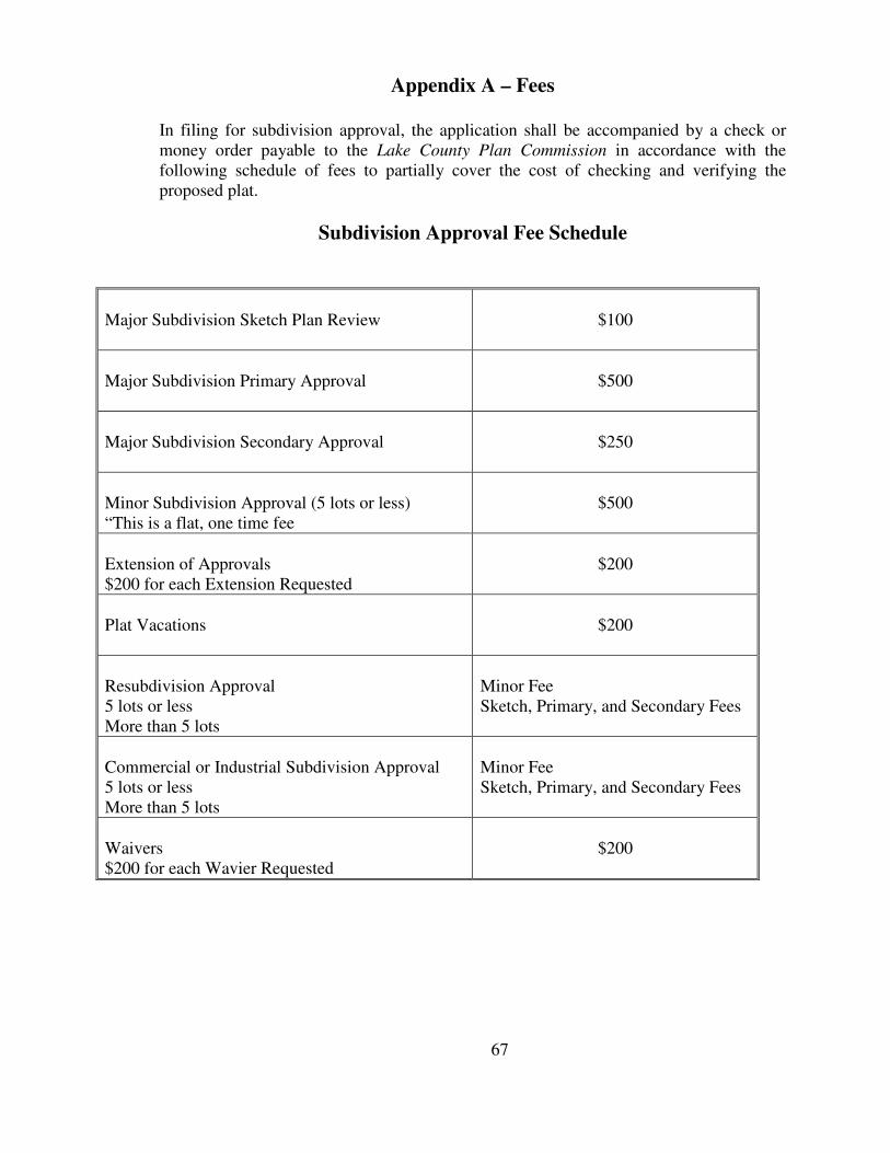
Appendix A – Fees
In filing for subdivision approval, the application shall be accompanied by a check or money order payable to the Lake County Plan Commission in accordance with the following schedule of fees to partially cover the cost of checking and verifying the proposed plat.
Subdivision Approval Fee Schedule
Major Subdivision Sketch Plan Review
$100
Major Subdivision Primary Approval
$500
Major Subdivision Secondary Approval
$250
Minor Subdivision Approval (5 lots or less) “This is a flat, one time fee
$500
Extension of Approvals $200 for each Extension Requested
$200
Plat Vacations
$200
Resubdivision Approval 5 lots or less More than 5 lots
Minor Fee Sketch, Primary, and Secondary Fees
Commercial or Industrial Subdivision Approval 5 lots or less More than 5 lots
Minor Fee Sketch, Primary, and Secondary Fees
Waivers $200 for each Wavier Requested
$200
67
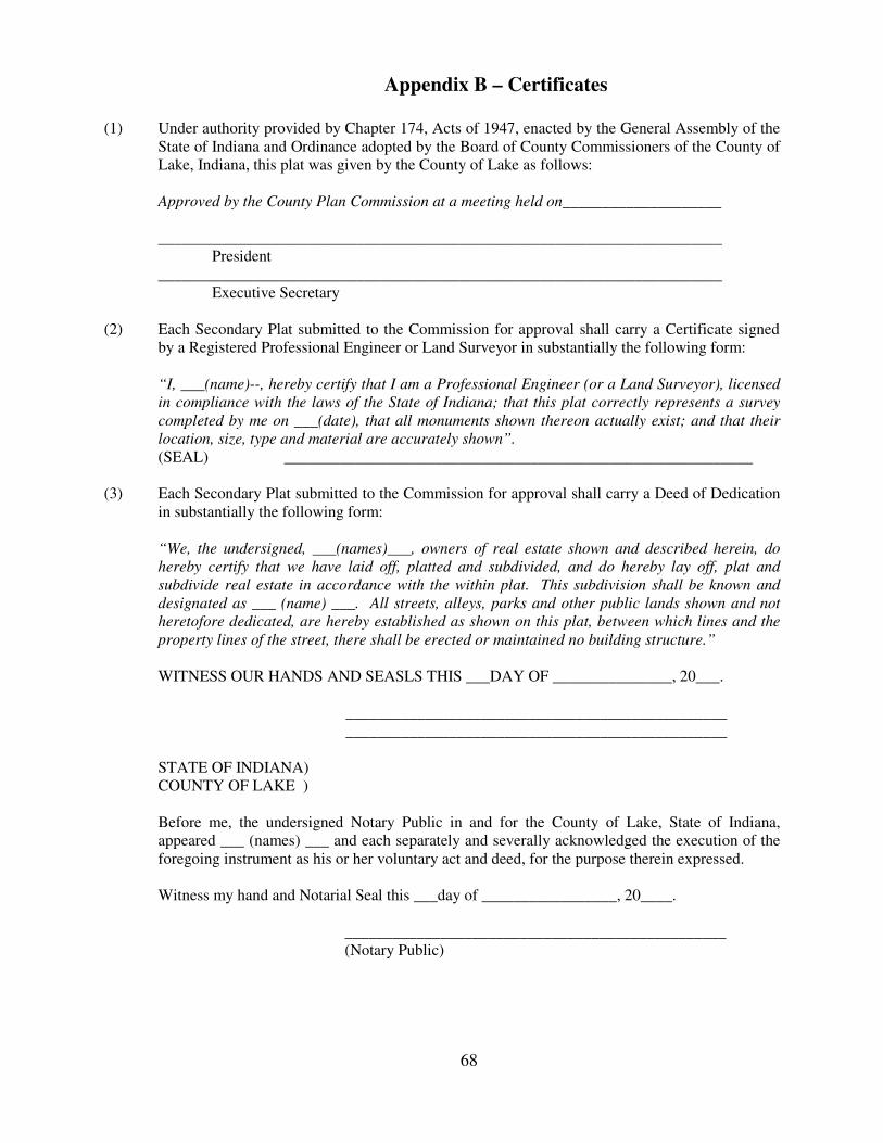
Appendix B – Certificates
(1) Under authority provided by Chapter 174, Acts of 1947, enacted by the General Assembly of the
State of Indiana and Ordinance adopted by the Board of County Commissioners of the County of Lake, Indiana, this plat was given by the County of Lake as follows:
Approved by the County Plan Commission at a meeting held on____________________
_______________________________________________________________________ President _______________________________________________________________________ Executive Secretary
(2) Each Secondary Plat submitted to the Commission for approval shall carry a Certificate signed by a Registered Professional Engineer or Land Surveyor in substantially the following form:
“I, ___(name)--, hereby certify that I am a Professional Engineer (or a Land Surveyor), licensed
in compliance with the laws of the State of Indiana; that this plat correctly represents a survey
completed by me on ___(date), that all monuments shown thereon actually exist; and that their
location, size, type and material are accurately shown”. (SEAL) ___________________________________________________________
(3) Each Secondary Plat submitted to the Commission for approval shall carry a Deed of Dedication
in substantially the following form:
“We, the undersigned, ___(names)___, owners of real estate shown and described herein, do
hereby certify that we have laid off, platted and subdivided, and do hereby lay off, plat and
subdivide real estate in accordance with the within plat. This subdivision shall be known and
designated as ___ (name) ___. All streets, alleys, parks and other public lands shown and not
heretofore dedicated, are hereby established as shown on this plat, between which lines and the
property lines of the street, there shall be erected or maintained no building structure.”
WITNESS OUR HANDS AND SEASLS THIS ___DAY OF _______________, 20___.
________________________________________________ ________________________________________________
STATE OF INDIANA) COUNTY OF LAKE ) Before me, the undersigned Notary Public in and for the County of Lake, State of Indiana, appeared ___ (names) ___ and each separately and severally acknowledged the execution of the foregoing instrument as his or her voluntary act and deed, for the purpose therein expressed. Witness my hand and Notarial Seal this ___day of _________________, 20____. ________________________________________________ (Notary Public)
68
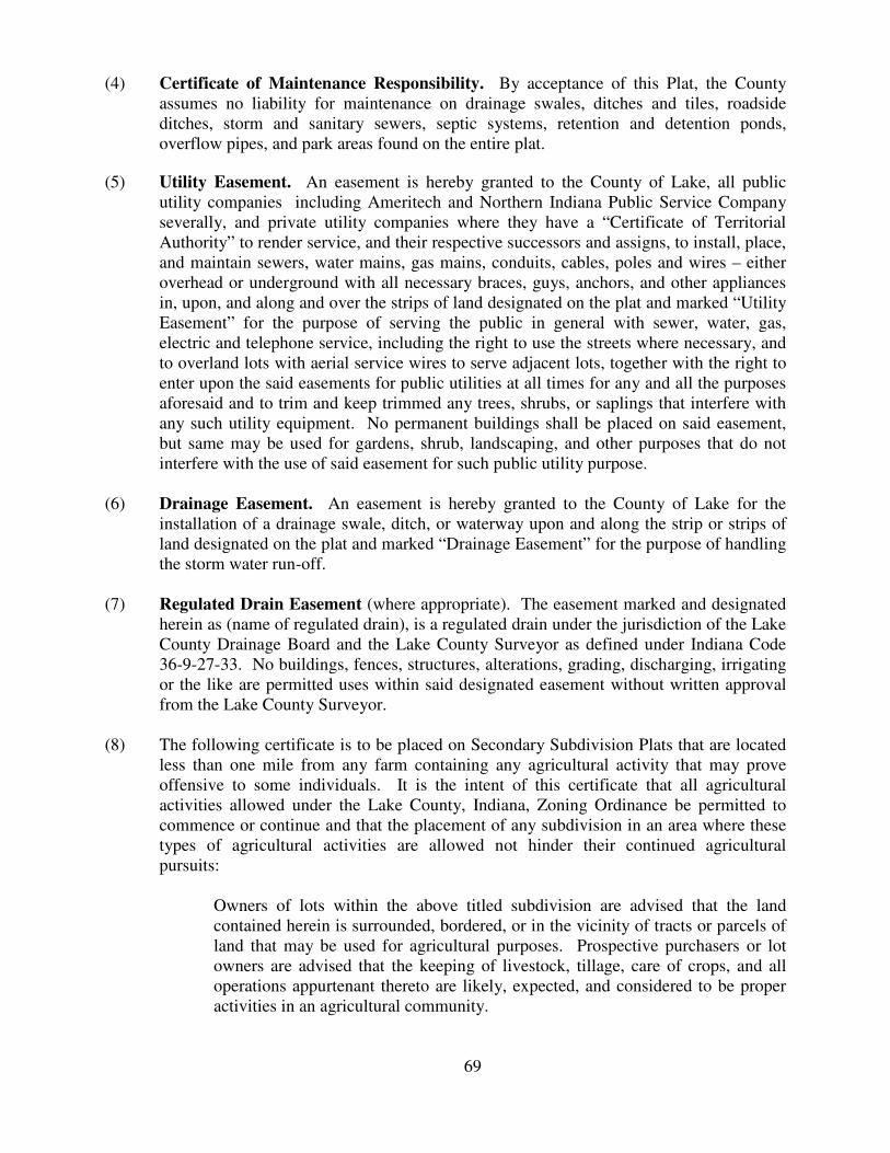
(4) Certificate of Maintenance Responsibility. By acceptance of this Plat, the County assumes no liability for maintenance on drainage swales, ditches and tiles, roadside ditches, storm and sanitary sewers, septic systems, retention and detention ponds, overflow pipes, and park areas found on the entire plat.
(5) Utility Easement. An easement is hereby granted to the County of Lake, all public utility companies including Ameritech and Northern Indiana Public Service Company severally, and private utility companies where they have a “Certificate of Territorial Authority” to render service, and their respective successors and assigns, to install, place, and maintain sewers, water mains, gas mains, conduits, cables, poles and wires – either overhead or underground with all necessary braces, guys, anchors, and other appliances in, upon, and along and over the strips of land designated on the plat and marked “Utility Easement” for the purpose of serving the public in general with sewer, water, gas, electric and telephone service, including the right to use the streets where necessary, and to overland lots with aerial service wires to serve adjacent lots, together with the right to enter upon the said easements for public utilities at all times for any and all the purposes aforesaid and to trim and keep trimmed any trees, shrubs, or saplings that interfere with any such utility equipment. No permanent buildings shall be placed on said easement, but same may be used for gardens, shrub, landscaping, and other purposes that do not interfere with the use of said easement for such public utility purpose.
(6) Drainage Easement. An easement is hereby granted to the County of Lake for the
installation of a drainage swale, ditch, or waterway upon and along the strip or strips of land designated on the plat and marked “Drainage Easement” for the purpose of handling the storm water run-off.
(7) Regulated Drain Easement (where appropriate). The easement marked and designated
herein as (name of regulated drain), is a regulated drain under the jurisdiction of the Lake County Drainage Board and the Lake County Surveyor as defined under Indiana Code 36-9-27-33. No buildings, fences, structures, alterations, grading, discharging, irrigating or the like are permitted uses within said designated easement without written approval from the Lake County Surveyor.
(8) The following certificate is to be placed on Secondary Subdivision Plats that are located
less than one mile from any farm containing any agricultural activity that may prove offensive to some individuals. It is the intent of this certificate that all agricultural activities allowed under the Lake County, Indiana, Zoning Ordinance be permitted to commence or continue and that the placement of any subdivision in an area where these types of agricultural activities are allowed not hinder their continued agricultural pursuits:
Owners of lots within the above titled subdivision are advised that the land
contained herein is surrounded, bordered, or in the vicinity of tracts or parcels of land that may be used for agricultural purposes. Prospective purchasers or lot owners are advised that the keeping of livestock, tillage, care of crops, and all operations appurtenant thereto are likely, expected, and considered to be proper activities in an agricultural community.
69
Appendix C – Surveying Requirements Every subdivision of land under the terms of this Ordinance shall require a survey meeting the following requirements prepared by a surveyor registered in the State of Indiana. (1) Requirements. The description and location of all survey monuments placed in
the subdivision shall be shown upon all maps of record. Permanent monuments shall be of concrete reinforced with one #4 vertical rod, and not less than 4 inches square on top and tapered to 6 inches square at the bottom and 36 inches long set flush with the ground.
Block corners shall be established by placement of an iron rod or pipe not less
than ½ inch in diameter and not less than 2 feet long and shall be driven flush with the ground. All points of intersection between lot lines and section, quarter section, or quarter quarter section liens shall be marked and referenced with an iron rod or pipe in an approved manner. Permanent monuments shall be erected at all corners of changes in bearing of the exterior boundary of the subdivision. All monuments shall be installed prior to recording of Secondary Plat, or if not, a Bond shall be posted to guarantee their installation.
(2) Certificates. Each and all Secondary Plats shall bear thereon the following
certificates:
(a) Plan Commission Approval Statement (see Appendix B, Item 1.) (b) Land Surveyor’s Statement (see Appendix B, Item 2.) (c) Deed of Dedication (see Appendix B, Item 3.) (d) Certificate of Maintenance Responsibility (see Appendix B, Item 4.)
70
Appendix D – Roadway Construction Specifications
(a) All construction shall be performed in the manner prescribed in the current
edition of Standard Specifications of the State Highway Department of Indiana and in the manner prescribed in any subsequent and applicable County Ordinance. In any instance where conflicting requirements may appear between Standard Specifications and applicable County Ordinance, the County Ordinance Regulation shall be binding. At minimum, all streets shall be constructed with 10 inches of compacted aggregate base, plus 2 and ½ inches of H.A.C. Binder Course, and 1 and ½ inches of H.A.C. Surface Course. A Tensar Geo Grid or other equivalent material shall be placed immediately below the 10 inch compacted aggregate base. All subterranean construction below street pavements shall be backfilled with a material approved by the Lake County Highway Engineer. Prior to placing the street surfacing, adequate sub-surface drainage for the street shall be provided where necessary. Concrete pavement (rigid pavement) can be used by the subdivider. Minimum requirements for concrete pavement shall be a 6 inch concrete slab on top of a 2 inch sand pad. In the event the subdivider elects to use concrete pavement, he shall submit 3 copies of a construction plan to the Plat Officer and shall have this plan approved by the County Inspecting Officials before concrete street construction is begun.
(b) See Figures 4.1 and 4.2 – Minimum Roadway Design Standards.
(c) Cul-de-sac streets, minor streets, and marginal streets built without curb and
gutter shall be surfaced to a minimum width of 24 feet. A road shoulder on both sides of the pavement shall be constructed to a width of 8 feet, and the slope on the shoulder shall be ½ inch per foot. Where roadside swales are constructed, the side slopes shall not be of a steeper gradient than 3 feet of horizontal measurement to one (1) foot of vertical measurement; furthermore, the subdivider shall demonstrate to the Commission what means he will employ to preserve the slope and maintain continuous flow of storm water in the roadside swales.
(d) Collector streets and secondary streets built without curb and gutter shall be built
as specified in Figures 4.1 and 4.2, Minimum Roadway Design Standards (see Section 4.3), except that the paved surface shall be a minimum of 24 feet in width, and the road shoulder shall be stabilized in a manner approved by the Highway Superintendent.
(2) Cul-De-Sacs. Cul-de-sacs shall meet all requirements for a minor street; however, the
pavement diameter shall be not less than one hundred twenty feet (120’). (3) Alleys. Alleys provided to serve business, commercial, or industrial uses shall be
constructed in accordance with the street specifications; however, the paved surface may be only twenty feet (20’).
71
(4) Curb and Gutter. Concrete curb and gutter shall be provided along the outside edge of all street pavements in subdivisions where the density of development (as defined in this Ordinance) is 1.0 or greater. In any case, curb and gutter shall be required for any subdivision within a two (2) mile radius of a duly incorporated municipality.
72
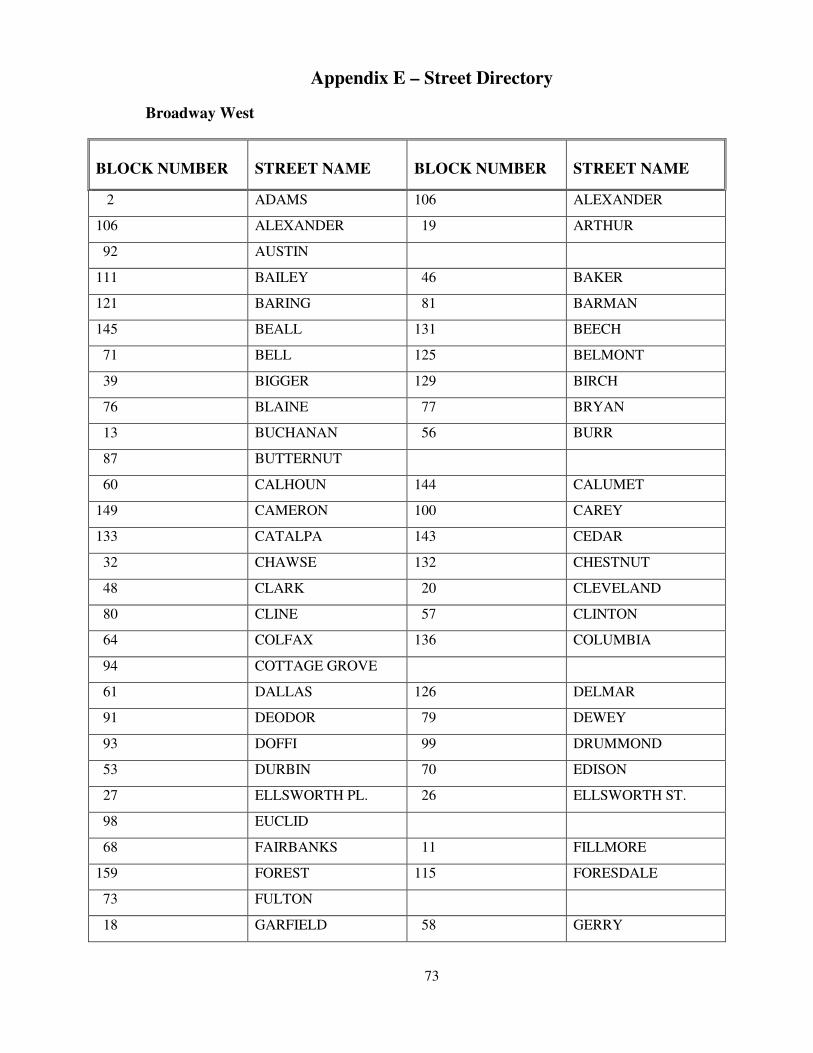
Appendix E – Street Directory
Broadway West
BLOCK NUMBER
STREET NAME
BLOCK NUMBER
STREET NAME
2 ADAMS 106 ALEXANDER
106 ALEXANDER 19 ARTHUR
92 AUSTIN
111 BAILEY 46 BAKER
121 BARING 81 BARMAN
145 BEALL 131 BEECH
71 BELL 125 BELMONT
39 BIGGER 129 BIRCH
76 BLAINE 77 BRYAN
13 BUCHANAN 56 BURR
87 BUTTERNUT
60 CALHOUN 144 CALUMET
149 CAMERON 100 CAREY
133 CATALPA 143 CEDAR
32 CHAWSE 132 CHESTNUT
48 CLARK 20 CLEVELAND
80 CLINE 57 CLINTON
64 COLFAX 136 COLUMBIA
94 COTTAGE GROVE
61 DALLAS 126 DELMAR
91 DEODOR 79 DEWEY
93 DOFFI 99 DRUMMOND
53 DURBIN 70 EDISON
27 ELLSWORTH PL. 26 ELLSWORTH ST.
98 EUCLID
68 FAIRBANKS 11 FILLMORE
159 FOREST 115 FORESDALE
73 FULTON
18 GARFIELD 58 GERRY
73
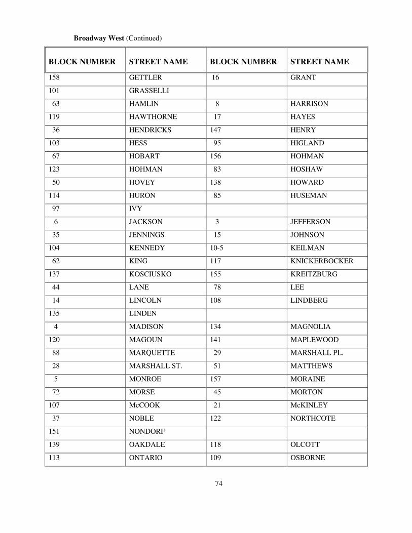
Broadway West (Continued)
BLOCK NUMBER
STREET NAME
BLOCK NUMBER
STREET NAME
158 GETTLER 16 GRANT
101 GRASSELLI
63 HAMLIN 8 HARRISON
119 HAWTHORNE 17 HAYES
36 HENDRICKS 147 HENRY
103 HESS 95 HIGLAND
67 HOBART 156 HOHMAN
123 HOHMAN 83 HOSHAW
50 HOVEY 138 HOWARD
114 HURON 85 HUSEMAN
97 IVY
6 JACKSON 3 JEFFERSON
35 JENNINGS 15 JOHNSON
104 KENNEDY 10-5 KEILMAN
62 KING 117 KNICKERBOCKER
137 KOSCIUSKO 155 KREITZBURG
44 LANE 78 LEE
14 LINCOLN 108 LINDBERG
135 LINDEN
4 MADISON 134 MAGNOLIA
120 MAGOUN 141 MAPLEWOOD
88 MARQUETTE 29 MARSHALL PL.
28 MARSHALL ST. 51 MATTHEWS
5 MONROE 157 MORAINE
72 MORSE 45 MORTON
107 McCOOK 21 McKINLEY
37 NOBLE 122 NORTHCOTE
151 NONDORF
139 OAKDALE 118 OLCOTT
113 ONTARIO 109 OSBORNE
74
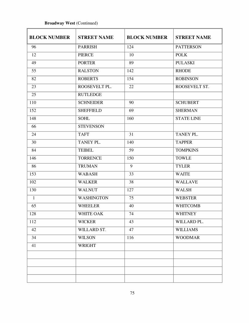
Broadway West (Continued)
BLOCK NUMBER
STREET NAME
BLOCK NUMBER
STREET NAME
96 PARRISH 124 PATTERSON
12 PIERCE 10 POLK
49 PORTER 89 PULASKI
55 RALSTON 142 RHODE
82 ROBERTS 154 ROBINSON
23 ROOSEVELT PL. 22 ROOSEVELT ST.
25 RUTLEDGE
110 SCHNEIDER 90 SCHUBERT
152 SHEFFIELD 69 SHERMAN
148 SOHL 160 STATE LINE
66 STEVENSON
24 TAFT 31 TANEY PL.
30 TANEY PL. 140 TAPPER
84 TEIBEL 59 TOMPKINS
146 TORRENCE 150 TOWLE
86 TRUMAN 9 TYLER
153 WABASH 33 WAITE
102 WALKER 38 WALLAVE
130 WALNUT 127 WALSH
1 WASHINGTON 75 WEBSTER
65 WHEELER 40 WHITCOMB
128 WHITE OAK 74 WHITNEY
112 WICKER 43 WILLARD PL.
42 WILLARD ST. 47 WILLIAMS
34 WILSON 116 WOODMAR
41 WRIGHT
75
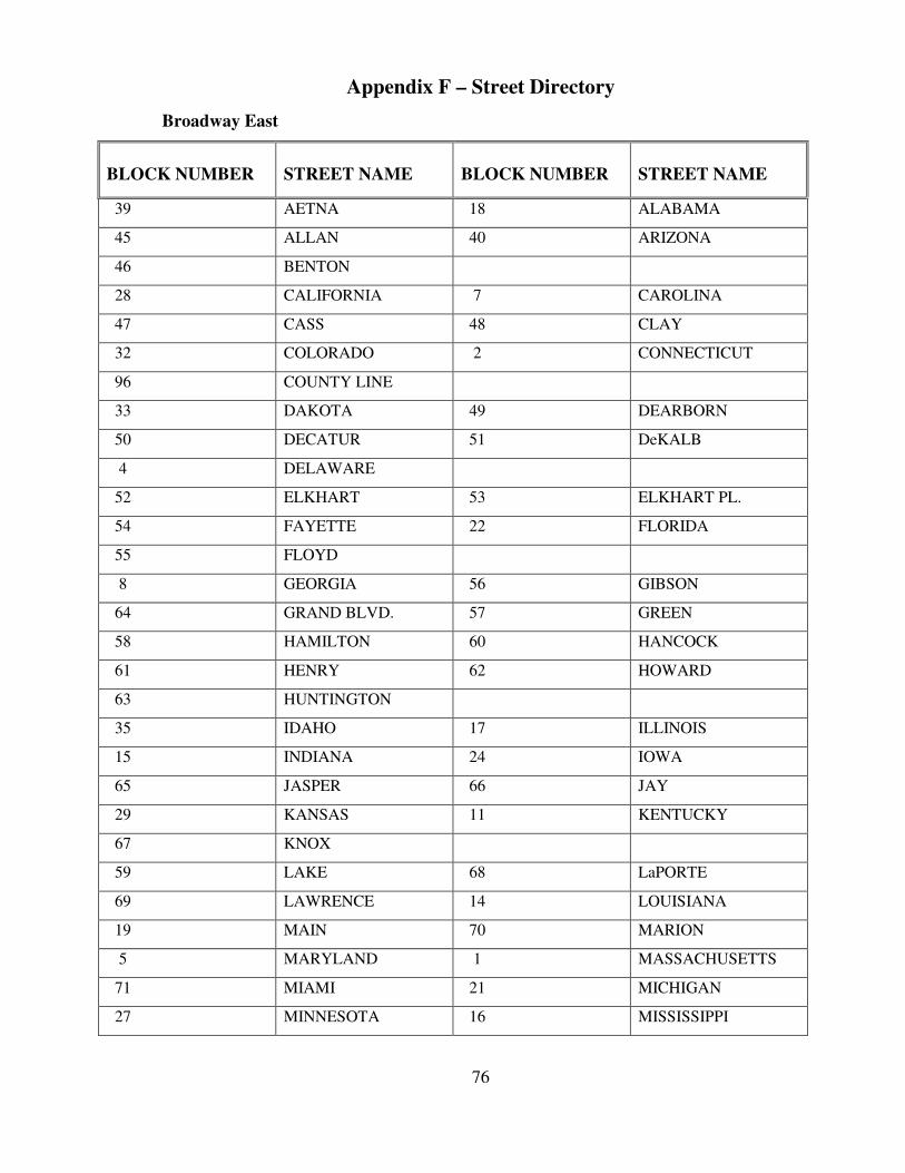
Appendix F – Street Directory
Broadway East
BLOCK NUMBER
STREET NAME
BLOCK NUMBER
STREET NAME
39 AETNA 18 ALABAMA
45 ALLAN 40 ARIZONA
46 BENTON
28 CALIFORNIA 7 CAROLINA
47 CASS 48 CLAY
32 COLORADO 2 CONNECTICUT
96 COUNTY LINE
33 DAKOTA 49 DEARBORN
50 DECATUR 51 DeKALB
4 DELAWARE
52 ELKHART 53 ELKHART PL.
54 FAYETTE 22 FLORIDA
55 FLOYD
8 GEORGIA 56 GIBSON
64 GRAND BLVD. 57 GREEN
58 HAMILTON 60 HANCOCK
61 HENRY 62 HOWARD
63 HUNTINGTON
35 IDAHO 17 ILLINOIS
15 INDIANA 24 IOWA
65 JASPER 66 JAY
29 KANSAS 11 KENTUCKY
67 KNOX
59 LAKE 68 LaPORTE
69 LAWRENCE 14 LOUISIANA
19 MAIN 70 MARION
5 MARYLAND 1 MASSACHUSETTS
71 MIAMI 21 MICHIGAN
27 MINNESOTA 16 MISSISSIPPI
76
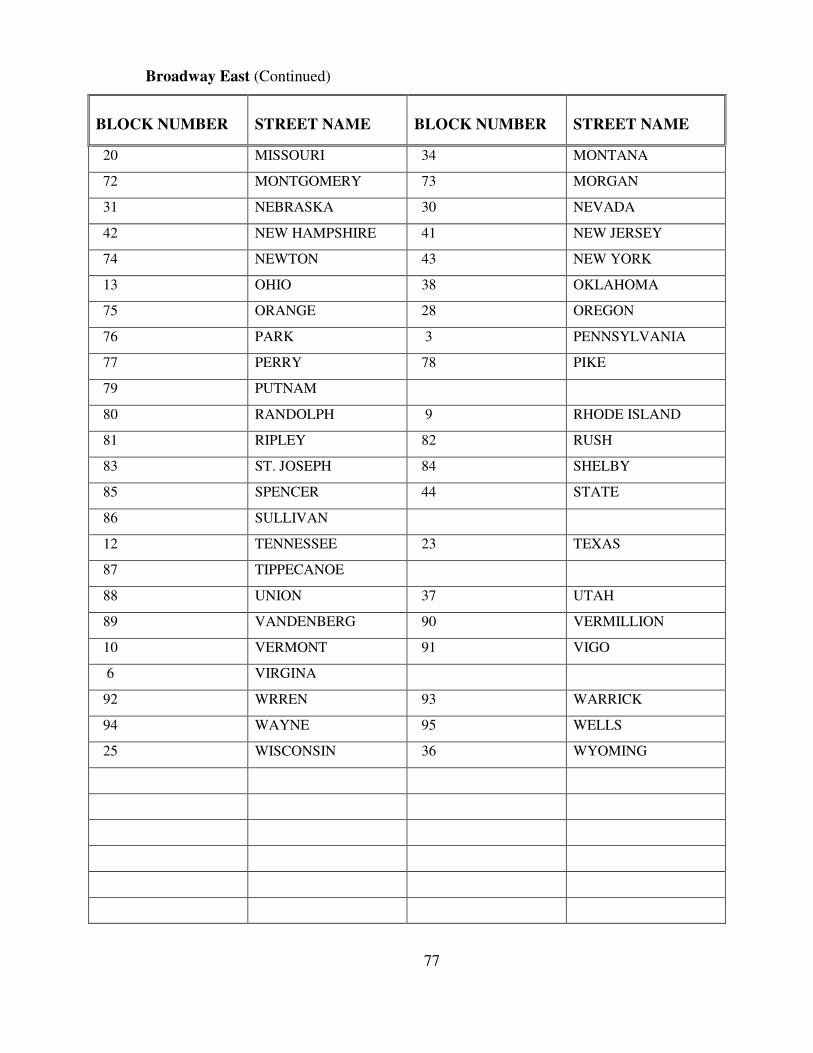
Broadway East (Continued)
BLOCK NUMBER
STREET NAME
BLOCK NUMBER
STREET NAME
20 MISSOURI 34 MONTANA
72 MONTGOMERY 73 MORGAN
31 NEBRASKA 30 NEVADA
42 NEW HAMPSHIRE 41 NEW JERSEY
74 NEWTON 43 NEW YORK
13 OHIO 38 OKLAHOMA
75 ORANGE 28 OREGON
76 PARK 3 PENNSYLVANIA
77 PERRY 78 PIKE
79 PUTNAM
80 RANDOLPH 9 RHODE ISLAND
81 RIPLEY 82 RUSH
83 ST. JOSEPH 84 SHELBY
85 SPENCER 44 STATE
86 SULLIVAN
12 TENNESSEE 23 TEXAS
87 TIPPECANOE
88 UNION 37 UTAH
89 VANDENBERG 90 VERMILLION
10 VERMONT 91 VIGO
6 VIRGINA
92 WRREN 93 WARRICK
94 WAYNE 95 WELLS
25 WISCONSIN 36 WYOMING
77
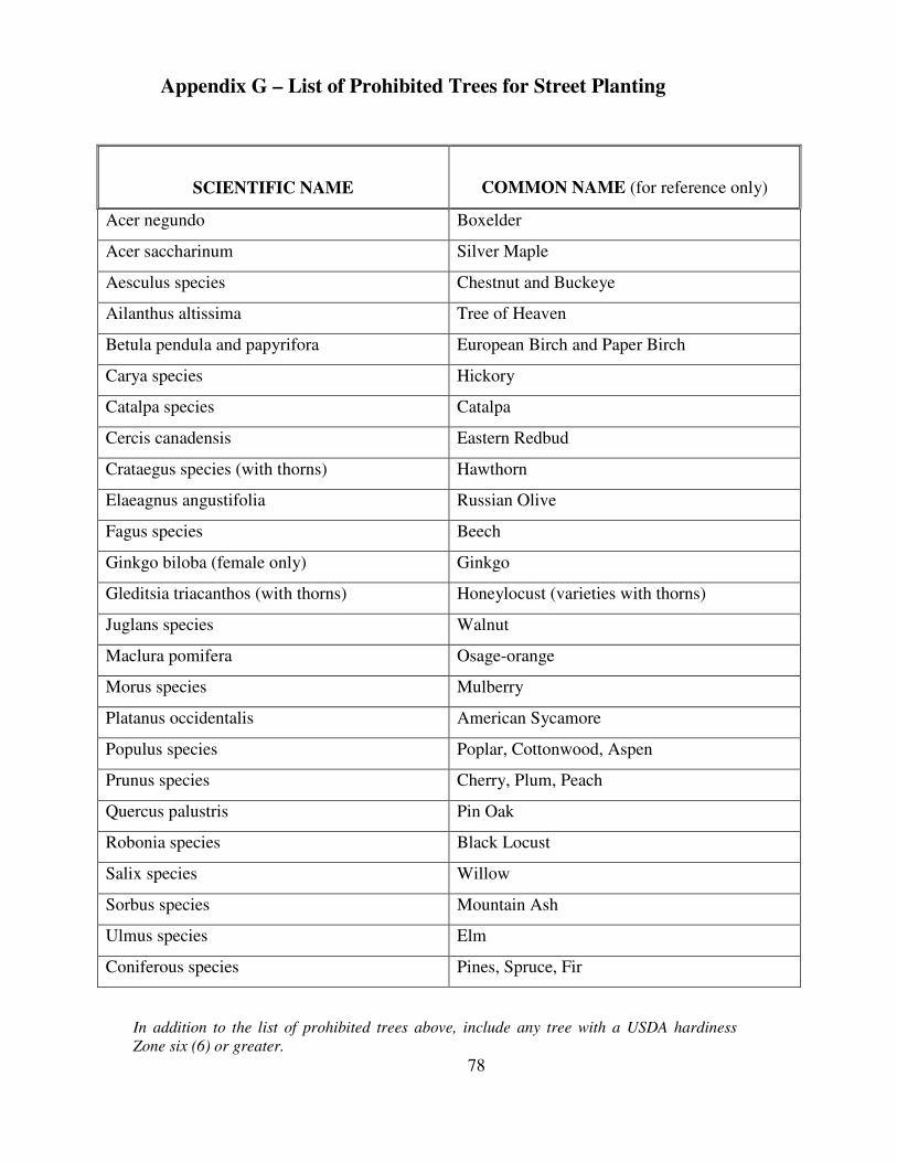
Appendix G – List of Prohibited Trees for Street Planting
SCIENTIFIC NAME
COMMON NAME (for reference only)
Acer negundo Boxelder
Acer saccharinum Silver Maple
Aesculus species Chestnut and Buckeye
Ailanthus altissima Tree of Heaven
Betula pendula and papyrifora European Birch and Paper Birch
Carya species Hickory
Catalpa species Catalpa
Cercis canadensis Eastern Redbud
Crataegus species (with thorns) Hawthorn
Elaeagnus angustifolia Russian Olive
Fagus species Beech
Ginkgo biloba (female only) Ginkgo
Gleditsia triacanthos (with thorns) Honeylocust (varieties with thorns)
Juglans species Walnut
Maclura pomifera Osage-orange
Morus species Mulberry
Platanus occidentalis American Sycamore
Populus species Poplar, Cottonwood, Aspen
Prunus species Cherry, Plum, Peach
Quercus palustris Pin Oak
Robonia species Black Locust
Salix species Willow
Sorbus species Mountain Ash
Ulmus species Elm
Coniferous species Pines, Spruce, Fir
In addition to the list of prohibited trees above, include any tree with a USDA hardiness
Zone six (6) or greater.
78