Embed Size (px)
Citation preview
IOSR Journal of Applied Geology and Geophysics (IOSR-JAGG)
e-ISSN: 2321–0990, p-ISSN: 2321–0982.Volume 1, Issue 4 (Sep. – Oct. 2013), PP 01-09 www.iosrjournals.org
www.iosrjournals.org 1 | Page
An Appraisal of Groundwater Resources and Sustainable
Stratigies for Recharge of Aquifers in State Of Rajasthan
S.K.Maanju *, K. Saha**, G.R.Jakhar** * Vikram University,Ujjain(M.P.)
** Govt. Dungar College, Bikaner (Rajasthan)
Abstract: The largest State of India, Rajasthan has since beginning witnessed scanty and erratic rainfall,
which is lonely source of groundwater recharge. More than 90% of land area is irrigated by groundwater and
main source of domestic water is also groundwater. Excessive withdrawal of groundwater has posed serious
problems and resulted in depletion of this natural resource. The water level has been declining at an alarming
rate of 1 to 2 mts. per year in critical aquifers which is a matter of great concern for every one specifically for
future generations.
The authors in this paper suggest viable methodologies for arrest of declining trend of water level by
adopting various artificial recharge methods and an emphasis is given for deciding accurate recharge method.
Key words: Aquifer, Groundwater, Recharge.
I. Introduction The state of Rajasthan which is largest state of India, lies between latitude 23031’N to 30012’ N and
longitude 6903’E to 780 E covering an area of 342239 sq. kms. which is 10.74% of Indian union.The state
suffers from vagaries of monsoon having lowest rainfall in western part namely, Jaisalmer district where it
rains only 171mm and this rain is not sufficient even to recharge aquifers there and entire rains are consumed as
soil moisture, evapotranspiration and allow little or no surface runoff as a result of which even defined channel
of stream flows are lacking. However, the story is entirely different in the eastern part of the state and as we
move from Jaisalmer-Jodhpur-Ajmer,Jaipure and Dholpur, there is a continuous rise in rainfall which is 386 mm
at Jodhpur, 514 mm at Ajmer,603 mm at Jaipur and 819 mm Dholpur indicating a condition of pure desertic to
semidesertic type.
The state which from suffers from such an extreme climatic condition in temperature and
rainfall also suffers lack of fresh water in its aquifers and in many western distts, 3/4 of the area are only
occupied by saline water tract. There was no scientific organization in the State to prospect and delineate the groundwater potential zones and people were digging their wells and tube wells on the advice of unscientific
methods of quacks. The State Government realised the shortcoming and opened up a survey and research wing
specially to prospect for groundwater and delineate the fresh potential zones of aquifers in the year 1966.
Background :- The survey and research wing earlier came into the existence as a very small unit in the
groundwater department in the year 1963-64 with a post of Geo-
Hydrologist, a junior Geology with two research assistants. Looking to the vastness of problem of groundwater
and its exploitation a further strengthening was made in the year 1966-67 and full fledge surrey and
investigation wing was created in the department with main aim to carry out detailed investigation and
demarcate ground water potential zones and its exploitation. Since, the departmental work increased and then it
was again reorganized as survey and research wing in 1970, which is exiting date.
The survey and research wing carried out hydro geological survey in whole of Rajasthan and mapped out the potential zones of ground water. This resulted in huge exploitation in ground water for agriculture and
domestic purpose with financing of NABARD. The resulted so much so that the total draft from the ground
water potential zone exceeded many times more than the recharge taking place through rainfall & other sources
between 1980 and 1990. The water level started declining at alarmingly fast rate and matter then came to the
notice of government.
Stages Of Ground Water Development.
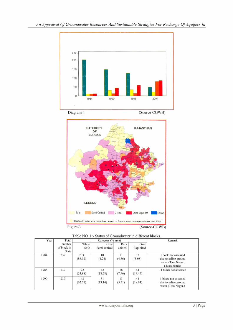
The number of safe blocks has significantly reduced from 203 to 49 in year 1984 to 2001 and status of
ground water condition of different blocks of Rajasthan during period from 1984 to 2001 is quite dismal as
shown in table no. 1. Groundwater resources as on 1.1.1998 and 1.1.2001 in state of Rajasthan is shown in table
no. 2 and district wise groundwater resources as on 1.1.2001 is shown in table no. 3. As per ground water department data of 1.1.95, out of 30 districts, only 9 districts namely, Baran, Banswara, Bikaner, Dholpur, Tonk,
Udaipur, Saimadhopur show some potential of exploitation but rest of the districts comes under grey and dark
An Appraisal Of Groundwater Resources And Sustainable Stratigies For Recharge Of Aquifers In
www.iosrjournals.org 2 | Page
categories and water level is going down by 1 to 2 meters every year and till date 3/4th of the potential aquifer
have been dewatered at the present rate of the present rate of the ground water withdrawal and if this trend is not
arrested timely, may bring havoc in the state even on the brink of rioting amongst the people for water. The
same point can be emphasis by stating that at present 123 block are over exploited, 28 block have become dark
and 50 block have gone gray as per 1.1.95 year of assessment of ground water department and during
subsequent year assessment many more numbers of blocks may be added leaving no hope for exploitation by the
tube well and dug wells in near future and even tube wells for drinking water will be drilled because if the following reason:-
A. Most of the potential zones are on the verge of drying up because of over exploitation.
B. Water level in dug wells and tube wells have declined to a depth, which have become uneconomic as the
cost of lift become exorbitantly high.
C. Deterioration of ground water quality with excessive withdrawal of water from the aquifer.
D. The entire ground water resources available for irrigation as per data collected and resources determined
as on 1.1.95 is 11028. 223 MCM. The net draft due to irrigation for agricultural area in the State is
6493.7144 MCM. The remaining ground water potential further utilization is 4534. 5085 MCM and this
meager balance too will be completely utilized by 2041 years by taking 4% growth rate of utilization of
ground water resources per year and taking 85% use of existing ground water storage.
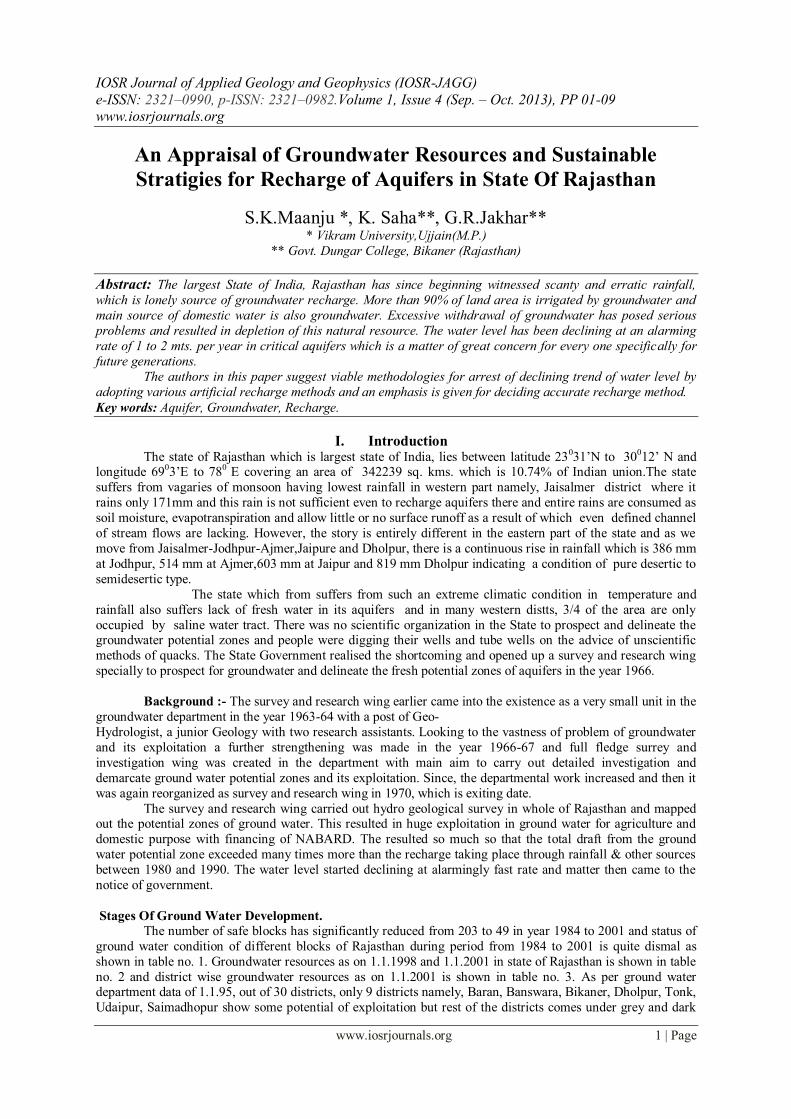
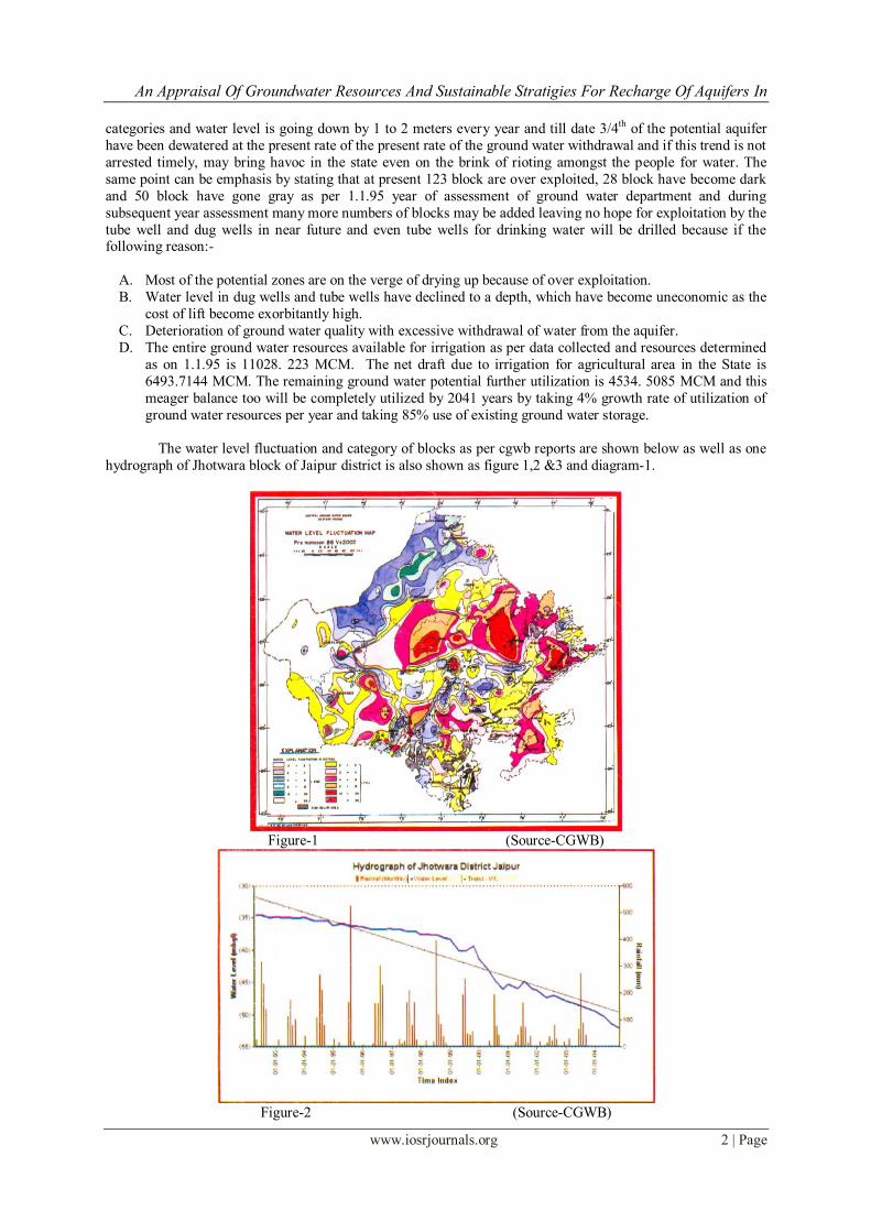
The water level fluctuation and category of blocks as per cgwb reports are shown below as well as one
hydrograph of Jhotwara block of Jaipur district is also shown as figure 1,2 &3 and diagram-1.
Figure-1 (Source-CGWB)
Figure-2 (Source-CGWB)
An Appraisal Of Groundwater Resources And Sustainable Stratigies For Recharge Of Aquifers In
www.iosrjournals.org 3 | Page
Diagram-1 (Source-CGWB)
Figure-3 (Source-CGWB)
Table NO. 1:- Status of Groundwater in different blocks. Year Total
number
of block in
State
Category (% area) Remark
White Grey Dark Over
Exploited Safe Semi-critical Critical
1984 237 203
(86.02)
10
(4.24)
11
(4.66)
12
(5.08)
1 bock not assessed
due to saline ground
water (Tara Nager,
Churu district
1988 237 122
(53.98)
42
(18.58)
18
(7.96)
44
(19.47)
11 block not assessed
1990 237 148
(62.71)
31
(13.14)
13
(5.51)
44
(18.64)
1 block not assessed
due to saline ground
water (Tara Nager,)
An Appraisal Of Groundwater Resources And Sustainable Stratigies For Recharge Of Aquifers In
www.iosrjournals.org 4 | Page
1992 237 149
(63.14)
19
(8.05)
15
(6.36)
53
(22.46)
1block not assessed
due to saline ground
water (Tara Nager)
1995 237
127
(53.81)
35
(14.13)
14
(5.93)
60
(25.42)
1 block not assessed
due to saline ground
water (Tara Nagar )
1998 237 135
(57.2)
34
(14.41)
26
(11.02)
41
(17.37)
1 block not assessed
due to saline ground
water (Tara Nagar )
2001 237 49
(20.76)
21
(8.9)
80
(33.9)
86
(36.44)
1 block not assessed
due to saline ground
water (Tara Nagar )
Table No. 2 :- Groundwater resources as on 1.1.1998 and 1.1.2001
Groundwater resource as on 1.1.1998 and 1.1.2001
S.No Particular 1998 2001
1 Recharge
Gross Recharge 12602.15 -
Net annual ground water availability - 11158.97
2 Ground water draft
(a) Irrigation Draft 11035.7 10453.52
(b) Domestic and Industrial Draft 983.42 1181.26
( c) Gross draft 12019.12 11634.78
(d) Net G.W draft(70% of irrigation Draft +domestic draft) 8708.41 -
3 Ground Water balance 3893.74 (-) 475.81
4 Stage of G.W development(%) 69.1 104.26
5 Total no of blocks (assessed) 236 236
(a)safe 135 49
(b)semi critical 34 21
(c) critical 26 80
(d)over exploited 41 86
UNIT : Million Cubic Mitre (MCM)
Table No. 3:- District-wise groundwater resources (as on 1.1.2001) District
Area
sq(km)
Potential
Zone
area
(Sq.km.)
Netannual
ground
Water
Availability
( mcm)
Existing
Gross
ground
Water
draft for
Arrigation
(mcm)
Existing
G.W draft
for
domestic
and
Industrial
use (mcm)
Existing
Gross
Ground
water
Draft for
all
Uses
(mcm)
Allocation
for
domestric
and
Industrial
requiremen
t
as
on year
2025
(mcm)
Net ground
water
availability
for futire
Irrigation
Developm
ent (mcm)
Prsent
ground
water
balance
(mcm)
Stage of
G.W
Developm
-ent ( %)
1 2 3 4 5 6 7 8 9 10 11
Ajmer 8481 7466.76 314.4243 305.2392 43.5855 348.8247 102.6046 -93.4195 -34.4004 110.94
Alwer 8720.46 6825.81 912.3019 1063.587 48.4847 1112.072 120.8226 -272.1083 -199.7704 121.9
Banswara 5037 4288.92 162.5044 28.6074 10.598 39.2054 24.7078 109.1892 123.299 24.13
Baran 6955.31 6892.21 495.3083 305.1357 16.858 321.9937 42.1455 148.0271 173.3146 65.01
Barmer 28387 21734.65 249.8049 204.5159 51.3937 255.9096 81.202 -35.913 -6.1047 102.44
Bharatpur 5044.1 3412.52 514.261 452.2776 27.3797 479.6573 78.38 -16.3966 34.6037 93.27
Bhilwara 10455 9354.85 426.7917 424.3371 26.0477 450.3848 75.9095 -73.4549 -23.5931 105.53
Bikaner 27244 10898.63 197.6075 110.703 33.8147 144.5177 78.0991 8.8054 53.0898 73.13
Bundi 5500 4240.18 355.7014 212.041 20.0769 232.1179 42.1148 101.5456 123.5835 65.26
Chattorgar
h
10856 8277.81 460.1123 503.9096 15.5684 519.478 65.6317 -109.429 -59.3657 112.9
Churu 16830 7895.62 197.6883 77.9693 39.3821 117.3514 67.4409 52.2781 80.3369 59.36
Dausa 3420.17 3085.62 269.0076 277.249 18.0481 295.2971 46.68 -54.9214 -26.2895 109.77
Dholpur 3009.05 2049.9 237.211 229.7608 16.0349 254.7957 35.7771 -28.3269 -8.5847 103.62
Dungarpur 3770 2634.13 92.7842 63.6858 12.8433 76.5289 35.7529 -6.6543 16.2553 82.48
Ganganaga
r
11603.65. 1545.6 198.8341 131.0265 2.5305 133.557 6.3263 61.4813 65.2771 67.17
Hanumang
arh
9579.54 1278.5 194.6094 162.0825 4.588 166.6675 10.2813 22.2456 27.9419 85.64
Jaipur 11061.44 9994.67 684.4074 855.4227 160.5661 1015.988 389.2935 -560.3088 -331.5814 148.45
Jaisalmer 38401 9868.3 52.5923 26.4482 13.147 39.5952 22.35 3.7941 12.9971 75.29
An Appraisal Of Groundwater Resources And Sustainable Stratigies For Recharge Of Aquifers In
www.iosrjournals.org 5 | Page
Jalore 10640 8228.1 423.614 797.7421 29.7364 827.4785 74.341 -448.4691 -403.8645 195.34
Jhalawar 6219 6106.16 397.6954 362.754 18.4849 381.2389 46.2123 -11.2708 16.4565 95.86
Jhunjhunu 5928 5273.69 243.0369 358.0869 61.5882 419.6751 139.25 -254.3 -176.6382 172.68
Jodhpur 22250 18867.92 393.1304 555.8329 105.0362 660.8691 182.4611 -345.1636 -267.7387 168.1
Karauil 5038.6 3902.42 412.6633 298.6469 42.1661 340.813 77.4437 36.5727 71.8503 82.59
Kota 5203.94 5123.17 404.1037 191.62 29.1788 220.7988 67.5018 144.9819 183.3049 54.64
Nagaur 17718.25 16378.5 628.1586 707.7749 134.3686 842.1435 228.897 -308.5133 -213.9849 134.07
Pali 12357 7362.54 413.391 304.4199 25.9214 330.3413 54.4331 54.538 83.0497 79.91
Rajsamand 4635.46 3540.09 154.1856 131.7258 11.8988 143.6246 36.416 -13.9562 10.561 93.15
S.
Madhopur
5020.65 4325.63 384.7027 262.4127 49.1224 311.5351 99.06 23.23 73.1676 80.98
Sikar 7880.85 7263.46 324.524 305.1129 39.5821 344.695 84.1352 -64.7241 -20.171 106.22
Sirohi 5136 4075.7 265.6484 240.9045 6.4672 247.3717 17.6779 7.066 18.2767 93.12
Tonk 7200 6525.72 414.531 230.6505 40.0198 270.6703 95.5775 88.303 143.8607 65.3
Udaipur 12643.54 8229.48 283.6293 271.8368 26.7417 298.5785 85.7885 -73.9957 -14.9489 105.27
TOTAL 34222.01 217947.3 11158.96 10453.51 1181.256 11634.77 2614.714 -1909.267 -475.8098 104.26
The water is being wasted an unintentionally also and quantity of such water is shown in table no. 4. Although
the government is aware of situation and in every meeting, daily news papers, the problem of lowering of water
level have been discussed but till date serious efforts the direction is lacking on the part of the government The
comprehensive State Water policy recently approved by the Govt. contains a tall order on the responsible
organizations in the water resources Sector, which inter-alia lays down that standardized training shall be a part
of water resources management & should cover all its aspects & all personnel involved in it, including farmers.
The State shall also encourage education of public at large. Scholarships, study tours, incentives etc. shell be
provided to encourage & support training.
Table No. 4 :- UNINTENTIONAL WASTAGE OF WATER
Activity Method adopted Qty
used
Ltr.
Method to be adopted
Qty.
required
Ltr.
Qty
saved
Ltr
Brushing teeth running tap for 5 min 20 tumbler or glass 0.5 19.5
Washing hand running tap for 2 min 8 half filled wash basin 2 6
Shaving running tap for 8 min 15 shaving mug 1 14
Shower letting shower run
while soaping. staying
under shower too long
70 wet down, tap off, soap up
rinse off
20 50
Flushing toilet using old fashioned
large capacity cistern
13.5or
more
dual system
short flush liquid waste
4.6 4.5
or
more
Watering plant running hose for 5
minutes
80 water cane 5 75
Washing floors running hose for 5
minutes
80 mop& bucket 18 62
Washing car running hose for 10
minutes
160 bucket 25 135
However the matter is becoming serious day by day and the government has to take a quick decision to meet the
above situation and specially the ground water department being an apex organization has to take the
responsibility of meeting the challenge of 21stcentury by solving this problem by taking up the following work
immediately in hand and effectively managing the ground water utilization in the State.
1) Artificially recharging the over exploited potential zones by taking best possible artificially recharging
method available in India.
2) There are 15 recognized basin in the state namely :-
1) Shekhawati (10) Sabarmati 2) Ruparaill (11) Luni
3) Banganga (12) West-Banas
4) Gambhir (13) Sukly
5) Parbati (14) Other Nallahs
6) Sabi (15) Out Side Basin
7) Banas
8) Chambal
9) Mahi
An Appraisal Of Groundwater Resources And Sustainable Stratigies For Recharge Of Aquifers In
www.iosrjournals.org 6 | Page
The above basins are very well defined and have different Geological and hydrogeological conditions and
requires special study for artificially recharging the aquifers falling in these basins.
3) Study for possibly of conjunctive use in chambal ,mahi, I.G.N.P. and gang canal area .This study is
essential to solve the water logging problems by sinking shallow tube wells along the canals and then
pouring the water in to the canal for increasing the flow to the tail and villages so that these are properly
irrigated. 4) Small stream flow retarding structure intended to enhance ground water replenishment deserves special
consideration in the state because of occurrence of flash floods, erratic and unevenly distributed
monsoonal rainfall.
5) Inter-basin transfer of surface water as well as ground water.
6) Importing water from surplus basin to deficit basin for artificial recharge.
7) Utilization of Ghaghar nali flood in the out side basin for artificial recharge.
8) Pursuing with the Government for bringing out a comprehensive ground water utilization rule in the state
binding the people not to dig or bore a hole eithout the permission of the officer of ground water
department.
9) Emphasis with the Government to build anicuts only mand not medium or minor irrigation projects which
makes the down stream area dry and thus reduce the chances of recharging the agriculturist well . 10) Building sub-terranean dams on rever emptying out side state boundaries to prevent base flow through
thick alluvium bed up to 75% depth of the total thickness. this would stop base flow going waste out side
state by 75% and only allows 25% of water to pass down stream so that salinity is not allowed to develop.
11) Because of developmental activities in the state big buildings & colonies have come up in an area which
used to from the recharging zones during rains and presently allowing large surface runoff. The
Government should make compulsory to conserve such rainwater by guiding it to a recharging pit.
Artificial Recharge methods
Artificial recharge is defined as "the practice of increasing by artificial means the amount of water that enters
ground water".
The specific purpose for which artificial recharge is praticed are:-
I) To conserve and dispose of run off and flood water.
II) Supplement the quantity of ground water available.
III) Reduce or eliminate the decline in water level of ground water reservoirs.
IV) Store water to reduce cost of pumping and piping.
V) Store clear, cool water for use of drinking during summer season.
To achieve the above objective we have to find out what are the methods available to us in present’s day times.
There are the following methods, which can be used permeability and then depth to areas based on
hydrogeological formations, permeability, and transmissibility and then depth to water level from natural
surface to aquifer to be take place in between natural surface and depth to water level. Boardly, artificial
recharge method can be classified in to two groups:- To achieve the above objective we have to To achieve the above objectives we have to find out what are the methods available to us in present’s day times. There are the
following methods, which can be used permeability and then depth to areas based on hydrogeological
formations, permeability, and transmissibility and then depth to water level from natural surface to aquifer to be
take place in between natural surface and depth to water level. Boardly, artificial recharge method can be
classified in to two groups:-
(a) Direct methods and (b) Indirect methods. These are as follws:
A) DIRECT METHODS:
The direct methods techniques can be divided in to two methods viz:-
1) Surface spreading techniques. 2) Sub surface technique.
Surface spreading technique :- These technique can be further divided into following sub -groups:
I. Flooding
II. Ditch and Furrows
III. Recharge basin
IV. Run off conservation
The structures which have following sub group
An Appraisal Of Groundwater Resources And Sustainable Stratigies For Recharge Of Aquifers In
www.iosrjournals.org 7 | Page
a) Gully plugging.
b) Bench Terracing
c) Contour Bunding
d) Nala Bund
e) Percolation Tank
V. Stream Modification
VI. Surface Irrigation.
B) INDIRECT METHODS:
The indirect methods can be further sub-divided in to
I. Induced recharge
II. Aquifer Modification
III. Grounds water conservation structure.
I. Induced Recharge- These can be further divided in following heads:
a) pumping wells b) collector well
c) infiltration Gallery
II Aquifer modification-
a) Bore Blasting
b) Hydro-Fracturing
c) Ground water conservation structure
d) Ground water dams/under ground bandharas
Of the above method, we have select the,most economical and suitable methods that
Suits to the climatic condition as well as taking into account the rever basins.
If we look at the map of Rajasthan State, we find a clear-cut division of the state parallel to the Aravallis
Hills and can be divided roughly in two parts To the Aravllis Hills and can be devided roughly in two parts
1. These areas are eastern sides falling in definded basins.
2. Areas that falls out side basins mostly in desertic areas(courtesy un – published report of TAHAL),
Methods of artificial recharge in both areas are of different types and hence dealt with separately.
The basin can be defined “as entire rains falling in area is drained by a single river having single out let and having
prominent water divide boundaries. Accordingly, there are 15 basin which have been mentioned earlier.
Based on the economic condition and with least effort the most important methods of artificial recharge that
would suit in these basin are by surface spreading methods.
Among surface spreading methods , following methods are best.
1) FLOODING BY.
a) check dams
b) anicuts
2) Run off conservation structure
a) Percolation tank
b) Water harvesting structure.
Each of the above methods are described as follows:
a) Check Dam
These are generally built to arrest the flood water and then these flood water is allowed on side to spread and remind in contract with permeable soil for longer period so as to enable the store water to infiltrate down ward
to become ground water. Therefore, permeability of the area to be recharged and topography play the important
role in location and contraction of check dams . Further, these structure are mostly suited if there is a deep
incised channel with sufficient permeable strata up stream and on side of reservoir . These store water up
stream and these water can be pumped out with construction of canal and can be taken to desired places also for
recharging purpose. The slope of valley / gradient should not be more than 3 to 4%.

An Appraisal Of Groundwater Resources And Sustainable Stratigies For Recharge Of Aquifers In
www.iosrjournals.org 8 | Page
Anicuts: Anicut too are an important structure which are generally utilized for water conservation and artificial
recharge in area where run off is going waste and because of slope factor flowing water does not have enough
contact time to allow recharge to take place through infiltration provided there are no impermeable bed down
below the river bed. Anicuts are smaller structure then check dam and when used for artificial it is designed in
such a manner as to retain/ arrest the surface run off water by obstructing its downward flow at the same time
allowing excess water to overflow it and move down ward recharging further down stream side.
3) Runoff conservation structure :-
a) Percolation Tank –its work is very well defined by its name. These are the structure conserve the surface
run off which finds little time and because of slope factor water is not allowed to recharge. The area after
investigation are selected and an obstruction is erected in the stream and nallah by building embankments
so as to store water for some time and thus allows the water to increase contact time the permeable zone and
thus recharging ground water in depleted zones.
b) Water harvesting structures –These are one of the best methods suites to spread the flood water going
waste through rivers stream. The surface runoff is diverted water to more permeable zones mostly on the
sides of the river banks and allows spreading. These allow increasing the contact of water with permeable
zones thus leading more water to infiltrate to become ground water.
Suitable methods of artificial recharge out side the basin.
These are the areas falling in the arid zone which experience precipitation less then 400mm/ annum
with number of rainy days between 29 to 30 days or even less ans rain fall variation coefficient lies from 30 to
70%. In such areas major component of out flow is evaporation due to high temperature and drainage is poorly
developed. The infiltration rarely exceeds field capacity of soil and ground water recharge may be very small or
negligible. Such region, though experience acute need, may be out of consideration for artificial recharge unless
Trans basin water transfer is available.
However, in these areas too some times cloud burst occurs and instances are there that there was 200 or
so millimeters rains have fallen with in 24 hours leading flooding especially in Jaiselmer, Barmer. Although, in
such areas not much can be done but under the circumstances explained above, water harvesting structures can
be tries and for such trial most suitable area is Lathi-Chandan basin which is a highly permeable area but so far
study conducted by various ground water agencies indicate occurrence of fossil water which are being utilized by agriculturist for irrigating their land.
However, there is yet another method can be tried over there if cost permits by importing water from
canal or by pumping through pipes from IGNP. This method can be attempted for artificial recharge either by
spreading or injection methods for confined aquifers though shaft, bore wells and due wells etc.
II. Conclusion Looking to the present condition existing in the state and results available of various studies points a
very poor position of availability of water.Therefore,massive efforts are require to be made for utilizing every
drop of rain water by diverting excess water for artificial recharging purposes so as to arrest the declining trend of water level or slowing down the downward trend. There is a need to bring ground water legislation to
regularize the use if ground water in the state. There is also need to accurately assess the recharge to ground
water as the present methodology followed by the state ground water department is on adhoc norms and it
should be replaced by use of ISOTOPE Hydrology methods which takes 3 to 7 years to assess the actual
recharge to ground water.
Refernces: [1]. Bouwer, H. 1978 : Ground Water Hydrology, McGraw Hill, New York.
[2]. Davis D.N. and Dewiest, R.J.M. 1968 : Hydrogeology John Willey & Sons, New York.
[3]. Garg, S.P. 1984 : Ground Water and Tube Wells Oxford & IBH Publishing Co. 2nd
Edn., New Delhi.
[4]. Ground Water Basin Management “ASCE Manual of Engineering Practice No.40”, American Society of Civil Engineer, New York,
1967.
[5]. Heath R.C. and Frenk W. Trainer 1968 : Introduction of Ground Water Hydrology, John Willey & Sons, New York.
[6]. Hem, J.C. 1970 : Study and Interpretation of the Chemical Characteristics of Natural Water U.S.G.S. Water Supply Paper, 1473.
[7]. Indian Standard Institute (ISI) 1968 : Indian Standard Specification for Drinking Water.
[8]. Jacob, C.E. 1960 : Flow of Ground Water in Engineering Hydraulics, John Willey & Sons, New York.
[9]. Karanth, K.R. 1987 : Groundwater Assessment Development and Management, Tata McGraw-Hill Publishing Company Ltd., New
Delhi.
[10]. Maanju, S.K. 1992 : Hydrogeology and Hydrochemistry of Part of Moral Basin, Jaipur District, Rajasthan, India. Unpublished Ph.D
Thesis, University of Rajasthan, Jaipur.
[11]. Rima, D.R. Chase, E.B. and Mayers, B.M., 1971 : “Sub-surface Disposal by Means of Wills – A Selected Annotated Bibliography”,
U.S. Geological Society Paper 2020.

An Appraisal Of Groundwater Resources And Sustainable Stratigies For Recharge Of Aquifers In
www.iosrjournals.org 9 | Page
[12]. Singor, D.C. Growetz, D.J. and Kam, W. 1971 : Annotated Bibliography on Artificial recharge of Ground Water 1955-67, U.S.
Geological Survey Water Supply Paper 1990.
[13]. Todd, D.K., 1959 : Ground Water Hydrology, John Wiley & Sons, New York.
[14]. Un-published Report, brochures, handbills and pamphlet of Central Ground water Board
[15]. Un-published Report, brochures, handbills and pamphlet of Ground Water Deptt., Govt. of Rajasthan.


![10 proven Stratigies to Increase Blog Traffic [Updated Version]](https://img.pdfslide.net/doc/110x75/58ed2df91a28abe0218b467b/10-proven-stratigies-to-increase-blog-traffic-updated-version.jpg)


