Embed Size (px)
Citation preview

Archaeometv 39, 1 (1997). 221-235. Printed in Great Britain
AN ARCHAEOLOGICAL INTERPRETATION OF GEOTECHNICAL SOUNDINGS UNDER THE METROPOLITAN CATHEDRAL,
MEXICO CITY*
E. OVANDO-SHELLEY' and L. MANZANILLA2
'Instituto de Ingenierfa and *Institute de Investigaciones Antropoldgicas, Universidad Nacionul Autrinoma de MPxico, Ciudad Universitaria, AP 70-472, Coyoacan 04510. MPxico, D. F., Mixico
The Metropolitan Cathedral of Mexico Cit?, has undergone alarmingly large differential settlings. An extensive geotechnical investigation programme was performed in its subsoil, as part of the studies required in an ongoing salvage project. The results of many of the soundings performed can be interpreted from the viewpoint of the archaeologist. This paper shows, based upon the framework provided by previous archaeological research performed in the cathedral, that the geotechnical investigations allow the unique opportunity of establish- ing hypotheses regarding the extent and distribution of some of the structures that existed in
the ritual precinct of Tenochtitlan, as well as of its foundation.
KEYWORDS: MEXICO, MEXICO CITY. METROPOLITAN CATHEDRAL, TENOCHTITLAN, AZTEC, HISPANIC, CONE PENETRATION TESTS, GEOTECHNICAL SURVEY
INTRODUCTION
The Metropolitan Cathedral in Mexico City, built within the ritual precinct of the prehispanic city of Mexico-Tenochtitlan has undergone exceedingly large differential settlements due to the high deformability of its subsoil. This settling reached a maximum of 2.4 m in 1991 and could cause the collapse of the cathedral within the next 30 years if it continues. A project for salvaging the cathedral has been in progress since 1989.
The origins of the problem are geotechnical and, as a consequence, a very detailed soil investigation programme was a necessary first step before attempting to implement any remedial measures. From the archaeological point of view, geotechnical investigations provide a unique opportunity to increase existing knowledge about a portion of the Aztec ritual precinct. The archaeological interpretation of geotechnical soundings requires the interdisciplinary partici- pation of geotechnical engineers and archaeologists. This paper is the result of the joint effort between specialists from these two disciplines. Analysis of the results of geotechnical soundings in the Metropolitan Cathedral provides the basis for establishing hypotheses about deep buried structures, about their distribution and probable use, about the presence of water sources and even about the foundation of Mexico-Tenochtitlan.
PREVIOUS ARCHAEOLOGICAL RESEARCH A T THE CATHEDRAL
Through research on early sixteenth-century historical sources, Marquina (1960) published a book on the reconstruction of the main precinct of Mexico-Tenochtitlan, the Aztec capital. Other data were obtained afterwards (Matos Moctezuma 1990).
* Received 18 April 1995, accepted 12 December 1995.
22 I
222 E. Ovando-Shelley and L. Manzanilla
From 1968 to 1976 archaeological research was undertaken in the cathedral and neighbouring areas due to the construction of the underground transportation system and the underpinning of the cathedral and its chapel (Vega Sosa 1979a; Vega Sosa 1990). Through ceramic analyses and obsidian hydration dating, Vega Sosa (1990) proposed two occupation episodes: one around AD 1080 and the other in AD 1480. Very little has been written about the first, whose importance lies in the existence of occupation levels preceding the Aztec presence in the islet.
Cabrera Castro (1979) published maps of the temples of Quetzalcoatl and Tonatiuh, as well as other structures underneath the cathedral. Villalobos PCrez (1985) also provided a modified version of the location of the Aztec structures in front of the Great Temple and under the actual cathedral. The difference with Marquina’s (1960) map is the orientation of the ball game court, as well as the existence of a structure around the water spring called Tozpulurl immediately to the south of the cathedral.
In 1969, Castillo Garcia and Urrutia Fucugauchi (1974) made magnetometry, gravimetry and seismic refraction surveys in the south of the cathedral to locate the ‘Painted stone’, one of the famous Aztec sculptures cited in the historical sources, but the archaeological work did not find it.
THE FOUNDATION OF MEXICO-TENOCHTITLAN
Different historical sources agree that the foundation of the Aztec capital took place in a reedbed where fresh water emerged. Some cite the fact that the water from the springs flowed from caves or rocks. It was the site where the heart of Copil (the god Huitzilopochtli’s nephew) had been thrown (Dahlgren et al. 1982).
The first foundation act was precisely the laying out of the ball game court, even before the construction of Huitzilopochtli’s sanctuary; following Marquina’s ( 1960) and Villalobos Perez’s (1985) maps, it lay under the north-western angle of the cathedral, to the south of which, and very near to it, lay a water spring. In fact, in shaft number ten of the cathedral there seems to have been a water spring, due to the strong flow of water that emerged during its construction and also due to the soft soils, of which we will speak further later: this sector is placed right up against the southern wall of the ball game court (Vega Sosa 1979b, map).
Torquemada adds that the water springs were blocked up, and particularly Tozpalarl was rediscovered in 1582 in the MarquCs Square, and sealed again (L6pez Lujin 1993, 89). In 1890, Batres found one of these water springs at the back of the cathedral (ibid.); another was found in 1749 in the foundations of the Sagrario Church (Olvera Hernindez pers. comm. 1992, source: Archivo de Indias de Sevilla, Espaiia); another may be located near shaft ten of the cathedral. We may conclude then that the sector where the second cathedral was constructed was an area of water springs, and in particular the one located in shaft ten (see Fig. I), very near the supposed location of the ball game court, may refer to the original place of the foundation of Tenochtitlan.
In fact the second cathedral was planned with an east-west orientation, as was the ancient cathedral of Hernin CortCs, but in this former place the soils were so soft (maybe due to the existence of water springs) that it was decided to move it to a new location where the soil was more consolidated by the Aztec constructions and to rotate its axis to a north-south direction.
Lastly, it is interesting to note that the location of the water springs could be related to the division line that Mazari and Alberro (1990, 99, Fig. 1 1) propose for the enormous earth fill in the central part of the Aztec sacred precinct.

An archaeological interpretation of geotechnical soundings 223
Figure 1

224 E. Ovando-Shelley and L. Munzanillu
THE CONSTRUCTION O F THE CATHEDRAL
The construction of the Metropolitan Cathedral in Mexico City began in 1573, within the cloister of the main Aztec ceremonial centre, over an area of approximately 80 by 140 m. Poor subsoil conditions induced differential settlement on the platform from the onset of its construction, as can be deduced from some of its geometrical features. For example, columns and walls have different heights, the maximum difference being 85 cm. As a consequence, it was necessary to insert wedged masonry layers to regain the horizontality in the peripheral walls and the first body of the western tower in 1642.
The vaults and domes were closed in the 1670s and the two towers completed by 1792. The adjoining Sagrario Church was built between 1749 and 1768 over another mortar and masonry platform that overlaps the cathedral’s. The construction of the cathedral was completed in 1813.
ORIGIN AND EVOLUTION O F DIFFERENTIAL SETTLEMENT
In order to analyse the evolution of the differential settling in the cathedral, there are two main components which must be distinguished and separated. The first one is the consolidation of the underlying soil brought about by the application of surficial overburden, that is, by the weight of the cathedral. It is estimated that up to the turn of the nineteenth century, the maximum difference in elevations was 1.50m, between the base of the western tower and the apse. Its rather large magnitude results from the extremely high compressibility of the underlying clay which may have originally contained as much as five parts, by weight, of water for every part of solid matter.
The other component is due to regional subsidence induced by the extraction of water from the aquifers that underlie the soft compressible clay. This has become a regional major problem, especially over the last 100 years and it affects the larger part of Mexico City. Over this period the base of the cathedral’s western tower has subsided more than 7 m with respect to fixed references located on the hills that surround the city, outside the old lake bed. As long as water is pumped from the deep aquifers, regional subsidence will continue to occur. More than 60% of the city’s supply of water is taken from these sources and it is very unlikely that the situation will change significantly in the future, given the present rate of urban and demographic expansion as well as the expected trends. Hence, regional subsidence will continue to occur for the foresee- able future.
A rigorous scientific explanation of the problem of regional subsidence has been available for nearly 50 years (Carrillo 1947). Succinctly, extraction of water induces a drop in the piezometric levels within the permeable aquifers which, in turn, produces a gradual, deferred reduction in the pore water pressure within the overlying, practically impervious clay; as a consequence, the stresses that effectively act upon the solids in the clay also increase gradually. A hydraulic gradient between the clay and the aquifer at its base develops and a slow flow of water from the clay and into the aquifer is established; the volume of water displaced from within the clay is for all practical purposes the same as the reduction of volume experienced by the clay and it is proportional to the settlement of the clay mass, provided the soil cannot deform laterally.
The rate and magnitude of the settling induced in this manner depend on the compressibility of the clay. Should the compressibility of the clay be the same or should it be uniformly distributed horizontally, the ensuing surficial settlement would be uniform. However, compress- ibility is a stress dependent parameter. If the clay is subjected to surficial loads, stresses within

An archaeological interpretation of geotechnical soundings 225
the soil mass will increase and, apart from the settlement brought about by these stresses, the compressibility of the clay mass will experience a reduction.
When surficial loads are distributed non-uniformly. the changes in compressibility will also be non-uniform, both vertically and horizontally. When a fairly uniform reduction in pore water pressures is imposed in the clay, say by the exploitation of the deep aquifers on such a soil, the resulting settlements will not be uniform. The zones having smaller compressibilities will settle less than those that are more compressible. Such is the case at the Metropolitan Cathedral. Some parts of its subsoil were first loaded by successive ancient Aztec pyramidal structures super- imposed one of top of the other. These structures were razed after the fall of Tenochtitlan but some parts of them were literally swallowed by the soil and left under the cathedral after its construction. The additional differential settlements brought about in the cathedral over the last 100 years by regional subsidence-about 1.20 m-are explained by the presence of these structures which overlie the less compressible clays.
CORRECTIVE PROJECTS
Damage induced by differential settlement caused by regional subsidence led to major interventions, to reinforce its foundations in 1929 (Ortiz-Monasterio 1929) and to underpin it with piles in 1972. These attempts reduced the settlement rates initially but in the long term were unsuccessful.
The level of damage became intolerable by 1989 when cracks in the main vault became alarmingly large. A series of studies was then started prior to the design of a project to reverse the trends and restore an adequate structural margin of safety to the cathedral. To this end a vast programme of geotechnical exploration was undertaken, 2 1 static cone penetration tests (CPT) and two undisturbed sampling borings were performed; also laboratory tests were undertaken to determine mechanical properties (strength, compressibility, etc.).
Piezometres as well as surficial and deep bench marks were also installed. Further geotechnical explorations took place during the construction of the 30 shafts necessitated by the project to correct the geometry of the cathedral, as will be explained later. The stratification in the shafts was logged down to depths ranging from 14 to 22m and 27 additional CPT soundings were performed at the bottom of them.
The information gathered during this stage, together with an appraisal of the conditions in the structure, was used to assess the various alternatives for relevelling the cathedral. After a thorough critical analysis, it was decided that the method of underexcavation would best meet the requirements of the project. The method of underexcavation was devised by an Italian engineer, Fernando Terracina, as a means for levelling the tower of Pisa, although he never had the chance of applying it. In Mexico City, the method has been applied successfully to correct excessive inclinations in several buildings. Before applying the method in the cathedral a large- scale experiment was devised in order to develop the required methodology (Ovando-Shelley et al. 1994).
The geotechnical design of the project for underexcavating the cathedral was developed by Tamez, Santoyo and Ovando-Shelley and is described in full elsewhere (Tamez et al. 1995a and 1995b; Tamez forthcoming). The structural aspects were left in charge of a team headed by L6pez-Carmona and Meli (L6pez-Carmona 1995; Meli and Sinchez 1995). Underexcavation in the cathedral is carried out from the bottom of 30 concrete shafts 3 m in diameter and between 12 and 24 m deep, depending on the thickness of the archaeological fills, as illustrated in Figure 2.

226 E. Ovando-Shelley and L. Manzanilla
Figure 2 Distribution of shafs under the Metropolirun Curhedral for underextuvuring irs subsoil.

An archaeological interpretation of geotechnical soundings 227
The distribution of shafts under the cathedral and the Sagrario Church is indicated in Figure 1. Underexcavation began in August 1993 and is still in progress at present. Initial evaluations up to October 1994 are highly encouraging and are reported in detail by Tamez et al. (1995a).
TECHNIQUES FOR GEOTECHNICAL EXPLORATION
Archaeological remains-Aztec structures, frescoes, pavements, pottery, caches, and so forth- were found by archaeological teams during the excavation of several of the shafts. Detailed analysis of the archaeological data is still in progress. Needless to say, the excavation of the shafts provided an invaluable opportunity for logging the extent and distribution of the archaeological fills. Moreover, a broader picture in this respect can be obtained from the geotechnical soundings performed in the cathedral. Cone penetration tests (CPT tests) are, inter alia, particularly well suited for this purpose.
Penetration tests have been a common tool for geotechnical exploration since the 1930s. The device used in this project was built following de Ruiter’s ( 197 1 ) design. It consists of a conical tip to which a load cell instrumented with strain gauges is attached (Fig. 3). The cell measures the resistance opposed by the soil as an instrumented conical tip is forced to penetrate into it at a constant speed, usually I to 2 c d s . Conventional perforation rods are attached to the instrumented tip and driven into the soil with a perforation rig (Fig. 4). There are versions of this apparatus that include a sleeve to measure frictional forces along the length of casing containing the load cell, which can be useful in identifying soils.
Penetration resistance has been correlated to basic soil parameters like strength and
Figure 3 displav unit for reading it).
Instrumented conical tip containing a loud cell ,fbr memuring soil penetration resistance (the box contains a

228 E. Ovando-Shelley und L. Manzanilla
compressibility. In the case of the Mexico City clay, soil strength has been found to be proportional to penetration resistance (Santoyo et ul. 1989); on the other hand, it can be shown that compressibility varies with a logarithmic function of it. Readings from the load cell are usually logged at 10 cm intervals but automated versions of cone penetrometers can reduce logging distances to obtain almost continuous profiles. Since penetration resistance vanes with soil type, the profiles obtained during a CPT test can also be used to define stratigraphical contacts with great precision. However, identification of soils based exclusively on the results of cone penetration tests may lead to ambiguous or even erroneous results. It is therefore very important to retrieve samples in order to calibrate CPT tests for identifying soils. Despite the fact that CPT tests have been performed in Mexico City for several decades and it is now a fairly simple matter to interpret their results within the framework of local stratigraphic conditions, two continuous soundings down to 45 m for this purpose and also for obtaining soil properties in the laboratory were performed.
The graph in Figure 5 shows the results of two typical CPT tests performed in the cathedral. Lacustrine clays generally have smaller tip strengths than coarser materials like sand, silty sands or silts. The tip resistance of soft, clayey soils located below the water table generally increases in direct proportion to depth whereas the presence of sands is indicated by sharp peaks of a considerably higher strength. Artificial fills like those forming the ancient prehispanic structures as well as the original natural dessicated crust also display high strengths; a thin layer of weaker
Figure 4 Perforation rig during a cone penetration test performed in the cathedrd at the level of the C I ~ [ J I S .

An urchaeolngicul interpretation of f'geotechnicul soundings 229
PENETRAnON RESISTANCE. MP 2.5 5.0
%
-
1 1
I. 1
1.
I.
t-
:I
i
c
2
fills and masonry
, platform 're - hispanr
fills
Natural crust
Upper clays
first hard layer
Lower clays
Deep 0lIlJvial
deposits
Deep clays
Typical soil profile at a hard site (west ern atrium)
E
5
0
5
21
?5
TO
15
10
15 i0
j5
;0
;5
70
'5 -
PENETRA TlON RESISTANCE. MPa 2.5 5.0
4 ',
'!
I,
I
i
I 1
fills and masonry platform
're- hispani fills
Natural crust
Upper clays
rirst hard layer
Lower clays
Deep alluvia/ deposits
Deep clays
Typical soil profile at a soft site (eastern atrium)
230 E. Ovando-Shelley and L. Manzanilla
2 225 m e 3i 2 215 E f 2 205
0 .s 2 2 195 G
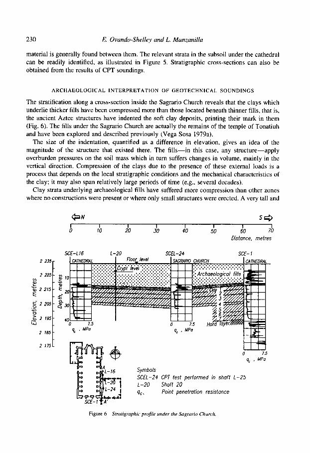
material is generally found between them. The relevant strata in the subsoil under the cathedral can be readily identified, as illustrated in Figure 5. Stratigraphic cross-sections can also be obtained from the results of CPT soundings.
- In
- 2 - z -s- - 2 -
ARCHAEOLOGICAL INTERPRETATION OF GEOTECHNICAL SOUNDINGS
The stratification along a cross-section inside the Sagrario Church reveals that the clays which underlie thicker fills have been compressed more than those located beneath thinner fills, that is, the ancient Aztec structures have indented the soft clay deposits, printing their mark in them (Fig. 6). The fills under the Sagrario Church are actually the remains of the temple of Tonatiuh and have been explored and described previously (Vega Sosa 1979a).
The size of the indentation, quantified as a difference in elevation, gives an idea of the magnitude of the structure that existed there. The fills-in this case, any structure-apply overburden pressures on the soil mass which in turn suffers changes in volume, mainly in the vertical direction. Compression of the clays due to the presence of these external loads is a process that depends on the local stratigraphic conditions and the mechanical characteristics of the clay; it may also span relatively large periods of time (e.g., several decades).
Clay strata underlying archaeological fills have suffered more compression than other zones where no constructions were present or where only small structures were erected. A very tall and
C J N s c 3 I I I I I I I I 0 10 20 30 40 50 60 70
Distance, metres
SCE-L16 L-20 SCEL-24 SCE- 1
2 7 175
Symbols SCEL-24 CPT test performed in shaft L-25 1-20 Shaft 20 Qc \ Point penetration resistance
Figure 6 Stratigraphic profile under the Sagrurio Church.

An archaeological interpretation qj‘ geotechnical soundings 23 1
heavy structure produces a deeper indentation than a smaller, less massive one. Furthermore, the presence of a structure, or the existence of a previous structure, induces changes in the mechanical properties of the clay-a reduction in compressibility and an increase in strength, as explained previously-which are also detectable in CPT tests or with independent testing of soil samples. Hence, the overburden applied by structures produces stratigraphic variations as well as changes in the mechanical properties of the soil and these two effects can be assessed independently to corroborate the presence of Aztec buildings under the cathedral.
Compression of the clay strata and changes in their properties are irreversible to a large degree, as has long been established in common geotechnical engineering practice. Assuming that a structure once existed in the surface and it was then removed or destroyed, for example after or during the Hispanic conquest, its effects would still be revealed with the geotechnical soundings. In this sense, the ‘memory’ of the soft clay deposits retains the effects of that structure on it.
The information gathered with the CPT tests was put together in a single data base containing the elevations of the contact points between different strata at each of the locations in which a CPT test was made as well as the relative coordinates of each point. For archaeological purposes in the cathedral-Sagrario zone the plane that defines the contact between the base of the Aztec fills and the ancient surficial soil is the most relevant. Using adequate interpolation algorithms, contours of equal elevations of this plane were superimposed on a plan of the cathedral, as shown in Figure 7. The zone indicated by ‘A’ in this figure corresponds to the pyramid of Tonatiuh (the Sun God) and the gladiatorial sacrificial complex and shows the way in which this pyramid
Figure 7 Relief of the contact plane heiween the riuiural soil and ihe archaeologicaljlls.

232 E. Ovando-Shelley and L. Munzanilla
indented the soft clay: the elevations of the contact plane at the central part of the Sagrario Church are 5 m below those of its periphery. ‘B’ and ‘C’ are two much smaller structures: ‘B’ has been mapped previously by Villalobos PCrez ( 1 985); the latter is yet unidentified but the evidence shown in the figure suggests that it is aligned with the temple of Ehecatl-Quetzalcoatl which lies towards its eastern side, outside the cathedral.
The depression indicated by ‘D’ is the most intriguing one. It suggests that a rather large structure, at least as tall as Tonatiuh’s temple but definitely smaller than the larger pyramids of the ritual precinct, existed under the northern portion of the cathedral. There are no references to it but it is situated near one of the extremes of the zone where Vega Sosa (1979a) locates a sunken court. The extent of the indentation may indicate that several structures, or a rather elongated one, existed in that area, perhaps forming part of the ball court complex. Should this be the case, it or they could be the remains of one of the side walls of the ball court or of one of its end structures. Vega Sosa also indicates that the ball court had a north-south orientation. Accepting this, the most likely hypothesis is that ‘D’ forms part of one of the lateral structures that enclosed the ball court.
The protuberance indicated by ‘E’ in Figure 7 marks a zone in which no structures were built as the contour lines slope from it towards the other points. Slopes are gentler towards the south and no structures have been found between it and ‘B’. Given the relative position of this structure-free zone with respect to the ball court, the Tozpa‘latl might have existed in that area.
To support this hypothesis further, a plot of equal strength contours is presented in Figure 8. Values indicated there are average strengths obtained from the CPT tests in the upper clay (see Fig. 7). The hard zones indicated in Figure 8 roughly coincide with the depressions indicated in Figure 7. The soft zone near axes 5 and 6 is close to the large depression in the north of the cathedral, that is, near the ball court. Soft areas or zones of low strength are usually places in which the natural moisture content within the soil mass is larger, as would be the case of the presence of a water spring flowing through fissures in the clay. Other evidence is provided by the fact that the remains of a small aqueduct that traversed the zone diagonally, roughly from the zone under discussion towards the south-east, have been reported (Villalobos Perez 1985). Lastly, during the construction of shaft number ten, prior to the underexcavation works in the cathedral, a large inflow of water flooded the excavation, thus supporting the notion that the soils within that zone are, indeed, much wetter.
CONCLUSIONS
The results of the CPT soundings performed under the Metropolitan Cathedral and the Sagrario Church in Mexico City can be interpreted to reveal the presence of buried prehispanic structures. The archaeological interpretation presented here is based on previous knowledge about the Aztec ritual precinct, which allowed some of these structures to be identified.
CPT soundings do not provide detailed archaeological information. Instead, the overall interpretation of the soundings performed in the area yields a global picture about the distribution of the structures found; they also give information about their dimensions, their volume and, in some cases, their orientation. Strength distributions within the upper clays indicate the presence of weak zones in which water springs may have existed. One of them could be Tozpdlatl, referred to in oral traditions about the foundation of Tenochtitlan.
Geotechnical evidence shown in this paper generally agrees with prehispanic and colonial chronicles that make reference to sites where water springs existed. It is not possible to reconcile

An archaeological interpretation of geotechnical soundings 233
Figure 8 less thun ten burs.
Contours oj'meun equal strength in the upper cluvs; shirded cireus indicate .soft zones where point resistunce i s
geotechnical knowledge with allusions to caves and large rocks at the foundation site, also mentioned in the chronicles, as they are not consistent with the geological and geomorphological lacustrine environment of Tenochtitlan.
The case described in the paper is unique. It is unlikely that a similar situation exists in which the results of such a detailed and extensive geotechnical exploration programme are available. The maps presented in Figures 7 and 8 are, consequently, exceptional. Nevertheless, CPT

234 E. Ovando-Shelley and L. Manzanilla
soundings could prove to be useful as auxiliary tools to archaeologists in other sites within the lake zone in Mexico City. In those cases the depth of the soundings could be limited to detect the interface between the natural soil and the artificial fills, focusing their applicability to the planning of detailed in situ archaeological investigations.
CPT tests were originally designed to explore soft cohesive soils but have also been used in medium dense or loose granular materials. Conceivably, they could be useful for archaeological explorations in which these types of materials are present, including underwater sites. Their use would of course be limited to estimating the depth and, possibly, the extent of the soils and sediments. Combined with other techniques like ground penetrating radar, electrical resistivity or magnetometry, CFT soundings can yield complementary information to ease the task of the archaeologist. In regard to its combined use with geophysical prospection methods, a CFT test could also be viewed as a relatively inexpensive calibration tool.
One of the drawbacks of CFT testing has already been mentioned. Namely, that soil identification can seldom be performed solely on its basis, at least in versions of the apparatus that do not have lateral friction cells. Its use can also be impeded by the presence of boulders, masonry fragments or other hard materials as very often is the case in archaeological sites.
ACKNOWLEDGEMENTS
The authors acknowledge the support and encouragement of Sergio Zaldivar, head of the project for the geometrical correction of the Metropolitan Cathedral, Ministry of Urban and Social Development Mexican Government 1988-94. later at the Ministry of Education. Enrique Santoyo and Enrique Tamez, responsible for the geotechnical aspects of the project, provided useful insight and valuable information about details of the underexcavation project. Francisco Enriquez provided the authors with documentary information and with helpful discussions.
REFERENCES
Broda, J., 1987, Templo Mayor as ritual space, in The great temple of Tenochtitlun. Center undperiphety in the Aztec. world (eds. J. Broda, D. Carrasco and E. Matos Moctezuma), 61-123, University of California Press, Berkeley.
Cabrera Castro. R.. 1979, Restos arquitect6nicos del recinto sagrado en excavaciones del metro y de la recimentaci6n de la catedral y Sagrario, in Vega Sosa 1979a. 55-66.
Carrillo, N., 1947, Influencia de 10s pozos artesianos en el hundimiento de la ciudad de Mexico, in Volumen Nubor Currillo (ed. Sociedad Mexicana de Mecinica de Suelos), 7- 14, Mexico.
del Castillo Garcia, L., and Urrutia Fucugauchi, J., 1974, Microgeofisica en arqueologia e ingenieria civil, Boletin de lu Asociacidn Mexicana de Geofisicos de Exploracicin, 15 ( I ), 1-46,
Cervantes de Salazar, F., 1978, Mexico en /554 y rumulo imperial (ed. E. O'Gorman), Editorial Pomia, Mexico. Dahlgren. B.. Perez-Rocha, E., Suirez Diez, L., and Valle de Revueltas, P., 1982, Corazdn de Cupil, Instituto Nacional de
Gussinyer, J., 1979, La arquitectura prehispinica en 10s alrededores de la catedral, in Vega Sosa 1979a, 67-74. Lombard0 de Ruiz, S.. 1973, Desarrollo urbano de Mexico Tenochtitlan segun b s fuentes histdricus, Secretaria de
Educaci6n Pliblica-Instituto Nacional de Antropologia e Historia, Mtxico. L6pez Carmona F., 1995, Aspectos arquitect6nicos y estructurales, in Catedral Metropolitans: correccio'n geornitricu.
informe tbcnico (ed. S . Zaldivar), 115-40, Asociaci6n de Amigos de la Catedral Metropolitand de Mtxico, Mtxico. Lopez Lujin, L., 1993, Las ofrendus del Templo Mayor de Tenochtitlan, Instituto Nacional de Antropologia e Historia,
Mexico. Marquina. I . , 1960, El Templo Mayor de Mexico, Instituto Nacional de Antropologia e Historia, Mtxico. Marsal, R., and Mazari, M., 1962, El subsuelo de la ciudad de Mexico. Facultad de Ingenien'a, Universidad Nacional
Matos Moctezuma, E. (ed.), 1990, Trabajos arqueoldgicos en el centro de lu ciudad de MPxico, Antologias, Sene
Antropologia e Historia, Mtxico.
Aut6noma de Mexico, Mexico.
Arqueol6gica. lnstituto Nacional de Antropologia e Historia, Mexico.

An archaeological interpretation qf geotechnical soundings 235
Mazari. M.. and Alberro, J., 1990, Hundimiento de la ciudad de Mexico. in Prohlenus de lu cuenca de Mixico (eds. J. Kumate and M. Mazari), 83-1 14, El Colegio Nacional. Mexico.
Meli. R., and Sinchez. R., 1995. Diagnostic0 estructural, in Cutedrul Metropolituna: correccidn geomttrica, informe ricnico (ed. S. Zaldivar), 141-88, Asociaci6n de Amigos de la Catedral Metropolitana de Mexico, Mtxico.
Ortiz Monasterio, M., 1929, Estudio de la cimenrucidn de lu carrdrul v crilculo del refuerzo de la seccion E.F. 67 , Informe a la Cornision TCcnica de la Catedral Metropolitana y el Sagrario, Secretm'a del Patrimonio Nacional. Mexico.
Ovando-Shelley, E., Cuevas, A., and Santoyo, E., 1994, Assessment of the underexcavation technique for levelling structures in Mexico City: the San Antonio Abad case. in Proeredings ufthe thirteenth international conference on soil mechanics andfinmdution engineering: Vol. 4 (ed. Indian Society for Soil Mechanics), 1461 -6, Internat. SOC. Soil Mechanics and Foundation Engineering, New Delhi.
de Ruiter, J.. 1971, Electric penetrometer for site investigations, J. Soil Mechanics und Foundutions Division (Proc. Am. Soc. Civil Engineer.s). 91 (SMZ). 457-72.
Santoyo, E., Riqing, X.. and Ovando-Shelley, E.. 1989. El cono d r la explorucihn geor6cnica (ed. C. Gutierrez), TGC Geotecnia, Mexico.
Tamez, E., Santoyo. E.. Cuevas, A.. and Ovando-Shelley, E., 199Sa. Diagn6stico y proyecto geottcnico, in Catedral Merropolicuna: correccicin geome'trica, iyfi,rme ticnico (ed. S. Zaldivar), 39- I 14, Asociacion Amigos de la Catedral Metropolitana de Mexico, Mexico.
Tamez. E., Santoyo, E., and Ovando-Shelley, E., 1995b, Procedimiento de subexcavacion, in Catedral Metropolitunu: correccidn geomttricu. itlfmne ticnico (ed. S . Zaldivar). 199-286. Asociaci6n de Amigos de la Catedral Metropolitana de Mtxico. Mexico.
Tamez, E., forthcoming, Hundimientos diferenciales de edificios coloniales en el centro historic0 de la ciudad de Mexico, X I Conferenciu Nubor Currillo. IYYZ (eds. M. J. Mendoza and J. Segovia). Sociedad Mexicana de Mecinica de Suelos, Zacatecas. Mexico.
Vega Sosa, C. (ed.), 1979a. El recinto sugrado de Mdxico-TenoeI?titlan. Excuvuciones 1968-69 y 1975-76. Instituto Nacional de Antropologia e Historia, Mexico.
Vega Sosa, C., 1979b. La cerimica: clasiticaci6n y cronologia, in Vega Sosa 1979a. 37-54. Vega Sosa, C., 1990. La cronologia relativa de Mtxico-Tenochtitlan, Mixicon, 12 ( I ) , 9- 14. Villalobos Perez, A.. 1985, Consideraciones sobre un plano reconstructivo del recinto sagrado de Mexico-Tenochtitlan.
Cuademos de Arquitectura Mesoumericunu (Universidud Nucionul Autiinotnu de Mexico). 4. 57-63.