Embed Size (px)
Citation preview

UNIVERSITY OF NAIROBI
AN ARCHAEOLOGICAL STUDY OF SIYU OLD TOWN ON THE
NORTH COAST OF KENYA FROM THE 9TH
CENTURY UP TO
THE 19TH
CENTURY AD: AN EXCHANGE SYSTEMS
PERSPECTIVE
IBRAHIM BUSOLO NAMUNABA
REG. NO: C80/82461/2011
THESIS SUBMITTED TO THE DEPARTMENMT OF HISTORY
AND ARCHAEOLOGY IN PARTIAL FULLFILMENT OF THE
REQUIREMENTS FOR THE DEGREE OF DOCTOR OF
PHILOSOPHY IN ARCHAEOLOGY OF THE UNIVERSITY OF
NAIROBI.
JANUARY 2020

0
DECLARATION
This thesis is my original work and has not been presented for a degree
in any other university
Signature: Date:
IBRAHIM BUSOLO NAMUNABA
REG. NO. C80/82461/2011
This thesis has been submitted for examination with our approval as
university supervisors.
Signature: Date:
SIMIYU WANDIBBA (PhD)
Professor of Archaeology, Institute of Anthropology, Gender and African
Studies University of Nairobi. P.O. Box 30197 Nairobi, Kenya.
Cellphone: 0722552391, Office 3742080/78/36.
Signature: Date:
EPHRA M WAHOME (PhD)
Professor of Archaeology, Department of History and Archaeology,
University of
Nairobi. P.O. Box 30197 Nairobi, Kenya. Cellphone: 0721354131.

1
DEDICATION
I dedicate this work to God Almighty, my source of wisdom, knowledge and
understanding. It required His intervention to slow down and readjust to His pace and
time. He has kept His promise and by his hand he has fulfilled as it is today.

i
TABLE OF CONTENTS
LIST OF FIGURES .................................................................................................... v
LIST OF TABLES. ................................................................................................... vii
LIST OF PLATES. .................................................................................................. viii
LIST OF MAPS…...................................................................................................... ix
ACKNOWLEDGEMENTS ....................................................................................... x
ABSTRACT…….. .................................................................................................... xiii
ACRONYMS AND ABBREVATIONS ................................................................. xiv
CHAPTER ONE: BACKGROUND TO THE STUDY … ...................................... 1
1.1 Introduction ........................................................................................................... 1
1.2 Early African Cities .............................................................................................. 1
1.3 East African Coastal Cities .................................................................................. 4
1.4 Problem Statement................................................................................................ 6
1.5 Objectives of the Study ......................................................................................... 8
1.5.1 Broad Objectives ................................................................................................ 8
1.5.2 Specific Objectives ............................................................................................ 8
1.6 Justification of the Study ...................................................................................... 8
1.7 Scope of the Study ................................................................................................. 9
1.8 Limitations of the Study ....................................................................................... 9
1.9 Definition of Terms ............................................................................................. 10
1.10 Conclusion…. .................................................................................................... 14
CHAPTER TWO: HISTORICAL AND ARCHAEOLOGICAL SOURCES .... 15
2.1 Introduction…. .................................................................................................... 15
2.2 Siyu in Historical Sources .................................................................................. 15
2.3 Previous Archaeological Work .......................................................................... 20
2.3.1 Siyu………… .................................................................................................... 20
2.3.2 Pate………… .................................................................................................... 21
2.3.3 Mbui……….. .................................................................................................... 24
2.3.4 Shanga…….. ..................................................................................................... 25

ii
2.4 Theoretical Framework ...................................................................................... 27
2.4.1 Settlement Patterns Theory ............................................................................ 28
2.4.2 The Exchange Systems Theory ....................................................................... 30
2.5 Conceptual Framework ...................................................................................... 34
2.6 Conclusion…… ................................................................................................... 37
CHAPTER THREE: THE RESEARCH SETTING ............................................. 38
3.1 Introduction…. .................................................................................................... 38
3.2 Physical Environment ......................................................................................... 38
3.2.1 Geology and palaeoenvironment .................................................................... 46
3.3 Climate ................................................................................................................. 47
3.4 Vegetation ............................................................................................................ 50
3.5 The People of Siyu ............................................................................................... 54
3.5.1 Ethnic Composition ......................................................................................... 54
3.5.2 Economy, Exchange and Subsistence ............................................................. 61
3.5.3 Architecture.. .................................................................................................... 63
3.5.4 Marriage, Property and Inheritance .............................................................. 65
3.5.5 Religion and Customs ...................................................................................... 66
3.6 Conclusion…… ................................................................................................... 67
CHAPTER FOUR: METHODOLOGY ................................................................. 69
4.1 Introduction ......................................................................................................... 69
4.2 Sampling .............................................................................................................. 69
4.3 Survey and Mapping........................................................................................... 71
4.4 Excavation ........................................................................................................... 75
4.4.1 Trench 1…… .................................................................................................... 76
4.4.2 Trench 2…… .................................................................................................... 81
4.4.3 Trench 3…… .................................................................................................... 83
4.4.4 Trench 4…… .................................................................................................... 88
4.5 Data Processing and Analysis ............................................................................ 95
4.6 Legal and Ethical Issues ................................................................................... 101
4.7 Conclusion…… ................................................................................................. 102

iii
CHAPTER FIVE: THE FINDINGS … ................................................................ 103
5.1 Introduction…. .................................................................................................. 103
5.2 Archaeological Materials................................................................................. 103
5.2.1 Pottery……… ................................................................................................. 109
5.2.2 Texture of Pottery Fabrics and Temper ...................................................... 125
5.2.3.Petrology of Potsherds and Clay .................................................................. 126
5.2.4 Imported Pottery ............................................................................................ 128
5.2.5 Imported Beads .............................................................................................. 134
5.3 Conclusion…… ................................................................................................. 135
CHAPTER SIX: FUANAL REMAINS ................................................................ 136
6.1 Introduction ....................................................................................................... 136
6.2 Faunal assemblage ............................................................................................ 136
6.3. Taphonomic and subsistence processes ......................................................... 137
6.4 Conclusion…… ................................................................................................. 140
CHAPTER SEVEN: DISCUSSION, CONCLUSION AND
RECOMMENDATIONS…….. .................................................................. 142
7.1 Introduction…. .................................................................................................. 142
7.2 Discussion…….................................................................................................. 142
7.2.1 Early Settlements ........................................................................................... 151
7.2.2 Periodization. .................................................................................................. 155
7.3 Conclusion…… ................................................................................................. 158
7.4 Recommendations ............................................................................................. 160
REFERENCES….. .................................................................................................. 162
APPENDICES…… ................................................................................................. 178
Appendix 1: Illustration of Decorative Elements and Vessel Shapes....................... 178
Appendix 2: Researcg Authirztion from the National Council for Science and
Technology……… ....................................................................................... 184

iv
Appendix 3: Research Affiliation Status from the National Museums of
Kenya…………….......................................................................................... 185
Appendix 4: Excavation/ Exploration Licence From The National Museums of
Kenya…………….......................................................................................... 186

v
LIST OF FIGURES
Figure 2.1 : Conceptual framework for the early settlement of Siyu.......................... 36
Figure 3. 1: Sea level changes in Africa ..................................................................... 44
Figure 4.1: Schematic plan of trench 1. ...................................................................... 77
Figure 4. 2: Limestone and post hole between levels 7 and 8 of trench ..................... 78
Figure 4. 3: Post holes at level 24 of trench 1 square A. ............................................ 79
Figure 4.4: Stratigraphic profile of square A, Trench 1. ............................................. 80
Figure 4.5: Stratigraphic profile of Trench 2. ............................................................. 82
Figure 4. 6: Plan of Trench 3. ..................................................................................... 83
Figure 4. 7: Stratigraphic profile of Trench 3. ............................................................ 87
Figure 4.8: Stratigraphic profile of Trench 4. ............................................................. 94
Figure 4.9: Simplified illustration of an atomic mass spectrometry. ........................ 100
Figure 5.1: Decorative elements on Siyu pottery...................................................... 118
Figure 5.2 (462): Jar-hard brown fabric, plain and smooth on both interior and
exterior surfaces, round straight rim with horizontal incisions below
rim…………. ................................................................................................ 119
Figure 5. 3 (110): Short necked pot in hard brown fabric, plain and rough on interior
and exterior, with continuous stabs below the rim. ...................................... 119
Figure5. 4 (162): Carinated bowl- reddish brown fabric, plain smooth interior, plain
rough exterior, round concave with continuous stabs along the carination. . 119
Figure 5.5 (467): Simple carinated bowl- soft reddish brown fabric, plain smooth on
both interior and exterior, round straight rim with diagonal incisions bound by
horizontal lines…… ...................................................................................... 120
Figure 5.6 (469): Carinated bowl- brick reddish brown fabric, plain smooth interior,
plain rough exterior, round sloping concave rim with diagonal incisions below
the rim……………….. ................................................................................. 120
Figure 5.7 (252): Simple bowl in hard red fabric, plain smooth interior, plain smooth
exterior, round concave rim decorated with a combination of short oblique
incisions, arrow incisions and thumb stabs on body. .................................... 120

vi
Figure 5.8 (299): Simple bowl in hard red fabric, plain smooth interior, plain smooth
exterior, round concave rim decorated with a combination of standing triangle
with a single vertical incision and continuous thumb nail on a slight
carination…................................................................................................... 121
Figure 5.9 (361): A shallow bowl in hard reddish brown fabric, plain smooth on both
interior and exterior surfaces, with single cross hatching on a flat expanded
rim……….. ................................................................................................... 121
Figure 5.10 (464): Hole mouthed jar in grayish brown fabric, plain smooth interior,
plain smooth exterior, round concave slightly out-turned rim, with single
cross-hatching delimited by a horizontal incision below the rim. ................ 122
Figure 5.11 (461): Spherical pot in hard brown fabric, red wash interior, plain exterior
round concave rim, single cross hatching below rim. ................................... 122
Figure 5.12 (476): Spherical pot in hard pale red fabric, plain smooth interior and
exterior, double cross-hatching. .................................................................... 122
Figure 5.13 (475): Necked pot in hard pale red fabric, orange burnish on interior,
plain smooth on exterior with double cross-hatching below the neck.
Additional illustrations are appended as Appendix 1 for reference. ............. 122

vii
LIST OF TABLES
Table 3. 1: Rainfall figures from Siyu recording station ............................................ 49
Table 4.1: Organization of excavation ........................................................................ 71
Table 5.1: Excavated materials from trench 1. ......................................................... 104
Table 5.2: Excavated materials from trench 2. ......................................................... 105
Table 5.3: Excavated materials from trench 3. ......................................................... 107
Table 5.4: Excavated materials from trench 4. ......................................................... 108
Table 5.5: Total pottery assemblage ......................................................................... 109
Table 5.6: Diagnostic and undiagnostic local pottery ............................................... 110
Table 5.7: Frequencies of vessel categories .............................................................. 111
Table 5.8a: Frequencies and percentages of Rim Morphology, trench 1. ................ 112
Table 5.8b: Frequencies and percentages of rim morphology, trench 3. .................. 113
Table 5.8c: Frequencies and percentages of rim morphology, trench 4. .................. 114
Table 5.9a: Vessel forms of potteries from trench 1. ................................................ 115
Table 5.9b: Vessel forms of potteries from trench 3. ............................................... 115
Table 5.9c: Vessel forms of potteries from trench 4 ................................................. 116
Table 5.9d: Cross-tabulation of rim morphology and vessel form ........................... 117
Table 5.9e: Cross-tabulation of the levels and decorative elements ......................... 123
Table 5.10: Frequencies and percentages of location of decorative motifs. ............ 124
Table 5.11: Correlation of decorative motif and vessel form. .................................. 124
Table 5.12: Texture of pottery fabric. ....................................................................... 125
Table 5.13: Frequencies of tempering material ........................................................ 126
Table 5.14: Mineralogy of potsherds and clay .......................................................... 128
Table 5.15: Frequencies and percentages of imported pottery wares ....................... 131
Table 6.1: Summary of faunal assemblage ............................................................... 137
Table 7.1: Summary of ware and date of manufacture of imported pottery. ............ 150

viii
LIST OF PLATES
Plate 3.1: The ruined mihrab of Bwana Shee mosque. .............................................. 65
Plate 4. 1: A section of the bastion along the southern town wall. ............................. 76
Plate 4.2: Excavation of Trench 4 in progress. ........................................................... 89
Plate 4.3: Partially excavated Trench 4, a built bore-hole and a water jar in the left
background……… .......................................................................................... 90
Plate 4.4: Excavated borehole, to the right is a water jar. .......................................... 91
Plate 4.5: Fragments of charcoal and ash overlain on clay strata. .............................. 93
Plate 5.1(513): 11th
-13th
century late sgraffiato with dark green glaze on the
interior…………… ....................................................................................... 129
Plate 5.2 (345): 14th
century Chinese porcelain. ....................................................... 129
Plate 5.4 (552): Mid 15th
-16th
century rim of a shallow ledged standard Islamic
monochrome bowl with a blue to green-blue under glaze. See also Plate 5.7
(580)……… .................................................................................................. 130
Plate 5.3 (571): 11th
century White Chinese porcelain. ............................................. 129
Plate 5.5 ( 589):13th
-14th
century worn out piece of black-on-yellow ware, decorated
with thin black or brown lines. ..................................................................... 130
Plate 5.6 (604):13th
-14th
century worn out black-on-yellow Islamic potsherd. ........ 130
Plate 5.7 (620): Assorted imported pottery. …. ........................................................ 130
Plate 5.8(568 ): Assorted impoted pottery from the Far East. ................................. 131
Plate 5.9: Assorted imported beads from Siyu......................................................... 134

ix
LIST OF MAPS
Map 3.1: The East African Coast showing sites mentioned in the text ...................... 40
Map 3.2: Lamu archipelago showing Pate Island and Siyu ........................................ 42
Map 3.3: Topography of Siyu. .................................................................................... 45
Map 3.4: Average annual rainfall of Lamu archipelago and its environments ........... 48
Map 3.5: Agro-ecological zones and subzones of Lamu archipelago and its
environments……. .......................................................................................... 53
Map 4.1: Contour map. ............................................................................................... 70
Map 4.2: Siyu site.. ..................................................................................................... 72
Map 4.3: The town wall and distribution of ruins ...................................................... 74

x
ACKNOWLEDGEMENTS
This work is a result of vigorous academic exercise that involved a number of people
and institutions. While it is not practical to mention all who assisted me and my team,
I wish to acknowledge the support I got from the following. I am particularly grateful
to Professor Simiyu Wandibba of the Institute of Anthropology, Gender and African
Studies, University of Nairobi, for his immense guidance and to Professor Ephraim
Wahome of the Department of History and Archaeology, University of Nairobi, for
his tireless counsel throughout this study. This work would have been difficult
without the brotherly support from Professor Chap Kusimba of the Field Museum of
Natural History Museum (FMNH), Chicago (USA) and from Dr. Steven Strohmeier
of FMNH for the timely remittance of scholarship funds. I thank Professor Paul
Sinclair of Uppsala University, Archaeology Department, for encouraging me when I
shared with him the thoughts of working on Siyu. I also thank Professor Felix Chami
of the University of Dar-es-Salaam for critical approaches to the study of East
African coastal archaeology that I found invaluable in the interpretation of my
research data. He also allowed me unlimited access to resources of the African
Archaeology Network during his tenure as Director General. I wish to thank
Associate Professor Herman Kiriama, formerly Head of Coastal Archaeology Unit,
National Museums of Kenya, currently Faculty member at Kisii University, and Mr.
Philip Jimbi Katana, formerly a Principal Curator at Fort Jesus Museum for their
encouragement and for allowing unlimited access to facilities and equipment at the
museum. My sincere thanks go my colleague Dr. Ben Nyanchoga of the University
Nairobi for his thoughtful remarks and encouragements.

xi
In the fieldwork of 2012 I was assisted by George Gandi, Mohammed Mchulla,
Mohammed Chiguyaso and Philip Wanyama of Coastal Archaeology Unit, National
Museums of Kenya at Fort Jesus Museum, and Patrick Abungu and Said
Mwakureherwa of Sites and Monuments Unit- Fort Jesus Museum. In the village of
Siyu where this study was conducted, many residents gave all the support I required
including accommodation and providing a hand during survey and excavation of the
site. Some of these are Salim Bwana Heri, Masoud Muhammed, Feisal Sheriff,
Hussein Athman and Muhammed Maulana. Others are Saqara Abdalla, Shee Mbwana
and Said Ali. I also owe special thanks to coxswain Anwar Saburi Omar for skillfully
navigating through fierce waves across Manda Bruno channel on the numerous trips
between Lamu and Siyu. Besides, I acknowledge the following students from Pwani
University for their participation in this study: Khalifan Ahmed, Doreen Mutoro,
Millicent Ngonyo (deceased), Charles Adika, Masoud Mohammed and Wilson
Mwangandi. Others are David Manyeso and Ruth Kahariri. I thank Ms Mary Gitata
of High Cyber Speed at „KM 1‟ for solving the most challenging puzzle of formatting
the preliminary pages of this document. I sincerely thank my wife Hannah C. Mombo
and children Neema, Pendo and Austin for enduring difficulties throughout the period
I was away in the field.
Several institutions have played a crucial role towards the successful completion of
this thesis. The Field Museum of Natural History for financial support of the doctoral
programme. Specifically, I register my gratitude to the President and Chief Executive
Officer of the Field Museum, John W. McCarter Jr. and the President of IDP
Foundation, Inc., Irene D. Pritzker for the rare consideration to offer me the

xii
scholarship. I thank the University of Nairobi for offering me the opportunity to
register for the doctoral programme. Many thanks to Pwani University for giving me
time off to conduct field work as well as travel to consult with my supervisors away
in Nairobi. I also thank Pwani University Research Board for partial funding of my
field work. The National Museums of Kenya allowed its staff to assist me in the field
and during laboratory analysis at the Archaeology Unit at Fort Jesus Museum. My
thanks are due to the Geology and Mines Department of Kenya for conducting
petrological analysis of samples. I thank the National Council for Science and
Technology for issuing the research authorization in good time.

xiii
ABSTRACT
This study was an archaeological investigation into the early settlement of the ancient
town of Siyu. The objectives of the study were to determine the strategic factors that
influenced initial settlements and growth of Siyu, determine the exchange system and
resource base, and establish the sequence of occupation at the site. To achieve these
objectives, the study employed site survey, excavation and analysis of excavated
materials. The findings indicate that abundant marine resources, a navigable creek
and emergent sand dunes influenced early settlements at Siyu. The study also
established that Siyu did not make her own pottery but procured it through exchange.
Local pottery bears Early Iron Ware and Tana Tradition affinities that have been
reported elsewhere along the eastern Africa coast. This implies an exchange network
that linked Siyu to known centres such as Shanga, Pate and Manda and sites on the
mainland. It was also established that Siyu was linked to an international exchange
system that brought in imported merchandise such as ceramics, beads, cotton cloth
and dates from China, Arabia, India and Europe. These were in exchange for items
such as mangrove, ivory and silk. The growth of exchange systems between Siyu and
the rest of the world was not limited to exchange of merchandise but exchange of
ideas on Islamic faith and sociopolitical order that saw Siyu emerge as a strong city-
state. Using archaeological evidence, the study has established four periods of
occupation of Siyu between the 9th
and 19th
century. Mud and thatch houses were
predominant during Period I with the introduction of stone houses in the terminal
phase. Cattle were brought to Siyu during period II that lasted from the 11th
to the 13th
century. Period III lasted between the 13th
and the 16th
century. This was the
industrial age that saw Siyu‟s wealth thrive through her textile industry, masonry and
carpentry. Finally, Period IV is the period of decline that is associated with the
coming of foreign political powers. Turkey, Portugal and Zanzibar orchestrated the
decline of Siyu‟s political power, wealth and population at the close of the 19th
century. In conclusion, the study has met its objectives by determining the factors
that influenced early settlements, and the exchange systems that characterized Siyu's
economy. Finally, the study has determined the sequence of occupations at Siyu. The
study recommends further investigations at the site to provide chronometric dates and
locate precise sources of local pottery and other ceramics.

xiv
ACRONYMS AND ABBREVATIONS
AAS Atomic Absorption Spectroscopy
AEZ Agro-Ecological Zone
DP Datum point
EIA Early Iron Age
FMNH Field Museum of Natural History
GPS Global Positioning System
IDP-F Innovation Development Progress Foundation
LAPSSET Lamu Port-South Sudan-Ethiopia Transport
LOI Light On Ignition
MNI Minimum Number of Individuals
NCST National Council of Science and Technology
NDGM National Department of Geology and Mines
NISP Number of Identified Specimens
NMK National Museums of Kenya
OT Observation Tower
RAS Research Affiliation Status
TIW/TT Triangular Incised Ware/Tana Tradition

1
CHAPTER ONE
BACKGROUND TO THE STUDY
1.1 Introduction
This chapter provides the background information related to archaeology of early
urbanism in Africa and early urbanism in the East African Coastal cities. Synthesis of
documentary and archaeological evidence on early urbanism has been useful in
identifying the problem statement as well as setting the objectives of this study. This
study involved an archaeological investigation of the ancient town of Siyu by
employing exchange systems approach in explaining the presence of non-local
pottery and other materials at the site. The study utilized archaeological survey,
mapping and excavation techniques to collect data for analysis. In this chapter I have
explained why it was necessary to conduct the study at this time and site as well as
the scope and limitations encountered during the study.
1.2 Early African Cities
Early settlements in Africa may be the least understood of any region in the world
(Mabogunje, 1962). First, archaeologically, the African city is poorly known, and
well-excavated sequences are few. Second, early documentary evidence of Africa‟s
urban heritage is drawn from travellers such as Ptolemy, al-Bakri, al Yakubi, al-
Masudi, Ibn Batuta and an anonymous author of the Periplus of Erythraen Sea
(Freeman-Grenville, 1975; Hamdun and King, 1994; Kusimba, 2008). The early
documentaries, much as they were valuable sources of information, were not based on
any scientific research but notes on observations documented in travellers‟ personal

2
diaries and therefore subject to bias. The travellers were more concerned with
documenting the urban heritage of the „other‟ as a product of foreign influence rather
than as a reflection of people‟s cultural systems. Unfortunately, this view found
acceptance in the scientific fraternity since the Victorian era. For instance, Reader
(1997, cited in Kusimba, 2008: 229) is convinced that Africa‟s vastness and a readily
travelling population and prevalence of disease prevented it from population growth
and the socioeconomic dynamics that would lead to urbanism.
Western historiography has broadly relegated Africa as lacking history and was
incapable of developing early urban centres due to climate, soil and isolation (Holl,
2003; Kusimba, 2008: 230). The advent of Islam and Christianity has always been
associated with early urbanism in East Africa (Levitzioni, 1988; Stigand, 1913; Holl,
1995; Kusimba, 2008: 230)). Yet according to others like Clark (1962), African
abundant resources and gentle climate did not need urbanism to premediate resources
as required in cities. Clearly, the environmental determinism argument cannot sustain
generalizations about this vast continent and its impressive environmental diversity.
A survey of Africa‟s most successful state societies such as Ghana, Mali and Songhai,
and cities like Timbuktu, Walata, Jenne-Jeno and Gao, reveals how these state
societies developed from settlements on or near the inland Niger Delta and the upper
and middle zones of the Niger (McIntosh and McIntosh, 1984; Hunwick, 1999;
Insoll, 2000; Kusimba, 2008). The region cultivated rice and also participated in
interregional trade in gold and salt that dates back to the Roman period. The political
complex and urban infrastructure at Jenne-Jeno were in place between 300 and 200

3
BC (Kusimba, 2008:230). The brief survey shows that Western Sahel was already
dotted with cities contemporary to urban centres in Europe and the Indian
subcontinent.
In the eastern Africa region, two sets of cities emerged. First, the emergence of
hierarchical society and cities like Aksum and Adulis is attributed to population
pressure on the productive, volcanic soils of the area, which supported agriculture
much better than the surrounding area (Butzer, 1981; Kusimba, 2008). Second, were
the East African Coastal cities that emerged in areas with numerous resources that
required a sound socio-political order to manage. According to Kusimba (1999b),
competition for productive land and access to ocean resources are demonstrated by
the presence of territorial markers such as mounds and burial tumuli, a system of land
tenure in which clan leaders determined access and mediated land disputes, and the
demarcation of clan land into sacred and ritual areas to ensure ownership through
time, characterized the emergence of a complex sociopolitical order. In the lower
coast, the resultant urbanite culture developed a unique architecture of closely built
villages and towns with two-storied houses, which suggest competition for land
(Connah, 2001:176).
It is clear that the above studies focused mainly on activities that took place in the
already advanced settlements which had just realized urban complexity during the 8th
century AD. Little attention is given to their occupations prior to this date and the
exchange patterns that characterized their beginnings are not emphasized.

4
1.3 East African Coastal Cities
Archaeologists and historians have done extensive research on the development of
complex societies and urbanism in eastern and southeastern Africa (Abungu, 1998;
Kusimba, 1999a, 2008; Sinclair and Hakansson, 2000). The studies are all in
agreement that early cities developed along the East African coast around 500 AD.
Recent research by Oka (2018) and Kusimba (2018) has identified religion, in
particular Islam, as a major factor that influenced political stability for the emerging
city states. Specialized occupations such as farming, fishing, trading, rulers, scribes
and enslaved persons, on the one hand, and wealth from the trans-Indian Ocean trade,
on the other, were the main factors that influenced the growth of cities (Middleton,
2004; Kusimba, 2008). Cities that thrived had by the 9th
century AD and are well
documented along the East African coast include Takwa, Manda, Shanga, Pate,
Ungwana, Kilwa (Chittick, 1974, 1984; Horton, 1996; Abungu, 1998).
Mutoro (1998) and Pearson (1998) discuss relationships between hinterland societies
and the coastal towns. Socio-economic interactions between the hinterland and
coastal people, though drawn from different linguistic groups, encouraged the
development of Kiswahili (Kusimba, 2008: 239). It is possible that the social and
economic interactions, amongst these groups led to ideological and innovative skills
that fed into the international trade exchange systems. As a result of these
interactions, the East African coast had been netted to become an important economic
player in the Trans-Indian ocean trade involving sea ports in the Middle East and
China. Technological advancements in ironworking was a major factor that
influenced subsistence agriculture and specialization in fishing and herding of

5
livestock (Abungu, 1998; Horton, 1996). The growth of agriculture led to the
improved quality of life, increased population and economic prosperity that
eventually attracted foreign political interests (Kusimba, 2004).
It is important to point out that the coastal towns did not grow in isolation; rather,
smaller settlements in the hinterland grew alongside as they too improved their
sociopolitical order to control the emerging trade (Kusimba and Kusimba, 2005). The
foregoing literature only documents the archaeology of the EAC between 800AD and
1500 AD. We barely have an understanding of how the coastal settlements and their
hinterland counterparts interacted.
Archaeological surveys in the Kasigau area by Kusimba and his team have located
more than 250 sites. Upon further research evidence emerged for intensive iron
production spanning 800 years (Kusimba and Kusimba, 2005). The study concluded
that the volumes of slag demonstrate that the most intensive iron smelting occurred
during the deposition of these levels, dating from AD 700 to 1380, a time when urban
growth was intensifying on the coast.
According to Kusimba (2008: 243), iron from a hinterland site known as K1 in the
Taita Taveta region, was probably used in the manufacture of household and farm
implements as well as weapons used primarily for hunting and meeting the demand
for hinterland items from the coast. The use of iron tools, no doubt, accelerated
terrace farming and livestock husbandry in the hinterland (Kusimba and Kusimba,
2005) and enabled local hunters to make successful hunting expeditions.

6
Archeological research has shown that ancient complex settlements emerged along
the East African Coast (EAC) from Somalia to Mozambique around 500 AD
(Abungu, 1998; Juma, 2004). However, the occurrence of ancient stone buildings had
been erroneously linked to the emergence of settlements and urbanism, implying that
there was no urban life predating 500 AD. Yet, documentary evidence of the first
century AD such as the Periplus of the Erythraen Sea records the prosperity of the
trans-Indian Ocean trade involving East African coastal sea ports, the hinterland and
overseas ports (Freeman-Grenville, 1975; Huntingford, 1980).
Further, the nature of relationships between the coastal settlements and their
hinterland counterparts prior to AD 1500 was not certain before the current study and
we could not exactly state the role of ancient settlements such as Siyu. Before this
study, there was no archaeological material to show the significance of Siyu in
shaping island-hinterland interactions prior to AD 1500. This study has uncovered
material evidence for exchange between the two entities.
1.4 Problem Statement
The origins of the ancient Swahili settlement and town of Siyu remain one of the
major unresolved questions in East African Coastal archaeology. Five decades of
archaeological study documents the long-term processes of urbanization and origins
of complex societies in Eastern and South-eastern Africa but none of these has
focused on the unique settlement of Siyu.
Researchers working on the East African coast have accumulated data on the origins
and growth of urbanism in the region (Juma, 2004; Kusimba, 1999a; LaViolette and

7
Fleisher, 2005; Middleton, 1992; Horton and Middleton, 2000; Pikirayi, 2001; Pwiti,
2005; Sinclair and Hakansson, 2000). The emphasis has been on early urbanism and
on early settlements that were precursors of the city-states. These studies agree that
early cities on the East African coast developed around 500 AD. The occurrence of
ancient stone buildings has been linked directly to the emergence of urbanism but this
view implies that there was no urban life before 500 AD. Yet it is known that the
residents of the EAC included farmers, fishers and traders and that their activities
generated the wealth that became the main precursor of early urbanism on the East
Africa Coast (Middleton, 1992).
The understanding of Siyu‟s past has hitherto been very little especially about its
industrial status which is captured by a legendary phrase, Mui wa Mafundi or the city
of craftsmen, as Siyu was famously known in East Africa. Siyu is one settlement that
has experienced continuous occupation. This study addressed three questions about
the early settlements and subsequent developments. First, what factors influenced the
settlement, development and location of Siyu? Two, what was the resource base of
the earliest settlers? And three, what was the sequence of occupation at the site?
Earlier researches in the EAC seldom applied the theories of exchange and settlement
patterns to investigate settlements that predate the 7th
century AD. It is therefore on
the strength of these theories that new scientific knowledge was sought about earlier
settlements in the islands and how they related with the hinterland counterparts.

8
1.5 Objectives of the Study
1.5.1 Broad Objectives
To explore dynamics that influenced the emergence and development of Siyu as an
important settlement that evolved into a complex city state.
1.5.2 Specific Objectives
i. To examine strategic influences that led to the initial settlements at Siyu.
ii. To determine the exchange systems and resource base of the early settlement of
Siyu.
iii. To reconstruct the sequence of occupations at Siyu.
1.6 Justification of the Study
The Lamu archipelago and the immediate hinterland is undergoing major
infrastructural development. The Lamu-Port-South Sudan-Ethiopia Transport
(LAPSSET) project is set to create a unique dimension through the following
infrastructure development; the sea port hub that will serve the entire eastern Africa
littoral and inland up to and including South Sudan and Ethiopia. The construction of
infrastructure poses the risk of destroying the cultural heritage of Siyu which is part
of the Lamu UNESCO heritage landscape. The settlement and the people of Siyu
have a gorgeous cultural, historical and architectural heritage which is worthy
studying and documenting. Siyu was known for artistic skills, namely printing press,
woodworking and cottage industries that characterized production economy of the
region. This study, therefore, provided a window to document the socio-political

9
dynamics that premediated the early settlement and subsequent occupation of not
only Siyu town but other coastal towns.
1.7 Scope of the Study
This study investigated early settlements on the island of Pate and in particular at
Siyu during the early first settlements up to the close of the 15th
century AD.
Emphasis was placed on the site of Siyu old town as well as the contemporary
settlement and its surroundings. The study focused on the changing landscape of the
island of Pate around Siyu and the human-environmental interaction that is evident in
form of ruins within the ruined wall enclosure. It also paid attention to material
remains from both past and present human activities. The study endeavoured to
establish the ancient physical environment that conditioned a resource base that
shaped human activities at the site. It was guided by two theories, namely, settlement
pattern theory and exchange systems theory.
1.8 Limitations of the Study
The study had a number of limitations. First, despite the vast area of about 22 acres
the study focused on two zones within the settlement and was limited to only four test
pits due to limited funding. Second, this study did not conduct absolute dating on any
samples of charcoal or pottery. Instead a technic known as cross-dating technique was
applied in which known pottery from other regions were used to determine to the
chronology of the site of Siyu. Imported potteries to the East African coast were
sourced from known kilns in places with well documented production dates such as
Siraf in Iran and Lishui prefecture in China.

10
Finally, it was not easy dealing with relics of the past whose makers and owners have
long gone by. This brings forth another limitation of this study; the study was partly
through interpretation of non-local materials at the site but it was not possible to
interact with past inhabitants to understand why they chose to settle at Siyu and the
type of transactions they were engaged in. This limitation was addressed using the
excavated archaeological materials accepted as a product of past cultures at the site.
1.9 Definition of Terms
Assemblage
Assemblage refers to the entire set of specimens of ceramics or faunal remains from a
given cultural or geological context, in which the defining context is provided by the
analyst. Thus, a ceramic assemblage of an archaeological site would comprise all
types of potteries excavated from that site. The potteries can be divided into a series
of sub-assemblages depending on the analyst‟s goal. For instance, there could be
imported and local pottery sub-assemblages based on the origins and the type of
fabrics used in the manufacture of the wares.
City-State
City-state combines two words, city and state. A city is defined as a community or
settlement that performs numerous functions in relation to a broader hinterland
(Trigger, 2003). It provides specialized services to a wider society (Renfrew,
2008:34). According to Renfrew (2008), cities are a feature of state societies, though
the existence of a city does not imply the full range of features associated with the
state which often includes a structured political system. A state is a self-governing
entity made up of a people who not only claim a territory of their own but also share a

11
common history, identity, economy and destiny. In archaeology the city with
increasing complexity and specialization of functions necessitated the need to control
the flow of commodities, hence the growth of political interest from elite class
leading to political autonomy. City-states were characterized by competitive
emulation, warfare, symbolic entrainment and an increasing flow in the exchange of
goods, skills and ideas.
Exchange
Exchange is transfer of commodities through a systematized network. Exchange is
considered a form of interrelations such that system interrelations operate on regional
level (Torrence, 1986:35). Through exchange social inequalities were reduced
through institutionalized channels that allowed the flow of commodities (Earl,
1982:201). The media for exchange are trade, migration and conquest. Trade takes
many shapes which include remunerated transactions, barter and direct or indirect
transactions between groups or individuals. Populations migrate or move from their
settlements due to involuntary or voluntary factors to new places. They carry along
material culture and ideas to new cultural systems. These may show distinction with
pre-existing cultural materials. Exchange has frequently been equated to trade and
defined as the peaceful, reciprocal movement of goods among members of different
societies (Hirst, 2019).
Minimum Number of Individuals
Minimum number of individuals (MNI) is one of the basic counting units used in the
quantification of bone remains to determine the number of individual animals
represented at a site. It refers to the smallest number of faunal organisms represented

12
in the skeletal assemblage from a site (Grayson, 1984:20). The minimum number of
individuals is helpful in determining the ecological diversity and richness of an
archaeological site.
Number of Identified Specimens
Number of identified specimens (NISP) is defined as a counting unit that is useful in
determining the abundance of taxa within archaeological faunas (Grayson, 1984:17).
The identified specimen of the single bone or tooth or fragment therefore, is assigned
to some taxonomic unit and then quantified. The NSIP can be applied to bone and
other organic remains at a site to determine population size and animal weights. It can
also be used to examine the changing taxonomic frequencies through time and space.
Periodization
Periodization is the process of categorizing the past into discrete blocks of time in
order to facilitate the study and analysis of history (Pare, n.d.). Periodization leads to
descriptive abstractions that provide convenient terms for periods of time with
relatively stable characteristics. In archaeological practice there is an ending effort to
improve and refine chronological schemes by describing changes in material culture
with strata or context. A period is a set of particular dates selected as the boundary
between ages marked by unique cultural assemblages. Transition from one period to
the next can be defined and characterized by transformation in all aspects of life.
Periodization as a tool in archaeology utilizes several principles such as stratigraphy,
typology and seriation (Green, 1995).

13
Sassanian Pottery
This is a type of pottery manufactured in Persia during the Sassanid Empire, the last
pre-Islamic Iranian empire that lasted from 224 to 651 AD and stretched from Syria
to northwest India (Horton, 1996: 274). The term was first used to summarize the
chronological spread of the kind of pottery made during the Sassanid period. A
particular feature of this pottery is the use of applique clay strips and stamps for
decoration. The fabric is creamy white, fairly hard with a little sand temper but few
inclusions with rough fracture and evenly fired.
Seriation
Seriation is a relative dating method in which assemblages or artefacts from an
archaeological site are placed in chronological order (Renfrew and Bahn, 2000).
Seriation utilizes associations of archaeological finds to determine dates. It can be
used to date stone tools, pottery fragments, and other artefacts. In this technique, it is
assumed that pottery styles gradually become more popular, reach peak popularity and
then fade away. It is argued that at a given time period, a pot style popular at one site
would similarly be popular at another.
Settlement
A settlement is a term used in archaeology to denote a permanent or temporary
community in which people live, without being specific to size, population or
importance (Foley, 1981). It is a site or location that is or was in habitation. A
settlement may range in size from a very small number of occupants grouped together
to the largest cities.
14
Sgraffiato Pottery
Sgraffiato is a decorative technique produced by applying layers of colour or colours
as under-glaze to hard pottery. Parts of the layers of colour are then scratched off to
create patterns underneath. Several varieties of sgraffiato pottery were imported to the
East African coast. One of these was late sgraffiato with various decorations
including hatched, Champlevé decorated, brown splash, polychrome and green
decorated (Horton, 1996: 284).
Trade
Trade involves the transfer of goods or services from one person or entity to another,
often in exchange for some benefit. Trade is necessitated by a market, a system or
network that is characterized by demand and supply of a commodity or service.
1.10 Conclusion
This chapter has provided background information to the study. It has presented the
problem statement, objectives, justification of the study, scope as well as the
limitations that this study encountered and how this was navigated. The chapter has
concluded with a definition of the key terms used in the study.
15
CHAPTER TWO
HISTORICAL AND ARCHAEOLOGICAL SOURCES
2.1 Introduction
This chapter provides information on early historical documents. The anthropological
composition of the people of Siyu is discussed with a focus on ethnic composition,
economy, mode of production and exchange, architecture, marriage, property,
religion and custom. The chapter ends by presenting earlier archaeological work at
Siyu and the nearby sites.
2.2 Siyu in Historical Sources
Analysis of some of the earliest documents on the East African Coast does not reveal
a clear identity of the earliest settlers of this region. However, a critical synthesis
gives a keyhole view of the nature of the people of coast and the activities these
settlers engaged in. For instance, Busolo et al. (2019: 27), observed that long before
the 7th
century AD when Arab traders sailed down the Western seaboard of the Indian
Ocean, the East African coast and the immediate hinterlands were already populated
by indigenous people. By the 1st millennium BC settlements had already been
established in the Lamu archipelago. In the accounts of the anonymous author of the
Periplus of the Erythraen Sea dated between 40 and 70 AD, reference is made to
flourishing „marts‟ of Azania south west of Adouli and a range of merchandize traded
with overseas centres (Huntingford (1980: 28). However, the Periplus does not give
any identifiable tribal names of the settlers, instead the book captures the prosperity
of cities and flourishing trade between them. Concerning settlements in Lamu
16
archipelago, the Periplus captures a succession of sails down the coast of Azania
(Huntingford, 1980:29):
Then the lesser and greater strands, of another six courses and
after them in succession the courses of Azania, the first called
Sarapion‟s then that of Nikon after which there are several
rivers and a series of other roadsteads separated by several
stations and courses of a day, several in all, as far as the
Paralaon islands and what is called The Channel….
According to Huntingford (1980:97), the name Paralaon appears to be in the genitive
form and in ancient Greek it means „fire‟. Hence, Paralaon Island could be translated
as „Islands of fire‟. Bantu agrarian communities are thought to have inhabited Pate,
Manda and Lamu islands and used fire to prepare land for a new planting season, an
activity that is performed year in and year out (Busolo et al. 2019: 27; Busolo, 2005).
The Siyu Channel separates Pate Island from the mainland and is still remains a major
factor in the navigation between the islands and the hinterland (Huntingford,
1980:97). Since the eastern shoreline is characterized by coral outcrops that and is
largely difficult to navigate.
The ancient settlers had their own language as documented and corroborated by early
visitors such as Al- Masoud, Idrisi and Burzug (Busolo, 2020; Freeman-Grenville,
1975). These people practiced mixed economy; they cultivated crops, kept livestock
and hunted wild game. This is documented in the Periplus in which the cites
exchanged goods such as animal skins, ivory, tortoise shell, rhinoceros horn, for
cloth, beads, metal, wire glass, porcelain and wine from overseas (Busolo et al. 2019:
28; Huntingford, 1980:122; Freeman-Grenville, 1975:6). Tuan Ch‟eng-Shih, a 9th

17
century author of the Yu-Yang-Tsa-Tsu, a compendium of various kinds of knowledge
gives an eye witness account of the coastal people, who married off their daughters to
strangers at higher bride prices than they would fetch from local men. They also kept
cattle and engaged in a blood-oath to allow Persians trade with them (Freeman-
Grenville, 1975:8).
It is not clear when the transition took place from the very early settlers to the later
occupants of Siyu. However, the eye witness accounts shed light on the identity of the
ancient people. The people of the coast were definitely of black complexion and had
by the tenth century AD established indisputable level of political organization as we
can read in Burzug‟s account, a Persian sailor who sailed to Azania coast, and
recorded this on encounter with a contingent of naval guards “…The canoes of
negroes surrounded us and brought us into the harbour; we cast anchor and
disembarked on the land. They led us to their king. He was a young negro, handsome
and well made...”. (Freeman-Grenville, 1975:9).
Muhammad Ibn Abdullah Ibn Batuta often known by his last name is credited for his
vivid description of the towns and the people of the east African coast in 1331. Ibn
Batuta is probably the one who introduced the word Al Sahel in reference to the
dwellers of Lamu archipelago and coastal shores with no intention to create a tribal
identity (Freeman-Grenville (1975:31). These were pastoralists, fishers, farmers,
traders, scribes, rulers and slaves alike that characterized a cultural dialogue.
However, subsequent authors quoted Ibn Battuta to have identified a coastal people

18
known as Swahili. This name has now evolved to refer to one of the world renown
Swahili civilization.
Oral information from the current townspeople, indicate that the early settlers came
from Dondo a dispersal point on the mainland in present day Lamu East county of
Kenya (Busolo et al. 2019: 28). Among the people thought to have been early settlers
of Siyu to have come from Dondo on the mainland are WaBajuni, WaTikuu and
Wakatwa from Kiwayu and southern Somalia, who settled on the islands.
Karisa (2011) has argued that most of the coastal Bantu people of east Africa
including the Swahili and the Taita all share the same legend of origin from
Shungwaya. He discusses this in a paper entitled, „Origin of the Swahili from their
neighbours’ perspective’, and illustrates how the Mijikenda and the Swahili
interacted with each other as neighbours at Shungwaya before they were dispersed by
Wagalla and WaOromo who forced them to a southerly migration. The Bajuni were
the first to leave their domicile and settled at Siyu among other localities that became
known as Uswahilini. While there they established a maritime economy that saw
them hooked up in the trans-Indian Ocean trade network (Karisa, 2011:38).
Siyu‟s reputation as a „town of craftsmen‟ has been noted in several local genealogies
including the Pate Chronicle. Revered carpentry that was a preserve of people of Siyu
produced fine carved doors, stools and beds. Another reference to Siyu was made by
a Portuguese clergy, Father Jao Dos Santos of Faza who in 1586, gave an account of
the Turkish attacks of the coastal cities (Freeman-Grenville, 1975). Siyu was one of
the city-states that suffered Turkish attack for her association with the Portuguese

19
(Freeman-Grenville, 1975:150). As fate would have it, Siyu had to suffer humiliation
when the Portuguese reclaimed their domain from the Turks. The Sultan of Siyu was
sermoned to witness the execution of the Sultan of Lamu in 1569. This action served
to communicate two important statements. One of this was to instill fear among the
Swahili states and deter future rebellion against Portuguese rule. The second was that
the Portuguese were not just about to leave and this suggests Siyu‟s prominence and
relationship with the Portuguese then (Strandes, 1961:138; Horton, 1984: 72).
Strandes (1961: 139) also records that the Sultan of Siyu was taken into custody for
the accommodation and cash he gave to the Turks and also because he did not agree
to the Portuguese demands for military action against the Turks. As reported by
Gasper de Santos Bernadino, another Portuguese writer in 1606, Siyu was the
principal, well-structured and heavily populated town on the island (Freeman-
Grenville, 1975:162). A generation later, Siyu‟s political fortunes appear to have
changed from rule by one ruler to a kind of council of governors or Wazee wa Mui, as
recorded by Rezende in 1634 (Gray, 1957: 108).
Another very useful reference of Siyu was a Portuguese punitive expedition against
Siyu for her collaboration with the Turks. Captian Francisca de Seixas Cabreira,
acting in the interest of the Portuguese bombarded the city and destroyed the town
wall (Kirkman, 1974:18). The town lost her sovereignty, pledged loyalty that
included paying homage to the Portuguese crown. However, despite the European
presence and interest in the Lamu archipelago, the late 18th
and 19th
centuries caused
mixed fortunes. Siyu‟s political power changed hands from the Portuguese to the
Omani Arabs (Coopers, 1980). As testimony to Siyu‟s importance to its new leaders

20
the Omani constructed a military fortress to guard the fortunes of the region and
especially the strategically placed Siyu Channel that separates Pate Island from the
mainland (Busolo, 2005:35).
2.3 Previous Archaeological Work
2.3.1 Siyu
Previous research did not attempt to map the site of Old Siyu and its ruins. This study
has addressed this gap by mapping the extent of the ancient town including the town
wall and some of the ruins on the site. In earlier research, Wilding (1973) and Horton
(1984) did some surface survey as an adjunct to the investigation of Swahili
settlements in the north coast and Shanga, respectively. From surface surveys
conducted in 1972, Wilding concluded that Siyu was not occupied before the 16th
century AD. This appears to have been a very limited survey restricted to surface
materials and a single test pit at a ruined house structure believed to be a palace.
Subsequent test studies by Horton (1996:24) recovered late Sgraffiato pottery of the
12th
century AD and a sample of much older Sassanian-Islamic pottery dated to the
6th
century AD. The recovery of a sample of Sassanian-Islamic pottery on the surface
added confusion to a hitherto difficult question of the date of the early settlement of
Siyu. Further, Horton does not mention the significance of local pottery associated
with the imported wares recovered. It is evident from current research that the earlier
strata at the site exhibited much earlier occupations than the imported pottery could
tell. The chronology of occupation is now better understood than previously thought.

21
2.3.2 Pate
Understanding the previous archaeological work at Pate is important for two reasons.
First, Pate is one of the longest continuously occupied settlements in Eastern Africa
with habitation spanning 1,200 years (Wilson and Omari, 1997: 32). Second, Pate is
also one of a number of coastal city-states whose histories are documented in local
chronicles (Freeman-Grenville, 1975). Third, the chronology of Pate is well
established using known ceramic wares and these were useful in comparing with
similar ceramic wares at the site, considering that Siyu too has had continuous
occupation.
Earlier archaeological work at Pate was conducted with the objective of
understanding further the history of the Swahili coast (Chittick, 1967; Wilson and
Omar, 1997). Chittick (1967) did some survey, partial mapping and test excavations
at various localities. He was able to compare the outcome of the excavation with the
content of the Pate Chronicle. Six of these test trenches were located in a crescent
from the northwest to the south. He also aimed at determining the date and position of
the earliest town wall. The seventh test pit aimed at investigating occupations on the
west side. Chittick‟s investigation indicated that the construction of the town walls in
the northwest took place in the 18th
century while Trench V in western side yielded
15th
and 16th
century deposits at the earliest. Trenches VI and VII produced small
numbers of 14th
century ceramics (Chittick 1967:41).
Wilson and Omar (1997), on their part, undertook to investigate site topography as
well as locate by excavation, areas of early occupations. They also aimed at securing

22
a ceramic sequence for the site and to discover other evidence that would shed light
on the relationship between archaeological and historical research in Eastern Africa.
The test pits were positioned on the high ground in the central point on the
assumption that such an area would have been occupied much earlier when other
areas were not habitable due to the high sea level then. Test pit 1 produced a complex
urban stratigraphy down to a depth of 4.2 m with structures dating to the 14th
century
at the bottom and evidence of earlier occupation (Wilson and Omar, 1997: 36). Test
pit 2 produced a sequence of occupations from the late 8th or early 9th
century
through the 13th
century using ceramic sequence.
Following their research, Wilson and Omar (1997) established that Pate experienced
at least five periods of occupation as follows: Period I: two Phases identified as Ia,
lasted from 8th
-9th
century characterized by Sassanian-Islamic and one white-glazed
(Tin glazed) sherd. The local pottery assemblage consists of two kinds of globular
pots and two kinds of bowls (Wilson and Omar, 1997:45). Some of the decorations
on the pots are similar to those found on Siyu pottery. These include horizontal
incisions on rims, below rims, shoulder, cross-hatches and irregular multiple
diagonals. Sharp object or fingernail (thumb and index) impressions are also common
decorations. Bowls are open carinated types. Period Ib, lasted from 9th
-10th
century
with globular pots similar to those in Period Ia. Decorations include triangles in-filled
with diagonal incisions or hatching. Imported pottery in this period included
Sassanian Islamic and a red paste earthenware sgraffiato sherd.

23
During Period II, globular pots no longer resemble necked pots in Period I; rather
they tend towards hole mouth pot types. The decorations featured double line lattice,
single line cross-hatching, double diagonal incisions and punctates on dark grey or
brick red fabric with quartz temper. Hatched and cross-hatched sgraffiato were
introduced at the beginning of the 11th
century followed by Champlevé sgraffiato and
late sgraffiato types at around 1150AD putting a date range for the Period from the
11th
– mid-12th
century. Period III featured a range of vessels such as globular pots,
carinated bowls and open bowls. The clays used in the manufacture appeared to be
poorly consolidated and tempered with either coarse quartz fragments or coral shell
and grit (Wilson and Omar 1997: 50). A notable appearance of bowls with diagonal
or zigzag incisions on expanded rim was observed. Imported pottery consisted of
Champlevé sgraffiato and the late sgraffiato types such as late greens. The date for
Period III was suggested to between the 12th
and 13th
centuries.
Period IV lasted between the 14th
and the 17th
century and contained crudely made
vessels, red, brown and black burnished types and painted bowls. The following
pottery types from the Arabian Peninsula were excavated; Islamic black-on-yellow,
Islamic monochromes, thin glazed ware and late Islamic monochromes. Also
excavated was Chinese blue-and-white pottery. Period V lasted from 17th
-19th
century
with local ceramics mainly lighter in density and thinner in body than the pottery of
the earlier periods featuring orange or red fabric, sometimes brown or grey. Imported
pottery includes Chinese and Islamic blue and white, Chinese polychrome porcelain,
Indian earthenware and European wares. The current study revealed that Pate was
contemporary to the earliest founders of Swahili culture such as Shanga, Manda and

24
Kilwa (Wilson and Omar, 1997: 50). It was important to compare these findings with
those from Siyu.
2.3.3 Mbui
Mbui is located at the western end of Pate Island near the port of Mtangawanda,
approximately 3 kilometres to the northwest of the island. Besides Shanga and Pate,
Mbui is one other ancient town that was in close geographical proximity to Siyu. A
locale near the eastern shoreline within the ruins of an old mosque was selected and a
test pit excavated down to 4.1m deep revealing 13 natural strata on the basis of soil
colour and cultural debris. It is thought that Mbui was a centre of pottery production
(Chami et al., 2012). In their survey and test-excavations, Chami et al. (2012)
discovered an expansive area with huge mounds of rubble of local pottery. The huge
volume of debris of local pottery was attributed to a kiln that may have served local
demand and probably spanning Siyu‟s demand as well. Two sherds of local pottery
had similar attributes to those of Siyu pottery (Chami et al., 2012: 40). First, was a
potsherd decorated with cross hatches and a horizontal line below the rim. Second,
was a shallow bowl with cross hatches on expanded rim. Similar pottery was reported
at Shanga and described as mature Tana tradition phase B pottery (Horton, 1996:
261).
Among the imported wares recovered was a thin glaze ware. This kind of pottery was
produced in Iraq between 750 and 1258 AD and in Mesopotamia in the 9th
century
AD (Chittick, 1974). Associated with the tin glazed sherd were two Sassanian sherds,
one of which was green in colour with a blue glaze and a raised decoration on a hard
25
buff body, and the other with a worn-out glaze revealing a white fabric. The two
types of pottery were dated to between the 9th
and 10th
centuries AD (Chittick, 1974).
In the lowest stratum between 3.72 and 3.82m deep, evidence of early Triangular
Incised pottery ware was encountered. However, no imported ware was associated
with these sherds at the depth. The appearance of daub with pole impressions above
this stratum suggests an earlier settlement of mud-and-thatch houses at the site. The
daub was reminiscent of pre-stone house settlements in both Siyu and Mbui. It was
therefore necessary to compare the contexts of daubs found in the two sites. The site
chosen for excavation was approximately 1m above the active inter-tidal zone at the
time of this research and the beach sands in the lower stratum indicate that this
locality was not habitable in the past due to a higher sea level. A more central and
higher altitude position would have had potential for early occupations when the sea
level was much higher than it is now.
2.3.4 Shanga
The archaeology of Shanga is important for this study for two reasons. First, given the
geographical proximity of Shanga to Siyu it was necessary to check similarity of
archaeological materials between the two sites. The Pate Chronicle states that Siyu
was founded by a people who were abandoning Shanga due to an unidentified
epidemic disease that had killed many townspeople (Freeman-Grenville, 1975). It
was, therefore, expected that some ceramics reported at Shanga by Horton (1996) also
make appearance at Siyu. While it is true that having been an independent political
entity Siyu could have procured imported ceramics through the wider trade network,

26
it could also have been possible for exchange of household goods between the two
towns through social networks.
Second, the descendants of a Chinese shipwreck survivors who settled at Shanga have
been traced to Siyu using genetic studies (Bently and Ziegler, 2018). There was a
compelling need to find archaeological materials that may have been exchanged
between the two towns. In his study of Shanga settlement, less than three kilometres
south of Siyu, Horton (1996: 243) established that pottery typologies indicated a
logical evolution of forms, decoration and surface treatments. Some of the potteries
were similar to those excavated in Mombasa, Pemba, Zanzibar, Kilwa and the
Comoros. He also established that earlier pottery forms were found inland along the
coastal hinterland in Usambara Mountains and that those represented a separate
distribution pattern that did not correspond to that of the Swahili communities. This
interpretation aimed to advance an exotic origins hypothesis of coastal settlements
without regard to the pre-Islamic settlements and the exchange networks with the
hinterland communities.
In addition, Horton‟s (1996) work suggests a general sequence of early occupation of
Shanga and that of other sites on Pate Island dating to 750 AD. The total count of
East African pottery in what Horton calls Phase One of occupation comes to 1,371
potsherds (Horton, 1996: 244). This big number of potsherds at a single phase was
not clearly explained. For the proponents of the Arab-driven civilization of the
Swahili coast, the occurrence of such a high amount of pottery could easily mark the
beginning of a settlement such as Shanga, rather than be a settlement at an advanced

27
stage of occupation with a well-established exchange and trading network. Whichever
the view one follows, Shanga could procure supplies from overseas, from other island
settlements and from the hinterland with much ease than was thought by earlier
researchers. There is no explanation as to why the lower stratification of materials
was not examined alongside those that yielded imported wares to understand the
dynamics which would mark the state of minimal cultural activity, say, at a time
when the site was just being occupied. Earlier scholars, among them Phillipson (1995:
221), based on the available evidence then claimed it was not tenable to suggest pre-
Islamic settlements on the EAC prior to the eighth century AD or earlier. However,
with the expanded researches along the Swahili coast, there is now overwhelming
archaeological evidence for pre-Islamic settlements.
2.4 Theoretical Framework
This study utilized two theories to explain the emergence and subsequent
development of the ancient Siyu settlement. First, was the settlement pattern theory
which was used to explain how initial settlement on Pate was influenced by the
physical environment and natural resources. The theory examines adaptive strategies
a society needs to apply so as to survive in a new landscape away from what they had
known before. Second, was the theory of exchange systems that was used to explain
the continued expansion of the initial settlement into a complex state even after they
had diminished resources that attracted them to the island. The theory of exchange
was particularly necessary to effectively explain the acquisition of off-site materials
found at Siyu. The two theories complemented each other in explaining how the
unique island-marine environment necessitated early settlements and an exchange

28
system that characterized the growth of not only Siyu but other settlements on the
entire Pate Island.
2.4.1 Settlement Patterns Theory
Settlement patterns theory was developed from central place theory originally
postulated by Walter Christaller in 1933 in an attempt to explain spatial organization
of settlements, their size and distribution (Fagan, 2008). The theory was first applied
to archeological studies of ancient settlements in China (Chang, 1958). The general
view held by the proponents of this theory is that settlement patterns on the landscape
are the product of relationship between people and their physical environment. For
instance, Willey (1953) and Chang (1984) view settlement patterns as the way people
exposed themselves over the natural environment in which they lived. Willey (1953)
further argues that settlements are a reflection of the natural environment, the
technical skills and subtending social responses and dynamics that arise from the
interactions. This theory can be used to explain the relationship of living
arrangements to geographical features and settlements as reflective of social structure,
culture and culture change (Willey, 1953).
Trigger (2003) emphasizes that culture change is a product of environmental
adaptation. He argues that the central element in any culture is its technical means
and successful interaction with the environment. Trigger further argues that the
comparison of many contemporary settlements reveals a settlement pattern that
provides information about a large spatial organization across a whole landscape.

29
Settlement patterns are the distribution of human settlement on the landscape and
within archaeological communities (Fagan, 2008: 386).
Settlement patterns in themselves are determined by many factors related to the
environment such as the physical practicality of a place for habitation, economic
practices, and technological skills. According to Fagan (2008), inherited cultural
patterns and well-neat interactions among people‟s behaviour have a driving
influence on settlement patterns in some societies. He also notes that these
interactions play an important role in the emergence of central places that sooner or
later grow into complex societies with define organizational structure. It is further
argued that a settlement pattern that develops on the basis of trade may be determined
partly by environmental features and partly on social underpinnings. This may
eventually develop into a vertically stratified order of sites as technology and socio-
demographic forces interact (Busolo, 2020: 94; Fagan, 1991: 419).
The overall outcome of this development is that societies become sophisticated in
terms of socio-political structures as they struggle to access exchange networks and to
sustain procurement of valuable goods. Settlement patterns theory has, therefore,
been an adjunct to settlement archaeology that analyses adaptive interactions between
people and their physical environment. Published reports indicate that the earliest
settlers of Siyu took refuge on the island as a security measure but maintained
agricultural activities on the mainland. Farther to that, the decline of local resources
on the island premediated the growth of an exchange system that did not depend
entirely on agriculture for survival (Busolo, 2020: 94).
30
The application of this theory to archaeology dates back to the post World-War I
period. In the 1930s settlement sites were increasingly taken as units of study into
archaeological cultures by Taylor (1948 cited in Deetz, 2017). The associations of
artefacts in specific contexts including spatial distribution became a key tool for
reconstructing past lifeways. For instance, the study of the well-preserved Iron Age
crannog (lake settlement) of Glastonbury in south-western England is a classic
example of settlement pattern analysis where the complex stratified deposits of timber
and earth floors were interpreted as a series of horizontal and vertical divisions in site
usage (Clarke, 1962). Elsewhere in Europe, large-scale settlement archaeology
projects thrived as part of the research into the Aryan heritage (Bailey et al., 1984).
By applying the settlement patterns approach, this study was able to reconstruct the
physical environment and distribution of ruins of the ancient settlement and how Siyu
became habitable through time. However, since the theory was not useful in the
investigation of how Siyu acquired off-site materials, a second theory was required to
examine the presence of merchandize from overseas and other localities in the
hinterland. The theory of exchange systems was seen to be appropriate as discussed in
the following section.
2.4.2 The Exchange Systems Theory
The exchange systems theory was developed by an economic anthropologist, Karl
Polanyi, in the 1940s (Hirst, 2019). Polanyi defined an exchange system as any
manner in which consumers connected with producers. He stated that reciprocity,
redistribution and market exchange were basic types of trading exchange. For
31
communities to have engaged in trading exchange it implied that they had gained
trust and confidence in each other. Exchange is a mechanism for introducing not only
exotic materials, but also for meeting the demand of local goods into the daily life of
a society. Market exchange, on the other hand, involved a more or less organized
institution in which producers met at specific locations and at specified times to allow
those in demand to buy or exchange by whatever medium. In this case we see the
theory being used to explain the dynamics of demand and supply in a market
environment.
Archaeologists have applied the theory of exchange to explain the acquisition of
resources by ancient societies (Earle and Ericson, 1976). In support of the application
of the theory in archaeological studies, Renfrew (1977) argued that the institution of
trade network was a causal factor for culture change and defined exchange as the
mutual movement of goods between ancient societies. According to Torrence (1986),
exchange can be seen as a form of interrelations operating at a regional level and
reveals the economic aspects of past societies as well as the socio-political order then.
According to Dillian and White 2010: 45), investigations of ancient exchange is a
useful interpretative means for cultural processes including describing the
characteristics of raw materials and their provenance. It is also noted that the
exchange networks between societies are productive as trade merchandize are
delivered through them depending upon a sustainable socio-political structure as
mentioned earlier in the section (Earle and Ericson, 1976). The theory of exchange
systems was appropriate for this study because it takes into account of the social
dynamics that characterized this process as the traded merchandize themselves. Since

32
the theory of exchange emphasizes the identification and significance of non-local
materials in archaeological assemblages, Earle (1982:201) recommends a
multifaceted approach involving provenance, stylistic and economic documentary.
A close look at the exchange of goods reveals a set of mechanisms at work within
larger systematic practices (Dillian and White, 2010). Organized trade takes many
shapes that include remunerated transactions, barter and direct or indirect transactions
between groups and individuals. The theory of exchange systems can be seen in two
approaches as defined by Earle (1982: 201), the formalist approach and the
substantivist approach. In the formalist approach exchange is examined through the
context of individuals, while in the substantivist approach exchange is examined in
the context of social groups. Using the formalist approach this study investigated the
outcome of rational decision-making with regard to the choices available to a
population. To apply this approach, the following assumption was envisaged, that
socio-political institutions control the distribution of valued items. Under such
circumstances individuals acting within these institutional constraints, procure and
distribute materials within the political class. This behaviour is likely to produce
regular patterns visible in the archaeological record and suggest a predictive element
for an expected percentage of exotic items in archaeological assemblages.
On the other hand, the substantivist approach focuses on the social and political
contexts of economic behaviour as suggested by Earle (1982:202). Sahlins (1972)
and Mauss (1990) view exchange and social relations as intertwined and should not
be treated in isolation, rather as mechanisms that sustain interactions. Dillian and

33
White (2010, cited in Busolo et al., 2019: 27), suggest the use of social simulations of
exchange from ethnographic data. Such models are then applied to archaeological
data since living societies can be studied to serve as viable models for such processes
in the past (see also Renfrew and Shennan, 1982: 278). Other aspects to consider
under the substantivist approach are symbolic and ideological dimensions of
exchange, information flow and social change as these are likely to be visible in the
archaeological data. The strength of this approach is that it pays attention to the role
of social differentiation, political and economic systems and exchange as important
catalysts for the emergence of complex societies as people try to manage the stress
between distance and resources (Arnold, 1985: 32).
The large-scale American projects to examine the settlement evidence for the
emergence of states in both Mesoamerica and South America provide a good example
where both the settlement patterns approach and exchange system theory were
applied. For instance, in the Oaxaca Project in Mexico, Flannery (1976) combined
settlement pattern techniques with palaeo-environmental reconstruction to investigate
the origins of farming and the emergence of the Zapotec state. He established that in
the earliest period, families lived in micro-band camps such as Guila Naquitz and
engaged in broad-spectrum hunting and gathering, with the shift to food production.
Later, permanent villages and hamlets of up to sixty people were established for the
first time, with one central place, at San Jose Mogote. Finally, a three-tier hierarchy
was documented on the basis of site size, with a ceremonial centre at the largest site
of Monte Alban which had hitherto been unoccupied (see also Renfrew, 2008).

34
This study applied the exchange systems theory by examining off-site archaeological
assemblages not only as indicators of contact and exchange but as an expression of
social organization and status as well. Imported pottery sub-assemblage, for instance,
was not accessible to all urbanite populations except to the elite class and wealthy
traders who were able to spur socio-political power that sovereign states could afford
(Busolo et al., 2019: 27). This way the elite class could control accessibility to
prestigious trade items by hooking up in the international trade network and ensure
sustainable exclusivity. Farther, fictive ties were created through blood brotherhood
between coastal communities and hinterland traders to legitimize partnerships beyond
the family to tap into exchange network at the time (Kusimba, 2008: 241). The
application of the settlement patterns and exchange systems theories allowed a more
complete picture of the early settlements and the long-term structure of exchange
networks that enabled Siyu to develop into a complex society.
2.5 Conceptual Framework
The settlement of Siyu took place in two phases marked by variations in declining
resources and intermittent hostilities from invasions by the mainland societies. The
first phase was mere experimental as fishermen set up fish camps on the shores of
Siyu creek mid-way the island between Mtangawanda on the western tip and Faza on
the northeast. The site was mainly coral outcrop overlaid with sands and occasionally
submerged in the ocean due to tidal oscillations. The site was appropriate for the sea
fearing fishermen who could stop by to cast their nets and sun-dry their fish on return
from fishing expeditions. Semi-permanent settlements were established as the settlers
continued to depend on local resources, supplemented by various supplies from the

35
hinterland and other localities from neighbouring islands. As reported in an article
published by Busolo (2020), the fishermen would go back to their permanent
settlements on the mainland with a stock of marine resources. The site of Siyu
continued to attract not only the fishermen but other personnel who opted to set up
sedentary settlements apart from the hinterland. The site was relatively secure
compared to hinterland sites which were prone to invasions from the Oromo and the
Wagalla tribes. The landscape was such that the habitable area continued to be
reclaimed as the sea level continued to drop leaving behind a sand-laden coral with an
altitude of between 7 and 10m above sea level. Phase two was marked by declining
resources and increasing human population. These events premediated the growth of
a political structure to enable a controlled access to traded merchandize without
necessarily depending on local and agricultural products from the mainland. The
result was to tap into the exchange network that saw the influx of resources, new
ideas and skills from other localities to Siyu (Fig. 2.1). These aspects witnessed the
development of a complex social system which did not need an agrarian economy for
survival.

36
OTHER
ISLANDS Marine resources Timber Resources
Ideological inputs
SIYU Local resources
Marine resources
Ideology
PATE ISLAND Local resources Marine resources
Ideological inputs
OVERSEAS
CONTACT Ideological inputs
Ceramics
Textiles
Glass
HINTERLAND SITES Migrations
Ideological inputs
Agricultural & iron
products Livestock products
Ceramics
Stage I: Initial settlement
Stage II: Complex settlement
Figure 2.1 Conceptual framework for the early settlement of Siyu
OTHER
ISLANDS Marine
resources
Timber
Resources Ideological
inputs
SIYU
Habitable area
between 7 and 10m
above sea level, Marine resources
Local resources
Ideology
HINTERLAND
SITES Migrations, Ideology, Agriculture &
Livestock products,
Ceramics, Iron

37
2.6 Conclusion
In the foregoing chapter historical documents and current sources have been
discussed. The chapter has also discussed previous archaeological research at Siyu,
Pate, Mbui and Shanga ancient settlements all located on Pate Island. Theoretical
approaches and conceptual framework for early settlements of Siyu have also been
discussed.

38
CHAPTER THREE
THE RESEARCH SETTING 3.1 Introduction
This chapter describes the physical setting of Siyu from a wide perspective of coastal
region and the Lamu archipelago. It covers the physical environment under which
geology, topography and the palaeo-environment are discussed. The anthropological
structure of the people of Siyu is discussed with a focus on ethnic composition,
economy, mode of production and exchange, architecture, marriage, property,
religion and custom. The chapter also discusses the climate, vegetation and agro-
ecological zones in the Lamu archipelago and the hinterland.
3.2 Physical Environment
To understand the physical environment of Siyu, it is imperative to first of all
understand the physical environment of the coast of Kenya. According to Tychsen
(2006:14) three basic physiographic zones are identified in the Kenya coastal region.
First, there is the Nyika zone which lies at 600m above the present sea level and
represents the higher ground covered by the Duruma sandstone series. Second, is the
Foot Plateau zone that occurs at an elevation of between 140 and 600m above the
present sea level. Third, is the Coastal Plain zone within which the Lamu archipelago
lies, rises from the sea level to 140m and is characterized by a series of raised sea
level terrace complexes (Tychsen, 2006: 16).
The Lamu archipelago comprises Lamu, Manda and Pate islands, and lies at the
mouth of three ancient rivers which join to produce a wide bay on the north coast of
Kenya just south of the Kenya/Somali border (Kairu, 1997). It falls within the
39
northern part of the broad East African Coast with ancient settlements, whose
inhabitants share a number of cultural features that are now classified as Swahili
(Horton, 1996:1). The Swahili communities are found along 3,000 kilometres of
coastline from southern Somalia in the north to Mozambique in the south. Off-shore
islands found in this region are Pate, on which Siyu is located, Manda and Lamu
(Map 3.1).
Siyu covers an area of 22 between Pate and Faza on Pate Island at the following
coordinates, 020 06‟.070” S, 41
0 03‟.400” E. As with other island settlements, Siyu is
located strategically at the end of a shallow winding creek that provides sea route to
Siyu Channel on the west. The creek is only navigable during tidal surge when the
volume is high enough to accommodate medium-sized boats. There is an airstrip to
the northeast for light aircraft but it is seldom used. The ancient town of Shanga was
located 3 kilometres to the south and it is today survived by an elaborate cluster of
ruins and two modern villages settled near the ruins, namely, Shanga Ishakani and
Shanga Rubu (Horton, 1996:17), as shown in Map 3.2.

40
Map 3.1: The East African Coast showing sites mentioned in the text
(Source: Horton, 1996:2).

41
Other islands found on the southern stretch of the Eastern Coast of Africa are
Zanzibar, Mafia, Pemba, the Comoros and Madagascar. The Periplus of the
Erythraen Sea records that this region provided valuable resources that were in
demand in Europe and in Asia (Freeman-Grenville, 1975; Huntingford, 1980). It is
without doubt that settlements of the East African Coast together with their hinterland
counterparts, played an important role in the Trans-Indian Ocean trade that witnessed
the growth of stone towns. Large urban sites on the East African Coast were often
located at the mouths of creeks or near estuaries, inlets and offshore islands
(Middleton, 2004:11).
However, within the hinterlands of these large urban areas were smaller rural village
communities that were linked to large settlements across Siyu Channel. Beyond the
hinterlands, these cities were connected to a wider eastern, central, and southeastern
African forager, agrarian, and pastoral chiefdoms and states through a complex
network of interaction spheres (Kusimba and Kusimba, 2005). The movement of
people and resources was important for Siyu and other settlements in the Lamu
archipelago given their trade orientation.
The topography of Pate Island is generally flat with a rugged terrain in a few places
(Personal observation). Poorly developed soils dominate the central regions while
sandy plains commonly occur on the fringes of the shoreline. The foreshore area
between Pate and Mbui, and between Siyu and Shanga consists of wide low-gradient
extensive beaches that submerge during spring tides (personal observation).

42
The site of Siyu is bound by a shallow creek that circumnavigates the entire northern
and western ends of the settlement (Map 3.2). The eastern part of the site is covered
in mangrove forest lying between 0 and 3m above sea level. There is a steady
increase in altitude from the sea level at the shoreline of Siyu creek to 12m above sea
level towards the mid-west and North West of the site.
Map 3.2: Lamu archipelago showing Pate Island and Siyu
(Source: Horton 1996:17).

43
To the west of Siyu, random coral outcrops are visible and these have poorly
developed soil deposits that support a dry coral rag forest, while the shorelines to the
south and south-east have sand dunes of the Holocene. It is evident that once the sea
had receded after coral formation there was a series of sea level fluctuations that led
to deposits of terraces overlain on coral rock (Chami, 1994: 39). These sea level
changes are shown in Fig 3.1. As a caution, archaeologists of coastal lands, should
note that some of the terraces that are habitable today were under the sea during the
last quarter of the first millennium BC and the first half of the first millennium AD,
invalidating them as suitable sites for ancient settlements. Thus, some of the
settlements of the first millennium AD could have been located some distance beyond
the present-day littoral (Chami, 1994: 39).
The area around Mtangawanda at the western tip of Pate Island is generally the most
raised in altitude at ca. 24m above sea level (GPS reading at the time of study). There
are emergent cliffs on the seaward side overlooking Dodori and Wange creeks. This
is because the entire northern Kenyan coastal belt has experienced a rapid fall in sea
level since 4,500 years BP exposing morphological steps of sands, also known as
terraces and coral reefs in some places (Accordi and Carbone, 2016, see Fig. 3.1).
Siyu, like many other coastal city-states in East Africa, is located on such sand dunes
that emerged due to the dropping sea level. As more and more sands were exposed
due to receding sea level, people settled on the emergent sands where they built
houses and embarked on maritime activities in the nearby creek.

44
Figure 3. 1: Sea level changes in Africa
(Source: Accordi and Carbone, 2016: 241).
The current topography of the site of Siyu was documented during survey and a
contour map produced) See Map 3.3).

45
Map 3.3: Topography of Siyu.
Source: Field Data (2012)

46
3.2.1 Geology and palaeoenvironment
As for the geology of Siyu, there is no particular literature that discusses the geology
and palaeoenvironment of Siyu. However, Braithwaite (1984) and Abuodho (1992)
were useful sources in understanding the general Kenya coastal geology and
palaeoenvironment of the Lamu archipelago. The present Kenya coastal geology
evolved during the Pleistocene to the Holocene, a period that witnessed numerous sea
level changes (Abuodho, 1992; Ochola, 2011).
Coastal geology is dominated by rocks of sedimentary origin which range in age from
the Triassic to Recent, with the Duruma sandstones being the oldest formation and
represented by the Mariakani and the Mazeras variants (Tychsen, 2006: 14). These
are thought to have formed under subaqueous conditions before the Indian Ocean
opened up. The Upper Mesozoic is represented by marine limestone and shales. The
conglomerates of clay and gravels of Marafa Beds represent the Cenozoic and Recent
rocks. In the mid-north coastal region are the Magarini Sands, limestone cemented
sands and coral sands representing the Quaternary. Recent unconsolidated river silt,
beach sands and some reefs overlie the older units with a variety of depths (Abuodho,
1992: 4). Some of the sand in the Lamu archipelago are thought to be of terrestrial
origin deposited by some ancient river system and backed up by wind-blown sand
dunes (Tychsen, 2006:14).
The Lamu archipelago lies within an emergent coastline. Different geological features
are evidence of marine regression and depositional activity since the Triassic period
(Abuodho, 1992: 4). During the Pleistocene, sea level fluctuations associated with

47
glacial/interglacial phases were responsible for the raised coral reefs and white sands
witnessed around the islands and in the offshore regions (Braithwaite, 1984:24). The
geology of Pate Island is characterized by an assemblage of aeolian sediments,
sandstone pebbles and coral limestone. There are also calcarenites and intercalations
of quartz sands, silts and calcareous algae that formed during the late Pleistocene and
the Holocene. Underlying these formations are older sandstones of the Pliocene
period (Kairu, 1997:10).
3.3 Climate
The climate of the Lamu archipelago is tropical and is highly influenced by the
interface of the sea and the landmass. Some of the crucial climatic factors that arise
due the interface of the sea and the landmass are the monsoon winds. These winds
bring precipitation to the coast throughout the year in varying amounts. The north-
east monsoon blows between November and February while the South-east monsoon
occurs from May to August. The reversal of the wind direction causes two distinctive
rainfall seasons, the high season that occurs from April to June and the low season
that occurs from October to December (White, 1983: 111).
It is evident that the amount of rainfall varies considerably with season and distance
from the sea. For instance, the amount of rainfall in the first season decreases from
the coastal strip of about 10km wide to the hinterland at the rate of about 100mm per
5km. In the second season the rains increase from the coast for the first 10km and
then drop to lower levels (Jaetzold and Schmidt, 2012: 392). The average annual
rainfall (AAR) of the Lamu archipelago ranges between 800 and 1000mm, which is

48
slightly higher than the coastal hinterland (AAR) between 500 and 900 mm (see Map
3.4).
Map 3.4: Average annual rainfall of Lamu archipelago and its environments
(Source: Jaetzold and Schmidt, 2012:294).

49
The high rainfall season occurs from April to July with a seasonal average rainfall of
730 mm while the low season occurs from August to December with a seasonal
average rainfall of 104mm (Table 3.1). The intermediate rains between the two
seasons also occur most frequently, although with very low reliability.
It is also noteworthy that the monsoon winds were an important sustenance for
maritime economy. Trans-Indian Ocean trade and fishing expeditions depended on
wind-driven vessels such as ships, boats and sometimes canoes (Busolo, 2020: 90).
The overseas travellers had to master the operation of these winds between the East
African Coast and their localities for effective movement of merchandise (Casson,
1989: 11). Equally, indigenous seafaring communities of the coast had to exploit
these winds as they shuttled for fishing and trade between the sea ports on the East
African Coast.
Table 3. 1: Rainfall figures from Siyu recording station
(Source: Jaetzold and Schmidt, 2012:293).
Altitude Name
of
station
Kind of
records
Annual
Rainfall
in mm
Monthly & seasonal average rainfall in mm
J
F
M
A
M
J
J
A
S
O
N
D
9m Siyu Average 920 4 3 25 111 299 202 93 43 36 36 40 28
Reliability 909 0 0 0 67 198 108 69 16 9 10 11 0
Seas. Av. 730 104

50
Temperatures range from 22-340 C during the northeast monsoon, dropping to about
19-290 C during the southeast monsoon (Abuodho, 1992; White, 1983: 111). The
warmer temperatures and saline waters have provided favourable conditions for the
growth of polyps and subsequent development of coral reefs (Chami, 1994: 35). The
entire coastal zone also exhibits generally high humidity. There are no large wildlife
species on the island. Features observed such as burrows and droppings suggest the
presence of wild pig, aardvark and a variety of small antelopes.
3.4 Vegetation
The vegetation of the East African coastal belt is mainly scrub forest and thicket
developed on coral rag (Clarke and Robertson, 1996). On Pate island where Siyu is
located, the forest is highly responsive to natural factors such as Oceanic climate and
related landscape and part of it is influenced by anthropogenic activities (Busolo,
2005: 45). The vegetation is mainly dry coral rag forest dominated by Cynometra,
Julbernardia and Erythrophloeum, of the legume family associated with Albizia and
Newtonia of the sub-family Mimosoideae (Clarke and Robertson, 1996:85). Shrubs
are frequent, mainly the same tree species as the canopy. There are occasional stands
of Terminalia thorningi (local name, mwangati), a common hardwood with a layered
canopy towering over shrub line canopy. Acacias are dominated by Acacia seyal
species (local name, mkunga) and Makhamia lutea spp.
The canopy of the forest near Siyu rises to between 6 and 10m above the ground and
has emergent trees of up to 12m high normally associated with pockets of deep soils.
There is some vegetation of relatively young scrub forest to the west of Siyu. The

51
scrub forest is made up of mixed short scrub woodlands and grasses that thrive in rich
but shallow loamy sandy soils (White, 1983: 113). Here, the vegetation is partly
influenced by marine derived sandy soils, thin loams and red soils overlain on coral
(Personal observation, 2012).
Along the creek leading up to Siyu, the vegetation is characterized by no less than
three species of mangrove (Clarke and Robertson, 1996). The most common species
that occur along Siyu creek, is Rhizophora mucronata, followed by Sonneratia alba
and Avicennia marina. The later species is among the earlier colonizers in the
ecological succession on primitive substrates especially over the highly saline ones
(Busolo, 2020: 91). The A. marina species is a primary colonizer in the first row of
ever wet and muddy shoreline to the south of the settlement and along Siyu Creek.
The stretch of land to the northeast features isolated miniature „islands‟ of subclimax
grasslands and Acacia woodland (Clarke and Robertson, 1996:87). Towards the south
on the seaward near Shanga ruins, large emergent trees appear over a dense canopy
formed by heath bush of dry coastal scrub forest (Clarke and Robertson, 1996: 90).
The following description of the agro-ecological zones has been abstracted from
Jaetzold and Schmidt (2012). The description identifies a number of agro-ecological
zones (AEZ) and subzones in the Lamu archipelago based on a combination of
existing land-use patterns, amounts of rainfall and soil types. To the west of Siyu, for
instance, is a coastal low land zone under coconut and cassava with a medium
cropping season as shown in Map 3.5. The soil in this zone is well drained, ranging
from very deep to dark red to strong brown and sometimes firm sandy clays to sandy

52
clays with underlying medium sands to loamy medium sands. The northeast of Siyu is
a coastal low land zone under cashew and cassava with a medium to short cropping
season (see zone labelled CL4). This zone receives very short and weak intermediate
rains (m/si). CL 5 depicts coastal low land with short (si) and very short (v/s)
intermediate rains. There are some cattle and goats which are kept by Siyu residents
on a communal basis (Personal observation). The climate is also conducive to the
production of sesame, finger-millet and sorghum, as well as modern crops such as
pigeon peas, green grams and maize (Jaetzold and Schmidt 2012: 396).

53
Map 3.5: Agro-ecological zones and subzones of Lamu archipelago and its
environments
(Adapted from Jaetzold and Schmidt, 2012: 398).

54
3.5 The People of Siyu
3.5.1 Ethnic Composition
The coastal people of Kenya are historically identified as Mijikenda, Swahili and
Taita (Spear 2000). This is not to mention the presence of non-African identifies such
as Indians and Arabs who have been to the coast of East Africa since the early first
millennium AD (Huntingford, 1980:31). The Mijikenda appear to be the most
dominant in terms of numbers and geographic spread in the coastal hinterland and
comprise nine major clans namely; Giriama, Duruma, Chonyi, Digo, Jibana, Ribe,
Rabai, Kauma and Kambe. The Swahili are confined in the islands, coastal shoreline
and creeks, while the Taita settled in the upper coast region characterized by
intermittent highlands. Others are Bajuni and Pokomo who occupy the north coast of
Kenya but south of Uswahilini. All these people mentioned above speak languages of
the Sabaki sub-group of Northeast Coastal Bantu (Spear 2000:56).
These people almost entirely acknowledge identify with one of the earliest traditions,
the Shungwaya legend of origin. This tradition describes how the Mijikenda and the
Bajuni people lived together at a region by that name, somewhere in southern
Somalia or thereabouts and how later moved in a series of migrations to their present
day localities (Helm, 2004: 60). The migration was majorly involuntary due to
invasions by the Galla and Oromo who forced them southwards to coastal areas and
islands stretching between Tana river and Kenya/Tanzania border. Apparently, the
Taita had moved out of Shungwaya much earlier as indicated in the variation and less
cognates between Kidawida and other coastal languages.

55
Siyu is inhabited mainly by the Bajuni who are classified in a broad group called the
Swahili (Swaleh, 2011: 324). These people are inhabitants of coastal land stretching
from the northern islands between Kismayu and the Lamu archipelago and they too
have dispersed along the entire coast of Kenya and beyond to northern Tanzania
including the island of Zanzibar and Pemba (Busolo et al., 2019: 35; Middleton,
2004: 20). The Bajuni practice a maritime economy comprising fishing, boat
construction, trade and agriculture and a little livestock husbandry. Those in Siyu
speak Ki-Siyu dialect that is one of the many dialects of Kiswahili. Busolo et al.,
(2019) identify other dialects that have had influence on Ki-Siyu as Ki-Amu and Ki-
Pate, spoken in the neighbouring Lamu and Pate respectively. Ki-Siyu just the
Kiswahili, has significant cognates with other foreign languages that have impacted
on the social life of the people. These are Arabic, Chinese, Portuguese Gujarat and
Indonesian.
One feature that stands out about Siyu is that unlike other Swahili settlements, only a
small number of Siyu people perceive themselves descendants of emigrants from
Arabia. However, the distribution of those who claim Arabic origin is reminiscent of
the Swahili people‟s perception across the East African coast. The majority of them
claim decency to the Hadhrami of Hadhramaut in Yemen whom according to
Middleton (2004) were among the earliest foreigners to arrive at the East African
coast in the first century AD. They established trading posts as well as colonial
enclaves along the East African coast and became part of the broader Swahili society.

56
The second clan in importance of Arabic decency is that of the MaSharifu (Allen,
1993). This clan is thought to have descended from the Prophet Mohamed and they
play a significant religious and social role not only in the Siyu community but in
every Swahili community across the Azania coast. It is believed the MaSharifu clan
has had a conspicuous socio-cultural influence on Siyu people because they are
devoted to Islam and have power to bless all (Busolo et al., 2019; Oka, 2018).
Another clan is that of the Albaury, descendants of the later Omani Arabs who had
emigrated from Arabia and settled in Zanzibar between the mid-eighteenth and the
twentieth centuries AD (Middleton 2004:22). According to Middleton (2004 cited in
Busolo et al., 2019: 35) the Omani Arabs influenced almost all aspects of life among
the Islamized Swahili who wanted to be associated with what they considered noble
or Ungwana. More and more would be willing to be counted as having descended
from this so called Waungwana and so it requires diligence and patience conducting a
study in this society.
In an interview with some townspeople of Siyu, quite a number of people consider
themselves „Chinese‟ or WaChina. This clan comprise residents with genetic
connections to the Chinese ancestry (Kusimba, 2020:54). The WaChina of Siyu tend
to have some or all of these features associated with the Chinese: flatter faces, smaller
noses and wider cheekbones (see figure 3.1 in Kusimba, 2020: 55). Others tend to
have epicanthic folds and thin eyes which are some of the physical characteristics of
modern Chinese (Zheng et al., 2013). The WaChina clan are direct descendants of
survivors of a Chinese shipwreck off Pate Bay, more often related in legends but

57
confirmed by DNA studies. The Chinese expeditions to the East African Coast are
well documented to taken place during the Ming Dynasty and at a time when the
fortunes of the Swahili civilization were declining (Bita, 2010). The decline was
partly due to the impact of the Little Ice Age (1450-1715 CE) that saw drought affect
resource-availability and drove coastal communities to tension and conflict (Kusimba,
2020: 53). In one of the expeditions, a Chinese sailor, Zheng He, set off sail to East
Africa but one of his ships capsized near Pate in the Lamu archipelago in 1431 and
the majority of the crew drowned. The survivors of this episode were accommodated
and allowed to settle outside the village of Shanga. They became Islamized and were
allowed to marry local Muslim girls. When Shanga was abandoned the remaining
population migrated to the neighbouring Siyu which was already occupied by people.
The WaFamau is another clan that attracts attention in this discussion. In the current
study, oral accounts appear to dispute earlier views that the WaFamau clan did not
come from Dondo as recorded by Stigand (1913:18) but from Shanga. Busolo et al.
(2019) have tried to connect this clan to the Chinese owing to their name being linked
to the water tragedy. According to Busolo et al. (2019: 36), the name WaFamau is
derived from two words from Siyu-Swahili dialect, „kufa‟ which means death and
„mai‟ or also „maji‟ which means water or water body as in sea or ocean. The name
WaFamau is a compound word with a prefix ‘Wa’ referring to „people‟ and would
therefore mean people who had survived the shipwreck episode. However, oral
accounts distinguish between WaFamau and WaChina, which would suggest that
these two clans cannot be one and of the same origin as previously thought.

58
Another way in which the group could be identified was through a subdivision into
three groups such as the Bumbuweli, Urdumila, and the Waungwana Ngamia. Allen
(1993) further argues that WaFamau refer to other people whose origin was either
Portuguese, Chinese or Persian and could not be easily fitted into any other group.
The Portuguese connection would make sense considering that Urdumila, having no
particular meaning in Siyu, was likely derived from a household Portuguese name, de
Mello. For instance, Martin Affonso de Mello was one of the Portuguese commandos
who attacked the city-states of Siyu and Faza for their role in the Turkish invasions
(Strandes, 1961). In most of the Swahili settlements, when people of doubtful origins
died of say water tragedy, they could not be buried in public cemeteries but in
undignified sites near the shoreline and away from the town. But it is doubtful that
any of these three groups were treated as such.
Interestingly, WaFamau appear to be a relatively large lineage spread all over the
Swahili coast and in every Swahili settlement it is common to come across one or two
people who identify themselves as being of WaFamau lineage.
Allen (1979:67) reports another subgroup called WaSegeju, to have been among the
people of Siyu although this study did not find anybody who admitted to belong to
this group. The WaSegeju were first described by Father Monclaro in 1569 to have
been of mixed Somali-Nyika tribe of pastoral habits (Strandes, 1961: 304). Historical
records show that they were among the earliest neighbours of the Bajuni in what was
then called „Uswahilini‟ or the Lamu archipelago before the middle of the 16th
century (Walsh, 2018: 125). In about 1640 they were reported by the Portuguese to

59
have bveen in the Malindi area (Strandes, 1961: 141, 304). According to another
source, Veran (2013), the WaSegeju may have been pushed further south by the
WaGalla to their present day region between the Kenya/Tanzania border and Tanga.
One very important aspect that this study found out was the recognition of WaSwahili
as a separate clan among the people of Siyu. Earlier in the chapter, the term
WaSwahili has been used to refer to all townspeople who are Muslim Swahili
speakers whether or not they claim Arab origin. According to Allen (1979), clans that
claimed Middle East origin would all in other towns be WaSwahili per excellence,
which is not the case at Siyu. Current historical and linguistic research into the origin
of WaSwahili seems to confirm that WaSwahili are indeed non-Arabic but of African
Bantu speaking group with remarkable Muslim cultural influence including many
loan words from Arabic and other languages into Kiswahili language (Karisa, 2011:
39).
It is also noted that a few people in Siyu lay claim to Portuguese and people of Indian
ancestry (Busolo et al., 2019). The Portuguese gained control and subjected East
African coastal cities to their rule from the 16th
century to the mid-eighteen century
AD (Strandes, 1961). By the close of eighteenth century the Portuguese had settled in
the Swahili towns and established their own enclaves such as Gavana in Mombasa.
With such enclaves came also their administrative posts in Lamu, Pate, Faza for the
implementation of the levies upon the Swahili city-states. The Portuguese tried to
convert many to Christianity but their effort came to naught once they were defeated
by the Omani Arab Muslims. The people of Indian origins on the other hand, are

60
known to have come to the east African coast much earlier than the British period.
For instance, earlier in the First century AD, the author of the Periplus shows that the
Indian Ocean was traversed by merchants between the East African sea ports and the
Indian Sub-content (Huntingford, 1980). Some of the Indians settled on the western
seaboard of the Indian Ocean as they went about their businesses. Later in the 15th
century, Christian Indians were present in Malindi when Vasco da Gama stopped by
in 1498 (Freeman-Grenville, 1975: 55). We also know that an Indian pilot navigated
da Gama‟s fleet from Malindi to India attesting that they (Indians) had mastered the
sea route across the Indian Ocean for sometimes. They brought with them fashionable
merchandise in fabrics and clothing as well as furniture and cookery that today form
Swahili ethnographics and life in general (Middleton, 2004: 22). The Indians came
from different ethnic backgrounds such as Konkani, Goans, Parsis, Gujarati and
Punjabis.
Lastly, there is a population of descendants of ex-slaves. Apparently slave trade was
an important economic activity alongside other types of trade throughout the history
of Swahili society to the close of the nineteenth century. Coopers (1980 cited in
Busolo et al., 2019) notes that the majority of slaves were exported to overseas
destinations but some were sold to slave owners within the East African region
(Busolo et al., 2019: 40):
61
While the majority of slaves were shipped abroad, some were kept as
farm workers, domestic servants and craftsmen in the Swahili states.
Siyu was one such state that kept slaves as workers on the coconut
plantations and as household servants. Following the British
abolition of the slave trade in 1897 in Zanzibar and in 1907 in
Kenya, freed slaves were allowed to settle as free people but
continued to identify themselves with particular patrician lineages.
Each of the Swahili settlements has a unique account of how the two have interacted
through time. In the neighbouring Pate, for instance, though living in Mtaa wa chini,
also known as Kitokwa, descendants of ex-slaves maintain an inconspicuous social
relationship with the descendants of their masters who live in Mtaa wa juu, a preserve
of the patrician. As for Siyu, this kind of identity and relationship seems to have
fizzled out, probably due to the cosmopolitan nature of its population and that the
three settlements namely, Shindayuwa, Maziwani and Pwani could not be associated
with social stratification as it were in other former Swahili city-states.
3.5.2 Economy, Exchange and Subsistence
There is no doubt that Siyu took part in the trans-Indian Ocean economy and trade
network that developed during the Early Common Era that peaked around 1300 AD
(Oka, 2018). The economy of Siyu is today dominated by marine resources
(Middleton, 2004; Busolo, 2005), one of which is the mangrove forest. Lamu
archipelago alone has more than 300 km2 out of a total area of 500 km
2 of mangrove
forests on the Kenyan coast (Tychsen, 2006: 25). The mangrove forest that fringes
Siyu creek and the shore line at Shanga is a valuable resource that provides hardwood
poles for roofing, charcoal, tannin and medicine. It is also used as fuel in burning
coral rag and in boat construction (Allen, 1993). The mangrove forest grows in
saltwater swamps of mud and sands in the inter-tidal zones of Dodori, Kiangwe and
62
Siyu Creeks (Busolo, 2005). The trees provide breeding grounds for fish which is
one very important source of subsistence and livelihood for the coastal people.
The abandoned reef platforms west of Siyu fort and upstream Siyu Creek are useful
sources of coral mortar, known in local dialect as chanu, and stone for construction
purposes. The coral stones are quarried, dressed and sold for masonry works. Siyu
people also own extensive farmlands east and west of the contemporary settlement
and on the mainland at Dondo area in Boni forest (Busolo, 2005). They cultivate
coconuts, mango trees, cassava, sesame and maize. Small gardens in the backyard of
most households grow varieties of vegetables such as peas, beans, egg-plant, pepper
and tobacco (Busolo, 2005: 23).
Another important economic activity is livestock keeping which involves rearing
cattle, goats and poultry (Chami, et al., 2012). The cattle are the indigenous humped
zebu type mainly kept and butchered for food and sometimes sold for ceremonial
purposes. The sea and narrow creeks not only permit a closely knit network of sailing
routes between Siyu and other island settlements but also with mainland farming
settlements.
Road transport has become popular with regular public service vehicles shuttling
between Mtangawanda via Pate and Siyu to Rasini and Kizingitini for traders and
travellers alike wishing to connect to a cargo- or racing- boat to or from Lamu
(Chami et al., 2012).

63
Siyu people live in the town, muini, and tend to their farms, mashamba, away, within
the island and on the mainland (Busolo, 2005: 34). For subsistence purposes, these
people cultivate maize, cowpeas, sesame and a variety of vegetables some of which
they consume locally while some is sold. One very important area of production is
that of artisan construction. Siyu is renowned in Pate Chronicle as a town of
craftsmen especially in house construction, ships, craft goods such as leather,
clothing, door works, stools and boat making (Stigand, 1913; Tolmacheva, 1993).
The town is also dotted with shopkeepers who process and sell such commodities as
bread, salt, sesame-oil and coconut besides having a common market where
townspeople bring their merchandise such as fish, meat, fruits and coconuts.
3.5.3 Architecture
The houses of Siyu are typical of Swahili architecture, mainly of coral stone bonded
in mortar and rectangular with complex internal designs (Allen, 1993: 69). According
to Allen (1993), the houses traditionally contained long parallel rooms with avenues
leading to ablutions, each normally designed with an internal water cistern. The
cistern is filled with water from an external well through some conduits. All houses
have a terrace or baraza upon which the man of the house will meet his visitors or
just take a rest as he chats with peers. The terrace is equally an important part of the
architecture since ancient times as captured in the account of Fra Gaspar de Santos
Bernardino of Italy who visited Siyu in May 1606 and made this observation “…so
many people indeed came to their windows and on to their terraces to see us…”
(Freeman-Grenville, 1975: 162).

64
Storied houses were reported by Stigand in 1913. However, many eighteenth century
houses and mosques have since collapsed and modern houses have hardly been of
storey design (Busolo, 2005: 35). Ceilings are made of coral mortar with mangrove
poles and coconut palm-leaf roofs. Houses are adorned with a double door elaborately
carved from indigenous wood. The house‟s central courtyard is used by household
members for general activity and as a playground for children as well as storage for
firewood, building materials and extra space for past-time family chats. Like in all
other Islamic settlements, mosques are quite significant features in Siyu. About ten
mosques are in use today all spread out in the entire settlement that ensures easy
access for all town dwellers (Personal observation, 2012). These are built with high
skilled masonry that ensure durability. Most of the surviving ruins include elaborately
curved and decorated mihrab (see Plate 3.1). Mihrab is an Arabic word referring to a
semicircular niche in the wall of a mosque that indicates the north or qibla that is, the
direction of the Kaaba in Mecca from East Africa and hence the direction that
Muslims should face when praying. The wall in which a mihrab appears is thus the
"qibla wall" or the north wall.

65
Plate 3.1: The ruined mihrab of Bwana Shee mosque.
3.5.4 Marriage, Property and Inheritance
Marriage is one of the transformative rites of passage that continue to epitomize the
Swahili culture. Other transformative rites of passage are birth, initiation and death.
The complexity of these rites varies greatly between people of differing social status
(Middleton, 2004: 92). Siyu is mainly a matriarchal society where women control
family property since they inherit from their fathers. Like in all other Swahili
societies, a daughter who is ready for marriage receives the right of residence in
either a new house built for her by her father or she may be allocated a specific room
in her father‟s house. On marriage a groom moves into the bride‟s house where the
two will establish a new family. The understanding with all other Swahili is that in

66
case of divorce or death of one of them the house remains the property of the father‟s
lineage and cannot be disposed off (Middleton, 2004: 97).
Middleton identifies several kinds of marriage between men and women in Swahili
society. However, this study was confined to the kind of marriage in Siyu community.
The most common kind of marriage in Siyu is the legal Islamic marriage. This is
presided over by a Muslim judge witnessed by family members, friends and relatives
in line with Islamic law. A groom, normally a close-cousin, pays bride wealth and
gives gifts to the bride and her family. Another kind of marriage involves unrelated
groom and pride. The groom will still have to move to the bride‟s house in the
fathers‟ home.
3.5.5 Religion and Customs
Religion, in particular Islam, has been mentioned as one of the major global forces
that connected ideology and polity through the activities of Arab merchants and
warriors to the East African coast between the 8th
and 12/13th
centuries (Oka, 2018:
296). However, it is not clear what kind of belief system the early settlers of Siyu had.
Speculating from the variety of subgroups that settled on Pate after the initial
settlements, it is possible there were quite a number of belief systems that may have
characterized early religion and customs. From the archaeological record with
evidence of ancient mosques, Siyu had trade connections with the outside world
especially with the Muslim centres of Arabia (Allen, 1979; Horton, 1996). People
from Arabia had a significant influence on Siyu‟s religion and customs. One piece of
evidence of early Islamic faith in Siyu comes from an antique minbar of the Friday
67
mosque that bears the Muslim date of 928 AH that translates into 1521 AD (Allen,
1979). This antique minbar was still in current use in the Friday Mosque (Personal
observation, 2012). Minbar is a dais next to the mihrab in the Mosque where the
Imam stands to deliver the sermon. Throughout her history, Siyu has remained largely
a Muslim town. Among the ruins observed in Siyu are those of five mosques that
were used in the past, while a total of ten mosques were in use at the time when this
research was done. Like all other Swahili people (Middleton, 2004: 113), the people
of Siyu believe that the Quran is the sacred book set down by the Prophet Mohammed
on his hearing the words of Allah (Allen, 1993:45). They observe religious rules
based on men‟s attendance at mosques up to five times a day. Only men are allowed
to enter most of the mosques while women remain in the outside courtyard or pray in
their houses.
According to Middleton (2004: 114), the extent to which Islamic practices are
adhered to depend on one‟s alleged sub-clan of origin as well as personal occupation.
It is believed that while the majority of the people are staunch Muslims, a few others
mix Islamic faith with the traditional belief system associated with spirits of the sea,
forest and sacred cults that are characteristic of their neighbouring communities in the
hinterland (Horton and Middleton, 2000; Busolo, 2005: 34).
3.6 Conclusion
This chapter has discussed the setting of the study area covering the physical
environment, climate, vegetation and the anthropological component. Under the later,
ethnic composition of the people of Siyu is discussed showing the various clans they

68
claim to belong or come from. Economy and exchange systems that characterize
Siyu‟s current resource base and wealth is also covered. Other aspects of the society
that are discussed include architecture, marriage, property ownership as well as
religion and customs.

69
CHAPTER FOUR
METHODOLOGY 4.1 Introduction
This chapter describes the various methods that were employed to conduct the survey,
mapping, excavation and analyses. Surveying and mapping remain some of the most
useful tools in presenting spatial data and spatial relationships between the various
features observed inside and outside the town wall enclosure. Each of the methods
discussed was adopted depending upon the terrain, archaeological features and
materials.
4.2 Sampling
The study employed sampling techniques as a means of choosing the excavation units
and collecting samples. A large portion of the town wall enclosure was neglected and
overgrown with vegetation, making it difficult to set transects over the site. However,
the vegetation cover was cleared from the southern part of the ancient settlement
guided by the occurrence of archaeological features and material in more accessible
localities. Judgmental sampling was applied select areas in the contemporary
settlements that were not physically well planned within the town wall enclosure.
Two zones were mapped out on the basis of altitude above sea. First, zone 1 was at an
elevation 3 and 7m above sea level, within which Trenches 1 and 2 were located.
Second, zone 2 was mainly in the central part of the ancient settlement with an
elevation of 7m but not higher than 12m above sea level. In this zone were located
Trenches 3 and 4. The occurrence and distribution of surface artefacts were useful in
determining the excavation units. Zone 1 was crucial for this study due to the overlap

70
of modern and ancient settlement now in ruins. There was a challenge of dealing with
surface materials from different time periods apparently mixed during cultivation.
The majority of the ruins of the ancient settlement were located in the region with an
altitude of between 7m and 10m above sea level, where there was a high
concentration of much older archaeological materials and site abandoned earlier. (see
Map 4.1).
Map 4.1: Contour map (Adopted from Busolo et al, 2019: 20).

71
In trench 4 a grid system of squares measuring 1 m x 1m was designed with the
following squares marked out: A, B, C, D, E, F, G, H, I, J, K, L, M, N and O. Out of
these, squares C, K and M were randomly selected for excavation to sterile levels.
Other squares were excavated as extensions to trace and record the occurrence of
archaeological features (see Table 4.1).
Table 4.1: Organization of excavation
ZONE 1
TRENCH SQUARE UNITS
Excavated squares Extended excavations
1 A B
2 A B
ZONE 2 3 A B, C, D, E, F and X
4 C, K, M A, B, D, E, F, G, H, I, J, L, N and O
4.3 Survey and Mapping
Archaeological survey enabled collection of data for the drawing a site map capturing
major features and localities at the site. Natural features such creek, mangrove forest,
settlements, ruined houses and mosques were plotted. The setting of the site of the
settlement is clearly presented in this map (see Map 4.2).

72
Map 4.2: Siyu site. (Adopted from Busolo et al., 2019: 31)

73
The town wall enclosed an area of 22ha of settlement area with ruins of ancient and
modern domiciliary structures. The visible ruins are mainly mosques, houses,
boreholes, cisterns and tombs. There are burial sites to the north of every ancient
mosque. However, a number of tombs, including the tomb of a revered 18th
Century
Poetess, Mwana Kupona, were observed in designated cemeteries away from the
mosques. Six observation towers (OTs) and two sentries were positioned at strategic
localities along the town wall. One sentry was located beside the main gate to Shanga,
while another overlooked the creek to the east. A small midden in the southeast rises
to an altitude of 7m above sea level. Contemporary houses are concentrated in the
north and in areas between 3 and 7m above sea level (see Map 4.3).

74
Map 4.3: The town wall and distribution of ruins (Adopted from Busolo et al., 2019:
32).
75
There is an overlap area between the ancient and the modern settlement, which could
indicate that the occupations oscillated within the enclosed city-settlement through
time, as people re-used coral materials from older houses for new constructions and
cultivated crops in the abandoned areas. There is minimal cultivation within the town
wall enclosure with about seven agricultural zones identified, five of which are
located within the ruins of the ancient settlement while the remaining two are located
within the modern settlement. However, major agricultural activities take place
outside the town wall and to the south of the settlement. Natural vegetation cover and
the current land use were delimited as well as contemporary houses and structures.
4.4 Excavation
The excavation was done using a selection of tools to remove soils or spits at an
interval of 10cm. The vertical dimensions and depth of the spits were controlled by
the use of a datum point fixed at a designated locale on the site. The spits were thus
labelled serially from levels 1 through to level 33. The excavation progressed with the
removal of soils together with archaeological materials from arbitrary levels of 10cm
depth using trowels, brushes and geological picks. The soil was then sieved through a
5mm wire mesh that allowed collection of artefacts and faunal materials. The colour
of soil was determined using the Munsell Soil Chart. A complete record of all
archaeological materials, their association, provenience and context maintained
throughout the excavation. Stratigraphic profiles were drawn based on soil colour,
texture and cultural materials that occurred in every stratum. The excavation of the
trenches is discussed in the proceeding sections.

76
4.4.1 Trench 1
Trench 1 was besides a bastion on the South west of the settlement (Figure 4.1). Grid
squares A and B were plotted each square measuring 1m by 1m, set next to the
northern wall of the bastion marked X. The centre of the bastion appear to have been
back filled with coral debris overlaid with gravel and sand is sequence. A flight of
steps could be seen to the right that enabled people to climb up the tower. The walls
of the tower measured between 50 and 55cm wide with internal diameter measuring
490 cm while the town wall around the settlement measured 60cm wide. Plate 4.1
shows a section of one the observation towers along the southern town wall.
Plate 4. 1: A section of the bastion along the southern town wall.

77
The surface materials in square A were mainly debris from the ruins of the southern
bastion. In the top most level 1 at a depth between 30 and 40cm, light yellowish
brown sandy soils (2.5Y/6/3) dominated with coral boulders and fragments of white
wall plaster. Assortments of local pottery and few imported pottery as well as faunal
remains were excavated. In levels 2 and 3 the soil colour was consistent with that in
level I except that there were tiny shinny fragments of silts, and a reduced number of
coral boulders.
Figure 4.1: Schematic plan of trench 1.
However, colour change was noticed in levels 4 and 5 with the appearance of light
greyish sands (2.5Y7/1)) at the close of 80 cm below datum point. Loose reddish
brown soils (2.5YR4/3) appeared I level 6 between 80 and 90cm with burnt lime
extending down to level 7. Between levels 7 (90-100cm) and 8 (110-120cm) a deposit

78
of limestone stretched along one section of the trench. A posthole measuring
approximately 17 cm in diameter was discovered in one section of the trench. A pale
brownish deposits filled the hole with no other organic matter nor coral.
Figure 4. 2: Limestone and post hole between levels 7 and 8 of trench
At a depth of between 110 and 120cm sandy soils with high moisture content were
excavated together with charcoal fragments, glassware, a single sherd of imported
ware, wheel-drawn potteries and numerous local pottery. Rodent mandible with
incisor and premolar teeth were also excavated. Loose grayish sands (2.5Y6/1) were
noticed in level 10 (120-130cm) mixed with ash deposits. Some of the material finds
included a glass bead and Chinese porcelain associated with a high concentration of
charcoal fragments extending down to level 11 and level 12. In level 15 light
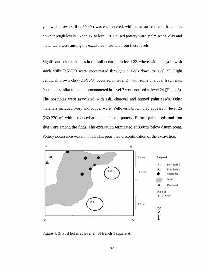
79
yellowish brown soil (2.5Y6/3) was encountered, with numerous charcoal fragments
down through levels 16 and 17 to level 18. Reused pottery ware, palm seeds, clay and
metal ware were among the excavated materials from these levels.
Significant colour changes in the soil occurred in level 22, where with pale yellowish
sands soils (2.5Y7/3 were encountered throughout levels down to level 23. Light
yellowish brown clay (2.5Y6/3) occurred in level 24 with some charcoal fragments.
Postholes similar to the one encountered in level 7 were noticed at level 24 |(Fig. 4.3).
The postholes were associated with ash, charcoal and burned palm seeds. Other
materials included ivory and copper ware. Yellowish brown clay appears in level 25
(260-270cm) with a reduced amounts of local pottery. Burned palm seeds and iron
slug were among the finds. The excavation terminated at 330cm below datum point.
Pottery occurrence was minimal. This prompted discontinuation of the excavation.
Figure 4. 3: Post holes at level 24 of trench 1 square A.

80
The figure below (Fig 4.4) below shows stratigraphy as a representation of the
proceedings of the field activity at Trench 1.
Figure 4.4: Stratigraphic profile of square A, Trench 1.
Square B
The purpose of excavating square B was twofold. First, was to understand the depth
of the bastion foundation and, second, to expose the feature of the limestone heap that

81
occurred between levels 6 and 8 of Square A. The upper section of the square was
mainly of fallen rubble.
4.4.2 Trench 2
Level 1 (30-40cm) was characterized by hard and compact greyish sandy soils
(5Y6/1) with white spots of coral or limestone. Towards the close of the level, soil
colour changed to reddish brown. Level 2 (40-50cm) exhibited hard and compact
reddish brown soils. White lumps of limestone indicating rubble of an ancient built
structure were observed. Among the material finds were potsherds of wheel-drawn
Indian ware and Chinese celadon. In level 3 (50-60 cm), the soil was hard to excavate
and this necessitated addition of water to soften the ground. Plant roots and insect
burrows were common in this level of the square.
The ground was compact at level 4 (60-70cm) but relatively easy to excavate due to
the addition of water. The soils were black loams with fine sand particles. A small
quantity of potsherds was recovered in level 4. Level 5 (70-80cm) yielded hard
grayish soils (2.5Y6/) with fragments of charcoal and numerous potsherds of local
and imported pottery.
At level 6 (80-90cm), loose yellowish brown soils appeared while towards the middle
of the square some scattered coral boulders were encountered. Level 7 (90-100cm)
was dominated by loam soils with embedded pebble granules. Other parts of level 7
exhibited yellowish brown clays. Towards the closure of level 7 a local pot was
excavated adjacent to coral rubbles. Level 8 (100-110cm) was dominated by reddish
brown soils with deposits of ash. Charcoal fragments were collected in aluminium

82
foils. Level 9 (110-120cm) was made up of hard darkish brown soils with ash and
charcoal fragments. A half of the level was covered in loose fragments of coral
boulders probably from a fallen house.
In level 10 (110-120cm) the ground was hard with yellowish grey soils and only a
few pottery materials were recovered. The excavation of square B ended with level 11
(120-130cm), when cultural materials declined. Initially, the soils were loose
yellowish sands with a few patches of black clay soils and spots of charcoal across
the level. The stratigraphic profile of Trench 2 (Fig.4.5) shows six occupational layers
represented by six horizons. Loose boulders bounded by lime mortar were found on
the bottom right corner of the square. The rubble from a fallen house is likely to
predate the lower-most horizon of yellowish brown soils.
Figure 4.5: Stratigraphic profile of Trench 2.

83
4.4.3 Trench 3
Trench 3 (3m x 4m) was located in the centre of the ancient settlement near a ruined
house. A grid of squares labelled A, B, C, D E F and X was created (Fig.4.6). Square
A was excavated stratigraphically to sterile depths while the remaining squares were
opened as extensions to expose the plan of the ruined house.
Figure 4. 6: Plan of Trench 3.
Square A
Level 1 (30-40cm) contained loose light brownish grey soils (2.5Y6/2) with coral
boulders. Plant roots and insect burrows were common. The soil appeared cultivated

84
in the recent past as it featured very fragmentary potsherds and coral boulders from a
house. Level 2 (40-50cm) was dominated by reddish brown (2.5YR4/3) soils with
coral boulders coated with wall plaster. Low amounts of pottery were recovered. In
level 3 (50-60cm) depicted some grayish ash and coral boulders with plaster from
walls of fallen houses. Very few cultural materials were recovered. A thin layer
(~2.54cm) of yellowish brown sandy soils (2.5Y6/3) appeared at level 4 (60- 70cm)
as well as patches of coarse reddish brown gravel (2.5YR4/3). This was a floor filling
of an ancient house. The eastern side of the square featured a heap of coral rubble
probably from a collapsed wall. One piece of iron slag was among local and imported
pottery wares that were recovered from this level. The upper section of level 5 (70-80
cm) contained white lime (7.5YR8/1) followed by a layer of hard compact but coarse
gravel. Level 6 (80-90 cm) contained a high content of ash deposits and fragments of
charcoal. Coarse gravel was observed with limestone rubble probably from the wall
of a fallen house. A clay bead glazed with red wash was also encountered for the first
time.
Between level 7 and 13 cultural materials were relatively fewer than in the previous
levels. However, metacarpals of a small bovid (?ovi/caprine) were collected. Levels
14 and 15 (160-180cm) were characterized by very loose soils that made it difficult to
maintain a 10-cm spit. The soils were sandy silts with a small count of coral boulders.
Bone fragments and local pottery were also excavated. The lower section of the levels
featured a high concentration of charcoal fragments and ash. Level 16 (180-190cm)
contained dark grayish soil with low sand content and some charcoal fragments.

85
In level 17 (190-200cm) loose dark grayish soils were encountered with fragments of
wall plaster. The lower sections of the level were characterized by compact darkish
grey soils with a few counts of coral debris. Local pottery and imported wares were
among the cultural materials recovered. In level 18 (200-210cm), dark grayish sandy
soil (7.5YR3/1) dominated through down to level 19 (210-220cm) where shiny silts
dominated. Wall plaster and local pottery also occurred at this level.
Level 20 (220-230cm) featured dark grayish sandy soils with high moisture content.
Coral rubbles were numerous as were wall plaster fragments. Among the finds was a
green glazed glass bead. There were also bone fragments and potsherds. A posthole
occurred towards the lower section of the level at the centre of the square and
measured 16 cm in diameter.
Towards the close of level 23 the soils were light grayish sands (7.5YR7/1). Moisture
content appeared to increase and the cultural materials recovered included local
pottery and bone fragments from fish and bovid. Light grayish sandy soils continued
to dominate levels 24 (260-270cm) and 25 (270-280cm). Among the finds was a large
bovid mandible with a molar tooth. Level 25 exhibited relatively moist sands with
silts compared to the previous levels.
A second bovid mandible with two molar teeth was found in level 26 (280-290cm). In
level 27 (290-300cm) coral boulders appeared in this level embedded in moist silts.
Besides coral boulders other cultural materials recovered from level 27 included
fragments of bones well preserved in the sandy context, potsherds, a piece of broken
black glassy bead and some cowry shells. Level 28 (300-310cm) contained, among

86
other materials, a sherd of sgraffiato pottery and numerous local potsherds. One
potsherd was found to have been worked into circular shape of 10 cm in diameter and
a hole at the middle suggesting reuse broken pottery. Also found in level 28 was one
worked-fish vertebra.
A piece of daub with pole impression was excavated in level 29 (310-320cm). The
daub and pole impression indicate a change from mud and thatch to stone houses in
the previous levels in which stone masonry tended to dominate. Two counters made
from local potsherds were recovered. In addition, bone fragments of fish and cattle
and goat/sheep occurred in this level. Level 30 (320-330cm) featured grayish sand
with loose corals and lime. Excavation of level 31 (330-340 cm) revealed loose
yellowish brown soils (2.5Y6/3). White sands in level 33 appeared to continue down
to the upper sections of level 34 (360-370cm). The lower section of level 34 exhibited
a high deposit of fine white sands (2.5Y8/1) with minimal cultural material. Further
excavation revealed a deep deposit of white sands and few cultural remains.
Consequently, the excavation of square A was closed at the depth of 360 cm below
datum point and a stratigraphic profile drawn (Figure 4.7).

87
Figure 4. 7: Stratigraphic profile of Trench 3.
Squares B, C, D, E and X were excavated as extensions to understand the occurrence
of house foundations observed in Square A. Level 1 (30-40cm) featured hard
compacted dark grayish soils (7.5YR4/1) with high amounts of coral boulders. A
range of pottery from China, the Arabian Peninsula, Europe, the Indian subcontinent
and those made locally, was recovered as well as numerous bone remains. Iron slag
was also recovered. Farther down to level 2 (40-50cm) coral boulders and a few
pottery materials were recovered. The boulders appeared to be coated with white

88
plaster from burnt coral lime. Level 3 (50-60cm) featured loose yellowish sandy silts.
There were large pieces of coral boulders (>50cm). A single sherd of imported ware
was recovered together with other locally made pottery wares and fish bones.
In level 4 (60-70cm), two adjoining walls of a house were excavated on the western
and northern sides. A depth of 5cm of excavation into the level revealed a section of
reddish brown gravel (2.3YR4/4) which was part of the floor of a house encountered
at the same depth in square A. The occurrence of the features of a foundation
necessitated the opening of squares C, D, E, F and X to expose the floor plan of the
house. No attempt was made to excavate beyond level 6 in these squares.
Below the foundation of the house was a layer of ash and another layer of reddish
brown (2.3YR4/4) gravel revealed in level 5 (70-80cm). The ash was sandwiched
between two deposits of gravel. Low amounts of cultural material were recovered.
Level 6 (80-90 cm) contained some ash and fragments of charcoal. A layer of coarse
rubble is overlain on some ash deposit. The excavation of squares B, C, D, E and X
was discontinued at 90 cm below datum point once the entire floor plan of the house
had been revealed.
4.4.4 Trench 4
Trench 4 measuring 3mx5m, was located in a flat fallow land north of the southern
bastion. The trench was excavated stratigraphically from levels 1 throughout levels to
30. Excavated materials cut across all categories including various ceramics types
faunal remains including fish bones, mammalian bone fragments cowry shells. Plate
4.2 shows the excavation of trench 4 in progress. The materials were very fragmented

89
due to the agrarian activities around the site. Coral rubble with plaster were
numerous. Between levels 2 and 5 a built bore-hole, 130cm in diameter was
encountered (see Plates 4.3 and 4.4). Further excavation revealed a near complete
water jar in situ, seated on an ashy floor. The fragments were all collected for future
reconstruction
Plate 4.2: Excavation of Trench 4 in progress.
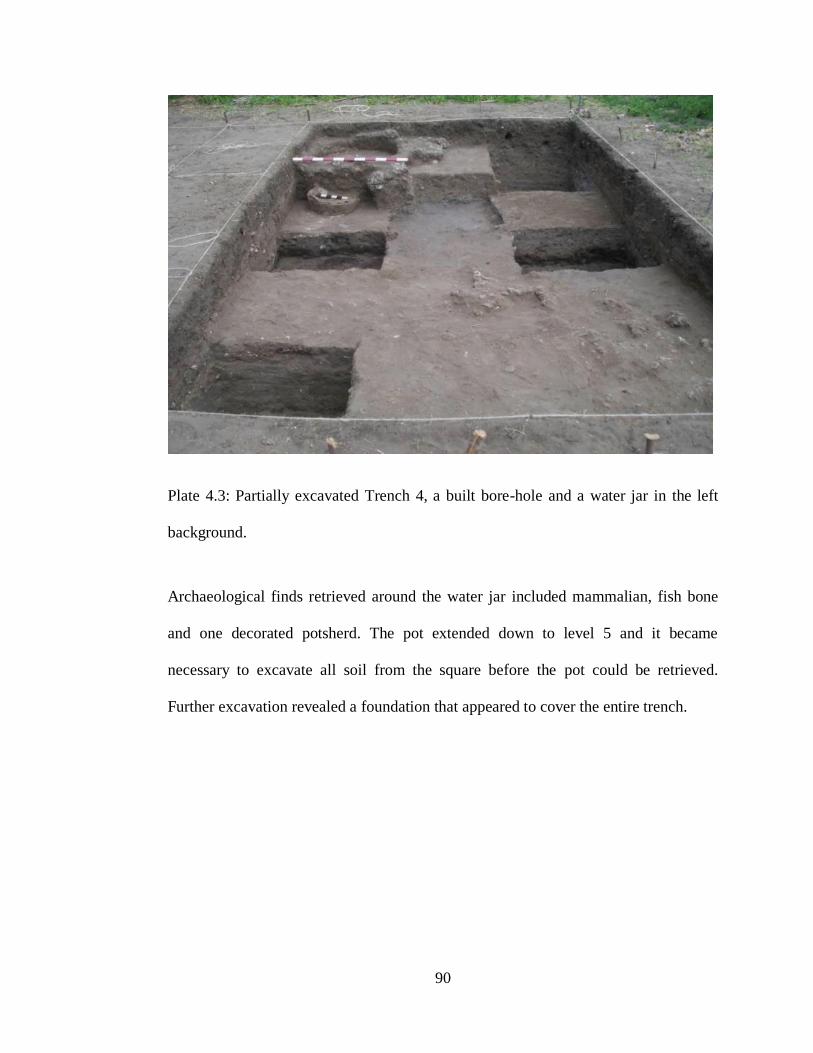
90
Plate 4.3: Partially excavated Trench 4, a built bore-hole and a water jar in the left
background.
Archaeological finds retrieved around the water jar included mammalian, fish bone
and one decorated potsherd. The pot extended down to level 5 and it became
necessary to excavate all soil from the square before the pot could be retrieved.
Further excavation revealed a foundation that appeared to cover the entire trench.

91
Plate 4.4: Excavated borehole, to the right is a water jar (Adopted from Busolo et al,
2019: 34).
Level 6 (80-90cm) featured loose greyish soil (2.5Y6/1) with patches of ash and a
high concentration of charcoal fragments. A high concentration of decorated as well
as undecorated pottery and daub was encountered. Change of soil colour from grey to
dark grey (2.5Y4/1) was observed in level 7 (90-100cm) in which a bluish glass bead
appeared for the first time in the excavation of this square.
Level 8 (100-110cm) contained loose dark grey sandy soils (2.5Y4/1) and random
coral boulders were common. Charcoal fragments continued to appear in this level.
Among the materials excavated were potsherds with a repair hole, Islamic

92
monochrome and one Chinese ware. Others were faunal remains such as bovid and
fish bone fragments.
The dark grayish soils (2.5Y4/1) were gradually replaced by loose reddish brown
soils in level 9 (110-120cm). The excavation of level 9 yielded charcoal fragments
daub and some local pottery. Another colour change from reddish brown to yellowish
brown was observed in levels10 and 11(120-140cm) with a decline in the
concentration of charcoal fragments. Besides local pottery, imported pottery was also
represented.
Levels 12 (140-150cm) and 13 (150- 160cm) exhibited loose black soil (10YR2/1)
with minimal pottery. The soil was easy to excavate but with numerous coral
boulders. A pit filled with olive brown soil (2.5Y4/4) appeared in one section of the
square. A high concentration of charcoal was recorded. Loose dark olive brown soil
(2.5Y3/3) with charcoal deposits occurred between levels14 and 24 with cultural
materials similar to those from level 13. The moisture content appeared to increase as
the excavation progressed through levels 25, 26 and 27. Charcoal fragments re-
appeared but in a very fragmentary state due to the high moisture content in the soil.
Scattered lumps of reddish yellow clay soils were observed, and plain potsherds of
local wares were recovered. Other findings included two sherds of imported wares,
ostrich egg-shell, marine shell and pieces of daub.
Levels 28 and 29 (310-330cm) were hard to excavate due to the sticky nature of the
clay soils. In the upper section of the level, dark greyish soil (7.5YR4/1) dominated
but later this was replaced by light yellowish brown soil (2.5Y6/3) in the lower

93
section (see Plate 4.5). Scatters of coral fragments were encountered in these levels
and appeared highly worn-out, probably due to marine action. A detailed stratigraphic
profile of Trench 4 is shown in Figure 4.8.
Plate 4.5: Fragments of charcoal and ash overlain on clay strata (Adopted from 2019:
35).

94
Figure 4.8: Stratigraphic profile of Trench 4.
The amount of cultural material was minimal except for ash and charcoal fragments
(see strata 3 and 4 in Plate 4.5). Moist yellowish brown clay (2.5Y6/3) with a high
sand content was dominant down to 330cm. The On the other hand, imported pottery
included those wares that came from China, the Persian Gulf and Europe, together
with range of other ceramic wares and glass represent trade and exchange networks
the ancient settlement of Siyu was involved in. On the other hand, imported pottery
included those wares that came from China, the Persian Gulf and Europe, together

95
with range of other ceramic wares and glass represent trade and exchange networks
the ancient settlement of Siyu was involved in. excavation was extended down to 340
cm below datum point where sterile layers of dark grey and yellowish brown were
exposed. This translates into 320cm depth below the ground surface. Plate 4.3 shows
a cultural layer dotted with charcoal fragments and ash deposits above two clay strata.
4.5 Data Processing and Analysis
The processing of data followed a systematic quantification and classification of
materials by level and raw material. This process was conducted alongside the
excavation process top minimize costs. This initial process involved creating
exclusive categories such as faunal materials, local pottery, imported pottery beads,
iron slags, charcoal and reused sherds.
Typological or attribute analysis was useful in identifying similarities in pottery
types. Three main types of pottery analysis were used in this research to investigate
the significance of exchange networks in the early settlement of Siyu. First, were
descriptive types which involved describing the form, shape and physical features
seen on the potsherds. Second, were chronological types whose physical features and
decorative techniques and motifs are known and are accepted as time indicators
because they are based on attributes that show change over time. Finally, functional
types were created on the basis of cultural use or role intended by the makers of the
pottery. Their study identified attributes such as shape and thickness of vessels that
reflect function so that some of them were classed as cooking pots, bowls, storage jars

96
and special or general purpose pots. Typological comparisons of pottery types were
useful in investigating the exchange networks between Siyu and other sites.
Another important approach to pottery analysis was through the application of ethno-
archaeological techniques. There was an effort to determine the presence of potters in
Siyu today, the type of pots they make and where they obtain the clay and temper for
pottery production. In other words, this method assisted in identifying the elements of
cultural continuity, similarities and exchange by analysing the pottery that was made
locally at Siyu or elsewhere in the East African region. This study distinguished
between two categories of pottery on the basis of origin, local pottery and imported
pottery. Local pottery referred to the wares made in the East African coast or
hinterland with relatively similar fabric and surface treatment (Chami, 1994). For
instance, pottery from the Tana tradition sites in Eastern Africa was useful for
comparative analysis because the affinities of Tana tradition occur on Siyu pottery.
Elsewhere, Chami (1994) has referred to this type of pottery as Triangular Incised
Ware (TIW) to delink a geographical phenomenon from typologies. Whether one is
describing the TT or TIW pottery they both refer to a tradition that replaces the
preceding Early Iron Age pottery across the entire East African littoral although
variants are not uncommon.
All the local potteries were counted and weighed at the site before they were sorted
into diagnostic and undiagnostic potsherds. Diagnostic potsherds were those which
had descriptive attributes that could assist the researcher to make comparisons with
other known pottery in line with the set objectives. The attributes included, but were

97
not limited to, rim morphology, neck, shoulder, base, decorative elements, motifs and
their placement on the vessel. The lack of such attributes on a potsherd led it to being
classified as undiagnostic.
The analysis of structural shapes and vessel forms was used successfully by Soper
(1971b), Wandibba (1977, 1990), Sinclair (1987) and Chami (1994). Others are Jama
(1996), Radimilahy (1998) and Juma (2004) in the analyses of pottery from
Mogadishu, Mahilaka and Zanzibar, respectively. The above scholars have variously
used and modified structural shape categories in analysing pottery and also allowed
inclusion of thickness, surface treatment, weight, colour, motif placement, rim
morphology and fabric of pottery types. In particular, Chami (1994) used decorative
elements, shapes and rim morphology in classifying the Swahili pottery.
Besides the identifiable vessel parts, diagnostic potsherds had other attributes such as
decorative techniques and motifs. Rims, shoulders and bodies were further analysed
in detail to record the decorative techniques and motifs. Impressions and burnishing
were some of the surface treatments made on the pots. Impressions represent pressure
on the clay before the pot is fired, while incised lines involve incisions made by a
sharp or blunt instrument.
Decorative structures on local pottery have been useful in identifying these wares and
have taken varying terminologies such as motifs (Collett and Robertshaw, 1983),
decorative patterns (Nordstrom, 1972:77), structure of design (Hulthen, 1974:25), and
decorative format (Sinclair, 1987:164). It is, however, agreed that these terms refer to
independent impressions or incisions that can be either single or in bands or both in

98
combination. Hulthen (1974:26) identifies some of these as elements comprising
horizontal, zigzag line and vertical, rectilinear band filled with a rhombic checkered
pattern. In this study the term decorative element is used.
This study sought to establish the relationship between the placement of decorative
elements and vessel forms, that is, whether the vessel forms of Siyu pottery
determined the location of decorative elements on the pot. While in archaeology we
deal with physical objects such as artefacts, the vessel forms and decorative elements
are a function of human behaviour which can be predicted using a statistical tool such
as the Pearson correlation coefficient. This was used to measure the strength of
association and relationship between vessel form and placement of decorative
elements.
This study sort to establish the relationship between the placement of decorative
elements and the vessel forms. That is, whether the vessel forms of Siyu pottery
determined the place for decorative elements. While in archaeology we deal with
physical objects such as artefacts, the vessel forms and decorative elements on pottery
are a function of human behaviour which can be predicted using a statistical tool such
as the Pearson correlation coefficient. This was used to measure the strength of
association and relationship between vessel form and placement of decorative
elements. The Pearson correlation coefficient value (r) was computed using the
following formula derived by Karl Pearson (Vanpool and Leonard, 2011: 22);

99
where,
n = number of paired scores
∑xy = sum of the product of paired scores
∑x = sum of independent variables (vessel forms)
∑y = sum of dependent variables (placement of decorative elements)
∑x2 = sum of squared x values
∑y2 = sum of squared y value
(Sources: Vanpool and Leonard, 2011: 22)
According to this test, r could have values ranging from +1 to -1. A value of 0 shows
that there is no relationship between the variables being compared. A value higher
than 0 means that there is a positive relationship; such that, as the value of one
(independent) variable increases, so does value of the other (dependent) variable.
A more specialized analysis was conducted and this involved a comparative petrology
of samples of clay and sherds obtained from excavation. This was to help trace the
mobility of clays or finished pottery products from sources or manufacturing points to
places of utility. Interest in exchange networks led the author to seek the application
of atomic absorption spectrometry of potsherds and clay samples as a means of
tracing sources of clay for pottery manufacture and exchange routes. Mass
spectrometry is the generation, separation and characterization of gas phase ions
according to their relative mass as a function of charge (Dougherty, 1981). The
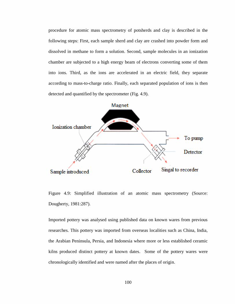
100
procedure for atomic mass spectrometry of potsherds and clay is described in the
following steps: First, each sample sherd and clay are crashed into powder form and
dissolved in methane to form a solution. Second, sample molecules in an ionization
chamber are subjected to a high energy beam of electrons converting some of them
into ions. Third, as the ions are accelerated in an electric field, they separate
according to mass-to-charge ratio. Finally, each separated population of ions is then
detected and quantified by the spectrometer (Fig. 4.9).
Figure 4.9: Simplified illustration of an atomic mass spectrometry (Source:
Dougherty, 1981:287).
Imported pottery was analysed using published data on known wares from previous
researches. This pottery was imported from overseas localities such as China, India,
the Arabian Peninsula, Persia, and Indonesia where more or less established ceramic
kilns produced distinct pottery at known dates. Some of the pottery wares were
chronologically identified and were named after the places of origin.

101
The analysis of faunal materials endeavoured to establish the minimum number of
identified species (NISP). First, all faunal materials were weighed and undiagnostic
bone fragments separated from the diagnostic pieces. The second step was to sort the
diagnostic bone fragments into the main classes of fish, bird and mammal. Using
osteological materials in the Nairobi National Museum laboratory, the bird and
mammal categories were further analysed to identify domesticated fauna from wild
fauna and the categories identified included bovid, equid and canis. However, faunal
analysis was limited to quantitative data especially that of identified specimens. Using
a hand lens, it was possible to identify taphonomic processes that took place on the
bones during and after deposition.
4.6 Legal and Ethical Issues
Principal researchers in archaeological activity are normally expected to meet their
statutory/institutional obligations, the local community and the site under
investigations. All necessary permits and licenses were obtained from the National
Council of Science and Technology (NCST) (Appendix 2) and National Museums of
Kenya. The National Museums of Kenya issued a Research Affiliation Status
certificate (Appendix 3). As well as exploratory license for the researcher to be able
to conduct excavations on sites (Appendix 4).
The researcher also went out of his way to request for admission to private land to be
able to conduct excavations on such land. Besides, seminars were held to create
awareness and involvement of local community in the project. Public awareness
programmes were organized to sensitize the local people about this study and the

102
methodology used. Local men and women were enlisted, trained and given work on
casual basis during the fieldwork. There was a good working relationship with the
local community and an endeavour to preserve the integrity of the site. All trenches
were backfilled with excess pottery and sands as was professionally acceptable. A
few samples were taken for destructive analysis while some were kept for posterity at
Fort Jesus Museum in Mombasa. The project enabled in-house management of
materials at the host museum and further equipped participant students field skills in
survey, mapping, excavation and drawing of stratigraphic profiles.
4.7 Conclusion
This chapter has described all the methodologies employed in the collection of data.
First, sampling as well as surveying and mapping of the site has been discussed.
Second, the chapter has discussed the excavation procedure, stratigraphic profiles
indicating changes in the soil colour and cultural materials in every level. Third, the
chapter has presented a summary of methodologies applied in data processing and
analysis. Finally, the chapter has highlighted the legal and ethical obligations by the
researcher at the site and towards management of excavated materials.

103
CHAPTER FIVE
THE FINDINGS
5.1 Introduction
This chapter presents and discusses the research findings. A range of archaeological
materials from the excavation of each of the four trenches is presented in tabular
format, indicating quantities of identified basic categories such as local pottery,
imported pottery, beads, fauna, stoneware, daub, charcoal, iron and spindle whorls.
5.2 Archaeological Materials
In Trench 1 excavated materials local pottery were 8,128 sherds (see Table 5.1).
Imported pottery featured evenly throughout the trench with notable scarcity between
levels 26 and 27. Faunal materials and marine shells classified separately from other
faunal finds totalled 26 and 20 respectively. Table 5.2 shows quantities of excavated
materials from trench 2. Local pottery was at 2,111 sherds, faunal materials at 654
fragments. Imported pottery totaled 156 sherds. Other finds were 10 samples.

104
Table 5.1: Excavated materials from trench 1.
Tr Sq Lv Lp Ip st sh fn mt is ch bd du wp ro ds sp
1 A mixed 15 2 2 2 4
" " 1 246 4 3 1
" " 2 130 6 5
" " 3 167 10 5 2 1 1
" " 4 228 5 1 1 2
" " 5 85 1 1 1
" " 6 398 10 1 3 1 1
" " 7 195 1 2 1 1
" " 8 555 4 2 2 1
" " 9 192 2 1 1 1
" " 10 520 5 2 1 1
" " 11 514 3 6 1 1 1
" " 12 460 7
" " 13 546 5 1 1 1
" " 14 326 2 1 2
" " 15 277 1 2 1 1 4 1
" " 16 207 2 2 1
" " 17 405 4 1 2
" " 18 353 1 1 1 1 1
" " 19 463 1 1 1 1
" " 20 405 2 2 2 1 2
" " 21 253 1 1 1 1 1 1
" " 22 231 4
" " 23 162
" " 24 322 2 1 1
" " 25 322 3 1 1
" " 26 106
" " 27 45
TOTAL 8128 88 11 20 26 3 8 8 9 4 2 10 2 4
Abbreviations used in Table 5.1: Tr= trench, Sq=square, Lv=level, Lp=Local pottery,
Ip=imported pottery, st=stoneware, sh=shell, fn=fauna other than shell, mt=metal,
is=iron slag, ch=charcoal, bd=bead, db=daub, wp=wall plaster, ro=red ocher,
ds=seed, sp=spindle whorl.

105
Table 5.2: Excavated materials from trench 2.
Tr Sq Lv Lp Ip st sh fn mt is ch bd du ro ds
2 A surface 4 0
" " 1 0 17
52 1 1 1
" " 2 46 20 1 1 45 2 1 1
" " 3 78 7 1 5 1
" " 4 20 2 2 21 1
" " 5 126 16 43 1 4
" " 6 101 3 3 21 4
" " 7 241 2 2 11 2 1 3
" " 8 163 4 1 2 44 2 1 1
" " 9 67 6 1 28 2
" " 10 77 12 17 3
" " 11 36 0 1
2 B 1 29 17 6
" " 2 255 16 1 82 11 1 1
" " 3 107 2 21 1
" " 4 225 14 52 5 1 1
" " 5 132 5 49 1 1 1
" " 6 55 4 1 13 3 1 1 1
" " 7 68 2 23 1
" " 8 107 5 67
" " 9 98 1 1 35 1
" " 10 64 1 19 1
" " 11 12
TOTAL " 2,111 156 7 10 654 26 10 6 12 4 4 5
Abbreviations used in Table 5.2: Tr= trench, Sq=square, Lv=level, Lp=Local
pottery, Ip=imported pottery, st=stoneware, sh=shell, fn=fauna other than
shell, mt=metal, is=iron slag, ch=charcoal, bd=bead, db=daub, ds=date palm
seed, ro=red ocher.

106
A wide range of materials were excavated in Trench 3 with a notable absence of
spindle whorls and red ochre (Table 5.3). Local pottery totalled 6,105 sherds with
alternating highs and lows in certain depths while imported pottery was 102 sherds
showing a similar pattern to that of local pottery in the previous trenches. Shells and
other faunal materials totalled 155 and 1,663 respectively. Twenty-eight pieces of
daub were encountered in the lower levels between levels 24 and 34. Wall-plaster on
the other hand occurred between levels 17 and 24.

107
Table 5.3: Excavated materials from trench 3.
Tr Sq Lv Lp Ip st sh fn mt is ch bd du wp ds
3 A surface 4 1
" " mixed 44 11
" " 1 452 19 1 4 61 1 3
" " 2 12 2 1
" " 3 1
" " 4 19
" " 5 28 2 9
" " 6 48 2 1 30 2
" " 7 55 1 2 46
" " 8 68 48 1
" " 9 88 1 2 74
" " 10 39 2 25
" " 11 16 1 14
" " 12 45 1 57 1 1
" " 13 79 2 31 1
" " 14 178 1 40 1
" " 15
" " 16 72 3 53
" " 17 115 2 12 39 3
" " 18 24 3 18 8
" " 19 29 2 2
" " 20 63 6 31 1 2
" " 21 54 1 2 24
" " 22 67 1 1 21 2 1
" " 23 236 5 1 5 80 1 1
" " 24 195 2 3 101 1 1 1
" " 25 303 4 5 58 2 1
" " 26 390 2 5 2 55
" " 27 320 3 1 29 41 1 1
" " 28 462 5 5 20 125 2 1
" " 29 631 4 7 106 1
" " 30 445 6 2 13 138 1
" " 31 411 9 7 76 3
" " 32 614 17 14 114 4
" " 33 170 5 8 35 1 1 1 5
" " 34 231 5 2 102 1 14
TOTAL 6007 102 18 155 1663 9 2 9 11 28 17 3

108
Trench 4 was excavated to a maximum depth of 3.3m. See Table 5.4 for a summary
of excavated materials. The materials recovered were as follows: local pottery 3,206
sherds, imported pottery 61 sherds, stoneware, 12 pieces, faunal finds totalled 289
fragments, 1 piece each of metal ware and iron slag. Twenty-four charcoal fragments
and 41 lumps of daub.
Table 5.4: Excavated materials from trench 4.
Tr Sq Lv Lp Ip st fn mt is ch bd du gl
4 C 1
" " 2 67 3 1
" " 3 21 2 12 3
" " 4 70 5 7 1
" " 5 114 3 10
" " 6 268 6 1 3
" " 7 223 1 8 12
" " 8 280 4 11 2
" " 9 256 5 7
" " 10 210 1
" " 11 140 2
" " 12 214
" " 13 276 2 6 35 7
" " 14 53 14 3 2
" " 15 44
" " 16 144 1 25
" " 17 212 4 1 2
" " 18 130 1 1
" " 19 133 20 1 2
" " 20 139 9 1 1
" " 21 66 1 25
" " 22 61 2 1 2
" " 23
" " 24 58 4 14 6
" " 25 86 5 27 3
" " 26 186 2 2 18 3
" " 27 116 3 36 2
" " 28 39 2 17 2 2
" " 29 4 1 5 2
Total 3,206 61 12 289 1 1 24 2 41 4

109
Abbreviations used in Table 5.4: Tr= trench, Sq=square, Lv=level, Lp=Local pottery,
Ip=imported pottery, st=stoneware, sh=shell, fn=fauna other than shell, mt=metal,
is=iron slag, ch=charcoal, bd=bead, du=daub, gl=glass.
5.2.1 Pottery
The total pottery assemblage was 19, 957 sherds. Local pottery was represented by
19,550 sherds while imported pottery was represented by 407 sherds (Table 5.5).
Table 5.5: Total pottery assemblage
Square Imported pottery Local pottery Total
1 A 88 8,128 8,216
2 A & B 156 2,111 2,267
3 A 102 6,007 6,207
4 C 61 3,206 3,267
Total 407 19,550 19,957
This data can help the reader appreciate the proportion of imported pottery in the
entire ceramic assemblage. Imported pottery accounted for about 2% while local
pottery accounted for 98%. The data shows a ratio of imported pottery to local pottery
as 1:49, suggesting that only a small amount of imported pottery was in circulation at
the time and was probably limited to the elite economic group or ruling class. Due to
logistical challenge, materials from trench 2 were not included in the analysis. But
such materials are stored in the National Museum laboratory for posterity. Should
upcoming researchers have interest in a studying them they should be able to access
them.

110
Table 5.6: Diagnostic and undiagnostic local pottery
Trench
Diagnostic
pottery
Undiagnostic
pottery Total
1 1,887 6,242 8,129
3 979 5,028 6,107
4 794 2,509 3,203
Total 3,660 13,779 17,439
Different attributes have been used to analyze pottery by different scholars depending
on the problems under investigation (Chami, 1994; Collett and Robertshaw, 1983;
Hulthen, 1974; Nordstrom, 1972). This study utilized shape, decoration, placement of
decorative element and fabric. In view of the exchange systems approach, these
attributes were chosen to assist in tracing possible movement of ideas and materials
between Siyu and other places.
In determining the shapes of pottery vessels, Shepard (1963) developed a model that
recognizes two categories of restricted and unrestricted vessels, either pots or bowls.
The contours of the various parts of the vessel are important determinants of the
category pottery vessel should be included. Another model involves identification of
shapes such as necked pot, narrow-mouthed, globular, rough, open bowls, carinated
forms from pottery fragments (Collett and Robertshaw, 1983:109; Chami, 1994: 77).
The total sample population from trenches 1, 3 and 4 was 3,660 diagnostic sherds, out
of which 366 (10%) sherds were selected by simple random sampling.

111
The undiagnostic pottery comprised plain body sherds that included highly
fragmented sherds of less than 3cm width and others as wide as 10cm yet did not
have attributes necessary for this study. Diagnostic potsherds are those that featured
structural shapes of vessel parts on the basis of profiles or contours such as rim (R),
neck (N), shoulder (S), decorated body (Bd) and base (Bs). The categories were
useful in identifying two general types of vessels, restricted and unrestricted mouth
vessels. Seven structural shapes were identified with the majority of sherds falling in
category 1 with 190 cases. The lowest of all categories was category 7 with 21 cases
(see Table 5.7). Categories 2, 3,4,5,6 and 7 were useful in comparing the various
types of pottery. These categories each have different capacities in distinguishing
ceramic vessel shapes. For instance, category 1 could be derived from any vessel
shape hence less informative since all the types of vessels must have all the three
parts, rims, bodies and bases and, may be, necks for some.
Table 5.7: Frequencies of vessel categories
Shape categories Frequency Percentage
1 R, Bo/Ba, Bo, Ba 190 51.9
2 R/S/Bo/Ba, R/S/Bo,R/S 36 9.8
3 R/N, N 34 9.3
4 R/N/Bo/Ba, R/N/Bo, N/Bo/Ba, N/Bo 24 6.6
5 R/Bo/Ba, R/Bo 22 6.0
6 S, S/Bo, S/Bo/Ba 21 5.7
7 R/N/S/Bo/Ba, R/N/S/Bo, R/N/S, N/S/Bo/Ba,
N/S/Bo,N/S
39
10.7
Total 366 100.0
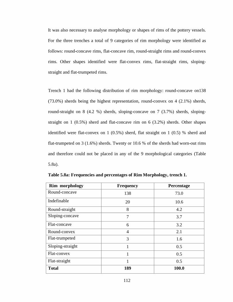
112
It was also necessary to analyse morphology or shapes of rims of the pottery vessels.
For the three trenches a total of 9 categories of rim morphology were identified as
follows: round-concave rims, flat-concave rim, round-straight rims and round-convex
rims. Other shapes identified were flat-convex rims, flat-straight rims, sloping-
straight and flat-trumpeted rims.
Trench 1 had the following distribution of rim morphology: round-concave on138
(73.0%) sherds being the highest representation, round-convex on 4 (2.1%) sherds,
round-straight on 8 (4.2 %) sherds, sloping-concave on 7 (3.7%) sherds, sloping-
straight on 1 (0.5%) sherd and flat-concave rim on 6 (3.2%) sherds. Other shapes
identified were flat-convex on 1 (0.5%) sherd, flat straight on 1 (0.5) % sherd and
flat-trumpeted on 3 (1.6%) sherds. Twenty or 10.6 % of the sherds had worn-out rims
and therefore could not be placed in any of the 9 morphological categories (Table
5.8a).
Table 5.8a: Frequencies and percentages of Rim Morphology, trench 1.
Rim morphology Frequency Percentage
Round-concave 138 73.0
Indefinable 20 10.6
Round-straight 8 4.2
Sloping-concave 7 3.7
Flat-concave 6 3.2
Round-convex 4 2.1
Flat-trumpeted 3 1.6
Sloping-straight 1 0.5
Flat-convex 1 0.5
Flat-straight 1 0.5
Total 189 100.0
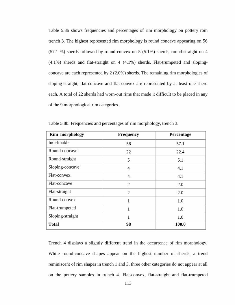
113
Table 5.8b shows frequencies and percentages of rim morphology on pottery rom
trench 3. The highest represented rim morphology is round concave appearing on 56
(57.1 %) sherds followed by round-convex on 5 (5.1%) sherds, round-straight on 4
(4.1%) sherds and flat-straight on 4 (4.1%) sherds. Flat-trumpeted and sloping-
concave are each represented by 2 (2.0%) sherds. The remaining rim morphologies of
sloping-straight, flat-concave and flat-convex are represented by at least one sherd
each. A total of 22 sherds had worn-out rims that made it difficult to be placed in any
of the 9 morphological rim categories.
Table 5.8b: Frequencies and percentages of rim morphology, trench 3.
Rim morphology Frequency Percentage
Indefinable 56 57.1
Round-concave 22 22.4
Round-straight 5 5.1
Sloping-concave 4 4.1
Flat-convex 4 4.1
Flat-concave 2 2.0
Flat-straight 2 2.0
Round-convex 1 1.0
Flat-trumpeted 1 1.0
Sloping-straight 1 1.0
Total 98 100.0
Trench 4 displays a slightly different trend in the occurrence of rim morphology.
While round-concave shapes appear on the highest number of sherds, a trend
reminiscent of rim shapes in trench 1 and 3, three other categories do not appear at all
on the pottery samples in trench 4. Flat-convex, flat-straight and flat-trumpeted

114
shapes were not represented on potteries in trench 4. Fifteen (19.0%) rim sherds had
worn-out surfaces and therefore could not be classified (see Table 5.8c).
Table 5.8c: Frequencies and percentages of rim morphology, trench 4.
Rim morphology Frequency Percentage
Indefinable 17 21.5
Round-concave 15 19.0
Round-straight 15 19.0
Sloping-concave 10 12.7
Flat-convex 8 10.1
Flat-concave 8 10.1
Flat-straight 6 7.6
Round-convex 0 0.0
Flat-trumpeted 0 0.0
Sloping-straight 0 0.0
Total 79 100.0
The main vessel forms are identified as pots, bowls and jars (Table 5.9a-c). The pots
were further classified into various categories such as open-mouthed pots, restricted-
mouthed pots, hole-mouthed pots, globular pots and spherical pots with short neck.
Two other categories were jar and carinated pot. Bowls were identified as either plain
or carinated bowls. In trench 1 open-mouthed pots were represented by 46 sherds
accounting for 24.3% of the total sample of 189. Spherical pots with short neck,
restricted mouthed pots and carinated pots were represented by 1 sherd each. Jars and
hole-mouthed pots were represented by 3 sherds each. Plain bowls were represented
by 121 sherds accounting for 64.0% while carinated bowls were represented by 1
sherd only.
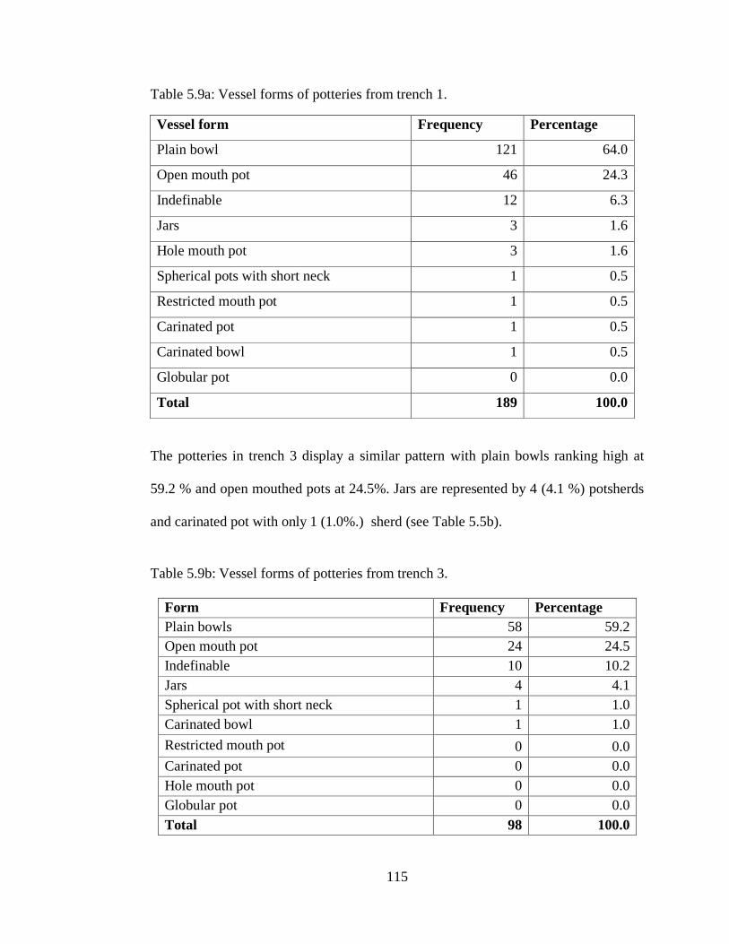
115
Table 5.9a: Vessel forms of potteries from trench 1.
The potteries in trench 3 display a similar pattern with plain bowls ranking high at
59.2 % and open mouthed pots at 24.5%. Jars are represented by 4 (4.1 %) potsherds
and carinated pot with only 1 (1.0%.) sherd (see Table 5.5b).
Table 5.9b: Vessel forms of potteries from trench 3.
Form Frequency Percentage
Plain bowls 58 59.2
Open mouth pot 24 24.5
Indefinable 10 10.2
Jars 4 4.1
Spherical pot with short neck 1 1.0
Carinated bowl 1 1.0
Restricted mouth pot 0 0.0
Carinated pot 0 0.0
Hole mouth pot 0 0.0
Globular pot 0 0.0
Total 98 100.0
Vessel form Frequency Percentage
Plain bowl 121 64.0
Open mouth pot 46 24.3
Indefinable 12 6.3
Jars 3 1.6
Hole mouth pot 3 1.6
Spherical pots with short neck 1 0.5
Restricted mouth pot 1 0.5
Carinated pot 1 0.5
Carinated bowl 1 0.5
Globular pot 0 0.0
Total 189 100.0

116
In trench 4, open mouthed pots were represented by 40 (50.0%) sherds, plain bowl
had 6 (7.6 %) sherds and carinated bowl had 5 (5.3%) sherds. The rest of vessel forms
do occur at less than 5.1 %.
Table 5.9c: Vessel forms of potteries from trench 4
Cross-tabulation of rim morphology and vessel form shows that the majority of
vessels (263) were plain bowls with round concave rims (see Table 5.9d). Vessels
with flat convex and flat straight rims were rare at this site. Round straight, sloping
concave and flat concave vessels were rare in all categories except for plain bowls
and open-mouthed bowls.
Form Frequency Percentage
Open mouth pot 40 50.6
Indefinable 11 13.9
Plain bowl 6 7.6
Carinated pot 5 6.3
Jar 4 5.1
Carinated bowl 3 3.8
Hole mouth pot 3 3.8
Globular pot 3 3.8
Spherical pot with short neck 2 2.5
Restricted mouth pot 2 2.5
Total 79 100.0

117
Table 5.9d: Cross-tabulation of rim morphology and vessel form
Ind
efi
nab
le
Op
en
mou
thed
pot
Sp
heric
al
pot
wit
h s
hort
neck
R
est
ric
ted
mou
thed
pot
Carrin
ate
d
pot
Carrin
ate
d
bow
l
Pla
in b
ow
l
Jar
Hole
-mou
thed
pot
Glo
bu
lar p
ot
Tota
l
Round,
concave
14 91 1 3 1 3 141 5 3 1 263
Indefinable 21 7 0 0 0 0 14 4 0 0 46
Flat,
concave
2 3 0 0 0 0 12 0 0 0 17
Round,
straight
4 2 0 0 0 0 5 4 0 0 15
Sloping,
concave
1 2 0 0 0 1 6 0 0 1 11
Round,
convex
0 3 1 0 0 0 1 2 0 0 7
Flat ,
trumpeted
0 0 0 0 0 0 3 0 0 0 3
Sloping,
straight
0 1 0 0 0 0 1 0 0 0 2
Flat,
convex
0 0 0 0 0 0 0 1 0 0 1
Flat,
straight
0 0 0 0 0 0 1 0 0 0 1
Total 42 109 2 3 1 4 184 16 3 2 366
Another attribute that was considered for analysis was decoration. A total of 14
decorative elements on local pottery were identified and are illustrated in Figure 5.1.

118
Figure 5.1: Decorative elements on Siyu pottery (Adopted from: Busolo et al, 2019:
37).
According to Busolo et al (2019) decorative element 1 appears to dominate in Swahili
sites and has been described as being both Tana Tradition (T/T) and Early Iron Ware
(EIW) design. It is also suggested that those occurring in EIW designs normally
combined with other designs (see Figure 5.2-5.13). The number in bracket represents
the accession number of the sherd.

119
Figure 5.2 (462): Jar-hard brown fabric, plain and smooth on both interior and
exterior surfaces, round straight rim with horizontal incisions below rim.
Figure 5. 3 (110): Short necked pot in hard brown fabric, plain and rough on interior
and exterior, with continuous stabs below the rim.
Figure5. 4 (162): Carinated bowl- reddish brown fabric, plain smooth interior, plain
rough exterior, round concave with continuous stabs along the carination.

120
Figure 5.5 (467): Simple carinated bowl- soft reddish brown fabric, plain smooth on
both interior and exterior, round straight rim with diagonal incisions bound by
horizontal lines.
Figure 5.6 (469): Carinated bowl- brick reddish brown fabric, plain smooth interior,
plain rough exterior, round sloping concave rim with diagonal incisions below the
rim.
Figure 5.7 (252): Simple bowl in hard red fabric, plain smooth interior, plain smooth
exterior, round concave rim decorated with a combination of short oblique incisions,
arrow incisions and thumb stabs on body.

121
Figure 5.8 (299): Simple bowl in hard red fabric, plain smooth interior, plain smooth
exterior, round concave rim decorated with a combination of standing triangle with a
single vertical incision and continuous thumb nail on a slight carination.
.
Figure 5.9 (361): A shallow bowl in hard reddish brown fabric, plain smooth on both
interior and exterior surfaces, with single cross hatching on a flat expanded rim.

122
Figure 5.10 (464): Hole mouthed jar in grayish brown fabric, plain smooth interior,
plain smooth exterior, round concave slightly out-turned rim, with single cross-
hatching delimited by a horizontal incision below the rim.
Figure 5.11 (461): Spherical pot in hard brown fabric, red wash interior, plain exterior
round concave rim, single cross hatching below rim.
Figure 5.12 (476): Spherical pot in hard pale red fabric, plain smooth interior and
exterior, double cross-hatching.
Figure 5.13 (475): Necked pot in hard pale red fabric, orange burnish on interior,
plain smooth on exterior with double cross-hatching below the neck. Additional
illustrations are appended as Appendix 1 for reference.
It was also necessary to determine the location of the various decorative elements on
the vessels and whether this varied with vessel form. Frequencies and percentages of
placement of decorative motifs are presented in Table 5.10. A total of 248 sherds
were plain with no decoration, 27 sherds had decorative element along rim and 27
sherds were decorated on neck. Twenty-five sherds were decorated on shoulder, 20
potsherds on body and 19 sherds had decorative motif on carination.

123
Table 5.9e: Cross-tabulation of the levels and decorative elements
LE
VE
L
Non
e
Horiz
on
tal
lin
e
incis
ion
C
on
tin
uou
s st
ab
s
Dia
gon
al
incis
ion
s
Th
um
b n
ail
sta
bs
Mu
ltip
le v
erti
cal
incis
ion
s R
ow
of
pu
ncta
tes
Lad
der f
ille
d
incis
ion
s C
om
ple
x d
iagon
al
incis
ion
s T
ria
ngu
lar
incis
ion
s O
bli
qu
e i
ncis
ion
s
Inte
rlo
ck
ing
zig
zag i
nci
sion
s
Cross
-hatc
hed
incis
ion
s D
ou
ble
cross
-
hatc
hes
TO
TA
L
1 11 2 0 0 2 0 0 0 0 0 0 0 0 0 15
2 6 1 0 0 0 0 0 0 0 0 0 0 0 0 7
3 15 1 2 0 0 0 0 0 0 0 0 0 0 0 18
4 15 3 6 2 0 0 3 0 1 0 0 0 0 0 30
5 17 0 1 0 0 0 0 0 0 0 0 0 0 0 18
6 9 2 1 1 0 0 1 0 0 0 0 0 0 0 14
7 4 1 1 0 2 0 0 0 1 1 1 0 0 0 11
8 12 3 1 0 1 0 0 0 0 0 0 0 0 0 17
9 10 1 0 0 0 0 0 0 0 0 0 0 0 0 11
10 8 1 0 0 0 0 0 0 0 1 0 1 0 0 11
11 20 2 1 0 0 0 0 1 0 2 0 0 0 0 26
12 11 0 2 0 2 0 0 1 2 0 0 1 0 0 19
13 14 0 0 0 0 0 2 0 0 0 0 0 0 0 16
14 7 0 0 0 0 0 0 0 0 0 0 0 0 1 8
15 13 1 1 0 2 0 1 0 0 0 0 0 0 0 18
16 5 1 1 0 0 0 0 0 0 0 1 0 0 0 8
17 7 0 1 0 0 0 0 0 0 1 0 0 1 0 10
18 4 1 2 0 0 0 1 0 0 0 0 0 0 0 8
19 5 1 0 1 0 0 0 0 0 0 0 0 0 0 7
20 6 2 1 0 0 1 0 0 0 0 0 1 0 0 11
21 6 1 2 0 1 0 0 0 0 0 0 0 0 0 10
22 8 0 0 0 1 0 0 0 0 0 0 0 0 0 9
23 8 1 0 0 1 0 0 0 0 0 0 0 1 0 11
24 3 0 0 0 0 0 0 0 0 0 0 0 0 0 3
25 4 0 0 1 1 1 1 0 0 0 0 0 0 0 8
26 10 0 0 1 0 0 0 0 0 0 1 0 0 0 12
27 2 0 4 0 0 0 0 2 0 0 0 1 0 0 9
28 7 2 3 1 2 0 1 3 0 0 0 0 1 0 20
29 1 0 0 0 0 0 0 0 0 0 0 0 0 0 1
Total 248 2
7
3
0 7
1
5 2
1
0 7 4 5 3 4 3 1
36
6

124
Table 5.10: Frequencies and percentages of location of decorative motifs.
There was need to check whether or not there was a relationship between the
placement of decorative element and vessel form. The researcher wanted to find out
whether the vessel form influenced the location for a decorative element as was the
case in some TIW sites (Chami: 1994:80). Using Pearson correlation analysis, a
coefficient (r) value of 0.041 was generated. This value was not significant since it
was below the significance level of 0.05 (Table 5.11).
Table 5.11: Correlation of decorative motif and vessel form.
Correlations Vessel
form
Location of
decorative motif
Vessel form Pearson correlation 1 .041
Sig. (2-tailed) .433
N 366 366
Location of decorative
motif
Pearson Correlation .041 1
Sig. (2-tailed) .433
Sig. (2-tailed) .433
Location Frequency Percentage
None (sherds with no
decoration) 248 67.8
Along rim 27 7.4
Neck 27 7.4
Shoulder 25 6.8
Body 20 5.5
On carination 19 5.1
Total 366 100.0

125
5.2.2 Texture of Pottery Fabrics and Temper
A description of the texture of pottery material was also thought to be important.
Pottery material includes clay and temper. Texture was categorized as soft, hard and
crumbly. In addition, a few sherds described as hard with air-holes. A sherd with soft
fabric could easily be scratched with a thumb nail. Hard fabric was mainly from very
fine clay that was well fired, and pottery of this kind of fabric could not be scratched
easily with a thumbnail but by use of a metal object such as a pocket knife. Table 5.8
shows the frequencies of each type of fabric. A total of 291 (79.5%) sherds were of
hard fabric, 44 (12 %) sherds were of soft fabric while 21(5.7%) sherds were
characterized as crumbly. The remaining 10 (2.7 %) were of hard fabric with air-
holes. Some of the potteries were tempered using varying materials (Table 5.12).
Table 5.12: Texture of pottery fabric.
Texture Frequency Percentage
Hard 291 79.5
Soft 44 12.0
Crumbly 21 5.7
Hard with air-holes 10 2.7
Total 366 100.0
The raw materials for temper were identified using a light microscope (x10) and a
hand lens of x5 magnification. The main tempering materials were quartz, limestone,
mica, pebble grit, gravel and some were a combination of two or more of these.
Charcoal and shell were uncommon sources of temper for Siyu pottery except where
these were used in combination with other inclusions. Quartz and a combination of it
with limestone and with gravel were the most dominant raw materials for temper

126
(Table 5.13). Quartz alone was identified in 56 (15.3 %) sherds, followed by fine
sands identified in 20 (5.5%) sherds while mica particles were identified in 18 (4.9 %)
sherds. A combination of quartz and limestone was identified in 96 (26.2 %) sherds
while quartz and unspecified shiny particles occur in 84 (22.0 %) sherds. Quartz and
charcoal grits occur in 8 sherds. Other raw materials identified in the pottery were
gravel, mica and pebbles. Quartz and plant materials were also identified in 5 sherds.
Table 5.13: Frequencies of tempering material
Tempering materials Frequency Percent
Quartz and limestone 96 26.2
Quartz and unspecified shinny mineral 84 22.0
Quartz 56 15.3
Gravel and quartz 22 6.0
Fine sands 20 5.5
Indefinable 18 4.9
Mica 18 4.9
Quartz and charcoal 9 2.5
Gravel 8 2.2
Quartz and sand 6 1.6
Quartz and fine sand 5 1.4
Quartz and plant materials 5 1.4
Limestone 3 0.8
Coarse sand 3 0.8
Pebbles and quartz 3 0.8
Gravel and limestone 3 0.8
Fine sand and gravel 3 0.8
Charcoal 1 0.3
Pebbles 1 0.3
Unspecified shinny mineral particles 1 0.3
Limestone and white dull pieces 1 0.3
Total 366 100.0
5.2.3. Petrology of Potsherds and Clay
Petrological analysis of a selected sample of sherds and clay was done at the National
Department of Geology and Mines (NDGM), Nairobi, using atomic absorption

127
spectroscopy (AAS) to determine possible compositional elements in the potsherds
and clay (Table 5.14). One category of samples included four specimens of potsherds
and another category included two samples of clay. The four samples of potsherds
were selected as follows: Two potsherds from a depth of 192cm below datum point
and assigned laboratory numbers (Lab no.) 91/13 and 92/13. One potsherd from a
depth of 246cm below datum point was assigned Lab no. 93/13 while another one
potsherd from a depth of 324 cm was assigned Lab no. 94/13. The specimens, Lab.
Nos./13, 4992/13, 93/13, 94/13 contain 67.16 %, 66.51%, 65.35% and 66.88% of
silicon dioxide (SiO2), respectively, compared to 68.66 % of SiO2 in a specimen of
clay (Lab no. 01/13) from Siyu. Specimen 01/13 contained a relatively low
percentage of aluminium oxide (Al2O3) at 10.77% compared to 13.16%, 15.69%,
15.72% and 16.89% in the four specimens of potsherds above. Specimen 01/13
contains a relatively high percentage of ferrous oxide (Fe2O3) at 7.00% compared to
2.91%, 3.46%, 3.83%, and 3.63% in the four specimens of potsherds above.
The second raw clay specimen, Lab no. 02/13, was obtained from a known source of
clay at Kiangwe on the shores of Dodori creek about 20km from Siyu. All specimens
were fired at high temperatures with the objective of measuring the amount of mass
loss-on-ignition (LOI). LOI is a test used in analyzing minerals where a sample is
ignited at high temperatures allowing all organic components to escape until its mass
stabilizes (Veres, 2002: 172). LOI was used to determine the amount of organic
matter in the clay. The LOI results indicated a large variation between organic matter
in the specimens of potsherds and those of raw clay. The pottery specimens had LOI

128
values ranging between 4.92 and 5.67% compared to the clay specimens with LOI of
8.92 and 16.21%.
Table 5.14: Mineralogy of potsherds and clay
5.2.4 Imported Pottery
As for the imported pottery a total of eight decorative motifs were identified as
follows: blue and white floral, chrysanthemum floral, green linear motif, curvilinear,
polychrome hand painted, blue-on-white monochrome, greenish brown and, finally,
light green floral motif. The majority of the imported wares were coated with a glaze
of some sort as seen in Plates 5.1-5.8. The number in brackets indicates the accession
number of the sherd.
Sherd/L
ab. No.
Ref:
code
SiO2
(%)
Al2O3
(%)
CaO
(%)
MgO
(%)
Na2O
(%)
K2O
(%)
TiO
(%)
Mno
(%)
Fe2O3
(%)
LOI
(%)
91/13 192a 67.16 13.16 1.20 3.10 2.59 0.90 0.45 0.08 2.91 5.14
92/13 192b 66.51 15.69 1.01 3.20 2.52 1.10 0.39 0.06 3.46 5.19
93/13 246 65.35 15.72 1.62 2.70 1.84 0.90 0.21 0.10 3.83 5.67
94/13 324 66.88 16.89 0.67 0.26 3.19 1.70 0.94 0.05 3.63 4.92
Clay/La
b. No
01/13 S1-1 68.66 10.77 0.32 0.05 0.56 0.79 0.32 0.40 7.00 8.92
02/13 K1-1 45.17 15.66 8.50 5.10 1.23 1.82 0.91 0.40 5.46 16.21
Rock/La
b. No
03/13 R1-1 40.23 15.71 6.34 4.98 0.67 1.98 0.34 0.45 5.67 9.34
04/13 R1-2 35.09 16.23 10.9
6
5.32 1.45 1.56 0.91 0.42 7.12 8.45
05/13 R1-3 36.89 15.67 8.34 6.06 2.09 1.87 0.56 0.56 6.23 10.89
06/13 R1-4 49.01 14.50 7.06 2.48 0.45 1.78 0.43 0.60 5.75 11.01

129
Plate 5.1(513): 11th
-13th
century late sgraffiato with dark green glaze on the interior.
Plate 5.2 (345): 14th
century Chinese porcelain.
Plate 5.3 (571): 11th
century White Chinese porcelain.

130
Plate 5.4 (552): Mid 15th
-16th
century rim of a shallow ledged standard Islamic
monochrome bowl with a blue to green-blue under glaze. See also Plate 5.7 (580).
Plate 5.5 ( 589):13th
-14th
century worn out piece of black-on-yellow ware, decorated
with thin black or brown lines.
Plate 5.6 (604):13th
-14th
century worn out black-on-yellow Islamic potsherd.
Plate 5.7 (620): Assorted imported pottery. Left. Late15th
-16th
century Chinese blue-
and–white glazed sherd; Middle (536) 9th
-12 th
century unglazed Islamic ware in
coarse cream white fabric; Right (580) Mid 15th
-16th
century standard Islamic
monochrome bowl in pink fabric, green glaze on both sides.

131
Plate 5.8(568 ): Assorted imported pottery from the Far East.
Left: Chinese blue-and –white glazed sherd. The second is likely a flake from?
Chinese celadon.Top: Unidentified sherd with thick yellowish paste and a worn-out
brown glaze. Extreme right: Green glazed Chinese stoneware? Dated 9th
-10th
cnetury. This pottery was also reported at Manda (Chittick, 1984).
The findings on imported pottery indicated that Siyu, like other coastal cities, had
access to the pottery from the Arabian Peninsula and China. Table 5.15 shows
frequencies of diagnostic imported pottery.
Table 5.15: Frequencies and percentages of imported pottery wares
Ware Frequency Percentage
Standard Islamic monochrome 46 41.8
Chines blue and white 33 30.0
Black-on-yellow Islamic 6 5.5
Longquan green glazed 5 4.5
Thin glazed earthenware 5 4.5
Late sgraffiato 3 2.7
Persian blue and White 3 2.7
White Chinese porcelain 3 2.7
Unglazed Islamic ware 2 1.8
Marco Polo ( De Hua) 2 1.8
Portuguese glazed ware 2 1.8

132
Pottery wares were cross-tabulated with levels as indicated in Table 5.16. This was
done to determine which wares occur in which level and at what depth. Since the
stratigraphy of the three trenches does not exhibit Pottery wares were cross-tabulated
with levels as indicated in Table 5.16. This was done to determine which wares occur
in which level and at what depth. Since the stratigraphy of the three trenches does not
exhibit any disconformities, the order of materials is assumed to be in sequence, from
the oldest to the youngest.

133
Table 5.16: Cross tabulation of level and imported pottery wares
LE
VE
L
Late
sgraff
iato
Lon
gq
uan
green
Ch
inese
S
tan
dard
Isla
mic
Mon
och
ro
me
Bla
ck
-on
-
yell
ow
Isla
mic
Un
gla
zed
Isla
mic
Persi
an
blu
e a
nd
Wh
ite
Blu
e –
n-
wh
ite
Ch
inese
T
hin
gla
zed
Wh
ite
Ch
inese
porcela
in
Portu
gu
ese
Marco
Polo
1 0 0 0 0 0 0 1 0 0 0 0
2 0 0 17 0 0 0 1 0 0 0 0
3 0 0 14 0 0 0 0 1 0 0 0
4 0 0 1 0 0 0 1 0 0 0 0
5 0 0 0 0 0 0 0 1 0 0 0
6 0 0 10 0 0 0 1 1 0 0 0
7 0 0 0 0 0 0 1 0 0 1 0
8 0 0 0 0 0 0 1 1 0 0 0
9 0 0 1 0 0 0 1 0 0 1 0
10 0 0 0 0 0 1 0 0 1 0 0
11 0 0 1 0 0 1 5 1 0 0 0
12 0 0 2 1 0 0 1 0 0 0 0
12 0 0 0 0 0 0 0 0 0 0 0
3 0 0 0 0 0 0 4 0 0 0 0
14 0 0 0 0 0 0 0 0 0 0 0
15 0 0 0 0 0 0 13 0 0 0 0
16 0 0 0 0 0 0 1 0 0 0 0
17 0 0 0 0 0 0 0 0 0 0 0
18 0 0 0 2 0 1 2 0 0 0 0
19 0 1 0 0 0 0 0 0 0 0 0
20 0 0 0 0 0 0 0 0 0 0 0
21 0 0 0 0 0 0 1 0 0 0 0
22 0 2 0 0 0 0 0 0 0 0 0
23 0 1 0 2 0 0 0 0 0 0 0
24 0 0 0 0 0 0 0 0 0 0 0
25 0 1 0 1 0 0 0 0 0 0 1
26 1 0 0 0 0 0 0 0 1 0 0
27 1 0 0 0 0 0 0 0 0 0 1
28 1 0 0 0 0 0 0 0 1 0 0
29 0 0 0 0 0 0 0 0 0 0 0
30 0 0 0 0 0 0 0 0 0 0 0
31 0 0 0 0 0 0 0 0 0 0 0
32 0 0 0 0 1 0 0 0 0 0 0
33 0 0 0 0 1 0 0 0 0 0 0
34 0 0 0 0 0 0 1 0 0 0 0
Total 3 5 46 6 2 3 33 5 3 2 2

134
5.2.5 Imported Beads
Beads of two categories were found at Siyu. One category was of beads made from
shells. Associated with the shell beads were numerous bead grinders made from
pumice or coral. Another category was that of imported glass beads. In this study,
only wound beads were recovered, mainly green, blue, turquoise, yellow, red, white
and black ( See Plate 5.9). One is cream and another has a worn-out colour. All the
beads were recorded from upper levels except one yellow glass wound bead which
came from a depth of 330cm.
Plate 5.9: Assorted imported beads from Siyu.
Top left to right: First two beads, glass spheroid, wound opaque turquoise, diameter
4mm; glass wound spheroid opaque turquoise, diameter 3mm (Trench 3). Fourth is a
bead shell disc, diameter 5mm (Trench 3), terracotta bicone reddish brown opaque,
diameter 8mm. Top right: Glass wound spheroid opaque white, diameter 8mm.
Bottom left to right: Glass wound lenticular, tapered with notches on edge, opaque
yellow, diameter 6mm (Trench 3); glass wound spheroid black, diameter 10mm and a

135
flat piece of worked pottery with a hole at the middle. Bottom right: a broken piece of
glass wound spheroid black, diameter 10 mm (Horton 1996: 324-325).
5.3 Conclusion
In the foregoing chapter research findings have been presented in tabular form
indicating quantifies and frequencies of archaeological materials. A detailed
presentation of results in frequencies and percentages for shapes has been done as
well as decorative techniques, texture of pottery fabric and temper. The petrology of
sherds and clay has been presented showing mineral components of selected sherds
and clay samples.

136
CHAPTER SIX
FUANAL REMAINS
6.1 Introduction
This chapter presents the analysis of faunal remains, giving a summary of all faunal
assemblage at the site. Also presented are the taphonomic processes that affected the
faunal remains prior to deposition. Special attention was paid to the type of marks
that occurred on the bones in an effort to identify the type of animals that chewed on
the bones after disposal.
6.2 Faunal assemblage
The analysis of faunal remains began by separating diagnostic elements from non-
diagnostic fragments of bones, teeth, horny-parts and shells. The faunal assemblage
comprised a total of 2,817 specimens out of which 2,620 and 185 were from fish and
an unidentified marine shell, respectively (Table 5.18). The remaining 22 specimens
belonged to terrestrial fauna. Also considered were the taphonomic processes that
took place during and after deposition. The analysis included identifying specimens
from terrestrial and aquatic animals. The terrestrial animal families represented
ranged from very small bovine, Neotragini, through small Caprini, and medium to
large Bovini. Others were Equidae, Canidae and Phansianidae. The aquatic
specimens were fish and shellfish. Fish bones are distinct from other types of bones
due to their flat and thin nature. Shellfish was evident by the spiral nature of the shell.

137
Table 6.1: Summary of faunal assemblage
Trench Aquatic
(shellfish)
Aquatic
(Fish)
Terrestrial
fauna
Total
1 20 23 3 46
2 10 648 6 654
3 155 1653 10 1663
4 - 286 3 289
Total 185 2,610 22 2,817
6.3. Taphonomic and subsistence processes
All the diagnostic bones were identified to element, portion, side and taxon using the
osteological reference collection at the Nairobi National Museum‟s Osteology
section. Other important attributes that were observed and recorded were the presence
or absence of cut-marks, charring and fractures. A large number of bones were
fragmentary accounting for the large number of undiagnostic specimens.

138
Table 6.2: Taphonomic processes
Family Element Portion Side Taphono
my
Numb
er
NIS
P
MNI
Very small
bovidae
T Px R Ca, Vc, Vf 1
Fe Ds L Ca, Vc,
Rt, Vf
1
LV CO Ca, Rt, Ct 1
3 1
Small bovidae Fe Px L Ca, Vc, Rt,
Vf
2
T Ds R Ca, Vc, Rt,
Vf
2
4 2
Medium
bovidae
Fe Ds 1 Ca, Vc, Rt, 1
C L Ex, Rt
As R Ex, Rt 1 1
2
Large bovidae Ma L Ca, Vc, Rt,
Ct
1
H Ds R Vc, Rt, Ct,
Vf
1
1 2
Canidae To U, r Ex, Rt 1
P L Ex, Rt 1 1
2
Equidae Fe CO R Ex, Rt, Ct,
Vc*
1
FP CO l Ex, Rt, Ct 2
FP CO R Ex, Rt, Ct 1 1
4
Suidae FP Px L Ca, Rt, Ct 1
1 1
Phasianidae Fe Ds R Rt, Ct 2
T Ds R Rt, Ct 1
F Px L Rt, Ct 2
5 2
22 11
Abbreviations used in faunal analysis; H=Humerus, LV =Lumbar Vertebrae,
P=Parietal bone,

139
C=Calcenium, As=Astragalus, T=Tibia, F= Fibula Fe=Femur, Ri=Rib, r=right,
l=left,
Px=Proximal, Ds=Distal, Ma=Mandible, Ax=Axis, CO=Complete, FP=First
Phalanges, Ex=Exfoliated, Ca=Carbonized, Vc=Human cut-marks, Vf =Very
fragmented, Rt= Rodent tooth-marks, Ct=Carnivores tooth-marks,
NISP=Number of Identified Specimens, MNI=Minimum Number of Individuals.
Table 6.2 above shows that the minimum number of identified specimens (NISP)
from the excavation is 22. The very small bovidae is represented by three elements,
one right tibia (rT), one left femur (lFe) and one complete lumbar vertebrae (COLV).
Small bovidae (Ovi/caprini), is represented by 2 proximal pieces of lFe and 2 distal
pieces of lT. Cattle are represented under the large bovidae family by one fragment of
mandible (l Ma) and one piece of right humerus (rH). Most of the bones in the
assemblage were fragmentary mainly due to food processing and post-depositional
conditions.
Humans are known to break and cut bones to extract bone-marrow (Mutoro, 1987). It
is known from other studies that humans as well as rodents and carnivores alike
prefer chewing the articular ends of bones which are spongy with tendons (Busolo,
2007:119). Once the meat is removed from long bones, the articular ends of the bones
continue to attract carnivores and rodents long after deposition. Using a hand lens, it
was possible to identify various cut-marks inflicted on the bones by different agents
including humans. Rodents make two-square shaped grooves on the bones using their
lower incisors. All the 22 bones examined exhibited this kind of chew marks recorded
as Rt. Once discarded by humans, bones will be gnawed and chewed upon a number
of times by rodents and carnivores, respectively.

140
Humans, on other hand, inflict straight V-shaped cut-marks on bones using iron tools
such as knives and axes, besides chewing. Eight bones indicated V-shaped cut-marks
made by humans, one of which had post-depositional cut-marks not related to
butchery. It is important to note that among the remaining 15 bones are complete
bone elements of the Equidae family, to which belongs the common donkey. In Siyu,
people keep donkeys for farm activity and not for subsistence. Culturally, the people
here have a close attachment to the donkey and once it dies owners discard the
carcass without dismembering it. The carcass is allowed to decay away under
physical conditions where, post-depositional marks are limited to exfoliation and
probably teeth marks from carnivores and rodents.
Carnivore tooth-marks (Ct) occur as U-shaped grooves on as many as 20 bone
elements. The structure of the U-shaped grooves observed on the bones showed
variations in size meaning that there was more than one variety of carnivores other
than the Canidae family present in the archaeological record. It was not easy to
identify depositional marks on fish bones due to their fragmentary and delicate
nature. However, most of the fish bones were carbonized probably due to food
processing or sometimes due to external fires not related to subsistence. The
minimum number of individuals (MNI) represented in the Siyu faunal assemblage is
11, fish not included.
6.4 Conclusion
The summary of total faunal assemblage at the site has been presented in tabular
form. Post depositional processes and features caused by physical forces as well those

141
caused by wildlife and humans have been presented. Farther, it is now clear from the
analysis the minimum number of individuals as well as the number of identified
specimens represented at the site.

142
CHAPTER SEVEN
DISCUSSION, CONCLUSION AND RECOMMENDATIONS
7.1 Introduction
The chapter discusses results of the study. The discussion focuses on the variety of
pottery, beads and mineralogical compositions of sherds and clay. Discussion is made
on the implication of the data in understanding the factors that premediated early
settlements, items of exchange, both local and imported, as well as the exchange
systems and resources of Siyu. Periods of occupation and the main settlement
activities are also discussed. Conclusions and recommendations are made based on
the findings of the study.
7.2 Discussion
The results of local pottery analysis show a complete contrast from other TIW sites
especially those on the coast of Tanzania in which Chami reports a higher frequency
of pots against a low frequency of bowls (Table 15 in Chami, 1994:79). This would
imply a noticeable difference between TIW sites regarding the types of vessels in use
at a particular time. Cross-tabulation of rim morphology and vessel form shows that
the majority of vessels (263) were plain bowls with round concave rims (see Table
5.9d). Vessels with flat convex and flat straight rims were rare at this site. Round
straight, sloping concave and flat concave vessels were rare in all categories except
for plain bowls and open-mouthed bowls. Cross-tabulation of the levels and
decorative elements across the three trenches confirms the existence of pottery
traditions with both EIW and TT/TIW designs (see Table 5.5e). The presence of
sherds with cross-hatched incisions delimited by horizontal lines, typical of EIW and

143
sherds with ladder and oblique incisions within the same depth range indicate a
transitional period from EIW to TT/TIW. Continuous stabs and horizontal incisions
which feature dominantly in sites with transitional traditions from EIW and TT/TIW
also appear to have been retained throughout Siyu‟s occupation with occasional
breaks as observed in the stratigraphy. Other elements such as thumb nail stabs and
punctuates make a significant occurrence throughout the levels at frequencies of 15
and 10, respectively, indicating that some of the EIW designs were retained more in
the northern Swahili sites. As seen from the illustrated samples in figures 5.8 and 5.9
above, there is a combination of decorative elements on a single vessel as is typical
with most TT/TIW pottery (Chami, 1994:71). As shown in Table 5.9e, typical EIW
elements become rare and fade out giving way to fully developed TT/TIW elements
in upper levels.
Further to this, horizontal incisions are quite common decorative elements on
potteries in Swahili sites and have been described as being inevitable elements in
Tana Tradition (TT)/Triangular Incised Ware (TIW) and Early Iron Ware (EIW)
designs. More often than not those occurring in EIW designs combine with other
elements such as vertical or triangular incisions (Chami, 1994:74) (see Figure 5.3-
5.14). Continuous stabs are also common to both TT/TIW and EIA short necked jars,
pots and carinated bowls.
Decorative element 3 represents diagonal incisions delimited by horizontal lines
(EIW design) as illustrated in Figures 5.6 and 5.7. Two types of cross-hatching
decorations typical of the EIW as also represented at Siyu ceramic assemblage. This

144
design appears as a band of crisscrossing lines with or without horizontal delimiting
lines usually incised but occasionally comb-stamped as described by Soper (1971:18).
For instance, a single cross-hatching decoration was observed on a flat expanded rim
of a shallow bowl. This type of decoration was also reported as a Mature TT pottery
dated to 1060AD+/-110 (Horton, 1996 cited in Busolo et al., 2019).
Beside the cultural aspects of pottery, the following discussion examines the chemical
composition of the sherds and raw clay. The mineralogy of specimens showed a great
variation in chemical compounds such as SiO2, CaO, MgO, MnO and Fe2O3
compared to the four specimens of potsherds. This suggests that the clay used in the
manufacture of Siyu pottery was not sourced from within Siyu locality. With no
traces of clay sources or even kilns at Siyu, it is certain that actual pots were brought
into Siyu from other sites. More work needs to be done at Mbui which is thought to
have been a production site on Pate Island (Chami et al., 2012).
The results of loss on ignition (LOI) suggest that the clay in the potsherd had less
organic matter compared to the raw clay from nearby sources. This is explained in
three perspectives. First, there is variation in the amount of organic matter in the raw
clay and the clay in the potsherds because they come from different sources. Different
sources of clay are exposed to varied organic matter and this can be seen in the
variation of LOI between the samples. Second, the addition of temper materials to
improve plasticity of clay during production reduces overall amount of organic matter
present in the pottery. For instance, in preparing the clay, potters could mix together
two clay types or add some tempering materials to not only improve plasticity by

145
increasing certain chemical compounds in the final potting clay but also reduce the
effect of organic matter (Tite, 2008). Third, a substantial amount of energy was
already lost during the firing technique applied on finished pots during manufacture.
Further, potential changes in the chemical composition of pottery may occur during
deposition (Freeth, 1967). For example, major or minor elements such as sodium,
potassium, magnesium and calcium can be readily leached from or deposited within
pottery during a range of environmental conditions (Freeth, 1967:112). Exposure of
pottery to intense heat may alter the initial chemical composition. For instance,
exposing functional cooking pots to intense heat during utility, or exposing discarded
potsherds to wild fires may also alter the levels of chemical compounds. The current
work provides baseline data for future research that may add more knowledge on the
question of clay sources.
In addition, the findings of this study show that a number of decorative elements
present in Siyu pottery are comparable to those in other Swahili pottery. The pottery
and their decorative designs are chronological and show ideological and or cultural
link to TT/TIW and EIW traditions. It is with no doubt that Siyu is a Swahili
settlement with an exchange network that linked it to other cities.
The analysis of imported pottery indicate that the pottery came from two main
geographical areas, the Arabian Peninsula and the Far East. It was evident from cross-
tabulations that potteries from the Arabian Peninsula and those from the Far East
arrived in Siyu almost at the same time. Europe was a third source of imported
pottery and this features in the later occupation period.

146
From the findings, the majority of imported pottery were sourced from the Arabia
Penisula and Persia. One pottery that makes a strong presence at Siyu from these
sources is the late sgraffiato. This potterry is of Iranian origin from a place known as
Siraf where it is described as style 3 sgraffiato and from the inland town of Sirjan and
dated to between 950 and 1050AD (Morgan and Letherby, 1987: 52). This may have
remained in circulation alongside other variants up to the 13th
century, the time when
this pottery is reported in Kilwa, Shanga and Manda ( Horton, 1996; Chittick, 1984).
The late sgraffiato pottery cames from levels 27, 28 and 29 of trench 3 and above
unglazed Islamic ware. This type of pottery has a pale orange-pink paste fabric with
a fine sand temper, a few air holes and occassional white specks. Sometimes it was
decorated with a flowery or lineal motifs on or over a layer of lead and sometimes
involoved painting with slip clay water suspension (Kusimba, 1999a). Mending holes
were common in the late sgraffiato pottery group, suggestsing that it was valued,
even after breakage the sherds would find other uses. At Shanga the late sgraffiato
occurs in stratified levels above white glazed wares with a date of 1000 AD or later
(Horton, 1996:15). A similar pottery was reported at Mbui (Chami et al., 2012) and at
Kilwa Period II ( Chittick, 1974).
While at Mbui site, located less than 10 km west of Siyu, Chami et al. (2012) report
late sgraffiato pottery in strata 2, 4 and 5. In stratum 2 one potsherd was associated
with two Sassanian-Islamic pottery and two pieces of daub suggesting a much earlier
date for Mbui‟s contact with the outside world than Siyu. Other varieties of sgraffiato
pottery that were exported to the East African coast include champlevé sgraffiato

147
dated to between the 11th
and 12th
century, and the simple and late green sgraffiato
dated to the 13th
century (Chittick, 1984: 79).
Another type of pottery from the Arbian peninsular to be excavated at Siyu is
unglazed Islamic ware. Potsherds from this type of pottery are characterized by a
coarse cream to pink sandy fabric, and a worn-out red slip on the exterior excavated
from levels 34 and 33 of trench 3. Another imported pottery that occurs is black–on-
yellow Islamic ware dated between the 13th
and 14th
centuries in levels 19, 24 and 26
of trench 3. The black-on-yellow pottery is very common on the East African coast.
The basic forms are: bowls with plain rim and ring base, and medium bowls with
ledged rims with flat bases. The pottery is named by its typical decoration of a thin
black line or very dark green lines over a yellow glaze. The likely source are the kilns
of Khanfur near Aden in southern Arabia manufactured between 1200 and 1300 AD.
At the nearby site of Shanga, this type of pottery probably arrived c. 1250 and
remained in circulation for more than a century (Horton, 1996:291).
Two types of standard Islamic monochrome were identfied and represented by 46
sherds thought to be part of a bowl with pronounced ledges and another by a ring
base. The majority of these were in the upper levels of trench 1 but not lower than
level 12. These pottery types are also represented in the other trenches. The standard
Islamic monochrome depicted a blue monochrome ware with soft red to pink paste
decorated with a blue to green-blue underglaze, while the ring base was a green
monochrome ware with soft pinkish-grey to pale-pink buff paste.

148
Persian blue-and-white also occurs at Siyu below the earlier standard Islamic
monochrome with one of the three sherds occuring in level 19 of trench 1. It is not
uncommon to find young materials below older pottery in Swahili sites. The tendency
to dig boreholes in the Swahili settlements unearths deeply buried materials to the
surface that eventually mixing potteries of different dates. The Persian blue-and-
white ware was produced in Persia during the Safavid period between the 16th
and
17th
century AD. The designs of this ware imitated those of Chinese porcelain but
with more subtle shades.
From the Far East, the main source of pottery was China. Among the most common
ones is the white Chinese porcelain produced in the Tang and the Song Dynasty (Zhu
and Kusimba, 2020). Though not a very common pottery in the east African sites, its
occurrence at Siyu is significant for the chronology of the site. This type of pottery is
dated between 10th
and 11th
centuy AD. It is represented by three sherds (see Plate
5.3), depicting a white fabric with a clear overglaze, excavated from levels 27 and 29
of trench 3. This was produced either in the Ding or Liao kilns of the northern Song
dynasty (Zhu and Kusimba, 2020:125).
Another notable pottery from China is the 12th
to mid-13th
century pottery known as
Macro Polo, named after a voyager by that name, who brought back to Italy a bowl
from his voyage of the East. Also known as De Hua after a production centre in
Fujian province with 180 kilns, this pottery was moulded bowls in creamy white paste
with a cream overglaze. Chinese blue-and-white is one of the most common imported
pottery in the Swahili sites. The blue-and-white was found in all the three trenches

149
but not lower than level 22 and above its contemporary, black-on-yellow ware from
the Arabian Peninsula. This was produced during the Yuan dynasty between 1280
and 1368 AD. The pottery was decorated with an underglaze of blue pigment, usually
cobalt oxide. Underglaze technique is a method of decorating pottery in which
painted design or pattern is applied to the surface of a vessel before it is covered with
a transparent glaze and fired in a kiln at high temperatures of between 1,200 and
1,4000 C ( Kusimba, 2020; Finlay, 2010).
Longquan green glazed ware is another pottery that was imported to Siyu from
China. The earliest variant of this pottery was produced during the Yuan dynasty
(970-1279 AD) in kilns located in Lishui Prefecture in central China (Vainker, 1991).
Another variant reached the Western Indian Ocean coast as a result of the
development of the port of Quanzhou (Horton, 1996: 307). This pottery was
manufactured during the Song dynasty in the 13th
century but may have remained in
circulation for a century or so. Further, Lonquan celadons with brown or yellow
glaze were produced at Zhejiang during the Ming dynasty between the 14th
and 15th
centuries (Zhu and Kusimba, 2020:127).
Two types of European wares are represented in the Siyu pottery assemblage. First, is
thin glazed earthen ware represented by two sherds in level 9 of trench 1, probably
of a large bowl with red-white floral decoration. Second, were two sherds with worn-
out yellow-brown glaze over a pinkish fabric probably a Portuguese glazed ware
dated to the 17th century. Similar pottery was found in Pate in the 17
th-18
th century
levels (Wilson & Omar, 1997:57).

150
From the above analysis, a total of eleven imported wares are represented. Five
wares from the Arabian Peninsular and Persia, 4 wares from China and 2 wares from
Europe ( see Table 7.1).
Table 7.1: Summary of ware and date of manufacture of imported pottery.
It is important to note that among the imported potteries, namely, unglazed Islamic
ware, white Chinese porcelain and late sgraffiato are found in association with EIW
and TT potteries. This provides ground for them to be treated as contemporaries in
determine the chronology of the site.
According to Horton, (1996: 329), glass beads were rare on the East African coast
before c. 1000AD. However, thr situstion changed by the 11th
century AD, such that
an enhanced trade with the region brought in a larger number of other merchandize ,
among them beads (Wood ( 2011). Archaeological evidence indicates that glass
Ware
Date of manufacture
9th
-
10th
C
11th
C
12th
C
13th
C
14th
C
15th
C
16th
C
17th
C
18th
C
Unglazed Islamic
White Chinese porcelain
Late sgraffiato
De Hua (Marco Polo Ware)
Longquan green Chinese
Blue and white Chinese
Black –on- yellow Islamic
Standard Islamic
Monochrome
Persian blue and white
Thin glazed European ware
Portuguese ware?

151
wound beads made in Egypt or other areas in the eastern Mediterrenean were traded
into East Africa. Wood ( 2011:33) thinks that after the 14th
century when commercial
activity shifted from Zanzibar northwards to Mombasa, Malindi and Pate, more glass
beads were brought into the East African ports. Arab and Indian merchants traded
commodites in these ports. Horton suggests that due to the low number of beads in
these sites, beads were exchanged as gifts to cement relations between merchants and
local people rather than as items of trade ( Horton, 1996: 329). The beads found at
Siyu compare well with those recorded at Manda and Kilwa ( See Chittick 1984),
with samples of green, yellow, black, blue and turquoise types. Wound types are
common.
7.2.1 Early Settlements
One objective of this study was to examine strategic factors that influenced initial
settlements at Siyu. The findings indicate that the early settlement of Siyu was
influenced by its strategic location not only on the landward side of Pate Island but
also on the inner shoreline of a winding Siyu Creek. The presence of a navigable
creek from Siyu channel that separates Pate Island from the mainland enabled
individual fishers or groups of fishermen to sail to the site of Siyu, which was then a
beach on the north-western inner shoreline of Pate Island. This strategic location
ensured protection of the settlement from two major threats. One of these threats was
that of strong oceanic waves that could put anchored vessels and fishing activities at
risk. Another threat was naval military invasion by rival-city states with ambition to
expand territorially. In later periods when Siyu had grown into an important

152
settlement, political insecurity was anticipated from as far as Zanzibar, besides threats
from close neighbouring city-states such as Shanga, Pate and Faza.
The settlement was accessible by sea through the creek that was, and still is,
navigable today. The creek grew in importance for navigation to the extent that it
could anchor relatively large cargo and passenger vessels during high tide. Siyu could
also be accessed by foot from the neighbouring Shanga, Pate and Faza settlements.
The second objective of this study was to determine the exchange systems and
resource base of Siyu settlement. The rich marine resources in the form of fish and
mangrove forest were important items of exchange at the initial stage of occupation.
Fish bones formed a major proportion of faunal remains in the excavation. Perennial
fishermen used the site as a stopover beach and seasonal camp with minimal settled
activities. Erratic fish bone remains in the lower strata indicate that cultural activities
in the initial settlement were limited to preservation of fish caught for later transfer to
mainland localities. This is still in practice by contemporary fishermen who camp on
sites such as Parsalia rocks off Shanga (Personal communication: Bwana Heri
Mmaka, 2012). Impermanent mud and straw huts were constructed to provide ad hoc
shelter whenever fishermen anchored their boats on the island. Evidence of cultural
activities at the site is indicated by the occurrence of daub, charcoal, fish bones,
shells, and other faunal materials totalling up to 327 faunal remains. Most of these
come from Trench 3 at a depth of 340cm in level 34. The three main domesticates,
cattle, goat/sheep and donkey, appear to have been brought to Siyu quite early to
supplement fish resources and also because the settlements had become more

153
permanent. The settlers seem to have hunted wild game of Madiqua/Neotragus sp.
from the nearby forest to supplement earlier subsistence.
Mangrove forests grow in marine swamps and are an important source of hard wood
poles used for construction of houses as well as charcoal and tannin, among other
uses (Middleton, 2004:13). The research findings reveal that Siyu is endowed with a
rich and mature mangrove forest on the north-eastern shoreline. Poles harnessed from
the mangrove forest have been traded for a long time between cities on the East
African coast, the Arabian Peninsula and Europe. For instance, poles from Siyu were
transported in dhows to Zanzibar and Yemen via Lamu port (Middleton, 2004:81).
Archaeological evidence reveals that mangrove poles were used locally for
construction of mud and thatch houses. There were efforts to construct housing
structures at Siyu to accommodate seasonal fishing activities.
Another item of exchange was pottery. Seven pottery types with EIW and TT/TIW
affinities were recovered from lower levels. The occurrence of these potteries suggest
that some form of procurement was done, albeit on a small scale, going by the
amount of potsherds at a depth lower than 270cm.The decorative elements found on
Siyu pottery also make significant appearances at Shanga and are identified as mature
Tana tradition (Horton, 1996: 253). For instance, diagonal incisions bounded by
horizontal incisions on either side on flat expanded rims form part of what is known
as phase B pottery by Horton (1996: 261). Cross-hatches on flat expanded rims of
shallow bowls are also reported at Mbui (Chami et al., 2012:40).

154
Horizontal incisions, diagonal incisions and a pattern of punctuates and thumb nail
stabs below the rim or on the shoulder are common types of decoration on Siyu
pottery. The large amounts of pottery in upper levels, presuppose a more elaborate
exchange system between the early settlers of Siyu and potters from the mainland.
Petrology of a sample of potsherds revealed no evidence that the clay used in the Siyu
pottery was sourced from any locally known site within Siyu and its environments.
No archaeological evidence of pottery kilns has been located at Siyu and this suggests
that the inhabitants were connected to a wider exchange network that enabled them
access some of the highly valued ceramics alongside developing a sophisticated
society that grew into an important centre.
The early connection of Siyu to the larger international exchange system beyond the
East African coast is confirmed by the occurrence of notable imported pottery from
the Arabian Peninsula, the Far East and even Europe. This suggests that Siyu was
connected to the world‟s renown civilizations of the time. Among the potteries
imported into Siyu include unglazed Islamic ware, late sgraffiato potsherds, black-on-
yellow, standard Islamic monochrome and Persian blue and white.
The findings suggest that Siyu has had a linked network of exchange that enabled her
gain access to imports of pottery and beads among other items from the Arabian
Peninsula, Persia and China. These imports were procured directly from overseas
centres or indirectly through other city-states such as Pate and Shanga punctuated by
periods of harmony and conflict between them. The third objective of this study
involved reconstructing sequence of occupations as discussed under periodization.

155
7.2.2 Periodization
To arrive at the periodization of the occupation of Siyu the study applied cross-dating.
The cross-dating technique is based on the occurrence of archeological finds in
association with dated objects such as pottery types whose ages are known in the
localities of ultimate origin. Such items as Chinese porcelain and Islamic pottery
were merchandize traded and exchanged widely throughout the East African coast.
The dates of styles of pottery changing according to fashion dictates are firmly
established in historical records. Because the date of import is known at its source, a
settlement in which it is found can be relatively dated to a period contemporary with,
or younger than the exotic object of a known age.
From the study findings, the settlement of Siyu took place in about four periods.
Period I lasted from the 9th
to the 11th
century. This period is marked by fine (white)
sand dunes overlain on a deep coral. The sand dunes are characteristic of an active
inter-tidal zone at a time when the sea level was higher than it is at the time of this
research. Burnt clay and ashes overlay the sand dunes, thereby marking the first
evidence of human activities at the site. Charcoal deposits in association with fish
bones occur in trenches 3 and 4 at levels 28, 29, 33 and 34 which lie in Stratum I of
the settlement. The charcoal deposits indicate the use of fire in food processing sites
such as roasting of fish for the campsite fishermen and as a supplement to the sun-
drying of fish. The terminal part of Period I witnessed intense use of mud-and-thatch
shelters especially at the centre of the settlement. Potsherds of local pottery with Tana
tradition attributes were found in the earlier levels of Trench 3 and 4. The period
coincides with the last half of what Horton (1996:256) termed mature Tana tradition

156
at Shanga that lasted from c. 920-1050 AD. The earliest imported pottery to occur in
Period I is the White Chinese porcelain produced in the 11th
century though earlier
phases may have been produced earlier in the 10th
century (Horton, 1996: 310). These
reached the East African coast between the late 11th
and mid-13th
centuries.
Period II lasted from the11th
to the 13th
century and features a substantial layer of red
loam soils mixed with ashes, charcoal and numerous fish bones and marine shells as
well as bovid bones. This was a phase of settled community subsisting mainly on fish
and other marine foods and goat/sheep. Daub with wood-pole impressions dominate
while wall plaster is sparse. A post hole was excavated in Trench 1 at a depth of
between 70 and 80 cm depth in association with a heap of unused coral mortar. This
suggests that during Period II permanent settlements comprising mud and thatch
houses were established. A small number of houses built of stone in limestone mortar
and finished with wall plaster on both interior and exterior surfaces were built
alongside.
Period III lasted from the 13th
to the 16th
century. This period is probably the
industrial age that saw Siyu expand her economic base and political power.
Documentary accounts show that the textile industry was already established in cities
along the Eastern African coast by the 16th
century or earlier (Horton, 1996: 337).
Horton discusses in chapter 16 the various types of spindle whorls and their use in
textile working at Shanga to the south. Evidence for textile working in Siyu is
provided by spindle whorls from trench 1. One type was made from sherds of broken
sgraffiato pottery and another type from ivory. Portuguese sources allude to the

157
production and export of fine silk from Pate in exchange for ironworks, beads and
cotton cloth (Freeman-Grenville, 1975:142).
Intensive stone masonry can be seen in the massive town wall with strategic watch
towers and construction of stone mosques and houses most of which survive in ruins,
numerous coral rubbles, wall plaster and coral Porites and abandoned built wells.
Elaborate woodworking is thought to have developed during Period III. Some
ethnographic evidence for elaborate woodworking include a wooden minbar of the
Friday mosque dated to 1521 and a number of carved doors that are still in use to this
day. Siyu is also known to be the origin of the carpentry of carved doors that has
since spread to other coastal towns. Further, Period III witnessed an enhanced contact
with the outside world with merchants increasing their activities that saw the
appearance of more pottery at the site.
The beginning of Period IV is marked by numerous mosques and stone houses during
the late 16th
century. One Portuguese traveller, Gasper de Santos Bernados, wrote in
1606 that Siyu was probably not only the largest and most populated at the time, but
also well-organized town on Pate Island (Freeman Grenville, 1975:150). This period,
which lasted until the end of the 19th
century, attracted foreign political powers that
desired to control the wealth of Siyu. Documentary evidence indicates the coming of
the Portuguese and Turkish invasions between 1585 and 1590 (Kirkman, 1964:18).
The Portuguese intimidated the Sultan of Siyu by compelling him to witness the
execution of the Sultan of Lamu in 1590 as punishment for collaborating with the
Turkish intruders (Horton, 1984: 72). Perhaps one symbolic action by the Portuguese

158
against Siyu was the total destruction of the town wall in 1637. It is not clear whether
or not the town wall was rebuilt after the destruction. With the town wall collapsed,
the city-state of Siyu was vulnerable to her enemies. Her trade, wealth and political
power were gone. Archaeological evidence for these events includes a ruined town
wall with its 7 watch towers and guardrooms. There was a marked increase of mud
and thatch houses against decreasing stone houses, probably due to the plundered
wealth by the foreign powers. Between 1837 and 1860, a third political power from
the south, Zanzibar, took control of Siyu from the Portuguese and built a fortress,
north of the ancient settlement but strategically positioned to provide sentry against
naval attacks that were very much anticipated from Siyu creek. The wealth, political
power and population of Siyu declined as people migrated to other towns. It was
observed during this study that the majority of stone houses are vacant and many are
collapsing due to continued disuse. Interviews with town‟s people revealed that the
majority of the people abandoned their houses and migrated to Zanzibar in search of
better business prospects.
7.3 Conclusion
In conclusion, this study has shown that Siyu is one of the few ancient towns that
have experienced continuous occupation since the 9th
century AD to date. Siyu has
never been abandoned by its inhabitants as seen in the interpretation of the sequence
of archaeological materials and the stratigraphy. This study has established that the
occupation of Siyu has been very much a function of the interplay between marine
dynamics and evolution of landscape at the site. Earlier occupations took place in the
higher area of approximately 7 and 11 m above sea level. This is an area that was

159
habitable then with the nearby areas occasionally submerged due to tidal changes.
With the gradual recession of the sea level more land was reclaimed through time
hence allowing more settlements in lower altitude areas between 3 and 7m above sea.
It is evident from the study that Siyu was first visited by seasonal fishermen who used
the site as a stopover camp for their fishing activities. The strategic factors that
influenced the initial settlement at the site included marine resources such as fish,
mangroves and a navigable creek that enabled them access to the island and the sea.
The receding sea level that left more sand dunes exposed encouraged permanent
settlements with more specialized activities.
The study has also shown that Siyu did not make her own local pottery but rather
procured finished pottery from other sites by way of exchange. Local pottery with
EIW and TT affinities indicate an exchange network that linked Siyu to known
centres on Pate Island such as Shanga. It is now established that Siyu was linked to an
international exchange system that brought in imported merchandise from China,
Arabia, India and Europe in exchange for items such as mangroves, ivory and animal
products.
This study has made it possible to determine using archaeological evidence the four
periods of occupation at Siyu. Period I lasted between the 9th
and 11th centuries and
was characterized by seasonal fishing activities. Period II lasted between the 11th
and
13th
centuries. Mud and thatch houses were introduced as well as stone houses
towards the close of that period. Goat/sheep, cattle and donkey were brought to Siyu
during this period. Period III lasted between the 13th
and 16th
centuries. This is the
160
industrial age that saw Siyu‟s wealth thrive through her textile industry, masonry and
carpentry. Finally, Period IV is the period of decline that is associated with the
coming of foreign political powers. For instance, Turkey, Portugal and Zanzibar
orchestrated the decline of Siyu‟s political power, wealth and population at the close
of the 19th
century.
Throughout her occupation, Siyu‟s subsistence economy was dominated by fish
resources from the nearby Siyu creek. The creek gave the fishermen access to greater
marine resources from the sea. Fish was caught directly by local fishermen or
indirectly through social exchange networks. Through social exchange networks, it is
not uncommon for relatives and friends to carry fish to Siyu from other towns
whenever they visit. It is therefore possible that fish bones at Siyu represent not only
the fish sourced directly from the nearby sea, but also the fish that would have been
caught anywhere else along the coast between Siyu and Mombasa.
Cattle and goat/sheep supplemented fish resources for meat. The highly fragmentary
nature of cattle and goat/sheep bones is evidence of subsistence. The cattle bones
occur in the lower stratum beginning with stratum 2 in trench 4. Stratigraphic
sequence also shows that there has been continuous occupation of the site since the
10th
through to the 19th
century. Besides, Lamu and Pate, Siyu is one of the longest
continuously occupied Swahili sites along the East African coast.
7.4 Recommendations
This study makes the following recommendations.
161
1. Chronometric dating could be done on samples of charcoal and potsherds
from the site to validate the suggested periodization.
2. Further survey of the hinterland sites will be necessary to discover precise
provenance of clay that was used in the production of pottery found at Siyu
and the surrounding sites.
3. The buffer zone around the Lamu World Heritage Site should be extended to
include Siyu as a conservation area.

162
REFERENCES
Abuodho, P. A. W. (1992). Geomorphology of the Kenya Coast: Not as a Result of
Sea-level Change alone. Unpublished Reviews of Literature on Coastal
Geomorphology of Kenya.
Abungu, G. H. O. (1998). City states of the East African coast and their maritime
contacts. In Transformations in Africa: Essays on Africa's later past, pp. 204-
218. G. Connah (Ed.). Leicester: Leicester University Press.
Accordi, G. and Carbone, F. (2016). Evolution of Siliciclastic-carbonate Shelf
System of the Northern Coastal Belt in Response to Late Pleistocene-
Holocene relative Sea Level Changes. Journal of Earth Sciences, 123: 234-
857.
Allen, J. V. (1993). Swahili Origins: Swahili Culture and the Shungwaya
Phenomenon. London: James Currey.
Allen, J. V. (1979). Siyu in the Eighteenth and Nineteenth Centuries. Transafrica
Journal of History, 8(2): 1-35.
Arnold, D. E. (1985). Ceramic Theory and Cultural Process. Cambridge: Cambridge
University Press.
Ashmore, Wendy and Gordon R. Willey (1981). A Historical Introduction to the
Study of Lowland Maya Settlement Patterns. In Lowland Maya Settlement
Patterns, pp. 3-18. W. Ashmore (Ed.), Albuquerque, NM: University of New
Mexico Press.

163
Bailey, G., P. Carter, C. Gamble, H. Higgs and C. Roubet (1984). Palaeolithic
Investigations in Epirus: The Results of the First Season's Excavations at
Klithi, 1983. The Annal of the British School at Athens, 79: 7-22. Available at
DOI:10.1017/S0068245400019833. Accessed on 27 20th
November 2107.
Bently, J. H. and Ziegler, H. E. (2018). DNA test proves some East Africans are
descendants of Chinese sailors shipwrecked on Kenya‟s shores 600 years ago.
Available at http://solarey.net/dna-test-proves-east-africans-descendants-
chinese-sailors-shipwrecked-kenyas-shores-600-years-ago). Accessed on 20th
November, 2017.
Bita, C. (2010). Ancient Afro-Asia Links: New Evidence from a Maritime
Perspective. Available at https://www.academia.edu/9976919. Accessed on
20th
November, 2017
Braithwaite, C. J. R. (1984). Depositional History of the Late Pleistocene Limestones
of Kenya Coast. Journal of Geological Society, 141: 685-699.
Busolo, I. N. (2020). Siyu Intertwined Exchange Networks from the Early beginnings
to the Fifteenth Century. In China and East Africa: Ancient Ties,
Contemporary Flows. C. M., Kusimba. T., Zhu and P. W., Kiura (Eds.), pp.
89-103. London; Lexington Books.
Busolo, N. I. (2007). Faunal remains from Kaya Bate, an ancient Mijikenda
settlement on the Northern Kenya Coast. Studies in the African Past, 6:112-
122.

164
Busolo, N, I. (2005). Report of Archaeological Survey of Siyu Fort, September 2005.
Copies of Typescript held in Fort Jesus Museum Library, Mombasa.
Busolo, N, I., Wandibba, S. and E. W. Wahome (2019). An archaeological and
genetic study of the ancient people of Siyu and their Chinese connection.
International Journal of Innovative Research and Knowledge, Vol 4, Issue 6:
25-44.
Butzer, K. W. (1981). Rise and Fall of Axum, Ethiopia: A Geoarchaeological
interpretation. American Antiquity 46: 471-495.
Casson, L. (1989). Periplus Maris Erythreai. Princeton: Princeton University Press.
Chami, F. (1994). The Tanzanian Coast in the First Millennium AD: An Archaeology
of the Iron-working, Farming Communities. Unpublished PhD thesis, Uppsala
University.
Chami, F., I. N. Busolo, P. Wanyama and M. Mchulla, (2012). The archaeology of
Mbui: In search of Pre-Islamic settlement on Pate Island. The Journal of
African Archaeology Network, 10: 21-46.
Chang, K. C. (1958). A Study of Neolithic social Groupings. Examples from the New
World. American Anthropology, 60: 298-334
Chang, K. C. (1984). The Archaeology of Ancient China, 3rd
ed. New Haven, NJ:
Yale University Press.
Chittick, N. (1967). Discoveries in the Lamu archipelago. Azania, 2: 37-68.

165
Chittick, N. (1974). Kilwa: An Islamic trading city on the East African coast, Vol 2:
The Finds. Nairobi: British Institute in Eastern Africa.
Chittick, N. (1984). Manda: Excavation at an island port on the Kenya coast.
Nairobi: British Institute in Eastern Africa.
Clarke, G. P. and Robertson, S.A. (1996). Vegetation Communities. In Coastal
forests of East Africa, pp. N. D. Burges, and G. P. Clarke (Eds.). London:
Butterworth Press.
Clark, J. D. (1962). Africa South of the Sahara. In Courses toward urban life, pp. 1-
33. R. Braidwood and G. Willey (Eds.). New York: Wenner-Gren Foundation.
Collett, D. P. and Robertshaw, P.T. (1983). Pottery Traditions of Early Pastoral
Communities in Kenya. Azania,18:107-125.
Connah, G. (2001). African Civilizations: An Archaeological Perspective, 2nd
ed.
Cambridge: Cambridge University Press.
Coopers, F. (1980). From Slaves to Squatters: Plantation Labour and Agriculture in
Zanzibar and Coastal Kenya, 1890-1925. New Haven, NJ: Yale University
Press.
Deetz, J. (2017). History and Archaeological Theory: Walter Taylor Revisited:
Available at https://doi.org/10.2307/281151. Accessed on 20th November
2019.
Dillian, D. C. and White, C. L. (Eds.). (2010). Trade and Exchange: Archaeological
Studies from History and Prehistory. London: Springer Science & Business
Media.

166
Dougherty, R. C. (1981). Negative Chemical Ionization Mass Spectrometry:
Applications in Environmental Analytical Chemistry. Biomed. Mass
Spectrom, 8: 283-92.
Earle, T. K. (1982). Prehistoric Economies and The Archaeology of Exchange. In
Contexts for Prehistoric Exchange pp, 1-12. J. E. Ericson and T. K. Earle
(Eds.). New York: Academic Press.
Earle, T. and Ericson, J. (1976). Exchange Systems in Archaeological perspectives.
In Exchange Systems in Prehistory, pp. 3-12. T. Earle and J. Ericson (Eds.).
New York: Academic Press.
Fagan, B. (2008). In the Beginning: An introduction to archaeology, 12th
ed. New
York: Prentice Hall.
Finlay, R. (2010). The Pilgrim Art. Cultures of Porcelain in World History. UCL:
University of California Press
Foley, R. (1981). A Model of Regional Archaeological Structure. Available at
https://doi.org/10.1017/S0079497X0000882. Accessed on 20th
November
Freeman-Grenville, G. S. P. (1975). The East African Coast: Select Documents from
the First to the earlier Nineteenth Century,2nd
ed. Oxford: Oxford University
Press.
Freeth, S. J. (1967). A chemical study of some Bronze Age pottery and sherds.
Archaeometry,10: 104-119.
Gray, J. (1957). The British in Mombasa, 1824-1826. Transactions of the Kenya
History Society,1:123-167.

167
Grayson, D. K. (1984). Quantitative zooarchaeology: Topics in the analysis of
archaeological faunas. New York: Academic Press.
Green, W. A. (1995). Periodizing history. In History and Theory.34. (2): 99-111.
Available at URL: http://www.jstor.org/stable/2505437. Accessed on 23rd
May 2018.
Hamdun, S. and King, N. (1994). Ibn Batuta in Black Africa.Princeton, NJ: Markus
Wiener.
Helm, R. M. (2000). Conflicting Histories: The archaeology of iron working farming
communities in the southern coast region of Kenya. Unpublished Ph.D.
Thesis University of Bristol.
Helm, R. (2004). Re-evaluating Traditional Histories on the Coast of Kenya: An
Archaeological Perspective. In Reid A.M., Lane P.J. (eds) African Historical
Archaeologies. Contributions to Global Historical Archaeology. Springer,
Boston, MA.
Hirst, K. K. (2019). Exchange Systems and Trade Networks in Anthropology and
Archaeology. Available at https://www.thoughtco.com/what-are-exchange-
systems-170817. Accessed on 2nd August, 2019.
Hodder, I. (1982). Toward a contextual approach to prehistoric exchange. In Contexts
for prehistoric exchange, pp: 199-211. J. E. Ericson and T. K. Earle (eds).
New York: Academic Press.

168
Holl, A. F. C. (1995). African history: Past, present, and future – The unending quest
for alternatives. In Making alternative histories: The practice of archaeology
and history in non-western settings, pp. 183-212. Peter R. Schmidt and
Thomas C. Patterson (Eds.). Santa Fe, MX: School of American Research
Press.
Holl, A. F. C. (2003). The land of Houlouf: Genesis of a Chadic chiefdom (1900BC-
1800AD. Ann Arbor: University of Michigan Museum of Anthropology.
Horton, M. (1984). The early Settlement of the Northern Swahili Coast. Unpublished
PhD Thesis, University of Cambridge.
Horton, M. (1996). Shanga: The Archaeology of a Muslim trading Community on the
Coast of East Africa. Memoir No. 14 of the British Institute in Eastern Africa.
Horton, M. and Middleton, J. (2000). The Swahili: The Social Landscape of a
Mercantile Society. Oxford: Blackwell.
Hulthen, B. (1974). On the Documentation of Pottery. Lund: Acta Archaeologica
Lundensia.
Huntingford, G. W. B. (1980). The Periplus of the Erythrean Sea. London: The
Hakluyt Society.
Hunwick, J. (1999). Timbuktu and the Songhay empire. Leiden: Brill.
Iliffe, J. (1995). Africans: History of a continent. Cambridge: Cambridge University
Press.

169
Insoll, T. (2000). Urbanism, archaeology, and trade: Further observations on the Gao
region (Mali). Oxford: British Archaeological Reports.
Insoll, T. (2003). The Archaeology of Islam in Africa. Oxford: Cambridge University
Press.
Jaetzold, R. and Schmidt, H. (2012). Farm Management Handbook of Kenya, Vol. II
Part A. Nairobi: Rossdorf.
Jama, A. D. (1996). The Origins and development of Mogadishu AD 1000 to 1850.
Available at https://www.arkeologi.uu.se/digitalAssets/488/c_488734-l_3-
k_jama.pdf. Accessed on November 17, 2017.
Juma, A. (2004). Unguja Ukuu on Zanzibar: An Archaeological Study of early
Urbanism. Uppsala: University of Uppsala Press.
Kairu, K. K. (1997). Vulnerability of the Kenyan Shoreline to Coastal Instability.
Paper presented at the UNESCO Seminar, 23rd
-25th
June, 1997, Whitesands
Hotel, Mombasa.
Karisa, B. S. (2011). “Chimbuko la Mswahili: Nadharia yamkoshoro”. A paper
presented at the Inaugural RISSEA International Scientific Conference, 18th
-
20th
November, 2011, Travellers Beach Hotel, Mombasa.
Kiriama, H. O., M. Mchulla, G. Gandi and P. Wanyama, (2006). Excavations at Kaya
Bate: an ancient Mijikenda settlement. In Studies in the African Past, J.
Kinhan, and J. Kinhan (Eds.), pp. 167-181. Dar es Salaam: Dar es Salaam
University Press.

170
Kusimba, C. M. (1999a). The rise and fall of Swahili states. Walnut Creek, CA:
Altamira Press.
Kusimba, C. M. (1999b). The rise of elites among the precolonial Swahili of the East
African coast. In Material symbols in prehistory, John Robb (Ed.)
Carbondale: Southern Illinois University Press.
Kusimba, C. M. (2004). Archaeology of slavery in East Africa. African
Archaeological Review, 21: 59-88.
Kusimba, C. M. (2008). Early African Cities: their role in the shaping of Urban and
rural interaction spheres. In The Ancient City: New Perspectives on urbanism
in the Old and New World. Pp. 229-46. J. Marcus and J. A. Sabloff (Eds.).
Santa Fe, New Mexico: School for Advanced Research Press
Kusimba, C. M. (2018). Trade and civilization in Medieval East Africa:
Socioeconomic networks. In Trade and Civilization, pp. 320-353 K.
Kristiansen, T. Lindvist and J. Mrydal (Eds.). Cambridge: Cambridge
University Press.
Kusimba, C. M. (2020). Ancient connections between China and East Africa. In
China and East Africa: Ancient Cities, Contemporary flows. C. M. Kusimba,
T. Zhu and P. W. Kiura (Eds), pp 35-63. New York; Lexington Books.
Kusimba, C. M. and Kusimba, S. B. (2005). Mosaics and interactions: East Africa,
2000 b.p. to the Present. In African Archaeology, pp: 392-419. A.B. Stahl
(Ed.). Oxford: Blackwell.

171
LaViolette, A. and Fleisher, J. B. (2005). The archaeology of sub-Saharan urbanism:
Cities and their countryside. In African Archaeology, pp: 392-419. A.B. Stahl
(Ed.). Oxford: Blackwell.
Levitzioni, N. (1988). Islam and State formation in West africa. In The Early state in
African Perspective,pp: 98-108. S.N. Eisenstadt, M. Abitbol, and N.
Chazan(Eds.). Leiden: E.J. Brill.
Mabogunje, A. L. (1962). Yoruba Towns. Ibadan: University of Ibadan Press.
McIntosh, S. K. and McIntosh, R. J. (1984). The early city in West Africa: Toward an
understanding. The African Archaeological Review, 2: 73-98.
Middleton, J. (2004). African Merchants of the Indian Ocean: Swahili of the East
African Coast. Long Grove, IL: Waveland Press.
Middleton, J. (1992). The World of the Swahili: An African Mercantile Civilization.
New Haven, NJ: Yale University Press.
Mitchell, P. (2005). African Connections: Archaeological Perspectives on Africa and
the Wider World. Walnut Creek, CA: Altamira Press.
Morgan, P. and Letherby, J. (1987). Excavated ceramics from Sirjan. In J. Allan & C.
Roberts (eds). Three Studies in Medial Ceramics. Oxford: Oxford Studies in
Islamic Art 4, pp. 23-175.
Munson, P. J. (1971). Tichitt Tradition: A Late prehistoric occupation in the
Southwestern Sahara. PhD. Dissertation, University of Illinois at Urbana-
Champaign.

172
Mutoro, H. W. (1998). Precolonial trading systems of the East African interior. In
Transformations in Africa: Essays on Africa's later past, pp:186-203. G.
Connah (Ed.). Leicester: Leicester University Press.
Mutoro, H. W. (1987). An archaeological study of the Mijikenda Kaya settlements on
the hinterland Kenya Coast. Unpublished Ph.D. Dissertation, University of
California, Los Angeles.
Nordstrom, H. A. (1972). Neolithic and A- Group Sites: The Scandinavian Joint
Expedition to Sudanese Nubia III. Stockholm: Scandinavian University
Books.
Ochola, K. (2011). Geological Setting and heavy Mineral Sands Occurrence at the
Kenyan Coast and the effects of Mining in the Kwale Ecosystem. Unpublished
BSc. Research Project, University of Nairobi.
Oka, R. (2018). Trade, Traders, and Trading Systems: Macromodelling of Trade,
Commerce and Civilization in the Indian Ocean. In Trade and Civilization,
pp. 279-319, K. Kristiansen, T. Lindvist and J. Mrydal (Eds.). Cambridge:
Cambridge University Press.
Pare, C. (n.d) (2018). Archaeological periods and their purpose. Available at
https://www.academia.edu/1477777/Archaeological_Periods_and_their_Purpo
se. Retreived on 24th
, June 2018.
Pearson, M. N. (1998). Port cities and intruders: The Swahili coast, India, and
Portugal in the early modern era. Baltimore, MD.: Johns Hopkins University
Press.
173
Phillipson, D. (1995). African Archaeology. Cambridge: Cambridge University Press.
Pikirayi, I. (2001). The Zimbabwe culture: Origins and decline of Southern
Zambezian states. Walnut Creek, CA: Altamira Press.
Pwiti, G. (2005). Southern African and the East African coast. In African
archaeology, pp: 378-391. A. B. Stahl (Ed.). Oxford: Blackwell.
Radimilahy, C. (1998). Mahilaka: An Archeological investigation of an Early Town
in Northwestern Madagascar. Studies in African Archaeology, 5. Unpublished
PhD thesis, Uppsala University
Reader, J. (1997). Africa: A biography of the continent. London: Hamish Hamilton.
Renfrew, A. C. (2008). The City through Time and Space. In The Ancient City: New
Perspectives on Urbanism in the Old and New World, pp. 29-51. J. Marcus
and J. A. Sabloff (Eds.). Santa Fe, NM: School for Advanced Research Press.
Renfrew, A. C. and Bahn, P. (2000). Archaeology, 3rd
ed. London: Thames and
Hudson.
Renfrew, A. C. and Shennan, S. (1982). Ranking, Resources and Exchange.
Cambridge: Cambridge University Press.
Sahlins, M. D. (1972). Stone Age Economics. Chicago: Aldine.
Saitowitz, S. J. (1996). Glass beads as indicators of contact and trade in southern
Africa ca. AD 900-AD 1250. Unpublished PhD thesis, University of Cape
Town.
174
Sinclair, P. (1987). Space, Time and Social Formation: A Territorial Approach to the
Archaeology and Anthropology of Zimbabwe and Mozambique, c 0-1700 AD.
Uppsala: Societas Archaeologica Upsaleinsis.
Sinclair, P. and Hakansson, T. (2000). The Swahili City State cultures. In
Comparative study of thirty city-states cultures, pp. 461-482. M. Hansen
(Ed.). Copenhagen: CA Reizels Forlog.
Soper, R. (1970b). A general review of Early iron Age of the southern half of Africa,
Azania V: 39-52
Spear, T. (2000). Early Swahili History Reconsidered. The International Journal of
Historical Studies 33 (2): 257-290.
Stigand, C. H. (1913). The Land of Zanj: An Account of British East Africa, its
ancient History and present Inhabitants. London: Routledge.
Strandes, J. (1961). The Portuguese Period in East Africa. Nairobi: Kenya Literature
Bureau.
Sutton, J. E. G. (1998). Engaruka: an irrigation agricultural community in northern
Tanzania before the Maasai. Azania, 33: 1-37.
Swaleh, H. K. (2011). “The Demise of Religio-cultural Heritage of the Swahili
People of Kenya”. A paper presented at the Inaugural RISSEA International
Scientific Conference on 18th
-20th
November, 2011, Travellers Beach Hotel,
Mombasa.

175
Tite, M. S. (2008). Ceramic production, provenance and use- A review.
Archaeometry, 50: 216-325.
Tolmacheva, M. (1993). The Pate Chronicle. East Lansing, MI: Michigan State
University Press.
Torrence, R. (1986). Production and Exchange of Stone Tools. Cambridge:
Cambridge University Press.
Trigger, B. G. (2003). Understanding early Civilization: A comparative Study.
Cambridge: Cambridge University Press.
Tychsen, J. (2006). KenSea. Environmental Sensitivity Atlas for Coastal Area of
Kenya, Copenhagen: Geological Survey of Denmark and Greenland(GEUS).
Vainker, S. J. (1991). Chinese pottery and porcelain. London: British Museum Press
Vanpool, T. and D. R. Leonard (2013). Quantitative analysis in Archaeology.
London: Blackwell.
Veran, C. (2013). Staying Segeju: Young Activist Researchers from an Indigenous
East African People Fight Forced Integration Campaigns among Swahili
Coast Communities. Available at https://www.culturals urvival.org
/publications/cultural-survival-quarterly/staying-segeju-young-activist-
researchers-indigenous- east. Accessed on 15th
July 2019.

176
Veres, D. S. (2002). Comparative study between Los on Ignition and total carbon
analysis on minerogenic sediments. Available at https://scholarcommons.usf.
edu/cgi/viewcontent.cgi?referer=https://www.google.com/&httpsredir=1&arti
cle=1169&context=geologia. Accessed on 31st July 2019.
Walsh, M. (2018). The Swahili language and its early history. In The Swahili World,
121–130.Availabaleat:https://www.Academia.edu/36719077/
The_Swahili_languageand_its_ early_history? auto.
Wandibba, S. (1999). The Past and the Present in the Present: Ceramic
ethnoarchaeology in Kenya. Inaugural Lecture, University of Nairobi.
Wandibba, S. (1997). Ceramic Ethnoarchaeology: Some Examples from Kenya.
Paper presented to the Annual Symposium of the Center for African Area
Studies, Kyoto University, 24th
February, 1997.
Wandibba, S. (1990). Ancient and Modern Ceramic Traditions in the Lake Victoria
Basin of Kenya. Azania, 25 (1): 69-78.
Wandibba, S. (1977). An Attribute Analysis of Ceramics of the Later Stone Age/ Early
Pastoralist Period from the Southern Rift Valley, Kenya. Unpublished MA
thesis, University of Nairobi.
White, F. (1983). The Vegetation of Africa. Paris: UNESCO.
Wilding, R. (1973). A report on archaeological fieldwork on the Northern Kenyan
coast, 1971-73. Copies of typescript held in Fort Jesus Museum Library,
Mombasa.

177
Willey, G. R. (1953). Prehistoric Settlement Patterns in the Viru Valley, Peru.
(Bureau of American Ethnology 155).
Wilson, T. H. (1978). Swahili funerary architecture of the North Kenya Coast.
Unpublished manuscripts at the Fort Jesus Museum library, Mombasa.
Wilson, T. H. and Omar, A. L. (1997). Excavations at Pate on the East African Coast.
Azania, 32:31-76.
Zheng, L., Y. Li, S. Lu, et al. (2013). China Life Science, 56: 541. Available at
https://doi.org/10.1007/s11427-013-4471-7. Accessed on 12th
July, 2019.
Zhu, T. and Kusimba, C. M. (2020). Chinese Porcelain as proxy for understanding
Early Globalization between China and Eastern Africa. In China and East
Africa: Ancient Cities, Contemporary flows. C. M. Kusimba, T. Zhu and P. W.
Kiura (Eds), pp. 121-134. New York; Lexington Books.

178
APPENDICES
APPENDIX 1: ILLUSTRATION OF DECORATIVE ELEMENTS
AND VESSEL SHAPES
Diagonal (e), irregular line incisions (a, d) and irregular cross-hatches (b, c and f) on
carinated bowls from trench 1.
Figure 6.2. Decorative elements featuring zigzag (g), diagonal (h) and irregular line
incisions (i) on simple carinated bowls from trench 1.

179
Figure 6.3. Decorative elements featuring punctuates on carinated bowl (j) and line
incisions (k) on vessel shapes from trench 2.
Figure 6.4. Decorative elements and vessel shapes (l, m, n) from trench 3.

180
Figure 6.5. Decorative elements (o-s) and vessel shapes from trench 1.
Figure 6.6. Decorative elements featuring single cross-hatches and vessel shapes
(t,u,v) from trench 4.

181
Figure 6.7. From left to right: Vessel bases of bowls (w is a flat pedestal base, y is a
shallow ring-base, and z is a solid pedestal base), punctuates (x), double cross-hatches
(aa)and thumb nail decorations (bb) from trench 1.

182
Figure 6.8. Plain deep bowl, (cc) short necked pot with out-turned rim (dd) and a
small deep bowl with concave rim (ee) from trench 1.
Figure 6.9. From left to right: Carinated bowl with notches on carination (ff), small
deep bowl with thumb nail incision, and potter‟s mark below rim (gg). Also
illustrated is a plain open mouth bowl with flat rim (hh) and a deep bowl with
continuous index nail stabs (ii), from trench 3.
Figure 6.10. Deep bowls with notches on carination (jj), deep bowl with thumb stabs,
from trench 4.

183
Figure 6.11. Shallow bowls with expanded rim and diagonal incisions on rim, from
trench 3.

184
APPENDIX 2: RESEARCG AUTHIRZTION FROM THE
NATIONAL COUNCIL FOR SCIENCE AND TECHNOLOGY

185
APPENDIX 3: RESEARCH AFFILIATION STATUS FROM THE
NATIONAL MUSEUMS OF KENYA

186
APPENDIX 4: EXCAVATION/ EXPLORATION LICENCE
FROM THE NATIONAL MUSEUMS OF KENYA